6 transportation effects - · pdf filetransportation effects ... in tysons corner, reston,...
TRANSCRIPT

Dul les Corr idor Rapid Trans it Project 6-1 Final Environmental Impact Statement
TRANSPORTATION EFFECTS
This chapter describes the long-term and construction effects of the No Build Alternative, the WiehleAvenue Extension, and the full LPA on the local and regional transportation network. The analysisincludes the following sections:
Section 6.1 discusses the existing and planned transit system in the Dulles Corridor and the potentialeffects of implementing the No Build Alternative, the Wiehle Avenue Extension, and the full LPA.
Section 6.2 presents the existing and planned roadway system in the Dulles Corridor, as well as thepotential effects of the No Build Alternative, the Wiehle Avenue Extension, and the full LPA on theplanned system. Measures proposed to mitigate traffic impacts are also described.
Section 6.3 presents the anticipated long-term effects associated with the No Build Alternative, theWiehle Avenue Extension, and the full LPA on other transportation facilities in the corridor. The sectionalso presents the proposed mitigation measures for any anticipated adverse effects.
The alternative formerly known as “LPA Phase 1” in the October 2003 Supplemental Draft EnvironmentalImpact Statement and Section 4(f) Evaluation has been renamed the Wiehle Avenue Extension in thisFinal EIS and is expected to begin operations in 2011. This change reflects the federal approach to theproject’s funding under the Federal Transit Administration’s New Starts program. It will assureconsistency among the environmental, engineering and financial documents during the project’sdevelopment.
In the October 2003 Supplemental Draft Environmental Impact Statement and Section 4(f) Evaluation aswell as this Final EIS, the term “full LPA” represents the Wiehle Avenue Extension and the second phaseof the Dulles Corridor Rapid Transit Project. This second phase would extend west from Wiehle Avenueto Washington Dulles International Airport and Route 772 and is expected to begin operations in 2015.
The term “LPA”, “proposed action”, or “selected LPA” refers to both the Wiehle Avenue Extension and thefull LPA collectively.
6.1 TRANSIT EFFECTS
The Dulles Corridor Rapid Transit Project would add rapid transit service, in the form of Metrorail andexpress bus service, to the Dulles Corridor. The corridor is currently served by express and local busservices, but implementation of the Wiehle Avenue Extension and full LPA would result in a substantialincrease in high-quality transit capacity.
This section discusses the existing and planned transit system in the Dulles Corridor, as well as thepotential effects of implementing the Wiehle Avenue Extension and the full LPA on the planned transitsystem. In Section 6.1.1, the methodology for evaluating transit effects is discussed. Section 6.1.2
6

T R A N S P O R T A T I O N E F F E C T S
Final Environmental Impact Statement 6-2 Dul les Corr idor Rapid Trans it Project
summarizes the existing transit system in the Dulles Corridor and the planned transit system without theDulles Corridor Rapid Transit Project which represents the No Build Alternative. Section 6.1.3 presentsthe anticipated long-term effects associated with the No Build Alternative, the Wiehle Avenue Extensionand the full LPA, in terms of transit ridership, transit travel times, transit capacity, operations andmaintenance costs, and other measures of transit service. Section 6.1.4 provides an overview of theexpected effects on transit service during construction of the Wiehle Avenue Extension and the full LPA,and Section 6.1.5 presents proposed mitigation measures for any anticipated adverse effects.
6.1.1 METHODOLOGY
The anticipated effects of the No Build Alternative, the Wiehle Avenue Extension and full LPA on transitridership and other transit operating characteristics were evaluated using the Northern Virginia MajorInvestment Study Model (NVMISM). This model was developed for the original Dulles Corridor MIS andwas last used, prior to this project, for the I-66 MIS. The model used regionally adopted population andland use data (Metropolitan Washington Council of Governments [MWCOG] Round 6.3 Cooperative LandUse Forecasts), future highway and transit networks, transit operating plans developed for the project,assumptions regarding tolls on the Dulles Toll Road, and other specific model inputs described in thefollowing paragraphs.
Travel demand forecast results are based on the MWCOG Round 6.3 Cooperative Land Use Forecasts.These forecasts represent the regionally adopted population and employment forecasts, through 2025,for the metropolitan Washington area, including Fairfax and Loudoun counties. By federal regulation,such regionally approved land use forecasts must be used in the travel demand analysis of eachalternative studied in an EIS. More specifically, model assumptions regarding socioeconomic variablesand land use must be consistent among alternatives so as to not bias the results of the travel demandforecasting process.
The transportation analysis zones (TAZs) used for the travel demand forecasts were based on the TAZstructure used for MWCOG’s regional travel demand forecasting model set. By federal regulation, thisTAZ structure must be used to ensure an accurate comparison of transportation projects. Since the TAZsin Tysons Corner, Reston, and Loudoun County were quite large, the project team worked with Fairfaxand Loudoun counties to split these zones to more accurately distribute population and employment data,as well as land use densities within the smaller zones. No adjustments were made to the original TAZboundaries or total TAZ population and employment data.
Operating plans for the No Build Alternative, the Wiehle Avenue Extension and full LPA were developedbased on a common set of assumptions relative to fares, service frequencies, vehicle load factors, vehicledwell times, corridor parking capacities, and other service variables. Each alternative was then modeledfor its opening year (2011 for the Wiehle Avenue Extension, 2015 for the full LPA) and forecast year(2025) based on a preliminary service plan. Following initial model runs, these preliminary service planswere adjusted to provide adequate capacity for ridership demand at maximum load points (throughequilibration). The operating plans for the full LPA reflect line-haul services operating within the corridorformed by the Dulles Connector Road, the Dulles International Airport Access Highway (DIAAH), and theDulles Toll Road, as well as complementary local and feeder bus service operating in activity centersalong the corridor.

T R A N S P O R T A T I O N E F F E C T S
Dul les Corr idor Rapid Trans it Project 6-3 Final Environmental Impact Statement
6.1.2 EXISTING AND PLANNED TRANSIT SYSTEM
As described in Chapters 1 and 2, the existing transit system in the Dulles Corridor consists primarily ofexpress and local bus services provided by Fairfax County, Loudoun County, and the WashingtonMetropolitan Area Transit Authority (WMATA). Transit services for the three providers are integrated withtransit centers and park-and-ride lots located throughout the corridor.
6.1.2.1 Primary Transit ServicesExisting and planned services and facilities in the Dulles Corridor are described in Chapters 1 and 2, andthe anticipated No Build transit network in 2025 is depicted in Figure 2.4-1. Table 6.1-1 provides asummary of the primary transit services currently operating in the corridor.
Table 6.1-1: Summary of Primary Transit ServicesWMATA Fairfax County Loudoun County
Name of Service Metrorail Metrobus Fairfax Connector Loudoun County Transit
Type of Service Regional Rail Regional service withsome local circulation
Express, feeder, andlocal circulator bus
Express, reversecommute, and localcirculator bus
Total Number of Routes 5 lines 322 routes 54 routes 3 commuter routefamilies, 4 circulatorroutes
Number of Routes inCorridor
1 line 14 routes 28 routes 3 commuter routefamilies, 2 circulatorroutes
Peak ServiceFrequencies in Corridor
6 minutes 15-30 minutes 5 – 30 minutes ~ 15 minutes
Information on transit travel times and other service characteristics for the transit network in the No BuildAlternative is provided in Section 6.2.3. More detailed information on transit centers and other transitservices in the Dulles Corridor is provided in the following sections.
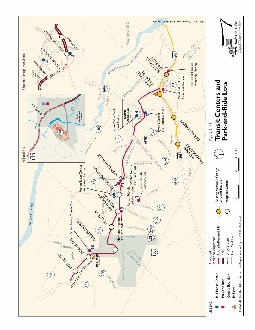
6.1.2.2 Transit CentersAn important element of existing and near-term planned transit service in the Dulles Corridor is itsnetwork of bus transit centers and park-and-ride lots. Figure 6.1-1 presents the location of the park-and-ride facilities and bus transit centers within the corridor. Each of these facilities is identified and describedin Table 6.1-2. Facilities that also provide parking are described in further detail in Section 6.3. TheTysons-West*Park Transit Station is the primary bus transfer facility for Tysons Corner, particularly forexpress bus service and other travel to and from the north, west, and east. In addition, an on-streetfacility on the ring road of the Tysons Corner Center shopping mall currently serves as a transfer point forinternal trips and trips oriented south and east of Tysons Corner, as well as some local Fairfax Connectorroutes from the west.

T R A N S P O R T A T I O N E F F E C T S
Final Environmental Impact Statement 6-4 Dul les Corr idor Rapid Trans it Project
This Page Intentionally Left Blank
Falls
C
hurc
hFa
lls
Churc
h
Tyso
ns
Corn
erTy
sons
Corn
er
Her
ndon
Her
ndon
Res
ton
Res
ton
Fair
fax
Fair
fax
Vie
nna
Vie
nna
CapitalB
eltway
Mar
ylan
dM
aryl
and
Old
Dom
inio
nD
rive
Old
Dom
inio
nD
rive
G
eorge
Washington M
emor
ial P
arkw
ay
G
eorge
Washington M
emor
ial P
arkw
ay
WiehleAvenueWiehleAvenue
Old
Ox
Roa
d
Old
Ox
Roa
d
Vir
ginia
Vir
ginia
Loud
oun
CountyPa
rkway
Loud
oun
CountyPa
rkway
Beulah Road
PO
TO
MA
C R
I VE
R
Du
lles
Inte
rnati
on
al A
irp
ort
Was
hin
gton, D
.C.
Was
hin
gton, D
.C.
DIA
AH
/ DT
R
CentrevilleRoad
Arli
ngto
nCou
nty
Fairf
axCou
nty
Fairf
axCou
nty
Loud
ounCou
nty
675
828
7100
640
674
602
County
Boundar
y
DIA
AH
/DT
R is
the
Dulle
s In
tern
atio
nal
Air
port
Acc
ess
Hig
hw
ay/D
ulle
s To
ll R
oad
Pro
pose
dM
etro
rail
Alig
nm
ent
Aer
ial
At-
grad
e/R
etai
ned
Fill
Under
ground
Aer
ial Y
ard L
ead
Rai
l Yar
d
Bus Tr
ansi
t C
ente
r
Par
k-an
d-R
ide
Tra
nsi
t C
en
ters
an
dP
ark
-an
d-R
ide L
ots
LEG
EN
DFi
gure
6.1
-1
Rail
Yard
Y15
Y15
Y15
Route
7
I-495
Jone
sB
ranch
Drive
Wes
tpar
kD
rive
Greensboro
Dri
ve
International Drive
Tyso
nsBoulevard
CapitalBelt
way
Spri
ng
Hill
R
oad
Tyco
Road
Wes
twood
Cen
ter
Dr.
DIAAH/DTR
PO
CK
ET
TR
AC
K
Rout
e12
3
Rou
te12
3
Align
men
t Thr
ough
Tyso
ns Co
rner
(see
inse
t)
T
YSO
NS
ALI
GN
MEN
T
FEIS_6.1-1_TransitCenter_ParkRide_v7 July2004
10
9
8 7
6
4
3
2
5
1
Dulle
s N
ort
h T
ransi
t C
ente
r
Her
ndon-M
onro
ePar
k-an
d-R
ide
Res
ton T
ow
n C
ente
rB
us Tr
ansi
t C
ente
r
Res
ton S
outh
Par
k-an
d-R
ide
Res
ton N
ort
hPar
k-an
d-R
ide
Wie
hle
Ave
nue
Par
k-an
d-R
ide
Tyso
ns-
Wes
t*Par
kTr
ansi
t C
ente
r
Tyso
ns
Cen
ter
Bus Tr
ansi
t C
ente
r
Wes
t Fa
lls C
hurc
hM
etro
rail
Stat
ion
Eas
t Fa
lls C
hurc
hM
etro
rail
Stat
ion
10
3
4
TYSO
NS EA
ST
TYSO
NS CEN
TRAL
123
TYSO
NS CEN
TRAL
7TY
SON
S WES
T
WO
LF T
RAP
(FUTU
RE)
WIEHLE
AVE
NUE
HER
NDO
N-
MO
NRO
E
ROUTE
606
VIEN
NA/
FAIR
FAX-G
MU
DUN
N LO
RIN
G
WES
T FA
LLS
CHURC
H
REST
ON
PARK
WAY
ROUTE
28
DULL
ES A
IRPO
RT
ROUTE
606
ROUTE
772
EAST
FALL
S
CHURC
H
Exis
ting
Met
rora
il O
range
Lin
e an
d S
tations
Pro
pose
d S
tation


T R A N S P O R T A T I O N E F F E C T S
Dul les Corr idor Rapid Trans it Project 6-7 Final Environmental Impact Statement
Table 6.1-2: Bus Transit Facilities in the Dulles Corridor
Bus Transit Centers LocationOwner/Operator
No. ofBays
Kiss &Ride Parking Connecting Services
East Falls ChurchMetrorail Station
I-66 at Sycamore Drive,Arlington
WMATA 8 Yes Yes Metrobus
West Falls ChurchMetrorail Station(south side)
I-66 at Route 7, Falls Church WMATA 8 Yes Yes Metrobus, PrivateShuttles
West Falls ChurchMetrorail Station(north side)
I-66 at Route 7, Falls Church WMATA 9 No Yes Metrobus, FairfaxConnector,Washington Flyer
Tysons CornerCenter Bus Stop
Tysons Center Ring Road,south side of mall
TysonsCorner I
4 No No Metrobus, FairfaxConnector
Tysons-West*ParkTransit Station
8300 Jones Branch Road,McLean
FairfaxCounty
10 Yes No Metrobus, FairfaxConnector
Reston East 1860 Wiehle Avenue,Reston
FairfaxCounty
8 Yes Yes Fairfax Connector,RIBS, Private Shuttles
Reston North(overflow parking forReston East)
Sunset Hills Road at WiehleAvenue, Reston
VDOT 2 No Yes Fairfax Connector,RIBS
Reston South Reston Parkway at Fox MillRoad, Reston
FairfaxCounty
3 Yes Yes Fairfax Connector,RIBS
Reston Town Center Explorer Street betweenMarket Street and BluemontWay, Reston
FairfaxCounty
2 No No Fairfax Connector,RIBS
Herndon-Monroe 1230 Sunrise Valley Drive,Herndon
FairfaxCounty
8 Yes Yes Fairfax Connector,RIBS
Dulles North TransitCenter
Route 606 at Route 789,Loudoun County
VDOT 6 Yes Yes Loudoun CountyExpress Bus
6.1.2.3 Other Transit ServicesAside from fixed route service provided by WMATA and each of the counties, a few other transit servicesoperate in the corridor. The Potomac and Rappahannock Transportation Commission (PRTC)—whichoperates the Virginia Railway Express (VRE) commuter rail service between Northern Virginia andWashington, D.C.—also provides weekday commuter bus service between Manassas and Washington,D.C., with an hourly stop at the West Falls Church Metrorail Station. The City of Falls Church initiated itsown bus service in late 2000 with two circulator routes linking the East and West Falls Church Metrorailstations with Seven Corners and several Falls Church locations. The City of Fairfax’s City-University-Energysave (CUE) bus system provides fixed-route service between the Vienna/Fairfax- George MasonUniversity (GMU) Metrorail Station, George Mason University, and other locations in the City of Fairfax.
In addition to Metrobus and Metrorail services, WMATA provides demand-response MetroAccessparatransit service throughout the Washington metropolitan region. MetroAccess provides curb-to-curbservice to persons with disabilities who cannot access public transportation and have been certified aseligible to use paratransit service. MetroAccess service is provided through contract with local operators.
Loudoun Transit is a private not-for-profit operator providing limited fixed route bus service in Leesburgand advance registration on-demand transportation in Leesburg and the Sterling areas.

T R A N S P O R T A T I O N E F F E C T S
Final Environmental Impact Statement 6-8 Dul les Corr idor Rapid Trans it Project
Washington Flyer coach service is operated by the Metropolitan Washington Airports Authority (MWAA)and provides scheduled shuttle service between Dulles Airport and the West Falls Church MetrorailStation every half-hour.
6.1.3 LONG-TERM EFFECTS
Two of the major goals of the Dulles Corridor Rapid Transit Project, as outlined in Chapter 1 of thisdocument, are to increase transit ridership and improve transportation service in the corridor. Thissection presents the anticipated long-term effects of the No Build Alternative, the Wiehle AvenueExtension, and the full LPA on the Dulles Corridor transit system and highlights the effectiveness inmeeting these goals.
Both the Wiehle Avenue Extension and full LPA meet these goals more effectively than the No BuildAlternative. The full LPA is the most effective in meeting these goals.
6.1.3.1 Transit RidershipThe change in ridership resulting from implementation of the rapid transit service in the Dulles Corridor isa measure of fundamental importance in assessing the transit effects of the Wiehle Avenue Extensionand full LPA. The potential influences of the Wiehle Avenue Extension and full LPA on regional transitridership, ridership at proposed stations in the corridor, and the transit mode share in the corridor, inrelation to the No Build Alternative, are discussed below.
While the Wiehle Avenue Extension and the full LPA would both increase ridership and mode sharecompared to the No Build Alternative, the full LPA would result in the greatest increases. The full LPA isprojected to attract 41,600 new average weekday trips to the regional transit system in its opening year(2015) while the Wiehle Avenue Extension would attract 29,100 in its opening year (2011). In 2025, thefull LPA would attract nearly 47,800 new average weekday trips to the regional transit system while theWiehle Avenue Extension would attract 34,300 new trips (38 percent fewer new trips). The full LPA isprojected to increase the transit mode share at various activity centers in the corridor by 3 to 5 percent.The Wiehle Avenue Extension would result in a mode share increase that is 1 to 2 percent lower.
6.1.3.2 Regional Transit RidershipTable 6.1-3 presents the average weekday ridership estimates associated with the Wiehle AvenueExtension and full LPA in relation to the No Build Alternative. The first two rows of the table presentridership related specifically to the Dulles Corridor, while the remaining four rows present forecast activityfor the entire Washington metropolitan region.

T R A N S P O R T A T I O N E F F E C T S
Dul les Corr idor Rapid Trans it Project 6-9 Final Environmental Impact Statement
Table 6.1-3: Average Weekday Transit Patronage Forecasts
Locally Preferred Alternative
Wiehle Avenue Extension (2011)Wiehle Avenue Extension
(2025)
No BuildAlternative
(2025)No Build
AlternativeMetro-
rail
CorridorExpress
Bus TotalMetro-
rail
CorridorExpress
Bus TotalFull LPA
(2025)
Project-Related Corridor Ridership Activity
Total Corridor Trips n.a. n.a. 59,000 3,8001 62,800 68,500 4,8001 73,300 91,200
Total CorridorBoardings n.a. n.a. 24,600 13,200 37,800 27,300 16,800 44,100 57,500
Project-Related Regional Ridership Activity
Regional HBW Rail/Corridor Express Bus 541,100 471,400 490,600 n.a. 563,500 n.a. 575,300
Regional Total Rail/Corridor Express Bus 914,500 788,400 826,500 n.a. 960,600 n.a. 977,300
Regional TotalTransit Trips 1,331,200 1,159,500 1,188,600 n.a. 1,365,600 n.a. 1,379,000
Regional New Trips n.a. n.a. 29,100 n.a. 34,400 n.a. 47,800
HBW – home-b ased work1 T h is f igure repr esents r i ders h ip ac t i vi ty tha t occurs on expr ess bus on l y w i th no t ransfer to ra i l . T r ips tha t s tar t w i thexpr ess bus but a lso invo lve u ti l i za t i on o f Met ror a i l a re inc luded in the Met ror a i l co lum n.
The “Total Corridor Trips” row reflects all corridor-related boardings and alightings for the Metrorailsystem and/or corridor express bus service, including passengers entering the system outside of thecorridor but exiting at a corridor station or stop. “Total Corridor Boardings” represent all trips that boardthe system at a station within the Dulles Corridor.
The “Regional Home Base Work Trips (HBW) Rail/Corridor Express Bus Trips” row represents total dailyregional rail or corridor express bus trips that begin at the trip maker’s home and end at their place ofwork. Home-based work trips are an important set of trips to consider in ridership analysis because tripsbetween home and work comprise the largest segment of public transportation use. The “Regional TotalRail/Corridor Express Bus Trips” row represents all daily Metrorail and/or corridor express bus trips, notjust those used for the commute between home and work. “Regional Total Transit Trips” reflects forecastridership on the assumed regional transit network, and includes Metrorail trips, corridor express bus trips,commuter rail trips, and trips made by local bus. The “Regional New Trips” column presents the numberof new transit trips attracted to the regional transit network as a result of the implementation of eachalternative. The number of new trips for an alternative is calculated by subtracting the No Build Alternative“Regional Total Transit Trips” from the alternative’s “Regional Total Transit Trips” for the same year ofanalysis.
The No Build Alternative would not provide additional rapid transit service in the Dulles Corridor;therefore, there would be no project-related effects from this alternative.
The Wiehle Avenue Extension and the full LPA are expected to increase the number of regional transittrips, and substantially increase the number of new trips on the system. Overall, in 2025, the full LPAwould result in approximately 47,800 new average weekday trips on the system. Considered alone, theWiehle Avenue Extension would attract approximately 34,400 new average weekday trips in 2025.
T R A N S P O R T A T I O N E F F E C T S
Final Environmental Impact Statement 6-10 Dul les Corr idor Rapid Trans it Project
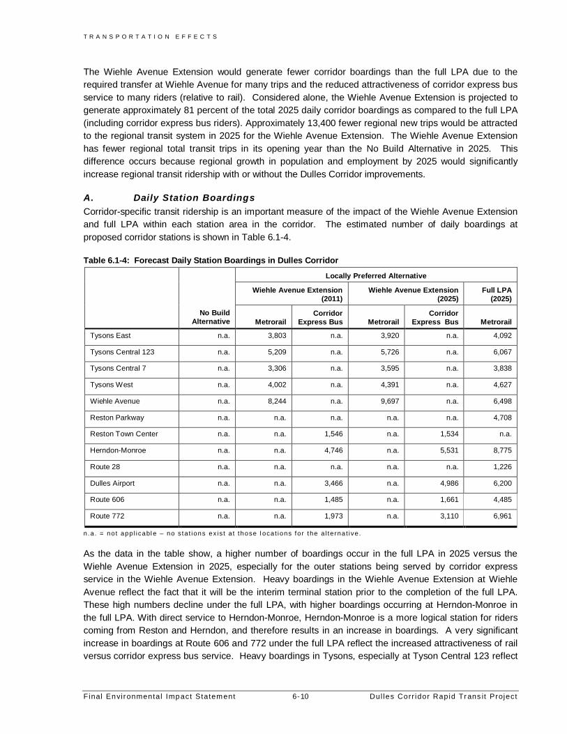
The Wiehle Avenue Extension would generate fewer corridor boardings than the full LPA due to therequired transfer at Wiehle Avenue for many trips and the reduced attractiveness of corridor express busservice to many riders (relative to rail). Considered alone, the Wiehle Avenue Extension is projected togenerate approximately 81 percent of the total 2025 daily corridor boardings as compared to the full LPA(including corridor express bus riders). Approximately 13,400 fewer regional new trips would be attractedto the regional transit system in 2025 for the Wiehle Avenue Extension. The Wiehle Avenue Extensionhas fewer regional total transit trips in its opening year than the No Build Alternative in 2025. Thisdifference occurs because regional growth in population and employment by 2025 would significantlyincrease regional transit ridership with or without the Dulles Corridor improvements.
A. Daily Station BoardingsCorridor-specific transit ridership is an important measure of the impact of the Wiehle Avenue Extensionand full LPA within each station area in the corridor. The estimated number of daily boardings atproposed corridor stations is shown in Table 6.1-4.
Table 6.1-4: Forecast Daily Station Boardings in Dulles Corridor
Locally Preferred Alternative
Wiehle Avenue Extension(2011)
Wiehle Avenue Extension(2025)
Full LPA(2025)
No BuildAlternative Metrorail
CorridorExpress Bus Metrorail
CorridorExpress Bus Metrorail
Tysons East n.a. 3,803 n.a. 3,920 n.a. 4,092
Tysons Central 123 n.a. 5,209 n.a. 5,726 n.a. 6,067
Tysons Central 7 n.a. 3,306 n.a. 3,595 n.a. 3,838
Tysons West n.a. 4,002 n.a. 4,391 n.a. 4,627
Wiehle Avenue n.a. 8,244 n.a. 9,697 n.a. 6,498
Reston Parkway n.a. n.a. n.a. n.a. n.a. 4,708
Reston Town Center n.a. n.a. 1,546 n.a. 1,534 n.a.
Herndon-Monroe n.a. n.a. 4,746 n.a. 5,531 8,775
Route 28 n.a. n.a. n.a. n.a. n.a. 1,226
Dulles Airport n.a. n.a. 3,466 n.a. 4,986 6,200
Route 606 n.a. n.a. 1,485 n.a. 1,661 4,485
Route 772 n.a. n.a. 1,973 n.a. 3,110 6,961
n.a . = not app l icabl e – no s ta t ions ex is t a t those l ocat ions for the a l te rnat ive .
As the data in the table show, a higher number of boardings occur in the full LPA in 2025 versus theWiehle Avenue Extension in 2025, especially for the outer stations being served by corridor expressservice in the Wiehle Avenue Extension. Heavy boardings in the Wiehle Avenue Extension at WiehleAvenue reflect the fact that it will be the interim terminal station prior to the completion of the full LPA.These high numbers decline under the full LPA, with higher boardings occurring at Herndon-Monroe inthe full LPA. With direct service to Herndon-Monroe, Herndon-Monroe is a more logical station for riderscoming from Reston and Herndon, and therefore results in an increase in boardings. A very significantincrease in boardings at Route 606 and 772 under the full LPA reflect the increased attractiveness of railversus corridor express bus service. Heavy boardings in Tysons, especially at Tyson Central 123 reflect

T R A N S P O R T A T I O N E F F E C T S
Dul les Corr idor Rapid Trans it Project 6-11 Final Environmental Impact Statement
high employment densities in the area as well as the fact that this station is the nexus for Tysons shuttleservices.
B. Corridor Transit Mode ShareChanges in transit mode share identify whether overall corridor travel choices are changing becausepeople have switched to transit from their automobiles due to the presence of the new corridor rapidtransit service. Transit mode share analysis distinguishes between absolute transit volumes and theoverall effectiveness of transit service in meeting regional travel needs. If transit ridership goes up whileits mode share declines, then transit is not succeeding in contributing to the performance of the overallregional transportation system.
The effects of the Wiehle Avenue Extension and full LPA on corridor transit mode share, in relation to theNo Build Alternative, are summarized below in Tables 6.1-5 and 6.1-6.
Table 6.1-5: Transit Mode Share for Home-Based Work Trips (Trips Attracted to the Dulles Corridor)
Locally Preferred Alternative
No Build Alternative(2025)
Wiehle AvenueExtension
(2011)
Wiehle AvenueExtension
(2025)Full LPA
(2025)
Tysons Corner 8.4% 11.9% 11.6% 12.6%
Reston 6.4% 7.9% 7.6% 9.6%
Herndon/Dulles 4.4% 5.8% 6.2% 7.9%
Loudoun East 1.0% 2.0% 2.1% 2.7%
Table 6.1-6: Transit Mode Share for Home-Based Work Trips (Trips Produced in the Dulles Corridor)
Locally Preferred Alternative
No Build Alternative(2025)
Wiehle AvenueExtension
(2011)
Wiehle AvenueExtension
(2025)Full LPA
(2025)
Tysons Corner 25.9% 33.5% 34.3% 34.4%
Reston 11.7% 15.1% 15.4% 17.4%
Herndon/Dulles 10.8% 13.9% 14.8% 16.2%
Loudoun East 2.9% 6.9% 6.8% 10.8%
Relative to the No Build Alternative, home-based work transit mode share for the full LPA would increasein each of the corridor sub areas due to the implementation of a much more attractive transit service thanthe bus only service provided in the No Build Alternative.
The Wiehle Avenue Extension would result in less improvement in home-based work transit mode shareat activity centers than the full LPA, especially in the western end of the corridor, due to a lower overallridership. However, in the eastern end of the corridor the increase in mode share for the Wiehle AvenueExtension would result in a significant improvement over No Build Alternative mode shares.
C. Transit Travel TimesThe level of convenience for passengers using transit is directly related to the amount of time that isrequired to make a trip by bus or rail versus alternative modes such as the automobile. Transit travel timeincludes time spent accessing the station or stop, time spent waiting for the bus or train, time spent riding

T R A N S P O R T A T I O N E F F E C T S
Final Environmental Impact Statement 6-12 Dul les Corr idor Rapid Trans it Project
the bus or train, and the time spent transferring between transit services. The longer each of these transittrip components take, the less attractive transit becomes relative to other modes for travelers who have achoice of mode. For passengers who do not have access to other modes and thus rely on transit to meettheir basic mobility needs, excessive travel times result in less time available to spend on other priorities.Table 6.1-7 shows transit travel times for the No Build Alternative, the Wiehle Avenue Extension, and thefull LPA in 2025 for select origin/destination (O/D) pairs within the region.
Table 6.1-7: Transit Travel Times for Select O/D Pairs in Minutes
No Build Alternative Locally Preferred Alternative
Origin DestinationHighway
(2025)Transit(2025)
WiehleAvenue
Extension(2011)
WiehleAvenue
Extension(2025)
Full LPA(2025)
Tysons West –West*Park Area
Metro Center 35 37 38 38 38
Wiehle Avenue Union Station 59 57 57 57 51
Rosslyn Dulles Airport 36 64 54 54 43
Wiehle Avenue Pentagon 57 50 57 57 55
Herndon-Monroe Tysons Central123
26 42 28 28 26
Tysons West –Tysons West StationArea
Dulles Airport 21 72 30 30 19
Wiehle Avenue Tysons East –Tysons EastStation Area
25 46 26 26 19
Route 606 Metro Center 52 60 65 65 60
For all but three origin-destination (O/D) pairs, the full LPA would improve transit travel times over thosefor the No Build Alternative, especially for reverse commute trips and trips with one end in Tysons Corner.For many trips, transit travel times would improve by 20 to 30 minutes. The transit travel times for the fullLPA would generally be time-competitive with highway travel (travel by private vehicle).
In general, the Wiehle Avenue Extension would offer less travel time savings than the full LPA, but itwould still offer an improvement in transit travel times over the No Build Alternative for most O/D pairs.For trips traveling between Wiehle Avenue and points east, the Wiehle Avenue Extension would providetravel times similar to the full LPA, because the Metrorail service would be similar in this portion ofcorridor. For trips with at least one end west of Wiehle Avenue, the Wiehle Avenue Extension would havegreater travel times than the full LPA due to transfer requirements and decreased service frequency in thereverse peak direction. For these trips, the Wiehle Avenue Extension would generally have travel timesthat are 10 to 15 minutes longer than the full LPA.
6.1.3.3 Effects on Travel PatternsThe data presented in this section complements the mode share data presented above in Tables 6.1-5and 6.1-6. The purpose of this data is to show the changes in trips being generated and attracted todifferent parts of the corridor due to the implementation of the full LPA or the Wiehle Avenue Extension.Specifically, the data show the impacts on mode choice of a greater range of transit options for people

T R A N S P O R T A T I O N E F F E C T S
Dul les Corr idor Rapid Trans it Project 6-13 Final Environmental Impact Statement
starting trips in the corridor as well as for people making trips into the corridor. Tables 6.1-8 and 6.1-9show the number of daily transit trips attracted to and produced in the Dulles Corridor.
Table 6.1-8: Number of Daily Transit Trips Attracted to Corridor Geographic Areas
Locally Preferred Alternative
No Build Alternative(2025)
Wiehle AvenueExtension
(2011)
Wiehle AvenueExtension
(2025)Full LPA
(2025)
Tysons Corner 13,870 19,335 20,514 21,981
Reston 7,942 9,382 9,168 10,888
Herndon/Dulles 5,449 5,722 6,808 8,282
Loudoun East 3,133 8,742 12,758 15,389
Table 6.1-9: Number of Daily Transit Trips Produced in Corridor Geographic Areas
Locally Preferred Alternative
No Build Alternative(2025)
Wiehle AvenueExtension
(2011)
Wiehle AvenueExtension
(2025)Full LPA
(2025)
Tysons Corner 6,034 8,908 9,732 9,787
Reston 11,980 13,333 14,786 16,068
Herndon/Dulles 7,793 8,104 9,556 10,602
Loudoun East 6,505 9,450 13,359 17,955
With implementation of the Wiehle Avenue Extension and the full LPA, trip productions and attractions forall parts of the corridor show increases with the most dramatic increases in trips in the westernmost partof the corridor. While this increase is especially notable in the full LPA, increases in the Wiehle AvenueExtension are also significant. These increases are directly related to providing greater transit choices inthe corridor, especially for reverse commute and off-peak trips.
6.1.3.4 Transit CapacityTransit capacity in the corridor represents the amount of physical capacity available to carry passengersand provides an understanding of the number of riders that can be comfortably accommodated in thecorridor during peak travel times. This measure also provides an understanding of the level of serviceprovided and how well the Wiehle Avenue Extension and full LPA support the corridor’s mobility needs.Total capacity will vary according to the number of vehicles in service and the capacity of each of thosevehicles. Vehicle capacity, in turn, will vary based on vehicle size, policies regarding the level ofacceptable vehicle loading, and the allowable number of standing passengers.
Table 6.1-10 summarizes the transit capacity provided at each of the corridor stations or stops (or stationareas in the No Build Alternative) for service in the a.m. peak hour in the peak direction. The figures inthe table represent the number of peak-hour spaces available to carry passengers at each station orstation area under each alternative.

T R A N S P O R T A T I O N E F F E C T S
Final Environmental Impact Statement 6-14 Dul les Corr idor Rapid Trans it Project
Table 6.1-10: Transit Capacity by Alternative in the a.m. Peak Hour
Locally Preferred Alternative
Station/StopNo Build Alternative
(2025)
Wiehle AvenueExtension
(2011)
Wiehle AvenueExtension
(2025)Full LPA
(2025)
East Falls Church 21,120 18,240 21,120 21,120
West Falls Church 21,120 10,560 12,480 12,480
Tysons East 90 7,680 8,640 8,640
Tysons Central 7 n.a. 7,680 8,640 8,640
Tysons Central 123 400 7,680 8,640 8,640
Tysons West n.a. 7,680 8,640 8,640
Wiehle Avenue 720 7,860 8,820 8,820
Reston Parkway n.a. n.a. n.a. 8,640
Herndon-Monroe 1,012 1,665 2,430 8,640
Route 28 n.a. n.a. n.a. 8,640
Dulles Airport n.a. 180 180 8,640
Route 606 495 2,295 2,565 8,955
Route 772 n.a. 1,980 2,250 8,640
NOTE: Veh ic le Ca pac i ty Ass umpti ons : Met rora i l – 120 passengers per veh ic le ; F a i r fax Conn ector an d Loudoun County– 45 passengers per veh ic le ( assumes some s tandees) .n .a . = t rans i t s erv ices not p ro vi ded to th is s ta t i on area under the a l te rnati ve .
In the full LPA, transit capacity at all stations in the corridor between Route 772 and Tysons East wouldincrease relative to the No Build Alternative because the multiple car trains in the full LPA would providesignificantly higher capacity than the single buses providing corridor service under the No BuildAlternative (furthermore, a single rail car also has a higher capacity than a single bus).
In the Wiehle Avenue Extension, similar improvements in transit capacity would occur relative to the NoBuild Alternative for the corridor stations from Wiehle Avenue east (in the Wiehle Avenue Extension,Wiehle Avenue will be the western terminal station for the Wiehle Avenue Extension rail service). Thisimprovement in capacity would occur both in the short term as well as in the long term, if the full LPA isnot implemented in its entirety. In the Wiehle Avenue Extension, west of Wiehle Avenue, transit capacitywould be much less than the full LPA because transit service would be provided by buses (i.e., singlevehicles) rather than by multiple car trains. In 2025, the Wiehle Avenue Extension would provideapproximately 30 percent of the capacity of the full LPA west of Wiehle Avenue.
6.1.3.5 Hours of Operation and Frequency of ServiceHours of operation and service frequency, especially in the off-peak, are important determinants of thequality and convenience of transit service that would be provided in the Dulles Corridor, including howwell transit supports everyday activities and travel needs other than peak hour commutes.
For the Wiehle Avenue Extension, hours of operation for both Metrorail and corridor express bus serviceswould correspond to the existing Metrorail system’s operating hours: 5:00 a.m. to 12 p.m. on weekdays (3a.m. on Friday), 7 a.m. to 3 a.m. on Saturdays, and 7 a.m. to 12 p.m. on Sundays. In addition, overallspan of service for local/feeder bus services would correspond to these operating hours. Limited “night

T R A N S P O R T A T I O N E F F E C T S
Dul les Corr idor Rapid Trans it Project 6-15 Final Environmental Impact Statement
owl” bus service operates beyond these hours throughout the region. For the full LPA, the DullesCorridor line would have the same hours of operation as described for the Wiehle Avenue Extension.
While the hours of operation are comparable between the No Build Alternative, the Wiehle AvenueExtension, and the full LPA, service frequencies—particularly in the off-peak periods (midday andevening)—would be much better for the full LPA than for the No Build Alternative. Table 6.1-11summarizes the range of service frequencies planned for each alternative in both the peak and off-peakperiods.
The service frequencies for the full LPA were designed to be consistent with planned Metrorailoperations. Accordingly, the full LPA would operate with 7-minute headways in the peak period and 12-minute headways at most other times. In the peak period, this level of service is better than what wouldbe provided under the No Build Alternative, and in the off-peak period—where headways for most travelmarkets in the corridor improve from 30 minutes to 12 minutes—the level of service would be far betterthan that provided by the No Build Alternative.
Table 6.1-11: Peak and Off-Peak Headways in the Dulles Corridor (in minutes)
Locally Preferred AlternativeNo Build
Alternative(2025)
Wiehle AvenueExtension
(2011)
Wiehle AvenueExtension
(2025)Full LPA
(2025)Fairfax County ConnectorService
5-30 15-30 15-30 15-30
Loudoun County CommuterService
15 15 15 No Service
Metrorail No Service 7 7 7Metrobus 15-30 15-30 15-30 15-30
PeakPeriod
Corridor Express Bus Service No Service 7-30 7-30 No ServiceFairfax County ConnectorService
30-60 30-60 30-60 30-60
Loudoun County CommuterService
No Service No Service No Service No Service
Metrorail No Service 12 12 12Metrobus 30-60 30-60 30-60 30-60
Off-PeakPeriod
Corridor Express Bus Service No Service 21-30 21-30 No Service
For the Wiehle Avenue Extension, the frequency of service east of and including Wiehle Avenue would bethe same as that for the full LPA. The corridor express bus service proposed for points west of WiehleAvenue is intended to operate in the peak direction with frequencies comparable to those provided by therail segment. However, express bus services would operate in heavily congested conditions whenaccessing and exiting stations and stops, and could experience delays that affect service reliability. In thereverse-peak direction and during the off-peak period, express bus service would operate less frequentlythan the full LPA, but more frequently than No Build Alternative transit services.
6.1.3.6 Transfer RequirementsThe number of transfers required to make a trip from an origin to a destination is one of the mostimportant determinants of passenger convenience and comfort. Research shows that there are severalreasons transfers decrease the attractiveness of a transit service. First, the added time associated withtransfers increases a passenger’s overall trip time. Second, transfers between different transit lines oftentake place at bus stops that are unprotected from the elements and not suited to long waits. Third, there

T R A N S P O R T A T I O N E F F E C T S
Final Environmental Impact Statement 6-16 Dul les Corr idor Rapid Trans it Project
is a discomfort associated with uncertainty about the arrival of the vehicle being transferred to, specificallywhether the vehicle will be early (and therefore missed by on-time arriving passengers), late, or will arriveat all.
For the No Build Alternative, the Wiehle Avenue Extension, and the full LPA, the minimum number oftransfers necessary to travel between select O/D pairs (the same pairs analyzed for travel time effects)was determined. The results of this analysis show that for most of the O/D pairs analyzed, the full LPAwould require fewer transfers than the No Build Alternative. The full LPA would often provide a one-seatride between origin and destination. Where transfers are required, they would be within the regional rapidtransit system; therefore, perceived transfer “penalties” are somewhat mitigated by completely shelteredenvironments and the ability to transfer between lines without paying an additional fare or showing atransfer pass.
The Wiehle Avenue Extension would require at least one more transfer than the full LPA for trips with oneend in the western part of the corridor and one end east of Wiehle Avenue. For these trips, the WiehleAvenue Extension would generally require the same number of transfers as transit services operatingunder the No Build Alternative, but in most cases would not require transfers between different serviceproviders. For O/D pairs with both ends in the western end of the corridor, no transfers would berequired.
6.1.3.7 Effects on Regional Rail OperationsThe implementation of the Wiehle Avenue Extension and full LPA would affect the operations of otherportions of the regional transit system, including Metrorail, Metrobus, and the local operating systems inthe corridor. This section includes a summary of the effects of the full LPA on planned Metrorail systemcapacity and operations. Of particular concern is the ability of Metrorail vehicles to accommodateadditional passenger loads resulting from the implementation of the Dulles Corridor Rapid Transit Projectwithout significant crowding, especially in the peak hour of demand. The operations of the WiehleAvenue Extension and full LPA are discussed in Section 2.4.2.
A. Passenger Volumes at Maximum Load PointsTable 6.1-12 presents forecasted Metrorail passenger loads at the maximum load point (the point atwhich Metrorail vehicles experience the highest passenger volumes and thus the most crowding), and theaverage loads per car during the peak hour of the a.m. peak period for the No Build Alternative, theWiehle Avenue Extension, and the full LPA. The maximum load point for each alternative would occurbetween the Rosslyn and Foggy Bottom stations on the Metrorail Orange Line. The average load per carreflects the number of passengers carried on each car of a train during the peak hour, assuming thatpassenger loads are spread evenly among all cars in operation during that period.
WMATA's current primary passenger load guideline is 140 passengers per rail car (ppc) in the peakdirection during the peak 30-minute period (i.e., the peak of the peak). In an effort to improve the qualityof Metrorail service, WMATA has established an objective of reducing its passenger load standard to 120ppc in the peak hour. This passenger load guideline was used in WMATA's Core Capacity Study (seeSection 1.3) and in determining Metrorail fleet requirements for the Dulles Corridor Rapid Transit Project.

T R A N S P O R T A T I O N E F F E C T S
Dul les Corr idor Rapid Trans it Project 6-17 Final Environmental Impact Statement
Table 6.1-12: A.M. Peak Hour Maximum Loads and Average Loads per Vehicle
Locally Preferred Alternative
No Build Alternative(2025)
Wiehle AvenueExtension
(2011)
Wiehle AvenueExtension
(2025)Full LPA
(2025)Passenger
LoadAverage
Load/CarPassenger
LoadAverage
Load/CarPassenger
LoadAverage
Load/CarPassenger
LoadAverage
Load/Car
Orange Line, Vienna toLargo 3,726 109 3,185 124 3,383 99 3,358 98
Orange Line, Vienna toNew Carrollton 7,483 110 6,398 107 6,791 99 6,738 98
Orange Line, WestFalls Church toStadium 5,194 76 n.a. n.a. n.a. n.a. n.a. n.a.
Wiehle AvenueExtension and full LPA n.a. n.a. 6,845 114 7,389 108 8,642 126
Total 16,404 96 16,428 112 17,563 103 18,738 109
n.a. = not appl icable f or th is al ternat i ve
Passenger loads on the Orange Line Vienna service would decrease under the full LPA relative to the NoBuild Alternative because passengers from the Dulles Corridor riding the Vienna service under the NoBuild Alternative would instead board the service provided by the Wiehle Avenue Extension or full LPA,thus lessening the number of passengers on board Vienna Line trains. Under the Wiehle AvenueExtension, passenger loads and average loads per car on the Dulles Corridor line would decrease at themaximum load point relative to the full LPA. This decrease would be attributable to the decrease inridership on the Dulles Line for the Wiehle Avenue Extension. Conversely, there would be a smallincrease in passenger loads and average loads per car on the Orange Line Vienna service for the WiehleAvenue Extension in 2025. Since Metrorail service would not be available in the western portion of thecorridor under the Wiehle Avenue Extension, some people from the west would choose to drive to theVienna line to board rather than be forced to transfer at Wiehle Avenue on the Dulles Line. The decreasein passengers on board at the maximum load point and the average loads per car in the full LPA are evenmore pronounced relative to the Wiehle Avenue Extension opening year.
B. Other Effects on the Existing Metrorail SystemImplementation of the full LPA would result in two additional effects on Metrorail service along the OrangeLine. The Wiehle Avenue Extension and the full LPA would replace Orange Line service runningbetween West Falls Church and Stadium Armory in the peak period only with new Metrorail service in theDulles Corridor and along the Orange Line, with the first Orange Line stop for the new Dulles service atthe East Falls Church Metrorail Station. Because the Dulles line service would operate all day, servicefrequencies along the Orange Line (east of East Falls Church) would improve during the off-peak period,as Dulles trains would merge with the Orange Line alignment at East Falls Church. This would result in acombined off-peak headway of 6 minutes from East Falls Church to Rosslyn and 4 minutes along theremainder of the shared Orange/Blue alignment through downtown Washington, D.C. By comparison,the No Build Alternative would provide a 12-minute off-peak headway on the Orange Line east to Rosslynand a 6-minute combined Blue/Orange Line headway through downtown Washington, D.C.
While off-peak service frequencies east of (and including) East Falls Church Metrorail Station wouldimprove, peak period service at the West Falls Church Metrorail Station would decline under theimplementation of the Wiehle Avenue Extension and the full LPA. This is because the Wiehle Avenue

T R A N S P O R T A T I O N E F F E C T S
Final Environmental Impact Statement 6-18 Dul les Corr idor Rapid Trans it Project
Extension and the full LPA would replace a service (the peak period only Orange Line service betweenWest Falls Church and Stadium-Armory) with a Metrorail Line that would bypass West Falls Church andenter the Orange Line alignment at the East Falls Church Metrorail Station. This would result in peakperiod trains at West Falls Church being reduced from approximately 21 trains per hour in the No BuildAlternative to approximately 13 trains per hour under the Wiehle Avenue Extension and full LPA.
6.1.3.8 Effects on Operations and Maintenance CostsThe ridership figures outlined at the beginning of Section 6.1.3 show the positive impacts of implementinga major transit capital investment in the Dulles Corridor. This section outlines the estimated changes inoperations and maintenance (O&M) costs associated with the Wiehle Avenue Extension and full LPA.These figures, in conjunction with ridership changes, help to identify the cost-effectiveness of a givenalternative. Table 6.1-13 presents the annual operations and maintenance costs estimated for 2025 (in2004 dollars).
Table 6.1-13: Annual Operations and Maintenance Costs – 2025 (2004 dollars in millions)
Locally Preferred Alternative
Transit Service
No BuildAlternative
(2025)
Wiehle AvenueExtension
(2011)
Wiehle AvenueExtension
(2025)Full LPA
(2025)
Metrorail $587.73 $581.98 $627.85 $657.64
WMATA Bus $14.53 $11.74 $13.30 $13.30
Fairfax Connector $19.19 $19.74 $23.42 $21.32
Loudoun County(includes corridorexpress service)
$4.38 $7.96 $9.71 $6.33
TOTAL $625.83 $621.42 $674.28 $698.59
NOTE: See Chapter 8 for cos ts expr essed in year -o f -e xpend i tu re dol la rs .
Though revenue vehicle hours for all transit modes in the corridor are expected to decrease for the fullLPA relative to the Wiehle Avenue Extension, the full LPA would have higher O&M costs due to theadded cost of infrastructure maintenance for a rail line which extends to Loudoun County. Thisinfrastructure includes stations, tracks, power distribution systems, structures, and right-of-way. The costassociated with maintaining more sophisticated rail vehicles is also higher than the cost of maintainingbuses (the mode of service west of Wiehle Avenue in the Wiehle Avenue Extension).
6.1.3.9 Metrorail Fleet RequirementsFleet requirements represent the number of Metrorail cars that would be required to meet peak loadsunder each of the alternatives, plus spare cars and gap trains. This measure is another means ofdescribing the level of transit service and investment in resources. Table 6.1-14 presents the fleetrequirements for each alternative in the opening years.
Table 6.1-14: Fleet Requirements – Opening Year
Transit ServiceNo Build
(2011)
Wiehle AvenueExtension
(2011)No Build
(2015)Full LPA
(2015)
Metrorail Cars 1,108 1,172 1,238 1,366
As shown in the table, the Wiehle Avenue Extension alternative requires an additional 64 Metrorail carsfor year 2011 operations when compared to the No Build Alternative. The full LPA requires an additional

T R A N S P O R T A T I O N E F F E C T S
Dul les Corr idor Rapid Trans it Project 6-19 Final Environmental Impact Statement
64 Metrorail cars. Independent of the LPA, WMATA will procure a gap train and also rail cars toaccommodate growth in the system.
6.1.4 CONSTRUCTION EFFECTS
6.1.4.1 Wiehle Avenue ExtensionThe Wiehle Avenue Extension would merge with the Orange Line at a point between the East and WestFalls Church Metrorail Stations. This connection would require new special track work, including turnoutsand a double crossover on the existing Orange Line track. It would also require some re-alignment of theOrange Line. WMATA would be able to maintain Orange Line operations by single-tracking trains toimplement such improvements. To the extent possible, overnight periods would be utilized forconstruction that would require closure of both tracks. If closure of both tracks is required during operatinghours, buses would be used to connect stations affected by the closure.
A yard lead from the mainline in the median of the Dulles Connector Road would be required for accessto the West Falls Church Yard. This lead would cross under the eastbound lanes of the Connector Road.If cut and cover tunneling is identified as the best method for constructing the tunnel it would require adetour on the eastbound lanes.
In Tysons Corner, the rail line would run in tunnel for 1.1 miles. If cut and cover is the selectedconstruction method, lane closures that would have a considerable impact on traffic operations would berequired.
Construction of the Wiehle Avenue station would require widening of the DIAAH. This widening wouldresult in lane closures in the station area. The construction impacts of parking, Kiss & Ride and busfacilities associated with the station are expected to be minimal. The construction of pedestrianoverpasses to the Wiehle Avenue median station may require limited off-peak lane closures on theDIAAH and the Dulles Toll Road.
West of the Wiehle Avenue Station, there would be construction of a pocket track for train storage thatwould result in lane closures for roadway widening.
6.1.4.2 Full LPAConstruction effects for the full LPA would be the same as the Wiehle Avenue Extension east of andincluding Wiehle Avenue.
West of Wiehle Avenue, the construction of the Reston Parkway, Herndon-Monroe, and Route 28 stationswould require the same widening of the DIAAH as the Wiehle Avenue station construction, and thereforewould also have the same impacts.
At Dulles Airport, the rail alignment would run through a 1.72 mile tunnel. Impacts from the use of acombination of cut and cover and conventional tunneling techniques would include vehicular, pedestrian,and potentially air traffic disruptions as the tunneling proceeds across roads leading to the main terminal,parking lots, and the northern portion of the service tarmac.
The northwestern-most section of the Dulles Airport alignment would be an aerial alignment providing aconnection to the Dulles Greenway median. Impacts due to construction are expected to be minimal, withsome off-peak lane closures across the eastbound lanes expected.

T R A N S P O R T A T I O N E F F E C T S
Final Environmental Impact Statement 6-20 Dul les Corr idor Rapid Trans it Project
Relocation of lanes on the Dulles Greenway would be required at the Route 606 and Route 772 stationsin Loudoun County. These relocations may result in some traffic disruptions as lanes are closed at eachstation location. Impacts from lane closures for construction of pedestrian bridges to the Greenwaymedian are expected to be minimal.
6.1.5 MITIGATION
Maintenance of traffic plans would be developed for all construction activities that would affect roadways.The construction of all stations along the alignment of both the full LPA and the Wiehle Avenue Extensionwould be coordinated with the following agencies: VDOT regarding lane closures in Tysons Corner andon the Dulles Toll Road; MWAA regarding possible disruptions in airport service and construction on theDIAAH; and with TRIP II regarding construction events on the Dulles Greenway. To the extent possible,all construction requiring lane closures would be done at night, on weekends, or in the off-peak periods.
6.2 EFFECTS ON ROADWAYS
Because of the population and employment growth forecast for the metropolitan Washington, D.C. region,traffic is expected to consistently increase throughout the Dulles Corridor over the next ten to 20 years.Under the No Build Alternative, anticipated growth is expected to occur in a dispersed pattern ofdevelopment, which would be highly auto-oriented, leaving people with few travel choices and resulting inwidespread congestion. At many corridor intersections, travelers would experience substantial delays andvery poor levels of service. The intent of the Dulles Corridor Rapid Transit Project is to provide travelchoices for corridor residents and employees and to help focus anticipated growth in Fairfax and Loudouncounties into patterns that will increase the number of viable travel options available to corridor residentsand employees, including transit, walking, and bicycling.
This section presents the existing and planned roadway system in the Dulles Corridor, as well as thepotential effects of the Wiehle Avenue Extension and the full LPA on the planned system. In Section6.2.1, the methodology for evaluating roadway effects is discussed, then in Section 6.2.2 the existing andplanned roadway systems in the Dulles Corridor are described. Section 6.2.3 presents the anticipatedlong-term effects associated with the No Build Alternative, the Wiehle Avenue Extension, and the full LPAin terms of roadway volumes, levels of service, and anticipated delay at intersections, and Section 6.2.4presents proposed mitigation measures for anticipated adverse traffic effects.
6.2.1 METHODOLOGY
Like transit effects, the anticipated effects of the No Build Alternative, the Wiehle Avenue Extension andthe full LPA on the regional and corridor roadways were estimated using the Northern Virginia MajorInvestment Study Model (NVMISM). NVMISM was used to generate highway assignments that were, inturn, used to forecast traffic volumes on regional highway links and adjusted to develop detailed trafficforecasts for the local road network surrounding proposed stations and stops in the Dulles Corridor.
6.2.2 EXISTING AND PLANNED ROADWAY SYSTEM
The Dulles Corridor is served by a number of regional and local roadway facilities. This section providesan overview of these facilities, including a general assessment of current traffic operations. Additionalinformation on existing transportation facilities and assumed highway and transit improvements isprovided in Chapters 1 and 2.

T R A N S P O R T A T I O N E F F E C T S
Dul les Corr idor Rapid Trans it Project 6-21 Final Environmental Impact Statement
6.2.2.1 Regional RoadwaysThe regional highway facilities, major arterials, and key regional roadway links in the Dulles Corridor areshown in Figure 2.4-2. These highways, their existing capacity, and the improvements included in theregion’s financially constrained long-range transportation plan (CLRP) are described in more detail inChapter 2. The major regional highway facilities in the corridor include the following:
§ Interstate 66 (I-66);§ Dulles Connector Road;§ Interstate 495 (I-495 or Capital Beltway);§ Dulles Toll Road;§ Dulles International Airport Access Highway; and,§ Dulles Greenway.
The other major arterials serving regional travel patterns in the corridor include:
§ Route 7 (Leesburg Pike);§ Route 123 (Chain Bridge Road/Dolley Madison Boulevard);§ Route 193 (Georgetown Pike);§ Route 7100 (Fairfax County Parkway);§ Route 28 (Sully Road);§ Route 50 (Lee Jackson Memorial Highway); and,§ Route 607 (Loudoun County Parkway).
As indicated in Chapter 1, regional roadways and major arterials in the Dulles Corridor currentlyexperience a substantial amount of congestion during peak travel periods. Typically, the level ofcongestion on a roadway or at an intersection is reflected by a qualitative measure called level of service(LOS). In general, LOS reflects the impacts of congestion on travel speeds or the average delayexperienced by vehicles at an intersection. Six letter designations (A through F) are used to representdifferent levels of service, with LOS A reflecting free flow conditions and LOS E and F representing verycongested or gridlock conditions. Many of the facilities in the Dulles Corridor are currently at LOS E andF, and increasing demand is only expected to worsen conditions. LOS is explained in more detail inSection 6.2.3 where anticipated highway volumes and LOS for the No Build Alternative are presented.
6.2.2.2 Local Roadways and IntersectionsIn addition to regional travel functions, the roadways described above, in combination with other roads,provide local circulation within the project corridor. For local travel, intersection operations are a keyperformance factor. Local transportation facilities in the corridor’s activity centers are summarized in thefollowing sections. Particular attention is given to roadways and intersections in the vicinity of proposedstations.
A. Falls ChurchFalls Church is located at the eastern end of the Dulles Corridor. In addition to several of the regionalroadways discussed earlier, the following major local roadways serve this activity center:
§ Sycamore Street – Four-lane collector road adjacent to the East Falls Church Metrorail Station,connecting the residential areas of North Arlington with Falls Church;
§ Route 29 (Lee Highway) – Four-lane east-west roadway serving this portion of the corridorserving as an alternative to I-66;

T R A N S P O R T A T I O N E F F E C T S
Final Environmental Impact Statement 6-22 Dul les Corr idor Rapid Trans it Project
§ Haycock Road – Four-lane minor arterial linking Route 29 and Westmoreland Street. The WestFalls Church Metrorail Station entrance is off of Haycock Road; and
§ Great Falls Street – Two-lane minor arterial that intersects Haycock Road and runs to the northand east of the West Falls Church Metrorail Station.
Key intersections in the area of the West Falls Church station currently operate at an acceptable rangefrom LOS A and B with one LOS C in the p.m. peak period. Future traffic growth for the No BuildAlternative will result in deteriorating traffic conditions in the area. In 2025, intersection a.m. peak LOSwould range from A to E and p.m. peak LOS would range from A to F.
B. Tysons CornerTysons Corner is the primary activity center in the Dulles Corridor and the second largest employmentcenter in the Washington metropolitan region. The internal roadway network in Tysons Corner isgenerally circuitous as opposed to a typical urban grid network. Vehicular access into and out of TysonsCorner is limited to six intersections and interchanges:
§ Route 123 at the Dulles Connector Road;§ I-495 at Route 123;§ Route 123 at Route 7;§ Spring Hill Road at the DIAAH and Dulles Toll Road;§ Route 7 at the DIAAH and Dulles Toll Road; and§ Gallows Road at Old Courthouse Road.
The major local roadways within Tysons Corner are summarized below:
§ International Drive – Six-lane north-south minor arterial linking central Tysons Corner (and tworegional shopping malls) with the Dulles Toll Road;
§ Westpark Drive – Semi-circumferential four-lane minor arterial linking Route 7 on the west withthe northeast quadrant of the Tysons Corner area;
§ Tysons Boulevard – Four to six-lane north-south local road linking the two shopping malls andproviding a bypass to the International Drive/Route 123 intersection. The TysonsBoulevard/Route 123 intersection features Virginia’s first three-lane left turn movement;
§ Spring Hill Road – Two to four-lane minor arterial linking International Drive with Route 7,planned for expansion to four lanes along entire length of facility by 2005; and
§ Tyco Road – Four-lane local roadway connecting Spring Hill Road with Route 7 to the northwest.
The majority of key intersections on the roadway network within the heart of Tysons Corner currentlyoperate at generally poor LOS, with associated high delay. Generally, future growth in traffic in the area inthe No Build Alternative resulting from increased development will lead to increases in delay anddeteriorating LOS in 2025, even for intersections that operate fairly efficiently today. In instances wherean intersection fails today, continued growth in traffic will typically result in significantly increased delaysin 2025 compared to the delays that exist today.
C. Reston, Herndon, and Dulles CornerIn the mid-section of the Dulles Corridor, arterials and collectors generally run north-south and east-west,while the clustered residential development in the area results in circuitous local street networks. Thissection of the corridor includes the following major local roadways:

T R A N S P O R T A T I O N E F F E C T S
Dul les Corr idor Rapid Trans it Project 6-23 Final Environmental Impact Statement
§ Wiehle Avenue – Two to four-lane minor arterial currently connecting Sunrise Valley Road southof the Dulles Toll Road with Fairfax County Parkway near Route 7. Wiehle Avenue is beingextended west to Dranesville Road;
§ Sunset Hills Road – Four-lane minor arterial north of, and running parallel to, the Dulles TollRoad between Hunter Mill Road and Fairfax County Parkway;
§ Sunrise Valley Drive – Four-lane minor arterial south of, and running parallel to, the Dulles TollRoad between Hunter Mill Road and Monroe Street, where it changes names and becomes FoxMill Road. East of Route 28, the road becomes Horsepen Road;
§ Reston Parkway – Four to six-lane minor arterial north-south roadway linking Restoncommunities with the Reston Town Center and other large developments;
§ Monroe Street/Van Buren Street – Two- to four-lane collector connecting Herndon with westernFairfax County neighborhoods south of the Dulles Toll Road (and just west of the Herndon-Monroe park-and-ride lot). Monroe Street is assumed to be widened to six lanes betweenSunrise Valley Drive/Fox Mill Road and Herndon Parkway by 2010; and
§ Centreville Road/Elden Street – Four-lane minor arterial connecting western Fairfax Countyneighborhoods south of the Dulles Toll Road with Herndon (where it is named Elden Street). Aone-half mile section between Worldgate and Herndon Parkway is assumed for expansion fromfour to six lanes by 2010.
Most of the major intersections in the Reston, Herndon, and Dulles Corner portion of the corridor currentlyoperate at failing conditions, while some of the area intersections with lower volumes operate atreasonable Levels of Service (LOS B and C). In nearly every instance, future growth in the area under theNo Build Alternative will result in deteriorating intersection operations in 2025. For those intersections thatare currently failing, delay will increase in the future while those intersections that currently havereasonable operations will generally experience increased delay and in some instances poorer Levels ofService.
D. Dulles AirportDulles Airport is located southwest of the interchange for the DIAAH and Dulles Toll Road, the DullesGreenway, and Route 28. These roadways converge at Dulles Airport, and access to the airport isprovided through a diamond interchange with loop access to the eastbound and westbound Dulles TollRoad and DIAAH. Flyover access from northbound Route 28 is provided to Dulles Airport.
E. Eastern Loudoun CountyLoudoun County, at the western end of the corridor, is currently rural in nature, with limited, butincreasing, commercial and residential development and a somewhat limited local roadway network.Local roadways within the Loudoun County portion of the Dulles Corridor are identified below:
§ Route 606 – Four-lane arterial connecting southeastern Loudoun County with Herndon andnorthern Fairfax County;
§ Route 789 – Two-lane local road connecting Route 606 with Moran Road. Route 789 is plannedfor widening to four lanes and an extension north to Ashburn by 2010; and
§ Route 772 – Two-lane local road running south from the Dulles Greenway.
The key existing intersection of Route 606 and Route 789 in the vicinity of the Loudoun County stationscurrently operates at a LOS B. Future operations in the No Build Alternative deteriorate to Level ofService F due to significant traffic growth associated with increased development.

T R A N S P O R T A T I O N E F F E C T S
Final Environmental Impact Statement 6-24 Dul les Corr idor Rapid Trans it Project
6.2.3 LONG-TERM EFFECTS
The implementation of the Wiehle Avenue Extension and the full LPA (and the provision or expansion ofpark-and-ride and Kiss & Ride facilities) would result in increased traffic on local roadways aroundstations. Park-and-ride and Kiss & Ride facilities are provided at these stations. Stations located in thecentral business district type environments would have substantially fewer passengers accessing thestation via automobile resulting in minimal impacts to traffic in the areas adjacent to those types ofstations. Although the full LPA is not expected to substantially affect the operation of regional highwayfacilities or roadways outside of station areas, it would provide travel options and help to increase overallmobility in the corridor, the counties, and the region.
This section presents the anticipated long-term effects of the No Build Alternative, the Wiehle AvenueExtension, and the full LPA on regional and corridor roadways. Forecast levels of service and delay arediscussed for each roadway link and intersection.
6.2.3.1 Regional Highway OperationsLOS is typically used to describe the operation of roadway facilities. LOS is a qualitative measure thatdescribes the flow of vehicles along freeways and arterials, and the apparent ease of movement throughintersections. In general, LOS reflects the impacts of congestion experienced by vehicles traveling alonga road or through an intersection. This delay reflects a combination of factors, such as speed, travel time,traffic interruptions, and driving comfort. In its Highway Capacity Manual (2000), the TransportationResearch Board defines LOS characteristics and conditions for multilane highways and freeways. Thesecharacteristics are summarized in Table 6.2-1.
Six letter designations (A through F) are used to represent different levels of service. LOS A typicallyreflects free flow conditions, while LOS B and LOS C are generally considered declining, but acceptable,traffic conditions. LOS D represents moderate delays. LOS E represents traffic volumes approaching thecapacity of the roadway, and LOS F reflects stop-and-go, near-gridlock traffic conditions.
Table 6.2-1: Multilane Highway and Freeway Level of Service Characteristics
LOS Speed Characteristics Multilane Highway Conditions Freeway Conditions
A Free-flow speeds Uncongested or no delay Uncongested or no delay
B Free-flow speeds Reasonably unimpeded flow
Presence of other vehicles anoticeable influence on ability tomaneuver
Reasonably unimpeded flow
Maneuverability is slightly restricted
C At or near free-flow speeds Moderately congested
Other vehicles a strong influence,ability to maneuver is noticeablyrestricted
Moderately congested
Maneuverability is noticeably restricted,significant incidents could cause queues
D Speeds are reduced moderately Congested
Ability to maneuver severelyrestricted
Congested
Ability to maneuver more restricted,psychological comfort reduced, minorincidents expected to cause queues
E Speeds highly variable and can begreatly reduced
Very congested
Queues can form readily
Very congested
Vehicles closely spaced, ability tomaneuver severely restricted, poorpsychological comfort, minor incidentswill cause extensive queuing

T R A N S P O R T A T I O N E F F E C T S
Dul les Corr idor Rapid Trans it Project 6-25 Final Environmental Impact Statement
LOS Speed Characteristics Multilane Highway Conditions Freeway Conditions
F Very low speeds, many vehiclesstopped, flow likely to be stop-and-go
Severely congested, gridlock Severely congested, gridlock
Source: T ranspor ta t i on Rese arch Board, Hi ghway Capac i ty Manual (20 00) .
For analysis of freeways and multilane highways, LOS reflects the density of vehicles on the facility aswell as average travel speeds. Traffic operations on multilane and arterial highways are slightly differentthan those on freeways because freeway access is controlled and access is allowable only atinterchanges, freeways have higher design standards, whereas multi-lane/arterial highways may havetraffic signals. Vehicles entering or leaving the road at intersections and driveways will affect traffic flowon multi-lane and arterial highways.
The 2025 peak-hour volumes and levels of service (LOS) on selected highway links throughout the DullesCorridor are shown in Table 6.2-2 for the No Build Alternative, the Wiehle Avenue Extension, and the fullLPA.
Table 6.2-2: Peak-Hour Traffic Volumes and Levels of Service on Selected Highway Links
Locally Preferred Alternative
No BuildAlternative
(2025)
Wiehle AvenueExtension
(2011)
Wiehle AvenueExtension
(2025)Full LPA
(2025)
Highway Link Location LOS
Peak-Hour
Volume LOS
Peak-Hour
Volume LOS
Peak-Hour
Volume LOS
Peak-Hour
Volume
I-66 Eastbound Route 29 toDulles ConnectorRoad
F 6,900 F 5,900 F 6,900 F 6,900
Dulles ConnectorRoad Westbound
F 6,200 F 4,600 F 5,800 F 5,700
Route 7 to Route123
E 7,800 E 6,900 E 7,700 E 7,700I-495 Northbound
HOV lane D 1,500 D 1,300 D 1,500 D 1,500
DullesInternationalAirport AccessHighwayEastbound
At Route 7 D 4,100 B 2,400 C 3,900 C 3,800
Hunter Mill Roadto RestonParkway
F 7,100 E 6,300 F 7,300 F 7,300Dulles Toll RoadEastbound
HOV lane C 1,200 C 1,200 C 1,200 C 1,200
Route 50* Fairfax CountyParkway andRoute 28
F 8,300 D 7,100 F 8,200 F 8,200
Route 28* Dulles Toll Roadand Route 606
D 6,600 C 5,100 D 6,600 D 6,600
Dulles GreenwayEastbound
Route 772 toRoute 659
F 8,100 D 6,800 F 8,100 F 8,100
NOTE: HOV – H igh Occup anc y Vehic le lane(s)*Direc tion not s pec i f ied by VDOT .

T R A N S P O R T A T I O N E F F E C T S
Final Environmental Impact Statement 6-26 Dul les Corr idor Rapid Trans it Project
In 2025, the full LPA would result in similar traffic volumes on regional routes to the No Build Alternative.Most of the routes shown in Table 6.2-3 would only experience slight decreases in traffic for the full LPA.Only the DIAAH would experience a decrease in traffic large enough to result in an improved level ofservice. Similarly, the Wiehle Avenue Extension is expected to have a negligible impact on regionalhighway volumes.
Given that the change in traffic volumes for the Wiehle Avenue Extension and the full LPA is small, it isexpected that the increase in transit ridership associated with the Wiehle Avenue Extension and the fullLPA would have very little effect on vehicle-trip reduction at the regional level. However, implementationof the full LPA would increase overall transportation capacity in the corridor, permitting the movement ofmore people without requiring for additional highway capacity.
6.2.3.2 Local Traffic OperationsProjected delays at key intersections in the corridor and the corresponding LOS were assessed for 2025,the forecast year for the full LPA and 2011, the opening year for the Wiehle Avenue Extension todetermine the anticipated effects of the full LPA on local traffic operations. All intersection delay has beenrounded to the nearest whole number. Due to the nature of intersections, travelers are bound toexperience some delay at intersections; even during uncongested conditions.
For signalized intersections, the Highway Capacity Manual (2000) defines delay thresholds associatedwith each LOS. Intersection delay includes dwell (stop) time as well as the time associated withacceleration and deceleration at the signal. This measure is intended to reflect driver frustration, fuelconsumption, and increased travel time. The delay time represented by each LOS and a qualitativeassessment of conditions under each LOS is summarized in Table 6.2-3.
Table 6.2-3: Signalized Intersection Level of Service Characteristics
Level of Service Intersection ConditionsAverage Delay
(seconds/vehicle)
A Uncongested or no delay (Few vehicles stop) 0 – 10
B Reasonably unimpeded flow (Some vehicles stop) 10 – 20
C Moderately congested (Significant number of vehicles stop, possible that a fewvehicles sit through cycle more than once)
20 – 35
D Congested (Many vehicles stop, a noticeable number of vehicles sit throughcycle more than once)
35 – 55
E Very congested (Nearly all vehicles will stop, vehicles frequently have to sitthrough cycle more than once)
55 – 80
F Severely congested (Gridlock) > 80
Source: T ranspor ta t ion Research Board , H i ghway Capac i t y Manua l (20 00) .
It is important to emphasize that LOS for signalized intersections represents average delay per vehicle.While individual vehicles may experience delays greater than the maximum indicated above for a givenLOS, on average, the delay falls within these ranges.
Given the large number of key intersections in the Dulles Corridor, the results of the local traffic analysisare presented below by geographic corridor section. The intersections included in the traffic analyseswere selected based on their proximity to the proposed Metrorail stations, and would have the potential toexperience the greatest impacts, if any, from the project.

T R A N S P O R T A T I O N E F F E C T S
Dul les Corr idor Rapid Trans it Project 6-27 Final Environmental Impact Statement
Intersections operating at LOS D or better were considered to perform at an acceptable level of service,which is consistent with Fairfax County and VDOT guidelines for signalized intersections. Intersectionsthat performed at LOS E or LOS F under the Wiehle Avenue Extension and the full LPA were determinedto warrant mitigation if the delay time for the intersection was more than the delay experienced under theNo Build condition by the greater of either five (5) seconds (or more) or five (5) percent greater than theNo Build Alternative delay. In other words, delay at an LOS E or F intersection has to increase at leastfive (5) seconds to warrant mitigation; however, mitigation might not be required at an intersection with adelay increase of 15 or 20 seconds if that intersection experiences high levels of delay in the No Buildcondition. For example, if intersection delay increased from 385 seconds to 400 seconds, no mitigationwas recommended because this 15-second increase is not greater than 5 percent of the No BuildAlternative delay.
A. West Falls Church StationThe West Falls Church Metrorail Station is an existing Orange Line station located in the median of I-66,between the I-66/Route 7 and I-66/Dulles Connector Road interchanges. Private vehicle access to theWest Falls Church Station is provided at an entrance just off Haycock Road. This station can also beaccessed by the I-66 eastbound ramp. Route 7 is a principal arterial that provides access to HaycockRoad from the west, while Great Falls Road is a minor arterial connecting to Haycock Road from the east.Intersections of these roadways were selected for the traffic impact analysis in this station area. Inaddition, the park-and-ride structure currently under development at West Falls Church Station wasconsidered in the analysis as part of the No Build Alternative.
Table 6.2-4 presents the projected LOS and delay for key intersections in the vicinity of the West FallsChurch Metrorail Station.
Table 6.2-4: West Falls Church Station Peak Hour Intersection LOS and Delay in Seconds
Locally Preferred Alternative
No Build Alternative(2025)
Wiehle AvenueExtension
(2011)
Wiehle AvenueExtension
(2025)Full LPA
(2025)
Primary Ro-adway/CrossStreet
a.m.LOS/
Delay
p.m.LOS/
Delay
a.m.LOS/
Delay
p.m.LOS/
Delay
a.m.LOS/
Delay
p.m.LOS/
Delay
a.m.LOS/
Delay
p.m.LOS/
Delay
Route 7/ Haycock Road C/33 D/35 C/25 D/35 D/30 D/37 C/34 D/36
Haycock Road/ West FallsChurch Station ParkingEntrance
A/6 A/6 A/6 A/7 A/7 A/6 A/7 A/7
Great Falls Street/HaycockRoad
E/62 F/98 E/57 F/88 E/60 F/94 E/57 F/91
NOT E: Und er l ined i tems me et the thres hol d a t wh ich mi t i gat i on sho u ld be cons id ered.
The data in Table 6.2-4 show that the construction of either the Wiehle Avenue Extension or the full LPAwould have almost no impact on level of service or delay at intersections around the West Falls ChurchMetrorail station. This minimal impact is based on the fact that no additional parking capacity will beavailable at the station after implementation of rail in the Dulles Corridor and therefore changes in trafficvolumes resulting from implementation, and which would impact LOS and delay, would be marginal.

T R A N S P O R T A T I O N E F F E C T S
Final Environmental Impact Statement 6-28 Dul les Corr idor Rapid Trans it Project
B. Tysons East StationThe Tysons East Station is the easternmost station for the Wiehle Avenue Extension and the full LPA.The Tysons East Station platform would be located on the north side of Route 123, east of OldSpringhouse Road/Scott’s Crossing. Off-street Kiss & Ride parking and curbside feeder bus facilitieswould be located on the south side of Route 123 along Colshire Drive, with additional curbside busfacilities located on the north side of Route 123. A pedestrian bridge spanning Route 123 would connectthe south station facilities with the station platform.
Table 6.2-5 presents the projected LOS and delay for key intersections in the vicinity of the Tysons EastStation.
Table 6.2-5: Tysons East Station Peak Hour Intersection LOS and Delay in Seconds
Locally Preferred Alternative
No Build Alternative(2025)
Wiehle AvenueExtension
(2011)
Wiehle AvenueExtension
(2025)Full LPA
(2025)
Primary Roadway/CrossStreet
a.m.LOS/
Delay
p.m.LOS/
Delay
a.m.LOS/
Delay
p.m.LOS/
Delay
a.m.LOS/
Delay
p.m.LOS/
Delay
a.m.LOS/
Delay
p.m.LOS/
Delay
Route 123/ Old MeadowRoad
F/139 F/88 n.a. n.a. F/154 E/77 F/154 E/77
Colshire Drive/ StationEntrance
n.a. n.a. n.a. n.a. B/10 B/12 B/10 B/12
Route 123/ Anderson Road D/41 C/33 n.a. n.a. D/47 D/36 D/47 D/36
NOTE: n .a . = not app l ic able – op ening yea r ana lys is not c onducted for s ta t i on because min imal au to r e la ted fac i l i t iesare p lanned
Under l ined i tems meet the thr esho ld a t wh ich mi t iga t ion s hou ld be cons id ered.
The data in Table 6.2-5 show that traffic conditions will substantially deteriorate at two of the intersectionsanalyzed at the Tysons East Station, under both the Wiehle Avenue Extension and the full LPA; Route123, Old Meadow Road, Route 123 and Colshire Drive. A description of the mitigation measuresproposed to address these impacts at these two intersections is outlined in Section 6.2.4.
C. Tysons Central 123 StationThe Tysons Central 123 Station would be located just west of Tysons Boulevard on the north side ofRoute 123. This station would have an aerial platform spanning Tysons Boulevard, and would have apedestrian bridge over Route 123 to provide access to the Tysons Corner Center Mall (Tysons I). Nopark-and-ride or Kiss & Ride facilities would be provided at this station.
Table 6.2-6 presents the projected LOS and delay for key intersections in the vicinity of the TysonsCentral 123 Station.

T R A N S P O R T A T I O N E F F E C T S
Dul les Corr idor Rapid Trans it Project 6-29 Final Environmental Impact Statement
Table 6.2-6: Tysons Central 123 Station Peak Hour Intersection LOS and Delay in Seconds
Locally Preferred AlternativeNo Build
Alternative(2025)
Wiehle AvenueExtension
(2011)
Wiehle AvenueExtension
(2025)Full LPA
(2025)
Primary Roadway/Cross Street
a.m.LOS/
Delay
p.m.LOS/
Delay
a.m.LOS/
Delay
p.m.LOS/
Delay
a.m.LOS/
Delay
p.m.LOS/
Delay
a.m.LOS/
Delay
p.m.LOS/
Delay
International Drive/ Galleria Drive A/2 A/2 n.a. n.a. A/2 A/2 A/2 A/2
International Drive/ Route 123 EBRamp/ Local Road
C/22 C/31 n.a. n.a. C/22 2/28 C/22 C/28
International Drive/ Route 123 WBRamp/ Local Road
C/27 C/29 n.a. n.a. C/27 C/29 C/27 C/29
Route 123/ Tysons Boulevard C/29 F/215 n.a. n.a. D/35 F/185 D/35 F/185
Tysons Boulevard/ Galleria Drive C/33 F/87 n.a. n.a. C/34 F/82 C/34 F/82
International Drive/ Fletcher Street D/40 B/20 n.a. n.a. D/41 C/20 D/41 C/20
International Drive/ Route 7 SBLocal Road
C/33 C/32 n.a. n.a. C/33 C/31 C/33 C/31
International Drive/ Route 7 NBLocal Road
E/60 E/56 n.a. n.a. E/59 D/55 E/59 D/55
NOTES: n .a . = not app l icab le – open ing year ana lys is not c onducte d fo r s ta t ion bec aus e min imal au to r e lated fac i l i t iesare p lanned
Under l ined i tems meet the thr esho ld a t wh ich mi t iga t ion s hou ld be cons id ered.
The data in Table 6.2-6 show that there would be almost no change in the Level of Service or delay at theanalyzed intersections after implementation of either the Wiehle Avenue Extension or the full LPA. Thismarginal change in intersection operations is based on the fact that the primary mode of access thisstation is not by automobile, thus no parking or Kiss & Ride facilities will be developed at the station, andvolumes on roadways around the station will remain generally consistent with the No Build Alternative.
D. Tysons Central 7 StationThe Tysons Central 7 Station would be located underground on the south side of Route 7; north of theRoute 7/123 interchange, between Tysons Square Center and Pike 7 Plaza. Entrance pavilions would beprovided on both sides of Route 7 and would be connected by a pedestrian bridge that spans theroadway. Park-and-ride and Kiss & Ride facilities would not be provided, and feeder and/or circulator busservice is not planned to serve this station. Table 6.2-7 presents the projected LOS and delay for keyintersections in the vicinity of the Tysons Central 7 Station.

T R A N S P O R T A T I O N E F F E C T S
Final Environmental Impact Statement 6-30 Dul les Corr idor Rapid Trans it Project
Table 6.2-7: Tysons Central 7 Station Peak Hour Intersection LOS and Delay in Seconds
Locally Preferred AlternativeNo Build
Alternative(2025)
Wiehle AvenueExtension
(2011)
Wiehle AvenueExtension
(2025)Full LPA
(2025)
Primary Roadway/Cross Street
a.m.LOS/
Delay
p.m.LOS/
Delay
a.m.LOS/
Delay
p.m.LOS/
Delay
a.m.LOS/
Delay
p.m.LOS/
Delay
a.m.LOS/
Delay
p.m.LOS/
Delay
Route 7 SB Ramp/ Local Road/Route 123 EB Ramp/ Local Road
B/13 B/14 n.a. n.a. B/13 B/14 B/13 B/14
Route 7 NB Ramp/ Local Road/Route 123 EB Ramp/Local Road
B/17 B/18 n.a. n.a. B/17 B/17 B/17 B/17
Route 7 SB Ramp/ Local Road/Route 123 WB Ramp/Local Road
C/23 B/21 n.a. n.a. C/22 B/20 C/22 B/20
Route 7 NB Ramp/ Local Road/Route 123 WB Ramp/Local Road
C/22 C/22 n.a. n.a. C/21 C/21 C/21 C/21
Route 7 SB Local Road/ West ParkDrive
E/71 D/42 n.a. n.a. E/57 D/36 E/57 D/36
Route 7 NB Local Road/ West ParkDrive
E/62 D/38 n.a. n.a. D/48 C/32 D/48 C/32
NOTE: n .a . = not app l ic able – op ening yea r ana lys is not c onducted for s ta t i on because min imal au to r e la ted fac i l i t iesare p lan ned.Under l ined i tems meet the thr esho ld a t wh ich mi t iga t ion s hou ld be cons id ered.
The data in Table 6.2-7 show that there would be almost no change in LOS or delay at the analyzedintersections after implementation of either the Wiehle Avenue Extension or the full LPA. As with theTysons Central 123 Station, this minimal change is based on the fact that no parking or Kiss & Ridefacilities will be developed at the station.
E. Tysons West StationThe Tysons West Station will be located above ground on the west side of Route 7 between Tyco andSpring Hill Roads. Entrance pavilions would be provided on both sides of Route 7, with the east side ofRoute 7 connected to the station via a pedestrian bridge. A Kiss & Ride and bus bays would located onthe east side of Route 7, between Tyco Road and Spring Hill Road. Access to the bus facility will be viaTyco Road.
Table 6.2-8 presents the projected LOS and delay for key intersections in the vicinity of the Tysons WestStation.
Table 6.2-8: Tysons West Station Peak Hour Intersection LOS and Delay in Seconds
Locally Preferred AlternativeNo Build
Alternative(2025)
Wiehle AvenueExtension
(2011)
Wiehle AvenueExtension
(2025)Full LPA
(2025)
Primary Roadway/Cross Street
a.m.LOS/
Delay
p.m.LOS/
Delay
a.m.LOS/
Delay
p.m.LOS/
Delay
a.m.LOS/
Delay
p.m.LOS/
Delay
a.m.LOS/
Delay
p.m.LOS/
Delay
Route 7/Dulles Toll Road EB Ramp A/5 A/4 A/7 A/5 A/7 A/5 A/7 A/5
Route 7/ Dulles Toll Road WB Ramp C/25 C/25 D/41 C/28 D/41 C/28 D/41 C/28
Route 7/Tyco Road F/230 F/385 F/185 F/195 F/186 F/192 F/190 F/202

T R A N S P O R T A T I O N E F F E C T S
Dul les Corr idor Rapid Trans it Project 6-31 Final Environmental Impact Statement
Locally Preferred AlternativeNo Build
Alternative(2025)
Wiehle AvenueExtension
(2011)
Wiehle AvenueExtension
(2025)Full LPA
(2025)
Primary Roadway/Cross Street
a.m.LOS/
Delay
p.m.LOS/
Delay
a.m.LOS/
Delay
p.m.LOS/
Delay
a.m.LOS/
Delay
p.m.LOS/
Delay
a.m.LOS/
Delay
p.m.LOS/
Delay
Tyco Road/Station Entrance n.a. n.a. A/7 A/6 A/7 A/6 A/7 A/6
Route 7/Spring Hill Road F/314 F/467 E/77 E/146 E/84 F/135 E/84 F/135
Under l ined i tems meet the thr esho ld a t wh ich mi t iga t ion s hou ld be cons id ered.
The data in Table 6.2-8 show that traffic conditions will remain the same or actually improve afterimplementation of either the Wiehle Avenue Extension or the full LPA. Level of Service will deterioratemarginally at the intersection of Route 7 and the westbound ramp to the toll road, but the marginalimpacts do not warrant additional mitigation, especially given the very poor intersection operationsconditions at adjoining intersections.
F. Wiehle Avenue StationThe Wiehle Avenue station in both the Wiehle Avenue Extension and the full LPA would be located in themedian of the DIAAH, just west of the Wiehle Avenue overpass. Pedestrian bridges spanning the DIAHHwould connect the north and south side station facilities with the station platform. A large park and ridefacility would be located on the north side of the station. Also located on the north side will be a large busfacility and Kiss & Ride facilities. For Wiehle Avenue Extension, Wiehle Avenue will be the terminal stationfor rail and thus will be handling very large volumes of bus traffic coming from locations to the west of thestation. This will require a bus intermodal facility on the north side of the station as well as a bus facilitylocated adjacent to the eastbound exit ramp from the Dulles Toll Road to Wiehle Avenue. The north sidebus facility will have a dedicated bus access lane from Wiehle Avenue to separate buses from generaltraffic. The north side bus facility will also have direct access to the westbound entrance ramp to theDulles Toll Road. The LOS and delay figures outlined below in Table 6.2-9 reflect the Wiehle AvenueExtension bus operations.
Table 6.2-9: Wiehle Avenue Station Peak Hour Intersection LOS and Delay in Seconds
Locally Preferred AlternativeNo Build
Alternative(2025)
Wiehle AvenueExtension
(2011)
Wiehle AvenueExtension
(2025)Full LPA
(2025)
Primary Roadway/Cross Street
a.m.LOS/
Delay
p.m.LOS/
Delay
a.m.LOS/
Delay
p.m.LOS/
Delay
a.m.LOS/
Delay
p.m.LOS/
Delay
a.m.LOS/
Delay
p.m.LOS/
Delay
Wiehle Avenue/Dulles Toll Road WBRamp
C/25 C/22 C/23 C/22 D/39 C/32 D/45 C/25
Wiehle Avenue/ Dulles Toll Road EBRamp
C/25 C/21 C/24 C/21 D/37 C/25 D/35 C/22
Wiehle Avenue/Station Entrance C/21 D/50 D/43 E/59 D/47 E/58 D/36 E/80
Wiehle Avenue/Sunset Hills Road E/62 F/148 E/68 F/144 E/67 F/152 E/79 F/153
Wiehle Avenue/Sunrise Valley Drive E/75 D/50 F//104 E/62 F/86 E/66 F/85 E/64
NOTES: Under l ined i t ems me et the thresho l d a t whic h mi t ig a ti on shou ld be c ons i der ed.

T R A N S P O R T A T I O N E F F E C T S
Final Environmental Impact Statement 6-32 Dul les Corr idor Rapid Trans it Project
Park-and-ride, Kiss & Ride, and express bus (for the Wiehle Avenue Extension only) demand at Wiehlewould lead to increased traffic volumes, increased delay, and declining Levels of Service at intersectionsin the vicinity of the station in both the Wiehle Avenue Extension and the full LPA. For the WiehleAvenue/Sunset Hills Road, the Wiehle Avenue/Sunrise Valley Drive, and station entrance, the impactswould be significant enough to warrant mitigation. Proposed mitigation strategies for Wiehle Avenue areincluded in Section 6.2.4.
G. Reston ParkwayThe Reston Parkway station would be located in the median of the DIAAH, just west of the RestonParkway overpass. Pedestrian bridges spanning the DIAAH would connect the north and south sidestation facilities with the station platform. Kiss & Ride and bus access would be provided on both sides ofthe DIAAH and Dulles Toll Road. On the north side, facilities would be located along eastbound SunsetHills Road, east of Town Center Parkway. Access to the south side facility would be provided at the northend of Edmund Halley Drive. Table 6.2-10 presents the projected LOS and delay for key intersections inthe vicinity of the Reston Parkway Station.
Table 6.2-10: Reston Parkway Avenue Station Peak Hour Intersection LOS and Delay in Seconds
Locally Preferred AlternativeNo Build
Alternative(2025)
Wiehle AvenueExtension
(2011)
Wiehle AvenueExtension
(2025)Full LPA
(2025)
Primary Roadway/Cross Street
a.m.LOS/
Delay
p.m.LOS/
Delay
a.m.LOS/
Delay
p.m.LOS/
Delay
a.m.LOS/
Delay
p.m.LOS/
Delay
a.m.LOS/
Delay
p.m.LOS/
Delay
Reston Parkway/Dulles Toll Road WBRamp
F/119 F/117 n.a. n.a. n.a. n.a. F/106 F/119
Reston Parkway/Dulles Toll Road EBRamp
F/100 C/22 n.a. n.a. n.a. n.a. F/102 D/36
Reston Parkway/Sunset Hills Road E/78 F/98 n.a. n.a. n.a. n.a. F/82 F/100
Reston Parkway/Sunrise Valley Drive F/216 F/207 n.a. n.a. n.a. n.a. F/218 F/209
Reston Parkway/Town CenterParkway
C/24 F/98 n.a. n.a. n.a. n.a. C/26 F/99
Sunset Hills Road/Future NorthStation Entrance
n.a. n.a. n.a. n.a. n.a. n.a. B/16 A/6
Edmund Haley Drive/Future SouthStation Entrance
n.a. n.a. n.a. n.a. n.a. n.a. B/11 B/11
NOTES: n .a . = not app l icab le – s ta t ion ex is ts onl y i n ful l LPA
Under l ined i tems meet the thr esho ld a t wh ich mi t iga t ion s hou ld be cons id ered.
The majority of the intersections in the vicinity of the Reston Parkway Station that were analyzed for trafficimpacts will be failing in the 2025 No Build Alternative, and the implementation of the full LPA will haveminimal additional impact on all but two of these intersections. The two intersections where adeterioration in LOS and increased delay will occur after implementation of the full LPA are at theintersections of Reston Parkway and the Dulles Toll Road eastbound and westbound exit ramps.Proposed mitigation strategies for are discussed in 6.2.4.
H. Herndon-Monroe StationThe Herndon-Monroe station would be located at the site of the present Herndon-Monroe park-and-ridelot, off of Sunrise Valley Drive and just east of the Van Buren/Monroe Street overpass. The station would

T R A N S P O R T A T I O N E F F E C T S
Dul les Corr idor Rapid Trans it Project 6-33 Final Environmental Impact Statement
be located in the median of the DIAAH, with entrance pavilions provided on both sides of the roadway.These would be connected to the station by pedestrian bridges over the Dulles Toll Road and the DIAAH.On the north side of the Dulles Toll Road, a sidewalk would be constructed to provide direct access to thenorth side entrance pavilion from Herndon Parkway. On-street bus bays are planned for this location butno Kiss & Ride facilities are planned. Table 6.2-11 presents the projected LOS and delay for keyintersections in the vicinity of the Herndon-Monroe Station.
Table 6.2-11: Herndon-Monroe Station Peak Hour Intersection LOS and Delay in Seconds
Locally Preferred AlternativeNo Build
Alternative(2025)
Wiehle AvenueExtension
(2011)
Wiehle AvenueExtension
(2025)Full LPA
(2025)
Primary Roadway/Cross Street
a.m.LOS/
Delay
p.m.LOS/
Delay
a.m.LOS/
Delay
p.m.LOS/
Delay
a.m.LOS/
Delay
p.m.LOS/
Delay
a.m.LOS/
Delay
p.m.LOS/
DelayFairfax County Parkway/Dulles TollRoad WB Ramp
C/31 D/46 n.a. n.a. n.a. n.a. C/34 E/67
Fairfax County Parkway/Dulles TollRoad EB Ramp
D/39 E/59 n.a. n.a. n.a. n.a. D/39 E/70
Fairfax County Parkway/SpringStreet/Sunset Hills Road
B/11 C/21 n.a. n.a. n.a. n.a. B/11 C/21
Fairfax County Parkway/SunriseValley Drive
F/164 F/95 n.a. n.a. n.a. n.a. F/168 F/107
Herndon Parkway/SpringStreet/Sunset Hills Road
C/33 F/114 n.a. n.a. n.a. n.a. D/41 F/116
Herndon Parkway/Monroe Street/VanBuren Street
D/58 E/76 n.a. n.a. n.a. n.a. E/61 F/93
Sunrise Valley Drive/Monroe Street E/74 D/44 n.a. n.a. n.a. n.a. F/107 E/76
Sunrise Valley Drive/Roark Drive (H-M park-and-ride Entrance)
B/11 B/10 n.a. n.a. n.a. n.a. D/43 C/28
Worldgate Drive/Van Buren Street B/15 C/22 n.a. n.a. n.a. n.a. B/18 C/26
NOTES: n .a . = not app l icab le – s ta t ion ex is ts onl y i n ful l LPA
Under l ined i tems meet the thr esho ld a t wh ich mi t iga t ion s hou ld be cons id ered.
Park-and-ride and Kiss & Ride demand at Herndon-Monroe will lead to increased traffic volumes,increased delay, and declining Levels of Service at a number of intersections in the vicinity of the stationin the full LPA. Impacts at the following intersections would be significant enough to warrant mitigation:
§ Fairfax County Parkway/Dulles Toll Road Westbound Ramp;§ Fairfax County Parkway/Dulles Toll Road Eastbound Ramp;§ Fairfax County Parkway/Sunrise Valley Drive;§ Herndon Parkway/Monroe Street/Van Buren Street; and§ Sunrise Valley Drive/Monroe Street.
Proposed mitigation strategies for these intersections are discussed in section 6.2.4.
I. Route 28 StationThe Route 28 Station would be located in the median of the DIAAH, midway between CentrevilleRoad/Elden Street and Route 28. Station entrance pavilions would be located on the north and southsides of the DIAAH, with a pedestrian bridge connecting each to the station platform. On the north side, asmall Kiss & Ride and bus transfer facility would be built to provide access to the station from Herndon

T R A N S P O R T A T I O N E F F E C T S
Final Environmental Impact Statement 6-34 Dul les Corr idor Rapid Trans it Project
and Sterling. On the south side, a park-and-ride, and bus transfer facility would be constructed. Table 6.2-12 presents the projected LOS and delay for key intersections in the vicinity of the Route 28 Station.
Table 6.2-12: Route 28 Station Peak Hour Intersection LOS and Delay in Seconds
Locally Preferred AlternativeNo Build
Alternative(2025)
Wiehle AvenueExtension
(2011)
Wiehle AvenueExtension
(2025)Full LPA
(2025)
Primary Roadway/Cross Street
a.m.LOS/
Delay
p.m.LOS/
Delay
a.m.LOS/
Delay
p.m.LOS/
Delay
a.m.LOS/
Delay
p.m.LOS/
Delay
a.m.LOS/
Delay
p.m.LOS/
Delay
Centreville Road/Worldgate Drive D/41 E/64 n.a. n.a. n.a. n.a. D/42 E/64
Centreville Road/Dulles Toll Road –WB Ramp
F/130 F/142 n.a. n.a. n.a. n.a. F/125 F/154
Centreville Road/Dulles Toll Road –EB Ramp
F/102 C/27 n.a. n.a. n.a. n.a. F/116 C/23
Centreville Road/Sunrise Valley Drive D/54 E/79 n.a. n.a. n.a. n.a. D/53 E/56
Sunrise Valley Drive/South StationEntrance
n.a. n.a. n.a. n.a. n.a. n.a. B/15 C/21
Herndon Parkway/Centreville Road F/99 F/110 n.a. n.a. n.a. n.a. F/107 F/197
NOTES: n .a . = not app l icab le – s ta t ion ex is ts onl y i n ful l LPA
Under l ined i tems meet the thr esho ld a t wh ich mi t iga t ion s hou ld be cons id ered.
Park-and-ride and Kiss & Ride demand at Route 28 will lead to increased traffic volumes, increaseddelay, and declining Levels of Service at a number of intersections in the vicinity of the station in the fullLPA. Impacts at the following intersections would be significant enough to warrant mitigation with theimplementation of the full LPA.
§ Centreville Road/Dulles Toll Road – Westbound Ramp;§ Centreville Road/Dulles Toll Road – Eastbound Ramp; and§ Herndon Parkway/Centreville Road.
Proposed mitigation strategies for these intersections are discussed in section 6.2.4.
J. Dulles Airport StationA formal traffic analysis for the full LPA was not performed for the Dulles Airport station area because theproposed station at the airport would not have any project-related park-and-ride or Kiss & Ride activity.
K. Route 606 StationThe Route 606 Station will be located in the median of the Dulles Greenway, just to the west of the Route606 overpass. A pedestrian bridge spanning the westbound lanes of the Dulles Greenway would connectthe median mezzanine with feeder bus facilities Kiss & Ride, and park-and-ride facilities and parking.Table 6.2-13 presents the projected LOS and delay for key intersections in the vicinity of the Route 606Station.

T R A N S P O R T A T I O N E F F E C T S
Dul les Corr idor Rapid Trans it Project 6-35 Final Environmental Impact Statement
Table 6.2-13: Route 606 Station Peak Hour Intersection LOS and Delay in Seconds
Locally Preferred AlternativeNo Build
Alternative(2025)
Wiehle AvenueExtension
(2011)
Wiehle AvenueExtension
(2025)Full LPA
(2025)
Primary Roadway/Cross Street
a.m.LOS/
Delay
p.m.LOS/
Delay
a.m.LOS/
Delay
p.m.LOS/
Delay
a.m.LOS/
Delay
p.m.LOS/
Delay
a.m.LOS/
Delay
p.m.LOS/
Delay
Route 606/Route 789 C/21 C/24 n.a. n.a. n.a. n.a. E/56 F/89
Route 789/North Station Entrance n.a. n.a. n.a. n.a. n.a. n.a. B/19 B/12
South Station Entrance n.a. n.a. n.a. n.a. n.a. n.a. B/11 B/17
NOTES: n .a . = not app l icab le – s ta t ion ex is ts onl y i n ful l LPA
Under l ined i tems meet the thr esho ld a t wh ich mi t iga t ion s hou ld be cons id ered.
Traffic operations at one intersection in the vicinity of the Route 606 Station will deteriorate under the fullLPA. Proposed mitigation strategies for this intersection are discussed in section 6.2.4.
L. Route 772 StationThe Route 772 Station will be located in the median of the Dulles Greenway, east of the Route 772overpass. Pedestrian bridges spanning the Dulles Greenway would connect the median platform withfeeder bus, Kiss & Ride and park-and-ride facilities. Table 6.2-14 presents the projected LOS and delayfor key intersections in the vicinity of the Route 772 Station.
Table 6.2-14: Route 772 Station Peak Hour Intersection LOS and Delay in Seconds
Locally Preferred AlternativeNo Build
Alternative(2025)
Wiehle AvenueExtension
(2011)
Wiehle AvenueExtension
(2025)Full LPA
(2025)
Primary Roadway/Cross Street
a.m.LOS/
Delay
p.m.LOS/
Delay
a.m.LOS/
Delay
p.m.LOS/
Delay
a.m.LOS/
Delay
p.m.LOS/
Delay
a.m.LOS/
Delay
p.m.LOS/
Delay
North Side Facility: Station AccessRoad/Station Entrance
n.a. n.a. n.a. n.a. n.a. n.a. A/5 A/8
South Side Facility: Station AccessRoad/Station Entrance
n.a. n.a. n.a. n.a. n.a. n.a. C/24 B/15
NOTES: n .a . = not app l icab le – s ta t ion ex is ts onl y i n ful l LPA
Under l ined i tems meet the thr esho ld a t wh ich mi t iga t ion s hou ld be cons id ered.
Intersections in the vicinity of the station will operate at acceptable levels of service and therefore nomitigation is required.
6.2.4 MITIGATION
6.2.4.1 Station AccessTo ensure adequate vehicular access to station areas, the following roadway improvements specified inthe General Plans would be constructed under the Wiehle Avenue Extension and the full LPA.

T R A N S P O R T A T I O N E F F E C T S
Final Environmental Impact Statement 6-36 Dul les Corr idor Rapid Trans it Project
A. Wiehle Avenue ExtensionAt the Tysons Central 123 station, a dedicated right turn lane for buses on Tysons Boulevard andacceleration lane on Route 123 would be added.
At the Wiehle Avenue station, a new left turn lane northbound on Wiehle Avenue, a new left turn lane toeastbound Dulles Toll Road exit ramp at Wiehle Avenue, and a new acceleration lane for bus egress fromstation facilities onto the westbound Dulles Toll Road would be added. Westbound Sunset Hills Roadbetween Wiehle Avenue and Isaac Newton Square would be widened and a left turn lane would beprovided. The private roadway south of Sunset Hills Road would be improved to VDOT standards.
B. Full LPAIn addition to the access improvements constructed as part of the Wiehle Avenue Extension, the full LPAwould include additional left turn lanes to northbound Route 789 at both north and south station entrancesat the Route 606 station. A right turn lane and left turn lanes on Route 606 for vehicular access to yardfacilities would be added at S&I Yard Site 15.
6.2.4.2 Station VicinityTo mitigate long-term effects on traffic in the vicinity of proposed Metrorail stations, these additionalroadway improvements would be constructed before the opening of the Wiehle Avenue Extension and thefull LPA.
A. Wiehle Avenue ExtensionA second left turn lane from Old Meadow Drive to southbound Route 123 would be added at Tysons East.At Wiehle Avenue, the right turn lane (dual or free-flow) from eastbound Sunset Hills Road to southboundWiehle Avenue, and the right turn lane (dual or free-flow) from westbound Sunrise Valley Drive tonorthbound Wiehle Avenue, would be improved.
B. Full LPAFor the Reston Parkway station, an additional northbound through lane on Reston Parkway at SunriseValley Drive intersection would be constructed, and the right turn lane (dual or free-flow) from southboundReston Parkway to westbound Sunrise Valley Drive would be improved.
At the Herndon-Monroe station, a left turn lane from southbound Monroe Street to eastbound SunriseValley Drive would be added; and the right turn lane (dual or free-flow) from eastbound Sunrise ValleyDrive to southbound Fairfax County Parkway would be improved. The lane configurations at the VanBuren (Monroe) Street and Herndon Parkway intersection would be modified.
An additional right turn lane from southbound Route 789 to westbound Route 606 would be constructedat the Route 606 station.
Additional intersection improvements in the vicinity of stations would be needed by 2025, as presented inthe Traffic Analysis Technical Report.
6.2.4.3 Construction ActivitiesTo mitigate the effects of construction related traffic management and detours, DRPT would preparemaintenance of traffic plans. In addition, DRPT will make all efforts to maintain access (pedestrian andvehicular) to existing businesses during construction. Existing access points would be used to the extentpossible. If alternative access is required, signage and detours will be provided. DRPT would maintaincommunication with affected businesses and residents in order to minimize construction effects. The

T R A N S P O R T A T I O N E F F E C T S
Dul les Corr idor Rapid Trans it Project 6-37 Final Environmental Impact Statement
development of mitigation measures for construction activities would be coordinated with VDOT forCommonwealth-owned roadways and MWAA for the Dulles Airport property, including the DIAAH.
6.3 EFFECTS ON OTHER TRANSPORTATION FACILITIES ANDSERVICES
Other transportation facilities and services in the corridor include parking, bicycle and pedestrian facilities,and air transportation service. This section provides a brief description of these transportation facilitiesand services in the Dulles Corridor, and also documents the potential effects of the Wiehle AvenueExtension and the full LPA on these services and facilities. Section 6.3.1 describes the existing andplanned parking, bicycle and pedestrian facilities, and air transportation facilities in the corridor. Section6.3.2 presents the anticipated long-term effects associated with the No Build Alternative, the WiehleAvenue Extension and the full LPA. Section 6.3.3 provides an overview of the expected effects on othertransportation facilities and services during construction of the Wiehle Avenue Extension and the full LPA,and Section 6.3.4 presents proposed mitigation measures for any anticipated adverse effects.
6.3.1 EXISTING AND PLANNED FACILITIES AND SERVICES
6.3.1.1 ParkingSeveral public park-and-ride facilities are located within the Dulles Corridor. Table 6.3-1 identifies each ofthe public parking facilities designed to facilitate use of public transportation and/or ridesharing in thecorridor.
Table 6.3-1: Park-and-Ride Facilities in the Dulles Corridor
Park-and-Ride FacilitiesOwner/Operator
DailyCost
Number ofSpaces
UsageRate
(2000)ConnectingServices
1 East Falls Church Metrorail Station WMATA $3.75 385 100.0% Metrobus
2 West Falls Church Metrorail Station WMATA $3.75 1,037 100.0% Metrobus, FairfaxConnector,Washington Flyer
3 West Falls Church Metrorail Station(overflow parking)
Virginia Tech/University ofVirginia
$3.75 275 100.0% Metrobus, FairfaxConnector,Washington Flyer
4 Reston East (Wiehle Avenue) FairfaxCounty
Free 827
(2,300)*
100.0% Fairfax Connector,RIBS
5 Reston North (Overflow parking forReston East)
VDOT Free 320 28.4% Fairfax Connector,RIBS
6 Reston South FairfaxCounty
Free 400 42.3% Fairfax Connector,RIBS
7 Herndon-Monroe FairfaxCounty
Free 1,745 47.2% Fairfax Connector,RIBS
8 Dulles North LoudounCounty
Free 750 31.6%** Loudoun CountyCommunity BusService
Total Capacity 5,739(7,212)*
NOTES: See F igure 6 .1-1 for loc ati ons* P lanned to tal num ber o f s pac es by 2010. * * For Year 2002Source: W MAT A, Fa i r fax County , VDOT, and CTC.

T R A N S P O R T A T I O N E F F E C T S
Final Environmental Impact Statement 6-38 Dul les Corr idor Rapid Trans it Project
Except for the two overflow facilities, each of the park-and-ride lots also provides Kiss & Ride areas. Inthe No Build Alternative, it is assumed that the Reston East Park-and-Ride at Wiehle Avenue will expandfrom 827 spaces to a total of 2,300 spaces by 2010, resulting in a baseline parking capacity of 7,212spaces through 2025. A park-and-ride structure at West Falls Church Station is also being constructedby Fairfax County and WMATA. No other changes to the existing park-and-ride lots in the corridor areanticipated.
Non-transit-related parking systems in the Dulles Corridor are typical of other suburban environments.Off-street parking is provided at most major office complexes and retail facilities within the corridor.Surface parking is most typical. Structured parking is increasing, particularly in Tysons Corner. RestonTown Center also contains large multi-level parking garages. Parking is generally free at office and retaildevelopments within the corridor. However, some businesses in Tysons Corner are beginning to chargeemployees for parking as the value of these spaces increases. It is expected that the amount of paidparking in Tysons Corner will continue to increase. Dulles Airport recently added 8,500 parking spacesas part of its six-year expansion plans.
6.3.1.2 Bicycle and Pedestrian FacilitiesThe pedestrian environment varies within the corridor. Most roads in Tysons Corner have sidewalks,although the character of existing development and topography discourage walking. Residential areas inReston are typically served by a system of trails linking neighborhood clusters. Commercial areas aregenerally equipped with adequate pedestrian facilities to support internal circulation, although pedestrianlinkages between developments are usually poor. Eastern Loudoun County is less developed, and thereare currently no pedestrian facilities within proposed station areas. A detailed inventory of pedestrianfacilities in the corridor is provided in the Traffic Analysis and Station Access Study (August 2004).
The Dulles Corridor includes approximately 25 miles of the 45-mile Washington & Old Dominion RailroadRegional Park (commonly known as the W&OD Trail). The park consists of a 100-foot wide right-of-wayreserved for recreational use, and extends from just west of Interstate 395 in south Arlington toPurcellville in central Loudoun County. Within the corridor, the W&OD Trail runs along I-66 adjacent tothe East Falls Church Metrorail Station and continues west through Falls Church, Vienna, and Reston.The trail crosses the DIAAH and Dulles Toll Road just east of Wiehle Avenue and runs parallel to SunsetHills Road through the Reston Town Center area. The trail continues northwest through Herndon,Sterling, and Ashburn.
No new major pedestrian facilities are planned in the corridor through 2025.
6.3.1.3 Air TransportationDulles Airport is located in eastern Loudoun County and western Fairfax County, just west of Route 28and south of the Dulles Greenway. Ground access to Dulles Airport is currently provided primarily via theDIAAH and Route 28. According to MWCOG’s Washington-Baltimore Regional Air Passenger Survey(1998), access by private vehicle to Dulles Airport has been declining as a share of total passengeraccess to the airport for flight originations, but the total overall number of vehicle trips to the airport hasincreased. In addition, the use of taxis and airport shuttles and buses, provided through the privatelycontracted Washington Flyer service, has increased dramatically. Table 6.3-2 provides information onmode of access to Dulles Airport and to all three of the region’s major airports (Dulles Airport, NationalAirport, and Baltimore-Washington International Airport (BWI) in Maryland) for the years 1987 and 1998.

T R A N S P O R T A T I O N E F F E C T S
Dul les Corr idor Rapid Trans it Project 6-39 Final Environmental Impact Statement
Table 6.3-2: Mode of Access, Dulles Airport and All Major Airports in Region, 1987 to 1998 (thousands oforiginations)
Dulles Airport All Major Airports in RegionMode of Access1987 % 1998 % 1987 % 1998 %
Private Car 2,127 61 2,549 47 6,127 47 8,081 44
Rental Car 616 18 839 15 1,747 14 2,734 15
Taxi 368 11 875 16 2,905 22 3,535 19
Metrorail (National Airport) 0 0 0 0 1,025 8 801 4
LRT/Commuter Rail (BWI) 0 0 0 0 10 0 138 1
Airport Bus/Limo 170 5 618 11 456 4 1,892 10
Hotel/Motel Courtesy Bus 57 2 516 10 377 3 1,250 7
Other 129 4 39 1 277 2 95 1
TOTAL 3,467 100 5,444 100 12,924 100 18,526 100Source: MW COG Sur ve y ( 2001)NOTE: Percenta ges m ay not sum to 10 0% due to round in g.
Dulles Airport is the region’s largest air passenger facility, and one of the largest and fastest growingairports in the world. Dulles Airport served 20.1 million passengers (an average of 55,000 a day) onnearly 454,000 commercial, general aviation, and commuter flights in 2000. Passenger traffic hasincreased 56 percent since 1996. In addition, Dulles Airport is currently undergoing a six-year, $3.4billion program of improvements to increase air and landside capacity (including the construction of 8,500new parking spaces). MWAA plans to add a third lane in both directions of the DIAAH sometime before2010. It is anticipated that air passenger service will eventually reach 55 million annually when allplanned facilities are built by 2035. Employment at the airport is expected to reach 60,000 that sameyear.
6.3.2 LONG-TERM EFFECTS
6.3.2.1 ParkingParking for each rail station was designed and sized based on projected demand for spaces, siteconstraints, cost, local land use plans, as well as consultations with local governments. As identifiedearlier, Fairfax County plans to expand the Reston East Park-and-Ride facility to 2,300 spaces by 2010.Implementation of the Dulles Corridor Rapid Transit Project would accelerate the expansion of this facilityas part of the construction Wiehle Avenue Station. In addition to this expansion, the project would addbetween 1,500 and 9,550 other new parking spaces in the corridor by 2025. Table 6.3-3 summarizes theplanned parking expansion program of the Dulles Corridor Rapid Transit Project.
Table 6.3-3: Existing and Planned Parking Capacity for the Dulles Corridor Rapid Transit ProjectLocally Preferred Alternative
Park-and-Ride StationsNo Build Alternative
(2025)
Wiehle AvenueExtension
(2011)
Wiehle AvenueExtension
(2025)Full LPA
(2025)
Tysons West 0 500 500 500
Wiehle Avenue 2,300 2,300 2,300 2,300
Herndon-Monroe 1,750 1,750 2,450 3,500
Route 28 0 0 0 2,000
Route 606 750 750 750 2,750
Route 772 0 300 300 3,300
TOTAL 4,800 5,600 6,300 14,350

T R A N S P O R T A T I O N E F F E C T S
Final Environmental Impact Statement 6-40 Dul les Corr idor Rapid Trans it Project
Parking totals for the full LPA in the table above reflect maximum planned capacities for the full LPA. Theparking capacities for Route 606 assume the capacity at the Dulles North Transit Center, in addition toany parking built for the Dulles Corridor Rapid Transit Project. The Dulles North Transit Center wouldcontinue to operate through 2025 as an overflow parking facility.
For the Wiehle Avenue Extension and the full LPA, parking fees would be charged at corridor parkingfacilities. Parking costs at stations and stops throughout the corridor are assumed to be $3.75 per day(the current charge levied at Fairfax County Metrorail park-and-rides), and increase every three years atthe 3-year average of the Consumer Price Index.
For the Wiehle Avenue Extension, parking levels would be far less than those for the full LPA. East ofand including Wiehle Avenue Station, the park-and-ride capacity provided by the Wiehle AvenueExtension would be the same as that provided by the full LPA, but west of Wiehle Avenue Stationsubstantially less capacity would be provided. Overall, the Wiehle Avenue Extension would provide 39percent of the parking capacity for the full LPA. If the full LPA is not implemented in its entirety, park-and-ride capacity would be increased at Herndon-Monroe to 2,450 spaces to meet the increased demand fortransit services in the corridor. By 2025, capacity would be approximately 44 percent of the capacity forthe full LPA.
6.3.2.2 Bicycle and Pedestrian FacilitiesThe Dulles Corridor Rapid Transit Project is not expected to have a significant impact on existing andplanned bicycle and pedestrian facilities in the corridor. Implementation of the Wiehle Avenue Extensionor the full LPA would include the construction of pedestrian and vehicular access to/from public rights ofway. Bicycle racks and lockers would be provided at all stations and express bus stops, adjacent tostation/stop entrances. All other pedestrian and bicycle trails would fall under the jurisdiction of the localgovernments. All pedestrian facilities built for the Dulles Corridor Rapid Transit Project would becompliant with requirements of the Americans with Disabilities Act of 1991.
The full LPA would not affect the alignment and operation of the W&OD Trail. However, it would result inthe provision of greater regional transit access to the western portion of the trail. The Metrorail systemhas a liberal “Bike-on-Rail” policy, which allows passengers, during designated hours, to bring bicycles onto the system. Both the Wiehle Avenue and Reston Parkway stations are located adjacent to the W&ODTrail, and, therefore, would serve as convenient bike/transit transfer points for passengers choosing tosplit their trip between bicycles and rail.
6.3.2.3 Air TransportationThe Dulles Corridor Rapid Transit Project would have no impact on air transportation at Dulles Airport.However, the project would provide improved transit access to and from Dulles Airport for most of themetropolitan area. Specifically, the full LPA will provide seamless transit access to and from anywhere onthe existing Metrorail system, including downtown Washington, D.C.; regional employment and activitycenters such as Reston, Tysons Corner, Ballston, Rosslyn, Crystal City, Pentagon City, Alexandria,Bethesda, Rockville, and Silver Spring; and National Airport. The project would also provide a connectionto MARC Commuter Rail services at the Union Station and New Carrollton Metrorail stations. MARCprovides a rail link from the Metrorail system to BWI Airport in Maryland.

T R A N S P O R T A T I O N E F F E C T S
Dul les Corr idor Rapid Trans it Project 6-41 Final Environmental Impact Statement
6.3.3 CONSTRUCTION EFFECTS
No construction effects are anticipated for bicycle and pedestrian facilities or air transportation. Someimpacts may occur during the expansion of park-and-ride lots at the different Metrorail stations. Theseimpacts should be minor and of a short duration.
6.3.4 MITIGATION
Plans for operations during construction would be developed for each of the park-and-ride lots to beaffected during lot expansion, in coordination with the lot owners, either Fairfax County or VDOT.

T R A N S P O R T A T I O N E F F E C T S
Final Environmental Impact Statement 6-42 Dul les Corr idor Rapid Trans it Project
This Page Intentionally Left Blank