6. transportation - city of fresno | welcome to fresno, ca€¦ · · 2016-11-03this chapter...
TRANSCRIPT

P L A C E W O R K S 6-1
Transportation 6.
6.1 OVERVIEW This chapter describes the existing transportation conditions in the Southwest Fresno Specific Plan Area.
This includes the existing roadway, transit, bicycle, and pedestrian networks within the Plan Area.
6.2 REGULATORY SETTING This section summarizes the relevant transportation policies, laws, and regulations that apply to the
proposed project.
6.2.1 STATE REGULATIONS
CALIFORNIA DEPARTMENT OF TRANSPORTATION
The California Department of Transportation (Caltrans) is responsible for operating and maintaining the
State highway system. In the project vicinity, State Routes (SR) 41, 99, and 180, along with all the freeway
ramps and ramp terminal intersections, fall under Caltrans jurisdiction. Caltrans provides administrative
support for transportation programming decisions made by the California Transportation Commission
(CTC) for state funding programs. The State Transportation Improvement Program (STIP) is a multi‐year
capital improvement program that sets priorities and funds transportation projects envisioned in long‐
range transportation plans.
Corridor System Management Plans and Transportation Concept Reports
A Corridor System Management Plan (CSMP) is a long‐range comprehensive planning document that
identifies the current traffic level of service (LOS) on a facility and the anticipated future LOS when
considering feasible long‐term projects. Similarly, a Transportation Concept Report (TCR) is a long‐range
system‐planning document that establishes a planning concept for state facilities. Both documents
identify a concept LOS, or “target” LOS, for the applicable highway facility. A deficiency or need for
improvement is triggered when the actual LOS falls below the concept LOS.
In July 2013, Caltrans released the SR 41 TCR. The SR 41 TCR shows that SR 41 is anticipated to operate at
LOS D south of SR 99 and LOS F north of SR 99 in 2035 within the Plan Area. The SR 41 TCR identifies LOS
D as the route concept LOS within the Plan Area.
In April 2009, Caltrans released the Fresno/Madera Urban Route 99 CSMP. Based on this CSMP for SR 99,
the segments of this facility located within the project Plan Area are anticipated to operate at LOS F

S O U T H W E S T F R E S N O S P E C I F I C P L A N – E X I S T I N G C O N D I T I O N S P R O F I L E C I T Y O F F R E S N O
TRANSPORTATION
6-2 A U G U S T 2 0 1 5
conditions in 2030 with the 2030 concept facility (six‐lane freeway with auxiliary lanes). However, the
CSMP identifies LOS D as the concept LOS.
In February 2014, Caltrans released the SR 180 Transportation Concept Report (TCR). The SR 180 TCR
shows that SR 180 is anticipated to operate at LOS C west of SR 99 and LOS E east of SR 99 in 2035 within
the Plan Area. The SR 180 TCR identifies LOS D as the route concept LOS within the Plan Area.
Guide for the Preparation of Traffic Impact Studies
Caltrans’ Guide for the Preparation of Traffic Impact Studies (Caltrans, 2002) provides general guidance
regarding the preparation of traffic impacts studies for projects that may have an impact on the State
Highway System. The guidance includes when a traffic study should be prepared and the methodology to
use when evaluating operating conditions on the State highway system.
The Guide for the Preparation of Traffic Impact Studies states that “Caltrans endeavors to maintain a
target LOS at the transition between LOS C and LOS D on state highway facilities; however, Caltrans
acknowledges that this may not always be feasible and recommends that the lead agency consult with
Caltrans to determine the appropriate target LOS.” Future discussions with Caltrans will confirm the
appropriate target LOS for the transportation analysis for the Southwest Fresno Specific Plan and Program
Environmental Impact Report (PEIR).
The Guide for the Preparation of Traffic Impact Studies also states that where “an existing State highway
facility is operating at less than the appropriate target LOS, the existing measure of effectiveness (MOE)
should be maintained.”
Senate Bill 743
On September 27, 2013, Governor Brown signed Senate Bill 743 (SB 743), which made several changes to
the California Environmental Quality Act (CEQA) for projects located in areas served by transit. The
changes direct the Governor’s Office of Planning and Research (OPR) to develop a new approach for
analyzing the transportation impacts under CEQA, which may eliminate vehicle delay and level of service
as CEQA impacts for many parts of California. SB 743 also creates a new exemption for certain projects
that are consistent with a Specific Plan, and in some circumstances, eliminates the need to evaluate
aesthetic and parking impacts of a project. OPR is in the process of developing new CEQA guidelines in
response to SB 743. The guidelines will require certification and adoption by the Secretary for Resources
before they go into effect.
California High-Speed Rail
The California High‐Speed Rail Authority (Authority) is proposing to construct, operate, and maintain an
electric‐powered high‐speed train system in California. On May 7, 2014, the Authority Board of Directors
certified the Final Environmental Impact Report/Environmental Impact Statement (EIR/EIS) for the Fresno
to Bakersfield project section of the high‐speed rail program and approved the rail alignment. The
alignment passes through Downtown Fresno in close proximity to southwest Fresno, but does not pass
through the Plan Area.

S O U T H W E S T F R E S N O S P E C I F I C P L A N - E X I S T I N G C O N D I T I O N S P R O F I L E C I T Y O F F R E S N O
TRANSPORTATION
P L A C E W O R K S 6-3
6.2.2 REGIONAL REGULATIONS
FRESNO COUNCIL OF GOVERNMENTS
The Fresno Council of Governments (Fresno COG) is an association of local governments in Fresno County.
Fresno COG is the State‐designated regional transportation planning agency (RTPA) and federally
designated metropolitan planning organization (MPO) for Fresno County. Fresno COG’s primary functions
are regional transportation planning and programming. Fresno COG also serves as a forum for the study
and resolution of regional issues.
2014 Fresno COG Regional Transportation Plan and Sustainable Communities Strategy
The 2014 Fresno COG Regional Transportation Plan and Sustainable Communities Strategy (RTP/SCS) is a
federally mandated, long‐range transportation plan for Fresno County. It is a fiscally constrained plan that
includes only those projects which can be delivered with funds expected to be available and that will help
attain and maintain air quality standards. The RTP/SCS also includes an integrated land use and
transportation plan to meet greenhouse gas emission reduction targets set forth by the California Air
Resources Board (CARB). To receive federal funding, transportation projects nominated by cities, counties,
and agencies must be consistent with the RTP/SCS. The 2014 RTP/SCS provides a comprehensive
assessment of all forms of transportation available in Fresno County and of the needs for travel and goods
movement through 2040.
The 2014 Fresno COG RTP/SCS includes the following relevant policies:
Develop a regional streets and highways system that has a balanced mix of high speed and local
corridors which are functional and flexible for intermodal use, providing connectivity to the region,
state, and nation.
Pursue development of strategies and methods to enhance the efficient movement of freight through
the multimodal network.
Integrate transportation modes through a coordinated transportation systems management process.
Develop bicycle and pedestrian facilities as viable alternatives to single‐occupancy vehicle use.
Manage the transportation system in a manner designed to increase operational efficiency, conserve
energy and space, reduce air pollution and noise, and provide for effective goods movement, safety,
personal mobility, and accessibility.
Maintain stringent safety requirements for all transportation modes, identify problem (hazardous)
locations, and implement counter measures for anticipated problems wherever possible.
Seek to ensure fair distribution of the benefits and burdens of transportation projects, and seek to
address the transportation needs of the disadvantaged communities through SCS Implementation
Programs.
Encourage infill development in areas that take advantage of remaining capacity in existing
transportation facilities.

S O U T H W E S T F R E S N O S P E C I F I C P L A N – E X I S T I N G C O N D I T I O N S P R O F I L E C I T Y O F F R E S N O
TRANSPORTATION
6-4 A U G U S T 2 0 1 5
Coordinate with other public agencies to ensure that the overall social, health, economic, energy, and
environmental effects of transportation decisions are understood, and have the opportunity to
provide input to the general public and groups that have been traditionally underrepresented in
planning processes.
Monitor levels of service on the streets and highways network within Fresno County to ensure safe
and efficient movement of people and goods.
Manage the highways, streets and roads network in a manner designed to increase operational
efficiency, reduce air pollution, and provide adequate mobility for both people and goods.
Regional Transportation Improvement Program
The Regional Transportation Improvement Program (RTIP) is a list of transportation projects and programs
to be funded and implemented over the next three years. Fresno COG submits this document to Caltrans
and amends the program on a quarterly cycle.
Fresno Bus Rapid Transit Master Plan
The Fresno COG Bus Rapid Transit (BRT) Master Plan studies the introduction of BRT service in the Fresno‐
Clovis Metropolitan Area. The BRT Master Plan identifies potential BRT corridors and recommends the
first phase of BRT service along the Ventura Avenue/Kings Canyon Road corridor and the Blackstone
Avenue/Abby Street corridor connecting to Downtown. California Avenue, which runs through the Plan
Area, has been identified in the BRT Master Plan as a future BRT route.
6.2.3 LOCAL REGULATIONS
CITY OF FRESNO
The City of Fresno provides for the mobility of people and goods within the city. The majority of the
transportation facilities within the Plan Area for this project are within the City of Fresno’s jurisdiction.
Fresno General Plan
The Fresno General Plan, adopted in 2014, is an update to the previous 2025 Fresno General Plan. The
Fresno General Plan serves as the community’s guide for the continued development, enhancement, and
revitalization of the Fresno metropolitan area.
The Fresno General Plan includes the following policies related to transportation and circulation that are
relevant to this analysis:
MT‐1‐d: Integrate Land Use and Transportation Planning. Plan for and maintain a coordinated and well
integrated land use pattern, local circulation network and transportation system that accommodates
planned growth, reduces impacts on adjacent land uses, and preserves the integrity of established
neighborhoods.
MT‐1‐f: Match Travel Demand with Transportation Facilities. Designate the types and intensities of
land uses at locations such that related travel demands can be accommodated by a variety of viable

S O U T H W E S T F R E S N O S P E C I F I C P L A N - E X I S T I N G C O N D I T I O N S P R O F I L E C I T Y O F F R E S N O
TRANSPORTATION
P L A C E W O R K S 6-5
transportation modes and support Complete Neighborhoods while avoiding the rerouting of excessive
or incompatible traffic through local residential streets.
MT‐1‐g: Complete Streets Concept Implementation. Provide transportation facilities based upon a
Complete Streets concept that facilitates the balanced use of all viable travel modes (pedestrians,
bicyclists, motor vehicle and transit users), meeting the transportation needs of all ages, income
groups, and abilities and providing mobility for a variety of trip purposes, while also supporting other
City goals.
MT‐1‐k: Multi‐Modal Level of Service Standards. Develop and use a tiered system of flexible, multi‐
modal Level of Service standards for streets designated by the Circulation Diagram (Figure MT‐1 of the
General Plan). Strive to accommodate a peak hour vehicle LOS of D or better on street segments and
at intersections, except where Policies MT‐1‐m through MT‐1‐p provide greater specificity. Establish
minimum acceptable service levels for other modes and use them in the development and
environmental review process.
MT‐1‐m: Standards for Planned Bus Rapid Transit Corridors and Activity Centers. Independent of the
Traffic Impact Zones identified in MT‐2‐I and Figure MT‐4, strive to maintain the following vehicle LOS
standards on major roadway segments and intersections along Bus Rapid Transit Corridors and in
Activity Centers:
- LOS E or better at all times, including peak travel times, unless the City Traffic Engineer
determines that mitigation to maintain this LOS would be infeasible and/or conflict with the
achievement of other General Plan policies.
- Accept LOS F conditions in Activity Centers and Bus Rapid Transit Corridors only if provisions are
made to improve the overall system and/or promote non‐vehicular transportation and transit as
part of a development project or a City‐initiated project. In accepting LOS F conditions, the City
Traffic Engineer may request limited analyses of operational issues at locations near Activity
Centers and along Bus Rapid Transit Corridors, such as queuing or left‐turn movements.
- Give priority to maintaining pedestrian service first, followed by transit service and then by
vehicle LOS, where conflicts between objectives for service capacity between different
transportation modes occur.
- Identify pedestrian‐priority and transit‐priority streets where these modes would have priority in
order to apply a multi‐modal priority system, as part of the General Plan implementation.
MT‐1‐n: Peak Hour Vehicle LOS. Maintain a peak‐hour vehicle LOS standard of D or better for all
roadway areas outside of identified Activity Center and Bus Rapid Transit Corridor districts, unless the
City Traffic Engineer determines that mitigation to maintain this LOS would be infeasible and/or
conflict with the achievement of other General Plan policies.
MT‐1‐o: LOS Deviations Outside of Activity Centers and Areas Designated for Mixed‐Use. Accept
vehicle LOS E or F conditions outside of identified multi‐modal districts only if provisions
commensurate with the level of impact and approved by the City Traffic Engineer are made to
sufficiently improve the overall transportation system and/or promote non‐vehicular transportation as
part of a development project or City initiated project.
MT‐2‐b: Reduce Vehicle Miles Traveled and Trips. Partner with major employers and other responsible
agencies, such the San Joaquin Valley Air Pollution Control District and the Fresno Council of

S O U T H W E S T F R E S N O S P E C I F I C P L A N – E X I S T I N G C O N D I T I O N S P R O F I L E C I T Y O F F R E S N O
TRANSPORTATION
6-6 A U G U S T 2 0 1 5
Governments, to implement trip reduction strategies, such as eTRIP, to reduce total vehicle miles
traveled and the total number of daily and peak hour vehicle trips, thereby making better use of the
existing transportation system.
MT‐2‐c: Reduce VMT through Infill Development. Provide incentives for infill development that would
provide jobs and services closer to housing and multi‐modal transportations corridors in order to
reduce citywide vehicle miles travelled (VMT).
MT‐2‐d: Street Redesign where Excess Capacity Exists. Evaluate opportunities to reduce right of way
and/or redesign streets to support non‐automobile travel modes along streets with excess roadway
capacity where adjacent land use is not expected to change over the planning period.
MT‐2‐e: Driveway and Access Consolidation. Take advantage of opportunities to consolidate
driveways, access points, and curb cuts along designated major roadways when a change in
development or a change in intensity occurs or when traffic operation or safety warrants.
MT‐2‐f: Optimization of Roadway Operations. Optimize roadway operations by continuing to expand
the use of techniques such as the City’s intelligent transportation system (ITS) to manage traffic signal
timing coordination in order to improve traffic operations and increase traffic‐carrying capacity, while
reducing unnecessary congestion and decreasing air pollution emissions. In order to facilitate roadway
optimization and as a potential revenue source for the optimization, the following strategies need to
be implemented:
- Dig Once Policy. Install conduit for telecommunications use when trenching or construction
occurs.
- Telecommunications Strategy. Develop a costing mechanism for allowing the use of excess
conduit within the City for use by communication carriers. The Policy shall follow regulations of
the California Public Utilities Commission.
- Grant Funding. Pursue grant funding to assist in construction and/or implementation of fiber‐
optic or other telecommunication infrastructure for additional public services such as education,
economic development, reaching underserved populations, and public safety communications.
MT‐2‐g: Transportation Demand Management and Transportation System Management. Pursue
implementation of Transportation Demand Management and Transportation System Management
strategies to reduce peak hour vehicle traffic and supplement the capacity of the transportation
system.
MT‐2‐i: Transportation Impact Studies. Require a Transportation Impact Study (currently named
Traffic Impact Study) to assess the impacts of new development projects on existing and planned
streets for projects meeting one or more of the following criteria, unless it is determined by the City
Traffic Engineer that the project site and surrounding area already has appropriate multi‐modal
infrastructure improvements.
- When a project includes a General Plan amendment that changes the General Plan Land Use
Designation.
- When the project will substantially change the off‐site transportation system (auto, transit, bike or
pedestrian) or connection to the system, as determined by the City Traffic Engineer.
S O U T H W E S T F R E S N O S P E C I F I C P L A N - E X I S T I N G C O N D I T I O N S P R O F I L E C I T Y O F F R E S N O
TRANSPORTATION
P L A C E W O R K S 6-7
- Transportation impact criteria are tiered based on a project’s location within the City’s Sphere of
Influence. This is to assist with areas being incentivized for development. The four zones, as
defined on Figure MT‐4, are listed below. The following criteria apply:
o Traffic Impact Zone I (TIZ‐I): TIZ‐I represents the Downtown Planning Area. Maintain a peak
hour LOS standard of F or better for all intersections and roadway segments. A TIS will be
required for all development projected to generate 200 or more peak hour new vehicle trips.
o Traffic Impact Zone II (TIZ‐II): TIZ‐II generally represents areas of the City currently built up
and wanting to encourage infill development. Maintain a peak hour LOS standard of E or
better for all intersections and roadway segments. A TIS will be required for all development
projected to generate 200 or more peak hour new vehicle trips.
o Traffic Impact Zone III (TIZ‐III): TIZ‐III generally represents areas near or outside the City Limits
but within the SOI as of December 31, 2012. Maintain a peak hour LOS standard of D or
better for all intersections and roadway segments. A TIS will be required for all development
projected to generate 100 or more peak hour new vehicle trips.
o Traffic Impact Zone IV (TIZ‐IV): TIZ‐IV represents the southern employment areas within and
planned by the City. Maintain a peak hour LOS standard of E or better for all intersections and
roadway segments. A TIS will be required for all development projected to generate 200 or
more peak hour new vehicle trips.
MT‐2‐l: Region‐Wide Transportation Impact Fees. Continue to support the implementation of
metropolitan‐wide and region‐wide transportation impact fees sufficient to cover the proportional
share of a development's impacts and need for a comprehensive multi‐modal transportation system
that is not funded by other sources. Work with the Council of Fresno County Governments,
transportation agencies (e.g. Caltrans, Federal Transportation Agency) and other jurisdictions in the
region to develop a method for determining:
- Regional transportation impacts of new development;
- Regional highways, streets, rail, trails, public transportation, and goods movement system
components, consistent with the General Plan, necessary to mitigate those impacts and serve
projected demands;
- Projected full lifetime costs of the regional transportation system components, including
construction, operation, and maintenance; and
- Costs covered by established funding sources.
MT‐4‐b: Bikeway Improvements. Establish and implement property development standards to assure
that projects adjacent to designated bikeways provide adequate right‐of‐way and that necessary
improvements are constructed to implement the planned bikeway system shown on Figure MT‐2 to
provide for bikeways, to the extent feasible, when existing roadways are reconstructed; and
alternative bikeway alignments or routes where inadequate right‐of‐way is available.
MT‐4‐d: Prioritization of Bikeway Improvements. Prioritize bikeway components that link existing
separated sections of the system, or that are likely to serve the highest concentration of existing or
potential cyclists, particularly in those neighborhoods with low vehicle ownership rates, or that are
likely to serve destination areas with the highest demand such as schools, shopping areas,
recreational and park areas, and employment centers.

S O U T H W E S T F R E S N O S P E C I F I C P L A N – E X I S T I N G C O N D I T I O N S P R O F I L E C I T Y O F F R E S N O
TRANSPORTATION
6-8 A U G U S T 2 0 1 5
MT‐5‐a: Sidewalk Development. Pursue funding and implement standards for development of
sidewalks on public streets, with priority given to meeting the needs of persons with physical and
vision limitations; providing safe routes to school; completing pedestrian improvements in established
neighborhoods with lower vehicle ownership rates; or providing pedestrian access to public
transportation routes.
MT‐5‐b: Sidewalk Requirements. Assure adequate access for pedestrians and people with disabilities
in new residential developments per adopted City policies, consistent with the California Building
Code and the Americans with Disabilities Act.
MT‐5‐d: Pedestrian Safety. Minimize vehicular and pedestrian conflicts on both major and non‐
roadways through implementation of traffic access design and control standards addressing street
intersections, median island openings and access driveways to facilitate accessibility while reducing
congestion and increasing safety. Increase safety and accessibility for pedestrians with vision
disabilities through the installation of Accessible Pedestrian Signals at signalized intersections.
MT‐5‐e: Traffic Management in Established Neighborhoods. Establish acceptable design and
improvement standards and provide traffic planning assistance to established neighborhoods to
identify practical traffic management and calming methods to enhance the pedestrian environment
with costs equitably assigned to properties receiving the benefits or generating excessive vehicle
traffic.
MT‐6‐g: Path and Trail Development. Require all projects to incorporate planned multi‐purpose path
and trail development standards and corridor linkages consistent with the General Plan, applicable
law and case‐by‐case determinations as a condition of project approval.
MT‐8‐a: Street Design Coordinated with Transit. Coordinate the planning, design, and construction of
the major roadway network with transit operators to facilitate efficient direct transit routing
throughout the Planning Area.
Commentary: Neighborhoods with circuitous and discontinuous streets are more difficult for public
transit to serve efficiently than those with consistently spaced linear or semi‐grid patterns.
MT‐8‐c: New Development Facilitating Transit. Continue to review development proposals in
transportation corridors to ensure they are designed to facilitate transit. Coordinate all projects that
have residential or employment densities suitable for transit services, so they are located along
existing or planned transit corridors or that otherwise have the potential for transit orientation to FAX,
and consider FAX’s comments in decision‐making.
MT‐11‐c: Truck Route Designations. Continue to plan and designate truck routes within the
Metropolitan Area to facilitate access to and from goods production and processing areas while
minimizing conflicts with other transportation priorities.
City of Fresno Traffic Impact Study Report Guidelines
The City of Fresno’s Traffic Impact Study Report Guidelines establish general procedures and requirements
for the preparation of traffic impact studies associated with development within the City of Fresno. The
guidelines are intended to be a checklist to ensure regular study items are not missed, but are not
intended to be prescriptive to the point of eliminating professional judgment.

S O U T H W E S T F R E S N O S P E C I F I C P L A N - E X I S T I N G C O N D I T I O N S P R O F I L E C I T Y O F F R E S N O
TRANSPORTATION
P L A C E W O R K S 6-9
The guidelines include the preferred traffic analysis methodologies, significance criteria, and
documentation requirements. This study is conducted using the preferred analysis methodologies and
significance criteria as outlined in the City’s guidelines.
City of Fresno Bicycle, Pedestrian, & Trails Master Plan
The City of Fresno Bicycle, Pedestrian, & Trails Master Plan (2010) is intended to guide and influence
bikeway policies, programs, and development standards to encourage bicycling in the City of Fresno. The
plan includes a variety of resources for bicycle transportation, including:
Identification of existing and planned bicycle facilities
Goals, objectives, and policies that expand upon objectives and policies in the Fresno General Plan
Encouragement, education, and enforcement programs designed to increase bicycling in Fresno
Implementation steps for the planned bicycle network
The Bicycle, Pedestrian, & Trails Master Plan includes the proposed Fresno bikeway system. Within
southwest Fresno, Class II bicycle lanes are proposed on all arterials and collectors, and Class I bicycle
paths are proposed along North Avenue, Marks Avenue, and the Dry Creek Canal.
The City of Fresno is currently in the process of updating the Bicycle, Pedestrian, & Trails Master Plan
(2010) to an Active Transportation Plan.
FRESNO AREA EXPRESS
The City of Fresno provides public transit service through its Fresno Area Express (FAX) public
transportation service. FAX offers two principal services throughout the City of Fresno: 16 fixed‐route bus
lines and Handy Ride demand‐response service for people with disabilities.
FAX’s 2014‐2018 Short‐Range Transit Plan (2013) is the five‐year plan for transit operations and capital
improvements for 2014‐2018. The Short‐Range Transit Plan (SRTP) proposes specific recommendations
for implementing the long‐range objectives of the Fresno COG RTP/SCS and guides the provision of transit
service in the Fresno‐Clovis Metropolitan Area for its five‐year timeframe.
The Long‐Range Transit Plan (2002) identifies transit system improvements over a 20‐year period. The
Long‐Range Transit Plan (LRTP) recommends increases in transit service (decreased headways) on highly
utilized routes. California Avenue is identified as a future Bus Rapid Transit route with the Plan Area.
6.3 EXISTING CONDITIONS This section describes the existing travel characteristics and the condition of the roadway, transit, bicycle, pedestrian, and goods movement systems in the Plan Area.

S O U T H W E S T F R E S N O S P E C I F I C P L A N – E X I S T I N G C O N D I T I O N S P R O F I L E C I T Y O F F R E S N O
TRANSPORTATION
6-10 A U G U S T 2 0 1 5
6.3.1 ROADWAY NETWORK The roadway network within the Plan Area is generally a traditional grid‐based network of north‐south
and east‐west streets. Major streets are generally spaced at half‐mile intervals. East of Thorne Avenue and
north of California Avenue, the traditional north‐south and east‐west grid meets Downtown Fresno’s
diagonal grid‐based roadway network, which creates several atypical intersections where the two grid
networks meet.
Since the Plan Area follows the city limits, several roadways transition into and out of the Plan Area
multiple times as they travel into and out of the City of Fresno. The existing roadway network in the Plan
Area includes a mix of arterials, collectors, local residential streets, rural roadways, and industrial
roadways. State Routes 41, 99, and 180 are located immediately east, northeast, and immediately north
of the Plan Area respectively, and provide regional access to the Plan Area via interchanges at Jensen
Avenue, North Avenue, Ventura Street, Fresno Street, and Marks Avenue.
Figure 6.1 provides existing roadway functional classifications from the Fresno General Plan and Figure 6.2
shows the existing roadway number of lanes in the Plan Area as identified in the Fresno General Plan
Master Environmental Impact Report (MEIR).
FREEWAYS
Freeways are high‐speed, multi‐lane facilities that are designed to carry interregional and crosstown
traffic. Access to freeways is restricted to interchanges at expressways, arterials, and other freeways, with
no access to abutting properties and no at‐grade intersections. Freeways are under the jurisdiction of
Caltrans and are outside of the control of the City of Fresno.
The following describes the freeway facilities in the Plan Area:
State Route 41 (SR 41) is a north‐south freeway that connects Fresno to Yosemite National Park to the
north and the Central Coast towns of Atascadero and Morro Bay to the south. It is located on the
eastern edge of the Plan Area, where it is a four‐lane freeway from Central Avenue to SR 99 with
interchanges at North Avenue and Jensen Avenue. North of SR 99, SR 41 widens to a six‐lane freeway.
South of Central Avenue, SR 41 is a four‐lane divided expressway.
State Route 99 (SR 99) is a north‐south freeway that originates south of Bakersfield, traverses through
the San Joaquin Valley as it heads north towards Sacramento. It travels along a northwest‐southeast
orientation to the east of the Plan Area as a six‐lane freeway. Access to SR 99 is provided via
interchanges at North Avenue, Jensen Avenue, Ventura Street, and Fresno Street.
State Route 180 (SR 180) is an east‐west state highway that originates on the west in Mendota and
ends on the east in Kings Canyon National Park. It is located on the northern edge of the Plan Area,
where it is a four‐lane freeway west of Marks Avenue and widens to a six‐lane freeway east of Marks
Avenue. West of Brawley Avenue, SR 180 becomes a two‐lane conventional highway. Access to SR 180
in the Plan Area is provided via an interchange at Marks Avenue.

S O U T H W E S T F R E S N O S P E C I F I C P L A N - E X I S T I N G C O N D I T I O N S P R O F I L E C I T Y O F F R E S N O
TRANSPORTATION
P L A C E W O R K S 6-11
Figure 6.1 Existing Roadway Classification

S O U T H W E S T F R E S N O S P E C I F I C P L A N – E X I S T I N G C O N D I T I O N S P R O F I L E C I T Y O F F R E S N O
TRANSPORTATION
6-12 A U G U S T 2 0 1 5
Figure 6.2 Existing Roadway Number of Lanes

S O U T H W E S T F R E S N O S P E C I F I C P L A N - E X I S T I N G C O N D I T I O N S P R O F I L E C I T Y O F F R E S N O
TRANSPORTATION
P L A C E W O R K S 6-13
ARTERIALS
Arterial roadways have the primary purpose of moving traffic within and between neighborhoods, and to
and from freeways and expressways. When built out to City standards, arterials typically feature raised
landscaped medians that control cross‐traffic and left‐turn movements to and from the arterial streets, as
well as somewhat limit motor vehicle access to abutting properties.
The following describes the key arterial roadways within the Plan Area:
Marks Avenue is a north‐south arterial road on the western edge of the Plan Area. South of Kearney
Boulevard, it is generally a two‐lane undivided rural roadway with no curb, gutter, or sidewalk
treatments. From Kearney Boulevard to Whitesbridge Avenue, Marks Avenue is generally a divided
two‐lane roadway with a raised landscaped median, and has curb, gutter, and sidewalk treatments
adjacent to recent residential development at the northwest quadrant of Kearney Boulevard. North of
Whitesbridge Avenue, it transitions to a four‐lane divided arterial as it meets the SR 180 interchange.
Elm Avenue is a north‐south, four‐lane divided roadway that is the primary arterial street in the
eastern part of the Specific Plan Area. Elm Avenue was formerly SR 41 prior to the construction of the
SR 41 freeway, which runs parallel to Elm Avenue approximately ¼‐mile to the east. North of California
Avenue, Elm Avenue turns northwest and becomes B Street connecting to Ventura Avenue, which
provides access to Downtown Fresno and SR 99.
Fresno Street is a northeast‐southwest four‐lane divided roadway that connects the Plan Area to
Downtown Fresno. Fresno Street currently terminates at California Avenue just east of Thorne
Avenue.
California Avenue is an east‐west arterial roadway that travels into and out of the northwestern
section of the Plan Area. West of West Avenue, it is generally a two‐lane undivided rural roadway
without curb, gutter, and sidewalk treatments. East of West Avenue, California Avenue has multiple
transitions between a four‐lane divided arterial cross‐section and two‐lane sections with a center
two‐way left turn lane. East of Martin Luther King Jr. Boulevard, California Avenue becomes Ventura
Street as it travels eastward into Downtown Fresno.
Jensen Avenue is an east‐west arterial road that provides access to both SR 41 and SR 99.West of
Martin Luther King Jr. Boulevard, Jensen Avenue is generally a two‐lane undivided roadway. East of
Martin Luther King Jr. Boulevard, it is generally a four‐lane divided roadway.
North Avenue is generally an east‐west, two‐lane undivided road with sparse curb, gutter, and
sidewalk treatments. North Avenue provides access to SR 41 and SR 99 east of the Plan Area.
COLLECTORS
Collector roadways primarily connect local streets and neighborhoods to arterials and expressways. When
built out to City standards, collector streets typically have a center two‐way left‐turn lane and generally
allow motor vehicle access to abutting properties, consistent with the City’s engineering standards and
accepted traffic engineering practices.

S O U T H W E S T F R E S N O S P E C I F I C P L A N – E X I S T I N G C O N D I T I O N S P R O F I L E C I T Y O F F R E S N O
TRANSPORTATION
6-14 A U G U S T 2 0 1 5
The following are north‐south two‐lane collectors in the Plan Area:
Hughes Avenue
West Avenue
Roeding Drive
Fruit Avenue
Walnut Avenue
Martin Luther King Jr. Boulevard (Fig Avenue)
The following are east‐west two‐lane collectors in the Plan Area:
Whitesbridge Avenue
Kearney Boulevard
Church Avenue
Annadale Avenue
6.3.2 TRANSIT FACILITIES Fresno Area Express (FAX) is the primary provider of bus transit service within the City of Fresno. FAX
operates the following four fixed‐route bus lines in the Plan Area:
Route 30 – Pinedale / Blackstone / W. Fresno
Route 32 – Fresno St / Manchester / SW Fresno
Route 34 – NE Fresno / First / SW Fresno
Route 38 – Chukchansi Park / River Park / SW Fresno
Fresno Area Express (FAX) Handy Ride is a paratransit service for people with disabilities and those who
cannot functionally use the FAX City bus system.
Figure 6.3 shows the existing transit facility routes in the Plan Area. The areas on the western portion of
the Plan Area are less developed and are not directly served by existing fixed route bus service.
6.3.3 BICYCLE AND PEDESTRIAN FACILITIES
EXISTING BICYCLE FACILITIES
Within the Plan Area, bicycle facilities are relatively sparse with Class II bike lanes present only on the
following roadways:
Kearney Boulevard: east of West Avenue
California Avenue: West Avenue to Fruit Avenue
Church Avenue: east of Martin Luther King Jr. Boulevard
Jensen Avenue: Martin Luther King Jr. Boulevard to Elm Avenue
Marks Avenue: north of Whitesbridge Avenue
Martin Luther King Jr. Boulevard: adjacent to Gaston Middle School (south of Church Avenue)
Elm Avenue: north of North Avenue
Figure 6.4 presents the existing bicycle facilities in the Plan Area. As shown in Figure 6.4, the bicycle
network has very little coverage in the Plan Area, with Class II bike lanes only present on a fraction of the
existing roadway network.

S O U T H W E S T F R E S N O S P E C I F I C P L A N - E X I S T I N G C O N D I T I O N S P R O F I L E C I T Y O F F R E S N O
TRANSPORTATION
P L A C E W O R K S 6-15
Figure 6.3 Existing Transit Facilities

S O U T H W E S T F R E S N O S P E C I F I C P L A N – E X I S T I N G C O N D I T I O N S P R O F I L E C I T Y O F F R E S N O
TRANSPORTATION
6-16 A U G U S T 2 0 1 5
Figure 6.4 Existing Bicycle Facilities

S O U T H W E S T F R E S N O S P E C I F I C P L A N - E X I S T I N G C O N D I T I O N S P R O F I L E C I T Y O F F R E S N O
TRANSPORTATION
P L A C E W O R K S 6-17
Investigation of bicyclist‐involved vehicle collisions from January 2010 to December 2014 based on
Statewide Integrated Traffic Records System (SWITRS) data found seven bicycle collisions and two fatalities
within the Plan Area over the four‐year time period. These recorded instances are spread throughout the
Plan Area, but do show a minor trend of bicycle collisions on Jensen Ave and North Avenue near Elm
Avenue. Additional collisions not reported in the SWITRS database may have occurred.
EXISTING PEDESTRIAN FACILITIES
Within the Plan Area, sidewalks are generally found on most local residential streets in the built‐out
northeast portion of the Plan Area. However, there also several gaps in the sidewalk network throughout
the Plan Area, most notably along many of the arterials and collectors, including most of Marks Avenue,
Hughes Avenue, West Avenue, Roeding Drive, Whitesbridge Avenue, Kearney Boulevard, Church Avenue,
Jensen Avenue, and North Avenue. Most of these gaps in sidewalk coverage are located in the more rural
areas of the Plan Area.
The patchwork development patterns in the Plan Area have also left some developed areas isolated
without any pedestrian connections to adjacent developed areas. For example, the neighborhood north
of Jensen Avenue between Fruit and Walnut Avenue generally has decent sidewalk coverage on the local
streets within the neighborhood, but does not have any sidewalks along the collector or arterial streets
that connect the neighborhood to the developed areas to its north and east.
Investigation of pedestrian‐involved vehicle collisions from January 2010 to December 2014 based on
Statewide Integrated Traffic Records System (SWITRS) data found seven pedestrian collisions and no
fatalities within the Plan Area over the four‐year time period. These recorded instances do not show any
key hot‐spots; however, additional collisions not reported in the SWITRS database may have occurred.
Figure 6.5 shows the existing presence of sidewalks in the Plan Area.
6.3.4 GOODS MOVEMENT
RAILROAD CROSSINGS/FACILITIES
No railroad facilities or crossings exist within the Plan Area. Railroad facilities do exist in nearby
neighborhoods, including the Union Pacific Railroad and Santa Fe‐Burlington Northern Railroad east of the
Plan Area in Downtown Fresno; and the San Joaquin Valley Railroad north of the Plan Area.
TRUCK ROUTES
The City of Fresno has designated certain roadways within the City as “truck routes” to facilitate the
movement of goods within and through the City while minimizing impacts to sensitive land uses. Figure
6.6 shows the existing truck routes within the Plan Area.

S O U T H W E S T F R E S N O S P E C I F I C P L A N – E X I S T I N G C O N D I T I O N S P R O F I L E C I T Y O F F R E S N O
TRANSPORTATION
6-18 A U G U S T 2 0 1 5
Figure 6.5 Existing Pedestrian Facilities

S O U T H W E S T F R E S N O S P E C I F I C P L A N - E X I S T I N G C O N D I T I O N S P R O F I L E C I T Y O F F R E S N O
TRANSPORTATION
P L A C E W O R K S 6-19
Figure 6.6 Existing Truck Routes

S O U T H W E S T F R E S N O S P E C I F I C P L A N – E X I S T I N G C O N D I T I O N S P R O F I L E C I T Y O F F R E S N O
TRANSPORTATION
6-20 A U G U S T 2 0 1 5
Truck routes within the Plan Area along north‐south roadways include:
Marks Avenue
West Avenue
Thorne Avenue
Walnut Avenue
Elm Avenue
Truck routes along east‐west roadways include:
Whitesbridge Avenue
California Avenue
Church Avenue
Jensen Avenue
North Avenue
A few of the truck routes along arterials and collectors pass through residential areas, including roadways
with residential driveways. These include Jensen Avenue and North Avenue in the southeastern portion of
the Specific Plan Area and have been noted to present conflicts with adjacent neighborhoods.
6.3.5 EXISTING TRAFFIC CONDITIONS This existing traffic conditions assessment is a summary of the traffic operations analysis previously
completed for the Fresno General Plan MEIR. Roadway operations are analyzed using traffic counts that
represent year 2012 conditions. Minimal development has occurred in the Plan Area since this traffic data
was collected; therefore, traffic volumes and operations are not expected to have changed dramatically.
The existing conditions level of service (LOS) results presented in this section are directly from the Fresno
General Plan MEIR existing conditions analysis. The Fresno General Plan MEIR determined the peak hour
LOS for elected roadway segments by comparing the peak hour traffic volumes with peak hour traffic
volume thresholds presented in Table 6.1.
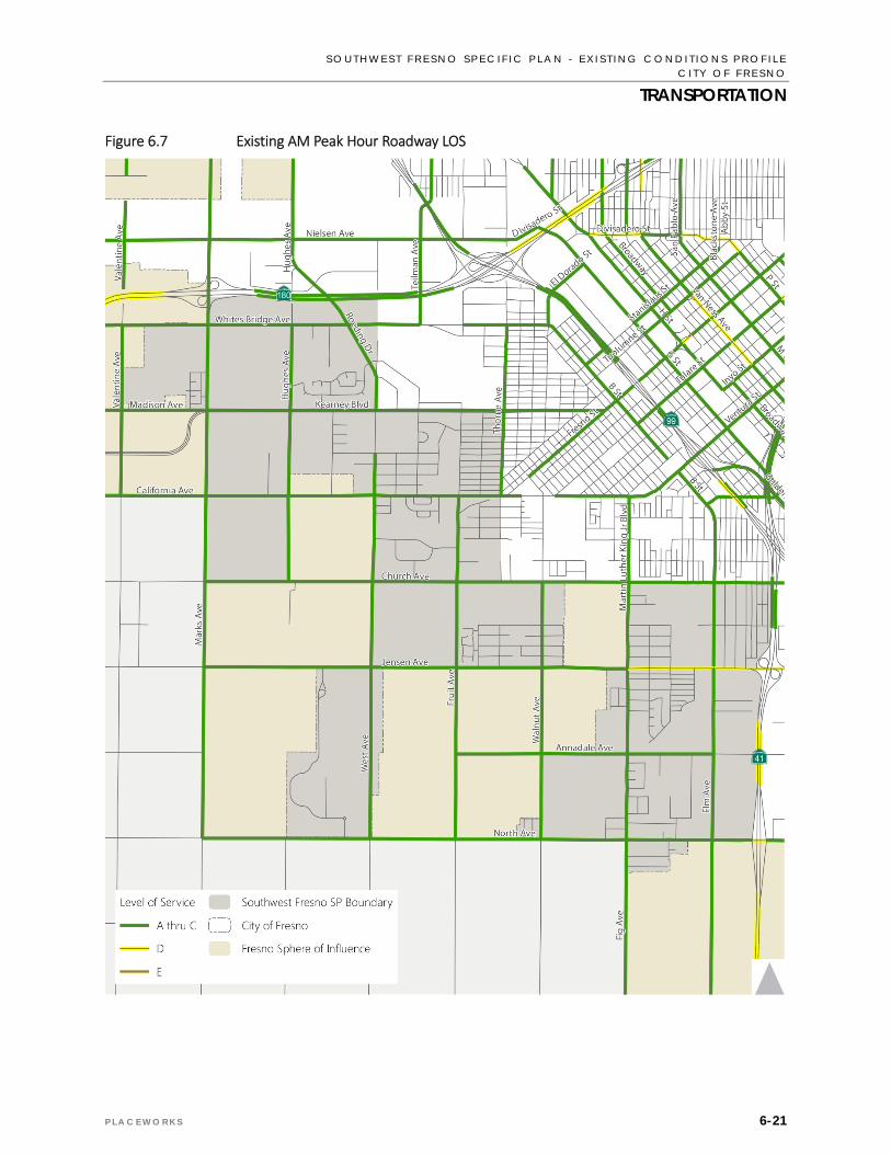
Figures 6.7 and 6.8 present the LOS for roadways in the Plan Area during the AM and PM peak hour
respectively, as reported in the Fresno General Plan MEIR. All of the roadways in the project vicinity
operate at LOS D or better under both peak hours. This reflects traffic volumes below the capacity of
many of the roadways, which may provide opportunities for additional development without impacts to
traffic operations or requiring adding vehicular travel lanes to existing roadways, and opportunities for
additional pedestrian and bicycle facilities.
A few of the roadway segments in the Plan Area are projected to operate at LOS D during either the AM or
PM peak hours. This includes portions of Fresno Street, California Avenue, Church Avenue, Jensen
Avenue, North Avenue, and Martin Luther King Jr. Boulevard. These segments that operate at LOS D today
may require additional travel lanes with additional development to remain consistent with the City of
Fresno’s LOS policies.
S O U T H W E S T F R E S N O S P E C I F I C P L A N - E X I S T I N G C O N D I T I O N S P R O F I L E C I T Y O F F R E S N O
TRANSPORTATION
P L A C E W O R K S 6-21
Figure 6.7 Existing AM Peak Hour Roadway LOS

S O U T H W E S T F R E S N O S P E C I F I C P L A N – E X I S T I N G C O N D I T I O N S P R O F I L E C I T Y O F F R E S N O
TRANSPORTATION
6-22 A U G U S T 2 0 1 5
Figure 6.8 Existing PM Peak Hour Roadway LOS

S O U T H W E S T F R E S N O S P E C I F I C P L A N - E X I S T I N G C O N D I T I O N S P R O F I L E C I T Y O F F R E S N O
TRANSPORTATION
P L A C E W O R K S 6-23
TABLE 6.1 ROADWAY FUNCTIONAL CLASS AND PEAK HOUR LOS THRESHOLDS
Functional Class Median Lanes
Peak Hour Level of Service Capacity Thresholds
A B C D E
Freeway N/A1
4 2,720 4,460 6,630 7,720 8,630
3+Aux2 2,360 3,860 5,640 6,730 7,530
3 2,000 3,270 4,660 5,740 6,430
2+Aux 1,650 2,700 3,850 4,760 5,340
2 1,300 2,130 3,050 3,790 4,260
State Expressway Divided
6 2,410 3,960 5,730 7,450 8,450
4 1,610 2,650 3,810 4,960 5,630
2 810 1,340 1,890 2,470 2,810
City Expressway Raised Median
6 ‐ ‐ 1,860 6,170 6,520
5 ‐ ‐ 1,520 5,110 5,430
4 ‐ ‐ 1,180 4,050 4,340
2 ‐ ‐ 520 1,910 2,160
Super Arterial Raised Median
6 ‐ ‐ ‐ 4,910 6,240
5 ‐ ‐ ‐ 4,040 5,195
4 ‐ ‐ ‐ 3,170 4,150
Arterial
Raised Median
8 ‐ ‐ 2,120 7,070 7,490
6 ‐ ‐ 1,560 5,270 5,610
5 ‐ ‐ 1,280 4,370 4,670
4 ‐ ‐ 1,000 3,470 3,730
3 ‐ ‐ 720 2,555 2,795
2 ‐ ‐ 440 1,640 1,860
TWLTL3 4 ‐ ‐ 940 3,290 3,550
2 ‐ ‐ 420 1,550 1,760
Undivided 4 ‐ ‐ 770 2,740 2,980
2 ‐ ‐ 340 1,270 1,480
Collector
TWLTL 4 ‐ ‐ 940 3,290 3,550
2 ‐ ‐ 420 1,550 1,760
Undivided 4 ‐ ‐ 770 2,740 2,980
2 ‐ ‐ 340 1,270 1,480
One‐Way Undivided
3 ‐ 1,960 2,240 2,430 2,610
2 ‐ 1,250 1,490 1,620 1,740
1 ‐ 550 740 800 870

S O U T H W E S T F R E S N O S P E C I F I C P L A N – E X I S T I N G C O N D I T I O N S P R O F I L E C I T Y O F F R E S N O
TRANSPORTATION
6-24 A U G U S T 2 0 1 5
TABLE 6.1 ROADWAY FUNCTIONAL CLASS AND PEAK HOUR LOS THRESHOLDS
Functional Class Median Lanes
Peak Hour Level of Service Capacity Thresholds
A B C D E
Rural State Highway Undivided 2 310 570 1,020 1,730 2,470
Rural Arterial Divided 4 ‐ ‐ 1,950 3,580 3,780
Undivided 2 ‐ ‐ 570 1,230 1,310
Rural Collector/Local Undivided 2 ‐ ‐ 700 930 1,000
Notes: 1 N/A – Not applicable for operational class 2 Aux – Auxiliary lane 3 TWLTL – Two‐way left‐turn lane ‐ LOS is not achievable because of the type of facility Source: Table 5.14‐2, Fresno General Plan Master Environmental Impact Report, 2014.
The Fresno General Plan MEIR traffic analysis also shows that the freeway system around the Plan Area
generally operates at LOS D or better during the AM and PM peak hours. SR 41 and 180 operate at LOS D
or better south and west of SR 99, respectively; while SR 99 operates at LOS D or better between SR 41
and SR 180.
The Fresno General Plan MEIR traffic analysis does show that some segments of SR 41 and SR 99 operate
at LOS E or F during the AM or PM peak hours north of the project Plan Area. This includes the following
segments:
SR 41 Northbound – Divisadero Street / Tulare Street to SR 180 (LOS F during the AM peak hour)
SR 41 Northbound – SR 180 to Shaw Avenue (LOS E during PM peak hour)
SR 41 Southbound – SR 180 to O Street (LOS F during the AM peak hour)
SR 99 Southbound – Belmont Avenue to SR 180 (LOS F during AM peak hour)
SR 99 Northbound – SR 180 to Belmont Avenue (LOS E during PM peak hour)
Many of these existing traffic operations issues correspond with commute traffic traveling into Downtown
Fresno during the AM peak hour and out of Downtown Fresno during the PM peak hour.
6.4 SUMMARY OF KEY FINDINGS This section summarizes the issues and opportunities related to the transportation network within the Plan Area.
6.4.1 ISSUES Limited transit. Not all of the Plan Area is served by fixed route bus transit.
Lack of bicycle facilities. The majority of the Plan Area lacks bicycle lanes or multi‐use trails, limiting
access to vehicular travel.

S O U T H W E S T F R E S N O S P E C I F I C P L A N - E X I S T I N G C O N D I T I O N S P R O F I L E C I T Y O F F R E S N O
TRANSPORTATION
P L A C E W O R K S 6-25
Inconsistent sidewalk coverage. Most notably absent in undeveloped areas and on streets that
transition between the City of Fresno and the unincorporated County, the Plan Area’s inconsistent
sidewalks limit neighborhood access and safety.
Patchwork pattern of development and infrastructure improvements. Development and street
infrastructure has occurred sporadically throughout the Plan Area, which has led to disconnected
neighborhoods in the Plan Area and transportation inefficiencies.
Location truck routes. Multiple truck routes pass directly through residential areas, which causes
safety concerns and reduces comfort levels for residents.
6.4.2 OPPORTUNITIES Low traffic volumes. Vehicle traffic volume on existing city streets is low, providing capacity for
additional traffic from future development within the current roadway cross‐sections, as well as
opportunities to potentially repurpose existing roadway right‐of‐way to serve bicycle, pedestrian, and
transit modes as well as future vehicle travel.
Available right‐of‐way. Additional roadway is available for bicycle, and pedestrian infrastructure in
undeveloped areas.
General Plan’s proposed improvements for Southwest Fresno. The Mobility and Transportation chapter
of the Fresno General Plan, the transportation section of the General Plan MEIR, and the City of
Fresno’s Bicycle, Pedestrian, & Trails Master Plan include policies and potential improvements to the
transportation system, including the following:
Roadway realignment. The General Plan shows Fresno Street realigned to allow for an improved
connection with California Avenue and Walnut Avenue. Opportunities for community input will
continue before the final design is determined.
Roadway widening. The following roadways within the Plan Area are identified as widened to four
lanes in the Fresno General Plan MEIR:
- California Avenue: Fruit Avenue to Martin Luther King Jr. Boulevard
- Jensen Avenue: Marks Avenue to Martin Luther King Jr. Boulevard
- North Avenue: Martin Luther King Jr. Boulevard to SR 41
- Marks Avenue: Whitesbridge Avenue to Jensen Avenue
- Roeding Drive: Whitesbridge Avenue to Kearney Boulevard
- Walnut Avenue: California Avenue to Jensen Avenue
BRT service on California Avenue. The Fresno General Plan states that BRT is envisioned on
California Avenue connecting southwest Fresno with Downtown as part of the second phase of
BRT implementation.
Bicycle facilities. The Fresno Bicycle, Pedestrian, & Trails Master Plan identifies several
recommended bicycle facilities in the Plan Area. This includes:
- Class I bicycle/pedestrian paths along Jensen Avenue, North Avenue, Marks Avenue, the Dry
Creek Canal, on the Florence Avenue alignment between Walnut Avenue and Fairview
Avenue between Edison High School and Edison Computech Middle School, and on the Grove

S O U T H W E S T F R E S N O S P E C I F I C P L A N – E X I S T I N G C O N D I T I O N S P R O F I L E C I T Y O F F R E S N O
TRANSPORTATION
6-26 A U G U S T 2 0 1 5
Avenue alignment between Clara Avenue and Elm Avenue southeast of Gaston Middle
School.
- Class II bicycle lanes on all arterial and collector streets.
- Class II bicycle lanes on Grove Avenue from Arthur Avenue to Martin Luther King Jr.
Boulevard.
- Class III bicycle routes on the following streets:
o Walnut Avenue: California Avenue to Church Avenue
o Florence Avenue Bicycle Route: Fairview Avenue to Kirk Avenue (includes segments of
Bardell Avenue, Belgravia Avenue, and Clara Avenue
o Kirk Avenue: Florence Avenue to Grove Avenue
o Grove Avenue: Martin Luther King Jr. Boulevard to Clara Avenue; and Elm Avenue to Kirk
Avenue
Policies regarding pedestrian facilities. The Fresno General Plan states that continuous sidewalks
will be required along public streets on both sides within all new development. The General Plan
also includes the following policies for implementing pedestrian facilities in the City:
- MT‐5‐a: Sidewalk Development. Pursue funding and implement standards for development of
sidewalks on public streets, with priority given to meeting the needs of persons with physical
and vision limitations; providing safe routes to school; completing pedestrian improvements
in established neighborhoods with lower vehicle ownership rates; or providing pedestrian
access to public transportation routes.
- MT‐5‐b: Sidewalk Requirements. Assure adequate access for pedestrians and people with
disabilities in new residential developments per adopted City policies, consistent with the
California Building Code and the Americans with Disabilities Act.