6 802 55362 1 in yukon, 018 yaa/c iel eam this is ...€¦ · slab avalanches: are there signs of...
TRANSCRIPT
Tombstone Mountain Viewpoint
Hart River Winter Road
Tombstone Interpretive CentreTombstone Mountain Campground
6299 ft1920 m
7743 ft2360 m
MountFrank Rae
7103 ft2165 m
MountMonolith
6411 ft1954 m
FoldMountain
6004 ft1830 m
North ForkMountain
7234 ft2205 m
CathedralMountain
6030 ft1838 m
GoldensidesMountain
Mt ChesterHenderson
DivideLake
WhitecrownMountain
HA
RT
P A S S
BlackcapMountain
Mt RobertHenderson
D I S C O V E R Y R I D G E
N O R T HK L O N D I K E
R I V E RV A N T A G E R I D G E
MountCairnes
OutriderMountain
RockcandyMountain
NO
RT
H
FO
RK
PA
SS
T O M B S T O N E P A S S
TalusLake
GrizzlyLake
TwinLakes
FoldLake
N O R T H K L O N D I K E R I V E RW
E S TH
A R TR I V E R
PR
OS
PE
CT
OR R
AN
GE
Bl ack Sha l e
C r eek
L i l
C r eek
C k
Fol d
Cr e
ek
G R I Z Z L Y
P A S S
G L I S S A D EP A S S
DEMP S TER
HIG HWAY
T O M B S T O N E
C L O U D Y R A N G E
R A N G E
6030 ft1838 m
InclineMountain
August 17 Creek
W ol f
C reek
Cr eek
G r i zzl y Cai r nes
Cre ek
B lack M i k e C r ee
Fer nC re e k
Axem
an C
reek
4000
5500
4000
6000
5500
3500
4500
5500
5000
6000
5000
6500
6500
6500
6000
4500
5500
6000
6500
6000
5500
5000
6000
5500
6500
5000
4500
3500 3000
3000
4000
5500
5000
6000
4000
5500
5500
5000
4000
5000
6000
6000
6000
6000
6500
6500
5500
5000
5500
5000
4500
45006000
5000
5500
60
00
5000
4500
6000
5500
4000
3500
4000
4000
5500
6500
5500
6000
4500
5500
7000
6500
70006500 6000
5500
5500
5000
5500
5000
4500
4500
3500
4000
5000
4500
4500
7000
6000 6000
5000
5000
5500
5500
6000
6000
6500
6000
4500
6000
6500
6000
5000
5500
5000
6000
6500
6000
5500
5500
6000
4500
4500
5000
5500
6000
4000
50004500
5000
4500
4500
5500
4000
4000
4500
5000
4500
5500
6000
6000
6000
5500
5500
6500
5000
5500
5000
6000
6500
3500
3500
4000
5500
5000
5500
6500
5000
6000
4500
4500
3000
5000
6000
6000
6000
To Eagle Plains(300 km)
To Dawson(110km)
Dawson
Eagle Plains
Whitehorse
9
5
2
YU
KO
N
AL
AS
KA
Tombstone Territorial Park
Reuse first – pass it on
YAA/CAC Field Team
Yukon Avalanche Association Connect with us:
EMERGENCY CONTACT:911 or 867-993-5555
FURTHER INFORMATION:yukonparks.cayukonavalanche.caavalanche.ca
Yukon Parks Main office (Whitehorse):867-667-5648, toll free 1-800-661-0408, ext. [email protected]
Yukon Parks Klondike office (Dawson City):867-993-6850
TRAINING:Avalanche safety training courses equip you to get the most out of your mountain backcountry experience. Knowledge, planning and carrying the proper safety equipment are the keys to fully experiencing Canada’s spectacular mountain terrain.
© Government of Yukon, 2018 ISBN 978-1-55362-802-6
EmergenciesThere is no cell phone coverage in Tombstone Territorial Park. Satellite phone coverage can be adversely affected by vegetation and topography in some locations.
PARKTERRAIN GUIDE
TOMBSTONE
FOR ALL BACKCOUNTRY USERS
TERRITORIAL
YAA
/CA
CSo
nny
Park
er
FREE
KNOW WHAT TYPE OF TERRAIN YOU ARE HEADING INTO • OBSERVE CURRENT AVALANCHE CONDITIONS
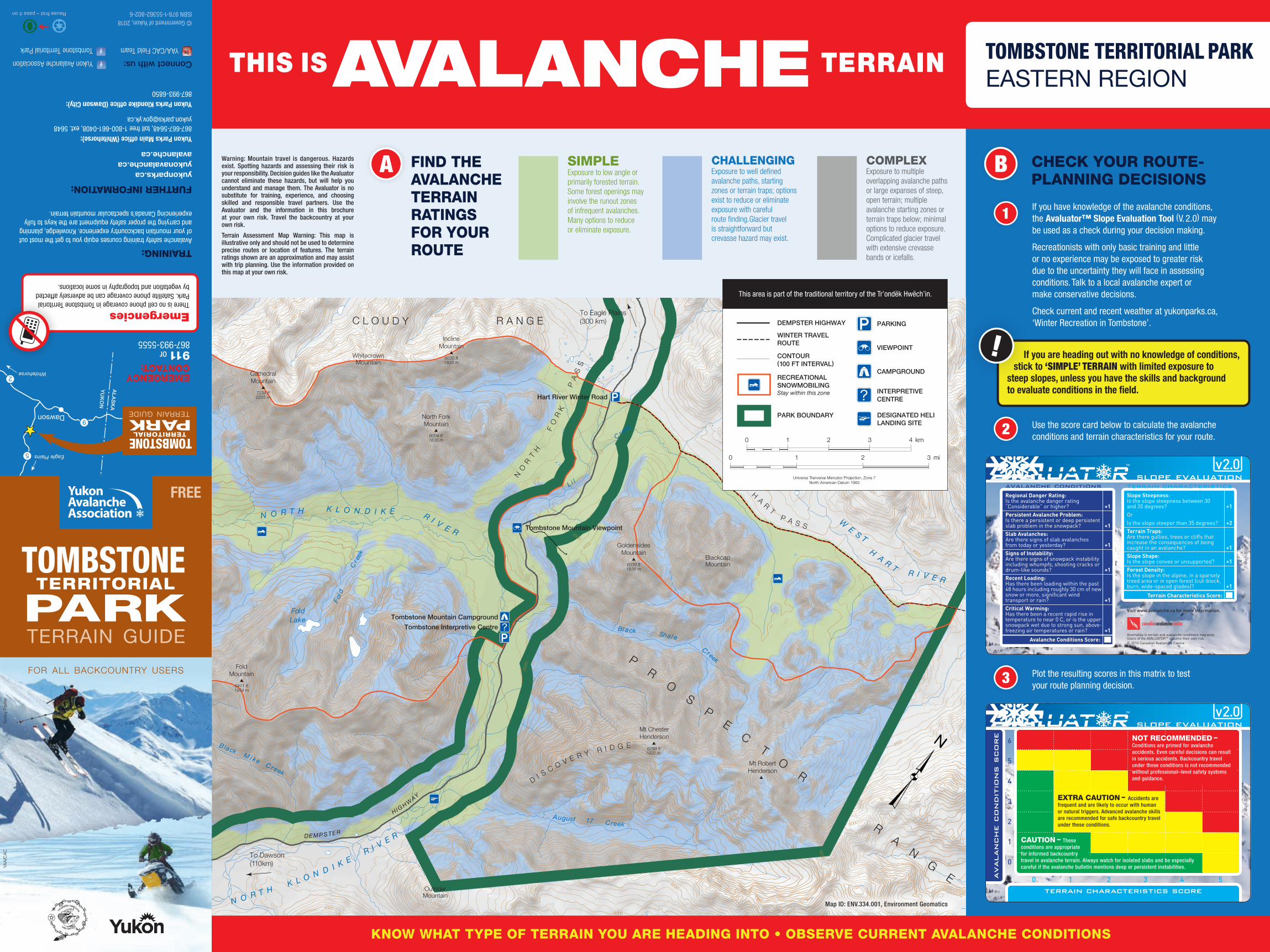
VIEWPOINT
PARKING
CAMPGROUND
DESIGNATED HELI LANDING SITE
INTERPRETIVECENTRE
PARK BOUNDARY
CONTOUR (100 FT INTERVAL)
RECREATIONALSNOWMOBILINGStay within this zone
DEMPSTER HIGHWAY
WINTER TRAVEL ROUTE
This area is part of the traditional territory of the Tr’ondëk Hwëch’in.
slope evaluation
Anomalies in terrain and avalanche conditions may exist. Users of the AVALUATORTM assume their own risk.© 2010 Canadian Avalanche Centre
avalanche conditions Regional Danger Rating:Is the avalanche danger rating “Considerable” or higher? +1Persistent Avalanche Problem:Is there a persistent or deep persistent slab problem in the snowpack? +1Slab Avalanches:Are there signs of slab avalanches from today or yesterday? +1Signs of Instability:Are there signs of snowpack instability including whumpfs, shooting cracks or drum-like sounds? +1Recent Loading:Has there been loading within the past 48 hours including roughly 30 cm of new snow or more, significant wind transport or rain? +1Critical Warming:Has there been a recent rapid rise in temperature to near 0 C, or is the upper snowpack wet due to strong sun, above- freezing air temperatures or rain? +1
Avalanche Conditions Score:
terrain characteristicsSlope Steepness:Is the slope steepness between 30 and 35 degrees? +1Or
Is the slope steeper than 35 degrees? +2Terrain Traps:Are there gullies, trees or cliffs that increase the consequences of being caught in an avalanche? +1Slope Shape:Is the slope convex or unsupported? +1Forest Density:Is the slope in the alpine, in a sparsely treed area or in open forest (cut-block, burn, wide-spaced glades)? +1
Terrain Characteristics Score:
Visit www.avalanche.ca for more information.
slope evaluation
avalanche c
ondit
ions s
core
6
5
4
3
2
1
0
terrain characteristics score
CAUTION
EXTRA CAUTION
NOT RECOMMENDED
0 1 2 3 4 5
NOT RECOMMENDED – Conditions are primed for avalanche accidents. Even careful decisions can result in serious accidents. Backcountry travel under these conditions is not recommended without professional–level safety systems and guidance.
EXTRA CAUTION – Accidents are frequent and are likely to occur with human or natural triggers. Advanced avalanche skills are recommended for safe backcountry travel under these conditions.
CAUTION – These conditions are appropriate for informed backcountry travel in avalanche terrain. Always watch for isolated slabs and be especially careful if the avalanche bulletin mentions deep or persistent instabilities.
3 Plot the resulting scores in this matrix to test your route planning decision.
THIS IS TERRAINAVALANCHE TOMBSTONE TERRITORIAL PARK EASTERN REGION
2
CHECK YOUR ROUTE- PLANNING DECISIONS
Use the score card below to calculate the avalanche conditions and terrain characteristics for your route.
If you have knowledge of the avalanche conditions, the Avaluator™ Slope Evaluation Tool (V. 2.0) may be used as a check during your decision making.
Recreationists with only basic training and little or no experience may be exposed to greater risk due to the uncertainty they will face in assessing conditions. Talk to a local avalanche expert or make conservative decisions.
Check current and recent weather at yukonparks.ca, ‘Winter Recreation in Tombstone’.
B
If you are heading out with no knowledge of conditions, stick to ‘SIMPLE’ TERRAIN with limited exposure to steep slopes, unless you have the skills and background to evaluate conditions in the field.
1
SIMPLEExposure to low angle or primarily forested terrain. Some forest openings may involve the runout zones of infrequent avalanches. Many options to reduce or eliminate exposure.
CHALLENGINGExposure to well defined avalanche paths, starting zones or terrain traps; options exist to reduce or eliminate exposure with careful route finding.Glacier travel is straightforward but crevasse hazard may exist.
COMPLEXExposure to multiple overlapping avalanche paths or large expanses of steep, open terrain; multiple avalanche starting zones or terrain traps below; minimal options to reduce exposure. Complicated glacier travel with extensive crevasse bands or icefalls.
A FIND THE AVALANCHE TERRAIN RATINGS FOR YOUR ROUTE
Warning: Mountain travel is dangerous. Hazards exist. Spotting hazards and assessing their risk is your responsibility. Decision guides like the Avaluator cannot eliminate these hazards, but will help you understand and manage them. The Avaluator is no substitute for training, experience, and choosing skilled and responsible travel partners. Use the Avaluator and the information in this brochure at your own risk. Travel the backcountry at your own risk.
Terrain Assessment Map Warning: This map is illustrative only and should not be used to determine precise routes or location of features. The terrain ratings shown are an approximation and may assist with trip planning. Use the information provided on this map at your own risk.
Map ID: ENV.334.001, Environment Geomatics

Tombstone Mountain Viewpoint
Hart River Winter Road
Tombstone Interpretive CentreTombstone Mountain Campground
6299 ft1920 m
7743 ft2360 m
MountFrank Rae
7103 ft2165 m
MountMonolith
6411 ft1954 m
FoldMountain
6004 ft1830 m
North ForkMountain
7234 ft2205 m
CathedralMountain
6030 ft1838 m
GoldensidesMountain
Mt ChesterHenderson
DivideLake
WhitecrownMountain
HA R
T
P A S S
BlackcapMountain
Mt RobertHenderson
D I S C O V E R Y R I D G E
N O R T HK L O N D I K E
R I V E RV A N T A G E R I D G E
MountCairnes
OutriderMountain
RockcandyMountain
NO
RT
H
FO
RK
PA
SS
T O M B S T O N E P A S S
TalusLake
GrizzlyLake
TwinLakes
FoldLake
N O R T H K L O N D I K E R I V E RW
E S TH
A R TR I V E R
August 17 Creek
Bl ack
Sha l eC r eek
L i l
C r eek
C reek
Cr eek
G r i zzl y Cai r nes
Cre ek
B lack M i k e C r eek
Fol d
Cre
ek
G R I Z Z L Y
P A S S
G L I S S A D EP A S S
Fer nC re e k
DEMP S TER
HIG HWAY
Axem
an C
reek
T O M B S T O N E
R A N G E
6030 ft1838 m
InclineMountain
4000
5500
4000
6000
5500
3500
4500
5500
5000
6000
5000
6500
6500
6500
6000
5500
6000
6500
6000
5500
5000
6000
5500
6500
5000
4500
3500 3000
3000
4000
5500
5000
6000
4000
5500
5500
5000
4000
5000
6000
6000
6000
6000
6500
6500
5500
5000
5500
5000
4500
45006000
5000
5500
60
00
5000
4500
6000
5500
4000
3500
4000
4000
5500
6500
5500
6000
4500
5500
7000
6500
70006500 6000
5500
5500
5000
5500
5000
4500
4500
3500
4000
5000
4500
4500
7000
6000 6000
5000
5000
5500
5500
6000
6000
6500
6000
4500
6000
6500
6000
5000
5500
5000
6000
6500
6000
5500
5500
6000
4500
4500
5000
5500
6000
4000
50004500
5000
4500
4500
5500
4000
4000
4500
5000
4500
5500
6000
6000
6000
5500
5500
6500
5000
5500
5000
6000
6500
3500
3500
4000
5500
5000
5500
6500
5000
6000
4500
4500
3000
5000
6000
6000
6000
To Dawson(100 km)
To Eagle Plains(300 km)C L O U D Y R A N G E
SIMPLEExposure to low angle or primarily forested terrain. Some forest openings may involve the runout zones of infrequent avalanches. Many options to reduce or eliminate exposure.
CHALLENGINGExposure to well defined avalanche paths, starting zones or terrain traps; options exist to reduce or eliminate exposure with careful route finding.Glacier travel is straightforward but crevasse hazard may exist.
COMPLEXExposure to multiple overlapping avalanche paths or large expanses of steep, open terrain; multiple avalanche starting zones or terrain traps below; minimal options to reduce exposure. Complicated glacier travel with extensive crevasse bands or icefalls.
A
Warning: Mountain travel is dangerous. Hazards exist. Spotting hazards and assessing their risk is your responsibility. Decision guides like the Avaluator cannot eliminate these hazards, but will help you understand and manage them. The Avaluator is no substitute for training, experience, and choosing skilled and responsible travel partners. Use the Avaluator and the information in this brochure at your own risk. Travel the backcountry at your own risk.
Terrain Assessment Map Warning: This map is illustrative only and should not be used to determine precise routes or location of features. The terrain ratings shown are an approximation and may assist with trip planning. Use the information provided on this map at your own risk.
Map ID: ENV.334.001, Environment Geomatics
KNOW WHAT TYPE OF TERRAIN YOU ARE HEADING INTO • OBSERVE CURRENT AVALANCHE CONDITIONS
FIND THE AVALANCHE TERRAIN RATINGS FOR YOUR ROUTE
THIS IS TERRAINAVALANCHE TOMBSTONE TERRITORIAL PARK WESTERN REGION
VIEWPOINT
PARKING
CAMPGROUND
DESIGNATED HELI LANDING SITE
INTERPRETIVECENTRE
PARK BOUNDARY
CONTOUR (100 FT INTERVAL)
RECREATIONALSNOWMOBILINGStay within this zone
DEMPSTER HIGHWAY
WINTER TRAVEL ROUTE
This area is part of the traditional territory of the Tr’ondëk Hwëch’in.
slope evaluation
Anomalies in terrain and avalanche conditions may exist. Users of the AVALUATORTM assume their own risk.© 2010 Canadian Avalanche Centre
avalanche conditions Regional Danger Rating:Is the avalanche danger rating “Considerable” or higher? +1Persistent Avalanche Problem:Is there a persistent or deep persistent slab problem in the snowpack? +1Slab Avalanches:Are there signs of slab avalanches from today or yesterday? +1Signs of Instability:Are there signs of snowpack instability including whumpfs, shooting cracks or drum-like sounds? +1Recent Loading:Has there been loading within the past 48 hours including roughly 30 cm of new snow or more, significant wind transport or rain? +1Critical Warming:Has there been a recent rapid rise in temperature to near 0 C, or is the upper snowpack wet due to strong sun, above- freezing air temperatures or rain? +1
Avalanche Conditions Score:
terrain characteristicsSlope Steepness:Is the slope steepness between 30 and 35 degrees? +1Or
Is the slope steeper than 35 degrees? +2Terrain Traps:Are there gullies, trees or cliffs that increase the consequences of being caught in an avalanche? +1Slope Shape:Is the slope convex or unsupported? +1Forest Density:Is the slope in the alpine, in a sparsely treed area or in open forest (cut-block, burn, wide-spaced glades)? +1
Terrain Characteristics Score:
Visit www.avalanche.ca for more information.
slope evaluation
avalanche c
ondit
ions s
core
6
5
4
3
2
1
0
terrain characteristics score
CAUTION
EXTRA CAUTION
NOT RECOMMENDED
0 1 2 3 4 5
NOT RECOMMENDED – Conditions are primed for avalanche accidents. Even careful decisions can result in serious accidents. Backcountry travel under these conditions is not recommended without professional–level safety systems and guidance.
EXTRA CAUTION – Accidents are frequent and are likely to occur with human or natural triggers. Advanced avalanche skills are recommended for safe backcountry travel under these conditions.
CAUTION – These conditions are appropriate for informed backcountry travel in avalanche terrain. Always watch for isolated slabs and be especially careful if the avalanche bulletin mentions deep or persistent instabilities.
3 Plot the resulting scores in this matrix to test your route planning decision.
2
CHECK YOUR ROUTE- PLANNING DECISIONS
Use the score card below to calculate the avalanche conditions and terrain characteristics for your route.
If you have knowledge of the avalanche conditions, the Avaluator™ Slope Evaluation Tool (V. 2.0) may be used as a check during your decision making.
Recreationists with only basic training and little or no experience may be exposed to greater risk due to the uncertainty they will face in assessing conditions. Talk to a local avalanche expert or make conservative decisions.
Check current and recent weather at yukonparks.ca, ‘Winter Recreation in Tombstone’.
B
If you are heading out with no knowledge of conditions, stick to ‘SIMPLE’ TERRAIN with limited exposure to steep slopes, unless you have the skills and background to evaluate conditions in the field.
1
YG P
hoto