5.29.1 - planning inspectorate · 2016-04-20 · environmental statement sensitivity test hinkley...
TRANSCRIPT

September 2014Application Reference EN020001
Environmental Statement Sensitivity Test Appendices
5.29.1.2Do
cum
ent
Hinkley Point C Connection Project
Regulation 5(2)(q) of the Infrastructure Planning (Applications: Prescribed Forms and Procedure) Regulations 2009

Environmental Statement Sensitivity Test
Hinkley Point C Connection Project
5.29.1.2 – Environmental Statement Sensitivity Test-
Appendices
Appendix Title
3B Revised Construction Programme- Issue B ES Sensitivity Test
7A Section A: Visual Assessment Tables - Issue B ES Sensitivity Test
7C Section C: Visual Assessment Tables - Issue B ES Sensitivity Test
7D Section D: Visual Assessment Tables - Issue B ES Sensitivity Test
13A 1km2 Background Pollutant Concentration Estimates – Issue B ES Sensitivity Test
14B Construction Traffic Noise Assessment – Issue B ES Sensitivity Test
15G Planning Allocations within Local Area of Influence – Issue B ES Sensitivity Test
15H Planning Permissions within Local Area of Influence – Issue B ES Sensitivity Test
17C Cumulative Assessment – Other Major Development Proposals Indicative Programmes- Issue B ES Sensitivity Test
17D Cumulative Assessment – Scoped Out Major Development Proposals- Issue B ES Sensitivity Test


Document Control
Document Properties
Organisation National Grid
Author All ES Technical Chapter Authors
Approved By Hilary Brett, TEP
Title Environmental Statement Sensitivity Test Appendices
Document Reference Volume 5.29.1.2
Date Version Status Description/Changes
01/10/2014 A Live Final Submission to PINS


Appendix 3B - Revised Construction Programme -
Issue B ES Sensitivity Test


VOLUME 5.29.1.2, APPENDIX 3B – REVISED CONSTRUCTION PROGRAMMES - ISSUE B ES SENSITIVITY TEST
Revised Proposed Development Components
Proposed Development Component Revised Start Date
Revised Finish Date
400kV Overhead Line 400kV Route (South) Q2 2018 Q2 2020
400kV Overhead Line 400kv Route (North) Q3 2018 Q3 2021
400kV Overhead Line 400kV Route (Huntspill to Bridgewater Tee)
Q3 2019 Q2 2020
400kV Cable Mendip Hills Route- works between A38 Bristol Road to Tower head Road (including South of Mendip Hills CSE Compound, A38 Bristol Road (UGC) Compound and haul Road
Q1 2016 Q2 2020
400kV Cable Mendip Hills Route – works between Towerhead Road and Sandford Substation
Q1 2018 Q2 2020
400kV Cable – works between Towerhead Road and Sandford Substation (haul road and compound only)
Q1 2017 Q3 2021
Bridgwater Tee 400kV Cable Route Q3 2019 Q3 2020
AT Route Underground and Overhead Line Q4 2019 Q3 2020
W Route Q2 2017 Q2 2019
BW Route Avonmouth Option A Q4 2018 Q2 2019
BW Route Portishead Option B Q4 2018 Q4 2019
G Route Q3 2019 Q3 2020
Seabank Line Entries BW Route December 2015
Q2 2016
Seabank Line Entries G Route Q1 2016 Q3 2016
Seabank Line Entries DA Route Q1 2018 Q3 2018
N Route Overhead Line (including disconnection and removal)
Q3 2019 Q2 2020
Hinkley Line Entries Q3 2018 March 2022
Y Route Churchill Q1 2018 Q4 2018
W Route Churchill Q3 2018 Q3 2018
Sandford 400/132kV Substation Q1 2018 Q3 2020
Seabank 400/132kV Substation Q4 2019 Q4 2021
Churchill 132/33kV WPD Substation December 2015
Q4 2018
Portishead 132/33kV WPD Substation Q3 2018 Q2 2019
Avonmouth132/33kV WPD Substation Q3 2019 Q2 2020
Removal of Southern Half F Route Q3 2019 Q4 2019
Removal of Northern Half F Route Q2 2020 Q2 2021
Removal of 132kV G Route Q3 2019 Q3 2020

Proposed Revised Development Construction Compounds
Compound Name Local Authority Proposed Development Component
Anticipated Revised Start Date
1: Bridgwater Tee (Bath Road)
Sedgemoor District Council
Bridgwater Tee July 2019
2: A38 Bristol Road (underground cables)
Sedgemoor District Council
400kV underground cables March 2016
3: A38 Bristol Road (overhead lines)
Sedgemoor District Council
400kV overhead lines April 2018
4: South of the Mendip Hills (Hams Lane)
Sedgemoor District Council
400kV underground cables March 2016
5: Barton Road Sedgemoor District Council
400kV underground cables April 2016
6: Castle Hill North Somerset Council
400kV underground cables March 2016
7: Towerhead Road North Somerset Council
400kV underground cables January 2017
8: Sandford Substation North Somerset Council
Sandford March 2016
9: AT Route North Somerset Council
AT Route November 2019
10: Churchill North Somerset Council
Churchill January 2017
11: Engine Lane North Somerset Council
W Route underground cables March 2018
12: Nailsea North Somerset Council
W Route March 2018
13: Church lane North Somerset Council
W Route March 2018
14: Clevedon Road North Somerset Council
W Route underground cables March 2018
15: Whitehouse Lane North Somerset Council
W Route underground cables March 2018
16:Caswell Hill North Somerset Council
W Route March 2018
17: Sheepway North Somerset Council
W Route March 2018
18: BW Route (west) North Somerset Council
BW Route April 2018
19: BW Route (east) North Somerset Council
BW Route April 2018

Compound Name Local Authority Proposed Development Component
Anticipated Revised Start Date
20: St Andrews Road Bristol City Council 400kV overhead lines April 2018
21: Kings Weston Lane Bristol City Council G Route June 2018
22: G Route (east of M49)
Bristol City Council G Route underground cables June 2018
23: Seabank (Severn Road)
Bristol City Council Seabank October 2019


Appendix 7 - Issue B ES Sensitivity Test


Environmental Statement Sensitivity Test
Hinkley Point C Connection Project
5.29.1.2 – Environmental Statement Sensitivity Test-
Appendix 7
Appendix Title
7A Section A: Visual Assessment Tables - Issue B ES Sensitivity Test
7C Section C: Visual Assessment Tables - Issue B ES Sensitivity Test
7D Section D: Visual Assessment Tables - Issue B ES Sensitivity Test


Appendix 7A - Section A: Visual Assessment Tables -
Issue B ES Sensitivity Test


ENVIRONMENTAL STATEMENT SENSITIVITY TEST
Hinkley Point C Connection Project
VOLUME 5.29.1.2, APPENDIX 7A: SECTION A PURITON RIDGE VISUAL ASSESSMENT TABLES - ISSUE B SENSITIVITY TEST (additional committed development)
Committed Developments within 1km of the LoD for the Proposed Development in Section A
The sensitivity of visual receptors to the Proposed Development depends on the susceptibility of the view to change, and the value attached to the view experienced. Receptor sensitivity has been assigned to receptors as follows:
Susceptibility to Change: High or Medium or Low Value of View: National or Regional and or Local Receptor Sensitivity: High or Medium or Low
The assessment of the magnitude of effect of the Proposed Development evaluates the visual effects identified in terms of the size or scale of the development; the geographical extent of the area influenced; the nature of the effect (adverse or beneficial); and its duration and reversibility. The following range of judgements are used to determine the magnitude of effect, which can be adverse or beneficial:
Magnitude of Effect: High or Moderate or Low (adverse or beneficial) or Negligible
The assessment of the significance of visual effects of the Proposed Development is a judgement based on the sensitivity of the receptor and the magnitude of the effect. The following range of judgements are used to determine the significance of effect, which can be adverse or beneficial:
Significance of Effect: Major or Moderate or Minor (adverse or beneficial) or Negligible
Ref No Receptor Susceptibility
to ChangeValue of view
Receptor
Sensitivity
Distance from receptor to the
nearest part of the Proposed
Development
Baseline View Magnitude of Effect
103 Bridgwater Gateway
Ltd
Land to the southwest
of Stockmoor
Distributor Road and
northwest of Taunton
Road, North Petherton,
Bridgwater.
Outline planning
application for the
erection of three storey
building (use class B1),
formation of parking
and access. Total B1
comprises 2,867 sqm.
Low Local Low 1,000m Views northeast and east across the M5 motorway to
Horsey Level and Puriton Ridge with the VQ Route to the
south. The F Route is visible in distant views to the east
above field trees. The M5 and Morrison's distribution
centre visible in views.
During construction: Low adverse
The M5 motorway and the VQ Route are visible. In the short-term receptors on the edge of the development would have views to Horsey Level
and the top of Puriton Ridge with construction of the new 400kV overhead line visible. Cranes used in construction of the Bridgwater Tee CSE
compounds would also be visible, largely above existing trees, where the new 400kV overhead line connects to the VQ Route. Receptors in the
development, away from the development edge, typically would have views screened by built form with some occasional glimpsed oblique views
at gaps in built form similar to those on the development edge.
During operation: Low adverse
In the short and medium-term receptors on the development edge would have the new 400kV overhead line in views across Horsey Level and at
the top of Puriton Ridge. The Bridgwater Tee CSE compounds would be visible above existing trees where the new 400kV overhead line
supported by T-pylons connects to the VQ Route. Receptors within the development typically would have views screened by built form with some
occasional glimpsed oblique views at gaps in built form similar to those on the development edge.
After 15 years: Low adverse
In the long-term views of the new 400kV overhead line would remain the same as those for immediately on completion. However the Bridgwater
Tee CSE compounds tree and shrub planting would have matured to provide a more robust screen of the lower parts of the CSE compounds in
views with the tops of gantries and sealing ends still just visible above.
Minor adverse Minor adverse Minor adverse A1.1 VPA1
Verified
photomontage of
anticipated view
Receptor Sensitivity
Significance of Effect
During construction
(short-term)
Significance of Effect
During Operation
(short and medium-term)
Significance of Effect
After 15 years
(long-term)
Photograph of
existing view
X1979.70.018 Page 1


Appendix 7C - Section C: Visual Assessment Tables -
Issue B ES Sensitivity Test


ENVIRONMENTAL STATEMENT SENSITIVITY TESTHinkley Point C Connection Project
VOLUME 5.29.1.2, APPENDIX 7C: SECTION C MENDIP HILLS VISUAL ASSESSMENT TABLES - ISSUE B ES SENSITIVITY TEST (Only receptors where the magnitude of effect would change as a result of the Revised Construction Programme are included in this table)
Public Rights of Way (PRoW) within 1km of the LoD for the Proposed Development in Section C
The sensitivity of visual receptors to the Proposed Development depends on the susceptibility of the view to change, and the value attached to the view experienced. Receptor sensitivity has been assigned to receptors as follows:Susceptibility to Change: High or Medium or Low Value of View: National or Regional and or Local Receptor Sensitivity: High or Medium or Low
The assessment of the magnitude of effect of the Proposed Development evaluates the visual effects identified in terms of the size or scale of the development; the geographical extent of the area influenced; the nature of the effect (adverse or beneficial); and its duration and reversibility. The following range of judgements are used to determine the magnitude of effect, which can be adverse or beneficial:Magnitude of Effect: High or Moderate or Low (adverse or beneficial) or Negligible
The assessment of the significance of visual effects of the Proposed Development is a judgement based on the sensitivity of the receptor and the magnitude of the effect. The following range of judgements are used to determine the significance of effect, which can be adverse or beneficial:Significance of Effect: Major or Moderate or Minor (adverse or beneficial) or Negligible
Susceptibility to Change
Value of ViewReceptor
Sensitivity
C1.F22 Public Right of Way PRoW AX 3/53 and PRoW AX 3/33 between Sandford Batch and Towerhead Road
High National High 0m Along this PRoW views are largely obscured by dense mature hedgerows along the edge of the track that the PRoW follows. The F Route is not visible for most of the PRoW. Between Sandford and Banwell Hill dense mature hedgerows on either side of the PRoW heavily filter views with glimpses of the F Route in places to the west. At the northern end at Banwell Wood a pylon is located adjacent to the PRoW and receptors have views of the F Route above hedgerows where it passes over the PRoW. Further north the PRoW follows a track down the hill and mature hedgerow and landform to the edge of the track screen views. At the northern end of the PRoW near Towerhead Road the PRoW is across a field on elevated ground. Receptors have views north, over trees and farm buildings, across the Levels in Section D. Views include the F Route connection with the N Route and properties on Mead Lane in Sandford. The F Route is visible for a small section above trees heading north.
During construction: Low adversePRoW AX 3/53 would be managed during construction works and would pass through the proposed 400kV underground cables swathe and under the F Route to be removed. The southern section of the PRoW would also form an access track to the work area. In the medium-term along the majority of the PRoW views of construction operations would be heavily filtered and screened by mature hedgerows adjacent to the PRoW with glimpsed views of works and construction machinery in Section C, and in places in Section D. For a short section of the PRoW near Banwell Wood receptors would pass through the working area for the installation of the proposed 400kV underground cables and the F Route removal. Receptors would have views southwest and northeast where hedgerows would be removed within the cable swathe. The installation of the proposed 400kV underground cables would include HDD or open cut activity to the south of the PRoW. In the short-term receptors would have relatively near and open views along the working areas and machinery associated with removal of the F Route as well as the preparation of the trenches and installation of the underground cables. North of Banwell Wood receptor views would be screened by dense hedgerow adjacent to the track. At the northern end of the PRoW near Towerhead Road receptors would have views north, over trees and farm buildings, across the Levels in Section D towards at-height works to remove the F Route and part of the N Route. The proposed 400kV underground cable installation and construction of Sandford Substation, the proposed 400kV overhead line and the AT Route connection would be just visible in the distance in a small proportion of views. Views include the F Route connection with the N Route and properties on Mead Lane in Sandford. Distant views of at-height works to construct the proposed 400kV overhead line in Section D would increase the duration of construction works visible from short-term to medium-term, however this would form a small proportion of distant views. A low adverse or negligible magnitude of effect would be experienced along most of the PRoW where views would be heavily filtered or screened. For a short section near to the cable swathe a moderate adverse magnitude of effect would be experienced where views would extend along the working area in close proximity of the works and a large proportion of view would be affected for the short-term. Overall construction works would be visible in Section C and Section D in the medium-term however given the extent of filtering and screening along most the PRoW receptors would experience a low adverse magnitude of effect. During operation: Low beneficialIn the short and medium-term the F Route would be removed from views but this would only be noticeable for a short section of the PRoW near Banwell Wood and near Towerhead Road. Through the cable swathe near Banwell Wood on completion, the reinstated and reseeded underground cable swathe would be perceptible along with replanted hedgerow field boundaries protected with stock-proof fencing. Grassland across the cable swathe would have become established within 1 to 3 years and replacement hedgerow would be established (and stock-proof fencing will no longer be visible) within 3 to 5 years following planting works. Along most of the PRoW this would not be noticeable due to heavy filtering and screening by hedgerows. Near Towerhead Road for a short section of the PRoW receptors would have views north, over trees and farm buildings, across the Levels in Section D and towards the proposed 400kV overhead line and AT Route connection just visible in the distance above trees. Sandford Substation would be screened by properties on Mead Lane. Overall a small proportion of the view would be affected but the effect would be reduced due to a high degree of filtering and screening along most of the PRoW. There would be a low scale of change from existing views and the magnitude of effect would be low beneficial.
After 15 years: Low beneficial In the long term views of the cables swathe would be similar to those anticipated following the establishment of grassland and hedgerow in the short and medium-term.
Minor adverse Minor beneficial Minor beneficial C1.54, C1.55, C1.56 and C1.57
N/A
Photograph of existing view
Verified Photomontage of anticipated view
Receptor Type Magnitude of EffectSignificance of EffectDuring construction
(short-term)
Significance of EffectDuring Operation
(short and medium-term)
Receptor Sensitivity
Nearest distance from the receptor to the LoD
for the Proposed Development
Ref No Receptor Baseline ViewSignificance of Effect
After 15 years(long-term)
X1979.70.009 Page 1

ENVIRONMENTAL STATEMENT SENSITIVITY TESTHinkley Point C Connection Project
VOLUME 5.29.1.2, APPENDIX 7C: SECTION C MENDIP HILLS VISUAL ASSESSMENT TABLES- ISSUE B SENSITIVITY TEST (Only receptors where the magnitude of effect would change as a result of the Revised Construction Programme are included in this table)
Residential Properties within 1km of the LoD for the Proposed Development in Section C
The sensitivity of visual receptors to the Proposed Development depends on the susceptibility of the view to change, and the value attached to the view experienced. Receptor sensitivity has been assigned to receptors as follows:Susceptibility to Change: High or Medium or Low Value of View: National or Regional and or Local Receptor Sensitivity: High or Medium or Low
The assessment of the magnitude of effect of the Proposed Development evaluates the visual effects identified in terms of the size or scale of the development; the geographical extent of the area influenced; the nature of the effect (adverse or beneficial); and its duration and reversibility. The following range of judgements are used to determine the magnitude of effect, which can be adverse or beneficial:Magnitude of Effect: High or Moderate or Low (adverse or beneficial) or Negligible
The assessment of the significance of visual effects of the Proposed Development is a judgement based on the sensitivity of the receptor and the magnitude of the effect. The following range of judgements are used to determine the significance of effect, which can be adverse or beneficial:Significance of Effect: Major or Moderate or Minor (adverse or beneficial) or Negligible
Susceptibility to Change
Value of ViewReceptor
Sensitivity
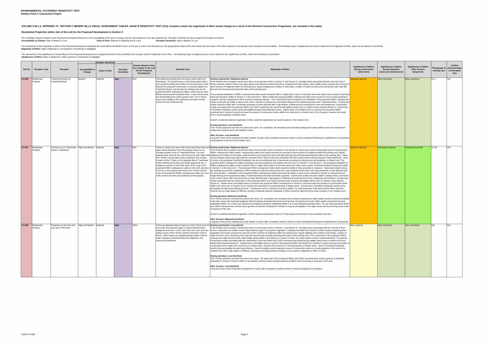
C1.H56 Residential Property
Towerhead House on Towerhead Road
Medium National High 40m This detached property has trees and a stone wall to its boundaries. The property has a north facing aspect with a part woodland setting which filters and screens views north towards the proposed construction compound adjacent to Towerhead Road, and towards the working area for the proposed 400kV underground cables. Views east are also filtered and screened by garden trees. Lower storey views are heavily filtered by mature garden trees. The F Route may be perceptible to the southeast and south running across the foot of Banwell Hill.
During construction: Moderate adverseIn the medium-term receptors would have views of construction works in Section C and Section D. At-height works associated with the removal of the F Route would be visible in direct rear upper storey views filtered by intervening trees. Underground cable works, where visible would comprise the removal of short sections of hedgerow within the working area, topsoil stripping and creation of soil heaps, creation of cable trenches and a temporary haul road with post and wire fencing protecting both sides of the working area.
The proposed installation of 400kV underground cables would comprise HDD or cables laid in open cut trenches where the cable route crosses Towerhead Road and would be visible in Section C in the short-term. Where visible the proposed 400kV underground cable works would be seen in close proximity to receptors and the magnitude of effect would be moderate adverse. The Towerhead Road Compound and installation of the proposed 400kV underground cables would also be visible in views to the north in Section D, beyond tree and hedge filtering to the property boundary and Towerhead Road. Construction activity would be visible with a moderate proportion of views affected with a high degree of filtering and screening from trees and hedgerows. Construction activity associated with the proposed 400kV and 132kV overhead lines would be perceptible above trees in northern views towards Section D. Construction of Sandford Substation would not be perceptible through heavy filtering by trees. Distant views of at-height works to construct the proposed 400kV overhead line in Section D would increase the duration of construction works visible from short-term to medium-term (5 to 15 years), however this would form a small proportion of distant views.
Overall a moderate adverse magnitude of effect would be experienced by visual receptors in the medium-term.
During operation: Low beneficialThe F Route would be removed from direct rear views. On completion, the reinstated and reseeded underground cable swathe and in-situ replacement hedgerows would be barely perceptible in views.
After 15 years: Low beneficialLong-term views of the underground cables swathe 15 years after completion would be similar to those anticipated following the establishment of grassland and hedgerow in the short and medium-term. .
Moderate adverse Minor beneficial Minor beneficial D1.1 N/A
C1.H57 Residential Property
Orchard Lea on Towerhead Road in Towerhead
High and Medium National High 65m There is a direct front view north-north-west (from lower and upper storey windows) from this property which is in an elevated position south of Towerhead Road. The view extends down and over the road and across open fields with the F Route running within close proximity to the receptor. A pylon on the F Route on the opposite side of Towerhead Road is filtered at the base and visible against the sky. A hedgerow and line of trees filter views of the route of the proposed 400kV underground cables to the north and west. There is a rear property view west of the F Route and the route of the proposed 400kV underground cables as it runs north south to the west and southwest of this property.
During construction: Moderate adverseIn the medium-term receptors would have views of construction works in Section C and Section D. Views west would include partial views of the proposed 400kV underground cable swathe. Underground cable work would comprise the removal of short sections of hedgerow within the working area, topsoil stripping and creation of soil heaps, cable trenches and a temporary haul road with post and wire fencing protecting both sides of the working area. Views would comprise works associated with the removal of the F Route at the foot of Banwell Hill and in views north-northwest beyond Towerhead Road. Views of works at the proposed Sandford Substation site are not anticipated due to intervening screening by rising ground and properties on Mead Lane. The proposed 400kV underground cables installation would be temporary and visible in the short-term in Section C and Section D. The proposed installation of 400kV underground cables would comprise HDD or cables laid in open cut trenches where the cable route crosses Towerhead Road and would be visible in Section C in the short-term. The proposed 400kV underground cable works would be visible in close proximity to receptors. Views would extend along the working area and the magnitude of effect would be moderate adverse given the close proximity of the works, the large proportion of view affected and the short duration. Installation of the proposed 400kV underground cables would also be visible in views to the northwest in Section D, beyond tree and hedge filtering to the property boundary, Towerhead Road and field boundaries opposite. Construction activity would be visible in oblique views, and further north in direct views, with a low proportion of views affected with a high degree of filtering and screening from trees, hedgerows and landform. Construction activity associated with the construction of the proposed 400kV and 132kV overhead lines would be perceptible above trees in northern views towards Section D. Distant views of at-height works to construct the proposed 400kV overhead line in Section D would increase the duration of construction works visible from short-term to medium-term, however this would form a small proportion of distant views. Construction of Sandford Substation would not be perceptible through heavy filtering by trees. Construction works in Section D would be visible in a small proportion of the view and the effect would be reduced due to a high degree of filtering. Overall a moderate adverse magnitude of effect would be experienced by visual receptors in the medium-term.
During operation: Moderate beneficialThe F Route would be removed from direct front views. On completion, the reinstated and reseeded underground cable swathe would be barely perceptible in the view, along with replanted hedgerow field boundaries protected with stock-proof fencing. Grassland across the cable swathe would have become established within 1 to 3 years and replacement hedgerow would be established within 3 to 5 years following planting works. The top of the proposed 400kV and 132kV overhead lines, and the top of gantries at Sandford Substation in Section D may be perceptible in the upper storey view but forming a very small component of the view.
Overall a moderate beneficial magnitude of effect would be experienced due to F Route being removed from close proximity in the view.
After 15 years: Moderate beneficialLong-term views of the underground cable swathe 15 years after completion would be similar to those anticipated following the establishment of grassland and hedgerow in the short and medium-term. .
Moderate adverse Moderate beneficial Moderate beneficial C1.65 N/A
C1.H65 Residential Property
Properties on the west and east side of Hill Road
High and Medium National High 345m There are glimpsed views of pylons on the F Route from the rear to the west between gaps in mature field boundary hedgerow and trees. To the north there are more open but oblique views of the F Route and the connection to the N Route. 132kV pylons are partially backgrounded, with the lower elevations remaining filtered by vegetation and screened by built form.
During construction: Low adverseIn the medium-term receptors would have views of construction works in Section C and Section D. At-height works associated with the removal of the F Route is expected to be visible in some views between gaps in the garden vegetation. Underground cable work would be visible in places beyond garden vegetation and would comprise the removal of short sections of hedgerow within the working area, topsoil stripping and creation of soil heaps, creation of cable trenches, and a temporary haul road with post and wire fencing protecting both sides of the working area. The construction of the proposed 400kV underground cable would include cable bridge activity visible in the distance in Section D where the cable swathe crosses Towerhead Brook. The general construction activity associated with the construction of the new 400kV and 132kV overhead lines would be perceptible above trees in northern but more distant views towards Section D. Distant views of at-height works to construct the proposed 400kV overhead line in Section D would increase the duration of construction works visible from short-term to medium-term, however this would form a small proportion of distant views. Views of Sandford Substation would not be perceptible through heavy filtering. Overall receptors would experience views of construction works in a small proportion of the view in the medium-term with a high degree of filtering, screening and backgrounding resulting in a low adverse magnitude of effect on views.
During operation: Low beneficialThe F Route would be removed from direct rear views. The upper part of the proposed 400kV and 132kV overhead lines and the gantries at Sandford Substation in Section D may be visible in rear oblique northerly views, backgrounded by landform and comprising a small part of the view.
After 15 years: Low beneficialLong-term views of the Proposed Development 15 years after completion would be similar to those anticipated on completion.
Minor adverse Minor beneficial Minor beneficial N/A N/A
Photograph of existing view
Verified photomontage of anticipate
view
Receptor Type Magnitude of EffectSignificance of EffectDuring construction
(short-term)
Significance of EffectDuring Operation
(short and medium-term)
Receptor Sensitivity
Ref No Receptor Baseline View
Nearest distance from the receptor to the LoD
for the Proposed Development
Significance of EffectAfter 15 years
(long-term)
X1979.70.009 Page 2


ENVIRONMENTAL STATEMENT SENSITIVITY TESTHinkley Point C Connection Project
VOLUME 5.29.1.2, APPENDIX 7C: SECTION C MENDIP HILLS VISUAL ASSESSMENT TABLES- ISSUE B SENSITIVITY TEST (Only receptors where the magnitude of effect would change as a result of the Revised Construction Programme are included in this table)
Residential Properties within 1km of the LoD for the Proposed Development in Section C
The sensitivity of visual receptors to the Proposed Development depends on the susceptibility of the view to change, and the value attached to the view experienced. Receptor sensitivity has been assigned to receptors as follows:Susceptibility to Change: High or Medium or Low Value of View: National or Regional and or Local Receptor Sensitivity: High or Medium or Low
The assessment of the magnitude of effect of the Proposed Development evaluates the visual effects identified in terms of the size or scale of the development; the geographical extent of the area influenced; the nature of the effect (adverse or beneficial); and its duration and reversibility. The following range of judgements are used to determine the magnitude of effect, which can be adverse or beneficial:Magnitude of Effect: High or Moderate or Low (adverse or beneficial) or Negligible
The assessment of the significance of visual effects of the Proposed Development is a judgement based on the sensitivity of the receptor and the magnitude of the effect. The following range of judgements are used to determine the significance of effect, which can be adverse or beneficial:Significance of Effect: Major or Moderate or Minor (adverse or beneficial) or Negligible
Susceptibility to Change
Value of ViewReceptor
Sensitivity
Photograph of existing view
Verified photomontage of anticipate
view
Receptor Type Magnitude of EffectSignificance of EffectDuring construction
(short-term)
Significance of EffectDuring Operation
(short and medium-term)
Receptor Sensitivity
Ref No Receptor Baseline View
Nearest distance from the receptor to the LoD
for the Proposed Development
Significance of EffectAfter 15 years
(long-term)
C1.H68 Residential Property
Properties on Quarry Road High and Medium National High 365m From this group of properties there is an oblique rear and front aspect views southwest as well as direct side views to the northwest from a single end property at the junction with Hill Road. Views northwest from other properties are screened by landform of Sandfrod Hill. There are first floor views of the existing F Route as it crosses the view, appearing backgrounded by Banwell Wood. The pylons are assumed to be visible to the west from some views, some being screened by built form and some would be viewed visible against the sky when travelling along the valley at the base of Crooks Peak, although they are barely perceptible. Views look straight down the alignment to the southwest. The pylons are filtered by garden vegetation and in places screened by built form.
During construction: Low adverseIn the short-term at-height works associated with the removal of the F Route is expected to be visible in some direct and oblique views. The 400kV underground cable will be perceptible but heavily filtered in views due to screening by intervening garden vegetation and hedgerow field boundaries. Underground cable work visible would comprise the removal of short sections of hedgerow within the working area, topsoil stripping and creation of soil heaps, creation of cable trenches, and temporary haul road with post and wire fencing protecting both sides of the working area. The construction of the proposed 400kV underground cable would include HDD or open cut crossing Castle Hill. The access roads servicing the angle pylon may also be visible but filtered and oblique. In the medium-term the end propoperty at the junction with Hill Road would have views of construction works in Section C as described above and distant filtered views northwest that would include glimpses of 400kV underground cable installation and cable bridge activity where the cable swathe crosses Towerhead Brook. At-height works would also be perceptible in distant views towards Section D, removing the F Route and for the general construction activity associated with the construction of the new 400kV and 132kV overhead lines visible above trees. Distant views of at-height works to construct the proposed 400kV overhead line in Section D would increase the duration of construction works visible from short-term to medium-term, however this would form a small proportion of distant views. Overall receptors would experience views of construction works in a small proportion of the view in the short and medium-term with a high degree of filtering, screening and backgrounding resulting in a low adverse magnitude of effect on views.
During operation: Low beneficialOn completion, the reinstated and reseeded underground cable swathe would be barely perceptible along with replanted hedgerow field boundaries protected with stock-proof fencing. Grassland across the cable swathe would have become established within 1 to 3 years and replacement hedgerow would be established (and stock-proof fencing no longer visible) within 3 to 5 years following planting works.
The F Route would be removed from front and rear views resulting in a beneficial visual effect. The Proposed Development would result in a low beneficial magnitude of effect in views from this receptor.
After 15 years: Low beneficial Long-term views of the underground cable swathe 15 years after completion would be similar to those anticipated on completion. Replacement hedgerow planting would have matured and stock-proof fencing protecting hedgerows would not be visible. .
Minor adverse Minor beneficial Minor beneficial C1.58 N/A
X1979.70.009 Page 3


ENVIRONMENTAL STATEMENT SENSITIVITY TESTHinkley Point C Connection Project
VOLUME 5.29.1.2, APPENDIX 7C: SECTION C MENDIP HILLS VISUAL ASSESSMENT TABLES- ISSUE B ES SENSITIVITY TEST- (Only receptors where the magnitude of effect changes as a result of the Revised Construction Programme are included in this table)
Businesses within 1km of the LoD for the Proposed Development in Section C
The sensitivity of visual receptors to the Proposed Development depends on the susceptibility of the view to change, and the value attached to the view experienced. Receptor sensitivity has been assigned to receptors as follows:Susceptibility to Change: High or Medium or Low Value of View: National or Regional and or Local Receptor Sensitivity: High or Medium or Low
The assessment of the magnitude of effect of the Proposed Development evaluates the visual effects identified in terms of the size or scale of the development; the geographical extent of the area influenced; the nature of the effect (adverse or beneficial); and its duration and reversibility. The following range of judgements are used to determine the magnitude of effect, which can be adverse or beneficial:Magnitude of Effect: High or Moderate or Low (adverse or beneficial) or Negligible
The assessment of the significance of visual effects of the Proposed Development is a judgement based on the sensitivity of the receptor and the magnitude of the effect. The following range of judgements are used to determine the significance of effect, which can be adverse or beneficial:Significance of Effect: Major or Moderate or Minor (adverse or beneficial) or Negligible
Susceptibility to Change
Value of ViewReceptor
Sensitivity
C1.B3 Business Towermead Farm scrap yard south of Towerhead Road
Low National Medium 100m There are rear views east and north across Towerhead Road from the property, although all views will be heavily filtered by mature garden vegetation and restricted to the field gate in the summer. The front views are heavily filtered and look across the road to the north. There are rear and side glimpsed views over a neighbouring wooded garden with the F Route running across the adjacent field of the F Route as it runs to the west across the foot of Banwell Hill. The lower elevations of pylons would be filtered by field boundary vegetation. Most views to the south are obscured by large sheds and mature trees on the boundary.
During construction: Low adverseIn the short-term at-height works associated with the removal of the F Route are anticipated to be perceptible in upper storey views through intervening filtering. In the medium-term heavily filtered views anticipated to include glimpsed views of proposed underground cable works in Section C and Section D including preparation of cable trenches and installation of cables, including activity at the temporary construction compound north of Towerhead Road. Construction of the cables bridge on lower ground to the north passing over Towerhead Brook would not be visible due to screening by intervening trees closer in the view. Distant views of at-height works to construct the proposed 400kV overhead line in Section D would increase the duration of construction works visible from short-term to medium-term, however this would form a small proportion of distant views. Overall receptors would experience views of construction works in a small proportion of the view in the short and medium-term with a high degree of filtering and screening resulting in a low adverse magnitude of effect on views.
During operation: NegligibleThe F Route would be removed from views resulting in a beneficial visual effect. On completion, the reinstated and reseeded underground cable swathe would be barely perceptible along with replanted hedgerow field boundaries. The Proposed Development would result in a low beneficial magnitude of effect in views from this receptor.
After 15 years: Negligible In the long-term views of the Proposed Development would be similar to those anticipated in the short and medium-term.
Minor adverse Negligible Negligible C1.56 and D1.1 N/A
C1.B4 Business Fred Sweeting & Sons Haulage depot south of Towerhead Road
Low National Medium 135m There are no or limited views from the industrial building in this depot. Views from the entrance to the car park on Towerhead Road extends beyond Towerhead Road across open fields with the F Route running over the road near to this receptor. The F Route is filtered at the base and visible against the sky as it runs across higher ground to the west of the depot.
During construction: Low adverseIn the medium-term receptors would have views of construction works in Section C and Section D. Views west would include partial views of the proposed 400kV underground cable swathe. Underground cable work would comprise the removal of short sections of hedgerow within the working area, topsoil stripping and creation of soil heaps, cable trenches and a temporary haul road with post and wire fencing protecting both sides of the working area. Views would comprise works associated with the removal of the F Route at the foot of Banwell Hill and in views north-northwest beyond Towerhead Road. Views of works at the proposed Sandford Substation site are not anticipated due to intervening screening by rising ground and properties on Mead Lane. The proposed 400kV underground cables installation would be temporary and visible in the medium-term in Section C and Section D. The proposed installation of 400kV underground cables would comprise HDD or cables laid in open cut trenches where the cable route crosses Towerhead Road and would be visible in Section C in the short-term. Installation of the proposed 400kV underground cables would also be visible in views to the northwest in Section D, beyond tree and hedge filtering to the boundary, Towerhead Road and field boundaries opposite. Construction activity would be visible in oblique views, and further north in direct views, with a low proportion of views affected with a high degree of filtering and screening from trees, hedgerows and landform. Construction activity associated with the construction of the proposed 400kV and 132kV overhead lines would be perceptible above trees in northern views towards Section D. Distant views of at-height works to construct the proposed 400kV overhead line in Section D would increase the duration of construction works visible from short-term to medium-term, however this would form a small proportion of distant views. Construction of Sandford Substation would not be perceptible through heavy filtering by trees. Construction works in Section D would be visible in a small proportion of the view and the effect would be reduced due to a high degree of filtering. Overall given the moderate and low proportions of the views affected for a short period of time, the magnitude of effect would be low adverse.
During operation: Low beneficialThe F Route would be removed from views resulting in a beneficial visual effect. On completion, the reinstated and reseeded underground cable swathe would be perceptible along with replanted hedgerow field boundaries protected with stock-proof fencing. Grassland across the cable swathe would have become established within 1 to 3 years and replacement hedgerow would be established (and stock-proof fencing no longer visible) within 3 to 5 years following planting works. The Proposed Development would result in a low beneficial magnitude of effect in views from this receptor.
After 15 years: Low beneficial Long-term views of the underground cables swathe 15 years after completion would be similar to those anticipated following the establishment of grassland and hedgerow in the short and medium-term.
Minor adverse Minor beneficial Minor beneficial C1.H65 N/A
C1.B5 Business Yew Tree Joinery and large industrial shed to rear accessed via scout hut on Hill Road, Sandford
Low National Medium 490m There are glimpsed oblique ground floor views north and west of the F Route pylons from these receptors but heavily filtered by mature field boundary vegetation. To the north there are more open but oblique views of the F Route and connection to the N Route. The pylons are viewed half against the backgrounded of the hills and half against the sky, with the lower elevations remaining filtered by vegetation and screened by built form.
During construction: Low adverseIn the medium-term receptors would have views of construction works in Section C and Section D. At-height works associated with the removal of the F Route is anticipated to be glimpsed in some views between gaps in the boundary vegetation. Underground cable work perceptible would comprise the removal of short sections of hedgerow within the working area, topsoil stripping and creation of soil heaps, creation of cable trenches, and temporary haul road with post and wire fencing protecting both sides of the working area. Intervening trees and hedgerow field boundaries would partially filter and screen proposed cable works in the view. Distant views of at-height works to construct the proposed 400kV overhead line in Section D would increase the duration of construction works visible from short-term to medium-term, however this would form a small proportion of distant views. Overall receptors would experience views of construction works in a small proportion of the view in the short and medium-term with a high degree of filtering and screening resulting in a low adverse magnitude of effect on views.
During operation: Low beneficialThe F Route would be removed from views resulting in a beneficial visual effect. On completion, the reinstated and reseeded underground cable swathe would be perceptible along with replanted hedgerow field boundaries protected with stock-proof fencing. Grassland across the cable swathe would have become established within 1 to 3 years and replacement hedgerow would be established (and stock-proof fencing no longer visible) within 3 to 5 years following planting works. The Proposed Development would result in a low beneficial magnitude of effect in views from this receptor.
After 15 years: Low beneficial Long-term views of the underground cables swathe 15 years after completion would be similar to those anticipated following the establishment of grassland and hedgerow in the short and medium-term.
Minor adverse Minor beneficial Minor beneficial C1.58 N/A
Verified Photomontage of anticipated
view
Receptor Type Magnitude of EffectSignificance of EffectDuring construction
(short-term)
Significance of EffectDuring Operation
(short and medium-term)
Receptor Sensitivity
Nearest distance from the receptor to the LoD
for the Proposed Development
Ref No Receptor Baseline ViewPhotograph of existing view
Significance of EffectAfter 15 years
(long-term)
X1979.70.009 Page 4


Appendix 7D - Section D: Visual Assessment Tables -
Issue B ES Sensitivity Test


ENVIRONMENTAL STATEMENT SENSITIVITY TESTHinkley Point C Connection Project
VOLUME 5.29.1.2, APPENDIX 7D: SECTION D SOMERSET LEVELS AND MOORS NORTH VISUAL ASSESSMENT TABLES- ISSUE B ES SENSITIVITY TEST (Only receptors where the magnitude of effect would change as a result of the Revised Construction Programme are included in this table)
Properties within 1km of the Proposed Development in Section D
The sensitivity of visual receptors to the Proposed Development depends on the susceptibility of the view to change, and the value attached to the view experienced. Receptor sensitivity has been assigned to receptors as follows:
Susceptibility to Change: High or Medium or Low Value of View: National or Regional and or Local Receptor Sensitivity: High or Medium or Low
The assessment of the magnitude of effect of the Proposed Development evaluates the visual effects identified in terms of the size or scale of the development; the geographical extent of the area influenced; the nature of the effect (adverse or beneficial); and its duration and reversibility. The following range of judgements are used to determine the magnitude of effect, which can be adverse or beneficial:Magnitude of Effect: High or Moderate or Low (adverse or beneficial) or Negligible
The assessment of the significance of visual effects of the Proposed Development is a judgement based on the sensitivity of the receptor and the magnitude of the effect. The following range of judgements are used to determine the significance of effect, which can be adverse or beneficial:Significance of Effect: Major or Moderate or Minor (adverse or beneficial) or Negligible
Ref No Receptor Susceptibility
to ChangeValue of view
Receptor Sensitivity
Distance from receptor to the nearest part of the Proposed
Development Baseline View Magnitude of Effect
D1.H4 Group of residential properties on Towerhead Road
Low Local Low 85m Receptors experience easterly views across pastoral farmland along a shallow river valley towards properties on Mead Lane. The F Route is visible as it crosses Towerhead Road and passes along the river valley.
For some properties northerly views are partially screened by intervening buildings and garden trees but from some windows there are panoramic views across pastoral farmland interspersed with frequent hedgerows and trees. To the east the backdrop is formed by Cleeve Ridge. The F Route is barely perceptible either by filtering by intervening trees or backgrounding by Cleeve Ridge. The AT Route is also barely perceptible above intervening trees.
Properties also have southerly views, partially filtered by garden trees towards the wooded slopes of Banwell Hill, the F Route is visible passing to the east of the hill in oblique views.
During construction: Moderate adverseIn the medium-term receptors would have views of construction works in Section C and Section D. During construction, for a short duration of time, there would be open easterly views of the site compound comprising cabins, vehicles, machinery and storage of materials immediately to the east of the properties. In the short-term the 400kV underground cables trenches, haul road and construction machinery would also be visible although partially filtered by trees to the north and south of the properties. Southerly views to Section C would be more filtered by garden and road side hedgerows and trees. In addition there would be views of the removal of the F Route and glimpses of temporary at height working to construct the AT Route connection and proposed 400kV overhead line. Distant views of at-height works to construct the proposed 400kV overhead line in Section D would increase the duration of construction works visible from short-term to medium-term in combination with views towards 400kV underground cables works in Section C, however this would form a small proportion of distant and filtered views. Construction of the Proposed Development in Section D would be seen in close proximity with a large proportion of the view affected for the short-term. Construction of the Proposed Development in Section C would be visible in a small proportion of the view with a high degree of filtering and screening resulting in a low adverse magnitude of effect on views. Overall given the proximity and extent of construction operations visible across the view the magnitude of effect would be moderate adverse.
During operation: Low beneficialIn the short and medium-term the F Route would be removed from north westerly views (and for one property southerly views), this would also include the angle pylon and connection with the N Route and more distantly the removal of a short section of AT Route (although this would be barely perceptible). The proposed AT Route connection and 400kV overhead line and the top of terminal pylons at Sandford Substation would be perceptible but as they are more distant the removal of the F Route would be a more noticeable change. This would give rise to low levels of benefit to visual amenity. The underground cables connection would quickly re-establish to grass and be barely perceptible. If constructed the permanent bridge crossing over pylonhead Brook would be discernible but would be a small change to the view.
After 15 years: Low beneficialIn the long-term views of the Proposed Development would be the same as on completion.
Moderate adverse Minor beneficial Minor beneficial D1.1 N/A
D1.H5 Residential properties on Mead Lane ( 2 storey detached & bungalow)
High &Medium
Local Medium 100m Receptors in properties have front upper storey oblique northerly views over dense hedgerow along Mead Lane. Views comprise the N Route which is partly obscured by Mead Farm.
Properties often have low boundary shrubs and trees enabling open rear views southwest across Towerhead Valley with the Mendip Hills prominent in the background. The F Route is visible crossing the adjacent field. Some properties have direct views of pylons others the pylons are more oblique but still have direct views of conductors.
Receptors in bungalows on the southern end of Mead Lane (east side) have rear oblique view towards the N Route. However some properties rear views are screened by trees along the Strawberry Line disused railway. Views from front windows are of properties on the opposite side of Mead Lane with occasional glimpses of the F Route and Mendip Hills between properties.
During construction: Moderate adverseIn the medium-term receptors would have views of construction works in Section C and Section D. In the short-term properties on the western side of Mead Lane would experience open near distance views from rear windows of construction activity to install the proposed 400kV underground cables connection and to remove the F Route in Section D. Views would comprise cable trenches and access track across fields, construction machinery, temporary cranes, site compound and work to cross Towerhead Brook either by HDD or cable ducts within adjacent fields. Construction work for a temporary and permanent bridge crossing (if constructed) and tree removal would also be visible. Although construction operations are only temporary given the degree of construction activity across fields and the proximity of the properties this would give rise to a moderate adverse magnitude of effect. Views of installation of the proposed 400kV underground cables in Section C would be visible, partially filtered by trees and hedgerows, visible in a small proportion of the view with a high degree of filtering and screening resulting in a low adverse magnitude of effect on views. Views from front elevation windows of properties on the western side of Mead Lane and properties on the eastern side would comprise temporary glimpses of cranes and at-height working to remove a short section of N Route including a temporary pylon diversion and oblique views of removal of a section of F Route and construction of terminal pylons at Sandford Substation. Construction of the Proposed Development in Section D would be seen in close proximity with a large proportion of the view affected for the short-term. Overall given the proximity and extent of construction operations visible across the view the magnitude of effect would be moderate adverse.
During operation: Low beneficial In the short and medium-term the F Route would be removed from near distance direct rear elevation views for properties on the western side of Mead Lane. Tree removal along pylonhead Brook and a new bridge crossing (if constructed) would be visible from some properties but would form a small change compared to the removal of the F Route. The ground along the route of the 400kV underground cables would quickly establish making the line of the cables indistinguishable from surrounding fields. Given the proximity of the F Route in the adjacent field, the magnitude of effect would be low beneficial. Front elevation views and views from properties on the eastern side of Mead Lane would alter with the removal of oblique views of a short section of N Route and removal of the F Route. Sandford Substation would generally be screened by intervening trees although views from upper storey windows of the top of the terminal pylon would be possible. However, this would be further away and a less perceptible change than the N Route pylons that would be removed.
After 15 years: Low beneficialIn the long-term views of the Proposed Development would be the same as on completion although where properties have views of the bridge crossing at pylonhead Brook mitigation tree planting would be establishing to reduce its visibility.
Moderate adverse Minor beneficial Minor beneficial C1.65 and D1.2 N/A
D1.H6 Mead Farm and two storey property at the northern end of Mead Lane, Sandford
High Local Medium 55m Mead Farm has ground and upper storey northerly views towards the N Route and an oblique view towards its connection with the F Route and oblique views along the F Route.
The two storey property has similar northerly views from side elevation windows with a direct and near distance view of the pylon connecting the F and N Routes.
This property also has open rear views southwest across Towerhead Valley with the Mendip Hills in the background. The F Route is visible crossing the adjacent field and pylons are visible in oblique views.
During construction: Moderate adverseIn the medium-term receptors would have views of construction works in Section C and Section D. In the short-term the two storey property at the northern end of Mead Lane would experience open near distance views from rear windows of construction activity to install the proposed 400kV underground cables connection and remove the F Route in Section D. Views would comprise cable trenches and access track across fields, construction machinery, temporary cranes, site compound and work to cross Towerhead Brook either by HDD or cable ducts within adjacent fields. Construction work for the temporary and permanent bridge crossing and tree removal would also be visible if constructed. Views of installation of the proposed 400kV underground cables in Section C would be filtered by trees and hedgerows, visible in a small proportion of the view with a high degree of filtering and screening resulting in a low adverse magnitude of effect on views. Views from side elevation windows of this property and views from Mead Farm would comprise glimpses of temporary scaffolding across Mead Lane, temporary cranes and at-height working to remove a short section of N Route including a temporary pylon diversion, glimpsed views of a construction compound to the west of Droveway Farm and oblique views of removal of a section of F Route and construction of terminal pylons at Sandford Substation. In Section D construction of the Proposed Development would be seen in close proximity with a large proportion of the view affected for the short-term. Overall given the proximity and extent of construction operations visible across the view the magnitude of effect would be moderate adverse.
During operation: Moderate beneficial In the short and medium-term the F Route would be removed from near distance direct rear elevation views for the property at the northern end of Mead Lane including the adjacent connection pylon between the N and F Routes. Tree removal along pylonhead Brook and the new bridge crossing would be visible, if constructed, but would form a small change compared to the removal of the F Route. The ground along the route of the 400kV underground cables would quickly establish making the line of the cables indistinguishable from surrounding fields. Side elevation views and views from Mead Farm would alter with the removal of direct views of the N Route and more oblique views of the F Route. Sandford Substation would generally be screened by intervening trees although views from upper storey windows of the top of the terminal pylon would be possible. However, this would be further away and a less perceptible change than the F and N Route pylons that would be removed. Given the proximity of the F and N Routes in the adjacent field, and particularly for the property on the northern end of Mead Lane removal of the F Route and N Route in near views from rear and side elevation windows, the magnitude of effect would be moderate beneficial.
After 15 years: Moderate beneficialIn the long-term views of the Proposed Development would be the same as on completion although mitigation tree planting close to pylonhead Brook would reduce the visibility of the proposed bridge crossing at pylonhead Brook, if constructed.
Moderate adverse Moderate beneficial Moderate beneficial D1.2 N/A
Verified photomontage of anticipated view
Receptor Sensitivity
Significance of EffectDuring construction
(short-term)
Significance of EffectDuring Operation
(short and medium-term)
Significance of EffectAfter 15 years
(long-term)
Photograph of existing view
X1979.70.010 Page 1

ENVIRONMENTAL STATEMENT SENSITIVITYHinkley Point C Connection Project
VOLUME 5.29.1.2, APPENDIX 7D: SECTION D SOMERSET LEVELS AND MOORS NORTH VISUAL ASSESSMENT TABLES - ISSUE B ES SENSITIVITY TEST (Only receptors where the magnitude of effect would change as a result of the Revised Construction Programme are included in this table)
Roads within 1km of the Proposed Development in Section D
The sensitivity of visual receptors to the Proposed Development depends on the susceptibility of the view to change, and the value attached to the view experienced. Receptor sensitivity has been assigned to receptors as follows:Susceptibility to Change: High or Medium or Low Value of View: National or Regional and or Local Receptor Sensitivity: High or Medium or Low
Magnitude of Effect: High or Moderate or Low (adverse or beneficial) or Negligible
The assessment of the significance of visual effects of the Proposed Development is a judgement based on the sensitivity of the receptor and the magnitude of the effect. The following range of judgements are used to determine the significance of effect, which can be adverse or beneficial:Significance of Effect: Major or Moderate or Minor (adverse or beneficial) or Negligible
Ref NoReceptor
TypeReceptor
Susceptibility to Change
Value of viewReceptor
Sensitivity
Distance from receptor to the nearest part of the Proposed
Development Baseline View Magnitude of Effect
D1.R1 Road Towerhead Road Low (motorists and potentially cyclists) no pavement so anticipate no pedestrians
Local Low 0m Towerhead Road is bordered by mature hedgerows and frequent hedgerow trees which limits and channels views along the route. Occasional breaks in hedgerows or sections of lower hedgerows enable views of the rising ground of the Mendip Hills to the immediate south and to the north often panoramic views across the pastoral farmland towards Cleeve Ridge. The F Route is generally barely perceptible in the view given the distance, degree of backgrounding by Cleeve Ridge and the speed of travel. The most notable section of the F Route is where it crosses the road but only a short stretch north and south are visible from the road.
During construction: Low adverseIn the medium-term receptors would have views of construction works in Section C and Section D. Along most of this road construction operations would be barely perceptible due either to distance or screening by intervening trees and built form. Distant views of at-height works to construct the proposed 400kV overhead line in Section D in combination with 400kV underground cables works in Section C would increase the duration of construction works visible from short-term to medium-term, however this would form a small proportion of distant views. Along a very short section of the route there would be open views of the bell mouth entrances to the site compound to the north in Section D and into the field and access track to the south in Section C. At this point construction machinery, site cabins and construction operations would be visible. In addition work to remove the F Route would also be visible in close distance views. Effects along this short section of road would be moderate adverse, however along the remainder of the route effects would be no greater than low adverse.
During operation: NegligibleIn the short and medium-term views along the route would be similar to the baseline. Where the proposed underground cables crosses the road the route would be barely perceptible apart from reinstated hedgerows and re-establishing ground cover which in the medium term would become similar to the baseline views. The F Route would be removed from the view but it is only noticeable along a very short section of the route where it would introduce low levels of benefit to visual amenity. Along much of the route the proposed development would be barely perceptible.
After 15 years: NegligibleIn the long-term views of the Proposed Development would be the same as on completion with the only change being the re-establishment of hedgerows along the road.
Minor adverse Negligible Negligible C1.65 and D1.1 N/A
The assessment of the magnitude of effect of the Proposed Development evaluates the visual effects identified in terms of the size or scale of the development; the geographical extent of the area influenced; the nature of the effect (adverse or beneficial); and its duration and reversibility. The following range of judgements are used to determine the magnitude of effect, which can be adverse or beneficial:
Significance of EffectAfter 15 years
(long-term)
Photograph of existing view
Verified photomontage of anticipated view
Receptor Sensitivity
Significance of EffectDuring construction
(short-term)
Significance of EffectDuring Operation
(short and medium-term)
X1979.70.010 Page 2

Appendix 13A - 1km2 Background Pollutant
Concentration Estimates – Issue B ES Sensitivity Test


Hinkley Point C Connection Project
Volume 5.29.1.2 - Appendix 13A: 1km2 Background Pollutant Concentration Estimates – Issue B ES
Sensitivity Test
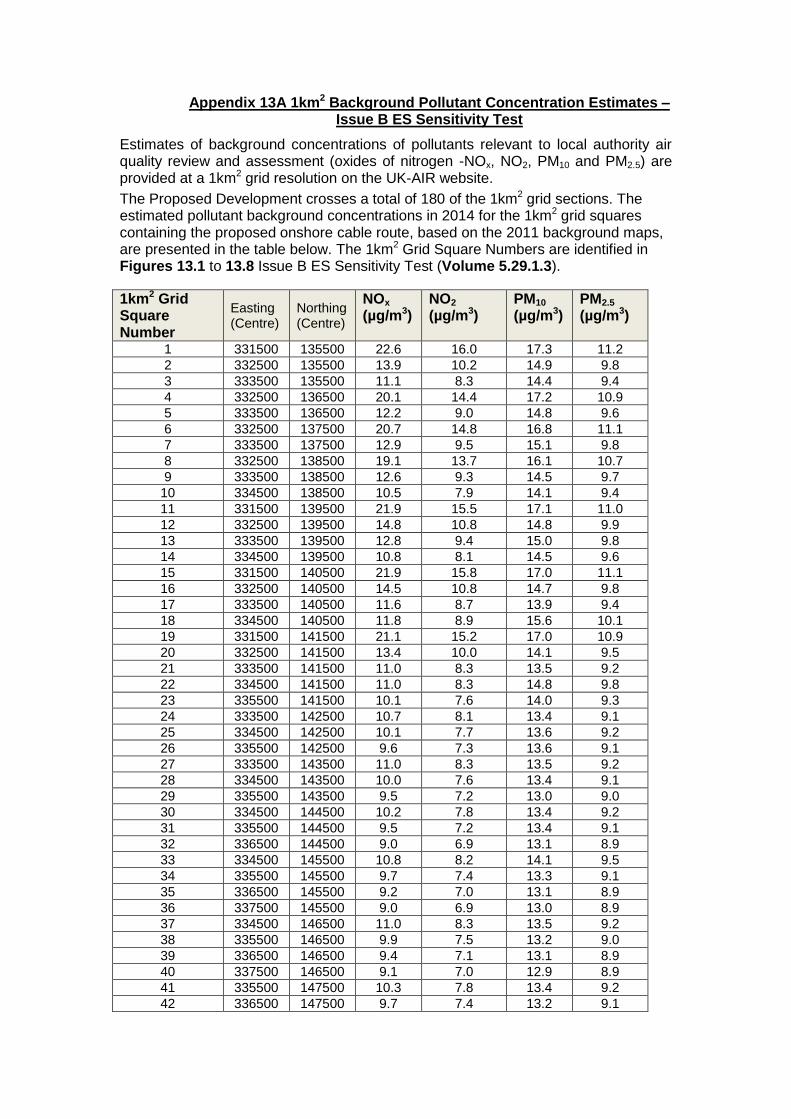
Appendix 13A 1km2 Background Pollutant Concentration Estimates – Issue B ES Sensitivity Test
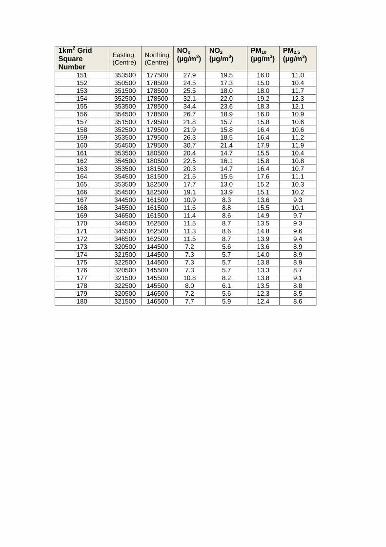
Estimates of background concentrations of pollutants relevant to local authority air quality review and assessment (oxides of nitrogen -NOx, NO2, PM10 and PM2.5) are provided at a 1km2 grid resolution on the UK-AIR website.
The Proposed Development crosses a total of 180 of the 1km2 grid sections. The estimated pollutant background concentrations in 2014 for the 1km2 grid squares containing the proposed onshore cable route, based on the 2011 background maps, are presented in the table below. The 1km2 Grid Square Numbers are identified in Figures 13.1 to 13.8 Issue B ES Sensitivity Test (Volume 5.29.1.3).
1km2 Grid Square Number
Easting (Centre)
Northing (Centre)
NOx (µg/m3)
NO2 (µg/m3)
PM10
(µg/m3) PM2.5 (µg/m3)
1 331500 135500 22.6 16.0 17.3 11.2
2 332500 135500 13.9 10.2 14.9 9.8
3 333500 135500 11.1 8.3 14.4 9.4
4 332500 136500 20.1 14.4 17.2 10.9
5 333500 136500 12.2 9.0 14.8 9.6
6 332500 137500 20.7 14.8 16.8 11.1
7 333500 137500 12.9 9.5 15.1 9.8
8 332500 138500 19.1 13.7 16.1 10.7
9 333500 138500 12.6 9.3 14.5 9.7
10 334500 138500 10.5 7.9 14.1 9.4
11 331500 139500 21.9 15.5 17.1 11.0
12 332500 139500 14.8 10.8 14.8 9.9
13 333500 139500 12.8 9.4 15.0 9.8
14 334500 139500 10.8 8.1 14.5 9.6
15 331500 140500 21.9 15.8 17.0 11.1
16 332500 140500 14.5 10.8 14.7 9.8
17 333500 140500 11.6 8.7 13.9 9.4
18 334500 140500 11.8 8.9 15.6 10.1
19 331500 141500 21.1 15.2 17.0 10.9
20 332500 141500 13.4 10.0 14.1 9.5
21 333500 141500 11.0 8.3 13.5 9.2
22 334500 141500 11.0 8.3 14.8 9.8
23 335500 141500 10.1 7.6 14.0 9.3
24 333500 142500 10.7 8.1 13.4 9.1
25 334500 142500 10.1 7.7 13.6 9.2
26 335500 142500 9.6 7.3 13.6 9.1
27 333500 143500 11.0 8.3 13.5 9.2
28 334500 143500 10.0 7.6 13.4 9.1
29 335500 143500 9.5 7.2 13.0 9.0
30 334500 144500 10.2 7.8 13.4 9.2
31 335500 144500 9.5 7.2 13.4 9.1
32 336500 144500 9.0 6.9 13.1 8.9
33 334500 145500 10.8 8.2 14.1 9.5
34 335500 145500 9.7 7.4 13.3 9.1
35 336500 145500 9.2 7.0 13.1 8.9
36 337500 145500 9.0 6.9 13.0 8.9
37 334500 146500 11.0 8.3 13.5 9.2
38 335500 146500 9.9 7.5 13.2 9.0
39 336500 146500 9.4 7.1 13.1 8.9
40 337500 146500 9.1 7.0 12.9 8.9
41 335500 147500 10.3 7.8 13.4 9.2
42 336500 147500 9.7 7.4 13.2 9.1

1km2 Grid Square Number
Easting (Centre)
Northing (Centre)
NOx (µg/m3)
NO2 (µg/m3)
PM10
(µg/m3) PM2.5 (µg/m3)
43 337500 147500 9.5 7.2 13.2 9.1
44 335500 148500 10.3 7.8 13.6 9.1
45 336500 148500 9.7 7.4 13.2 9.0
46 337500 148500 9.5 7.2 13.6 9.2
47 336500 149500 10.0 7.6 13.2 9.0
48 337500 149500 9.4 7.2 12.9 8.9
49 336500 150500 11.1 8.5 13.6 9.2
50 337500 150500 9.8 7.5 13.4 9.0
51 336500 151500 12.0 9.1 14.2 9.4
52 337500 151500 10.3 7.8 13.6 9.1
53 336500 152500 13.8 10.4 15.0 9.8
54 337500 152500 11.8 8.9 14.4 9.4
55 338500 152500 10.8 8.2 13.8 9.2
56 336500 153500 18.4 13.5 16.7 10.7
57 337500 153500 11.8 8.9 14.1 9.3
58 338500 153500 11.4 8.7 14.7 9.4
59 336500 154500 13.2 9.9 14.7 9.6
60 337500 154500 16.3 12.1 15.4 10.1
61 338500 154500 11.2 8.5 13.7 9.2
62 336500 155500 10.9 8.3 13.8 9.1
63 337500 155500 17.3 12.8 16.0 10.4
64 338500 155500 11.7 8.9 13.8 9.2
65 337500 156500 12.1 9.1 13.6 9.2
66 338500 156500 16.2 12.0 15.6 10.1
67 339500 156500 11.1 8.5 13.6 9.1
68 340500 156500 10.3 7.8 13.4 9.1
69 338500 157500 16.9 12.6 15.4 10.2
70 339500 157500 11.6 8.8 13.7 9.2
71 340500 157500 10.5 8.0 14.0 9.3
72 341500 157500 10.7 8.1 13.6 9.2
73 339500 158500 11.7 8.9 13.7 9.2
74 340500 158500 11.2 8.5 14.7 9.5
75 341500 158500 10.7 8.1 14.1 9.3
76 342500 158500 10.5 7.9 13.6 9.2
77 340500 159500 11.3 8.6 13.9 9.3
78 341500 159500 11.5 8.7 14.0 9.4
79 342500 159500 10.9 8.3 13.6 9.3
80 340500 160500 11.0 8.4 13.8 9.3
81 341500 160500 10.9 8.3 13.5 9.2
82 342500 160500 10.7 8.1 13.2 9.1
83 340500 161500 11.2 8.5 14.4 9.4
84 341500 161500 10.9 8.3 13.3 9.1
85 342500 161500 10.7 8.2 13.6 9.2
86 339500 162500 12.9 9.8 14.4 9.3
87 340500 162500 11.8 8.9 15.0 9.5
88 341500 162500 11.2 8.5 13.2 9.1
89 342500 162500 11.0 8.4 13.1 9.1
90 339500 163500 17.1 12.8 14.8 9.6
91 340500 163500 14.6 10.8 13.8 9.4
92 341500 163500 12.2 9.2 13.3 9.2
93 342500 163500 12.0 9.1 13.2 9.2
94 340500 164500 15.0 11.2 14.6 9.7
95 341500 164500 15.9 11.8 13.8 9.5
96 342500 164500 15.0 11.2 13.5 9.4

1km2 Grid Square Number
Easting (Centre)
Northing (Centre)
NOx (µg/m3)
NO2 (µg/m3)
PM10
(µg/m3) PM2.5 (µg/m3)
97 340500 165500 15.4 11.5 13.9 9.6
98 341500 165500 13.9 10.4 13.5 9.3
99 342500 165500 15.0 11.1 13.6 9.4
100 340500 166500 22.0 15.9 16.6 11.0
101 341500 166500 16.3 12.0 14.4 9.7
102 342500 166500 16.2 11.9 14.4 9.8
103 340500 167500 20.8 15.2 17.3 11.0
104 341500 167500 15.3 11.4 14.9 9.8
105 342500 167500 13.8 10.3 14.2 9.5
106 343500 167500 13.4 10.0 13.6 9.4
107 341500 168500 15.2 11.3 14.4 9.7
108 342500 168500 13.7 10.3 13.6 9.4
109 343500 168500 13.0 9.8 13.4 9.3
110 344500 168500 12.1 9.2 13.3 9.2
111 345500 168500 13.0 9.7 13.7 9.3
112 346500 168500 16.1 11.9 14.0 9.5
113 342500 169500 14.9 11.1 14.1 9.6
114 343500 169500 13.5 10.1 13.6 9.4
115 344500 169500 12.7 9.6 13.4 9.3
116 345500 169500 13.1 9.8 13.5 9.3
117 346500 169500 14.4 10.8 13.5 9.4
118 343500 170500 13.2 10.0 13.5 9.3
119 344500 170500 12.7 9.7 13.1 9.2
120 345500 170500 13.8 10.5 13.3 9.3
121 346500 170500 16.8 12.6 13.8 9.7
122 345500 171500 15.5 11.7 14.1 9.6
123 346500 171500 16.4 12.3 14.5 9.8
124 347500 171500 18.0 13.4 14.5 9.9
125 345500 172500 24.5 17.7 16.0 10.9
126 346500 172500 16.8 12.5 14.3 9.8
127 347500 172500 16.5 12.4 14.1 9.8
128 348500 172500 16.5 12.3 14.7 9.9
129 347500 173500 25.7 18.5 16.5 11.1
130 348500 173500 17.2 12.9 15.0 10.0
131 347500 174500 19.1 14.1 15.2 10.2
132 348500 174500 28.4 20.3 17.2 11.5
133 349500 174500 18.3 13.6 14.5 9.9
134 347500 175500 18.6 13.8 15.0 10.1
135 348500 175500 19.8 14.6 14.8 10.1
136 349500 175500 30.0 21.2 17.3 11.6
137 350500 175500 31.5 22.0 17.5 11.7
138 351500 175500 26.0 18.5 16.1 10.9
139 347500 176500 19.7 14.4 16.3 11.0
140 348500 176500 17.8 13.2 14.7 10.1
141 349500 176500 22.3 16.1 15.1 10.3
142 350500 176500 27.8 19.5 15.6 10.5
143 351500 176500 34.6 23.8 18.8 12.1
144 352500 176500 28.1 19.7 16.1 11.0
145 347500 177500 18.1 13.4 14.7 10.2
146 348500 177500 17.9 13.2 14.0 9.8
147 349500 177500 18.4 13.6 15.4 10.1
148 350500 177500 23.2 16.6 15.4 10.4
149 351500 177500 27.3 19.1 15.8 10.8
150 352500 177500 38.3 25.8 18.6 12.4
1km2 Grid Square Number
Easting (Centre)
Northing (Centre)
NOx (µg/m3)
NO2 (µg/m3)
PM10
(µg/m3) PM2.5 (µg/m3)
151 353500 177500 27.9 19.5 16.0 11.0
152 350500 178500 24.5 17.3 15.0 10.4
153 351500 178500 25.5 18.0 18.0 11.7
154 352500 178500 32.1 22.0 19.2 12.3
155 353500 178500 34.4 23.6 18.3 12.1
156 354500 178500 26.7 18.9 16.0 10.9
157 351500 179500 21.8 15.7 15.8 10.6
158 352500 179500 21.9 15.8 16.4 10.6
159 353500 179500 26.3 18.5 16.4 11.2
160 354500 179500 30.7 21.4 17.9 11.9
161 353500 180500 20.4 14.7 15.5 10.4
162 354500 180500 22.5 16.1 15.8 10.8
163 353500 181500 20.3 14.7 16.4 10.7
164 354500 181500 21.5 15.5 17.6 11.1
165 353500 182500 17.7 13.0 15.2 10.3
166 354500 182500 19.1 13.9 15.1 10.2
167 344500 161500 10.9 8.3 13.6 9.3
168 345500 161500 11.6 8.8 15.5 10.1
169 346500 161500 11.4 8.6 14.9 9.7
170 344500 162500 11.5 8.7 13.5 9.3
171 345500 162500 11.3 8.6 14.8 9.6
172 346500 162500 11.5 8.7 13.9 9.4
173 320500 144500 7.2 5.6 13.6 8.9
174 321500 144500 7.3 5.7 14.0 8.9
175 322500 144500 7.3 5.7 13.8 8.9
176 320500 145500 7.3 5.7 13.3 8.7
177 321500 145500 10.8 8.2 13.8 9.1
178 322500 145500 8.0 6.1 13.5 8.8
179 320500 146500 7.2 5.6 12.3 8.5
180 321500 146500 7.7 5.9 12.4 8.6


Appendix 14B - Construction Traffic Noise Assessment
– Issue B ES Sensitivity Test


Hinkley Point C Connection Project
VOLUME 5.29.1.2, Appendix 14B – Construction Traffic Noise Assessment – Issue B ES
Sensitivity Test
1
ATC
Number Road Name
Peak
Year
Increase in
Road
Traffic
Noise
during
peak year,
dB
Magnitude of Effect
1 A39 Puritan Road 2021 0.1
Negligible
2 A39 Bath Road 2021 0.0
No change
3 B3141 Woolavington Hill 2021 0.2
Negligible
4 B3141 Causeway 2021 0.2
Negligible
5 B3139 (West of Watchfield) 2019 0.1
Negligible
6 A38 Bristol Road (North of
Highbridge) 2019
0.0
No Change
7 Harp Road No longer a proposed construction traffic route
8 Southwick Road No longer a proposed construction traffic route
9 A38 Bristol Road, Tarnock 2016 0.1
Negligible
10 A38 Bristol Road (North of Sidcott) 2016
0.1
Negligible
11 A368 Dinghurst Road, Churchill 2016 0.2
Negligible
12 A38 Bristol Road, Langford 2017 0.1
Negligible
13 A3133 Stock Lane No longer a proposed construction traffic route
14 A370, Hewish 2018 0.1
Negligible
14(2) A370, Hewish 2018 0.1
Negligible
15 A370 Station Road, Congresbury No longer a proposed construction traffic route
16 Lampley Road 2018 0.1
Negligible

Hinkley Point C Connection Project
VOLUME 5.29.1.2, Appendix 14B – Construction Traffic Noise Assessment – Issue B ES
Sensitivity Test
2
ATC
Number Road Name
Peak
Year
Increase in
Road
Traffic
Noise
during
peak year,
dB
Magnitude of Effect
17 Kenmoor road 2018 0.2
Negligible
18 B3133 Kenn Road 2018 0.1
Negligible
19 Kenn Street, Kenn No longer a proposed construction traffic route
20 Nailsea Wall 2018 0.4
Negligible
21 B3133 (South of Clevedon) 2018 0.0
No Change
22 Court Lane 2018 0.2
Negligible
23 Clevedon Road (East of Celvedon) 2019
0.0
No change
24 Clevedon Road (North of
Tickenham) 2019
0.0
No change
25 B3128 Clevedon Road (North of
Nailsea) 2019
0.0
No change
26 Whitehouse Lane 2019 0.0
No Change
27 Caswell Hill 2019 0.4
Negligible
28 Sheepway 2019 0.3
Negligible
29 A369 The Portbury Hundred 2019 0.0
No Change
30 Victoria Road 2019 0.1
Negligible
31 Avonmouth Way 2018 0.4
Negligible
32* A403 St Andrews Road 2018 0.3 Negligible
33 Kings Weston Lane 2018 0.1
Negligible
34 A403 Smoke Lane 2018 0.1
Negligible
35 Poplar Way West 2018 0.1
Negligible
36 Poplar Way East 2018 0.3
Negligible
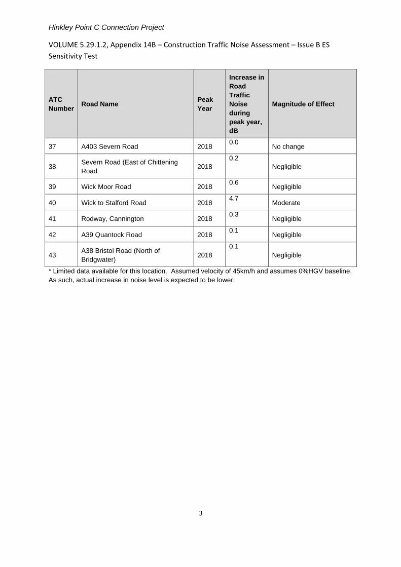
Hinkley Point C Connection Project
VOLUME 5.29.1.2, Appendix 14B – Construction Traffic Noise Assessment – Issue B ES
Sensitivity Test
3
ATC
Number Road Name
Peak
Year
Increase in
Road
Traffic
Noise
during
peak year,
dB
Magnitude of Effect
37 A403 Severn Road 2018 0.0
No change
38 Severn Road (East of Chittening
Road 2018
0.2
Negligible
39 Wick Moor Road 2018 0.6
Negligible
40 Wick to Stalford Road 2018 4.7
Moderate
41 Rodway, Cannington 2018 0.3
Negligible
42 A39 Quantock Road 2018 0.1
Negligible
43 A38 Bristol Road (North of
Bridgwater) 2018
0.1
Negligible
* Limited data available for this location. Assumed velocity of 45km/h and assumes 0%HGV baseline.
As such, actual increase in noise level is expected to be lower.


Appendix 15 - Issue B ES Sensitivity Test


Environmental Statement Sensitivity Test
Hinkley Point C Connection Project
5.29.1.2 – Environmental Statement Sensitivity Test-
Appendix 15
Appendix Title
15G Planning Allocations within Local Area of Influence – Issue B ES Sensitivity Test
15H Planning Permissions within Local Area of Influence – Issue B ES Sensitivity Test


Appendix 15G - Planning Allocations within Local Area
of Influence – Issue B ES Sensitivity Test


VOLUME 5.29.1.2, APPENDIX 15G: PLANNING ALLOCATIONS WITHIN LOCAL AREA OF INFLUENCE (JULY 2014) ISSUE B ES SENSITIVITY TEST
Table 15.2 Planning Allocations and Emerging Allocations within Local Area of Influence (updates Table 15G.1 of the submitted ES)
Site/ allocation/ policy Name
Description Location Source July 2014 Status
Royal Ordnance Factory
An energy park with specific reference to accommodating renewable and low-carbon energy generation
Puriton Ridge Sedgemoor District Council, 2011, Core Strategy (published version 2012)
No change
RLT1 Protection of Recreational and Open Space (saved policy)
Woolavington Sedgemoor Local Plan - proposals map. Woolavington Map 54
No change
DM25 Proposed strategic Cycle Routes:
Yatton, Congresbury, Churchill, Winscombe & Sandford: Cheddar Valley Railway Route
Clevedon, Kenn and Yatton
Clevedon to Nailsea
Portishead to Clapton Court
Throughout North Somerset
North Somerset Council, North Somerset Replacement Local Plan, 2007 Proposals Map / Cross referenced with North Somerset Sites and Policies Plan - consultation draft 2013
North Somerset emerging proposals map
No change
Site/ allocation/ policy Name
Description Location Source July 2014 Status
DM22
T/1
Bristol to Taunton existing railway 10m buffer Portishead to Pill (Portbury) proposed railway line
Puxton and Portishead (respectively)
North Somerset Council, North Somerset Replacement Local Plan, 2007 Proposals Map / Cross referenced with North Somerset Sites and Policies Plan - consultation draft 2013
North Somerset emerging proposals map
No change
DM50 Safeguarded Employment Sites:
Smart Systems, Yatton Bob Martin and Stowell Concrete, Yatton Land to the south of Wemberham Lane West End Trading Estate, Nailsea
Yatton and Nailsea
North Somerset emerging proposals map No change
E/5 Safeguarded Employment Site: Land at Wemberham Lane
Yatton North Somerset Council, North Somerset Replacement Local Plan, 2007 Proposals Map / Cross referenced with North Somerset Sites and Policies Plan - consultation draft 2013
No change
CF/4 Safeguarded Site for Proposed Public Utilities/Services (West End - Nailsea)
Nailsea North Somerset Council, North Somerset Replacement Local Plan, 2007 Proposals Map / Cross referenced with North Somerset Sites and Policies Plan - consultation draft 2013
No change
CF/4 Safeguarded Site for Proposed Public Utilities/Services
Portishead Quays
North Somerset Council, North Somerset Replacement Local Plan, 2007 Proposals Map / Cross referenced with North Somerset Sites and Policies Plan - consultation draft 2013
No change
CF/4 Safeguarded Site for Strategic & structural Open Space
Portishead Ashlands
North Somerset Council, North Somerset Replacement Local Plan, 2007 Proposals Map / Cross referenced with North Somerset Sites and Policies Plan - consultation draft 2013
No change
Site/ allocation/ policy Name
Description Location Source July 2014 Status
E/6 Royal Portbury Dock. Proposals for Development on Safeguarded Land at Court House Farm. Safeguarded land for Port Use.
Portbury North Somerset Council, North Somerset Replacement Local Plan, 2007 Proposals Map / Cross referenced with North Somerset Sites and Policies Plan - consultation draft 2013
No change
T/3 Proposed Rail Station. Off Royal Portbury Dock Road
Portbury North Somerset Council, North Somerset Replacement Local Plan, 2007 Proposals Map / Cross referenced with North Somerset Sites and Policies Plan - consultation draft 2013
No change
DM51, NA2 Land at North West Nailsea. New allocation for mixed use site.
Nailsea North Somerset Council, Emerging Sites and Policies Development Plan Document
Emerging Sites and Policies DPD. Consultation closed in April 2013. No changed since ES was submitted.
DM13, BCS8 Principle industrial and warehousing areas
Avonmouth Bristol City Council, 2013 Site Allocations and Development Management Policies
Published Polices considered in Submitted ES. Document adopted as of 22nd July 2014. No significant alterations upon adoption.
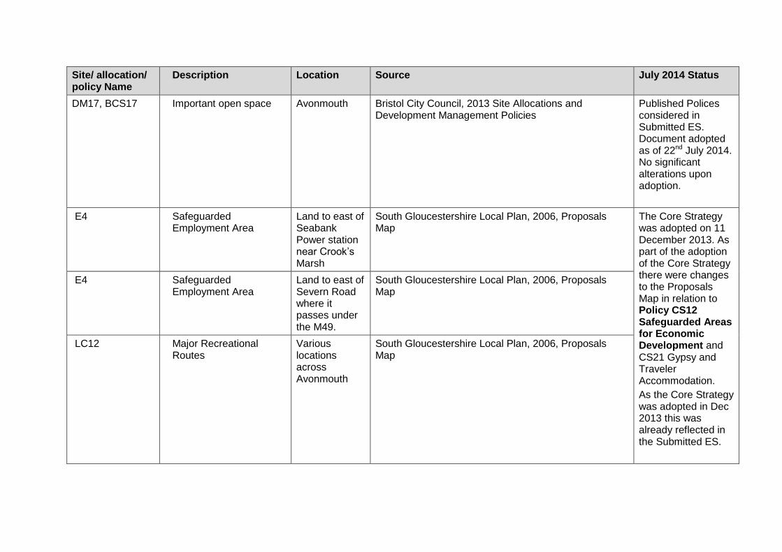
Site/ allocation/ policy Name
Description Location Source July 2014 Status
DM17, BCS17 Important open space Avonmouth Bristol City Council, 2013 Site Allocations and Development Management Policies
Published Polices considered in Submitted ES. Document adopted as of 22nd July 2014. No significant alterations upon adoption.
E4 Safeguarded Employment Area
Land to east of Seabank Power station near Crook’s Marsh
South Gloucestershire Local Plan, 2006, Proposals Map
The Core Strategy was adopted on 11 December 2013. As part of the adoption of the Core Strategy there were changes to the Proposals Map in relation to Policy CS12 Safeguarded Areas for Economic Development and CS21 Gypsy and Traveler Accommodation.
As the Core Strategy was adopted in Dec 2013 this was already reflected in the Submitted ES.
E4 Safeguarded Employment Area
Land to east of Severn Road where it passes under the M49.
South Gloucestershire Local Plan, 2006, Proposals Map
LC12 Major Recreational Routes
Various locations across Avonmouth
South Gloucestershire Local Plan, 2006, Proposals Map

Site/ allocation/ policy Name
Description Location Source July 2014 Status
DS15 Strategic waste site identified for residual (and in certain circumstances non-residual) waste related facilities
Advanced Transport System Ltd site
West of England Joint Waste Core Strategy, 2011 No change
DS07 Strategic waste site identified for residual (and in certain circumstances non-residual) waste related facilities
Sevalco Plant, Severn Road
West of England Joint Waste Core Strategy, 2011 No change
DS06 Strategic waste site identified for residual (and in certain circumstances non-residual) waste related facilities
BZL site, Kings Weston Lane
West of England Joint Waste Core Strategy, 2011 No change
SG39 Strategic waste site identified for residual (and in certain circumstances non-residual) waste related facilities
South of Severnside Works
West of England Joint Waste Core Strategy, 2011 No change


Appendix 15H - Planning Permissions within Local Area
of Influence – Issue B ES Sensitivity Test

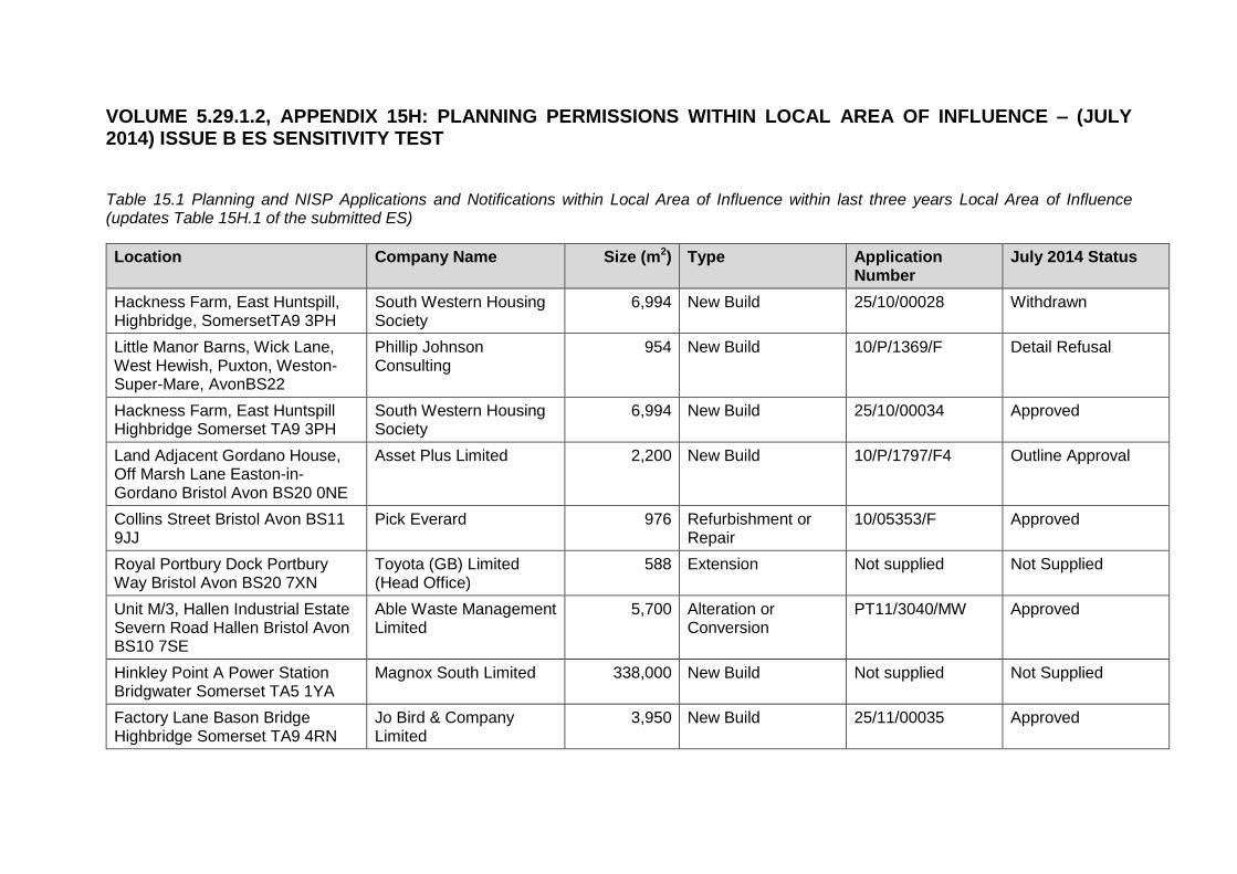
VOLUME 5.29.1.2, APPENDIX 15H: PLANNING PERMISSIONS WITHIN LOCAL AREA OF INFLUENCE – (JULY 2014) ISSUE B ES SENSITIVITY TEST
Table 15.1 Planning and NISP Applications and Notifications within Local Area of Influence within last three years Local Area of Influence (updates Table 15H.1 of the submitted ES)
Location Company Name Size (m2) Type Application Number
July 2014 Status
Hackness Farm, East Huntspill, Highbridge, SomersetTA9 3PH
South Western Housing Society
6,994 New Build 25/10/00028 Withdrawn
Little Manor Barns, Wick Lane, West Hewish, Puxton, Weston-Super-Mare, AvonBS22
Phillip Johnson Consulting
954 New Build 10/P/1369/F Detail Refusal
Hackness Farm, East Huntspill Highbridge Somerset TA9 3PH
South Western Housing Society
6,994 New Build 25/10/00034 Approved
Land Adjacent Gordano House, Off Marsh Lane Easton-in-Gordano Bristol Avon BS20 0NE
Asset Plus Limited 2,200 New Build 10/P/1797/F4 Outline Approval
Collins Street Bristol Avon BS11 9JJ
Pick Everard 976 Refurbishment or Repair
10/05353/F Approved
Royal Portbury Dock Portbury Way Bristol Avon BS20 7XN
Toyota (GB) Limited (Head Office)
588 Extension Not supplied Not Supplied
Unit M/3, Hallen Industrial Estate Severn Road Hallen Bristol Avon BS10 7SE
Able Waste Management Limited
5,700 Alteration or Conversion
PT11/3040/MW Approved
Hinkley Point A Power Station Bridgwater Somerset TA5 1YA
Magnox South Limited 338,000 New Build Not supplied Not Supplied
Factory Lane Bason Bridge Highbridge Somerset TA9 4RN
Jo Bird & Company Limited
3,950 New Build 25/11/00035 Approved
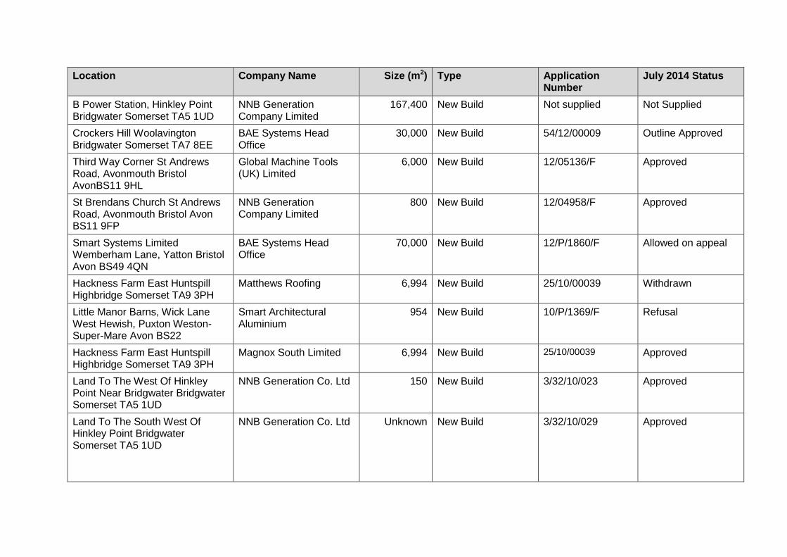
Location Company Name Size (m2) Type Application Number
July 2014 Status
B Power Station, Hinkley Point Bridgwater Somerset TA5 1UD
NNB Generation Company Limited
167,400 New Build Not supplied Not Supplied
Crockers Hill Woolavington Bridgwater Somerset TA7 8EE
BAE Systems Head Office
30,000 New Build 54/12/00009 Outline Approved
Third Way Corner St Andrews Road, Avonmouth Bristol AvonBS11 9HL
Global Machine Tools (UK) Limited
6,000 New Build 12/05136/F Approved
St Brendans Church St Andrews Road, Avonmouth Bristol Avon BS11 9FP
NNB Generation Company Limited
800 New Build 12/04958/F Approved
Smart Systems Limited Wemberham Lane, Yatton Bristol Avon BS49 4QN
BAE Systems Head Office
70,000 New Build 12/P/1860/F Allowed on appeal
Hackness Farm East Huntspill Highbridge Somerset TA9 3PH
Matthews Roofing 6,994 New Build 25/10/00039 Withdrawn
Little Manor Barns, Wick Lane West Hewish, Puxton Weston-Super-Mare Avon BS22
Smart Architectural Aluminium
954 New Build 10/P/1369/F Refusal
Hackness Farm East Huntspill Highbridge Somerset TA9 3PH
Magnox South Limited 6,994 New Build 25/10/00039 Approved
Land To The West Of Hinkley Point Near Bridgwater Bridgwater Somerset TA5 1UD
NNB Generation Co. Ltd 150 New Build 3/32/10/023 Approved
Land To The South West Of Hinkley Point Bridgwater Somerset TA5 1UD
NNB Generation Co. Ltd Unknown New Build 3/32/10/029 Approved

Location Company Name Size (m2) Type Application Number
July 2014 Status
Hinkley Point B Power Station, Hinkley Point Stogursey Bridgwater Somerset TA5 1UD
EDF Energy PLC Unknown New Build 3/32/10/031 Permitted Development
Avonmouth Filling Station Avonmouth Road Bristol Avon BS11 9LP
Union Pension Fund Trustees
2,600 New Build 10/05512/R Approved
Co-op Distribution Warehouse N/o Poplar Way, Avonmouth Bristol AvonBS10
Stoford Properties Limited
Unknown New Build 10/05469/F (original application plus subsequent NMA applications
Approved and NMA agreed
Field Parcel 4231, West Of Caswell Hill Portbury Bristol Avon BS20
Not Supplied 600 New Build 12/P/1154/F Approved
Land To The North Of Avonmouth Way Avonmouth Bristol Avon BS
Not Supplied 49,000 New Build 11/02914/F Approved
Toyota Portbury Import Centre Royal Portbury Dock Road, Portbury Bristol Avon BS20 7XQ
Toyota (GB) Limited (Head Office)
600. New Build 11/P/1879/F Approved
Ng003 The Causeway Nailsea Bristol Avon BS48 2AY
Not Supplied 250,00 New Build 12/P/0230/F Approved
Eastern Arm Royal Edwards Dock Avonmouth Dock Bristol Avon BS11 9DA
The Bristol Port Company
Unknown Alteration or Conversion
12/02773/CP Certificate of Lawfulness Issued
Portbury Bulk Terminal Portbury Dock Easton-In-Gordano Bristol Avon BS20
Not Supplied 2,590 New Build 12/P/1578/LUP Certificate of Lawfulness Issued
National Grid Electricity Substation Hinkley Point A, Stogursey Bridgwater Somerset
EDF Energy PLC 10,000 New Build 3/32/12/068 Approved

Location Company Name Size (m2) Type Application Number
July 2014 Status
TA5 1UD
Hinkley Point C Hinkley Point Road Stogursey Bridgwater Somerset TA5 1UF
EDF Energy, NNB Generation Co
1,710,000 Alteration or Conversion
3/32/12/062 Approved
Box Bush Yard Box Bush Lane Weston Super Mare Avon BS24 6UA
Karen Bartlett 300 New Build 13/P/0471/LDE Approved. Certified with a split decision
B Power Station, Hinkley Point Bridgwater Somerset TA5 1UD
British Energy, EDF Energy Legal Services
178 Alteration or Conversion
3/32/10/017 Permitted Development
98 Gloucester Road Avonmouth Bristol BS11 9AQ
CVR Truck & Trailers (Bristol) Ltd
270 Alteration or Conversion
10/04429/F
Approved
Area Adjacent To Berth 2, Royal Portbury Dock Royal Portbury Dock Road Easton-in-Gordano Bristol Avon BS
Not Supplied 115,000 Alteration or Conversion
11/P/0428/LUP Approved
Existing Shed In Avonmouth Dock St Andrews Road Avonmouth Bristol Avon BS11 9DQ
The Bristol Port Company
760 Alteration or Conversion
11/02229/CP Approved
Unit 1-5, West End Trading Estate Blackfriars Road Nailsea Bristol Avon BS13
Not Supplied 8,110 Alteration or Conversion
11/P/0969/F Approved
30 Greenslade Gardens Nailsea Bristol BS48 2BJ
Not Supplied Unknown New Build 11/P/1369/F Approved on Appeal
Hinkley Point B Power Station Stogursey Bridgwater Somerset TA5 1UD
EDF Energy 780 New Build 3/32/11/037 Approved

Location Company Name Size (m2) Type Application Number
July 2014 Status
R/O King Lifting Ltd King Road Avenue Bristol Avon BS11 9HF
Telefonica UK Ltd 100 New Build 12/00361/F Approved
Bristol Water Waste Treatment Works Kings Weston Lane Avonmouth Bristol Avon BS11 0YS
Wessex Water Services Ltd
12 New Build 12/03106/F or 11/04705/F
Both applications approved
Banyard Road Portbury Bristol BS20 7XH
Not Supplied 800 Alteration or Conversion
12/P/1267/F Approved
Unit 3 Avonbridge Trading Estate, Atlantic Road Bristol BS11 9QD
Bloodhound SSC 4325 Alteration or Conversion
13/00241/F Approved
Pavement Outside16 - 18 Marsh Street Jctn Claire Street City Centre Bristol Avon BS1 1XY
BT Payphones 2 New Build 13/00835/Y Prior Approval Given
Land At Severnside Works, Severn Road Hallen
Sita UK Ltd 102,350 New Build 12/04619/X or PT13/0744/NMA
Approved
Hinkley Point C Nuclear Generating Station
NNB Generation Co. Ltd 200,000 New Build ENO10001 NISP Approved
Land at Ashlawn Farm, Pill Road, Rooksbridge, Axbridge,
BS26
Brilliant Harvest 76,200 New Build 24/14/00007 (new) Approved
Land offHorsey Lane, Horsey, Bridgwater, TA7 8QJ
Cannington Enterprises LTD
9,600 New Build 1/09/12/026 (new) Under consideration
Land at former, Royal Ordnance Factory
BAE Systems Land at former, Royal Ordnance Factory
2,212,300 New Build 42/13/00010
(new) Outline Application Under consideration

Location Company Name Size (m2) Type Application Number
July 2014 Status
Land at, Pyde Drove (2), The Causeway, Woolavington, Bridgwater
Wessex Solar Energy 184,700 New Build 54/13/00010 (new) Approved
Land west of Iwood Lane off Stock Lane Congresbury
Wessex Solar Energy 186,900 New Build 13/P/2382/F
(new) Under consideration
Marsh Lane Easton-in-Gordano BS20 0NF
Siniat Limited 130,100 New Build 13/P/1273/F (new) Approved
Land Adjoining Moorhouse Caravans Moorhouse Lane Hallen Bristol
Orta Solar 59,200 New Build 13/05491/F (new) Approved
Seabank 3 – CCGT Power Station
SSE 1,750,000 New Build EN010058 (new) NISP Pre Application Notification Accepted

Appendix 17 - Issue B ES Sensitivity Test


Environmental Statement Sensitivity Test
Hinkley Point C Connection Project
5.29.1.2 – Environmental Statement Sensitivity Test-
Appendix 17
Appendix Title
17C Cumulative Assessment – Other Major Development Proposals Indicative Programmes- Issue B ES Sensitivity Test
17D Cumulative Assessment – Scoped Out Major Development Proposals- Issue B ES Sensitivity Test


Appendix 17C - Cumulative Assessment – Other Major
Development Proposals Indicative Programmes-
Issue B ES Sensitivity Test

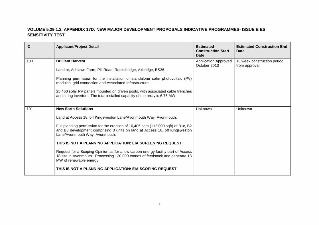
1
VOLUME 5.29.1.2, APPENDIX 17D: NEW MAJOR DEVELOPMENT PROPOSALS INDICATIVE PROGRAMMES- ISSUE B ES
SENSITIVITY TEST
ID Applicant/Project Detail Estimated Construction Start Date
Estimated Construction End Date
100
Brilliant Harvest Land at, Ashlawn Farm, Pill Road, Rooksbridge, Axbridge, BS26. Planning permission for the installation of standalone solar photovoltaic (PV) modules, grid connection and Associated Infrastructure.
25,460 solar PV panels mounted on driven posts, with associated cable trenches and string inverters. The total installed capacity of the array is 6.75 MW.
Application Approved October 2013
10 week construction period from approval
101 New Earth Solutions
Land at Access 18, off Kingsweston Lane/Avonmouth Way, Avonmouth.
Full planning permission for the erection of 10,405 sqm (112,000 sqft) of B1c, B2 and B8 development comprising 3 units on land at Access 18, off Kingsweston Lane/Avonmouth Way, Avonmouth.
THIS IS NOT A PLANNING APPLICATION: EIA SCREENING REQUEST
Request for a Scoping Opinion as for a low carbon energy facility part of Access 18 site in Avonmouth. Processing 120,000 tonnes of feedstock and generate 13 MW of renewable energy.
THIS IS NOT A PLANNING APPLICATION: EIA SCOPING REQUEST
Unknown Unknown

2
ID Applicant/Project Detail Estimated Construction Start Date
Estimated Construction End Date
102 Smiths Gore
Land at Meer Wall near Strawberry Line, Congresbury.
EIA Screening opinion for a 36 MW power Solar Farm.
THIS IS NOT A PLANNING APPLICATION: EIA SCREENING OPINION
Unknown Unknown
103 Bridgwater Gateway Ltd
Land to the SW of Stockmoor Distributor Road and NW of Taunton Road, North Petherton, Bridgwater.
Outline planning application for the erection of three storey building (use class B1), formation of parking and access. Total B1 comprises 2,867 sqm.
Unknown Unknown
104 DFE Skanska Residential Ltd
Land At Cribbs Causeway, Almondsbury, Bristol, South Gloucestershire BS10 7TE.
Outline application including access with all other matters reserved for a mixed use development of 51.49 hectares of land comprising: up to 1,000 new dwellings (Use Class C3); a 36-bed Extra Care Home (Use Class C2): a mixed use local centre including a food store up to 2000 sqm. gross floor area (Use Classes A1, A2, A3, A4, A5, B1, D1, D2); a 2-form entry primary school; community facilities including a satellite GP surgery, dentist and community centre; associated public open space and sporting facilities; green infrastructure integrated with foot and cycle paths; together with supporting infrastructure and facilities including three new vehicular accesses.
Unknown Unknown

3
ID Applicant/Project Detail Estimated Construction Start Date
Estimated Construction End Date
105
A & R House Partnership
Weston Wake Park, Accommodation Road, Bleadon.
Large scale major application for Leisure complex together with an Environmental Impact Assessment with change of use from agricultural lakes to tourist facility(D2) providing a water-park for cable-tow wake-boarding, water-skiing, canoeing and other non-powered water-based sports with construction of retaining bank for a series of lakes consisting of a long lake for triathlon with 2no islands, a main lake with central island, up to 8 masts for cable-skiing, a balancing lake and a training lake. Works to include erection of club house with showers/wc, restaurant/cafe, equipment hire/shop-(A1), kitchen-(A3 and A4), offices, training facilities and grounds management. Erection of a boat and equipment storage building, boiler room, pumping and control cabins, parking for 65 vehicles, reed-bed treatment plant, associated landscaping with hard-surfaced tracks and water-control features for attenuation of excess water (part retrospective).
Unknown 104 week construction- no indication of when this would commence
106 Taylor Wimpey UK Ltd And Bristol Polytechnic Enterprises Dev
Land East Of Coldharbour Lane, Stoke Gifford, Bristol, South Gloucestershire BS16 1UX.
Development on 14.8 hectares of land seeking outline permission for the erection of up to 550 no. dwellings with associated infrastructure to include full permission for Phase I of development, consisting of the erection of 282 no. dwellings (of the 550 no. total), 250m2 of Retail and/or Community Meeting Space (mixed Class A1 Retail / Class D2 Assembly and Leisure), site access/spine road, car parking, open space, landscaping and drainage infrastructure
Unknown 10 year construction programme.

4
ID Applicant/Project Detail Estimated Construction Start Date
Estimated Construction End Date
107 Bridgwater Gateway Phase 2
Land South of Bridgwater to the West of, Taunton Road, North Petherton, Bridgwater.
Outline application for residential development of up to 292 dwellings and associated infrastructure.
Unknown Unknown
108 Green Switch Solutions
Parcel 2900, Greenhouse Lane, Nempnett Thrubwell, Bristol.
Development of a 7 MW solar park on land associated to Howgrove Farm, Redhill, Bristol (nearest postcode BS40 5TS).
THIS IS NOT A PLANNING APPLICATION: EIA SCREENING REQUEST
Unknown Unknown
109 KWTN Solar Ltd
Land at Bowerhouse, East of Riverside Banwell, BS29 6EL.
Proposed 7.48 MW solar farm.
THIS IS NOT A PLANNING APPLICATION: EIA SCREENING REQUEST
Unknown
Unknown
110 Green Energy UK Direct Ltd
Churchill Park Farm, Ladymead Lane, Langford, Churchill BS40 5ED
Proposed 4.5 MW solar farm.
THIS IS NOT A PLANNING APPLICATION: EIA SCREENING REQUEST
Unknown Unknown

5
ID Applicant/Project Detail Estimated Construction Start Date
Estimated Construction End Date
111 Estrans Ltd
Land Adjacent to Church Road and the M49, Severn Beach, Bristol, South Gloucestershire BS35 4NL
Proposed 3.5 MW Solar Farm.
THIS IS NOT A PLANNING APPLICATION: EIA SCREENING REQUEST
Unknown Unknown
112 Network Rail
Permitted Development.
Railway Between Temple Meads And Abbey Wood Stations Bristol
Filton bank capacity improvement project - railway line improvements between Temple Meads and Filton Abbey Wood stations including track re-doubling, new road access and replacement of bridges.
THIS IS NOT A PLANNING APPLICATION: EIA SCREENING REQUEST
Unknown Unknown

6
ID Applicant/Project Detail Estimated Construction Start Date
Estimated Construction End Date
113 Bristol City Council & South Gloucestershire Council
Land and Highways between Cribbs Causeway/Emersons Green and Hengrove including Aztec West Roundabout, Bradley Stoke, Stoke Gifford Transport Link, Hambrook, Stoke Lane, M32, Bristol City Centre, Redcliffe Hill And Hartcliffe Way.
Construction of North Fringe to Hengrove Package (NFHP) MetroBus: A rapid bus route between Bristol North and East Fringes to South Bristol via Bristol City Centre comprising new roads and alteration to existing highways to prioritise MetroBus, including widening of Bradley Stoke Way, A 4174 Avon Ring Road at Hambrook junction, Stoke Lane/Coldharbour Lane, new footbridge at Church Lane over A 4174, a new bus only junction on the M32, alterations to roads and public spaces at St Augustine's Parade/Baldwin Street/ Colston Avenue, widening of Hartcliffe Way, new MetroBus stop infrastructure, public realm works, associated engineering and earthworks, drainage works and landscaping.
April 2015 Oct 2017
114
Oaktree Environmental Limited
Filton Golf Club, Golf Course Lane, Bristol, BS34 7QS.
Infilling of irrigation lakes and landscaping works to practice area at Filton Golf Course.
Total of 292,244 tonnes of inert material to be imported to site, over a minimum period of two years, maximum of three years. This means that between 97,415 tonnes and 146,122 tonnes of inert material will be imported to the site per annum.
THIS IS NOT A PLANNING APPLICATION: EIA SCOPING REQUEST
Unknown 3 years from approval

7
ID Applicant/Project Detail Estimated Construction Start Date
Estimated Construction End Date
115 Clean Earth
Charlton Drive, Wraxall, Bristol, Avon, BS48 1PF
Single wind turbine single wind turbine of maximum hub height 50 m and maximum tip height 77 m, with a 3 bladed rotor design.
THIS IS NOT A PLANNING APPLICATION: EIA SCREENING OPINION
Unknown 2-3 day installation of turbine; other works unknown. 25 year life span
116 Balfour Betty
Land Eastern Side Of Chittening Trading Estate, Greensplott Road, Avonmouth, Bristol.
Request for a Scoping Opinion for the erection of a 10.4 MW Bioenergy Facility using a gasification process to approximately 60,000 tonnes (dry) of waste wood per annum being supplied by the neighbouring wood recovery facility Boomeco.
THIS IS NOT A PLANNING APPLICATION: EIA SCOPING REQUEST
Unknown Unknown


Appendix 17D - Cumulative Assessment – Scoped Out
Major Development Proposals-
Issue B ES Sensitivity Test


VOLUME 5.29.1.2, APPENDIX 17D: CUMULATIVE ASSESSMENT -
SCOPED OUT MAJOR DEVELOPMENT PROPOSALS – ISSUE B ES
SENSITIVITY TEST
A1. Due to the bespoke nature of potential cumulative effects for each of the
environmental topics and the manner in which they are considered and
assessed, it is not appropriate to include all major development proposals
identified in the Final Master List in the assessment of potential cumulative
effects. Therefore, for each environmental topic, each Final Master List
development proposal has been further considered with regard to whether it
is likely (either alone or in combination with other major development
proposals) to have cumulative effects with the Proposed Development.
A2. Where such cumulative effects are considered unlikely to arise, they are
then scoped out from that cumulative assessment; justification is provided in
each case. The projects that have been scoped out for each environmental
topic are provided at Table A17.1. This includes new major developments
identified as part the ES Sensitivity Test. The developments are shown on
Figure 17.1 Cumulative Assessment- Other Major Development Proposals -
Issue B ES Sensitivity Test (Volume 5.29.1.3)
Table A17.1 Cumulative Assessment Scoped Out Major Development
Proposals
ID Justification for Scoping Out
Landscape
104 No substantive cumulative effects are expected as a result
ofthis development because the proposals are contained
withinthe north Bristol conurbation and are distant from the
Proposed Development. The development proposals would
have no effect on landscape affected by the new 400kV
overhead line.
105 No cumulative effects are anticipated as a result of this
development because this proposal is distant from the
Proposed Development in Section B Somerset Levels and
Moors South.
106 No substantive cumulative effects are expected as a result of
this development because the proposals are contained
withinthe north Bristol conurbation and are distant from the
Proposed Development. The development proposals would
have no effect on landscape affected by the new 400kV
overhead line.

ID Justification for Scoping Out
107 No substantive cumulative effects are expected as a result of
this development because the proposals are contained within
the urban areas south of the Bridgwater conurbation and are
distant from the Proposed Development. The development
proposals would have no effect on landscape affected by the
new 400kV overhead line.
108 No cumulative effects are anticipated as a result of this
development because this proposal is distant from the
Proposed Development in Section D Somerset Levels and
Moors North.
110 No substantive cumulative effects are anticipated as a result of
this development as it is relatively small scale and distant from
the Proposed Development and would have no effect on
landscape character affected by the Proposed Development in
Section D Somerset Levels and Moors North.
111 No substantive cumulative effects are anticipated as a result of
this development as it is relatively small scale and distant from
the proposed 400kV overhead line in Section G Avonmouth.
112, 113 and 114
No substantive cumulative effects are expected as a result of
these developments because the proposals are contained
within the Bristol conurbation and are small scale and distant
from the Proposed Development. The development proposals
would have no effect on landscape affected by the new 400kV
overhead line.
116 No substantive cumulative effects are expected as a result of
this development because the proposals are in keeping with the
scale, massing and appearance of development in Section G
Avonmouth. The development proposals would have limited
effect on landscape character affected by the new 400kV
overhead line.
Visual Effects
103 A small-scale development for a building, located approx. 0.5km north west of the Proposed Development at Bridgwater Tee, beyond the M5 and railway.No significant cumulative impacts are anticipated.

ID Justification for Scoping Out
104 Mixed-use development east of the M5, west of Bristol City Airport, approx. 2km east of the Proposed Development at Hallen/Seabank.
No significant cumulative impacts are anticipated on ecological receptors. The Proposed Development will not restrict the use of Hallen Marsh as future mitigation land, if indeed ID 104 was found to require delivery/partial delivery of this.
106 Mixed-use development on the north eastern edge of Bristol, located over 8km east of the Proposed Development at Avonmouth. No significant cumulative impacts are anticipated
107 Moderate-scale residential development located over 2.5km south west of the Proposed Development at Bridgwater substation, west of the M5 (junction 24). No significant cumulative impacts are anticipated.
111 Solar energy facility located approx. 2.4km north of Seabank substation. An EIA for project ID 111 is required, although no detailed documents supporting this decision or the subsequent EIA available. Based on aerial photography, ID 111 appears to comprise arable and pasture fields, with hedgerows, trees and ditches/drains along the field boundaries.
ID 111 lies outside the SAC Consideration Zones for horseshoe bats that apply to the Proposed Development. Low levels of bat activity were recorded in the vicinity of Seabank substation during the field surveys carried out since 2012. Given the distance between ID 111 and the Proposed Development, no cumulative effects in respect of protected species, such as GCN, are anticipated.
112 Localised works to rail embankment on line heading north through the city (between Lawrence Hill and Flinton Abbey Wood stations), over 7km east of the Proposed Development at Avonmouth. No significant cumulative impacts are anticipated.
113 Localised works to highways land within Bristol, extending to the western edge of the city, approx. 7km from the Proposed Development at Portbury at the closest point. No significant cumulative impacts are anticipated
114 Landscape works, including infilling of irrigation lakes, within Flinton Golf Club works, located over 5km east of the Proposed Development at Avonmouth at the closest point. No significant cumulative impacts are anticipated.
116 Bioenergy facility to process dry waste wood (supplied by neighbouring wood recovery facility), located approx. 1.35km south of Seabank substation within previously development industrial land. No significant cumulative impacts are anticipated

ID Justification for Scoping Out
Ground Environment
100 103 104 105 106 107 108 109 110 111 112 113 114 115 116
The other major developments ID100, ID103 to ID116,
identified within Table 17.1 have been scoped out based on
geographical separation and the localised physical impacts to
the ground environment that the Proposed Development and
the other major developments are likely to have either
individually or cumulatively.
Hydrology and Water Resources
103 Due to the hydrological separation of the projects
(approximately 1.00km) and by the M5, the potential for
cumulative effects on hydrology and water resources is
considered to be negligible.
104 Due to the hydrological separation of the projects (in excess of
2.5km), the potential for cumulative effects on the ground
environment is considered to be negligible.
105 Due to the distance of the A&R House Partnership
development (in excess of 4.50km downstream) from the
proposed crossing works at the River Axe, the potential for
cumulative effects on hydrology and water resources is
considered to be negligible.
106 Due to the hydrological separation of the projects (in excess of
8.00km), the potential for cumulative effects on the ground
environment is considered to be negligible.
107 Due to the two developments being separated by the
Bridgwater and Taunton Canal, River Parrett, the M5 and
Bridgwater, the potential for cumulative effects on hydrology
and water resources is considered to be negligible.
108 The potential for cumulative effects on the water environment is
considered to be negligible. The hydrological separation
between the proposed solar farm and the proposed
development (Churchill Substation) is in excess of 7.00km. In
addition, the proposed installation of a solar energy facility is on
Greenfield land and runoff rates would be restricted to pre-
development rates, therefore any impact upon the water
environment is unlikely.

ID Justification for Scoping Out
109 The potential for cumulative effects on the water environment is
considered to be negligible. The hydrological separation of the
two developments is in excess of 1.00km. In addition, the
proposed installation of a solar energy facility is on Greenfield
land and runoff rates would be restricted to pre-development
rates, therefore any impact upon the water environment is
unlikely.
110
The potential for cumulative effects on the water environment is
considered to be negligible. The hydrological separation of the
two developments is in excess of 4.00km. In addition, the
proposed installation of a solar energy facility is on Greenfield
land and runoff rates would be restricted to pre-development
rates, therefore any impact upon the water environment is
unlikely.
111 The potential for cumulative effects on the water environment is
considered to be negligible. The hydrological separation of the
two developments is in excess of 2.00km predominantly
consists existing infrastructure. In addition, the proposed
installation of a solar energy facility is on Greenfield land and
runoff rates would be restricted to pre-development rates,
therefore any impact upon the water environment is unlikely.
112 Due to the hydrological separation of the project (in excess of
3.00km), the potential for cumulative effects on hydrology and
water resources is considered to be negligible.
113 Due to the hydrological separation of the projects (in excess of
8.00km), the potential for cumulative effects on the ground
environment is considered to be negligible.
114 Due to the hydrological separation of the projects (in excess of
7km), the potential for cumulative effects on hydrology and
water resources is considered to be negligible.
115 Due to the hydrological separation of the projects
(approximately 1km) and the single turbine development, the
potential for cumulative effects on hydrology and water
resources is considered to be negligible.
116 Due to the hydrological separation of the projects
(approximately 800m) and the existing infrastructure, the
potential for cumulative effects on hydrology and water
resources is considered to be negligible.

ID Justification for Scoping Out
Historic Environment
100 101 103
104 105 106
107 108 109
110 111 112
113 114 115
116
Inter-project cumulative effects on the historic environment can occur during construction where areas of archaeology or contiguous/ contemporary archaeology assets are affected by more than one development footprint. For such effects to occur development footprints need to overlap or be adjacent and where this is not the case the distance of separation is such that the inter-project development proposal can be scoped out of any cumulative assessment for this aspect of the historic environment topic.
Different development projects in combination can also have a cumulative effect on the settings of a heritage asset, or shared setting of an associated group of assets, when it is affected by more than one development during the construction and operational phases of those developments; and where the part of the settings that are affected by both proposals makes a positive contribution to the heritage significance of the asset. Therefore effects can be scoped out where there are no heritage asset effects common to the Proposed Development and the project being assessed for cumulative effects, and/ or the effects are individually and in combination not of sufficient scope to affect underlying historic landscape character or the contribution made by setting to significance.
These projects meet both of the criteria referenced above and would have no construction or operational phase cumulative effects on the historic environment.
As no cumulative effects are predicted during the construction or operation of these projects in combination with the Proposed Development no additional decommissioning effects are predicted either. This is because historic environment effects occur during the construction and operational phases of developments and are generally only reversed on decommissioning.
Traffic and Transport
Note: As part of our agreed methodology TEMPro (Trip End Model Program) and the National Trip End Model (NTEM) software and databases have been used to apply growth factors to the observed background traffic. The application of these growth factors accounts for the growth associated with committed developments. Therein, whilst scoped out, these developments have been accounted for in future year traffic growth which has been input into all capacity assessments undertaken as part of the TA.

ID Justification for Scoping Out
100 101 102 103 104 105 106 107 108 109 110 111 112 113 114 115 116
As part of the scoping process it was agreed that TEMPro (Trip End Model Program) and the National Trip End Model (NTEM) forecasts databases would be used to uplift the observed (2013) traffic for future year capacity assessments.
These uplifts, specific to the year would account for the scoped out committed development identified within the traffic and transportation capacity impact assessments.
TEMPro is a software package published by the Department for Transport (DfT) which allows users to generate growth factors which can be applied to observed traffic data in order to establish forecast future year scenarios. The primary function of the software is to uplift observed traffic flows to a future year to represent the growth in traffic resulting from forecast committed developments in a specific geographical location.
The software produces growth factors based on various input parameters which can be tailored to suit the needs of a particular geographical locations and road type. For the purposes of this assessment, TEMPro has been used to generate growth factors for LGVs only as no dedicated data is provided for HGVs.
TEMPro also employs the use of the National Trip End Model (NTEM) forecasts to allow growth factor forecasts to be made based on population, employment, households – by car ownership, trip ends and simple traffic growth factors.
This methodology to establish background traffic growth factors has been agreed with the LPAs.
However, to ensure a robust assessment and through discussions with the Local Planning Authorities, ten local committed developments have been included in addition to the growth factors applied by TEMPRo.
Air Quality and Emissions
104, 105, 106, 107, 108, 110, 111, 112, 113, 114
This project is sited >1km from the Proposed Development.
Construction fugitive emissions impacts are local to the site and
no addition of effects is likely.
Noise and Vibration
100 101 102 103 104 105 106 107 108 109 110 111 112 113 114 115 116
Cumulative construction noise not expected to exceed threshold values for significant duration at nearby receptors.

ID Justification for Scoping Out
Socio-economics and Land Use
100 Construction completed by start of Proposed Development
101 32 Full Time Equivalent ’s identified, with 12 month construction
programme, no confirmed start date and no detail available on
construction workforce. There is no evidence to suggest that
this project will generate effects of a scale likely to have
significant cumulative socio-economic effects with the Proposed
Development.
102 107 108 109 110 111 112 114 115 116
There is no evidence to suggest that this project will generate
effects of a scale likely to have significant cumulative socio-
economic effects with the Proposed Development.
103 Potential cumulative effects associated with construction
employment demand from the local labour market are
considered insignificant between the Proposed Development
and this type of development. The majority of the works for the
Proposed Development will require skilled staff with specialist
knowledge specific to the Proposed Development, these will be
provided by the appointed contractor and are considered part of
the assessed in-migrating workforce. Whilst cumulative
demand for local staff could occur between elements of the
civils work such as earthworks, access roads and fencing, the
duration of these works for the Proposed Development are
short periods (up to 6 month) within the overall programme.
The Proposed Development has an identified peak local
employment demand of up to 60 staff for civils work which is
considered unlikely to have a significant cumulative effect with
this project.

ID Justification for Scoping Out
104 Potential cumulative effects associated with construction
employment demand from the local labour market are
considered insignificant between the Proposed Development
and this type of development. The majority of the works for the
Proposed Development will require skilled staff with specialist
knowledge specific to the Proposed Development, these will be
provided by the appointed contractor and are considered part of
the assessed in-migrating workforce.
Whilst cumulative demand for local staff could occur between
elements of the civils work such as earthworks, access roads
and fencing, the duration of these works for the Proposed
Development are short periods (up to 6 month) within the
overall programme which is considered unlikely to have a
significant cumulative effect with this project.
Socio-economics information for the pending application does
not identify likely employment numbers during construction but
notes the majority are likely to be local.
105 The construction programme of this project is unknown, although anticipated to be two years. The ES for the project does not include information on the type of employees required during the construction phase. An Economic Statement is referenced but not available on to view. However, it is noted that the Local Authority consider that the application will ‘create new jobs and give additional leisure opportunities to residents as well as visitors. As the Proposed Development is unlikely to have significant employment effects once completed, only the potential long-term operational effect on local tourism economy is considered further.
The overall significance of the Proposed Development on the local visitor economy is assessed as no more than minor adverse.
This application has the potential to positively affect tourism in North Somerset and is being progressed in full knowledge of the Proposed Development.
National Grid’s Proposed Development is not considered likely to have a cumulative effect on tourism in the context of this development and given the limited information available, this is not considered further in the assessment.
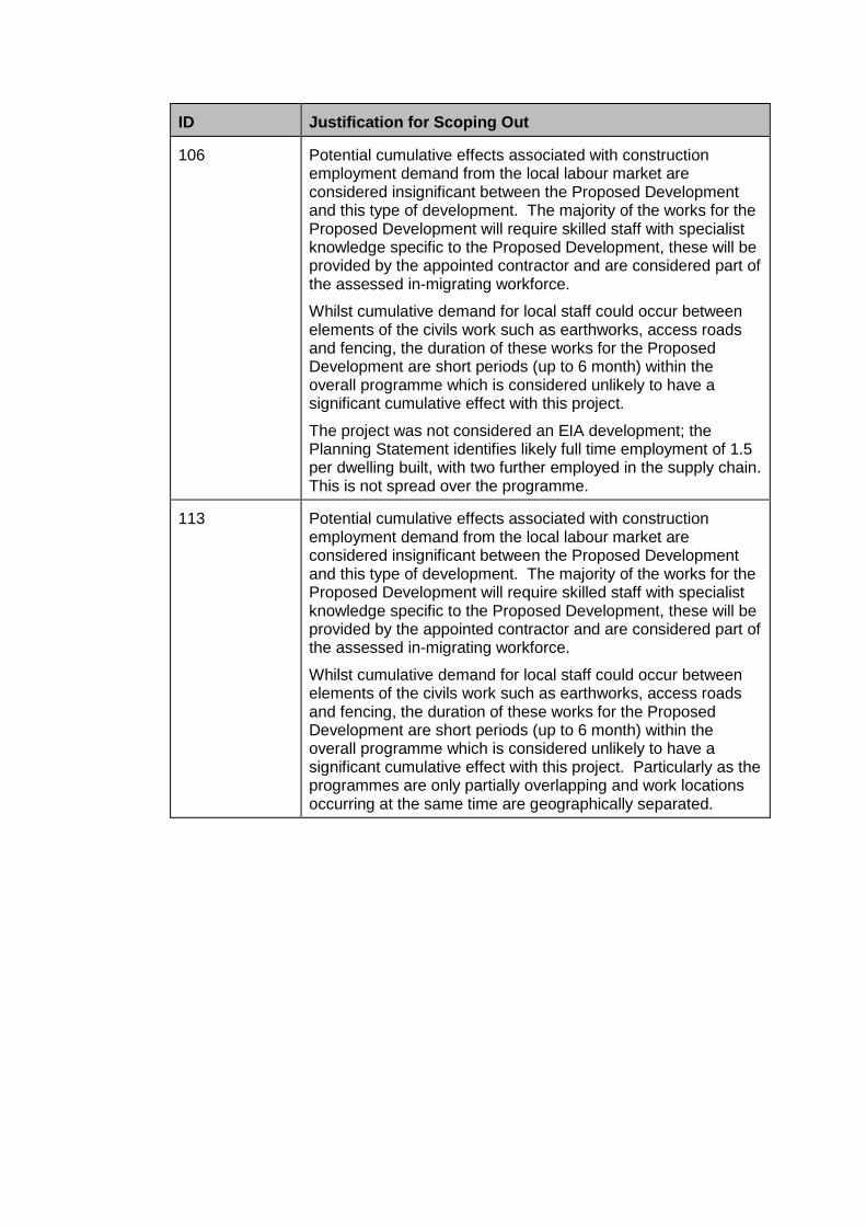
ID Justification for Scoping Out
106 Potential cumulative effects associated with construction employment demand from the local labour market are considered insignificant between the Proposed Development and this type of development. The majority of the works for the Proposed Development will require skilled staff with specialist knowledge specific to the Proposed Development, these will be provided by the appointed contractor and are considered part of the assessed in-migrating workforce.
Whilst cumulative demand for local staff could occur between elements of the civils work such as earthworks, access roads and fencing, the duration of these works for the Proposed Development are short periods (up to 6 month) within the overall programme which is considered unlikely to have a significant cumulative effect with this project.
The project was not considered an EIA development; the Planning Statement identifies likely full time employment of 1.5 per dwelling built, with two further employed in the supply chain. This is not spread over the programme.
113 Potential cumulative effects associated with construction employment demand from the local labour market are considered insignificant between the Proposed Development and this type of development. The majority of the works for the Proposed Development will require skilled staff with specialist knowledge specific to the Proposed Development, these will be provided by the appointed contractor and are considered part of the assessed in-migrating workforce.
Whilst cumulative demand for local staff could occur between elements of the civils work such as earthworks, access roads and fencing, the duration of these works for the Proposed Development are short periods (up to 6 month) within the overall programme which is considered unlikely to have a significant cumulative effect with this project. Particularly as the programmes are only partially overlapping and work locations occurring at the same time are geographically separated.

ID Justification for Scoping Out
EMF
All Projects within Final Master List and New Major Projects List
Both the transmission and distribution assets associated with the Proposed Development have each been assessed for compliance against Government guideline limits documented in NPS EN-5.
Electric and magnetic fields can combine with the EMFs already present in the development area from other sources such as appliances, domestic and industrial wiring etc; however the largest source of fields are typically from electricity transmission and distribution infrastructure. The way in which fields from different sources combine with each other is complex. The relative power flows, voltage and the relative phasing of each electrical asset would affect the direction of the fields from each asset and therefore whether they add or subtract with one another. The cumulative field could increase or decrease depending on the specific conditions, but it would only be a slight effect either way.
However even considering the worst case situation of the maximum electric and magnetic fields from both the proposed 400kV overhead lines and cables combining, i.e. the highest EMFs encountered along the route, these combined fields would still be lower than the Government guideline levels.
Therefore the cumulative impact of all of the components of the Proposed Development and any interactions with other developments which produce lower EMFs are not significant.
