5.0 androscoggin river basin - maine · the androscoggin river flows 169 miles from the headwaters...
TRANSCRIPT

5-1 October 2007 C:\Documents and Settings\swiding\Desktop\Maine River
Basin Report _Final4.doc
5.0 Androscoggin River Basin
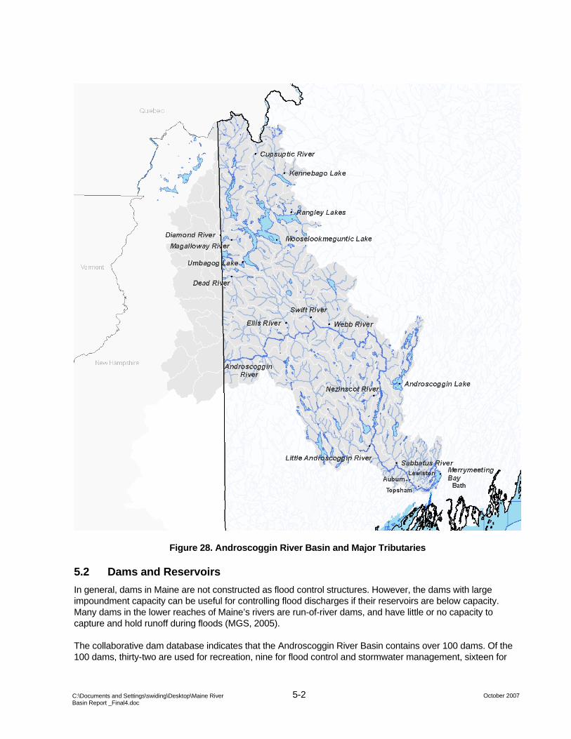
5.1 Watershed Description The Androscoggin River Basin occupies 3,500 square miles in western Maine and northeastern New Hampshire. The Androscoggin River flows 169 miles from the headwaters in Umbagog Lake in Errol, New Hampshire (near Mount Washington) to its mouth at Merrymeeting Bay.
The Androscoggin River originates in the White Mountains. Below Rumsford, Maine the river basin becomes hilly and flat and is generally suitable for agriculture. Large communities in this basin include Bethel, Rumford, Mexico, Canton, Jay, Livermore, Lewiston, Auburn, and Brunswick/Topsham.
Table 40 presents the major tributaries to the Androscoggin River from upstream to downstream along with their respective drainage areas. The Androscoggin River is influenced by tidal process as far as Brunswick, Maine. Figure 28 illustrates the location of the Androscoggin River basin within Maine and the major tributaries.
Table 40. Androscoggin River, Tributaries from Upstream to Downstream and Drainage Areas
Tributary Drainage Area (square miles)
Mooselookmeguntic Lake 470 Umbagog Lake Drainage 120 Aziscohos Lake Drainage 250 Magalloway River 200 Clear Stream 60 Middle Androscoggin River 270 Gorham-Shelburne Tributaries 150 Androscoggin River (2) at Rumford Point 310 Ellis River 160 Ellis River 200 Androscoggin River (3) above Webb River 250 Androscoggin River (4) at Riley Dam 200 Androscoggin River (5) at Nezinscot River 180 Nezinscot River 80 Androscoggin River (6) above Little Androscoggin River 350 Little Androscoggin River 260 Total 3530
5-2 October 2007 C:\Documents and Settings\swiding\Desktop\Maine River
Basin Report _Final4.doc
Figure 28. Androscoggin River Basin and Major Tributaries
5.2 Dams and Reservoirs In general, dams in Maine are not constructed as flood control structures. However, the dams with large impoundment capacity can be useful for controlling flood discharges if their reservoirs are below capacity. Many dams in the lower reaches of Maine’s rivers are run-of-river dams, and have little or no capacity to capture and hold runoff during floods (MGS, 2005).
The collaborative dam database indicates that the Androscoggin River Basin contains over 100 dams. Of the 100 dams, thirty-two are used for recreation, nine for flood control and stormwater management, sixteen for

5-3 October 2007 C:\Documents and Settings\swiding\Desktop\Maine River
Basin Report _Final4.doc
hydropower generation, nine for reservoir storage, twenty-eight for “other” purposes. The storage capacity of impoundments in the Androscoggin River Basin is approximately 215,300 acre-feet. Appendix E contains the list of dams located within the Androscoggin River Basin and included in the collaborative dam database.
5.3 Precipitation The average annual precipitation in the Androscoggin River Drainage Basin is approximately forty inches uniformly distributed throughout the year. Snowfall contributes the equivalent of six to ten inches of rainfall. The average annual streamflow of the Androscoggin River Basin is approximately 1.8 cubic feet per second per square mile, equivalent to approximately twenty-five inches of runoff.
5.4 Population The basin contains all or portions of sixty-three towns, three cities (Auburn, Bath, and Lewiston), thirty-seven unincorporated areas, and falls within six counties. Table 41 presents the US census data for the Androscoggin River basin from 1970 to 2000. The population within the drainage basin has increased since the 1970s, but the proportion of the population residing within cities has decreased by about 10% since 1990.
Table 41. Androscoggin River Basin, Population within Maine
Census date
Population Population in cities
1970 141,000 62,000 1980 156,000 60,000 1990 168,000 60,000 2000 169,000 55,000
5.5 Historic Flooding Events (1970 – 2007) Flooding within the Androscoggin River Basin is most often caused by rainfall in combination with snowmelt. Ice jams have been known to cause acute localized flooding. Conditions favorable for flooding typically occur during the spring. Table 42 presents the list of major and minor flood events identified within the Androscoggin River basin between 1970 and the present using the sources of data described in Section 1 of this report. The flood events indicated with an “x” are described in greater detail in the following section of the report.

5-4 October 2007 C:\Documents and Settings\swiding\Desktop\Maine River
Basin Report _Final4.doc
Table 42. Androscoggin River Basin, Identified Flood Events
Date Flood Location Flood Documentation Damages December 1973 Androscoggin River FIS Lewiston, Bethel March 1977 Nezinscot, Little Andro. River USGS January/February 1978 Androscoggin River CRREL Major damages April 1984 Androscoggin River FIS Bethel, USGS 1986 FIS Bethel
x March/April 1987 Androscoggin, Wild, Swift, Nezinscot, Little Andro. Rivers USGS, CRREL, ACOE Flood of record
February 1981 Androscoggin River CRREL, Newspaper April 1992 FEMA 940-DR-ME October 1995 Wild River USGS x December 2003 Oxford County USGS, CRREL, Photos Severe damages x April 2005 Androscoggin River CRREL, Photos January 2006 Androscoggin River CRREL Bethel
July 2007 Swift River [Need reference] Water supply in Bethel was destroyed
CRREL – Ice jam database, USGS – Streamgage record, ACOE – 1990 study, FIS – Flood Insurance Study, IHMT – Interagency Hazard Mitigation Report
The USGS record of peak discharge and stage at streamgages within the Androscoggin drainage basin indicate major high flow events, which may have resulted in flooding. Appendix B contains a streamgage inventory of all active and historical gages in the Androscoggin River Basin. Table 43 presents the highest daily discharge recorded at selected streamgages. The floods of record on the Androscoggin River include events that occurred in March 1936, March 1953, October 1959, and March/April 1987. The 1936 flood was caused by heavy rainfall on a dense, melting snowpack. The March 1953 flood was primarily caused by a large quantity of rainfall. Information on the event of 1959 was not available at the time of publication. Photos shown below document the extent of flooding for both storms in Auburn, Maine. The March/April 1987 flood was caused by precipitation and snowmelt and the December 2003 event was caused by higher than average flows and extensive ice jams.
Table 43. Androscoggin River Basin, Flood of Record at Streamgages
Site Site Name Date Discharge
(cfs) Gage Height
01054200 Wild River at Gilead, Maine 10/24/1959 28,300 15.6 01054300 Ellis River at South Andover, Maine 12/18/2003 7,830 19.26 01054500 Androscoggin River at Rumford, Maine 3/20/1936 74,000 01055000 Swift River near Roxbury, Maine 10/24/1959 16,800 12.87 01055500 Nezinscot River at Turner Center, Maine 3/27/1953 13,900 11.18
01057000 Little Androscoggin River near South Paris, Maine 4/1/1987 9,340 12.22
01059000 Androscoggin River near Auburn, Maine 3/20/1936 135,000 27.57

5-5 October 2007 C:\Documents and Settings\swiding\Desktop\Maine River
Basin Report _Final4.doc
5.5.1 Notable Historical Floods Figure 29, Figure 30, and Figure 31 illustrate the extent of flooding during the floods of 1936 and 1953.
Figure 29. Little Androscoggin River, March 1936
Figure 30. Little Androscoggin River, March 1953

5-6 October 2007 C:\Documents and Settings\swiding\Desktop\Maine River
Basin Report _Final4.doc
Figure 31. Little Androscoggin River, March 1953
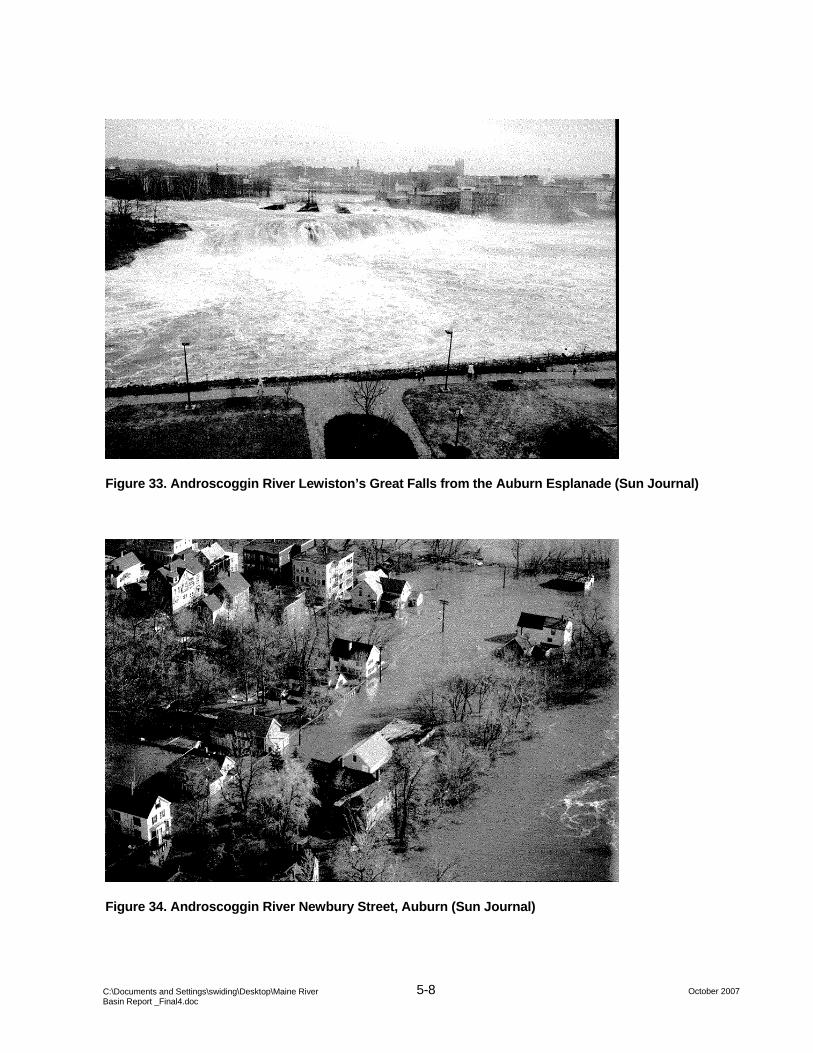
5.5.2 March/April 1987 The Androscoggin River Basin received approximately three inches of precipitation between March 31 and April 1, 1987. The rainfall was accompanied by warm temperatures and melting snowpack. Three days later, a second storm dropped approximately two inches of rain over the saturated basin. The resultant runoff caused the flood of record for the Androscoggin River Basin. Table 44 presents the observed stage, discharge, and recurrence interval (where available) for the March/April 1987 flood. The photos presented in Figure 32, Figure 33, Figure 34, Figure 35, Figure 36, Figure 37, and Figure 38 illustrate the extent of flooding at various locations along the Androscoggin River and tributaries. The USGS estimated the return period of the flows on the Androscoggin River and tributaries to be one hundred to five hundred years or greater.

5-7 October 2007 C:\Documents and Settings\swiding\Desktop\Maine River
Basin Report _Final4.doc
Table 44. Androscoggin River Basin, USGS Streamgage Peaks, March/April 1987
Station Name Stage Discharge
(cfs)
Estimated Recurrence
Interval (years)
01054200 Wild River at Gilead, Maine 13.03 17,000 10-25 01054500 Androscoggin River at Rumford, Maine 23.22 63,900 100-500 01055000 Swift River near Roxbury, Maine 12.54 15,900 25-50 01055500 Nezinscot River at Turner Center, Maine 10.2 11,600 100-500 01057000 Little Androscoggin River near South Paris, Maine 12.22 9,340 100-500 01059000 Androscoggin River near Auburn, Maine 23.71 103,000 >500
Figure 32. Androscoggin River at the Longley Bridge between Lewiston and Auburn (Sun Journal)
5-8 October 2007 C:\Documents and Settings\swiding\Desktop\Maine River
Basin Report _Final4.doc
Figure 33. Androscoggin River Lewiston’s Great Falls from the Auburn Esplanade (Sun Journal)
Figure 34. Androscoggin River Newbury Street, Auburn (Sun Journal)

5-9 October 2007 C:\Documents and Settings\swiding\Desktop\Maine River
Basin Report _Final4.doc
Figure 35. Androscoggin River, Durham, April 1987 (Sun Journal)
Figure 36. Androscoggin River, Jay – Livermore Falls, April 1987 (Sun Journal)

5-10 October 2007 C:\Documents and Settings\swiding\Desktop\Maine River
Basin Report _Final4.doc
Figure 37. Androscoggin River, Rumford, April 1987 (Sun Journal)
Figure 38. Androscoggin River, Miller Street and Road Block, Auburn, April 1987 (Sun Journal)

5-11 October 2007 C:\Documents and Settings\swiding\Desktop\Maine River
Basin Report _Final4.doc
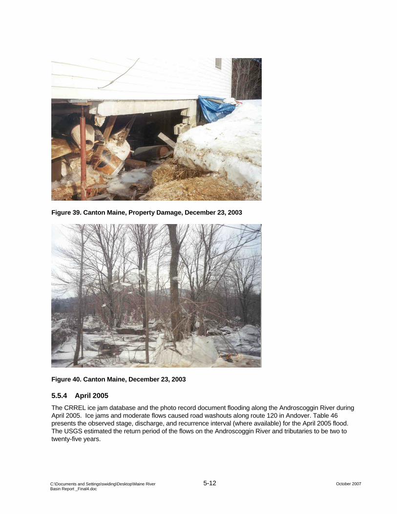
5.5.3 December 2003 In December 2003, moderate to high flows coupled with ice jams caused extraordinary flooding in Oxford County. Farmington and Rumford were inundated and Bethel was isolated due to road closures. Vulnerable portions of the town of Canton were purchased and moved as a consequence of this event. Table 45 presents the observed stage, discharge, and recurrence interval (where available) for the December 2003 flood. Figure 39 and Figure 40 illustrate the damage caused by the flood event. The USGS estimated the return period of the flows on the Ellis River to be one hundred to five hundred years.
Table 45. Androscoggin River Basin, USGS Streamgage Peaks, December 2003
Station Name StageDischarge
(cfs)
Estimated Recurrence
Interval (years)
01054200 Wild River at Gilead, Maine 12.06 15,000 5-10 01054300 Ellis River at South Andover, Maine 19.26 7,830 100-500 01054500 Androscoggin River at Rumford, Maine 14.56 35,200 2-5 01055000 Swift River near Roxbury, Maine 10.91 11,900 5-10 01055500 Nezinscot River at Turner Center, Maine 5.81 3,790 2-5 01057000 Little Androscoggin River near South Paris, Maine 8.82 3,470 5-10 01059000 Androscoggin River near Auburn, Maine 14.18 48,000 2-5
5-12 October 2007 C:\Documents and Settings\swiding\Desktop\Maine River
Basin Report _Final4.doc
Figure 39. Canton Maine, Property Damage, December 23, 2003
Figure 40. Canton Maine, December 23, 2003
5.5.4 April 2005 The CRREL ice jam database and the photo record document flooding along the Androscoggin River during April 2005. Ice jams and moderate flows caused road washouts along route 120 in Andover. Table 46 presents the observed stage, discharge, and recurrence interval (where available) for the April 2005 flood. The USGS estimated the return period of the flows on the Androscoggin River and tributaries to be two to twenty-five years.

5-13 October 2007 C:\Documents and Settings\swiding\Desktop\Maine River
Basin Report _Final4.doc
Table 46. Androscoggin River Basin, USGS Streamgage Peaks, April 2005.
Station Name Stage Discharge
(cfs)
Estimated Recurrence
Interval (years)
01054200 Wild River at Gilead, Maine 10.34 9,860 2-5 01054300 Ellis River at South Andover, Maine 17.67 5,180 5-10 01054500 Androscoggin River at Rumford, Maine 14.16 33,500 2-5 01055000 Swift River near Roxbury, Maine 9.41 8,820 2-5 01055500 Nezinscot River at Turner Center, Maine 8.72 8,630 25-50 01057000 Little Androscoggin River near South Paris, Maine 9.81 4,750 10-25 01059000 Androscoggin River near Auburn, Maine 16.44 58,500 10-25
Figure 41. Route 120 Washout in Andover Caused by Blocked Culvert, Maine April 5, 2005

5-14 October 2007 C:\Documents and Settings\swiding\Desktop\Maine River
Basin Report _Final4.doc
Figure 42. Route 120 Washout in Andover Caused by Blocked Culvert, Maine April 5, 2005
Figure 43. Route 120 Washout in Andover Caused by Blocked Culvert, Maine April 5, 2005

5-15 October 2007 C:\Documents and Settings\swiding\Desktop\Maine River
Basin Report _Final4.doc
5.5.5 July 2007 In July 2007, an unusually intense thunderstorm tracked up the Swift River basin into Bethel and Newry causing extensive localized damage. Culverts and bridges on Route 131 and Route 2 were washed out, the water supply from Bethel was destroyed, and the Sunday River Ski area sustained substantial damage. Rainfall estimates for this storm were four to seven inches over a period of two hours. [Additional information on this event was not available at the time of publication]