5. site 324 - deep sea drilling
TRANSCRIPT

5. SITE 324
The Shipboard Scientific Party1
SITE DATA
Position: 69°03.21'S, 98°47.20'WWater Depth: 4433 corrected meters, echo sounding;
4449 meters, drill pipe measurementNumber of Holes: 1Number of Cores: Attempted: 10Penetration: 218 metersTotal Length of Cored Section: 95.0 metersTotal Core Recovered: 48.1 metersPercentage Core Recovered: 51%Oldest Sediment Cored:
Depth Subbottom: 199.0 metersNature: Claystone fragments, coarse sandAge: PlioceneVelocity: 1.60 km/sec in firm clay at 174.6 meters sub-
bottom depthBasement: Not reachedPrincipal Results: A single shallow hole was drilled on the
lower continental rise. Fifty meters of Pliocene andPleistocene gray clay and minor claystone were recoveredfrom the 218 meters penetrated. Ice-rafted debris, commonin the upper part of the sequence, decreases with depth butis present throughout. An upper (50 m thick) acousticallylaminated unit corresponds to soft watery diatomaceousclay and ooze with abundant ice-rafted debris. This is un-derlain by an acoustically transparent layer which com-prises about 120 meters of gray unfossiliferous clay withsilt laminae and thin (<l cm) beds. A deeper acousticallystratified zone is composed of silty clay and sand beds. Itwas in this lower unit that sand plugged the bit causingabandonment of the hole.
Charles D. Hollister, Woods Hole Oceanographic Institution,Woods Hole, Massachusetts (Co-chief scientist); Campbell Crad-dock, University of Wisconsin, Madison, Wisconsin (Co-chief scien-tist); Yury A. Bogdanov, P.P. Shirshov Institute of Oceanology,U.S.S.R. Academy of Sciences, Moscow, U.S.S.R.; N. TerenceEdgar, Scripps Institution of Oceanography, La Jolla, California(Present address: U.S. Geological Survey, Reston, Virginia); Joris M.Gieskes, Scripps Institution of Oceanography, La Jolla, California;Bilal U. Haq, Woods Hole Oceanographic Institution, Woods Hole,Massachusetts; James R. Lawrence, Lamont-Doherty GeologicalObservatory, Columbia University, Palisades, New York; Fred Rögl,Eidg. Technische Hochschule, Zurich, Switzerland (Present address:Naturhistorisches Museum, Vienna, Austria); Hans-JoachimSchrader, Institut und Museum der Universitat Kiel, Kiel, Germany;Brian E. Tucholke, Lamont-Doherty Geological Observatory,Columbia University, Palisades, New York; Walter R. Vennum,Sonoma State College, Rohnert Park, California; Fred M. Weaver,Florida State University, Tallahassee, Florida; Vasily N. Zhivago,P.P. Shirshov Institute of Oceanology, U.S.S.R. Academy ofSciences, Moscow, U.S.S.R.
BACKGROUND AND OBJECTIVES
BackgroundSite 324 is located on the lower continental rise of
Antarctica, about 75 miles north of the base of the con-tinental slope (Figures 1 and 2). Water depth here isabout 4449 meters, but it decreases gradually and thenrapidly southward. The closest land is Thurston Island,about 160 miles to the south, and Peter I Island, about160 miles to the east. Technically, the site lies in theoceanic part of the Antarctic plate. A seismic profilethrough the site, parallel to bathymetric contours,Eltanin-42 (198) 2100 hr, 31 March 1970, shows a rela-tively thick (2.0 km) sedimentary sequence which in-cludes an acoustically transparent and lenticular near-surface layer about 200 meters thick (Figures 3, 4, and5).
Present knowledge of the geology of Antarctica hasbeen summarized in a series of recent geologic maps(Craddock, 1970, 1972). The rocks of coastal West Ant-arctica record a complex history of Phanerozoic sedi-mentation, volcanism, plutonism, metamorphism, andorogenic deformation; no rocks of definitely Pre-cambrian age are presently known. Several orogeniccycles have been identified, and the youngest is the An-dean of Cretaceous to early Tertiary age. Cenozoic vol-canic rocks are widespread in coastal West Antarctica.Peter I Island is a basaltic volcano, probably Miocenein age, and other seamounts are known near this site.Thurston Island consists of Paleozoic and Mesozoic ig-neous and metamorphic rocks. Upper Tertiary basalticextrusives rest upon a glaciated unconformity in theJones Mountains, just inland from Thurston Island.
Due to lack of magnetic profiles near Site 324, thepattern of magnetic anomalies has not been estab-lished. It appeared probable that the crust at this sitewas formed at the east Pacific-Antarctic Ridge. Becausethe axis of the east Pacific-Antarctic Ridge lies morethan 1000 miles away, the crust at Site 324 could be ofMesozoic age.
Scattered piston cores taken in the area recoveredsiliceous clayey silt, silty clay, and clayey silt. Goodellet al. (1973) give an average acculumation rate of 2.5cm/1000 yr for glaciomarine sediments on the con-tinental rise of Antarctica. However, even higher rateswere encountered at Sites 322 and 323 on the abyssalplain.
Site 324 lies nearly 600 miles south of the surface axisof the eastward-flowing Antarctic circumpolar current,but beneath the westward-flowing bottom counter-current (Hollister and Heezen, 1967). Kennett et al.(1972) reported a regional unconformity of Oligoceneage in the southwestern Pacific Ocean Basin which theyattribute to paleocirculation changes related to theseparation of Australia from East Antarctica and toglacial episodes in Antarctica.
127

SITE 324
RIDGE
FLANK
(after HeezenTharp, 1972)
Figure 1. Location of Site 324.
Evidence for Tertiary glaciation in the Jones Moun-tains (74°S, 94°W) was first reported by Craddock etal. (1964) and later summarized by Rutford et al.(1972). LeMasurier (1972) described the volcanichistory of Marie Byrd Land and postulated the ex-istence of a West Antarctic ice sheet since the Eocene.Margolis and Kennett (1970) studied the quartz grainsand foraminifers in 18 piston cores from the SouthPacific and inferred that Antarctica was glaciated dur-ing much of the time since the Eocene, but with a warmepisode in the Miocene. During DSDP Leg 28 glacio-marine sediments were found in holes in the Ross Sea,including beds as old as Oligocene at Site 270.
The Jones Mountains have yielded importantevidence for Miocene glaciation of ice-sheet dimensionsin this part of West Antarctica. Radiometric (K-Ar)ages on basaltic rocks overlying a fresh glacial pave-ment give discordant results, probably due to in-complete degassing of mantle-derived Ar40during sub-glacial eruptions. The calculated ages cluster in the 7-10m.y. range. Site 324 was strategically located to test theexistence of the postulated Miocene ice sheet in theregion of the Jones Mountains. Such an ice sheet
should have calved many bergs, which would havedrifted both northward and eastward; at least someshould have reached the vicinity of Site 324 anddropped their entrained rock debris to the sea floor.
ObjectivesThe main objectives at this site were: (1) to deter-
mine, if feasible, the age or a minimum age of the base-ment by drilling through or deeply into the thicksedimentary sequence; (2) to determine lithology,provenance, and processes of depositon that wereresponsible for building this portion of the continentalrise; (3) to seek evidence of Tertiary glaciation in Ant-arctica, especially during the period of 7-10 m.y.B.P.(late Miocene); (4) to understand the biostratigraphyand paleooceanographic environment of this region; (5)to obtain samples of pore waters for studies ofgeochemical gradients and halmyrolysis.
OPERATIONSThe ship arrived in the vicinity of Site 324 at ap-
proximately 2300 hr 12 March 1974 and slowed to 170rpm. At 2345 hr Glomar Challenger changed course to
128

BATHYMETRY OF THEBELLINGSHAUSEN BASINContours in uncorrtct d fathoms
105* lOO 95" 90 85°
Figure 2. Bathymetric map of the Bellingshausen region. (See also foldout in back cover.)

SITE 324
spuooθs
2345 LTAV0445Z
69°S
σL OCVJCNJ
oσoCO
oin
n
ooLf>^ 1 "
SITE 324-0112 Beacon away13 March 1974
ELTANIN 42
Figure 3. Eltanin-42 seismic profile in vicinityof Site 324 (approximately 69°03'S, 98°5θ'W). See Figure 4 for location.
0037 LT
B
98°45r
Figure 4. Glomar Challenger and Eltanin-42 track in thevicinity of Site 324. Arrow corresponds to arrow onEltanin profile, Figure 3.
160° for a final pass across the Eltanin-42 profiler track(Figure 3 and 4) prior to dropping the beacon (13.5 kHzO.R.E.) 0112 hr 13 March 1974. Figure 5 shows theGlomar Challenger profile approaching Site 324. Thebeacon reached the sea floor at about 0157 hr and thevessel stabilized over the site at about 0220 hr (4433 mcorrected echo sounding depth). Bottom contact wasmade with the drill pipe (1530 hr) at a depth of 4459meters below the rig floor. (The rig floor is 10 m abovethe sea surface.)
The first core was taken at 9 meters subbottom in un-consolidated pebble clay. The rest of the cores, exceptthe last one which contained sand and claystone, con-sisted of soft silty clay with thin lenses and laminae ofwell-sorted silt. Coring rates dropped sharply fromnearly 5 meters per minute at 9-18 meters subbottom(Core 1) to 1.5 meters per minute at 50 meters (Core 2)and remained at about 1 meter per minute to the bot-tom of the hole (218 m total depth).
A total of 10 cores (9.5 m each) was attempted in thehole. Recovery averaged 51% for the entire hole andranged from 0% to 100%. The core bit becameplugged with sand shortly after cutting Core 10, and asthe hole appeared to be collapsing and filling it wasnecessary to terminate drilling. The end of the corebarrel was found to be highly polished, and a few grainsof fine sand were found adhering to the empty coreliner (Core 10). Apparently a sand and claystone for-mation with clean, unconsolidated sand had collapsedinto the hole. Coring at Site 324 is summarized in Table1.
LITHOLOGY
Site 324 was drilled to 218 meters in acoustically non-laminated sediments on the lower continental rise and
130

SITE 324
SITE324
r DU D
I I I
uncons. pebbly,1 diatomaceous clay
IIclay withs i l t laminae
TTT claystone, sand,or silt beds
10I
Figure 5. Glomar Challenger seismic profile approachingSite 324, see Figure 4 for location. Acoustic units (I, II,III) are discussed in text.
the deepest sediment recovered was at 189.5 to 199meters. The deepest, unsuccessful core (10) containedonly traces of coarse sand, and the hole collapsed whenthe interval was penetrated; the combined evidencesuggests that the drill string had penetrated coarse, un-consolidated sand underlying the nonlaminatedsediments (see Tucholke, Edgar, and Boyce, thisvolume).
The sediment recovered is remarkably uniform inlithology, and the entire sequence is discussed as oneunit. Cores 1 through 9 contain gray Pliocene toPleistocene clays with scattered ice-rafted debris andwell-sorted silt and sand in beds, stringers, and podscreated by drilling disturbance. Diatom clays and oozeswere found only in Core 1; both diatoms andradiolarians are rare in deeper sediments.
Figure 6 graphically presents estimates of the prin-cipal components as determined from smear slides.
Silt-sized quartz is ubiquitous in the clays, usually inamounts of 5%-10%. The clays are mostly structure-less, although a few trace fossils are present. Colorchanges in the clays are normally subtle andgradational, but are occasionally sharp. Very wellsorted laminae and 0.5 to 1.0 cm thick beds of quartzsilt were found in most cores. Their frequency appearsto be inversely related to the amount of ice-rafteddebris in the cores.
In addition to quartz, the layers contain heavy andopaque minerals, feldspar, and mica. Rock fragmentsare present in some cores. Even where core disturbancewas not severe, primary structures were seldom ob-served in the silt layers. Occasionally, alternatinglight/dark, silt/clay laminae form the beds. Upper andlower contacts are invariably sharp.
The clays in Core 8-3 (174 m) show incipient indura-tion to claystone, but are still pliable. A clay gall inCore 8, Section 2 and silt and clay beds in Core 9, Sec-tion 1 and 9, CC are weakly silicified.
Sedimentation ProcessesThe Pliocene and Pleistocene sediments recovered at
Site 324 exhibit the strongest evidence for bottomcurrent activity that was encountered during Leg 35.Nearly every core contains quartz-silt and sandy-siltlayers (contourites) interbedded in terrigenous clay andranging from a few millimeters to about 1 cm inthickness. The layers have sharp upper and lower con-tact, generally show excellent sorting, but rarely exhibitinternal structure. A few are faintly laminated becauseof thin, dark mineral placers or clayey laminae. Sizegrading was not observed in the beds, and heavyminerals are usually present in amounts of 5%-10%.
Site 324 lies beneath the westward-flowing counter-current on the continental rise and the cores were allrecovered from a section of acoustically nonlaminatedsediment (Heezen and Hollister, 1964). Sediment withthis acoustic character on the rise appear to be con-fined to channel levees; the limited profiler data nearthis site do not show clearcut evidence for an adjacentchannel (Tucholke and Houtz, this volume), although abroad trough exhibiting highly reflective sediments eastof the site may represent a primary path of turbiditedispersal.
Although the texture and structure of the silt layersappear to present strong evidence for their current-controlled origin, the mechanism of formation can betwofold. They may have been formed as placer depositsby winnowing of fines from silty clay, or they may havebeen deposited from contour-following currents whichpirated sediment placed in suspension by turbiditycurrents (Hollister and Heezen, 1972); when the currentis not competent to carry the material entrained, itdeposits it as a laterally graded bed downstream fromthe channel. Ideally, slight vertical grading also wouldbe present in the bed, with the finest material at the toprepresenting the limit of competence of the bottomcurrent.
If the silt beds were formed as placer deposits by win-nowing of silty clay, we would expect the frequency andthickness of the silt beds to increase in siltier sediment.However, as shown in Figure 7, there is no correlationbetween bed frequency and percent silt-in-clay, and bedthickness shows no correlative trend. In addition, thebeds commonly contain a small fraction of sand (>62µm), whereas the interbedded clays contain no sand.One exception is the clays containing ice-rafteddetritus, but silt beds are not observed in these inter-vals.
The alternative explanation, deposition of turbidity-current-derived sediment by contour currents, is moresatisfactory. Variations in the intensity of contour-
131

SITE 324
TABLE 1Coring Summary, Site 324
Core
123
4
5
6789
10
Total
Cored Interval
TotalDepth (m)
4468.04477.54506.0-4515.54534.5-4544.0
4563.04572.5
4591.5-4601.0
4601.04610.54610.54620.04629.54639.04648.54658.0
4667.54677.0
4677.0
SubbottomDepth (m)
9.0-18.547.0-56.575.5-85.0
104.0-113.5
132.5-142.0
142.0-151.5151.5-161.0170.5-180.0189.5-199.0
208.5-218.0
218.0
Cored(m)
9.59.59.5
9.5
9.5
9.59.59.59.5
9.5
95
Recovered(m) (%)
8.1 859.7 1008.3 87
5.0 53
4.5 47
2.0 215.6 594.2 440.7 7
0.0 0
48.1 51
Lithology
Clay and diatom oozeClay with silt stringersClay with silt stringers
and podsClay with silt layers
and podsClay and interbedded
silt and clayClay with silt layersQuartz-silty clayClay with interbeddes siltClay and claystone with
ice-rafted debrisNo recovery except for
fine sand on core liner
Age
PleistocenePleistocenePleistocene
Pleistocene
?
?77
Pliocene
_
Recovery of total sequence penetrated = 22%.
current flow and in the magnitude of turbidity currentscan account for the variability in the silt-layer thick-ness, development of internal structure, and mediangrain size (fine to coarse silt). In this instance, each siltlayer results from a discrete turbidity current traversingthe continental rise upcurrent from the site. At the ob-served accumulation rates (5.5 cm/1000 yr average), thefrequency of silt beds suggests turbidity currents asfrequent as one per 500 yr, but at a lower average rateof about one per 2000 yr during the Pliocene (Figure 7).These are minimum frequencies because all turbiditycurrents may not result in deposition of a recognizablecontourite down-current from the turbidite channel.
Structures generally cannot be recognized in the clay-size sediment recovered, although faint colorlaminations and contacts occur locally. Trace fossils arevery rare. It is likely that most of the clay was depositedfrom a current-maintained nepheloid layer duringperiods of less intense bottom current activity.
The grain size data for Site 324 clays show dramaticevidence for hydraulic sorting in the form of verysymmetrical sigmoid curves typical of well-sortedmaterial (see Tucholke, Hollister, Weaver and Ven-num, this volume). This is the only site dominated bysediment exhibiting this characteristic, and we interpretthe data to represent clayey contourites. Unfortunately,no detailed grain size analyses were made on thecoarser contourite silts; however, one sand-silt-claydetermination made on a contourite silt in Sample 7-6,133 cm showed that the size-class percentage are 0-86-14. This is very well sorted silt (14% less than 4 µm) andis clean compared to matrix values for abyssal tur-bidites (Hollister and Heezen, 1967); the data thus sup-port our contourite interpretation of the silt.
GEOCHEMISTRY
The mineralogy of this site is dominated by aterrigenous suite of minerals. Minor amounts of clinop-tilolite were noted in the sediments above 110 meters
(Gorbunova; Zemmels and Cook, this volume). Itspresence is possibly a result of alteration of minoramounts of volcanic glass which was also present inthese sediments.
Concentration gradients of calcium in the interstitialwater suggest reactions of an undefined nature, butpossibly related to alteration of volcanic debris. Theobserved oxygen isotope gradients do not require an ex-planation related to extensive alteration.
A source for dissolved calcium was present in thePliocene/Pleistocene sediments, leading to a maximumconcentration at about 115 meters. This may be due tothe same processes active at Sites 322 and 323 in similarhorizons. Small amounts of clinoptilolite (Zemmels andCook, this volume) and glass shards, however, could in-dicate alteration of volcanic matter. Changes in δθ 1 8
are relatively large. Unfortunately, we do not knowmuch about the nature of the underlying sediments, sothat interpretations of interstitial water compositionare necessarily hampered.
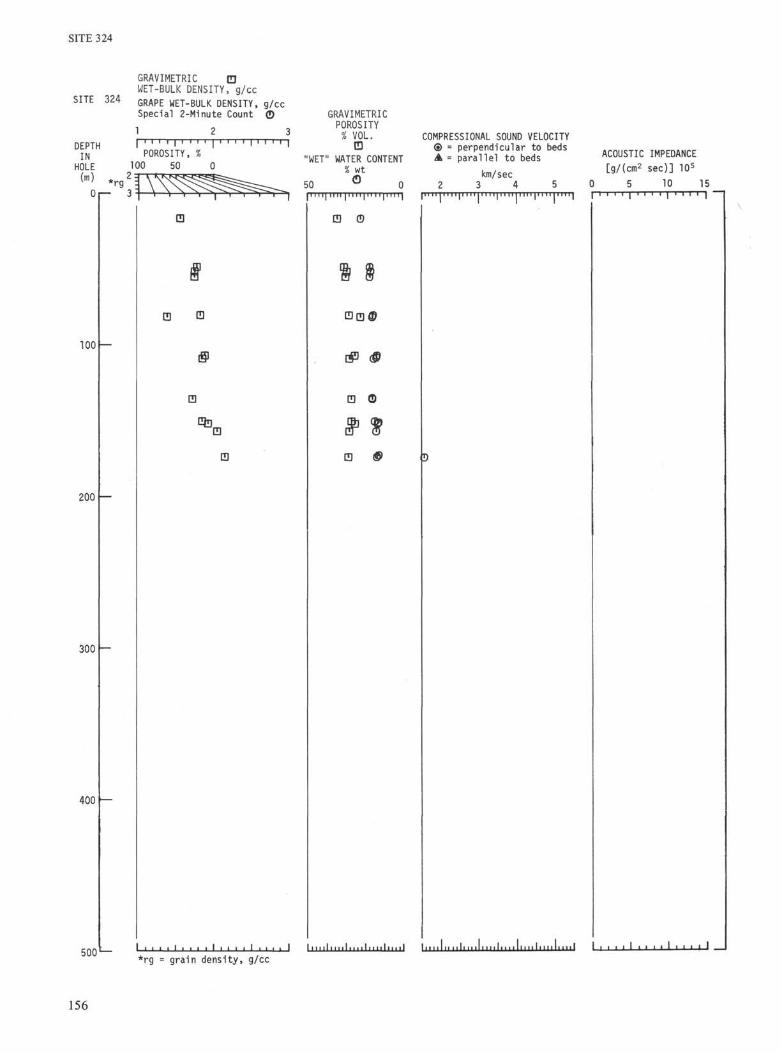
PHYSICAL PROPERTIES
Syringe measurements of water content, saturatedbulk density, and porosity, as well as GRAPEmeasurements of saturated bulk density (continuousmode), were made on Cores 1-8 (Table 2 and Figure 8),but only Cores 6 and 8 contained firm sediment with lit-tle deformation. The other cores exhibited moderate tointense deformation, and the measurements made onthese sediments are not considered reliable.
Unfortunately, deteriorating hole conditionsforced abandonment of this site before many cores wererecovered from the deeper, firmer clays of the sedi-mentary column.
Saturated Bulk DensityGamma Ray Attenuation Porosity Evaluator
(GRAPE) determinations of saturated bulk density(±11%) are plotted in Figure 9. An estimated grain den-
132

SITE 324
KEY TRACE-RARE < 5
SMEAR SLIDE SUMMARY SITE 324 SL itDOMINANT 75-100 |
EXOGENIC J X Z AUTHIGENIC-DIAGENETIC BIOGENIC
Figure 6. Estimate of principal components from smear slides, Site 324.
sity of 2.61 g/cm3 (collapsed montmorillonite) was usedin these determinations. The wide scatter of valuesreflects the variability of deformation in the cores.
Syringe determinations (±5% relative error) ofsaturated bulk density have a similar scatter, again
reflecting core deformation. However, the syringevalues tend to be higher than the GRAPE values.Probably the most accurate values of saturated bulkdensity are 1.73 to 2.16 g/cm3 in the nearly undeformedsediments of Cores 6 and 8. Bulk density increases
133

SITE 324
KEY TRACE-RARE < 5
SMEAR SLIDE SUMMARY SITE 324 [EL illDOMINANT 75-100
EXOGENIC ^ ^ ^ AUTHIGENIC-DIAGENETIC I BIOGENIC
* ' • ' ' • ' I ' • • 1—1 > 1 I I I I I I 1—I 1 I I I I . L - J ' ' ' • • ' ' ' ' ' ' ' • ' ' ' ' I I
Figure 6. (Continued).
downhole, from 1.56 g/cm3 at 16 meters to about 1.9g/cm3 at 150 meters; the latter values also are com-parable to those of deeper diatom-free sediment at Sites322 and 323.
Water Content and PorositySyringe determination of water content (% wet
weight; 2% absolute error) and porosity (±4% absoluteerror) are slightly more consistent than determinationof saturated bulk density (Figure 8), although the in-tense deformation in the uppermost cores undoubtedlyaffects the measured values. Water content and porosi-ty both decrease rapidly in the first 70 meters of hole,but at a lesser rate below. The values in the lower partof the hole (25% water content and 50% porosity) ap-proach those found at depths of several hundred metersat Sites 322 and 323. Diatoms are very rare in all thecores except Core 1, and their absence probably ac-counts for the low porosity and water content at theshallow depths.
Only one sonic velocity measurement was made onthe virtually undeformed sediments of Core 8, Section 3at 110 cm. The value obtained (1.60 km/sec) per-pendicular to the bedding in firm clay at 174.6 meterssubbottom is probably somewhat higher than the aver-age Vp for the overlying unconsolidated sediments. Thesample was a very firm clay, and adjacent clays ex-hibited incipient induration to claystone.
134
INTERPRETATION OF SEISMIC PROFILESIN VICINITY OF SITE 324
Site 324 was drilled 218 meters into a wedge of non-laminated sediment on the continental rise (Figures 3and 4). The prolonged, reverberant character of the air-gun signal is repeated in the sea-floor reflection, but asingle reflection event at about 0.05 sec subbottom doesnot match the pulse character and appears to be a realreflector. Acoustically laminated sediment at about0.23 sec subbottom underlies the sediment drilled.
Physical properties measurements were made only onthe unconsolidated and slightly consolidated clayswhich comprise the bulk of sediment cored at Site 324.Small samples of partially silicified quartz silt andclaystone were recovered just below 190 meters in Core9. The last core attempted at this site (Core 10) failed torecover any sediment except a trace of sand; thisfailure, and the high polish on the core barrel, suggestthat a thick interval of unconsolidated sand was pene-trated. Thus the sediments represented by Cores 9 and10 are the first deviation from unconsolidated clay sedi-ments in the hole, and they may correspond to the topof the acoustically laminated sediment at 0.23 sec in theprofiler record. The acoustic lamination of the intervalbelow 0.23 sec is similar to that caused by interbeddingof unconsolidated sand, silt, and clay in the upper 300meters of Sites 322 and 323. If the boundary between

SITE 324
SITE 324
Average no. of s i l t beds/m I c e - r a f t e d
9.0
56.5
75.5
85 .0
104.0
113.5
132.5
142.0
142.0
151.5
151.5
161.0
170.5
180.0
189.5
section10 20
debrisAR C AB
t>4 µm in c lay and ooze
10 20 30 40
'".-I
10 20 30
A = AbsentR = RareC = Common
AB = Abundant
Figure 7. Relative abundance of clastic debris with respectto average number of silt beds and depth as determinedfrom smear slides.
the two units is placed at the level where silicified sedi-ment was first recovered, a minimum average velocityof 1.66 km/sec for the nonlaminated layer is indicated;if the boundary were as deep as Core 10 (208.5 m), theinterval velocity would be 1.81 km/sec. The only directvelocity measurement was 1.60 km/sec on the con-solidated clay at 176.4 meters. This value, if correctedfor overburden stress, hydrostatic pressure, and tem-
perature to in situ conditions, probably would be onlyslightly higher than the first of the above average inter-val velocities, suggesting that it is the better estimate.Two sonobuoy profiles recorded over nonlaminatedsediments adjacent to this site suggest a similar lowvelocity. The sonobuoy closest to Site 324 (E42-47) wason the eastern edge of the nonlaminated sedimentwedge; it indicates an interval velocity of 1.68 km/secfor the upper 473 meters of sediment. The intervalvelocity for the nonlaminated layer alone is probablyslightly lower.
The apparent reflector at 0.05 sec probably lies atabout 40 meter depth. We have no velocity or im-pedance measurements in this interval, but the reflectormay relate to the marked changes in density and indrilling/coring rates near this level. The sediments inthe upper 40-50 meters are lithologically dissimilar tothe deeper clays in that they are enriched in diatomsand ice-rafted debris.
BIOSTRATIGRAPHY
ForaminifersOnly a small number of left-coiling Neoglobo-
quadrina pachyderma and of Globigerina quinquelobawere found in the Pliocene sediments within Cores 5 to
Calcareous NannoplanktonNo calcareous nannoplankton were found in cores
recovered at Site 324.
RadiolariansSixty-five samples were examined for radiolarians
from the first nine cores (Table 3). Forty-eight of thesamples analyzed between 324-1, CC and 324-9-1 aretotally barren of any radiolarian remains. Only the corecatcher of Core 9 and Core 1 contain any radiolarians.
TABLE 2Summary of Physical Properties, Site 324
Sample(Interval
in cm)
1-5, 135-1502-1, 1132-3, 1052-6,0-1534,543-5,0-154-3, 3644,0-1544,865-2, 135-1505-3,556-6, 1397-0, 0-157-1,7374, 1248-2, 135-1508-3, 1018-3, 110
EstimatedDepth
(m)
16.3548.6351.5555.0080.5481.50
107.36108.50109.36135.35136.05150.89151.50152.43157.44173.35174.51174.60
Velocity(km/sec)
II Beds iBeds
1.60
GRAPE Special2-Min Count
Sat. BulkDensity (g/cc)
II Beds 1 Beds
Sat.Bulk
Density(g/cc)a
1.561.781.751.751.83
1.89
1.86
1.731.86
1.94
WetWater
Content(%)
4435333431312627303131282425272426
GrainDensity(g/cc)a
2.823.042.822.872.89
2.78
2.94
2.552.83
2.84
Porosity(%)a
6962596056
50
56
5353
49
Impedance
(gjcrvr sec)× 105 Lithology Remarks
Intensely deformed clayIntensely deformed clayIntensely deformed clayIntensely deformed clayIntensely deformed clayIntensely deformed clayModerately deformed clayModerately deformed clayModerately deformed claySlightly deformed claySlightly deformed claySlightly deformed clayGassy clayGassy clayGassy claySlightly deformed claySlightly deformed clayFirm clay
aSyringe values.
135

SITE 324
WATERCONTENT
20I I
40 60 40i i I I
POROSITY60 80 1.4
I I
SATURATEDBULK
DENSITY
1.8 2.2I REFLECTORS
\\
100-it .1
2 0 0 -i i i I L
% wetweight
\
I i I i I
g/cm3
300 —
400-
0.05
0.23
0.24
0.39
NONL
AMIN
ATED
£
SEMI
LAMI
NATE
D /
AC
COUS
TICA
LLY
DRILLINGAND CORING
RATE
0I I I I i
Coring
Drilling
LITHOLOGIC
SUMMARY
i 'I i i i
meters/min
UNCONS.OL-IDATEDSAND,SILT, ANDCLAYINTERBEDDED
CONSOLI-DATEDSEDIMENTS
500 —
Figure 8. Summary of physical properties, acoustic character and lithology of sediments at Site 324. Velocities are thosemeasured perpendicular to bedding or on unoriented samples. Relative strength of reflectors is indicated by heavysolid lines (strongest) to dotted lines (weakest), and depth of each reflector (in seconds reflection time) is indicated.All physical properties values were determined by the syringe technique.
Core 1, Section 1 is of Pleistocene age, and twobiostratigraphic zones defined by Chen (1975) arerecognized. Samples 324-1-1, 143-145 cm through 324-1-2, 53-55 cm fall within the Antarctissa denticulataZone, while the Saturnalis circularis Zone extends fromSamples 324-1-2, 138-140 cm through 324-1-6, 128-130cm.
Most samples from Core 1 contain the typical Qua-ternary Southern Ocean radiolarian assemblage whichconsists of Antarctissa denticulata, A. strelkovi, Styla-tractus neptunus, Lithelius nautiloides, Spongothrochusglacialis, Spongodiscus osculosus, Saccospyris ant-arctica, Triceraspyris antarctica, Stylodictya validi-spina, Spongoplegma antarcticum, Peripyramis circum-texta, Prunopyle antarctica, Cycladophora davisiana,and Spongurus pylomaticus.
The Stylatractus universus Zone of Chen (1975) is notrecognized in Core 324-1, although this species wasfound in the Saturnalis circularis Zone.
Sample 324-9, CC contains a few moderately wellpreserved radiolarians diagnostic of an early Plioceneage, but this age determination is very questionablebecause the hole was collapsing while Core 9 was beingtaken. Downhole contamination from radiolarian-richstringers between the coring intervals cannot be ruledout even though much of the sediment at Site 324 wasbarren.
SilicoflagellatesDetailed study of Core 1, Section 5, which contains
well-preserved siliceous microfossils, revealed thefollowing silicoflagellate species: Cannopilus binoculus,Distephanus speculum (long-spined variety), D. poly-actis, and D. quinquangellus. This assemblage is tenta-tively placed in the middle Pliocene Distephanus bolivi-ensis Zone. Some unidentifiable silicoflagellate frag-ments were found in Core 9. All other samples werebarren.
136

SITE 324
1.3 1.4 1.5
SATURATED BULK DENSITY (g/cmJ)
1.6 1.7 1.8
SITE 324
1.9 2.0 2.1 2.21.2
10
20
30
40
50
60
70
80
90
100
Q.
Q
no
120
130
140
150
160
170 =
180-
190
200
•• GRAPE (continuous mode)
Δ Syringe
Figure 9. Saturated bulk density with respect to depth determined from the Gamma Ray Attenuation Porosity Evaluator(GRAPE) and syringe technique.
1 1
B •
_
Intensely disturbed gray
-
-
-
Moderately to intenselydeformed clay
Weakly deformed clay~T
i i
• Δ•
•
clay
Drill ing->r'
=
Slurry
Intensely deformed clay
Weakly deformed clay
Gassy
Weakly — Tdeformed clay I
No measurements
Core: P be inaccurate
Drilling-—"*"" 'slurry
i
Soupy,core
•
1
•
••
•
intensely
•ΔΔ
•
•
•
Δ
i i i i
disturbed
Peak
Moderately to intenselyΔ deformed clay
ΔΔ •
•
ΔL ,.| Δ
•
CORE
NO.
1
2
3
4
5
6
7
8
9
Diatoms
The sediments recovered in Cores 1 through 9 consistof terrigenous clays and silty clays with thin layers ofwell-sorted silt. Thin intervals of Cores 1, 4, and 9 arecomposed of diatom ooze to diatom-bearinghemipelagic clays. Samples 1-1, 141 cm to 1-4, 37 cmbelong to the Nitzschia kerguelensis Zone of Abbott (inpress) (uppermost part of the Brunhes normal epoch),the Fragilariopsis kerguelensis Partial Range Zone ofDonahue (1970), (0.35 m.y.B.P.), and the Coscinodiscus
lentigenosus Partial Range Zone of McCollum (1975).Reworked older fossils, such as Denticula hustedtii andActinocyclus ingens, occur in trace amounts through-out this core. The top of Core 1 (at 9 m) to 14 meterssubbottom is therefore younger than 0.35 m.y.B.P.based on the upper boundary of Donahue's (1970)Rouxia californica Partial Range Zone.
The interval between Sample 1-4, 66 cm to 1-5, 69 cmis correlated to the Rouxia California Partial RangeZone of Donahue (1970) and is 0.35-0.66 m.y. in age,on the basis of rare occurrences of Rouxia californica.
137

TABLE 3Occurrence of Radiolarians at Site 324
SITE 324
138

SITE 324
The interval between Sample 1-5, 103 cm throughSample 4-2, 66 cm is placed into the A ctinocyclus ingensPartial Range Zone of Donahue (1970) which ischaracterized by the occurrence of A ctinocyclus ingens(upper boundary as 0.66 m.y.B.P.) and into theCoscinodiscus elliptopora/'A ctinocyclus ingens Con-current Range Zone of McCollum, 1975 which hasbeen dated by paleomagnetic stratigraphic correlationto a radiometric time scale as being 0.7 to 1.6 m.y.B.P.All samples below Core 4 are nearly barren of diatomsexcept 9, CC which contains a moderately well pre-served diatom assemblage with low species diversity.
Denticula hustedtii and Trinacria excavata are inter-preted as being reworked because Cosmiodiscus insig-nis and Nitzschia kerguelensis are still present. Thissample is placed into the Cosmiodiscus insignis PartialRange Zone of McCollum (1975) and is correlative tothe upper part of the Gauss normal epoch and is ap-proximately 2.43 to 2.82 m.y. in age.
RATES OF SEDIMENT ACCUMULATIONSediment accumulation rates cannot be effectively
determined for this site. Core 1 provides a date of 0.7-l!6 m.y. (Matuyama) based on radiolarian species. Thisgives us a minimum sedimentation rate of 11.2 cm/1000yr and a maximum of 25.6 cm/1000 yr for the first core(Figure 10). (The rates are based on the assumptionthat no hiatus occurs between the sediment-water inter-face and the bottom of Core 1.)
The remainder of the cored interval does not pro-vide sufficiently good dates from paleontological data.However, in Sample 9, CC scattered fragments of onePliocene radiolarian species were found. However,these fragments could easily have been reworked andeven if they are autochthonous, the age of 9, CC can beplaced anywhere between 1.8 and 5 m.y.B.P. At best,we can only be certain that sediment accumulationrates ranged between 4.3 and 17.3 cm/1000 yr.
ioo-
200-
5.5 cm/1000 yr.
SITE 324
Figure 10. Rate of sediment accumulation, Site 324.
SUMMARY AND CONCLUSIONS
SummarySite 324 is located at 69°03.21'S, 98°47.20'W on the
lower continental rise of Antarctica, about 75 milesnorth of the base of the continental slope. The singlehole drilled at this site reached a total depth of 218meters before hole cavings of loose sand forced itsabandonment. The entire sequence penetrated consistsof Pliocene and Quaternary sedimentary deposits. A
total of 95.0 meters was cored, and 48.0 meters (51%) ofcore were recovered. The results of drilling are summa-rized in Figure 11.
The sedimentary materials recovered in Cores 1through 9 are rather uniform and can be treated as asingle lithologic unit. Almost all the sediment recov-ered consists of terrigenous clays and silty clays withthin layers of well-sorted silt; a small part of Core 1 iscomposed of diatom ooze. Detrital silt-sized quartz is aminor component in most of the clays. Silt layers,mainly 0.5 to 1.0 cm thick, are common throughout thesequence; they consist largely of quartz with minoramounts of feldspar, mica, heavy minerals, opaqueminerals, and rock fragments. Ice-rafted detritus iscommon in the upper part of the sequence, but itappears to decrease with depth. There was no recoveryin Core 10, but grains of sand on the core liner,scratches and polish on the outside of the core barrel,and caving of the hole suggest that an unconsolidatedsand layer was penetrated at the bottom of the hole.
Seismic profiles near Site 324 show a near-surfaceacoustically transparent layer (about 150 m thick)overlain by a thin reverberant layer and underlain by avery thick acoustically reverberant layer (about 500 mthick). These three seismic units have been identified inthe sequence penetrated, and they are numbered indescending order. Unit I is the surficial reverberantlayer, about 40 meters thick; Core 1 shows that this unitconsists of soft, watery clay with minor diatomaceousooze. Unit II is the acoustically transparent layer about150 meters thick; Cores 2-7 indicate that this unit iscomprised of unconsolidated gray clay with thin siltlayers. Unit III is the lower reverberant layer at least 48meters thick; Cores 8-10 suggest that this unit is com-posed of claystone and sand beds.
Most fossils were recovered from Cores 1 and 9; theintervening cores are barren except for a fewforaminifers {Neogloboquadrina pachyderma) and somediatom fragments. Core 1 is dated as Pleistocene on thebasis of abundant diatoms of the Nitzschia ker-guelensis and Rouxia californica zones, radiolarians ofthe A. denticulata and S. circularis zones, and silico-flagellates of the Distephanus boliviensis Zone. Thelower part of Core 1 through Core 4 is also Pleistoceneand belongs to the diatom A ctinocyclus ingens Zone.Core 9 is considered to be Pliocene on the basis ofdiatoms of the Cosmiodiscus insignis Zone and a fewradiolarians.
A 15-cm sample was taken from each of seven coresfor geochemical studies. Measurements were obtainedon formation factor, water content, porosity, and cer-tain chemical properties. Water contents in the upper-most 200 meters are lower here than at Sites 322 and323. Downhole increases in formation factor and in dis-solved ammonia were noted, along with decreases inwater content, porosity, and dissolved silica andmagnesium. The value of pU rises slightly at first, butstabilizes near 8 at greater depth. Values of alkalinityand dissolved calcium increase with depth in the upperpart of the hole and then decrease below 150 meters.
ConclusionsThe sequence penetrated at Site 324 may comprise an
uninterrupted section representing most of the Pliocene
139

SITE 324
Site 324 Water Depth 4449 m Lat. 69°03.2'S Long. 98°47.2'W
LITHOLOGY
Unit
zszszszszz o
Description
Clay anddiatom ooze,olive gray
Clay:gray,withsilt and ice-rafted gravel
Clay:gray,with
silt poαs.
Clay:olivegra,with silt pods
Clay: gray tobrownish grayto bluish gray,with silt1ayers
Clay:gray,withsilt layersand claystonefragments.
Claystonefragments,sand, pebbles
No recoveryprobably sand
AverageBiogenicComponent
BIOSTRATIGRAPHY
Diatoms RadiolariansSilico-
flagellates Forams
ENVIRONMENTOF
DEPOSITION
+-> α> α>•i- O i .
S_ T 3 CD <U
•r O U+>
c t/> C res<u +->••- o
•i-> s- o oc s- c i—
TOTAL DEPTH 2 1 8 . 0 m
Figure 11. Lithologic and biostratigraphic summary, Site 324.
and Quaternary time. Core 9 from near the bottom ofthe hole yielded Pliocene microfossils. Goodell et al.(1973) gave 2.5 cm/1000 yr as a mean accumulationrate for glaciomarine sediments on the continental riseof Antarctica; accumulation at this rate will produce125 meters in 5 m.y. A somewhat higher rate, however,occurred at Site 324, inasmuch as the Pliocene-Qua-ternary sequence appears to be at least 200 metersthick.
The processes by which the clays, silty clays, and siltsat this site were deposited are not fully understood. Thegeologic location and composition of the sedimentsshow that these detrital materials were derived fromAntarctica. These beds are similar to those in the con-tinental rise along the Atlantic coast of North Americawhere both turbidity currents and contour currents areimportant agents of sediment transportation anddeposition. Interbedded clays and well-sorted silt bedsmay be laterally graded beds deposited by contourcurrents.
Several pronounced changes occurred in thedepositional environment at this site during the last 2m.y. There was a sharp upward decrease in the numberof silt layers deposited, perhaps indicating a dimin-ished importance of contour currents. Moreover, therewas a complementary increase in the abundance of ice-rafted detritus and diatoms abounded in great
numbers. (Diatoms were not found in the underlyingbeds.)
These changes in sedimentation pattern are probablyrelated to changes in the extent of the Antarctic icesheet, but their exact significance is not clear. The in-crease in ice-rafted debris may imply a more vigorouscontinental glaciation during the Quaternary than dur-ing the Pliocene. On the other hand, the appearance ofdiatoms may indicate the disappearance of pack-ice,which existed during the Pliocene, from this site duringthe Quaternary, suggesting that the Antarctic ice sheetwas diminishing during Pliocene time. The relation-ship between the abundance of silt layers and the extentof glaciation, if any, is unknown. Because the hole didnot penetrate beds older than about 5 m.y., it was notpossible to seek marine evidence for the postulated lateMiocene glaciation in the Jones Mountains to thesouth.
Geochemical gradients rather similar to those ob-served at Sites 322 and 323 were detected at Site 324.The shallow depth of penetration and the inferred greatthickness of sediments, however, make the inter-pretation of these gradients difficult. Thus it is not clearwhether or not the gradients at this site are related tobasement alteration.
Since drilling penetrated only a small fraction of thesedimentary sequence, the age of basement remains un-
140

SITE 324
known. Major uncertainties about the true thickness ofthe total sedimentary sequence and about the range ofaccumulation rates preclude a meaningful estimate ofbasement age by this method. The great thickness ofthese sediments (estimated at about 1900 m) and thegreat depth to basement (about 7 sec below sea level),however, suggest a probable Mesozoic or early Tertiaryage for basement.
REFERENCESAbbott, W.H., in press. Temporal and spatial distribution of
Pleistocene diatoms from the southeast Indian Ocean:Nova Hedwigia.
Chen, P., 1975. Antarctic Radiolaria, Leg 28, Deep Sea Drill-ing Project. In Frakes, L.A., Hayes, D.E., et al., InitialReports of the Deep Sea Drilling Project, Volume 28:Washington (U.S. Government Printing Office), p. 437-513.
Craddock, C. (Ed.), 1970. Geologic maps of Antarctica, Folio12, Antarctic Map Folio Series: New York (Am. Geogr.Soc).
, 1972. Geologic map of Antarctica, Scale1:5,000,000: New York (Am. Geogr. Soc).
Craddock, C, Bastien, T.W., and Rutford, R.H., 1964.Geology of the Jones Mountains. In Adie, R.J. (Ed.), Ant-arctic geology; Amsterdam (North Holland Pub. Co.),p. 171-178.
Donahue, J.G., 1970. Diatoms as Quaternary biostrati-graphic and paleoclimatic indicators in high latitudes ofthe Pacific Ocean: Ph.D. thesis, Facility of Pure Science,Columbia University.
Goodell, H.G., Houtz, R., Ewing, M., Hayes, D., Naini, B.,Echols, R.J., Kennett, J.P., and Donahue, J.G., 1973.
Marine sediments of the southern oceans, Folio 17, Ant-arctic Map Folio Series: New York (Am. Geogr. Soc).
Heezen, B.C. and Hollister, CD., 1964. Deep-sea currentevidence from abyssal sediments: Marine Geol., v. 2,p. 141-174.
Heezen, B.C. and Tharp, M., 1972. Morphology of the seafloor, Folio 16, Antarctic Map Folio Series: New York(Am. Geogr. Soc).
Hollister, CD. and Heezen, B.C., 1967. The floor of theBellingshausen Sea. In Hersey, J.B. (Ed.), Deep seaphotography: Baltimore (Johns Hopkins Press), p. 177-189.
Hollister, CD. and Heezen, B.C., 1972. Geologic effects ofcontour currents: western North Atlantic. In Gordon, A.L.(Ed.), Studies in physical oceanography: New York (Gor-don and Breach), v. 1.
Kennett, J.P., Burns, R.E., Andrews, J.E., Churkin, M., Jr.,Davies, T.A., Dumitrica, P., Edwards, H.R., Galehouse,J.S., Packham, G.H., and van der Lingen, G.J., 1972.Australian-Antarctic continental drift, paleocirculationchanges and Oligocene deep sea erosions: Nature, v. 239,p. 51-55.
LeMasurier, W.E., 1972. Volcanic record of Cenozoic glacialhistory of Marie Byrd Land. In Adie, R.J. (Ed.), Antarcticgeology and geophysics: Oslo (Universitetsforlaget),p. 251-259.
Margolis, S.V. and Kennett, J.P., 1970. Antarctic deep seacores: Science, v.170, p. 1085-1087.
McCollum, D.W., 1975. Leg 28 diatoms. In Hayes, D.E.,Frakes, L.A., et al., Initial Reports of the Deep Sea Drill-ing Project, Volume 28: Washington (U.S. GovernmentPrinting Office), p. 515-571.
Rutford, R.H., Craddock, C, White, CM., and Armstrong,R.L., 1972. Tertiary glaciation in the Jones Mountains. InAdie, R.J. (Ed.), Antarctic geology and geophysics: Oslo(Universitetsforlaget), p. 239-243.
141

SITE 324
Hole 324, Core 1 Cored Interval : 9.0-18.5 m
FOSSILCHARACTER
LITHOLOGY LITHOLOGIC DESCRIPTION
0.5-
1.0-
VOID
-_-_-_-©--_-_-.
CoreCatcher
CLAY AND DIATOM OOZE
QUARTZ-BEARING DIATOM OOZE: light olive gray (5Y 6/1)with pale yellow brown (10YR 6/2) mottles and smallsandy silt pods. One quartizite cobble. Composition:50% diatoms, 40% clay mins., 10% qtz.
CLAY: grayish brown (10YR 5/2).
CLAY: olive gray (5Y 5/3), soft, wet, sticky. Intenselydeformed, no internal structures preserved. Ice-raftedgravel and coarse sand scattered throughout (<1%) and0.5-1.0 cm gravel (G) where noted. Composition: 85%_clay mins., 10% qtz., 5% diatom frags.:LAYEY DIATOM OOZE in mottles: grayish brown (2.5Y 5/2).Composition: 60% diatoms, 35% clay mins., 3% qtz., 2%Fe-oxides. Carbon/carbonate: 3-92 (0.1-0.1-0.0).
BULK X-RAY (3: 27-29)Amorph. 64.2% Crystal. 35.8%
Percent of Crystalline ComponentQuartz 15.7% Chlorite 5.1%K-Fldspr. 9.3% Mont. 30.3%Plag. 19.2% Clinop. 0.3%Kaol. 18.4% Amphi. 1.8%
Faint color transition (Sect. 3, 85-100 cm tobrownish olive (5Y 5/3).CLAY: olive (5Y 5/3), firm, sticky, faintly mottled.Traces of ice-rafted sand and gravel. Composition:90% clay mins., 5% qtz., 3% Fe micronodules, 2%opaques. Few silt pods. Grain size: 4-29 (0.2-21.3-78.5).
CLAY: color transition (Sect. 4, 70 cm) to olive gray(5Y 5/2). Contains Mn micronodules.
CLAY: gray (5Y 5/1) with light gray mottling. Siltpods. Trace ice-rafted sand and gravel. Composition:95% clay mins., 5% qtz. silt. Silt pod composition:80% qtz., 7% heavy mins., 5% feldspar, 5% rock frags.,3% opaque mins. Grain size: 5-15 (9.3-20.9-69.9). Ca/C035-10 (0.1-0.1-0.0).CLAYEY DIATOM OOZE: light olive gray (5Y 6/2).
QUARTZ-RICH DIATOM CLAY: pale olive (5Y 6/3) mottled,20% diatoms.CLAY: pale olive (5Y 6/3).DIATOM-BEARING CLAY: olive gray (5Y 5/2), <1% ice-rafted sand and gravel. Two pebbles, one is basalt.Mottled at base. Grain size: 6-10 (3-25-72).
CLAY: gray (5Y 5/1) with brown mottling.
CLAY: olive (5Y 5/3). Composition: 97% clay mins.,2% qtz., 1% opaque mins.
TLAY: light olive gray (5Y 5/2), greasy, soft. One0.7 cm pebble, one 3.5 cm cobble (ice-rafted).
Explanatory notes in Chapter 2
142

SITE 324
GRAPE WET-BULK DENSITY, g/cc
1 2 3
D E P T H POROSITY, %
CORE 1 0° 50 " °[m) * r g |
2-1
5-1
7~\
\ \ V\
= Pre-Path LengthAdjustment
• = Post-Path LengthAdjustment
® = 2-Minute Count
*rg = grain density, g/cc
CMro
h75
Moo
125
" -150
1-2 1-3 1-4 1-5 1-6
143

SITE 324
Hole 324, Core 2 Cored Interval:47.0-56.5 m
FOSSILCHARACTER
LITHOLOGY LITHOLOGIC DESCRIPTION
VOID
0.5—I
CoreCatcher
CLAY WITH SILT LAYERS
CLAY WITH SILT LAYERS: gray (5Y 5/1) stiff,greasy with deformed 0.3-1.0 cm well sortedqtz. silt beds. Sharp upper and lower contactson beds and no size grading noted. Mainly freeof ice-rafted material.
Ice-rafted gravel.
Composition: 95% clay mins., 3% qtz. opaque
QUARTZ-RICH CLAY: medium bluish gray (5B 5/1).Abundant ice-rafted fine gravel and sand in upperpart. Pods of coarse sand with composition: 65%qtz., 27% rock fragments, 5% opaque mins., 3% heavymins. No silt stringers. Grain size: 2-138 (15-21-64),
CLAY WITH SILT BEDS: gray (5Y 5/1), stiff withqtz. silt layers (up to 15 per meter). No ice-rafted material noted. Composition: 90% claymins., 8% qtz., 2% opaque mins.
2:BULK X-RAY
18-21 2: 120-125 3: 6-11Amorph.Crysta l .
QuartzK-Feldspr.Plag.Kaol.MicaChlor i teMont.Clinop.Amphi.
58.4%41.6%
Percent of36.8%25.8%24.2%0.8%6.8%1.4%4.2%
--
54.4545.65
Crystal l ine22.2515.4515.354.35
24.354.25
13.350.450.65
t 48.9%I 51.1%Component
I 27.5%i 16.2%I 21.9%i 0.7%i 12.2%i 3.5%/ I C O 0 /o 1 0 . L hi 0 . 5 %I 1 .4%
GC
Core catcher composition: clay mins., 8% qtz.
Explanatory notes in Chapter 2
144

SITE 324
GRAPE WET-BULK DENSITY, g/cc
1 2 3
D E P TH POROSITY, %
™ 100 50 ' 0LORE OT•m)
0
4-q
= Pre-Path LengthAdjustment
• = Post-Path LengthAdjustment
® = 2-Minute Count
*rg = grain density, g/cc
^1CMrθ
-25
-50
-75
-100
-125
•150
2-1 2-2 2-3 2-4 2-5 2-6
145

SITE 324
Hole
AGE
3 2 4 , Core
ZON
E
3
FOSSILCHARAC~ER
SS
IL
o
D
u
D
D
n
D
D
D
D
n
oZDCQ
—
—
-
—
ES.
ad.Q L
—
-
-
—
SE
CT
IC
0
1
2
3
4
5
6
ME
TER
S
-
0.5 —
1 .0 —
-
-—-
-
-
__
-
--
-
-
-
-—
-
-
-
z——
Catcher
Cored Interval
LITHOL0GY
I-I^-I-I-I-I-
r_-?c-_r-_r- -_r-_r•
_ _ —
.£: •_, - - - » - -
- 1 * -_.
r -J-_-_-_-_~-.. ̂ r~i-,—
t '̂~ "**"_ ^ T _ _ ^ •
: . J - - -^~-M _
b-zzi-i:-i-i:-r-:
- — ^ ^ -^– ^^»
_
£" ISVUID
'-".-_V_VJ!
VOID
^ ^
..,
o
OR
MA
T
YA/\
LU
HO
.SA
f
i
- *
- *
- *
- €
X
-z
-*
GC
-*
. *
- j*
75.5-85.0 m
LITH0L0GIC DESCRIPTION
CLAY WITH SILT LAYERS AND PODS
QUARTZ-BEARING CLAY: dark gray (5Y 4 / 1 ) , s t i f f .Greenish gray (5G 6/1) and medium gray (N5) mott les.Qtz. s i l t pods and 0.3-1.0 cm layers. Sharp upperand lower contacts on most beds. Not graded. Noevidence of i c e - r a f t i n g .Composition: 90% clay mins. , 8% q t z . , 2% opaquemins.
CLAY: dark gray (5Y 4/1 and 10YR 5 /1 ) , s t i f f , f a i n tlayer ing . S i l t layers and pods. No evidence of i ce-r a f t i n g . S i l t composition: 75% q t z . , 16% rock f r a g s . ,7% heavy mins. , 2% opaque mins. Carbon/carbonate:3-59 (0 .5 -0 .4 -1 .0 ) .
BULK X-RAY (3: 81-86)Amorph. 49.2% Crys ta l . 50.8%
Percent of Crys ta l l ine ComponentQuartz 21.8% Mica 19.5%K-Fldspr. 15.0% Chlor i te 5.4%Plag. 16.9% Mont. 18.2%Kaol. 2.6% Amphi. 0.6%
CLAY: gray (10YR 5/1) wi th s i l t pods.
CLAY: dark gray (10Y 4 /1 ) , wi th th in s i l t layers.Grain s ize : 3-121 (0-31-69).
QUARTZ-BEARING CLAY: dark gray (5Y 4 / 1 ) , s t i f f , wi thth i n s i l t beds. No ind ica t ion of i c e - r a f t i n g . S i l tcomposition: 90% q t z . , 5% heavy mins. , 5% opaquemins.
CLAY: dark gray (5Y 4 /1 ) , w i th pods and t h i n bedsof q tz . s i l t . No evidence of i c e - r a f t i n g .
Clay composition: 87% clay mins. , 9% q t z . , 4%heavy mins.
S i l t composition: 88% quar tz , 8% heavy mins. , 2%fe ldspar , 2% opaque mins.
f CLAY: dark gray (5G 6/1) wi th th in s i l t/ layers. Grain s i ze : 6-110 (11-25-64).
/ <*-
•^s CLAY: greenish gray (5G 6/1) wi th i ce - ra f ted sandand grave l .
Composition: 98% clay mins. , 2% qtz .
Explanatory notes in Chapter 2
146

SITE 324
GRAPE WET-BULK DENSITY, g/cc
. 1 2 _3i i i , i . ,
DEPTH POROSITY, %I N TOO 50 ' 0
23
CM
= Pre-Path LengthAdjustment
•••= Post-Path LengthAdjustment
® = 2-Minute Count
*rg = grain density, g/cc
r
100
125
150
3-2 3-3 3-4 3-5 3-6
147

SITE 324
Hole 324, Core 4 Cored Interval :104.0-113.5 m
LITHOLOGIC DESCRIPTION
CLAY WITH SILT LAYERS AND PODS
CLAY: olive gray (5Y 4/1), stiff, with layers ofwell sorted quartz silt. Mainly lacks evidence ofice-rafting. Clay composition: 9550 clay mins., 5%qtz., traces heavy mins., opaque mins., and mica.Silt composition: 97% qtz., 3% heavy mins., tracesopaque mins., fldspr., vole, glass, and rock frags.Grain size: 3-16 (0-35-65). Carbon/carbonate: 3-77(0.4-0.4-1.0), 4-81 (0.5-0.4-1.0).
Ice-rafted gravel.
BULK X-RAY (4: 40-41, s i l t bed)Amorph. 20.5% Crystal. 79.5%
Percent of Crystal l ine ComponentQuartz 38.9% Chlorite 1.4%K-Fldspr. 25.6% Clinop. 0.6%Plag. 27.8% Amphi. 1.0%Mica 4.8%
CLAY: dark greenish gray (5GY 4/1) with deformed siltpods and faint gray color banding.
Explanatory notes in Chapter 2
148

SITE 324
GRAPE WET-BULK DENSITY, g/cc1 2 3i • • • • • ' • ' • i • • ' ' • • ' ' • i
POROSITY, %
50 0
2 -H
4 -
5 -
= Pre-Path LengthAdjustment
•••= Post-Path LengthAdjustment
® = 2-Minute Count
*rg = grain density, g/cc
CM
-25
-50
-75
-100
I-125
1-150
1:.
ft1'. V
4-1 4-2 4-3 4-4
149

SITE 324
Hole 324, Core 5 Cored I n t e r v a l : 132 .5 -142 .0 m
FOSSILCHARACTER
LITHOLOGY LITHOLOGIC DESCRIPTION
VOID
0.5-
1.0—
GC
CLAY AND INTERBEDDED CLAY AND SILT
CLAY: gray (5Y 5/1), quartz-rich, totally disturbed.
Composition: 88% clay mins., 12% qtz., traces feldspar,mica, opaque mins., diatoms, radiolarians, spongespicules.
CLAY AND INTERBEDDED SILT: brownish gray (5YR 4/1),with 0.1-1.0 cm silt beds, moderately to well sorted.Silt composition: 90% qtz., 5% rock frags., 3% heavyminerals, traces feldspar, vole, glass.
/CLAY AND INTERBEDDED SILT: medium bluish gray (5B 5/1)[with interbedded brownish gray (5YR 4/1) clay and gray(5Y 5/1) silt. Ice-rafted sand and gravel at Sect. 3,100-110 cm. Silt composition: 95% qtz., 3% heavy mins.,2% opaque mins., trace feldspar. Grain size: 3-100 (0.8-25.1-74.1).lLAY: gray (5Y 5/1), with silt stringers. Silt composi-ftion: 95% qtz., 3% heavy mins., 2% opaque mins., tracesfeldspar, vole, glass, nonbiogenic carbonate.
_ l ± !_• _ ±4 _ _L
CoreCatcher
Amorph.Crystal.
QuartzK-Fldspr.Plag.Kaol.MicaChlor.Mont.
BULK X-RAY3: 60-65 3:
41.9%58.1%
Percent of Crystalline Component30.9%15.2%17.1%1.4%
17.4%5.2%
12.6%
118-12345.0%55.0%
30.7%13.8%20.6%0.7%
23.0%5.8%5.4%
Hole
CD
PLIO
CENE
324, Core
ZONE
5FOSSIL
CHARACTER
FOSS
IL
F
D
F
FD
ABUN
D.
R
R
PRES
.
G
G
Core
SECT
ION
0
1
2
6
METE
RS
-
0.5-
T 7 0 -
-
-
II 1
1 1
1 1 1
I
CoreCatcher
Cored Interval:
LITHOLOGY
VOID
11
11
11
11
11
11
11
11
11
11
11
1 1
' !
' 1
' 1
1 1
1 '
1 1
1 1 1 1 1 1 |
1 1 1 i 1 1
1 1 1 1
1 1 11
| 1
, 1
| 1
, 1
1 1
1 1
1 1
| 1
| 1 |
1 1
1 1
i 1
1 1
, 1
1 1
1 1
1 1
1 1
1 1
c 1
1 1
| 1
1 1
| 1
1 1
1 1
1 1 1
1 1
1 1
1 1
1 ' 1 ' 1 1
1 1 ' 1 ' 1
1 1 1 1 1 1 1 1 1 1 1 1 I 1 1 1 | 1 | 1 |1 1 1 1 1 1 1 i 1 i 1 1 1 1 1 1 1 | 1 1 1I
I 1
1 ' 1 ' 1 1
1 1 ' 1
1! i
! i! i' i
! i! i! i
! i' i
! i!
VOID
VOID
VOID
'~ ~' i a — ' * * - •
^-s--szs--zzszszi
DEFO
RMAT
ION
—I—1ii
LITH
O.SA
MPLE
- *
-X
-X
- *
142.0-151.5 m
LITHOLOGIC DESCRIPTION
CLAY WITH SILT BEDS
CLAY: gray (5Y 5/1) to dark gray (5Y 4/1), firm, somesilt beds. No ice-rafted material observed.
Composition: 90-95% clay mins., 2-10% qtz., 1-2%opaque mins., traces heavy mins., vole, glass, andcarbonate.
CLAY: dark gray (5Y 4/1), with quartz-silt beds. Noice-rafted material. Silt composition: 89% qtz., 7%heavy mins., 3% opaque mins., 1% rock frags., tracesfldspr. and mica.
Carbon/carbonate: 6-137 (0.5-0.4-2.0).
Explanatory notes in Chapter 2
150

SITE 324
GRAPE WET-BULK DENSITY, g /cc
1 2 3
SITE 324
DEPTH POROSITY, %IN 100 50 0
CORE
5 -
DEPTH POROSITY, %
CORE 10° 5° °rg-=
1 -
2 -
4
— = Pre-Path LengthAdjustment
• • •= Post-Path LengthAdjustment
® = 2-Minute Count*rg = grain density, g/cc
6-2 6-6
151

SITE 324
Hole 324, Core 7 Cored Interval:151.5-161.0 m
FOSSILCHARACTER
LITHOLOGY LITHOLOGIC DESCRIPTION
1.5 —
1.0-
c-c
. *CLAY AND SILTY CLAY
QUARTZ-SILTY CLAY: dark gray (5Y 4/1), with silt podsand stringers. Clay composition: 95% clay mins., 5%qtz. Silt composition: 98% qtz., 2% heavy mins.,traces opaque mins., carbonate. Minor ice-raftedgravel at Sect. 1, 90 cm.
VOID
VOID X
VOID
VOID
QUARTZ-BEARING CLAY: dark gray (5Y 4/1), firm withsilt layers. Composition: 85-90% clay mins., 5-10%qtz., traces opaque and heavy mins., mica.
QUARTZ-SILTY CLAY: dark gray (5Y 4/1), mainly firm butsome beds disturbed by gas expansion. Minor ice-raftedgravel. Composition: 65% clay mins., 30% qtz., 3%heavy mins., traces opaque mins., mica. Carbon/carbon-ate: 3-142 (0.5-0.4-1.0).
BULK X-RAY (3: 137-141)Amorph. 47.3% Crystal. 52.7%
Percent of Crystalline ComponentQuartz 23.4% Mica 22.4%K-Fldspr. 12.9% Chlorite 6.2%Plag. 14.6% Mont. 18.1%Kaol. 1.7% Amphi. 0.6%
CLAY: dark gray (5Y 4/1), one silt stringer. Noice-rafted material. Composition: 80-90% claymins., 5-15% qtz., 2-3% opaque mins., 1-2%heavy mins.
VOID
VOID
CoreCatcher
CLAY: dark gray, firm, with small silt pods.
QUARTZ-BEARING CLAY: dark gray (5Y 4/1), firm, withlayers of well sorted silt. Grain size: 6-133 (0.0-85.6-14.4).
CLAY: gray (5Y 5/1), soft, sticky.
Explanatory notes in Chapter 2
152

SITE 324
GRAPE WET-BULK DENSITY, g/cc
1 2 3
DEPTH POROSITY, %I N 100 50
CORE 2
1(m) *
r πi
0
CM
2 -
4-
5-
7-
= Pre-Path LengthAdjustment
•••= Post-Path LengthAdjustment
® = 2-Minute Count
*rg = grain density, g/cc
-25
-50
-75
-100
-125
1-150
‰t 1
...1
HHH7-1 7-2 7-3 7-4 7-5 7-6
153

SITE 324
Hole 324, Core 8 C o r e d I n t e r v a l : 1 7 0 . 5 - 1 8 0 . 0 m
Hole 324, Core 9 Cored I n t e r v a l : 189 .5 -199 .0 m
Explanatory notes in Chapter 2
154

SITE 324
GRAPE WET-BULK DENSITY, g/cc
1 2 3
POROSITY, %
50 0
1 -
2 -
4 -
= Pre-Path LengthAdjustment
•• •= Post-Path LengthAdjustment
® = 2-Minute Count*rg = grain density, g/cc
CM- 0
-25
-50
-75
- 1 0 0
-125
- 1 5 0
I
f
-
!
; fl
—
'
CO<
C£3
oo
o
8-1 8-2 8-3 9-1+CC
155
SITE 324
SITE 324
DEPTHIN
HOLE(m)
GRAVIMETRIC GJWET-BULK DENSITY, g/ccGRAPE WET-BULK DENSITY, g/ccSpecial 2-Minute Count ©
1 2
I ' • ' ' I ' ' ' r IPOROSITY, %
100 50 0
TOO
200
300
400
GRAVIMETRICPOROSITY% VOL.
03"WET" WATER CONTENT
% wt
o50
COMPRESSIONAL SOUND VELOCITY® = perpendicular to bedsA = parallel to beds
km/sec2 3 4 5
ACOUSTIC IMPEDANCE
[g/(cm2 sec)] 10
5
5 10 15|. Ml, M M , M M , .,..,,.,,,
CD Θ
m m Dm®
π Θ
m
500I • • . . i • • • • I , . • , I . • • . I I • M • I . M • I • . • . I M • . I • • • • I I . . M I • , , • I • M , I .
* r g = g r a i n d e n s i t y , g/cc
, , I , , , , I , , , , [ , , , , I I , • , • I . • . , I
156