5 classroom activities introduction and a rocky...
TRANSCRIPT
5
Journeys through Earth and SpaceVideo Resource Guide
Classroom Activities
Introduction and A Rocky Paradox: Plate Tectonics/MountainBuilding
Subjects
Supercomputers, simulation, modeling, plate tectonics, Rocky Mountains, seismology
Background
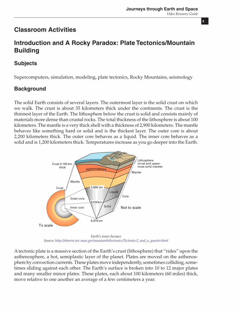
The solid Earth consists of several layers. The outermost layer is the solid crust on whichwe walk. The crust is about 35 kilometers thick under the continents. The crust is thethinnest layer of the Earth. The lithosphere below the crust is solid and consists mainly ofmaterials more dense than crustal rocks. The total thickness of the lithosphere is about 100kilometers. The mantle is a very thick shell with a thickness of 2,900 kilometers. The mantlebehaves like something hard or solid and is the thickest layer. The outer core is about2,200 kilometers thick. The outer core behaves as a liquid. The inner core behaves as asolid and is 1,200 kilometers thick. Temperatures increase as you go deeper into the Earth.
Earth’s inner furnaceSource: http://observe.arc.nasa.gov/nasa/earth/tectonics/Tectonics2_and_a_quarter.html
A tectonic plate is a massive section of the Earth’s crust (lithosphere) that “rides” upon theasthenosphere, a hot, semiplastic layer of the planet. Plates are moved on the asthenos-phere by convection currents. These plates move independently, sometimes colliding, some-times sliding against each other. The Earth’s surface is broken into 10 to 12 major platesand many smaller minor plates. These plates, each about 100 kilometers (60 miles) thick,move relative to one another an average of a few centimeters a year.

6
Journeys through Earth and SpaceVideo Resource Guide
Plate tectonics is the branch of science that deals with the process by which rigid platesmove across hot, more deformable material. It has helped to explain much in global-scalegeology, including the formation of mountains and the distribution of earthquakes andvolcanoes.
Major tectonic plates of the worldSource: http://geology.er.usgs.gov/eastern/plates.html
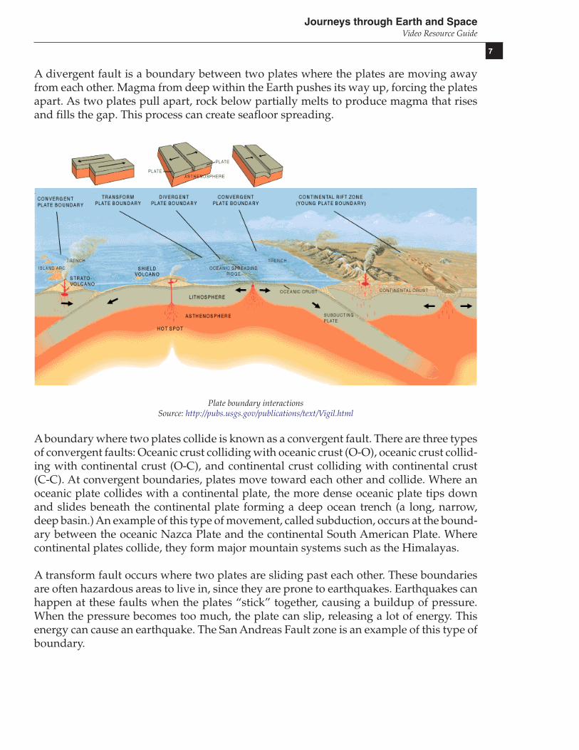
Three types of movement are recognized at the boundaries between plates: convergent,divergent, and transform-fault.
Three types of faultsSource: http://observe.arc.nasa.gov/nasa/earth/tectonics/Tectonics3.html
7
Journeys through Earth and SpaceVideo Resource Guide
A divergent fault is a boundary between two plates where the plates are moving awayfrom each other. Magma from deep within the Earth pushes its way up, forcing the platesapart. As two plates pull apart, rock below partially melts to produce magma that risesand fills the gap. This process can create seafloor spreading.
Plate boundary interactionsSource: http://pubs.usgs.gov/publications/text/Vigil.html
A boundary where two plates collide is known as a convergent fault. There are three typesof convergent faults: Oceanic crust colliding with oceanic crust (O-O), oceanic crust collid-ing with continental crust (O-C), and continental crust colliding with continental crust(C-C). At convergent boundaries, plates move toward each other and collide. Where anoceanic plate collides with a continental plate, the more dense oceanic plate tips downand slides beneath the continental plate forming a deep ocean trench (a long, narrow,deep basin.) An example of this type of movement, called subduction, occurs at the bound-ary between the oceanic Nazca Plate and the continental South American Plate. Wherecontinental plates collide, they form major mountain systems such as the Himalayas.
A transform fault occurs where two plates are sliding past each other. These boundariesare often hazardous areas to live in, since they are prone to earthquakes. Earthquakes canhappen at these faults when the plates “stick” together, causing a buildup of pressure.When the pressure becomes too much, the plate can slip, releasing a lot of energy. Thisenergy can cause an earthquake. The San Andreas Fault zone is an example of this type ofboundary.
8
Journeys through Earth and SpaceVideo Resource Guide
The processes that produce mountain belts are called orogenesis. Mountain belts are typi-cally formed by plate tectonic activity, specifically continental collision. Orogeny is thevariety of processes that result in mountain formation.
Lesson Plan
ObjectivesStudents will
Describe and draw Earth’s geological layers from the inner core to the outercontinental crust.Explain the process of orogenesis using drawings and simulations from platetectonics theory.Use a bar graph to describe the relative thickness of each of the Earth’s geo-logic layers.Create a clay model of divergent, convergent, and transform fault plateboundaries.
Engage:1. Locate and display pictures of Nepal and its people (many are available online).2. Scenario: Consider that you are a citizen of Nepal. Scientists tell you that your countrywill “cease to exist” physically and literally in 10 million years. What can this mean? Canthis be true, and if so how can it be prevented? How can you or scientists explain thiseventual disappearance of your homeland? What tangible evidence can support this claim?3. Students can work in groups of three to four to discuss the real-world problem. Theycan use any resources available to discern plausible answers. One Internet source is:http://www.pbs.org/wgbh/nova/everest/earth/birth.html4. Follow up with whole-group sharing. Have students make connections between thedynamic changing Earth and its effect upon human life.
Explore:1. Have students use the Pre-viewing Activities to review and access prior knowledge.Review the vocabulary.2. Introduce the Video Viewing Questions. Ask students to complete the questions whilewatching the video and check their answers with a partner after viewing.3. Show the video “Journeys through Earth and Space,” Introduction and A RockyParadox.4. Discuss controversial answers to the Video Viewing Questions.5. Have students read the Background for this story. Students will complete Activities 1, 2,3, and 4. Activities 3 and 4, which model the three types of fault boundaries, may be doneas a demonstration or in groups.6. Have students complete Activity 5.

9
Journeys through Earth and SpaceVideo Resource Guide
Explain:Students will apply knowledge to answer the following questions:1. What is the energy source that moves the Earth’s plates? Is this an example of convec-tion, conduction, radiation, or a combination of these? Explain.2. Why does the Earth’s inner core (4300 degrees C) have solid properties while the coolerouter core (3700 degrees C) is liquid?3. What is the Mohorovicic Discontinuity, and why is it important to us in understandingthe composition of the Earth?4. Respond to Analysis Questions in Activity 5.
Evaluate:Replay the video, “Journey through Earth and Space,” A Rocky Paradox.Students will write a one- to two-page essay describing in detail: “How did the Rockymountains form and why are they so far inland from the Pacific Coast of the United States?”Do you think the Rocky Mountains have completed their formation? Defend youranswer.
Extend: TechnologyUse the following Web site:Quakes and Plateshttp://edmall.gsfc.nasa.gov/inv99Project.Site/Pages/trl/inv1-1.htmlStudents can complete an online activity that will show how tectonic plate movement isrelated to regions of earthquakes.
Activity Reading Level: Flesch-Kincaid: 7.5
National Standards (Science Content)Grades 9-12
Scientific Inquiry-Content Standard A:Abilities Necessary to do Scientific Inquiry
• Use technology and mathematics to improve investigations and communications.• Formulate and revise scientific explanations and models using logic and
evidence.• Communicate and defend a scientific argument.
Earth and Space Science-Content Standard D:Energy in the Earth System
• The outward transfer of Earth’s internal heat drives convection circulation inthe mantle that propels the plates comprising Earth’s surface across the faceof the globe.
The Origin and Evolution of the Earth System• Interactions among the solid Earth, the oceans, the atmosphere, and organisms
have resulted in the ongoing evolution of the Earth system.

10
Journeys through Earth and SpaceVideo Resource Guide
Science and Technology-Content Standard E:Understandings about Science and Technology
• Scientists in different disciplines ask different questions, use different methodsof investigation, and accept different types of evidence to support theirexplanations.
• Science often advances with the introduction of new technologies.
Science in Personal and Social Perspectives-Content Standard F:Natural and Human-Induced Hazards
• Normal adjustments of Earth may be hazardous for humans.
History and Nature of Science-Content Standard G:Nature of Scientific Knowledge
• Scientific explanations must meet certain criteria. First and foremost, they mustbe consistent with experimental and observational evidence about nature, andmust make accurate predictions, when appropriate, about systems beingstudied.
• Because all scientific ideas depend on experimental and observationalconfirmation, all scientific knowledge is, in principle, subject to change as newevidence becomes available.
Additional References
On the Move: Continental Drift and Plate Tectonicshttp://kids.earth.nasa.gov/archive/pangaea/
Plate Tectonicshttp://scign.jpl.nasa.gov/learn/plate.htm
Plate Tectonics/Plate Typeshttp://observe.arc.nasa.gov/nasa/earth/tectonics/Tectonics1.html
What on Earth is Plate Tectonicshttp://wrgis.wr.usgs.gov/docs/parks/pltec/pltec1.html
Major Tectonic Plates of the Worldhttp://geology.er.usgs.gov/eastern/plates.html
Activities and Teaching Suggestions for Plate Tectonicshttp://www.volcanoworld.org/vwdocs/vwlessons/plate_tectonics/part1.html
Printable World Map.http://www.abcteach.com/Maps/world.htm

11
Journeys through Earth and SpaceVideo Resource Guide
NASA Observatorium Teacher’s Guides: Plate Tectonicshttp://observe.arc.nasa.gov/nasa/education/teach_guide/tectonics.html
Geology: Plate Tectonicshttp://www.ucmp.berkeley.edu/geology/tectonics.html
Plate Tectonics: Looking at Our Ever-Changing Planethttp://www.gsfc.nasa.gov/gsfc/service/gallery/fact_sheets/earthsci/earth.htm
Plate T-48: Himalayan Front and Tibetan Plateauhttp://daac.gsfc.nasa.gov/DAAC_DOCS/geomorphology/GEO_2/GEO_PLATE_T-48.HTML
Plate T-11: Appalachian Mountainshttp://daac.gsfc.nasa.gov/DAAC_DOCS/geomorphology/GEO_2/GEO_PLATE_T-11.HTML
Credits
Lynn Birdsong, Ambassador, Maryland Ambassador Program, NASA Goddard SpaceFlight Center Earth and Space Sciences Education Project, Secondary Science New TeacherMentor, Howard County (Maryland) Public Schools.Greg Helms, Ambassador, Maryland Ambassador Program, NASA Goddard SpaceFlight Center Earth and Space Sciences Education Project, Earth Science Teacher, NorthCounty High School, Glen Burnie, Maryland.Eleanor Smith, Ambassador, Maryland Ambassador Program, NASA Goddard Space FlightCenter Earth and Space Sciences Education Project, Aerospace Teacher, DuVal High School,Lanham, Maryland.

12
Journeys through Earth and SpaceVideo Resource Guide
Introduction and A Rocky Paradox: Plate Tectonics/MountainBuilding
Pre-viewing Activities
Questions
What are the geological layers of the Earth?
Where is the Earth’s mantle? Draw an illustration to depict the Earth’s layers.
The Rocky Mountains are 1,500 kilometers (1,000 miles) inland from the Pacific coast.How do you suppose they formed so far inland?
How do you think a computer could help answer this question?
Vocabulary to Know
Convergent Plate BoundariesCore (Inner and Outer)Crust (Continental and Oceanic)Divergent Plate BoundariesLithosphereMantleMohorovicic DiscontinuityPlate TectonicsTransformational Plate Boundaries

13
Journeys through Earth and SpaceVideo Resource Guide
Video Viewing Questions
1. What is NASA using to tackle questions such as the inland position of the RockyMountains?
2. Two things supercomputers can do include: a. _________________________ b. _________________________
3. What is ESS? How is it different from Earth Science?
4. Describe the Earth’s mantle.
5. What forms and drives tectonic plates?
6. How far inland are the Rocky Mountains from the Pacific coast of the U.S.?
7. Which tectonic plates were involved in the formation of the Rocky Mountains?
8. What types of plates were these: convergent, divergent, or transformational? How doyou know that?
9. What caused the crust to “bob up” or upwell?
14
Journeys through Earth and SpaceVideo Resource Guide
Introduction and A Rocky Paradox: Plate Tectonics/MountainBuilding
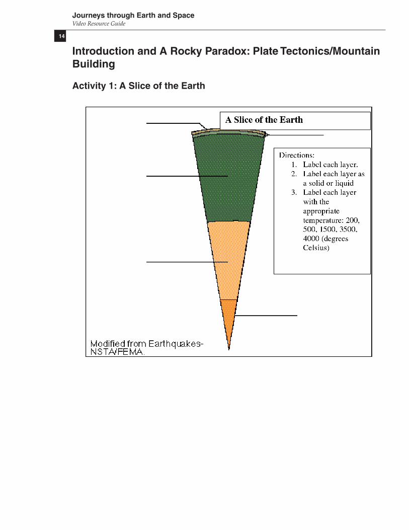
Activity 1: A Slice of the Earth
15
Journeys through Earth and SpaceVideo Resource Guide
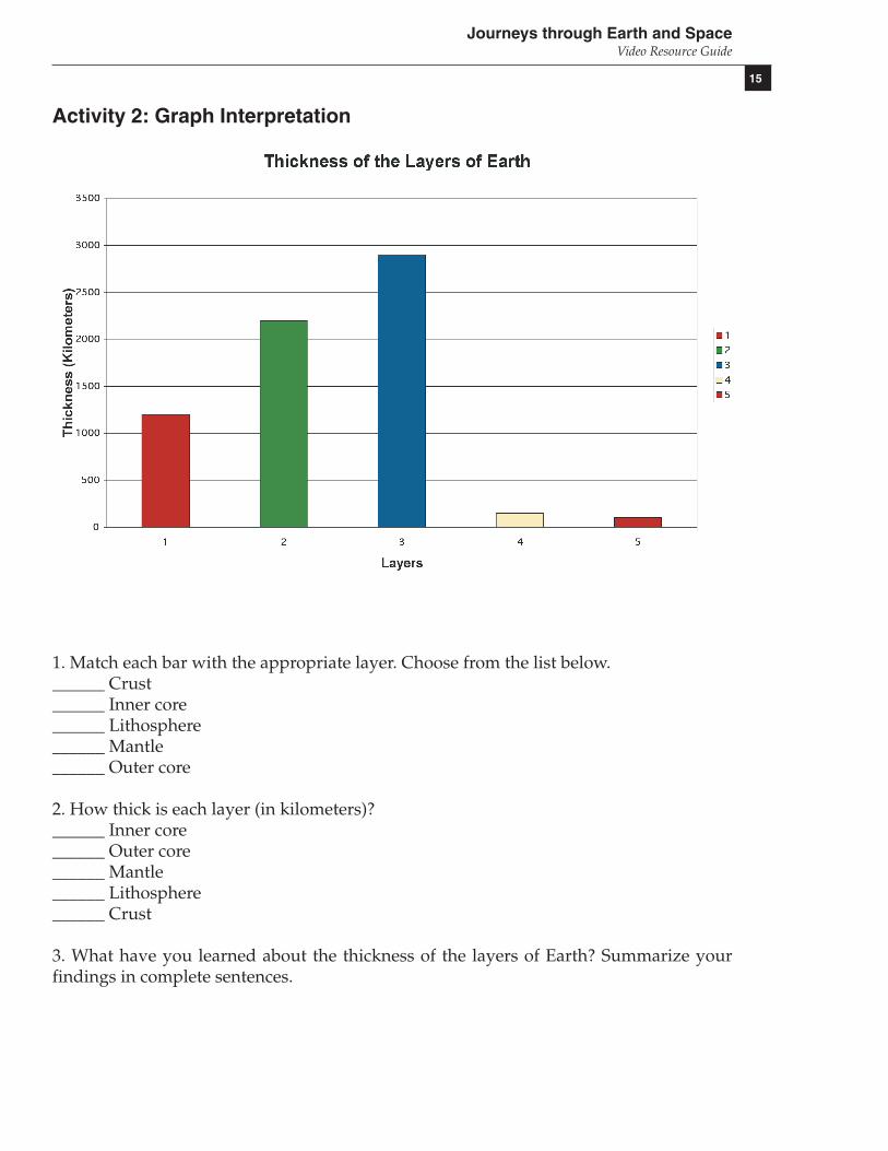
Activity 2: Graph Interpretation
1. Match each bar with the appropriate layer. Choose from the list below.______ Crust______ Inner core______ Lithosphere______ Mantle______ Outer core
2. How thick is each layer (in kilometers)?______ Inner core______ Outer core______ Mantle______ Lithosphere______ Crust
3. What have you learned about the thickness of the layers of Earth? Summarize yourfindings in complete sentences.

16
Journeys through Earth and SpaceVideo Resource Guide
Activity 3: Faults
Transform faultYou can simulate a transform fault by placing your hands side-by-side and sliding oneforward. Each hand represents a tectonic plate.
1. Describe in your own words what happens in a transform fault. Give an example of thistype of a plate boundary.
Divergent faultUse your hands again to simulate a divergent fault. Just place your hands together andthen separate one hand away from the other (left and right).
2. Describe in your own words what happens in a divergent fault.
Convergent faultUse your hands once more to simulate a convergent fault. Place your hands side-by-side.Now push one hand against the other. Allow them to push together and rise up in thecenter where they touch.
3. What does this uprising represent in terms of geology and plate tectonics?4. Describe in your own words what happens in a convergent fault.
Activity 4: Clay ModelingUse three different colors of modeling clay to create models of each type of fault: trans-form, divergent, and convergent. Models should look something like this example of atransform fault. Why are there three layers represented? Are there ALWAYS three layersinvolved in plate movement? Explain.

17
Journeys through Earth and SpaceVideo Resource Guide
Activity 5: Mapping1. Read the background material.2. Use an atlas world relief map or an Internet site to find and name the major mountainsystems. Identify and list at least eight of these.Major Mountain Systems
a.b.c.d.e.f.g.h.
3. Use a sheet of acetate (transparency film) to trace the major tectonic plates of the world.Make sure that this is the same size as a world map you will use in the next step of thisactivity.4. Overlay a geophysical or political map of the world with the tectonic plates tracing.5. Label the plate boundaries on the overlay in the following way:
D–divergentT–transformC–convergentTo convergent add:OO–oceanic with oceanic (your label should look like this, C-OO)OC–oceanic with continental crustCC–continental crust with continental crust.
Analysis Questions (Refer to the previous USGS map and the following NASAmap.)1. Name four major mountain ranges that might have been formed by colliding plates.2. Using the atlas, locate the Zagros Mountains in southern Iran, where the Arabian Plateis impacting the Iranian Plate. Sketch and describe what is happening.3. Which plate is forming the Andes Mountains on the west side of South America?4. What plates were involved in forming the Rocky Mountains?5. Why are the Rocky Mountains so far inland? Describe what happened.

18
Journeys through Earth and SpaceVideo Resource Guide
Digital tectonic activity map of the EarthSource: http://denali.gsfc.nasa.gov/dtam/dtam/

19
Journeys through Earth and SpaceVideo Resource Guide
Introduction and A Rocky Paradox: Plate Tectonics/MountainBuilding
Educators’ Answer Key
Pre-viewing Activities
Questions
The three basic Earth layers are the crust, mantle, and core. (The Background materialadds the lithosphere between the crust and mantle and divides the core into the outer coreand the inner core.)
The mantle is the middle layer of the Earth. A drawing of concentric circles labeled withcrust, mantle, and core might work well at this stage, depending on what the studentshave learned so far.
Although students would not be aware of it before watching the video or learning fromanother source, the tectonic plate that formed the Rocky Mountains did not sink until ithad traveled 1,500 kilometers from the Pacific coast.
A computer can help answer the question by simulating the geological processes indetail.
Video Viewing Questions
1. Supercomputers2. Process observations into a motion picture, solve equations that describe realities seenand unseen.3. Earth and Space Sciences. It is different because it includes space phenomena such asthe Sun.4. The mantle is the middle layer of the Earth.5. Tectonic plates are formed when rock cools off at the top of the mantle. The plates aredriven by the flow of rock (motions) in the mantle.6. 1,500 kilometers, or 1,000 miles7. Farallon Plate and North American Plate8. Convergent. The plates came together.9. The Farallon Plate settling to the bottom of the mantle.

20
Journeys through Earth and SpaceVideo Resource Guide
Additional background on Video Viewing Question 9: As the Farallon Plate movedeastward, the North American Plate moved westward above it. The lower crust of theNorth American Plate was relatively soft, and as this plate moved westward some of thelower crust tended to lag behind and pile up in front of where the Farallon Plate wassinking (subducting). There was a significant thickening of the crust in this region.Eventually, plate motion in the Pacific Ocean changed so that the Farallon Plate ceasedto grow anymore, and the plate completely sank into the mantle. This subductioncaused the thickened crust to bob up like a cork to produce the Rocky Mountains.
Activity 1: A Slice of the Earth
From top to bottom, the labels, matter states, and temperatures are as follows:
Crust Solid 200 degrees CLithosphere Solid 500 degrees CMantle Solid 1500 degrees COuter core Liquid 3500 degrees CInner core Solid 4000 degrees C
Activity 2: Graph Interpretation
1. 5 = Crust, 1 = Inner core, 4 = Lithosphere, 3 = Mantle, 2 = Outer core
2. 1,200 km = Inner core, 2,200 km = Outer core, 2,900 km = Mantle,100 km = Lithosphere, 35 km = Crust
Activity 5: Mapping
2. Major Mountain Systems
Alps (Europe)Andes Mountains (South America)Appalachian Mountains (North America)Atlas Mountains (Africa)Brazilian Highlands (South America)Carpathian Mountains (Europe)Cascade Range (North America)Great Dividing Range (Australia)Himalaya Mountains (Asia)Rocky Mountains (North America)Tian Shan (Asia)Transantarctic Mountains (Antarctica)Ural Mountains (Asia, Europe)Zagros Mountains (Asia)

21
Journeys through Earth and SpaceVideo Resource Guide
Analysis Questions
1. All of the Major Mountain Systems listed above qualify, plus chains such as the SierraNevada (North America) that formed when the Farallon Plate first sank beneath theNorth American Plate.2. The Arabian Plate is colliding with the Iranian Plate, pushing the Zagros Mountainsslowly upward.3. Nazca Plate4. Farallon Plate and North American Plate5. The Rocky Mountains are so far inland because the Farallon Plate scraped along thebottom of the North American Plate for 1,500 kilometers before sinking to the bottom ofthe mantle.