4921 memorial highway, suite 300 tampa, florida 33634 … ·...
TRANSCRIPT

G:\ENV_SCI\Projects\2031\500\002\Admin\Memos\Alt Memorandum_Draft_PJB_ v2_10-21-12.doc
MEMORANDUM
To: Ms. Kimberly O. Tracy Date: October 18, 2012 Assistant Director Stormwater
Management Pinellas County Dept. of Environment & Infrastructure
From: Peter Bottone, Project Manager Agustin Maristany, P.E., Project Engineer
Project No.: 2031-500-002
Subject: Cross Bayou Maintenance
Project- Alternatives Development
Project Name: Cross Bayou Canal Maintenance Project- Phase 1 Preliminary Feasibility Study
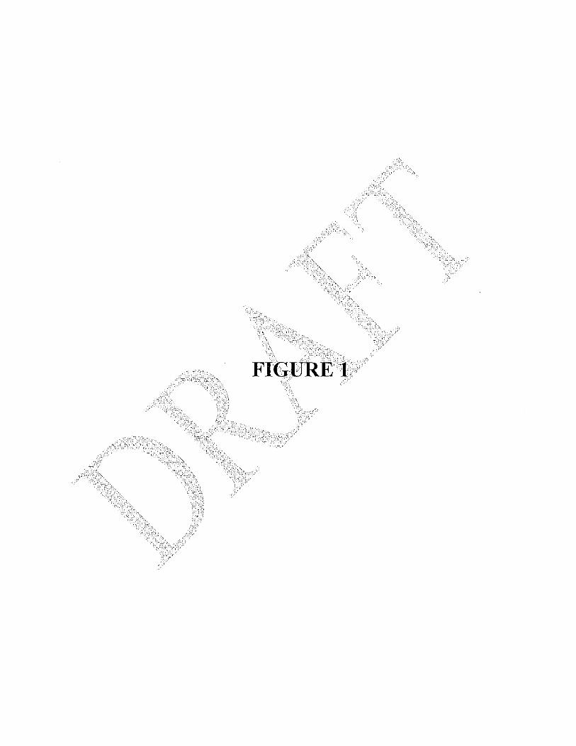
INTRODUCTION King Engineering Associates. Inc. (King), under contract with Pinellas County, Department of Environment and Infrastructure (County), was tasked with conducting a Preliminary Feasibility Study (FS) assessing the County’s intent to implement needed maintenance activities (e.g. dredging, vegetation and debris removal) within a highly urbanized, 1.4 mile segment of the Cross Bayou Canal (CBC) located between 102nd Ave. and Ulmerton Road (Figure1). Four (4) distinct sections of the CBC were identified by County Stormwater Management staff as problematic based on visible vegetative blockages and/or sediment deposits believed to be contributing to chronic flooding in the immediate project area. For assessment purposes, these sections were further identified by King as follows:
o Section 1- Cross Bayou Canal from 102nd Ave to 66th Street o Section 1A- Cross Bayou Canal from 66th Street to Cedarbrook Drive South o Section 2- Cross Bayou Canal from Bryan Dairy Road to US 19 o Section 3- Cross Bayou Canal from US 19 to Ulmerton Road
As an interim step to completing this feasibility study, some base alternatives were considered by King in evaluating potential maintenance options, benefits, costs and constraints within the CBC Phase 1 limits based on review of available data sources obtained from the County and preliminary results from King’s data collection efforts. Two (2) potential alternatives were assessed by King for initial planning purposes, and to assist the County in the development and selection of a recommended alternative for proceeding to final design and permitting of the CBC Phase 1 Maintenance Project which meets the County’s objectives, goals and available budget.
4921 Memorial Highway, Suite 300 Tampa, Florida 33634
(813) 880-8881 ♦ (813) 880-8882 fax
www.kingengineering.com

G:\ENV_SCI\Projects\2031\500\002\Admin\Memos\Alt Memorandum_Draft_PJB_ v2_10-21-12.doc
Summarized below is a brief description of the project background, preliminary data collection results, design rationale, description of each alternative as well as planning level costs for each. Additional informational needs required for further project development are also identified. PROJECT BACKGROUND Originally constructed in the early 1900’s to facilitate the draining of lowlands for agricultural purposes, the existing ±7,700 acre CBC watershed has been a source of recurring maintenance (erosion, sedimentation, debris accumulations) and flooding issues for Pinellas County dating back to at least the 1960’s. With the intensive urbanization of the CBC watershed beginning in the early 1980’s, these conditions have become more prevalent, resulting in more frequent flooding events as well as numerous flood complaints from residences and businesses that have experienced property loss and damages. In addition, the CBC system has incurred significant degradation to both water quality and habitat associated with increased development, stormwater run-off and exotic/nuisance species colonization, a condition sustained by the inability of the local municipalities to effectively access and maintain the CBC system due to regulatory constraints. For these reasons, the County initiated a diagnostic feasibility study of the watershed beginning in 2003. This effort consisted of data collection in order to characterize the watershed relative to existing conditions, natural systems and habitat, water quality, erosion control and public awareness as an initial step in the development of a management plan to guide future improvements in the CBC watershed. The second phase of this study, consisting of the development of the Cross Bayou Watershed Management Plan, began in 2010. The results of this study are expected to be complete in December 2012, and are anticipated to help identify what actions should be considered relative to the CBC watershed and canal system in addressing TMDLs, water quality and flood protection levels of service (LOS). These actions may include specific recommendations to improve stormwater conveyance such as increasing the cross-sectional area, channel depths and/or modifying existing drainage structures within the affected portions of the CBC to achieve the desired LOS. Recognizing the need to address recurring flooding problems in some areas of the CBC, the County met with the regulatory agencies to discuss their need to perform maintenance activities as an interim relief effort to affected local residents and businesses. In September 2011, the County submitted an application to the Southwest Florida Water Management District (District) for “Verification of Exemption” to perform proposed maintenance activities within the CBC along the south side of US 19. Initial review of that request by the District indicated that the project would meet the exemption criteria. However, feedback obtained from the U.S. Army Corps of Engineers (USACE) regarding the specifics of the proposed action indicated that the project activities would not qualify for a maintenance exemption and would therefore need to proceed under a USACE Individual Permit, a process that would require updated surveys along with engineering plans providing more detail on the dredging areas, techniques, impacts, handling and disposal of spoil. With this requirement in mind, the County then considered the benefits of a more comprehensive maintenance project within 4 specific sections of the CBC system. Subsequently, the County contracted King to perform the CBC Phase 1 Maintenance Project Feasibility Study to assist them with evaluating how to best proceed with the final project design and permitting requirements for this larger project. DATA COLLECTION A preliminary assessment of the site conditions within the CBC Phase 1 study area was conducted based on data provided by the County, other readily available information, GIS database searches, and in conjunction with limited field reconnaissance conducted by King. It should be emphasized that no current, site specific professional survey work was provided by the County or performed by King in development of this FS. As a result, the user is cautioned that all referenced elevations, cross section data as well as estimated dredging volumes referenced herein are approximate, to allow a relative comparison of alternatives for planning purposes only. The primary documents and GIS data bases reviewed included:
• Miscellaneous Survey Data provided by Pinellas County from other studies (1981-2004) • Preliminary Reports and GIS files of the Cross Bayou Canal Watershed Management Plan (JEA 2010-2012) • Cross Bayou Drainage Basin Study (TBE 1964) • CR 296, E. of US 19 to E. of Roosevelt Blvd Roadway Plans (Atkins 8/12/11)

G:\ENV_SCI\Projects\2031\500\002\Admin\Memos\Alt Memorandum_Draft_PJB_ v2_10-21-12.doc
• Bryan Dairy Rd.,72nd St, North to US 19 (RSH 7/94) • Survey Report on Cross Bayou Canal, Florida (USACE 1971) • History of Cross Bayou Canal (Pinellas Co. 1995) • 1926 B/W Aerial Photography • 1972 SWFWMD Topographic Aerial Maps • Google Maps Imagery, Pinellas Co. 1993-2011 • SWFWMD FLUCFCS Mapping • SCS Soils Map • USGS Quadrangle Topographic Maps • Tidal and NAVD 1988 Conversion Data (LABINS) • FWC/FNAI Element Occurrence Data (1999-2007) • FWC Bald Eagle Nesting and Waterbird Breeding Atlas databases;
Field reconnaissance activities consisted of a two (2) day, waterside field review to assess the aquatic habitats and vegetative cover proximal to the canal, relative canal depths and unconsolidated sediment layers present within CBC system. To accomplish this, the CBC was accessed by canoe from open portions of the canal between Ulmerton Road and US 19, then 66th Street south to 102nd Avenue. One section (Section 2) of the CBC, from US 19 south to Bryan Dairy Road, however, was precluded from in-water review due to the heavy vegetative cover blocking the waterway. In this case, a limited shoreline review was performed from private properties situated along the north and south ends of the CBC within this section, after obtaining permission from the owners. At each sampling location, water depths (e.g. canal bottom elevations) were obtained using a stating rod, and the location recorded using mapping grade GPS. All elevations were recorded relative to existing water surface and referenced against known invert elevations (converted to NAVD 1988) of selected structures within the corresponding section of the CBC. In addition, dominant vegetative communities, species composition, the location of exotic and nuisance plant species, general faunal use or other pertinent conditions were noted. Representative photographs were also taken to document the conditions present at the time of the assessment. Concurrent with this effort, a preliminary geotechnical assessment was also conducted to collect and generally characterize bottom sediments (e.g. soil classification and grain size analysis) found in representative sections of the CBC. The preliminary results of the data collection efforts were reviewed by King Engineers and Scientists, and were also evaluated in concert with dredging contractors and geotechnical engineers in order to assist with project planning and evaluation. EXISTING CONDITIONS Land Use and Cover A majority of the adjacent land uses present within this portion of the CBC watershed consist of High Density Residential (1300 FLUCS Code) and Industrial (1300 FLUCS Code) land uses under the FDOT’s Florida Land Use and Cover Classification System (FLUCS). Other notable land uses or cover classifications present include Roads and Highways (8140 FLUCS Code), Reservoirs (5300 FLUCS Code), Wetlands (6000 FLUCS Code), Urban Open Land (1900 FLUCS Code) or Disturbed Lands (7400 FLUCS Code). Cross Bayou Canal (CBC) System The CBC is a man-made, tidally influenced canal system classified as a Linear Waterway (5100 FLUCS) with fringing Mangrove (6120 FLUCS) and Brazilian Pepper (4220 FLUCS) habitats present along a majority of the canal banks. Salinity fluctuates based on tide and season, but generally fluctuates between 0-2 ppt in the CBC Phase 1 study limits based on review of available data sources. In cross section, the CBC varies in width (from 37 to 120 feet wide @ T.O.B.) within the study area, but the typical cross section can be generally described as approximately 50-55 feet wide at T.O.B, with 2:1 to 3:1 side slopes down to the channel bottom. Water depths recorded at the approximate center line of the CBC ranged from 0.5’ to 6.6 feet deep with corresponding channel bottom elevations of 0.0’ to – 5.2’ NAVD within the Phase 1 study limits. Predicted tidal elevations (for what period) within the CBC near Ulmerton Road (Tidal Station # 6342) ranged from a Mean Low Water (MLW) of -0.3’ NAVD to a Mean High Water (MHW) of 0.86’ NAVD, with tidal amplitude of 1.2 feet near Safety Harbor (LABINS). As the CBC approaches Boca Ciega Bay south of Park Boulevard, a lower MHW (0.46’ NAVD) and tidal amplitude is predicted.

G:\ENV_SCI\Projects\2031\500\002\Admin\Memos\Alt Memorandum_Draft_PJB_ v2_10-21-12.doc
Very little emergent or submerged aquatic vegetation (SAV) is currently present within the waterway. All three mangrove species (black, red and white) were observed colonizing the intertidal portions of the lower banks of the CBC from the MLW elevation of -0.3’ NAVD to just above the MHW elevation (0.86’ NAVD) along large portions of the system. The exception were Section 1A and portions of Section 1, from Bryan Dairy Road south of 66th Street towards 102nd Avenue, where the CBC banks have been previously cleared, re-graded and maintained. Although sometimes intermixed with the mangroves, Brazilian pepper generally occurred above the mangrove elevational zone. Combined, both mangroves and Brazilian pepper have become overgrown along large portions of the CBC, with lateral branches, roots, stumps and dead wood extending out, in and over the waterway. In some cases, the waterway has been completely blocked by the encroaching vegetation which in turn has resulted in the accumulation of additional debris such as abandoned turbidity curtains, coolers, trash, flotsam, etc., that have become lodged in these constricted areas. During large storm events this condition can cause a significant impediment to stormwater conveyance, resulting in flooding, sediment deposition and safety concerns. CBC Sediments Thirteen (13) sediment cores were collected at representative CBC Sections along the canal centerline, to a minimum depth of -8 ft MLW in August 2012 by Driggers Engineering Services, Inc. (DESI). These samples were field classified, and the estimated depth to original dredge/excavation depth interpreted by DESI. Both composite samples as well as individual fractions encompassing proposed dredging depths from each sediment core were evaluated for grain size analysis and fines content using sieve and hydrometer testing in accordance with ASTM D 244. Surficial sediments were also secured and stored for up to six-months for potential beneficial use testing if requested by the County. Fines content (≤ 0.074 mm) of the tested sediments and/or fractions ranged from as low as 2% up to 53%, with a mean ± 20% (n= 10) of the all the fractions tested within the proposed dredge depth to elevation -4.3’ NAVD. In general, the deeper the canal depth, the greater the percent fines present. The fines fraction was typically comprised of grain sizes in a near 50/50 mix of silts (0.074 and 0.005 mm) and clays (< 0.005 mm), with silts ranging from 2-25% and clay/colloidal material ranging from 0-18% in the applicable fractions. It is important to note that much of the fines included an appreciable organic component (5-20% by weight) such that on a volumetric basis, fines content would tend to be higher than would be predicted on strictly a weight basis. Therefore the sediments are predominately described as silts (silty fine sands, silty fine, organic sands with clays etc.) even though fines comprise less than 50% of the sample by weight. Thus this description provides a better representation of the behavioral characteristics of the dredge material versus what would be expected based strictly on grain size analysis. Listed Species Review of data obtained during this assessment, supplemented by field reconnaissance efforts indicate a low to moderate likelihood of listed species involvement for this project. During the course of field investigations, only two listed species; the little blue heron and snowy egret were observed utilizing the CBC system. These species are far ranging and can be expected to utilize many wetland resources in the project vicinity. Furthermore there are no known or documented nesting sites for listed avifauna species on the project site, with the closest bald eagle nest (PI025) located approximately 1.9 miles northeast of Ulmerton Road at the CBC, while the closest wading bird nesting colony (#615337) was located approximately 4 miles southeast the site. The northern portion of the project is however located partially within a Wood Stork Core Foraging Area (CFA). Therefore, potential foraging impacts to this species may be assessed by the USACE and the USFWS during project permitting. It is expected that since the project impacts will be temporary in nature, and will result in a net improvement in Wood Stork feeding habitat, a “may effect, not likely to adversely effect” conclusion by these agencies is anticipated. Based on the results of this preliminary assessment, it appears that this project’s potential impact on listed plant or wildlife species is limited and should not be an impediment to project implementation. PROJECT ALTERNATIVES By design, each of the proposed alternatives is intended to serve only in an interim maintenance capacity, targeting the removal of the vegetative blockages and accumulated sediments within the CBC Phase 1 study limits to achieve an improved hydraulic conveyance function. The ultimate CBC configuration needed to meet the County’s Flood Protection Level of Service (LOS) objectives remains unknown pending the final recommendations to be presented as part of the on-going CBC Watershed Management Plan. In the interim, the minimum hydraulic conveyance function
G:\ENV_SCI\Projects\2031\500\002\Admin\Memos\Alt Memorandum_Draft_PJB_ v2_10-21-12.doc
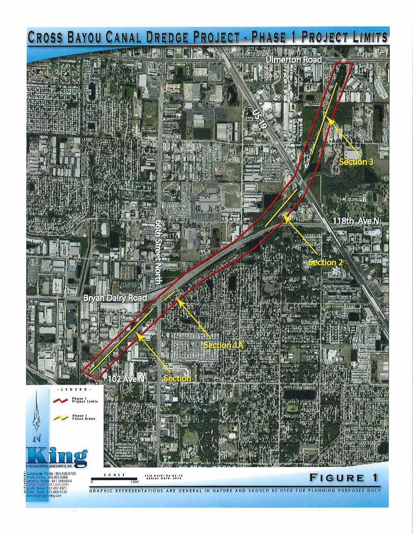
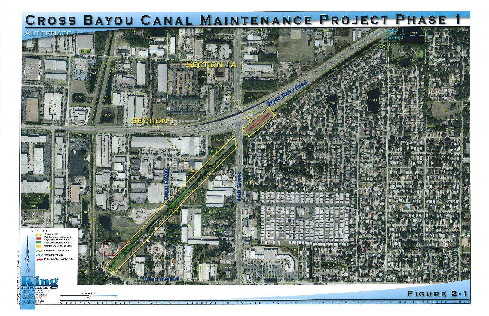
established for the Phase 1 maintenance work was largely based on available 1964 channel profile surveys and/or recently redesigned/reconstructed portions of the CBC. This approach assumes that by achieving a similar channel profile and cross sectional configuration following completion of maintenance work, a reasonable improvement to the current LOS would be realized while remaining under the framework of maintenance activities. In addition, to avoid or minimize the potential requirements for habitat mitigation associated with impacts to intertidal mangrove habitat, and reduce the need to rework/stabilize existing CBC canal banks above the intertidal zone, it is recommended that maintenance dredging occur at or below the approximate 0.0’ NAVD contour in areas where mangroves are present. Based on the review of existing data, site conditions and the design rationale discussed above, two (2) generalized project alternatives were developed by King (Figures 2-1 & 2-2). King’s approach provides both a minimal impact/low cost alternative (Alternative 1) targeting the most restrictive sections/segments of the CBC, along with a more comprehensive maintenance plan (Alternative 2) designed to address the identified deficiencies while minimizing environmental and adjacent property impacts within the entire CBC Phase 1 study limits. A brief description of each alternative is summarized below: Alternate 1
• Vegetation and Debris Removal & Trimming- Remove/treat (herbicide) exotic vegetation, primarily Brazilian pepper (Schinus terebinthifolius) and Australian pine (Casuarina sp.), along the banks and extending out into the canal system within specified reaches of the CBC. Trim mangroves (any other woody vegetation) along the canal shoreline from the waterline (MLW) up to a minimum 12 feet in height above MLW (11.7’ NAVD) to achieve a minimum clear width of 25 feet horizontally across the waterway. Under Alternate 1, it is envisioned that only sections of the CBC that have significant vegetative/debris blockage or are proposed for maintenance dredging, totaling approximately 4.6 acres would be subject to this activity.
• Maintenance Dredge- Perform maintenance dredging of selected portions of the CBC system preliminarily
identified as having an average channel bottom elevation of over -2.0’ NAVD to achieve a target of -4.3’ NAVD (4.0 ft below MLW) including a planned 1’ over dredge. The typical design cross-section would utilize an average dredge slope of 3:1 (w/maximum 2:1 slope) to best match the existing grade at elevation ±0.0’ NAVD and provide a minimum channel width of 35 feet at MHW and a channel bottom width of 5 feet. Specifically the following areas are targeted for maintenance dredging/sediment removal under Alternate 1:
1) Section 1A, from 66th Street northeast (± 530 LF). This relocated portion of the CBC constructed
during Bryan Dairy Road improvements now exhibits an average bottom elevation of -0.9’ NAVD, versus a design invert elevation of -2.3’ NAVD. Approximately 650 CY of dredge material would be targeted for removal along this section of the CBC;
2) Section 2, Segments 2-1, 2-2 and 2-3, from a 100 ft. north of Bryan Dairy Road, to the south side of the US 19 Bridge (±1,800 LF). Both existing survey cross-sections and in-water field assessments were unavailable in this area due to the heavy vegetative cover present. However, available data suggests that the majority of this CBC section has bottom elevation over -2.0’ NAVD, with one segment (2-2) as shallow as 0.0’ NAVD. As a result, maintenance dredging along this entire section of the CBC is proposed, yielding an estimated volume of approximately 6,250 CY of dredge material;
3) Section 3, from Belleview Nursery north to just past 126th Avenue (±350 LF). This area appears to have experienced a prior bank washout along the west side of the CBC, reportedly from a ruptured or overflowing pipe (pers.comm with Belleview Nursery Owner) and/or due to overflow from the man-made pond to the west. As a result, this segment now exhibits an average bottom elevation of -0.6’ NAVD, but varies to a depth of -2.0’ NAVD. Approximately 1,550 CY of dredge material would be targeted for removal at this location;
For Alternate 1, a total of 4.6 acres of vegetative clearing/debris removal and trimming is anticipated, along with dredging of approximately 8,450 CY of sediments. In addition, a potential option (Option 1A) to reduce the planned dredge depth to -3.3’ NAVD including a 1 foot over dredge, would reduce total dredge volumes by approximately 20%.

G:\ENV_SCI\Projects\2031\500\002\Admin\Memos\Alt Memorandum_Draft_PJB_ v2_10-21-12.doc
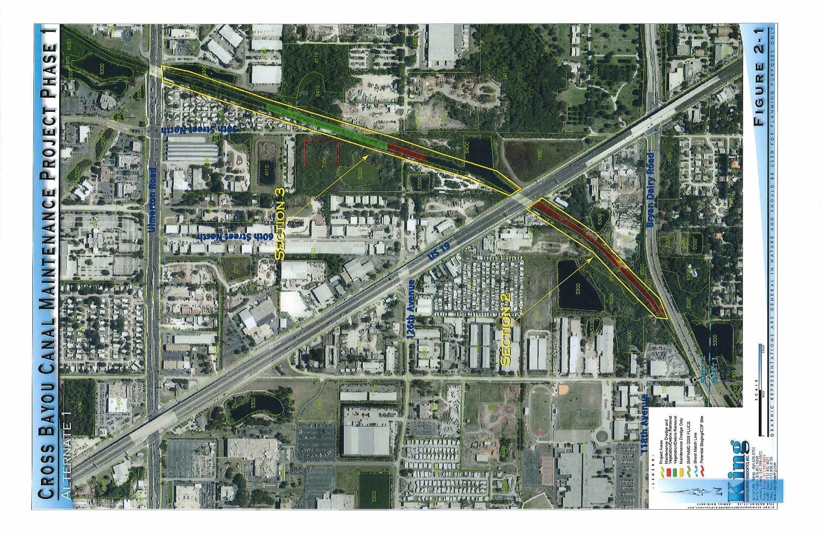
Alternate 2
• Vegetation and Debris Removal & Trimming- Remove/treat (herbicide) exotic vegetation, primarily Brazilian pepper (Schinus terebinthifolius) and Australian pine (Casurina sp.), along the banks and extending out into the canal system within specified reaches of the CBC. Trim mangroves (and other woody vegetation) along the canal shoreline from the waterline (MLW) up to a minimum 12 feet in height above MLW (11.7’ NAVD) to achieve a minimum clear width of 25 feet horizontally across the waterway. Under Alternate 2, it is envisioned that the entire length of the Phase 1 area would subject to this activity to achieve a more comprehensive maintenance relative to improved stormwater conveyance.
• Maintenance Dredge- Perform maintenance dredging of all portions of the CBC Phase 1 area preliminarily
identified as having an average channel bottom elevation above-3.3’ NAVD (-3 ft MLW) to achieve a target -4.3’ NAVD (-4.0 ft MLW) bottom elevation including a planned 1’ over dredge. The typical design cross-section would utilize an average dredge slope of 3:1(w/maximum 2:1 slope) to best match the existing grade at elevation ± 0.0’ NAVD and would result in a minimum channel width of 35 feet at MHW, with a channel bottom width of 5 feet. Specifically the following areas are targeted for maintenance dredging/sediment removal under Alternate 2:
1) Section 1, from 102nd Avenue to 66th Street (±1,650 LF). Segments 1-1 and 1-2 within this CBC
section have varying bottom elevations averaging between -2.0’ and -2.2’ NAVD. In total, approximately 3,000 CY of dredge material would be targeted for removal within this section under Alternative 2. In addition, a redesign/reconstruction of the existing concrete splash pad that currently encroaches halfway into the CBC should be considered;
2) Section 1A, from 66th Street northeast to Cedarbrook Drive (±530 LF). This relocated portion of the CBC constructed during the Bryan Dairy Road improvements area now has an average bottom elevation of -1.0’ NAVD, versus a design invert elevation of -2.3’ NAVD. Approximately 650 CY of dredge material would be targeted for removal along this section of the CBC;
3) Section 2, Segments 2-1, 2-2 and 2-3, from a 100 ft. north of Bryan Dairy Road to the south side of the US 19 Bridge (± 1,800 LF). Detailed survey in this area is limited due to the heavy vegetative cover, however available data suggests the majority of this area is above -2.0’ NAVD with one segment (2-2) as shallow as 0.0’ NAVD. As a result, an estimated volume of 6,250 CY of dredge material would be anticipated for removal along this section of the CBC;
4) Section 3, Segment 3-1 from Belleview Nursery ±350 ft. north to just past 126th Avenue (± 370 LF). This segment of the CBC appears to have experienced a prior bank washout along the west side of the CBC. As a result, this segment exhibits an average bottom elevation of -0.6’ NAVD, but varies to a low bottom elevation of -2.0’ NAVD. Approximately 1,550 CY of dredge material would be targeted for removal along this section of the CBC;
5) Section 3, Segment 3-2 beginning at the north end of Segment 3-1 (±930 LF). This segment exhibits an average bottom elevation of -2.8’ NAVD, but varies to bottom elevations of -3.0’ NAVD. Approximately 2,850 CY of dredge material would be targeted for removal along this section of the CBC;
6) Section 3, Segment 3-3, from south side of Ulmerton Avenue Bridge (± 50 LF). This small area consists of accumulated sediments deposited in front of a 3.6’ x 20’ box culvert located along the west bank (retaining wall) of the CBC. This depositional area has an approximate width of 30 feet, and extending out for a distance of approximately 15-25 feet. The average elevation of the sediment delta was -1.7’ NAVD. Approximately 100 CY of dredge material would be targeted for removal at this location.
For Alternate 2, a total of 6.8 acres of vegetative clearing/debris removal and trimming is anticipated, along with the dredging of approximately 14,400 CY of sediments. In addition, a potential option (Option 2a) to reduce the planned dredge depth to -3.3’ NAVD including a 1 foot over dredge, would reduce total dredge volumes by approximately 25%.

G:\ENV_SCI\Projects\2031\500\002\Admin\Memos\Alt Memorandum_Draft_PJB_ v2_10-21-12.doc
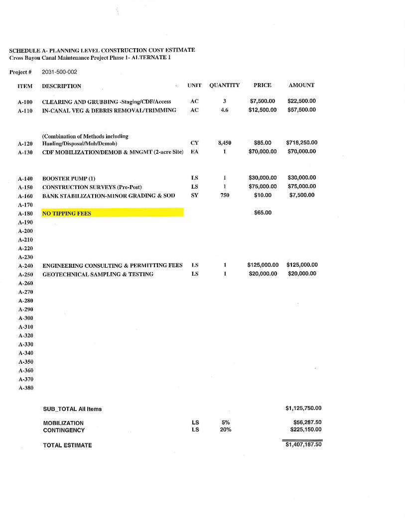
DREDGING METHODS Based on the field conditions present, it is anticipated that either hydraulic or landside based mechanical dredging techniques could be effectively utilized in performing the maintenance work within the CBC Phase 1 project area. Both construction techniques have specific limitations, project design and permitting constraints specific to each. Hydraulic dredging of larger volumes (> 1200 CY) of sediment comprised primarily of unconsolidated fine sands/silts can often be most cost effective, with less impact to bank/slope areas, structures and private properties. The use of smaller equipment such as an 8” “swinging ladder” type dredge could be effectively deployed in narrow, shallow waterways similar to the CBC. This method also tends to be more environmentally sensitive. The use of hydraulic dredging however will typically require one or more larger (1-2 acre) de-watering sites for sediment handling within a Confined Disposal Facility (CDF) or geotube storage configuration, located in relative close proximity (3500 ft) to the dredge work. The use of landside mechanical dredging can often be cost-effective for smaller areas/volumes where adequate access is available for equipment staging and direct sediment transfer to haul trucks or geotubes immediately adjacent to areas proposed for dredging. This technique tends to be less effective for unconsolidated fine sands/silts in-situ, potentially requiring phased de-watering within the canal to enable work in the “dry”. This technique can also be more impactive to existing bank/slope areas, structures, private properties and the environment (i.e. more re-suspension of sediments and vegetative impacts along the shoreline). Review of existing land uses and available parcel information indicate that some adjacent properties in both public and private ownership potentially suitable for implementing both methodologies are available. The large scale use of land based dredging in this application however, will require the use of multiple private properties along the CBC. For these reasons, King anticipates that a combination of both techniques could be utilized to most cost-effectively conduct the maintenance activities within the Phase 1 project area, knowing the final selection of means and methods utilized is generally left to the discretion of the Contractor under the competitive bid solicitation process. PRELIMINARY COST ESTIMATE A planning level cost estimate associated with maintenance activities proposed under Alternates 1 and 2 can be found in Appendix A. Table 1 summarizes the approximate volumes, vegetative/debris removal areas and estimated total costs for each alternative for general comparison purposes. These estimates were based on conceptualized plans developed during preliminary data analysis, review of contractor bid pricing from similar sized dredging projects and unit costs developed in consultation with local dredging contractors. Given the conceptual level of plan development and a number of project unknowns (i.e. disposal sites, the availability of staging/CDF sites, lack of detailed survey etc.) the unit costs indicated for the dredging component represent a blend of both hydraulic and mechanical dredging work that includes mobilization/de-mobilization, BMP implementation, handling, hauling and disposal of dredged sediments in a 10-mile radius (assuming no tipping fees will be required). In addition, some associated design costs such as pre-post project surveys, engineering consulting and permitting fees, supplemental geotechnical fees as well as a 5% project mobilization fee (for bonding etc.) and a 20% contingency allowance commensurate with a planning level assessment is reflected in the estimated total project costs. No land ROW/easement acquisition costs were also considered in this preliminary estimate.
TABLE 1 Summary of Estimated Total Project and Unit Costs for CBC Phase 1 Maintenance Project; Alternates 1&2
Alternate Estimated Dredge Volume (CY)1
Vegetation/Debris Removal Area (ac.) Estimated Total Cost2
Dredging Cost w/o Engineering
& Veg. Removal
1 8,450 4.6 $ 1.4 M $137/CY 2 14,400 6.8 $ 2.3 M $129/CY
1 Estimated Dredge Volume based on a target dredge depth of -4.3’ NAVD including a 1 ft over dredge 2 Estimated Total Cost includes vegetative removal/hauling, dredging, spoil handling & disposal, pre-post surveys, engineering/permitting fees, mobilization/ demobilization, bonding with a 20% contingency allowance.

G:\ENV_SCI\Projects\2031\500\002\Admin\Memos\Alt Memorandum_Draft_PJB_ v2_10-21-12.doc
For additional comparison purposes, an evaluation of costs associated using primarily hydraulic dredging methods (no mechanical dredging) with hauling of decanted sediments to a near off-site location for disposal (no tipping fees) with the same contingencies but excluding vegetation/debris removal and engineering fees would be estimated to range from $110 to $115/ CY. ADDITIONAL PROJECT NEEDS Prior to proceeding towards the final design and permitting of the CBC Phase 1 Maintenance Project, and to facilitate a project design that will meet the County’s requirements, budgets and schedule, the following items should also be considered:
• Obtain updated survey of canal cross-sections in proposed work areas at appropriate intervals (100 ft) to more accurately quantify the project for permitting and construction purposes;
• Conduct additional sediment testing and analysis (elutriate, column settling and beneficial use testing) to assist with final project design, permitting and construction purposes.
• Address uncertainty regarding the potential location of spoil disposal and disposal requirements, beneficial uses or the applicability of tipping fees;
• Address uncertainty regarding the potential use and availability of public or private lands adjacent to the project for construction access, staging and/or use for temporary dewatering and sediment handling;
• Obtain input and direction from the County regarding the limits of the final work areas within the CBC Phase 1 Maintenance Project in consideration of the ultimate CBC configuration to be recommended under the CBC Watershed Management Plan;
• Obtain more project specific input from regulatory agencies regarding the CBC Phase 1 Maintenance Project. PJB/arb Attachments cc: Keith Appenzellar, P.E., King Engineering Assoc., Inc. Brian K. Skidmore, King Engineering Assoc., Inc.
File: 2031-500-002