48 - bharsar studentsk8449r.weebly.com/uploads/3/0/7/3/30731055/env3.pdf · when my grandfather was...
TRANSCRIPT


In Chapter 1 you have learnt that early human beingsdepended entirely on nature for food, clothing andshelter; but with time they learnt new skills to grow food,build homes and develop better means of transport andcommunication. In this way they modified theenvironment where they lived.
Settlements are places where people build theirhomes. Early human beings lived on trees and in caves.When they started to grow crops it became necessary tohave a permanent home. The settlements grew near theriver valleys as water was available and land was fertile.With the development of trade, commerce andmanufacturing, human settlements became larger.Settlement flourished and civilizations developed nearriver valleys. Do you recall the names of civilization thatgrew along the banks of rivers Indus, Tigris, Nile andHwang-He.
Settlements can bepermanent or temporary.Settlements which areoccupied for a short timeare called temporarysettlements. The peopleliving in deep forests, hot andcold deserts and mountainsoften dwell in such temporarysettlements. They practicehunting, gathering, shiftingcultivation and transhumance.However more and moresettlements today arepermanent settlements. Inthese settlements, peoplebuild homes to live in. Fig. 7.1: Human Settlement
Do you know?
The place where abuilding or asettlement develops iscalled its site.
The naturalconditions forselection of an idealsite are-1. favourable climate2. availability of
water3. suitable land4. fertile soil
© NCERT
not to
be re
publi
shed
48 OUR ENVIRONMENT
Glossary
Fig. 7.2: Compact Settlement
It was Mary’s birthday party. She and her friendswere waiting for Gurpreet to arrive so that Mary couldcut the cake. At last Gurpreet arrived- tired, coughingand wheezing. She explained that the traffic jam wasterrible. Mary’s mother Mrs.Thomas patted Gurpreet’sback and sighed, “Oof! The pollution in our city!” Prasadhad recently come from his village. He asked, “Why dowe have such traffic jams and such pollution in thecities?” “The number of vehicles is increasing day byday due to the growing population in the cities”, Mary’sfather, Mr. Thomas replied. Mary asked, “Then whyare people coming to the cities?” Her mother replied,“They come looking for jobs, better education andmedical facilities.” Mary further enquired, “If so manypeople keep coming to cities, where will all the peoplelive?” Mr. Thomas said, “That is why you see so manyslums and squatter settlements where people stay incongested and unhygienic conditions. Shortage ofpower and water supply are common problems in thecities”. Prasad said, “Our villages may not have bigcinema halls, well-equipped schools and good hospitals,but we have lot of open spaces and fresh air to breathe
in. When my grandfather was sick wehad to rush him to the city hospital.”
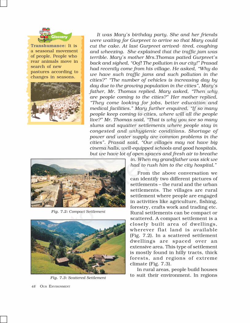
From the above conversation wecan identify two different pictures ofsettlements – the rural and the urbansettlements. The villages are ruralsettlement where people are engagedin activities like agriculture, fishing,forestry, crafts work and trading etc.Rural settlements can be compact orscattered. A compact settlement is aclosely built area of dwell ings,wherever f lat land is available(Fig. 7.2). In a scattered settlementdwellings are spaced over anextensive area. This type of settlementis mostly found in hilly tracts, thickforests, and regions of extremeclimate (Fig. 7.3).
In rural areas, people build housesto suit their environment. In regions
Transhumance: It isa seasonal movementof people. People whorear animals move insearch of newpastures according tochanges in seasons.
Fig. 7.3: Scattered Settlement
© NCERT
not to
be re
publi
shed
HUMAN ENVIRONMENT – SETTLEMENT, TRANSPORT AND COMMUNICATION 49
Let’s do
of heavy rainfall, they have slantingroofs. Places where wateraccumulates in the rainy season thehouses are constructed on a raisedplatform or stilts (Fig. 7.4).
Thick mud walled houses withthatched roofs are very common inareas of hot climate. Local materialslike stones, mud, clay, straw etc areused to construct houses.
The towns are small and the citiesare larger urban settlements. Inurban areas the people are engaged in manufacturing,trading, and services. Name some of the villages, townsand cities of your state.
TRANSPORT
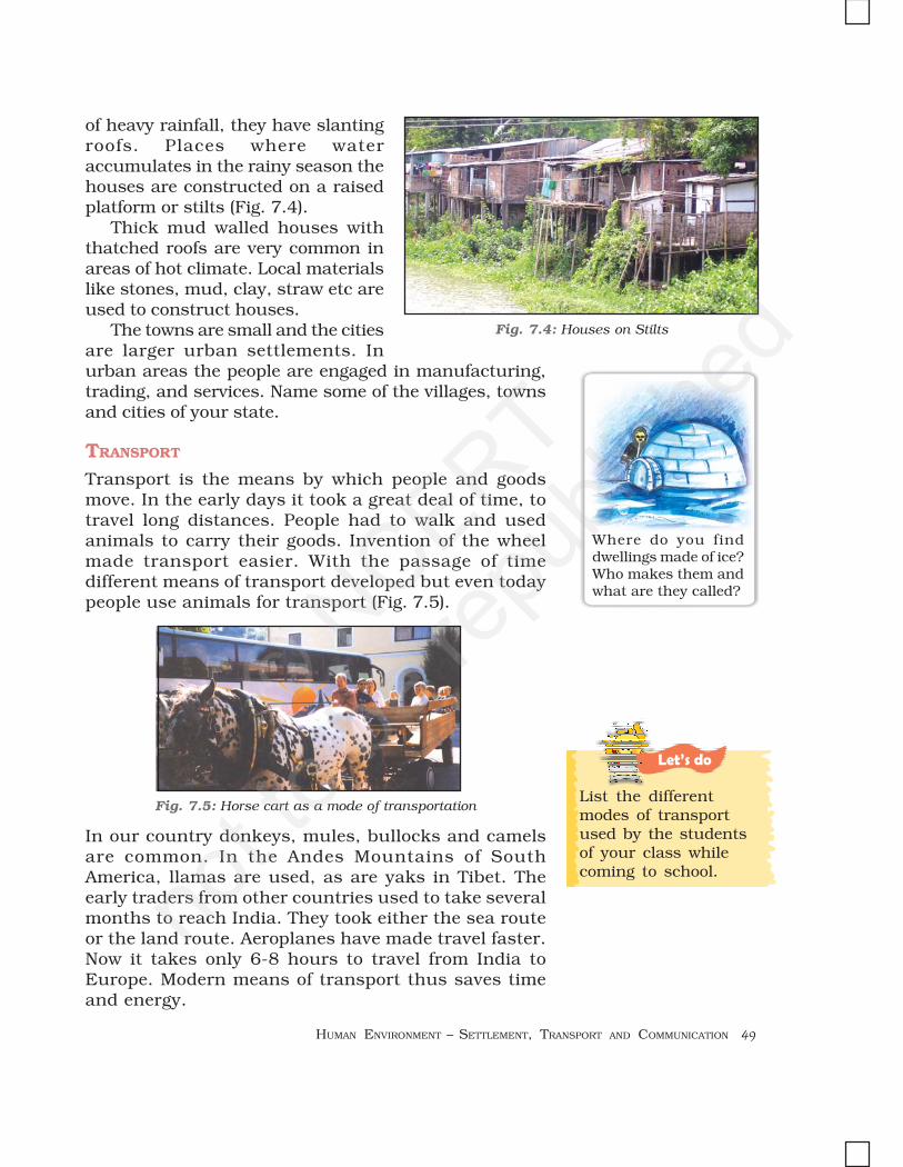
Transport is the means by which people and goodsmove. In the early days it took a great deal of time, totravel long distances. People had to walk and usedanimals to carry their goods. Invention of the wheelmade transport easier. With the passage of timedifferent means of transport developed but even todaypeople use animals for transport (Fig. 7.5).
Where do you finddwellings made of ice?Who makes them andwhat are they called?
Fig. 7.5: Horse cart as a mode of transportationList the differentmodes of transportused by the studentsof your class whilecoming to school.
Fig. 7.4: Houses on Stilts
In our country donkeys, mules, bullocks and camelsare common. In the Andes Mountains of SouthAmerica, llamas are used, as are yaks in Tibet. Theearly traders from other countries used to take severalmonths to reach India. They took either the sea routeor the land route. Aeroplanes have made travel faster.Now it takes only 6-8 hours to travel from India toEurope. Modern means of transport thus saves timeand energy.
© NCERT
not to
be re
publi
shed

50 OUR ENVIRONMENT
The four major means of transport are roadways,railways, waterways and airways.
ROADWAYS
The most commonly used means of transport especiallyfor short distances are roads. They can be metalled(pucca) and unmetalled (kutcha) (Fig. 7.6 and 7.7). Theplains have a dense network of roads. Roads have alsobeen build in terrains like deserts, forests and even highmountains. Manali-Leh highway in the HimlayanMountains is one of the highest roadways in the world.Roads built underground are called subways/underpaths. Flyovers are built over raised structures.
Fig. 7.6: Metalled Road Fig. 7.7: Unmetalled Road
RAILWAYS
The railways carry heavy goods andpeople over long distances quickly andcheaply. The invention of the steamengine and the Industrial Revolutionhelped in speedy development of railtransport. Diesel and electric engineshave largely replaced the steamengines. In places super fast trainshave been introduced to make thejourney faster. The railway networkis well developed over the plain areas.Advanced technological skills haveenabled laying of railway lines indifficult mountain terrains also. But
these are much fewer in number. Indian railway networkis well developed. It is the largest in Asia.
Do you know?
There are severalNational and Statehighways in India. Thelatest development inIndia is the constructionof Express Ways. TheGolden Quadrilateralconnects Delhi,Mumbai, Chennai andKolkata.
Do you know?
The train from Xining to Lhasa runs atan altitude of 4,000m above sea leveland the highest point is 5,072 m
© NCERT
not to
be re
publi
shed
HUMAN ENVIRONMENT – SETTLEMENT, TRANSPORT AND COMMUNICATION 51
Do you know?
WATERWAYS
You have already learnt that since early days waterwayswere used for transportation. Waterways are thecheapest for carrying heavy and bulky goods over longdistances. They are mainly of two types – inlandwaterways and sea routes.
Navigable rivers and lakes are used as inlandwaterways. Some of the important inland waterways arethe Ganga-Brahmaputra river system, the Great Lakesin North America and the river Nile in Africa.
Sea routes and oceanic routes are mostlyused for transporting merchandise andgoods from one country to another. Theseroutes are connected with the ports. Someof the important ports of the world areSingapore and Mumbai in Asia, New York,Los Angeles in North America, Rio deJanerio in South America, Durban andCape Town in Africa, Sydney in Australia,London and Rotterdam in Europe (Fig. 7.11).Can you name some more ports of the world?
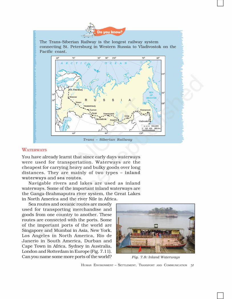
The Trans-Siberian Railway is the longest railway systemconnecting St. Petersburg in Western Russia to Vladivostok on thePacific coast.
Trans – Siberian Railway
Fig. 7.8: Inland Waterways
© NCERT
not to
be re
publi
shed

52 OUR ENVIRONMENT
Let’s do
AIRWAYS
This is the fastest way of transport developed in the earlytwentieth century. It is also the most expensive due tohigh cost of fuels. Air traffic is adversely affected by badweather like fog and storms. It is the only mode oftransport to reach the most remote and distant areasespecially where there are no roads and railways.Helicopters are extremely useful in most inaccessibleareas and in time of calamities for rescuing people anddistributing food, water, clothes and medicines (Fig. 7.9).Some of the important airports are Delhi, Mumbai, NewYork, London, Paris, Frankfurt and Cairo (Fig. 7.11).
COMMUNICATION
Communication is the process of conveying messages toothers. With the development of technology humans havedevised new and fast modes of communication. The Fig.7.10 explains the evolution of the communication system.
The advancement in the field of communication hasbrought about an information revolution in the world.Different modes of communication are used to provideinformation, to educate as well as to entertain. Throughnewspapers, radio and television we can communicatewith a large number of people. They are therefore calledmass media. The satellites have made communicationeven faster. Satellites have helped in oil exploration,survey of forest, underground water, mineral wealth,weather forecast and disaster warning. Now we can sendelectronic mails or e-mails through Internet. Wirelesstelephonic communications through cellular phones
have become very popular today. Internet notonly provides us with worldwide informationand interaction but has also made our lives
more comfortable. Now wecan reserve tickets for railways,
airways and even cinemas andhotels sitting at home.
With this kind
Fig. 7.9: A Helicopter
Fig. 7.10: Progress in the meansof communication
Find out the names ofsome newspapers andTV news channels inEnglish, Hindi and aregional language.
52 OUR ENVIRONMENT
© NCERT
not to
be re
publi
shed

HUMAN ENVIRONMENT – SETTLEMENT, TRANSPORT AND COMMUNICATION 53
of inter connectivity of people, services and institutions –across the world, we are a large global society.
Fig
. 7
.11
: W
orld
– M
ajo
r S
ea P
orts
an
d A
irp
orts
© NCERT
not to
be re
publi
shed

54 OUR ENVIRONMENT
Exercises
1. Answer the following questions.
(i) What are the four means of transport?
(ii) What do you understand by the term ‘settlement’?
(iii) Which are the activities practised by the rural people?
(iv) Mention any two merits of railways.
(v) What do you understand by communication?
(vi) What is mass media?
2. Tick the correct answer.
(i) Which is NOT a means of communication?(a) telephone (b) books (c) table
(ii) Which type of road is constructed under the ground?(a) fly over (b) expressways (c) subways
(iii) Which mode of transport is most suitable to reach an island?(a) ship (b) train (c) car
(iv) Which vehicle does not pollute the environment(c) cycle (b) bus (c) aeroplane
3. Match the following.
(i) Internet (a) areas where people are engaged inmanufacturing, trade and services
(ii) Canal route (b) closely built area of houses
(iii) Urban areas (c) houses on stilts
(iv) Compact settlement (d) inland waterway
(e) a means of communication
4. Give reasons.
(i) Today’s world is shrinking.
5. For fun.
(i) Conduct a survey in your locality and find out how people commute to theirrespective workplaces using –(a) more than two modes of transport(b) more than three modes of transport(c) stay within walking distance.
(ii) Mention which mode of communication you will prefer most in the followingsituations –(a) Your grandfather has suddenly fallen ill. How will you inform the doctor?(b) Your mother wants to sell the old house. How will she spread this news?(c) You are going to attend the marriage of your cousin for which you will
be absent from the school for the next two days. How will you inform theteacher?
(d) Your friend has moved out with his/her family to New York. How willyou keep in touch on a daily basis?
© NCERT
not to
be re
publi
shed

Renuka was excited. Shrikant Uncle was home after agap of nearly four months. He was a wildlife photographer
and travelled widely. Renuka’s interest in wildlife andforests began at an early age, when her uncle introduced
her to books on nature. Pictures of distant lands andpeople, who lived there, always fascinated her.
Fig. 8.1: People from various parts of the world
“In these pictures Renuka, you can see people fromdifferent parts of the world – some from dry deserts, some
from frozen lands and some from hot wet rainforests.”“They look so different from me”, observed Renuka. “Theymay look different, but they share the same basic needs
of life – food, clothing and shelter”, explained Shrikant Uncle.“Their children do the same things as you probably do,
play games, quarrel sometimes and then make-up, sing,dance and help the families with various things that needto be done. They live closer to nature and very early in
their lives have learnt to care for nature. They learn howto catch fish and how to collect material from the forests.”
2015-16 (12-01-15)
OUR ENVIRONMENT
Glossary
In Chapters 8, 9 and 10, you will learn about the lifeof people in the different natural regions of the world.
LIFE IN THE AMAZON BASIN
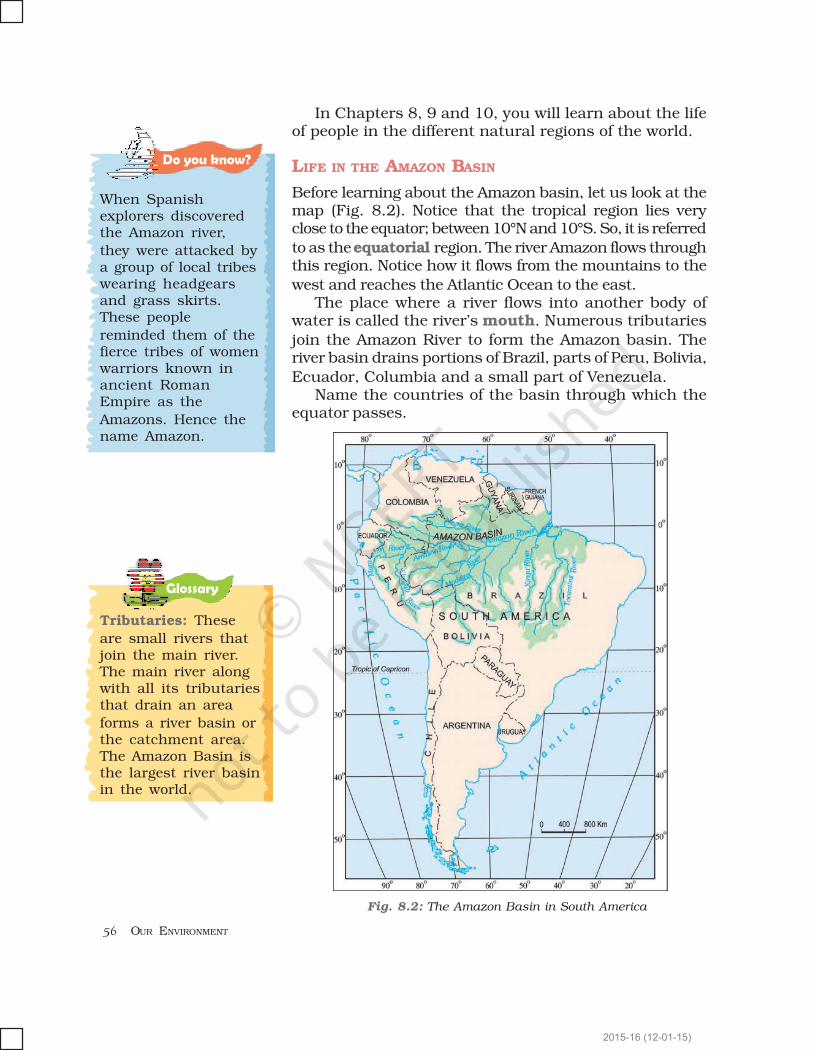
Before learning about the Amazon basin, let us look at themap (Fig. 8.2). Notice that the tropical region lies veryclose to the equator; between 10°N and 10°S. So, it is referred
to as the equatorial region. The river Amazon flows throughthis region. Notice how it flows from the mountains to the
west and reaches the Atlantic Ocean to the east.The place where a river flows into another body of
water is called the river’s mouth. Numerous tributaries
join the Amazon River to form the Amazon basin. Theriver basin drains portions of Brazil, parts of Peru, Bolivia,
Ecuador, Columbia and a small part of Venezuela.Name the countries of the basin through which the
equator passes.
Tributaries: These
are small rivers thatjoin the main river.The main river alongwith all its tributariesthat drain an area
forms a river basin orthe catchment area.The Amazon Basin isthe largest river basinin the world.
Fig. 8.2: The Amazon Basin in South America
Do�you�know?
When Spanishexplorers discoveredthe Amazon river,
they were attacked bya group of local tribeswearing headgearsand grass skirts.These people
reminded them of thefierce tribes of womenwarriors known inancient RomanEmpire as the
Amazons. Hence thename Amazon.
2015-16 (12-01-15)

HUMAN ENVIRONMENT INTERACTIONS: THE TROPICAL AND THE SUBTROPICAL REGION
CLIMATE
As you now know, the Amazon Basin stretches directlyon the equator and is characterized by hot and wet climate
throughout the year. Both day and nights are almostequally hot and humid. The skin feels sticky. It rainsalmost everyday, that too without much warning. The
day temperatures are high with very high humidity. Atnight the temperature goes down but the humidity
remains high.
RAINFORESTS
As it rains heavily in this region, thick forestsgrow (Fig. 8.3). The forests are in fact so thick
that the dense “roof” created by leaves andbranches does not allow the sunlight to reachthe ground. The ground remains dark and damp.
Only shade tolerant vegetation may grow here.Orchids, bromeliads grow as plant parasites.
The rainforest is rich infauna. Birds such as toucans (Fig. 8.4),humming birds, bird of paradise with
their brilliantly coloured plumage,oversized bills for eating make them
different from birds we commonly seein India. These birds also make loudsounds in the forests. Animals like
monkeys, sloth and ant-eating tapirsare found here (Fig. 8.5). Various species of reptiles and
snakes also thrive in these jungles. Crocodiles, snakes,pythons abound. Anaconda and boa constrictor aresome of the species. Besides, the basin is home to
thousands of species ofinsects. Several species of
fishes including the flesh-eating Piranha fish is alsofound in the river. This basin
is thus extraordinarily rich inthe variety of life found there.
PEOPLE OF THE RAINFORESTS
People grow most of their food in small areas after clearing
some trees in the forest. While men hunt and fish alongthe rivers, women take care of the crops. They mainly grow
Do�you�know?
Bromeliads arespecial plants thatstore water in theirleaves. Animals like
frogs use thesepockets of water forlaying their eggs.
Let’s�do
Some TV channelsbroadcast
documentaries on thewildlife of the world.Try to watch some ofthe films and shareyour experience with
the class.
Fig. 8.3 : The Amazon Forest
Fig. 8.4 : Toucans
Fig. 8.5 : Tapir
2015-16 (12-01-15)
OUR ENVIRONMENT
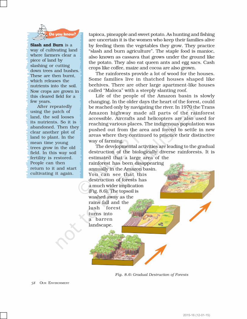
Fig. 8.6: Gradual Destruction of Forests
Do�you�know?
Slash and Burn is away of cultivating landwhere farmers clear apiece of land by
slashing or cuttingdown trees and bushes.These are then burnt,which releases thenutrients into the soil.
Now crops are grown inthis cleared field for afew years.
After repeatedlyusing the patch of
land, the soil loosesits nutrients. So it isabandoned. Then theyclear another plot ofland to plant. In the
mean time youngtrees grow in the oldfield. In this way soilfertility is restored.People can then
return to it and startcultivating it again.
tapioca, pineapple and sweet potato. As hunting and fishingare uncertain it is the women who keep their families alive
by feeding them the vegetables they grow. They practice“slash and burn agriculture”. The staple food is manioc,
also known as cassava that grows under the ground likethe potato. They also eat queen ants and egg sacs. Cashcrops like coffee, maize and cocoa are also grown.
The rainforests provide a lot of wood for the houses.Some families live in thatched houses shaped like
beehives. There are other large apartment-like housescalled “Maloca” with a steeply slanting roof.
Life of the people of the Amazon basin is slowly
changing. In the older days the heart of the forest, couldbe reached only by navigating the river. In 1970 the Trans
Amazon highway made all parts of the rainforestaccessible. Aircrafts and helicopters are also used forreaching various places. The indigenous population was
pushed out from the area and forced to settle in newareas where they continued to practice their distinctive
way of farming.The developmental activities are leading to the gradual
destruction of the biologically diverse rainforests. It is
estimated that a large area of therainforest has been disappearing
annually in the Amazon basin.You can see that thisdestruction of forests has
a much wider implication(Fig. 8.6). The topsoil is
washed away as therains fall and thelush forest
turns intoa barren
landscape.
2015-16 (12-01-15)

HUMAN ENVIRONMENT INTERACTIONS: THE TROPICAL AND THE SUBTROPICAL REGION
LIFE IN THE GANGA-BRAHMAPUTRA BASIN
The tributaries of rivers Ganga andBrahmaputra together form the
Ganga-Brahmaputra basin in theIndian subcontinent (Fig. 8.8). Thebasin lies in the sub-tropical region
that is situated between 10°N to 30°Nlatitudes. The tributaries of the River
Ganga like the Ghaghra, the Son, theChambal, the Gandak, the Kosi andthe tributaries of Brahmaputra drain
it. Look at the atlas and find namesof some tributaries of the River
Brahmaputra.The plains of the Ganga and the
Brahmaputra, the mountains and the foothills of the
Fig. 8.8: Ganga-Brahmputra Basin
Fig. 8.7 Brahmaputra river
INDIA
2015-16 (12-01-15)

OUR ENVIRONMENT
Glossary
Himalayas and the Sundarbans delta are the mainfeatures of this basin. Ox-bow lakes dot the plain area.
The area is dominated by monsoon climate. Themonsoon brings rains from mid-June to mid-September.
The summers are hot and the winters cool.Look at the map of India (Fig. 8.8). Find out the states
in which the Ganga-Brahmputra basin lies.
The basin area has varied topography. Theenvironment plays a dominant role in the distribution
of the population. The mountain areas with steep slopeshave inhospitable terrain. Therefore less number ofpeople live in the mountain area of the Ganga-
Brahmaputra basin. The plain area provides the mostsuitable land for human habitation. The soil is fertile.
Agriculture is the main occupation of the people whereflat land is available to grow crops. The density ofpopulation of the plains is very high. The main crop is
paddy (Fig. 8.9). Since cultivation of paddy requiressufficient water, it is grown in the areas where the amount
of rainfall is high.Wheat, maize, sorghum, gram and millets are the
other crops that are grown. Cash crops like sugarcane
and jute are also grown. Banana plantations are seen insome areas of the plain. In West Bengal and Assam tea is
grown in plantations (Fig. 8.10). Silk is produced throughthe cultivation of silk worms in parts of Bihar and Assam.In the mountains and hills, where the slopes are gentle,
crops are grown on terraces.The vegetation cover of the area varies according to
the type of landforms. In the Ganga and Brahmaputraplain tropical deciduous trees grow, along with teak, saland peepal. Thick bamboo groves are common in the
Brahmaputra plain. The delta area is covered with the
Fig. 8.9 : Paddy Cultivation Fig. 8.10 : Tea Garden in Assam
Let’s�do
River Brahmaputra isknown by different
names in differenceplaces. Find the othernames of the river.
Activity
Collect somehandicrafts madefrom jute, bamboo andsilk. Display them in
the class. Find out inwhich area they weremade?
Population density:It means the numberof persons that live inone sq. km. of areae.g. the population
density of Uttarakhandis 189 while thedensity of WestBengal is 1029 andthat of Bihar is 1102.
2015-16 (12-01-15)

HUMAN ENVIRONMENT INTERACTIONS: THE TROPICAL AND THE SUBTROPICAL REGION
Fig. 8.12 : CrocodilesFig. 8.11 : One horned rhinoceros
Lake: A source of livelihood
(A case study)
Binod is a fisherman
living in the MatwaliMaun village of Bihar.He is a happy man
today. With the effortsof the fellow
fishermen – Ravindar,Kishore, Rajiv andothers, he cleaned the
maun or the ox-bowlake to cultivate
different varieties of fish. The local weed (vallineria,hydrilla) that grows in the lake is the food of the fish.The land around the lake is fertile. He sows crops
such as paddy, maize and pulses in these fields.The buffalo is used to plough the land. The
community is satisfied. There is enough fish catchfrom the river – enough fish to eat and enough fish
Do�you�know?
In the fresh waters of
River Ganga and RiverBrahmaputra, avariety of dolphinlocally called Susu(also called blind
dolphin) is found. Thepresence of Susu is anindication of thehealth of the river. Theuntreated industrial
and urban wastes withhigh amount ofchemicals are killingthis species.
A clean lake
mangrove forests. In parts of Uttarakhand, Sikkim andArunachal Pradesh, coniferous trees like pine, deodar
and fir can be seen because the climate is cool and theslopes are steep.
There is a variety of wildlife in the basin. Elephants,tigers, deer and monkeys are common. The one-hornedrhinoceros is found in the Brahmaputra plain. In the
delta area, Bengal tiger, crocodiles and alligator are found.Aquatic life abounds in the fresh river waters, the lakes
and the Bay of Bengal Sea. The most popular varieties ofthe fish are the rohu, catla and hilsa. Fish and rice isthe staple diet of the people living in the area.
Blind Dolphin
Do�you�know?
Terraces are built onsteep slopes to create
flat surfaces on whichcrops are grown. Theslope is removed sothat water does notrun off rapidly.
Terrace Farming
2015-16 (12-01-15)
OUR ENVIRONMENT
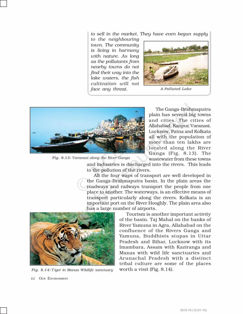
Fig. 8.13: Varanasi along the River Ganga
The Ganga-Brahmaputraplain has several big towns
and cities. The cities ofAllahabad, Kanpur, Varanasi,
Lucknow, Patna and Kolkataall with the population ofmore than ten lakhs are
located along the RiverGanga (Fig. 8.13). The
wastewater from these townsand industries is discharged into the rivers. This leads
to the pollution of the rivers.All the four ways of transport are well developed in
the Ganga-Brahmaputra basin. In the plain areas the
roadways and railways transport the people from oneplace to another. The waterways, is an effective means of
transport particularly along the rivers. Kolkata is animportant port on the River Hooghly. The plain area alsohas a large number of airports.
Tourism is another important activityof the basin. Taj Mahal on the banks of
River Yamuna in Agra, Allahabad on theconfluence of the Rivers Ganga andYamuna, Buddhists stupas in Uttar
Pradesh and Bihar, Lucknow with itsImambara, Assam with Kaziranga and
Manas with wild life sanctuaries andArunachal Pradesh with a distincttribal culture are some of the places
worth a visit (Fig. 8.14).
to sell in the market. They have even begun supplyto the neighbouring
town. The communityis living in harmony
with nature. As longas the pollutants fromnearby towns do not
find their way into thelake waters, the fish
cultivation will notface any threat. A Polluted Lake
Fig. 8.14: T iger in Manas Wildlife sanctuary
2015-16 (12-01-15)
HUMAN ENVIRONMENT INTERACTIONS: THE TROPICAL AND THE SUBTROPICAL REGION
1. Answer the following questions.
(i) Name the continent in which the Amazon Basin is located.
(ii) What are the crops grown by the people of the Amazon Basin.
(iii) Name the birds that you are likely to find in the rainforests of the Amazon.
(iv) What are the major cities located on the River Ganga.
(v) Where is the one-horned rhinoceros found?
2. Tick the correct answer.
(i) Toucans are a type of
(a) birds (b) animals (c) crops
(ii) Manioc is the staple food of
(a) Ganga Basin (b) Africa (c) Amazon
(iii) Kolkata is located on the river
(a) Orange (b) Hooghly (c) Bhagirathi
(iv) Deodars and firs are a type of
(a) Coniferous trees (b) Deciduous trees (c) shrubs
(v) Bengal tiger is found in
(a) mountains (b) delta area (c) Amazon
3. Match the following.
(i) Cotton textile (a) Assam
(ii) Maloca (b) Terrace farming
(iii) Piranha (c) Sericulture
(iv) Silk worm (d) Slanting roof
(v) Kaziranga (e) Ganga plain
(f) Varanasi
(g) Fish
4. Give reasons.
(i) The rainforests are depleting.
(ii) Paddy is grown in the Ganga-Brahmaputra plains.
5. Map skills.
(i) On an outline map of the Indian Sub-continent, draw the rivers Ganga andBrahmaputra from the source to the mouth. Also show the importanttributaries of both the rivers.
(ii) On the political map of South America, draw the equator. Mark the countriesthrough which the equator passes.
6. For fun.
Make a collage to show places of attractions in India. You can divide the classin different groups to show attractions based on mountain landscapes, coastalbeaches, wildlife sanctuaries and places of historical importance.
Exercises
2015-16 (12-01-15)
OUR ENVIRONMENT
7. Activity.
Collect under mentioned material and observe how destruction of trees effectthe soil cover.
Material
(i) Three small flowerpots or food cans (e.g., cold drinks tin cans),
(ii) one big can with holes punched in the bottom (this will act as asprinkling can),
(iii) twelve coins or bottle caps
(iv) soil.
Steps
Take three small cans or pots. Fill them with soil till the top. Press the soil tomake it level with the top of the can. Now put four coins or bottle caps on thesoil of each can. Take the big can that has been punched with holes and fill itwith water. You can also take the sprinkling can from your garden. Now, sprinklewater on the three cans. On the first can sprinkle water very slowly so that nosoil splashes out. Let moderate amount of water be sprinkled on the secondcan. On the third can, sprinkle the water heavily. You will observe thatunprotected soil splashes out. Where the ‘rain’ is heavy the amount of soil thatsplashes out is the maximum and least in case of the first can. The coins orcaps represent the tree covers. It is clear that if the land is cleared completelyof the vegetation, the soil cover will quickly disappear.
2015-16 (12-01-15)
Just as a forest can be defined as the place where treesare the main type of vegetation, grassland can bedefined as a region where grasses form the dominanttype of plant life. Grasslands make up almost a quarterof the total land surface. The types of plants thatgrow here greatly depend on what the climate and soilare like. As climate plays an important role in theformation of grasslands, it is generally used as a basisto divide the world’s grasslands into two broadcategories: those that occur in the temperate regionand those that occur in the tropical regions.
THE PRAIRIES
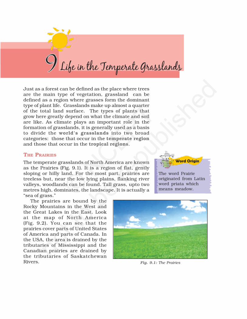
The temperate grasslands of North America are knownas the Prairies (Fig. 9.1). It is a region of flat, gentlysloping or hilly land. For the most part, prairies aretreeless but, near the low lying plains, flanking rivervalleys, woodlands can be found. Tall grass, upto twometres high, dominates, the landscape. It is actually a“sea of grass.”
The prairies are bound by theRocky Mountains in the West andthe Great Lakes in the East. Lookat the map of North America(Fig. 9.2). You can see that theprairies cover parts of United Statesof America and parts of Canada. Inthe USA, the area is drained by thetributaries of Mississippi and theCanadian prairies are drained bythe tributaries of SaskatchewanRivers.
Word Origin
The word Prairieoriginated from Latinword priata whichmeans meadow.
Fig. 9.1: The Prairies
© NCERT
not to
be re
publi
shed

66 OUR ENVIRONMENT
CLIMATE
Being located in the heart of a continent, the climate isof continental type with extreme temperatures.The summers are warm with temperatures of around20°C, while in winter -20°C has been recorded inWinnipeg, Canada. In winters a thick blanket of snowcovers this region.
The annual rainfall is moderate and is ideal for thegrowth of grass. Due to the absence of the north-southbarrier, a local wind “Chinook” blows here.
Do you know?
Chinook is a hot windthat blows in winterand therefore raisesthe temperaturewithin a short time.This increase intemperature resultsin the melting ofsnow, making pastureland available forgrazing of animals.
Fig. 9.2: The Prairies in North America
Do you know?
The grasslands ofPrairies were thehome of nativeAmericans oftencalled “Red Indians”.They were the actualhabitant of thecontinent. The Prairieswere home of othertribes also like theApache, the Crow, theCree and the Pawnee.
© NCERT
not to
be re
publi
shed

67LIFE IN THE TEMPERATE GRASSLANDS
Glossary
FLORA AND FAUNA
Prairies are practically tree-less. Where wateris available, trees such as willows, alders andpoplars grow. Places that receive rainfall ofover 50 cm, are suitable for farming as thesoil is fertile. Though the major crop of thisarea is maize, other crops including potatoes,soybean, cotton and alfa-alfa is also grown.Areas where rainfall is very little or unreliable,grasses are short and sparse. These areasare suitable for cattle rearing. Large cattlefarms called ranches are looked after by
sturdy men calledcowboys (Fig. 9.3). Bison or theAmerican buffalo is the mostimportant animal of this region(Fig. 9.4). It nearly got extinctdue to its indiscriminate huntingand is now a protected species.The other animals found in thisregion are rabbits, coyotes,gophers and Prairie dog.
PEOPLE
The people of this region are very hardworking. Theyhave successfully harnessed technology to utilise theirrich natural resources. Two of the most developedcountries in the world - the USA and Canada are locatedin this region. Scientific methods of cultivation and useof tractors, harvesters and combines has made NorthAmerica a surplus food producer. The Prairies are alsoknown as the “Granaries of the world,” due to the hugesurplus of wheat production.
Dairy farming is another major industry. The dairybelt extends from the Great Lakes to the Atlantic Coastin the east. Dairy farming and extensive agriculture bothpromote setting up of food processing industries.
Large mineral deposits particularly coal and ironand a good network of roads, railways and canals inthis region have made it the most industrialised regionin the world.
Fig. 9.3: A Cowboy with his horse
Combine: A singlemachine which cancombine the tasks ofsowing, ploughing andthreshing i.e. a three-in-one.
Do you know?
Important cities inthe American prairiesare Chicago,Minneapolis,Indianapolis, Kansasand Denver. In theCanadian prairies theimportant cities areEdmonton,Saskatoon, Calgaryand Winnipeg.
Fig. 9.4: A Bison
© NCERT
not to
be re
publi
shed

68 OUR ENVIRONMENT
Let’s do
THE VELDS
The temperate grasslands of South Africa are called thevelds (Fig. 9.5). Velds are rolling plateaus with varyingheights ranging from 600 m to 1100 m. It is bound bythe Drakensburg Mountains on the east. To its west liesthe Kalahari desert. On the northeastern part, “high velds”are located that attain a height of more than 1600 m, insome places. Look at the map of Africa. Name thecountries that are covered by the Velds. The tributariesof rivers Orange and Limpopo drain the region.
Velds lie in theSouthern hemisphere.When it is summersin velds, what seasonwould it be in theprairies?
Do you know?
The Veld name wasgiven by the Dutchsettlers before SouthAfrica was colonisedby the British.
Fig. 9.5: Veld in Africa
CLIMATE
The velds have a mild climate due to the influence of theIndian Ocean. Winters are cold and dry. Temperaturesvary between 5°C and 10°C and July is the coldestmonth. Summers are short and warm. Johannesburgrecords about 20°C temperature in the summer.
Let’s do
Some type of grassgrows on almost everysurface of the earth.List names of placeswhere you haveobserved grassgrowing, e.g., lawns,cricket field, betweencracks of a side walketc. © N
CERT
not to
be re
publi
shed
69LIFE IN THE TEMPERATE GRASSLANDS
The velds receive rainfall mainly in the summer monthsfrom November to February. This is mainly because ofthe warm ocean currents that wash the shores of thevelds. If the rainfall is scanty in the winter months fromJune till August, drought may occur.
FLORA AND FAUNA
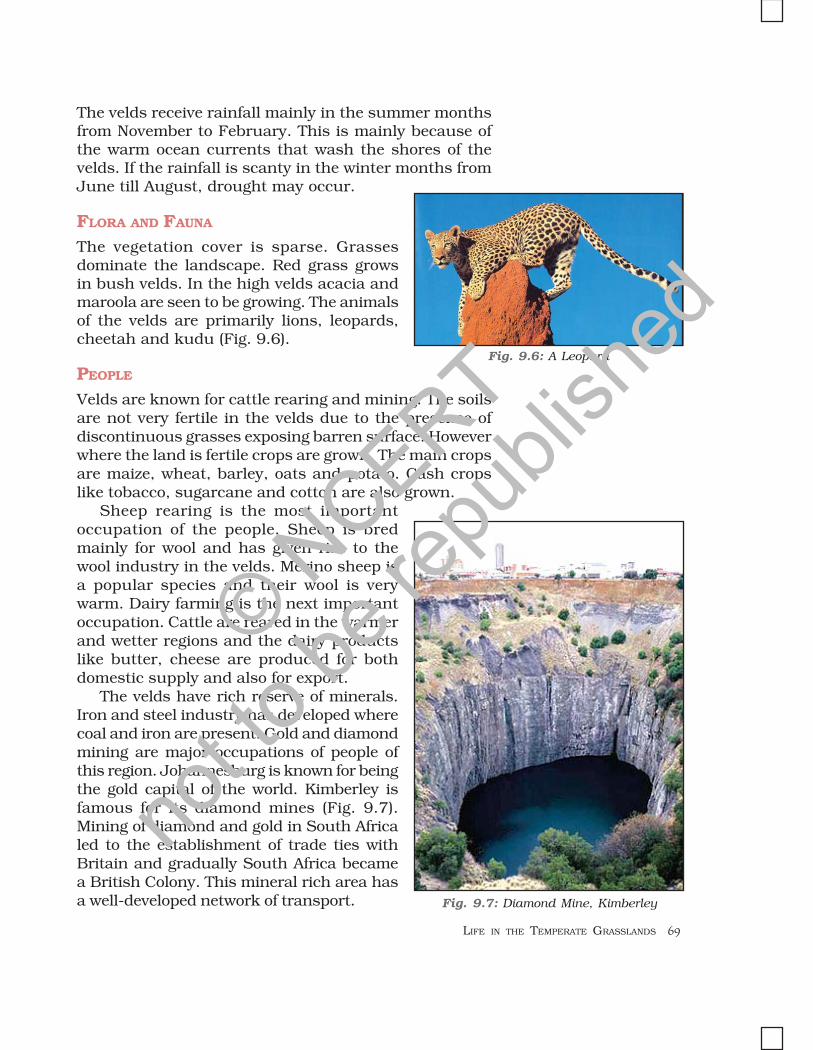
The vegetation cover is sparse. Grassesdominate the landscape. Red grass growsin bush velds. In the high velds acacia andmaroola are seen to be growing. The animalsof the velds are primarily lions, leopards,cheetah and kudu (Fig. 9.6).
PEOPLE
Velds are known for cattle rearing and mining. The soilsare not very fertile in the velds due to the presence ofdiscontinuous grasses exposing barren surface. Howeverwhere the land is fertile crops are grown. The main cropsare maize, wheat, barley, oats and potato. Cash cropslike tobacco, sugarcane and cotton are also grown.
Sheep rearing is the most importantoccupation of the people. Sheep is bredmainly for wool and has given rise to thewool industry in the velds. Merino sheep isa popular species and their wool is verywarm. Dairy farming is the next importantoccupation. Cattle are reared in the warmerand wetter regions and the dairy productslike butter, cheese are produced for bothdomestic supply and also for export.
The velds have rich reserve of minerals.Iron and steel industry has developed wherecoal and iron are present. Gold and diamondmining are major occupations of people ofthis region. Johannesburg is known for beingthe gold capital of the world. Kimberley isfamous for its diamond mines (Fig. 9.7).Mining of diamond and gold in South Africaled to the establishment of trade ties withBritain and gradually South Africa becamea British Colony. This mineral rich area hasa well-developed network of transport. Fig. 9.7: Diamond Mine, Kimberley
Fig. 9.6: A Leopard
© NCERT
not to
be re
publi
shed
70 OUR ENVIRONMENT
1. Answer the following questions.
(i) What are the Temperate Grasslands of North America called?
(ii) What are the cattle farms in the North American Grasslands known as?
(iii) Name the rivers that drain the Velds.
(iv) When is the rainy season in the Velds?
(v) What is the major occupation of the people of the South African grasslands?
2. Tick the correct answer.
(i) River Mississippi drains(a) Canada (b) Africa (c) USA
(ii) Drakensberg Mountains are to the west of(a) Prairies (b) Velds (c) Pampas
(iii) Merino is a species of(a) fish (b) elephant (c) sheep
(iv) Kimberley is famous for(a) diamonds (b) silver (c) platinum
3. Match the following.
(i) Cowboys (a) Iron and Steel(ii) Gold (b) Prairies(iii) Kudu (c) Hot wind(iv) Chinook (d) Velds(v) Coal (e) Johannesberg
(f) Animal
4. Give reasons.
(i) The Prairies are known as the ‘Granaries of the World’.
(ii) Rise of wool industry in the Velds.
5. Map skills.
On an outline map of North America, mark the Rocky mountains, the GreatLakes, river Mississippi, river Saskatchewan, the cities – Chicago and Winnipeg.
6. For fun.
Make a grass whistle
You will require a blade of grass about 5 cm in length. Be sure to choose thegrass blade longer than your thumb. The blade of grass should be fairly thick.Choose the grass that is broad and wide. Narrow blade is difficult to hold. Putyour thumbs together as your nails are facing you. Stretch the blade of grasslengthwise between the thumbs and the base of the hand. Your hands shouldbe cupped to create a hollow or a narrow opening between your palms. Youshould just be able to see the edge of the grass only through the narrow opening.Place your lips over the opening and blow gently into the palm. You may evenfeel the grass blade vibrating as you blow. As you gradually blow you will hearsound of whistle created by grass.
Exercises
© NCERT
not to
be re
publi
shed
2015-16 (12-01-15)
First Edition
March 2007 Phalguna 1928
ReprintedDecember 2007 Pausa 1928
December 2008 Pausa 1930
December 2009 Pausa 1931
December 2010 Pausa 1932
January 2012 Magha 1933November 2012 Kartika 1934
October 2013 Asvina 1935
November 2014 Agrahayana 1936
PD 480T MJ
© National Council of Educational
Research and Training, 2007
`̀̀̀̀ 50.00
Printed on 80 GSM paper with NCERT
watermark
Published at the Publication Division by
the Secretary, National Council ofEducational Research and Training,
Sri Aurobindo Marg, New Delhi 110 016 and
printed at Bengal Offset Works, G-181,
Sector-63, Noida 201 301.
ISBN 81-7450-714-0
ALL RIGHTS RESERVED
q No part of this publication may be reproduced, stored in a retrieval system ortransmitted, in any form or by any means, electronic, mechanical, photocopying,recording or otherwise without the prior permission of the publisher.
q This book is sold subject to the condition that it shall not, by way of trade, be lent,
re-sold, hired out or otherwise disposed of without the publisher’s consent, in anyform of binding or cover other than that in which it is published.
q The correct price of this publication is the price printed on this page, Any revised
price indicated by a rubber stamp or by a sticker or by any other means is incorrectand should be unacceptable.
Publication Team
Head, Publication : N. K. GuptaDivision
Chief Production : Kalyan Banerjee
Officer
Chief Editor : Shveta Uppal
Chief Business : Gautam GangulyManager
Production Officer : Arun Chitkara
Cover and Layout
Blue Fish
Illustrations
Meha Gupta
Blue Fish
Cartography
Cartographic Designs Agency
OFFICES OF THE PUBLICATION
DIVISION, NCERT
NCERT CampusSri Aurobindo Marg
New Delhi 110 016 Phone : 011-26562708
108, 100 Feet RoadHosdakere Halli ExtensionBanashankari III StageBengaluru 560 085 Phone : 080-26725740
Navjivan Trust BuildingP.O.NavjivanAhmedabad 380 014 Phone : 079-27541446
CWC CampusOpp. Dhankal Bus Stop
PanihatiKolkata 700 114 Phone : 033-25530454
CWC ComplexMaligaonGuwahati 781 021 Phone : 0361-2674869
2015-16 (12-01-15)

The National Curriculum Framework (NCF), 2005, recommends thatchildren’s life at school must be linked to their life outside the school.This principle marks a departure from the legacy of bookish learningwhich continues to shape our system and causes a gap betweenthe school, home and community. The syllabi and textbooksdeveloped on the basis of NCF signify an attempt to implement thisbasic idea. They also attempt to discourage rote learning and themaintenance of sharp boundaries between different subject areas.We hope these measures will take us significantly further in thedirection of a child-centred system of education outlined in theNational Policy on Education (1986).
The success of this effort depends on the steps that schoolprincipals and teachers will take to encourage children to reflect ontheir own learning and to pursue imaginative activities andquestions. We must recognise that, given space, time and freedom,children generate new knowledge by engaging with the informationpassed on to them by adults. Treating the prescribed textbook asthe sole basis of examination is one of the key reasons why otherresources and sites of learning are ignored. Inculcating creativityand initiative is possible if we perceive and treat children asparticipants in learning, not as receivers of a fixed body of knowledge.
These aims imply considerable change in school routines andmode of functioning. Flexibility in the daily time-table is as necessaryas rigour in implementing the annual calendar so that the requirednumber of teaching days are actually devoted to teaching. Themethods used for teaching and evaluation will also determine howeffective this textbook proves for making children’s life at school ahappy experience, rather than a source of stress or boredom.Syllabus designers have tried to address the problem of curricularburden by restructuring and reorienting knowledge at differentstages with greater consideration for child psychology and the timeavailable for teaching. The textbook attempts to enhance thisendeavour by giving higher priority and space to opportunities forcontemplation and wondering, discussion in small groups, andactivities requiring hands-on experience.
The National Council of Educational Research and Training(NCERT) appreciates the hard work done by the textbook developmentcommittee responsible for this book. We wish to thank theChairperson of the advisory committee for textbooks in SocialSciences, at the higher secondary level, Professor Hari Vasudevanand the Chief Advisor for this book, Vibha Parthasarathi for guiding
Foreword
2015-16 (12-01-15)

iv
the work of this committee. Several teachers contributed to thedevelopment of this textbook; we are grateful to their principals formaking this possible. We are indebted to the institutions andorganisations which have generously permitted us to draw upontheir resources, material and personnel. We are especially gratefulto the members of the National Monitoring Committee, appointedby the Department of Secondary and Higher Education, Ministry ofHuman Resource Development under the Chairpersonship ofProfessor Mrinal Miri and Professor G.P. Deshpande, for theirvaluable time and contribution. As an organisation committed tosystemic reform and continuous improvement in the quality of itsproducts, NCERT welcomes comments and suggestions which willenable us to undertake further revision and refinement.
Director
New Delhi National Council of Educational20 November 2006 Research and Training
iv
2015-16 (12-01-15)
v
CHAIRPERSON, ADVISORY COMMITTEE FOR TEXTBOOKS IN SOCIAL SCIENCE
AT THE UPPER PRIMARY LEVEL
Hari Vasudevan, Professor, Department of History, Universityof Calcutta, Kolkata
CHIEF ADVISOR
Vibha Parthasarathi, Principal (Retd.), Sardar Patel Vidyalaya,New Delhi
MEMBERS
Anindita Sarkar, Lecturer, Miranda House, Delhi University, Delhi
Anshu, Reader, Kirorimal College, Univeristy of Delhi, Delhi
Ekta Sindhu, PGT, Indus Public School, Rohtak
Mehar Singh, PGT, St. Mary’s School, Dwarka
Rekha Lohan, PGT, Motilal Nehru School of Sports, Rai
Samita Dasgupta, PGT, Anandalaya, Anand, Gujarat
Syamala Srivatsa, TGT, Sardar Patel Vidyalaya, New Delhi
MEMBER–COORDINATOR
Tannu Malik, Lecturer , Department of Education in Social Sciencesand Humanities, NCERT, New Delhi
2015-16 (12-01-15)

vi
Acknowledgements
The National Council of Educational Research and Trainingacknowledges the contributions of Daulat Patel, Teacher (Retd.),Sardar Patel Vidyalaya, New Delhi; Swagata Basu, Lecturer, SSV(PG) College, Hapur and Shipra Nair, Darjiling in the developmentof this textbook.
Acknowledgements are also due to Savita Sinha, Professor andHead , Department of Education in Social Sciences and Humanities,NCERT for her valuable support at every stage of preparation ofthis textbook.
The Council is also grateful to the individuals and organisationsas listed below for providing various photographs, illustrations andactivity used in this textbook:
Anshu, Reader, Kirorimal College, Delhi for photographs on page14,18, 55,61,62, 67, 76 and Fig. 3.8, 6.2, 6.5, 6.6, 6.9, 6.10, 6.15,7.7, 8.4, 8.5, 8.6, 8.11, 8.12, 9.4, 9.7 and 10.3; Seema Mathur, Reader,
Sri Aurobindo College (Evening), New Delhi for Fig. 6.7, 6.12 and7.1; Krishan Sheoran from Austria for a photograph on page 55,Fig. 6.13(a), 7.2, 7.3 and 7.5; Gitanjali Tahlan and Parikshit Tahlanfrom Rohtak for photographs on page 15, 61, Fig. 5.3, and 6.13(b);R. Pelisson, Sahara Met for Fig. 10.1; Shveta Uppal, NCERT forphotographs on page 1, 5, 18 and Fig. 6.3, 7.4 and 7.8; KalyanBanerjee, NCERT for a photograph on page 18, Fig. 6.1 and 7.9;ITDC/Ministry of Tourism, Govt. of India for pictures on page 9, 76and Fig. 3.9, 6.8, 7.6, 8.7, 8.9, 8.10, 8.13, 8.14, 10.5 and 10.6; DMD/Ministry of Home Affairs, Govt. of India for photographs on page 25,35 and Fig. 3.3; Bluefish for photographs on page 9, 55, 61, Fig.6.1, 7.6, and 9.6; Directorate of Extension, Ministry of Agriculture,Govt. of India for a photograph on page 48; www.terradaily.com forFig. 9.1; Times of India, New Delhi for news on page. 21, 33 and 50;Social Science Textbook for Class VII, part II (NCERT, 2005) for Fig.6.11, 8.3 and 9.3 and Centre for Environmental Education,Ahmedabad for an activity on page 32.
The Council also gratefully acknowledges the contribution ofAnil Sharma, DTP Operator; Ajay Singh, Copy Editor and DineshKumar, Incharge, Computer Station who have helped in giving afinal shape to this textbook. The contribution of the PublicationDepartment, NCERT is also duly acknowledged.
2015-16 (12-01-15)

vii
The following are applicable to all the maps of India used in this textbook
1. © Government of India, Copyright 2006
2. The responsibility for the correctness of internal details rests with thepublisher.
3. The territorial waters of India extend into the sea to a distance of twelvenautical miles measured from the appropriate base line.
4. The administrative headquarters of Chandigarh, Haryana and Punjab are
at Chandigarh.
5. The interstate boundaries amongst Arunachal Pradesh, Assam and
Meghalaya shown on this map are as interpreted from the “North-EasternAreas (Reorganisation) Act.1971,” but have yet to be verified.
6. The external boundaries and coastlines of India agree with the Record/Master
Copy certified by Survey of India.
7. The state boundaries between Uttaranchal & Uttar Pradesh, Bihar &
Jharkhand and Chhattisgarh & Madhya Pradesh have not been verified bythe Governments concerned.
8. The spellings of names in this map, have been taken from various sources.
vii
2015-16 (12-01-15)

2015-16 (12-01-15)
Contents
FOREWORD iii
Chapter 1
Environment 1 – 6
Chapter 2
Inside Our Earth 7 – 11
Chapter 3
Our Changing Earth 12 – 19
Chapter 4
Air 20 – 29
Chapter 5
Water 30 – 38
Chapter 6
Natural Vegetation and Wildlife 39 – 46
Chapter 7
Human Environment–Settlement,Transport and Communication 47 – 54
Chapter 8
Human Environment Interactions
The Tropical and the Subtropical Region 55 – 64
Chapter 9
Life in the Temperate Grasslands 65 – 70
Chapter 10
Life in the Deserts 71 – 77
APPENDIX 78
2015-16 (12-01-15)