47.4-1 0.343, - nasa · · 2013-08-31cerro negro momotombo masaya. date january 1974 volcano...
TRANSCRIPT

47.4-1 0.343,Progress Report: N.ovcmber 1973 - January 1974. C 1/ -/5
NAS 9-13311
Ground Survey of Active Central American Volcanoes
in November - December 1973
"Made available under NASA sponsorshipin the interest of early and wide dis- February 1974semination of Earth Resources SurveyProgram information and without liabilityfor any use made thereot."
Contents:
Summary Statements:
Overall StatusRecommendations
Expected Accomplishments
and Summary Outlook
Significant Results
Personnel
Volcano Site Re1portc
Addenda
Richard E. Stoiber
Department of Earth SciencesDartmouth College
Hanover, N.H. 03755
William I. Rose, Jr.
Department of Geology and Geological Engineering
Michigan Technological University
Houghton, Michigan 49931
(E74-10343 ) GROUJND SURVEY OF ACTIVE N74-18019
CEhTEAL AMERICAN VOLCANCES IL NOVEMBEE -
DECENBER 1973 Proqress Report, Nov.1973 - Jan. 1974 (Dartmouth Coll.) 18 p UnclasHC $4.00 CSCL 08F G3/13 00343
https://ntrs.nasa.gov/search.jsp?R=19740009906 2018-06-17T19:03:27+00:00Z
Summary Statements:
Overall Status:
Second ground survey of active vents is completed, accomplished during
the Skylab 4 mission. Several significant changes in the'rmal patterns were
noted.
Recommendations:
None
Expected Accomplishments and Summary Outlook:
Analysis of thermal imagery from Skylab 4 will ensue in this quarter.
Hopefully many of the thermal anomalies known from ground surveys will be
mappable with Skylab imagery.
Significant Results:
Thermal anomalies at two volcanoes, Santiaguito and Izalco, have grown
in size in the past six months, based on repeated ground survey. Thermal
anomalies at Pacaya volcano have become less intense in the same period.
Large (- 500 m diameter) thermal anomalies exist at 3 volcanoes presently,
and smaller scale anomalies are found at nine other volcanoes.
Travel Summary:
The investigators visited Guatemala, El Salvador and Nicaragua in the
months of November and December.
-p/-

Personnel:
Richard E. StoiberWilliam I. Rose, Jr.Ian M. LangeSamuel B. BonisMichael J. CarrRichard W. Birnie

Volcano Site Reports
Santiaguito
Pacaya
Izalco
San Cristobal
Cerro Negro
Momotombo
Masaya

Date January 1974
Volcano Santiaguito
Location Guatemala, 140 45. 5' N 910 32. 9' W
Dates of latest information 16-19 November; 11 December 1973
Dates and locations of PRT-5 Work
1 November from Buena Vista, 2. 0 km N of the Caliente vent1 November from La Loma trail 0. 7 km NW of the Brujo vent
PRT-5 Summary
Anomalously hot surface temperatures in areas near both the Calienteand Brujo vents.
Volcanic Activity Summary
Caliente vent: large plume of vapor is evident, but lava production has slowed,probably ceased altogether. Growth of the lava flow within the 1902 crater Jan.1972-July 1973 has covered most of the crater floor east of the Caliente vent, andhas filled the deep barrancas which had been eroded there in the 1960's.
El Brujo vent: The lava flow, which began in Dec. 1971 is still flowing, it hasnow reached a point about 2. 5 km to the south of the vent, still following the bedof the Rio Concepcion. The September nuee eruption had its source at the frontof this flow and caused the destruction of part of the advancing lobe. This in turncaused more rapid flow in the downstream portion of the flow, causing most ofthe flow to sink down within its levees. Small nuees were observed from the toesof the flow on 11 December.
Expected Thermal Anomalies
Same as August report, except the size of the Brujo flow anomaly is larger,now perhaps 2500 x 300 m.
Investigators Rose, Lange, Stoiber, Bonis, Carr and others

Date January 1974
Volcano Pacaya
Location Guatemala 140 23. 0' N 900 36. 2' W
Dates of latest information 5 December 1973
Dates and locations of PRT-5 Work
5 December 1973, from Cerro Chino, 1 km NNW of crater17 November 1973, from triangular hill near El Patroncinio, 2 km WSW of crater
PRT-5 Summary
Same pattern as July, see August report.
Volcanic Activity Summary
The lava flow on the SW flank has shown no activity since July. Activityin the MacKenney crater consists of infrequent (2 per hour). small explosions,producing vapor and small amounts of fine ash. The height of these ashclouds is usually about 100 m.
Expected Thermal Anomalies
Same as August report, except that the flow on the SW flank hascooled noticably.
Investigators Rose, Carr, Stoiber and others

Date January 1974
Volcano Izalco
Location El Salvador 130 48. 9' N 890 38.1' W
Dates of latest information 23 November, 2 December 1973
Dates and locations of PRT-5 Work
23 November 1973, from Hotel de la Montana
PRT-5 Summary
Only anomaly is near the summit crater, but its size and intensity have
increased greatly since July. (See Addenda)Volcanic Activity Summary
No activity. Fumaroles all cooling.
Expected Thermal Anomalies
In addition to the areas noted in the August report, a 1000 m 2 area
on the north slope of the cone just below the summit is a growing thermal
anomaly.
Investigators Rose, Lange, Stoiber, Carr
Date January 1974
Volcano San Cristobal
Location Nicaragua, 120 42' N; 870 1' W
Dates of latest informatiorl 29 November '1973
Dates and locations of PRT-5 Work
None
PRT-5 Summary
Volcanic Activity Summary
Steam cloud much less dense than in July, probably due to onset ofdry season. Temperature of the hottest fumarole within the crater was3500C, 500 warmer than in July, but comparable to the highest temper-atures recorded during the last dry season. Thus there is no evidence ofchange independent of seasonal influences.
Expected Thermal Anomalies
Same as August report, except:
1. Diminishing of the gas plume should aid imagery.
2. No dome is found in the innermost crater as was suggestedby earlier investigators.
Investigators Carr and others
-7-

Date January 1974
Volcano Cerro Negio
Location Nicaragua, 120 31' N, 860 44' W
Dates of latest information 27-28 November 1973
Dates and locations of PRT-5 Work
None
PRT-5 Summary
Volcanic Activity Summary
Virtually unchanged since July 1973. The only activity is fumarolic,within the main crater. Temperature at the hottest fumarole was 300 0 C,about the same as July. Thus there is no suspicion of warming.
Expected Thermal Anomalies
Same as August report
Investigators Carr, Rose and others

Date January 1974
Volcano Momotombo.
Location Nicaragua 120 25' N 860 33' W
Dates of latest information 30 November 1973
Dates and locations of PRT- 5 Work
None
PRT-5 Summary
Volcanic Activity Summary
No activity except fumarolic. 300 m diameter crater just below
summit to NE, source of last lava flow (1905) has more than one dozen
fumarolic vents, the hottest about 3000C. Many colored infcrustations.
Sketch map of the crater is available.
Expected Thermal Anomalies
1. The crater NE of the summit, where the hot fumaroles are located
(300 m diameter).
2. Fumaroles at the base of the cone to the SW.
3. Fumaroles about 1. 3 of the way up the cone on a direct line
between the crater and the fumaroles at the SW base.
Investigators Britton, Carmony, Dann, Duenwald, Hyde, Little, McCartney,
Merritt, Paddock, Shenstone, Tenney
-7-
Date January 1974
Volcano Masaya
Location Nicaragua, 110 57' N; 860 9' W
Dates of latest information 1 December 1973
Dates and locations of PRT-5 Work
None
PRT-5 Summary
Volcanic Activity Summary
Steam emission at about the same rate as July 1973. Incandescentlava no longer visible, however - and overall temperatures on the lavalake surface are undoubtedly lower than in July. Other than the onesteam vent, there is little other fumarolic activity on the lava lake.
Expected Thermal Anomalies
Same as August report, but the anomaly is of lesser magnitude.
Investigators Carr, Stoiber and others
--/) -

Addenda
I. Santiaguito activity to December 1973.
II. Izalco thermal anomaly (report submitted to Smithsonian
Inst. Center for Short-Lived Phenomena).

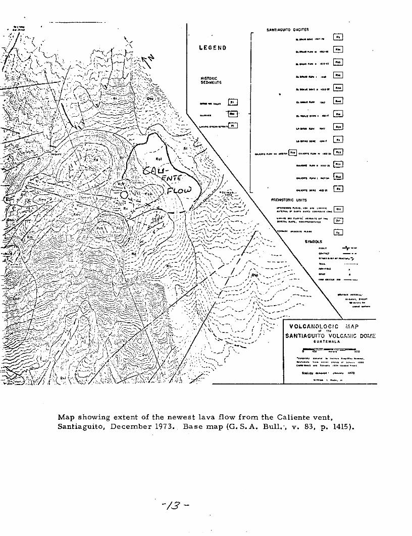
Santiaguito Activity to December 1973 W. I. RoseMemo
Caliente flow
The extrusion of the latest Caliente lava flow, which began in January 1972,
stopped in early 1973. Its areal extent is plotted on the attached map and is about
375, 000 m 2 with an average thickness of approximately 30 m for a volume of about
1 x 10⁷ m 3 .
El Brujo flow
The current flow, which began in early 1972, after a small plug dome was
extruded in late 1971, has advanced markedly between December 1972 and December
1973. As noted in earlier memo, all of the activity in the last year has been in the
southwest lobe which is following the Rio Concepcion Valley. In one year it has
flowed a distance of about 1 km and the total volume of this flow is in excess of
2 x 10⁷ m 3 .
Gross Extrusion Rate
Santiaguito has in 1972-1973 produced new lava at a rate of about 1. 5 x 10⁷ m 3 /yr.
This is about its 50 year average, and represents a definite increase compared to
the 1965-71 period.
Pyroclastic Activity
Two major pyroclastic eruptions also occurred in the past year. Both were
nuee ardentes. On April 19, 1973 a nuee descended from the Caliente vent down
a tributary of the Ro Nima II. Details are given in a separate report, but the
devastated zone is shown in an attached map. On September 16, 1973 another nue'e
issued from the foot of the El Brujo lava flow and traveled down the valley of the
Rio Concepcion. A detailed report on this event is being prepared to supplement
the initial reports. A sketch map of the devastated area is attached.
SU. * SANTIAGUITO OACITES
-\y LEGENDO I
i + . 4 ''e i it11.11
, HISTORIC .-
. SE'2 'M..T F.. .S' .ME TS
]. * ,*' . .**** ........ I...
"- i , :- -, .- - s- n .so pes ... -
... 4.. i-.....
VOLC PREASTORIC UNITSA 7.Ii ..- ... . . ., - .. . ... a,. an .'--- i-- , N.-/ BOS. SAPS * -'t-t- \... -
SAN-AG// jL DOSYMOLS
..... ., .
-A ,: -i.i -- , .i ---
S--" ..... j. VOLCA-.OLOCIC ,'- A .P
,i ,' .I. l '•- . - - . " . GUATEMALA
:7:. "-.,..,,, .... .. ,, ,....- -, , -..- .. t . . .. -.
Map showing extent of the newest lava flow from the Caliente vent,Santiaguito, December 1973.. Base map (G.S. A. Bull.-, v. &3, p. 1415).
-/,
\ ATAUIOVLAI OeL .- .< :-,,,,;../ ,.,---. ....
'-~~.~ '-:"~ '" I .... "~ rr .......i: ;! ,:;..,/,:-:;t~,: l #:! ' : .... ......
Mapshoingextnt f te nwes lva lowfro th Caiene vntSantiaguito Deeme 193 ae a GS..Bl.' .&, .11
-/.F -_.

-~ Ov-" ', " ---'... ,. '( r - -"-
" f . :-
• \ ; ";L .' ; i , .:£ .€ -,<,. :-
X r t
j A -'...
/
.:;,, .. . r. ....
.\-- / - - . :- -
"" " ; -',t.
I:r, t
at varou dates .Base ma (G.S.A. ul. v. 83 p., 1415).
;/'1'!-
.- -. . . .I ' - ,.. J: " -:.,..... 1 y\•: Rmo •: "
° -f /
1 " J , .' ,, Ij~ .... -. br .- ,.R;.h ' "i -"t~ - ...."i / , ii'~tPI jI',~~5 .. ' .
; J4
- 1;" p :: , - . RI :; . '
Rb
b4i
/.. ....... ..
i I I
Map showing extent of the newest El Brujo lava flow, 'Santiaguito
at var ious date s. Ba se map (G. S. A. Bull. , v. 83, p. 1415).
i-/V-

mag
ma
prod
ucti
on r
ate,
m
3 /yr(
xI6
)
N
o)
0 O
O
O
4.0
I
(D-
o)
7N
I r
Em
Io
Est
imate
o
f m
ag
ma extr
usi
on
ra
te
at
San
tiag
uit
o,
19
22
-73
.

45 51 52 53 .. ;.. . ..'B 5.6 0 61
11 '* -- ' ;f-- '7
.l. Cerro .oi,:...: -
. "... ... . .. , .
s-. '. , " . . I pai .,_ "
Ak
.... .-:. ._ ..o- .- - ,o.!' - l ri ; t lG
-.-- ... " " )"7"
7T? ~7L0 L. )r:
4v - .;;.?. .;.IT ... :--' .":'l
• • ( . .-J-+- -- -
Or _' .3 "1" .2
I. "-,Wc. ""riade" I
I 7K Z .7: I I jjr \er llrro
S(2 :, t .3~
, ,.. , " - a'." . ,,.roio do. ,
SF/ .10r -- ' .
ii.- , ,o
1' ,.ij'""ru, '," i" 6
49 51 .";5...
I "/i" i- - . ..
-J-i " /1 "'' ". ,i '-
f ! 24
L . - I" ,r- .
Map showing areas devastated by nuee ardentes of April and
December 1973 at Santiaguito volcano. .(North to the top;
rs are 1 km x 1 k) Base map (Colomba sheet 1:50, 000-IGN)
"# -- :+ -- .. . -- =v2 "-
I~ -" / 1 ,, ;,', " I , '- I ' " x' ¢ s'" ' i + ,,<
' / •4\ ' 7 " . ...i /"l / I . - ! . ,..,, ..+- : ..! -
, 1 , ." tC~~ 3 Z .' -/.. 7 : t " U ' %I ." 1
L . ..... ! .. ..a J ... I . . . . .. . ..,,,.-, --Eh .. --.; -1 -- --r .--' --, -- t ---<. ...... ..,.- -. ... .. .. .... .. ... ... , -'. I I . I f ~ .' ] ./ ,,[ • I- - , ' " \ ; , ! i "
-'--- ..... ... 1 .. " .__ :... .... .. +/.... --- -- - -i- .- - -- + - -.." :: . " : "-, : • I .
'. i , I " I L. p, ) ; . , 1 ./ :" I V .-...i-. . ". 7 . _ . .... _ .. . .' .. .. . .'_ -' t , ,, , - I ' .. ..I \ I ' . ' , ' ,' '[ - - , . . ' ' ,:; I , :;..= [ 4 T " . ' . - .. .. . .. . .; . ../ " i i i I~ 4.1 + l i II " t I X I I : I" l
Ii i,
fl I ." " ! :" : .: . . : '' i: '.'. , '" € . -, " , '• , \ \ i. . . .: i " , ,t ; . I .. ../II .. • .
,, .. , I" " :c_ " i : i ,i t . .. ) -2" " ;, ' i " " .Ii t , " ,, " : ' i , o- ' , 9 " -.. .
' " t I " ' " " ' : / : '" i " : .. / . :. ..," .' " -.I t% .¢• ' " """, • i . . ""
Map~" showing~ ara devastated by nueadne pi nDecmbe 197 at Satigut voc o -(ot totetpqU~~s re 1kmx1 k) Bae mp (oloma seet1:500001GN

IZALCO THERMAL ANOMALY
Remote infrared thermal patterns have been measured on the
northeast flank of Izalco Volcano four times since December 1969.
The sensor station Is on Cerro Verde at a distance of 1100 m. from
Izalco. On July 7, 1973, a thermal anomaly appeared near the
summit in a region that had been thermally inactive in earlier
infrared studies. The anomaly stretched down slope about 50 m.
and covered an area about 1000 sq. m. The highest of the anomalous
apparent surface temperatures was 15C, 20 C above ambiant. Data
just processed from the November 24, 1973, observations show the
anomaly expanded to the east to cover about 5000 sq. m. The most
intense apparent surface temperatures occur in the same spot as
the earlier pattern and register 1900, 80C above ambiant. The
anomaly was intensified. The appearance and intensification of a
thermal anomaly at Izalco indicates a change in the thermal regime
of the volcano.
The tew.peratures of the summit fumaroles were not unusually
high in early December 1973.
The concentration of intermediate depth earthquakes just
south of Izalco was unusually high for the period 1971-72 as
compared to 1967-70.
Geophysical observations of these anomalous events are
continuin .
Izalco last erupted in October-November, 1966, with a lava
flow from its south flank. Prior to that it had undergone inter-
mittent lava and pyroclastic eruptions from 1770 to 1957, building
up a comiposite cone 650 m. above its base.
February 7, 1974
Richard W. Birnie
Dept. of Geological Sciences
Harvard UniversityCambridge, Ma.
Ian M. LangeDept. of GeologyUniversity of Montana
Missoula, Montana
Richard E. Stoiber
Dept. of Earth SciE
Dartmouth CollegeHanover, N.H.