46°0'0e 46°30'0e 47°0'0e 47°30'0e n ceel afweyn district … · ceel afweyn...
TRANSCRIPT
n
n
n
n
n
n
n
n
n
n
")
")p
!(
!(
!(
! !!
!!!! !! !
!
! ! !!
!
! !!! !
!
!
! !
!! !!! !!! !!
!! !
!!
!
!! ! !!! !! !!
!!!
!!
! !!
!!!!
!!!!!
!!
!
!
!
! !!!
!
!! !
!! !!!!
!!!!!
! !!!!
!
!!
!!!!!
!!!
!
!
!!
!
!!!!
!!
! ! !!!
!
!! !! !
! !
!!!! !
! !!!
!!
!! !
!! ! ! !!
!!
!
!!
!
!! !!!
!
!!
!!!! !!!
!! !! !!!
!
!! !!!! !!!!
!!
!
!!
! !!!!!!!
!
! !
! !! !!!
!!!
! !! ! !!
! !!
!
!!!!
!
!!
!!
!
! !!!!
!!
!!!!! !
! !!
!!! !
!
!
!! !
!!
!!!
!!
! ! !!!
!!! !!! ! !
!
!!!!!
! !
!
!!
!
!
!
!! !
!
!
A EDB C F G IH J K A B C D E F G H I J K A B DC E F G6543218765432187654321876543218765
NC-38-044
NC-38-056
NC-38-068
NC-38-080
87
43
NC-38-045
NC-38-057
NC-38-069
NC-38-081
NC-38-093
NC-38-046
NC-38-058
NC-38-070
NC-38-082
NC-38-094
NC-38-047
NC-38-059
NC-38-071
NC-38-083
NC-38-095
NC-38
-060
NC-38
-072
NC-38
-084
NC-38
-096
H I
NC-38-092
J KG IH J K
Buq
Xiis
Goob
Qoof
Gaad
Xood
Rugay
DalohKarin Daray
Karin Xabow
Yufle
Dubad
Yufle
Illad
BixinKoolo Bixin
Huguf
Xaroo
Tuuro
Hadla
HargoDersi
Bohol
Bohol
Ruguda
CubaydConqor XamaasMulaax
Dayaxa
Mulaax Dagaar
DagaarXareed
Xariir
CadayoDhaban
DurdurKalmac
CadayoKabiid
Tuurta Huluul Camoud
CeelalCadayn
Ixdaad
Dhoomo
Dhoomo Xararo
Sinnar
DhabanDabaroCadaad
Gumbuxo Shalcaw KulmiyeGudaado
Rukuuda
Dhaxamo
ArgasanCilaamoDalarod
DhalaaxBahdoon
UurweynGaruble
ShoodheXamilka
Jablahe DocolkaQudbiga Garabad
Ras wedXamilka
Dariyar
Sincaro DudgaalDogobleXurfada Dogoble
DumadleShiisha AfweyneShoodhe
Lo'anebaMidhishi
Marawade
Dhifeeco
DaryalleMasa gan
DibqaraxLamadaga
GuryasanKaldarayRari-bul
Jidbaale
Il-carmoDhereran
KaldarayCeelcade
Forestry Garabcad
Dhereran
Gar adagDhanaanoWidhiidh
Wariiley
Faraguul
Soddonley
Xididaley Kal darayGod heeli
Kalsheekh
Suf dhere
Laas-geel
Geba gebo
Bacoolaha
Ceeg saaf Balanbaal
Dacawaale
Dameero 1 DudcaraleGod-dheerDameeraha
God-carmo
Ceel dibir
HaldhaaganXero mugle Madar mogeXeri-mooli
Darbi-duqa
Bildhaalay
Ceel baxay
Fiqi ayuub
Beer weyso
Ceel-dhere Fadhi gaab
Balan baal Godwaraabe
Bali-geedi Dalan dowl
Tuur xoday
Sabawanaag
Madar mugle
Garab karidBaqlo-jabis
Rag cadeeye
Karin kulan Kalmac sare
Ceel maweel
Galool adhi
Darar weyne
QabrisamaneBali-roobleGobol gobolWarta hooda
Siigo-dheer
Toor daaresIlka cadeys
TuurciyaaleWarta bayle
Warta-xooga Siifurweyne
Ceel madoobeXiman gareen
Dhaban dhige
Barde looxle
Karin biyoodDhuur cilaan
Dhadhinyahya
Ceel midgaanDhirin dhiro
Bali-caraale
Qabri samaneKala balaydh Ceel-lahelay
Widhiidh yar
Laas doomaare
Bali samakaab
Cadaadkulaale
Maax satelliteGudmo biyo cas
Dhadhiin yaxye
Baloole & igar
Caateeye cabdi Balli samokaab
Kurta gahaydha
Darsi satellite
Booca satellite
Raqas satellite
Gumbur xangeeyo
Xero-barkhadeed
Camuud satellite
Dhudhud dhaliilo
Dhalaax satellite
Cirshiida satellite
Kal booca satellite
War gunbi satellite
Laso-dhagax-guduudan
Dhahqadood satellite
Daan weyne satellite
Laan qiciye satellite
Gudma hadle satellite
Tuur xoday sattellite
Dhagax guduud satellite
Baylah ma leh satellite
Sanaag
Sool
Togdheer
Woqooyi Galbeed
Ceel Afweyn
Ceerigaabo
Burco
Caynabo
Berbera
Xudun
Sheikh
CEERIGAABO
CEEL AFWEYN
NC-38 -08 3-7 D
47°30'0"E
47°30'0"E
47°0'0"E
47°0'0"E
46°30'0"E
46°30'0"E
46°0'0"E
46°0'0"E
10°3
0'0"N
10°3
0'0"N
10°0
'0"N
10°0
'0"N
9°30'0
"N
9°30'0
"N
The boundaries and names on this map do not imply official endorsement or acceptance by the United Nations For copies of digital data please contact [email protected]
Map Production: Somalia Water and Land Information Management Project (SWALIM) and
United Nations High Commissioner for Refugees (UNHCR) Branch Office- Somalia
SWALIM is implemented by the United Nations Food & Agriculture Organisation.SWALIM is funded by European Commission with 5% co-funding provided by UNICEF.
The Somalia Reference Grid is a common reference system for all agencies working in Somalia. The system has been designed for reporting of geographic location in the field, without the use of a GPS. Map Reference: WAT-REF-GRID-20090608-CEELAFWEYN-A3-001
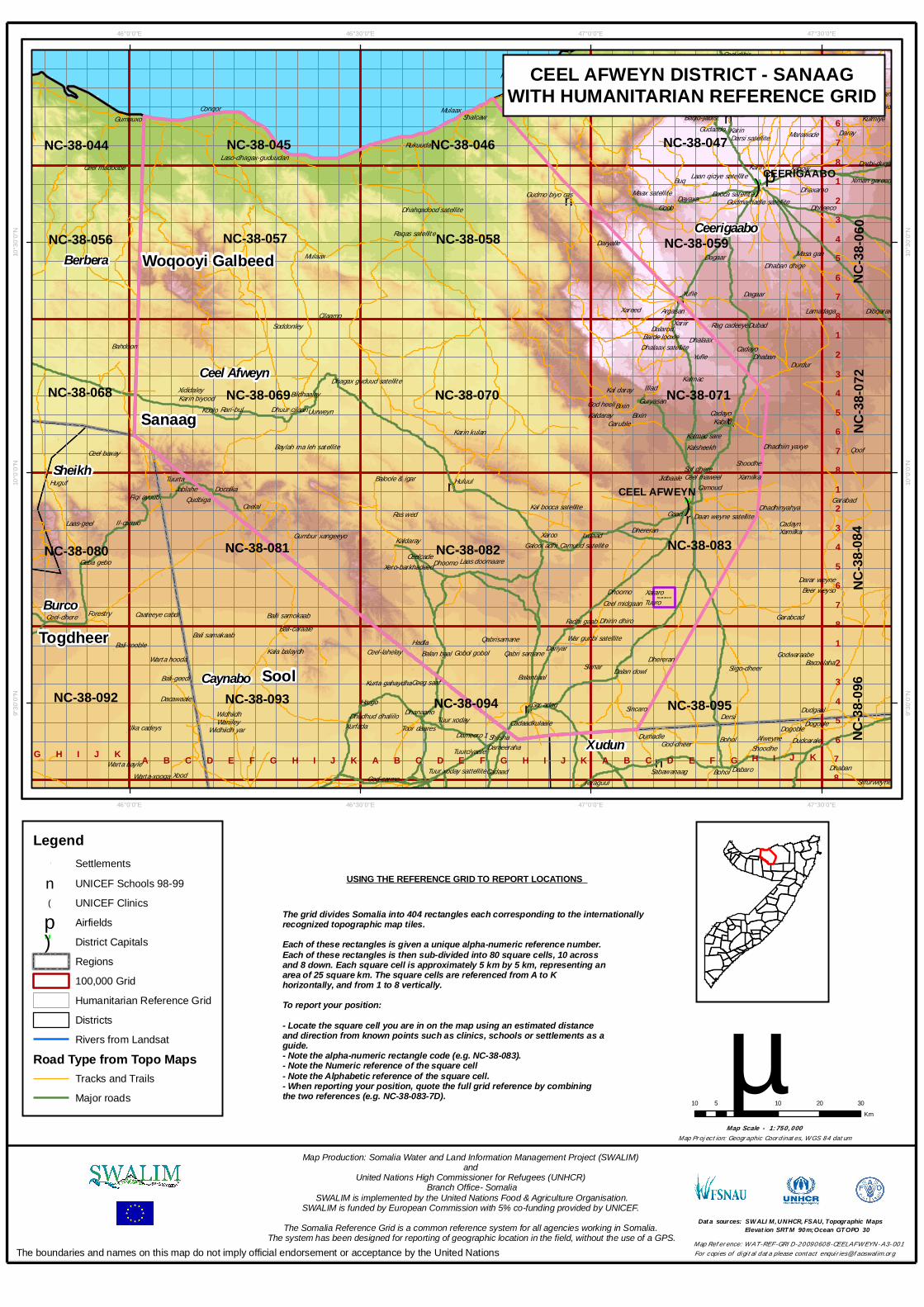
USING THE REFERENCE GRID TO REPORT LOCATIONS
The grid divides Somalia into 404 rectangles each corresponding to the internationally recognized topographic map tiles. Each of these rectangles is given a unique alpha-numeric reference number.Each of these rectangles is then sub-divided into 80 square cells, 10 acrossand 8 down. Each square cell is approximately 5 km by 5 km, representing anarea of 25 square km. The square cells are referenced from A to Khorizontally, and from 1 to 8 vertically.To report your position:- Locate the square cell you are in on the map using an estimated distanceand direction from known points such as clinics, schools or settlements as aguide. - Note the alpha-numeric rectangle code (e.g. NC-38-083).- Note the Numeric reference of the square cell- Note the Alphabetic reference of the square cell.- When reporting your position, quote the full grid reference by combiningthe two references (e.g. NC-38-083-7D).
Map Projection: Geographic Coordinates, WGS 84 datumMap Scale - 1:750,000
10 0 10 20 305Km
µData sources: SWALIM,UNHCR,FSAU,Topographic Maps
Elevation SRTM 90m;Ocean GTOPO 30
Legend! Settlementsn UNICEF Schools 98-99!( UNICEF Clinicsp Airfields") District Capitals
Regions100,000 GridHumanitarian Reference GridDistrictsRivers from Landsat
Road Type from Topo MapsTracks and TrailsMajor roads
CEEL AFWEYN DISTRICT - SANAAGWITH HUMANITARIAN REFERENCE GRID