45155192 atkinson lesley gail the earliest inhabitants the dynamics of the jamaican taino
TRANSCRIPT


The Earliest Inhabitants


The Dynamics of the Jamaican Taíno
Edited by
Lesley-Gail Atkinson
The EarliestInhabitants
University of the West Indies PressJamaica • Barbados • Trinidad and Tobago

University of the West Indies Press
1A Aqueduct Flats Mona
Kingston 7 Jamaica
www.uwipress.com
© 2006 by Lesley-Gail Atkinson
All rights reserved. Published 2006
10 09 08 07 06 5 4 3 2 1
CATALOGUING IN PUBLICATION DATA
Earliest inhabitants: the dynamics of the Jamaican Taíno / edited by
Lesley-Gail Atkinson
p. cm.
Includes bibliographic references.
ISBN: 976-640-149-7
1. Taino Indians – Jamaica – Antiquities. 2. Indians of the West Indies – Jamaica –
Antiquities. 3. Taino Indians – Jamaica – Ethnobotany. 4. Excavations (Archaeology) –
Jamaica. 5. Indian pottery – Jamaica. 6. Jamaica – History. I. Atkinson, Lesley-Gail.
F1875.E37 2006 972.92
Cover illustration: Anna Ruth Henriques, Cocoa Zemi (2006).
Reproduced with kind permission of the artist.
Book and cover design by Robert Harris.
E-mail: [email protected]
Set in AdobeCaslon 10.5/14.5 x 27
Printed in the United States of America.

This book is dedicated to two men who have
influenced my life tremendously.
In loving memory of my
grandfather, Ernest Aaron Adair,
for loving me unconditionally, and for teaching me
the significance of laughter. In my heart you’ll always
be “my favourite guy”!
and
Dr James W. Lee, founder and past president
of the Archaeological Society of Jamaica,
for your decades of contribution to
Jamaican archaeology, and for your
initiative and extensive research, which laid the
foundations for Jamaican prehistoric archaeology.
Thank you!


List of Illustrations / ix
List of Tables / xii
Preface / xiii
Acknowledgements / xv
Introduction / 1
Section 1 Assessment and Excavation of Taíno Sites
1 The Development of Jamaican Prehistory / 13William F. Keegan and Lesley-Gail Atkinson
2 The Taíno Settlement of the Kingston Area / 34Philip Allsworth-Jones, Gerald Lalor, George Lechler,Simon F. Mitchell, Esther Z. Rodriques and Mitko Vutchkov
3 The Pre-Columbian Site of Chancery Hall, St Andrew / 47Philip Allsworth-Jones, Anthony Gouldwell, George Lechler,Simon F. Mitchell, Selvenious Walters, Jane Webster and Robert Young
4 Excavations at Green Castle, St Mary / 69Philip Allsworth-Jones and Kit Wesler
5 The Impact of Land-Based Development on Taíno Archaeology in Jamaica / 75Andrea Richards
Section 2 Taíno Exploitation of Natural Resources
6 Notes on the Natural History of Jamaica / 89Wendy A. Lee
Contents

7 The Exploitation and Transformation of Jamaica’s Natural Vegetation / 97Lesley-Gail Atkinson
8 Early Arawak Subsistence Strategies: The Rodney’s HouseSite of Jamaica / 113Sylvia Scudder
Section 3 Analysis of Taíno Archaeological Data
9 Petrography and Source of Some Arawak Rock Artefacts from Jamaica / 131M. John Roobol and James W. Lee
10 Jamaican Taíno Pottery / 146Norma Rodney-Harrack
11 Jamaican Redware / 153James W. Lee
12 Taíno Ceramics from Post-Contact Jamaica / 161Robyn P. Woodward
Section 4 Taíno Art Forms
13 The Petroglyphs of Jamaica / 177James W. Lee
14 Zemís, Trees and Symbolic Landscapes:Three Taíno Carvings from Jamaica / 187Nicholas Saunders and Dorrick Gray
References / 199
Contributors / 214
viii

A.1 Map of the sites mentioned in the text / 4–5
1.1 Irving Rouse’s chronology of the series and subseries of cultures in the West Indies / 21
1.2 Ostionan pottery from Jamaica / 23
1.3 Chican pottery from Hispaniola / 23
1.4 Jamaican Meillacan boat-shaped vessel / 24
1.5 Meillacan pottery from Haiti / 24
1.6 Local styles in the Ostionan, Meillacan and Chican subseries / 25
2.1 Taíno sites in the Kingston area / 35
2.2 Histograms of the major elements in the pottery samples compared with the levels in the soils from the Kingston area / 43
3.1 Taíno skulls in situ / 48
3.2 Earthenware pot containing infant remains / 48
3.3 Beads associated with the skull / 49
3.4 JNHT excavations at Chancery Hall / 52
3.5 Stratigraphy of Chancery Hall / 56
4.1 Location of Green Castle / 70
4.2 Green Castle contour map / 71
4.3 Burial 1 / 73
4.4 Burial 2 / 73
5.1 Road cutting through Taíno site at Barbican, Hanover / 80
5.2 Road cutting through a portion of the Toby AbbottTaíno site / 81
5.3 Chancery Hall Taíno site, St Andrew / 83
5.4 Long Mountain prior to development / 84
5.5 Construction activity at the Long Mountain site / 84
6.1 Jamaican hutia or coney / 95
ix
Illustrations

6.2 Hawksbill turtle / 95
7.1 Fernández de Oviedo’s illustration of Taínan caney / 101
7.2 Dugout canoe from Black River, St Elizabeth / 102
7.3 William Keegan explaining the use of the wild cane / 103
7.4 Two-notched net sinkers / 104
7.5 Four-notched net sinkers / 104
7.6 The annatto plant / 104
7.7 Members of the Paradise Park 2001 excavations measuring the Ceiba tree / 112
9.1 Simplified geological map of Jamaica showing parishes / 134
10.1 Redware, White Marl and Montego Bay styles / 147
10.2 Normal boat-shaped vessel / 148
10.3 Round vessel / 149
10.4 Handled Taíno bowl / 150
10.5 Handles, lugs and decorative motifs / 150
10.6 Taíno bowl with hourglass-type handle / 151
10.7 Laterally perforated handle / 151
10.8 Ribbon decoration / 151
10.9 Cross-hatch decoration / 152
11.1 Map of Jamaican Redware sites / 154
11.2 Burén rim profiles / 156
11.3 Type I handles – plain “D” handles / 157
11.4 Type II handles / 157
11.5 Type III handles / 158
11.6 Other handle variations / 158
12.1 Map of St Ann’s Bay, Jamaica / 162
12.2 Distribution of New Seville and Taíno ceramics / 165
12.3 Meillac ware: (a) boat-shaped vessel; (b) round bowl / 166
12.4 Rim profiles / 167
12.5 Decorated rim sherds / 167
12.6 Spouted bowl / 168
12.7 Taíno water bottle / 168
12.8 New Seville ware bowls / 169
12.9 New Seville ware: (a) pitcher; (b) pedestal cup / 170
12.10 New Seville ware: (a) cup; (b) spout jug / 170
12.11 New Seville ware: jug / 171
12.12 New Seville pedestal cup / 171
13.1 Map of cave art sites / 178
x I L L U S T R A T I O N S

13.2 Petroglyphs from Coventry and Cuckold Point / 180
13.3 Petroglyphs from Gut River No. 1 / 180
13.4 Petroglyphs from Reynold Bent, Milk River and near God’s Well / 180
13.5 Petroglyphs at Canoe Valley / 181
13.6 Petroglyphs at Canoe Valley / 181
13.7 Pictographs at Spot Valley / 183
14.1 Anthropomorphic figure from Aboukir (detail) / 188
14.2 Anthropomorphic figure from Aboukir / 188
14.3 Bird figure from Aboukir (frontal view) / 189
14.4 Bird figure from Aboukir / 189
14.5 Carved wooden zemí of a bird standing on the back of a turtle or tortoise / 189
14.6 Small ladle/spoon with anthropomorphic handle,from Aboukir / 190
14.7 Small ladle/spoon with anthropomorphic handle,from Aboukir / 190
14.8 Carved wooden duho stool, Dominican Republic / 192
xiI L LU S T R A T I O N S

1.1 Midden Sites Reported by Robert Howard / 30
1.2 Cave Sites Reported by Robert Howard / 32
1.3 Cave Art Sites Reported by Robert Howard / 33
2.1 Shells Collected from Chancery Hall / 39
2.2 Neutron Activation Analysis of Pottery Samples / 42
2.3 Taíno Sites in the Kingston Area / 45
3.1 All Recovered Organic Materials / 60
3.2 Size Distribution of Charcoal Fragments / 60
3.3 Arthropod Remains / 61
3.4 All Bone / 63
3.5 Fish Bone / 64
3.6 Mammalian Bone / 65
5.1 Examples of Threats to Taíno Sites / 75
5.2 Recorded Number of Destroyed Taíno Sites in Jamaica by Parish / 76
6.1 Geologic Time and Corresponding Events in the Formation of the Island of Jamica / 90
6.2 Main Soil Types of Jamaica and Associated Landforms / 91
6.3 Total Number of Species / 94
6.4 Numbers of Endemic Species / 96
8.1 Significant Vertebrate and Crab Remains from the Rodney’sHouse Site / 117
8.2 Faunal Comparisons / 123
8.3 Rodney’s House Faunal List / 125
9.1 Lithology of Arawak Petaloid Celts from Jamaica / 135
9.2 Lithology of Petaloid Celts from Some Parishes of Jamaica / 142
13.1 New Petroglyph/Pictograph Sites, 1952–1985 / 179
13.2 Jamaican Petroglyph Sites by Parish / 185
xii
Tables

I HAVE ALWAYS been fascinated by prehistory. Even though Iam a public archaeologist – and our research ranges from prehistoric settle-ments to World War II hangars – I have an unapologetic bias towards Taínoarchaeology. I do not know if it is because my first dig was on a prehistoric siteor because my maternal ancestors were Maroons, who are said to have inte-grated with the Taínos. Regardless of the reason, Taíno archaeology hasbecome one of my special interests.
The idea for this publication originated in 1998, when I was an assistantcurator in the Museums Division at the Institute of Jamaica. I had recentlybeen assigned the project of refurbishing the Taíno Museum at White Marl,St Catherine. During my research for the museum, I uncovered a lot of dataon Jamaican prehistory – much of it unpublished and unfortunately not acces-sible to the public at large. I felt that a book on Jamaican prehistory was longoverdue.
Three years later, I was employed as an archaeologist at the JamaicaNational Heritage Trust. As a consequence of my job, I faced constant com-plaints from Jamaicans, overseas archaeologists and enthusiasts about theinadequacy of publications on Jamaican archaeology. In addition, there werefrequent questions as to whether there was any research being done on theisland. I realized that the public was generally unaware. I knew that differentprojects were taking place, and I was allowed to participate in many of them,but that was mainly as a result of my job. I strongly believe that archaeologybelongs to the public and not solely to archaeologists. The knowledge andthe artefacts do not belong to the Jamaica National Heritage Trust or theInstitute of Jamaica, but to the people of Jamaica. It is their heritage.
Jamaicans are very proud. Like a real Jamaican, I took my pride – and attimes my embarrassment – and decided to undertake this ambitious project. Ithought an edited volume would be ideal, as it would give various archaeolo-gists an opportunity to discuss their research projects. I formulated a proposedstructure for the text and contacted various people locally and overseas. I amhappy to say that most of them liked the idea and were glad to contribute to
xiii
Preface

the publication. The project took almost fifteen months to complete, and attimes I felt my ambition almost outdid me. This volume does not pretend tobe a comprehensive depiction of Jamaican prehistory, but it is a starting point,and it aims to fill some of the gaps in Jamaican archaeology.
Lesley-Gail Atkinson
xiv P R E F A C E

I WOULD FIRST like to express my gratitude to all the contrib-utors to this publication: Philip Allsworth-Jones, Dorrick Gray, William F.Keegan, Gerald Lalor, George Lechler, James W. Lee, Wendy A. Lee, SimonF. Mitchell, Andrea Richards, Norma Rodney-Harrack, M. John Roobol,Esther Z. Rodriques, Nicholas Saunders, Sylvia Scudder, Mitko Vutckhov,Selvenious Walters, Kit Wesler and Robyn Woodward. I would especially like to thank Philip Allsworth-Jones and my “left hand”, Andrea Richards,who were tremendously supportive throughout the entire process. There areseveral people – Debra-Kay Palmer, Basil Reid, Betty Jo Stokes and PeterHarris – who were asked to contribute to the text but were unable to do sofor various reasons; nevertheless, I would like to thank them for their supportof the project.
The text includes six reprinted articles; therefore, permission had to beobtained from various organizations. I thank the Anthropological ResearchPapers, Arizona State University; La Fundación Arqueológica, Antropológicae Histórica de Puerto Rico; Antiquity; the Archaeological Museum of Aruba;and the Archaeological Society of Jamaica. I would like to specificallyacknowledge Emily Lundberg, Arminda Ruiz, Raymondo Dijkhoff and JayHaviser of the International Association of Caribbean Archaeology for theirassistance. I am also grateful to the Institute of Jamaica, the Jamaica BauxiteInstitute and the Archaeological Society of Jamaica for their permission topublish and reprint several photographs and illustrations.
Several people have been extremely helpful, providing insight, advice andassistance, in particular Ambassador Peter King, Verene A. Shepherd, JamesRobertson, Patrick Bryan, F. Roy Augier, Marlon Manborde and JohnThaxter. Special thanks to the invaluable Karen Spence and the incredibleAinsley Henriques. In addition, I would like to thank Dayne Buddho, LaurisCodlin and Tyrone Barnett of the Institute of Jamaica for their assistance. Imust acknowledge the support of my other “family”, the staff of theArchaeology Division of the Jamaica National Heritage Trust, in particularAudene Brooks, Ann-Marie Howard-Brown, Rosemarie Whittaker, Colleen
xv
Acknowledgements

McGeachy, Michelle Topping, Ava Tomlinson, Evelyn Thompson, JasinthWilliams and June Heath.
I am gratefully indebted to Linda Speth, Shivaun Hearne, DionneWilliams, Claudette Upton and the team at the University of the West IndiesPress for their interest, patience and assistance throughout this project. Arenowned Jamaican politician once said that “it takes cash to care”; funding isnecessary for any publication, and this book is no exception. I would like totake this opportunity to thank my sponsors, the City of Kingston CooperativeCredit Union, the Shipping Association of Jamaica and Karen Adair. Withouttheir contributions this publication would not have been a reality.
I wish to acknowledge my family for their encouragement and toleranceduring this endeavour: my grandmother Dorothy Adair, my aunts KarenAdair and Millicent Lynch, my father, Lodric Atkinson, and my mother,Annette Adair-Hill. Finally, grateful thanks to my friends and special cheer-leading squad – Tyrone Grandison, Andree Holness, Gifford Rankine,Cherena Forbes, Howard Dawkins, Susan Chung and Velmore Coke.
xvi A C K N O W L E D G E M E N T S

IN JAMAICA, THE indigenous population is still being referredto as the Arawaks, despite the adoption of the term Taínos to distinguish thenative population of the Greater Antilles from the Arawaks of SouthAmerica. Irving Rouse defines the Taínos as “the ethnic group that inhabitedthe Bahamian Archipelago, most of the Greater Antilles, and the northernpart of the Lesser Antilles prior to and during the time of Columbus” (1992,185).
According to Rouse, in Columbus’s time the Taínos lacked an overallname. The people referred to themselves by the names of the localities inwhich they lived – for example, the Puerto Ricans called themselvesBorinquen, their name for the island, and the Bahamians called themselvesLucayo (Rouse 1992, 5). This raises the question of what was the Taínan namefor Jamaica. Traditionally Jamaicans have been taught that Xaymaca was theTaíno name given to the island, meaning “land abounding with springs”, fromwhich “Jamaica” – land of wood and water – was derived. However, D.J.R.Walker suggests Yamaye as the possible Taíno name for the island, based oninformation derived from Columbus’s journal (1992, 236–37).
The Arawaks or Taínos
The term Arawaks has been, and still is, mistakenly used to denote the aborig-ines of the Greater Antilles and the Bahamas. The Arawaks were the ethnicgroup that lived in the northern part of the Guianas, which formerly extendedonto the high land around the Orinoco delta (Rouse 1992, 173). According toJohn Peter Bennett, the Arawaks had names for themselves and their lan-guage, Lokono and Loko respectively (Bennett 1989, iv). For decades the termsArawak and Taíno have been used interchangeably; however, they are two distinct ethnic groups.
It is not clear when the confusion occurred. However, one contributing fac-tor was the attribution of the name of a language family to an ethnic group(Rouse 1987). The Taínan language is said to belong to the Arawakan
1
Introduction

language family tree. According to Rouse, linguists now believe that theTaíno, Island-Carib and Arawak languages diverged from the main line ofArawakan development at the same late date and that all three belong in theMaipuran subfamily (Rouse 1986, 120–23; Oliver 1989, 105).
Previously the Taínos were referred to as Island Arawaks; in fact, D.J.R.Walker still uses this term (1992). Rouse demonstrates that this is anothersource of the misnomer:
Daniel G. Brinton (1871) preferred to call the group Island Arawak because itshared many linguistic and cultural traits with the Arawak Indians (also knownas Lokonos), whose descendants still live in northeastern South America. Hisfollowers shortened the phrase to Arawak. That was a mistake. (1992, 5)
In the essay, “On the Meaning of the Term Arawak”, Rouse (1972) arguesthat neither Columbus nor any of his counterparts came across the wordArawak: “These Indians in the Greater Antilles are now known as ‘Arawaks’,but they themselves did not use that name, nor did Columbus and his con-temporaries ever come across it, as far as it is known.” Rouse adds that Arawakdoes not appear in the literature until the exploration of the Guianas thatbegan in the late 1500s, almost a century after the arrival of Columbus in theNew World.
Centuries later, in 1894, Juan Lopez de Velasco noted the presence of peo-ple who called themselves Arawaks on the Guiana coast, southeasternTrinidad, and commented that a group of them had “intruded” into Trinidad.Sir Walter Raleigh confirmed these statements and in 1928 included theAruacos in a list of five Indian “nations” that inhabited Trinidad ( Jane 1988).
Ethnohistorians merged the groups of people who inhabited the GreaterAntilles into one group – the Taíno – as they shared a single language and hadthe same culture (Rouse 1992, 5). Taíno, which means “good” or “noble”, waschosen because several of its members spoke that word to Columbus to indi-cate that they were not Island Caribs (Alegría 1981). Andres Bernaldezexplains:
On the day when they came down the coast, there were many men and womentogether, on the shore near the water, wondering at the fleet and marvellinggreatly at a thing so novel, and when a boat came to shore to have speech withthem they said, “Taínon, Taínon,” “good, good”. ( Jane 1988)
Since the 1980s the term Taínos has been accepted in Caribbean archaeol-ogy. In his article “Whom Did Columbus Discover in the West Indies?”Rouse (1987) suggested that the commonly used name Arawak be replacedwith the name Taínos when discussing native West Indians at the time of contact.
It is important to note that throughout this volume, the reader will
2 T H E E A R L I E S T I N H A B I TA N T S

encounter the term Arawaks used to describe the Jamaican Taíno culture.These references are presented in their original context, as most of the litera-ture assumed that the indigenous population of Jamaica was Arawak.
The Jamaican Taínos
It is believed that Jamaica was colonized after AD 600 by ancestors of theTaíno, the Ostionoid culture (Rouse 1992). At present, two of the earliestknown sites on the island are Little River, St Ann, and Alligator Pond(Bottom Bay), Manchester, dated AD 650 ± 120 (Vanderwal 1968a) (seeFigure A.1, nos. 89 and 4). These sites have been characterized as belongingto the Ostionan Ostionoid subseries (Rouse 1992) or, as it is called locally,Redware – a name reflecting its bright red ceramics. James W. Lee has pub-lished articles on the Redware culture in Archaeology Jamaica (see Lee 1980c,reprinted in this volume).
James Lee noticed that the Redware culture preferred coastal settlementsand illustrated that all but two of the eleven Redware sites highlighted in 1980were directly on the seashore (ibid.). The two exceptions were located about1 km inland. Preliminary observations indicate that most of the presentRedware sites are located at elevations of 0 to 15 m above sea level. These sitesare also near the sea or a river source such as Alligator Pond, St Elizabeth, andAlloa, St Ann, suggesting a dependence on marine resources (Atkinson 2003,8) (see Figure A.1, nos. 3 and 5).This reliance on the marine environment washighlighted at the Ostionan site at Paradise Park, Westmoreland (Keegan2002). According to William Keegan (personal communication, 2001), theOstionan deposit contains mostly sea turtles, freshwater turtles, large fishand shellfish (notably conch) from the seagrass environment. However, inJamaica, traditional research on this cultural period has concentrated mainlyon its ceramics and on comparisons with the Meillacan culture.
About three hundred years later another culture, categorized by Rouse(1992) as the Meillacan Ostionoid, settled on the island. The Meillacan cul-ture, which is also referred to as the White Marl style after the largest Meillacsite on the island, dated from AD 877 ± 95 to AD 1490 ± 120 (Silverberg,Vanderwal and Wing 1972). Traditionally, it was felt that the Ostionans werecolonized by the Meillacans and absorbed into the latter cultural group, andthe Ostionan period was believed to have ended around AD 900. However,recent archaeological investigations at the Sweetwater and Paradise sites atParadise Park, Westmoreland (see Figure A.1, no. 119), and other sites acrossthe island have indicated that the two groups possibly co-inhabited the island.
The settlement patterns of the Meillacans were more diverse than thoseof the Ostionans; they settled on the coast but also penetrated the interior as
3I N T R O D U C T I O N

1. Aboukir (ImageCave)
2. Alexandria3. Alligator Pond
(Alligator PondRiver)
4. Alligator Pond(Bottom Bay)
5. Alloa6. Armordale7. Auchindown8. Baalbec Cave9. Barbican10. Bellevue 11. Bellevue12. Bengal13. Beverly Hills14. Billy Bay15. Black River (Black
River West)16. Bloxblurgh17. Bluefields18. Bossue 19. Bull Savannah20. Byndloss Mountain
(Riverhead)
21. Calabash Bay22. California23. Cambridge Hill
Cave24. Canoe Valley25. Canoe Valley Caves26. Carpenter’s
Mountain27. Caymanas Bay28. Chancery Hall29. Cinnamon Hill30. Clitos Point31. Coleraine32. Cousins Cove33. Coventry 34. Cranbrook35. Creighton Hall36. Cuckold Point37. Cuckold Point Cave38. Culloden39. Dover40. Downtown
Kingston41. Drummond 42. Dryland (Image
Cave)
43. Duckenfield44. Duff House45. East Jackson Bay
Cave46. Fairfield (Fairfield
View)47. Ferry Hill48. Flint River49. Fort Charles50. Fort Charles-
Nembhard51. Fort Haldane52. Fort Nugent53. Freetown54. Friendship55. God’s Well 56. Great Goat Island57. Great Goat Island
Cave58. Great Pedro Bay59. (Great) Salt Pond60. Green Castle61. Green Hill62. Green Island63. Greenwich Park64. Gut River # 1
65. Halberstadt66. Harbour View67. Harmony Hall68. Haughton Hall69. Holmes Bay70. Hope71. Hope Mine72. Hope Tavern73. Hounslow74. Image Cave75. Inverness76. Ipswich77. Iter Boreale78. Ivor (Iver)79. Jacks Hill80. Jackson’s Bay Cave81. Jackson’s Bay82. Kempshot83. Kew84. Knapdale
(Knapville)85. Liberty Hill86. Little Bay Cave87. Little Miller’s Bay88. Llanrumney89. Little River
Figure A.1 Map of the sites mentioned in the text
4

90. Long Acre Point91. Long Mountain92. Mahogany Hill93. Mammee Hill94. Marlie Mount95. Milk River Spa96. Molynes Mountain97. Mona98. Montego Bay Point99. Montego Bay100. Mosquito Cove101. Mount Rosser102. Mount Salem103. Mountain River
Cave104. Naggo(s) Head105. Negril106. New Forest 107. New Ground108. New Market109. Newfound River110. Newry111. Norbrook112. Oakes113. Old Harbour 114. Old Harbour Hill
115. Orange Valley116. Pantrepant East117. Pantrepant West118. Paradise119. Paradise Park120. Parchment
(Parchment Cave)121. Pedro122. Pepper123. Plantation
Heights124. Port Antonio125. Port Henderson126. Portland127. Portland Cave128. Portland Ridge129. Portland Ridge
Cave130. Prospect131. Red Bank132. Rennock Lodge133. Retreat (Little
Nigger Ground)134. Reynold Bent 135. Rhodes Hall136. Rio Bueno
137. Rio Nuevo138. Rodney’s House139. Round Hill140. Round Hill B
New Ridge141. Rowe’s Corner142. Rozelle143. Rozelle Falls144. Runaway Bay145. Salisbury146. Salt River147. Sandy Bank148. Scarborough149. Seven Mile Hill 150. Seville151. Shaw152. Sommerville Cave153. Spot Valley154. Spotty Hill155. Spring 156. St Jean D’Acre157. Stewart Castle158. Stony Hill159. Sugar Loaf Hill160. Taylor’s Hut Cave
# 2
161. Tobolski162. Toby Abbot 163. Tower Hill (Dallas
Castle)164. Treasure Beach165. Two Sister’s Cave166. Tydenham167. Upper Retirement168. Upton 169. Vere170. Wales171. Walkerswood172. Wallman Town173. Wareika Hill174. Warminister175. Waterloo176. White Marl177. Williamsfield178. Windsor 179. Windsor Great
Cave180. Worthy Park # 1181. Worthy Park # 2182. Yardley Chase
(Lover’s Leap)
5

far inland as Ipswich, St Elizabeth, the Worthy Park sites and Mount Rosserin St Catherine (see Figure A.1, nos. 76, 180, 181 and 101). They did not,however, settle in the interior mountain range. It is the general consensusamong Jamaican archaeologists that Taíno sites have the best views. As theirsites are generally panoramic – located overlooking the landscape – it is notknown whether the purpose was defensive or aesthetic. The present researchhas illustrated that the Meillacans or White Marl culture were not as depend-ent on marine resources as the Ostionans. Although there is evidence thatthe Jamaican Redware culture cultivated cassava, it seems that the White Marlgroup was more dependent on agrarian resources.
The prehistoric culture that we call the Taíno developed about AD 1200.Samuel Wilson states that it is difficult to mark the “beginning” of the Taíno(1997b). Their society emerged as a continuation of the cultural developmentthat had characterized Caribbean history for several thousand years. Wilsonexplains that the Taínos
played the same ball game as their predecessors; their settlements were similar,although larger and more numerous; and their religious beliefs and rituals wererelated to those of their Saladoid and Archaic predecessors. In some cases, theirpottery was different from Ostionoid ceramics in form, style, and decoration,but in other instances not. (ibid.)
In the past, the Jamaican Taíno were described as having sub-Taíno culturaltraits (Lovén 1935); however, this terminology is no longer used. The termWestern Taínos is now used by Rouse and other scholars to describe the Taínoculture of Jamaica, central Cuba, and the Bahamas (Rouse 1992, 17). Theterm is indicative of a culture less developed than that of the Classic Taínosof Hispaniola and Puerto Rico. Despite being characterized as less advanced,the Jamaican Taínos displayed certain similarities to the Classic Taínos, interms of population density, agriculture and class system (Rouse 1948, 1992).Regardless of whether it is classified as Western or Classic Taíno, Jamaicancultural development was autonomous with respect to the other islands. Thiscould be a result of its isolated southward location within the Greater Antilles(Walker 1992).
Jamaican prehistory is regarded as one of the least studied Caribbean dis-ciplines. That is not necessarily the case; the fact is that published Jamaicanarchaeological research has not had sufficient international circulation. Thishas resulted in misconceptions about lack of scope, research activities andinformation on the Jamaican Taínos. These misconceptions are discussed andcountered in Keegan and Atkinson’s chapter in this volume. As early as 1897,J.E. Duerden published an excellent compilation on Jamaican prehistory,which included various sites and research on the island’s Taíno artefacts.
The mid-1960s saw the creation of two important forums for archaeolog-
6 T H E E A R L I E S T I N H A B I TA N T S

ical publication in Jamaica. Geologist James W. Lee established theArchaeological Society of Jamaica (ASJ) in 1965. Since then, Lee and otherASJ members have conducted extensive research on Jamaica prehistory, whichwas frequently published in the society’s newsletter Archaeology Jamaica. In1967, the Institute of Jamaica began publishing Jamaica Journal, which hasbeen an essential medium for promoting current archaeological research inJamaica.
Factors Affecting Jamaican Taíno Research
In the past fifty years, Jamaican archaeology has undergone significant devel-opments: the establishment of the Archaeology Division ( Jamaica NationalHeritage Trust [ JNHT]), the introduction of archaeology at the University ofthe West Indies in 1987, and improvements in the training of Jamaicanarchaeologists. The past decade has seen increased interest in Jamaican Taínoarchaeology and promotion of it via international archaeological associations.Despite these advances, research in Jamaican prehistory is negatively affectedby limited resources, a shortage of personnel, poor attitudes towards conser-vation, the improper monitoring of the island’s archaeological resources, andthe great evil – ignorance. These factors affect the investigation, recovery, andinterpretation of Jamaica’s prehistory, and its context within the island’sarchaeological development.
The lack of resources for archaeological investigations is a critical, evenparalysing factor. It affects the training of staff, the acquisition of essentialequipment and the comprehensive investigation of sites. Archaeologicalinvestigations are expensive and time-consuming, and this poses a problem fordevelopers, the general public, administrators and even some personnel withinthe JNHT.
Manpower is a serious problem in Jamaica, despite its having the largestcontingent of professional archaeologists in the English-speaking Caribbean.At present the severely short-handed staff at the Archaeology Division of theJNHT cannot cope with the needs of the island’s archaeological resources –it is physically impossible. In addition, because of the various developmentprojects taking place on the island, the JNHT is forced to conduct primarilywatching briefs and rescue operations, leaving little room for academic inves-tigations and long-term research.
Responsibility for the protection, preservation, promotion and study ofTaíno sites and artefacts is shared among the JNHT, the National Environ-mental and Planning Agency and the University of the West Indies. However,there is limited collaboration between the JNHT and other government agen-cies such as the Department of Mines and Geology, the Ministry of Land and
7I N T R O D U C T I O N

Development and the National Works Agency. Better interaction and collab-oration between the JNHT and these government agencies would bring aboutan improvement in both the circulation of information and the facilities andresources available.
More collaboration is essential given the island’s increased pace of develop-ment. The threat of development on Taíno sites is a matter of concern thatAndrea Richards addresses in this volume. Two examples are Seville, St Ann,and Rio Nuevo, St Mary (see Figure A.1, nos. 150 and 137), both importantTaíno centres mentioned in the Spanish chronicles. These sites face destruc-tion despite archaeologists’ efforts, demonstrating the need for more con-trolled development and for the implementation of an archaeological policy.
In Jamaica, more attention needs to be paid to Taíno artefacts – their recov-ery, treatment, storage and research. Despite the presence of qualified archae-ological conservators in the island, the importance of conservation is notcompletely appreciated. This is a problem not only for Taíno research but forJamaican archaeology in general. At present, the focus is mainly on interven-tive conservation – treating artefacts chemically. But conservation, which isrequired for an artefact’s physical welfare, should begin with the environmentfrom which the artefact is recovered – meaning that conservators should fre-quently be present in the field. Conservation does not begin in the lab but onthe first day the project is considered, so that danger to artefacts is minimized.Pottery, for example – the most abundant type of Taíno artefact recovered inJamaica – is sometimes found to have been incompletely fired and thusrequires special handling, particularly in the field. Because of the absence ofconservators in the field, by the time an artefact enters the lab, the conserva-tors can sometimes do nothing more than damage control. At the other endof the spectrum is storage of artefacts, which is also crucial to conservation.These are matters that preventive conservation addresses. Unfortunately, thepreventive approach has not been widely implemented. Jamaican conservatorsare concerned that the focus on interventive methods results in a loss of infor-mation that can be gained from an artefact, because the interventive methodsessentially constitute tampering with the artefact.
Another matter of concern is the monitoring of the material culture in theisland. Over the years many people have acquired private collections of Taínoartefacts. In the absence of effective legislation prohibiting the collection ofartefacts by private individuals, what is needed is an inventory of these pri-vate collections, so at least researchers can get a clear idea of what culturalmaterial has been recovered from what areas across the island. Unfortunately,in Jamaica a substantial portion of the island’s archaeological collections hasbeen obtained from surface collections rather than controlled excavations,which means that provenance is not known for many artefacts in these
8 T H E E A R L I E S T I N H A B I TA N T S

collections. Knowledge of the provenance or context of an artefact or featureis critical in archaeology, as it makes possible identification of associated arte-facts or features, establishment of the chronology of the stratum or site, andeducated assumptions about the site’s function.
Archaeology is renowned as an interdisciplinary subject. The Jamaicanarchaeological research establishment needs to embrace the various scientifictechniques available in the island. At the University of the West Indies, theInternational Centre for Environmental and Nuclear Sciences offers analytictechniques such as neutron activation analysis (NAA), X-ray diffraction andX-ray fluorescence, which can help archaeological data reveal more informa-tion. However, the high cost of scientific analytical tools limits their applica-tion in Jamaican archaeological investigations. This is especially apparent inregard to radiocarbon (C14) dating, as this method is only available overseasand is extremely expensive.
Publication of archaeological research is a serious matter.The JNHT, as theagency in charge of research and protection of the island’s archaeologicalresources, needs to produce and encourage more publications, and to conductits own research on Taíno archaeology. At present the research on JamaicanTaíno archaeology, with the exception of rescue archaeology, is being con-ducted by the University of the West Indies and overseas archaeologists.Jamaica’s prehistory needs to be studied in relation to the developments tak-ing place in the wider Caribbean and not as an isolated phenomenon.
It is difficult, in a developing country like Jamaica, to see the importance ofthe island’s archaeological heritage when the country is burdened with debtand essential socioeconomic matters demand attention and action. In Jamaicathe preservation of culture is not considered important outside of the possibil-ity of economic gain. As we move into the twenty-first century, archaeologists,conservators and cultural resource personnel need to come together andaddress these issues.
This book, The Earliest Inhabitants: The Dynamics of the Jamaican Taíno,seeks to promote Jamaican Taínan archaeology and highlights the variety ofthe research conducted on the island’s prehistoric sites and artefacts. The textconsists of a compilation of fourteen papers – six reprinted articles (editedslightly for style and audience) that were deemed to be of archaeological sig-nificance, and the remaining articles are based on recent archaeologicalresearch. These fourteen chapters are subdivided into four thematic areas:Assessment and Excavations of Taíno Sites, Taíno Exploitation of the NaturalResources, Analysis of Taíno Archaeological Data, and Taíno Art Forms.
The four themes were selected in an effort to illustrate the diverse areas ofresearch conducted in the island. The first section, Assessment andExcavations of Taíno Sites, looks at the various archaeological investigations
9I N T R O D U C T I O N

across the island. Taíno Exploitation of the Natural Resources examines howthe Taínos exploited the natural environment to fulfil their needs. The thirdsection, Analysis of Taíno Archaeological Data, highlights research conductedon various artefacts. The final theme, Taíno Art Forms, focuses specificallyon evidence of Taíno cave art, both in situ and mobiliary, and its impact on theinterpretation of the Jamaican Taíno livelihood.
10 T H E E A R L I E S T I N H A B I TA N T S

11
THE FIRST FOUR hundred years of European occupation saw the growth of col-lections of prehistoric objects of curiosity such as the Carpenter’s Mountainzemís. The first recorded archaeological investigations in Jamaica did notoccur until the late nineteenth century. During the past century, a series ofinvestigations have taken place across the island. Some archaeologists dis-credit many of these investigations because amateur or “avocational” archaeol-ogists conducted them. Regardless, the works of these amateurs havecontributed a lot of insight to Jamaican prehistory. The first chapter, “TheDevelopment of Jamaican Prehistory”, provides a background, not only for theevolution of Jamaican Taínan archaeology but also for the overall developmentof Jamaican archaeological research. It highlights the various investigationsand their significance, from the late nineteenth century to the present.
The remaining chapters in this section are based on research that tookplace during the past decade. The second article, “Taíno Settlement of theKingston Area”, reports on a survey of eighteen sites in Kingston. The authorsexamine the findings of two pilot studies, an examination of the molluscsrecovered from Chancery Hall and the application of the neutron activationanalysis of the pottery samples from the selected sites.
The Chancery Hall site is discussed in further detail in the three-partchapter “The Pre-Columbian Site of Chancery Hall”, which chronicles theinvestigations of this Taíno site from its discovery by George Lechler to thepost-excavation analysis of the material recovered.
The subject of the fourth chapter is the Green Castle, St Mary, excavations,a joint project between the University of the West Indies and Murray StateUniversity. The project directors, Philip Allsworth-Jones and Kit Wesler,describe progress and findings during the past three seasons.
Andrea Richards, in the final chapter in this section, “The Impact of Land-Based Development on Taíno Archaeology in Jamaica”, examines the effect ofdevelopment on prehistoric sites.
Assessment andExcavation of Taíno Sites
Section 1


ARCHAEOLOGY IN JAMAICA developed from prehistoric inter-ests. The island has a long, rich history of archaeological investigations. Onthe one hand, foreign archaeologists have come to Jamaica with the goal of fit-ting the island’s pre-Columbian past into the dominant frameworks of thetime. Their studies have had the widest dissemination and are most frequentlycited in synthetic studies (for example, Howard 1950, 1956, 1965). On theother hand, Jamaica has a tradition of research conducted by local, “avoca-tional” archaeologists (that is, those lacking a professional degree in archaeol-ogy), whose work was less widely disseminated because their results werepublished primarily in Archaeology Jamaica, the newsletter of the ArchaeologySociety of Jamaica. Only those foreign archaeologists who have made a con-scious effort to learn Jamaica’s prehistory have made use of the extensive lit-erature that is available.1 As a result, Jamaican archaeology is often portrayedas a “black hole” and as lacking any prior systematic research.
But that characterization of Jamaican archaeology is false. The Institute ofJamaica, the Archaeological Society of Jamaica, the Jamaica NationalHeritage Trust and the University of the West Indies have sponsored and sup-ported numerous projects, including both surveys and excavations. The resultsof these projects provide a rich database that is the equal to studies conductedon other islands in the West Indies. It is our goal in this chapter to broadenthe distribution of information about Jamaica’s past by drawing attention toresearch conducted on the island over the past century. We will pursue this
13
The Developmentof JamaicanPrehistory
W I L L I A M F. K E E G A N
a n d
LE S LE Y-GA I L AT K I N S O N
1

objective by using a frame of reference for the history of West Indian archae-ology introduced by Irving Rouse (1996). In this regard we will consider arte-factual research, chronological order, culture-historical inquiry andsociocultural research, as these have been exemplified by investigations under-taken in Jamaica. The review that follows will provide a basic outline for theinvestigations of the past, as well as references to work that should heightenawareness of Jamaica’s rich history among archaeologists working in the WestIndies.
Frame of Reference
In writing a history of Jamaican archaeology, we need to acknowledge thatIrving Rouse established the main framework and research agenda. Rouse’sapproach to culture history has dominated the field for more than sixty years(Rouse 1939, 1992). Rouse (1996) identified four levels of interpretation thatdeveloped in sequence. The first, called artefactual research, involved the dis-covery, description and identification of archaeological materials that wereoften removed to private collections and public museums. Such activitiesbegan in the eighteenth century and continue today, but they reached theiracme in the early twentieth century.
Rouse reports that by the 1920s attention had shifted to the second level –organizing known assemblages in chronological order. Coincident withchronology is the spatial distribution of material remains. The third level,initiated in the 1950s, involves using material remains to define “cultures”which in turn define the “peoples” who are the subject of culture-historicalinquiry (Rouse 1972, 1996). The fourth level, called sociocultural research,emerged in the 1970s. It involves a shift of attention from the peoples whoproduced the local cultures to the societies that used them (Rouse 1996).
Rouse’s scheme provides a useful frame of reference for characterizing pre-historic archaeological investigations conducted in Jamaica over the past century. For this reason we will review past research within the structure ofthese four categories. However, it should be noted that classification schemes,including Rouse’s characterization of stages of research, tend to emphasizesimilarities and disregard differences. In other words, these categories arefuzzy and porous. Some researchers were ahead of their time, while othershave clung to the old ways of doing things. What is most important is thatpeople recognize the breadth of research already conducted in Jamaica. Ourreview ends by highlighting the present research in the island.
Finally, Caribbean archaeology cannot outrun its past. Even on islands likeJamaica, where local historical goals have been pursued, the general tendencyhas been to lump all of the islands into one Caribbean/West Indian culture
14 T H E E A R L I E S T I N H A B I TA N T S

history. Yet self-awareness at a variety of different levels is important.According to Bob Marley, “If you know your history, then you will knowwhere you’re coming from.” Jamaica needs to relish its past, but at the sametime its archaeologists need to move toward using Jamaican prehistory tobroaden our understanding of West Indian history.
Artefactual Research
An early interest in Native American archaeology can be traced to the eigh-teenth century. American archaeologists have dated the founding of theirdiscipline to excavations conducted by Thomas Jefferson in 1780 on his prop-erty in Virginia (Thomas 1979). Yet Edward Long (1774) had alreadydescribed prehistoric artefacts in Jamaica. These early forays into prehistoricarchaeology certainly generated an interest in artefacts from the past, yet theseremained isolated in the “curiosity cabinets” of the eighteenth and nineteenthcenturies.
Jamaican Taíno artefacts, particularly the wooden zemís (representations ofsupernatural spirits), have been a subject of curiosity since the eighteenth cen-tury. George “Tony” Aarons (1994) has written about the discovery ofJamaican zemís before 1757. One of the most spectacular Jamaican discover-ies was three wooden zemís from Carpenter’s Mountain (Manchester) foundin 1792. The Carpenter’s Mountain zemís are individually referred to as the“Bird Man”, the “Rain Deity” and the “Man with the Canopy”. These zemíswere presented to the British Museum in 1799 (ibid.).
It was not until the late nineteenth century that a more formal interest inthe archaeology of the Americas developed. In the United States, theSmithsonian Institution was founded in 1846 with a gift from JamesSmithson of England, and in 1916 the George G. Heye Foundation in NewYork established a museum that is currently being transformed into theMuseum of the American Indian. Moreover, the Field Museum in Chicagosponsored the Colombian Exposition in 1893–94. Among the attractions ofthat World’s Fair was an exhibition of Native American encampments, pre-sented as a kind of human zoo. Today we view this exploitation of native peo-ples as an unfortunate episode in the history of American anthropology.
What many people fail to realize is that Jamaica’s history rivals that of itsNorth American neighbour. Founded in 1879 by then Governor Sir AnthonyMusgrave, the Institute of Jamaica is one of the oldest cultural heritage organ-izations in the Americas. The Institute of Jamaica played a formidable role inthe development of Jamaican archaeology, being responsible for all archaeo-logical expeditions, surveys and exhibitions from its inception up to the mid-1980s. In the 1890s, the Institute of Jamaica was pivotal in the emergence of
15T H E D E V E L O P M E N T O F J A M A I C A N P R E H I S T O R Y

two important figures in Jamaican archaeological research: J.E. Duerden andFrank Cundall. Cundall and Duerden both worked on the Institute of Jamaicastaff and made significant contributions to the evidence of pre-Columbianpeoples in Jamaica. The late nineteenth century witnessed a renewed interestin pre-Columbian peoples (Cundall 1894a, 1894b, 1895; Duerden 1895,1897) perhaps in relation to the quatercentenary of Christopher Columbus’sfirst voyage to the Americas. Frank Cundall’s 1894 publication on Columbus(Cundall 1894c) is testimony to this interest.
Between 1879 and 1930 the primary focus of Jamaican archaeology wasprehistoric sites, and more intensive archaeological investigations were carriedout in the 1890s than at any other period in the nineteenth century. LadyEdith Blake, the wife of the then governor general, had an abiding interest inJamaican archaeology. She published a paper on the Norbrook kitchen mid-den (Blake 1895) and amassed a collection of artefacts that eventually waspurchased by the Heye Foundation, Museum of the American Indian.She also promoted her interests among the staff of the Institute of Jamaica,resulting in an exhibition of pre-Columbian artefacts at the Institute in 1895and the publication of a pioneering book by Duerden in 1897. R.C.MacCormack’s excavations in southern Vere and the Portland Ridge inClarendon in 1897–98 ended the excavations for the nineteenth century.
The twentieth century was a crucial period for archaeological growth anddevelopment, beginning at the start of the century with J.F. Brennan’s inves-tigations at Knapdale, St Elizabeth (1901) and Cundall’s research at LibertyHill, St Ann (1902). In addition, archaeologists from the Museum forVolkepkunde, Berlin, investigated cave and open-air sites near Montego Bay,St James (Reichard 1904). Philip Sherlock and Frank Cundall both summa-rized the results of these studies in 1939.
The more general interest in the archaeology of the West Indies also con-tinued into the early twentieth century. Jesse Walter Fewkes made an expedi-tion to Puerto Rico in 1907 for the Smithsonian Institution and wrote aboutWest Indian archaeology in general (Fewkes 1922). Theodoor De Booy,working for the Heye Foundation, visited the Bahamas, the Turks and CaicosIslands, Margarita Island off the north coast of Venezuela, St John, Trinidad,the US Virgin Islands and Jamaica. Under the sponsorship of Americanmuseums, Fewkes, De Booy and Herbert Kreiger (1931) all worked to bringCaribbean archaeology to light.
De Booy (1913) excavated a midden on the Retreat property in St Ann.The site is of special interest because it is about 10 km from the sea. The hillon which the site is located is 365 m above sea level. The hilltop is level, witha series of middens positioned below the hilltop. The pottery in the site wasexecuted in the White Marl style, and there are a large number of handles that
16 T H E E A R L I E S T I N H A B I TA N T S

are typical of the unique Jamaican canteen. As De Booy noted, despite thesimilar use of incision and appliqué decorations, the pottery in Jamaica is con-siderably different from that found on neighbouring islands. Land snails(Pleurodonte acuta) were the dominant molluscs in the deposits, but marinetaxa (Arca, Strombus and Fasciolaria) were also observed. A year later, G.C.Longley (1914) provided supplementary information to De Booy’s Jamaicaninvestigations.
The initial phase of archaeological investigation consisted of simpledescriptions of site locations and artefacts from pre-Columbian sites. Forexample, Sven Lovén (1932) reported the discovery of projectile points(“stone dart points”) from Old Harbour, St Catherine. Projectile points arenot common in West Indian sites, and there is some question as to what thesemean in terms of Jamaican archaeology (Harris 1991). Some effort was madeto interpret how the native peoples of Jamaica might have lived by using thereports from the early Spanish chroniclers (Sherlock 1939); however, therewas little attempt to determine the accuracy of the Spanish characterizationof the Taíno. Moreover, because the Spanish tended to report that all of thepeoples on these islands were the same, there has been a tendency among eth-nohistorians to generalize as well. For example, religious beliefs recordedamong the Macorix of central Hispaniola have been used to characterizeTaíno religious beliefs on all of the islands (see Bourne 1906).
This phase of investigation had run out of steam by the 1930s. Lovén(1935) published an encyclopaedic summary of ethnohistoric reports andarchaeological investigations, The Origins of the Taínan Culture, West Indies. Bythe time this synthesis was published, there seemed to be nothing new thatcould be learned from collecting the artefacts of Jamaica’s prehistoric peo-ples.Thus, the 1930s saw a shift in interest toward Jamaica’s Hispanic heritage(Aarons 1983b, 1984), epitomized by the work of Charles S. Cotter. Afterthe 1940s, archaeological interest was focused on the historic sites, primarilyPort Royal, Kingston and Sevilla la Nueva (New Seville), St Ann.
Chronological Order
Initial efforts to arrange the events of the past in historical order were basedon the development of “relative” chronologies. One of the basic principles ofarchaeology is the law of superposition, which states that the deepest artefactsin a deposit generally are the oldest. In a midden (garbage heap), for instance,later deposits bury the first objects discarded. There is always the possibilitythat later activities can disturb the sequence (for example, when a burial pit isdug into existing deposits), but with careful attention to the integrity of strata,the observer can identify such disturbances. By developing sequences of arte-
17T H E D E V E L O P M E N T O F J A M A I C A N P R E H I S T O R Y

facts, from the most deeply buried to those closest to the surface, it is possi-ble to develop a “relative” chronology, with the oldest materials at the bottomand the youngest at the surface.
By 1950, Willard Libby had developed a technique for “absolute” dating,which enabled the calendar year in which an organic material died to be estab-lished, within an error range based on the accuracy of the technique. Yetradiocarbon dating of archaeological deposits in Jamaica has never been a pri-ority. As a result, there are very few absolute dates for any of the sites. Instead,the tendency has been to cross-date material remains on the basis of similar-ities to previously dated artefact styles. Cross-dating is accomplished bymatching artefacts from one site with those from other sites that have beenradiocarbon-dated.
Over the past decade, scientists have recognized potential sources of errorin radiocarbon dates. The method measures concentrations of carbon-14, anisotope of carbon-12 whose abundance in the atmosphere has varied throughtime. In addition, different living tissues contain different concentrations ofC14. Various correction factors are now applied to give corrected and calibratedradiocarbon dates, which are given as a mean date ± an error range (for exam-ple, one of the dates for the Sweetwater site at Paradise Park is calibrated AD
1430 ± 70).The calibration of radiocarbon dates indicates that the age ranges given for
Jamaican cultures may need revision. It should be remembered that radiocar-bon dates are not really “absolute”; they come with an error range and arebased on statistical probabilities. When atmospheric fluctuations in C14 areconsidered, the dates for Jamaican cultures are about a century younger thanprevious estimates, so some of the dates may need to be adjusted. For exam-ple, the AD 650 date, which is used for the beginning of the Little River style,should be revised to around AD 750. In addition, the early dates for the WhiteMarl site (Silverberg, Vanderwal and Wing 1972) – AD 877 ± 95 and AD 934± 95 – would calibrate to around AD 1000–1020. These calibrated dates aremore consistent with other dates from the site, which range from AD 1150 toAD 1350. We mention these modifications because it is often assumed thatradiocarbon dating provides absolute dates for material, and such is not thecase: radiocarbon dates indicate only a range of possibilities for the timing ofpast events (see Davis 1988).
Research in Jamaica is more characteristic of the culture-historicalapproach, in which the sequence of Redware to White Marl is viewed as anadequate rendering of the cultural sequence. Marion De Wolf in 1933 con-ducted excavations at three sites in the parish of St Ann: Little River, LittleNigger Ground Hill (Retreat) and Windsor. Twenty years later she high-lighted her findings in a report on these excavations entitled “Excavations in
18 T H E E A R L I E S T I N H A B I TA N T S

Jamaica” (De Wolf 1953). The Little River site revealed pottery of a charac-teristic red nature which had not previously been noted in Jamaica. De Wolfstated that the pottery resembled that of the Ostiones and Cuevas cultures ofPuerto Rico (see Rouse 1986). This ceramic culture is locally referred to asRedware. Its discovery established that the island had three ceramic cultures.
In 1968, Ronald Vanderwal presented the results of his investigations oftwenty-six sites across the island in his thesis “The Prehistory of Jamaica: ACeramic Study”. Vanderwal’s research included radiocarbon dates of samplesfrom Alligator Pond (renamed Bottom Bay), Manchester and Bengal, St Ann.The Alligator Pond site was dated AD 650 ± 120. It was not until thirty-fiveyears after the De Wolf excavations that an associated date range was allocatedto the Little River site, via cross-dating it with the Alligator Pond site. Thesedata established the Redware culture, or the Little River complex, as the ear-liest period in the island’s chronology. The Bengal sample was dated AD 1180± 100, and Vanderwal (1968a) suggests that the Fairfield Complex originatedsometime before this date.
In the past seventy years, three main ceramic cultures have been identi-fied, and radiocarbon dating has been used to establish their place in theisland’s chronology. The earliest is the Little River Style, dated AD 650 ± 120(Howard 1950; De Wolf 1953; Tyndale-Biscoe 1962; Vanderwal 1968a). Thesecond is the White Marl Style, dated AD 877 ± 95 to 1490 ± 120 (Howard1950; Vanderwal 1968a; Silverberg, Vanderwal and Wing 1972). The third isthe Montego Bay Style, or the Fairfield complex, dated AD 1180 ± 100(Howard 1950; Tyndale-Biscoe 1962; Vanderwal 1968a, 1968b).
Culture-Historical Inquiry
From the 1930s until 1960, Yale University conducted a special programme inCaribbean Anthropology. Professor Cornelius Osgood supervised the archae-ology component of this programme. The goal was to inventory archaeologi-cal sites on different islands and to catalogue and classify the material remainsthat were found. As part of the programme, Irving Rouse and Froelich Raineyconducted research in Haiti (Rainey 1941; Rouse 1939, 1941) and PuertoRico (Rainey 1940; Rouse 1952); Osgood and Rouse investigated easternCuba (Osgood 1942; Rouse 1942); Marshall McKusick (1959) conductedfield research in St Lucia; and Robert Howard (1950) investigated Jamaica.
Of this group, only Rouse would continue to work in the islands for hisentire career. Rouse, who is considered the “doyen of Caribbean prehistory” haslaboured for more than sixty years to delimit the time-space systematics ofWest Indian culture history (see Rouse 1939, 1972, 1992; Rouse and Allaire1978). His system of classifying material remains came to dominate research in
19T H E D E V E L O P M E N T O F J A M A I C A N P R E H I S T O R Y

the West Indies. In fact, his methods are highly idiosyncratic, and there are noother regions on the planet where archaeologists today use his technique. Forthis reason, it is imperative that one understand his methods for classifyingarchaeological materials. It is essential to understand this system in Jamaica,as Robert Howard was strongly influenced by Rouse’s methods, and Howard’sframework for Jamaican culture history continues in use to the present.
Rouse’s method starts with the artefacts and works up. The basic organi-zation of the chart has space on the horizontal axis and time on the vertical axis(see Figure 1.1). Temporal positions are determined by stratigraphic relations(that is, superposition) with calendar years obtained by radiometric dating.Until recently, relatively few radiocarbon dates were available, so the ten-dency has been to cross-date assemblages. However, a number of problemshave been observed, including the selective reporting of dates, the potentialfor misdating burials because older potsherds were mixed in the fill, the dat-ing of potentially contaminated samples, and an over-reliance on mean datesto the exclusion of standard deviations (Davis 1988).
Space in the chart is organized by island, island group and water passage.The emphasis on water passages reflects the observation that archaeologicalcomplexes that face each other across passages are more similar than those onopposite ends of the same island (Watters and Rouse 1989). Names withinthe body of the chart distinguish pottery styles that are observed in differentgeographical areas. In the absence of pottery, other elements of material cul-ture are substituted. Styles are defined on the basis of shared “modes”, whichare the basic elements of manufacture and decoration. These styles are thenclassified into hierarchical groupings based on shared modes. The highestorder of grouping is series (ending in -oid), which Rouse equates with “peoplesand cultures”. They are distinguished “by comparing their ceramic styles andassociated traits and grouping together peoples that resemble each other mostclosely in their styles and in other diagnostic traits” (Rouse 1992, 33). In thepast two decades Rouse recognized the need for a mid-level classification tocharacterize smaller geographical units that share similar modes. Thus theconcept of subseries (ending in -an), created by dividing series into smallerunits, was introduced.
Robert Howard’s research in Jamaica in 1947–48 initiated a new period ofinterest in Jamaican prehistory. He acknowledged the important contributionsof C.B. Lewis, curator of the Science Museum of the Institute of Jamaica.Howard introduced Rouse’s taxonomy and, in the process, established a newmindset for archaeological research on the island. Previous investigations hademphasized the description of artefacts that were unique and exotic. In con-trast, the culture-historical approach focused on the mundane, everyday arte-facts of life; this approach asked when and where particular forms of pottery
20 T H E E A R L I E S T I N H A B I TA N T S

21
Figure 1.1 Irving Rouse’s chronology of the series and subseries of cultures in the West Indies. Ages: A, Archaic;C, Ceramic; F, Formative; H, Historic; L, Lithic. The Bahama Channel area includes the Bahama Islands, theTurks and Caicos Islands and central Cuba; the Jamaica Channel area, Jamaica and southwestern Haiti; theWindward Passage area, eastern Cuba and the adjacent parts of Haiti; the Mona Passage area, the DominicanRepublic and western Puerto Rico, and the Virgin Passage area, eastern Puerto Rico and the Virgin Islands.(Rouse 1992, Fig. 8.)
UNINHABITED

decoration and other artefacts were found. In essence, the change in empha-sis reflected a shift from quality to quantity. On the one hand, the discovery ofexotic artefacts is a rare occurrence akin to winning the lottery; on the other,archaeological sites are common in Jamaica, and new ones can be found withrelatively little effort.
Howard’s dissertation (1950) describes in detail archaeological investiga-tions that had been conducted before 1950. In this regard it provides animportant starting point for an inventory of archaeological sites and descrip-tions for material remains. He recorded seventy-five midden sites, twenty-seven cave sites, and nine rock art sites. His inventory and references to theoriginal publications on these sites are reported in Tables 1.1–1.3 (see appen-dix). We include these tables to provide present and future researchers withthe sources for research up to that date.
In his later publications Howard (1956, 1965) fitted Jamaican archaeologyinto the dominant classification scheme of the time. It is worth reiteratingthat his scheme was based on Rouse’s taxonomy, which identified a singleline of development for the islands. Other archaeologists identified every dif-ferent pottery series as representing the migration of a new group of peopleinto the West Indies (see Keegan 2000). In contrast, Rouse has always main-tained that there was a single line of development, that each new pottery seriesdeveloped from the previous series and that new immigrants were not respon-sible for the observed changes (Siegel 1996).
According to Rouse’s scheme at the time, the first Ceramic Age peoples inthe islands were the Saladoid (named for the Saladero site on the OrinocoRiver in Venezuela). They reached Puerto Rico about 400 BC but did notexpand into Hispaniola, and there was no further movement to the west, untilafter AD 600. Rouse (1986) described the failure of pottery-making to expandwestward at this time as evidence for a “frontier” at the Mona Passage. By AD
600 a new pottery series had developed, which Rouse called Ostionoid(named for the Punta Ostiones site in Puerto Rico). The Ostionoid peoplesbegan a new phase of population movement, expanding into Hispaniola,Cuba, the Bahamas and Jamaica after AD 600. The Ostionoid series is distin-guished by simple hemispherical and boat-shaped vessels, frequently deco-rated with red paint (see Figure 1.2). For this reason the pottery is often calledRedware.
Rouse (1986) at one time concluded that the Ostionoid series then devel-oped into the Meillacoid series (named for the Meillac site in Haiti), throughthe abandonment of red paint and the adoption of fine-line incised andappliqué decorations. The change occurred in central Hispaniola, and the newform of decoration spread to Cuba and Jamaica. Rouse views this transition asthe spread of new ideas about decoration rather than the actual movement of
22 T H E E A R L I E S T I N H A B I TA N T S

peoples from Hispaniola to the west. Finally, the Chicoid series (named forthe Boca Chica site in the southeastern Dominican Republic) developed outof the Meillacoid and spread west to eastern Cuba and east to Puerto Ricoand the northern Lesser Antilles (Figure 1.3). Again, Rouse (ibid.) attrib-uted the spread of these decorative modes to the movement of ideas and notthe migration of peoples.
23T H E D E V E L O P M E N T O F J A M A I C A N P R E H I S T O R Y
Figure 1.2 Ostionan pottery from Jamaica. (Florida Museum of Natural History Collection.)
Figure 1.3 Chican pottery from Hispaniola. (Florida Museum of Natural History Collection.)
Howard (1965) recognized that Redware pottery was similar to theOstionoid pottery described by Rouse. Jamaican Redware, however, is differ-ent from Ostionoid pottery found elsewhere in the Greater Antilles; for thatreason he named the style after the Little River site (though many people con-tinue to use the name Redware to describe this style). Howard noted thatthere was another kind of pottery decorated with incised designs and filletedrims that was very similar to the Meillacoid pottery from Hispaniola, and hecalled this style White Marl after the site at which it was first described.Howard (ibid.) recognized that the pottery from the Fairfield site nearMontego Bay was similar to White Marl pottery, but that it was also quitedistinctive. He therefore identified the Fairfield complex or the MontegoBay style, which characterized the pottery of northwestern Jamaica.2
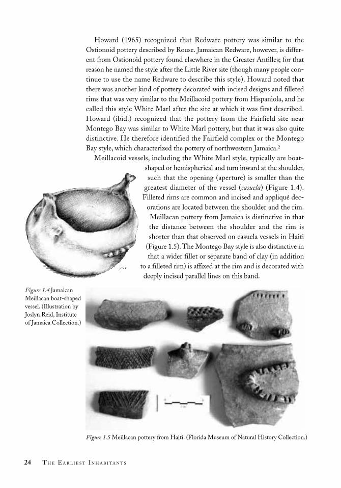
Meillacoid vessels, including the White Marl style, typically are boat-shaped or hemispherical and turn inward at the shoulder,such that the opening (aperture) is smaller than the
greatest diameter of the vessel (casuela) (Figure 1.4).Filleted rims are common and incised and appliqué dec-
orations are located between the shoulder and the rim.Meillacan pottery from Jamaica is distinctive in thatthe distance between the shoulder and the rim isshorter than that observed on casuela vessels in Haiti
(Figure 1.5).The Montego Bay style is also distinctive inthat a wider fillet or separate band of clay (in addition
to a filleted rim) is affixed at the rim and is decorated withdeeply incised parallel lines on this band.
24 T H E E A R L I E S T I N H A B I TA N T S
Figure 1.5 Meillacan pottery from Haiti. (Florida Museum of Natural History Collection.)
Figure 1.4 JamaicanMeillacan boat-shapedvessel. (Illustration byJoslyn Reid, Institute of Jamaica Collection.)

Descriptions of Jamaican Redware were based on pottery recovered dur-ing excavations at the Little River site in 1933 (De Wolf 1953). The LittleRiver site was the first at which Redware pottery was identified, althoughsince then a number of Redware sites have been discovered, primarily alongthe south coast. The Alligator Pond site is a good example (Silverberg,Vanderwal and Wing 1972). Howard (1950) reported the Little River styleas being part of the Ostionoid series, and the White Marl and Montego Baystyles as part of the Meillacoid series.
Rouse has since modified his classification system to include subseries,apparently based on his belief that all of the late-period styles were derivedfrom the Ostionoid series. According to the new scheme, there wereOstionan, Meillacan, and Chican subseries of the Ostionoid series (Figure1.6). In accord with this revised scheme, Jamaican Redware fits in theOstionan Ostionoid, and White Marl and Montego Bay styles are part ofthe Meillacan Ostionoid. The main problem with this classification is thatnew evidence from Haiti indicates that the Ostionan, Meillacan, and Chicansubseries are probably separate traditions. Meillacan and Chican apparentlydeveloped from an early migration of people or the diffusion of pottery mak-ing to archaic groups in the eastern Dominican Republic around 350 BC. TheOstionan subseries did not reach Hispaniola until after AD 600 (Keegan 2003;Veloz Maggiolo and Ortega 1996). The classification system has not, as yet,been modified to account for these new developments.
These new data on the origins of the Ostionan and Meillacan subseriesare especially important for Jamaican archaeology. It has been assumed, fol-lowing Rouse, that the Redware peoples changed their style of decorating pot-tery and transformed themselves into the White Marl people. The new datasuggest that there were two separate migrations to Jamaica. The first was by
25T H E D E V E L O P M E N T O F J A M A I C A N P R E H I S T O R Y
Figure 1.6 Local styles in the Ostionan (in black), Meillacan (in dark grey) and Chican (inlight grey) subseries, Ostionoid series, for Cuba, Haiti and Jamaica. (Rouse 1992, fig. 14.)
Central Cuba Jamaica Haiti (southwest) Eastern Cuba Haiti
AD 1500
AD 1200
AD 500
LittleRiver
Arroyo del Palo Macady?
Bani White Finca Viejo
Marl ? Mellac
Pueblo Carrier

people making Ostionan (Redware) pottery, who arrived on the island after AD
700. The second was by people making Meillacan (White Marl) pottery, andthey arrived around AD 1000. The questions that face us concern the interac-tions between these distinct cultures and the way in which the Meillacan peo-ples were able to displace the Ostionan peoples who arrived before them.Finally, we need to address why the people near Montego Bay developed adistinct style of pottery decoration. These and other questions concerningthe lifeways of the first people on Jamaica are the subject of the next phase ofresearch that began in the 1970s.
Sociocultural Research
The papers collected in this book reflect sociocultural research, the most recentphase of archaeological investigation as defined by Rouse. This research ini-tially was sponsored by the Archaeological Society of Jamaica, and was pub-lished in the society’s newsletter, Archaeology Jamaica (for example, see Wallace1992). The ASJ began as an Archaeology Club, established by James Lee in1965. Five years later, with outside support, Lee transformed the organizationinto the Archaeological Society of Jamaica. James Lee is a remarkable man.Not only did he devote substantial energy to identifying the prehistoric cul-tural resources of Jamaica, he also published reports on his investigations thatprovided a foundation for the future (see Lee 1991).
During the 1960s and 1970s the main excavation projects were conductedat White Marl (S-1) (Perrins 1981; Silverberg, Vanderwal and Wing 1972),Rodney’s House (S-5) and Port Henderson (S-29) (Wilman 1978, 1979), allin St Catherine. Others were carried on at Bellevue (K-13), St Andrew(Medhurst 1976a, 1976b, 1977a, 1977b; Wing 1977); Cinnamon Hill ( J-10), St James (Osborne and Lee 1976, 1977; Johnson 1976); and Upton (A-43), St Ann (Wilman 1983, 1984, 1992). Although most of the members ofthe ASJ have been avocational archaeologists, their investigations have alwaysbeen of the highest quality. In addition to visiting newly discovered prehistoricsites and conducting an active programme of prospecting for new sites, anumber of the members conducted excavations.
During the Lee administration the society focused primarily on the island’sprehistory, which is evident in issues of Archaeology Jamaica from the period.Between 1965 and 1985, James Lee and the ASJ conducted intensive investi-gations, and subsequently published several articles, on Jamaican prehistoricartefacts, such as Taíno stone celts, pendants, grinding stones and net-sinkers(Lee 1978a; Roobol and Lee 1976, reprinted in this volume). Lee also published research on Taíno buréns or cassava griddles (Lee 1980a) andJamaican adornos, which are clay heads that adorn the rims of pottery vessels
26 T H E E A R L I E S T I N H A B I TA N T S

(Lee 1983b). Dr Lee made a concerted effort to bring Jamaican archaeologyto the archaeological community at large, and his work has been widely disseminated.
In 1999, Lee handed over his collection to the University of the WestIndies. This collection is currently being studied by the archaeological lab atthe university’s Mona campus under the direction of Dr Philip Allsworth-Jones. The research done by Lee and the ASJ has also greatly benefited theJamaica National Heritage Trust, as Lee’s site codes and mapping informationhave provided important data for the Jamaica National Heritage Trust’sNational Inventory of Sites and Monuments.
The past two decades have involved diversification and growth in Jamaicanarchaeology. During this period we have seen the beginnings of investigationsof the Afro-Jamaican, Spanish and Jewish heritage – illustrating the island’smultiethnic composition, encapsulated in the motto on the national coat ofarms, “Out of Many, One People”.
The Jamaica National Heritage Trust was actually established as theJamaica National Trust Commission in 1958, under the administration of theInstitute of Jamaica. In 1985, the commission was separated from the Instituteof Jamaica and renamed the Jamaica National Heritage Trust. According toRoderick Ebanks, Technical Director of Archaeology at the Jamaica NationalHeritage Trust, the new and improved institution was responsible for “thelegal protection and administration of all historical sites, ranging from smallhouses – Taíno sites to Plantations” (personal communication, 1997). Foralmost two decades the Archaeology Division of the Jamaica NationalHeritage Trust has been responsible for most of the investigations conductedon the island. Although its members are highly trained and would like to pur-sue more scholarly research, the limited resources available have afforded theopportunity for little more than rescue and salvage operations (see Richards,this volume).
When archaeology as a discipline was established at the University of theWest Indies, the first lecturer was the Ghanaian Emmanuel Kofi Agorsah.“Dr Kofi”, as he is affectionately called, was influential in diversifyingJamaican archaeological research. His special interest was in Afro-Jamaicanand Maroon archaeology, which he brought to the forefront (Agorsah 1992,1993, 1994). He also challenged traditional methods of classifying the past(Agorsah 1994).
Since his arrival in 1998, Philip Allsworth-Jones has contributed toJamaican prehistoric research with his collaborative investigations atChancery Hall, St Andrew, and Green Castle, St Mary (both reported in thisvolume).
During the past decade significant progress has been made. In 1992, there
27T H E D E V E L O P M E N T O F J A M A I C A N P R E H I S T O R Y

was the recovery of the Aboukir zemís – the most significant Taíno find in twohundred years (discussed by Saunders and Gray in this volume). Subsequentlythere has been renewed interest in Jamaican prehistory, as seen by ElizabethRega at Sommerville Cave, Clarendon, William “Bill” Keegan at ParadisePark, Westmoreland, and, recently, Betty “Jo” Stokes at Rio Nuevo, St Mary.
Conclusions
Archaeologists throughout the West Indies have begun to move beyond thesimple classification of pottery decorations to ask questions about whereancient people lived, what they ate, what types of trade they engaged in, howtheir economy might be characterized, what types of social relations they hadand how their polities were organized. In this regard, it should be noted thatJamaican researchers were at the forefront in technical studies. They wereamong the first to seek the specific identification of animal bones found insites in order to determine what people ate and where the foods were captured( Johnson 1976; Wing 1977). They used petrographic analysis to identify thesources of stone artefacts in the sites (Robool and Lee 1976, reprinted in thisvolume); and they used X-ray diffraction to characterize the clays from whichpottery vessels were made at the Bellevue site (Medhurst 1976a, 1976b,1977a, 1977b). In addition, the study of wooden artefacts and of the petro-glyphs and pictographs that decorated cave walls provided information aboutthe makers’ belief systems and world view (Aarons 1994; Watson 1988;Saunders and Gray, this volume).
Jamaican archaeology has a long and rich heritage. In fact, its early practi-tioners equalled and in some cases surpassed their peers in the United States.Yet for many years Jamaica was isolated. Caribbean archaeologists tended toemphasize the earliest Ceramic Age culture, known as Saladoid, and the con-tact period “Classic Taíno” cultures of eastern Cuba, Hispaniola and PuertoRico. Because these cultures did not occur in Jamaica, Jamaican archaeologywas viewed as peripheral to the main archaeological interests in the region.This lack of interest was initially expressed by calling the peoples of centralCuba, the Bahamas, the northern Lesser Antilles and Jamaica “sub-Taínos”(Lovén 1935). Although the term Western Taínos has now been adopted forthe contact period peoples of central Cuba and Jamaica, the legacy of pastresearch orientations has maintained their peripheral position.
Despite a general lack of interest on the part of foreign archaeologists,Jamaica developed a model programme of national archaeology through thecombined efforts of the Institute of Jamaica, ASJ, the University of the WestIndies and the Jamaica National Heritage Trust. During the past decade,archaeologists working throughout the West Indies have begun to recognize
28 T H E E A R L I E S T I N H A B I TA N T S

that we need a more comprehensive view of the past. This new perspectivedoes not focus on a single island, but instead takes an “archipelagic” view(Watters 1997). In this regard, there is renewed interest in the archaeology ofthe periphery, and Jamaican archaeology stands poised to make significantcontributions to our understanding of the native peoples of the West Indies.
29T H E D E V E L O P M E N T O F J A M A I C A N P R E H I S T O R Y

Appendix
Site Parish Reference
Great Goat Island St Catherine Duerden 1897Jackson’s Bay Clarendon MacCormack 1898Jackson’s Bay Clarendon MacCormack 1898Portland Clarendon MacCormack 1898Portland Ridge Midden 1 Clarendon MacCormack 1898Portland Ridge Midden 2 Clarendon MacCormack 1898Harmony Hall Clarendon Duerden 1897Salt River Clarendon MacCormack 1898Round Hill Clarendon Howard 1950Pedro St Elizabeth Reichard 1904Hounslow St Elizabeth Duerden 1897Black River St Elizabeth Reichard 1904Bluefields Westmoreland C.B. Lewis, Howard 1950Newfound River Hanover Duerden 1897Rhodes Hall Hanover Duerden 1897Haughton Hall Hanover Duerden 1897Kew Hanover Duerden 1897Fairfield, Montego Bay St James Reichard 1904Montego Bay Point St James Reichard 1904Williamsfield St James Duerden 1897Mammee Hill St James Duerden 1897Spotty Hill St James Duerden 1897California St James Duerden 1897Wales Trelawny Duerden 1897Stewart Castle Trelawny Duerden 1897Rio Bueno Trelawny Howard 1950Dry Harbour St Ann Howard 1950Retreat St Ann Duerden 1897, De Booy 1913Mahogany Hill St Ann Longley 1914Scarborough St Ann Longley 1914Logie Green Clarendon Longley 1914St Jean D’Acre St Ann Longley 1914Culloden St Ann Longley 1914Green Hill St Ann Longley 1914
Table 1.1 Midden Sites Reported by Robert Howard and Reference to TheirOriginal Description
Table 1.1 continues
30

Site Parish Reference
Armordale St Ann C.S. Cotter, Howard 1950Boston St Ann C.S. Cotter, Howard 1950Orange Valley St Ann C.S. Cotter, Howard 1950Southfield St Ann Howard 1950Cranbrook St Ann Duerden 1897Seville St Ann C.S. Cotter, Howard 1950Liberty Hill St Ann Howard 1950Windsor St Ann C.S. Cotter, Howard 1950New Ground St Ann C.S. Cotter, Howard 1950Greenwich Park St Ann C.S. Cotter, Howard 1950Tydenham St Ann Howard 1950Prosper Hall St Ann C.S. Cotter, Howard 1950Trafalgar St Ann C.S. Cotter, Howard 1950Friendship St Ann Duerden 1897Belle Vue St Ann Duerden 1897Shaw St Ann Howard 1950Dunlookin St Mary Howard 1950Prospect St Mary C.S. Cotter, Howard 1950Llanrumney St Mary C.S. Cotter, Howard 1950Clitos Point St Mary Howard 1950Port Antonio Portland C.S. Cotter, Howard 1950Duckenfield St Thomas C.S. Cotter, Howard 1950Rozelle St Thomas C.S. Cotter, Howard 1950Creighton Hall St Thomas Howard 1950Cambridge Hill St Thomas Duerden 1897Sugar Loaf Hill St Thomas Howard 1950Seven Mile Hill Kingston & St Andrew Howard 1950Fort Nugent Kingston & St Andrew C.B. Lewis, Howard 1950Tower Hill Kingston & St Andrew C.B. Lewis, Howard 1950Long Mountain Kingston & St Andrew Duerden 1897Hope Kingston & St Andrew Duerden 1897Iver Kingston & St Andrew Howard 1950Norbrook Kingston & St Andrew Blake 1895; Duerden 1897Chancery Hall Kingston & St Andrew C.B. Lewis, Howard 1950Ferry Hill St Catherine Howard 1950Waterloo St Catherine Howard 1950White Marl St Catherine Duerden 1897; Howard 1950Port Henderson St Catherine Howard 1950
Source: Howard 1950.
Table 1.1 Midden Sites Reported by Robert Howard and Reference to TheirOriginal Description (cont’d)
31

Site Parish Reference
Great Goat Island St Catherine Duerden 1897
Portland Cave Clarendon C.B. Lewis, Howard 1950
Portland Ridge Cave No. 1 Clarendon C.B. Lewis, Howard 1950
Portland Ridge Cave No. 3 Clarendon Howard 1950
Portland Ridge Cave No. 4 Clarendon Howard 1950
Portland Ridge Cave No. 5 Clarendon C.B. Lewis, Howard 1950
Portland Ridge Rock Shelter Clarendon Howard 1950
Little Miller’s Bay Manchester MacCormack 1898
Little Miller’s Bay Manchester MacCormack 1898
Little Miller’s Bay Manchester MacCormack 1898
Jackson’s Bay Clarendon MacCormack 1898
Pedro St Elizabeth Duerden 1897
Hounslow St Elizabeth Duerden 1897
Ipswich St Elizabeth Howard 1950
Drummond Westmoreland Duerden 1897
Negril Westmoreland Duerden 1897
New Market St James Reichard 1904
California St James Duerden 1897
Windsor Trelawny Howard 1950
Alexandria St Ann Longley 1914
Botany Bay St Thomas Duerden 1897
Cambridge Hill St Thomas Duerden 1897
Cambridge Hill St Thomas Duerden 1897
Halberstadt Kingston & St Andrew Duerden 1897
Bloxburgh St Thomas Duerden 1897
Dallas Castle St Andrew Duerden 1897
Source: Howard 1950.
Table 1.2 Cave Sites Reported by Robert Howard and Reference to Their OriginalDescription
32

Notes
1. There are similar problems with access to archaeological research conductedon other islands, including Cuba and the Dominican Republic, where theresults are published locally and are not widely disseminated, especially to theEnglish-speaking world.
2. Vanderwal (1968a) called it the “Fairfield style” and reported that it was foundonly on the north coast in western Jamaica. Montego Bay–style potteryrecently was discovered on the south coast at the Sweetwater site, ParadisePark, Westmoreland, just east of the town of Savanna-la-Mar.
33T H E D E V E L O P M E N T O F J A M A I C A N P R E H I S T O R Y
Site Parish Reference
Canoe Valley Manchester C.B. Lewis, Howard 1950
Canoe Valley Manchester C.B. Lewis, Howard 1950
Canoe Valley Manchester C.B. Lewis, Howard 1950
Kempshot St James Duerden 1897
Pantrepant Trelawny Duerden 1897
Salisbury St Ann C.S. Cotter, Howard 1950
Walkerswood St Ann C.S. Cotter, Howard 1950
Dryland St Mary Duerden 1897
Mountain River Cave St Catherine Duerden 1897
Source: Howard 1950.
Table 1.3 Cave Art Sites Reported by Robert Howard and Reference to TheirOriginal Description

Introduction
THE PRESENCE OF Taíno sites in the Kingston area has beenrecorded from the last years of the nineteenth century onwards, and importantexcavations have been conducted at some of them, particularly by amateursin the 1970s. Dr James Lee included them in his general mapping project ofthe island, the results of which were mentioned in the newsletter, which heedited from 1965 to 1986. As a result of the development and spread ofKingston in recent times, some new sites have been discovered, but they andsome of the old ones have also been wholly or partially destroyed. The num-ber of people who are aware of the exact location of some of these sites islimited, and it seemed desirable to record this information before it was lost.A survey of all known sites was therefore carried out in order to ascertain theircurrent status and assess possible opportunities for future work. The resultscan be seen in the accompanying map (see Figure 2.1) and annotated list (seeTable 2.3). In addition, two pilot studies were undertaken to explore the pos-sibilities of scientific analysis of some of these materials. First, following a
34
The Taíno Settlementof the Kingston Area
P H I L I P A L L S W O R T H - J O N E S
G E R A L D L A L O R
G E O R G E L E C H L E R
S I M O N F. M I T C H E L L
E S T H E R Z . R O D R I Q U E S
a n d
M I T K O V U T C H K O V
2
Originally published in 1999, in Proceedings of the Eighteenth International Congress forCaribbean Archaeology, Grenada, 1999: 115–27.

small trial excavation at Chancery Hall in 1998, the molluscs from that exca-vation were examined, and the results are compared with the material alreadypublished from Rodney’s House and Bellevue. Second, an initial study of pot-tery from six of the sites has been carried out using neutron activation analy-sis (NAA), and preliminary results from that study are also presented here. Itis hoped that the pattern of interdisciplinary investigation employed in thisstudy, using geographical units larger than the individual site, can be extendedto throw light on the pre-Columbian occupation of Jamaica in general.
The Kingston Area: Geographical Background
The area with which this study is concerned is illustrated in Figure 2.1. Inthe centre is the Liguanea Plain, crossed by a number of gullies, and nowoccupied by the sprawling mass of the city of Kingston itself. To the north andeast it is bounded by an arc of hills, notably the Red Hills, Jacks Hill, DallasMountain and Long Mountain. The Hope River runs to the sea in a gorgebetween the last two. To the west, where once there was a morass, the Salt andFresh rivers and the Rio Cobre enter the sea at Hunts Bay. The Rio Cobre,canalized in the mid-nineteenth century, once joined the Fresh River in itscourse to the sea (Edward Robinson, personal communication, 1999). Port
35T H E TA Í N O S E T T L E M E N T O F T H E K I N G S T O N A R E A
Figure 2.1 Taíno sites in the Kingston area

Henderson Hill lies to the south, opposite the present Port Royal. Geologic-ally, Port Henderson Hill, the Red Hills, Dallas Mountain and LongMountain are all formed of Tertiary limestone, whereas Jacks Hill and themountains rising to the northeast are of Cretaceous-Tertiary granodiorites,andesites and volcaniclastic and clastic sediments (Matley 1951; Green 1977;Gupta and Ahmad 2000).
The Liguanea Plain represents an alluvial fan that was produced by sedi-ments carried by the Hope River before it was diverted into its present chan-nel (Wood 1976). It is possible that Sandy Gully marks its former course. It isnot known exactly when the drainage took on its present form, but presum-ably it was essentially as it is now during the time of the Taíno occupation.According to Claypole (1973), the Liguanea Plain was largely unsettled anduncultivated immediately prior to the English occupation in 1655: “Nosprings or rivers flowed in or across the centre portion which was composedmainly of a dry savanna area”. One result of the Hope River capture was theformation of the Palisadoes tombolo, made up of increased sediment enter-ing the sea southeast of Long Mountain and transported west by longshoredrift. According to Hendry (1978), Port Royal has at times been joined tothe rest of the Palisadoes and at times been separated from them.
Taíno Sites in the Kingston Area
The sites are arranged in an arc around Kingston, and are listed in Table 2.3in their approximate order from west to east (Figure 2.1). The code names(where applicable) are those assigned to them by Dr J.W. Lee. If MolynesMountain and Long Mountain are both considered as two sites, then thereare eighteen major open-air locations characterized as shell middens, two bur-ial caves, one stray find of a petaloid celt, one known raw-material source andone site where a canoe considered to be of Taíno origin was found. Some ofthe open-air sites were already known by the end of the nineteenth centuryand were commented on by Duerden (1897). Now they either are difficult toaccess because they are in socially volatile areas (Wareika and RennockLodge) or have been partially or totally built over (Norbrook and HopeTavern). Of the sites discovered later, Harbour View is also largely inaccessi-ble, Naggo Head has been totally destroyed by quarrying, and the few findsfrom Stony Hill were found only after the house on the site “Fort George” hadbeen demolished. Other sites (Caymanas Bay, Molynes Mountain, Jacks Hill,Ivor, Long Mountain) are apparently still largely intact but have not been sys-tematically investigated and are known only thanks to the work of interestedamateurs. The major excavated open-air sites are Rodney’s House, ChanceryHall, Bellevue and Tower Hill, and these have produced both artefactual and
36 T H E E A R L I E S T I N H A B I TA N T S

environmental evidence. Chancery Hall has also produced the only radiocar-bon date from the area, of 690 ± 50 BP (uncalibrated, which is equivalent toAD 1260 ± 50). Very little is known of the two burial caves (Beverly Hills andDallas Castle), and the exact whereabouts of the second are not certain. HopeMine certainly functioned as a source of galena until recently, and the localitywas known to the Taínos, since pieces of this material, presumably prized fortheir decorative effect, have been found at both Bellevue and Chancery Hall.The wooden canoe is an unusual find quite unlike any of the others. It wasdiscovered by National Water Commission (NWC) workmen in 1993–94 atthe corner of Harbour and Pechon streets in downtown Kingston and is nowin the custody of the Jamaica National Heritage Trust. It consists of a singlepiece of wood, is rounded at both ends and has a flat bottom with markings(presumably resulting from its construction) on both sides. It is considered tobe of Taíno origin, but dating of the material, as well as full publication bythe Jamaica National Heritage Trust, is still awaited.
A distinct pattern of settlement is apparent from the study of the map. Oneof the major open-air sites is at an altitude of more than 610 m, eight are morethan 305 m, and nine are between 305 m and 61 m above sea level. The ten-dency to settle on hilltops is clear. The stray find of a petaloid celt from theformer grounds of the Mona Great House, as well as that of the canoe nearthe present day shoreline, provides a hint, however, that the Liguanea Plainwas not entirely neglected, and the people must have traversed it to collect themarine molluscs which they evidently so much enjoyed, as well as for otherpurposes.
Analysis of Shells from Chancery Hall
A small excavation took place at Chancery Hall on 12–13 April 1998 as ajoint project between the University of the West Indies and the University ofLeicester. Work was carried out in two lots. On lot 340, a 1-m2 quadrant wasexcavated to a depth of 15 cm. Apart from shells, artefacts recovered includedninety-six potsherds and one limestone flake. In addition, a section was cutin lot 386, by the boundary wall between it and lot 340. Layer 3 containedabundant shells and artefacts comparable to those from the excavated quad-rant. There were twenty-three potsherds, fifteen chert flakes and a limestonecore. This study related to the totality of the molluscan material recovered atthat time.
Methods
All material recovered from the site was washed and dried. Molluscs werecounted, counts being based on apices for gastropods and umbones for
37T H E TA Í N O S E T T L E M E N T O F T H E K I N G S T O N A R E A

bivalves. Single gastropod valves were counted as one (operculae wereignored), while bivalve valves were counted as 0.5 (thus reflecting the fact thateach animal has two valves). Identification was based on standard texts (forexample, Abbott 1954; Humfrey 1975; Warmke and Abbott 1961).
We divide the material into two separate groups: terrestrial molluscs andmarine molluscs. While marine molluscs must have been transported to thesite, terrestrial molluscs may have lived on the site and may have had littlevalue to the Taíno people.
Results
The results of mollusc identifications are presented in Table 2.1. Represent-ative samples have been deposited in the Geological Museum, University ofthe West Indies, with catalogue numbers ranging from UWIGM.1999.5 toUWIGM.1999.44. Eighty-five per cent of the terrestrial gastropods on thesite are represented by Pleurodonte lucerna (Müller).
Eighteen species of marine bivalve and nine species of marine gastropodwere identified from Chancery Hall. Only five of the marine species [Neritina(Vitta) reclivata (Say), N. (V.) piratica (Russell), Anadara ovalis (Bruguière),Chione intapurpurea (Conrad) and Crassostrea rhizophorae (Guilding)] arenumerically important, accounting for 90 per cent of the total marine speciesrecovered (Table 2.1).
Discussion
The concentration of shells on the Chancery Hall site is likely to reflect boththe dietary preference of the Taíno people and the resources available to them.The five most abundant marine molluscs found on the site probably formeda significant part of their shellfish diet. The species of Neritina occur in brack-ish water on intertidal mudflats (Warmke and Abbott 1961, 50–51), while thebivalves A. ovalis and C. intapurpurea are semi-infaunal (partially buried)inhabitants of mudflats, and C. rhizophorae lives attached to mangrove roots.Kingston Harbour, with its protected mudflats and shallow water, is the mainsite on the central south coast of Jamaica where mudflat molluscs occur, andit seems likely that the Chancery Hall Taíno people collected their shellfishfrom these mudflats.
The modern mudflat fauna in Kingston Harbour is dominated by abun-dant examples of N. virginea Linné and C. cancellata Linné, while N. (V.)piratica, N. (V.) reclivata, A. ovalis and C. intapurpurea are rare. The abundanceof the latter four species on the Chancery Hall site suggests that at the time of
38 T H E E A R L I E S T I N H A B I TA N T S

Table 2.1 Shells Collected from Chancery Hall
Species Lot 340 Lot 386, Layer 3 Both Sites
Marine Gastropods Count1 Per cent2 Count1 Per cent2 Count1 Per cent2
Cittarium pica 1 0.1 0 0.0 1 0.04
Fasciolaria tulipa 1 0.1 0 0.0 1 0.04
Littorina sp. 0 0.0 1 0.2 1 0.04
Melongena melongena 21 1.2 10 1.6 31 1.30
Murex brevifrons 12 0.7 7 1.1 19 0.80
Nerita fulgurans 1 0.1 0 0.0 1 0.04
Neritina (Vitta) piratica 487 27.8 111 17.7 598 25.13
Neritina (Vitta) reclivata 771 43.9 198 31.7 969 40.71
Neritina (Vitta) virginea 7 0.4 6 1.0 13 0.55
Total marine gastropods 1,301 – 333 – 1,634 –
Terrestrial Gastropods – – – – – –
Pleurodonte lucerna 288 n/a 129 n/a 417 n/a
Dentellaria sloaneana 13 n/a 4 n/a 17 n/a
Other terrestrial 0 n/a 59 n/a 59 n/a
Total terrestrial gastropods 301 192 493
Bivalves – – – – – –
Anadara notabilis 1 0.0 3 0.2 4 0.08
Anadara ovalis 324 9.2 287 22.9 611 12.84
Anomalocardia brasiliana 3 0.1 2 0.2 5 0.11
Arca umbonata 35 1.0 10 0.8 45 0.95
Arca zebra 72 2.1 26 2.1 98 2.06
Barbatia candida 2 0.1 0 0.0 2 0.04
Brachidontes citrinus 2 0.1 6 0.5 8 0.17
Chama macerophylla 50 1.4 18 1.4 68 1.43
Chione cancellata 5 0.1 8 0.6 13 0.27
Chione granulata 60 1.7 19 1.5 79 1.66
Chione intapurpurea 215 6.1 123 9.8 338 7.10
Chione sp. 0 0.0 1 0.1 1 0.02
Codakia (s.s.) orbicularis 7 0.2 1 0.1 8 0.17
Crassostrea rhizophorae 117 3.3 79 6.3 196 4.12
Isognomon alatus 6 0.2 2 0.2 8 0.17
Ostrea frons 4 0.1 0 0.0 4 0.08
Semele proficua 3 0.1 0 0.0 3 0.06
Trachycardium muricatum 1 0.0 0 0.0 1 0.02
Total bivalve valves 907 – 585 – 1,492 –
1Individual bivalve and gastropod counts.2Percentage of marine shells based on complete animals (gastropods count 1, bivalves count 0.5).
39

Taíno occupation these species were dominant elements of the KingstonHarbour shellfish assemblage. Over-collection of these species by the Taínopeople may have been responsible for the demise of the natural populations.In this context, it is interesting to note that the species favoured by the Taínowere replaced by species of smaller size (judging from modern populations)and therefore less nutritional value (more need to be collected for the samefood quantity).
One notable rarity on the Chancery Hall site is the Strombus gigas Linné(queen conch), only a single fragment having been found on a subsequentvisit. This gastropod species is an important part of the modern shellfish dietin the Caribbean and was almost certainly collected for food by the Taíno peo-ple. S. gigas is a very large marine gastropod with an impressive shell. Itsabsence at Chancery Hall might be due to the fact that the shell is very heavy.(Why carry animal and shell up to the site when the muscle can be cut andonly the meat transported?) Modern Jamaican beaches are littered with pilesof S. gigas shells which have been culled for food; the antiquity of some pilesmay not even be guessed.
The terrestrial gastropod P. lucerna is abundant on the Chancery Hall site.However, there are many places in Jamaica where extensive accumulations ofterrestrial gastropods (often P. lucerna – Mitchell, personal observation) areconcentrated in soil profiles with no evidence of archaeological occupation.Furthermore, a Taíno rubbish tip may have been a highly desirable habitatfor such omnivorous terrestrial gastropods. It is therefore premature, withoutfurther investigation, to assume that the Taíno people ate these terrestrialmolluscs, and they may be present on Taíno sites simply because they livedthere. We therefore suggest that the presence of land snails on Jamaicanarchaeological sites should not necessarily be taken as evidence that theyformed part of the diet of the Taíno people.
Excavations at the Bellevue site (Wing and Medhurst 1977; Medhurst1977a, 1977b) recorded abundant marine and terrestrial shells. The mostabundant marine taxa recorded by these authors were species of Neritina, Arcazebra Swainson, Chione granulata Gmelin and Anadara brasiliana Lamarck.This is clearly a similar assemblage to that recorded from Chancery Hall,which is only about 1.5 km from Bellevue.
The assemblages of shells from Chancery Hall and Bellevue contrastmarkedly with those collected at Rodney’s House. Wilman (1978) recordedabundant marine (3,394) and terrestrial (371) shells from Rodney’s Housewith the marine assemblages dominated by A. zebra, A. imbricata Bruguière,Chama macerophylla Gmelin and Donax denticulatus Linné. The first threespecies are either cemented or attached by a byssus to hard substrates such asrocks, while the fourth is a shallow infaunal (living within the sediment)
40 T H E E A R L I E S T I N H A B I TA N T S

bivalve inhabiting intertidal sands.Thus the assemblage from Rodney’s Housetypifies the coastal environments of Port Henderson Hill, with its rocky head-lands and sandy beaches.
In summary, we conclude that while the molluscs preserved on Taíno sitesundoubtedly give some valuable insight into the Taíno diet, this may be tosome extent distorted by spurious additions (terrestrial molluscs living on thesite) and absences (large molluscs which were butchered on the shore).Arguments concerning human population size that are based solely on shell-fish found on archaeological sites may, therefore, be unsound.
Neutron Activation Analysis of Pottery
Twelve pottery samples from six sites in the area ( Jacks Hill, Harbour View,Bellevue, Chancery Hall, Rodney’s House and Norbrook) were chosen for thestudy at the International Centre for Environmental and Nuclear Sciences atthe University of the West Indies, to be carried out with the technique of neu-tron activation analysis (NAA). The objective was to determine whether thepotters employed the same clay source and, if variations were detected,whether these reflected different clay sources or some other factor – forinstance, different vessel types. Hence, there was an attempt to include asvaried a selection as possible from each site, including rims and body sherdswith different inclusions, and two griddles.
Results
A total of twenty-seven major, minor and trace elements was found. The con-centrations of these elements are summarized in Table 2.2.
Discussion
Two striking points emerge from a study of these figures. First, there is ageneral homogeneity in the quantity of each element present in each samplesite. The degree of homogeneity is particularly clear if only the four major ele-ments (Al, Fe, Ti and Ca) are considered. Second, the values for these ele-ments are consistent with their known occurrence in the soils of the Kingstonarea. Aluminium has an appropriate occurrence of between 8 and 10 per cent;iron, less than 1 per cent; titanium, between 0.49 and 0.7 per cent; and cal-cium, between 1 and 2 per cent (Lalor 1995). Histograms of the major ele-ments in the sampled sites compared with the levels in the soils of theKingston area are shown in Figure 2.2.
41T H E TA Í N O S E T T L E M E N T O F T H E K I N G S T O N A R E A

Table 2.2 Neutron Activation Analysis of Pottery Samples from Sites 1–6 (concentrations in ppm, unless otherwise noted)
Element Jacks Hill Harbour Bellevue Chancery Rodney’s Norbrook
View Hall House
Aluminium (%) 10.3 8.98 6.23 9.06 8.85 9.77
Vanadium 110 196 117 130 106 70.1
Titanium 4,830 5,310 3,920 3,370 3,440 3,860
Calcium (%) 0.808 1.12 1.5 1.21 0.997 1.26
Manganese 447 417 439 678 268 261
Dysprosium 2.72 2.08 2.06 2.31 1.08 1.46
Europium 0.99 0.635 0.727 0.825 0.50 0.65
Barium 582 1,330 589 470 672 792
Cadmium 2.24 3.29 5.16 6.91 1.13 2.25
Lanthanum 17.7 12.1 14.6 13.5 8.55 12.9
Samarium 4.00 2.39 2.75 2.76 1.39 2.12
Arsenic 4.32 10.1 5.08 5.23 5.79 2.12
Sodium (%) 2.12 1.76 1.86 2.45 1.54 2.32
Bromine 3.77 3.28 1.92 3.98 2.57 2.54
Uranium 2.52 1.87 1.55 1.90 1.39 1.3
Potassium (%) 2.65 1.90 2.03 1.65 1.95 2.18
Antimony 0.60 1.88 0.76 0.88 1.20 0.86
Lutetium 0.33 0.245 0.223 0.20 0.50 0.24
Chromium 24.5 50.9 34.3 <5 20.7 33.8
Iron (%) 4.67 6.16 3.89 4.43 2.88 3.87
Cobalt 15.3 10.0 10.2 15.6 4.44 6.20
Selenium 14.5 13.7 12.4 15.1 7.96 10.7
Cerium 53.0 22.8 33.2 26.4 11.1 35.2
Caesium 3.33 2.69 <1 <1 2.29 <1
Zinc 73.7 56.9 51.9 67.2 52.6 70.9
Thorium 10.9 5.10 8.95 1.80 4.37 10.6
Hafnium 6.26 5.86 5.72 4.55 4.04 6.40
42

We believe that there probably was a single clay source for these samples.It may have been in Hunts Bay, as suggested by Medhurst and Clarke(1976a), but this remains to be tested, and other sources within the area areknown (Hill 1978). A check will also be made to see whether the buff-yellowsherds found in the excavations at Bellevue (distinct from the majority red-brown wares, which alone formed part of this study) conform to the generalpattern. They are thought to represent water containers, and are said to havebeen found at various other places on the island; hence, they may show evi-dence of long-distance contacts in what otherwise appears to be a homoge-neous local industry.
Conclusion
The Taíno settlement of the area had a definite pattern. Most of the knownsites are on hilltops, although there are some indications that the Liguanea
43T H E TA Í N O S E T T L E M E N T O F T H E K I N G S T O N A R E A
Figure 2.2 Histograms of the major elements in the pottery samples compared with the levels in the soils from theKingston area
1 2 3 4 5 6
Site No.
12
10
8
6
4
2
0
% m
l na T
Al in Kingston Area 8–10%
1 2 3 4 5 6
Site No.
7
6
5
4
3
2
1
0
% m
l
Fe in Kingston Area <5%
1 2 3 4 5 6
Site No.
1.8
1.6
1.4
1.2
1.0
0.8
0.6
0.4
0.2
0.0
% m
l na CCa in Kingston Area 1–2%
1 2 3 4 5 6
Site No.
0.6
0.5
0.4
0.3
0.2
0.1
0.0
% m
l na T
Ti in Kingston Area 0.49–0.7%

Plain may have played a role in the economic network of the time. The analy-sis of the shells from Chancery Hall revealed a definite concentration of cer-tain species, which may be typical of inland sites as opposed to coastal sitessuch as Rodney’s House. Further study (coupled with an examination of ver-tebrate remains) at other sites in the area may reveal interesting local varia-tions in the Taíno patterns of faunal exploitation. There are indications thatcertain molluscs may have been over-collected, leading to a lasting diminutionof the natural populations. Neutron activation analysis of selected potsherdsshowed that they possessed a significant degree of homogeneity, perhaps sug-gestive of a single clay source. We intend to follow up with further studies onpossible clay sources, and also with an approach using X-ray fluorescence,before drawing definitive conclusions. The likelihood of raw-materialexchange is demonstrated for the area by evidence of exploitation, or at leastcollection, of galena at the Hope Mine, and study of the petrography of thecelts found at the sites would undoubtedly also reveal much about sourcematerials (Roobol and Lee 1976, reprinted in this volume). This study ishence not an end but a beginning to what it is hoped will be a larger work.
Acknowledgements
Thanks go to Mrs Margaret Hodges and Mr Michael Gardner for showing us thesites on Plantation Heights and Long Mountain, and to the Jamaica Defence Forcefor their permission to visit Rodney’s House. For help in the excavation at ChanceryHall in 1998, thanks go to Dr Rob Young and Dr Jane Webster of the University ofLeicester, to Dr Silvia Kouwenberg and Ms Susan Chung of the University of theWest Indies, who participated in the work, and to Mr Tony Gouldwell of theUniversity of Leicester, who studied and presented a report on some of the finds. MrJohn Wilman provided information about the excavations at Bellevue and Rodney’sHouse, Mr Douglas Aitken kindly showed us his collection from Ivor, and ProfessorMaureen Warner-Lewis told us about the finds made at her property near MonaGreat House. We are also grateful to Dr James Lee, who indicated on the map theprecise locations of some of the sites that he investigated or relocated from the 1960sonwards.
44 T H E E A R L I E S T I N H A B I TA N T S

Appendix
Site Code Comments
Rodney’s House S-5 Excavated by Wilman in 1978 and by Medhurst in 1979. Six middens. Faunalremains. 3,394 marine and 371 terrestrial molluscs, most common marine Arcazebra, Donax denticulatus, Arca imbricata, Chama macrophylla. 6,728 bone frag-ments, MNI 747. Four species of mammals, three species of reptiles, four fami-lies of birds, twenty-five families of fish, six of crabs and lobsters. Typical WestIndian dry coastal and shallow-water faunal communities. (Medhurst 1980;Scudder 1992; Wilman 1978, 1979)
Naggo Head S-12 Investigated 1972–73, now destroyed by quarrying. Child burial. (Lee 1972a,1972b; Aarons 1983a)
Caymanas Bay S-14 Investigated 1972–75. Small site on low hill. (Lee 1976b)
Molynes Mountain K-14 Two sites, including Plantation Heights, investigated by Lee and Hodges, 1967and 1985. Pottery of White Marl style. (Lee 1967a, 1967b, 1983a, 1985b)
Chancery Hall K-11 Investigated by Lechler from 1990 onwards, excavated by the Jamaica NationalHeritage Trust in 1996 and by a University of the West Indies–University ofLeicester team in 1998. Seven human burials. Faunal remains. Charcoal sampledated in 1992 by Beta Analytic Inc. at 690 ± 50 BP (uncalibrated). (Lechler2000)
Bellevue K-13 Excavated by Medhurst and Clarke in 1974–75 and by Medhurst and Wilmanin 1976–77. House foundation 4.5 m in diameter. Four human burials. Potteryprincipally red-brown, a little buff-yellow ware. Faunal remains. 1974–75: 474marine and 717 terrestrial molluscs; 1976–77: 2,500 marine and 2,341 terres-trial molluscs. Most common marine Neritina piratica reclivata and virginea,Arca zebra, Chione granulata, Anadara brasiliana; 1,207 bone fragments from thefirst excavation, MNI 126, predominantly land species. (Medhurst 1976a,1976b, 1977a, 1977b; Scudder 1992; Wing and Medhurst 1977)
Stony Hill Investigated by Gardner in 1997 when “Fort George”, Miss May Farquharson’shouse, was demolished.
Norbrook K-5 Investigated in 1890 by Lady Blake and therefore of considerable historicalimportance. Artefacts are still in evidence, but the site (hitherto owned by theNational Water Commission) is undergoing development. (Duerden 1897)
Jacks Hill K-1 Investigated by Lee and Lechler. Artefacts still in evidence.
Ivor K-10 Investigated by Lee in 1971. Some excavation during construction work.(Lee 1971)
Table 2.3 Taíno Sites in the Kingston Area
Table 2.3 continues
45

46
Table 2.3. Taíno Sites in the Kingston Area (cont’d)
Site Code Comments
Hope Tavern K-3 Investigated by Duerden and subsequently relocated by Lee in 1966.(Duerden 1897; Lee 1966)
Tower Hill K-7 Excavated by R.P. and A.K. Bullen in 1961. Faunal remains. Marine and terrestrial molluscs, sea turtles, fish including sharks, birds, and abundant hutia.(Bullen and Bullen 1974)
Mona A stray find of a petaloid celt within the former grounds of the Mona GreatHouse.
Long Mountain K-8 Duerden stated that shell middens were widely spread on the elongated topand on less elevated portions of the mountain. Two distinct sites were subse-quently identified by Lee and by Gardner. (Duerden 1897)
Wareika K-2 Recorded by Duerden as being behind the then newly built Wareika House.(Duerden 1897)
Rennock Lodge K-9 Marine shells, pottery, and two amulets reported by Duerden. (Duerden 1897)
Harbour View K-6 Site in the vicinity of the Martello Tower, investigated by Lechler. (Lee 1984;Wallace 1992)
Hope Mine Galena (lead and zinc ore) mined here from the time of the Spanish occupationonwards. Source of material found at Bellevue and Chancery Hall. (Matley1951; Hughes 1973)
Beverly Hills KC-7 Reported as a burial cave by Lewis. (Lee 1970a)
Dallas Castle KC-2 Reported as a burial cave by Duerden, could not be relocated by Lee.(Duerden 1897)
Downtown Kingston Canoe found in 1993–94 by National Water Commission workmen at the corner of Harbour and Pechon streets. Considered to be of Taíno origin. Madeof a single piece of wood.

ONE OF THE TAÍNO sites discovered in recent years on the out-skirts of Kingston is Chancery Hall, in Red Hills. In 1991, Mr GeorgeLechler, past president of the Archaeological Society of Jamaica, reported theexistence of the site and managed to salvage several important finds from it.In 1996, the Jamaica National Heritage Trust conducted test pit excavationson four of the Chancery Hall lots and retrieved further significant material. In1998, another small excavation was carried out by a combined team from theUniversity of the West Indies and University of Leicester, primarily for pro-viding stratigraphic control and recovering environmental data. This three-part report covers the discoveries made at the site so far. Much of ChanceryHall remains well preserved and it is hoped that further work can be donethere.
I. Discovery and First Investigation ofChancery Hall (1990–1994)
Chancery Hall is about 8 km inland and at an elevation of about 240 m ongentle slopes facing southeast. The site was discovered in 1990 when GeorgeLechler’s company, Explosive Sales and Services Ltd, was employed as sub-
47
The Pre-ColumbianSite of Chancery Hall,St Andrew
A N T H O N Y G O U L D W E L L
P H I L I P A L L S W O R T H - J O N E S
G E O R G E L E C H L E R
S I M O N F. M I T C H E L L
S E LV E N I O U S WA LT E R S
JA N E W E B S T E R
a n d
R O B E R T Y O U N G
3

contractors to drill and blast for roadways, storm drains, pipe trenches and soon, in connection with a new housing development in the area. The site wasdivided into lots, which have been sold and on many of which houses havebeen constructed. In subsequent years salvage archaeology was carried out onan amateur basis, particularly in the vicinity of Horatio Drive. Most but notall of the finds reported here come from lot 340 to the north of Horatio Drive.
Human Burials
Seven burials were discovered (Figure 3.1). One consisted of an adult with achild buried on top and three bowls on top of the child. A bulldozer hadcrushed two of the bowls, but the third was recovered intact and containedfragmented bones (Figure 3.2).
48 T H E E A R L I E S T I N H A B I TA N T S
Figure 3.1 Taínoskulls in situ.(ArchaeologicalSociety of Jamaica.)
Figure 3.2Earthenware pot containing infantremains.(ArchaeologicalSociety of Jamaica.)

The bones were sent to Dr Elizabeth Wing (University of Florida), whoidentified them as belonging to a human infant. They included the distal endof a femur and the proximal ends of an ulna and radius. There were severalribs. Also present were bones belonging to a hutia (Geocapromys brownii, rightacetabulum) and molluscs, including two large land snails (E.S. Wing, letterto author, 10 December 1991).
Also unearthed was a single skeleton – the skull of which was rescued byMr Errol Rhone, one of the workers on the site. His fellow workers, thinkingthat he was going to work obeah with the skull, crushed it into pieces, butthe shattered remains were brought to George Lechler. On later examina-tion, Lechler found four small beads associated with these remains (Figure3.3), which convinced us that this was indeed a Taíno burial.
Faunal Remains
There were thousands of shells on the site, as is the case on many Taíno mid-dens. But in addition, this site contained some unusual remains. In mid-1993,Lechler was given a fragmented animal skull, which was badly broken andclearly not complete. Lechler was puzzled by what appeared to be a doublerow of molars in the lower jaw. A portion of the skull was sent to Dr Wing,who identified it as a young manatee, measuring 1.5 to 1.8 m in length (Wing1994). As far as Lechler is aware, this is the first time the remains of a mana-tee have been discovered on a Jamaican Taíno site.
A triton shell about 11 cm in diameter at its widest part and 19 cm longwas also discovered (Reid and Lechler 1993). The apex, or narrow end, was
49T H E P R E -CO LU M B I A N S I T E O F C H A N C E R Y H A L L ,ST A N D R E W
Figure 3.3 Beads associated with the skull. (Archaeological Society of Jamaica.)

chipped away. It is believed that this was a musical instrument, a horn thatcould have been used for signalling over long distances. A second shell, simi-lar to the first but smaller, was also found. Conch-shell horns are, of course,still known in both Jamaica and Haiti, and Lechler has used them as a meansof informing people that blasting is about to take place.
Artefacts
Many petaloid celts of various sizes, grinding stones, pottery sherds and grid-dles, amulets, pendants, beads and other objects have been found. A piece ofbone carved to represent a dog’s head was recovered, as was a round, groovedsandstone object of unknown significance.
In addition, three clay zemís and a sandstone zemí were found, as well asbits and pieces of several more zemís of the same type. The sandstone zemíis 9 cm high, 6.8 cm wide, and 5.3 cm thick from front to back. It has roundinlet eyes, which Lee suggested might have been designed to hold gold leaf,and an elaborate crosshatched hair design. One of the clay zemís is particu-larly striking. It is 8.6 cm high, with a typical Taíno “skull face” encircled by a dotted headdress. The body has no arms or legs, and is rounded at thebottom.
A piece of galena (lead-zinc ore), probably originating from the Papinearea, was recovered. This ore is also known to be found elsewhere in the StAndrew area – for instance, at Smokey Vale, Belvedere.
Dating
In 1992, a charcoal sample was collected from the deposits just north ofHoratio Drive near the boundary between lots 340 and 339 and sent toMiami for carbon-14 dating. Dr Jerry J. Stipp of Beta Analytic Inc., where thetests were carried out, reported a date of 690 ± 50 BP or AD 1260 ± 50.
Dr Stipp’s report revealed that
some intrusive rootlet contamination was present in the initial sample. Afterwashing away all associated and adhering mineral matter, the charcoal pieceswere lightly crushed for increased surface exposure; all remaining rootlets wereremoved by combination of flotation and handpicking. The charcoal was thenchemically treated by repeat-soakings in dilute hot acid and alkali solutions toremove any carbonate or humic acid contaminants. After final thorough rins-ing to neutrality in hot distilled water, the clean charcoal was gently dried, syn-thesized to benzene, and counted for radiocarbon content. The sample was ofgood quality and quantity, and all analytical steps proceeded normally.
50 T H E E A R L I E S T I N H A B I TA N T S

Conclusion
This site is one of many circling the Liguanea Plain – Smokey Vale,Belvedere, Norbrook Gully, Skyline Drive, Wareika Hill and Harbour View.It is anticipated that more will be done to extract information from theChancery Hall site before it is too late.
II. Jamaica National Heritage TrustExcavations in 1996
In view of the potential that the site clearly possesses and the threat posed toit by development in the area, the Jamaica National Heritage Trust under-took excavations at Chancery Hall in the period from 17 June to 2 July 1996.Mr Selvenious Walters (field coordinator) conducted the excavations underthe overall supervision of Mr Roderick Ebanks (technical director and projectcoordinator) and with the participation of Ms Evelyn Thompson (actingdeputy technical director and conservator). Other Jamaica National HeritageTrust members who took part were Ms Dorothy Griffiths, Mr CliftonMcKen, Mr Ricardo Tyndall, Mr Ryan Murphy, and Mr R. Talbot. Two vol-unteers, Mr K. Farmer and Ms K. Redwood, accompanied them.
The objective was to obtain a general idea of the site by putting down pre-liminary test pits in some of the lots scheduled for development immediatelynorth and south of Horatio Drive. In itself, this area is no more than a frac-tion of the site as it originally existed, but it is the area from which Mr GeorgeLechler and his associates rescued some of the most significant finds. Six 1-m2 test pits were dug, five in lots 340, 339 and 338 (north of Horatio Drive)and one in lot 308 (south of Horatio Drive). The arrangement of the test pitsis shown in Figure 3.4.
The maximum depth of deposit in test pit 1 was 90 cm and in test pit 3 was110 cm, whereas the others varied between 40 and 60 cm. All the pits weredug in horizontal 10-cm levels. A few historic artefacts (mostly glass bottles)were encountered near the surface in test pits 2, 4 and 5, but the overwhelm-ing bulk of the material was pre-Columbian. Individual details of the exca-vated test pits follow.
Test Pit 1
Depth 90 cm. The most significant feature here was the discovery of humanbones at a depth of 59–71 cm in the southeast corner of the pit. They were
51T H E P R E -CO LU M B I A N S I T E O F C H A N C E R Y H A L L ,ST A N D R E W

preserved upon a pedestal as excavation elsewhere proceeded to what wasbelieved to be an archaeologically sterile horizon at the base. The humanremains include a skull with mandible and teeth, and limb bones. But whatwas found was evidently not the entire skeleton. The remainder extendedeastwards and southwards into the side of the pit. Conservation measureswere undertaken on the spot, but no attempt was made to lift the bones, inview of the fact that part of the skeleton still remained buried. A further exca-vation would be needed to complete this operation, if it were felt to be desir-able. On the basis of what was observed, it can be concluded that this was adeliberate burial. If the body had merely been left on the ground to decom-pose, the bones would have been more scattered than they were. In fact, they
52 T H E E A R L I E S T I N H A B I TA N T S
Figure 3.4 JNHT excavations at Chancery Hall. (Illustration by Selvenious Walters.)

were confined to a small area and placed in such a way as to suggest that thebody was buried in a flexed position.
Test Pit 2
Depth 60 cm. Some historic artefacts (green glass bottle fragments and acreamware sherd) were found in levels 1 and 2, but there were (comparativelysparse) pre-Columbian artefacts beneath, in a context generally characterizedas terra rossa in type. Excavation stopped when an archaeologically sterilehorizon appeared to have been reached.
Test Pit 3
Depth 110 cm. Significant concentrations of ash were detected, particularly inlevels 4 to 7 but continuing deeper than that in places. They were associatedwith increased concentrations of shells, both marine and terrestrial. In levels 5and 6 a large portion of a griddle was found, including the rim. Again, it wasexcavated separately on a pedestal. It was treated in situ with a solution of con-solidant before being carefully removed and transported to the conservationlaboratory at the Jamaica National Heritage Trust. In the light of the generalstratigraphic situation, it is considered that the griddle probably pre-datesthe skeletal remains found in test pit 1. When a depth of 110 cm was reachedin this pit, the soil was sterile.
Test Pit 4
Depth 40 cm. A few historic artefacts (green glass bottle fragments) wereencountered in level 1. The pre-Columbian artefacts beneath were notnumerous, but included a stone object the size and shape of a sewing-machinebobbin. Sterile soil was encountered at a shallow depth, indicating that as one goes up the hill the occupation deposits thin out. Limestone rocks arefrequent, indicating that bedrock is near.
Test Pit 5
Depth 50 cm. Some historic artefacts (green glass bottle fragments) werefound in levels 1 and 2. The matrix beneath, characterized as red bauxite intype, contained relatively few pre-Columbian artefacts. At the base it hadbecome completely sterile.
53T H E P R E -CO LU M B I A N S I T E O F C H A N C E R Y H A L L ,ST A N D R E W

Test Pit 6
Depth 40 cm.This is a steeply sloping area. Very few artefacts were found, andwe believe that even these were displaced by erosion from their original placeof deposition farther up the hill. Sterile soil was very quickly reached.
In general, it appears that the major deposits with signs of Taíno occupa-tion occur immediately north of Horatio Drive (test pits 1, 2, 3 and 5). Testpits 1 and 2 yielded relatively few artefacts compared with test pit 3, perhapscorresponding to a gardening area. The flat aspect that this part of the sitecurrently possesses probably is a result of later agricultural levelling, attestedto by the presence of some historic artefacts. The fact that no signs of a bur-ial were discovered in test pit 2 indicates that this area as a whole did not func-tion as a cemetery in Taíno times. Although the excavation in test pit 5 did notproduce many finds, there are in fact large numbers of shells and artefacts nowstrewn on the surface of lot 340.There is no doubt that this area supported thebulk of the Taíno houses which once existed here. The part of the site aroundtest pit 4 could also have been a gardening area, or it might have served as astone tool–manufacturing centre.
The preliminary investigation conducted by the Jamaica National HeritageTrust in 1996 revealed Chancery Hall’s importance as a major Taíno site worthy of thorough examination. Unquestionably there is more to be donehere before the completion of the current development renders it no longeravailable.
III. Excavations at Chancery Hall, 1998
A small excavation took place at Chancery Hall on 12–13 April 1998 as ajoint project between the University of the West Indies and the University ofLeicester. Work was carried out in two lots. On lot 340, a 1-m2 quadrant wasexcavated to a depth of 15 cm. Apart from shells, artefacts recovered includedninety-six potsherds and one limestone flake. In addition, a section was cutin lot 386, by the boundary wall between it and lot 340 (see Figure 3.4). Layer3 contained abundant shells and artefacts comparable to those from the exca-vated quadrant. There were twenty-three potsherds, fifteen chert flakes and alimestone core. A visit to the site in 1999 revealed that there were still manyartefacts and other traces of human activity eroding from the sediments in lot340, including five human teeth.
The molluscan material from the two lots excavated in 1998 has been
54 T H E E A R L I E S T I N H A B I TA N T S

described in detail in Allsworth-Jones et al. (2001, reprinted in this volume,Table 2.1). In addition, a 7.5-kg sample of material from layer 3 in the sec-tion on the edge of lot 386 was subjected to microscopic analysis in the labo-ratory at the School of Archaeological Studies in Leicester. A.J. Gouldwellreports on the results of this analysis (see appendix). These two studies are ofinterest primarily for the light that they cast on the Taínos’ environment andtheir exploitation of it. The principal points may be summarized as follows.
It is clear from the analysis that the marine gastropods and bivalves at thesite are dominated by only five species: Neritina reclivata and N. piratica,Anadara ovalis, Chione intapurpurea and Crassostrea rhizophorae. Both speciesof Neritina occur in brackish water on intertidal mudflats, which also serve asthe habitat for the first two bivalves. Crassostrea rhizophorae lives attached tomangrove roots. Hence, it is evident that the inhabitants collected their shell-fish mainly from what is now the Kingston Harbour. The terrestrial gas-tropods at the site are dominated by Pleurodonte lucerna, but there is somedoubt as to whether this really constituted an item in the human diet, since, asremarked earlier (Allsworth-Jones et al. 2001, reprinted in this volume), “thereare many places in Jamaica where extensive accumulations of terrestrial gas-tropods are concentrated in soil profiles with no evidence of archaeologicaloccupation”, and “a Taíno rubbish pit may have been a highly desirable habi-tat” for them.
Several salient points emerge from the study carried out by Gouldwell. Thestudy clearly shows the potential for microscopic work of this kind in recov-ering evidence which might not otherwise be available. Caution, however, isneeded in the interpretation of the results. Even in well-stratified conditionssuch as this, there is a possibility of contamination and intrusion by fibrousroots. Thus, the interesting and well-preserved insect and scorpion remainsare probably of recent origin, and the same goes for the two seeds. There isno need to doubt the antiquity of the wood charcoal, which is assumed to bean indication that the inhabitants used wood as fuel for cooking. There is anapproximately equal representation of mammalian and fish bone fragments,though the minimum numbers of individuals represented are obviously muchless than the fragments in the count. The mammalian remains probably allbelong to hutia, but a limitation of this study is that no specific identificationof the fish remains could be made. Some of the fish bones show signs of con-tact with fire, consistent with the hypothesis advanced to account for the pres-ence of charcoal. Interestingly enough, the fish bones showed no sign ofcracking caused by chewing, or of etching by gastric juices. The conclusion isthat the fish were filleted before being eaten, but it is desirable that this sug-gestion be tested elsewhere. As Gouldwell says, the conclusion in general isthat this was “a midden of food waste”.
55T H E P R E -CO LU M B I A N S I T E O F C H A N C E R Y H A L L ,ST A N D R E W

Figure 3.5 Stratigraphy of Chancery Hall
5YR F34 Dark reddish-brown clay soil, topsoil
2.5YR F38 Dark red clay soil, with some charcoal
Shell layer
7.5YR F34 Dark reddish-brown soil
7.5YR F44 Dark brown clay soil (buried soil layer? old land-surface)
5YR F44 Reddish-brown clay natural
CHANCERY HALL, JAMAICA
Benchmark height 16.607 m
19.375 19.275
Limit of excavation
2
6
5
4
0 50cms
3
1
56

Summary and Conclusion
Following development of the Chancery Hall area, Mr George Lechler andhis associates rescued some finds from the site. These included the remainsof seven human burials, as well as a number of artefacts. In 1992, a charcoalsample from the deposits just north of Horatio Drive, near the boundarybetween lots 340 and 339, was dated by Beta Analytic to 690 ± 50 BP, equiv-alent to AD 1260 ± 50.
Six test pits in four of the lots were excavated by the Jamaica NationalHeritage Trust in 1996 (Figure 3.4). The remains of another human burialwere discovered in lot 338, as were additional artefacts including a large por-tion of a griddle. The great majority of the finds were pre-Columbian, butthere were also a few historic pieces at the top of the sequence. The depth ofdeposits in the test pits varied between 40 and 110 cm.
In 1998, a team from the University of the West Indies and the Universityof Leicester undertook a small excavation. A 1 m2 quadrant was excavated toa shallow depth in lot 340, and a section was drawn at the boundary betweenlots 386 and 340. The material recovered is mainly of environmental interest,showing how the Taínos exploited the resources in their immediate surround-ings. A 7.5-kg sample from layer 3 in the section was analysed in the labora-tory at Leicester, confirming that this was a midden largely composed of foodwaste.
While a certain amount of information has been recovered from the site,undoubtedly much more has been destroyed or is no longer available for studyas a result of the development that has taken place. It is hoped that in future,when a proposed development will have an impact on an archaeological site,a concerted effort will be made to recover data in advance of construction.
Acknowledgements
Thanks go to Dr Silvia Kouwenberg and Ms Susan Chung for their assistance withthe excavation at Chancery Hall in 1998.
57T H E P R E -CO LU M B I A N S I T E O F C H A N C E R Y H A L L ,ST A N D R E W

Appendix
A Laboratory Study of the Remains from Layer 3, Lot 386, Chancery Hall
A . J . G O U L D W E L L
Introduction
A pre-Columbian shell midden at Chancery Hall was sectioned and exca-vated to a very limited extent in 1998 by a team from the University of theWest Indies and the School of Archaeological Studies at the University ofLeicester. A sample of the layer, context CH 98 lot 386: 3, was brought toLeicester for analysis and evaluation of macrofossil content. It was alreadyapparent that the material contained substantial quantities of bone of smallmammals and fish, and terrestrial and marine shell. The site is not situatedon the coast, hence the marine shell, and very probably the fish, was trans-ported to the site by the inhabitants of the time. Some large land snails werepresent, and small pieces of charcoal were also observed. Examination of thecontents should suggest what resources were being exploited, and this in turncan be expected to raise questions about the relationship between the humaninhabitants, their economy and the environment.
The macrofossils were divided into classes suitable for analysis. Particularcategories of material looked for included wood and other charcoal; cropresidues; seeds representing the background vegetation; insects and otherarthropods; molluscan shells; and bones of fish, amphibians, reptiles, birds andmammals.
Materials and Methods
The sample was reddish-brown, loamy, with gritty inclusions of charcoal,shell, bones, stone and pot. The total mass was 7.50 kg. The consistency andcolour of the sediment, together with the obvious presence of roots, suggestedwell-oxygenated conditions. This means that the primary mode of archaeo-logical preservation of seeds would be charring rather than waterlogging ordesiccation.
58 T H E E A R L I E S T I N H A B I TA N T S

The basic principle of separation of macrofossils employed was that ofdispersion, wash-over and flotation (Kenward, Hall and Jones 1980).
In the present case, successive subsamples were weighed out in 0.50-kg lotsand dispersed in a 5-litre bucket of water. The material was stirred in withthe water to ensure thorough mixing, and large inclusions such as stones, potand large shells were removed manually.
Floating and suspended material was decanted into nested sieves, the heav-ier residue remaining in the bottom of the bucket. Flot was collected in a 500-µm mesh, which was adequate for retaining most seeds. A 4.75-mmmesh was placed on top to screen out roots and other coarse matter.
Flot was resuspended in water when necessary, to clean it before decant-ing it into sieves to rinse out the silt. The flot was then allowed to dry onnewspaper before sorting.
Residue remaining in the bottom of the original bucket used for flotationwas washed through nested sieves to facilitate sorting. Clogging of the sieveswas a problem, so it was necessary to experiment with additional, coarsersieves to retain slowly disaggregating, coarse particles as well as a few remain-ing fibrous roots. Choice of meshes was pragmatic: the finest used was 500-µm. Coarser ones used ranged through 2 mm up to 4.75 mm. Differentsieve fractions were allowed to dry on separate sheets of newspaper to aid sub-sequent sorting of contents.
All the material thus obtained was sorted into categories using a low-powerlens for coarser material (larger pieces of charcoal, bone and shell), and astereoscopic microscope with a zoom magnification set at H 0.7 or slightlyhigher for fine material (seeds, insects, smaller shells and charcoal fragments).
Identifications are provisional, but every attempt was made to check withlocal specialists where appropriate.
Results
Fibrous roots formed a conspicuous component of the sample, warning ofthe likelihood of recent organic intrusion. Of the botanical remains, the mostinteresting finds are the fragments of wood charcoal. Two seeds that werefound were probably of recent origin. Of the zoological remains, the bonesand shells are probably reliable indicators of ancient human activity. Theinsects and other arthropods can probably be safely dismissed as more recentintrusions. Quantities are listed in Table 3.1.
59T H E P R E -CO LU M B I A N S I T E O F C H A N C E R Y H A L L ,ST A N D R E W

Wood Charcoal
Quantities are listed in Table 3.2. The vascular tissue of wood represented ascharcoal was of diffuse, porous type, with vessels (seen in transverse section)distributed singly or in radially aligned groups of two. These are visible at amagnification of H 10. Seasonal, presumably annual, rings are discernible. Thelargest fragment (30 mm long) showed vessels grouped in a cluster of six,mostly in a radial line, with a couple of cells offset from that line. The frag-ments were not broken to produce clean surfaces to be examined; destructiveanalysis has been left to whoever does the final identification.
The charcoal fragments were all of irregular shape and of insufficient sizeto reveal any indication of workmanship or stem growth form. The size rangeis indicated in Table 3.2.
Seeds
Two seeds were recovered. They were superficially similar to those ofRanunculus in outline, but are not flattened, and possess a warty surface andsquarish base. Length 1.6 mm. Colour: light yellowish-brown. The appear-
60 T H E E A R L I E S T I N H A B I TA N T S
Table 3.1 All Recovered Organic Materials
Class of Material Specimens MNI1
Plant MaterialRoots +++ n/aWood charcoal ca. 125 n/aSeeds 2
Animal MaterialArthropods 19 5Molluscs 350 223Marine worms (serpulids) 3 2Bone 748 5
Total 1,247 235
Table 3.2 Size Distribution of Charcoal Fragments
Size 25–30 mm 15–25 mm 10–15 mm 5–10 mm 2–5 mm
Fragments 2 2 6 25 ca. 90
1MNI = minimum number of individuals

ance of the seeds is fresh, and it is strongly suspected that they are of compar-atively recent origin.
Insects and Other Arthropods
Finds of arthropods are listed in Table 3.3. Most are disarticulated parts ofinsects: beetles (order Coleoptera); earwig (order Dermaptera) and whatappears to be the head of an ant (order Hymenoptera). Additionally, thereare components of claws of chelicerate arthropods, presumably scorpions. Theremains appear to be in good condition: some of the body parts remain artic-ulated, and the individual sclerites and other exoskeletal parts do not showobvious signs of degradation such as discolouration, cracking, perforation orabrasion (Kenward and Large 1998). In short, they look fresh (though a com-parison with modern reference material of the taxa has not been made), withthe earwig being the most complete.
The earwig possesses intact cerci (posteriorly situated pincers or “forceps”)
61
Anatomical Part Number
Insects
Order Hymenoptera Head, antlike 1
Order ColeopteraThorax, including fused elytra 1Beetle femur/fibia, jointed 1Pronotum 1Ventral tergite 1
Order Dermaptera Earwig abdomen with part thorax 1
Miscellaneous (mostly Coleoptera?) More or less undiagnostic, chitinous plates 4Cf. head 1
Scorpions
Segments of ?same, disarticulated chelicera 4Limb segments with 3 ?related chelicerae 4
Total 19
Table 3.3 Arthropod Remains

of slim, more or less parallel shape, suggesting a female. There are nearly twothousand recorded species of Dermaptera worldwide (Sakai 1996).
Beetles usually form the most conspicuous component of subfossil insectassemblages because of the toughness of their exoskeletons. In the presentcase, other groups seem to be present. The representation may not be abnor-mal, but experience of local subfossil insect assemblages would help in judg-ing whether this collection is typical. Of the scorpions, the three “related”chelicerae (claws) in Table 3.2 are all pale yellowish-brown, while the four seg-ments of the “same” chelicera are darker and more reddish-brown. All thechelicerae are fairly small, with the paler ones being clearly smaller than thedarker. For secure identification, these should all be compared with referencematerial of different species and different age stages of scorpion.
Molluscan Shell (and Serpulid Worm Cases)
The presence of large molluscan shells was obvious, and some specimens were large enough to be extracted by hand. Among these larger shells were amixture of thin-walled terrestrial specimens and a range of thick-walledmarine or at least littoral species. The smaller molluscs were viewed undermagnification.
Total fragments amounted to 350, divided (for gastropods) into apices,apertures and whorl fragments and (for bivalves) into left and right umbonesand valve fragments. In terms of minimum numbers of individuals, 225 spec-imens were recognized. Of these, 79 were marine gastropods, 74 were terres-trial gastropods and 70 were marine bivalves. The species represented wereidentified by means of voucher specimens returned to Jamaica for that pur-pose. The species so recognized were added to the rest of the sample from lot386 layer 3, and the grand totals appear in Table 2.1. The samples identifiedin Leicester were a recognizably similar subset of the totals for the site as awhole.
There were at least two serpulid worms (class Annelida: family Serpulidae)represented by three fragments. These form a chalky, loosely whorled, tubu-lar casing. Height ca. 3.5 mm. Serpulids are segmented worms, not molluscs.
Bone: General
Bone (Table 3.4) was mostly fragmented and ranged from 1.25 to 21 mm insize. The systematic groups represented included fish, possibly amphibian,and small mammal. Because of the comminuted nature of the material therewas much that could not be identified. Reptilian bone was not recognized.
62 T H E E A R L I E S T I N H A B I TA N T S

Fish Bone
Fish bone (Table 3.5) ranged from 16 mm to 1.25 mm in size. Of the totalvertebral fish bones observed, nine (possibly more) showed signs of calcining,and seven showed partial or extensive blackening. Thus just over 8 per centof the vertebrae showed signs of contact with fire.
Measurements of characterizable fish bone are as follows: prevomer: 3 mmwide, 6.5(+?) mm long; premaxilla 10.5 mm long; tooth curved; straight lineconnecting furthest points, 3 mm; ribs, fin spines, pterygiophores, etc. 2.5–16mm long.
An attempt was made to classify fish vertebrae in terms of anatomical posi-tion: anterior abdominal, abdominal, caudal (Wheeler and Jones 1989). Muchof the bone was damaged, in that vertebral processes were often incompleteand thin laminae of opercular bones were broken, but there was no crackingof vertebrae suggestive of chewing or of etching by gastric juices (hydrochlo-ric acid). It seems reasonable to assume that damage to the bone is post-burial in origin. There was, however, some evidence of light burning. Caudaland abdominal bones are probably under-represented; a few abdominals maybe damaged caudals, and the anterior abdominal figure might have beeninflated if spiny processes have been broken from abdominals and caudals.
The number of recorded bone elements, 390, may seem substantial, butwhen looking at the more characterizable bone, very few specimens are indi-cated. Three premaxillae can be reduced to two individuals. It will take spe-cific identifications to improve the estimate of number of individuals.
There were three anatomically unidentified bones, which may possiblyhave belonged to amphibians.
63T H E P R E -CO LU M B I A N S I T E O F C H A N C E R Y H A L L ,ST A N D R E W
Table 3.4 All Bone
Bone material Specimens
Piscean 390Cf. amphibian 3Mammalian 355
Total 748

Table 3.5 Fish Bone
Anatomical Part Number
Vertebrae: large
Caudal?, centrum: L 8.5 mm, H 8.5 mm 1
L 3–6 mm
Anterior abdominal vertebrae 6
Abdominal vertebrae 5
Caudal vertebrae 8
Other large
Urostyle, anterior facet: H 4.75 mm 1
Smaller vertebrae, L 1.25–3.0 mm
Anterior abdominal vertebrae, L 1.25–3.0 mm 77
Abdominal vertebrae: L 2–3 mm 38
Caudal vertebrae incl. one urostyle 27
Unplaced 29
Total vertebrae 192
Other bones
Articular 2
Dentary 1
Premaxilla 3
Hyomandibular 1
Prevomer 1
Tooth 1
Pterygiophores 23
Fin spines 38
Ribs 6
Miscellaneous* 122
Total non-vertebrate 198
Overall total 390
Note: L = length of centrum, H = height of centrum.
*Miscellaneous includes unsorted ribs, fin spines and rays, detached neural and haemalspines, etc.
64

Mammalian Bone
All the mammalian bone (Table 3.6) seems to have come from small mam-mals, which should mean they are all of hutia, Geocapromys brownii (orderRodentia: family Capromyidae).The bones and fragments ranged in size from2.5 to 21 mm. Of the two mammalian lower-jaw fragments, one containedthree molariform teeth with one empty socket; all the teeth were missing fromthe other.
Discussion
The sediment is loose and friable and therefore apparently well suited forwash-over and flotation and subsequent wet sifting of the non-floatingresidue. Without flotation and sifting, most of the fragments of charcoal, boneand smaller shells, particularly of land snails, would probably have been lost inthe course of manual extraction of finds. It was found, however, that particlestended to break down slowly and cause clogging of the meshes. Shell mate-rial needed cleaning after separation from the sediment.
65T H E P R E -CO LU M B I A N S I T E O F C H A N C E R Y H A L L ,ST A N D R E W
Table 3.6 Mammalian Bone
Anatomical Part Number
Skull 1
Loose, molariform teeth 10
Dentary (both right side) 2
Vertebrae 6
Ribs 8
Scapula (blade/spine fragment) 1
Humerus (distal) 1
Ulna (proximal articulation) 1
Femur (proximal) 1
Tibia (distal part of shaft) 1
Calcaneum (tibiale) 1
Cf. metatarsal 1
Proximal phalanx 1
Total identified 35
Total unidentified ca. 320

Survival of arthropod exoskeletons normally depends on either desicca-tion or anaerobic waterlogging, neither of which condition seems to applyhere. The remains of insects and other arthropods seldom survive as articu-lated, complete specimens. In the present case, such finds were predominantlyof disarticulated units of chitinous exoskeleton, with the notable exception ofthe substantial part of an earwig and an articulated leg of a probable beetle.This suggests – particularly in such a small sample, and in the light of rootpenetration and the oxidation status of the sediment – that much of the insectfauna represents recent intrusion. In a larger sample, it might be possible torecognize a continuum through states of preservation, with recent additionsbeing in near-perfect condition and the oldest specimens showing advanceddecay.
Shells of small terrestrial molluscs are assumed to have arrived there moreor less naturally, being too small to have been gathered intentionally. The con-centration of larger shells, both terrestrial and marine, on the other hand, canmost easily be explained as the result of intentional gathering for food. Thisalso applies to the presence of bones of fish and hutia. Most of the marineshells span a size range that one might expect for molluscs harvested forhuman consumption, but there are also some very small specimens.
Charcoal in the present context is probably indicative of fuel for cooking,and a few fragments of bone show signs of burning. It might be interesting toobtain identifications of the woody species present in order to compare withpresent vegetation. Use of particular species for fuel can be a matter of defi-nite choice rather than random collection (Prior and Tuohy 1987).
Only a small quantity of bone showed signs of burning, so combustionmust have been part of the cooking process or a source of nighttime light andwarmth, rather than a means of waste disposal.
Fish must have been brought to the site intentionally, presumably to beeaten, and filleted before consumption, as there is no evidence of chewing orof etching by digestive juices (hydrochloric acid).
Apart from bats, there is one surviving species of native mammal inJamaica, a local species of hutia, Geocapromys brownii. The most economicalinterpretation is that the mammalian bone is all of hutia.
The remains were mostly broken up, and there may have been scavengingby dogs, though the bones are too small to show convincing tooth marks. Itmay be just possible that reptilian bones, such as those of iguana, were pres-ent and not recognized, given the fragmented nature of much of the assem-blage, but teeth, characteristically durable parts, were all identifiable asmammalian, apart from the few fragments of mouth-parts of fish.
Statistics have been calculated to measure the usefulness of a range of sam-ple sizes (Van der Veen and Fieller 1982). The present sample serves to pro-
66 T H E E A R L I E S T I N H A B I TA N T S

vide a list of taxa present, but the statistical value of the figures varies for eachclass of material.
The sample of 1,247 objects gives an estimate, with a 98 per cent level ofconfidence, of the proportions of constituents of the midden overall. Fishand mammal bone occur in numbers of 390 and 355, respectively, but actu-ally reduce to very few individual creatures, below any level at which statisti-cal analysis has any meaning. Shell can be counted as something in the orderof 225 individuals (rather less than the total number of fragments).Fortunately, in this case the results could be combined with the rest of thematerial from the site to give a satisfactory overall classification (Allsworth-Jones et al. 2001, reprinted in this volume).
Taking more samples would bulk up the sample sizes for all classes ofmaterial and would permit a determination of degree of homogeneity, onwhich normal statistical descriptors depend. It is plain, however, that a con-siderably greater quantity of material is needed for a satisfactorily detailedanalysis of the bone content.
Conclusions
The sedimentary material is quite amenable to disaggregation and micro-scopic analysis. The oxidation state and presence of abundant roots suggeststhat the oxidizable remains recovered – arthropods and seeds – were probablyof recent origin. The most useful classes of material are wood charcoal, mol-luscan shell and bones.
It seems clear that the deposit represents a midden of food waste, primarilyof fish, mammal (hutia), and land and maritime shellfish, with charcoal frag-ments from a cooking fire. Insects and seeds seem to be contaminants frommore recent levels. Statistically, the sample gives a promising prediction of therest of the midden in terms of broad classes of data, but for a detailed descrip-tion of the individual groups – bone, charcoal, shell – more material ought tobe sampled. The maximum volume of material to be processed would proba-bly be governed by considerations of cost rather than of statistical theory. Inany case, a programme of taking pilot samples, similar in size to the presentexamples, for mutual comparison would help clarify longer-term needs.
It is apparent that the small terrestrial snails would be worth a moredetailed examination for any clues to environmental, as opposed to economic,history. Seeds do not seem to be important as a source of evidence. It wouldbe interesting to see whether future investigations will yield carbonized evi-dence of this class of material.
In general, it is clear that for satisfactory analysis a good collection of ref-erence material is needed.
67T H E P R E -CO LU M B I A N S I T E O F C H A N C E R Y H A L L ,ST A N D R E W

Acknowledgements
Thanks are due to Dr Robert Young for much practical assistance in the laboratory,and to Dr Frank Clark of the School of Biological Studies, University of Leicester,for confirming the identification of the scorpion remains.
68 T H E E A R L I E S T I N H A B I TA N T S

A JAMAICAN TAÍNO archaeological project was initiated in1998 as a joint programme of the Department of History (University of theWest Indies, Mona) and the Wickliffe Mounds Research Centre (MurrayState University, Kentucky). The project is co-directed by Dr P. Allsworth-Jones and Professor K.W. Wesler, and excavations have so far concentrated onthe site of Green Castle, near Annotto Bay (St Mary), on the north coast ofthe island. The purpose of this chapter is to provide a brief account of theresults achieved so far.
Excavations at Green Castle
Following a survey of available sites, it was decided that the joint University ofthe West Indies–Murray State University Jamaican Taíno archaeological proj-ect would concentrate first on excavations at Green Castle, and these excava-tions ran for three seasons from 1999 to 2001. An advantage of the site wasthat it appeared to be largely undisturbed, and it was thought that it wouldpermit questions to be addressed concerning both the settlement structure andthe exploitation of the environment by the pre-Columbian inhabitants. Thesite was first reported by Ms Jean Crum-Ewing and was mapped by JamesLeein 1978 (Lee 1978b). The excavations were made possible thanks to the gen-erous support of the landowner, Mr Duncan MacMillan, and the coopera-tion of the general manager, Mr Robin Crum-Ewing. Financial support wasprovided both by the University of the West Indies and by Murray State
69
Excavations at GreenCastle, St Mary
P H I L I P A L L S W O R T H - J O N E S
a n d
K I T W E S L E R
4
Originally published in 2003, in Proceedings of the Nineteenth International Congress forCaribbean Archaeology, Aruba, 2001: 186–93.

University, and during the last season by the National Geographic Society andthe Reed Foundation. The details given below are taken from the preliminaryannual reports on the excavations which have so far been submitted(Allsworth-Jones and Wesler 1999–2001).
The general position of the site is indicated on the map in Figure 4.1. It isa hilltop overlooking the sea, and the contours of the hilltop are shown inFigure 4.2. Over the three years, six trenches were excavated, designatedaccording to their position in relation to site datum. The three westernmosttrenches, excavated in 2000, were shallow and yielded very little information.The northernmost trench (0–2S 9–10E) was also quite shallow and was evi-dently affected by erosion and deflation. Conditions were quite different forthe middle trench on the eastern side (30–31S 7–10E, later extended to eastand north) and the southernmost trench on the eastern side (58–60S 5–6E).The southernmost trench produced the most complete stratigraphy, to a max-imum depth of 1.5 m. On its eastern side, the middle trench reached a maxi-mum depth of 80 cm. Three consecutive occupations were detected in thesouthernmost trench, separated by reddish, gravelly, more or less sterile layers.The difference between the two lowest occupations was particularly clearlymarked, the basal level being completely sealed by a horizon of large looserubble up to 25 cm thick. The situation was much more complex in the east-ern part of the middle trench, where it became apparent from 2000 onwardsthat we were dealing with an artificially cut burial pit and probably other cut-and-fill features as well. In 2001 a complete adult burial was uncovered here,lying on bedrock.
A number of radiocarbon dates for the site have been obtained from theBeta Analytic laboratory. For the southern trench they are as follows.
Occupation 3 Level 2: 330 ± 60 BP (cal AD 1470–1645)Level 3: 430 ± 80 BP (cal AD 1420–1616)
Occupation 2 Level 7: 760 ± 60 BP (cal AD 1221–1291)
70 T H E E A R L I E S T I N H A B I TA N T S
Figure 4.1 Location of Green Castle
SOUTHNEGRIL POINT
Savanna-la-Mar
Montego Bay
Mandeville
May Pen
SpanishTown
PORTLANDPOINT
JAMAICA
MORANTPOINT
GALINA POINT
KINGSTON
Green CastleEstate
20 mi.
32 km

Occupation 1 Level 13: 820 ± 60 BP (cal AD 1163–1277)Level 13: 920 ± 60 BP (cal AD 1024–1209)
Rounding, as suggested by Kit Wesler, it can be stated that occupation 1extended from about AD 1075 to 1250. There is an overlap here with occupa-tion 2, but this is consonant with the hypothesis advanced by Dr SimonMitchell (Department of Geography and Geology, University of the WestIndies) that the rubble horizon separating the two may have represented a
71E X C A VA T I O N S A T G R E E N C A S T L E , ST M A R Y
Figure 4.2 Green Castle contour map
20N
10N
0N/S
10S
20S
30S
40S
50S
60S
70S
80S
90S
100S
97.34
97.87
100.0
101.5
100.5
100.0
101.5
102.0
102.5
103.0
102.0
101.5100.5100.0101.0
104.0
103.5
103.0
102.5
101.0
100.5
100.0
100.5grid datumelevation datum AE 100m
contour interval 0.5melevation point
paved path
98.54
98.86
98.88
98.85
98.47
97.94
97.46
96.60
95.84
40W 30W 20W 10W W0E 10E 20E 30E 40E
0 5 10m

sudden event. Occupation 3 can be considered to have lasted from about AD
1440 to 1550, assuming that the latter is the practical upper limit for Taínosettlement of the site. There are no indications of Spanish contact, even in theuppermost deposits.
The dates in the middle trench are as follows.
Level 2: 70 ± 50 BP modernLevel 3: 750 ± 60 BP (cal AD 1223–1294)Level 7: 480 ± 80 BP (cal AD 1403–1469)Burial 1: 670 ± 40 BP (cal AD 1286–1385)
The date for burial 1 is a date determined by accelerator mass spectrometry(AMS). As can be seen, the dates for the burial and level 3 are similar, andare broadly comparable to those for occupation 2 in the south trench.The datefor level 7 corresponds with that for occupation 3 in the south trench, and,on the face of it, there is a stratigraphic inconsistency here. As mentionedabove, however, there is a cut-and-fill situation in this part of the trench, andwe also observed possible signs of disturbance by roots and rodents.These fac-tors may explain the apparent discrepancy.
In addition to these dates, a number of oxidizable carbon ratio (OCR) agedeterminations were obtained for the site, according to the method describedby D.S. Frink (1994). In his work at the Wickliffe site in Kentucky, Kit Weslerfound these determinations reliable and consonant with the radiocarbon dates(Wesler 2001). At Green Castle there are evident discrepancies between thetwo methods, which may be due to the fact that the model used for OCR dat-ing tends to assume a steady build-up of deposits, and the mode of formationat Green Castle may have been quite different.
Apart from burial 1 in the middle trench, a burial of a child was discov-ered in the south trench, and a small extension on its western side was exca-vated so that the inhumation could be uncovered and, eventually, removed.Burial 2 occurs at a depth of about 35 cm. The date of 430 ± 80 BP (cal AD
1420–1616) was obtained on material in immediate proximity to it; hence evi-dently it belonged to occupation 3.
The two burials were analysed and partly excavated by Dr Ana LuisaSantos, of the Department of Anthropology, Coimbra University (Santos2001). They are shown in Figures 4.3 and 4.4. Burial 1 is that of an adult,probably a male, who was interred in a flexed position, with an associatedceramic vessel at his feet. The individual was lying on his left side, with theright hand gripping the left forearm. The individual recovered in burial 2 is achild, with an estimated age at death of about seven years. The inhumationwas in a flexed position, with all the bones from the lower limbs so contractedas to suggest that he or she may have been bound before burial. The child
72 T H E E A R L I E S T I N H A B I TA N T S

was lying on its right side, with the left hand gripping the right elbow. In theirgeneral posture, therefore, there is a definite parallel between the two burials.
The bulk of the archaeological material consists of ceramic fragments aswell as chert and other stone pieces. In general, the decoration would appearto indicate that this is a White Marl site, with no traces of Redware.Obviously this definition requires more sharpening up, which we hope toachieve by comparing the material to other collections in the island. Some ofthe more unusual pieces found include potsherd and shell discs, a bone nee-
73E X C A VA T I O N S A T G R E E N C A S T L E , ST M A R Y
Figure 4.3 Burial 1
Figure 4.4 Burial 2

dle, a ground stone artefact that may be a fragment of a monolithic axe, a frag-ment of a petaloid celt and several beads. There are large numbers of shells,which are being analysed by Dr Simon Mitchell. Apart from pleurodonts,which may well occur naturally at the site, the majority identified so far aremarine gastropods which live mostly in the intertidal zone on the rocky shore,about 3 km from the site. In the first year, more than seven thousand frag-ments of bone were recovered. Jessica Allgood completed a study of thesebone fragments, using the resources of the University of Southern Mississippiand the Florida Museum of Natural History (Allgood 2000). In her studyshe identified at least twenty-seven species of fish, as well as land mammalsincluding, for the first time in Jamaica, the remains of guinea pig. Dr BetsyCarlson (Southeastern Archaeological Research Inc., Gainesville) is presentlyconducting the faunal analysis recovered from the later excavations.
Conclusion
In future, we intend to investigate another hilltop occurrence on the GreenCastle estate, that of Newry. Mr Robin Crum-Ewing discovered this site in1985 and it was mapped by Lee in that year (Lee 1985a). To all appearances,it could well turn out to be as extensive and productive as the first site. We alsohope to examine other localities in the area, such as Coleraine and Iter Boreale(Lee 1970b, 1970c). A suggestion originally made by Lee about Coleraineraises the possibility that all these sites formed part of the Guayguata settle-ment noted by Gonzalo Fernández de Oviedo in the Annotto Bay area, asettlement whose name was later corrupted to Wagwater (Padron 1952;Fernández de Oviedo 1959). We hope that a broader study of this type willallow us to address general questions about Taíno regional political organiza-tion on the eve of the Spanish conquest.
74 T H E E A R L I E S T I N H A B I TA N T S

THE DESTRUCTION OF archaeological sites is a worldwideproblem. The issue of striking a balance between site preservation and devel-opment is common to many countries, in particular developing countries suchas Jamaica. It has become apparent that with each passing year sites are beingdestroyed, and site destruction as a result of development will continue.
The threats to sites in Jamaica are numerous. Archaeological sites have tocontend with looting, not just by the average citizen, but also by professionalswho seek to build their private collections of artefacts. Other major threats arevandalism (as a result of insensitivity and ignorance), real estate development,raw-material extraction (mining), farming, natural disasters, tourism and infra-structural development. Examples of these threats are illustrated in Table 5.1.
This chapter seeks to examine two major threats to Taíno sites in Jamaica
75
The Impact of Land-BasedDevelopment on TaínoArchaeology in Jamaica
A N D R E A R I C H A R D S
5
Threats Sites Affected
Housing development Harmony Hall, ClarendonTreasure Beach, St Elizabeth
Quarrying Old Harbour Hill, Clarendon
Farming Old Harbour, St CatherineBull Savannah, St Elizabeth
Wave erosion Little Miller’s Bay, ManchesterLong Acre, St Elizabeth
Tourism development Auchindown, Westmoreland
Infrastructural development Canoe Valley, Manchester
Table 5.1 Examples of Threats to Taíno Sites

– infrastructural development through major road construction (such as theOld Harbour Bypass, the North Coast Highway Project and Highway 2000)and real estate development, particularly housing solutions. These threats arecollectively referred to as land-based development. Solutions for all partiesinvolved in the preservation of Jamaican archaeological resources will also beexamined.
Table 5.2 illustrates that the total number of recorded Taíno sites inJamaica is 357; of this total, 53 or 14.9 per cent of these sites have beenreported destroyed. Half of these were destroyed as a result of land-baseddevelopment (infrastructural and real estate). Farming, natural disasters andraw-material extraction contributed towards the destruction of 26.3 per centof the sites, and the cause of the destruction of 24.5 per cent is undetermined.These data suggest that land-based development is responsible for half of thevarious impacts on archaeological sites. This information is by no means com-plete and is based only on sites recorded to date in the Jamaica NationalHeritage Trust’s Sites and Monuments Record (SMR). Taíno sites are stillbeing located, and there may be many more sites that have been destroyed, butno record is evident.
76 T H E E A R L I E S T I N H A B I TA N T S
St Ann 71 2 2 1 3 – 1
St Mary 31 – 2 – – –
St Elizabeth 37 2 – – – – 1
Portland 0 – – – – – –
St Thomas 20 1 – 1 – 1
Clarendon 40 2 1 1 1 2 1
St Catherine 29 1 1 1 – – –
Hanover 23 3 – – – – –
Kingston and St Andrew 20 1 3 – – 1 –
Trelawny 22 – 1 – – – 2
Westmoreland 19 1 1 1 – 1 2
Manchester 20 – – – – 1 2
St James 25 – – – – – 3
Total sites 357 13 13 5 4 51 3
Source: Compiled by author from the Jamaica National Heritage Trust’s National Inventory of Sites.
Parish ParishSite
Totals
Infrastruc-tural
RealEstate
Develop-ment
Farming Raw-material
Extraction
Elements Other/Uncertain
Table 5.2 Recorded Number of Destroyed Taíno Sites in Jamaica by Parish

The Agents of Development and the Role of the Jamaica National Heritage Trust
The Government of Jamaica, through various agencies, promotes develop-ment work in Jamaica. The three primary agencies concerned with develop-ment are as follows:
1. The Urban Development Corporation is a statutory body created by theGovernment of Jamaica primarily to ensure that development takes placein an orderly manner throughout Jamaica.
2. The National Works Agency, formerly the Public Works Department,concentrates on managing government infrastructure through mainte-nance and construction.
3. The National Housing Trust was established in 1975, mainly to acceler-ate housing development throughout the island.
These agencies are the major players – through the Ministries of Transportand Works, Water and Housing, and Land and the Environment. There areother instrumental organizations, such as the Jamaica Bauxite Institute andthe National Environment and Planning Agency, which also have input intodevelopment issues. Another organization that carries out real estate develop-ment is the National Housing Development Corporation, a merger of theCaribbean Housing Finance Corporation, the National Housing Corporationand Operation PRIDE. In addition, there are many private developers whohandle the construction of housing schemes, hotels and resorts, and arterialand secondary roads.
Agencies carrying out large-scale development are required to conduct anenvironmental impact assessment. This assessment will sometimes include acultural history component or an archaeological impact assessment. Thearchaeological impact assessment will give an estimation of the impact thisparticular development will have on the archaeological heritage of the area inquestion.The Jamaica National Heritage Trust is the government agency withthe mandate of protecting the nation’s historic and archaeological heritage.
The Jamaica National Heritage Trust Act of 1985 grants to this body thepower to protect sites from inappropriate development. When the JamaicaNational Heritage Trust is contacted, an archaeological impact assessment ora heritage survey is conducted and recommendations are made. Impact assess-ments were virtually nonexistent before the North Coast Highway projectbegan in the late 1990s (Ainsley Henriques, personal communication, 2002).The Jamaica National Heritage Trust may recommend mitigation measuresfrom a shift in the road alignment (so that the site can be spared if it is a sig-nificant find) to the initiation of rescue archaeology ahead of major soil
77T H E I M PA C T O F L A N D -B A S E D D E V E L O P M E N T O N TA Í N O A R C H A E O L O G Y I N J A M A I C A

removal. Sometimes what is required is simple monitoring of the site when itis being cleared – if the nature of the site was not ascertained previously or itsboundaries established (this is called a watching brief ).
In general, developers have been hesitant to report findings of artefacts tothe relevant authorities, as the result could mean losing work time and hav-ing their projects delayed while the site is surveyed or excavated. An impactassessment is seen by some as being time-consuming, a waste of money andan unnecessary hindrance to the work of developers. The Jamaica NationalHeritage Trust has been contacted on some occasions; however, in manyinstances work goes on without its knowledge, approval or recommendations(Dorrick Gray, personal communication, 2002).
Another problem is that penalties for noncompliance are insufficient. Aperson who wilfully defaces, damages or destroys any national monument isguilty of an offence, and on conviction is liable to a fine not exceedingJ$40,000 or imprisonment not exceeding two years – or both ( JamaicaNational Heritage Trust Act 1985). The fine seems low in relation to thepriceless nature of historic and archaeological sites.
Many Taíno sites have already been destroyed, and many more sitesunknown to researchers will continue to be destroyed as the bulldozers ofdevelopment move in without the necessary and proper assessment of the landin question. The White Marl Taíno site in St Catherine is the only declaredTaíno site in Jamaica (Roderick Ebanks and Lloyd Wright, personal com-munication, 2002). The Jamaica National Heritage Trust Act of 1985 givesthe trust power to halt development through the issuance of preservation ordeclaration notices. This often occurs where there are visible structuresremaining above the ground. However, the Taíno left no structures above theground; the remnants of Taíno existence remain below the earth, and it iseasier to destroy what is not seen. When structures are not present on a site,it is easier for developers to clear it. Soil removal on the 14.5-km Old HarbourBypass led to the discovery of three Taíno sites. Many more Taíno sites werelocated along the North Coast highway route. These sites have been partiallyor completely destroyed. Sites, once destroyed, are irreplaceable and theirmaterial remains irretrievable.
The Impact of Road Construction
North Coast Highway, Highway 2000, the Old Harbour Bypass and SouthCoast Sustainable Development Study illustrate the effect of road construc-tion on Taíno sites across the island.
78 T H E E A R L I E S T I N H A B I TA N T S

The North Coast Highway Improvement Project
The North Coast Highway Project is a 255-km roadway extending fromNegril, Westmoreland, to Port Antonio, Portland. The highway has three seg-ments:
Segment 1 – Negril to Montego Bay (71 km) – completed
Segment 2 – Montego Bay to Ocho Rios (92 km) – not completed
Segment 3 – Ocho Rios to Port Antonio (92 km) – not started
This highway project has affected several Taíno sites. Segment 1 saw thepartial and complete destruction of Taíno sites at Mosquito Cove, Barbicanand Kew in Hanover. The Jamaica National Heritage Trust conducted watch-ing briefs and pre-development excavations on the sites at Rhodes Hall,Haughton Hall, Green Island, Cousins Cove, Flint River and Paradise (all inHanover). Seven watching briefs were conducted during segment 1, as werethree pre-development rescue excavations and eleven re-routings; two archae-ological and historic sites were recorded and reconstructed.
A few sites that will be affected by segment 2 of the highway werereviewed. Jamaica National Heritage Trust archaeologists conducted a watch-ing brief on the Taíno site at Little River, St Ann (one of the earliest datedsites in the island). The predicted impact of this highway development wasnot clear, as the boundaries of several sites were never established and somedocumented sites were not located. The proposed realignment also posed athreat to the site at Rio Bueno, Trelawny.
Barbican, Hanover
Archaeologists from the Jamaica National Heritage Trust located the Taínosite at Barbican in Hanover while carrying out surveys ahead of a major clear-ing of lands designated for the North Coast Highway Segment 1 project –Montego Bay to Negril. A field-walking exercise revealed a surface litteredwith Taíno pottery, some already fragmented by the tractor clearing the land.Rescue archaeology was conducted by the Jamaica National Heritage Trust,and several unique pottery pieces were found, along with a Taíno burial. Thesite is now a part of the highway (Figure 5.1).
Highway 2000
Highway 2000 is a 230-km toll highway being constructed to open the coun-try to roads and highways and increase access to new territories. The largest
79T H E I M PA C T O F L A N D -B A S E D D E V E L O P M E N T O N TA Í N O A R C H A E O L O G Y I N J A M A I C A

infrastructural development to date in the country, it is designed to beJamaica’s pathway to the future (Highway 2000 Supplement, 2002). Thehighway is also designed to open the country’s tourism “hotspots” by connect-ing the tourism centres in Montego Bay, St James and Ocho Rios, St Ann.Highway 2000 is intended to facilitate direct and efficient links between eco-nomic centres and to stimulate additional economic development in Jamaica.
Phase 1 – Kingston to Mandeville (74 km)
Phase 2 – Bushy Park to Ocho Rios (67 km)
Phase 3 – Mandeville to Montego Bay (85 km)
The exact highway path has not been finalized, so the anticipated impact hasnot been ascertained.
The Old Harbour Bypass
The Old Harbour Bypass is a 14-km roadway linking Sandy Bay, Clarendon,and Nightingale Grove, St Catherine. It is a major part of the South CoastHighway development programme. Three Taíno settlements were noted – atFreetown, Inverness and Toby Abbott (all in Clarendon) – by JamaicaNational Heritage Trust archaeologists conducting an archaeological impactassessment during the construction of the Old Harbour Bypass (Figure 5.2).Rescue excavations were conducted on all three sites. On the Inverness site,the developers and archaeologists reached a compromise. The intended roadcould not be moved from its planned location, so it was agreed that the roadwould be elevated into a gravel foundation, 2 m high, thus saving the site fromdestruction.
80 T H E E A R L I E S T I N H A B I TA N T S
Figure 5.1 Road cutting through the Taíno site at Barbican, Hanover

South Coast Sustainable Development Study
This study was undertaken by a team led by Sir William Halcrow andPartners to ascertain the feasibility of development along the south coast ofJamaica. The south coast is home to some of the least developed sections ofthe country and is considered “ripe for infrastructural development”. It is alsohome to numerous historic and archaeological sites in the island, includingmany Taíno sites. Technical reports were prepared for the following areas: ter-restrial resources, environmental audit and issues, marine resources, hydrology,geology and natural hazards, land use and planning, physical infrastructure,tourism, agriculture and aquaculture, socio-economic review, legal and insti-tutional, and framework and cultural heritage.
A total of sixty-four Taíno sites, including villages, middens, burial/ritualcaves and cave art sites, were identified in the study area, which ranges fromGreat Salt Pond, St Catherine, to the Negril Green Island, Westmoreland.The study area encompasses sections of the parishes of Westmoreland (fivesites), St Elizabeth (nineteen sites), Manchester (fourteen sites), Clarendon(eighteen sites) and St Catherine (eight sites).
The Impact of Housing Developments
A great deal of land in Jamaica is allocated to housing developments, affect-ing archaeological sites throughout the island. Numerous houses have beenbuilt in the archaeologically sensitive Bluefields area of Westmoreland. TheTaínos settled in locations that could be described as “prime settlement areas”.
81T H E I M PA C T O F L A N D -B A S E D D E V E L O P M E N T O N TA Í N O A R C H A E O L O G Y I N J A M A I C A
Figure 5.2 Road cutting through a portion of the Toby Abbott Taíno site

Later on the Spanish settled in these areas, followed by the English (forinstance, Seville and Bellevue sites in St Ann). The majority of these areashave been selected for housing development. The cases of Chancery Hall andLong Mountain, both in St Andrew, illustrate the impact of housing develop-ment on Taíno sites.
Chancery Hall Phase Two, St Andrew
The subcontractors for the Chancery Hall Phase Two housing developmentdiscovered the Chancery Hall Taíno site (Figure 5.3) in St Andrew in 1990,during drilling and blasting for the construction of roadways and pipetrenches. People who dealt with antiques reported that whole pots were recov-ered from the site, along with a well-preserved stone axe and a stone arrowpoint. A pot containing bones was also located. Seven burials were found atthe Chancery Hall site.
In 1993, archaeologist Carey McDonald of the Jamaica National HeritageTrust visited the site and noted that it appeared to be a “major Amerindiansite” (McDonald 1993). All but one of the middens had been dug unprofes-sionally. The archaeologist noted three areas:
Area 1 – Three middens were located (one extensive and two moderate).Area 2 – This area was extensively cleared (topsoil clearing and extensivetrenching) Three extensive middens were located. McDonald also notedthat the contextual pattern of the soil might have been destroyed becauseof the tractor clearance of the land.Area 3 – This area was located along Lord Nelson’s Drive, where tractorshad exposed a large midden. Coney jawbones, flint, griddle fragmentsand potsherds were evident from this clearing.
In 1994, archaeologists from the Jamaica National Heritage Trust visitedthe site again, seeking information about the site boundaries and who wasresponsible for the current structural development, as the Jamaica NationalHeritage Trust had not received formal notification about the developmentproject. The site was examined further and excavated. This examinationrevealed that a house was to be built in an area that had previously been iden-tified as an archaeologically sensitive area. Another part of the site had beenalmost completely destroyed by treasure hunters and looters. Layers of top-soil had been removed by earth-moving equipment. Roads had been cut, andpreparations were being made for housing construction. There was also exten-sive trenching in the area where the Taíno skeletons had been located.Chancery Hall is a major Taíno site which has yielded large quantities of arte-facts. Radiocarbon dating of the site in 1992 had placed it at AD 1260 ± 50.
82 T H E E A R L I E S T I N H A B I TA N T S

The archaeological value of the site was diminished as a result of the devel-opers’ actions. It is unfortunate that the areas where Taíno sites are locatedare those that have been selected for real estate development. Archaeologistsbelieve that many other Taíno sites have been destroyed in other hilly areasof Kingston and St Andrew, such as Norbrook.
Long Mountain, St Andrew
Concerns about the development of Long Mountain were not just archaeo-logical in nature. In addition to housing several archaeological sites, in par-ticular Taíno sites, Long Mountain is the only remaining locale of drylimestone forest in Kingston and St Andrew (see Figure 5.4). Archaeologists,land developers and environmentalists agreed that development would takeplace only on a section of the mountain behind Beverly Hills and facingKingston Harbour. The area designated for the housing development wasexcavated ahead of development. Recommendations were made for changesin road alignment, and the developers followed these suggestions. The sectionfacing the University of the West Indies, Mona, would be preserved, as thisside was also the home of a number of larger Taíno sites that are in need offurther professional research ( JNHT Survey 2002).
Jamaican archaeologists have not been able to conduct long-term researchon most Taíno sites. Long-term work was conducted at the White Marl Taíno
83T H E I M PA C T O F L A N D -B A S E D D E V E L O P M E N T O N TA Í N O A R C H A E O L O G Y I N J A M A I C A
Figure 5.3 Chancery Hall Taíno site, St Andrew

site in St Catherine, which to date is believed to be the largest Taíno site inJamaica. Information from this site opened the gates to Taíno research inJamaica, but island-wide, sites researched by professional archaeologists con-stitute a minority. It is possible that information about the Taínos, gleanedfrom properly researched sites, may be used to attract public interest and sup-port for further research.
It is difficult in the context of development to properly investigatesites.When the sites become known, all that can be done is to record them, if
84 T H E E A R L I E S T I N H A B I TA N T S
Figure 5.4 Long Mountain prior to development
Figure 5.5 Construction activity at the Long Mountain site. (Courtesy of SelveniousWalters.)

they have not previously been recorded, and carry out rescue archaeology toretain what is possible. Preservation is done on sites that can be preserved inthe hope that they will one day be effectively and systematically researchedbefore becoming threatened by development once more.
Preservation and research of Jamaica’s Taíno sites will undoubtedly provideinsights into their culture and evolution as a people and society, and theirinteraction with the African and European cultures with which they came incontact. Only by researching the sites and making comparisons with othersites will archaeologists be able to draw academic conclusions on the life of theTaíno. Properly investigated, sites enable interpretations of the past that can-not be made otherwise (McManamon 2000, 5).
Recommendations
The Government of Jamaica, like the governments of many developing coun-tries, is more concerned about managing unemployment, crime and otherchallenges of a growing population than about understanding the Taínos andtheir role in our history. Culture, at times, is perceived as expendable in thecontext of development.
The government and the Jamaica National Heritage Trust should requirethat impact assessments be carried out for any land-based development workin Jamaica. The Jamaica National Heritage Trust will have to become moreproactive with developers regarding the destruction of sites, which shouldcarry stiffer penalties. Public-sector agencies dealing with development proj-ects should be informed of any archaeological heritage in the area and invitedinto partnerships with the Jamaica National Heritage Trust. The trust shouldalso consider reviewing its policies to ensure that it becomes more proactive incarrying out its mandate. Decision makers should also seek the assistance ofcountries that have successfully solved at least some of the conflicts betweendevelopment and preservation. Collaborative efforts will be required, and con-cessions will have to be made by both sides. For instance, the Inverness site inClarendon, along the Old Harbour Bypass, was at risk of being destroyed.Thedevelopers met with archaeologists from the Jamaica National Heritage Trust,the two parties agreed that since the road could not be moved, it would be ele-vated onto a gravel foundation; no digging would take place, and the sitewould be preserved. Developers and cultural resource managers will have tosit at the same table, hammer out differences and make serious decisions. Thiswas the case for the Long Mountain Steering Committee, which consistedof representatives from the University of the West Indies, the NationalArboretum Foundation, the Jamaica National Heritage Trust and theNational Environmental and Planning Agency as well as the developers;
85T H E I M PA C T O F L A N D -B A S E D D E V E L O P M E N T O N TA Í N O A R C H A E O L O G Y I N J A M A I C A

among other collaborative efforts, the developers provided the JamaicaNational Heritage Trust Archaeology Division with a weekly work plan.
Some sites will be preserved, and others will not. Where is the line to bedrawn? Should attempts be made to preserve all sites or a select few? If onlya few sites are to be preserved, how will their relative importance be evaluated?Sometimes a lack of communication is the only thing obstructing researchon a site ahead of development. Incentives should be offered to developers toensure that development does not severely damage sites, as sometimes devel-opers are unaware of the options they have. One approach might be to col-laborate with developers to create green spaces in sensitive areas and therebypreserve Taîno sites that would otherwise be destroyed or damaged.
The public cannot be excluded, as they constitute possibly the largest bodyof potential preservationists. Until individuals are properly educated about theTaínos, their culture (and its contribution to the Jamaican culture) and theimportance of the Taíno legacy, the significance of the loss of Taíno sites willnot be understood. Heritage parks should be set up depicting the life of theTaíno. Sites have already been lost along the Old Harbour Bypass and thenorth coast; however, educational exhibits could be set up to inform peoplethat a Taíno site once existed there. The Jamaica National Heritage Trustshould have a larger presence in schools, present more seminars, use the newsmedia more effectively and take legal action against those who destroy archae-ological and historic sites.
Protection of our Taíno sites cannot depend only on preservationists; itmust be a nationwide initiative backed by effective government policies. “Thegreatest benefit of archaeological resources is what we can learn about the pastfrom them and the links they have as material remains to important pastevents, individuals or historical processes” (McManamon 2000, 5).
86 T H E E A R L I E S T I N H A B I TA N T S

87
THE TAÍNOS WERE heavily dependent on natural resources, and this wasreflected in every aspect of their lives. Adaptation to a new environment isessential for survival. The floral and faunal remains from a site are useful indi-cators for the reconstruction of the natural environment as well as providinginformation on subsistence patterns, exploitation of plants for the creation ofproducts, and human impact on the natural environment. This section illus-trates the importance of natural resources for the Jamaican Taínos.
Wendy Lee’s “Notes on the Natural History of Jamaica” introduces thereader to the natural history of Jamaica. Lee concisely discusses the geologyand geography of the island, highlighting the flora and fauna.
The second chapter in this section is “The Exploitation and Transform-ation of Jamaica’s Natural Vegetation”, by Lesley-Gail Atkinson. In 1991,John Rashford published “Arawak, Spanish and African Contributions toJamaica’s Settlement Vegetation”, identifying the human selective pressures onJamaica’s vegetation. Atkinson applies Rashford’s principles to demonstratethe Taínos’ impact on the natural vegetation and their role in the introduc-tion of new flora.
Sylvia Scudder’s chapter, “Early Arawak Subsistence: The Rodney Site ofJamaica”, reports on the analysis of the faunal remains recovered in 1978 fromRodney’s House, St Catherine, by John Wilman and Colin Medhurst.Scudder not only identified and analysed the faunal remains but also com-pared the results with those from the sites at Bellevue, St Andrew, and WhiteMarl, St Catherine, to determine the subsistence patterns of the JamaicanTaíno.
Taíno Exploitation ofNatural Resources
Section 2


THE TERM NATURAL HISTORY loosely refers to the study andappreciation of nature and natural resources, including both living species andtheir habitats. These notes include brief descriptions of Jamaica’s geology, cli-mate, landforms, major ecosystems, flora and fauna.
Size and Location of Jamaica
Jamaica is one of a group of four islands called the Greater Antilles, locatedin the Caribbean Sea. It is 235 km long by 82 km wide; its area is 11,400km2.
Geology
Jamaica is a land mass on the Caribbean Plate. The oldest rocks in the islandare volcanic in origin and over 100 million years old, but most of the bedrockis limestone deposited on the seafloor between 45 and 12 million years ago,while the land mass was submerged beneath the sea. There have been twomajor periods of tectonic activity (uplifting, folding and faulting), the firststarting about 65 million years ago and the second about 12 million yearsago. Most major landforms of the island as we know it were formed within thepast 5 to 10 million years, after the island finally emerged from the sea.Jamaica has never been connected to the mainland of North America, butwhen sea levels were much lower than present, about 18,000 years ago, therewas a chain of islands between here and Central America. Table 6.1 describesmajor events in the island’s formation.
89
Notes on the NaturalHistory of Jamaica
W E N D Y A . L E E
6

Geologic Time Event
110 to 65 million years ago Volcanic islands spew lava and ash into coastal waters,which over time form a thick layer of sedimentaryrock.
65 to 50 million years ago First major uplifting (tectonic activity) begins. Rocksare uplifted and folded, mountains rise up from theseafloor and some land areas sink under the sea. Newrivers form and begin to erode the rocks and depositnew sediments on old rocks. Active volcanoes remainonly in the Wagwater Trough, on a diagonal linebetween Port Maria on the north coast and Bull Bayon the south.
50 to 12 million years ago The land begins to subside beneath the sea and withinabout 5 million years is totally submerged. For thenext 33 million years calcium carbonate is depositedfrom the skeletons of tiny marine organisms, forminga layer of pure white limestone up to 2,400 m thickthat makes up two-thirds of the island’s bedrock.
12 to 2 million years ago Second major uplifting, folding and faulting of theland, followed by erosion as the limestone dissolvesover the next 10 million years. This causes the islandto emerge from the sea and results in the formation of the karst landscape in the Cockpit Country and thedeposition of bauxite and “terra rosa” soils inlimestone cavities. Large amounts of sand and gravelare also deposited along the north and south coasts,up to 150 m thick in places.
2 million years ago to The present-day river systems emerge from the older,underlying rocks. They erode and deposit tons ofmaterial downstream, forming broad alluvial plains,especially on the south coast.
Source: Porter 1990. Information summarized and tabulated by Wendy Lee.
Table 6.1 Geologic Time and Corresponding Events in the Formation of the Islandof Jamaica
(± 45 million years)
(± 15 million years)
(± 5 million years to subside,
33 million years of deposition)
(± 10 million years)
the present time
90

Soils
Several different soil types are found in Jamaica, depending on the sourcematerial and the processes that have formed them. The main soil types andtheir locations are listed in Table 6.2.
Major Landforms and Vegetation Types
The major landforms of Jamaica are
Mountain ranges
Hills and plateaus
Interior valleys
Coastal plains
Rivers
Shoreline
Cays and banks
Mountain Ranges
The Blue Mountains are the highest of Jamaica’s mountain ranges, at 2,256 m. The John Crow Mountains are lower and further east. Both havepatches of montane cloud forest and rain forest and are high in endemicspecies. The Port Royal Mountains form the foothills of the Blue Mountains.The Dry Harbour Mountains are found in the north-central part of theisland. The Hellshire Hills in the southeast are important for endemic verte-brate species, including the endangered Jamaican hutia or “coney”(Geocapromys brownii) and the Jamaican iguana (Cyclura collei).
91N O T E S O N T H E N A T U R A L H I S T O R Y O F J A M A I C A
Table 6.2 Main Soil Types of Jamaica and Associated Landforms
Soil Type Associated Landforms
Rich volcanic soils formed from igneous Mountain ranges in the northeastand metamorphic rock and centre of the island
Limestone and “terra rosa” (red dirt), rich Interior hills and plateaus in bauxite
Alluvial soils, sand, silt, gravel, clay Lowlands (interior valleys andcoastal plains)
Source: Porter 1990.

Hills and Plateaus
The Cockpit Country in the northwest is a fine example of karst topography(egg-box–shaped hills and valleys with many caves, formed as limestone wasdissolved by acidic rain and groundwater). It has a mixture of wet evergreenforest and seasonally dry deciduous forest and is high in endemic species ofplants (more than one hundred) and animals. There are many caves, and riversthat disappear into the ground and reappear further downstream.
A plateau is an area of relatively flat land on top of a range of hills or moun-tains. The Manchester Plateau is in the main central range. It consists ofrolling hills, with hillsides and valleys mostly planted or in pasture. Parts of thearea have been extensively mined for bauxite.
Interior Valleys
Major interior valleys include Lluidas Vale, St Thomas in the Vale, the NassauValley, Queen of Spain’s Valley and Cave Valley.
Coastal Plains
An almost continuous strip of coastal lowland surrounds Jamaica. On thenorth coast there is a narrow coastal plain – usually less than 2 km wide – withlush vegetation nurtured by plentiful rainfall from the prevailing northeasterlytrade winds. The south coast has a broad coastal plain, several kilometres widein places, with a variety of ecotypes: semi-arid lands (for example, parts ofthe St Thomas, St Catherine and St Elizabeth coastlines), dry limestone scrubforests (St Catherine, Clarendon and Manchester coasts), mangrove forests(St Thomas, Kingston Harbour, St Catherine, Clarendon, St Elizabeth andWestmoreland), herbaceous swamps (Black River Upper and Lower morasses,St Elizabeth, Negril Morass, Hanover and Westmoreland), and marsh forests(Black River Lower Morass and Westmoreland).
Rivers
Major north-flowing rivers include the Rio Grande, Wagwater, Martha Brae,White River and Great River. Major south-flowing rivers include the BlackRiver (the largest river in the island, navigable for 40 km upstream), PlantainGarden, Rio Cobre, Rio Minho, Cabaritta, and Milk River (all of which arelonger than 32 km).
92 T H E E A R L I E S T I N H A B I TA N T S

Shoreline
On the north coast, there are mainly white sand beaches derived from coralreefs close to the shore. Towards the east there are some rugged, pebblybeaches, derived partly from stones and sand washed down by rivers. Muchof the south coast has black sand beaches, with particles of metallic oxides car-ried from the interior and deposited by south-flowing rivers. Many southcoast coral reefs are far from shore (several kilometres in some areas) andcontribute proportionally less to beach sands than on the north coast.
Climate
Jamaica has a maritime tropical climate. Trade winds blow from the northeast,especially in the summer. Hurricane season is July through November.Jamaica has frequent storms but few direct hits. There are two rainy seasons,in May and October/November. Kingston, Hellshire and southern StElizabeth, in the rain shadow of the Blue Mountains and central ranges,receive the least rain. Portland, in the northeast, receives the highest rainfall inthe island.
Average temperatures: 28E C (78E F) at sea level15E C (56E F) at 2,000 m above sea level
Mean annual rainfall: Approximately 200 cm
Range of rainfall: 75–500 cm
Ecosystems
An ecosystem is a community of living creatures (plants and animals) andtheir non-living environment (soil, water, air, and so on) in a particular area,which together form a self-sustaining natural system. Ecosystems found inJamaica are
Forests
Caves
Rivers, streams and ponds
Wetlands
Coral reefs
Banks and cays
Seagrass beds
93N O T E S O N T H E N A T U R A L H I S T O R Y O F J A M A I C A

Biodiversity
Biodiversity refers to the variety and abundance of life forms in a particularplace or ecosystem. Biodiversity comprises flora (plants) and fauna (animals).Indigenous species are plants and animals that naturally occur in a particularcountry but may also be found elsewhere in the world. An endemic species isany kind of plant or animal that is found only in a particular area (usuallyrefers to a country). For a small island, Jamaica has a relatively large numberof endemic species of flora and fauna – species that are found nowhere else inthe world.
Examples of biodiversity include flowering plants such as grasses andpalms, orchids, cacti and ferns, and fauna including mammals, birds, reptiles,amphibians, fish and invertebrates.
Flora
Jamaica is well known for its many species of flowering plants and ferns, morethan four hundred of which are considered threatened or endangered due toclearing of land and other changes in habitat or over-harvesting. Floweringplants include numerous species of orchids, bromeliads, cacti, palms, trees,vines, shrubs and grasses. Approximately 30 per cent of the island’s floweringplants are endemics. Indigenous plants include the national flower, the lignumvitae (Guaiacum officinale), pimento (Pimenta dioica), pawpaw or papaya(Carica papaya), sweet potato (Ipomea batatas), pineapple (Ananas comosus),cassava (Manihot esculenta) and guava (Psidium guajava). Many of the island’smost familiar and useful plants have been introduced since European colo-nization in the sixteenth century. Introduced plants include ackee (Blighia sap-ida), breadfruit (Atrocarpus altilis), coconuts (Cocos nucifera), mangoes(Mangifera indica), bananas and plantain (Musa spp.) and a great many orna-mental plants used in horticulture. The latter include hibiscus, bougainvillaea,oleander, anthuriums, and poinsettia. Many introduced plants have become so
94 T H E E A R L I E S T I N H A B I TA N T S
Table 6.3 Total Number of Species
Total Species Endemic Species Per cent Endemic
Flowering plants (all) 3,003 830 28
Orchids and bromeliads 267 82 31
Ferns 579 82 14
Source: Adams 1971, 1972; Bretting 1983a, 1983b; Johnson 1988.

well established, especially in disturbed or urban areas, that they are replacingnative species and threatening their survival in some parts of Jamaica.
Table 6.3 provides estimates of the total number of species and the num-ber and per cent of endemic species of some distinctive Jamaican plant groups.
Fauna
Mammals
The Jamaican hutia or coney (Figure 6.1) is a rabbit-sizedendemic rodent which is now very rare and hard to find.Three or four species of the more than twenty species ofbats are endemic. The West Indian manatee (Trichechusmanatus) occurs here as well as elsewhere in the region. Themongoose is an introduced mammal which has become apest to farmers and indigenous wildlife, as have rats andmice and feral dogs and cats.
Birds
Over 200 species of birds are found in Jamaica, 113 species bred in Jamaica,and at least 25 species (possibly as many as 30) are endemic. Well-knownendemic species include Jamaica’s national bird, the streamertail hummingbirdor doctor bird (Trochilus polytmus), the Jamaican woodpecker (Melanerpes radi-olatus), and the Jamaican tody or robin redbreast (Todus todus). Endemicspecies that are endangered include the yellow-billed and black-billed parrots(genus Amazona), the ring-tailed pigeon (Columba caribaea) and the Jamaicanblackbird (Nesopsar nigerrimus). There may have been an endemic Jamaicanmacaw that became extinct soon after the arrival of Columbus. The WestIndian whistling-duck (Dendrocygna arborea) is a Caribbean endemic speciesthat is considered endangered throughout its range.
Reptiles
Native reptile species include several small lizards (of which sevenare endemic, including the green lizard); the endangered endemicJamaican iguana; the American crocodile; nine snakes, includingthe large Jamaican boa (yellow snake); four species of sea turtles(see Figure 6.2), all of which are highly endangered worldwide;and the endemic pond turtle. The lizard-like galliwasps are alsoendemic. In all, there are thirty-three endemic reptiles.
95N O T E S O N T H E N A T U R A L H I S T O R Y O F J A M A I C A
Figure 6.1 Jamaicanhutia or coney.(Oliver 1983, 53.)
Figure 6.2 Hawksbillturtle

Fishes
Of the many freshwater fishes found in Jamaica’s rivers and streams, threespecies are endemic (minnows). Hundreds of marine species are found inJamaican waters, but none are endemic.
Amphibians
Twenty-one endemic amphibian species are present in Jamaica. They includecertain cave-dwelling species of frogs and bromeliad frogs.
Invertebrates
This broad group includes insects, molluscs and many other classes of animalswithout backbones. Unique in the world is the bromeliad crab, which lives inthe water at the base of bromeliads in the limestone forests. The endangeredendemic giant swallowtail butterfly is one of over one hundred butterflyspecies found here. It is found in only two areas, the Cockpit Country and theBlue and John Crow Mountains. With a wingspan of up to 15 cm, it is oneof the world’s largest butterflies. Jamaica has high levels of diversity in manyinsect groups, including fireflies (forty-eight species, of which forty-five areendemic).
Jamaica’s mollusc fauna is among the most diverse in the world. There areabout 550 species of land snails, of which 505 (92 per cent) are thought to beendemic. Of the 52 species of millipedes so far described from Jamaica, 48 (92per cent) are endemic. There are thousands of species of marine invertebratesin Jamaican waters, including hard and soft corals, molluscs and crustaceans.
Acknowledgements
Ann Haynes-Sutton reviewed these notes and provided valuable suggestions that havebeen incorporated into the document. Her assistance and contributions are gratefullyacknowledged.
96 T H E E A R L I E S T I N H A B I TA N T S
Table 6.4 Numbers of Endemic Species
Mammals Birds Reptiles Amphibians Fish
5 30 33 21 3
Source: Johnson 1988; Raffaele et al. 1998; Vogel, lecture, 1998.

NATURAL VEGETATION IS influenced largely by topography, cli-mate and precipitation. At present, forests occupy over 265,000 hectares or 24per cent of Jamaica’s total land mass (NRCA/NEPA/MLE 2001, 10). Theisland has an estimated 3,304 species of vascular plants, of which 923 (27.9per cent) are endemic (ibid., 9). From an archaeological perspective, a limitedamount of work has been done with regard to environmental studies of theisland and the reconstruction of the natural vegetation.
The vegetation of Jamaica has undergone changes since the first humanoccupation of the island, more than thirteen centuries ago. All the majorracial/ethnic groups that have inhabited the island have contributed to theisland’s present vegetation, as John Rashford (1991) discusses in his article“Arawak, Spanish and African Contributions to Jamaica’s SettlementVegetation”. In it, Rashford applies the concept of human selective pressuresto the Taínos. The Taínos were the first to have assisted in the transforma-tion of the vegetation, whether deliberately or inadvertently. This chapterdemonstrates the Taínos’ impact on Jamaican vegetation and discusses thearchaeological and ethnographic evidence for their utilization of endemic,indigenous and introduced flora, in particular the cassava (Manihot esculenta).
Evidence of Flora
Palaeoethnobotany refers to the analysis and interpretation of archaeobotan-ical remains to elucidate the interaction between human populations andplants (Hastorf and Popper 1988, ix). Colin Renfrew and Paul Bahn (2000)describe several different methods in which archaeologists derive informa-
97
The Exploitation andTransformation of Jamaica’sNatural Vegetation
L E S L E Y- G A I L AT K I N S O N
7

tion from plants, with the objectives of reconstructing the plant environmentand determining subsistence and diet, evidence of trade and various ways inwhich societies utilize flora. Useful indicators for examination and analysisinclude macrobotanical remains, microbotanical remains, associated arte-facts, art, and historical and ethnographic texts.
Macrobotanical Remains
The analysis of macrobotanical remains includes the study of seeds and fruits,plant residues and charcoal (Renfrew and Bahn 2000, 244–46). In Jamaica,faunal analysis has significantly overshadowed floral analysis. The excava-tions at White Marl, St Catherine, and Chancery Hall, St Andrew, highlightthe importance of the recovery and analysis of faunal remains. The recovery ofmacrobotanical remains has been largely limited to the collection of charcoal,primarily for dating purposes. For example, a charcoal sample from ChanceryHall dated the site AD 1260 ± 50 (Lechler 2000, 11). The excavations con-ducted by Bill Keegan at Paradise Park, Westmoreland, have encouraged therecovery of macrobotanical remains from Taíno sites in an effort to reconstructthe natural environment.
Microbotanical Remains
The examination of microbotanical remains includes the analysis of pollen,phytoliths, fossil cuticles and plant DNA (Renfrew and Bahn 2000, 239–44).Unfortunately, to date there is no evidence that analysis of microbotanicalremains has been conducted in the island.
Associated Artefacts
Tools associated with certain activities can be useful indicators of plant use.According to Renfrew and Bahn, tools can prove or at least suggest that plantswere processed at a site, and on rare occasions may indicate the species and theuse that was made of it (2000, 276). However, in the absence of supportingevidence, such as remains of domesticated plants, associated artefacts are inad-equate indicators of such features (ibid.). Some artefacts are multifunctional,and without supporting evidence it is difficult to determine what function oractivity was performed at the specific site. In Jamaica, there are many artefactsassociated with plant use that have been found across the island, and theseobjects can at least be used as possible evidence.
98 T H E E A R L I E S T I N H A B I TA N T S

Art
Art can be religious, functional, aesthetic or documentary (Atkinson 2002).Taíno art forms include idols, figurines, duhos, cave art and other items(Moure and Rivero de la Calle 1996). Prehistoric art can be useful in illustrat-ing the importance of plants and how they were utilized by various societies.Jamaica has a number of examples of Taíno art; however, the motifs ofJamaican petroglyphs and pictographs are primarily zoomorphic and anthro-pomorphic (Atkinson 2002).
Texts
Most of our information on Taíno exploitation of plants and agricultural prac-tices is derived from Hispanic ethnographic data. Gonzalo Fernández deOviedo’s The Natural History of the West Indies highlights some of the uses ofplants by the Taínos of Hispaniola – and invites the reader to assume that sim-ilar techniques were used by the Jamaican Taínos: “All that I have said of thepeople and other things of Hispaniola applies in part to Cuba, Puerto Rico,and Jamaica” (1959, 19).
Because so little work has been done on macro- and microbotanicalremains in the island, the arguments in this chapter rely on other evidence:associated artefacts, art and ethnographic texts.
Taíno Impact on the Natural Vegetation
The Jamaican Taínos and their predecessors, the Ostionoids (Ostionan andMeillacan), were the first to have an impact on the island’s vegetation.According to Rashford, humans assist, directly or indirectly, in the transfor-mation of natural environments. The intentional and unintentional selectionof plants in the environment produces distinctive settlement vegetation that isan expression of the historical development of their way of life (1998, 37).
When the Ostionoids arrived in Jamaica around AD 650, they must havefound incredibly rich natural resources:
The West Indian forests contained an abundance of wild fruits and vegetables,including palms, guava berries, and guáyiga, a cycad with edible roots. Saltwaterfish, shellfish, and waterfowl were available along the shores, especially in estu-aries, mangrove swamps, and reefs, which provided shelter from the open sea.Manatees and turtles could also be hunted there. The food resources variedfrom island to island, making it possible for the natives to develop extensivetrading networks. (Watters and Rouse 1989)
99T H E E X P L O I TA T I O N A N D T R A N S F O R M A T I O N O F J A M A I C A ’ S N A T U R A L V E G E TA T I O N

The Ostionoids undoubtedly sought to recreate a familiar environment intheir new home. The Taínos assisted in the transformation of Jamaica’s natu-ral forests into settlement vegetation by two main human selective pressures:the impact on wild plants and the cultivation of domesticated and wild plants(Rashford 1991, 18).
According to Rashford, there are three human responses to wild plants:they are destroyed to make space, to remove interference and to create usefulproducts; they are tolerated when they do not interfere with human activi-ties; and when they are valued, they are protected and cultivated (ibid.). It isbelieved that the Taínos removed and altered the natural vegetation in orderto establish settlements and areas for cultivation and to create useful products.
Settlements
When the Taínos’ predecessors arrived, they must have required space fordwelling and other functions. It is logical to assume that the natural vegeta-tion was altered first along the coasts. There is a consensus among archaeolo-gists that the coast is generally settled first, and then expansions are made intothe interior. Presumably, the natural vegetation was removed at areas wherethe newcomers wished to establish settlements.
The Ostionans – or, as they are locally known, the Redware culture – werethe first known inhabitants of Jamaica. They settled primarily on the southcoast, and in the interior of what is now the parish of St Ann (Lee 1980).Examples of Redware sites in the island are Alligator Pond or Bottom Bay,Manchester; Great Pedro Bay, St Elizabeth; Paradise Park, Westmoreland;and Little River, St Ann. All of these sites are located within the coastal plain.
The Meillacan occupation of the island commenced around AD 900 andcontinued to the point of European contact. The Meillacan distribution ofsites ranges from coastal settlements such as Old Harbour Bay, St Catherine,to sites in the limestone hills and plateaus such as Mount Rosser, also in StCatherine. Certain areas of the island contained nuclei of Taíno settlements,as seen in the parishes of St Catherine, St Ann, St Mary and St James.
Cultivation
Agriculture was an important component of Taíno subsistence (and will bediscussed later in the section “Cultivation of wild and domesticated plants”).Land would have been allocated for the cultivation of essential crops. Any dis-turbance of the natural vegetation cover provides growth opportunities forplants not normally dominant (Alexander 1969, 126). In “The Vascular Flora
100 T H E E A R L I E S T I N H A B I TA N T S

of Long Mountain”, Andreas Oberli of the National Arboretum Foundationhighlights the presence of invasive species such as woman’s tongue (Albizialebbeck), which is normally found on Taíno sites where land has been clearedfor cultivation (Proctor and Oberli 2002). Mr Oberli had identified woman’stongue on the Long Mountain Taíno sites (ibid.). Another invasive species,logwood (Haematoxylum campechianum), despite being introduced in 1715,appears on Taíno sites across the island (Selvenious Walters, personal commu-nication, 2002). The presence of logwood on Taíno sites could also be an indi-cator of land that had been cleared by the Taínos for cultivation.
The Creation of Useful Products
According to Bray and Trump (1982, 180), much of man’s material equipmentcame and comes from vegetable matter – food, fibres for clothing, construc-tion material for tools and houses, and so on. The Taínos were very resource-ful, utilizing the endemic and indigenous plants to manufacture necessarycommodities.
Housing
According to Fernández de Oviedo, the houses of the Taínos (see Figure 7.1)
are made of substantial framing, with walls of canes tied with lianas, which areround vines or filaments that grow on large trees and interlaced with them.The lianas are all sizes and sometimes the natives cut and prepare those theyneed to tie the timber and supports of the house. The walls are made ofcanes placed close together, plastered over with earth four or five fin-gers thick, and extend to the top of the house. The houses are cov-ered with straw or long grass which is well placed and lasts along time. (1959, 39)
In Jamaica, an indigenous wild cane (Gynerium sagittatum)is readily accessible along the riverbanks. The blue mahoe(Hibiscus elatus) and red mangrove (Rhizophora mangle)(Adams 1972) are other species that would have been avail-able for the construction of Taíno homes. The island has largelianas, Tanaecium jaroba and the endemic Combretum robinsonii(Clarke 1974), which could have been used to tie the canes together; the bluemahoe also was a source of good rope (Adams 1971). The varieties ofJamaican thatch – silver thatch (Coccothrinax jamaicensis), broad thatch(Thrinax excelsa) and long thatch (Calyptronoma occidentalis) – provide plen-tiful roofing material that is still used in contemporary Jamaica. At this point
101T H E E X P L O I TA T I O N A N D T R A N S F O R M A T I O N O F J A M A I C A ’ S N A T U R A L V E G E TA T I O N
Figure 7.1 Fernándezde Oviedo’s illustra-tion of Taínan caney.(Rouse 1992, fig. 4.)

there is no direct material evidence to state that Taínos utilized these plants;however, ethnographic information and the present and historical functions ofthe plants suggest that they are likely to have been used.
Fishing
Fish was an important source of protein for the Jamaican Taínos. The Taínosbuilt canoas and made poisons to assist in fishing. In Jamaica the Taínos wereknown for their majestic canoas. “Columbus later saw the biggest and bestmade Arawak canoes in Jamaica during his second voyage. Those belongingto the caciques of that island were elaborately decorated for they were thegreatest symbols of their status” (Walker 1992, 58). Bernaldez wrote that “oneJamaican canoe measured later by Columbus proved to be no less than 96feet in length and 8 feet wide” (ibid., 241). According to Viviene Wallace(1992, 88), there is evidence suggesting that the Taínan canoes were largeand sturdy enough for deep-sea fishing, and analysis of fish bones recoveredfrom kitchen middens revealed that some of the fish consumed by the Taínoswere indeed deep-sea fish.
The West Indian cedar (Cedrela odorata) and the silk cotton tree (Ceibapentandra) were durable sources of wood for the construction of canoas. Theprow of a cedar canoe was found at the Halberstadt Cave, St Thomas. A fullcanoe found in 1993–94 in downtown Kingston consists of a single piece ofwood (so far unidentified), is rounded at both ends and has a flat bottom
with markings (presumably resulting from its construction)on both sides (Allsworth-Jones et al. 2001). ContemporaryJamaican fishermen still use the wood of the silk cotton treefor dugout canoes, whose construction is similar to thosemade by the Taínos (see Figure 7.2).
Wild cane (Gynerium sagittatum) is also used to makearrows and lances (William Keegan, personal communica-tion, 2002; Figure 7.3). The firmness of the cane and theabsence of nodes make it the perfect material for spears. In1935, at Old Harbour, St Catherine, several stone projectilepoints were found, suggesting that the Taínos of Jamaicamade arrows or spears (Lovén 1935).
Cotton
Cotton, from the cotton shrub (Gossypium spp.) (Adams1972), was an essential, multifunctional product for Taínos.It was used for making hammocks, as described by
102 T H E E A R L I E S T I N H A B I TA N T S
Figure 7.2 Dugout canoe from Black River, St Elizabeth

Fernández de Oviedo (1959, 42): “The beds in which they sleep are calledhamacas [hammocks], which are pieces of well-woven cotton cloth. . . . On theend they are covered with long cords made of cabuya (century plant) and ofhenequén (sisal hemp).” Cabuya and henequén belong to the Agave species.
Cotton was also used for making fishing nets and other articles of domes-tic use. A wooden spindle with a fishbone needle was found at Image Cave,Manchester, and spindle whorls were recovered from the sites at ChanceryHall, St Andrew, and Alligator Pond, St Elizabeth. These artefacts indicatethat cotton or other fibres were being woven at these sites. The cotton wasextracted from the pods and freed from the seeds; afterwards, it was pulled byhand into a long, uneven, loose band. One end of this was fastened to thehook or needle at the end of the spindle. Spindles were used in pairs andwere held between the thumb and one finger of the left hand. A spinningand twisting motion produced cotton threads, which were then woven intocloth.
Sven Lovén (1935) reported that Jamaica furnished cotton cloth and ham-mocks to the islands of Cuba and Española [Hispaniola], which had beenSpanish already for some time. It was also said that the Jamaican Taínos madesails for some Spanish ships (ibid.).
Abundant net sinkers were found across the island at Taíno sites such asHarbour View, Kingston and St Andrew; Seville, St Ann; and Rio Nuevo, StMary (Figures 7.4 and 7.5). Net sinkers are inorganic evidence of fishing nets,to which they were previously attached as weights. These nets would havebeen made of cotton.
103T H E E X P L O I TA T I O N A N D T R A N S F O R M A T I O N O F J A M A I C A ’ S N A T U R A L V E G E TA T I O N
Figure 7.3 William Keegan explaining the use of the wild cane to participants at theParadise Park 2002 excavations

Dyes
According to Irving Rouse, Taíno married women wore short skirts callednaguas (1992, 11). These skirts or aprons were made from cotton. Fernándezde Oviedo adds that the Taínos used seeds, berries, leaves and bark to colourtheir cotton cloth: “They colour it black, tan, green, blue, yellow, and red, thecolours being as vivid or as subdued as the Indians desire. After boiling the
bark and leaves in a pot without changing the dye, they can produce all thedistinct colours” (1959, 103).
Jamaica has various plants which can be used to makedyes. According to Rouse (1992, 11), red was a favoured
colour. Three indigenous species that produce red dyes arethe annatto (Bixa orellana) or, as the Taínos called it, bija,
whose seeds/berries produce a reddish-orange dye (Figure 7.6);brazilwood or brasiletto wood (Caesalpinia brasiliensis); and red
mangrove (Rhizophora mangle). Guava (Psidium guajava) is saidto produce a black pigment.
Religious Paraphernalia
Select woods were used for the construction of wooden religious furnitureand paraphernalia (Saunders and Gray 1996). The lignum vitae (Guaiacumofficinale) or guyacan is referred to as “holy wood”, “wood of life” or “holy Tree”(Fernández de Oviedo 1959; Adams 1972). Zemís and duhos were created fromthis wood. A small lignum vitae duho was recovered from the Cambridge HillBurial Cave, St Thomas. Lignum vitae was also used for axe handles (Duerden1897). West Indian mahogany (Swietenia mahagoni) or caoba, West Indian
104 T H E E A R L I E S T I N H A B I TA N T S
Figure 7.4 Two-notched net sinkers.(Illustration by James W. Lee,Archaeological Society of Jamaica.)
Figure 7.5 Four-notched net sinkers.(Illustration by James W. Lee,Archaeological Society of Jamaica.)
Figure 7.6 Theannatto plant.(National Libraryof Jamaica; Pollard1983, 16.)

cedar (Cedrela odorata), santa maria (Calophyllum calaba) and blue mahoe(Hibiscus elatus) are examples of woods that were used for creating zemís.
The foregoing section illustrates the diverse ways in which the JamaicanTaínos responded to the natural environment and utilized it to meet theirneeds. The next section discusses the second type of human selective pressure:the cultivation of domesticated and wild plants.
Cultivation of Domesticated and Wild Plants
According to Colin Renfrew and Paul Bahn, subsistence – the ability to keeponeself alive – is the most basic of all necessities (2000, 269). The JamaicanTaíno subsistence consisted of agriculture, fishing and gathering (see Scudder,this volume). Agriculture was a very important component of the Taíno liveli-hood. It was a means of survival and regulated an organized system of labour.
Cultivation is simply the deliberate assistance given to plants, such aspreparing the soil, fertilizing, irrigating, weeding and providing protectionfrom predators. Whether grown from seeds or vegetatively, wild plantsbecome domesticated when, through cultivation, they have been geneticallymodified to the point of dependence on human activity for their successfulreproduction and dispersal (Rashford 1991).
The domestication of plants did not occur overnight but took thousands ofyears. According to Peter Ucko and G.W. Dimbleby, our record of manufac-tured tools goes back over one million years, but evidence of domesticated ani-mals and plants starts much later, around the end of the European Ice Age,after ca. 10,000 BC (1969, xvii). They go on to say:
Domestication was a process extending over several thousand years and that it[sic] had its own special characteristics in different areas of the ancient world.Domestication did not, of course, happen only once but has recurred time andtime again in different parts of the world and at different times. Domesticationas a process still continues. (Ucko and Dimbleby 1969, xx)
Agricultural Practices
The Slash-and-Burn Technique
The agricultural practices and techniques applied in Jamaica and the GreaterAntilles were strongly influenced by the methods used in the Amazon region.Marcio Veloz Maggiolo states that rainforest farming and an agricultural sys-tem based on deforestation (forest-burning and ash-bedded sowing) reachedthe Caribbean around 400 BC. Slash-and-burn agriculture, as this system is
105T H E E X P L O I TA T I O N A N D T R A N S F O R M A T I O N O F J A M A I C A ’ S N A T U R A L V E G E TA T I O N

called, requires that a population move to new land every ten to twelve years,soon after the soil has been exhausted (Veloz Maggiolo 1997, 34).
According to Veloz Maggiolo, the Ostionoid were the most important pre-Taíno society of the slash-and-burn agricultural period. Originally, they com-bined an attenuated approach to slash-and-burn agriculture with gathering,fishing and hunting (ibid., 36). He continues:
In stark contrast to the vast expanses of rain forest on the mainland, the islandswere small. So migrants had to shift away from slash-and-burn agriculture withits requirements of large tracts of land available for burning and constant mobil-ity. Toward the first and second centuries AD, the island societies had adapted tothe new environment They soon discovered a new technique: mound farming.Decomposed garbage and refuse accumulations, they found, were particularlyfertile planting terrains, as nitrogen levels in these naturally fertilized moundsincreased productivity. (ibid., 36)
Conucos
The Taínos cultivated their root crops, such as cassava (Manihot esculenta), inman-made earthen mound fields called conucos, or monticulos in Spanish.These conucos are what Veloz Maggiolo refers to as mound farming (1997).These mounds were 1 m high and some 3 m in circumference and werearranged in regular rows (Rouse 1992). The conuco was said to provide moreroom and fertile soil for the growth of the tuber; it maintained humiditylonger, and thus the crops were not overly affected by seasonal variations inrainfall. The mature tuber could be stored in the ground for longer periods oftime, and the mound’s structure prevented soil erosion and improved drainage(ibid.). According to William Keegan, “the Taino name conuco refers to thefields in which their cultigens were planted”. Keegan adds that “not all conu-cos had mounds; some had terraces, others were irrigated, and the majority hadno significant modifications to the landscape” (personal communication,2003).
Gonzalo Fernández de Oviedo in The Natural History of the West Indiesinfers that both techniques were used by the Taínos in specific circumstances,such as the cultivation of cassava:
To propagate this plant, the Indians break a branch of it into pieces about 2spans long. Some men make small hills of the earth at regular intervals. . . . Ineach hill they place 5 or 6 or more of the cuttings of the plant. Other Indiansdo not go to the trouble to make hills but simply level the soil and insert thesecuttings at regular intervals in the earth. Before planting the yuca, the nativesgrub or cut over land and burn the brush just as they do in preparing the landfor planting corn. . . . After a few days the cutting buds for then it takes root.(Fernández de Oviedo 1959, 16)
106 T H E E A R L I E S T I N H A B I TA N T S

According to Rouse, the density of Jamaica’s population suggests that itsinhabitants practised the same advanced form of agriculture (conuco) as theClassic Taínos (1992, 18).
Introduction of Flora
Indigenous species are plants and animals that occur naturally in a particularcountry but may also be found elsewhere in the world. An endemic species isany plant or animal that is found only in a particular area (usually a country).For a small island, Jamaica has a high level of plant endemism; it been ratedfifth among the world’s islands in terms of plant endemism (NRCA/NEPA/MLE 2001, 9).
Veloz Maggiolo refers to the Taínos’ use of the slash-and-burn technique.Since their ancestors brought their agricultural practices with them to theCaribbean, it is not far-fetched to assume that they, and the subsequent cul-tures, introduced domesticated flora into the islands. It is generally assumedthat several species of plants which were of importance to the Taínos’ ances-tors were carried to the islands.
According to Rashford, the flora that the Taínos introduced into Jamaicawas generally domesticated plants. This new flora was introduced by theTaínos to maintain their traditional lifestyles. The Taínos’ ancestors are said tohave originated in the Amazon basin of South America (Keegan 1992), wheremany species, such as the cassava or manioc (Manihot esculenta), were domes-ticated. South America was the probable centre of origin for the followingcultivated plants: amaranth (Amaranthus spp.), peanut (Arachis hypogaea),common bean (Phaseolus spp.), manioc (Manihot esculenta), potato (Ipomoeabatatas), cotton (Gossypium spp.), squash (Cucurbita maxima), bottle gourd(Lagenaria siceraria) and tobacco (Nicotiana tabacum) (Scarre 1999, 78).
The following is a list of flora introduced to Jamaica – these plants wereneither endemic nor indigenous plants. Rashford states that these crops rep-resent herbaceous plants, which require systematic cultivation (1991, 18).
1. Cassava (Manihot esculenta)2. Sweet potato (Ipomoea batatas) 3. Yampi (Colocasia spp.) 4. Arrowroot (Maranta arundinacea) 5. Coco/Indian kale (Xanthosoma sagittifolium) 6. Maize (Zea mays) 7. Pineapple (Ananas comosus)8. Peanuts (Arachis hypogaea) 9. Squashes (Cucurbita maxima)
107T H E E X P L O I TA T I O N A N D T R A N S F O R M A T I O N O F J A M A I C A ’ S N A T U R A L V E G E TA T I O N

10. Beans (Phaseolus spp.) 11. Tobacco (Nicotiana rustica)
According to ethnographic sources, the Taínos cultivated cassava, sweetpotato, yampi, arrowroot, coco, maize, pineapple, peanuts, squash, beans andtobacco in their conucos or gardens. Fernández de Oviedo describes their cul-tivation of maize:
In Hispaniola both the Indians and Spaniards have two kinds of bread, for theChristians eat the same bread as the Indians. One sort is made of maiz (maize),which is a grain, and the other is cassava, which is a root of the manioc. Cornis planted and harvested in the following manner. . . .The Indians first cut downthe cane and trees where they wish to plant it. After the trees have been felledand the field grubbed, the land is burned and the ashes left as a dressing forthe soil. An Indian takes in his hand a stick (coa) as tall as he is, and plunges thepoint into the earth, then he pulls it out, and in the hole he has made placeswith his other hand about seven or eight grains of corn. Then he takes anotherstep forward and repeats the process. (1959, 13–14)
Fernández de Oviedo also states that when the Indians and Christians plantedpineapples, they put them in regular rows like vine stalks in a vineyard (1959, 99). Cultivation of domesticated crops was clearly important to Taínosubsistence.
Evidence of Cultivation: The Cassava
Alexander (1969), in an article discussing evidence of plant domestication,states that the evidence can be divided into cultural and non-cultural. Directcultural evidence includes precise literary references, drawings, paintings andcarvings, specialized tools and cultivation systems. Indirect cultural evidenceincludes the actual remains of plant cultigens preserved by carbonization,matrix impressions, silica skeletons, and the bones, teeth, horns or antlers ofanimals (ibid.).
In determining evidence of the domestication and cultivation of species,Alexander suggests that the crop be assessed in terms of the following fac-tors: clearing of the land; preparation of the land; planting or sowing; harvest-ing; processing and storing; and cooking and preparations for eating.
The Taínos’ prized crop was yuca, the cassava or manioc (henceforthreferred to as cassava). Cassava was not indigenous to Jamaica. Angulo Váldesstates that roots and tubers dominated rainforest farming on the mainland,where the main staple was cassava, which began to be used for bread around2000 BC (Veloz Maggiolo 1997). There are two species of cassava – sweet andbitter. The latter is poisonous and, according to Fernández de Oviedo (1959,
108 T H E E A R L I E S T I N H A B I TA N T S

17), grows abundantly on the islands of San Juan (Puerto Rico), Cuba,Jamaica and Hispaniola.
The Taínos are believed to have used stone tools to fell trees for the clear-ing of land (Lovén 1935; Veloz Maggiolo 1997). The stone tool most com-monly recovered in Jamaica is the celt (stone axe blade). Many of the celtspecimens found are petal-shaped, hence the term petaloid celts (Porter 1990,54). The celts were hafted into wooden handles. Most of the celts are almostsymmetrical and highly polished (ibid.). Celts have been recovered from sitesacross the island including Norbrook, St Andrew; Rozelle, St Thomas;Liberty Hill, St Ann; California, St James; Salt River, Clarendon; and PortHenderson, St Catherine.
Celts served as knife, hammer and axe. As a general rule, the older, almostworn-out ones are triangular in shape, while others are double-ended, one endbeing a sharp cutting edge and the other a pointed butt. They can measure upto 25 cm in length (ibid.).The abundance of these celts and other stone imple-ments suggests that they were used to clear land, carve canoes and possibly tocut manioc (Veloz Maggiolo 1997). Celts were used, along with fire, to fellselected trees and hack out the interior. This technique was used in the con-struction of dugout canoes, which, according to Ferdinand, were “hollowed likea tray” (Walker 1992, 58). Despite their distribution across the island, celts donot necessarily indicate agricultural activities, as they also served other func-tions; some highly polished ones were used in religious ceremonies.
Admittedly, it is difficult to prove archaeologically the details of cultivation,forcing reliance on ethnographic sources. A wooden zemí of Baibrama wasfound in Jamaica in 1757. Baibrama is said to have helped cassava to grow(Rouse 1992, 117); thus the presence of the zemí suggests the cultivation ofcassava. Baibrama is generally depicted in a standing or squatting positionwith an erect penis, as if urinating to increase the growth of cassava. Baibramais said to be one of the many alternative names for the Taíno supreme deity,Yocahu Bagua Maorocoti – the giver of the cassava and master of the sea.Yucahu is said to be the spirit of the cassava, who helped in the growing ofcassava and cured people who were poisoned by the juice of the cassava.Three-pointed zemís, which represent Yocahu, are said to have mimicked thetriad shape of the cassava tuber.
Cassava was essential to the Taínos, not just as a food staple but also in reli-gious terms. According to Sven Lovén (1935, 563):
Yocahu is identifiable as a Yuca god, “who gave and increased the natural foodplants of the Antilleans”. Fewkes agrees with this theory. It is probable that thecompound part yoca is the same as yuca. Possibly the Taíno originally receivedyuca from Yocahu. But after they had received it, it grows through zemíco-operation.
109T H E E X P L O I TA T I O N A N D T R A N S F O R M A T I O N O F J A M A I C A ’ S N A T U R A L V E G E TA T I O N

After the cassava was harvested, it was processed and prepared for con-sumption. It is from this phase that additional evidence exists of the presenceof the cassava. After the roots were grated, the poisonous juices were extractedby way of cibucanes, large woven baskets with a fastening on top and a ring atthe bottom through which a stick would be inserted and turned to twist thebasket, thus squeezing and straining the grated cassava inside (VelozMaggiolo 1997, 39).
The resulting cassava flour was baked on a burén, a circular clay griddle, tomake casabe – cassava bread. According to Fernández de Oviedo, this breadcould be kept for a year or more (1959, 17). The poisonous juice was boiledto make cassareep, a preservative used in stews. Taíno buréns have been foundisland-wide, from Tower Hill, St Andrew, at Bengal, St Ann, Great PedroBay, St Elizabeth and Taylor’s Hut Cave #2, Clarendon. The burén is believedto have been used solely for cooking cassava bread or cakes. According toJames W. Lee:
Jamaican Arawak buréns were essentially flat, more or less circular platters madeof baked clay and were propped on stones above wood fires to cook cassavabread. The most typical style has a raised rim, bevelled outer edge, is more oftenthan not poorly fired and has no decoration. The average thickness at the rimis 2.6 cm (about one inch), in the interior about 2.0 cm (0.78 inch) and in anannular zone a few centimetres from the rim 1.8 cm (0.71 inch); based onmeasurements of some 200 specimens of rim sherds in the author’s collection.(Lee 1980a, 1–2)
No village site in Jamaica that has been carefully examined is without burénsherds, a fact that attests to the universal use of cassava as a dietary staple(ibid.).
In the text Jamaica under the Spaniards (1919), Frank Cundall and JosephPietersz refer to Jamaica as a food-producing country and offer evidence ofthe presence and production of cassava bread on the island:
As early as that year (1512) it became evident that Jamaica, though possessingno gold of importance, would prove of value as a food producing country, andarrangements were made to send foodstuffs to the mainland. Two years later,Velasquez, the Governor of Cuba, sent a caravel to Jamaica for cassava bread as,owing to drought the natives in Trinidad (in Cuba) were suffering from famine.(Cundall and Pietersz 1919, 2)
In contemporary Jamaica, farmers use a mound-farming technique similarto the Taínan conuco. So-called cassava hills, generally 1 m wide and 50 cmhigh, are placed at regular intervals (Selvenious Walters, personal communi-cation, 2002). Modern Jamaicans produce a cassava bread called bammy,which is also derived from the Taíno tradition.
110 T H E E A R L I E S T I N H A B I TA N T S

Incidental Dispersal
The plant component of the Taíno diet included wild fruits and vegetables,such as sweetsop (Annona muricata), macca fat (Acrocomia spinosa) and papaya(Carica papaya). So far we have focused on deliberate means of transformingthe natural vegetation; however, in some cases the Taínos accidentally encour-aged the growth of flora not common to the specific terrain. Wild plants areincidentally dispersed in the settlement environment by humans and otheranimals and by wind, water and abiotic means. Human incidental dispersalresults from three basic processes: harvesting, adhesion, and mediation(Rashford 1991, 18).
There are four ways in which incidental dispersal by harvesting can occur:rejection, loss, discard and defecation (ibid., 18–19). Rejection refers to thespreading of seeds as a result of humans spitting them out. The sweetsop(Annona squamosa) and soursop (Annona sapota) could have been spread thisway. Incidental dispersal by loss occurs when collected fruits are dropped whilebeing taken from one place to another. Discard is the intentional throwingaway of seeds. Rashford suggests that the papaya and mammee (Mammeaamericana) were spread via discarded seeds. In the fourth method of inciden-tal dispersal, the seeds are ingested with the rest of the fruit and later dispersedthrough defecation. Guava (Psidium guajava) may have been dispersed thisway.
Rashford (ibid.) points out the complexity of incidental dispersal, as thereare some plants – for instance, guava – which could have been spread by anyor all of the methods. In any case, we know that incidental dispersal did takeplace: for example, in Jamaica there exists an endemic mountain guava(Psidium montanum) which is generally found in the Lower Montane MistForest between 375 m and 1,200 m above sea level (Adams 1972). The loca-tion of mountain guava at Taíno sites at lower elevations suggests human inci-dental dispersal.
The other methods of incidental dispersal are adhesion and mediation.Adhesion occurs when plants or seeds become attached to people, their equip-ment or their animals and are thus spread in the human environment.Mediation occurs as a result of human settlement, when a built environment,together with the activities associated with it, affects animals and other natu-ral agents that in turn have an impact on plant dispersal (Rashford 1991, 19).
Generally, it is difficult to prove human incidental dispersal on an archae-ological site. Knowledge of the processes of incidental dispersal, however, canprovide clues to recognizing a Taíno site. For instance, at the Meillacan siteat Paradise Park, Westmoreland, there is a very large silk cotton tree (Ceibapentandra), 26 m tall. In Jamaica, the silk cotton tree is naturally found at ele-
111T H E E X P L O I TA T I O N A N D T R A N S F O R M A T I O N O F J A M A I C A ’ S N A T U R A L V E G E TA T I O N

vations above 300 m (Adams 1972); yet the Paradise Park site was a coastalsettlement.
The majority of known Taíno sites are located in the interior valleys andcoastal plains (Atkinson 2002), which were the first places for human settlement. Many former Taíno sites were settled upon by the Spanish andsubsequently by the British, and are now in built-up areas, as illustrated bySeville, St Ann, and Spanish Town, St Catherine. It is only in remote areasaway from human disturbance that one could begin to search for evidence ofincidental dispersal.
Conclusion
Traditionally, faunal analysis has predominated in archaeological investiga-tion, and floral analysis has been sidelined. However, the development of thediscipline of palaeoethnobotany is bringing about a change in attitude towardsthe importance of floral evidence. In Jamaica, a great deal of useful informa-tion can be obtained through the analysis of macro- and microbotanicalremains. It has become obvious that we have barely scratched the surface ofthe evidence regarding the importance of flora to the Taíno, as plants hadmedicinal, subsistence and religious roles as well as food value. There is alsothe issue of the Taínos’ impact on the natural environment, which was brieflydiscussed in this chapter. The Taínos’ role in the introduction of new florahas been considered minimal in comparison with that of the Europeans; how-ever, it is now recognized that the presence of cassava, maize and other non-indigenous plants indicate that they did contribute, directly or indirectly, tothe present vegetation of Jamaica.
112 T H E E A R L I E S T I N H A B I TA N T S
Figure 7.7 Members of the Paradise Park 2001 excavations measuring the Ceiba tree atthe Meillacan site. From left: Bill Rogers, Dan Keegan, Bill Keegan, Ralph Pax, MaryLou Pax, Bob Gezon, Nadia Manning and Lesley-Gail Atkinson. (Courtesy of WilliamF. Keegan.)

ONE OF THE clearest links to past environments is the faunalmaterial excavated from archaeological sites. Identification and analysis ofvertebrate and invertebrate species sought as food by aboriginal peoples shedlight on animal community structure, population dynamics, zoogeography,habitat use, food procurement techniques and food preferences. A carefulscrutiny of faunal and botanical materials, taking into account losses due totaphonomy and other factors of deposition, sampling error and the bias ofhuman choice, can eliminate subjective interpretations and provide a morecomplete picture of past settlement subsistence activity.
The Rodney’s House site is designated S-5 and is located in the parish ofSt Catherine, Jamaica, in the limestone hills behind Port Henderson, at anelevation of 133 m above sea level. Four 1.5-m2 units were excavated duringtwo field seasons; the fauna material from those squares was analysed at theEnvironmental Archaeology Laboratory, Florida Museum of Natural History(FMNH). This report presents the results of that analysis, and then com-pares the Rodney’s House fauna with analyses of faunal remains recovered atthe sites Bellevue, St Andrew, and White Marl, St Catherine, also onJamaica’s south coast.
The Site and Its Environment
St Catherine is situated on the southeast coast of Jamaica at 17E 56' N latitudeand 76E 53' W longitude. The southeastern portion of the parish, including
113
Early Arawak SubsistenceStrategies: The Rodney’s House Site of Jamaica
S Y LV I A S C U D D E R
8
Originally published in Archaeology Jamaica, new ser., 6 (1992): 28–43.

the Hellshire Hills and Great Salt Pond area southwest of Kingston, is drythorn scrub, receiving the least amount of rainfall of any area in Jamaica,approximately 508 mm per year (Collins and Longman 1978). Soils in theimmediate vicinity of S-5 are predominantly shallow, somewhat excessivelydrained loams and clays formed on limestone, with numerous limestone out-croppings (Ministry of Agriculture 1987). South, towards Great Salt Pond,as the hill slope flattens to less than 1 per cent, the soils become very poorlydrained, mottled, with weakly defined horizonation and high salt content.Within a few kilometres to the west a large area of deep alluvial soils is found.Within approximately 5 km of S-5 and encompassing the entire broad southcoast of St Catherine parish, including the Hellshire Hills, is another area ofshallow cambisols similar to those at the site (ibid.). Vegetation supported bythese cambisols takes the form of dry limestone scrub forest (thorn woodland,according to the Holdridge system) and includes cactus, trees such as Bursera,Acacia, Haematoxylon and Leucanea, and a number of xerophytic climbingplants and epiphytes (Asprey and Robbins 1953). The coastal fringe of thisdry forest is dominated by sclerophyllous dry limestone shrubs, cacti, halo-phytes and salt-tolerant trees such as Chrysobalanus and Hippomane. Shelteredbays may support a mangrove community. Seifriz (1943) aptly described thisregion: “The heat is intensive, the light blinding, every plant armed, no water,no shade, and no trail leading anywhere, as awe-inspiring, as fearful, as superba picture of the eternal persistence of life under the most adverse conditionsthat nature can produce.”
The site itself occupies about one-half a hectare of gently sloping land onthe limestone hill behind Port Henderson. It is within 1 km of the coast atGreen Bay and within 1.5 km of the mangrove swamps of Dawkins Pondand Great Salt Pond (Medhurst 1980). Six middens were identified, alongwith a flat area of cultivable land to the west. There is at present no permanentsource of fresh water on the site. Medhurst and Clarke (1976a), in their reporton the Bellevue site in the Manning Hills area of St Andrew Parish (approx-imately 18 km from S-5), mentions the presence of a recently dried-up pondand several springs within a 2-km radius of the site. He speculates that a pos-sible cause of abandonment of S-5, with its ready access to food sources, maybe that its water source dried up.
Excavation
Between February and July 1978, J.C. Wilman, in association with ColinMedhurst, excavated two 1.5-m2 units ( J1 and K2) in the centre of an appar-ent midden (Midden 2). Seven 20 cm levels were removed, the last reachingbedrock at 1.4 m. All material was screened (screen size was not indicated)
114 T H E E A R L I E S T I N H A B I TA N T S

and bagged by level. In April of 1979, Wilman and Medhurst excavated anadditional unit of the same size at Midden 2 (K3), and another unit atMidden 3 (S17) using the same 20 cm vertical levels. Six levels resulted at unitK3 and two at S17 before sterile sand was reached. Mollusc remains were notsaved from K3, but a sample from S17 was retained.
Methods
Faunal remains were analysed using standard zooarchaeological technique:identifications were made to the lowest possible taxon by comparison withknown specimens in zooarchaeology collections, FMNH. Minimum numbersof individuals (MNI) were calculated by matching paired elements, taking sizeinto consideration (Wing and Brown 1979, 123–26). Total number of frag-ments identified per taxon and weight of fragments per taxon were also deter-mined. Reference was made to molluscs identified and presented in a previousreport on Rodney’s House by John Wilman (1978). Material from units J1and K2 was combined for the analysis since each collection included completesamples of vertebrate, crab and molluscan material. Square K3, without mol-luscs, was treated separately, as was square S17 (representative mollusc sam-ple taken but not defined). Of the three categories of data produced (fragmentcount, MNI and fragment weight) only fragment count was applied to themolluscan sample from J1 and K2 combined material. This is because,although the bivalves were counted as two valves per individual, it was notstated whether the valves were paired (left to right), so an accurate assess-ment of MNI could not be made. Also, no weights were taken on the mol-luscs. Molluscs from unit S17 were not included in the analysis since themanner in which they were sampled was not outlined. MNI of vertebrates andcrabs were determined by level, in keeping with the method used for tabula-tion of numbers of molluscs. Regarding quantification of all molluscan mate-rial, both the sample taken in the field and incidentals found with thevertebrate material were retained in the raw data for each square but notincluded in the comparative analyses.
The faunal assemblage will be presented in two ways:
1. Vertebrate and crab material only, with all squares combined to give a picture of the site through time, and
2. Squares J1 and K2 combined, relating vertebrate, crab and mollusc com-ponents.
115E A R LY A R A WA K S U B S I S T E N C E ST R A T E G I E S : T H E RO D N E Y ’ S H O U S E S I T E O F J A M A I C A

Results
Vertebrate and Crab Remains: All Units Combined
A total of 6,728 bone and crab fragments were identified to at least a familylevel, resulting in an MNI of 747. Mammal taxa were of five families, includ-ing five genera and four species. Birds were represented by four families, threegenera and two species. Reptiles (no amphibians were found) yielded threefamilies, three genera and three species; Chondrichthyes (sharks and rays) twofamilies, two genera and two species; Osteichthyes, twenty-three families,twenty-five genera and sixteen species; and crabs and lobsters six families,seven genera, and one species. Table 8.1 summarizes the most abundant ver-tebrate and crab taxa in the assemblage (complete data and details of analysiscan be obtained from the author). Table 8.3 (see appendix) presents a com-plete listing of all vertebrate and invertebrate taxa.
Mammals comprised 13.7 per cent of the total sample (considering MNI)and were dominated by Geocapromys brownii, the Jamaican hutia or coney,which constituted 87.2 per cent of mammalian species and 12.0 per cent ofthe total vertebrate/crab assemblage (see Table 8.1). One other rodent wasfound: Oryzomys antillarum, the Jamaican rice rat (7.4 per cent of the mam-mals and 1.0 per cent of the total).
Cyclura collei, the land iguana, was the most abundant reptile in the sample,with eleven individuals. The green sea turtle, Chelonia mydas and the sea tur-tle family Cheloniidae combined to yield four individuals. Crocodylus acutus,the saltwater crocodile, was represented by one individual.
Bony fish (with a few Chondrichthyes represented) constitute 53.4 percent of the total sample (MNI = 365). The most abundant taxa are represen-tatives of families that utilize both reef and open-bottom areas in shallownearshore environments. The family Gerreidae, mojarras, and in particular thegenus Diapterus, contributed 69 MNI of the fish sample and 10.1 per cent ofthe total. Lutjanidae, snappers, totalled 38 MNI. In decreasing order of abun-dance, other important taxa of fish included Sparidae, porgies, MNI 30;Haemulidae, grunts, MNI 29; Serranidae, groupers, MNI 27; Centropomi-dae, snook, MNI 25; Balistidae, triggerfish, MNI 21; and Carangidae, jacks,MNI 19. Carcharhinid sharks, requiem sharks, yielded eight individuals.
The contribution of crabs to the diet was second only to fish. The 172 indi-viduals recorded constituted 25.1 per cent of the total sample. The large landcrab, Cardisoma, was the most abundant genus recovered, yielding 98 individ-uals. The aquatic blue crab Callinectes was second in abundance (40 MNI).Gecarcinus, another large terrestrial crab, was represented by 17 individuals,and an unidentified member of the family Diogenidae the hermit crabs, con-
116 T H E E A R L I E S T I N H A B I TA N T S

tributed 18 individuals. Due to a lack of comparative crab material in themuseum collections, the identification of the hermit crab remains incomplete.A large member of the family Diogenidae is the best possibility, the largestspecies, Petrochirus diogenes, being a denizen of mud- or sand-bottomed areas(Williams 1984). Coenobita clypeatus, in the family Coenobitidae, is anotherpossibility. It is the largest terrestrial hermit crab in the area.
When presentation of MNI as total site percentage is broken down level bylevel, some interesting shifts in faunal exploitation emerge. Reptiles maintaina low and fairly stable percentage through time, from a high of 5.9 per centin level 4 to a low of 2.7 per cent in level 3. Mammals start at 9.5 per cent inlevel 7, peak at 20.6 per cent in level 4, return to a low of 8.1 per cent in level3, then increase slowly towards the surface levels. Of much greater interest is
117E A R LY A R A WA K S U B S I S T E N C E ST R A T E G I E S : T H E RO D N E Y ’ S H O U S E S I T E O F J A M A I C A
Table 8.1 Significant Vertebrate and Crab Remains from the Rodney’s House Site
Taxon Common MNI Per cent Per centName of Class of Total
Mammals 13.7Geocapromys brownii Hutia or coney 28 87.2 12.0Oryzomys antillarum Jamaican rice rat 1 7.4 1.0
Reptiles 6.6Cyclura collei Land iguana 11 68.8 3.7Chelonia mydas Green sea turtle 4 25.0 1.6Crocodylus acutus Saltwater crocodile 1 6.2 0.8
Osteichthyes 53.4Gerreidae Mojarras 69 18.9 10.1Lutjanidae Snappers 38 10.4 5.6Sparidae Porgies 30 8.0 4.4Haemulidae Grunts 29 7.9 4.2Serranidae Groupers 27 7.4 3.9Centropomidae Snooks 25 6.8 3.7Balistidae Triggerfish 21 5.8 3.2Carangidae Jacks 19 5.2 2.8
Chondrichthyes Carcharchinidae Requiem sharks 8 2.2 1.2
Crabs 25.1Cardisoma Land crabs 98 57.0 14.3Diogenidae Hermit crabs 18 7.6 1.9

the interplay between fish and crabs. Both represent approximately 36 percent of the level 7 sample. From this point they diverge dramatically, fishincreasing to a maximum of 64.9 per cent in level 2 and crabs decreasing to alow of 10.4 per cent, also in level 2. There is a reversal and then recovery ofboth of these trends, between levels 4 and 5 for fish and between levels 3 and4 for crabs. When mollusc fragment count is superimposed on the vertebrateMNI figures, it closely tracks the fish values, complete with reversal andrecovery in levels 4 and 5.
Vertebrate and Complete Invertebrate Sample: Units J1 and K2
In the 1976 report on the Bellevue site, Medhurst and Clarke state: “In com-mon with all Jamaican Arawak sites, vast quantities of molluscs were in themidden material” (1976a, 4). The mollusc sample taken from S-5 during thefirst field season represented an average of 43.6 per cent of the total fragmentcount in each level of squares J1 and K2 combined. As stated in the introduc-tion, count was used instead of MNI in this comparison due to the questionof valve pairing (or not) of molluscs in the original quantifications. Count andMNI will, of course be identical in the case of whole gastropods; the problemarises with the possibility of under-representation of bivalves.
Of a total of 9,418 identified vertebrate and invertebrate fragments, verte-brates contributed 4,063, crabs 1,245, and molluscs 4,110 fragments, or 43.6per cent. Of these molluscs, 92 per cent were marine taxa and 8.4 per centwere terrestrial. The molluscan sample was dominated by two shallow-waterbivalves: Arca spp., and Donax denticulata. Arca contributed 1,420 fragmentsand Donax totalled 1,149. One other nearshore bivalve contributed signifi-cantly: Ostrea frons, the leaf or coon oyster.
Minor contributors to the molluscan sample were Chama spp., the jewel-box shell, the family Neritidae, Melongena spp., the crown conchs, andCittarium pica, the West Indian top shell. The only terrestrial molluscs occur-ring in abundance were Pleurodonte spp., and Dentellaria peracutissima. Bothof these genera are found in leaf litter on the forest floor.
Discussion
Animal Habits and Habitats
In order to gain an understanding of the strategies and technologies neededto procure animals for food, one must have knowledge of their natural his-
118 T H E E A R L I E S T I N H A B I TA N T S

tory and habitat preferences. Following are summaries of such informationpertinent to the most significant species identified in the Rodney’s House fau-nal material.
Geocapromys is a large (up to 2 kg) herbivorous rodent, once abundant inJamaica and now nearly extinct. It is nocturnal and social, preferring areas thatinclude exposed limestone outcrops, the crevices of which are used as refuges.Conies may breed throughout the year, usually producing one young per lit-ter. They feed on leaves, bark and twigs of small shrubs, sometimes climbingup into the plants to reach forage (Walker 1975). Oryzomys antillarum, theJamaican rice rat, was a small diurnal seedeater, also eating grass, fruit andinvertebrates. It has not been seen in Jamaica since 1877, just five years afterthe mongoose was introduced to the island to help control the rat populationin sugar-cane fields (Hall 1981).
The land iguana, or guana, is a large (approximately 4 to 5 kg) herbivorouslizard. It is diurnal, like the coney preferring limestone karst areas for protec-tion among the natural crevices and tree roots. One clutch of eggs is laid peryear, and data on the Turks and Caicos iguana (data not available on theJamaican species) suggest that they are very long-lived, not reaching sexualmaturity until the seventh year (Iverson 1979). The Jamaican iguana has beenconsidered extinct on the island since the early 1940s, although a small pop-ulation has maintained itself in the Hellshire Hills on the south coast (Carey1975).
The green sea turtle, Chelonia mydas, is most easily caught as the femaleslay eggs on sandy beaches. Once nest digging commences, the females arecompletely vulnerable, being single-mindedly focused on the task at hand.Nest excavation and egg laying may take most of the night, providing ampleopportunity for predation by hunters. The nesting season for the West Indies,according to Carr (1952), is May through October. Crocodylus acutus, the salt-water crocodile, occurs in mangrove swamps and marshes. It has been docu-mented in archaeological sites on the south coast only (Wing 1972) and maynever have occurred on the north coast.
Two of the most common families of bony fish, Sparidae and Gerreidae,are bottom-dwelling invertebrate feeders, preferring shallow, quiet waters withor without reefs. Diapterus may be found over muddy bottoms in brackish-water areas (Randall 1968). Haemulidae, the grunt family, forms dense aggre-gations on small patch reefs during the day, whereas at night individualsdisperse to feed over sand and grass flats (Randall 1968). Some species ofHaemulon exploit mud bottoms in brackish areas.
The fish genus most closely tied to the reef environment is Balistes, thetriggerfish. The arrangement of interlocking dorsal spines on this fish isspecifically adapted to offer protection from predators: when threatened, the
119E A R LY A R A WA K S U B S I S T E N C E ST R A T E G I E S : T H E RO D N E Y ’ S H O U S E S I T E O F J A M A I C A

fish swims into reef crevices, and its spines enable it to wedge itself in.Triggerfish occasionally venture out into clear sand areas. Centropomus, thesnook, is most often encountered in freshwater or brackish areas of rivermouths, or in mangrove swamps or salt marshes (Hoese and Moore 1977).They are occasionally found on inshore reefs near mangrove areas.
Lutjanidae (snappers) and Carangidae (jacks) are carnivorous predators.Snappers are usually nocturnal, feeding primarily over offshore reefs andbanks (Randall 1968). The genus Lutjanus prefers the shallowest water of thegroup, and L. griseus actually spends most of its time inshore. Unfortunately,the faunal material was not well enough preserved to allow identification tothe species level, so this zoogeographic information could not be accessed.Carangids are schooling predators that may use the reef as a foraging area butdo not reside there. Caranx hippos are sometimes scavengers in areas of humanuse (Hoese and Moore 1977).
Cardisoma and Gecarcinus of the family Gecarcinidae are large terrestrialscavengers sometimes called soldier crabs. Cardisoma may reach maximumcarapace length (posterior to anterior margins, at midline) of 90 mm, andGecarcinus attains a maximum of 70 mm. Cardisoma inhabits the lower flood-plains of rivers and other low-lying areas. Individuals construct burrows thatpenetrate the water table, and under threat, will plunge beneath the water toavoid danger. During daylight hours they rarely wander more than a metrefrom their burrows, though at night they roam considerable distances (Chaceand Hobbs 1969). Gecarcinus occurs at higher elevations than Cardisoma,though the young of both species sympatrically inhabit the talus slopes at thebases of cliffs. Adults prefer cliffs and hills inland from the coastal lowlands.They emerge from their shallow burrows at night, especially after rain.Callinectes, the blue crab, is found in freshwater stream mouths, estuaries andshallow ocean settings. It is a diurnal scavenger that tolerates great extremesof salinity (ibid.). Some species are more tolerant than others of muddy or pol-luted conditions.
Both Arca and Ostrea can be found attached to hard substrates or mangroveroots in quiet-water areas (Emerson and Jacobson 1976). Donax, the coquinaclam, inhabits wave-wash areas of sandy beaches, actively burrowing andbeing carried about the midtide line by wave action. They can be easily gath-ered in great quantities at certain localities. Chama may be found attached bythe left valve to hard substrates below the tideline in warm, shallow waters.The right valve is often thrown onto shore during storm tides (Emerson andJacobson 1976). Cittarium and the nerites cling to wave-washed rocks andmay be found in dense groups. Melongena is an active predator and scavenger,usually frequenting sandy, shallow areas.
120 T H E E A R L I E S T I N H A B I TA N T S

Changing Subsistence Strategies
The overall faunal assemblage depicts a localized exploitation of typicalWest Indian dry-coastal and shallow-water animal communities. S-5 iswithin a short distance of areas inhabited by the primary terrestrial andaquatic target species identified in the analysis. Limestone karst areasfavoured by Geocapromys and Cyclura dominate the south-coast landscape.Marine edge, shallow bay and brackish water areas, inshore reefs and sand-bottomed shallow seas are all easily available and heavily exploited. Theabsence of the distant montane and pelagic species indicates a restrictedcatchment area, suggesting a highly supportive local environment and rela-tive self-sufficiency.
The shift toward greater use of fish and marine molluscs and the con-comitant decrease in abundance of crabs in later levels reveal an increasedreliance on marine organisms over terrestrial ones. An interesting exceptionis Callinectes, the blue crab, whose representation in the sample decreases inconcert with the terrestrial Cardisoma and Gecarcinus. Since these crabs areubiquitous in stream mouths, estuaries and shallow embayments, their capturemay be viewed as a simple extension of terrestrial gathering, explaining theirdisappearance along with that of the soldier crabs.
The dramatic shift in emphasis at Rodney’s House from land to marinefood species may indicate an over-exploitation of terrestrial habitats of lowintrinsic productivity. Modern crab populations can be easily over-harvestedand are jealously guarded in the Cayman Islands (R. Franz, Florida Museumof Natural History, personal communication). However, a brief examinationof the occurrence of unfused long-bone epiphyses in the Geocapromys sampledid not indicate a shift in age classes captured. In support of this, the fishvertebrate did not show a decrease in size through time, which would havesuggested over-harvesting of the resource base.
Another explanation of the faunal shift may be cultural. A review of theceramic chronology outlined by Wilman (1978) reveals that filleted rims onclay vessels begin appearing at the site in level 3, indicating a change in com-plexion of the human population and suggesting the possibility of disruptionor alteration of subsistence activity. The seeming return to an earlier (or moreterrestrial) pattern of faunal use may point to an influx of people unfamiliarwith the local marine resources, or to a more general use of all habitats as aresult of increased human population pressure. A third explanation may bethat terrestrial animal population levels recovered in response to decreasedhunting pressure as marine environments were increasingly utilized, and sub-sequently were re-exploited.
121E A R LY A R A WA K S U B S I S T E N C E ST R A T E G I E S : T H E RO D N E Y ’ S H O U S E S I T E O F J A M A I C A

Effects of Geography and Location: A Comparison of Sites
Three important south-coast Jamaican sites – Rodney’s House, White Marland Bellevue – are located within an approximate 15-km radius of modern-day Kingston. Their positions along a continuum from coastal (Rodney’sHouse) to inland (Bellevue) localities allow an interesting comparison of sub-sistence strategies and habitat exploitation within similar life zones.
The Bellevue site (K-13) in St Andrew, situated at an elevation of 412 m,lies approximately 10 km north of the coast at Kingston Harbour and 15 kmnorth of Rodney’s House. White Marl, in St Catherine, is approximately 5.5km inland from Kingston Harbour to the west. Although the maximum ele-vation of White Marl is approximately 150 m, the greatest concentration ofmidden material is at 60 to 90 m. The Rio Cobre flows near the base of thehill, although its course was shifted to the west by the storm of 1722(Silverberg, Vanderwal and Wing 1972). Extensive areas of fertile soil arefound within the immediate vicinity of the site and suggest an excellent areafor cassava production and other forms of gardening.
All three sites yielded griddle fragments and large numbers of staghorncoral (Acropora prolifera) fragments, indicating cassava utilization. Accordingto Wilman (1978), the coral fragments were probably fitted into woodenframes that were used as scrapers to prepare the cassava. The proximity to allthree sites of level, arable land suggests the importance of horticulture to theseprehistoric people, but the absence of plant material in the recovered biologi-cal samples makes its contribution an unknown quantity as yet.
Silverberg et al. state in their 1972 report on the White Marl site that themost reliable ceramic chronological indicator in the Jamaican MeillacanOstionoid subseries (Rouse 1986) is the replacement of plain rims by filletedrims. In that case, Rodney’s House seems to pre-date both White Marl andBellevue. Both Vanderwal at White Marl and Medhurst at Bellevue found fil-leted rims in even the earliest levels of those sites, whereas Rodney’s Housebegan yielding filleted rims only in level 3. Occupation of White Marl andBellevue has been indicated by carbon dating to span a period from AD 900 tothe beginning of the historical period or just before.
Fauna from the Bellevue site reflects a heavy dependence (89 per cent) onland species (Table 8.2). Geocapromys, Oryzomys, Cyclura and Canis familiaris(the domestic dog), are the most abundant taxa in the faunal assemblage. Apreponderance of the remaining species are inshore mammals (Trichechusmanatus, manatee), Crocodylus and fishes such as Centropomus (snook),Carangidae (jack), Sparidae (porgy) and Aetobatis narinari, spotted eagle ray.In addition, members of the families Serranidae (grouper), Lutjanidae (snap-
122 T H E E A R L I E S T I N H A B I TA N T S

per) and Scombridae (tuna) – all active predators – are present in small num-bers. The composition of this assemblage indicates a highly localized, mainlyterrestrial subsistence strategy. Further, the virtually identical percentages ofterrestrial species in both levels 3 and 2 (88 and 89 per cent, respectively) indi-cate a stable environment with no overt signs of over-exploitation or shift infaunal preference.
Wing’s 1972 report on the White Marl site indicates that a total of 62 percent of the MNI in the faunal sample analysed is composed of terrestrialspecies, with Geocapromys again dominating the sample. Cyclura, Oryzomysand a small number of Canis familiaris round out the land animals. Marinespecies make up the remaining 38 per cent of the MNI at White Marl.Twenty-two per cent of these species are inshore, estuarine taxa, 11 per centare from banks and reefs and 3 per cent are from beach areas. The proportion-ate representation of these species accurately reflects the fact that the nearestwater to White Marl is the large, shallow estuary of Kingston Harbour. Thestability of the percentages through the levels of the site again indicatesexploitation at or below carrying capacity of the environment. The inlandlocation of the White Marl site explains the greater reliance of its inhabitantson terrestrial species than those at Rodney’s House.
Summary and Conclusions
Analysis of the faunal material from the Rodney’s House site, S-5, on thesouth coast of St Catherine, Jamaica, revealed subsistence strategies adaptedto local conditions of dry thorn woodland and tropical marine edge environ-ments. The communities of animals exploited derived exclusively from theseareas; no montane or pelagic species appeared in the sample. A shift in pro-portional representation of two classes of animals, bony fish and crabs, indi-cates a disruption of, or voluntary change in, procurement patterns. Increasinguse of fish through time, with a concomitant decrease in (mainly) terrestrialcrabs, shows a growing reliance on marine resources.
123E A R LY A R A WA K S U B S I S T E N C E ST R A T E G I E S : T H E RO D N E Y ’ S H O U S E S I T E O F J A M A I C A
Table 8.2 Faunal Comparisons: Per cent of Site Total MNI
Rodney’s House White Marl Bellevue
Terrestrial 35 62 89
Inshore 26 25 8
Banks and reefs 26 10 2
Other: pelagic, beach 13 3 1

A comparison of Rodney’s House with the White Marl and Bellevue sitesshows a clear continuum of coastal to inland localized adaptation, withRodney’s House (marine edge) yielding the highest proportion of marine fish,and Bellevue (inland hills) contrasting with a greater reliance on terrestrialspecies. White Marl, at a lower elevation than Bellevue and farther from thecoast than Rodney’s House, is intermediate in its ratio of terrestrial/marinetaxa.
Future work on these sites – if it is possible, with urbanization taking placeso rapidly in Jamaica, even on the south coast – should address the questionsof plant remains and comparability of molluscan samples from within andamong the sites. A refinement of crab identifications, as mentioned above,may reveal some choices in microhabitat exploitation that are elusive at thispoint.
124 T H E E A R L I E S T I N H A B I TA N T S

Appendix
Table 8.3 Rodney’s House Faunal List
Scientific Name Common Name
Geocapromys brownii Jamaican hutiaOryzomys antillarum Jamaican rice ratErophylla sezekorni Buffy flower batcf. Trichechus manatus West Indian manateeHomo sapiens HumanUnidentified mammal
Egretta alba Great egretArdeidie Herons and egretsColumba spp. DovesColumbidae Doves and pigeonsRallus longirostris Clapper railLaridae SeagullsUnidentified bird
Cyclura collei Land iguanaCrocodylus acutus Saltwater crocodileChelonia mydas Green sea turtleCheloniidae Sea turtles
Carcharhinus cf. leucas Bull sharkCarcharhinus maculipinnis Spinner sharkCarcharhinus spp. Requiem sharkCaracharhinidae Requiem sharksDasyatis spp. StingrayChondrichthyes Cartilaginous fishAcanthurus spp. Surgeon fishAlbula vulpes BonefishArchosargus sp. SheepsheadCalamus sp. PorgySparidae PorgiesBalistes cf. vetula Queen triggerfishBalistes spp. TriggerfishBalistidae TriggerfishBelonidae NeedlefishCaranx hippos Crevalle jackCaranx latus Horse-eye jack
125
Table 8.3 continues

Table 8.3 Rodney’s House Faunal List (cont’d)
Scientific Name Common Name
Caranx cf. rubber Bar jackCaranx sp. JackSelene vomer LookdownCarangidae JacksCentropomus spp. SnookChaetodipterus faber Atlantic spadefishDiapterus spp. MojarraDiodon hystrix Porcupine fishDiodon spp. Porcupine fishEpinephelus morio Red grouperEpinephelus spp. GrouperSerranidae Sea bassesEcheneidae RemorasGerreidae MojarrasGymnothorax sp. Moray eelcf. Muraenidae MoraysHaemulon cf. album MargateHaemulon sciurus Blue striped gruntHaemulon spp. GruntHaemulidae GruntsLachnolaimus maximus HogfishLutjanus cf. analis Mutton snapperLutjanus spp. SnapperElops sp. LadyfishMegalops atlanticus Atlantic tarponMicropogonias furnieri CroakerMugil sp. Mulletcf. Mugilidae MulletsScarus sp. ParrotfishSparisoma spp. Parrotfishcf. Scaridae Parrot fishesSphyraena barracuda Great barracudaSphyraena spp. Barracudacf. Strongylura sp. NeedlefishScornberomorus sp. MackerelScombridae Tunas and mackerelsUid Osteichthyes Bony fishes
Callinectes spp. Blue crabCardisoma spp. Soldier crabGecarcinus spp. Land crabcf. Diogenidae Hermit crab
126
Table 8.3 continues

Table 8.3 Rodney’s House Faunal List (cont’d)
Scientific Name Common Name
Mithrax sp. Coral crabcf. Mithrax Coral crabUca sp. Fiddler crabUid crabPanulirus argus Spiny lobster
Melongena melongena Crown conchMurex pomum Apple mumexArca zebra Turkey wingArca spp. Arc shellNeritina piratical NeriteNeritina virginina Virgin neriteChama macerophylla Leafy jewelChama spp. Jewel boxCrassostrea sp. Eastern oyster
Ostrea frons Leafy oysterArca imbricate Mossy arcChione cancellata Cross-barred venusAnomalocardia brasiliana Venus clamAsaphis deflorata Sand clamCodakia orbicularis Tiger lucinaAnomia simplex Jingle shellAnadara brasiliana Brazil arcNeritina reclivata Olive neriteNeritina versicolor Variegated neriteNeritina tessellate Tessellated neritePlicatula gibbosa Kitten’s pawsBrachidontes recurvus Sea musselCittarium pica West Indian top shellDonax denticulat Coquina clamTectarius muricatus Beaded periwinkleStrombus pugilis West Indian fighting conchStrombus gigas Queen conchNeritina clenchi NeritePhacoides pectinatus Comb lucinaStrombus costatus Milk conchAstraea caelata Engraved star shell Chiamys ornate Ornate scallopNerita peloranta Bleeding toothNeritidae Nerites Petaloconchus McGintyi Worm shell
127
Table 8.3 continues

Table 8.3 Rodney’s House Faunal List (cont’d)
Scientific Name Common Name
Petaloconchus irregularis Worm shell Lithophaga antillarum Antillean date musselAnadara notabilis Arc shellLatirus McGintyi LatirusCantharus auritulus Lesser whelkOliva reticularis Netted pliveCrepidula aculeate Spiny slipper shellDiodora listeri List keyhole limpetNatica cantrena Colourful moon shellNatica cayennensis Moon shellTellina alternate Alternate tellinCharonia variegate Trumpet tritonVasum municatum Caribbean vase shellLittorina angulifera Angulate periwinkle Pteria sp. Pearl oyster
Pleurodonte acuta No common namePleurodonte jamaicensis No common name
Pleurodonte sp. No common nameDentellaria peracutissima No common name
Urocoptis sp. Rock snailsUid mollusc
Cirripedia BarnaclesPolyplacophora Chitons
128

IN JAMAICA, THE most abundant artefacts recovered from Taíno sites are ceram-ics and, second, stone tools. This section analyses and highlights the impor-tance of the data recovered from these sites, in particular the stone andceramic artefacts.
Jamaican Taíno stone artefacts include celts, flint scrapers, zemís and pen-dants. Celts – petal-shaped axe blades made of either stone or shell, formallyknown as polished petaloid celts – are thought to be the most common stonetool. Celts, which Afro-Jamaicans call “thunderbolts”, are said to have fallenfrom the sky, and are traditionally placed in yabba pots to cool water (Senior1985). Thomas A. Joyce wrote that
the petaloid celts of Jamaica, both for symmetry and polish, are unsurpassed bythose of any locality in the world, and considering the fact that they are inmost cases fashioned from a very hard variety of stone, the amount of patientlabour involved in their preparation must been enormous. (1907, 234)
M.J. Roobol and J.W. Lee’s paper, “Petrography and Source of SomeArawak Rock Artefacts from Jamaica” (1976, reprinted in this volume),reports on the first technical attempt since the nineteenth century to studythese stone artefacts. The authors were able to identify and subdivide the arte-facts into major rock types. Roobol and Lee analysed the artefacts accordingto colour, size and texture and were able to identify the source of the stonesused to make them, thus providing evidence of intra- and inter-island trade.
The pottery of the Jamaican Taíno has been frequently described as“unique” or “simple”. Lovén suggests that the pottery indicates “an endemicceramic development” and adds that compared with the ceramics of otherTaíno people, those of the Jamaican Taíno are much plainer. Many influencesthat affected the Taíno in Puerto Rico, Española and Cuba never reached
129
Analysis of TaínoArchaeological Data
Section 3

Jamaica (1935, 322). Originally, Jamaican pottery was classified as having sub-Taíno cultural traits; however, this terminology is no longer used. The term“Western Taíno” is now used by Rouse (1992) and other scholars to indicatea culture less developed than that of the Classic Taíno of Hispaniola andPuerto Rico.
The three other chapters in this section, by Norma Rodney-Harrack, J.W.Lee and Robyn Woodward, focus on Taíno ceramics. These chapters exam-ine overlapping issues from different perspectives. Rodney-Harrack gives ageneral overview of Taíno ceramics, Lee discusses the Jamaican Redware cul-ture, and Woodward assesses evidence of Taíno and Hispanic cultural contact.
Norma Rodney-Harrack’s “Jamaican Taíno Pottery” examines the differentTaíno ceramic cultures present in Jamaica – the Ostionoid and Meillacan –from a master potter’s perspective. She discusses the Taíno techniques of fab-ricating and firing the clay and examines both the various vessel forms recov-ered from Taíno sites and their different surface decorations.
James W. Lee’s study “Jamaican Redware” (1980c) was the first paper pub-lished on the Ostionoid culture of the island. It illustrates the history ofRedware site discoveries. Lee describes the thirteen Redware sites that werelocated before 1980 and the types of ceramics and other artefacts associatedwith this cultural period. Since 1980, twelve additional Redware sites havebeen identified, including Paradise Park, Westmoreland; Mammee Bay, StAnn; and Porus and Anderson, both in Manchester (Atkinson 2003, 5).
Sevilla la Nueva, St Ann’s Bay, is one of the most significant sites inJamaica. The site of the first Spanish capital, it represents the point of culturalcontact among the Taíno, Spanish, English and Africans. Robyn Woodward’sstudy of the material culture from Seville identifies evidence of Taíno–Hispanic cultural contact. Woodward’s research is essential in understandingthe processes of cultural adaptation and the importance of Taíno labour inthe establishment of the sixteenth-century Spanish capital.
130 T H E E A R L I E S T I N H A B I TA N T S

THE EARTH’S CRUST comprises three main groups of rock:
1. Sedimentary – originating as sediments, pebbles, sand, silt and mud, whichby the various processes of lithification become conglomerates, sand-stones, shales and mudstones. Where the sediment is composed largely ofthe calcareous remains of organisms, limestone results.
2. Igneous – originating as a molten material which may be erupted ontothe earth’s surface to form lavas, domes or pyroclastic (fragmented byexplosion) deposits, or remain within the crust and form coarser-grainedintrusions.
3. Metamorphic – originating when either of the above groups are altereddue to burial, where increased temperatures and pressures result in theformation of new minerals or recrystallization. Such rocks are exposed atthe earth’s surface by erosion.
If the geology of the Caribbean islands can be summarized in a few briefsentences, it might be said that the Greater Antilles are very similar to oneanother, being composed of an older (pre–60 million years) group of volcanicrocks inter-stratified with sediments. The latter are composed of fragments ofthe volcanic rocks and, as such, differ from their quartz-rich counterparts onthe continents. These older volcanic and volcaniclastic sedimentary rocks havebeen affected to varying extents by metamorphism and also invaded by a beltof coarse-grained igneous intrusions. All of these are overlain by a group ofyounger sedimentary rocks (post–60 million years) where limestone predom-
131
Originally published in 1976, in Proceedings of the Sixth International Congress for theStudy of Pre-Columbian Cultures of the Lesser Antilles, Guadeloupe, 1975: 304–13.
Petrography and Source of Some Arawak Rock Artefacts from Jamaica
M . J O H N R O O B O L
a n d
JA M E S W. L E E
9

inates or is conspicuous. Volcanic rocks are sparsely present amongst theseyounger sedimentary rocks, many of which are unaffected by metamorphism.In contrast to the Greater Antilles, the Lesser Antilles – forming the arc fromSaba in the north through Guadeloupe, Martinique and St Vincent toGrenada in the south – are built up almost entirely of volcanic rocks. Theseare all younger than 60 million years old and largely non-metamorphosed.This volcanic arc contains abundant active volcanoes and is continuing itsgrowth today.
Thus volcanism was the major factor contributing to the growth of theGreater Antilles up until 60 million years ago, probably commencing around130 million years ago. Around 60 million years ago, volcanism largely ceasedalong the Greater Antilles but began in the Eastern Caribbean, to build theLesser Antilles. While these latter islands were building, the older, extinct vol-canoes of the Greater Antilles were buried beneath sediments and partlymetamorphosed. For further reading on this subject, one should consultKhudoley and Meyerhoff (1971) and Weyl (1966).
If the Caribbean archaeologist can have artefacts examined by a geologistin the light of the above variations, it may be possible to locate their sourceswithin the Caribbean. In addition, the rocks of the Caribbean islands are veryyouthful and different from those of the earth’s continents, so the geologistshould be able to identify rocks that have been transported into theCaribbean. In Jamaica many such observations can be made. Fresh, whitevesicular pumice occurs on the Pedro Cays. Those pumices in the Jamaicanvolcanic deposits have been altered by devitrification (as are many old bot-tles) and flattened by compaction, and the deposits lithified. The whitepumice of the Pedro Cays is characterized by pipe vesicles (a structure foundin pumice flow deposits) and most probably originated from one of the late-prehistoric pumice eruptions of Mt Pelee (Roobol, Pettijean Roget and Smith1976) from which it drifted across. Boulders and pebbles of Precambriangneisses and schist – some of the oldest metamorphic rocks on earth – can befound on the shores of the geologically youthful Jamaica. Some are scatteredalong the shore of Palisadoes, west of Plumb Point Lighthouse. Such rocks donot outcrop on any of the Greater or Lesser Antilles and probably originatedin Scandinavia, coming to the Caribbean as ballast stones in ships. Those onPalisadoes mark the site of an early shipwreck close inshore, now largelydestroyed by wave action. White Italian marble from Carrara abounds on theisland in the form of early gravestones, and a fragment of a Carrara marblefountain was recently excavated at Kings House, Spanish Town. Around theruined great houses of Jamaica, fragments of British roof slate can be found,some of which can be traced to particular quarries in North Wales, such as thepurple slate with large white-green blebs from Penrhyn quarry.
132 T H E E A R L I E S T I N H A B I TA N T S

The results discussed here were obtained from a study of Jamaican Arawakartefacts at the Institute of Jamaica, and others made available by members ofthe Archaeological Society of Jamaica. In the first instance, a collection oftwenty-two broken petaloid tools was examined. As these proved to beextremely fine-grained, slices were cut from them and prepared for micro-scopic examination. Once the main rock types were identified with certainty,it was possible to identify further specimens without damage, by hand orbinocular microscope examination of a wet surface. Many specimens requiredscrubbing before examination to remove surface encrustation.
The Geology of Jamaica
Unlike other islands of the Greater Antilles, most of the rocks outcropping atthe surface are limestone (66.7 per cent of the area of Jamaica) containingabundant flints. The older volcanic and metamorphic rocks that underlie thelimestone are exposed in a number of small inliers or erosional windows wherethe limestone has been removed. It is mainly these older metamorphic rocksthat were used by the Jamaican Arawaks for the manufacture of their tools.Because of the distinctive nature of different inliers of oldest rocks, it is rela-tively easy in this case to trace the sources of the Arawak tools. In contrast, theother islands of the Greater Antilles have their ancient rocks exposed overgreater areas (which also accounts for their greater mineral wealth, aside frombauxite), so that source areas cannot be pinpointed readily.
A simplified geological map of Jamaica (Figure 9.1) is based on the provi-sional geology map of Jamaica (1958). In keeping with the outline of theGreater Antilles given here, rocks are shown only as five groups. The youngerseries (post–60 million years) is divided between limestone and another groupof mainly sedimentary rocks (Wagwater conglomerate and Richmond shale)containing some volcanic rocks (Newcastle keratophyres). The older series isdivided as follows:
1. Sediments (of volcanic debris) found mainly in the inliers at the westernend of the island.
2. A group of lavas and sediments with igneous intrusions which have notbeen so altered by burial that their original characteristics are now lost; forinstance, lavas can still be distinguished from sediments. This groupoccurs in the central part of the island.
3. Metamorphic rocks occurring only in the large Blue Mountains Inlierand the tiny Green Bay inlier near Port Henderson.
The term metamorphic is used here in the sense that a sufficient portion ofthe rock has recrystallized so that the original characteristics cannot be seen
133PE T R O G R A P H Y A N D S O U R C E O F S O M E A R A WA K RO C K A RT E FA C T S F R O M J A M A I C A

in hand specimens. It is therefore not usually possible to say whether the orig-inal rock was, for instance, lava, a conglomerate or a sandstone before it wasmetamorphosed. Sometimes on a sawed section or under the microscope itmay be possible to see a few relict structures or textures indicative of its ori-gin. Most of the metamorphic rocks of Jamaica have not undergone a majoralteration and can be considered to be only lightly metamorphosed. Theyappear as extremely fine-grained massive rocks lacking structure. Indeed, thecrystals are so small that very often it is difficult to identify them under themicroscope.
The most common of these rocks are coloured green, and the term “green-stone” seems as good as any. Less common is a black-coloured variety (“black-stone”), which occurs interlayered with the greenstone; where the two occurin cliff faces, they are usually strongly folded. Marble (metamorphosed lime-stone) also occurs interlayered with the greenstone – for example, at thequarry at Serge Island Estate in the east arm of the Morant River, southernBlue Mountains. A higher degree of metamorphism results in a coarser-grained rock which shows a foliation of crystals. Such a rock is called a schistand tends to split easily.
134 T H E E A R L I E S T I N H A B I TA N T S
Figure 9.1 Simplified geological map of Jamaica showing parishes
1. St James
2. Trelawny
3. St Ann
4. St Mary
5. Portland
6. Hanover
7. Westmoreland
8. St Elizabeth
9. Manchester
10. Clarendon
11. St Catherine
12. St Andrew
Limestone
Sediments other than limestone andsome volcanic lavas
Sediments
Lavas, sediments and igneous intrusions
Metamorphic rocks
YOUNGERGROUP
OLDERGROUP

Petaloid Axes of Arawak Origin from Jamaica
During the present study, 456 specimens of smooth-ground petaloid axe wereexamined. Eight different rock types were recognized; the numbers and per-centages of each are listed in Table 9.1. Each of the rock groups is describedand their probable sources within Jamaica discussed below.
Greenstone
This is by far the most common rock used for the celts (78.3 per cent).Greenstone celts vary in texture and colour. Most are extremely fine-grained,others coarser, so that individual crystals can be seen in the hand specimen.They generally lack structures, although a few show sparse, well-shaped,large feldspar crystals on polished surfaces, indicating that the particularspecimen was a lava before metamorphism. All are green-coloured, althoughthe shade varies: some are black-green due to a predominance of the mineralchlorite, others are vegetable-green due to actinolite, and still others are yel-low-green due to epidote. Some are mottled due to a patchy distribution ofthese minerals. The three green minerals all form during the relatively low-
135PE T R O G R A P H Y A N D S O U R C E O F S O M E A R A WA K RO C K A RT E FA C T S F R O M J A M A I C A
1. J. Lee, Pres., ASJ 260 37 5 1 17 8 8 1
2. Bond coll., IOJ 59 – 1 1 – 5 – –
3. Mannings Hill coll. of Senior, Medhurst, Clarke and Hart 19 3 – 1 4 – – –
4. Alligator Pond coll.S. Hart 1 – – – 1 – – –
5. Naggo Head coll.G. Senior 1 – – – 1 – – –
6. Lee coll., 22 celts microscope study 17 2 – – 1 1 – 1
Totals 357 42 6 3 24 14 8 2
Percentages 78.3 9.2 1.3 0.7 5.3 3.1 1.7 0.4
*Metamorphic rocks as found in the Blue Mountain Inlier
CollectionGreen-stone*
Black-stone*
WhiteSchist*
BlueSchist*
Lava Sediment-ary Rock
ConchShell
Mineral
Table 9.1 Lithology of Arawak Petaloid Celts from Jamaica

pressure, low-temperature, hydrous burial metamorphism of older rocks. Thesmall crystals are interlocking so that the rock is extremely tough. Theirhardness is similar to that of steel, with some harder and some softer. Wherethe greenstones of Jamaica outcrop, they usually show a good jointing orparting; however, by the time the fragments have been transported somedistance by river, all joint planes have been opened, and the resulting peb-bles are extremely tough. It is probable that river pebbles were the principalsource. Greenstones occur in the Blue Mountain Inlier where they form thecore of the mountains, especially on the south side of the ridge. They alsooccur in the tiny inlier behind the beach at Green Bay, Port Henderson. Atthe latter locality the rocks are schistose and probably unsuitable for themanufacture of tools.
The term “greenstone” as used here would also include the hydrous silicatemineral nephrite, which is the most common variety of jade. Although the lat-ter has not yet been identified in Jamaica, it is interesting to note that this par-ticular variety of greenstone was similarly used for stone implements inMexico, at the Swiss Lake Habitations and by the Maori of New Zealand,whose term for nephrite was punamu – axe stone.
Blackstone
This variety of low-grade metamorphic rock contains similar minerals to thegreenstone but also an abundance of tiny granules of the black iron oxidemagnetite. Axes made from this type of stone retain a high degree of polish.Blackstone occurs only in the Blue Mountain Inlier of Jamaica, where it inter-leaves with the greenstone but is far less common in occurrence.
White Schist
Also restricted to the Blue Mountain Inlier are small areas of white schist.These are coarser-grained than the greenstone and usually have a poor schis-tosity. They are composed of the white or colourless minerals quartz, feldsparand muscovite (white mica). White schist represents a higher degree of meta-morphism than the greenstone and blackstone. A small number of axes aremade of this rock type, which has an unfortunate tendency to split readilybecause of the parallelism of muscovite flakes. The white schist occurs onlyin the Blue Mountains of Jamaica in close proximity to the greenstone andblackstone – all having been faulted up from great depths to form the moun-tains. White-schist pebbles occur in the same riverbeds as the greenstones.They are, however, far from common, as white schist occurs only sparsely.
136 T H E E A R L I E S T I N H A B I TA N T S

Blue Schist
The story of Jamaican blue schist is particularly interesting. The rock has astriking blue colour caused by the mineral glaucophane. This rock currentlyhas great geological significance as it forms under conditions of low-temper-ature, high-pressure metamorphism, thought to exist only at the margins oflithospheric plates (in terms of current plate tectonic theory). It was previouslyknown in the Caribbean only in southeast Cuba and the Dominican Republicbut was discovered in Jamaica in 1972 on Union Hill, St Thomas, on thesouth flanks of the Blue Mountain Inlier (Draper and Horsfield 1973). Thisprominent hill forms the divide between the eastern and western arms of theMorant River, and sparse pebbles of blue schist occur in the riverbed. They arevery rare on the south-coast beaches. Three celts are composed of this rock,which almost certainly originated in Union Hill.
Lava
A number of celts are composed of relatively unaltered lava – mostly andesites,readily recognized by their porphyritic texture of large, well-shaped crystals ofwhite feldspar and black pyroxene or amphibole, set in a finer-grainedground-mass. It is not possible to identify the source of the lava as such rocksare found in all of the inliers of older rocks in Jamaica. They occur either asancient lava flows or as pebbles and boulders of lava in the sedimentary rocks,where they were derived by erosion of the ancient lavas many millions of yearsago. Lava boulders are also abundant in the younger sedimentary rocks ofJamaica and have a similar origin. It is possible, however, that one day archae-ologists may find a tool with such striking and unusual texture that it can bematched with its parent lava flow. Several such flows exist; for example, inthe Wagwater River there are pebbles of an andesite lava with abundantfeldspar phenocrysts around 3 cm long. The Swift River in Portland providesthe north-coast beaches with pebbles of another striking andesite, notable foran abundance of cube-shaped, plagioclase phenocrysts.
Sedimentary Rock
A few axes are composed of the sedimentary rocks sandstone and shale. Theseare khaki- or yellow-coloured, and their source cannot be located as they occuras both younger and older sedimentary rocks across the island. It is surprisingto see tools manufactured from these rocks, for although the coarser sedimen-tary grains are composed of lava or hard minerals found in lava, the grains are
137PE T R O G R A P H Y A N D S O U R C E O F S O M E A R A WA K RO C K A RT E FA C T S F R O M J A M A I C A

cemented by calcite. This mineral breaks very easily, so such tools are inferiorto those of low-grade metamorphic rock.
Mineral
Only two specimens were found which were manufactured from samples ofwhat might be called mineral rather than rock, as they are largely mono-min-erallic. One of these is composed of white calcite crystals. Layers of this min-eral occur as cavity linings in limestone. The cavity forms by solution of thelimestone in percolating underground water, and the coarsely crystalline calcite is a later partial infilling caused by reprecipitation from the circulatingwater. The second specimen (A277, site A-14 – Tobolski, St Ann) is analtered iron ore (mainly the mineral magnetite). Such a mineral deposit is bestknown at Mavis Bank, St Andrew, near Kingston. Boulders of similar mate-rial have been found derived from unexplored mineral deposits in the head-waters of the east arm of the Morant River on the south side of the BlueMountains and in the Swift River on the north side.
Conch Shell
A small number of celts were manufactured from the shell of the commonconch (Strombus), which can be found today all around the island, browsingon seagrass (Thallasia) in shallow water. Similar celts were described fromJamaica by Duerden (1897).
Other Rock Artefacts from Arawak Sites
A small number of other artefacts were examined and found to be manufac-tured from rocks and minerals common to Jamaica.
Flint Scrapers
A fine set of about twenty elongate flakes or scrapers of flint was recentlygathered (H.R. Clarke collection) at site K-13, Bellevue, St Andrew. A fewothers are present in the collections at the Institute of Jamaica. Many are men-tioned by Duerden (1897). The Lee collection contains numerous flint spec-imens, chiefly from north-coast sites in the Montego Bay area (sites J-1,Mammee Hill; J-3, Fairfield; and J-11, Mount Salem) and in St Mary (Y-4,Rio Nuevo; Y-14, Iter Boreale; Y-15, Nonsuch; Y-17, Tweedside; and Y-19,
138 T H E E A R L I E S T I N H A B I TA N T S

Coleraine) but also from other major sites in Trelawny and St Ann (T-1, NewForest; T-3, Spring; and A-19, Windsor). Secondary working of flakes isextremely rare. These flints originate in the white limestone group, which cov-ers two-thirds of Jamaica; some can be traced to particular horizons as theycontain an abundance of silicified fossils. The flints are concentrated in therivers and on beaches around the island.
Beads
Eight small (1 cm diameter) cylindrical beads perforated by a central holewere examined (Lee and Clarke collections). Three are from site K-13,Bellevue, St Andrew; three from C-7, Harmony Hall, Clarendon; one fromY-21, Fort Haldane, St Mary, and one from E-5, Alligator Pond, StElizabeth. All are composed of white chalcedony containing small green crys-tals of the minerals epidote and chlorite. The rock can be matched only withchalcedony pods present in the greenstones of the southern Blue MountainsInlier. Lee obtained spherical beads of limestone from S-8, Marlie Mount,and S-12, Naggo Head, both in St Catherine.
Pendants
Seven pendants were examined and found to be composed of rocks that canbe readily matched in Jamaica. Four (Lee collection), from Y-19, Coleraine, StMary; Pepper, St Elizabeth; S-12, Naggo Head, St Catherine; and C-12,Logie Green, Clarendon, are composed of polished clear keratophyre. A fifthpendant of this rock has just been found by James Godfrey of Mandeville atE-2, Fort Charles, St Elizabeth. Keratophyre is a rare altered igneous rock inJamaica, and the clear, non-weathered variety is found only in the Stony RiverValley in the southern Blue Mountains Inlier, although extensive outcrops ofits weathered equivalent occur along the Wagwater Belt (see Figure 9.1).Pendants found by Lee at Runaway Bay, St Ann, and at T-1, New Forest,Trelawny, are of calcite and limestone, respectively. Two other pendants (G.Senior collection) found at K-13, Bellevue, St Andrew, are composed of por-phyritic lava, which cannot be traced to a particular locality.
Pebbles and Boulders
Numbers of unworked pebbles and boulders have been found in Jamaicanmiddens.These too, like the petaloid celts, can often be demonstrated as beingalien to the midden area. Most common are pebbles of greenstone. One very
139PE T R O G R A P H Y A N D S O U R C E O F S O M E A R A WA K RO C K A RT E FA C T S F R O M J A M A I C A

unusual specimen (Medhurst collection) was found at Mannings Hill. It is awhite, garnet-bearing rock, which occurs only as inclusions in the serpentinitein the vicinity of the Stony River, southern Blue Mountains.
Artefacts of Rocks Alien to Jamaica
All of the artefacts so far described were manufactured from rocks and min-erals common to Jamaica. This does not prove that they originated in Jamaica,as the geology of this island is very similar to that of Hispaniola and PuertoRico. Only two of the artefacts found were composed of rock that can beproven to have originated outside of Jamaica. A small, well-shaped pendantfrom K-13, Bellevue, St Andrew (H.R. Clarke collection), is composed ofgranular quartzite. A similar but broken pendant was found at C-8, WallmanTown, Clarendon, by Lee (specimen no. 368). These two small artefacts are ofgreat interest, as quartzite does not occur in either the Greater or the LesserAntilles. The rock quartzite forms from sands composed almost entirely ofquartz grains which either are metamorphosed and recrystallized or arecemented in a sedimentary environment by silica. Quartz does not form acommon detrital grain in the Greater Antilles. More than 60 million yearsago, a number of large bodies or intrusions of quartz-bearing igneous material(granodiorite and tonalite) were emplaced along the Greater Antilles. Theirsubsequent deroofing and erosion provided more detrital quartz in theyounger sediments. Quartzite occurs in areas where the most ancient recrys-tallized parts of the Earth’s crust are being eroded – the nearest place beingnorthern South America. It is therefore concluded that these two artefactswere transported to Jamaica via the Lesser Antilles from South America.
Subdivision of Greenstone Group
The next step in the petrographic study is the subdivision of the greenstonegroup. This at present covers a wide variety of rock types differing in grainsize, texture, structure, composition, mineral assemblage and ability to take apolish. Separation of at least the most striking types could provide an estimateof inter-island trade or migration within the Greater Antilles (a particularlystriking study could be made in Puerto Rico, near the eastern end of thegreenstone belt, southeast of which only lavas and rare cherts or jaspers areavailable on the volcanic Lesser Antilles). A preliminary attempt at such astudy was made when eight stone celts and one pestle from Haiti were com-pared with their Jamaican counterparts in Lee’s collection. Three Haitianspecimens of distinctive rock types matched exactly (by hand lens) the rock
140 T H E E A R L I E S T I N H A B I TA N T S

from which several Jamaican artefacts were made. In every instance, therewere four or more Jamaican specimens corresponding to the Haitian celt.Although lacking absolute certainty of comparison, this evidence pointsstrongly to an origin in one or the other island and to the existence of pre-Columbian inter-island trade. Another celt from Lee’s collection (no. 197)compares exactly in shape and rock colour, type and texture with a specimenin the museum at Roseau, Dominica, which was found in that island. Becausethe rock is a flow-textured young volcanic type, it appears that the Jamaicanspecimen is an import from the Lesser Antilles.
Discussion
The percentages of rock types for the celts, together with the artefactsdescribed above, indicate that by far the greater part of the Jamaican Arawakrock and mineral artefacts are composed of metamorphic rocks similar tothose occurring either in the southern part of the Blue Mountain Inlier or atGreen Bay, Port Henderson. Their presence across the entire island suggeststhat they were transported there. Some of this transportation occurred natu-rally by rivers and longshore drift along the coast. A check was made on allrivers draining the Blue Mountains to assess their content of greenstone peb-bles and boulders. The Wagwater River, Rio Nuevo and Rio Grande lackthem. There are a few pebbles of greenstone in the Swift River, more in theYallahs River, but it is only in the lower reaches of the Morant River on thesouth flanks of the Blue Mountains that such pebbles are abundant.Greenstone pebbles are therefore being added to the beaches in some quan-tity only along the south shore of the Blue Mountains. Here the longshoredrift is from east to west, and it is surprising how sparse the content of peb-bles has become on the Palisadoes beach bar, south of Kingston. It must there-fore be concluded that greenstone pebbles can be collected, with patience,from the beaches south of the Blue Mountains, and readily only from theMorant River.
In 1972, blue schist – an extremely rare rock in the Caribbean – was dis-covered for the first time in Jamaica on Union Hill, separating the east andwest arms of the Morant River. Three celts were found to be composed of thisrock, which can be traced to Union Hill or – as extremely sparse pebbles – inthe Morant River. The five pendants of keratophyre lava, together with thegarnetiferous boulder mentioned previously, can be matched only with rocksoutcropping between the Stony River and Cedar Valley on the south flanksof the Blue Mountains Inlier, immediately west of the Morant River. It istherefore concluded that the Arawak Indians of Jamaica did not make manyof their rock tools and decorations from rock and pebbles in the vicinity of the
141PE T R O G R A P H Y A N D S O U R C E O F S O M E A R A WA K RO C K A RT E FA C T S F R O M J A M A I C A

middens; rather, they obtained mainly fine-grained metamorphic rocks fromthe rivers and shores of the southern Blue Mountains. This indicates thatdomestic trade must have existed within the island.
Although the data are not really sufficient, a start has been made on cata-loguing the lithologies of the petaloid tools parish by parish (Table 9.2). Theultimate aim must be to catalogue midden by midden, where the percentagesof the different rock types used will reflect movement across the island; thismay vary by stratigraphic level. For the seven parishes where there is a fairnumber of samples, the percentages of tools composed of non-metamorphicrocks (that is, those that could be collected from areas other than the south-ern Blue Mountains) have been determined. It is tempting to look at thissparse data and to see yet another correlation with the geology of Jamaica.Thepercentages of non-metamorphic rocks appear to be greatest for south-coastparishes, suggesting that the wide gravel plains of the south coast provided asmall percentage of non-metamorphic pebbles suitable for tool making. Thepresence of only limestone and flints along the north coast of Jamaica results
142 T H E E A R L I E S T I N H A B I TA N T S
Trelawny 60 6 – – 1 1 – – 3.0
N. Coast 88.2% 8.8% – – 1.5% 1.5% – – –
St Ann 57 12 2 – 1 1 1 2 6.5
N. Coast 75.0% 15.8% 2.6% – 1.3% 1.3% 1.3% 2.6%
St Elizabeth 52 4 1 1 4 4 3 – 15.9
S. Coast 75.4% 6.0% 1.5% 1.5% 6.0% 6.0% 4.3% – –
Manchester 33 7 – – 2 – – – 4.8
S. Coast 78.6% 16.7% – – 4.8% – – –
Clarendon 15 3 – – 2 1 – – 14.3
S. Coast 71.4% 14.3% – – 9.5% 4.8% – – –
St Catherine 23 5 2 – 5 – – – 14.3
S. Coast 65.7% 14.3% 5.7% – 14.3% – – – –
St Andrew 23 3 – 1 5 – – – 15.6
S. Coast 71.9% 9.4% – 3.1% 15.6% – – – –
Note: Whole numbers corresponding to individual parishes represent numbers of celts found there.
Parish
Metamorphic Non-metamorphic
Black-stone
Green-stone
WhiteSchist
BlueSchist
Lava Sedimen-tary Rock
ConchShell
Mineral Per cent
Non-meta-morphic
Table 9.2 Lithology of Petaloid Celts from Some Parishes of Jamaica

in a lack of suitable rocks, so that imported Blue Mountains metamorphicrock predominates there.
Comments on the 1895 Display of Arawak Material
In November 1895, Mr J.E. Duerden, curator of the museum of the Instituteof Jamaica, assembled a large collection of Arawak artefacts and describedthem in his excellent publication of 1897. Although at that time far less wasknown than today of the geology of Jamaica and of the other Caribbeanislands, it is of particular interest, in the light of the present work, to requiteDuerden’s observations on the lithologies of the collection of almost four hun-dred celts that he assembled. He wrote of the celts:
The material of which the implements are composed varies considerably, exam-ples of most of the types of the sedimentary, metamorphic, and igneous rocksbeing met with. The most abundant material undoubtedly belongs to the trap-pean series of rocks, including the trachytes, felsites, rhyolites, and basalts, soprominent in various part of the island. Dolerite is rather common, as well as agreenish schist, and others graduating between quartzites and gneisses. A meta-morphic siliceous green rock resembling jade, and taking a high polish, is metwith, sometimes with light and dark bands. Most of the material is such asoccurs in the island. The flint is the same as is derived from various districts.(1897, 37)
There is a discrepancy here between Duerden’s observations and those pre-sented here. His trappean group are here grouped as lava. His identificationrefers to hand specimens, and the term would not be used today in the lightof chemical analyses. Duerden’s trachyte is probably a flow-banded andesite,the felsite and rhyolite are keratophyre, and the basalt either black vitrophyricandesite or spilite. Nonetheless, his point that the lava group predominatesdiffers from the present study, where lava makes up only 5.3 per cent. Thegreenish schist and metamorphic jade-like rock undoubtedly refer to the pres-ent greenstone group and the gneiss to the present white schist group. Hisobservation of quartzite is very interesting in the light of the two pendantsdescribed here, but may refer to sandstones. The problem is raised, however,as to why, in a collection of almost 400 celts, lava should predominate, whereasin the present study of 450, metamorphic rocks predominate. Duerden listedthe ownership of the celts he described, and none of them were available during the present study. Apart from the Bond collection of sixty-six celtsfrom the Institute, all of the remainder examined during the present studywere collected by members of the Archaeological Society of Jamaica duringthe past two decades. There are several possible explanations for the differencein predominant rock type between the two collections.
143PE T R O G R A P H Y A N D S O U R C E O F S O M E A R A WA K RO C K A RT E FA C T S F R O M J A M A I C A

1. The study made by Duerden was not primarily aimed at the petrogra-phy, and he examined only a small, non-representative group. His termi-nology, however, is such that anyone familiar with Jamaican rocks canrecognize his groupings, except perhaps for “dolerite”.
2. Perhaps neither of the two collections is representative of the island, andfurther study is required of larger numbers of samples. We do not favourthis solution. Over a two-year period, while increasing numbers of celtswere being examined, the proportions of the different groups did notchange appreciably from that established in the initial set of twenty-twocelts (see Table 9.1).
3. There is a stratigraphic variation in the proportion of rock types. Many ofthe celts available to Duerden were complete and were collected from offthe surface of the earth. These presumably represented the youngestmaterial. After these had been collected and removed from circulation,erosion and cuts for foundations and roads would have revealed a gener-ally older set of celts in which broken specimens from middens were morefrequent. It is possible that in the older celts greenstones predominate,while in the younger group volcanic rocks (perhaps even imported fromother islands) predominate.
There seems no immediate way of settling this problem other than by fur-ther examination of more celts, both in Jamaica and in the early collectionsnow on other Caribbean islands or on the North, Central and SouthAmerican mainland.
Conclusions
The petrographic study of Arawak rock artefacts from Jamaica has providedan answer to the question of source material. Nearly all rock artefacts can bematched with rocks outcropping in Jamaica, where the geology is similar tothat of the Greater Antilles as a whole. Around 90 per cent of the artefacts aremanufactured from low-grade metamorphic rocks, of which greenstone pre-dominates. To a much lesser extent, ancient lava was used. Rarely, friable sed-imentary and mineral specimens were used. Only two small, well-shapedpendants can be shown to be composed of rock alien to the Antilles, andthese, significantly, are small pendants, bored and carried attached to the body.However, a preliminary attempt at subdivision of the greenstones for a com-parison of Haitian and Jamaican samples reveals varieties common to bothislands. This suggests that within the Greater Antilles there were commonorigins and consequently transport between the islands.
144 T H E E A R L I E S T I N H A B I TA N T S

A surprising conclusion of the present petrographic study is that most ofthe rocks used, if derived from Jamaica, must have a source in the southernBlue Mountains. The fissile greenstone of the tiny Green Bay Inlier is unsuit-able for working. The present degree of understanding of Caribbean geologyis such that the conclusion about the utilization of metamorphic rock in theGreater Antilles raises another question. In the Lesser Antilles the activevolcanic islands lack metamorphic rocks, which are thus not available for toolmanufacture. What then did the people of these islands use to make tools?Furthermore, any artefacts manufactured from low-grade metamorphic rockin the Lesser Antilles must have been transported there from either northernVenezuela or the Greater Antilles. With this unanswered question in mind,it is interesting to note that one of us was recently shown a broken Arawak celtin Martinique (collection of the president of the Society of History), whichwas composed of greenstone. On this island its “unusual” colour had attractedattention.
Acknowledgements
We wish to thank members of the Archaeological Society of Jamaica for making avail-able their collections and Mr Bernard Lewis and Mr Neville Dawes for permission toexamine the collections at the Institute of Jamaica. The study was made between 1972and 1974 while one of us (MJR) lectured at the University of the West Indies,Kingston, Jamaica.
145PE T R O G R A P H Y A N D S O U R C E O F S O M E A R A WA K RO C K A RT E FA C T S F R O M J A M A I C A

EARLY JAMAICAN POTTERY designs, in terms of their form anddecorative elements, can be traced to the indigenous Taíno people. Two Taínopottery phases have been identified for Jamaica, the Ostionoid culture and theMeillacan culture (Rouse 1992, 107).
Ostionoid/Ostionan Culture
The Ostionan were Jamaica’s earliest inhabitants, from AD 600 to 900 (ibid.),and the first ceramic culture to arrive in the island. Ostionan pottery is oftenreferred to as Redware, reflective of the red slip or gilt that was painted,smudged or banded on in areas of the pot’s shoulder. Redware sites are gen-erally found on Jamaica’s southern coasts, with exceptions in the parish of StAnn (see Lee 1980c). Their pottery is characterized by a fine-grained redbauxite clay “body”. Taíno pottery is frequently burnished to a high, lustroussheen and decorated with zoomorphic designs of turtles, manatees, fish andcrocodiles.
Meillacan Culture
The Meillacan culture appeared after AD 900 (Rouse 1992, 107). Meillacanpottery is also locally known as White Marl, after its type-site at White Marl,Central Village, in St Catherine. This type of pottery is formulated from anon-lustrous brown clay paste and has a thinner clay wall than Redware pot-tery (Figure 10.1). These potters incorporated various decorative motifs thatwere impressed, incised and modelled. The Meillacan people occupied theentire island – coasts, plains, low-lying hills and highland interior – and con-sequently, their pottery is found virtually everywhere on the island.
146
Jamaican Taíno Pottery
N O R M A R O D N E Y- H A R R A C K
10

Figure 10.1 Redware, White Marl and Montego Bay styles. (Vanderwal 1968a.)
147

These two types form the main origins of early Jamaican pottery. A sub-phase known as the Montego Bay style (see Figure 10.1) is said to be lessstriking in its deviation from the main Jamaican pottery tradition, particularlyin its use of incision. This ceramic substyle is found in the western section ofthe island – for instance, at Fairfield, St James.
Fabrication Method
Taíno hand-coiled pottery reached an aesthetic level comparable to that ofmore advanced ceramic cultures. Taíno potters are documented as having hadgood knowledge of local clays, which they used extensively to fashion a widerange of shapes for varying uses. To strengthen the fabric of the fired pottery,they first tempered the clays with substances such as sand, ash, crushed shellor vegetable fibres. The Taíno, it is presumed, would lay out coils vertically, inconcentric circles, for bowls and jars, and horizontally for plates and flat-bot-tomed vessels, such as buréns. Modelling with their hands, they smoothed andfused the coils together. They also employed the paddle-and-anvil techniqueto thin and compress the clay walls of their pots: the anvil is held inside the potwhile the paddle is used on the outside. This process resulted in thin-walled,lightweight pots, some of which can be seen in our heritage museums.
Pottery Forms
A large percentage of Taíno pottery exhibits a low lustre on both exterior andinterior surfaces as a result of burnishing without a gilt or slip. Burnishing isa process of smoothing leather-hard clay with a hard object, like a smooth
pebble, for decorative purposes and to give a hard,dense coating to unglazed ware.
The corpus of Taíno pottery included bowls forcooking and serving, effigy vessels, buréns (cassavagriddles), body stamps and other forms of humanand zoomorphic designs for ancestral worship. Butthe two basic shapes that remained intrinsic toJamaican Taíno pottery are the round and boat-shaped bowls. The boat, or oval, shape is the morecommon of the two (Figure 10.2). These vessels
usually have both ends elevated and often terminate in cylindrical or flat han-dles that flare at the tips. An alternative design has only one end elevated,resulting in a calabash shape. When the boat-shaped vessel is devoid of ter-minal handles, the stems or projecting ends are modelled to form thickened
148 T H E E A R L I E S T I N H A B I TA N T S
Figure 10.2 Normalboat-shaped vessel.(Institute of JamaicaCollection.)

triangular ridges. It is thought that the shape of the turtle may have inspiredthe oval or boat-shaped vessels; the Taíno esteemed the turtle and used turtlemotifs extensively as adornment on their pottery.
In contrast, the round bowls were modelled in a form similar to the cal-abash, sometimes with only one end elevated (Figure 10.3). Often when ter-minal handles are absent, the stems of the vessels, like those of theboat-shaped bowls, are worked into slightly thick-ened triangular ridges. Both round and oval bowlshave symmetrically rounded bottoms and frequentlyhave distinctive shoulders. With or without a shoul-der, the sides of these bowls invariably curveinwards towards the rim so that the opening issmaller than the greatest diameter. A vessel of thisshape is commonly referred to as a carinated bowl.Carination is an angular bending used to turn potssharply inwards or create a constricted mouth withinward-curving shoulders.
The bowls were made for several purposes: somewere used for cooking and serving and others as eating vessels. Others werespecifically made for sniffing during zemí worship. Some bore complexdesigns and are thought to have been used for preparation of food during a rit-ual or as a burial offering. Other pottery items include bottles, effigy vessels,carafes, funerary urns and buréns for baking cassava bread. The functions ofthese vessels, however, do not appear to have a strict morphological correla-tion. Many types of vessels were smoothed on the outside, indicating their useas cooking pots. Variations in depth suggest possible differences in function.Taíno potters also made body stamps. The Taínos did not wear much cloth-ing; instead they decorated their bodies with designs using pottery stampscoated with red, white and black pigments obtained from plants and colouredclays.
We believe that the most intricate objects were made by women who werereceptive to new ideas, drawing on traditions from their own society and fus-ing them with elements of Jamaican life into something unique. Theautochthonous Taíno people sought out influences from the environment thatwould lead them through to their own creative trajectory.
Surface Decoration
The most distinguishing feature of Taíno pottery is its surface decoration,which incorporated incising, punctuation, modelling and other techniques to produce designs of parallel and curved lines, spirals, cross-hatching and
149J A M A I C A N TA Í N O P O T T E R Y
Figure 10.3 Roundvessel. (Institute ofJamaica Collection.)

circles. These decorative motifs, undoubtedly thehallmark of Taíno pottery, have long aroused inter-est among scholars, archaeologists and historians.
Taínos customarily incorporated modelled headsof human and animal forms on lugs and handles oftheir vessels (Figure 10.4). Several such adornmentscan be identified with certainty as turtle and snakeheads, whereas others portrayed spiritual zemí sym-bols as well as objects of power that representedgods and ancestors.
Lugs and handles show the greatest variation and are the most frequentlydecorated features of Taíno pottery. There are four main types of handles(Figure 10.5): cylindrical knob-like handles, hourglass-shaped flaring handles
150
Figure 10.4 HandledTaíno bowl.(Institute of JamaicaCollection.)
A. Flaring-type (orhourglass)
B. Looped handle
C. Cylindrical knob
D. LaterallyPerforated
F. Bottle neck
G. S-shaped motif
H. Filleting and “W”
I. Perforation and“W”
J. Handle withhuman facial features
K. Dot and circle
L. Vertical incisedlines (reptile)
Figure 10.5 Handles, lugs and decorative motifs. (Howard 1950.)

(also see Figure 10.6), loop handles, and raised, lat-erally perforated knob handles (also see Figure10.7).
The looped handle is the least frequentlyencountered, while the hourglass type, usuallyplaced at both ends of boat-shaped vessels, is themost frequently seen. Cylindrical knobs were oftenplaced at either end of a vessel, at the apex or justbelow the rim. There may be one such knob orgroups of two or three smaller ones. The laterallyperforated knob handle, which resembles a crude face with perforations rep-
resenting the eye and the ridgeof the mouth, is said to beunique to Jamaica. Theirlarge size would indicatetheir probable use on largebowls and jars (Figure 10.7).The most common type oflug is wedge-shaped; these
were customarily placed on theshoulder or rim and at the endof a vessel.
Incised linear designs appearto have been a favourite withTaíno potters. Curved lines, alsoreferred to as ribboning (Figure10.8), and parallel lines occurred
on only a few potsherds. Spirals and circles were alsoused. Cross-hatching was a common decorativemotif around the vessel (Figure 10.9). There are sev-eral variations of these basic patterns.
The favoured areas for incised decorations werethe vessels’ shoulders, handles and lugs. Rims andedges only rarely received ornamentation. Rims,however, are known for the significant feature of fil-leting, in which the edge of the wall was turned out-wards and flattened against itself, or a strip or smallcoil of clay was added to the outside of the vesselagainst the rim and then smoothed into the wall.
According to James W. Lee, “The favourite motif [of Taíno potters] wasthe turtle, with head and foreflippers at one end of a bowl and tail and hind-
151
Figure 10.6 Taínobowl with hourglass-type handle.(Institute of JamaicaCollection).
Figure 10.7 Laterally perforated handle.(Illustration by Audrey Wiles, James W.Lee collection. Courtesy of the JamaicaBauxite Institute.)
Figure 10.8 Ribbondecoration. (NormaRodney-Harrackcollection.)
J A M A I C A N TA Í N O P O T T E R Y

flippers at the opposite end. Incisionwas used to create the impression ofscales, particularly on the flippers”(Lee 1980b, 600). It was also custom-ary for the sides of bowls to haveextended turtle fins modelled onto
them. Bowls were the preferred itemsfor adornment: moulded and sculpted ele-
ments were attached to them for either util-itarian or purely decorative purposes, or a
combination of both. It is not unusual forTaíno enthusiasts to employ the Spanish word
adorno in reference to pottery adornment. Primarily, adornos areeither zoomorphic or anthropomorphic. The eye, moulded in pairs, is a signif-icant adornment feature.
Firing
The process of transforming the clay body into pottery by exposing it to heatis called firing. Indigenous societies practised simple firing in the open usingwood, dung and grass. Taíno potters used this type of firing; they packedtheir dry pots atop one another in the open and stacked potsherds, wood, grassand twigs around them. As the firing took place, this fuel became a body ofhot embers that retained the heat directly around the pots.
The Taíno population is said to have dwindled before the impact of theaggressive Spanish colonizers and European diseases to which they had noimmunity. According to J. H. Parry and Philip Sherlock, “within less than 100years they were extinct” (1971, v). However, this matter is debatable, as indi-viduals and groups of Indians managed to survive and integrate with theJamaican maroons (Agorsah 1994; Wilson 1997a). What is apparent is thatmany of their cultural traditions had been passed on through domestic unions,social interaction and cultural fusion throughout the centuries.
152 T H E E A R L I E S T I N H A B I TA N T S
Figure 10.9 Cross-hatch decoration.(Illustration byAudrey Wiles, JamesW. Lee collection.Courtesy of theJamaica BauxiteInstitute.)

A DISTINCTIVE ABORIGINAL pottery style found in elevenJamaican occupation sites has been named Redware because of the character-istic red slip applied to parts of some vessels. Lieutenant Commander J.S.Tyndale-Biscoe, an English surveyor and amateur archaeologist, had noticed,long before 1933, that many potsherds from the dry southern coastal areas ofSt Elizabeth parish showed an unmistakable red slip, but he had no occasionto write about his discovery, nor did he realize until much later (1962) thatthis was a separate culture both in style and time from other Arawak settle-ments in Jamaica.
Howard (1956) described in some detail the ceramics of the “Little Riverstyle” and agreed with De Wolf (1953) that, chronologically, it belonged toRouse’s period IIIa (Rouse 1951, 1964). Ronald L. Vanderwal, then govern-ment archaeologist, had charcoal from the Alligator Pond site (M-4) tested in1965 and gave the date as AD 650 ± 120 (Vanderwal 1968a). By comparison,the earliest date so far determined for White Marl type-sites in Jamaica is AD
900. Recent work at the Rodney’s House site (S-5) by John Wilman (1978)suggests the possibility of an age at that location pre-dating the White Marlsite but with the same style of pottery.
Lee (1976a) summarized the Redware status as of that date and later(1978c) reviewed the overall picture of this culture in a paper submitted to thePonce conference in August 1978.
Redware Sites
Except for the two most recently discovered occupation sites (which are bothabout 1 km inland), all the Redware settlements were directly on the seashore
153
Originally published in 1980, in Proceedings of the Eighth International Congress for theStudy of Pre-Columbian Cultures of the Lesser Antilles, St Kitts, 1979: 597–609.
JamaicanRedware
JA M E S W. L E E
11

(Figure 11.1). Midden material in sites usually commences at the high-watermark and extends at most only a few hundred metres inland. Other featurescommon to most Redware sites are that they are on or very near a sandybeach; that midden deposits are shallow, generally less than 10 cm; that mid-dens are surrounded by a wide “halo” of small potsherds; and that the sites areclose to a supply of fresh water.
The choice of village locations at or near sea level contrasts with the laterWhite Marl people’s preference for hilltops. Although many WhiteMarl–type middens are also shallow, the major sites contain deposits 2 m ormore thick, indicative of either long or repeated periods of occupation. Theshallow depth of midden accumulation points to a relatively short term ofactivity at every Redware site.
The maximum midden thickness personally observed is about 25 cm. Inthe majority of cases, modern cultivation by small farmers has disturbed prac-tically the entire stratum of original midden material. The hot, dry climate ofthe Alligator Pond–Black River area (St Elizabeth) obviously appealed to theRedware people, for along this 40-km belt are eight of eleven occupation sites.Rainfall of 35 to 50 cm annually is poorly distributed seasonally and, conse-quently, the area does not produce food crops readily – cassava being the oneexception able to withstand the long droughts. A few vegetables will mature
154 T H E E A R L I E S T I N H A B I TA N T S
Figure 11.1 Map of Jamaican Redware sites (prior to 1980)

only if planted at exactly the correct time in relation to the infrequent rains.When considering the relatively brief sojourn of these people in Jamaica,
one wonders what made them leave their former homeland in the first place?Were they lured away by curiosity to explore new islands? Or did they fleefrom some danger? Were they chased? Then, having reached Jamaica, whywere they here for such a short time? Did they, perhaps, send scouts ahead tosome other location and then pack up to go off to a new and better area?There is no evidence to show that this happened, so perhaps our Redwarepeople were themselves an exploratory group checking out Jamaica on behalfof others who decided not to follow. Or is the answer simply that a severe hur-ricane demolished their coastal villages and crippled the colony so badly itnever recovered? This could be the reason for the halos of potsherds scatteredinland from the seaside middens, but such scattering could as easily haveoccurred at any time since the sites were last occupied.
Ceramics
De Wolf ’s description of the Redware pottery is still the most concise:
. . . curvatures of the surface; simplicity of decoration; ware, medium finegrained but poorly fired; colour, reds, tans and greys; average thickness 0.5 cm;shape, open bowls with some flat bottoms; shoulder, straight or incurving; rim,tapered to the lip; lip, rounded or flat; D-shaped handles, amorphous and tablugs; some painting and rubbing of restricted area. (1953, 233)
The graceful, sleek appearance and other characteristics as detailed above byDe Wolf and by Howard (1956) compare most closely to late Cuevas and toearliest Ostiones of Puerto Rico. Paradoxically, the handsome, artisticRedware pre-dates the rough but sturdy White Marl pottery. The firstimpression, when viewing the two types, is that the more crudely workedWhite Marl ought to be the older, with the smooth, shapely, red-painted ves-sels following as a final stage of evolution, but this is a wrong conception. Inall probability, the two peoples did not co-exist in Jamaica, as the 250-year dif-ference in the radiocarbon dates of their artefacts seems far longer than thetime span necessary to produce the very shallow midden deposits.
Painting
Judging from the relative numbers of sherds with and without the diagnosticred slip, probably fewer than 20 per cent of all pottery objects had this type offinish, which was restricted to the exterior of the bowl above the line wherethe line turns under to form the bottom. Handles are always included in the
155J A M A I C A N RE D WA R E

painted zone. Bowls with zoomorphic handles are almost always painted,while only the smallest of those with loop or “D” handles are.
One possible example of a black-painted handle has been found, andanother specimen contains what appears to be white pigment imbedded in theincision of a design.
Red-painted sherds were generally poorly fired, resulting in black cores andsuch brittleness that the majority of fragments are only a few centimetres insize. On the other hand, vessels with “D” handles were fired usually to a uni-form tan colour and were relatively stronger, as reflected in the much greatersize of sherds.
Thickness and Temper
The vessels range from 3 to 8 mm in thickness, and the average is between 4and 5 mm. Generally the bottom is thicker than the sides, and there is com-monly a gentle taper toward the rounded rim. The most common temper is asandy grit, apparently obtained locally from dark beach sand, and identified byblack magnetic grains of ilmenite and magnetite.
Cassava griddles vary from 1 or 2 cm thick in central parts to over 4 cm atthe rims (Figure 11.2).
156 T H E E A R L I E S T I N H A B I TA N T S
Figure 11.2 Burén rim profiles
E-4 M-4 E-4 E-4
E-4 M-4 E-4
M-4E-5 M-4

Handles
Handles may be classified in the followinggroups: “D”, loop, zoomorphic, geometricand amorphous tabs or lugs.
“D” handles (Figure 11.3) are the mostcommon. Their flat straps range from 1 to3.6 cm in width and from 0.5 to 1 cm inthickness. Ratios of width to thickness aver-age 3.5 but vary from 2 to 8. This group canbe subdivided into several types: Types I, IIand III have a simple strap whose upper endmelds smoothly into the rim of the vessel,and Types Ia and IIIa have bowl rims dis-tinctly higher than the top of the “D”. TypeI straps have lower ends or bases which forma continuous graceful sweep into the side ofthe bowl. In Type II, the strap bases flare outto join the body of the bowl in a symmetri-cal pair of lifting lugs. Type III handles haveflared bases like Type II and, in addition, have a spur or tab fixed to the strapitself.These three main and two subsidiary types are illustrated in Figures 11.3to 11.6.
Only one complete specimen is known of a horizontal loop handle (Figure11.6). The strip making the loop has an oval cross-section, 0.75 H 1.0 cm, andthe space between the vessel wall and the loop is about 0.3 H 1.5 cm.This han-dle and the area above it (towards the rim) are red-painted, the loop beingaffixed at the line where the side of thebowl turns under. One end of the loophas three short horizontal incisions. Asecond example, also painted andincised, is lacking one end of the loop.
Zoomorphic handles were almostalways used for red-painted vessels, andthe handles themselves were alsopainted. The favourite motif was theturtle, with head and foreflippers at oneend of the bowl and a tail and hind-flippers at the opposite end. Incisionwas used to create the impression ofscales, particularly on the flippers.
157J A M A I C A N RE D WA R E
Figure 11.3 Type Ihandles – plain“D” handles
Figure 11.4 Type II handles – similar to Type I but with flaredbase to strap
end view
cross-section through handles
end view
sectionthrough handles
end view
plan view

Other recognizable forms depicted in Redware handles are heads of croco-diles, snakes, birds (parrot, duck) and various fish. Often the artist accentuatedthe eyes, mouth, gills and fins by incised lines.
The geometric class includes cylindrical to flattened oval knobs and minia-tures of the bow or stern of canoes. There are indentations to produce crescen-tic ridges and slightly raised V-shaped patterns, which merge over into theamorphous tabs and lugs.
Miscellaneous Features of Pottery
Piercing at or just above the handle is fairly common, the holes being typically2 to 3 mm in diameter. Some vessels had feet, and one of these has an incisedpattern on its sole. One vessel has a circular incision on the inside wall directlyover the foot. In addition to its chief use for zoomorphic features, incisionoccasionally forms abstract designs such as concentric triangles or polygons.Unexplained single or doubles lines occur on some sherds.
The author’s collection contains two examples of spouts, both bluntly con-ical, slightly curved and with inside diameters of 5 mm at the tips. The inte-rior of the spout of one is funnel-shaped with walls 1 cm thick. The otherspout is solid except for the constant-diameter 5-mm hole.
158 T H E E A R L I E S T I N H A B I TA N T S
Figure 11.5 Type III handles – similar to Types I andII but with flared base and tabular spur
Figure 11.6 Other handle variations
end view
Type 1A: plain D handle, top below bowl rim
Type 3A: top of handle below bowl rim
Type 4: horizontal loop
Painted areas

Two more or less spheroidal pottery beads have been found in Redwaresites – 1 cm and 2 cm in size – each pierced by a hole 2 mm in diameter. Thelarger one may possibly be a spindle whorl.
Other Artefacts
Polished petaloid greenstone celts or broken pieces of them have been foundin several sites. Brother Michael excavated one 23 cm long in 1966 at LongAcre Point (E-6). A perfect specimen 5.5 cm long was collected at AlligatorPond (E-5) by the author, and three fragments were found by his daughter atthe E-4 and M-4 sites.
Two off-white chalcedony beads from the E-5 site are cylindrical, about 1cm in each dimension, and pierced longitudinally by holes 2.5 mm in diame-ter. An elliptical bead of milky agate found at M-4 is also pierced longitudi-nally. Two small pendants, or perhaps beads, from Calabash Bay (E-11) weremade from a distinctive coarsely crystalline white metamorphic rock withoccasional speckles of a jet-black mineral strongly resembling a rock used inthe extreme southeastern Caribbean for the manufacture of similar smallornamental trinkets. Such rock is unknown in Jamaica, so there must havebeen trade or travel to transport these two pieces to our island. Likewise, asmall figurine or zemí of white quartzite found at Great Pedro (E-4) is madefrom a type of rock that does not occur in Jamaica. Pieces of white and grey-flaked flint abound but only rarely do any show evidence of wear. Some mayhave been scrapers, knives or awls,while others are obviously cores from whichuseful flakes were struck. All have a heavy whitish patina.
Three specimens of Oliva reticularis with spire truncated and outer lippierced were probably once part of either an anklet or wristlet to be shakenduring dances. Other possible shell artefacts include cores of various Strombus,which may have been used as crude gouges, and portions of outer lips thatresemble spoons or ladles. Thick conch lip fragments may have been intendedas clubs. No conch celts, ceramic zemís or large polished stone pendants havebeen found yet on Redware sites.
Food
The presence of griddle fragments indicates that cassava was cultivated. Basedonly on casual examination of midden material, it appears that about a dozenvarieties of shellfish provided the bulk of the protein consumed. These areStrombus pugilis, S. raninus, S. gigas, Melongena melongena, Arcopagia fausta,Anadara brasiliana, A. chemmitzi, A. ovalis, Arca imbricate, A. zebra and Donaxdenticulatus.
159J A M A I C A N RE D WA R E

Burials
No midden burials have been found yet, but two caves are known to have hadhuman bones in close association with Redware potsherds, suggesting thatsecondary burial in caves was practised at least to a limited degree. There is noevidence that Redware people were responsible for any of the Jamaican pet-roglyphs or pictographs.
Conclusion
Having recognized that this early Arawak culture is so different from the laterWhite Marl period, we should identify topics for future study that will enableus to clarify parts of the overall picture that are today still hazy. We should, forinstance, obtain more radiocarbon dates to reinforce the single date we nowhave and to determine the span of occupation by checking ages for severalsites. There is no published report of a systematic excavation of a JamaicanRedware site.
Limestone areas surrounding the south-coast Redware sites could beexplored for burial caves to see whether the practice of secondary burial wasrare or common. Most important, there should be exchange of informationamong the researchers of the Greater Antilles to establish migration routesand comparisons of this culture in its several locations.
160 T H E E A R L I E S T I N H A B I TA N T S

THE EXPANDING ECONOMIES of renaissance Europe created ademand for luxury goods, especially spices to make food edible, and preciousmetals. The objective of the fifteenth- and early sixteenth-century voyages ofreconnaissance, sponsored first by the Portuguese Crown and later by theother western European powers, was not discovery for its own sake but ratherthe opening of oceanic routes to the rich markets of the east: India, China andJapan. The heroic accomplishments of these early explorers, however, obscurethe true effects of European colonialism on local ecologies and the culturalstructures and practices of indigenous people. These effects occurred as a con-sequence of the sustained contact between the Old World and New whichbegan on 12 October 1492 – the day Christopher Columbus arrived in theCaribbean.
The discovery of gold, and the Spanish need for labour to exploit thisresource, dominated the initial Caribbean phase of the conquest. Consider-ation of settlement and structured colonization were subordinate to the desireof amassing a quick profit from the labours of Indian slaves (Hennessy 1993,9). The comparative dearth of archival records for this initial phase ofHispanic–Indian contact in the Caribbean means that the material culture –of both Europeans and Indians – recovered from archaeological excavationsis essential to enable our understanding of cultural adaptation, state formationand dissolution, labour arrangements, race, class and gender – all of whichshaped this period of momentous historical change (Paynter 2000, 170). Theanalysis of the aboriginal ceramics and faunal remains from the fortress at theSpanish town site of Sevilla la Nueva in Jamaica provides an understanding ofhow some of these processes worked to shape the colonial society of a prima-rily agricultural settlement during the first decades of the sixteenth century(Figure 12.1).
161
Taíno Ceramics from Post-Contact Jamaica
R O B Y N P. W O O D WA R D
12

A major part of the initial Spanish colonial enterprise was concerned withthe organization and exploitation of mineral and human resources of theGreater Antilles. The strategies and policies that were developed to achievethese objectives not only had a profound impact on the peoples of theCaribbean but ultimately shaped Spanish attitudes and colonial institutions,which were subsequently implemented throughout their empire (Deagan1988, 188). No single institution was to have a more profound impact thanthat of the encomienda, a policy of forced labour, in which the Crown grantedcertain Spanish settlers a restricted set of property rights over a specified num-ber of local Indians for use as labourers for mining, construction, transporta-tion and, later, farming.The Spanish were entitled to extract tribute from theirIndian labourers in the form of goods, precious metals or direct labour serv-ices in exchange for “protection” and instruction in the Catholic religion andcivilization (Yeager 1990, 843). These entitlements could not be sold orrented, nor could they be inherited past a second generation or relocated fromthe geographical area in which they were originally granted (ibid.). When andwherever peaceful relations existed between the two groups, the organization
162 T H E E A R L I E S T I N H A B I TA N T S
Figure 12.1 Map of St Ann’s Bay, Jamaica

and distribution of native labour was effected through the caciques – nativechiefs (Deagan 1988, 198). Resistance to these forced labour arrangementswas frequent, resulting in outright enslavement or massacres of whole vil-lages (Rouse 1992, 154). The absence of young males and females from thevillages disrupted the traditional social hierarchy and lifeways of the variousindigenous peoples, and this, combined with exposure to European disease,caused a precipitous decline in the indigenous population, first on the islandof Hispaniola and later throughout the region. The need for additional slavesto mine gold on Hispaniola was the major impetus for the exploratory expe-ditions to Cuba, Puerto Rico, Florida and Central America.
Spanish Settlement in Jamaica
The history of Jamaica and of the first Spanish settlement on the island,Sevilla la Nueva, is elaborately entwined with that of Christopher Columbusand his heirs (Woodward 1988, 9). He discovered the north coast of the islandon his second voyage to the New World. Entering the present-day St Ann’sBay, which he named Santa Gloria, on 5 May 1494, the admiral declared thatthe island was the “fairest that eyes had beheld, mountainous and heavily pop-ulated” (Morison 1974, 126). In 1503, nearing the end of his fourth and finalvoyage to the Caribbean, Columbus was forced to return to this bay andremained there for more than a year due to the waterlogged condition of histwo remaining ships. Columbus returned to Spain in late 1504 and diedwithin a year.
In 1508, Diego Colon, Columbus’s eldest son, was appointed governor ofthe Indies. In an effort to forestall any further erosion of his family’s claimsin the New World, he charged Juan de Esquivel with the responsibility ofcolonizing Jamaica. Esquivel had been on Hispaniola for some years and wasa battle-hardened lieutenant of Nicolás de Ovando, the former governor of theIndies and Diego Colon’s immediate predecessor (Rouse 1992). Esquivellanded on the island in 1510 with eighty settlers and established the settlementof Sevilla la Nueva, in the bay of Santa Gloria, which was known to have botha sheltered harbour and a large, peaceful Indian populace (Cotter 1970, 15).
Shortly after their arrival in 1509, the Spanish discovered that Jamaicalacked the rich alluvial gold resources of Hispaniola. The Crown encouragedthe settlers to turn their efforts to raising food crops and European livestockto support other expeditions to Central and South America (Wright 1921,71). Columbus and Peter Martyr (the first Abbot of Jamaica, albeit he actu-ally never visited the island) wrote extensively about Jamaica’s fertile soil, largenative population and finely fashioned canoes (Sauer 1966, 179). However,reports of the brutal atrocities carried out by Esquivel and his men against
163TA Í N O C E R A M I C S F R O M P O S T-CO N TA C T J A M A I C A

rebellious Taíno Indians resulted in the appointment of Francisco de Garay asEsquivel’s replacement in 1513.
Garay did not arrive on the island from Spain until May 1515, bringingwith him skilled farmers and livestock for the two estates that he was to ownin partnership with King Ferdinand. The period of Garay’s governorshipappears to have been a relatively prosperous one for Jamaica. There was asteady build-up of Spanish settlers, agricultural resources and livestock, theestablishment of a second town and the development of sugar estates andtwo mills owned by the governor himself (Wright 1921, 76). Garay left theisland with a number of the island’s Spanish residents in June 1523 to lead anexpedition of conquest in Northern New Spain (Cundall and Pietersz 1919,6). The subsequent discovery of the rich mineral resources of Central andSouth America, given the depletion of human and mineral resources in theAntilles, diverted the attention of the Spanish Crown away from theCaribbean.
By 1524 the fortunes of Jamaica had entered a period of drastic decline,and in 1528 the king’s estates were dissolved, with the livestock and landdivided among the remaining residents (Wright 1921). Sevilla la Nueva wasabandoned in 1534 when the island’s administrative centre moved to Ville dela Vega, on the south coast, near the sugar estate of Pedro de Mazuelo, theisland’s treasurer.
The driving force behind the early colonial economy in the sixteenth-cen-tury Caribbean was aboriginal labour; without it, the Spanish could not havemined the alluvial gold beds, established agricultural estates or built towns.Many contemporary historians believe that Jamaica, like many other islandsof the region, was exploited for its human resources, and this, combined withdisease, resulted in the virtual extinction of the indigenous Taíno Indians by1520 (Sauer 1966, 181). A closer examination of archival records for Jamaica,however, details Indian slaves at work on the abbey in Sevilla la Nueva in1526. In 1533 there were two censuses of Indians, slaves and cattle, and as lateas 1597 authorities were discussing how to settle the remaining Indians(Cundall and Pietersz 1919, 7–8, 20). The archaeological record from Sevillala Nueva supports these archival sources, in that it appears that the local TaínoIndians were present at the site throughout its short occupation.
Archaeological Investigation of Sevilla la Nueva
The fortress at Sevilla la Nueva (Figure 12.2) was excavated by Charles Cotterbetween 1953 and 1964. It yielded a large collection of carved limestoneblocks, Spanish bricks, tiles, ceramic vessels, beads, Taíno ceramics and mixedfaunal materials. The structure had substantial stone and brick foundations,
164 T H E E A R L I E S T I N H A B I TA N T S

brick floors, and a brick-lined cellar and vaulted cistern. Horizontal spatialcontrol was maintained during this investigation, but because of the rela-tively short occupancy of the town and the fact that this land was used onlyfor agriculture in later historical times, Cotter did not document temporal dis-tinctions. Upon his death, Cotter’s unpublished collection of artefacts andfield notes were left to the Institute of Jamaica, and I subsequently studiedthem as part of my research for my master’s thesis. It should be noted that thisfortress was investigated by Dr Lorenzo López y Sebastián between 1981 and1986, but materials recovered during this later project have not been publishedor made available for study.
Taíno Ceramics
Ceramics manufactured by the local indigenous people were the most com-mon ceramic type in the assemblage from the fortress area. Based on the doc-umented material discovered by Cotter, 63.3 per cent of the vessel-formceramics from the fortress were Taíno, and 1.3 per cent of the total was NewSeville ware, a locally manufactured Hispanic–Taíno Indian colonoware.Spanish tin-glazed majolica tableware accounts for just 6.7 per cent of thetotal, and Spanish lead-glazed and unglazed storage- and tableware make up
165TA Í N O C E R A M I C S F R O M P O S T-CO N TA C T J A M A I C A
Figure 12.2Distribution of NewSeville and Taínoceramics

the remaining 28.7 per cent of the assemblage (Woodward 1988, 50). Theintrusive European ceramics from the seventeenth, eighteenth and nineteenthcenturies that Cotter collected from across the whole lower estate were notfactored into this analysis.
The Casimiroid peoples began human occupation of the West Indiesaround 4000 BC (Rouse 1992, 51). The first settlers of Jamaica were theOstionoids, who expanded south and west through the island of Hispaniolaand across the Jamaica Channel to the south coast of Jamaica by AD 650(Atkinson 2003, 1). The Meillacan Ostionoids, who would evolve into theWestern Taínos of Jamaica and parts of Cuba, were present in Jamaica by880 BC (Rouse 1992, 96). The White Marl style of the Meillacan subseries ofpottery is characteristic of all Meillacan and Western Taíno sites in Jamaica,and St Ann’s Bay in particular (ibid., 52). This ware is characterized by coil-constructed vessels, the coils being set and then shaped by an anvil-and-pad-dle technique rather than by scraping (Howard 1950, 140). The pottery variesin colour from brick-red through dull brown and even black. A dull polish wasapplied to the exterior surfaces of most vessels. Temper was not normallyadded to the clays; the sand or marl particles that are in evidence appear tohave been part of the original clay. The paste of the Taíno sherds found inCotter’s collection from the fortress conforms to this tradition.
The shapes of the White Marl–style vessels are limited to thin-walled(averaging 8 mm) carinated boat-shaped or round bowls (ibid., 141). Both
these bowl forms have symmetrically roundedbottoms and frequently have distinctive shoul-
ders (Figure 12.3). Regardless of whetherthe bowls have a shoulder or not, the sidesof these vessels invariably curve inwardtowards the rim so that the opening of the
bowl is smaller than the greatest diameter ofthe vessel (ibid., 138).
The rims of the White Marl–style vesselsare predominantly rounded or slightly rec-tangular in shape (Figure 12.4a–e). Thesecond variant is a filleted rim, which has astrip or thin fillet of clay applied along the
exterior edge (Figure 12.4f–h) or, less fre-quently, along the interior edge (Figure 12.4i).
Decorated rims are rare, but when they areencountered, they are more elaborate than on con-
temporaneous vessels from elsewhere in the Caribbean.Decorative devices include incised designs (Figure 12.5a), cross-
166 T H E E A R L I E S T I N H A B I TA N T S
Figure 12.3 Meillacware: (a) boat-shapedvessel; (b) round bowl
A
B
0 5cm
0 5cm

hatching (Figure 12.5c), and closely spaced parallelincisions placed along the top edge of the rim tocreate a serrated effect (Figure 12.5b, d). The col-lection also contains one example of a thicker, moremassive decorated rim, characteristic of the variantMontego Bay style (Howard 1950, 144–45). It hasincised oblique parallel lines running down fromthe rim to the shoulder. Finally, there is one sherdthat has a perforation between the appliquéd shoul-der ridges below the rim (Figure 12.5f ). This perfo-ration appears to be utilitarian in nature, permittingthe bowl to be suspended (ibid., 151).
Excavations at other Taíno sites on Jamaica havedemonstrated that although plain rounded rims arealways present in greater numbers, there is a ten-dency in the later levels towards an increase in thenumber of filleted rims ( James W. Lee, personalcommunication, 1984). Of the rims from Sevilla laNueva, 56.14 per cent are plain, 36.84 per cent arefilleted and 7.02 per cent are decorated (Woodward1988, 103). Based on this collection of Taínoceramics excavated by Cotter from the fortress,there is no evidence that the indigenous ceramicstyle went through a phase of simplification in formor degradation of quality, as has been documentedat contact-period colonial sites in Cuba, Haiti andNueva Cadiz (Willis 1976, 143; Deagan 1983,295).
The Cotter collection includes three round,plain-rimmed bowls, two of which have distinctshoulders and polished exteriors. These bowls (thelargest of which is illustrated in Figure 12.3b) havediameters of 16.5 cm, 23 cm and 32 cm. The bot-tom of the smallest bowl has been blackened fromuse over a fire. The large fragment belonging to aboat-shaped bowl (Figure 12.3a) has a filleted rimand an upraised prow at the remaining end. Theincised wedge knobs on either side of this prow areits only form of decoration. The presence of smokepatches on the lower regions of this bowl indicatesthat it was also used for cooking.
167TA Í N O C E R A M I C S F R O M P O S T-CO N TA C T J A M A I C A
Figure 12.4 Rim profiles
Figure 12.5 Decorated rim sherds
a b
c e
fg h i
j
d
0 5cm
ab
c
e
d
0 5cm

The collection contains one round, single-spouted inhaling bowl (Figure 12.6) that is a uniqueexample of this vessel form in Jamaica (Lee, per-sonal communication, 1984). It is generallyaccepted that the spout would have acted as aninhaling device and that these bowls were used inthe ritual inhaling of cohobas, hallucinogenic pow-ders (Kaye, 1999, 59). Taíno ritual paraphernalia iscommonly decorated with anthropomorphic orzoomorphic imagery, and in the inverted positionthis small bowl resembles a turtle. Turtles featureprominently in the creation myths of the Taíno(ibid., 65). Other ceremonial Taíno artefacts such aszemís (statuettes), duhos (ceremonial chairs) andvomitive spatulas are commonly found in ritual set-tings, such as cave burials, where access is controlledand limited to those of high social standing in thecommunity. Inhaling bowls, however, have mostfrequently been found in domestic midden burials,perhaps demonstrating a wider participation in rit-ual activity than previously believed (ibid., 61).
Figure 12.7 depicts the well-defined neck andspout of a Taíno water bottle found at the Spanishfortress. Although no precise chronologicalsequence has been developed for these bottles, it isthought that the neck and spout became more pronounced during this terminal period (Lee, per-sonal communication, 1984). Water bottles weretypically well fired on the outside, but due to theirsmall aperture, their interior surfaces were poorly finished.
Sixteen fragments of Taíno cassava griddles, orburéns, were present in the assemblage. These areflat, circular platters, 30 to 60 cm in diameter, madeof very coarse tempered earthenware. These clayplatters are typically suspended on rocks above afire. The Jamaican buréns usually have a smoothupper surface that at times may have been bur-nished, and a rough, heavily pitted underside. Thegriddle fragments ranged from 12.2 to 22.5 cm inthickness. Owing to the fact that these thick buréns
168 T H E E A R L I E S T I N H A B I TA N T S
Figure 12.6 Spouted bowl
Figure 12.7 Taíno water bottle
cm
cm
early
middle
terminal 0 5

were fired at a low temperature, they are frequently friable (Lee, personalcommunication, 1984). The single griddle-rim sherd has a slightly upturnedor bevelled outer edge, which is a common feature of Jamaican buréns.
The Spanish called cassava “the bread of the Indies”, and these buréns havebeen reported from all Taíno sites in the Caribbean, attesting to the universaluse of cassava as a dietary staple in the region (Lee 1980a, 1). As wheat didnot grow well on the Caribbean islands and shipments of grain from Spainwere sporadic, cassava bread was somewhat reluctantly adopted into theSpanish diet early in the conquest period (Faerron 1985, 2). Not only was cas-sava readily available, it also had the advantage over traditional grain-basedbreads of being able to be stored for months without spoiling (Lee 1980a, 2).
Cotter’s notes indicate that the majority of the Taíno ceramics were foundin the area of the cellar and on the floor in the northern end of Room 2 inthe Spanish fortress. There was a second major concentration of this materialaround the well and in the two refuse dumps north of the fortress (see Figure12.2). Obviously these vessels played an integral role in food preparation bythe Spanish inhabitants, and the presence of cassava buréns further suggeststhe adoption by the Spanish of some of the aboriginal subsistence traditions.
New Seville Ware
From the time Esquivel arrived in Jamaica in 1509,the Spanish, under the policy of the encomienda, hada large aboriginal work force under their command.While locally produced Taíno ceramics were widelyused by the Spanish for cookware, it is evident fromthe presence of a unique style of colonoware in theCotter collection that native potters were also beingorganized to work at craft production in this colony.Thirty-two sherds and seven vessels can be identi-fied as belonging to a category of pottery now des-ignated as “New Seville ware”. The presence of thisstyle of syncretic Hispanic–Indian ware demon-strates a degree of cultural adaptation at the domes-tic level that has only been found at a fewsixteenth-century Spanish contact sites, and neverin this form. Hispanic–Indian colonoware wasfound at Concepción de la Vega on Hispaniola.That pottery, however, exhibits characteristics of theceramics of the South American Arawaks asopposed to those of the Western Taíno (Deagan
169TA Í N O C E R A M I C S F R O M P O S T-CO N TA C T J A M A I C A
Figure 12.8 New Seville ware bowls
a
b
c
cm0 5

1988, 210). Archaeologists have suggested that thepresence of this colonoware in Hispaniola repre-sents the importation of non-Taíno Indians asslaves. Various examples of colonoware have alsobeen found at a number of Western Taíno sites inCuba (most notably Yalal) as well as a few Taínosites on Hispaniola (ibid., 204). Colonowares werealso encountered in late-sixteenth-century depositsat St Augustine, Florida (Deagan 1978, 33).
The vast majority of the New Seville ware sherdshave sandy, pale brown to yellowish-brown paste.Like the Taíno ceramics, these pottery vessels areconstructed of hand-formed coils, in contrast to thewheel-thrown tradition of European ceramics.Included in this group are six base sherds fromsmall bowls that either have a triangular wedgepushed onto the rounded base as a crudely formedring-foot (Figure 12.8a) or show clearly where thiswedge has been sheared off. Figure 12.8b depictsthe most complete example of these bowls. It has adiameter of 11 cm, and two others have a diameterof 16 cm. These bowls are similar in size to theColumbia Plain majolica escudillas found at the siteand invariably served as substitutes for this form ofSpanish tableware. There are also two rims/shoul-der fragments of small open-mouthed jars or pitch-ers. One of these fragments is the neck and roundshoulder of a jug (Figure 12.9a). Finally, there areeighteen fragments of small round handles, a devicenot used on any White Marl–style vessel.
Two examples of New Seville ware in the Cottercollection are complete vessels: a small jug and apedestal cup. The coil-constructed pedestal cup(Figures 12.9b, 12.12) appears to have the samepaste as the majority of the Taíno sherds in the col-lection: dark brown to black, with a dull polish onthe exterior surface.The interior is more highly pol-ished than the exterior, and the cup has a solidribbed pedestal and base.
The handmade jug (Figures 12.10c, 12.11) hasthe same paste as the cup, and finger indentations
170 T H E E A R L I E S T I N H A B I TA N T S
Figure 12.10 New Seville ware (a) cup; (b) spout;(c) jug
Figure 12.9 New Seville ware: (a) pitcher;(b) pedestal cup
a
a
b
b
c
cm0 5
cm0 5

are clearly visible on the interior of this 6-mm-thick vessel. The handle is notcompletely round but is similar in shape and thickness to the other handlefragments of New Seville ware mentioned above. The base of the jug has a flatouter rim and a slightly concave centre. Both these vessels were found inRoom 1 of the fortress and were obviously used as Spanish tableware (Cottern.d., 39).
The other two New Seville ware vessels in this collection were a small cupdecorated with parallel, incised lines around the rim (Figure 12.10a), and aspout from an unknown type of vessel (Figure 12.10b). The decoration ofboth these vessels is consistent with the decorated rims of White Marl stylebowls; their European forms, however, indicate that they were locally craftedcopies of Spanish wares.
Faunal Remains
Faunal evidence from the fortress at Sevilla la Nueva indicates that Europeandomestic animals account for 95 per cent of the biomass. Pig was the mostcommonly occurring species, accounting for 33 per cent of the total biomass,while local marine fish and molluscs accounted for just 3 per cent. Nearlyhalf of the mammalian bones from the site belonged to medium- to large-sized animals that were unidentifiable but are believed to be pig (McEwan1982).
As was first observed at St Augustine, Florida, and subsequently at manyother sixteenth-century Spanish-contact sites in the Caribbean, Spanish set-tlers preferred and attempted to maintain Iberian lifeways, especially in themore visible areas such as tableware, diet, ornamentation and architecture
171TA Í N O C E R A M I C S F R O M P O S T-CO N TA C T J A M A I C A
Figure 12.11 New Seville ware: jug Figure 12.12 New Seville pedestal cup

(Deagan 1983; Ewan 1991; McEwan 1995).Those households with the high-est socioeconomic status were expected to have greater access to scarceimported goods. The reliance of the inhabitants of the fortress at Sevilla laNueva on imported domestic mammals would therefore be expected.The fau-nal assemblage is highly fragmented, and very few bones exhibit any sign ofbeing charred, suggesting that the meat was boiled rather than roasted.Traditional Iberian food-preparation techniques emphasized boiling versusroasting (McEwan 1982, 6), and pork dishes were preferred by the upperclasses (ibid.). The faunal assemblage of the Cotter collection conforms to thepattern of upper-class Iberian food preferences. The almost total absence offish in the diet of the fortress inhabitants could also be predicted, as fish wasthe common food of the lower-status Spanish peasants and the indigenouspeoples of the region.
Discussion
The Spanish settlers at Sevilla la Nueva, as elsewhere in the Caribbean, heldthe dominant political position over the local Indian inhabitants and con-trolled them through the auspices of the hierarchical structure of the localAmerindian societies. Within the Spanish contingent there were also socialdistinctions: the conquistadors and high government officials of the Crownformed the upper social class and held the economic power, while the rest ofthe settlers, who were tradesmen and commoners, tended to be less exclusivistand were normally in more direct contact with the non-Hispanic people.These commoners tended toward more exchange and racial mixing with thelocal Amerindian population and also were the social class most influenced bythe process of acculturation with the Indians (Esteva-Fabregat 1995, 19).
Acculturation: is a phenomenon resulting from the addition to an already exis-tent cultural system of one or various elements of another, or other systems.These additions appear in the form of isolated traits or of complexes that, uponjoining the system, modify the ingredients of social action and thus the cul-tural system without necessarily transforming its political or social structure.(ibid., 5)
In the early decades of the sixteenth century, the majority of Spanishimmigrants were young, unmarried men from the lower ranks of the nobilityor from the working class, seeking fortunes to better their social positions athome (Pérez-Mallaína 1998, 35). As only 6 per cent of the Spanish immi-grants were women, unions between Spanish men and Indian women werecommon (Hennessy 1993, 17). The church naturally encouraged formal mar-riages, especially unions with either female caciques (local chiefs) or the daugh-
172 T H E E A R L I E S T I N H A B I TA N T S

ters of the caciques. These politically motivated unions were thought to ensurethe cooperation and even subservience of the local Indians. However, multi-ple unions of an informal, polygynous nature, between Spanish men of everysocial class and Indian women, were more frequently the case in the earlydecades of the conquest (Esteva-Fabregat 1995, 34). Whereas family migra-tion was common among English settlers along the eastern seaboard of NorthAmerica in the seventeenth century, the widespread incorporation ofAmerindian women into domestic unions with Spanish settlers gave rise to adistinct “Spanish Colonial pattern” that is reflected in the archaeologicalremains of all contact-period sites (Deagan 1983; McEwan 1995).
By the second decade of the sixteenth century, Santo Domingo, on thesoutheast end of the island of Hispaniola, was the main port of call for sup-ply ships from Spain. Since the prevailing trade winds in the Caribbean comefrom the southeast, Jamaica is downwind of Hispaniola. As the island lackedlucrative mineral resources, there was little reason for trading vessels to visitthe island unless they were already bound for the Central American coast orwere in need of foodstuffs. With the exception of European domestic animals(which were raised on the island in great numbers) and a small quantity ofIberian ceramics, Cotter did not recover any glassware, candleholders, cloth-ing and sewing accessories, personal items, weapons, hooks or ornamentsduring his excavation of the fortress. This seems to support the premise thatthis isolated colony on the Spanish frontier not only was less well suppliedwith European merchandise than other contact-period sites such as NuevaCadiz, Puerto Real or even the later settlement of St Augustine (Woodward1988, 113; McEwan 1995, 216–17), but also had few Hispanic women. Assuch, the upper-class inhabitants of the fortress at Sevilla la Nueva wereforced to adapt more fully to their new environment than those residingcloser to the major colonial centres on Hispaniola or even to the rich pearl-fishing colony of Nueva Cadiz, off the coast of Venezuela (McEwan 1995;Willis 1976).
Conclusion
The high social standing of the inhabitants of the fortress at Sevilla la Nuevais reflected in their diet and in the presence of majolica tableware and elabo-rate architectural ornamentation. The presence of aboriginal ceramics andthe evidence of some aboriginal food-preparation techniques indicate thatlocal Taíno women were employed in daily domestic activities. It appears that both the remoteness of this colony and the lack of Spanish women forcedeven the highest-status Hispanic settlers to engage in some degree of culturalmixing.
173TA Í N O C E R A M I C S F R O M P O S T-CO N TA C T J A M A I C A

Lack of access to Iberian tableware and drinking vessels caused the resi-dents of Sevilla la Nueva to organize a craft industry to produce locally man-ufactured equivalents. In so doing, the Spanish settlers resisted the outrightadoption of aboriginal vessel forms in the visible arena of dining, in an attemptto maintain their traditional Iberian cultural norms.
Despite the predominance of European domestic animals in the diet of thefortress’s residents, the presence of cassava buréns suggests that the inhabitantsalso adopted cassava bread as a substitute for their grain-based breads.
The degree to which the lower-class Spanish settlers at Sevilla la Nuevawere able to maintain their traditional lifeways has yet to be determined, as noother residential features have been identified or investigated. Based on thearchaeological evidence from St Augustine and Puerto Real, one might expectto see varying patterns of acculturation based on social status (McEwan1995).
Examining the Cotter collection material from the perspective of the Taínowomen, one could suggest that the lack of Spanish domestic materials atSevilla la Nueva enabled them to maintain a small degree of cultural auton-omy within a totally Hispanic setting. Archaeological evidence demonstratesthat they used their traditional cooking wares to prepare food, even if theywere forced to adopt some Hispanic food-preparation techniques, such asboiling rather than roasting meats. While Spanish materials have shown up insurface collections at White Marl, the large Taíno site on the south coast ofJamaica, the degree to which the indigenous population of St Ann’s Bay incor-porated Hispanic food or materials into their traditional lifeways during thefirst decades of contact has yet to be determined (Goggin 1968, 36). Likewise,it has been noted that the degradation of local ceramic traditions is not imme-diately apparent from the materials found in the domestic assemblage of theSpanish fortress. The effects of the Spanish colonization on the indigenoussocial structures, farming techniques and craft industries will truly be deter-mined only through controlled excavations of the several Taíno sites on thehills surrounding the site of Sevilla la Nueva.
As at all other Spanish colonial sites in the Caribbean, the Spanish colonialpattern is evident at Sevilla la Nueva; however, the diversity in cultural pat-terning and the degree to which any individual or culture is forced to integratewere clearly influenced by the processes of economic and political domination,the degree of remoteness of specific colonies, race, social status and gender.The examination of Taíno ceramics and faunal materials from the fortress atSevilla la Nueva demonstrates that even in the narrow domestic arena, a vari-ety of cultural syncretisms evolved in response to the differing economic andnatural environment of frontier communities, as well as social spheres of theindividual inhabitants.
174 T H E E A R L I E S T I N H A B I TA N T S

ART IS A CRITICAL and continual aspect of the human experience. Art, regard-less of chronology and geographic locale, has been used to express thoughts,emotions, beliefs and events. It can be religious, functional, aesthetic or doc-umentary. Ramón Dacal Moure and Manuel Rivero de la Calle, in Art andArchaeology of Pre-Columbian Cuba (1996), categorize the art of the Taíno intoidolillos, wooden idols, figurines, duhos and cave art. Caves were used by theTaínos as shrines, burial sites, temporary shelters, water sources and rock artsites. Since the eighteenth century, caves in Jamaica have provided invaluableevidence of Taíno culture and art forms.
Cave art can be broken down into two main categories: mobiliary art andcave art proper. In Jamaica, there is evidence of both categories. Mobiliary artconsists of small objects found inside caves; examples include the woodenzemís found in Carpenter’s Mountain, Manchester (1799), and Aboukir, StAnn (1992).
Cave art proper consists of petroglyphs – carvings – and pictographs –paintings – found inside caves. Petroglyphs can be located on almost everyCaribbean island, in both the Greater and the Lesser Antilles (Bullen 1974).In Jamaica, the earliest known petroglyph site was the Dryland Cave, StMary, from 1820. This site is now known as One Bubby Susan, found inWoodside, St Mary. The Mountain River Cave, St Catherine, is the earliestknown pictograph site, discovered in 1896 (Duerden 1897).
The two chapters in this section discuss the Taíno art forms found inJamaica. James W. Lee’s paper “The Petroglyphs of Jamaica” was publishedin 1990. It highlights the discovery of cave art sites before 1952 and sites dis-covered between 1952 and 1985. Lee discusses the motifs of the petroglyphsand pictographs, and identifies a spatial relationship between cave art sites andoccupation sites. Lee identified twenty-four cave art sites; since then an addi-
175
Taíno Art Forms
Section 4

tional eleven sites have been discovered. The highest concentration of cave artsites in Jamaica is found in the southern parishes of Clarendon, St Elizabeth,St Catherine and Manchester.
Ethnographic data reveal that Jamaican Taínos are renowned for severalthings – cotton, cassava bread, celts and, most important, wooden idols. Afterhe assessed the three wooden sculptures from Carpenter’s Mountain in 1792,William Faggs said:
It is remarkable, since rather few figures in wood have been found in theAmericas, that this one tribe, the Arawak, has produced so many works ofsupreme sculptural merit, fit to be compared with the best tribal works of theother continents, and, so far as the surviving works allow us to judge, probablythe finest works of wood sculpture produced in the Americas before or sinceColumbus. (National Gallery of Jamaica 1992, 4)
Cave art sites in Jamaica are not as common as burial caves, and woodenzemís found in caves are considered rare treasures. Nicholas Saunders andDorrick Gray, in their chapter “Zemís, Trees and Symbolic Landscapes: ThreeTaíno Carvings from Jamaica”, discuss the most important Taíno find inJamaica since the eighteenth century – the Aboukir zemís recovered in 1992.The Aboukir finds include a ceremonial staff, a bird figure and a small cere-monial ladle or spoon, which are now housed in the National Gallery ofJamaica.
Saunders and Gray re-examine the place of wooden zemís in Taíno reli-gion. They highlight the importance of the zemís, the selection of the woodused in their creation and the Taíno perception of the natural world. Theauthors then demonstrate similarities between the Taíno view of the naturalworld and that of the lowland Amazon societies.
Since the discovery of the Aboukir zemís, a wooden duho has been recov-ered from the Hellshire Hills, St Catherine. This duho, dated AD 1000–1170,is currently housed in the National Gallery of Jamaica. Thus an estimatedthirteen wooden objects have been obtained from Jamaican caves, located inthe parishes of Manchester, St Thomas, St Ann and St Catherine.
176 T H E E A R L I E S T I N H A B I TA N T S

TWENTY-FOUR PETROGLYPH and pictograph sites have beenmapped in Jamaica, and reports of several others remain to be verified. Alloccur in limestone terrain and have been worked in soft dripstone of rockshelters or cave entrances. By far the most common motif is a simple oval face,incised by a continuous line and three circular depressions to represent eyesand mouth. Three-dimensional figures on stalagmites or pillars are rare.
Distribution of sites suggests a spatial relationship to the White Marl(later) phase of Arawak settlement, and this is corroborated by ceramics asso-ciated with cave burials at or near several of the petroglyphs. All sites are par-ticularly susceptible to vandalism, and only Mountain River Cave has so farbeen provided with permanent protection and placed in the care of theJamaica National Trust Commission.
History of Site Reports
Early Period
Four petroglyph sites were known in Jamaica before the beginning of thetwentieth century (Duerden 1897). By 1952, three of these locations had been“lost” to the scientific community as a result of inadequate descriptions in theearly reports and subsequent lack of public interest. The lone exception wasPantrepant, Trelawny, owned until recently by Mr Frank Roxburgh, whosewife was the sister of the well-known amateur archaeologist Captain CharlesCotter. Cotter’s frequent visits to his sister and brother-in-law allowed him
177
Originally published in 1990, in Proceedings of the Eleventh International Congress forCaribbean Archaeology, Puerto Rico, 1985: 153–61.
The Petroglyphsof Jamaica
JA M E S W. L E E
13

to check the original Pantrepant East site from time to time and led to his dis-covery of the second group of carvings on the west side of the same property.These two sites, fortunately, have suffered minimal wear and tear comparedwith the damage to other petroglyphs by vandals, who chop and hack for noreason at all.
The other three sites described by Duerden are at Dryland, St Mary,known from about 1820, though not then officially reported; Kempshot, StJames, seen by the property owner, Mr Maxwell Hall, from about 1872 butnot recognized as aboriginal until the mid-1890s; and the Mountain RiverCave, discovered shortly before the publication of Duerden’s article in theJournal of the Institute of Jamaica.
Second Period
During the years 1897–1939, four more petroglyph sites were observed(Sherlock 1939). These comprise caves at Coventry, St Ann, reported by MissLily Perkins in 1913; Windsor, Trelawny, found by H.D. LaCaille in 1925;Byndloss Mountain, St Catherine, discovered by Archibald Campbell in1931; and the Canoe Valley petroglyph cluster, first noted in 1916 by Martinand MacCormack.
Recent Period
No new petroglyph sites were identified in literature published between 1939and 1967, but since the formation of the Archaeological Society of Jamaica,reports by its members have confirmed a further fifteen sites. In addition, all
178 T H E E A R L I E S T I N H A B I TA N T S
Figure 13.1 Map of cave art sites

previously described petroglyphs except LaCaille’s Windsor site have been re-located. Data for these sites are tabulated below in Table 13.1.
General Description of Sites
Brief descriptions of Jamaican petroglyphs are included in articles publishedby Duerden (1897, 48) and Lee (1974, 2). These writers stated that Jamaicanpetroglyphs are executed in limestone, a tertiary age rock that forms the west-ern two-thirds of the island. Many, if not most, of the carvings are incised inthe soft dripstone deposits coating the walls of caves or rock shelters or onpulpits, pillars, stalactites or stalagmites of the same material. Few petroglyphsare actually inside caves but rather are found at cave entrances or on the sur-face of massive blocks of limestone broken from sinkhole or cave walls.
The most common motif by far is the human face, portrayed by simpleoval-shaped lines 1 to 2 cm wide, incised to a depth generally less than 1 cm(Figures 13.2a, c, d). Three shallow circular or oval depressions represent eyesand mouth. Variations on this basic theme include elongate-oval or straight-line incisions for the mouth (Figure 13.2b), lines running from the eyes as
179T H E PE T R O G LY P H S O F J A M A I C A
Table 13.1 New Petroglyph/Pictograph Sites, 1952–1985
Site Parish Reference Date Reporter*
Spot Valley ( JC-7) St James 1970 David Fletcher 70/4
Worthy Park No. 1 (SC-6) St Catherine 1963 Marjorie Sweeting 70/4
Two Sisters Cave (SC-7) St Catherine 1968 Alan Teulon 88/1
Worthy Park No. 2 (SC-10) St Catherine 1973 George Clarke 73/1
Milk River (CC-1) Clarendon 1964 R.E. Anderson
Jackson Bay Cave (CC-2) Clarendon 1953 C.B. Lewis
East of Jackson Bay Cave (CC-6) Clarendon 1968 R.L. Vanderwal 68/2
God’s Well (CC-10) Clarendon 1969 J.W. Lee 69/1
Little Miller’s Bay (CC-18) Clarendon 1970 C.B. Lewis
Cuckold Point (MC-5) Manchester 1968 Mrs Lee Hart 68/3
Gut River (MC-6) Manchester 1969 J.W. Lee 69/1
Duff House (EC-11) St Elizabeth 1980 Wendy A. Lee 80/1
Warminister (EC-15) St Elizabeth 1969 J.W. Lee 80/1
Red Bank (EC-16) St Elizabeth 1969 J.W. Lee 69/1
Reynold Bent (EC-19) St Elizabeth 1970 J.W. Lee 70/1
Negril (WC-2) Westmoreland 1969 E.S. Harvey 67/3
*Numbers refer to Archaeology Jamaica newsletters.

tears, one or more “haloes” above the head (Figures13.3b, 13.4a), raising the eyeballs in high reliefwithin the depression (Figure 13.3c), and steeplyslanted, narrow incisions for the eyes (Figure13.4d).
Pillars or other vertical cave formations are oftenadapted to create a three-dimensional appearancefor the carvings. Abstract or geometric patterns alsooccur but rarely.
Table 13.2 (see appendix) gives details of petro-glyph locations and their proximity to known occu-pation sites. Figure 13.1 shows petroglyphs inrelation to the principal Arawak settlements. Apartfrom WC-2, AC-1 and YC-1, which are relativelyisolated from either settlements or other petro-glyphs, the remaining occurrences comprise a cen-tral cluster of four in St Catherine; a south-coastgroup of thirteen, ranging from St Catherine to StElizabeth; and another group of four in St Jamesand Trelawny. The very dry south-coast climatemay be responsible for the better survival of petro-
180 T H E E A R L I E S T I N H A B I TA N T S
Figure 13.2 Petroglyphs from Coventry andCuckold Point
Figure 13.3 Petroglyphs from Gut River No. 1Figure 13.4 Petroglyphs from Reynold Bent, MilkRiver and near God’s Well
a
a
bb
c
c
a
b
cd
d
e
AC-1Coventry, St Ann
MC-5CuckoldPoint,
Manchester
MC-6
EC-19Reynold Bent Cave,
St Elizabeth
CC-1Milk River, Clarendon
CC-10Vicinity God’s Well,
Clarendon

glyphs in that belt, as the geologic processes of solution and re-deposition oflimestone are less active. The wetter north-coast zone probably has lost someaboriginal sculptures in limestone because of either more rapid solution byrainwater or faster build-up of the dripstone, which tends to mask earlier fea-tures. In exceptional circumstances, such objects as modern Coca-Cola bottleshave become completely imbedded in travertine precipitated from dripping orsplashing water over a period of fifteen to twenty years.
Details of Sites
The twenty-four sites mapped by the author include several where only oneglyph was observed or where only one carv-ing had originally been reported and was nolonger visible, as a result of either defacing orremoval. Examples of these are Dryland,Byndloss Mountain, Two Sisters Cave,Cuckold Point, Red Bank, Reynold Bent andNegril. Others boast one principal carvingand a few smaller or less well-executed effortsthat may be so widely spaced as to give theimpression of single glyphs. In this categoryare the sites at Coventry Cave, PantrepantEast, Little Miller’s Bay, Gut River No. 1 andDuff House. Finally, there are locationswhere the petroglyphs occur in clusters. Until1970, by far the best example of Jamaicanpetroglyphs was the group at Canoe Valley(Figures 13.5 and 13.6). But several misguided people, who claimed afterward
181T H E PE T R O G LY P H S O F J A M A I C A
Figure 13.5Petroglyphs atCanoe Valley
Figure 13.6Petroglyphs atCanoe Valley

that they believed construction work for a new road would shortly demolishthe site, and who attempted to “save” the petroglyphs by sawing them fromthe outcrop, succeeded in almost totally destroying this once prime site. Notone of the “saved” pieces has had the good fortune to find its way into theInstitute of Jamaica’s Museum.
The Canoe Valley site is only a few metres away from the road betweenAlligator Pond and Milk River, near Mile Post 48. It formerly had aboutthirty petroglyphs. Perhaps two-thirds of these were the basic oval face out-line enclosing eye and mouth depressions. Others were loops and curves thatmay have been incomplete drawing or may have represented some conceptthat we cannot understand. Haloes appear on several heads, and one even hasits face line completely encircled by another, outer line. The largest are barelylife-size, and the smaller ones start at about 7 cm in width. All are carvedinto several steeply sloping to vertical limestone surfaces at the base of a pre-cipitous ridge forming part of the south edge of the Manchester Plateau.
At the nearby occupation sites, White Marl–style pottery (AD 900–1500)suggests that the artists were Arawaks of the later period.
Other “cluster”-type sites are simple, smooth circular or oval depressions.Rarely, the artist produces an annular depression with a raised centre, like aneyeball in its socket. Gut River No. 1 (see Figure 13.3c) and the Two SistersCave are examples. The sloping, narrow eye shape, similar to the mask motifson pottery handles, occurs in several sites – Warminister, God’s Well andWorthy Park No. 1. Tear lines streaming from the eyes are discernible in oneof the Canoe Valley carvings and at Cuckold Point.
Two figures portray the nose quite distinctly at the Two Sisters Cave andat Worthy Park No. 1, but all the others accentuate only eyes and mouth.Perhaps the haloes represent hair or headdresses, features that are oftenincluded as part of face-handles decorating Jamaican bowls. But whereas thepotters occasionally showed ears on faces, the petroglyph sculptors never did.
The petroglyph at Cuckold Point differs from the normal style in that theoutline of the face is almost rectangular, the eye depressions are disproportion-ately smaller and more close-set than usual and the mouth is accentuated bylines that may represent large teeth. There is always the possibility that itmay be a fake, but the sculpting appears to be at the very least fifty to one hun-dred years old, and at that time there was virtually no human traffic in thatarea because of the difficulty in traversing the honeycomb limestone throughnearly impenetrable thornbush and cactus. Moreover, in the same sinkhole, afew metres from the petroglyph, there is a freshwater pool, and around itwere numerous sherds of White Marl–style earthenware water bottles, pre-sumably broken while transporting water for the village at M-5, about 400 maway.
182 T H E E A R L I E S T I N H A B I TA N T S

Another carving that is unique is the principal one at Little Miller’s Bay.It is carved into waist-high stalagmite in a small, low cave with a wide mouth,within 50 m of the rocky coast forming the west side of Old Harbour Bay.This glyph has bolding eyes, which have small, round central depressions. Theface has a forehead, eyes and flattish nose. The absence of a mouth suggeststhat the nose might be a beak and the whole figure might be intended as anowl.
The few abstract designs seem to be purely whimsical, and repetition of anypattern has not been recognized.
Pictographs
Aboriginal paintings have been observed at three sites in Jamaica – MountainRiver Cave and Worthy Park in St Catherine and Spot Valley in St James. Atthe first two sites, petroglyphs and sparseWhite Marl–style earthenware potsherdscorroborate an Arawak origin for bothtypes of primitive art. At Spot Valley, thepaintings (Figure 13.7), partly obscured bydirt, dust or smoke, are on one wall of asmall cave whose single chamber measuresabout 8 m by 12 m and contains evidenceof Arawak burials in the floor, WhiteMarl–style potsherds and human skeletalmaterial.
The Mountain River site was first men-tioned by Duerden (1897) and again whenthe title for the two-acre parcel of land washanded over to the Jamaica National TrustCommission by the Archaeological Society(Lee 1982; Morbán Laucer 1982). Thecave, which is really a limestone rock shel-ter, is situated in rugged terrain nearGuanaboa Valley. The paintings are black silhouette figures applied to theceiling of the shelter, whose 5-m by 15-m area is now secured behind metalgrillwork and protected by National Trust monument guards.
The artist’s emphasis was on birds, turtles, lizards, fishes, frogs andhumans. There are also some abstract patterns whose significance has notbeen deciphered. With so many of the paintings dealing with food sourcesand consumers, it seems likely that the “cave” was used for religious purposesintended to ensure successful hunts. Morbán Laucer sees some of the figures
183T H E PE T R O G LY P H S O F J A M A I C A
Figure 13.7Pictographs at Spot Valley
a
b
c

as participants in the cohoba rite of smoking tobacco, whereas the bird masksof these same figures suggest that they may be catching food birds by amethod similar to the one described in the text accompanying TommasoPorcacchi’s 1576 map of Jamaica (said to have been taken verbatim fromGonzalez Fernando de Oviedo’s Historia General y Natural de las Indias[1519]). We are fortunate that this excellent group of paintings has been pre-served from further damage, as it is without doubt the best example of its kindin Jamaica, if not the entire Caribbean.
Associated Ceramics
For many years, there was uncertainty as to whether the petroglyphs were thework of the earlier Redware or the later White Marl Indians. It now seemsfairly clear that both the rock carvings and the rock painting were producedin the White Marl period. We have the close association of petroglyphs, pic-tographs and pottery at Mountain River Cave and Worthy Park and the bur-ial and painting site at Spot Valley. In addition, there are three instances whereWhite Marl potsherds occur within a few metres of petroglyphs: at JacksonBay Cave, Cuckold Point and Duff House. Finally, the Pantrepant East pet-roglyphs are located a mere 200 m from a small village site (T-7) whose mid-dens contain Montego Bay–substyle potsherds. I recently illustrated oneadorno handle (Lee 1983b).
Conclusion
We may be reasonably sure that the majority of Jamaica petroglyphs belong tothe later period of Arawak occupation, inasmuch as all pottery so far foundclosely associated with these rock carvings is in the White Marl style. Thespatial distribution of petroglyph sites also supports this view. Of the twenty-four locations listed in Table 13.2, thirteen are much farther from the coastthan any known Redware site, and White Marl–type villages are the nearestoccupation sites in every case.
184 T H E E A R L I E S T I N H A B I TA N T S

Appendix
Table 13.2 Jamaican Petroglyph Sites by Parish
St James Kempshot ( JC-1)* 503 547,100 N Upper Retirement ( J-17) 3.05248,800 E
Spot Valley ( JC-7) 290 576,250 N Spot Valley ( J-15) 1.22279,800 E
Trelawny Pantrepant West (TC-1) 91 536,600 N Pantrepant (T-7) 1.49308,450 E
Pantrepant East (TC-2) 91 535,950 N Pantrepant (T-7) 0.20313,900 E
Windsor-LaCaille (TC-5)†
St Ann Coventry (AC-1) 427 528,000 N Friendship (A-22) 3.14513,300 E
St Mary Dryland (YC-1) 390 489,900 N Nonsuch (T-15) 5.58572,950 E
St Catherine Mountain River Cave (SC-1) 290 422,800 N Dover (S-2) 6.64522,150 E
Byndloss Mountain (SC-2)* 198 455,150 N Mt. Rosser (S-3) 4.33522,850 E
Worthy Park #1 (SC-6) 381 447,100 N Oakes (C-15) 8.66494,100 E
Two Sisters Cave (SC-7) 15 357,000 N Salt Pond (S-11) 5.00489,000 E
Worthy Park #2 (SC-10) 457 458,500 N E Mt. Rosser (S-3) 9.45489,000 E
Clarendon Milk River (CC-1) 8 3 44,300 N Round Hill (C-1) 2.41421,150 E
Jackson Bay (CC-2)* 8 302,350 N Harmony Hall (C-7) 3.26472,650 E
East of Jackson Bay (CC-6) 30 303,200 N Harmony Hall (C-7) 3.05471,850 E
Parish Site Elevation(m)
Island GridCoordinates
(ft)
NearestOccupation
Site
Distance(km)
Table 13.2 continues
185

Table 13.2 Jamaican Petroglyph Sites by Parish (cont’d)
Clarendon God’s Well (CC-10) 23 351,250 N Round Hill–NW Ridge (C-11) 0.76(Cont’d) 414,000 E
Little Miller’s Bay (CC-18) 8 303,000 N Holmes Bay (C-5) 1.52505,950 E
Manchester Canoe Valley (MC-1)* 8 351,050 N Bossue (M-10) 3.44393,950 E
Cuckold Point (MC-5) 8 342,650 N Cuckold Point (M-5) 0.37370,000 E
Gut River (MC-6) 8 349,200 N Bossue (M-10) 5.27388,150 E
Gut River #4 (MC-9)†
St Elizabeth Duff House (EC-11) 114 360,150 N Rowe’s Corner (M-3) 1.01350,900 E
Warminister (EC-15) 229 378,200 N Bull Savannah (E-7) 8.11350,900 E Montpelier (M-9)
Red Bank (EC-16)* 373 376,550 N Yardley Chase (E-9) 7.99329,850 E
Reynold Bent (EC-19)* 267 376,550 N Yardley Chase E-9) 8.41329,850 E Montpelier (M-9)
Norman Bernard (EC-20)†
Eric McPherson (EC-21)†
Westmoreland Negril (WC-2)* 30 500,300 N Negril (W-4) 0.6481,500 E
*Seriously defaced, erased or removed.†Location or coordinates unknown.
Parish Site Elevation(m)
Island GridCoordinates
(ft)
NearestOccupation
Site
Distance(km)
186

IN 1495, DURING his second voyage to the Caribbean,Christopher Columbus was one of a handful of Europeans to observe a reli-gious rite of the indigenous Taíno (Arawak) inhabitants of Hispaniola(Bourne 1906, 171–72; Columbus 1969, 192). Central to this ritual was therole of wooden “idols”, zemís, which the Taíno appeared to worship, and whichthe Spanish regarded as evidence of pagan idolatry (Columbus 1969, 154).Wooden image-zemís have been found throughout the Greater Antilles,notably in the Dominican Republic, Haiti and Cuba (Fewkes 1907, 197–202;Lovén 1935, 598–602).
In 1792, three figures carved of a dark, polished wood were discovered in acave in the Carpenter’s Mountain in southern Jamaica (Anon. 1803, 1896;Joyce 1907, 402–7; Lester 1958). In 1992, three further wooden objects cameto light, said to have been discovered in a cave in north-central Jamaica(Aarons 1994; Weintraub 1993).
This new discovery, a major find of Taíno wooden carvings, is the mostimportant in Jamaica for two hundred years.1 In studying these new images,we realized that they afforded an opportunity to re-examine the place ofwooden zemís in Taíno religion, rather than simply “fit” the pieces into theaccepted hierarchy of putative Taíno deities – which themselves are imper-fectly known from a fragmentary and often ambiguous ethnohistorical record;they had a more complex symbolic importance. Here we consider these newdiscoveries as well as the generality of wooden zemís from the perspective oftheir material – wood, the trees from which the wood came and the concep-
187
Originally published in Antiquity 70, no. 270 (1996): 801–12.
Zemís, Trees and SymbolicLandscapes: Three TaínoCarvings from Jamaica
N I C H O L A S S A U N D E R S
a n d
D O R R I C K G R AY
14

tual association of the objects with the animated landscape of the Taíno worldview.
The New Discoveries
In June 1992, the Jamaica National Heritage Trust heard that three Taínowooden images had been discovered near the small village of Aboukir in thenorthern central highlands. The images, apparently discovered originally dur-ing the 1940s in a nearby cave, had subsequently been returned. Theyallegedly remained in the cave until 1972, when they were once againremoved, this time by a Mr Clayton, and kept in his house for twenty years.These events, and the circumstances which led to the images finally comingto the attention of the Jamaica National Heritage Trust, appear to have beenassociated with obeah, Jamaican voodoo (Abrahams and Szwed 1983; Schuler1979). The three objects, acquired by the Jamaica National Heritage Trust inSeptember 1992, are currently (1994) on display in the National Gallery inKingston. Each object is of a different type – an anthropomorphic figure, abird and a small “utilitarian” spoon-like object with an anthropomorphic han-dle. On the basis of photographs, Arrom and Rouse (1992), seeing the agedand cracked appearance of the wood, judged them authentic.
The anthropomorphic figure (Figures 14.1 and 14.2) is 168.4 cm high witha maximum width of 26 cm. The form of the bent legs suggests the presence
of ligatures – a practice well knownamong the Taíno in general, anddocumented for the Jamaica Taínoby Columbus (1969, 196). It hasprominent male genitals and thinarms with hands reclining on thechest. Arrom and Rouse (1992) con-sider these features characteristics ofTaíno representations of Baibrama,the deity identified with the cultiva-tion and consumption of cassava(Arrom 1989, 68–73), and not to beconfused with Yúcahu, the supremeTaíno deity, whose name means“spirit of cassava” (ibid., 17–20). Theeye sockets, ears and mouth proba-bly originally held inlay, possiblyshell, but conceivably gold or gua-nine, a copper-gold alloy.
188 T H E E A R L I E S T I N H A B I TA N T S
Figure 14.1Anthropomorphic figure from Aboukir(detail), possibly rep-resenting the Taínodeity Baibrama. Notetraces of white aroundface and mouth andeye sockets, whichprobably originallyheld inlay.
Figure 14.2Anthropomorphic figure from Aboukir.Figure is 168.4 cmhigh, 28 cm maxi-mum width. ( JNHT[ArchaeologyDivision], recorded29.9.1992. Illustrationby T. Lindsay.)

According to Arrom and Rouse (1992), the projection at the top of the fig-ure may have supported a table or “canopy” (see below), and the pole uponwhich the figure is perched may have served as a support, replacing the circu-lar base upon which such figures normally stand. Aarons (1994, 17) regardsthis figure, more speculatively, as the ceremonial “staff of office” of a para-mount cacique (chief ). According to Lewis (1994, 1), the colour and texture ofthe wood, as well as the presence of insect boreholes and possibly trunkthorns, strongly suggests the Ceiba or silk cotton tree (Ceiba pentandra).
The bird figure (Figures 14.3 and 14.4) is 61 cm high with a maximumwidth of 28 cm. Thought by Arrom and Rouse (1992) to represent an aquaticspecies, possibly a pelican, it recalls a similar avian image in the BritishMuseum (Figure 14.5) ( Joyce 1907, 406, plate L1, Figure 2; Rouse 1992, 117,Figure 29f ). However, a comparison of the two images shows possibly signif-icant differences in style, structure and type of wood. Arrom and Rouse (1992)also note that the circular table or “canopy” protecting the back of the birdimage is associated with the cohoba ceremony (see below). On the basis ofcolour and grain pattern, Lewis (1994, I) identifies three kinds of wood fromwhich this figure might have been made – West Indian mahogany (Swietenia
189ZE M Í S , T R E E S A N D S Y M B O L I C L A N D S C A P E S : T H R E E TA Í N O C A R V I N G S F R O M J A M A I C A
Figure 14.3 Bird figurefrom Aboukir (frontalview), with circular table,possibly used for snuffinghallucinogenic cohobapowder Figure 14.4 Bird figure from Aboukir.
Height is 61 cm, maximum width 28 cm.( JNHT [Archaeology Division], recorded1.10.1992. Illustration by B. Callum.)
Figure 14.5 Carved wooden zemíof a bird standing on the back ofa turtle or tortoise, probably fromJamaica. Note eye socket forinlay, and damaged column uponwhich originally was a circulartable, probably for cohoba snuff-ing. The figure is 66.5 cm high.(Reproduced by permission ofthe British Museum.)

mahogoni), West Indian cedar (Cedrela odorata) and Santa Maria (Calophylumcalaba).
The third and smallest object (Figures 14.6 and 14.7) appears to be half ofa container used for ritual purposes (Arrom and Rouse 1992) – possibly a ladleor spoon. It is 15.9 cm high with a maximum width of 7.7 cm. The handle isin the shape of a “human” head, and the eyes, mouth and possibly ears mayoriginally have been inlaid. Arrom and Rouse (1992), considering that theminimal details preclude an exact identification, tentatively suggest that itmight be Maquetaurie Guayaba, the Taíno Lord of the Underworld (Arrom1989, 54–55). Again on the basis of wood colour and grain, Lewis (1994, II)identified this object as being made probably from either Hibiscus tiliaceus orH. elatus.
190 T H E E A R L I E S T I N H A B I TA N T S
Figure 14.7 Smallladle/spoon withanthropomorphic handle, from Aboukir.Height is 15.9 cm,maximum width is 7.7 cm. ( JNHT[ArchaeologyDivision], recorded1.10.1992. Illustrationby B. Callum.)
Figure 14.6 Smallladle/spoon withanthropomorphichandle, fromAboukir. Note highpolish and eye andmouth sockets,which originallyhad inlay.
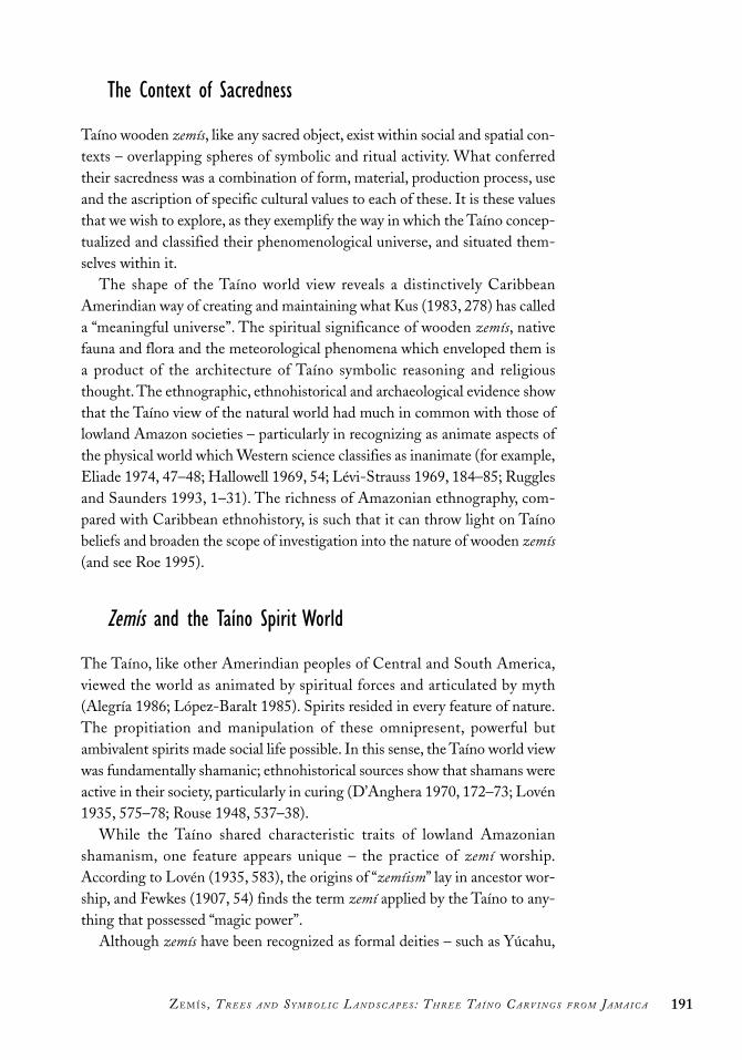
The Context of Sacredness
Taíno wooden zemís, like any sacred object, exist within social and spatial con-texts – overlapping spheres of symbolic and ritual activity. What conferredtheir sacredness was a combination of form, material, production process, useand the ascription of specific cultural values to each of these. It is these valuesthat we wish to explore, as they exemplify the way in which the Taíno concep-tualized and classified their phenomenological universe, and situated them-selves within it.
The shape of the Taíno world view reveals a distinctively CaribbeanAmerindian way of creating and maintaining what Kus (1983, 278) has calleda “meaningful universe”. The spiritual significance of wooden zemís, nativefauna and flora and the meteorological phenomena which enveloped them isa product of the architecture of Taíno symbolic reasoning and religiousthought. The ethnographic, ethnohistorical and archaeological evidence showthat the Taíno view of the natural world had much in common with those oflowland Amazon societies – particularly in recognizing as animate aspects ofthe physical world which Western science classifies as inanimate (for example,Eliade 1974, 47–48; Hallowell 1969, 54; Lévi-Strauss 1969, 184–85; Rugglesand Saunders 1993, 1–31). The richness of Amazonian ethnography, com-pared with Caribbean ethnohistory, is such that it can throw light on Taínobeliefs and broaden the scope of investigation into the nature of wooden zemís(and see Roe 1995).
Zemís and the Taíno Spirit World
The Taíno, like other Amerindian peoples of Central and South America,viewed the world as animated by spiritual forces and articulated by myth(Alegría 1986; López-Baralt 1985). Spirits resided in every feature of nature.The propitiation and manipulation of these omnipresent, powerful butambivalent spirits made social life possible. In this sense, the Taíno world viewwas fundamentally shamanic; ethnohistorical sources show that shamans wereactive in their society, particularly in curing (D’Anghera 1970, 172–73; Lovén1935, 575–78; Rouse 1948, 537–38).
While the Taíno shared characteristic traits of lowland Amazonianshamanism, one feature appears unique – the practice of zemí worship.According to Lovén (1935, 583), the origins of “zemíism” lay in ancestor wor-ship, and Fewkes (1907, 54) finds the term zemí applied by the Taíno to any-thing that possessed “magic power”.
Although zemís have been recognized as formal deities – such as Yúcahu,
191ZE M Í S , T R E E S A N D S Y M B O L I C L A N D S C A P E S : T H R E E TA Í N O C A R V I N G S F R O M J A M A I C A

the supreme god (Arrom 1989, 17–30; Rouse 1992, 13, 118), and Atabey, hismother, goddess of human fertility (Arrom 1989, 31–36; Rouse 1992, 13) –they have also been regarded as spiritual forces residing in trees, rocks, cavesand other features of the landscape. Apart from wooden images, the term zemíhas been applied to artefacts of different forms and sizes made from stone,shell, pottery, cotton and human bones (Fewkes 1907, 53–54; Lovén 1935,585–86, 591, 597 620; Rouse 1992, 13; Vega 1987).
Clearly, zemí is a widely used but analytically imprecise term. This is duepartly to the relative poverty and ambiguity of the ethnohistorical record, andpartly to the favoured ascription of the term to one kind of artefact – the dis-tinctive “three-pointed stone” (for example, Fewkes 1907, 111–33; Lovén1935, 638–43). This imprecision, and the corresponding practice of labellingmany disparate items as zemís, may obscure meaningful Taíno discriminationbetween gods, spirits, ancestors, forces resident within the landscape, and thekinds of material (in this case varieties of wood) from which zemís were made.While zemís could have been perceived as ubiquitous links between the natu-ral and supernatural worlds (Stevens-Arroyo 1988, 59), it is unclear to whatextent any hierarchy of sacredness or spiritual power existed, although somezemís were more esteemed than others (ibid., 62). For the Taíno, zemí wasspirit, not object.
The “social life” of zemís also is problematical. In Amazonia it was shamanswho possessed toolkits of magicalobjects, including wooden images, tocontact the spirit world (for example,Reichel-Dolmatoff 1961, 1975, 46).Among the Taíno, it appears, every per-son possessed at least one zemí, withsome individuals owning possibly asmany as ten (Rouse 1948, 535; 1992,13). It is probable that owning certain
types or categories of zemís was a privilegeof the caciques (Columbus 1969, 192), a view inferred by Rouse (1948, 536),with reference to the chiefs’ depending for their power and status on the supe-riority of their zemís.
Supporting this view is the fact that representations of zemís (as spirits or“gods”) occur as decoration on religious paraphernalia, including the elite duhostools (Figure 14.8) (Rouse 1992, 121). Another possibility is that an oldertradition of lineage-based zemí ancestor images was developing into a situa-tion where caciques were vying for status through the manipulation of theirzemís – a case perhaps of incipient stratification, which may, in turn, have beenleading to the appearance of formal deities.
192 T H E E A R L I E S T I N H A B I TA N T S
Figure 14.8 Carvedwooden duho stool,Dominican Republic.Note high polish,gold inlays on faceand shoulders andengraved decoration.Figure is 22.2 cmhigh, 43.4 cm long.(Reproduced by per-mission of the BritishMuseum.)

Kept in niches or on tables within the dwellings, and sometimes in sepa-rate structures (Lovén 1935, 598), zemís could be inherited, traded, given awayor even stolen (Rouse 1992, 13). The possible pre-eminence of wooden zemísover other kinds is suggested by references to a category of hollow “speakingzemís” which appeared to have had an oracular function. They were regardedby the Spanish as a method of hoodwinking the gullible by ventriloquy, witha shaman speaking through a tube (Bourne 1906, 312; Lovén 1935, 599–600).If wooden zemís were the most spiritually important, it is possible that somestone zemís imitated wooden originals (Lovén 1935, 603; Stevens-Arroyo1988, 58).
As Wilson (1990, 88) notes, zemís were less a symbol of a cacique’s powerthan his supernatural allies, to be venerated, respected and consulted. The roleof the manipulation of wooden image-zemís in articulating shaman linksbetween the physical world and the spirit realm is seen in the important cohobaceremony.
By sniffing the hallucinogenic cohoba powder,2 Taíno caciques and shamans(bohitu) communed with the spirit world (Bourne 1906, 327; D’Anghera1970, 174) – particularly, it appears, with ancestor spirits resident within treesand wooden zemís, an association suggested by the arboreal nature of cohoba.It was snuffed through polished wood or cane tubes (Kerchache 1994, 85)from a round wooden table, an integral part of the class of wooden zemí fig-ure (for example, Joyce 1907, 403; Lovén 1935, 599) to which the bird imagefrom Jamaica belongs.3 Most suggestive in this report is the description by LasCasas (Arrom 1989, 106) of a cacique taking cohoba while sitting on an elabo-rately carved wooden duho stool. It was the cohoba ceremony that Columbusobserved in 1495 (1969, 192):
In these houses are highly carved tables, round in shape like a chopping table,on which lies a special powder, which they place on the heads of their cemiswith certain rites. They then sniff up this powder through a double-branchedcane, which they place in their nostrils. This powder intoxicates them . . .
Trees and the Supernatural
Wooden zemís, cohoba and trees associate the physical and supernatural worldsof the Taíno in ways which are deeply rooted in wider Amerindian as well asspecifically lowland Amazonian traditions of mythic thought (for example,Heyden 1993). For Amazonian societies, trees possess a complex, multilayeredcosmological symbolism that links origin myths (for example, Métraux 1946,369), the bestowal of cultural identity (for example, Descola 1994, 19) andideas of shamanic access to the spirit world (for example, Karsten 1964,
193ZE M Í S , T R E E S A N D S Y M B O L I C L A N D S C A P E S : T H R E E TA Í N O C A R V I N G S F R O M J A M A I C A

198–204; Roe 1982, 118–19; Sullivan 1988, 60–61). The AmazonianBaranana, for example, believe that the paxiuba palm (Iriartea exorrihiza) hasgrown from the ashes of the culture hero’s body and carried his soul heaven-wards as it grew, thus becoming a mediator between earth and sky (Hugh-Jones 1979, 157–58). The Brazilian Kuikuru believe that trees were oncepeople, in mythic time (Carneiro 1978, 214).
Analogous ideas are found among the Taíno of Hispaniola, of whomD’Anghera (1970, 168) records an origin myth in which men who failed toreturn to their caves before sunrise were turned into “myrobolane” trees.4 Thesame author says that some zemís were made of wood “because it is amongstthe trees and in the darkness of the night they have received the message ofthe gods” (1970, 173). For lowland South American Amerindians as for theTaíno, the depths of the forest were sacred zones, spatially distant from the“socialized” fields and village, and home to the largest trees; they were theplaces where spirits revealed themselves to humans.
According to Lovén (1935, 586–87), the Taíno of Hispaniola made woodenzemís only from trees occupied by the spirits of a dead cacique. Once carved,and no longer confined within the tree, the image-zemí was believed to be ableto move about. In nineteenth-century Jamaica, Afro-Caribbean peoplesbelieved that Ceiba trees assembled together at night (Rashford 1985, 51, andsee below). These Caribbean beliefs parallel similar ones from northeasternSouth America concerning trees that move around at night (Roth 1887).
The way in which trees and wooden zemís articulate within the Taínoworld view can be seen in an extraordinary quotation from Dr Chanca,Columbus’s physician during his second voyage (Pané 1974, 41–42).
When a native was passing by a tree which was moved more than others bythe wind, the Indian in fear calls out, “Who are you?” The tree responds, “Callwhere a behique or priest and I will tell you who I am.” When the priest orshaman had come to the tree . . . he performed certain prescribed ceremonies.. . . He would ask the tree, “What are you doing here? What do you wish of me?. . . Tell me if you wish me to cut you down and . . . whether I shall make you ahouse and a farm and perform ceremonies for a year.” The tree answered thesequestions, and the man cut it down and made of it a statue or idol.
Here the tree advertises its presence by being moved by the wind more thanother trees – interestingly, a structural characteristic of the Ceiba (Descola1994, 50). Is there a symbolic association between the animating wind,Amazonian ideas of the shaman’s magical blowing powers (Butt 1956; Hugh-Jones 1979, 90–93) and – more specific to the Caribbean – the dangerous hur-ricanes, which were deified by the Taíno as Guabancex, the “Lady of theWinds” (Arrom 1989, 46, 49–51; Bourne 1906, 333; Stevens-Arroyo 1988,234–38)?
194 T H E E A R L I E S T I N H A B I TA N T S

Another important correspondence between Amazonian and Caribbeanexpressions of arboreal symbolism concerns mortuary associations. TheKuikuru carve the memorial post to a dead chief from the uengifi tree, whichis believed to be occupied by the chief spirit of the forest (Carneiro 1978,214–15). Similarly, among the Irurí during the seventeenth century, the prin-cipal men, their wives and children were buried in great hollow tree trunks(Porro 1994, 88). Among the Warao of coastal Venezuela, trees are conceivedas mythically important anthropomorphic spirits, and canoes made from theirtrunks can be used as coffins (Wilbert 1975, 169; 1977, 33, 36, 37, Figure 8).
There is analogous evidence for the Taíno. Not only were tree trunks rec-ognized as zemís, but also some image-zemís carved from them functioned ascoffins, containing the remains of dead caciques (Arrom 1989, Figure 42;Centro de estudios avanzados de Puerto Rico y el Caribe 1987, 54, illustra-tions; Fewkes 1907, 56–57; Kerchache 1994, 130–39; Lovén 1935, 585). In aprobable burial cave in Jamaica, human bones were associated with a cedar-wood canoe (Flower 1895, 607). To be buried in a wooden zemí was to besymbolically interred within a hollow tree, and thus to be assured of rebirth(Peter G. Roe, personal communication, 1994). When not disposed of in thisway, a Taíno cacique might be buried sitting on his carved wooden duho stool(Fewkes 1907, 70; Scott 1985, 7, illustration), quite literally supported by thespirit of an ancestor who inhabited the wood.
Occasionally it is possible to be specific in terms of a particular tree. As Roe(personal communication, 1994) has shown, the silk cotton tree (Ceiba pen-tandra) is the principal “spirit tree” of the Amazonian Shipibo. The tallest treein the forest canopy, its upper reaches form a ladder to enable the shaman tovisit the celestial sphere, and its deep roots help him visit the underworld.
The Ceiba is also present in the Greater Antilles (Vázquez de Espinosa1942, 330), where, for example, modern rural populations in Puerto Rico stillrevere it (Roe, personal communication, 1994). Given their regard for trees,it is possible that the Taíno also regarded the Ceiba as a spirit tree, perhaps thepre-eminent one – a view expressed by Nicholson (1983, 19). The continuedspiritual importance of the Ceiba in Afro-Caribbean (especially Jamaica) cul-ture as a “god tree” associated with snakes, obeah and ghosts is documented byRashford (1985); it probably descends, at least in part, from the Taíno(Cundall 1894c, 65). The choice of Ceiba wood to carve the Jamaican figureof Baibrama clearly possesses levels of meaning which are difficult to assesssolely by recourse to Caribbean ethnohistory.
The Ceiba has sharp, spiny thorns on its lower trunk (Standley 1920–1926,791), and in lowland Amazonia these are analogous to the shaman’s super-natural yoto missiles, sent to cause illness or death (Roe, personal communica-tion, 1994). Similar beliefs about the nature of illness are evident for the Carib
195ZE M Í S , T R E E S A N D S Y M B O L I C L A N D S C A P E S : T H R E E TA Í N O C A R V I N G S F R O M J A M A I C A

and Taíno (Fewkes 1907, 60–62) and suggest the possibility that for them alsothe Ceiba was a shaman’s spirit tree. More generally for the Taíno, Europeansand Afro-Caribbean peoples, there are many beliefs concerning the spiritualand medicinal qualities of trees, their bark and leaves (for example, Cundall1894c, 55–56; Rashford 1985, 52; Sloane 1725, 134; Vásquez de Espinosa1942, 116, 330). The Ceiba itself is said to have emetic, diuretic and antispas-modic properties (Standley 1920–1926, 791). Fernández de Oviedo (1959,8–9) reports that for the Taíno a decoction of wood from the guayacán tree(Guaiacum officinale) was a much-valued cure for syphilis (see also Crosby1972, 154–55). Lovén (1935, 540) reports that the Taíno made their zemísfrom wood which they believed to possess strong curative properties – anobservation supported by Lehmann’s study of an elaborate duho stool fromHaiti that was carved from guayacán wood (Lehmann 1951, 153n2).
Having established the spiritual importance of trees, it is appropriate toconsider wood as a symbolically important material. Objects made of black,polished wood were regarded by the Taíno as markers of elite status (Helms1986; Wilson 1986, 142–43). Chiefly duhos, canoes (Wilson 1986, 143–44)and ritual paraphernalia, such as cohoba sniffing tubes, were associated withTaíno caciques and shamans (Helms 1986, 27–29). Apart from the spiritualityof trees per se, there was evidently also a cultural value placed on the shinyqualities of certain wooden artefacts, including their shell and metal inlays(see Figure 14.8) (Stevens-Arroyo 1988, 66). The idea that carving and pol-ishing wooden objects enabled ancestral spirits or essences dwelling within tobe revealed or liberated suggests complex and apparently pan-Amerindiannotions of “sacred brilliance” associated with metals (Lechtman 1993, 269;Reichel-Dolmatoff 1988), precious and semi-precious stones (Reichel-Dolmatoff 1981) and mirrors (Saunders 1988).
The symbolism of trees and wooden artefacts featured also in the contactsbetween the Taíno and the Spanish. On first seeing Hispaniola and Jamaica,Columbus was amazed at the remarkable abundance and variety of trees(Columbus 1969, 155; Vásquez de Espinosa 1942, 118). He saw these forestssawn up into planks for caravels or raised as masts for the largest ships inSpain (Gerbi 1986, 18). Conversely, the Taíno saw the Spanish, their unfamil-iar goods and large wooden ships with masts like trees, as turey, things whichcame from the sky, charged with supernatural powers (Chanca 1932, 64; andsee Helms 1988, 187).
When Bartolomé Columbus visited the Taíno chiefdom of Xaraguá onHispaniola, he was met by people whose first act was to offer him branchesand palms (Las Casas 1992). Subsequently, the high-ranking Taíno womanAnacaona presented him with prestige items of black polished wood, includ-ing fourteen beautifully carved duho (D’Anghera 1970, 125). Despite Taíno
196 T H E E A R L I E S T I N H A B I TA N T S

beliefs in the spiritual and life-giving qualities of trees, the Spanish subse-quently hanged Anacaona and burnt Taínos whom they suspended from spe-cially constructed timber gibbets (Las Casas 1992, 16, illustration, 22; Walker1992, 299, illustration).
Conclusion
Wooden zemís, among the most elaborate and distinctive of Taíno artefacts,have received little systematic analytical study (but see Helms 1988). Despitebeing amenable to radiocarbon dating, botanical identification, chemicalanalysis, adhering resin and the potential of analogous explanation, manyremain undated, their material unidentified and their possible semantic “con-nections” with South America unexplored. They have been identified with afew major gods, regardless of wood type, age, stylistic variability and geo-graphical/cultural location, in an approach that denies the informative role ofdiversity in throwing light on wider conceptual issues – on, for example, thesignificance of wood type and of the presence or absence of polishing andform.
Evidence from lowland South America as well as the Caribbean indicatesthat trees and wood possessed a rich symbolism for indigenous peoples. Forthe Taíno, trees contained spirits, and the zemís carved from them bestowedanimated shape and elite status. The complex relationship between the phys-ical and symbolic landscapes of the Taíno represents a unique opportunity toinvestigate a world view that was fundamentally Amerindian and also distinc-tively Caribbean.
197ZE M Í S , T R E E S A N D S Y M B O L I C L A N D S C A P E S : T H R E E TA Í N O C A R V I N G S F R O M J A M A I C A

Acknowledgements
We would like to thank the Jamaica National Heritage Trust; the Department ofHistory, University of the West Indies, Mona, Jamaica; Leonard Clayton (“Chemist”)of Aboukir, St Ann; Tony Aarons; the Museum of Mankind, London; and PatrickLewis of the University of the West Indies Herbarium, Mona, Jamaica. We are par-ticularly grateful to Peter G. Roe for his insightful comments on an earlier version ofthis chapter.
Notes1. There has been some confusion about the number and location of Taíno
wooden objects from Jamaica. To the three pieces from Carpenter’s Mountaincan be added the figure of a bird on the back of a turtle or tortoise, in theBritish Museum ( Joyce 1907, 406, plate L1, figure 2), an anthropomorphicseated figure, currently in the Museum of Primitive Art New York (Arrom1985, figures 43 and 44), and a duho found by C.B. Lewis at the site ofCambridge Hill (Howard 1956, 56). Aarons (1994, 15) reports a wooden“doll” figure, 31 cm high, found in a shallow cave in front of the gate at theNew Seville Great House Estate, which disappeared some fifty years ago.Including the three new discoveries, possibly ten wooden Jamaican Taínoobjects/zemís are known. A small anthropomorphic figure in the BritishMuseum (Register no. Am St 332) may also be from Jamaica. Althoughlabelled by Arrom (1989, figure 48) as coming from Haiti or DominicanRepublic, its British Museum record shows no definite provenance, and it isstylistically similar to the figure from Carpenter’s Mountain.
2. After much confusion concerning botanical identification, it is now recognizedthat cohoba was hallucinogenic snuff made from the ground-up seeds ofAnadenanthera peregrina (Naxon 1993, 178; Wilbert 1987, 17–18), a mimosa-like tree closely related to A. colubrine, the source of the sacred huilca snuff usedin western South America (Gollán and Gordillo 1994; Wessén 1967).
3. The association of avian-image zemís and hallucinogenic cohoba may relate tocomplex Taíno beliefs concerning shamanic flight and spirit trees, for whichthere exist South American parallels. Warao shamans launch supernaturalattacks accompanied by an effigy of their avian master (Wilbert 1985, 154),and the Cubeo possess bird images representing patrons of mourning ritualsand said to be under the effects of the hallucinogen Banisteriopsis coapi(Goldman 1979, 249).
4. This term is sometimes recognized as the Ceiba, and sometimes as a genericterm for several tree varieties which had medicinal qualities.
198 T H E E A R L I E S T I N H A B I TA N T S

Aarons, G.A. 1983a. Archaeological sites in the Hellshire area. Jamaica Journal 16, no. 1:76–87.
———. 1983b. Sevilla la Nueva: Microcosm of Spain in Jamaica, part 1. Jamaica Journal16, no. 4: 37–46.
———. 1984. Sevilla la Nueva: Microcosm of Spain in Jamaica, part 2. Jamaica Journal17, no. 1: 28–37.
———. 1994. Taínos of Jamaica: The Aboukir zemis. Jamaica Journal 25, no. 2: 11–17.Abbott, R.T. 1954. American Seashells. New York: D. Van Nostrand Company Inc.Abrahams, R.D., and J.F. Szwed. 1983. After Africa. New Haven: Yale University Press.Adams, C.D. 1971. The Blue Mahoe and Other Bush: An Introduction to the Plant Life of
Jamaica. Kingston: Sangster’s Book Stores, and Singapore: McGraw-Hill Far EasternPublishers.
———. 1972. Flowering Plants of Jamaica. Kingston: University of the West Indies.Agorsah, E.K. 1992. Jamaica and Caribbean archaeology. Archaeology Jamaica, n.s., 6:
1–14.———. 1993. An objective chronological scheme for Caribbean history and archaeology.
Social and Economic Studies 21: 119–47.———. ed. 1994. Maroon Heritage: Archaeological, Ethnographic and Historical
Perspectives. Kingston: Canoe Press.Alegría, R.E. 1981. El uso de la terminología etno-histórica para designar las culturas aborig-
ines de las Antillas. Cuadernos Prehispánicas. Valladolid: Seminaro de Historia deAmeríca, University de Valladolid.
———. 1986. Apuntes en torno a la mitología de los Indios Taínos de las Antillas Mayores ysus origenes Suramericanos. San Juan: Centro de Estudios Avanzados de Puerto Rico yEl Caribe, Museo del Hombre Dominicano.
Alexander, J. 1969. The indirect evidence of domestication. In The Domestication andExploitation of Plants and Animals, ed. Peter Ucko and G.W. Dimbleby. London:Gerald Duckworth.
Allgood, J.L. 2000. Faunal analysis of the Green Castle Estate assemblage. Unpublishedreport.
Allsworth-Jones, P., G. Lalor, G. Lechler, S.F. Mitchell, E. Rodriques, and M. Vutchkov.2001. The Taino settlement of the Kingston area. Proceedings of the EighteenthInternational Congress for Caribbean Archaeology, Grenada, 1999: 115–27.
Allsworth-Jones, P., and K. Wesler. 1999. Excavations at Green Castle Estate (STM25)St Mary Parish. Unpublished annual report.
———. 2000. Excavations at Green Castle Estate (STM25) St Mary Parish.Unpublished annual report.
199
References

———. 2001. Excavations at Green Castle Estate (STM25) St Mary Parish.Unpublished annual report.
Anonymous. 1803. Appendix, 11 April 1799. Archaeologia 14: 269, pl. 46.———. 1896. Jamaican wooden images in the British Museum. Journal of the Institute of
Jamaica 2, no. 3: 303–4.Arrom, J.J. 1989. Mitologia y artes prehispanicas de las Antillas. México: Siglo Veintiuno.Arrom, J.J., and I. Rouse. 1992. Comments on the three woodcarvings from St Anne’s,
Jamaica. Letter on file at Jamaica National Heritage Trust.Asprey, G.F., and R.G. Robbins. 1953. The vegetation of Jamaica. Ecology Monographs
23, no. 4: 359–412.Atkinson, L. 2002. Jamaican cave art: An overview. Paper presented at the
Archaeological Society of Jamaica symposium Current Research in JamaicanArchaeology, Kingston, April 25.
———. 2003. Jamaican Redware revisited. Paper presented at the Archaeological Societyof Jamaica symposium Zemis, Yabbas and Pewter: The Diversity of JamaicanArchaeology, Kingston, 3 April.
Bennett, J.P. 1989. Arawak/English Dictionary. Georgetown: Walter Roth Museum ofAnthropology.
Blake, E. 1895. The Norbrook kitchen midden. American Antiquarian Society, n.s., no. 9:283.
Bourne, E.G. 1906. Columbus, Ramon Pane and the beginning of American anthropol-ogy. Proceedings of the American Antiquarian Society, n.s., no. 17: 310–48.
Bretting, P. 1983a. Jamaica’s flowering plants: the five endemic genera. Jamaica Journal16, no. 1: 20–23.
———. 1983b. Jamaica’s flowering plants: the five endemic genera. Jamaica Journal 16,no. 2: 49.
Bullen, R.P. 1974. Certain petroglyphs of the Antilles. Proceedings of the FifthInternational Congress for the Study of Pre-Columbian Cultures of the Lesser Antilles,Antigua, 1973: 94–109.
Bullen, R.P., and A.K. Bullen. 1974. Inferences from Cultural Diffusion to Tower Hill,Jamaica, and Cupercoy Bay, St Martin. Proceedings of the Fifth International Congressfor the Study of Pre-Columbian Cultures of the Lesser Antilles, Antigua, 1973: 48–60.
Butt, A.J. 1956. Ritual blowing. Man 56: 49–55.Carey, M.W. 1975. The rock iguana, Cyclura pinguis, on Anegada, British Virgin Islands,
with notes on Cyclura ricordi and Cyclura cornuta on Hispaniola. Bulletin Florida StateMuseum Biological Science 19, no. 4: 191.
Carneiro, R. 1978. The knowledge and use of rain forest trees by the Kuikuru Indians ofcentral Brazil. In The Nature and Status of Ethnobotany, ed. R. Ford. Ann Arbor,Michigan: Museum of Anthropology, University of Michigan.
Carr, A.F. 1952. Handbook of Turtles of the United States, Canada, and Baja California.New York: Cornell University Press.
Centro de Estudios Avanzados de Puerto Rico y El Caribe. 1987. Exposician deEsculturas de los Indios Tainos. San Juan: Centro de Estudios Avanzados de PuertoRico y El Caribe.
Chace, F.A., Jr., and H.H. Hobbs, Jr. 1969. Freshwater and terrestrial decapod crus-taceans of the West Indies with special reference to Dominica. Bredin-Archbold
200 RE F E R E N C E S

Smithsonian Biological Survey of Dominica. Smithsonian Institution Bulletin 292:123–24, 194–202.
Chanca, D.A. 1932. Letter to the city of Sevilla. London: Hakluyt Society.Clarke, C. 1974. Jamaica in Maps. London: Hodder & Stoughton.Claypole, W.A. 1973. The settlement of the Liguanea Plain between 1655 and 1673.
Jamaican Historical Review 10: 7–15.Collins and Longman Atlas for Jamaica and the Western Caribbean. 1978. Hong Kong:
Collins and Longman: 10–15.Columbus, C. 1969. The Four Voyages of Christopher Columbus. London: Penguin
Books.Cotter, C.S. 1970. Sevilla la Nueva: The story of excavation. Jamaica Journal 4, no. 2:
15–22.———. n.d. Field notes of excavations at Sevilla la Nueva 1953–1968.Crosby, A.W. 1972. The Columbian Exchange. Westport: Greenwood Press.Cundall, F.1894a. Pre-Columbian Jamaica. Journal of the Institute of Jamaica 2, no. 1:
62.———. 1894b. The Aborigines of Jamaica. Journal of the Institute of Jamaica 2, no. 1.———. 1894c. The story of the life of Columbus and the discovery of Jamaica. Journal of
the Institute of Jamaica 2, no. 1: 1–79.———. 1895. Discovery of aboriginal Indian remains in Port Royal Mountains. Journal
of the Institute of Jamaica 2, no. 2: 188.———. 1939. A Record of Investigations into the Subject of Arawak Remains in Jamaica.
Kingston: Institute of Jamaica.Cundall, F., and J.L. Pietersz. 1919. Jamaica under the Spaniards. Kingston: Institute of
Jamaica.D’Anghera, P.M. 1970. De Orbe Novo: The Eight Decades of Peter Martyr D’Anghera. New
York: Burt Franklin. (Orig. pub. 1912.)Davis, D.D. 1988. Calibration of the ceramic period chronology for Antigua, West
Indies. Southeastern Archaeology, no. 7: 52–60.Deagan, K. 1978. Material assemblage of sixteenth-century Spanish Florida. Historical
Archaeology 12: 25–50.———. 1983. Spanish St Augustine: The Archaeology of a Colonial Creole Community. New
York: Academic Press.———. 1988. The archaeology of the Spanish contact period in the Caribbean. Journal
of World Prehistory 2, no. 2: 187–233.De Booy, T. 1913. Certain kitchen middens in Jamaica. American Anthropologist 15:
425–34. Reprinted in Contributions from the Heye Museum, no. 3, 1916.De Wolf, M. 1953. Excavations in Jamaica. American Antiquity 18, no. 3: 230–38.Descola, P. 1994. In the Society of Nature. Cambridge: Cambridge University Press.Draper, G., and W.T. Horsfield. 1973. Blue schist metamorphism in Jamaica.
Transactions of Second Congreso Latino-Americano de Geologia, Caracas,Venezuela.
Duerden, J.E. 1895. Discovery of aboriginal remains in Jamaica (letter). Nature 52:173–74.
———. 1897. Aboriginal Indian remains in Jamaica. Journal of the Institute of Jamaica 2,no. 4: 1–51.
201RE F E R E N C E S

Eliade, M. 1974. Shamanism: Archaic Techniques of Ecstasy. Princeton: PrincetonUniversity Press.
Emerson, W.K., and M.K. Jacobson. 1976. American Museum of Natural History: Guide toShells. New York: Alfred Knopf.
Esteva-Fabregat, C. 1995. Mestizaje in Ibero-America. Trans. by John Wheat. Tucson:University of Arizona Press.
Ewan, C.R. 1991. From Spaniards to Creole. Tuscaloosa: University of Alabama Press.Faerron, J. 1985. The Tainos of Hispaniola. Part 1. Archaeology Jamaica 85, nos. 1–2: 1–4.Fernández de Oviedo, G. 1959. Natural History of the West Indies. Trans. and ed. S.A.
Stoudemaire. University of North Carolina Studies in the Romance Languages andLiterature, No. 32. Chapel Hill: University of North Carolina Press.
Fewkes, J.W. 1907. The Aborigines of Puerto Rico and Neighbouring Islands. AmericanBureau of Ethnology Annual Report, no. 25. Washington, DC: American Bureau ofEthnology.
———. 1922. A Prehistoric Island Culture of the Americas. American Bureau of EthnologyAnnual Report, no. 34. Washington, DC: American Bureau of Ethnology,:35–281.
Flower, W.H. 1895. On recently discovered remains of the aboriginal inhabitants ofJamaica. Nature 52: 607–8.
Frink, D.S. 1994. The oxidizable carbon ratio (OCR): A proposed solution to some ofthe problems encountered with radiocarbon data. North American Archaeologist 15,no. 1: 17–29.
Gerbi, A. 1986. Nature in the New World: From Columbus to Oviedo. Pittsburgh:University of Pittsburgh Press.
Goggin, J.M. 1968. Spanish Maiolica in the New World. Yale University Publications inAnthropology, no. 72. New Haven: Yale University Press.
Gollán, J.A.P., and I. Gordillo. 1994. Vilca/Uturuncu: Hacia una arqueología del uso alu-cinógenos en las sociedades prehispánicas de los Andes del Sur. Cuicuilco 1, no. 1:99–140.
Green, G.W. 1977. Structure and stratigraphy of the Wagwater Belt, Kingston, Jamaica.Overseas Geology and Mineral Resources 48: 1–21.
Gupta, A., and R. Ahmad. 2000. Urban steeplands in the tropics: An environment ofaccelerated erosion. Geojournal 84, no. 1.
Hall, E.R. 1981. Mammals of North America. New York: John Wiley & Sons.Hallowell, A.I. 1969. Ojibwa ontology, behavior, and world view. In Primitive Views of
the World, ed. S. Diamond. New York: Columbia University Press.Harris, P. O. 1991. A Paleo-Indian stemmed point from Trinidad, West Indies.
Proceedings of the Fourteenth Congress of the International Association of CaribbeanArchaeologists, ed. A. Cummins and P. King. Bridgetown: Barbados Museum andHistorical Society: 73–93.
Hastorf, C.A., and V.S. Propper, eds. 1988. Current Paleoethnobotany: Analytical Methodsand Cultural Interpretation of Archaeological Plant Remains. Chicago and London:University of Chicago Press.
Helms, M.W. 1986. Art styles and interaction spheres in Central America and theCaribbean: Polished black wood in the Greater Antilles. Journal of Latin AmericanLore 12, no. 1: 25–43.
202 RE F E R E N C E S

———. 1988. Ulysses’ Sail: An Ethnographic Odyssey of Power, Knowledge and GeographicalDistance. Princeton: Princeton University Press.
Hendry, M.D. 1978. Historical evidence of shoreline evolution for the Palisadoes,Kingston, Jamaica. Journal of the Geological Society of Jamaica 17: 39–48.
Hennessy, A. 1993. The nature of the conquest and the conquistadors. In The Meetings ofTwo Worlds: Europe and the Americas 1492–1650, ed. Warwick Bray. Oxford: OxfordUniversity Press: 5–36.
Heyden. D. 1993. El árbol en el mito y el símbolo. Estudios de Cultura Náhuatl 23:201–19.
Highway 2000 Supplement. 2002. Development Bank of Jamaica. Daily Gleaner, 24April.
Hill, V.G. 1978. Distribution and potential: Clays in Jamaica. Jamaica Journal 12: 64–75.Hoese, H.D., and R.H. Moore. 1977. Fishes of the Gulf of Mexico. Texas: Texas A & M
University Press.Howard, R.R. 1950. The archaeology of Jamaica and its position in relation to circum-
Caribbean culture. PhD diss., Yale University.———. 1956. The archaeology of Jamaica: A preliminary survey. American Antiquity 22,
no. 1: 45–59.———. 1965. New perspectives on Jamaican archaeology. American Antiquity 31:
250–55.Hughes, I.G., ed. 1973. The mineral resources of Jamaica. Geology Survey Department,
Mines and Geology Division, Kingston. Bulletin no. 8: 1–79.Hugh-Jones, S. 1979. The Palm and the Pleiades. Cambridge: Cambridge University
Press.Humfrey, M. 1975. Seashells of the West Indies. A Guide to the Marine Molluscs of the
Caribbean. New York: William Collins Sons.Iverson, J.B. 1979. Behavior and ecology of the rock iguana Cyclura carinata. Bulletin of
the Florida State Museum of Biological Sciences 24, no. 3: 175.Jane, C., trans. and ed. 1988. The Four Voyages of Columbus. New York: Dover.Johnson, K.F. 1976. Supplement on Cinnamon Hill: Faunal analysis. Archaeology Jamaica
76, no. 1: 9–18.Johnson, T.H. 1988. Biodiversity and Conservation in the Caribbean: Profiles of Selected
Islands. ICBP Monograph No. 1. Cambridge: International Council for BirdPreservation.
Joyce, T.A. 1907. Prehistoric antiquities from the Antilles in the British Museum. Journalof the Royal Anthropological Institute 37: 402–19.
Karsten, R. 1964. Studies in the religion of the South American Indians east of theAndes. Commentations Humanarum Litterarum 29, no. 1.
Kaye, Q. 1999. Intoxicant use in the prehistoric Caribbean with particular reference tospouted inhaling bowls. Papers from the Institute of Archaeology 10: 55–75.
Keegan, W.F. 1992. The People Who Discovered Columbus: The Prehistory of the Bahamas.Gainesville: University Press of Florida.
———. 2000. West Indian archaeology 3: Ceramic age. Journal of Archaeological Research8: 135–67.
———. 2002. Archaeology at Paradise Park, Westmoreland. Archaeology Jamaica, n.s.,no. 14: 2–6.
203RE F E R E N C E S

———. 2003. Islands of chaos. In The Late Ceramic Age in the Eastern Caribbean, ed. C.Hofman and A. Delpuech. Oxford: BAR International Series.
Kenward, H.K., A.R. Hall, and A.K.G. Jones. 1980. A tested set of techniques for theextraction of plant and animal macrofossils from waterlogged archaeologicaldeposits. Science and Archaeology 42: 3–15.
Kenward, H.K., and F. Large. 1998. Recording the preservational conditions of archaeo-logical insect assemblages. Environmental Archaeology 2. Oxford: Oxbow Books:49–60.
Kerchache, J, ed. 1994. L’art des sculpteurs Tainos chefs d’oeuvre des Grandes AntillesPrécolombiennes. Paris: Paris- Musées.
Khudoley, K.M., and A.A. Meyerhoff. 1971. Palaeogeography and geological history of theGreater Antilles. Geological Society of America Memoir 129.
Kus, S.M. 1983. The social representation of space: Dimensioning the cosmological andthe quotidian. In Archaeological Hammers and Theories, ed. J.A. Moore and A.S.Keene, 278–300. New York: Academic Press.
Lalor, G.C. 1995. A Geochemical Atlas of Jamaica. Kingston: Canoe Press.Las Casas, B. 1992. A Short Account of the Destruction of the Indies. London:
(Harmondsworth) Penguin. (Orig. pub. 1951.) Lechler, G.P. 2000. Chancery Hall, St, Andrew: A recently discovered Taino site on the
outskirts of Kingston. Archaeology Jamaica, n.s., no. 12.Lechtman, H. 1993. Technologies of power: The Andean case. In Configurations of
Power, ed. J.S. Henderson and P.J. Netherly, 244–80. Ithaca: Cornell UniversityPress.
Lee, J.W. 1966. Current activity. Archaeology Jamaica 66, no. 6: 1.———. 1967a. Current activity. Archaeology Jamaica 67, no. 7: 1.———. 1967b. Current activity. Archaeology Jamaica 67, no. 12: 1.———. 1970a. Current activity. Archaeology Jamaica 70, no. 4: 2.———. 1970b. The Coleraine site (Y-19) St Mary. Archaeology Jamaica 70, no. 1: 2.———. 1970c. Iter Boreale (Y-14) St Mary. Archaeology Jamaica 70 no. 3: 1–2.———. 1971. Site survey. Archaeology Jamaica 71, no. 2: 2.———. 1972a. Site survey. Archaeology Jamaica 72, no. 2: 2.———. 1972b. Naggo Head. Archaeology Jamaica 72, no. 4: 1.———. 1974. Petroglyphs and pictographs. Archaeology Jamaica 74, no. 4.———. 1976a. Jamaican Redware. Archaeology Jamaica 76, no. 2: 1–5.———. 1976b. Society activities. Archaeology Jamaica 76, no. 3: 1.———. 1978a. Fish Net Sinkers. Archaeology Jamaica 78, no. 1: 1–5.———. 1978b. Site survey. Archaeology Jamaica 78, no. 2: 5.———. 1978c. The Jamaican Redware culture. Paper presented at Simposio sobre
Problemas de la Arqueologia Antillana, Ponce, Puerto Rico, 1978.———. 1980a. Arawak burens. Archaeology Jamaica 80, no. 2: 1–11.———. 1980b. Jamaican Redware. Proceedings of the Eighth International Congress for the
Study of Pre-Columbian Cultures of the Lesser Antilles, St Kitts, 1979: 597–609.———. 1982. The Mountain River cave (SC-1), St Catherine, Jamaica. Archaeology
Jamaica 82, no. 2: 10–13.———. 1983a. Site survey. Archaeology Jamaica 83, no. 1: 9.
204 RE F E R E N C E S

———. 1983b. Adornos, Jamaica and Caribbean – Figure 2d. Archaeology Jamaica 83,no. 2.
———. 1984. Field trips. Archaeology Jamaica 84, no. 4: 41.———. 1985a. Activities. Archaeology Jamaica 85, nos. 1–2: 5.———. 1985b. Activities. Archaeology Jamaica 85, nos. 3–4: 5.———. 1991. Dr James W. Lee’s articles and papers published in Archaeology Jamaica.
Archaeology Jamaica, n.s., no. 3: 11–12.Lehmann, H. 1951. Un ‘duho’ de la civilisation Taino au Musée de l’homme. Journal de la
société des Américanistes, n.s., 40: 153–61, plates 1–3.Lester, S. 1958. Jamaican treasures in London. The West Indian Review 4, no. 30.Lévi-Strauss, C. 1969. The Savage Mind. London: Weidenfeld & Nicolson.Lewis, P. 1994. Probable tree identities of Taino sculptures. Letter to Dorrick Gray,
Jamaica National Heritage Trust, 22 June 1994. University of the West IndiesHerbarium, Mona, Jamaica.
Long, E. 1774. History of Jamaica. London: T. Lowndes.Longley, G. C. 1914. Kitchen middens of Jamaica. American Museum Journal 14: 296–98.López-Baralt, M. 1985. El Mito Taíno: Raiz y Proyección en la Amazonia Continental, rev.
ed. Río Piedras: Ediciones Huracan.Lovén, S. 1932. Stone Dart Points from the District of Old Harbour, Jamaica. Göteborg:
Erlanders Boktryckerie Aktiebolag, 1932.———. 1935. Origins of the Tainan Culture, West Indies. Göteborg: Erlanders
Boktryckerie Aktiebolag, 1935.MacCormack, R.C. 1898. Indian remains in Vere, Jamaica. Journal of the Institute of
Jamaica 2, no. 5: 744–48.Matley, C.A. 1951. Geology and Physiography of the Kingston District, Jamaica. London:
Crown Agents of the Colonies.McDonald, C. 1993. Report on visit to Chancery Hall. JNHT Files.McEwan, B.G. 1982. Faunal remains from Sevilla Nueva, Jamaica. Unpublished report.
Gainesville, Florida: Florida State Museum.———. 1995. Spanish precedents and domestic life in Puerto Real: The archaeology of
two hispanic homesites. In Puerto Real: The Archaeology of a Sixteenth-Century SpanishTown in Hispaniola, ed. Kathleen Deagan, 195–230. Gainesville: University Press ofFlorida.
McKusick, M. 1959. The distribution of ceramic styles in the Lesser Antilles, WestIndies. PhD diss., Yale University.
McManamon, F. 2000. Archaeological messages and messengers. Public Archaeology 1.no. 1.
———. 1977a. Part 3: Bellevue site, K-13 – analysis of mollusc shells. ArchaeologyJamaica 77, no. 1: 8–9.
———. 1977b. The Bellevue site, K-13 – analysis of mollusc shell. Archaeology Jamaica77, no. 3: 1–9.
———. 1980. The Rodney’s House site: A preliminary report on the April 1979 excava-tion. Archaeology Jamaica 80, no. 4: 1–16.
Medhurst, C.W., and H. Clarke. 1976a. The Bellevue site. Archaeology Jamaica 76, no. 3:3–23.
———. 1976b. The Bellevue site. Archaeology Jamaica 76, no. 4: 12–40.
205RE F E R E N C E S

Métraux, A. 1946. Indians of the Gran Chaco. In The Handbook of South AmericanIndians: The Marginal Tribes, ed. J.H. Steward. Washington, DC: SmithsonianInstitution.
Ministry of Agriculture. 1987. Jamaica: Country Environmental Profile. Government ofJamaica. Natural Resources Conservation Division and Ralph M. Field, Assoc., Inc.
Morbán Laucer, F. 1982. Interpretation of Jamaican pictographs. Archaeology Jamaica 82,no. 2: 13.
Morison, S.E. 1974. The European Discovery of America: The Southern Voyages 1492–1616.New York: Oxford University Press.
Moure, R.D., and M. Rivero de la Calle. 1996. Art and Archaeology of Pre-ColumbianCuba. Pittsburgh: University of Pittsburgh Press.
National Gallery of Jamaica. 1994. Arawak Vibrations: Homage to the Jamaican Taino.Kingston: National Gallery of Jamaica and the Jamaica National Heritage Trust.
Natural Resources Conservation Authority/National Environmental Planning Agency.2001. Towards a National Strategy and Action Plan on Biological Diversity in Jamaica.Green paper no. 3/01. Jamaica: Ministry of the Land and Environment.
Naxon, R.M. 1993. The Nature of Shamanism: Substance and Function of a ReligiousMetaphor. Albany: State University of New York Press.
Nicholson, D.V. 1983. The Story of the Arawaks in Antigua and Barbuda. Antigua:Antigua Archaeology Society and Linden Press.
Old Harbour Bypass, North Coast Highway Project and Highway 2000 Projects.www.mtw.gov.jm/projects.
Oliver, J.R. 1989. The archaeological, linguistic, and ethnohistorical evidence for theexpansion of Arawak into northwestern Venezuela and northeastern Colombia. PhDdiss., University of Illinois, Urbana.
Oliver, W. 1983. Looking for conies. Jamaica Journal 16, no. 2.Osborne, S.J., and J.W. Lee. 1976. Preliminary report on the Cinnamon Hill site ( J-10).
Archaeology Jamaica 76, no. 1: 1–7.———. 1977. Skeletal material from Cinnamon Hill site ( J-10). Archaeology Jamaica 77,
no. 2: 1–2.Osgood, C. 1942. The Ciboney culture of Cayo Redondo, Cuba. Yale University
Publications in Anthropology. New Haven: Yale University Press.Padron, F.M. 1952. Jamaica Española. Seville: Consejo Superior de Investigaciones
Cientificas.Pané, R. 1974. Relacíon Acerca de las Antigüedades de los Indios, 41–42. Mexico City: Siglo
Vientiuno. Quoted in Stevens-Arroyo 1988, 59.Parry, J.H., and P.M Sherlock. 1971. Short History of the West Indies. New York: St
Martin’s Press.Paynter, R. 2000. Historical archaeology and the post-Columbian world of North
America. Journal of Archaeological Research 8, no. 3: 169–217.Pérez-Mallaína, P. 1998. Spain’s Men of the Sea: Daily Life on the Indies Fleets in the
Sixteenth Century, trans. Carla Rahn Phillips. Baltimore: Johns Hopkins UniversityPress.
Perrins, W.A.T. 1981. The White Marl Arawak village site. Archaeology Jamaica 81, no.2: 1–4.
Pollard, V. 1983. Frederic G. Cassidy dictionary-marker. Jamaica Journal 16, no. 2: 11–17.
206 RE F E R E N C E S

Porro, A. 1994. Social organization and political power in the Amazonian Floodplain:The ethnohistorical sources. In Amazonian Indians from Prehistory to Present, ed.A.C. Roosevelt, 79–94. Tucson: University of Arizona Press.
Porter, A.R.D. 1990. Jamaica: A Geological Portrait. Kingston: Institute of JamaicaPublications.
Prior, J., and J. Tuohy. 1987. Fuel for Africa’s fires. New Scientist 115: 48–51.Proctor, G., and A. Oberli. 2002. The vascular flora of Long Mountain. Paper presented
at the Long Mountain Symposium, University of the West Indies, January.Raffaele, H., J. Wiley, O. Garrido, A. Keith, and J. Raffaele. 1998. A Guide to the Birds of
the West Indies. Princeton: Princeton University Press.Rainey, F.G. 1940. Porto Rican archaeology: Scientific survey of Porto Rico and the
Virgin Islands. New York Academy of Sciences 18, no. 1.———. 1941. Excavations in the Ft. Liberté Region, Haiti. Yale University Publications
in Anthropology. New Haven: Yale University Press.Randall, R.E. 1968. Caribbean Reef Fishes. Hong Kong: T.F.H. Publications.Rashford, J. 1985. The cotton tree and the spiritual realm in Jamaica. Jamaica Journal 18,
no. 1: 49–57.———. 1991. Arawak, Spanish and African contributions to Jamaica’s settlement vege-
tation. Jamaica Journal 24, no. 3: 17–23.———. 1998. Human influence on the vegetation of Jamaica. In A Reader in Caribbean
Geography, ed. David Barker, Carol Newby and Mike Morrissey, 37–43. Kingston:Ian Randle, 1998.
Reichard, A. 1904. Archaeological discoveries in Jamaica. Globus 86.Reichel-Dolmatoff, G. 1961. Anthropomorphic figurines from Colombia, their magic
and art. In Essays in Pre-Columbian Art and Archaeology, ed. S.K. Lothrop et al.,229–41. Cambridge: Harvard University Press.
———. 1975. The Shaman and the Jaguar: A Study of Narcotic Drugs among the Indians ofColombia. Philadelphia: Temple University Press.
———. 1981. Things of beauty replete with meaning: Metals and crystal in ColombianIndian cosmology. In Sweat of the Sun, Tears of the Moon: Gold and Emerald Treasuresin Colombia, 17–33. Los Angeles: Terra Magazine Publications/Natural HistoryMuseum Alliance of Los Angeles County.
———. 1988. Orfebrería y Chamanismo: Un Estudio Iconográfico del Museo del Oro.Medellín: Compañía Litográfico Nacional.
Renfrew, C., and P. Bahn. 2000. Archaeology: Theories, Methods, and Practice. New York:Thames & Hudson.
Roe, P.G. 1982. The Cosmic Zygote: Cosmology in the Amazon Basin. New Brunswick, NJ:Rutgers University Press.
———. 1995. Myth–material cultural semiotics: prehistoric and ethnographic Guiana-Antilles. Paper presented at the ninety-fourth annual meeting of theAmerican Anthropological Association, Washington, DC.
Roobol, M.J., and J.W. Lee. 1976. Petrography and source of some Arawak rock artefactsfrom Jamaica. Proceedings of the Sixth International Congress for the Study ofPre-Columbian Culture of the Lesser Antilles, Guadeloupe, 1975: 304–13.
Roobol, M.J., H. Petitjean Roget, and A.L. Smith. 1976. Mt. Pelée and the island popu-
207RE F E R E N C E S

lation of Martinique. Proceedings of the Sixth International Congress for the Study ofPre-Columbian Culture of the Lesser Antilles, Guadeloupe, 1975: 46–53.
Roth, H.L. 1887. The aborigines of Hispaniola. Journal of the Royal AnthropologicalInstitute of Great Britain and Ireland 16: 247–86.
Rouse, I. 1939. Prehistory in Haiti: A Study in Method. Yale University Publications inAnthropology no. 21. New Haven: Yale University Press.
———. 1941. Culture of the Ft. Liberté Region, Haiti. Yale University Publications inAnthropology no. 24. New Haven: Yale University Press.
———. 1942. Archaeology of the Mariabon Hills, Cuba. Yale University Publications inAnthropology no. 26. New Haven: Yale University Press.
———. 1948. The Arawak. In Handbook of South American Indians, ed. J. H. Steward,507–46. Vol. 4, Bulletin of the Bureau of American Ethnology, no. 142. Washington,DC.
———. 1951. Areas and periods of culture in the Greater Antilles. Southwestern Journalof Anthropology 7, no. 3: 248–65.
———. 1952. Porto Rican Prehistory. Introduction: Excavations in the West and North.Scientific Survey of Porto Rico and the Virgin Islands, no. 18. New York: New YorkAcademy of Sciences: 307–460.
———. 1964. Prehistory of the West Indies. Science 144, no. 3618: 499–513.———. 1972. Introduction to Prehistory: A Systematic Approach. New York: McGraw-Hill.———. 1986. Migrations in Prehistory: Inferring Population Movements from Cultural
Remains. New Haven: Yale University Press.———. 1987. Whom did Columbus discover in the West Indies? In On the Trail of
Columbus, ed. C.A. Hoffman. American Archaeologist (Ridgefield) 6, no. 2: 83–87.———. 1992. The Tainos: Rise and Decline of the People Who Greeted Columbus. New
Haven: Yale University Press.———. 1996. History of archaeology in the Caribbean area. In The History of
Archaeology: An Encyclopaedia, ed. T. Murray. New York: Garland Publishing.Rouse, I., and L. Allaire. 1978. Caribbean. In Chronologies in New World Archaeology, ed.
R. E. Taylor and C. Meighan, 431–81. New York: Academic Press.Ruggles, C.L.N., and N.J. Saunders. 1993. The study of cultural astronomy. In
Astronomies and Cultures, ed. C.L.N. Ruggles and N.J. Saunders, 1–31. Niwot:University Press of Colorado.
Sakai, S. 1996. Notes on the contemporary classification of Dermaptera and recent refer-ences on Dermaptera II. In Taxonomy of the Dermaptera Proceedings of the TwentiethInternational Congress of Entomology, ed. S. Sakai, 1–10. Tokyo: Seiroku Sakai.
Santos, A.L. 2001. Green Castle burials: Anthropological report. Unpublished report.Sauer, C.O. 1966. The Early Spanish Main. Berkeley: University of California Press.Saunders, N.J. 1988. Chatoyer: Anthropological reflections or archaeological mirrors. In
Recent Studies in Pre-Columbian Archaeology 1, ed. N.J. Saunders and O. de Monte-mollin, 1–40. Oxford: British Archaeological Reports International Series 421.
Saunders, N.J., and D. Gray. 1996. Zemis, trees, and symbolic landscapes: Three Tainocarvings from Jamaica. Antiquity 70: 270.
Scarre, C. ed. 1999. The Times Archaeology of the World. London: Times Books.Scott, J.F. 1985. The Art of the Taino from the Dominican Republic. Gainesville: University
Gallery, College of Fine Arts, University of Florida.
208 RE F E R E N C E S

Scudder, S. 1992. Early Arawak subsistence strategies: The Rodney site of Jamaica.Archaeology Jamaica, n.s., no. 6: 28–43.
Seifriz, W. 1943. Plant life of Cuba. Ecology Monographs 13: 375–426.Seigel, P.E. 1996. An interview with Irving Rouse. Current Anthropology 37: 671–89.Senior, O. 1985. A–Z on Jamaican Heritage. Kingston: Heinemann.Sherlock, P.M. 1939. The Aborigines of Jamaica. Kingston: Institute of Jamaica.Silverberg, J., R.L. Vanderwal and E.S. Wing. 1972. The White Marl Site in Jamaica.
Report of the 1964 Robert R. Howard Excavations. Milwaukee: Department ofAnthropology, University of Wisconsin.
Sloane, H. 1707. A Voyage to the Islands Madera, Barbados, Nieves, S. Christophers, andJamaica. 2 vols. London: B.M. for the author.
Standley, P.C. 1920–26. Trees and Shrubs of Mexico. Washington, DC: Smithsonian Press.Stevens-Arroyo, A.M. 1988. Cave of the Jagua: The Mythological World of the Tainos.
Albuquerque: University of New Mexico Press.Sullivan, L.E. 1988. Icanchu’s Drum. London: Macmillan.Thomas, D.H. 1979. Archaeology. New York: Holt, Rinehart & Winston.Tyndale-Biscoe, J.S. 1962. The Jamaica Arawak. Jamaican Historical Review 3, no. 3: 1–9.Ucko, P., and G.W. Dimbleby. 1969. The Domestication and Exploitation of Plants and
Animals. London: Gerald Duckworth.Vanderwal, R.L.1968a. The prehistory of Jamaica: A ceramic study. MA thesis,
University of Wisconsin–Milwaukee.———. 1968b. Problems of Jamaican pre-history. Jamaica Journal 2, no. 3.Vega, B. 1987. Descubrimiento de la actual localización único zemí del algodón antillano
aún existente. In Santos, Shamans, y Zemies, 1–16. Santo Domingo: FundaciónCultural Dominicana.
Veloz Maggiolo, M. 1997. The daily life of the Taíno people. In Taíno: Pre-ColumbianArt and Culture from the Caribbean, ed. F. Bercht, E. Brodsky, J.A. Farmer and D.Taylor, 34–45. New York: Monacelli Press.
Veloz Maggiolo, M., and E.J. Ortega. 1996. Punta Cana y el origin de la agricultura en laisla de Santo Domingo. In Ponencias del Primer Semimario de Arqueologia del Caribe,ed. Marcio Veloz Maggiolo and Angel Caba Fuentes. República Dominicana: MuseoArqueológico Regional Altos de Chavón.
Walker, D.J.R. 1992. Columbus and the Golden World of the Island Arawaks: The Story of theFirst Americans and their Caribbean Environment. Kingston: Ian Randle.
Walker, E.D. 1975. Mammals of the World, 3rd ed. Baltimore: Johns Hopkins UniversityPress.
Wallace, V. 1992. The socio-cultural life of Arawak Indians of Jamaica: An archaeologi-cal evaluation. Archaeology Jamaica, n.s., no. 6: 73–96.
Warmke, G.L., and R.T. Abbott. 1961. Caribbean Seashells. Pennsylvania: LivingstonPublishing.
Watson, K. 1988. Amerindian cave art: Mountain River Cave, St Catherine. JamaicaJournal 21, no. 1: 13–20.
Watters, D.R. 1997. Maritime trade in the prehistoric Eastern Caribbean. In TheIndigenous People of the Caribbean, ed. S.M. Wilson, 88–99. Gainesville: UniversityPress of Florida.
Watters, D.R., and I. Rouse. 1989. Environmental diversity and maritime adaptations in
209RE F E R E N C E S

the Caribbean area. In Early Ceramic Population Lifeways and Adaptive Strategies inthe Caribbean, ed. P.E. Siegel, 129–44. Oxford: BAR International Series 506.
Weintraub, B. 1993. Geographica. National Geographic Magazine (September).Wesler, K.W. 2001. Excavations at Wickliffe Mounds. Tuscaloosa: University of Alabama
Press.Weyl, R. 1966. Geologie der Antillen. Gebruder Borntraeger. Berlin-Nicolasse.Wheeler, A., and A.K.G. Jones. 1989. Fishes. Cambridge Manuals in Archaeology.
Cambridge: Cambridge University Press.Wilbert, J. 1975. Eschatology in a participatory universe. In Death and the Afterlife in
Columbian America, ed. E.P. Benson, 163–90. Washington, DC: Dumbarton Oaks.———. 1977. Navigators of the winter sun. In The Sea in the Pre-Columbian World,
16–46. Washington, DC: Dumbarton Oaks.———. 1985. The house of the swallow-tailed kite. Warao myth: The art of thinking in
images. In Animated Myths and Metaphors in South America, ed. G. Urton, 145–82.Salt Lake City: University of Utah Press.
———. 1987. Tobacco and Shamanism in South America. New Haven: Yale University Press.Williams, A.B. 1984. Shrimps, Lobsters, and Crabs of the Atlantic Coast of the Eastern
United States, Maine to Florida. Washington, DC: Smithsonian Press.Willis, R. 1976. The archaeology of sixteenth-century Nueva Cadiz. MA thesis,
University of Florida.Wilman, J.C. 1978. Rodney’s House (S-5) St Catherine. Archaeology Jamaica 78, no. 3:
1–10.———. 1979. Rodney’s House: A postscript. Archaeology Jamaica 79, no. 4: 2–3.———. 1983. Arawak site: Upton (A-43). Archaeology Jamaica 83, no. 3.———. 1984. Arawak site: Upton (A-43) Part II. Archaeology Jamaica 84, no. 2: 2–3.———. 1992. An archaeological investigation of the Upton site (A-43) St Ann, Jamaica.
Archaeology Jamaica, n.s., no. 6: 17–27.Wilson, S.M. 1986. The conquest of the Caribbean chiefdoms: Socio-political change on
prehispanic Hispaniola. PhD diss., University of Chicago. Ann Arbor: UniversityMicrofilms, 1986.
———. 1990. Hispaniola: Caribbean Chiefdoms in the Age of Columbus. Tuscaloosa:University of Alabama Press.
———, ed. 1997a. The Indigenous People of the Caribbean. Gainesville: University Press ofFlorida.
———. 1997b. The Caribbean before European conquest: A chronology. In Taíno:Pre-Columbian Art and Culture from the Caribbean, ed. F. Bercht, E. Brodsky, J.A.Farmer and D. Taylor, 15–17. New York: Monacelli Press.
Wing, E.S. 1972. The White Marl Site in Jamaica. Report of the 1964 Robert R.Howard Excavation, 18–35. University of Wisconsin–Milwaukee: Department ofAnthropology.
———. 1977. Use of animals by the people inhabiting the Bellevue site. ArchaeologyJamaica 77, no. 1: 2–7.
———. 1991. Animal exploitation in prehistoric Barbados. In Proceedings of theFourteenth Congress of the International Association for Caribbean Archaeology, Barbados,1989: 360–67.
———. 1994. Manatee in Arawak diet. Archaeology Jamaica, n.s., 8: 4.
210 RE F E R E N C E S

Wing, E.S., and A.B. Brown. 1979. Paleonutrition. New York: Academic Press.Wing, E.S., and C.W. Medhurst. 1977. The Bellevue site (K-13). Archaeology Jamaica 77,
no. 1: 2–9.Wood, P.A. 1976. The evolution of drainage in the Kingston area. Journal of the Geological
Society of Jamaica 15: 1–6.Woodward, R. 1988. The Charles Cotter collection: A study of the ceramic and faunal
remains from Sevilla la Nueva. MA thesis, Texas A & M University.Wright, I. 1921. The early history of Jamaica 1511–1536. English Historical Review 36:
70–95.Yeager, T.J. 1989. Encomienda or slavery? The Spanish Crown’s choice of labour organi-
zation in sixteenth-century Spanish America. Journal of Economic History 50: 842–59.
Supplemental Biliography
Aarons, G.A. 1988. The Mountain River cave. Jamaica Journal 21, no. 3: 21.Alegría, R.E. 1985. Christopher Columbus and the treasure of the Taino Indians of
Hispaniola. Jamaica Journal 18, no. 1: 2–11.Armstrong, D. 1990. The Old Village and the Great House. Chicago: University of Illinois
Press and University of Chicago Press.Atkinson, L. 1998. The Tainos: The aborigines of Jamaica – A research text.
Unpublished manuscript.———. 2003. The distribution of the Taino cave art sites in Jamaica. Proceedings of the
Nineteenth International Congress for Caribbean Archaeology, Aruba, 2001: 300–312.Auld, M. 2000. Tainos of Jamaica: The myth of extinction. United Confederation of Taino
People Newsletter, 4 April. www.indigenouspeople.org/natlit/uctp/UCTP_Newsletter_ April_04.html
Bercht, F., E. Brodsky, J. A. Farmer and D. Taylor, eds. 1997. Taíno: Pre-Columbian Artand Culture from the Caribbean. New York: The Monacelli Press, 1997.
Black, C.V. 1957. Historical notes on the food plants of Jamaica. The Farmers’ FoodManual: A Recipe Book for the West Indies. Kingston: Jamaica Agricultural Society andGlasgow: Robert Maclehoses: 335–40.
Braunholtz, H.J. 1970. Sir Hans Sloane and Ethnography. London: Shenval Press.Browne, P. 1756. The Civil and Natural History of Jamaica. London: Institute of
Jamaica.Campbell, S. 1974. Bush teas a cure all: Corollary to folklore and food habits. Jamaica
Journal 8, no. 2 and 3: 60–65.Carnegie, J. 1979. The Institute of Jamaica: A century of culture. Americas 31: 11–12.Cotter, C.S. 1954. A comment on the Windsor site, Jamaica. American Antiquity
20: 2.Cundall, F. 1934. The Aborigines of Jamaica. Kingston: Institute of Jamaica.Dadea, R. 1981. Porcacchi Map text translation. Archaeology Jamaica 81, no. 4.Dams, L. 1980. Prehistoric Art. Vol. 4, Lexicon Universal Encyclopaedia. New York:
Lexicon Publications, 1980.Dehring, P., and J.K. Southerland. The Bellevue Estate archaeological field season
May–June 1991. Archaeology Jamaica, n.s., 4: 27–30.
211RE F E R E N C E S

Downer, A., and R. Sutton. 1990. Birds of Jamaica: A Photographic Field Guide.Cambridge: Cambridge University Press.
Ebanks, R. 1997. Heritage Resource Survey of the North Coast Highway DevelopmentProject: Segment One – Negril to Montego Bay. JNHT files.
Edwards, A. 2001. The road to nowhere. Daily Gleaner, 28 February.Environmental Solutions Limited. 1997. Environmental impact assessment: Beaches
Whitehouse Resort, Westmoreland – Final report. Prepared for Mortimer andAssociates.
Eyre, A. 1996. The tropical rainforests of Jamaica. Jamaica Journal 26, no. 1: 26–37.Faerron, J. 1985. The Tainos of Hispaniola (Part 2). Archaeology Jamaica 85, nos. 3–4:
1–6.Farr, T.H. 1984. Land animals of Jamaica: Origins and endemism. Jamaica Journal 17,
no. 1: 38–48.Fincham, A.G. 1997. Jamaica Underground: The Caves, Sinkholes, and Underground Rivers
of the Island, 2nd ed. Kingston: The Press, University of the West Indies.Fincham, A.G., and A.M. Fincham. 1998. The Potoo Hole pictographs: A preliminary
report on a new Amerindian cave site in Clarendon, Jamaica. Jamaica Journal 26, no.3: 2–6.
Gleaner Company. 1985. The Gleaner Geography and History of Jamaica, 22nd ed.Kingston: Gleaner Company.
Government of Jamaica. 1998. Cultural Heritage. Technical Report 7, Multisectoralpreinvestment programme: South Coast sustainable development study. Sir WilliamHalcrow and Partners.
Handler, J. 1977. The “Bird Man”: A Jamaican Arawak wooden “idol”. Jamaica Journal11, nos. 3–4: 25.
Ingram, K. 1975. Manuscripts Relating to Commonwealth Caribbean Countries in UnitedStates and Canadian Repositories. Belgium: Caribbean Universities Press/BowkerPublishing.
Joyce, T.A. 1916. Central American and West Indian Archaeology. London: Philip LeeWarner.
Krieger, H.W. 1931. Aboriginal Indian pottery of the Dominican Republic. US NationalMuseum Bulletin 156.
Lee, J.W. 1981. Field trip to St Elizabeth petroglyphs. Archaeology Jamaica 81, no. 1.Lewis, C.B. 1967. History and the Institute. Jamaica Journal 1, no. 1: 4.Mattson, P.H., and L. Glover. 1960. Stratigraphic distribution of detrital quartz in the
pre-Oligocene rocks of south-central Puerto Rico. United States Geological SurveyProfessional Paper 400, B: 367–68.
Nicholas, G. 1980. Caves. Lexicon Universal Encyclopaedia. New York: LexiconPublications.
Rashford, J. 1982. Roots and fruits: Social class and intercropping in Jamaica. PhD diss.,City University of New York.
Reichel-Dolmatoff, G. 1971. Amazonian Cosmos: The Sexual and Religious Symbolism ofthe Tukano Indians. Chicago: University of Chicago Press.
Rosenberg, M. 2000. History in a rich soil. http://abcnews.go.com/sections/travel/DailyNews/jamaica000706.htm l
212 RE F E R E N C E S

Rouse, I. 1982. Ceramic and religious development in the Greater Antilles. Journal ofNew World Archaeology 5, no. 2: 45–55.
Sangster, A.W. 2001. Highway 2000. Daily Gleaner, 29 January.Seifriz, W. 1972. The White Marl Site in Jamaica. Report of the 1964 Robert R. Howard
Excavation. Milwaukee: Department of Anthropology, University of Wisconsin.Smith, G.C. 1995. Indians and Africans at Puerto Real. In Puerto Real: The Archaeology of
a Sixteenth-Century Spanish Town in Hispaniola, ed. Kathleen Deagan, 335–74.Gainesville: University Press of Florida.
Stokes, B. 2002. Settlement patterns and the placement of Jamaican Taino chiefdoms ina Greater Antilles context: Theory and practical method. Paper presented at theArchaeological Society of Jamaica symposium Current Research in JamaicanArchaeology, Kingston, Jamaica, 25 April.
Thompson, D.A., P.K. Bretting and M. Humphreys, eds. 1986. Forests of Jamaica.Kingston: Jamaican Society of Scientists and Technologists.
Tyndale-Biscoe, J.S. 1954. Arawak specimens from some middens of Jamaica. Bulletin ofthe Jamaica Historical Society 5, no. 10.
Vanderwal, R.L. 1967. Summer Excavation Programme. Archaeology Jamaica 67, no. 8:2–3.
Ven der Veen, M., and N.R.J. Fieller. 1982. Sampling seeds. Journal of ArchaeologicalScience 9, no. 3: 287–98.
Walters, S. 1994. Site visitation report: Chancery Hall (Phase II) St Andrew. JNHT files.———. 1996. Chancery Hall Phase II report. JNHT files.———. 1998. Beaches Whitehouse Resort report. JNHT files.Wassén, S.H. 1967. Anthropological survey of the use of South American snuffs. In
Ethnopharmacologic Search for Psychoactive Drugs, 233–89. Washington, DC: USGovernment Printing Office. Public Health Service Publication 1645.
Wilman, J.C. 1981. Additional comments by J.C. Wilman. Archaeology Jamaica 81, no. 1:1–2.
Woodley, J.D. 1968. A history of the Jamaican fauna. Jamaica Journal 2, no. 3: 14–20.Wright, R.M., and W.R. Dickinson. 1972. Provenance of Eocene volcanic sandstones in
east Jamaica: A preliminary note. Caribbean Journal of Science 12: 107–13.
213RE F E R E N C E S

Lesley-Gail Atkinson is Archaeologist, Archaeology Division, Jamaica NationalHeritage Trust, Jamaica.
Philip Allsworth-Jones is Senior Lecturer, Department of History andArchaeology, University of the West Indies, Mona, Jamaica.
Anthony Gouldwell is a technician with the Environmental Laboratories,School of Archaeology and Ancient History University of Leicester, UnitedKingdom.
Dorrick Gray is Deputy Technical Director of Archaeology, ArchaeologyDivision, Jamaica National Heritage Trust, Jamaica.
William F. Keegan is Associate Curator of Anthropology and AssociateProfessor of Anthropology, Florida Museum of Natural History, Department ofAnthropology, University of Florida, United States.
Gerald C. Lalor is Director General, International Centre for Environmentaland Nuclear Sciences, University of the West Indies, Mona, Jamaica.
George Lechler is Technical Director, Explosive Sales and Services, Jamaica.
James W. Lee is a geologist and the founder and former president of theArchaeological Society of Jamaica, now based in Vancouver, British Columbia,Canada.
Wendy A. Lee is an environmental educator with the St Ann EnvironmentProtection Agency, Jamaica.
Simon F. Mitchell is Lecturer, Department of Geography and Geology,University of the West Indies, Mona, Jamaica.
Andrea Richards is Assistant Archaeologist, Archaeology Division of theJamaica National Heritage Trust, Jamaica.
Norma Rodney-Harrack is a potter and Lecturer, Edna Manley College of theVisual and Performing Arts, Jamaica.
Esther Z. Rodrigues is Inventory and Database Officer, Jamaica BauxiteInstitute, Jamaica.
214
Contributors

M. John Roobol, is a consultant geologist, New Saudi Geological Survey,Jeddah, Saudi Arabia.
Nicholas J. Saunders is Lecturer, Institute of Archaeology, University College ofLondon, United Kingdom.
Sylvia Scudder is Senior Biologist and Collections Manager, University ofFlorida Museum of Natural History Department of Anthropology, Universityof Florida, United States.
Mitko Vutchkov is Senior Research Fellow, International Centre on NuclearSciences, University of the West Indies, Jamaica.
Selvenious Walters is Senior Archaeologist, Archaeology Division, JamaicaNational Heritage Trust, Jamaica.
Jane Webster is Lecturer, School of Archaeology and Ancient History,University of Leicester, United Kingdom.
Kit Wesler is Professor, Murray State University, Kentucky, United States.
Robyn Woodward is a PhD candidate, Simon Fraser University, Burnaby,British Columbia, Canada.
Robert Young is Senior Lecturer, School of Archaeology and Ancient History,University of Leicester, United Kingdom.
215CO N T R I B U T O R S