4.4 community facilities - department of primary...
TRANSCRIPT

35Section 4 - Elements
4.4 COMMUNITY FACILITIESThree community hubs are proposed: a northern, central and southern hub. The components of each of the hubs are as follows:
Northern Community Hub
• Primary school.
• Village green.
• Properties 47,48 and that part of Property 46 within the C219 Amendment area will be subject to a financial contribution for community and development infrastructure to be secured by a Section 173 Agreement or alternative appropriate mechanism.
Central Community Hub
• Town square.
• Secondary school.
• Integrated Community Centre comprising Business Accelerator, Double Kindergarten, Maternal and Child Health, playground, large community rooms, NGO consulting room and space for community development worker.
• Child care centre.
• Health precinct providing day surgery and other procedures, general practice and community health services as provided by the Department of Human Services.
• District open space providing for a two-oval football/cricket facility and two-court netball facility, co located with a joint use pavilion.
• Basketball stadium (within the Secondary School campus).
• Outdoor fitness station.
• Skate park and basketball court.
• A Nursing Home facility with a site area of 1.5 ha.
• A site for a CFA fire station (~2,000m2).
Southern Community Hub
• Primary school.
• Community meeting space.
• Village green.
• District open space providing for: • A two-oval cricket facility and three-field soccer facility, co-located
with a joint use pavilion. • A two-green lawn bowls facility and six-court tennis facility, co-
located with a joint use pavilion.

36 Section 4 - Elements
Figure 1: Concept plan for Large Neighbourhood Activity Centre
27Section 4 - Elements
Figure 4: Concept plan for Large Neighbourhood Activity Centre
plan 10activity centres
cranbourne west precinct structure plan
PROPOSED
DELETION

37Section 4 - Elements
Precinct Structure Plan Area
Large Neighbourhood Activity Centre
Government School
Business Activity Centre
Active Public Open Space with Pavilions
Parks with Special Infrastructure
Neighbourhood Activity Centre comprising community hubs
Integrated Community Centre &business acceleratorIntegrated Famiy and Community Centre
THOMPSONS ROAD
HALL ROAD
BALLARTO ROAD
EVAN
S
R
OADPR
OPO
SED
W
ESTE
RN
PO
RT
FR
EEW
AY
CR
ANBO
UR
NE
- FR
ANKS
TON
RO
AD
CENTRAL PARKWAY
0 100 200 500 1000
plan 10activity centres (updated plan - Amendment C219)
Proposed Plan

38 Section 4 - Elements
4.4.1 COMMUNITY INFRASTRUCTURE OBJECTIVES
• To foster a strong sense of community.
• To ensure the timely provision of community infrastructure based upon population thresholds.
• To secure the early provision of an indoor community meeting space in the northern and southern residential neighbourhoods.
4.4.2 IMPLEMENTATIONThe community infrastructure objectives are met by the implementation of the network and hierarchy of community hubs as a focus of community services and facilities as shown in Plan 11.
4.4.3 PLANNING AND DESIGN GUIDELINESThe following planning and design guidelines must be met:
• Preparation of a permit application for each site must set aside land as required for community infrastructure.
The following planning and design guidelines should be met:
• Community infrastructure should be integrated with council facilities and open spaces. Opportunities should be provided to co-locate the community centre with a proposed children’s playground, outdoor fitness station and kindergarten.
• A site within the northern and southern residential neighbourhoods should be considered for early service delivery and community engagement and development services on an interim basis. This may occupy a retail tenancy within the activity centres or a display home / office within the first residential estate developed.
4.5 OPEN SPACE AND NATURAL SYSTEMS
The provision of open space (both active and passive) would need to be reviewed as part of the next phase of the PSP review process. This will be informed by a Community and Recreation Facilities Assessment.
4.5.1 OBJECTIVES
Open Space objectives
• To provide and develop a range of open space types to meet the active and passive needs of residents, visitors and workers.
• To provide open space to protect and enhance environmental values and features.
• To create an attractive urban environment with a strong sense of place through the provision and landscaping of open space.
• To establish an equitable distribution of open spaces across the Precinct that are accessible to the community.
• To encourage and promote the early development of open space through subdivisional works, development contributions and Council’s Capital Works Programs.
• To deliver high quality public open space in a land efficient manner.
• To locate local parks and passive open space in accordance with Plan 12.
• To provide drainage corridors and retarding basins for adequate stormwater storage capacity to manage adverse effects from runoff.
• To improve the ecological function and hydrological function of drainage corridors.
• To ensure that drainage corridors or retarding basins can also contribute to the supply of usable open space.
• To locate linear green spaces that connect with key origins and destinations, such as schools, shops or areas of higher density housing; to allow most people within the community to experience them on their day to day business.
• To provide a strong central green spine to the northern residential community with key community, recreational, environmental and educational infrastructure reinforcing its role.
• To ensure that the contribution of passive open space across landowners is equalised within the residential area.
• To encompass elevated topography to preserve views and vistas, provide for visual relief or preserve landforms significant to the Aboriginal community.
• To develop two formal recreation reserves (regional parks) to serve the southern and northern residential areas with a pair of ovals and associated facilities and with the southern facility incorporating tennis courts and bowling greens.
• To develop ‘hub spaces’ distributed throughout the local and district parks that will become focal points for the local community and offer an accessible forum for social engagement which will include bbq/picnic areas, performance spaces, play areas, formal gardens, tennis courts, bowls green, volleyball and/or basketball courts, in various combinations in various places.
• To develop ‘edge spaces’ that will provide both an edge and a buffer to minimise conflicts between land uses and providing definition to different components of the plan.
Biodiversity objectives
• To preserve areas of environmental value.
• To enhance the environmental values of the Precinct.
Aboriginal cultural heritage objectives
• To ensure that places of Aboriginal cultural heritage significance are incorporated into the Precinct design from the outset.
• To provide space within the Precinct dedicated to Aboriginal cultural heritage interpretation.
• To respond appropriately to any further aboriginal cultural heritage sites identified during development of the Precinct.
• To ensure that the open space corridors running through the Precinct are evocative of the past Boon wurrung pathways and express some of the principles behind the use of, and relationship with the land by Aboriginal people.
• To ensure that the open space links different landforms, provide associations with water resources, link one significant archaeological site and provide a near-continuous pathway across the Precinct.
• To ensure that landscape treatment and the retention of different landform elements add and enhance the interpretation of Aboriginal cultural heritage.
• To create a park for Aboriginal cultural heritage interpretation in the southern residential area that contains a significant landform for the Boon wurrung community.
Post contact heritage objectives
• To conserve and enhance the recognised heritage place ‘Hayton Park’.
• To respond appropriately to any further historic sites uncovered during development.
• To recognise the post contact heritage of Cranbourne West through retention of planted vegetation.
• To incorporate existing planted vegetation that originates from the former agricultural use of the Precinct.

39Section 4 - Elements
plan 11community facilities (updated plan - Amendment C219)
0 100 200 500 1000
Precinct Structure Plan AreaLarge Neighbourhood Activity CentreComprising Health Precinct, NursingHome / Aged Housing and Child CareActive Open Space
Parks with Special InfrastructureGovernment School
Neighbourhood Activity CentreIntegrated Community Centre andBusiness AcceleratorIntegrated Family and Community Centre
Primary School
CENTRAL PARKWAY
THOMPSONS ROAD
HALL ROAD
BALLARTO ROAD
EVAN
S
R
OADPR
OPO
SED
W
ESTE
RN
PO
RT
FR
EEW
AY
CR
ANBO
UR
NE
- FR
ANKS
TON
RO
AD
28 Section 4 - Elements
plan 11community facilities
cranbourne west precinct structure plan
Proposed Plan
PROPOSED
DELETION

40 Section 4 - Elements
4.5.2 IMPLEMENTATIONThe open space objectives are met by implementation of all the following:
» Provision of open space in the locations shown on Plan 12. » Provision of open space in accordance with the requirements in Table 4. » Provision of open space in a manner that addresses the identified values
at Table 6. » Provisions of Clause 52.01 of the Casey Planning Scheme.
The biodiversity objectives are met by implementation of all the following:
» Open space identified in Plan 12. » Waterway management identified in Plan 16. » Native vegetation provisions at Clause 52.17 of the Casey Planning
Scheme and Victoria’s Native Vegetation Management – A Framework for Action (Department of Natural Resources and Environment 2002).
The heritage objectives are met by implementation of all the following:
» The Aboriginal Park in the location shown on Plans 7 and 12. » Aboriginal cultural heritage interpretation and activities within open
space areas. » Retention of planted vegetation within public parks in accordance with
Plan 12: Open space.
4.5.3 PLANNING AND DESIGN GUIDELINES
Open Space
The following planning and design guidelines must be met:
• A public open space contribution is not required for land set aside for government schools. If land set aside for government schools is not required in the long term then this land must make a public open space contribution in accordance with the provisions of the planning scheme.
• Where the size and location of a parcel of land being subdivided is unable to provide open space within the framework set out in the PSP a cash contribution in lieu of the provision of land for open space must be provided.
• If during detailed design of a subdivision land identified in the PSP for passive public open space is shown in a different configuration or location, the land identified in the PSP for passive public open space may be used in accordance with the adjoining applied zone.
• Detailed landscape plans must be prepared for all local open space as part of the subdivision and development of the land and form part of a wider landscape master plan for the area.
• All land shown as public open space must be landscaped in accordance with an approved landscape plan to the satisfaction of the responsible authority. The landscaping must include, as appropriate: • Drinking water fountains along shared path routes at key
junctions and major destinations. • Shared use paths. • Public art or other structures/features at key junctions.
• Provision of a dual pipe recycled water system.
• All open space reserves including drainage corridors must be fronted by a road or street to ensure development addresses open space.
• Tree planting on arterial roads must be provided in accordance with the Casey Arterial Roads Tree Strategy. Tree planting on all other roads should be provided in accordance with a relevant landscape plan.
The following planning and design guidelines should be met:
• Local open space reserves should contain a range of facilities including picnic tables, rotundas, barbeques, barbeque shelters, basketball half courts, playgrounds, tennis hit up walls, BMX tracks, golf hit up cages, informal cricket pitches and multi-sport fun goalposts which should be planned and delivered in consultation with Council’s Recreation Planning Team.
• Open space should be vegetated with appropriate indigenous species.
• Open space areas should generally be provided in the locations shown on Plan 12, however variations might be appropriate where they are supported by detailed site planning such as the preparation of a Design Response Plan.
Heritage
The following planning and design guidelines must be met:
• An Aboriginal cultural heritage interpretation area must be provided within the Aboriginal Park to represent a landform significant to the Boon wurrung community.
• The Boon wurrung people must be involved in preparation of detailed design and landscape plans for the Aboriginal Park and linear park networks.
• Hayton Park building and vegetation must be retained within public open space in accordance with planning scheme requirements for Heritage Overlay No. 163.
• Prior to transferring the Hayton Park building to Council, an appropriate engineering assessment of the building’s condition must be undertaken to establish the works required to restore the building to a state appropriate for a community use such as a neighbourhood house or learning centre.
• The association of the McNab family with land at 665 Hall Road, Cranbourne West must be recognised in public art within the Large Neighbourhood Activity Centre.
The following planning and design guidelines should be met:
• Opportunities to provide Aboriginal cultural heritage interpretation within open space corridors should be considered.
Biodiversity
The following planning and design guidelines should be met:
• Development should avoid woody native vegetation removal along roadsides and of scattered remnant indigenous trees.
• Development should avoid works that will impact upon both the in-stream and surrounding habitat values of the Evans Road wetland.
• Development should retain the potential aquatic habitat, remnant indigenous vegetation and isolated trees in linear reserves or easements as fauna habitat.
• Remnant indigenous vegetation occurring in small linear roadside patches should be retained and enhanced as they provide a natural landscape amenity.
• Scattered trees (predominantly River Red Gum; some Coastal Manna Gum, Swamp Gum, Blackwood, Black Wattle, Cherry Ballart and Swamp Paperback) should be retained wherever possible, and incorporated into ‘pocket parks’ and linear open space as identified in Plans 5 and 12.
• Planting of locally indigenous species should be undertaken to supplement natural recruitment throughout the Precinct.
• A Native Vegetation Plan should be prepared for major land parcels in conjunction with Department of Sustainability and Environment and Primary Industries DELWP for protection of vegetation identified in Plan 5.

41Section 4 - Elements
•
31Section 4 - Elements
The following planning and design guidelines should be met:
• Local open space reserves should contain a range of facilities including picnic tables, rotundas, barbeques, barbeque shelters, basketball half courts, playgrounds, tennis hit up walls, BMX tracks, golf hit up cages, informal cricket pitches and multi-sport fun goalposts which should be planned and delivered in consultation with Council’s Recreation Planning Team.
• Open space should be vegetated with appropriate indigenous species.
• Open space areas should generally be provided in the locations shown on Plan 12, however variations might be appropriate where they are supported by detailed site planning such as the preparation of a Design Response Plan.
Heritage
The following planning and design guidelines must be met:
• An Aboriginal cultural heritage interpretation area must be provided within the Aboriginal Park to represent a landform significant to the Boon wurrung community.
• The Boon wurrung people must be involved in preparation of detailed design and landscape plans for the Aboriginal Park and linear park networks.
• Hayton Park building and vegetation must be retained within public open space in accordance with planning scheme requirements for Heritage Overlay No. 163.
• Prior to transferring the Hayton Park building to Council, an appropriate engineering assessment of the building’s condition must be undertaken to establish the works required to restore the building to a state appropriate for a community use such as a neighbourhood house or learning centre.
• The association of the McNab family with land at 665 Hall Road, Cranbourne West must be recognised in public art within the Large Neighbourhood Activity Centre.
The following planning and design guidelines should be met:
• Opportunities to provide Aboriginal cultural heritage interpretation within open space corridors should be considered.
Biodiversity
The following planning and design guidelines should be met:
• Development should avoid woody native vegetation removal along roadsides and of scattered remnant indigenous trees.
• Development should avoid works that will impact upon both the in-stream and surrounding habitat values of the Evans Road wetland.
• Development should retain the potential aquatic habitat, remnant indigenous vegetation and isolated trees in linear reserves or easements as fauna habitat.
• Remnant indigenous vegetation occurring in small linear roadside patches should be retained and enhanced as they provide a natural landscape amenity.
• Scattered trees (predominantly River Red Gum; some Coastal Manna Gum, Swamp Gum, Blackwood, Black Wattle, Cherry Ballart and Swamp Paperback) should be retained wherever possible, and incorporated into ‘pocket parks’ and linear open space as identified in Plans 5 and 12.
• Planting of locally indigenous species should be undertaken to supplement natural recruitment throughout the Precinct.
• A Native Vegetation Plan should be prepared for major land parcels in conjunction with Department of Sustainability and Environment for protection of vegetation identified in Plan 5.
plan 12open space
cranbourne west precinct structure plan
PROPOSED
DELETION
plan 12open space (updated plan - Amendment C219)
R02R01
RB01
R04
R09
R11
R15
R18
R19
R22
R20
R24R23
R25
R30
R33R34
R32
R28
R21
R29
R31
R27R26
R14
R17R16
R08
R10
RB02
RB03
RB05 RP02
RP01
S01
S02
S03
RB04
RB06
RB07R06
R07
R05
R03
RP03
R35
R13
R12
Precinct Structure Plan AreaUrban ParkEmploymemt Pocket ParksLocal Neighbourhod ParksEcological Focused ParksActive public Open SpaceStormwater Retarding BasinsStormwater FloodwaysGovernment Schools
Parks Preserving Heritage ValuesTree Reserves
CENTRAL PARKWAY
THOMPSONS ROAD
HALL ROAD
BALLARTO ROAD
EVAN
S
R
OADPR
OPO
SED
W
ESTE
RN
PO
RT
FR
EEW
AY
CR
ANBO
UR
NE
- FR
ANKS
TON
RO
AD
0 100 200 500 1000
Proposed Plan

42 Section 4 - Elements
Table 6: Open Space values matrix
Park Number Park Size Primary Classification
Am
enity
and
vie
w
into
Ass
ocia
ted
with
st
orm
wat
er
Ecol
ogic
al v
alue
Educ
atio
nal v
alue
Exis
ting
tree
Expa
nsiv
e vi
ews o
ut
Gat
eway
His
toric
al v
alue
Land
scap
e bu
ffer
Impo
rtan
t circ
ulat
ion
link
to th
e gr
eate
r la
ndsc
ape
Prod
uctiv
e so
ils
Comments
R01 0.36 Tree reserve Strip buffer from the highway that protects existing trees.
R02 0.98 Employment pocket park
Good existing trees and pond developed in conjunction with ecological and pedestrian focused floodway reserve connecting from RB07. Seat and tables for workers and space for urban recreation such as a half court, and fitness stations. Due to its location beside the busy road and its important pedestrian function it is important to have activity here even out of normal work hours.
R03 0.71 Employment pocket park
Good existing trees and a expansive view out, opportunity to develop workers' passive recreation and lunch space. Good opportunity for the green space to give relief to the built form.
R04 1.84 Ecologically focused park
Excellent group of trees and important ecological node due to its relationship to stormwater corridor and RB01. Important break in the urban edge, good for passive recreation walks based around the landscape and existing trees with space for sports fields to the south.
R05 0.76 Local neighbourhood park
R05 creates highly visible access to the existing RB07 stormwater basin. The RB07 stormwater basin is an excellent opportunity for integrated ecological-educational and passive recreation design but for this to work and feel safe it requires clear and well defined access hence open spaces R05. R05 has a gateway function for the development as well as delivering good access and views into RB07. R05 is also located at a high point with expansive views out cross the landscape. R05 links RB07 to the central collector road. Great location for public toilets, drinking water and young children's playground.
R06 0.69 Local neighbourhood park
R06 lines up with a main road giving a open space termination point to the proposed road and a focus for the business park to take "visual/caretaker ownership" of RB07 making it a safer place for the public to use. Good location for a playground and picnic area with tables and BBQ because this area is readily accessible by the existing community to the east of Cranbourne west.
R07 0.38 Tree reserve Landscape buffer.
R08 0.33 Employment pocket park
Green space for the business park to focus on and a relief to the built form. Good space for worker lunch time activities, seats and tables and maybe a half court or some fitness activities. Creates a gateway for pedestrain that are moving between the residential area to the business park
R09 0.34 Employment pocket park
Excellent existing trees creating aA good pocket park for school children, local business and a good gateway for the development.
R10 1.00 Local neighbourhood park
This reserve's proximity to an ecological corridor and school make it an excellent opportunity to develop an ecological reserve that could act as an outdoor classroom and cycle/pedestrian gateway for the school.
R11 0.76 Local neighbourhood park Mid-block local park with space for active recreation such as fields, goals, pitches, playground, cycle tracks, BBQ and tables.
R12 0.611.00 Urban Park Local neighbourhood park
Important break in the urban fabric and creates safe walking connection from residential and business. Great location for skatepark and half courts with seats and tables. Good location for "teenpark" due to its high visibility in and out of working hours due to the main spine road and traffic.
R13 1.212.05Employment pocket park Local Neighbourhood park
Excellent existing trees with a positive relationship to the stormwater basin creating an important ecological recreation node. Idea for multi-sports fields, courts, active community recreation and toilets. Existing scar tree and Historical site, large park space and central to the neighbourhood. Important space in between active open space and waterway linking the green network. Opportunity for education component with historical area.
R14 0.64 Local neighbourhood park
R14 integrates with the stormwater corridor creating the opportunity for "floodable recreation" in which the basin area is designed for passive recreation and informal ball sports or built forms such as a half court that are capable of flooding once in a while during high flows not medium to low flows. The reserve is an important mid-block open space and one of the open space nodes along the stormwater corridor.
R15 1.00 Local neighbourhood park Mid-block local park with space for active recreation such as fields, goals, pitches, playground, cycle tracks, BBQ and tables.
R16 0.64 Tree reserve Some good existing trees, strip developed as a buffer from the highway, could also be developed as a stormwater floodway with a cycleway on the inside edge buffered from the highway.
R17 0.82 1.0Employment pocket park Local Neighbourhood park
Good existing trees. Close connection to the waterway and opportunities for a true community space with BBQ gathering areas particularly with surrounding density. Opportunity for education component with existing scar tree heritage site.
Table 6 - (Updated Table - Amendment C219)

43Section 4 - Elements
Table 6: Open Space values matrix (continued)
Park Number Park Size Primary Classification
Am
enity
and
vie
w
into
Ass
ocia
ted
with
st
orm
wat
er
Ecol
ogic
al v
alue
Educ
atio
nal v
alue
Exis
ting
tree
Expa
nsiv
e vi
ews o
ut
Gat
eway
His
toric
al v
alue
Land
scap
e bu
ffer
Impo
rtan
t circ
ulat
ion
link
to th
e gr
eate
r la
ndsc
ape
Prod
uctiv
e so
ils
Comments
R18 1.00 Local neighbourhood park
Good amenity for looking into due to its proximity to medium density housing. Also good for playground, cycle tracks, BBQ and tables. The reserve is an important mid-block open space.
R19 0.94 Local neighbourhood park Mid-block local park with space for active recreation such as fields, goals, pitches, playground, cycle tracks, BBQ and tables.
R20 0.4 Urban parkR20 is a urban town centre park which focus on high quality surfaces and tree canopy. They provide eating and resting spaces and help connect the activity centre to the stormwater pedestrian spine. Creates good views into the open space network and would use flood basin land and sculpture to make the most out of the stormwater component.
R21 0.12 Tree reserve Buffer landscape with an off-road pedestrian safe access route to RB05, R23 and RP02.
R22 0.62 Parks preserving heritage values
Historical farm house with historical landscape could become the community information / resource centre or a compatible community focused services such as food surrounded by passive recreation uses
R23 0.34 Local neighbourhood park Mid-block local park with space for active recreation such as fields, goals, pitches, playground, cycle tracks, BBQ and tables.
R24 0.7 Local neighbourhood park
R24 integrates with the stormwater corridor creating the opportunity for "floodable recreation" in which the basin area is designed for passive recreation and informal ball sports or built forms such as a half court that are capable of flooding once in a while during high flows not medium to low flows. The reserve is an important mid-block open space and one of the open space nodes along the stormwater corridor.
R25 1.06 Local neighbourhood park Mid-block local park with space for active recreation such as fields, goals, pitches, playground, cycle tracks, BBQ and tables.
R26 2.06 Parks preserving heritage values
Historical site with interesting topography and long views, good linking space to other open spaces. Likely to have a local stormwater function which could help develop vegetation on the sandy soil. Good for passive recreation and fitness trails with maybe some educational component.
R27 0.5 Local neighbourhood park Some existing trees, good space for active recreation such as fields, goals, pitches, playground, cycle tracks, BBQ and tables.
R28 0.93 Tree reserveSome good existing trees, strip developed as a buffer from the highway, could also be developed as a stormwater floodway with a cycleway on the inside edge buffered from the highway creating a safe access route from RB05-R33 to RB06-R36. It could also be used as stormwater floodway between basins
R29 1.14 Local neighbourhood park Mid-block local park with space for active recreation such as fields, goals, pitches, playground, cycle tracks, BBQ and tables.
R30 1.06 Local neighbourhood park Mid-block local park with space for active recreation such as fields, goals, pitches, playground, cycle tracks, BBQ and tables.
R31 0.12 Ecologically focused park Retention of trees forming a gateway with protential ecological value.
R32 0.98 Local neighbourhood park Significant existing tree great for family recreational use such as multiple playgrounds, half courts, multi sport goal posts and public toilet.
R33 0.55 Local neighbourhood park Mid-block local park with space for active recreation such as fields, goals, pitches, playground, cycle tracks, BBQ and tables.
R34 0.13 Tree reserve Some good existing trees, strip developed as a buffer from the highway, could also be developed as a stormwater floodway with a cycleway on the inside edge buffered from the highway.
R35 0.61 0.60 Local neighbourhood park Integrates with the waterway and has a clear connection to walking and cycling trails associated with the wetland
Table 6 - (Updated Table - Amendment C219)
44 Section 4 - Elements
4.6 TRANSPORT AND MOVEMENT
4.6.1 TRANSPORT AND MOVEMENT OBJECTIVES
Transport (overall)
• To ensure the transport network provides for the safe and efficient operation of the existing and future arterial road network both in the short and long term.
• To promote travel by more sustainable modes.
• To provide future residents, employees and visitors the opportunity to walk, cycle and use public transport.
• To reduce the reliance on the private motor vehicle.
Road network
• To provide an efficient, legible and safe road network that provides good internal movement within and between neighbourhoods and good access to external destinations.
• To maximise east west connectivity between the existing Cranbourne West and future Cranbourne West community with safe and frequent pedestrian and cycle connections across Evans Road to facilitate movement.
• To minimise the through movement of heavy vehicle traffic within the residential areas.
• To limit direct access to arterial roads to protect their function and safety.
• To minimise the opportunity for vehicles to travel at excessive speeds.
Public transport network
• To ensure that streets are constructed to accommodate bus movements in accordance with the Department of Transport’s Gguidelines of the Department of Economic Development, Jobs, Transport and Resources and to the satisfaction of the Director of Public Transport.
• To facilitate, where possible, the early provision of public transport services.
• To provide coverage to both residential and employment areas and connections to the existing Cranbourne community.
• To provide connections to areas of activity including education establishments and community services.
• Promote walking, cycling and public transport for access to the Merinda Park Station and connections to the PPTN.
Walking and cycling network
• To provide a safe and high amenity walking and cycling network through the considered placement of open space, active frontages and minimising the number of pedestrian / vehicle conflict points.

45Section 4 - Elements34 Section 4 - Elements
4.6 TRANSPORT AND MOVEMENT
4.6.1 TRANSPORT AND MOVEMENT OBJECTIVES
Transport (overall)
• To ensure the transport network provides for the safe and efficient operation of the existing and future arterial road network both in the short and long term.
• To promote travel by more sustainable modes.
• To provide future residents, employees and visitors the opportunity to walk, cycle and use public transport.
• To reduce the reliance on the private motor vehicle.
Road network
• To provide an efficient, legible and safe road network that provides good internal movement within and between neighbourhoods and good access to external destinations.
• To maximise east west connectivity between the existing Cranbourne West and future Cranbourne West community with safe and frequent pedestrian and cycle connections across Evans Road to facilitate movement.
• To minimise the through movement of heavy vehicle traffic within the residential areas.
• To limit direct access to arterial roads to protect their function and safety.
• To minimise the opportunity for vehicles to travel at excessive speeds.
Public transport network
• To ensure that streets are constructed to accommodate bus movements in accordance with the Department of Transport’s Guidelines and to the satisfaction of the Director of Public Transport.
• To facilitate, where possible, the early provision of public transport services.
• To provide coverage to both residential and employment areas and connections to the existing Cranbourne community.
• To provide connections to areas of activity including education establishments and community services.
• Promote walking, cycling and public transport for access to the Merinda Park Station and connections to the PPTN.
Walking and cycling network
• To provide a safe and high amenity walking and cycling network through the considered placement of open space, active frontages and minimising the number of pedestrian / vehicle conflict points.
plan 13road network
cranbourne west precinct structure plan
plan 13road network (updated plan - Amendment C219)
E1
T3
T2T1
E2a
E2b
E4
E5
E6
E7
E8H1
H2H3
E9
E10
WP2
WP1
CENTRAL PARKWAY
THOMPSONS ROAD
HALL ROAD
BALLARTO ROAD
EVAN
S
R
OAD
PRO
POSE
D
WES
TER
N
PORT
F
REE
WAY
CR
ANBO
UR
NE
- FR
ANKS
TON
RO
AD
Precinct Structure Plan Area
Freeway - VicRoads (60m+)6 Lane Arterial - VIcRoads (40m)4 Lane Arterial - VIcRoads (34m)Industrial RoadConnector Street Level 1 & 2(Subject to Tra�c Volumes)Local Access Street Level 2
Signalised Intersection
Roundabout
Future Thompsons Road and Western Port Highway UpgradeFuture Grade Separated FreewayUpgrade and Interchange
0 100 200 500 1000
Proposed Plan
PROPOSED
DELETION

46 Section 4 - Elements
4.6.2 IMPLEMENTATIONThe transport objectives are met by implementation of all the following:
» Road network in Plan 13. » Road type and cross sections provided in Table 7. » Intersections layouts provided in Table 8. » Road cross-section construction consistent with the Department of
Transport’s Guidelines for Land Use and Development, Casey Standard Drawings Engineering Standards of Metropolitan Planning Authority and Casey Arterial Roads Tree Strategy.
» Public transport network in Plan 14. » Walking and cycling network in Plan 15. » Provision of transport infrastructure and services indicated in the
transport plans and as set out in the Precinct Infrastructure Plan in Section 5.0 - Infrastructure and Staging.
Implementation of the transport objectives will be assisted through:
• Liaison with the Department of Transport DEDJTR and VicRoads to ensure successful delivery and implementation of road infrastructure and public transport.
• Liaison with Department of Transport DEDJTR to upgrade Merinda Park Station.
4.6.3 PLANNING AND DESIGN GUIDELINES
Road network
The following planning and design guidelines must be met:
• Investigation areas Land required for future grade separated Western Port freeway interchanges within the Precinct and future upgrade of Western Port Freeway and Thompsons Roadspecified under the gazetted Amendment C199 to the Casey Planning Scheme must be set aside to the satisfaction of VicRoads unless otherwise advised by VicRoads.
• Investigation areas for future widening of Thompsons Road must be set aside to the satisfaction of VicRoads unless otherwise advised by VicRoads. These may require a 10 metre wide strip of land: • on the south of the existing road reserve from east of Western
Port Highway to a point mid-way between Evans Road and the railway line; and
• on the north beyond the existing public acquisition overlay from Evans Road to the railway line.
• Road cross sections for collector roads must comply with requirements set out in Table 7 (Road type and cross sections) which references the cross section widths described in Clause 56.06-8 Table C1 of the Casey Planning Scheme, Casey Standard Drawings and the Department of Transport’s Guidelines.
• All roads must make provision for emergency vehicle and waste collection vehicle access.
• An interim intersection (roundabout) on Western Port Highway/Future Freeway into the Precinct on an alignment adjacent to Wedge Road must be provided.
The following planning and design guidelines should be met:
• Roads presenting motorists with an opportunity to travel at excessive speeds should be designed with slow points which can include intersection treatments, deflection points, speed humps or other treatments.
• Roads abutting open space areas including tree reserves, retarding basins and floodways may be entitled to a reduced road reserve width to an area equivalent to one nature strip width less 1m from back of curb, provided services or reserve design is not negatively impacted upon by this reduction.
• A southern access point into the Precinct at Ballarto Road should be provided via an eastern leg on the existing roundabout at Western Port Highway/Future Freeway.
• Road design should preserve the potential for future connectivity with land to the south of Ballarto Road in the event that residential development is permitted south of Ballarto Road.
• East–west connections across Evans Road should be developed to link the new residential population with the existing Cranbourne West community. A signalised pedestrian crossing should be located adjacent to Montrose Way.
• Roads providing a connection between a residential and employment area should contain traffic calming and specific design measures to prevent the through movement of heavy vehicles into residential areas
• VicRoads Access Management Principles – Arterial Roads (Existing and Proposed Access Management) should be met. Specifically: • Access to Western Port Highway/Future Freeway is only
permitted via Thompsons Road, Wedge Road, Hall Road and Ballarto Road as shown in Plan 5 and 7 (other than any temporary access agreed to by VicRoads at its absolute discretion).
• Access to Thompsons Road and Hall Road is only permitted via the signalised intersections as shown in Plan 5 and 7.
• Access to Evans Road and Cranbourne-Frankston Road is permitted via the signalised intersections as shown in Plans 5 and 13. Where access is permitted via unsignalised intersections as shown on the PSP, such intersections must be in accordance with the following access principles, all to the satisfaction of the VicRoads and Council: » The road connections should carry no more than 1000–2000
vehicles per day and should have a low level of internal connectivity.
» The road connections should be provided by way of median openings in accordance with VicRoads Standard Drawing No. 463743.
» The land the connections service should continue to have internal road connectivity via the signalized intersections.
» The road connections should be located to allow the provision of left turn and right turn deceleration lanes, and desirably be located mid-distance between the signalized intersections.
» The road connections should meet safe sight distance requirements, with turns permitted to be based on a safety assessment, including an analysis of predicted turn volumes.
» The location and design of the road connections has regard to any access on the opposite side of the road.
• Access on a local road must be restricted in the vicinity of an intersection with an arterial road. The length of access restriction must provide for the safe and efficient operation of the arterial road and the local road to the satisfaction of VicRoads and Council.
• Any additional access to Thompsons Road, Hall Road, Evans Road and Cranbourne-Frankston Road should be considered on a case by case basis where a need can be demonstrated and if permitted will be provided in accordance with VicRoads Access Management Policies for an AMP2 Limited Access (Urban) arterial road.
• Active frontages for development addressing Western Port Highway and arterial roads should be achieved through the use of internal loop roads.
• Land in the northern portion of the precinct should provide a layout that addresses the indicative concept in Figure 2 or otherwise demonstrate the provision of access between lots.
Intersection construction
The following planning and design guidelines must be met:
• Intersections must be designed and constructed in accordance with Plan 13 and Table 8.
• Where a road or street intersects with an existing or proposed arterial road the design of the intersection or proposed intersection must set aside the widening of the road reserve required to provide right of way flaring for the ultimate design of the intersection to the satisfaction of VicRoads and Council.
• Land within Property Nos. 50 and 51 known as 165 and 175 Evans Road, Cranbourne West must be acquired to enable delivery of Intersection E5 at Central Parkway and Evans Road.
• Intersection E4 providing a road connection to Evans Road from Property No. 49 must be constructed to pipe or cross via a culvert an existing open channel to the Evans Road retarding basin.
The following planning and design guidelines should be met:
• Unless signalised, intersections of local roads should be a roundabout or a T-intersection.
• T-intersections should be staggered to avoid overlap of right turning movements.
• Intersections E2a and E2b should be at least 200 metres apart to provide flexibility to allow any right turn lanes.
• Intersection E8 providing a road connection to Evans Road from the Large Neighbourhood Activity Centre on Property No. 53 should be located not less than 250 metres north of Hall Road.
• Intersection E9 providing a road connection to Cranbourne-Frankston Road between Hall Road and Brookland Greens Boulevard from Property No. 58 should only be permitted subject to the submission of a Road Safety Audit to the satisfaction of VicRoads.

47Section 4 - Elements
Figure 2: Indicative road layout for the northern fragmented area Figure 2- (New Figure - Amendment C219)
Precinct Structure Plan AreaIndustrialBusiness Park
Business Activity Centre
Large Neighbourhood Activity CentreResidential (Standard Density)
Residential (Medium Density)
Residential (Higher Density)Active Public Open Space
Passive Public Open SpaceEncumbered Public Open Space(Drainage)Retarding Basins and FloodwaysTrees Reserve
Government School
Future Thompsons Road and Western Port Highway UpgradeArterial Road Widening
Neighbourhood Activity Centre
Heritage SiteTrees to be retained
Default 400m EPA bu�er
Integrated Community Centre andBusiness Accelerator
Integrated Family and Community Centre
Future Grade Separated FreewayUpgrade And Interchanges
Victorian Broiler Code 300m Bu�er
Default 500m EPA bu�er
100m Bu�er Round Boarding Kennel
Bu�er Generating UsesRailway Line & Station
Transmission Easement
Existing Vegetation
Mixed Use
Future Fire Brigade
THOMPSONS ROAD
HALL ROAD
BALLARTO ROAD
EVAN
S
R
OAD
PRO
POSE
D
WES
TER
N
POR
T
FREE
WAY
CR
ANBO
UR
NE
- FR
ANKS
TON
RO
AD
CENTRAL PARKWAY
Signalised Intersection
Court Bowl
Signalised Intersection
Indicative Local Roads
Service lane starts 100m after Thompsons Road and should also account for the
departure side bus stop
Additional drainage crossing point to be provided for
better connectivity
Proposed Plan

48 Section 4 - Elements
Table 7: Road type and cross sections
Road / street type Road reservation Ultimate function and cross section
Western Port Highway / Future Freeway 60-61m reservation width south of Thompsons Road including 8.84m PAO on east side.
Future freeway widened from 4 to 6 lanes with grade separated interchanges under investigation as follows:• Full interchange at Thompsons Road (located wholly outside PSP area).• Half interchange (northern orientation only) at Wedge Road.• Full interchange at Hall Road.• Overpass / underpass at Ballarto Road.• No direct property access except at specified intersections.
Arterial Road – 6 lanes
Thompsons Road 40m reservation including 20m widening to north plus investigation area for additional future road widening. • Six lane divided road, no parking.• No direct property access except at specified intersections.• Grade separated (overpass / underpass) of the railway line.• PPTN bus route on specified routes.• Shared path on both sides.• Only permit low landscaping/planting in median that ensures visibility and is not a traffic hazard.
Hall Road 40m reservation including 20m widening to south.
Evans Road (north of Central Parkway)
40m reservation including variable widening to east between railway line and Breens Road and to west between Breens Road and Central Parkway.
Cranbourne-Frankston Road No widening required.
Arterial Road – 4 lanes Evans Road (south of Central Parkway) 34m reservation including variable widening to west between Central Parkway and Hall Road. 3,000
• Four lane divided road, no parking.• No direct property access except at specified intersections.• Proposed PPTN route via Central/Parkway/Camms Road.• Shared path on both sides.
Connector Street Level 1 & 2* in accordance with Clause 56.06-8 Table C1 of the Scheme and Casey Standard Drawing.
Connector Street Level 1 – 25m reservation (excluding shared path)
Connector Street Level 1A – 27m reservation (including shared path)
Connector Street Level 2 – 27m reservation (excluding shared path)
Connector Street Level 2A – 28m reservation (including shared path
• Two trafficable lanes (minimum 3.5m width each lane).• Two parallel parking lanes.• Two on-road bike lanes.• Shared path as specified.• Direct property access.• Proposed local bus route as specified.
Local Access Street Level 2* in accordance with Clause 56 and Casey Standard Drawing.
Local Access Street Level 2 – 23m reservation (excluding shared path)
Local Access Street Level 2A – 25m reservation (including shared path)
• Two trafficable lanes (minimum 3m width each lane).• Two parallel parking lanes as specified.• Two on-road bike lanes as specified.• Shared path as specified.• Direct property access.
Industrial Road* in accordance with Clause 56 and Casey Standard Drawing.
Industrial Connector – 25m reservation
• Two lanes (minimum 3.253.4m width each lane).• Two parallel parking lanes.• Two on-road bike lanes• Direct property access.
Table 7 - (Updated Table - Amendment C219)

49Section 4 - Elements
Cross-Section 1: Residential Interface to Western Port Freeway with Tree Reserve Cross-Section 2: Industrial Interface to Western Port Freeway with Tree Reserve
Cross-Section 3: Industrial Interface to Western Port Freeway with Tree Reserve adjacent Retarding Basin or Floodway
Cross-Section 4: Industrial Interface to Western Port Freeway with Tree Reserve and Building siding/backing

50 Section 4 - Elements
Table 8: Intersection layout
Intersection Management Ultimate layout (VicRoads Standard Drwg No.)
T1Thompson Road-Industrial spine road-Lyndhurst Blvd
Signalised 547839
T2 Thompson Road-Central spine road-Marriott Blvd Signalised 547839T3 Thompson Road-Merinda Park Industrial road Signalised 547839
E1Evans Road- Boland Drive (formerly Melada Parade) -Merinda Park Industrial road
Signalised 547839
E2a Evans Road Industrial road Unsignalised 463743E2b Evans Road-Volk Road Unsignalised 463743E3 Evans Road-Breens Road (extension) Signalised 547839E4 Evans Road Industrial road Unsignalised 463743E5 Evans Road-Central Parkway (extension) Signalised 547839E6 Evans Road-connector street Unsignalised 463743E7 Evans Road-Duff Street (extension) Signalised 547839
E8 Evans Road-Large Neighbourhood Activity Centre connector/access street Signalised 463744 if T-intersection or 547839 if
cross intersection.E9 Cranbourne-Frankston Road-connector street Unsignalised 463743
E10 Cranbourne-Frankston Road-Brooklands Green Blvd Signalised 547839H1 Hall Road Industrial spine road-connector street Signalised 547839H2 Hall Road-Central spine road-connector street Signalised 547839
H3 Hall Road-Large Neighbourhood Activity Centre connector/access street-connector street Signalised 547839
WP1a Western Port Highway/Future Freeway-Wedge Road – Interim
At-grade roundabout
Consistent with indicative intersection layout shown in Figure 2.1 of the expert witness statement provided to the planning panel by Christian Griffith of GTA Consultants dated 2 March 2009 with final design and alignment subject to VicRoads approval.
WP1b Western Port Highway/Future Freeway-Wedge Road – Ultimate
Grade separated interchange
No standard drawing. Freeway design to resolve.
WP2a Western Port Highway/Future Freeway-Ballarto Road – Interim
At-grade roundabout
136820 with final design and alignment subject to VicRoads approval
WP2b Western Port Highway/Future Freeway-Ballarto Road – Ultimate
Grade separated under/overpass
No standard drawing. Freeway design to resolve.

51Section 4 - Elements38 Section 4 - Elements
Table 8: Intersection layout
Intersection Management Ultimate layout (VicRoads Standard Drwg No.)
T1Thompson Road-Industrial spine road-Lyndhurst Blvd
Signalised 547839
T2 Thompson Road-Central spine road-Marriott Blvd Signalised 547839T3 Thompson Road-Merinda Park industrial road Signalised 547839
E1 Evans Road- Boland Drive (formerly Melada Parade) -Merinda Park industrial road Signalised 547839
E2a Evans Road-industrial road Unsignalised 463743E2b Evans Road-Volk Road Unsignalised 463743E3 Evans Road-Breens Road (extension) Signalised 547839E4 Evans Road-industrial road Unsignalised 463743E5 Evans Road-Central Parkway (extension) Signalised 547839E6 Evans Road-connector street Unsignalised 463743E7 Evans Road-Duff Street (extension) Signalised 547839
E8 Evans Road-Large Neighbourhood Activity Centre connector/access street Signalised 463744 if T-intersection or 547839 if
cross intersection.E9 Cranbourne-Frankston Road-connector street Unsignalised 463743
E10 Cranbourne-Frankston Road-Brooklands Green Blvd Signalised 547839H1 Hall Road-Industrial spine road-connector street Signalised 547839H2 Hall Road-Central spine road-connector street Signalised 547839
H3 Hall Road-Large Neighbourhood Activity Centre connector/access street-connector street Signalised 547839
WP1a Western Port Highway/Future Freeway-Wedge Road – Interim
At-grade roundabout
Consistent with indicative intersection layout shown in Figure 2.1 of the expert witness statement provided to the planning panel by Christian Griffith of GTA Consultants dated 2 March 2009 with final design and alignment subject to VicRoads approval.
WP1b Western Port Highway/Future Freeway-Wedge Road – Ultimate
Grade separated interchange
No standard drawing. Freeway design to resolve.
WP2a Western Port Highway/Future Freeway-Ballarto Road – Interim
At-grade roundabout
136820 with final design and alignment subject to VicRoads approval
WP2b Western Port Highway/Future Freeway-Ballarto Road – Ultimate
Grade separated under/overpass
No standard drawing. Freeway design to resolve.
plan 14public transport
cranbourne west precinct structure plan
CENTRAL PARKWAY
THOMPSONS ROAD
HALL ROAD
BALLARTO ROAD
EVAN
S
R
OAD
PRO
POSE
D
WES
TER
N
POR
T
FREE
WAY
CR
ANBO
UR
NE
- FR
ANKS
TON
RO
AD
RESIDENTIALNORTH
EMPLOYMENT
RESIDENTIAL SOUTH Employment
Precinct Structure Plan Area
Residential
Proposed Local Route
Proposed PPTN
Railway Line & Station
0 100 200 500 1000
plan 14public transport (updated plan - Amendment C219)
Proposed Plan
PROPOSED
DELETION

52 Section 4 - Elements
Public transport
The following planning and design guideline must be met:
• Bus stop facilities must be provided in accordance with DOI ‘Public transport Guidelines for Land Use Development’. Public Transport Victoria bus stop (PTV) and shelter design guidelines and VicRoads bus bay guidelines.
The following planning and design guidelines should be met:
• Early provision of local public transport services should be sought during the development of the Precinct in conjunction with Department of TransportPTV.
• 95% of all households should be within 400 metres of a public transport service.
Walking and cycling network
The following planning and design guideline must be met:
• Continuous shared paths must be provided along open space drainage links, along specified connector streets and along the arterial road network, including the Western Port Highway within a tree reserve and along the western side of Evans Road when constructed to an urban standard, in accordance with Plan 15 and Casey Standard Drawings prior to the issue of a Statement of Compliance for the relevant stage of subdivision.
The following planning and design guidelines should be met:
• Walking and cycling networks should be implemented early in the construction process to ensure that these facilities are available to all new residents, workers and visitors.
• Shared paths should be provided in areas expecting high foot traffic such as near schools, community centres, activity centres and public transport nodes.
• Cycle parking facilities should be provided at key destinations such as schools, community centres, activity centres and public transport nodes.
• Pedestrian and cycle crossings should be provided at all key street intersections and along key desire lines, particularly along the interface between the residential and employment areas.
• High quality linkages should be provided that include crossing facilities at main streets to the following trip attractors and generators: • Residential areas of Cranbourne. • Cranbourne Town Centre. • Schools. • PPTN along Evans Road and along Cranbourne-Frankston Road.

53Section 4 - Elements
Precinct Structure Plan AreaShared Path in StreetscapeShared Path On Arterial Roads
Secondary O�-road Shared pathNetworkProposed Regional Open Space LinksExisting Regional Sealed Curb CyclePathExisting Regional O�-road CyclePathExisting Regional On-road CyclePath
Existing O�-street PedestrianConnectionsProposed Pedestrian Signals
0 100 200 500 1000
THOMPSONS ROAD
HALL ROAD
BALLARTO ROAD
EVAN
S
R
OADPR
OPO
SED
W
ESTE
RN
PO
RT
FR
EEW
AY
CR
ANBO
UR
NE
- FR
ANKS
TON
RO
AD
CENTRAL PARKWAY
plan 15walking & cycling (updated plan - Amendment C219)
39Section 4 - Elements
Public transport
The following planning and design guideline must be met:
• Bus stop facilities must be provided in accordance with DOI ‘Public transport Guidelines for Land Use Development’.
The following planning and design guidelines should be met:
• Early provision of local public transport services should be sought during the development of the Precinct in conjunction with Department of Transport.
• 95% of all households should be within 400 metres of a public transport service.
Walking and cycling network
The following planning and design guideline must be met:
• Continuous shared paths must be provided along open space drainage links, along specified connector streets and along the arterial road network, including the Western Port Highway within a tree reserve and along the western side of Evans Road when constructed to an urban standard, in accordance with Plan 15 and Casey Standard Drawings prior to the issue of a Statement of Compliance for the relevant stage of subdivision.
The following planning and design guidelines should be met:
• Walking and cycling networks should be implemented early in the construction process to ensure that these facilities are available to all new residents, workers and visitors.
• Shared paths should be provided in areas expecting high foot traffic such as near schools, community centres, activity centres and public transport nodes.
• Cycle parking facilities should be provided at key destinations such as schools, community centres, activity centres and public transport nodes.
• Pedestrian and cycle crossings should be provided at all key street intersections and along key desire lines, particularly along the interface between the residential and employment areas.
• High quality linkages should be provided that include crossing facilities at main streets to the following trip attractors and generators: • Residential areas of Cranbourne. • Cranbourne Town Centre. • Schools. • PPTN along Evans Road and along Cranbourne-Frankston Road.
plan 15walking & cycling
cranbourne west precinct structure plan
Proposed Plan
PROPOSED
DELETION
54 Section 4 - Elements
4.7 UTILITIES AND ENERGY
4.7.1 UTILITIES AND ENERGY OBJECTIVES • To provide for more environmentally-responsible infrastructure
provision and resource management.
• To provide physical services at the time of development.
• To implement sustainable technologies, land management and building methods to reduce resource consumption.
• To ensure access to leading edge telecommunications technology.
• To ensure that reticulated gas is provided for both the residential and employment areas at the time of development.
• To provide stormwater quality treatment for both residential and employment areas to best practice or 45% nitrogen, 45% phosphorus and 80% suspended solids reduction across Melbourne Water and Council managed assets.
• To provide equitable and sustainable asset management outcomes for both Council and Melbourne Water as drainage authorities.
• To provide retarding required for the control of peak flow for 100 year ARI events and 1.5 year ARI events prior to discharging to a waterway downstream of the PSP area (i.e. upstream of Western Port Highway).
• To provide land use efficiencies through the co-location of stormwater retarding and stormwater quality treatment within the Precinct.
• To implement best practice in water sensitive urban design such that potable water use is minimised, water reuse is maximised and aquatic ecosystem health is protected and enhanced through improved stormwater quality and flow management.
• To ensure that stormwater drainage and storage areas contribute to the urban structure and amenity of the residential suburb and employment areas.
4.7.2 IMPLEMENTATIONThe utilities and energy objectives will be achieved by implementation of all the following:
• Management of urban stormwater in residential subdivisions in accordance with Clause 56.
• Preparation and application of an integrated stormwater management plan for the employment areas equivalent to Clause 56 requirements including best practice targets for stormwater management.
• Stormwater drainage and retarding basins being provided in accordance with Plan 16.
4.7.3 PLANNING AND DESIGN GUIDELINES
Resource conservation
The following planning and design guideline must be met:
• Reticulated recycled water must be provided within residential development areas.
The following planning and design guidelines should be met:
• Reticulated recycled water should be provided within employment precincts.
• Solar energy (e.g. solar hot water) should be harvested in new buildings and public lighting.
• New development should incorporate leading edge sustainable energy supply strategies and alternative energy sources such as combined heat and power and energy from waste.
Telecommunications
The following planning and design guideline must be met:
New subdivision must incorporate a conduit suitable for the provision of optical fibre services to service all dwellings, commercial buildings and lots.
The following planning and design guideline should be met:
• State of the art technology and communications should be planned and provided, incorporating of a variety of high speed technologies including WiFi, high speed broad band and mobile connection and coverage etc.
Electricity infrastructure
The following planning and design guidelines must be met:
• All existing above ground electricity powerlines at or below 22 KV on the land must be removed and placed underground before the issue of any Statement of Compliance or the final Statement of Compliance if the land is developed in stages.
• The design of electricity and other related infrastructure must provide for alternative electricity transmission through the new development so as to render any existing above ground assets along arterial roads on the same side of the road as the development redundant and subject to the relevant utility authority consenting those assets must be removed as part of the development works for the relevant stage of the subdivision at no cost to the relevant utility authority or Council.
• Delivery of underground services must be coordinated, located, and bundled (utilising common trenching) to facilitate the planting of trees and other vegetation within road verges.
• All existing above ground electricity cables of less than 66kv voltage must be placed underground as part of the upgrade of existing roads.
• All new electricity supply infrastructure (excluding substations
and cables of a voltage of 66kv or greater) must be provided underground.
• Where existing above ground electricity cables of 66kv voltage are retained along road ways, underground conduits are to be provided as part of the upgrade of these roads to allow for future undergrounding of the electricity supply.
Gas supply
The following planning and design guideline must should be met:
• Demand for pre-installation of reticulated gas to the employment area must be scoped prior to development.
Drainage
The following planning and design guidelines must be met:
• Retarding basins and floodway reserves must be provided generally in the location shown on the PSP. The shape of the retarding basins may change during detailed design.
• Retarding required for the control of peak flow for 100 year ARI events and 1.5 year ARI events must be constructed within the main waterway reserve prior to discharging to a waterway downstream of the PSP area.
• Development of end-of-pipe retardation for 1.5 year ARI events located outside the main floodway must not be permitted.
• Proposed retarding basins for the control of peak flow for 100 year ARI events must be developed to accommodate volumes required by Melbourne Water.
• The main floodway which traverses the Precinct from Cranbourne-Frankston Road to Western Port Highway/Freeway must be designed and constructed with a minimum width of 55 metres unless Melbourne Water permits otherwise.
• The floodway which traverses the residential precinct south of Hall Road must be designed and constructed with a minimum width of 35 metres unless Melbourne Water permits otherwise.
• The floodway which runs along an existing drainage channel from the existing retarding basin on Evans Road to Thompsons Road must be designed and constructed with a minimum width of 35 metres unless Melbourne Water permits otherwise.
• The floodway on Property No. 59 which generally runs from Ballarto Road along the Western Port Highway/Future Freeway must be designed and constructed with a minimum width of 40 metres unless Melbourne Water permits otherwise.
• Within residential and employment areas subdivisions, roads and public open space must be designed using Water Sensitive Urban Design Principles to achieve half of the best practice requirement before stormwater flows into the Melbourne Water drainage system.
41Section 4 - Elements
The following planning and design guidelines should be met:
• If during detailed design of retarding basins land identified for a retarding basin is not required for a retarding basin purpose and it has not been purchased or reserved by Melbourne Water as part of the drainage scheme the land should be used for a purpose which is in accordance with the adjoining applied zone.
• The design of retarding basin RB01 should endeavour to incorporate part of the public open space within Park R04 so that the 1:100 flood level (ARI) will be the same as for retarding basin RB02 provided the remnant vegetation within the park can generally be preserved.
• Floodway reserves accommodating overland flow paths may be subject to minor realignment following engineering analysis of the catchment during preparation of a drainage scheme by Melbourne Water.
• Wetlands should be constructed within the Melbourne Water Development Service Scheme retarding basins to provide stormwater quality treatment.
• Each residential dwelling should install a stormwater tank to be plumbed into the toilet system in order to save potable water, improve the waterway flow regime in main waterways by reducing stormwater in the drainage system and best approximate natural flow regime conditions.
• Preparation of site masterplans for land including parks and district playing fields should demonstrate how connection to recycled water for irrigation of Council reserves is provided from third pipe infrastructure or stormwater retarding basins.
• Design of the landscaping of drainage areas to should respond to amenity and microclimate influences.
• Sites with frontages and sideages abutting the industrial spine road should provide rain gardens within front landscape setbacks for on-site stormwater cleansing.
• The design of drainage reserves and drainage infrastructure should consider the potential to provide passive open space opportunities that will augment the supply and respond to the location of unencumbered passive open space areas.
plan 16water management plan
cranbourne west precinct structure plan

55Section 4 - Elements
RB01
RB02
RB03
RB05
RB04
RB06
RB07
Precinct Structure Plan Area
Stormwater Retarding Basins
Stormwater Floodways
Drainage Catchment Boundary
Existing Stormwater Outlets
THOMPSONS ROAD
HALL ROAD
BALLARTO ROAD
EVAN
S
R
OADPR
OPO
SED
W
ESTE
RN
PO
RT
FR
EEW
AY
CR
ANBO
UR
NE
- FR
ANKS
TON
RO
AD
CENTRAL PARKWAY
0 100 200 500 1000
plan 16water management plan (updated plan - Amendment C219)
41Section 4 - Elements
The following planning and design guidelines should be met:
• If during detailed design of retarding basins land identified for a retarding basin is not required for a retarding basin purpose and it has not been purchased or reserved by Melbourne Water as part of the drainage scheme the land should be used for a purpose which is in accordance with the adjoining applied zone.
• The design of retarding basin RB01 should endeavour to incorporate part of the public open space within Park R04 so that the 1:100 flood level (ARI) will be the same as for retarding basin RB02 provided the remnant vegetation within the park can generally be preserved.
• Floodway reserves accommodating overland flow paths may be subject to minor realignment following engineering analysis of the catchment during preparation of a drainage scheme by Melbourne Water.
• Wetlands should be constructed within the Melbourne Water Development Service Scheme retarding basins to provide stormwater quality treatment.
• Each residential dwelling should install a stormwater tank to be plumbed into the toilet system in order to save potable water, improve the waterway flow regime in main waterways by reducing stormwater in the drainage system and best approximate natural flow regime conditions.
• Preparation of site masterplans for land including parks and district playing fields should demonstrate how connection to recycled water for irrigation of Council reserves is provided from third pipe infrastructure or stormwater retarding basins.
• Design of the landscaping of drainage areas to should respond to amenity and microclimate influences.
• Sites with frontages and sideages abutting the industrial spine road should provide rain gardens within front landscape setbacks for on-site stormwater cleansing.
• The design of drainage reserves and drainage infrastructure should consider the potential to provide passive open space opportunities that will augment the supply and respond to the location of unencumbered passive open space areas.
plan 16water management plan
cranbourne west precinct structure plan
Proposed Plan
PROPOSED
DELETION
56 Section 4 - Elements
The following planning and design guidelines should be met:
• If during detailed design of retarding basins land identified for a retarding basin is not required for a retarding basin purpose and it has not been purchased or reserved by Melbourne Water as part of the drainage scheme the land should be used for a purpose which is in accordance with the adjoining applied zone.
• The design of retarding basin RB01 should endeavour to incorporate part of the public open space within Park R04 so that the 1:100 flood level (ARI) will be the same as for retarding basin RB02 provided the remnant vegetation within the park can generally be preserved.
• Floodway reserves accommodating overland flow paths may be subject to minor realignment following engineering analysis of the catchment during preparation of a drainage scheme by Melbourne Water.
• Wetlands should be constructed within the Melbourne Water Development Service Scheme retarding basins to provide stormwater quality treatment.
• Each residential dwelling should install a stormwater tank to be plumbed into the toilet system in order to save potable water, improve the waterway flow regime in main waterways by reducing stormwater in the drainage system and best approximate natural flow regime conditions.
• Preparation of site masterplans for land including parks and district playing fields should demonstrate how connection to recycled water for irrigation of Council reserves is provided from third pipe infrastructure or stormwater retarding basins.
• Design of the landscaping of drainage areas to should respond to amenity and microclimate influences.
• Sites with frontages and sideages abutting the industrial spine road should provide rain gardens within front landscape setbacks for on-site stormwater cleansing.
• The design of drainage reserves and drainage infrastructure should consider the potential to provide passive open space opportunities that will augment the supply and respond to the location of unencumbered passive open space areas.

57Section 5 - Precinct Infrastructure Plan
5.1 DEVELOPMENT STAGING
5.1.1 DEVELOPMENT STAGING OBJECTIVES • Ensure that staging of development facilitates the timely provision
of infrastructure.
• Establish a basis for a co-ordinated approach to the provision of necessary infrastructure including transport, open space, community services and facilities.
5.1.2 IMPLEMENTATIONThe development staging objectives are met by implementation of the:
• Cranbourne West Development Contributions Plan.
• Establishment of infrastructure arrangements with developers as part of development approvals.
5.1.3 PLANNING AND DESIGN GUIDELINES • Staging of individual developments must:
• Not create circumstances by which its future residents might be unreasonably isolated from employment, social and community needs.
• Ensure sealed road access from a sealed arterial road network. • Ensure road connections to adjoining development are
completed and in a logical and timely sequence and not held up to achieve advantage over abutting landowners.
• Only allow for temporary road access in exceptional circumstances and: » If the associated traffic volumes will not exceed that of local
street levels. » Where the road and access points are constructed to a
permanent standard in accordance with Casey Standard Drawings.
» Not overload the traffic carrying capacity of any collector road or access street within or adjoining the PSP area.
5.2 PRECINCT INFRASTRUCTURE PLAN
The Precinct Infrastructure Plan is shown in Table 9 and provides an indication of the infrastructure projects that will need to be provided, funded and coordinated to facilitate the vision of the PSP. The table should also be read in conjunction with the Cranbourne West Development Contributions Plan.
This table would need to be updated as apart of the next phase of work associated with the “proposed residential area”.
5.0 INFRASTRUCTURE AND STAGING

58 Section 5 - Precinct Infrastructure Plan
Table 9: Infrastructure and services required within the precinct to support the development of the precinct
Project Category Project Title Project Description Justification Lead AgencyTiming: S=2009-13 M=2014-18 L=2019+
Indicative Costs ($2009)
A - PUBLIC TRANSPORT
A1 Merinda Park Station Merinda Park Station upgrade Upgrade of existing station including bus interchange To attract new population to use public transport VicTrack, DoT DEDJTR M Undetermined
A2 Local Public Transport Network Local Public Transport Network One proposed local routes through precinct To provide options for alternative mode of transport for local trips DoT DEDJTR, City of Casey S Undetermined
A3 Regional Public Transport Network Regional Public Transport Network Upgrade of PPTN on Evans Road and Central Parkway/
Camms Road
To provide a regional service that responds to the travel patterns and distribution of the new community To provide alternative mode of transport for regional trips
DoT DEDJTR L Undetermined
B - ROADS
B1 Roads Industrial Connector Streets Industrial component of growth area To serve primary access and circulation requirements Developer to construct, City of Casey to maintain S Undetermined
B2 Roads Residential Connector Streets Residential component of growth area To serve access and circulation requirements To create direct connections to key activity nodes Developer to construct, City of Casey to maintain S Undetermined
B3 Roads Local Streets Throughout whole growth area To serve access and circulation requirements Developer to construct, City of Casey to maintain S Undetermined
B4a Intersections with arterial and future arterial roads
Signalised Intersection - Intersection of Thompsons Road and Evans Road
Signals and turn lanes (for six lane treatment on Thompsons Rd) plus a through carriageway To serve access and circulation requirements VicRoads S $4,656,328
B4b Intersections with arterial and future arterial roads
Signalised Intersection - Intersection of Cranbourne-Frankston Road, Hall Road and Evans Road
Signals and turn lanes(for six or four lane treatment on Hall Road and Evans Road To serve access and circulation requirements VicRoads
L* *In the medium
term an upgrade to the current
intersection will be required to service new development
ahead of construction
of the ultimate intersection.
$5,342,875* *Actual figure may vary when
design finalised.
B4c Intersections with arterial and collector roads
14 signalised intersections of collector roads with surrounding arterial road network
Generally cross intersections To serve access and circulation requirements Developers S Undetermined
B5 Arterial road widening Thompsons Rd Widening to 6 lanes divided To serve primary access and circulation requirements Vic Roads S Undetermined
B6a Arterial road widening Hall Rd widening Widening to 6 lanes divided To serve primary access and circulation requirements VicRoads[1] L $2,425,000 * *Indicative cost.
B6b Arterial road urbanisation Hall Rd urbanisation Construction of Hall Road to an urban standard. Upgrade to an urban standard suitable for development in Cranbourne West in the short term City of Casey S $2,110,338
B7a Arterial road widening Evans Rd widening Widening to 6 lanes (in part) & 4 lanes (in part) divided To serve primary access and circulation requirements VicRoads L $6,625,000 * *Indicative cost.
B7b Arterial road urbanisation Evans Rd urbanisation Construction of Evans Road to an urban standard. Upgrade to an urban standard suitable for development in Cranbourne West in the short term City of Casey S $3,134,876
B9 Westernport Highway Westernport Highway upgrade Upgrade to freeway and new interchanges To improve regional access Vic Roads S - L Undetermined
B10 Industrial road Missen Road land and construction in industrial area Widening to Industrial connector road To serve primary access and circulation requirements Developer to construct, City of Casey to maintain SM $3,913,500
B11 Shared path Westernport Highway shared pathway North-south pathway along western side of Westernport Highway, along growth area boundary
To provide walking and cycling access for people living and working in the growth area Developer to construct, City of Casey to maintain S Undetermined
B12 Shared path Evans Road shared pathway Eastern side of Evans Road To provide walking and cycling access for people living and working in the growth area City of Casey S Undetermined
B13 Shared path Evans Road shared pathway Western side of Evans Road To provide walking and cycling access for people living and working in the growth area Developer to construct, City of Casey to maintain S Undetermined
B14 Shared path Hall Road shared pathway North and south sides of Hall Road To provide walking and cycling access for people living and working in the growth area Developer to construct, City of Casey to maintain S Undetermined
B15 Shared path Thompsons Road shared pathway Southern side of Thompsons Road To provide walking and cycling access for people living and working in the growth area Developer to construct, City of Casey to maintain S Undetermined
B17 Shared path NAC shared pathway Shared path along access road into NAC from Hall Road and Evans Road
To provide walking and cycling access for people living and working in the growth area Developer to construct, City of Casey to maintain S Undetermined
Table 9 - (Updated Table - Amendment C219)

59Section 5 - Precinct Infrastructure Plan
Project Category Project Title Project Description Justification Lead AgencyTiming: S=2009-13 M=2014-18 L=2019+
Indicative Costs ($2009)
B18Employment Connector road uthori
Volk Road land and construction in the northern fragmented area
Widening to Employment connector road To serve primary access and circulation requirements Developer to construct, City of Casey to maintain M Undetermined
B19 Employment Connector road
Gwen Road land and construction in the northern fragmented area
Widening to Employment connector road To serve primary access and circulation requirements Developer to construct, City of Casey to maintain M
B20 Employment Connector road
Whitefield Boulevard land and construction in the northern fragmented area
Widening to Employment connector road To serve primary access and circulation requirements Developer to construct, City of Casey to maintain M Undetermined
BB - ROADS FUNDED BY PART B - DCP
RD15** Industrial Road Land - Intersection - Whitefield Boulevard / Thompsons Road.
Land required to facilitate construction of RD16 and ultimate road flaring To serve primary access and circulation requirements Developer / City of Casey to construct, City of Casey to maintain M - L $904,186*
RD16.1** Industrial Road Construction - Intersection - Whitefield Boulevard / Thompsons Road
Including provision of traffic signals in accordance with the intersection scope agreed by the City of Casey. To serve primary access and circulation requirements Developer / City of Casey to construct, City of Casey to maintain M - L $3,590,047*
RD16.2** Industrial Road Construction - Intersection - Whitefield Boulevard / Thompsons Road.
Construction of a second right turn lane from Thompsons Road to Whitfield Boulevard (by VicRoads as part of Thompsons Road duplication).
To serve primary access and circulation requirements Developer / City of Casey to construct, City of Casey to maintain M - L $150,000*
RD17** Industrial Road Land - Whitfield Boulevard Land required to achieve a 22 metre road reservation. To serve primary access and circulation requirements Developer / City of Casey to construct, City of Casey to maintain M - L $1,003,979*
RD18** Industrial Road Construction - Whitfield Boulevard To serve primary access and circulation requirements Developer / City of Casey to construct, City of Casey to maintain M - L $4,385,394*
RD19** Industrial Road Land - Gwen Road extension/widening Land required to achieve a 22 metre road reservation between Whitfield Boulevard and Missens Road. To serve primary access and circulation requirements Developer / City of Casey to construct, City of Casey to maintain M - L $746,835*
RD20** Industrial Road Construction - Gwen Road To serve primary access and circulation requirements Developer / City of Casey to construct, City of Casey to maintain M - L $3,872,786*
RD21** Industrial Road Land - Volk Road extension Land required to achieve a 22 metre road reservation between Missens Road and Evans Road. To serve primary access and circulation requirements Developer / City of Casey to construct, City of Casey to maintain M - L $245,000*
RD22** Industrial Road Construction - Volk Road To serve primary access and circulation requirements Developer / City of Casey to construct, City of Casey to maintain M - L $3,225,871*
RD23** Industrial Road Construction - Culvert at Volk Road To serve primary access and circulation requirements Developer / City of Casey to construct, City of Casey to maintain M - L $550,000*
RD24** Industrial Road Land - Intersection - Volk Road/ Evans Road
Land required to facilitate construction of RD25 and ultimate road flaring in accordance with Appendix 5. To serve primary access and circulation requirements Developer / City of Casey to construct, City of Casey to maintain M - L $110,000*
RD25** Industrial Road Construction - Intersections - Volk Road/ Evans Road To serve primary access and circulation requirements Developer / City of Casey to construct, City of Casey to maintain M - L $1,709,023*
C - UTILITY SERVICES
C1 Water Water Provision of reticulated water to site To meet essential servicing requirements of new development Relevant Service Authority S Undetermined
C2 Sewerage Sewerage Provision of reticulated sewerage to site To meet essential servicing requirements of new development Relevant Service Authority S Undetermined
C3 Gas Gas Provision of reticulated gas to residential area To meet essential servicing requirements of new development Relevant Service Authority S Undetermined
C4 Gas Gas Provision of reticulated gas to Industrial area To attract investment Relevant Service Authority S Undetermined
C5 Telecommunications Telecommunications Provision of high band width reticulated services to site To meet essential servicing requirements of new development and support business Relevant Service Authority S Undetermined
C6 Electricity Electricity Provision of reticulated electricity to site To meet essential servicing requirements of new development Relevant Service Authority S Undetermined
C7 Recycled Water Service Recycled Water Service Provision of third pipe to residential area To meet state government mandate regarding third pipe Relevant Service Authority S Undetermined
C8 Recycle Water Service Recycle Water Service Provision of third pipe to industrial area To attract investment Relevant Service Authority S Undetermined
C9 Cranbourne West Pumping Station Cranbourne West Pumping Station Upgrade to existing infrastructure To address to existing capacity constraints Relevant Service Authority S Undetermined
D - DRAINAGE
D1 Retarding Basins Industrial Area Retarding basins To retard peak stormwater flows Developer to construct, Melbourne Water to maintain S Undetermined
D2 Retarding Basins Residential Area Retarding basins To retard peak stormwater flows Developer to construct, Melbourne Water to maintain S Undetermined
Table 9: Infrastructure and services required within the precinct to support the development of the precinct (continued)
* Estimated project cost $ July 2014 (Part B Cranbourne West DCP, July 2016)
**Amendment C206 (gazetted on 10th March 2016) established an additional development contribution framework (Cranbourne West Part B DCP) to collect funds to deliver key local road infrastructure and facilitate early employment outcomes in the northern employment precinct
Table 9 - (Updated Table - Amendment C219)

60 Section 5 - Precinct Infrastructure Plan
Project Category Project Title Project Description Justification Lead AgencyTiming: S=2009-13 M=2014-18 L=2019+
Indicative Costs ($2009)
D3 Waterways Vegetated waterways in residential and Industrial area
• To provide flora and fauna habitat and links • To provide for sustainable stormwater drainage and cleansing Developer to construct, Melbourne Water / City of Casey to maintain S Undetermined
E - SCHOOLS
E1 Secondary College Secondary College East side of Central Spine road adjacent to district playing fields & NAC
Existing and new residential catchment meets threshold for new Secondary School DET M $28,000,000
(2008 $ cost)
E2 Primary School Primary School West of Evans Road, in the northern residential area Existing and new residential catchment meets threshold for (2) new Primary School/s DET S $11,500,000
(2008 $ cost)
E3 Primary School Primary School South of playing fields in the southern residential area Existing and new residential catchment meets threshold for (2) new Primary School/s DET M $11,500,000
(2008 $ cost)
F - COMMUNITY FACILITIES
F1 Double Kindergarten Double Kindergarten Large Neighbourhood Activity Centre To provide kindergarten services for the new resident population City of Casey M
$2,500,000 (this cost is included in
cost provided for F6 Community Centre)
F2 Child Care Centre Child Care Centre Small NAC (southern residential area) To provide localised services for the new resident and worker populations City of Casey, Private Providers M $3,000,000
F3 Health Precinct Health Precinct Large Neighbourhood Activity Centre To respond to the existing and future needs identified by Southern Health DHS L Undetermined
F4 Community Meeting Space Within the northern precinct Interim community meeting space in early stages of
development on adjacent land
To provide early service delivery and community engagement and development services until the integrated community centre is established in the large neighbourhood activity centre.
Developer / City of Casey to construct, City of Casey to maintain S Undetermined
F5 Community Meeting Space Within the southern precinct Interim community meeting space in early stages of
development on adjacent land
To provide early service delivery and community engagement and development services until the integrated community centre is established in the large neighbourhood activity centre.
Developer / City of Casey to construct, City of Casey to maintain S Undetermined
F6 Community Centre / Family Resource Centre
Community Centre / Family Resource Centre Large Neighbourhood Activity Centre To provide a maternal and child health centre in a flexible building for the new
resident population Developer / City of Casey to construct, City of Casey to maintain S-M $4,000,735
F8 Aged Housing Groups Aged Housing GroupsGroup of 20 dwellings adjacent the NAC in small groups of Adaptable Housing compliant with AS 4299-1995 and close to local public transport route
To provide low care residential aged care with operation costs funded through CAP package and constructed by private sector provider Private Developer M Undetermined
F9 Access for Transport Disadvantaged Community Bus Community Bus To provide a funded on demand community transport program for
disadvantaged to access the NAC, Rail stations and major bus stops City of Casey to run with funding S $149,341
F10 Community Development Worker Community Development Worker
Based initially in the City offices and commencing 3 months prior to the completion of new residential development and for a period of 3 years
To provide community development activities and programs for new residents City of Casey with possible funding S Undetermined
F11 Infrastructure Coordination Staff Infrastructure Coordination Staff Based in the Council offices To coordinate the implementation of integrated Community and Recreation
Facilities and service the Human Services Implementation Group City of Casey S Undetermined
F12 Emergency services Fire brigade New fire brigade and land (approx. 2,000m2) To service expanding urban development CFA M Undetermined
F13 Integrated Family and Community Centre***
Northern Residential Precinct Family and Community Centre Integrated Family and Community Centre To provide an integrated family and community centre in a flexible building
for the new resident population City of Casey to construct, City of Casey to maintain L Undetermined
G - ACTIVE OPEN SPACE
G1 Playing fields 1 Northern residential precinct. Establishment and infrastructure for Active Playing Fields 1 (Football/Cricket/Netball)
To provide a training and playing space for formal sports such as cricket and football with club facilities and a pavilion Developer / City of Casey to construct, City of Casey to maintain S-M $2,672,967 (plus $12M
for land)
G2 Playing fields 2 Southern residential precinct Establishment and infrastructure for Active Playing Fields 2 (Soccer/Cricket)
To provide a training and playing space for formal sports such as cricket and football with club facilities and a pavilion Developer / City of Casey to construct, City of Casey to maintain S-M $2,082,136 (plus $10M
for land)
G3 Basketball Stadium Basketball Stadium Secondary College Shared facility for community and school use City of Casey to maintain MUndetermined (unclear
if $28M cost for E1 includes this project)
G4 Tennis Courts Tennis Courts Southern residential precinct To provide variety in the provision of formal sports opportunities To create an integrated sports node Developer / City of Casey to construct, City of Casey to maintain M $1,068,213 (plus
$1.19M for land)
G5 Lawn Bowls Lawn Bowls Southern residential precinct To provide variety in the provision of formal sports opportunities To create an integrated sports node Developer / City of Casey to construct, City of Casey to maintain M $636,428 (plus $1.19M
for land)
G6 Club rooms / Sport Pavilions At the playing fields Club rooms / Sport Pavilions To provide support to the formal sport activities occurring at the playing fields Developer / City of Casey to construct, City of Casey to maintain S $4,199,824
Table 9: Infrastructure and services required within the precinct to support the development of the precinct (continued) Table 9 - (Updated Table - Amendment C219)
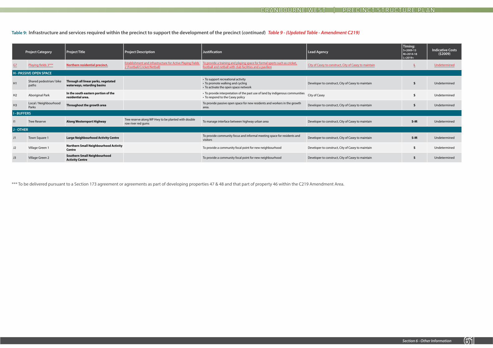
61Section 6 - Other Information
Project Category Project Title Project Description Justification Lead AgencyTiming: S=2009-13 M=2014-18 L=2019+
Indicative Costs ($2009)
G7 Playing fields 3*** Northern residential precinct. Establishment and infrastructure for Active Playing Fields 2 (Football/Cricket/Netball)
To provide a training and playing space for formal sports such as cricket, football and netball with club facilities and a pavilion City of Casey to construct, City of Casey to maintain L Undetermined
H - PASSIVE OPEN SPACE
H1 Shared pedestrian/ bike paths
Through all linear parks, vegetated waterways, retarding basins
• To support recreational activity • To promote walking and cycling • To activate the open space network
Developer to construct, City of Casey to maintain S Undetermined
H2 Aboriginal Park In the south eastern portion of the residential area.
• To provide interpretation of the past use of land by indigenous communities • To respond to the Casey policy City of Casey S Undetermined
H3 Local / Neighbourhood Parks Throughout the growth area To provide passive open space for new residents and workers in the growth
area. Developer to construct, City of Casey to maintain S Undetermined
I - BUFFERS
I1 Tree Reserve Along Westernport Highway Tree reserve along WP Hwy to be planted with double row river red gums To manage interface between highway urban area Developer to construct, City of Casey to maintain S-M Undetermined
J - OTHER
J1 Town Square 1 Large Neighbourhood Activity Centre To provide community focus and informal meeting space for residents and visitors Developer to construct, City of Casey to maintain S-M Undetermined
J2 Village Green 1 Northern Small Neighbourhood Activity Centre To provide a community focal point for new neighbourhood Developer to construct, City of Casey to maintain S Undetermined
J3 Village Green 2 Southern Small Neighbourhood Activity Centre To provide a community focal point for new neighbourhood Developer to construct, City of Casey to maintain S Undetermined
Table 9: Infrastructure and services required within the precinct to support the development of the precinct (continued)
*** To be delivered pursuant to a Section 173 agreement or agreements as part of developing properties 47 & 48 and that part of property 46 within the C219 Amendment Area.
Table 9 - (Updated Table - Amendment C219)

62 Section 6 - Other Information
6.0 OTHER INFORMATION
6.1 SUPPORTING INFORMATION
The following documents may assist in understanding the background to the vision, objectives, guidelines and other requirements of this PSP:
• C21 A vision for the future, City of Casey, 2002.
• Casey – Cardinia Growth Area Framework Plan, Department of Sustainability and Environment, 2006.
• South East Growth Corridor Plan, Growth Areas Authority, June 2012.
• Cranbourne West Urban Growth Plan – Key Issues Paper, David Lock Associates, April 2007.
• Activity Centres Strategy, City of Casey, October 2006.
6.2 GLOSSARY
Central Spine Road - means the north-south Connector Street (Level 1 or 2) which in Plan 13 runs from Intersection ‘T2’ on Thompsons Road through Intersection ‘H2’ on Hall Road to a T-intersection with the southern most east-west connector street in the southern residential area.
Industrial Spine Road - means the north-south Industrial Road which in Plan 13 runs from Intersection ‘T1’ on Thompsons Road to Intersection ‘H1’ on Hall Road Central Parkway.

63Section 6 - Other Information

Contact City of Casey Customer Service Centres
03 9705 5200
NRS: 133 677 (for the deaf, hearing or speech impaired)
TIS: 131 450 (Translating and Interpreting Service)
[email protected]/CityOfCasey
@CityOfCasey
PO Box 1000Narre Warren VIC 3805
Cranbourne Cranbourne Park Shopping Centre
Narre Warren Magid Drive
Narre Warren SouthAmberly Park Shopping Centre
2017/APRIL