4/25/071 nasa planetary data system structure, mission interfaces and distribution science archives...
TRANSCRIPT

4/25/07 1
NASA Planetary Data SystemStructure, Mission Interfaces and Distribution
Science Archives in the 21st Century
April 25 2007
PDS Project Scientist
Reta Beebe
QuickTime™ and aTIFF (Uncompressed) decompressor
are needed to see this picture.

4/25/07 2
PDS, a distributed archive, consists of Discipline and Support Nodes.
Discipline nodes represent traditional areas of scientific investigation and target their work toward one or more of the diverse user communities within planetary science, providing assistance for both data providers and users. (T14/Showalter is an example of discipline node service)
Support nodes provide expertise and ancillary information needed to interpret and preserve the data and for the integration of the PDS system.
Data nodes for specific instruments with large data volumes can be negotiated. The data structure must be compatible with PDS standards and node data is catalogued in and accessible through the PDS. The node contents are transferred to a discipline node of the PDS at the end of the mission.
The Planetary Data System (PDS)

4/25/07 3

4/25/07 4
Management duties are shared by a Program Manager, a Program Scientist and the Management Council (MC), composed of representatives from all nodes.
The MC communicates via face-to-face meetings, monthly scheduled telecons and structured emails.
PDS is tasked with supporting all missions of the Planetary Exploration Division and providing reliable and easy access to the archived data. This requires working with headquarters planners, proposers, instrument teams, missions and a broad spectrum of users.
PDS Management and Coordination

4/25/07 5
The PDS archives and makes available space-borne, ground-based, and laboratory experiment data from over 50 years of NASA-based exploration of comets, asteroids, moons, and planets. Many of the data sets are unique in that the observations cannot be duplicated.
Planetary missions frequently have short or intermittent observing phases that result in extended calibration phases possibly resulting in limited accuracy of calibration and an incomplete understanding of instrument stability and characteristics.
The archives include data products derived from a very wide range of measurements, e.g., imaging experiments, gravity and magnetic field and plasma measurements, altimetry data, and various spectroscopic observations.
The wide range of archival products and associated disciplines are fundamental reasons why PDS is organized as a confederation serving various science communities.
Characteristics of the PDS Archive

4/25/07 6
User desires and expectations are becoming more complex and demanding with time as data and mission complexity increase. They want and need derived products, rapid access, flexible search capability, refined catalogues, readily accessible data visualization, analysis, and cross-correlation tools.
Experienced users want interfaces with familiar data manipulation packages.
Inexperienced users are “Google” oriented but PDS data are not always adaptable to the expected level of indexing.
Interdisciplinary science requires parametric, geographic or spatial searches across missions, instruments and data sets.
Lack of reduced data records frustrate users who wish to find and download highly processed data at specific localities for further analyses, time intervals etc.
User and Customer Challenges

4/25/07 7
Users require that PDS supports heterogeneity for both technology and science - tools that run on a wide variety of platforms and adapt for different uses. Users expect to be able to search all of the PDS data holdings within the system and perform correlated searches for products.They expect online access and distribution of all the data holdings and to download data products of increasing sizes.
Mission loads require PDS be able to scale critical functions, storage infrastructure to support the increase of volume, architecture to support the complexity of missions with many types of instruments and operations to support the increasing number of missions occurring concurrently.
Aging and obsolete technology must be refreshed to ensure long term usability of the data and the system.
Data in the archive must be periodically validated to ensure long term preservation.
Operational Challenges

4/25/07 8
Active or Planned Missions

4/25/07 9
Flagships, PI led Discovery and New Frontiers missions, and missions in the Mars Program present a wide range of challenges.
These challenges are amplified by the NASA policy to compete missions or instruments, bringing a constantly changing group of data providers to the PDS.
Combinations of NASA funded teams based at individual institutions, internationally supplied instruments and the ensuing variable funding and physical locations of the teams further complicate budgeting, planning and data ingestion.
Mission and Data Provider Challenges

4/25/07 10
Data volumes will continue to increase:
Mars Reconnaissance Orbiter will produce ~100 TB
Mars data volume is likely to be surpassed by that returned from the Moon in the next 10 years.
Missions, instruments and data are becoming more complex:
Rovers generate complex sets of products
Flagship Missions strive to satisfy many science goals leading to a variety of instruments, complex structure of data returned, and extended missions with reduced budgets for archive production
Mission and Data Provider Challenges(cont.)

4/25/07 11
Smaller or more focused missions present challenges:
The budget is limited and the funding profile differs from that used in initial design & planning
Mission phases are compressed and require rapid PDS response
PDS must supply tools to help with data archiving tasks, provide a Common Data Model, and participate as early as possible
Problem: Intrinsic problems of sustaining mission science and data analysis budgets sharply limit production and archiving of higher order products.
Mission and Data Provider Challenges(cont.)

4/25/07 12
History and ProgressIn the past the AOs did not include data planning requirements.
Proposers were not challenged to present cost-effective plans to produce data useful to non-team members.
Data pipeline planning was deferred until after launch.
By the point in the mission when PDS began its interface, most teams had a partially completed pipeline and resisted PDS needs and standards as “Creeping Requirements”. This led to many data formats, variable documentation and low level products.
Successful archiving requires PDS science node involvement from proposal briefing and assessment to user assistance and archive maintenance. Production of quality advanced products requires heavy involvement of Mission instrument scientists.

4/25/07 13
NASA Levels
Product Description
Raw Telemetry data stream as received at the ground station, with science and engineering data embedded.
Level 0 Instrument science data (e.g., raw voltages, counts) at full resolution, time ordered, with duplicates and transmission errors removed.
Level 1A Level 0 data that have been located in space and may have been reversibly transformed (e.g., calibrated, rearranged) in a reversible manner and packaged with needed ancillary and auxiliary data (e.g., radiances with the calibration equations applied). No resampling.
Level 1B Irreversibly transformed (e.g., resampled, remapped, calibrated) values of the instrument measurements (e.g., magnetic field strength).
Higher levels
Geophysical parameters mapped into uniform space time grids.
NASA Data Levels

4/25/07 14
“Data must be made fully public through the PDS, in a usable form, as soon as practical but no later than six months following its collection. Mars Scout teams will be responsible for collecting the scientific, engineering, and ancillary information necessary to validate and calibrate the scientific data prior to delivery to the PDS. Archival data products shall include low-level (raw) data, high-level (processed) data, and derived data products such as maps, ancillary data, calibration data (ground and in-flight), documentation, and related software or other tools necessary to interpret the data. All data products shall be documented, validated, and calibrated in physical units usable by the scientific community at large.” (Sec. 6.2.4)
Mars Scout 2006 AO Data Rights Policy
4/25/07 15
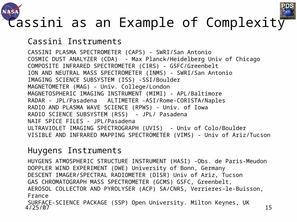
Cassini InstrumentsCASSINI PLASMA SPECTROMETER (CAPS) - SWRI/San AntonioCOSMIC DUST ANALYZER (CDA) - Max Planck/Heidelberg Univ of Chicago COMPOSITE INFRARED SPECTROMETER (CIRS) - GSFC/GreenbeltION AND NEUTRAL MASS SPECTROMETER (INMS) - SWRI/San AntonioIMAGING SCIENCE SUBSYSTEM (ISS) -SSI/BoulderMAGNETOMETER (MAG) - Univ. College/LondonMAGNETOSPHERIC IMAGING INSTRUMENT (MIMI) - APL/BaltimoreRADAR - JPL/Pasadena ALTIMETER -ASI/Rome-CORISTA/NaplesRADIO AND PLASMA WAVE SCIENCE (RPWS) - Univ. of Iowa RADIO SCIENCE SUBSYSTEM (RSS) - JPL/ Pasadena NAIF SPICE FILES - JPL/Pasadena ULTRAVIOLET IMAGING SPECTROGRAPH (UVIS) - Univ of Colo/BoulderVISIBLE AND INFRARED MAPPING SPECTROMETER (VIMS) - Univ of Ariz/Tucson
Huygens Instruments HUYGENS ATMOSPHERIC STRUCTURE INSTRUMENT (HASI) -Obs. de Paris-MeudonDOPPLER WIND EXPERIMENT (DWE) University of Bonn, GermanyDESCENT IMAGER/SPECTRAL RADIOMETER (DISR) Univ of Ariz, TucsonGAS CHROMATOGRAPH MASS SPECTROMETER (GCMS) GSFC, Greenbelt,AEROSOL COLLECTOR AND PYROLYSER (ACP) SA/CNRS, Verrieres-le-Buisson, FranceSURFACE-SCIENCE PACKAGE (SSP) Open University. Milton Keynes, UK
Cassini as an Example of Complexity

4/25/07 16
Cassini - 12 instruments
with CDA & RADAR having 2 separate components Huygens - 6 instruments
International participation and multiple funding agencies involved in both teams
Cassini is an “old” mission -the AO did not require data planning and budgeting.
3 Years into primary mission - delivery of level 1a data has been exemplary - but few higher order data products were included in the Data Management Plan
The announcement concerning an 2-year extended mission is scheduled for early May
Cassini as an Example of Complexity (cont.)

4/25/07 17
Active or Planned Missions

4/25/07 18
With the range of instruments, level of maturity of instruments and range of user needs - the answer is that they should be planned into the missions and produced by the instrument teams. How? See P7/Guinness.
The role of the PDS should be that of maintaining standards and providing assistance across Planetary Science.
In this framework the PDS in involved in the International Planetary Data Alliance (IPDA) to develop a core of standards, a data model, and tools that are used across the international planetary community. See P4/ Crichton.
Basic Problem - How Do We Get Higher-Order Products?

4/25/07 19
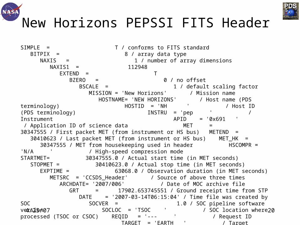
New Horizons (NH) has chosen to use FITS files - this is a PDS option.
According to the “FITS Myth” this would solve all our problems and make PDS data easily accessible to our users.
NH has a plasma package consisting of both the SWAP high-sensitivity solar wind monitor to address Pluto atmospheric escape objectives and the PEPSSI energetic particle spectrometer.
PEPSSI seems to be a simple instrument - flying by Jupiter, reading out its detector at specified times and storing the resulting parameters in a table, generating level 1 data that will be stored in the PDS for open user access.
How do we make Products accessible?
4/25/07 20
New Horizons PEPSSI FITS Header
SIMPLE = T / conforms to FITS standard BITPIX = 8 / array data type NAXIS = 1 / number of array dimensions NAXIS1 = 112948 EXTEND = T BZERO = 0 / no offset BSCALE = 1 / default scaling factor MISSION = 'New Horizons' / Mission name HOSTNAME= 'NEW HORIZONS' / Host name (PDS terminology) HOSTID = 'NH ' / Host ID (PDS terminology) INSTRU = 'pep ' / Instrument APID = '0x691 ' / Application ID of science data MET = 30347555 / First packet MET (from instrument or HS bus) METEND = 30410623 / Last packet MET (from instrument or HS bus) MET_HK = 30347555 / MET from housekeeping used in header HSCOMPR = 'N/A ' / High-speed compression mode STARTMET= 30347555.0 / Actual start time (in MET seconds) STOPMET = 30410623.0 / Actual stop time (in MET seconds) EXPTIME = 63068.0 / Observation duration (in MET seconds) METSRC = 'CCSDS_Header' / Source of above three times ARCHDATE= '2007/006' / Date of MOC archive file GRT = 17902.653745551 / Ground receipt time from STP DATE = '2007-03-14T06:15:04' / Time file was created by SOC SOCVER = 1.0 / SOC pipeline software version SOCLOC = 'TSOC ' / SOC location where processed (TSOC or CSOC) REQID = '--- ' / Request ID TARGET = 'EARTH ' / Target object TARGTYPE= 'Not defined' / Target object type CB1LOAD = '--- ' / Central Body 1 loaded CB2LOAD = '--- ' / Central Body 2 loaded CB3LOAD = '--- ' / Central Body 3 loaded REQDESC = '--- ' / Sequence description / notes REQCOMM = '--- ' / Sequence Comments SPCSEP

4/25/07 21
'***GEOMETRY SECTION*************************************' SPCQUAL = 'RECONSTRUCTED' / QUALITY: PREDICT (poor); RECONSTRUCTED SPCSTAT = 'OK ' / SPICE status [OK or INCOMPLETE ...] SPCINST0= 'NH_PEPSSI' / Starting SPICE Instrument or FRAME SPCINSTR= 'NH_PEPSSI' / Final SPICE Instrument or FRAME SPCMET0 = 30347555.0 / RAW MET timestamp SPCMETDL= 31534.0 / [s] delta, (Mid-obs time) - (RAW MET) SPCCBTNM= 'EARTH ' / [text] Target input name SPCCB1NM= '--- ' / [text] CB1 input name SPCCB2NM= '--- ' / [text] CB2 input name SPCCB3NM= '--- ' / [text] CB3 input name SPCCBTID= 399 / [SPICE ID] Target SPCCB1ID= -999999999 / [SPICE ID] CB1 SPCCB2ID= -999999999 / [SPICE ID] CB2 SPCCB3ID= -999999999 / [SPICE ID] CB3 SPCSCLK0= '1/0030347555:00000' / Spacecraft CLocK timestamp SPCINSID= -98400 / [SPICE ID] Instrument SPCSCID = -98 / [SPICE ID] Spacecraft SPCSCNAM= 'NH_SPACECRAFT' / [SPICE Name] Spacecraft SPCSCET = 221345236.5662582 / [s past J2000] Spacecraft mid-obs time, TDB SPCSCLK = '1/0030379088:49998' / Mid-obs Spacecraft CLocK SPCSCDP = 1518954449998.0 / [SCLK milli-ticks] Spacecraft mid-obs time SPCUTCID= '2007-006T08:46:11.382' / [ISO DOY] Spacecraft mid-obs time, UTC SPCUTCAL= '2007-01-06T08:46:11.382' / [Cal d] Spacecraft mid-obs time, UTC SPCUTCJD= 'JD 2454106.8654095' / [Julian d] Spacecraft mid-obs time, UTC SPCPSEP =

4/25/07 22
'******INSTRUMENT POINTING*******************************' SPCBRRA = 148.8434045968733 / [degrees] Boresight RA, EME J2000 SPCBRDEC= -58.32115900534507 / [degrees] Boresight DEC, EME J2000 SPCEMEN = 253.4712691301747 / [degrees] EME J2k North Clk Angle, CW from UP SPCQA = 0.879929725273648 / cos(theta/2) - Quaternion to transform SPCQX = 0.03474712520028299 / sin(theta/2) * X - instrument vectors SPCQY = 0.2707214153760393 / sin(theta/2) * Y - to EME J2000 vectors SPCQZ = -0.3888781700313765 / sin(theta/2) * Z - ***N.B. SPICE FORMAT SPCTSEP0= '******Target: Target->S/C****************************' SPCTCB = 'EARTH ' / [SPICE name] Target name SPCTSCX = -274841199.710429 / [km] S/C vec wrt Target, X, EMEJ2000 SPCTSCY = -726009069.7018574 / [km] S/C vec wrt Target, Y SPCTSCZ = -304911211.1260501 / [km] S/C vec wrt Target, Z SPCTSCVX= 29.19172368431725 / [km/s] S/C vel vec wrt Target, X SPCTSCVY= -11.01629447158524 / [km/s] S/C vel vec wrt Target, Y SPCTSCVZ= -4.611396857053522 / [km/s] S/C vel vec wrt Target, Z SPCTRANG= 834025000.235592 / [km] S/C range to Target center SPCTTGJD= 'JD 2454106.8332104' / [Julian d] Time at Target, UTC SPCTSEP1= '******Target: Target->Sun****************************' SPCTSOX = 39332569.83228773 / [km] Sun vec wrt Target, X, EMEJ2000 SPCTSOY = -130045351.0295347 / [km] Sun vec wrt Target, Y SPCTSOZ = -56378947.90190811 / [km] Sun vec wrt Target, Z SPCTSOVX= 29.17975073615336 / [km/s] Sun vel vec wrt Target, X SPCTSOVY= 7.406028350392652 / [km/s] Sun vel vec wrt Target, Y SPCTSOVZ= 3.209743656588055 / [km/s] Sun vel vec wrt Target, Z SPCTSORN= 147096669.3726706 / [km] Sun range to Target center SPCTSEP2= '******Target:

4/25/07 23
Target->EarthObserver****************************' SPCTEOX = 0.0 / [km] Earth observer vec wrt Target, X, EMEJ2000SPCTEOY = 0.0 / [km] Earth obs vec wrt Target, Y SPCTEOZ = 0.0 / [km] Earth obs vec wrt Target, Z SPCTEOVX= 0.0 / [km/s] Earth obs vel vec wrt Target, X SPCTEOVY= 0.0 / [km/s] Earth obs vel vec wrt Target, Y SPCTEOVZ= 0.0 / [km/s] Earth obs vel vec wrt Target, Z SPCTEORN= 0.0 / [km] Earth observer range to Target center SPCTEOJD= 'JD 2454106.8332104' / [Julian d] Time at Earth observer SPCTSEPB= '******Target: Body-fixed info****************************' SPCTSCLA= -21.45769603204148 / [degrees] planetocentric Sub-S/C latitude SPCTSCLO= 23.94635263603901 / [degrees] planetocentric Sub-S/C EAST longitudeSPCTSOLA= -22.5255463654812 / [degrees] planetocentric Sub-Solar latitude SPCTSOLO= 61.51046699593731 / [degrees] planetocentric Sub-Solar EAST long. SPCTNAZ = 253.4712691301747 / [degrees] Target North Azimuth, CW from UP SPC1SEP0= '******CB1: CB1->S/C****************************' SPC1CB = 'UNKNOWN ' / [SPICE name] CB1 name SPC1SCX = -1E+32 / [km] S/C vec wrt CB1, X, EMEJ2000 SPC1SCY = -1E+32 / [km] S/C vec wrt CB1, Y SPC1SCZ = -1E+32 / [km] S/C vec wrt CB1, Z SPC1SCVX= -1E+32 / [km/s] S/C vel vec wrt CB1, X SPC1SCVY= -1E+32 / [km/s] S/C vel vec wrt CB1, Y SPC1SCVZ= -1E+32 / [km/s] S/C vel vec wrt CB1, Z SPC1RANG= -1E+32 / [km] S/C range to CB1 center SPC1TGJD= 'JD 2454106.8654095' / [Julian d] Time at CB1, UTC SPC1SEP1= '******CB1: CB1->Sun****************************' SPC1SOX = -1E+32 / [km] Sun vec wrt CB1, X, EMEJ2000 SPC1SOY = -1E+32 / [km] Sun vec wrt CB1, Y SPC1SOZ = -1E+32 / [km] Sun vec wrt CB1, Z SPC1SOVX= -1E+32 / [km/s] Sun vel vec wrt CB1, X SPC1SOVY= -1E+32 / [km/s] Sun vel vec wrt CB1, Y SPC1SOVZ= -1E+32 / [km/s] Sun vel vec wrt CB1, Z SPC1SORN= -1E+32 / [km] Sun range to CB1 center SPC1SEP2= '******CB1: CB1

4/25/07 24
EarthObserver****************************' SPC1EOX = -1E+32 / [km] Earth observer vec wrt CB1, X, EMEJ2000 SPC1EOY = -1E+32 / [km] Earth obs vec wrt CB1, Y SPC1EOZ = -1E+32 / [km] Earth obs vec wrt CB1, Z SPC1EOVX= -1E+32 / [km/s] Earth obs vel vec wrt CB1, X SPC1EOVY= -1E+32 / [km/s] Earth obs vel vec wrt CB1, Y SPC1EOVZ= -1E+32 / [km/s] Earth obs vel vec wrt CB1, Z SPC1EORN= -1E+32 / [km] Earth observer range to CB1 center SPC1EOJD= 'JD 2454106.8654095' / [Julian d] Time at Earth observer SPC1SEPB= '******CB1: Body-fixed info****************************' SPC1SCLA= -1E+32 / [degrees] planetocentric Sub-S/C latitude SPC1SCLO= -1E+32 / [degrees] planetocentric Sub-S/C EAST longitudeSPC1SOLA= -1E+32 / [degrees] planetocentric Sub-Solar latitude SPC1SOLO= -1E+32 / [degrees] planetocentric Sub-Solar EAST long. SPC1NAZ = -1E+32 / [degrees] CB1 North Azimuth, CW from UP SPC2SEP0= '******CB2: CB2->S/C****************************' SPC2CB = 'UNKNOWN ' / [SPICE name] CB2 name SPC2SCX = -1E+32 / [km] S/C vec wrt CB2, X, EMEJ2000 SPC2SCY = -1E+32 / [km] S/C vec wrt CB2, Y SPC2SCZ = -1E+32 / [km] S/C vec wrt CB2, Z SPC2SCVX= -1E+32 / [km/s] S/C vel vec wrt CB2, X SPC2SCVY= -1E+32 / [km/s] S/C vel vec wrt CB2, Y SPC2SCVZ= -1E+32 / [km/s] S/C vel vec wrt CB2, Z SPC2RANG= -1E+32 / [km] S/C range to CB2 center SPC2TGJD= 'JD 2454106.8654095' / [Julian d] Time at CB2, UTC SPC2SEP1= '******CB2: CB2->Sun****************************' SPC2SOX = -1E+32 / [km] Sun vec wrt CB2, X, EMEJ2000 SPC2SOY = -1E+32 / [km] Sun vec wrt CB2, Y SPC2SOZ = -1E+32 / [km] Sun vec wrt CB2, Z SPC2SOVX= -1E+32 / [km/s] Sun vel vec wrt CB2, X SPC2SOVY= -1E+32 / [km/s] Sun vel vec wrt CB2, Y SPC2SOVZ= -1E+32 / [km/s] Sun vel vec wrt CB2, Z SPC2SORN= -1E+32 / [km] Sun range to CB2 center SPC2SEP2=

4/25/07 25
'******CB2: CB2->EarthObserver****************************' SPC2EOX = -1E+32 / [km] Earth observer vec wrt CB2, X, EMEJ2000 SPC2EOY = -1E+32 / [km] Earth obs vec wrt CB2, Y SPC2EOZ = -1E+32 / [km] Earth obs vec wrt CB2, Z SPC2EOVX= -1E+32 / [km/s] Earth obs vel vec wrt CB2, X SPC2EOVY= -1E+32 / [km/s] Earth obs vel vec wrt CB2, Y SPC2EOVZ= -1E+32 / [km/s] Earth obs vel vec wrt CB2, Z SPC2EORN= -1E+32 / [km] Earth observer range to CB2 center SPC2EOJD= 'JD 2454106.8654095' / [Julian d] Time at Earth observer SPC2SEPB= '******CB2: Body-fixed info****************************' SPC2SCLA= -1E+32 / [degrees] planetocentric Sub-S/C latitude SPC2SCLO= -1E+32 / [degrees] planetocentric Sub-S/C EAST longitudeSPC2SOLA= -1E+32 / [degrees] planetocentric Sub-Solar latitude SPC2SOLO= -1E+32 / [degrees] planetocentric Sub-Solar EAST long. SPC2NAZ = -1E+32 / [degrees] CB2 North Azimuth, CW from UP SPC3SEP0= '******CB3: CB3->S/C****************************' SPC3CB = 'UNKNOWN ' / [SPICE name] CB3 name SPC3SCX = -1E+32 / [km] S/C vec wrt CB3, X, EMEJ2000 SPC3SCY = -1E+32 / [km] S/C vec wrt CB3, Y SPC3SCZ = -1E+32 / [km] S/C vec wrt CB3, Z SPC3SCVX= -1E+32 / [km/s] S/C vel vec wrt CB3, X SPC3SCVY= -1E+32 / [km/s] S/C vel vec wrt CB3, Y SPC3SCVZ= -1E+32 / [km/s] S/C vel vec wrt CB3, Z SPC3RANG= -1E+32 / [km] S/C range to CB3 center SPC3TGJD= 'JD 2454106.8654095' / [Julian d] Time at CB3, UTC SPC3SEP1= '******CB3: CB3->Sun****************************' SPC3SOX = -1E+32 / [km] Sun vec wrt CB3, X, EMEJ2000 SPC3SOY = -1E+32 / [km] Sun vec wrt CB3, Y SPC3SOZ = -1E+32 / [km] Sun vec wrt CB3, Z SPC3SOVX= -1E+32 / [km/s] Sun vel vec wrt CB3, X SPC3SOVY= -1E+32 / [km/s] Sun vel vec wrt CB3, Y SPC3SOVZ= -1E+32 / [km/s] Sun vel vec wrt CB3, Z SPC3SORN= -1E+32 / [km] Sun range to CB3 center SPC3SEP2= '

4/25/07 26
''******CB3: CB3->EarthObserver****************************' SPC3EOX = -1E+32 / [km] Earth observer vec wrt CB3, X, EMEJ2000 SPC3EOY = -1E+32 / [km] Earth obs vec wrt CB3, Y SPC3EOZ = -1E+32 / [km] Earth obs vec wrt CB3, Z SPC3EOVX= -1E+32 / [km/s] Earth obs vel vec wrt CB3, X SPC3EOVY= -1E+32 / [km/s] Earth obs vel vec wrt CB3, Y SPC3EOVZ= -1E+32 / [km/s] Earth obs vel vec wrt CB3, Z SPC3EORN= -1E+32 / [km] Earth observer range to CB3 center SPC3EOJD= 'JD 2454106.8654095' / [Julian d] Time at Earth observer SPC3SEPB= '******CB3: Body-fixed info****************************' SPC3SCLA= -1E+32 / [degrees] planetocentric Sub-S/C latitude SPC3SCLO= -1E+32 / [degrees] planetocentric Sub-S/C EAST longitudeSPC3SOLA= -1E+32 / [degrees] planetocentric Sub-Solar latitude SPC3SOLO= -1E+32 / [degrees] planetocentric Sub-Solar EAST long. SPC3NAZ = -1E+32 / [degrees] CB3 North Azimuth, CW from UP SPCSEPS = '******S/C->SUN****************************************' SPCSSCX = 314170760.42838 / [km] Sun vec wrt S/C observer, X, EMEJ2000 SPCSSCY = 595972862.4004619 / [km] Sun vec wrt S/C obs, Y SPCSSCZ = 248536385.7896157 / [km] Sun vec wrt S/C obs, Z SPCSSCVX= -0.01197328187009267 / [km/s] Sun obs vel vec wrt S/C obs, X SPCSSCVY= 18.42232355282074 / [km/s] Sun vel vec wrt S/C obs, Y SPCSSCVZ= 7.821140831297835 / [km/s] Sun vel vec wrt S/C obs, Z SPCSSCRN= 718092789.6082171 / [km] S/C observer range to sun center SPCSSCJD= 'JD 2454106.8376861' / [Julian d] Time at Sun SPCSEPE = '******EARTH->S/C****************************************' SPCESCX = -274823876.7416071 / [km] S/C observer vec wrt earth, X, EMEJ2000 SPCESCY = -726014560.7946305 / [km] S/C obs vec wrt earth, Y SPCESCZ = -304913750.5998584 / [km] S/C obs vec wrt earth, Z SPCESCVX= 29.19172368431725 / [km/s] S/C obs vel vec wrt earth, X SPCESCVY= -11.01629447158524 / [km/s] S/C obs vel vec wrt earth, Y SPCESCVZ= -4.611396857053522 / [km/s] S/C obs vel vec wrt earth, Z SPCESCRN= 834025000.2355919 / [km] S/C observer range to earth center SPCESCJD= 'JD 2454106.8332104' / [Julian d] Time at Earth SPCKSEP = '******SPICE

4/25/07 27
KERNELS*************************************' SPCKNUM = 37 / COUNT OF LOADED SPICE KERNELS: SPCK0001= 'naif0008.tls' / SPICE kernel 0001 SPCK0002= 'new-horizons_194.tsc' / SPICE kernel 0002 SPCK0003= 'pck00008.tpc' / SPICE kernel 0003 SPCK0004= 'nh_v004.tf' / SPICE kernel 0004 SPCK0005= 'nh_allinstruments_v000.ti' / SPICE kernel 0005 SPCK0006= 'nh_alice_v002.ti' / SPICE kernel 0006 SPCK0007= 'nh_lorri_v002.ti' / SPICE kernel 0007 SPCK0008= 'nh_ralph_v002.ti' / SPICE kernel 0008 SPCK0009= 'nh_rex_v000.ti' / SPICE kernel 0009 SPCK0010= 'nh_sdc_v000.ti' / SPICE kernel 0010 SPCK0011= 'nh_swap_v002.ti' / SPICE kernel 0011 SPCK0012= 'sb-2002jf56-2.bsp' / SPICE kernel 0012 SPCK0013= 'jup204.bsp' / SPICE kernel 0013 SPCK0014= 'plu013.bsp' / SPICE kernel 0014 SPCK0015= 'nh_nep_ura_000.bsp' / SPICE kernel 0015 SPCK0016= 'de413.bsp' / SPICE kernel 0016 SPCK0017= 'nh_pred_20060119_20070401_od020.bsp' / SPICE kernel 0017 SPCK0018= 'nh_pred_20060119_20070101_od021.bsp' / SPICE kernel 0018 SPCK0019= 'nh_pred_20060119_20100601_od022.bsp' / SPICE kernel 0019 SPCK0020= 'nh_pred_20060119_20100101_od032.bsp' / SPICE kernel 0020 SPCK0021= 'nh_pred_20061001_20100101_od040.bsp' / SPICE kernel 0021 SPCK0022= 'nh_pred_20070307_20100101_od041.bsp' / SPICE kernel 0022SPCK0023= 'merged_nhpc_2006_v011.bc' / SPICE kernel 0023 SPCK0024= 'merged_nhpc_2007_01_v006.bc' / SPICE kernel 0024 SPCK0025= 'merged_nhpc_2007_02_v007.bc' / SPICE kernel 0025 SPCK0026= 'nhpc_2007_060_07.bc' / SPICE kernel 0026 SPCK0027= 'nhpc_2007_061_07.bc' / SPICE kernel 0027 SPCK0028= 'nhpc_2007_062_07.bc' / SPICE kernel 0028 SPCK0029= 'nhpc_2007_063_07.bc' / SPICE kernel 0029 SPCK0030= 'nhpc_2007_064_07.bc' / SPICE kernel 0030 SPCK0031= 'nhpc_2007_065_07.bc' / SPICE kernel 0031 SPCK0032=

4/25/07 28
'nhpc_2007_065_07.bc' / SPICE kernel 0031 SPCK0032= 'nhpc_2007_066_06.bc' / SPICE kernel 0032 SPCK0033= 'nhpc_2007_067_05.bc' / SPICE kernel 0033 SPCK0034= 'nhpc_2007_068_04.bc' / SPICE kernel 0034 SPCK0035= 'nhpc_2007_069_03.bc' / SPICE kernel 0035 SPCK0036= 'nhpc_2007_070_02.bc' / SPICE kernel 0036 SPCK0037= 'nhpc_2007_071_01.bc' / SPICE kernel 0037 INSTSSEP= '********************************************************' BLOCKCNT= 187 / Number of data blocks BLOCKSIZ= 604 / Size of each data block PHACNT = 1790 / Number of PHAs PHASIZ = 14 / Size of each PHA STATINT = 1 / Status interval (seconds) MACBLCKS= 1679 / Number of macro blocks free TLMVOL = 0 / Telemetry volume produced (KB) WTCHADDR= 0 / Memory watch address WTCHMEM = 0 / Watched memory (pg. no) WTCHDATA= 48644 / Watched memory PEPSWVER= 3 / Software version number ALARMID = 0 / Latest Alarm Id ALARMTYP= 0 / Latest alarm type ALARMCNT= 0 / Count of alarms CMDEXEC = 1 / Commands executed CMDREJCT= 0 / Commands rejected MACEXEC = 0 /0 / Macro commands executed MACREJCT= 0 / Macro commands rejected MACROID = 0 / Id of most recent macro executed MACROLRN= 0 / Macro learn mode MONRESP = 0 / Monitor response WRITEENB= 0 / Memory write enable HVPSCURR= 0 / Expansion Bus address 0x006 HVPSVOLT= 0 / Expansion Bus address 0x008 BIASCURR= 0 / Expansion Bus address 0x00A BIASVOLT= 0 / Expansion Bus address 0x00C

4/25/07 29
PEPSTAT = 15 / Expansion Bus address 0x000 DVOLTP5 = 668 / +5V digital volt. / LVPS ADC (mux sub-addr 0) AVOLTN5 = 666 / -5V analog volt. / LVPS ADC (mux sub-addr 1) VOLTP2 = 654 / +2.5V volt. / LVPS ADC (mux sub-addr 2) VOLTN5 = 605 / -5V volt. / LVPS ADC (mux sub-addr 3) VOLTP15 = 789 / +15V volt. / LVPS ADC (mux sub-addr 4) VOLTN15 = 723 / -15V volt. / LVPS ADC (mux sub-addr 5) DCURRP5 = 217 / +5V digital curr. / LVPS ADC (mux sub-addr 6) ACURRP5 = 193 / +5V analog curr. / LVPS ADC (mux sub-addr 7) CURRP2 = 403 / +2.5 volt curr. / LVPS ADC (mux sub-addr 8) CURRN5 = 582 / -5V curr. / LVPS ADC (mux sub-addr 9) CURRP15 = 75 / +15V curr. / LVPS ADC (mux sub-addr 10) CURRN15 = 481 / -15V curr. / LVPS ADC (mux sub-addr 11) PRIMCURR= 401 / LVPS ADC (mux sub-addr 12) LVPSTEMP= 441 / LVPS ADC (mux sub-addr 13) ENGYTEMP= 112 / LVPS ADC (mux sub-addr 14) HVPSTEMP= 464 / LVPS ADC (mux sub-addr 15) ADDR12C = 0 / Software read address RSLT12C = 0 / Software read value END

4/25/07 30
With the increase in the Mars Program and smaller missions, it has become apparent that imbedding PDS personnel within a mission is an effective way to insure that an efficient data pipeline is developed, but this does not assure higher order products.
Mission Data Management requires expert input to size and cost the data to ensure an adequate archiving budget.
PIs recognize this and many include a PDS-based individual, assigned with this task. Other missions negotiate this involvement.
Development of a data management plan during Phase A to scope the data management task should be a required component.
Imbedding PDS Personnel

4/25/07 31
Respond to an increasing spectrum of demands from a diverse and growing community of users
Interface with more than 20 missions at a time in various development phases
Ingest data from increasingly complex instruments
Educate data providers
Add non-mission data from individuals, laboratories and observatories
Provide useful links to related national and international data
Incorporate new storage/distribution technologies into preservation planning
Adapt to new modes of data access for users (animation
formats?)
Ongoing Challenges

4/25/07 32
Although many of these challenges are planetary oriented and efforts to face them are underway, the last two, in the form of reliability of archive media and an appropriate format for science animations, are topics that involve many of you.
I would propose that a valuable function of this group would be to identify mutual problems, define finite projects with a project leader, a working group and defined period for addressing the problem and reporting back to the participating group. In other words -- go for specific, identifiable accomplishments.
Ongoing Challenges

4/25/07 33

4/25/07 34
Altimeter Participants
The algorithm/software development is being done by CORISTA, Viale Kennedy 5, 80125 Naples, Italy,CORISTA = Consorzio Di Ricerca Su Sistemi Di Telesensori Avanzati
This software has been built into a processing and archiving facility by Alcatel Alenia Space-Italy in Rome and was funded by ASI (Agenzia Spaziale Italiana, 00198 Rome).
Dr. Philip S. Callahan/[email protected]