4 web viewattn: secretary. nsw department of planning & environment . monday 2 november 2015....
TRANSCRIPT

Attn: SecretaryNSW Department of Planning & Environment
Monday 2 November 2015
Submission to EIS for project SSI 6307 WestConnex M4 East
This document contains the formal submission made by WestCONnex Action Group Incorporated (WAG) to the WestConnex M4 East environmental impact statement (EIS).
WAG is a community group made up of residents from across western, inner and south-west Sydney. We are not affiliated with any political party.
WAG strongly objects to the M4 East project based on the information contained in this EIS, and to the WestConnex proposal as a whole. We ask the Minister for Planning to reject this proposal.
WestConnex as proposed is the wrong solution at the wrong time for Sydney. It is out of step with international best practice when it comes to transport policy and the creating liveable, economically viable cities in the 21st century. It is not going to solve Sydney’s congestion problems.
We recognise there is pressure on several NSW Departments, including Planning and the Environment, to approve this project, particularly as contracts have already been signed for the M4 East ahead of such approval being granted. We remind public servants of their obligation to the public and to the potential social, health and economic costs of spending $15.4 billion on WestConnex when it provides no solution to Sydney's transport needs.
In order to make this submission, WAG consulted with and/or reviewed evidence provided by a wide range of experts, including transport planners, environmental organisations, scientists, transport economists, local councils, medical professionals, social workers, investigative journalists, and more. Combined with our own primary research and review of the EIS, this leads us to not only object to the proposal as a whole, but to raise specific objections with regard to the following areas:
1.0 Objection to the failure of WestConnex, including the M4 East, to achieve its core objectives
2.0 Objection to the lack of transparency and proper process
3.0 Objection to AECOM doing the EIS for the WestConnex M4 East
4.0 Objection to the traffic modelling and analysis of alternatives to WestConnex
1

5.0 Objection to the corruption of planning process
6.0 Objection to the health impacts
7.0 Objection to the impact on air quality and EIS assessment of impact
8.0 Objection to the impact of WestConnex, including the M4 East, on climate change
9.0 Objection to the impact of noise and vibration caused by WestConnex, and failure of the EIS to properly analyse these impacts
10.0 Objection to the socio-economic impact of the project and failure of the EIS to properly analyse these impacts
11.0 Objection to the flooding impacts
12.0 Objection to the impact on key waterways
13.0 Objection to biodiversity impacts and failure of the EIS to properly assess these impacts
14.0 Objection to the destruction of Sydney’s heritage
WAG formally requests a detailed response to each of the concerns we have raised in this submission.
Please send this through to us at:
WestCONnex Action Group
c/o 16 Brown St
St Peters NSW 2044
2

1.0 Objection to the failure of WestConnex, including the M4 East, to achieve its stated core objectives
WAG therefore objects to both the failure of WestConnex to meet its stated core objectives and the manner in which these objectives were formulated.
The stated objectives for WestConnex were contrived to fit the project after it had already been announced. In a democratic strategic planning process, objectives are set first based on the needs and desires of the community, and then alternative projects/policies are appraised against their ability to meet those objectives.
The objectives have no associated targets by which their achievement can be ever be determined. Objectives/targets need to be specific, measurable, achievable, relevant and time-bound, and each of the project’s objectives fails on one or more of these measures.
Even though the objectives have been contrived to fit the project, the project still fails to meet them, as detailed below.
Core objective Objective Met?
Support Sydney’s long-term economic growth through improved motorway access and connections linking Sydney’s international gateways (Sydney Airport and Port Botany), Western Sydney and places of business across the city
NO
The planned route for the WestConnex does not connect to Sydney Airport or Port Botany.
The EIS does not provide evidence that economic growth can be assisted by increased motor traffic to the CBD.
There are serious flaws in the proponent’s traffic modelling.
If WestConnex leads to more traffic congestion in the inner west and routes into the CBD as most independents and even this EIS admits it will, the project will not improve access to businesses. Congestion and traffic will only worsen, not just on the M4 East and other parts of WestConnex, but on the surrounding road network.
3

Should Badgery’s Creek airport be built, the emphasis on Sydney Airport is likely to be misplaced, as this hub is likely to act as a more appropriate international gateway for many air freight movements given its proximity to western Sydney freight facilities, as well as western Sydney residents.
According to the 2013 WestConnex Business Case Summary, there will be only a $3.4 billion productivity benefit, while the scheme will cost more than $15.4 billion.
There are better ways of spending $15.4 billion that would deliver greater long-term economic growth, including:
improved road and rail access to Port Botany
improved public transport between Western
Sydney and Sydney’s various CBDs
improving ring roads in Western Sydney
supporting and developing businesses in Western
Sydney
There is already an extensive road and motorway network linking Sydney’s international gateways (Sydney Airport and Port Botany), Western Sydney and places of business across the city. The operation of this network could be improved significantly with demand management such as road pricing reform. There is no need for costly and destructive new motorways.
The most efficient and economic way to link large trip generators is with mass transit. A single motorway lane can transport only 2000 passengers per hour, under ideal conditions. A single railway line can transport 20,000 passengers per hour.
4
Relieve road congestion so as to improve the speed, reliability and safety of travel in the M4 corridor, including parallel arterial roads
NO
The improvements in congestion claimed for the project arise from measures that can be separated from the rest of the project – namely the reintroduction of charges for using the road.
Absent congestion charging, or similar, the laws of induced traffic means that increasing road capacity only increases traffic volumes; it does not reduce congestion
Charging for the M4 without congestion charging on alternate routes will increase, not reduce, congestion on those routes.
WestConnex will not solve congestion on arterial roads such as Parramatta Rd, Victoria Rd or Liverpool Rd. Many intersections will remain at the lowest Level of Service (F) even if the project, including the M4 East, is built.
The second sentence seems to assume rather than demonstrate that this objective is met by stating that diverse travel needs are ‘best met by road infrastructure.’
Claims by WestConnex that the project will improve speed and reliability depend on the reliability of its approach to traffic modelling, which experts argue are flawed.
There is no evidence that increasing road capacity and building urban motorways can relieve road congestion in the long term, because the added capacity simply induces more demand.
As travel speeds increase, so do travel distances, i.e., increasing the speed of the road network encourages urban sprawl. Perversely, this sprawl has the effect of reducing the population’s accessibility to employment,
5

education and services, and increasing transport costs, because people have to travel longer distances.
Road congestion is inevitable in any large city in the absence of adequate demand management. There can never be enough road capacity to satisfy the latent demand for driving, where everyone can live as far from work as they like, and drive whenever they like, to wherever they like in free flowing traffic. It is geometrically impossible.
Congestion on Sydney’s roads is the main thing keeping private vehicle travel demand in check. If this congestion is relieved temporarily by increasing the road supply, then demand will increase until limited by the resulting congestion.
A better objective would be to give as many people as possible a more pleasant and faster alternative to sitting in traffic – particularly drivers of single-occupant vehicles who make up the vast majority of peak-hour traffic.
Cater for the diverse travel demands along these corridors that are best met by road infrastructure
NO
The majority of traffic movements are fungible, and highly responsive to environmental changes including: provision of alternate modes of transport, (for e.g. public transport); provision of alternate traffic generators (for e.g. increased local employment opportunities); and cost and other signals (for e.g. congestion charging).Catering more adequately for travel demands that are not ‘best met by road infrastructure’ also has the advantage of releasing road capacity for road users with no alternatives (within the limitations imposed by induced traffic) and potentially at a lower overall cost that proper process would have seen explored as an alternative to this project.
6

There is already more than sufficient capacity along these corridors to cater for all the essential vehicle travel, particularly if alternative strategies such as demand management and public transport investment are implemented.
Create opportunities for urban revitalisation, improved liveability, and public and active transport (walking and cycling) improvements along and around Parramatta Road
NO
The transport requirements of large-scale urban revitalisation and densification are better met by public transport than roads.
Increasing traffic volumes reduces liveability.
Improvements to ‘public and active transport’ can be achieved without WestConnex, and provide no justification for any part of it, including the M4 East. No serious analysis of such alternatives is undertaken in this EIS, which is a serious flaw.
The overall impact of the project will be to increase car dependency. The project could improve liveability for some, though this is not proven by this EIS. What is clear from this EIS, but is not addressed in any serious measure, is that the WestConnex including the M4 East will seriously downgrade liveability for many thousands of others.
Traffic volumes on Parramatta Road will be higher with the proposed project than without it. The only reason the Traffic and Transport Assessment in the EIS is able to forecast lower traffic volumes is because it assumes new kerbside bus lanes will be implemented on Parramatta Road, in which case the number of general traffic lanes would be reduced. However, these bus lanes are neither part of the proposed project, nor the broader WestConnex scheme.
7

A six-lane motorway with high traffic volumes (and associated noise, air pollution and traffic danger) is not a basis for urban revitalisation, improved liveability, and public and active transport improvements.
Enhance the productivity of commercial and freight generating land uses strategically located near transport infrastructure
NO
The planned route for the WestConnex does not connect to Sydney Airport or Port Botany.
This is a reference to faster travel times that should enhance the productivity and attractiveness for businesses along the WestConnex route. It also relies on traffic modelling predictions being accurate. Modelling has failed for some past projects leading to business failure. It’s also not clear exactly what this is referring to and in the absence of a transparent business case, it’s not possible to evaluate the ‘enhanced productivity’ of land uses.
This objective could be more easily and more economically achieved by improving the operation of the existing road network with demand management, e.g., road pricing reform.
It has to be questioned whether a highly populated inner city area is the optimal location for some commercial and freight generating land uses. Could some of it be moved to less populated areas, where the transport costs and externalities are lower? There is evidence this is already happening in places like Moorebank; this would render this objective, and much of the justification for WestConnex, moot.
Enhance movements across the Parramatta Road corridor which are currently
NO
Improvements to ‘movements across the Parramatta Road corridor’ can be achieved without WestConnex and
8

restricted provide no justification for either the entire project or the M4 East.
Even without this, it’s hard to see how this objective will be achieved when there will be more traffic on some sections of Parramatta Rd after the project is built than there is now. Some intersections across Parramatta Rd west of Homebush will also be slower according to the M4 Widening EIS. Traffic flow might flow more easily in the M4 East at first, tunnel but some argue that it will hit congested spots not long after it emerges from the tunnel – and this EIS predicts that by 2031, the M4 East will reach full capacity, which will place slow movements across the Parramatta Rd corridor even more.
The project will result in increased traffic volumes on Parramatta Road and nearby roads, which will further hinder movement across the corridor.
Fit within the financial capacity of the State and Federal Governments, in partnership with the private sector
NO
The EIS does not include the business case. Until the full business case is released and has been independently verified, it cannot be assumed that the project fits within the financial capacity of the State and Federal Governments. It has already been made clear that the private sector will not be funding this project unless and until the toll road becomes profitable precisely because of concerns about its viability. The only business case that was ever produced was found by the NSW Auditor General to be inadequate.
Billions of dollars of public money are being paid to private companies, and the public not the private sector carry the risk on this project. Such a one-sided relationship can hardly be described as a “partnership”. Currently we do know that the WestConnex will absorb billions of Federal and State funds – not to mention toll revenues from
9

motorists – that could be spent on alternative projects with better and more sustainable returns.
There is a high risk of toll revenue from the project not meeting forecasts, resulting in financial losses for the government at state and federal level – which of course, are losses that be borne by NSW and Australian taxpayers.
Optimise user-pays contributions to support funding in a way that is affordable and equitable
NO
The proposed cost model will not be affordable for many residents, particularly when high parking and vehicle running costs are added to the equation. The tolls are likely to be even less affordable for residents from western and south-west Sydney, where the mean income is below that of residents in the inner city.
Numerous studies have shown that irrespective of income, drivers are extremely sensitive to tolls. This has been ably demonstrated by the financial failure of the last four toll roads built in Australia, including Sydney’s Lane Cove Tunnel and Cross City Tunnel.
More than 99% of the NSW population will not use the project each day, but they will still have to pay for it through general taxation.
Many of the potential users will be from low-income households who cannot afford to live near employment centres or railway stations. They will have to pay high tolls while higher-income households have access to cheaper roads and public transport. This is hardly equitable.
Integrate with the preceding and proposed future stages of WestConnex, without creating significant impacts
NO
The project proposes non-trivial environmental damage both during the 3-year construction period for the M4 East and the future operation of this tunnel if it is built.
10

on the surrounding environment or duplicating any potential issues across the construction periods
The EIS acknowledges there are significant impacts in relation to noise, loss of housing and destruction of heritage.
Already on the M4 widening, there are issues with asbestos waste, while at Beverly Hills noise walls have been stripped away from the M5 and will stay down for months longer than originally predicted. It is difficult to believe such construction issues will not eventuate with the M4 East is it proceeds.
There is a high risk that future stages of the WestConnex scheme will never go ahead, due to the likely financial failure of the preceding stages.
Protect natural and cultural resources and enhance the environment.
NO
The project proposes significant loss of Sydney’s heritage, which has been deemed unacceptable by The National Trust of Australia (NSW).
The project proposes non-trivial environmental and cultural damage, rather than enhancement or protection.
The proponents’ claim that WestConnex will reduce emissions (which could be held as enhancing the environment) does not hold up. No credible authority in the world today would suggest that building freeways is the solution to cutting national greenhouse emissions.
The project will result in poorer local air quality. The air quality modelling in the EIS is unreliable because it is based on flawed traffic modelling. Local air quality near the project is already compromised, with air toxin levels regularly exceeding standards. Even when they do not exceed standards, they still cause health problems. There is no safe level of air pollution.
11

The overall increase in VKT and increased traffic volumes on surface streets will result in poorer air quality and more noise pollution.
The in-tunnel air quality will be poorer than that for surface roads. People using the tunnels on a regular basis will have a higher risk of lung cancer, asthma, heart disease and other diseases. The health of children being driven through the tunnels is a particular concern.
Roads are one of most energy-intensive ways of moving people and freight. The project will encourage longer travel distances (sprawl), which will result in increased transport energy use and environmental damage. It will also encourage travellers to switch from energy-efficient public transport to energy-inefficient private vehicles.
Traffic volumes on surface roads will increase, resulting in increased noise pollution.
The project will reduce social and visual amenity.
a) Concrete interchanges and pollution stacks are visually obtrusive.
b) The increased traffic volumes on surface roads will result in more noise pollution, more fear and intimation and greater crash risk.
The increase in petrochemical exhaust emissions from the tunnel portals, pollution stacks and surface roads will reduce visibility and air quality.
The project will directly cause irreversible biodiversity loss, and indirectly through increased greenhouse gas emissions that will contribute to climate change and damage natural systems.
12

The project will result in increased VKT, and therefore more contaminants (brake and clutch dust, hydrocarbon particulates etc.) being deposited on roadways and washed into waterways.
The project is not a sustainable development either economically or environmentally.
1.1 Further comments on the proponents’ claims with regard to meeting the project objectives
The proponents claim in the Executive Summary of the EIS that the project will achieve its objectives by providing immediate operational benefits along the M4 and Parramatta Road, including a reduction in travel times and improvements in the level of road safety.
Whether the predicted improved travel times of 6-8 minutes by 2021 is worth the additional traffic congestion on Parramatta Rd from Parramatta Rd to Homebush and the inner west is highly debatable. Traffic is predicted to flow more smoothly on Parramatta Road between Homebush and Haberfield but even that depends on traffic modelling, which WAG and many independent experts believe is flawed.
The project is being developed as part of the first stage of WestConnex that also includes the M4 Widening project. The proponents claim that completion of both projects would provide a full motorway connection between the Blue Mountains in the west and Haberfield in the east. Future stages of WestConnex would link the project with Sydney’s south-west, as well as integral freight centres at Sydney Airport and the Port Botany precinct. As such, the proponents claim, the project would support NSW’s key economic generators and provide a strategic response to currently inadequate and highly congested transport routes, and provide “the missing link in the motorway network”, which supports what the proponents describe as “Sydney’s global economic corridor”.
13

Like so many claims in this EIS, this statement fails to stand up to scrutiny. What is known as Sydney’s ‘global economic corridor’ runs from Ryde, Macquarie Park towards the CBD and Sydney airport – much of which will not be serviced by WestConnex. In any case, even if the chosen route was the “global economic corridor”, this suggests that entrenching development towards Sydney’s CBD, which is on its eastern edge, is a desirable goal. Some planners, including the Committee of Sydney’s CEO Tim Williams, argue that a key driving principle of planning for Greater Sydney should be decentralisation, with an emphasis on enhancing the centres of Liverpool and Parramatta nearer the geographic centre of the city.
The proponents also claim that WestConnex will achieve its objectives because “the integrated package of transport improvements delivered by WestConnex would include complementary enhancements to the existing road network, a redesign of bus services and facilities, improved access to rail stations, and upgrades to cyclist and pedestrian facilities”. However, such “complementary enhancements” are not in scope of either the M4 East or the WestConnex as a whole, and it is not clear who will be responsible for these, or if they will happen at all.
There is a reference to improved bus services in the EIS – indeed, dedicated bus lanes on Parramatta Rd form an integral part of its traffic modelling – but these bus lanes promised on Parramatta Rd are only options being considered by Transport NSW, and are explicitly described as not being within the current project scope. Some bus routes across Parramatta Rd running N and S are predicted in the M4 widening to take longer after the completion of works.
The proponents also claim that the “project complements a number of other transport and freight-based infrastructure initiatives identified in the Transport Master Plan. Ultimately, it is the combination of these initiatives that will best address Sydney’s needs.” But evidence for this assertion is never provided, and there is no firm indication as to either what these other initiatives are, or indeed whether they are being done in the right order.
The proponents also claim that “To protect natural and cultural resources and enhance the environment, design, construction and operation of the project would be undertaken in accordance with environmental management commitments identified in this environmental
14

impact statement (EIS), as well as any additional measures identified in conditions of approval for the project”.
This promise covers many things. The EIS defers consideration of mitigation of many impacts off to the post approval ‘conditions of approval’ phase. It is not clear what access the public has to monitoring these. The experiences of residents affected by other parts of the WestConnex project – including those reporting repeated breaches of health, safety and/or licence conditions incurred by WestConnex contractors removing or storing asbestos at Granville, Erskine Park and St Peters, and residents enduring high levels of noise impacts at Beverly Hills where WestConnex has begun the King Georges Road Interchange upgrade – does not engender public trust in the proponent’s ability to meet this objective when it comes to the M4 East.
1.2 Conclusion
WAG formally and strongly objects to the WestConnex project, including the M4 East, on the basis that it will not even meet its contrived core objectives, and we ask that the Minister for Planning reject the WestConnex M4 East project.
15

2.0 Objection to the lack of transparency and proper process
WAG objects to the lack of transparency and proper process that has characterised the WestConnex project since its inception, and continues to do so with the M4 East.
These flaws are all the more serious given the Federal and NSW governments have called WestConnex the largest road infrastructure project in Australia’s history. For such a major piece of infrastructure it has had a relatively short period of review. It appears to have been ‘fast-tracked’ to bypass important evaluation steps aimed at providing assurance to government and the taxpayers that the project is the best solution.
2.1 No business case
To date, no business case to justify the $15.4 billion project has been released. Only an “Executive Summary” has been made available for public view. This summary is both out of date and lacking in any serious detail that would allow any independent experts to undertake a serious review of the projected costs and benefits of the WestConnex project.
Both the Federal and NSW governments have opposed calls for the release of the business case. WAG finds it difficult to believe that a compelling business case that supports the benefits being touted by its proponents would not have been shared with the Australian taxpayers by this time if it existed, particularly given the increasingly controversial nature of the WestConnex project.
2.2 Lack of independent oversight
There has also been an almost complete lack of independent oversight of the WestConnex project as a whole. Recent moves to dissolve the WestConnex Delivery Authority (WDA) and move its functions into the private corporation Sydney Motorway Corporation seem designed to make the planning processes even less transparent.
It is also disturbing that this merger follows reports of internal problems with the governance of WestConnex, including issues behind the move is conflict over the control of the planning processes. It is also unacceptable that public money has been used to establish a private company, with two ministerial shareholders, so that the corporation does not have to be publically accountable.
2.3 Grossly inadequate timeframe for community submissions to this EIS
Other projects that were less complex and impactful than the M4 East EIS were allocated considerably more time to the EIS process than the 45 days given to the M4 East project, which was only extended to 55 days when Ashfield Council discovered that the proponent
16

had left crucial data out of the EIS. For example, communities affected by NorthConnex were given 60 days to respond to its EIS.
The fact that the timeframe granted to this project is longer than the statutory 30-day requirement is irrelevant given the size, scope, and socio-economic cost of this project.
This is inadequate time for submissions and findings of EIS to be considered, summarised and incorporated. Even with our network of experts and actively involved individuals, WAG found it difficult to compile this response in the allotted time. We cannot believe that ordinary residents, especially those compiling submissions on their own, would have been able to manage this process effectively in the time allowed.
We also know that the Department of Planning & Environment was well aware of the depth community anger at the short period of time given for public review and submissions. WAG’s campaigns alone saw hundreds of people jam the phone lines at the Minister’s office on two separate occasions, and triggered hundreds of emails sent to the Minister, all to ask for an extension.
The failure to grant such an extension in the basis of such an obvious need can only be interpreted as an attempt to maintain the lack of transparency surrounding WestConnex, as well as an effort to avoid proper process by circumventing community input.
2.4 Lack of transparency around WestConnex contracts
More broadly, very little information about NSW government contracts is available to the public.
Notices for contracts worth more than $150,000 are published on the NSW Government eTendering website, but are removed soon after a contracts expires. This is in stark contrast to the Federal register, where historic contracts remain available. The NSW system makes it more difficult for the public to track the development process in NSW.
2.5 Failure to consider cumulative negative impacts
While cumulative benefits in travel-time savings and productivity are claimed for the whole 33km WestConnex project – and even, at times, for additional projects that are not in scope, such as dedicated bus lanes on Parramatta Rd – cumulative negative effects are almost completely overlooked in the entire EIS.
17

Negative impacts are restricted to the EIS M4 project footprint. They are not extended to include impacts on nearby local government areas such as the City of Sydney; the combined impacts of the full WestConnex on factors such as traffic congestion, pollution, health, and environmental and community destruction; and so on.
If cumulative negative aspects were considered, the opportunity cost of not spending $15.4 billion on a more efficient transportation system (or any public asset) could be evaluated. If the benefits are considered for the whole project at a NSW scale, so too should the negative aspects. The failure to include such analysis in this EIS has the effect of hiding the true impact of both the M4 East and the full motorway, and contributing further to the lack of transparency surrounding this project.
2.6 External criticism
WestConnex’s lack of transparency and proper process have also come in for sharp criticism from a number of credible independent sources.
2.6.1 NSW Auditor General’s Performance Audit
NSW Auditor General’s Performance Audit of WestConnex conducted in 2014 highlighted the importance of proper evaluation and identified some serious deficiencies in the development of the WestConnex project.
The Executive Summary of this audit concluded:
“In the period covered by this audit, the processes applied to WestConnex to provide independent assurance to Government did not meet best practice standards…“The preliminary business case submitted for Gateway review had many deficiencies and fell well short of the standard required for such a document. Further, on our analysis, the business case put to the Government still included some deficiencies that independent Gateway reviews and external assurance arrangements, if they had occurred, should have identified…
“The post-business case governance arrangements did not clearly separate board-level responsibilities for commissioning from responsibilities for delivering the WestConnex project. After not separating the roles, they also failed to provide mechanisms to effectively manage the conflict between these roles.
“The WestConnex project offers several lessons. While good internal controls are critical, they are not a substitute for externally managed Gateway reviews. Steering committees and boards cannot be responsible for both project delivery and independent assurance
18

and reporting to the Government. Responsibility for commissioning should be clearly differentiated from the responsibility for project delivery. Challenging deadlines heighten the need for good assurance but, paradoxically, also the risk of departure from best practice.” (p.3-4)
“The Government approved a new Major Projects Assurance Framework in December 2011…
“The objective of the Framework is to increase the Government’s confidence and assurance in planning and implementation of major projects through their entire lifecycle, specifically:
prevent projects failing or not realising their stated objectives/benefits improve clarity in the feasibility phase of projects drive better governance inform Cabinet Infrastructure Committee intervention
“A key component of the Major Projects Assurance Framework is the Gateway review system. The Gateway system is a series of structured reviews at key decision points (gates) in a project’s lifecycle. Gateway gives the Government a level of independent assurance on:
whether an investment in a project is warranted the strategic options considered the agency’s capacity to manage and deliver the project on time, on budget and
achieve desired project outcomes whether a project is on track and ready to move to the next phase.”(p.10-11)
WAG agrees with this assessment and it forms part of our objection to the M4 East and WestConnex as a whole. Failure to abide by the Major Projects Assurance Framework and employ best practice governance from project inception has greatly reduced community confidence in the WestConnex project. In the case of the M4 East EIS, the community is being asked to comment on an EIS that is deficient in analysis of project justification.
A project of this size and impact should adhere to the NSW Government’s Major Projects Assurance Framework. Vital gateway reviews should have been undertaken before the preparation of the EIS (and certainly before awarding construction contracts) should be
19

commissioned, completed and made publicly available before any further approvals are issued.
The NSW Auditor-General also called the assessment of the WestConnex project concept into serious question. The following quotes are taken directly from its Audit:
“Based on the Major Projects Assurance Framework, we expected a Gateway review (or similar arm’s length, independent review) either during the concept phase or early in the development of the business case.
“The Major Projects Assurance Framework introduced a Gate Zero to provide assurance that projects are well justified after considering a wide range of options. A Gateway review or similar should therefore be conducted early in a project’s life cycle to provide assurance around whether:
• the need for a project is properly defined • there is justification for addressing that need • the best value means of servicing that need are being proposed after considering a broad range of alternatives and their associated costs and benefits.
“We also expected that Infrastructure NSW or some other body would have recognised the need for a Gateway review during the concept phase, or early in the development of the business case and taken steps to ensure this occurred, including reporting to the Cabinet Infrastructure Committee.
“There was no independent Gateway review or equivalent undertaken at the concept stage. Infrastructure NSW has indicated that the concept paper it prepared to advise Government before WestConnex was publicly announced was not subjected to any independent assurance reviews. The first gateway review was of the preliminary business case late in the business case development phase..
“We saw no evidence that:
• the Government specifically exempted WestConnex from the Major Projects Assurance Framework Gate Zero • provided an explanation or justification for the variation from the Major Projects Assurance Framework • the alternative approach adopted was assessed as being equivalent to, or better than, the Major Projects Assurance Framework.
20

“…we believe that a Gate Zero Gateway review should have been conducted. It would have provided independent assurance that the project was justified…
“Infrastructure NSW’s roles at this stage of the WestConnex project were in conflict. It was responsible for developing the WestConnex concept and at the same time it was the key agency responsible for providing assurance to Government over major capital projects including WestConnex. A fundamental principle is separation between those providing independent assurance and those developing and delivering a project.” (p. 16-17)
WAG agrees with this assessment and it forms part of our objection to the M4 East and WestConnex as a whole.
The development of the WestConnex business case - which to date has not been made publicly available, as mentioned above - was also criticised in the NSW Auditor-General’s audit. The following quotes are taken directly from its report:
“Given no Gate Zero Gateway review was conducted during the concept phase, we expected one (or an equivalent arm’s length, independent expert review) at the beginning of this phase.
“In line with the Transport for NSW Investment and Gating System we also expected to see the following Gateway reviews (or equivalent arm’s length, independent expert reviews)
• a strategic business case review (Gate One) • a preliminary business case review (Gate Two) • a final business case review (Gate Three).
“We expected there would be acquittals of each of these reviews, and that the review reports and acquittals would be provided formally to Infrastructure NSW and followed up in each subsequent Gateway review or equivalent. We also expected regular progress reports to, and monitoring by, Infrastructure NSW.” (p.21)
“We expected to see outputs from the other peer reviewers but detailed reports were limited to infrastructure solutions, capital costs and traffic analysis. Even here, timing was a concern. The peer reviewer engaged to review the traffic analysis produced a report, but not until November 2013 after the business case went to the Government. The reviewer’s report indicated that the review was supposed to be
21
continuous throughout the process of modelling, but the traffic modellers were too pressed for time to consult on a continuous basis with the peer reviewer. The reviewer described the exercise as more an audit than a peer review. The reviewer concluded that the traffic data he received in early August 2013 ‘raises questions about the underlying quality of the modelling’.
“The agencies concerned advised us that significant analysis and review of traffic numbers was undertaken by the specialist work streams established within the Project Office. However, we have seen no evidence of an independent, arm’s length review of the traffic analysis used for the final business case, by someone technically qualified to do so, before the business case was presented to the Government.
“We did not find peer review outputs for land use, urban planning or transport planning.”(p.26)
WAG agrees with this assessment and it forms part of our objection to the M4 East and WestConnex as a whole.
As well as criticising the process by which the WestConnex business case was developed, the NSW Auditor General also criticised the lack of information provided about the project in the single independent review undertaken of the WestConnex business case. From its audit report:
“One formal, independent Gateway review was conducted during the development of the business case. This was of a preliminary business case.
“In its report to the Sydney Motorways Project Office (dated 14 June 2013), the Gateway Review Panel concluded that: ‘due to lack of key information presented for the review, the Gateway Review Panel was not able to form a view on whether the project is a worthwhile and prudent investment (both economically and financially viable) for the NSW Government’.
“Further, the Gateway Review Panel stated that:
“A number of key documents were delivered later than anticipated and the Review Panel had very limited time to review the Silver business case.
“Relevant documentation relating to a number of critical areas of the business case was not available for review – these included the Governance Section, Financial
22

Plan and Communications Plan. The absence of these documents did impact on the ability to review related sections.
“The Review Panel did not have access to a number of Stakeholders or documents that were considered essential in order to satisfactorily complete the review.
“The Review Panel noted that not all key benefits nor all key risks were adequately documented, and that the business case would benefit from these and other inclusions”. (p.28)
“The Gateway Review Panel also found the preliminary business case should have been more advanced than it was and would have benefited from previous iterations and review processes which had not occurred.
“The Gateway Review Panel’s ‘traffic light’ risk ratings against the Gateway criteria were all red and yellow, with no greens.”
WAG agrees with this assessment and it forms part of our objection to the M4 East and WestConnex as a whole.
According to the NSW Auditor General, a full Gateway review may have identified a number of key matters with the business case:
“We reviewed the final business case and identified some issues with the underlying analysis which we believe a full Gateway review should have identified.“These deficiencies related to the way the business case dealt with risks around traffic projections, project cost, economic benefits, financial analysis, governance arrangements and the procurement strategy.” (p.31)
WAG agrees with this assessment and it forms part of our objection to the M4 East and WestConnex as a whole.
The NSW Auditor General’s audit also raised serious criticisms about the lack of independent reviews of the WestConnex business case:
“Roads and Maritime Services say that the assurance provided to the Government on the WestConnex business case was appropriate for its purpose.
“It says the overall objective outlined in the Business Case Implementation Plan was to “produce a business case that demonstrates the overall technical and
23

financial viability of the WestConnex scheme, consistent with the State’s Fiscal Strategy”.
“Roads and Maritime Services advised that at the conclusion of the business case in July 2013, Stage 1 was regarded as being sufficiently developed to proceed to procurement and environmental planning phases. For the other stages, the business case outlined a pathway for their further development and planning. It says that it was always envisaged that there would be additional Gateway reviews conducted on the component parts of the scheme.
“Roads and Maritime Services’ arguments do not justify the lower level of independent assurance provided on WestConnex than that offered by the Major Projects Assurance Framework. The objective was to “produce a business case that demonstrates the overall technical and financial viability of the WestConnex scheme, consistent with the State’s Fiscal Strategy.” Approval of the business case was the key decision point so far for this project, and arguably the stage at which independent assurance was most critical.”(p.31)
WAG agrees with this assessment and it forms part of our objection to the M4 East and WestConnex as a whole.
2.6.2 Productivity Commission
It is also clear that the WestConnex project has failed to meet industry best practice in project selection and transparency. The Productivity Commission in its recent inquiry into public infrastructure found: “an urgent need to comprehensively overhaul processes for assessing and developing public infrastructure projects.”
It pointed to “numerous examples of poor value for money arising from inadequate project selection, potentially costing Australia billions of dollars”. It argued that further spending under the status quo will simply increase the cost to users, taxpayers and the community, and lead to more wasteful infrastructure.(1)
2.6.3 Grattan Institute
At the request of the Senate Select Committee into the Abbott Government’s Budget Cuts, the Grattan Institute recently prepared a paper on infrastructure financing and expenditure with a focus on transport infrastructure.(2) Their recommendations stand in stark contrast to the WestConnex planning process, which has failed to meet any of the standards outlined below (all excerpts taken directly from the Grattan Institute report):
24

“To get a better return from infrastructure spending, governments should focus on selecting the right projects, and on making the business cases and their underlying assumptions more transparent. Governments can also get a better return through use of new technologies to get more value out of existing infrastructure; through minor augmentation and relief of pinch points; and through more systematic maintenance.
“The capacity to waste money is a serious risk for infrastructure, given the very large amounts of money involved.” (p.1)
“Infrastructure investment over the past five years has been about one per cent of GDP higher than a decade earlier. Such a significant increase would have been expected to have some visible effect on GDP growth. There is no evidence it has done so, with GDP growth still well below three per cent per annum and below historic growth rates.
“The wrong projects can destroy value and divert funds from projects that would be more valuable to the economy and community.” (p.4-5)
“Australia could get better value from public infrastructure by making better project selections. Unreliable or non-existent cost-benefit analyses have been an obstacle to optimal project selection. Recent large infrastructure projects in Australia have typically suffered from cost overruns of about 15 per cent, while patronage has been 15 per cent lower than projected, on average. As a result, real cost-benefit multiples are expected to be about 25 per cent lower than projected on average. All other things being equal, this consistent overestimation of benefit-cost ratios is making uneconomic projects look viable at the approval stage.” (p.5)
2.6.4 Prof Peter Newman, Professor of Sustainability at Curtin University
Prof Newman, a former member of the Infrastructure Australia board, has spoken out strongly against the processes surrounding WestConnex on a number of occasions.
Newman was a board member of Infrastructure Australia at the time the motorway was first proposed. He is also a member of a Scientific Advisory Committee with the United Nations Educational, Scientific and Cultural Organization (UNESCO).
Professor Newman considers that WestConnex only became a serious proposition when Prime Minister Tony Abbott took up the issue while still in opposition, and that the project is highly politicised.
25
He described the planning processes around WestConnex as, “very tight knit… (this scenario) doesn't surprise me because I was involved in the planning side. The planning was really very, very light – just a few ideas being thrown together without any serious detailed work being done, and all the detail that was done showed very poor cost-benefit ratio.
“They have completely subverted the normal planning processes and now they’re subverting the consulting processes.
“It’s corrupting the process, that is what you can say. It doesn't mean that it is corrupt in a legal sense, but it is close to the edge."
2.7 Conclusion
WAG formally and strongly objects to the lack of transparency and proper process in the WestConnex project, including the M4 East, and we ask that the Minister for Planning reject the WestConnex M4 East project.
26

3.0 Objection to AECOM doing the EIS for the WestConnex M4 East
WAG strongly objects to the fact that AECOM, the company contracted to compile this EIS, has deep interests in the planning and construction of the $15.4 billion motorway project, raising questions about the independence and integrity of the planning assessment process.
The same firm is the subject of an ongoing legal action in Queensland – more than 650 investors are suing for $150 million, claiming the company’s traffic predictions for a privately-owned toll-road in Brisbane were substantially inflated.
While AECOM has been contracted for “Traffic Director” services on WestConnex in Sydney, it faces a class action over its traffic forecasts for the failed Clem 7 tunnel in Brisbane.
Brisbane’s Clem7 RiverCity tunnel carried less than one quarter of the traffic forecasted after it opened in 2010. Legal firm Maurice Blackburn is representing 650 investors who are seeking to recover losses of more than $150 million from AECOM.
According to Maurice Blackburn’s website, the case alleges that AECOM made forecasts without reasonable grounds, and left critical information out of its report published in RiverCity's Disclosure Statements.
It also allegedly failed to reveal that earlier traffic forecasts it had developed for Brisbane City Council showed traffic volumes substantially lower than those in the RiverCity Disclosure Statements.
AECOM is defending the action and has made cross claims against directors of RiverCity. The case is listed for hearing in 2016. Planning Minister Stokes did not respond to a question about whether he was aware of this court action.
In addition, AECOM recently has settled a major lawsuit over forecasts it made for a toll road in Australia, paying $280 million ($US201m) to creditors - one of the largest settlements related to misleading and deceptive conduct in Australian corporate history.
Yet despite all this, AECOM has been paid $1.6 million to provide the NSW Baird government an assessment of the environmental risks for the M4 East tunnel, from Homebush to Sydney’s Inner West (Stage 1 of WestConnex).
27

AECOM has previously partnered with Leighton Contractors, which is part of the successful joint venture winning bid with John Holland and Samsung C&T to construct the WestConnex M4 East, announced by the Baird government today. AECOM and Leightons had been joint construction partners in other road building contracts, and jointly bid for the East West Link in Melbourne but withdrew the bid on the grounds that it was too risky.
This is one of six contracts the company has been awarded by the proponent over the last 18 months. The contracts have a combined value of over $9 million, and cover a range of services.
AECOM was involved with preparing the proponent’s proposal for Stage 2 of WestConnex (the M5 tunnel) and is involved in business and traffic estimates for other parts of the project. The M4 East environmental assessment contract itself includes broader services, described as “Design Development & Communications Services” on the Contract Award Notice.
Even before its assessment was published or any feedback received, AECOM already endorsed the motorway on its website. It claimed - though these references seem to have been removed now - that “WestConnex will assist in making Sydney a more liveable city by reconnecting communities, enhancing centres and significantly improving the urban domain along Parramatta Road” and will “provide welcome relief from congestion on the M4 and Parramatta Road…”
These claims are hotly contested. An independent study commissioned by City of Sydney found that WestConnex will actually increase traffic congestion on Parramatta Road. In May the Sydney Morning Herald reported that the PROPONENT’s own traffic assessments show that the $15 billion project will not stop Sydney traffic from worsening.
AECOM’s other work on WestConnex includes a contract to prepare THE PROPONENT’s proposal for a new Stage 2 M5 East tunnel; a $4.9 million contract to conduct geotechnical investigations for the M5 Tunnel from South West Sydney to St Peters; a $700,000 contract for “Traffic Director” services; and two contracts worth more than $777,000 to work on the Stage 3 of the motorway, which is a tunnel linking the M5 and M4. These Stage 3 contracts include design engineering, business development, and environmental and technical services for the tunnel, about which almost no information is available. These are huge conflicts of interest when it comes to its contract to deliver this EIS.
28

WAG formally and strongly objects to the M4 East due to these conflicts of interests and serious doubts over AECOM’s ability to produce a truly independent EIS, and we ask that the Minister for Planning reject the WestConnex M4 East project.
29

4.0 Objection to the traffic modelling and analysis of alternatives to WestConnex
WAG strongly objects to the traffic modelling and analysis of alternatives to building the WestConnex M4 East included in the EIS.
Nearly all other claims in the EIS depend for their validity of the traffic analysis. However, the EIS has failed to model the impacts of implementing the proposed project (M4 East) relative to not implementing the proposed project (the 'future do minimum' scenario). The 'future do something' scenarios, on which the traffic, air quality, health and greenhouse modelling is based, include the M4 East project plus another uncommitted project to convert kerbside general traffic lanes on Parramatta Road to bus priority. With these additional bus lanes, the capacity of Parramatta Road would be significantly reduced and traffic volumes would fall accordingly, with drivers opting to use the M4 East tunnel instead. As such, the traffic volumes for the M4 East tunnel have been dramatically overestimated, and the traffic volumes for Parramatta Road have been dramatically underestimated in the 'future do something' scenarios.
The impacts of the project as proposed by the proponent (and as defined in Section 5 of the EIS), that is, the M4 East Tunnel with no new priority bus lanes on Parramatta Road, has not been presented in the EIS, as required by the SEARs.
As outlined in Section 1.0 of this submission, the stated objectives for the project were contrived to fit the project after it had already been announced. In a democratic strategic planning process, objectives are set first based on the needs and desires of the community, and then alternative projects/policies are appraised against their ability to meet those objectives.
The EIS has not modelled alternative policy scenarios that could meet the transport and accessibility needs of NSW's growing population, such as greater investment in public transport, road pricing reform, and land use planning that places more homes closer to employment and services.
It is no secret that the real purpose of the WestConnex scheme is to increase the road freight accessibility of Port Botany and Sydney Airport, and that private passenger vehicles have been included as a means of paying for it through tolls. However, there are various policy alternatives for dealing with the growing freight task that do not appear to have been considered, such as:
Increasing the capacity and reliability of rail freight.30

Increasing rail freight subsidies to match/surpass those of road freight. Diverting container operations to other ports outside the city centre. Very few cities
concentrate container operations in the city centre where road access is costly and has significant impacts on highly populated areas.
The M4 East will be used by less than 1% of the NSW population each day. The costs will be borne by the whole population. It can hardly be argued that it is providing for the "greater good".
The Traffic and Transport Assessment does not stand up to scrutiny for a number of reasons:
● The EIS does not provide enough information about the methodology, input data or assumptions used in the assessment for the forecasts to be independently verified.
● It does not include a sensitivity analysis. The effects of varying key assumptions (e.g. drivers’ willingness to pay the M4 East toll) have not been disclosed. How will traffic volumes be affected if (when) the willingness to pay for the toll is different to the point estimate used?
● It has failed to model the travel time and accessibility impacts for non-motorised modes (walking and cycling).
● The issue of induced demand has not been fully addressed.● Impacts of disruptive technology (e.g. automated vehicles) on future driving
demand have not been not considered● Intergenerational changes in vehicle ownership, driver licensing and transport
preferences have not been considered.● Changes in aggregate transport measures have not been provided for the various
scenarios, such as:○ Overall increase in VKT○ Change in average trip distance
Given the seriously flawed Traffic and Transport Assessment, there can be no confidence in the accuracy of the other impact analyses in the EIS that are dependent on the traffic forecasts, in particular:
Air quality Noise and vibration Human health Greenhouse gas emissions.
31

The role of motorways in a multimodal urban transport network is to allow traffic to circulate around the edge of a city connecting low density suburbs, where the traffic does not directly impact highly populated areas. For radial transport into and out of employment and activity centres, mass transit is faster and more efficient, requires less space, and has fewer impacts on highly populated inner-urban areas.
The EIS does not consider the cumulative costs of adding more urban motorways to those previously built through the heart of Sydney since the 1950s. Although the economic, social and environmental costs of each individual motorway (as reported in an EIS) may be considered by some stakeholders to be acceptable, the cumulative costs are considerable:
Following decades of road expansion and consequential sprawl, Sydney now spends about 13% of its GDP on transport, while the average European or Asian city spends only between 5% and 8%.1
Serious human health impacts due to petrochemical vehicle emissions/smog, including:
Lung cancer, Asthma, Heart disease, Impaired lung development in children living near motorways/exhaust
stacks. Waterways contaminated with road runoff (heavy metals and carcinogens in brake
and clutch dust, exhaust particulates etc.). High traffic crash costs (of deaths/traumatic injuries and material damage). Urban sprawl and increasing commuting distances. Social isolation for non-drivers living in car-dependent suburbs. Noise pollution from traffic and its impacts on sleep. Impacts on visual amenity (pollution stacks, concrete interchanges, concrete
flyovers). Extreme summer temperatures (urban heat island effect). Community destruction and severance. Destruction of heritage. Less incidental physical activity from walking and cycling (including to/from public
transport), resulting in higher rates of obesity, diabetes, cancer and heart disease. Increased chauffeuring burdens for parents and carers. Less independence for children. High per-capita greenhouse gas emissions.
32

The EIS also fails to consider the cumulative negative impact of the WestConnex project as a whole, even though it repeatedly cites the supposed benefits of building the entire motorway as justification for building the M4 East. At a minimum, it would be expected these would worsen the kinds of factors cited in the previous point, but this is not addressed in any meaningful way in the EIS.
4.1 SEARS not met
The EIS also fails to meet a number of the project’s SEARs as detailed in the following table.
SEAR Met? Reasons SEAR not met
An analysis of feasible alternatives to the carrying out of the project and project justification, including: an analysis of alternatives/options considered having regard to the project objectives (including an assessment of the environmental costs and benefits of the project relative to alternatives and the consequences of not carrying out the project), and the provision of a clear discussion of the route development and selection process, the suitability of the chosen alignment taking into account environmental impacts, consideration of tunnel construction methods and whether or not the project is in the public interest, and justification for the preferred project taking into consideration the objects of the Environmental Planning and Assessment Act
No The EIS does not include a cost-benefit analysis, or any other objective appraisal, of feasible alternatives.
33

1979.
Consideration of potential cumulative impacts due to other development in the vicinity; and
No The assessment of cumulative impacts does not include past/existing developments, in particular existing arterial roads and motorways. Although the economic, social and environmental costs of the proposed M4 East motorway (as reported in an EIS) on its own may be considered by some stakeholders to be acceptable, the cumulative costs of this and previous/existing motorway developments are considerable:1. Following decades of road expansion and consequential sprawl, Sydney now spends about 13% of its GDP on transport, while the average European or Asian city spends only between 5% and 8%.1
2. Serious human health impacts due to petrochemical vehicle emissions/smog, including:a. Lung cancer,b. Asthma,c. Heart disease,d. Impaired lung development in children living near motorways/exhaust stacks.3. Waterways contaminated with road runoff (heavy metals and carcinogens in brake and clutch dust, exhaust particulates etc.).
34

4. High traffic crash costs (deaths/traumatic injuries and material damage).5. Urban sprawl and increasing commuting distances.6. Social isolation for non-drivers living in car-dependent suburbs.7. Noise pollution from traffic and its impacts on sleep.8. Impacts on visual amenity (pollution stacks, concrete interchanges, concrete flyovers).9. Extreme summer temperatures (urban heat island effect).10. Community destruction and severance.11. Destruction of heritage.12. Biodiversity loss.13. Less incidental physical activity from walking and cycling (including to/from public transport), resulting in higher rates of obesity, diabetes, cancer and heart disease.14. Increased chauffeuring burdens for parents and carers.15. Less independence for children.16. High per-capita greenhouse gas emissions.
An assessment and modelling of operational traffic and transport impacts on the local and regional road network (including Parramatta Road, Queens Road,
No The EIS has failed to model the traffic and transport impacts of implementing the proposed project (M4 East) relative to not implementing the proposed
35

Gipps Street, and other arterials), and the Sydney motorway network
project (the 'future do minimum' scenario). The 'future do something' scenarios, on which the traffic, air quality, health and greenhouse modelling is based, include the M4 East project plus another uncommitted project to convert kerbside general traffic lanes on Parramatta Road to bus priority lanes. With these additional bus lanes, the capacity of Parramatta Road would be significantly reduced and traffic volumes would fall accordingly, with drivers opting to use the M4 East tunnel instead. As such, the traffic volumes for the M4 East tunnel have been dramatically overestimated, and the traffic volumes for Parramatta Road have been dramatically underestimated in the 'future do something' scenarios. The impacts of the project as proposed by the proponent (and as defined in Section 5 of the EIS), that is, the M4 East Tunnel with no new priority bus lanes on Parramatta Road, has not been presented in the EIS.
The EIS does not include any objective assessment or modelling of impacts on pedestrians and bicycles using the local and regional road network. Pedestrian and bicycle
36
movements have not been included in the strategic model (WRTM) and intersection models (LinSig). There is no forecast of the impacts on walking and bicycling travel times and accessibility. As such the EIS does not include a complete “assessment and modelling of operational traffic and transport impacts”, it only includes an assessment and modelling of motor vehicle and public transport impacts.
Induced traffic and operational implications for public transport (particularly with respect to strategic bus corridors and bus routes) and consideration of opportunities to improve public transport patronage;
No Induced demand has not been adequately accounted for because:1) The model ignores the induced demand caused by long-term transport decisions of individuals and firms, including:a) Residential location choice – the project will encourage more people to move further from work (sprawl), thereby increasing average travel distances/demand.b) Work location choice – the project will encourage more people to work further from home, thereby increasing average travel distances/demand.c) Car ownership choice – the project will encourage more car ownership.d) Firm location choice –
37

the project will encourage firms to locate in locations further away from their labour supply/customers/suppliers than they otherwise would, thereby increasing travel distances/demand.2) To WAG’s knowledge, there has been no long-term evaluation/verification of the methodology used to forecast induced demand (New Zealand Transport Agency Economic Evaluation Manual (EEM)). Induced demand by its nature materialises over several years, as people gradually move home/work location etc. Without a long-term evaluation/verification of the methodology, there can be no confidence in the induced demand forecast produced.
Impacts on cyclists and pedestrian access and safety and consideration of opportunities to integrate cycleway and pedestrian elements with surrounding networks.
No The EIS does not include any objective assessment or modelling of impacts on pedestrians and bicycles using the local and regional road network. Pedestrian and bicycle movements have not been included in the strategic model (WRTM) and intersection models (LinSig). There is no forecast of the impacts on walking and bicycling travel times and accessibility.
38

An assessment of construction and operational activities that have the potential to impact on in-tunnel, local and regional air quality. The air quality impact assessment must provide an assessment of the risk associated with potential discharges of fugitive and point source emissions on sensitive receivers
No An accurate assessment of air quality impacts is dependent on an accurate assessment of traffic and transport impacts. Because the traffic and transport impacts have not been correctly modelled, the air quality impact assessment is worthless.
An assessment of human health impacts
No An accurate assessment of human health is dependent on an accurate assessment of traffic and transport impacts. Because the traffic and transport impacts have not been correctly modelled, the human health impact assessment is worthless.
An assessment of the noise impacts of the project during operation
No An accurate assessment of noise impacts is dependent on an accurate assessment of traffic and transport impacts. Because the traffic and transport impacts have not been correctly modelled, the noise impact assessment is worthless.
An analysis of feasible alternatives to the carrying out of the project and project justification, including: an analysis of alternatives/options considered having regard to the project objectives (including an assessment of the environmental
No The EIS does not include a cost-benefit analysis, or any other objective appraisal, of feasible alternatives.
39

costs and benefits of the project relative to alternatives and the consequences of not carrying out the project), and the provision of a clear discussion of the route development and selection process, the suitability of the chosen alignment taking into account environmental impacts, consideration of tunnel construction methods and whether or not the project is in the public interest, and justification for the preferred project taking into consideration the objects of the Environmental Planning and Assessment Act 1979.
Consideration of potential cumulative impacts due to other development in the vicinity; and
No The assessment of cumulative impacts does not include past/existing developments, in particular existing arterial roads and motorways. Although the economic, social and environmental costs of the proposed M4 East motorway (as reported in an EIS) on its own may be considered by some stakeholders to be acceptable, the cumulative costs of this and previous/existing motorway developments are considerable:1. Following decades of road expansion and consequential sprawl, Sydney now spends about
40

13% of its GDP on transport, while the average European or Asian city spends only between 5% and 8%.2. Serious human health impacts due to petrochemical vehicle emissions/smog, including:a. Lung cancer,b. Asthma,c. Heart disease,d. Impaired lung development in children living near motorways/exhaust stacks.3. Waterways contaminated with road runoff (heavy metals and carcinogens in brake and clutch dust, exhaust particulates etc.).4. High traffic crash costs (deaths/traumatic injuries and material damage).5. Urban sprawl and increasing commuting distances.6. Social isolation for non-drivers living in car-dependent suburbs.7. Noise pollution from traffic and its impacts on sleep.8. Impacts on visual amenity (pollution stacks, concrete interchanges, concrete flyovers).9. Extreme summer
41

temperatures (urban heat island effect).10. Community destruction and severance.11. Destruction of heritage.12. Biodiversity loss.13. Less incidental physical activity from walking and cycling (including to/from public transport), resulting in higher rates of obesity, diabetes, cancer and heart disease.14. Increased chauffeuring burdens for parents and carers.15. Less independence for children.16. High per-capita greenhouse gas emissions.
An assessment and modelling of operational traffic and transport impacts on the local and regional road network (including Parramatta Road, Queens Road, Gipps Street, and other arterials), and the Sydney motorway network
No The EIS has failed to model the traffic and transport impacts of implementing the proposed project (M4 East) relative to not implementing the proposed project (the 'future do minimum' scenario). The 'future do something' scenarios, on which the traffic, air quality, health and greenhouse modelling is based, include the M4 East project plus another uncommitted project to convert kerbside general traffic lanes on Parramatta Road to bus priority lanes. With these additional bus lanes, the
42

capacity of Parramatta Road would be significantly reduced and traffic volumes would fall accordingly, with drivers opting to use the M4 East tunnel instead. As such, the traffic volumes for the M4 East tunnel have been dramatically overestimated, and the traffic volumes for Parramatta Road have been dramatically underestimated in the 'future do something' scenarios. The impacts of the project as proposed by the proponent (and as defined in Section 5 of the EIS), that is, the M4 East Tunnel with no new priority bus lanes on Parramatta Road, has not been presented in the EIS.
The EIS does not include any objective assessment or modelling of impacts on pedestrians and bicycles using the local and regional road network. Pedestrian and bicycle movements have not been included in the strategic model (WRTM) and intersection models (LinSig). There is no forecast of the impacts on walking and bicycling travel times and accessibility.
43

As such the EIS does not include a complete “assessment and modelling of operational traffic and transport impacts”, it only includes an assessment and modelling of motor vehicle and public transport impacts.
Induced traffic and operational implications for public transport (particularly with respect to strategic bus corridors and bus routes) and consideration of opportunities to improve public transport patronage;
No Induced demand has not been adequately accounted for because:1) The model ignores the induced demand caused by long-term transport decisions of individuals and firms, including:a) Residential location choice – the project will encourage more people to move further from work (sprawl), thereby increasing average travel distances/demand.b) Work location choice – the project will encourage more people to work further from home, thereby increasing average travel distances/demand.c) Car ownership choice – the project will encourage more car ownership.d) Firm location choice – the project will encourage firms to locate in locations further away from their
44

labour supply/customers/suppliers than they otherwise would, thereby increasing travel distances/demand.
To my knowledge, there has been no long-term evaluation/verification of the methodology used to forecast induced demand (New Zealand Transport Agency Economic Evaluation Manual (EEM)). Induced demand by its nature materialises over several years, as people gradually move home/work location etc. Without a long-term evaluation/verification of the methodology, there can be no confidence in the induced demand forecast produced.
Impacts on cyclists and pedestrian access and safety and consideration of opportunities to integrate cycleway and pedestrian elements with surrounding networks.
No The EIS does not include any objective assessment or modelling of impacts on pedestrians and bicycles using the local and regional road network. Pedestrian and bicycle movements have not been included in the strategic model (WRTM) and intersection models (LinSig). There is no forecast of the impacts on walking and bicycling travel
45

times and accessibility.
An assessment of construction and operational activities that have the potential to impact on in-tunnel, local and regional air quality. The air quality impact assessment must provide an assessment of the risk associated with potential discharges of fugitive and point source emissions on sensitive receivers
No An accurate assessment of air quality impacts is dependent on an accurate assessment of traffic and transport impacts. Because the traffic and transport impacts have not been correctly modelled, the air quality impact assessment is worthless.
An assessment of human health impacts
No An accurate assessment of human health is dependent on an accurate assessment of traffic and transport impacts. Because the traffic and transport impacts have not been correctly modelled, the human health impact assessment is worthless.
An assessment of the noise impacts of the project during operation
No An accurate assessment of noise impacts is dependent on an accurate assessment of traffic and transport impacts. Because the traffic and transport impacts have not been correctly modelled, the noise impact assessment is worthless.
4.2 Comments on specific sections
4.2.1 Section 1.4 Purpose of this report
One of the stated purposes of the report is to "Complete a holistic traffic and transport assessment including crash analysis, travel speeds and travel time analysis and
46

opportunities to enhance public and active transport networks within the project area". However, the report does not provide any travel time forecasts for active transport.
Another purpose is to "Recommend a suite of measures to mitigate and manage traffic and transport impacts of the project for construction and operational scenarios". The general consensus among transport experts is that the most effective way to manage traffic demand is through demand management, e.g., road pricing reform. However, the report does not recommend any demand measurement measures.
4.2.2 Section 3 Strategic context
The stated justification for the project is based on the discredited 'predict and provide' approach to transport planning, whereby it is assumed that transport demand will continue to grow, and that capacity must be increased to accommodate it. In practice, transport demand in cities is limited by capacity: as capacity increases, so does demand (induced demand). It is geometrically impossible to provide enough roadway capacity to accommodate all the latent demand for driving (i.e., where everyone can live and work where they want, and make all the driving trips they want, when they want, to wherever they want in free-flow traffic) in a city of Sydney's population.
Furthermore, the most efficient way to accommodate the transport and accessibility needs of a growing population is through mass transit and better land use-transport integration. Urban motorways are a very inefficient way of moving people around. A single traffic lane can transport a maximum of only 2000 people per hour (in ideal conditions); a single railway line can transport 20,000 people per hour.
The statement "It is acknowledged that any investment in motorway infrastructure has to be aligned with supporting public and active transport initiatives to achieve an increase in capacity, while aiming to reduce the reliance and demand of private vehicles on the future road network" is contradictory: increasing motorway capacity will only serve to increase private vehicle demand.
4.2.3 Section 4 Assessment methodology
There is not enough information about the modelling methodology for it to be replicated and the outputs independently verified.
The transport model (WRTM) has not been made available for independent verification.
47

The model input data and assumptions have not been made available for independent verification. E.g. what toll prices have been assumed?
The model coverage area is too small to capture all the transport impacts of the project. The project will affect transport demand and behaviour across the whole metropolitan area.
More detail on the Value of Travel Time Saving (VTTS)/Willingness to Pay (WTP) model is needed.
The form and parameters of the model have not been given. If it was based on stated preference surveys, then how has the issue of
hypothetical bias been addressed? Has the model been validated? Previous toll choice models in Australia have
overestimated WTP for toll roads. Does it include the negative utility of the tunnel environment (monotony, no natural
light, poor air quality)?
The weekend period has not been modelled, despite current weekend traffic volumes being higher than weekday traffic volumes on many corridors.
The EIS provides insufficient information about the travel zone structure in the WRTM, including:
What are the travel zones based on? How big are they? How are intra-zonal trips modelled? How are trips to/from external zones modelled?
Induced demand has not been fully addressed in this EIS. The model ignores the impact of the project on the long-term transport decisions of individuals and firms, including:
Residential location choice: the project will encourage more people to move further from work (sprawl), thereby increasing average travel distances and demand for driving.
Work location choice: the project will encourage more people to work further from home, thereby increasing average travel distances/demand.
Car ownership choice: the project will encourage more car ownership. Firm location choice: the project will encourage firms to locate in locations further
away from their labour supply/customers/suppliers than they otherwise would, thereby increasing travel distances/demand.
48

There appears to have been no long-term evaluation/verification of the methodology used to forecast induced demand (New Zealand Transport Agency Economic Evaluation Manual (EEM)). Induced demand by its nature materialises over several years, as people gradually move home/work location etc. Without a long-term evaluation/verification of the methodology, there can be no confidence in the induced demand forecast produced.
The EIS fails to provide sufficient detail on origin-destination demand matrix generation, including:
a) What are the form and parameters of the generalised cost function?b) How were shortest paths calculated?
34) Insufficient detail on trip generation: What are the form and parameters of the trip production function, and how was it
estimated? What are the form and parameters of the trip attraction function, and how was it
estimated? Were trips were balanced towards attractions, or towards productions?
Insufficient detail is provided on trip distribution/modal split.
What are the form and parameters of the gravity model used? What are the form and parameters of the deterrence function used? How has modal split been estimated?
The EIS fails to provide sufficient detail on road traffic assignment. E.g.:
Is assignment stochastic or deterministic? What link loading/flow function was used? Were intersection delays included?
Insufficient detail on public transport assignment:
How were access and egress points determined? How were route strategies determined?
Non-motorised trips have not been included in the WRTM or LinSig modelling.
Impacts on accessibility have not been modelled.
49

Most transport is not an end in itself; it is a means to access work, education, services etc. How does the project affect population accessibility? This EIS does not consider this.
Equity and equality impacts not described.
How many people are better off with the project? How many people are worse off with the project? Do benefits/impacts accrue to any population groups more than others, e.g., people
with a disability or on low incomes?
The Downs-Thomson Paradox has not considered.
The project will attract passengers away from public transport to road. As such, public transport patronage will be lower than it would be without the project. This could result in public transport service levels being cut, which will encourage further mode shift from public transport to road.
4.2.4 Section 7 Assessment of construction impacts
Impacts on walking/bicycle demand and travel times have not been modelled.
Does the LinSig intersection modelling take into account the impact that changes in intersection LOS will have on travel demand?
4.2.5 Section 8 Future year traffic volumes and patterns
Impacts on walking/bicycle demand and travel times have not been modelled.
Does the LinSig intersection modelling take into account the impact that changes in intersection LOS will have on travel demand?
4.2.6 Section 8 Future conditions without the project
Impacts on walking and bicycle demand and travel times have not been modelled.
Does the LinSig intersection modelling take into account the impact that changes in intersection LOS will have on travel demand?
4.2.7 Section 9 Assessment of operational impacts
Impacts on walking and bicycle demand and travel times have not been provided.50

4.3 Conclusion
WAG formally and strongly objects to the traffic modelling and analysis of alternatives to building the WestConnex M4 East included in this EIS, and we ask that the Minister for Planning reject the WestConnex M4 East project.
51

5.0 Objection to the corruption of planning process
WAG objects the corruption of proper planning processes that characterises WestConnex, including the M4 East.
This includes:
5.1 Strategic development
There is a requirement for the EIS that the proponent’s proposal is consistent with all Sydney’s strategic planning instruments. Requiring this project to be consistent with all strategic planning instruments sounds reasonable until you realise that all the plans were rewritten in 2012/2013 to place WestConnex at the centre of their transport strategies.
Up until 2012, metro strategy development in NSW was based on developing the broad strategy planning objectives and then discussing options to meet these strategic objectives before proposing individual projects/actions. Linking the M4 with the M5, as proposed by WestConnex, was never included as a project to realise previous Metropolitan Strategies.
Once WestConnex became the number one infrastructure project proposed by Infrastructure NSW, all strategic planning documents were rewritten to include WestConnex. In fact, it became the centrepiece of the transport strategy. This was after extensive community consultation was undertaken in February 2012 for the Long Term Transport Master Plan, which did not include Westconnex.
At the time, Les Walinga, the then Director General of Transport, was on the Board of Infrastructure NSW and at the same time was developing the Long Term Transport Master Plan. When Infrastructure NSW proposed WestConnex as the major infrastructure project of its plan, Les Walinga resigned from the Board citing conflict of interest as he was proposing public transport solutions in the Long Term Master Plan and was not supporting WestConnex. Even within Infrastructure NSW there was doubt about the appropriateness of WestConnex.
Even allowing for the bastardisation of the planning process, there are a number of areas where the M4 East is clearly not consistent with the Metro Strategy. These include:
● Does nothing to alleviate Western Sydney congestion
● Is an unsustainable solution as it will reach capacity by 2031
● Does not relieve traffic congestion on most downstream intersections.
52

In 1998 the NSW government released Action for Transport 2010 an integrated transport plan for Sydney. According to page 2 of this plan, it proposed to:
“redress the [then] current imbalance in the road and public transport system.”
The plan included a 10 Point Action Plan for Sydney:
1. Getting the best out of the Sydney system2. Improving Sydney’s air quality3. Reducing car dependency4. Meeting the needs of our growing suburbs5. Getting more people on public transport6. Safeguarding our environment7. Making space for cyclists and walkers8. Preventing accidents and saving lives9. Making freight more competitive10.Giving the community value for money
The plan listed 21 projects to be completed or started by 2010. These were:
Rapid Bus Only Transitways
1. Liverpool to Parramatta (2003)
2. Parramatta to Strathfield (2002)
3. St Marys to Penrith (Stage 1 2003) (Stage 2 2008)
4. Parramatta to Blacktown (2004)
5. Blacktown to Castle Hill (2009)
6. Blacktown to Wetherill Park (2006)
7. Parramatta to Mungerie Park (2010)
Heavy Rail
1.Airport Line (2000)2. Bondi Beach Railway (2002)
3. Parramatta Rail Link to Epping and Chatswood (2006)
53

4. Hornsby to Newcastle High Speed Rail (Stage 1 to Warnervale 2007) (Stage 2 to Newcastle work to start by 2010)
North West Rail Link Epping to Castle Hill (2010)
1. North West Rail Link Epping to Castle Hill (2010)
2. Sutherland to Wollongong High Speed Rail (2010)
3. Hurstville to Strathfield Railway (To start by 2010 and be completed by 2014)
4. Liverpool Y Link (Work to start by 2010
Light Rail
16. To Lilyfield (2001)
Road Improvements
17. Eastern Distributor (2000)
18. M5 East (2002)
19. Cross City Tunnel (2004)
20. M2 to Gore Hill (2004)
21. Western Sydney Orbital (2007)
All the projects in bold were built. It can be seen from the list that every road project was delivered. Of the 16 public transport projects only four were completed.
The inability for successive governments to deliver public transport projects has made Sydney (particularly western Sydney) more car dependent. Building more roads has not had any lasting impact on road congestion. The traffic projections in the current M4 East EIS show the tunnel at capacity by 2031.
“2031 AM peak and PM peak operational performances (in comparison to the ‘do minimum’ results) are detailed in Table 10.7 and Table 10.8 respectively. High traffic densities are now recorded in the project’s mainline tunnel east of Concord Road, particularly westbound during the AM peak and eastbound in the PM peak where capacity is reached.”
(M4 EIS M4 East EIS Volume 2A Appendix A-G, page 10-6)
54
What is the plan post 2031? Building more roads will not solve traffic congestion in Sydney. WestConnex clearly fails to:
● Reduce car dependency
● Meet the needs of our growing suburbs
● Get more people on public transport
The Benefit-Cost analysis of WestConnex is evaluated over a 40-year period. Relieving traffic congestion on the corridor appears to be a major objective of the project. The project reaches capacity in the M4 East tunnel within eight years after project completion. This does not seem to be an effective means of relieving congestion. Any cost-benefit analysis should include costs of additional measures required over the remaining 32 years of the project life to maintain the claimed congestion and travel-time savings. If included, it is likely that the project costs will significantly outweigh any benefits. It is hard not to conclude that this is why the NSW Government has failed to release the full WestConnex business case, including the cost-benefit analysis.
5.2 Contracts being signed before planning approval is granted
Another unusual feature of the M4 East is that while the EIS must look at “feasible alternatives” and “project justifications”, the contracts for construction will and are being awarded before this EIS was completed or planning approval granted.
Asked whether he would prefer to grant approval before the contract was awarded or whether he had any concerns about the process, Minister Stokes told New Matilda, "Timing of contracts is entirely the proponent’s responsibility and is not a consideration in the assessment process. However it is clear that no work on any project is able to commence without planning approval…. I do not intend to treat this project differently to any other project that comes to me or the Department.”
WAG believes that awarding the contracts before approvals as though such approvals are merely “green tape” is neither acceptable nor democratic.
5.3 Politicisation of the process by government officials and Ministers
One of the most disturbing elements of the WestConnex project has been the highly politicised nature of any discussion around the WestConnex. Expert analysis presented by the likes of SGS Economics and Planning, who prepared two independent reports on
55

WestConnex for the City of Sydney, and even the NSW Auditor General have been dismissed by the NSW Government.
Perhaps the most shocking public example of this was the treatment meted out to Dr Tim Williams, CEO of the Committee for Sydney, after he strongly criticised WestConnex and the highly politicised road-building ideology that lies behind these kinds of infrastructure projects in an heavily researched presentation at the University of Sydney in April 2015.
Within days of his speech being reported in the Sydney Morning Herald, Dr Williams backed away from the criticism, saying in a letter to the Herald co-signed by Committee for Sydney chair Lucy Turnbull that the speech reflected only his personal views, despite the fact that his presentation was made on Committee for Sydney-branded PowerPoint slides.
Days after this letter appeared, Roads Minister Duncan Gay admitted in Parliament that he and his staff had made angry phone calls to pressure the Committee for Sydney to retract Dr Williams’s comments, saying:
"I did most of the phoning but my office did some as well...This was an appalling situation in which there was a rogue operator using the Committee for Sydney's material without their permission. In the strongest possible terms I prosecuted that case to the members of that committee, as did some of my staff."
It is hard not to conclude that the pressure placed on the Committee for Sydney by Minister Gay and his employees did not play a pivotal role in Mrs Turnbull and Dr William’s decision to make such a public and humiliating backdown from his well-informed speech, which was in line with credible international analysis on best practice urban and transport policy.
It is a chilling development when elected officials use their power to shut down open and democratic debate on an issue in which so much public money, the future prosperity and liveability of Sydney, and the quality of life of thousands of people rests.
5.4 Compulsory acquisition of properties before planning approvals are granted
Residents and businesses in Haberfield and Ashfield received compulsory acquisition notices (PANS) before this EIS was released, let alone planning approval for the project granted. This has had the effect of residents being forced to either agree a settlement for their property with the RMS (which has been charged with acquiring properties for WestConnex), or refer their cases to the Valuer General where an agreed settlement
56

could not be reached, for properties being taken for the M4 East before this project has received planning approval.
Residents, some of who have lived their whole lives in the district, are being forced from their homes, often with what is considered inadequate funds to secure housing within the neighbourhood. Residents report that RMS staff are behaving in a forceful and bullying manner towards them. WAG has been contacted by numerous home and business owners affected by WestConnex compulsory acquisitions across the route, including the M4 East, who have reported being offered hundreds of thousands of dollars less than what they are legally entitled to. All of these affected property reported suffering physical and mental anguish as a result of the process, with anxiety, depression, insomnia, relationship strain, significant weight loss and worsening of existing conditions such as schizophrenia, chronic fatigue, and high blood pressure all being reported to WAG as a direct result.
The only true and fair way of mitigating this social and health impact on affected residents is to cease all property acquisition processes until there is full release of the WestConnex business case to parliament and the public to allow appropriate analysis of the entire project, including this M4 East proposal, to be considered and independently verified. This must include a full socio-economic impact analysis that accounts for the true costs of the project and does not hide the costs borne by individuals if the M4 East project were to proceed.
Should the project stand up to this level of transparency and independent scrutiny, affected property owners must be offered just compensation for their losses, and be left in a position that is no worse off than they would have been had they not been forced from their homes or businesses for the toll road. This protection should also extend to rental tenants who live and/or run a business from an affected property.
5.5 Conclusion
WAG formally and strongly objects to the corruption of the planning processes surrounding WestConnex, including the M4 East, and we ask that the Minister for Planning reject the WestConnex M4 East project.
57

6.0 Objection to the health impacts
WAG objects to the negative impact the WestConnex project, including the M4 East, would have on the health of residents who live, work or study along the motorway’s path, as well as drivers who use the tunnels and feeder roads.
WAG also objects to the human health risk assessment (HHRA) in this EIS on the grounds that so much of the air dispersion, traffic, noise, and vibration modelling assumptions or results upon which it is based are insufficient, poorly done, and/or unable to be verified. Unless the proponent can provide enough data and sufficient analysis to allow its assumptions in these areas to stand up to independent scrutiny, any areas of the EIS that relies on it – including the HHRA – should also be rejected, because the output of this modelling is pivotal data used by the HHRA. This is especially so for the traffic modelling and air dispersion modelling undertaken for the air quality impact assessment. Any deficiencies in the modelling, or change in predictions of pollutant air concentrations are likely to impact the HHRA, and may change the conclusions of the HHRA.
6.1 Failure to meet SEARS
There are several areas in which the HHRA either does not meet the Secretary’s Environmental Assessment Requirements (SEARs) related to human health, or it is unclear whether relevant SEARS have been adequately addressed.
● In relation to the requirement ‘how the design of the proposal minimises adverse health impacts’:
○ Although features of the proposed project and an overview of the construction activities are provided in Section 2 of Appendix J, how the design, e.g. relative to other design options, minimises adverse health impacts is unclear. o Sections 11.3 and 11.4 in Volume 1A provide a summary of the conclusions of the HHRA assessment, and identify where mitigation measures will be required. However, there is no specific reference to how the design, or as yet unconfirmed mitigation measures, minimises adverse health impacts.
○ The HHRA reports the chosen in-tunnel air quality criteria for NO2 may be exceeded. As a result, the report concludes asthmatics who use the tunnel may be at an increased risk of experiencing adverse health effects (Section 7.5, Appendix J). However the HHRA also notes (Section 7.1) the ventilation system of the tunnel has been designed so in-tunnel air quality will not
58

exceed these criteria. It is therefore difficult to objectively assess how the design of the tunnel minimises adverse health impacts.
Given the proposed scale and longevity of the WestConnex project, including the M4 East, additional detail for how the chosen project design, relative to other options, minimises adverse health impacts should have been included in this EIS.
6.2 Issues with the HHRA
There are a number of areas in which the HHRA fails to consider significant health impacts and risks associated with the M4 East project, and therefore cannot be considered fit for purpose.
6.2.1 Failure to assess impact of filtering ventilation stacks
Air quality (and resulting health impacts) once the tunnels are in operation was not assessed with the inclusion of filtration, or other pollutant reduction measures, in the tunnel exhaust stacks. As a result, the potential benefit to human health of including filtration has not been objectively assessed.
In addition to providing potential physical and clinical benefits from reducing pollution exposure, there are psychological health benefits that should also be taken into consideration when evaluating the worth of installing pollution abatement measures in the stacks.
Furthermore, the Protection of the Environment Operations Act 1997 of NSW (1997) states that, amongst its objectives, are: “to protect, restore and enhance the quality of the environment in New South Wales, having regard to the need to maintain ecologically sustainable development”, and “to reduce risks to human health and prevent the degradation of the environment by the use of mechanisms that promote the...making of progressive environmental improvements, including the reduction of pollution at source.”
Omission of in-stack pollution reduction measures in the air quality and HHRA considerations of the HHRA is not consistent with the policy objectives of the Protection of the Environment Operations Act 1997 of NSW. It is not appropriate to use logic that relies on existing bad (and non-compliant) air quality, and the attending health risks not getting any worse to justify the project or not evaluating the inclusion of pollution abatement equipment.
6.2.2 Over-reliance on vehicle emission exhaust data
59

Given the recent revelation of vehicle manufacturers to significantly (perhaps by as much as 50%) understate pollutant emissions, WAG questions whether vehicle exhaust data used in the dispersion modelling to predict levels of community exposure are sufficiently robust to provide an accurate estimation of exposure.
6.2.3 Compliance vs risk assessment
Apart from the assessment of NO2 and PM, the health effects of all other compounds chosen for assessment have been evaluated by compliance with air quality guidelines. Such a screening compliance assessment does not necessarily evaluate the actual risks or impacts to health. It is not sufficient or appropriate for a project of this scale.
Other serious concerns regarding the method of assessment used to evaluate risks and impacts to human health in the HHRA include:
● The justification for choosing the guidelines is not in the HHRA. For a project of this scale, it would be expected that a detailed explanation of the data underpinning the guideline value and why it is appropriate for judging the health effects (and not only compliance with a guideline) to people be provided. Included should be a scholarly exposure-response assessment (i.e. the effects that a substance may cause at exposure concentrations other than the effect used to set the guideline). The EIS should have included appropriate justification for choosing a guideline over a different one. A scholarly justification should also have been provided for the selection of the guidelines used in the HHRA with regards to what health effects are associated with a substance and how the guidelines are protective of acute and chronic health effects.
● For a number of the pollutants that may be in stack emissions, the averaging times of the guideline may not be pertinent for assessing short term health impacts – particularly for the assessment of eye and respiratory tract irritation from exposure to individual substances, and as a mixture. For example, acetaldehyde and formaldehyde were assessed against 1-hour guideline values derived by different states in the USA, but elicitation of sensory irritation can occur with very brief exposure, i.e. within 5-10 minutes (NHMRC 2006). Even though the irritation may be relatively mild, manifested as itchy eyes or a tingling nose, it can affect general amenity and wellbeing if it happens often and in conjunction with odour (see below). In this situation the effect should be considered adverse (NHMRC 2006). The risk of sensory irritation be assessed for all relevant compounds, and as a mixture.
60

● Missing from the HHRA is an evaluation for odour impacts. Repeated, unwanted odour can have significant bearing on the amenity of communities. It is well recognised that the health effects associated with malodour or unwanted odour are not of a clear toxicological nature but are an effect on wellbeing and include such non-specific symptoms such as headache, mental fatigue, stress and perceived irritation (NZ MfE 2002, TCEQ 2015). Providing the air concentration of odour is sufficient, only very short exposure times are required to experience an odour event, in the order of a few seconds. Although a brief compliance assessment for odour was included in the air quality chapter of the EIS (Appendix H, Part 5, pg. 170-171), the assessment was conducted using 1-hour average concentrations for only three individual pollutants. The assessment is deficient in that biologically relevant exposure concentrations (brief exposures to peak concentrations) of mixtures of air pollutants have not been considered. Odour impacts be assessed for the mixture of relevant compounds.
● Also missing from the HHRA is consideration of elicitation of an asthma response that does not necessarily requiring a visit to a hospital emergency department. In Section 6.9.2 of the HHRA, it is acknowledged that a wide range of other health effects and health measures including mortality for different age groups, chronic bronchitis, medication use by adults and children with asthma, respiratory symptoms including cough, restricted work days, work days lost, school absence, and restricted activity days have also been associated with PM exposure. The report indicates while these associations have been identified the exposure-response relationships established are not as strong as those used in the assessment for quantitative evaluation. The available baseline data do not include information for many of these health effects, making it impossible to undertake a quantitative assessment. Other indicators of acute health effects to PM (i.e. <24 hours in duration) than hospitalisation or respiratory mortality should have been considered as part of this EIS, because substantially more persons are likely to be affected (NHMRC 2006). Notwithstanding that the health impacts from PM have apparently been agreed in consultation with the NSW Department of Health, we believe such consultation established the minimum health effects that should be examined, and should not limit health risk assessment to only those ‘agreed’ effects. This could be done by acknowledging that exposure to PM (and NO2) should be somewhat less than the 24-hour guideline. The assessment for PM should include effects other than hospitalisation prevalence and mortality for shorter-term exposures.
6.2.4 Choice of chemicals included in HHRA
Not all pollutants relevant for assessing the impact of tunnel emissions have been included in the HHRA, or have been reasonably/objectively dismissed as having possible negligible impact.
61

For example the Australian Motor Vehicle Emission Inventory for the National Pollutant Inventory (NPI) (Smit 2014) lists 116 pollutants, included are metals and 14 carbonyl compounds. However the HHRA does not consider metals at all, and only two carbonyls (acetaldehyde and formaldehyde) are included. Of note is the inventory does not include the wear release of compounds entrained within tyres and brake pads that become resuspended in air and emitted from the tunnel stacks. Various authors (e.g. Sternbeck et al. 2002, Lough et al. 2005, Grigoratos and Martini 2015) have found brake wear to be a major emission pathway for some metals. A consensus statement from an international workshop held in June 2011 concluded that wear-related PM emissions that contain high concentrations of metals may (despite their limited contribution to mass of non-exhaust emissions) cause significant health risks for the population, especially those living near intensely trafficked locations (Denier van der Gon et al. 2012).
The selection of chemicals considered in the HHRA is probably limited by the data provided by the air quality assessment. However the air quality assessment did not include two important scenarios: inclusion of in-stack pollution abatement equipment, and ‘what-if’ modelling for traffic density increases on Parramatta Road after the tunnel is operational.
6.2.5 High-rise exposure
There is no discussion in the HHRA regarding the potentially different exposure profile for people who may be living above ground in medium-to high-rise apartments. The air quality modelling has projected ground level concentrations. Current and future development of the area with more people inhabiting apartment buildings could affect the exposure profile for this sector of the population, particularly if windows are open to allow air flow through the apartments. This is particularly significant given the latest plans for Parramatta Rd released by Urban Growth, which incorporates plans to build thousands of new dwellings in medium-to-high-rise apartments near the M4 East route. The HHRA in this EIS cannot be considered fit for purpose unless it considers how exposure and resulting risk profile for people living above-ground level in apartment buildings may be different from that discussed in the HHRA.
6.2.6 Lack of quantitative assessment of construction scenarios
Quantitative assessment of construction scenarios and lay-down areas has not been undertaken in the HHRA. The question arises how the construction management plan will ensure negligible health effects from potential dust impacts on nearby residents. For example drilling and grinding sandstone or other hard rock creates small biologically
62

active silica particulates which have carcinogenic potential (QLD WH&S 2009, Safe Work 2013). Public exposure to these particulates has not been considered in the HHRA.
As a result, the EIS contains no details as to how public exposure to such substances is to be minimised or preferably avoided entirely throughout the construction process if the project proceeds. Such conditions should include, at a minimum, requirement for measurement of respirable crystalline silica and adherence at the construction boundary to the Victorian ambient air standard (VIC EPA 2007) of 3 µg/m3 as PM2.5 (as NSW does not have an equivalent criteria); installation of vehicle washes, especially wheel washes, before leaving construction areas and entering public roads; and a minimum moisture content of trucked spoil of 10%.
6.2.7 Averaging time used for calculation of incremental risk of NO2 and PM
The calculation of incremental change in individual risk from modelled change in NO2 and PM concentrations has been undertaken in the HHRA using several short-term and long-term health endpoints. Many of the concentration-response functions from the literature which have been used in the HHRA are related to a daily maximum concentration (for NO2) or daily average concentration (for PM). However, the HHRA has used a change in annual average NO2 and PM for assessment against the short-term health endpoints. This is inappropriate, and is likely to be diluting the exposure and therefore the estimation of potential risk.
6.2.8 In-tunnel health risk assessment
The modelled in-tunnel concentration data are provided as maximum 1-hour average concentrations. However, the in-tunnel criteria which are used to judge the potential for health impacts are related to shorter averaging times. Comparing the two is inappropriate. In addition, the HHRA states the ventilation system in the tunnel has been designed so as not to exceed the in-tunnel criteria (Section 7.1). However for NO2, it is clearly evident that the in-tunnel criteria would be exceeded, since there are instances where the modelled maximum 1- hour average already exceeds the 15-minute criteria chosen as the guideline for HHRA.
The HHRA rightly concludes there may be a health risk for asthmatics who travel through the tunnel. The advice for management of this risk to asthmatics is to keep windows up and air conditioning on recirculation. This management approach is inadequate, as it does not protect motorcyclists or other people not travelling in fully enclosed vehicles. Perhaps more importantly, the first point of exposure management should be improving the tunnel design and engineering controls to minimise exposure by reducing pollutant concentrations in the first place.
63

An ‘in-tunnel’ worst-case exposure scenario that addresses ventilation decrease, or failure, has not been included in the HHRA. It is also noted that NSW Health commented in their requirements that in-tunnel exposures for vehicle occupants and motorcyclists be assessed, and that the assessment should include consideration of all reasonable and feasible mitigation measures. An objective assessment of all feasible mitigation measures does not seem to have been provided.
6.2.9 Combining suburbs
Appendix F in the HHRA presents the assessment of increased or decreased number of cases by suburb related to the population weighted change in modelled air concentration. Strathfield, Burwood and Ashfield have been combined and reported as one area without any explanation as to why this is the case provided in either the Appendix or the rest of the HHRA. Figure 6.4 in the HHRA indicates Haberfield (within the Ashfield LGA) is one of most impacted suburbs, but it has not been separately assessed in this EIS with respect to health impacts, though it contains areas from the dispersion modelling with higher concentrations. Again, no explanation has been provided for this decision.
These unexplained and, in WAG’s opinion, unjustifiable decisions are likely to obscure the potential health impact to the Ashfield LGA as a whole, and on individual suburbs – particularly the ones that are likely to be the most heavily impacted by the M4 East.
6.3 Conclusion
WAG formally and strongly objects to both the health impacts of the WestConnex including the M4 East, and to the way in which this HHRA has been conducted. We ask the Minister for Planning to reject the WestConnex M4 East project.
64

7.0 Objection to the impact on air quality and EIS assessment of impact
WAG objects to both the impact WestConnex, including the M4 East, will have on Sydney’s air quality, and the failure of this EIS to properly assess those impacts.
The Air Quality Impact Assessment (AQIA) in this EIS relies too heavily on the WestConnex Road Traffic Model (WRTM) forecast of reduced traffic on Parramatta Road for its claim that there will be negligible impact on the overall air quality in the vicinity of the WestConnex project.
In what should have been an independent study, the AQIA needed to model a fuller range of traffic scenarios for the corridor, including possible “rat runs” used to avoid tolls and thus changing the air quality at those points.
The fact that the Parramatta Road corridor has numerous traffic “hot spots”, where levels of dangerous pollutants are already elevated, is glossed over, and the dangers of adding to these “hot spots” and creating more of them is not taken into account by the overly conservative induced traffic forecasts.
There has been no modelling of estimates for any pollutants in a scenario where the traffic on Parramatta Road is more than the modelled forecast of a “53% reduction” (by 2021) along the Concord to Haberfield section.
There has been no comparison between the project and other cleaner forms of transport.
The AQIA makes no mention of the possibility of phasing out diesel fuel passenger vehicles as one way of assisting with the problem of elevated levels of PM2.5 and NO2 in the corridor.
The AQIA also should have used the new, soon to be endorsed National Environment Protection (Ambient Air Quality) Measure (NEPM) standard of 20ug/m3 for average 24-hours, rather than the current standard of 25ug/m3.
The AQIA also fails to comply with the project SEARS in a number of instances, as well as failing to provide enough data to adequately assess compliance with some SEARS.
Particle pollution levels along the proposed WestConnex route are already at or above current standards, and well above proposed standards. The EIS (p.66) states that annual PM2.5 concentrations measured in 2014 in the study area were “very close to or above” the current advisory reporting guideline (noting that the new national standards is
65

expected to include a stricter target of 7μg/m3 to be achieved over 10 years). Current 24-hour average concentrations of PM2.5 are “close to or above” the current NSW reporting standard of 25μg/m3 and well above the likely national target of 7μg/m3.
This is also true of coarse particle (PM10) pollution levels. Figure 8-54 (p,149) identifies several locations along the WestConnex route where annual average PM10 concentrations are already above 20μg/m3 (in the range 20-24μg/m3). Similarly. Figure 8-62 (p.155) identifies large residential areas adjacent to the M4 Western Motorway and A6 (Olympic Drive) where PM10 concentrations are already above 20μg/m3.
Figure 8-56 (Appendix H p.151) forecasts the maximum 24-hour mean PM10 concentrations at 31 ‘community receptors’ in 2021 and 2031. At all these receptor locations the maximum concentration was “below – but close to – the NSW impact assessment criterion of 50μg/m3”.
Particle pollution levels near the motorway already exceed the current PM10 and PM2.5 standards. Construction and operation of WestConnex will increase pollution concentrations and adverse health impacts.
Rather than building more mega-toll road projects like WestConnex that will only add to these levels, the NSW Government should be acting to prevent any additional sources of fine particle pollution and to actively manage existing polluters.
7.1 Flaws in the methodology of the EIS report
● The AQIA relies on the traffic modelling for its claim receptors will, generally, be improved. This traffic modelling did not include a scenario where traffic on Parramatta Road is greater than model estimates. Independent experts are predicting that this will be the case.
● The WRTM traffic forecasts rely on the Bureau of Transport Statistics (BTM) population model, which uses the main inputs from the Department of Planning and Environment’s (DP&E) 2014 NSW population, household and dwelling projections and Australian Bureau of Statistics’ (ABS) 2011 Census data on population and dwellings. The model makes adjustments to incorporate known major developments and future plans. Given that the EIS uses BTM data from 2013, before the Parramatta Road Renewal Plan was released, the model may not allow for an estimated additional 40,000 units (80,00 – 100,000 people) along the Parramatta Road corridor, many of whom it should be assumed will use a car.
● The estimates for “induced demand” in traffic (claimed as between 2%-7% – Vol 2A, Traffic and Transport Assessment, p4-6) are very conservative, given they rely
66

on population forecasts which may underestimate population growth along the corridor collected prior to the Parramatta Road Renewal Plan.
● Data reported against the current standard of 25ug/m3 (24-hour average) does not give an accurate picture of the peak hour traffic emissions, which would be well above the standard; the fact that children are walking to school near several of these sites in the morning peak hour means they are being daily exposed to dangerous emission levels. If their classrooms are also located near the sites with elevated emissions, they are exposed for lengthy periods. Dobroyd Point and Haberfield Public Schools will be particularly affected, and Homebush Public School slightly less so.
● The 31 community receptors used to indicate changes to emission levels at 2021 and 2031 already show levels of PM2.5 are above the new proposed NEPM standard of 20 ug/m3 (24 hour average), with most sitting just below the current standard (25ug/m3) (page K100). If the WestConnex project induces more traffic to the area by 2031 (or the population grows faster than planned or more diesel vehicles use the road or tunnel) then PM2.5 levels will be well over the current standard, let alone the new standard
● The planned height of the ventilation stacks is not modelled to show other scenarios, including effects of greater heights on dispersal of pollutants; there is a lot of international research that indicates a greater height of stack results in better dispersion
● The model claims the data from the OEH monitors and St Lukes Park Concord (M4E:05) is representative of the air quality of the project; the data from the other 4 roadside monitoring sites of the proponent’s is downplayed, yet there are currently many residents living within 200-300 metres of these “hot spots”
● The AQIA seems to downplay the key findings from the Human Health Risk Assessment (Volume 2D, Appendices J-L) including:
○ By 2021, without the project, the maximum (residential and commercial) 1-hour concentration of NO2 estimated to be (in micrograms per cubic metre) 375ug/m3 and 360ug/m3 (respectively) – which is well above the guideline (of 246ug/m3); with the project completion, the levels estimated as 307ug/m3 and 286ug/m3 (respectively) – still well above the guideline
○ By 2021, without the project, the maximum (residential and commercial) 24-hr average concentration of PM2.5 estimated to be 29.3 ug/m3 and 30.5ug/m3 (respectively) – which is significantly above the guideline (25ug/m3); with the project completion, the levels estimated as 28.2ug/m3 and 26.6ug/m3 (respectively)-still above the guideline
○ By 2031,with the project, PM2.5 levels estimated as above the guideline
67

○ By 2021, without the project, the maximum (residential and commercial) 24-hr average PM10 concentration estimated as 54ug/m3 and 55.4ug/m3 (respectively) – above the current guideline (50ug/m3) and well above the recommended (from the 2014/15 review) of 40-50ug/m3
○ By 2021, with the project, the maximum (residential and commercial) 24-hr average PM10 concentration estimated as 52 ug/m3 and 50ug/m3 (respectively) – above both the current guideline and recommended (review) guideline
○ By 2031, both without and with the project, PM10 will be above both guidelines
● The claim there will be no emissions from portal sites is questionable, given that any congestion on the feeder road into a portal entrance or the exit point will produce concentrated sites of emissions
● Bureau of Meteorology data from Canterbury Racecourse is used to model the atmospheric conditions for dispersion of the plume at Wattle Street Haberfield. This may not be appropriate, given the location of the very large Parramatta River to the East of the stack and thus different terrain compared to Canterbury; more suitable local data should have been collected for such a major project
● The GRAL dispersion model has been adopted in the AQIA for surface roads and for the ventilation outlet. The GRAL model was designed principally to model emissions from surface roads and tunnel portals in complex urban environments. Whilst the model has the capability to model emissions from ventilation outlets, other models such as CALPUFF are more often used. The GRAL model has certain limitations relative to CALPUFF, for example in relation to the characterisation of the temperature of the plume.
● Insufficient information has been provided to enable a detailed review of the model inputs.
● The AQIA has not predicted concentrations of air pollutants on elevated receptors. Experience elsewhere shows that higher concentrations of air pollutants will be experienced by receptors that are elevated above the ground when emissions occur from an elevated emission source. For example, the upper floors of a multi-storey building may receive higher concentrations of air pollutants from a stack or vent than are experienced at ground level. No justification is provided for this omission, which is particularly significant given the number of multi-storey buildings that already exist in the area, and the high number of medium-to-high rise developments Urban Growth plans to build in the vicinity of the M4 East as part of its New Parramatta Rd strategy. Consequently, the AQIA may have under-predicted concentrations of air pollutants on the upper floors of multi-storey apartments. The AQIA makes no mention of any plans to re-assess concentrations
68

of air pollutants on the facades of any existing or possible future multi-storey buildings in the vicinity of the ventilation stacks.
● The AQIA has not quantified emissions or ground-level concentrations of all air pollutants that may be associated with motor vehicles. For example, metals associated with the project. WAG notes that the NSW EPA’s 2008 Air Emissions Inventory for the Greater Metropolitan Region in New South Wales includes a range of metals from motor vehicles. In Section 8 of the AQIA, operational emissions and impacts of PM10, PM2.5, NO2, CO, benzene, PAH (as BaP), formaldehyde and 1,3-butadiene have been considered. There are a range of other air pollutants that are emitted from motor vehicles including metals, sulphur dioxide and volatile organic compounds. While these excluded air pollutants will not be critical in an assessment against air quality criteria, they may be an important consideration in the human health risk assessment, which relies on this AQIA.
● One “expected traffic scenario” has been considered for surface roads. It is unclear whether the scenario is representative of worst-case. The AQIA considers only one “expected traffic scenario” for 2021 Do Something, 2031 Do Something and 2031 Do Something Cumulative. The outcome of the AQIA is critically dependent on the traffic scenarios. In particular, the “expected traffic scenario” results in significant reductions in vehicles on surface roads such as Parramatta Road. However, alternative traffic scenarios that might result in higher traffic levels on surface roads have not been explored in the AQIA. The AQIA has relied upon the validity of the traffic modelling assessment. If the traffic modelling assessment has under estimated traffic volumes or has incorrectly characterised traffic volumes, it is possible that the air pollutant levels may also have been incorrectly characterised. As outlined in Section 4.0 of this submission, it is very likely that the traffic forecasts in this EIS are incorrect, which would render this AQIA incorrect as well.
● The AQIA has provided data only for the averaging times that are relevant for the regulatory assessment against air quality criteria. However, model predictions of short-term periods is required for the Human Health Risk Assessment (HHRA) in this EIS. This omission seriously compromises both the AQIA and HHRA in this report, both of which are critical to the overall validity (or lack thereof) of this entire EIS.
● The air pollutant emission rates applied in the dispersion model appear to have been averaged across three time periods through each day. If this is correct, peak 1-hour average ground-level concentrations of air pollutants are likely to have been underestimated. This will have implications for the regulatory assessment of nitrogen dioxide and other air pollutants that have criteria averaged over 1 hour. This will also have implications for the Human Health Risk Assessment.
69

● The AQIA has not provided predicted ground-level concentrations of air pollutants due to the ventilation outlets in isolation of the surface roads and regional background levels of air pollutants. This information is relevant to understanding the potential impacts of the project, whether filtration of ventilated air is required and its potential benefit.
● There is a lack of a quantitative assessment of air quality impacts from the construction phase of the project. The M4 East EIS has adopted a semi-quantitative approach to assess construction impacts on air quality. This approach assumes that mitigation “...should be straightforward.” The underlying assumption is that impacts will be manageable such that the residual effect will be “not significant”. The AQIA has not quantitatively assessed emissions and potential impacts of air pollutants from the project during construction. Rather, the AQIA includes a qualitative risk based approach in relation to construction emissions and potential impacts (Chapter 7). The risk based approach is based on Guidance from the United Kingdom Institute of Air Quality Management that has been “…adapted for use in NSW.” An inherent assumption of the assessment approach is that potential impacts can be managed to avoid adverse impacts. The approach does not have the ability to determine that a particular activity is not feasible because of its scale, duration or proximity to sensitive receptors. The AQIA states that “...A Construction Air Quality Management Plan will be produced to cover all construction phases of the M4 East project.” WAG does not consider it acceptable that such a significant risk to workers’ health and safety risks being compromised by the proponent’s failure to assess this as part of the EIS.
● There is a lack of information in the AQIA regarding monitoring (both ambient and in-tunnel) during the operation of the M4 East Project.
● The AQIA refers to five ambient air quality monitoring stations in the M4 East area established by WestConnex “to support the development and assessment of the project”, but it does not specify whether these monitors will remain operational after completion of construction of the M4 East if the project goes ahead. Nor does the AQIA indicate whether these monitoring locations best represent worst-case impacts from the M4 East.
● While the AQIA makes some attempt to identify the pollutant exposure for the M4 East journey (even though this is not complete when it comes to factors such as the types of pollutants measured), no attempt is made to measure either the levels or impact of cumulative exposure for people who would remain in tunnels for longer journeys if the remaining WestConnex tunnels are built, or for journeys that would include other existing or planned road tunnels.
● Australia’s nine environment ministers representing the states, territories and Commonwealth, are currently revising the national standards for particle pollution.
70

The NSW Government is leading this process and released an Impact Statement for comment in August 2014, presenting the costs and benefits of various options for these new standards. At their 14 July meeting this year, ministers agreed in principle to new standards for PM2.5. At their December meeting, ministers are expected to finalise new standards for both PM10 and PM2.5. The table below compares current Australian standards to the standards currently being considered, and to the standards that are referenced in this EIS (Appendix H, p.48).
The case for stricter standards outlined in that Impact Statement is compelling: “Decreasing short-term exposure to PM10 would reduce attributable hospital admissions for childhood respiratory disease and pneumonia/bronchitis in people aged 65 and above.” Reducing PM10 concentrations to 40μg/m3 is predicted to reduce health impacts in Sydney by around 50%. Meeting the proposed PM2.5 standard of 6μg/m3 nationally would prevent approximately 530 deaths.
This EIS (Appendix H, pages 36-37) reveals that the NSW EPA has sought the endorsement of the NSW Cabinet for an annual average PM10 standard of 25μg/m3. This would allow significantly higher pollution concentrations than any of the three options for the standard that are advocated in the Impact Statement prepared by the NSW EPA to guide the variation of these standards. It is important to note that the ministers will determine the new standard collectively. This is not a decision that will be made by the NSW minister alone. There is no reason to expect the standard proposed by the NSW EPA will be endorsed by other states or adopted nationally. It should not have been used to assess the impacts and viability of this project.The EIS (Appendix H p.48, Tables 7-5 and 7-6 on p.76. p.151 and elsewhere) interprets annual average PM10 levels in terms of a standard of 25μg/m3 and a ‘target’ (10-year objective) of 20μg/m3, ignoring the strong case for stricter
71

standards and the fact that a decision has not yet been made regarding the new PM10 standards.
Similarly, the EIS assumes that the standard for 24-hour average PM10 concentrations will remain unchanged. On page 151, the EIS acknowledges that, “The maximum 24-hour mean PM10 concentrations at the 31 community receptors with the project in 2021 and 2031… At all receptor locations the maximum concentration was below – but close to – the NSW impact assessment criterion of 50μg/m3.” If (as expected) a stricter national pollution standard or 30 or 40μg/m3 is adopted in December, it will already be significantly exceeded along the WestConnex route.
7.2 Flaws in model’s assumptions
● The benefits from the project, in terms of some reduced pollutant concentrations at particular points (as shown on contour maps (Fig K-98, K-99, K- 100), depend on completion of stage 3 of the project, which may not eventuate if tolling of stage 1 does not meet estimated revenue. If stage 3 is not completed, the levels of PM2.5 throughout many parts of Haberfield, Ashfield and Leichhardt will exceed current advisory and new standards.
● The overall benefits rely on the traffic on Parramatta Road being significantly reduced, as claimed in the EIS. The WRTM traffic model depends on the BTR population forecasts (which use ABS Census of Population & Housing data) and the toll-resistance modelling estimations. Traffic forecasting is a major issue in Australia, given the number of projects with significantly incorrect forecasts of volume, including the Brisbane N-S By-Pass, Sydney Cross City Tunnel, Brisbane Connections, Lane Cove Tunnel and East-Link Melbourne. As the Australian Bureau of Transport and Communication Economics, Canberra states, traffic models are … “radical simplifications of real urban systems” (cited in Black, J (2014) Traffic Risk in the Australian Toll Road Sector, Public Infrastructure Bulletin, Vol 1, Issue 9, Art 3). So all the claims of improvements in overall air quality, or at best negligible impacts on air quality, are reliant on the accuracy of the traffic modelling.
As Black (ib id, p5) shows, the eight most recently built toll-roads in Australia have all had significant underestimation of traffic volumes by an average ratio of .48 (total
72

traffic from the 8 projects forecast as 945,286 vehicles, but actual volume was 455,939 vehicles). The proponent must be very optimistic that this project will be the first one in many years to get the traffic forecasts correct. The problem is that local residents’ lives are about to be severely interrupted and possibly have the air quality worsened if this project attracts more traffic than estimated onto the surface roads, particularly Parramatta Road.
Following a review of local and international reports and data, the Australian Department of Infrastructure and Transport, Bureau of Transport and Regional Economics (BITRE) in its Review of Traffic Forecasting Performance Toll Roads (2011) sets out what it sees as the major sources of errors in toll road forecasting. These errors include both technical (inadequate models, data limitations, unrealistic model input assumptions and ramp-up risk) and non-technical (optimism bias and strategic misrepresentation) sources of errors. Given that the Project Manager of the proponent stated at an Ashfield Council Forum (23/09/2015) that a key element of the business case for the project is ..”as an enabler for the Parramatta Road Renewal Plan”, one would have to wonder whether the traffic forecast that the M4 will reduce surface traffic on Parramatta Road by 53% by 2021 is an error of misrepresentation (to cite the BITRE classification of errors). The robustness of the WRTM model is crucial to the claims that the air quality will not be adversely affected by the project, and this AQIA should have included a worst-case scenario of more than projected traffic on Parramatta Road, particularly given the series flaws in this EIS’s traffic modelling as detailed elsewhere in this submission.
● The five air quality monitors have been collecting data for about eight months, yet the proponent has only very recently posted three months of data (June/July/Aug 2015) on the website. The data indicates there were exceedences of PM2.5 as follows:
o 6 occurrences at Wattle Street (the maximum one on 7 June being 9.4ug/m3 above the average 24-hour standard of 25ug/m3); 2 occurrences at Concord Oval (maximum one 30 June, 11ug/m3 above standard)○ 2 occurrences at Concord Oval (maximum one on 5 July 1.5ug/m3 above
standard)○ 1 occurrence at Wattle Street (21 Aug 12.9 ug/m3 above standard); 1
occurrence at Edward St (21 Aug 10.8ug/m3 above standard); 1 occurrence at Bill Boyce Res (21 Aug 11.9ug/m3 above standard); 1 occurrence at Concord Oval (21 Aug 14.8ug/m3 above standard); 1 occurrence at St Lukes Pk (21 Aug 8.6ug/m3 above standard) - there was back-burning in national parks in Sydney on 21 Aug which would account for higher readings, but it shows that the air quality is readily affected in these parts of Sydney which
73

have already elevated readings; once the new NEPM is adopted (20ug/m3), there will be many more average 24-hour readings for the WestConnex corridor that will exceed the standard
● The AQIA appears to ignore key actions recommended in the new National Clean Air Act, including initiatives to reduce localised emissions. The WestConnex project will not only increase levels of NO2 and PM2.5 at several community receptors, it also runs the risk (if estimated traffic flows are greater on Parramatta Road than predicted) of increasing these levels across the Corridor. This project will not be futureproofing Sydney.
● Even if we accept the assertion in the EIS that the exhaust ventilation tunnel will for the most part allow for reasonable distribution of pollutants away from the immediate vicinity (which WAG does not), several issues of concern remain. For example, what would be the impact of intense localised plume strikes onto small areas, which will cause often short, but quite intense concentrations of pollutants in a restricted area, due to changes in wind patterns or atmospheric inversion layers? These acute events can be a major trigger for acute asthma episodes or people with other chronic lung conditions.
● With regard to in-tunnel air quality monitoring, the AQIA states “…the ventilation system would be automatically controlled using real-time traffic data covering both traffic mix and speed, and feedback from air quality sensors in the tunnel, to ensure in-tunnel conditions are managed effectively in accordance with the agreed criteria.” The AQIA does not specify the pollutants to be monitored, the method of monitoring, nor the location. This is a disturbing omission given that so much of WestConnex, including this M4 East, is made of tunnels that drivers may end up spending extended periods of time in.
● The proponents allege (Appendix H, Figure 5.2, page 50) that WestConnex will improve air quality. This beggars belief. Building and expanding motorways increases air pollution, as motorways induce traffic.
The EIS assumes a 31% increase in vehicle kilometres travelled (VKT) in the WestConnex domain (p.94). Increasing road capacity will directly increase VKT. As a result, air pollution worsens.
The EIS predicts that PM2.5 emissions in the WestConnex domain will decrease by 21% while vkt increases by 31% (Table 8.6 p.94), from 234 tonnes per annum in 2014 to 182 tonnes in 2031. Similarly, the EIS predicts a reduction in PM10 and PM2.5 emissions from the M5 East tunnel stack.
74

Across Sydney, ambient concentrations of PM2.5 and PM10 are increasing. This compels the NSW Government to act to improve air quality and take all available measures to reduce particle emissions.
The prediction that constructing WestConnex can reduce emissions is based in part on the assumption that the motorway will ensure that traffic moves faster and more freely. In reality, many motorways become congested more rapidly than expected, due in part to induced traffic.
7.3 Failure to comply with SEARS
WAG has reviewed the AQIA submission made by Ashfield Council to this EIS and we object to the AQIA’s failure to comply with the Secretary’s Environmental Assessment Requirements (SEARS) for the project. We also object to the AQIA’s omission of key data that would have made it possible for independent experts to review the claims made in this EIS.
The following table was taken from this submission and highlights the areas in which the AQIA fails to comply with SEARS or where compliance could not be verified based in the information provided in the EIS.
75

76

77

78

79

7.4 Conclusion
WAG formally and strongly objects to both the air quality impacts of the WestConnex including the M4 East, and to the way in which this AQIA has been conducted. We ask the Minister for Planning to reject the WestConnex M4 East project.
80

8.0 Objection to the impact of WestConnex, including the M4 East, on climate change
WAG objects to the increase in emissions WestConnex, including the M4 East, will cause, and the worsening of climate change that will result. WAG fundamentally rejects the proponents’ allegation (Appendix H, Figure 5.2, page 50) that WestConnex will improve air quality and reduce emissions.
This beggars belief. Building and expanding motorways increases air pollution, as motorways induce traffic. No credible authority in the world today would suggest that building motorways is the solution to cutting national greenhouse emissions.
The EIS assumes a 31% increase in vehicle kilometres travelled (VKT) in the WestConnex domain (p94). Increasing road capacity will directly increase VKT. As a result, air pollution worsens.
The EIS calculates the vehicle kilometres travelled (VKT) for light vehicle traffic (cars, vans and motorbikes) will increase from 266 million to 375 million VKT (i.e. by 41%) if WestConnex is built compared with if it was not built.
For heavy vehicles (trucks and buses) forecasts annual VKT to almost double from 27 million to close to 57 million by 2031 with WestConnex compared with if it wasn't built.
The EIS also provides calculations are then made about vehicle types, their fuel consumption and their speed and concludes that, despite these massive increases in VKT, there will be a decrease in overall fuel use. So light-vehicle VKT goes up 41%, but their total fuel consumption falls 115; trucks VKT doubles, but their fuel use falls 13%.
These predications of lower fuel use thanks to WestConnex underscores the proponent’s claims that vehicle greenhouse emissions will be lower with WestConnex than without it. The EIS predicts that PM2.5 emissions in the WestConnex domain will decrease by 21% while VKT increases 31% (Table 8.6 p.94), from 234 tonnes per annum in 2014 to 182 tonnes in 2031. Similarly, the EIS predicts a reduction in PM10 and PM2.5 emissions from the M5 East tunnel stack.
According to the EIS: "As improvements to traffic flow and congestion are achieved through increased speeds, reduced travel distances and reduced frequency of stopping, fuel efficiency is improved and subsequently GHG [greenhouse gas] emissions associated with road use are reduced."
81

The proponents allege that because traffic will be flowing freely rather than stuck in a jam, less fuel will be used. This argument has been thoroughly discredited for years. What matters is VKT. Higher VKT means higher greenhouse emissions.
Even if this argument did hold true, this EIS also shows that by 2031, WestConnex traffic will not be flowing freely. Its own figures say that by 2031, there will be "high traffic densities" in the M4 East tunnel, "particularly westbound during the AM peak where capacity is reached". In other words, the tunnel will be full and gridlocked.
WAG formally and strongly objects to the increase in greenhouse gas emissions and the worsening of climate change that will result if the WestConnex, including the M4 East, is built. We ask the Minister for Planning to reject the WestConnex M4 East project.
82

9.0 Objection to the impact of noise and vibration caused by WestConnex, and failure of the EIS to properly analyse these impacts
WAG objects to the both the long and short-term impact that increases in noise and vibration will have on the lives of the hundreds of thousands of people who currently live, work or study in or near the route of the planned WestConnex, including the M4 East. We also object to the poor analysis of these impacts in the M4 East EIS.
Noise could have a long-term impact on those who would live beside the proposed M4 East, as well as in local streets and roads carrying extra traffic nearer tunnel exits and on ‘rat runs’. Construction noise from demolition, thousands of truck movements a day and rock crushers would impact heavily on local communities and businesses. In some situations this could occur for several years. In others, the impact would be over shorter periods. Research has shown that noise does have negative effects on health. Vibration from construction including tunnelling could cause cracked walls. The proponent has already begun warning residents of this risk.
The SLR report does recommend noise mitigation for some buildings, although only up to the first story. It recommends noise walls and other strategies that would reduce the noise. Some buildings on Parramatta Rd that would under normal circumstances be offered noise protection would be left exposed so that the land between these buildings and the motorway can later be developed.
The EIS provides no justification for not treating residential buildings exposed to road traffic noise greater than two (2) storey in height. It provides no information regarding cumulative noise impacts from surface and underground tunnelling construction activities, or justification for not addressing construction noise at properties greater than single storey. Assessing such impacts were outlined in the SEARS for this project. On this basis alone, these findings in the EIS should be rejected.
There are many gaps in the EIS when it comes to assessing these impacts, and much is also left to future decision making during the final design phase.
Even the way the EIS reports are presented make it difficult for residents to see whether their neighbourhoods would be affected by excessive noise levels or not. While it’s expected that technical data can be hard to understand, the summary chapter should be presented in a more accessible way. It is not. Even so, it is clear that the EIS shows hundreds of homes and thousands of residents would be affected by noise either during both the three-year construction period and after the M4 East is opened if it is built.
83

There are many issues in this EIS that need to be redone before any Planning approval should be granted. It is not acceptable that, given the uncertainty raised in a range of areas of the noise and vibration assessment, and the number of potentially impacted properties and people within the project area, the local community and other affected stakeholders have not been provided with the information they need to make a fully informed assessment. This must occur as part of the EIS consultation process where further comment can be sought from the community, and not simply resolved through the Submissions Report that does not allow any further community input.
9.1 Gaps in the EIS analysis
There are a number of significant gaps in the EIS analysis, including:
9.1.1 Deficiencies in reporting of noise monitoring results
Table 10.2 does not provide information on what times of day, evening or night the noise levels presented for the attended noise monitoring was undertaken. If the purpose of the attended monitoring was to support the data gathered through unattended monitoring, then attended noise monitoring results for each of these time periods should be provided.
9.1.2 Construction noise management levels
Table 10.3 states out that the noise management levels (NMLs) for construction works during standard hours should be the rating background level (RBL) +10dBA and the rating background level +5dBA for out of hours works (based on the Interim Construction Noise Guideline (INCG), however not all of the NMLS for the project have been accurately calculated in Table 10.4 when compared to the measured INCG RBLs in Table 10.2. For example:
● INCG RBLs for monitoring location L23 are 53dBA (day-time), 52dBA (evening) and 46dBA (night-time) which should make the out of hours NMLs for this location 58dBA (day-time), 57dBA (evening) and 51dBA (night-time), however the night-time NML in this table is shown as being 54dBA
● INCG RBLs for monitoring location L22 are 53dBA (day-time), 53dBA (evening) and 49dBA (night-time) which should make the out of hours NMLs for this location 58dBA (day-time), 58dBA (evening) and 54dBA (night-time), however the NMLs shown in this table are 66dBA (day-time), 62dBA (evening) and 47dBA (night-time)
There are other inaccuracies in the calculations given and this whole section needs to be reviewed and amended as necessary. This would then need to be compared against the
84

data predicting exceedences of the NMLs to ensure that these are based on accurate NMLs. Given the significant predicted noise impacts discussed in later sections of the EIS, this is absolutely critical to get right so that the local community can make an informed decision about what the potential noise impacts are likely to be.
9.2.3 Sleep disturbance during construction
Page 10-11 states that a sleep disturbance NML of 55dBA LAFmax (internal) and 65DBA LAFmax (external) has been adopted, however Table 10.4 provides varying sleep disturbance NMLs for each noise catchment area and does not specify whether the sleep disturbance NML is internal or external. Page 10-29 summarises that Tables 10.14 to 10.19 show that sleep disturbance criteria are predicted to be exceeded during all construction scenarios that are proposed at night and notes that the INCG only requires consideration of maximum noise levels when more than two consecutive nights are proposed. More detail on how potential sleep disturbance would be managed should have been included in the EIS given the proposal to conduct such extensive out of hours works as identified in the EIS.
9.2.4 Construction vibration
In s10.3.2 on page 10-15 there is discussion about the application of blast vibration criteria with a statement: “For projects such as this, with a shorter duration of blasting of 12 months or less, a higher vibration criterion may be reasonable. For this project, the location of the blast moves along the alignment such that any one receiver is affected for only a short period of time.”
With no detail given about how long ‘a short period of time’ is, there is no way to determine whether it is appropriate that a higher vibration criterion be permitted, irrespective of whether or not the referenced standard was developed for mining operations rather than road tunnel construction. Given the range of sensitivities to vibration within any one community, it would be more appropriate to apply a conservation measure in the first instance.
In s10.3.2 the control of damage from air blast is discussed and there is a statement that: “Nominating appropriate criteria for heritage buildings generally require site inspections; this would be confirmed during detailed design.”
The SEARs state that the EIS must “include an environmental risk analysis to identify the potential environmental impacts associated with the infrastructure” and “where relevant…must include…measures to avoid, minimise and if necessary, offset the predicted impacts, including detailed contingency plans for managing any significant risks to the environment.”
85

If nominating appropriate criteria for the control of damage from air blast requires further site inspection then this should be conducted as part of the EIS process in order to meet the requirements of the SEARs as referenced above. Delaying this until detailed design, the completion of which would realistically occur some time after the commencement of construction should the project be approved, is not adequate given the potential impacts to the heritage and the concerns about this in the community.
Table 10-23 shows a total of 203 residential and light commercial buildings, 238 typical buildings, 11 heritage listed and 13 structurally unsound buildings are within safe working distances of highest vibration plant for cosmetic damage. 493 buildings are within the human response criteria for vibration. Additionally, three more properties are within the safe working distance for human response due to proposed tunnelling activities.
This is a large number of buildings that are going to be placed at risk of cosmetic damage and an even more significant number of buildings within which people would be at risk of experiencing adverse effects from vibration. The number of buildings predicted to be impacted by vibration is worrying, particularly for the human response criteria, as this impacts on the health and wellbeing of residents.
Page 10-35 refers to a detailed analysis of the potential vibration impacts needing to be undertaken for locations where the predicted and/or measured vibration levels are greater than the nominated screening levels, but no timeframe is supplied for this. Similarly, s10.4.5 discusses the need for further investigation into predicted noise and vibration levels after confirmation of the scope of blasting to determine whether or not the cosmetic damage and human comfort criteria would be met.
Given the significant numbers that are predicted to experience vibration impacts, both of these analyses should be undertaken as part of the EIS process, so that the local community and potentially impacted residents are fully informed opinion about the proposed project.
The proposed management measures in this EIS are also not adequate to mitigate the potential vibration impacts on such large numbers of receivers as they do not discuss ways to reduce or eliminate vibration impacts or provision of respite. More rigor should be applied to determining the exact extent of potential impact and what would be done in a practical sense to ensure that people and buildings are not exposed to potentially damaging levels of vibration.
9.2.5 Demolition of buildings
Table 10-13 shows that in 13 NCAs exceedences of the NMLss are predicted to be up to or more than 25dBA during day-time works. Given the RBLs are 10dBA less than the
86

NMLs, then this means that over half of the NCAs would experience noise levels of up to or more than 35dBA above the existing background level during demolition. The Transport for NSW Construction Noise Strategy referenced on page 10-5 of the EIS categorises this level of noise impact to be “highly intrusive” as it uses the rating background level as the starting point for determining exceedences.
What is proposed to mitigate noise impacts associated with demolition? As a minimum, highly affected receivers should be offered respite, such as accommodation elsewhere paid for during construction period. However, no mention of this is made in the EIS.
9.2.6 Work area establishment
Table 10-14 shows exceedences of up to or more than 25dBA above the NMLs are predicted for work areas establishment in 14 NCAs during standard daytime hours, with exceedences of more than 25dBA predicted for all but two sets of receivers during out-of-hours works. These exceedences are excessive and would have a significant impact on nearby receivers.
9.2.7 Construction facilities
Table 10-16 shows that operation of construction facilities is predicted to significantly exceed NMLs during night-time operations, including exceedences of 50dBA or more in 4 NCAs and 11 NCAs that are predicted to exceed night-time NMLs by 30-50dBA. This represents a significantly intrusive impact to residents and night-time operations should not be considered reasonable given the number of residents who would have to ensure these conditions in these locations.
9.2.8 Road construction
The opening paragraph on road construction states that new road works would be undertaken within the construction footprint, however out of hours works would be likely to minimise impacts to traffic and reduce safety risks for workers. If the works are being conducted entirely within the construction footprint, then why would there be potential impacts to traffic and workers safety? Does this actually mean that new road works would be undertaken within areas that are currently in use for road operations?
Table 10-17 shows that exceedences of over 25dBA above the NMLs are predicted for the majority of NCAs for all time periods during road construction works. Given the significance of this level of exceedance, more detail should have been provided about exactly how much over 25dBA predicted exceedences are for each of these time periods. The information presented in the table indicates that the majority of the NCAs would
87

experience high noise impacts (at the higher end of “moderately intrusive” as defined by the TfNSW CNS) for the duration of road works. This represents a significant burden on the local community, particularly during out of hours works when sleep disturbance is likely.
9.2.9 Tunnelling
Tunnelling is proposed to be carried out 24 hours a day, seven days a week and some above ground tunnel construction ancillary facilities would also be in use 24 hours a day, seven days a week to support tunnelling works. Page 10-28 states that:
“NMLs for residential properties located close to the tunnel construction ancillary facilities are predicted to be exceeded by more than 25dBA during the night-time periods. These exceedences would be restricted to residential properties directly adjacent to tunnelling sites. Where exceedances are expected, properties would be considered for construction mitigation.”
Even with the proposed installation of acoustic hoarding and the assumption that this would afford a 10dBA reduction in noise levels, there would still be residential receivers who would experience exceedences of more than 25dBA above the NML, as shown in Table 40 of Appendix I.
It is unacceptable to expect residents to be subjected to such potentially high noise levels 24 hours a day, seven days a week as this provides no respite from noise, light, dust and traffic impacts. It is also noted that the statement above gives no certainty about whether or not mitigation would actually be implemented, merely considered.
9.2.10 Highly noise affected residential receivers
Table 10.21 shows more highly noise affected receivers after acoustic hoarding is installed in NCA 13 and NCA 21. Yet installation of acoustic hoarding should reduce the numbers of impacted receivers, not increase them. The reasons for this highly unusual result are not explained in the EIS.
9.2.11 Ground-borne noise
Section 10.4.2 indicates that there are a number of locations within 40 metres of tunnelling works where the criteria for ground-borne noise would be exceeded in both the evening and night. While it is mentioned that the duration of these impacts would be a relatively short period of time at each location, there is no discussion on what mitigation would be implemented to reduce the impacts on the directly impacted residents. Given
88

exceedences are predicted for the time periods that people are more likely to be at home and trying to sleep, this is not acceptable.
9.2.12 Construction traffic noise
Given that spoil removal and concrete delivery are proposed during the night in s10.4.3, with potential impacts at Short Street East, the fact that detailed assessment of potential maximum night-time noise events on local roads has not yet been undertaken is unacceptable and does not allow affected residents in this area to be able to determine what the potential impacts on them are.
The reference to sleep disturbance in s10.4.3 is disingenuous as it only refers to light vehicles, when sleep disturbance will be more likely to be caused by heavier vehicles that would be undertaking night-time spoil removal and concrete delivery.
9.2.13 Operational noise and vibration impacts from ventilation facilities
Table 10-28 and the text below it shows that modelling has not been undertaken to predict potential operational impacts from the three proposed ventilation facilities. This does not allow potentially affected receivers to be able to make an informed opinion on what the impacts may be. It is also impossible to tell from this EIS whether the proposed maximum allowable sound power level for these facilities is achievable, and what the process would be if it is not.
9.2.14 Operational noise impacts and mitigation
Page 10-37 states that:
“…the project is predicted to result in an overall reduction in the number of receivers where exceedences of the noise criteria are experienced….This reduction is a result of reductions in the numbers of vehicles using some surface roads…
Large reductions in noise levels (up to 8dBA) have been identified…due to a reduction in the number of vehicles using the surface M4…”
A reduction of up to 8dBA, while noticeable, would not necessarily be clearly audible. As such, it is better described as a moderate reduction rather than large. The predicted “increases in noise levels (up to 16dBA)”, however, are more accurately described as large when they are at the upper end of being clearly audible.
The predicted reductions are based on the traffic modelling for the project undertaken on behalf of a proponent with a vested interest in undertaking road projects. And as has been
89

seen in a number of other large road infrastructure projects in Sydney in recent years, inaccuracies in traffic modelling can have disastrous impacts on the viability of a project on completion and on the community who are left shouldering the burden of such infrastructure in their local environment. This, combined with the fact that predicted increases in operational noise impacts are significantly higher than the predicted reductions in other areas, does not provide ample evidence that the project is justified.
Seven new or increased height noise barriers are proposed as part of the project. Some of the new noise walls are proposed to be 5m or 6m high which has the potential to significantly impact on the amenity (visual impact and overshadowing) of residential properties that are immediately adjacent to the proposed noise walls. Even with construction of these noise walls and the installation of low noise pavement, a large number of receivers (310) would still need consideration of additional mitigation. At-property treatment for noise mitigation, while being able to help achieve operational noise goals, also means that people are restricted in being able to open their windows without experiencing noise impacts, so can have a significant impact on the amenity of their property. The number of receivers that may need further at-property treatment is very high and further work should be done on the design and/or alignment of the proposal to reduce this number to a more acceptable level.
Table 10.24 shows number of receivers still affected operational traffic noise with mitigation installed in a number of scenarios. As this table uses different terminology to that of the scenarios at the beginning of the noise and vibration assessment on page 10-6 of the EIS, a direct comparison is made more difficult and it can only be assumed that the four scenarios presented in Table 10.26 are meant to mirror those given on page 10-6. There is also confusion caused by the explanatory text above this table that refers to data about numbers of affected receivers in scenarios without mitigation that is not shown in the table. The EIS should clearly communicate what the predicted operational impacts are likely to be and it does not do that.
The assessment of maximum noise levels discussed on page 10-42 indicates that there are a number of locations where the maximum noise level would increase but that not all of these potentially affected receivers would be eligible for property treatments. As some of these receivers would also be in line of sight to elevated vehicle exhausts, this is not an adequate response to a potential increase in maximum noise levels and impacts to health, wellbeing, visual amenity and air quality.
9.2.15 Environmental management measures
A number of environmental management measures for noise and vibration are proposed in the EIS. Of particular concern are the following:
90

NV6
“Permanent noise barriers will be scheduled for completion as early as possible in order to minimise construction noise”
NV7
“Property treatments identified for the operational phase of the project will be considered for installation before or early in the construction period, where they would improve noise levels”
Given the number of areas where the EIS delays the detailed assessment of noise and vibration impacts, presumably until after project determination, it is most likely that construction would commence well before information is available to base noise barrier design on, let alone construct them. Detailed noise and vibration assessment should be included in the EIS rather than deferred to after the project has been assessed and determined so that a more accurate picture of what is proposed is presented to the community for consideration, and management measures such as these can be realistically implemented.
NV10
“Night works will be programmed to minimise the number of consecutive nights that work affects the same receivers, where feasible. This would not apply to civil and tunnel sites.”
The proposal to undertaken tunnelling activities 24 hours a day, seven days a week is inconsistent with this management measure, particularly given the need for supporting tunnelling facilities to be utilised at the same time. The exemption of civil and tunnel sites covers a significant portion of the project works, making this exemption almost universal.
Out of hours/night works should only be undertaken when it can be demonstrated that no other options are safe or the impacts to the surrounding receivers are absent or minimal. This is not the case being presented in this EIS. Therefore more stringent limits on out of hours works should be applied, rather than more lenient limits such as those being proposed in this EIS.
NV11
“When working adjacent to schools, particularly noisy activities will be scheduled outside normal school hours, where practicable.”
While this proposed management measure is positive for schools, it also has the potential to increase the need for out of hours works and therefore must be considered in conjunction with other proposed management measures that relate to out of hours works.
91
Given there are areas within the project’s influence that may be subjected to prolonged and/or noise out of hours works, a balance needs to be struck between impacts to schools and impacts to residential receivers.
NV24
“Respite periods (eg one hour respite for every three hours of continuous construction activity) will be scheduled for high noise impact works where appropriate”
The EIS does not state that respite periods will be used for properties impacted by 24 hour, seven day a week tunnelling activities, even though these are likely to be the most highly impacted due to predicted noise levels and duration of works.
NV27
“As far as practicable, construction vehicle movements along local roads at night will be restricted to light vehicles only, subject to further investigation of potential night-time maximum noise levels during detailed design.”
NV29
“Spoil removal will be undertaken during the day as far as practicable”
These measures are inconsistent with information discussed above, and NV28 below, which states that spoil removal and concrete delivery will occur at night. Spoil removal and concrete delivery will be undertaken with heavy vehicles so statements about restricting night movements to light vehicles are largely irrelevant, and potentially misleading.
NV 28
“As far as practicable, heavy vehicle movements outside of standard construction hours associated with tunnel support works (spoil removal, concrete delivery and other heavy vehicle movements) will be limited to access and egress directly to and road network”
This needs further discussion on the numbers and location of potentially affected receivers within the EIS itself rather than these imprecise management measures.
NV31
“The safe working distances will be complied with where feasible and reasonable. This will include the consideration of smaller equipment when working close to existing structures.”
As outlined above, it is already known that there is a large number of buildings that would fall within the safe working distances, making the commitment to comply “where feasible
92

and reasonable” meaningless in these areas. Smaller equipment should be specified, not just considered.
NV 32
“If vibration intensive works are required within the safe working distances, vibration monitoring or attended vibration trials will be undertaken at the outset of these works to ensure that levels are within the relevant criteria.”
This management measure gives no assurance that vibration intensive works would not be carried out within safe working distances. Vibration monitoring once vibration intensive works have commenced is not appropriate given this in itself could cause damage and/or human discomfort.
NV44
“Once plant items within the ventilation building are confirmed during detailed design, impacts will be assessed with consideration of the INP modifying factors. Where modifying factors are found to be applicable they will be added to the assessment, and compliance with the INP criteria checked at all receivers.”
This management measure is specified as to be undertaken during pre-construction, however given it references detailed design, there is more likelihood that it would occur well after construction has commenced. As discussed above, there should be a specified process for how to manage non-compliances with the criteria prior to commencement of operation.
9.3 Conclusion
WAG formally and strongly objects to the increase in noise and vibration that will be experienced if WestConnex, including the M4 East, is built, and to the inadequate and not fit for purpose analysis of the same undertaken in this EIS. We ask the Minister for Planning to reject the WestConnex M4 East project.
93
10.0 Objection to the socio-economic impact of the project and failure of the EIS to properly analyse these impacts
WAG objects to the enduring and destructive impact that the WestConnex project, including the M4 East, will have on the lives of the hundreds of thousands of people who currently live, work or study in or near its path.
WAG also objects to the social impact analysis included in this EIS on the basis that it is markedly deficient, and meets neither the project SEARS nor what the community is entitled to expect from proper EIS process. And again, the proponents have failed to address the wider negative impacts of the entire WestConnex project, despite using the supposed benefits of the entire WestConnex as justification for proceeding with the M4 East.
The whole WestConnex, including the M4 East, will impact millions of people, and the Social and Economic Impact Assessment is where you would expect to find those impacts documented and evaluated in an EIS.
In regards to the M4 East in particular, the loss of homes and businesses will be irreplaceable. The social connections and networks of families and friends will be disrupted. However, no meaningful mitigation is proposed.
The central argument of the project proponents is that the perceived benefits of WestConnex will make Sydney a better place to live and work. However, the proponents do not provide any real evidence to support this. In fact, it would appear that the proponents are pushing ahead with the project in spite of clear external critiques and with no logical rebuttal to the critics.
WAG notes that GHD was commissioned to do the assessment. They also did the soil contamination assessment and would seem to be better qualified for that task. GHD has done some social impact assessments in the past but does not specialise in that area. It is not clear in the EIS why GHD was chosen over an independent social research company.
The project has already had an impact on the health and wellbeing of local citizens. Many residents have reported becoming anxious, angry, depressed and resorting to medication. There will be further health, social and economic consequences on a greater scale if construction activities remain unmodified, particularly in regard to 24 hour heavy vehicle movements and tunnelling work.
94

Even if the M4 East is completed, local pollution and noise hot-spots will remain; east of Bland St and along City West link will be as congested as ever, with increased the capacity coming to a stuttering halt at those 2 choke points. And despite the EIS relying on the improved public transport plans for Parramatta Road (for example, the introduction of dedicated bus lanes) for many of its assumptions, such improvements are not within the scope of this project, nor are they in scope for any approved project that exists at the present time.
As outlined there remain too many adverse impacts and unanswered questions about the social impacts of this project. From a health and welfare perspective, this is a slow-moving disaster for local affected communities. The disaster is easily avoidable and should be avoided by not proceeding headlong with this project. It is the wrong project at the wrong time for Sydney.
10.1 Flawed methodology
10.1.1 Cumulative positive effects highlighted while cumulative negatives ignored
While cumulative benefits in travel time savings and productivity are claimed for the whole 33km WestConnex, cumulative negative effects are almost completely overlooked in the entire EIS, including its socio-economic analysis.
Negative impacts are restricted to the M4 East project footprint. They are not extended to include impacts on nearby local government areas such as the City of Sydney, or the combined impacts of the M4 East and New M5 on traffic congestion in the inner west. This has the effect of underestimating the negative socio-economic impact of the project.
10.1.2 Framework established, then ignored
The EIS outlines the methods used to conduct the social and economic impacts, including the socio-economic assessment methodology (Chapter 14, p. 2), an SIA framework and rating table (Chapter 14, p. 3) where impacts are evaluated in consideration of their duration and spatial scope, and the combination of these two is given as the level of impact.
It is difficult from this point on (and including in the SIA and EIA) to see this methodology utilised in any great detail, and especially not with any consistency.
For example, how does the EIA come to the finding that “Overall, the assessment has concluded that the positive impacts on businesses and the economic benefits of the
95

project are expected to outweigh any negative impacts that cannot be satisfactorily mitigated” (Appendix N, p. 9–1)?
The social impacts of transport infrastructure, prior to analysis (given in the methodology section), are considered to be “property acquisition, community networks and amenity” (Chapter 14, p. 2), an insufficient starting point for a project of this scope and impact.
The maximum spatial scope of the Impact assessment rating criteria is “inner western region of Sydney”—though with the proponents billing WestConnex as the “biggest transport project in Australia” the economic and social ramifications of it will be far broader than this.
For example, there is no consideration of negative direct or indirect effects to the “wider state economy” (Appendix N, p. 6–1), despite consideration of several positive indirect or cumulative effects.
The scope of this section is therefore too confined. For instance: - “Significant subsurface works associated with the project, such as tunnelling, would occur outside these precincts; however, these are not expected to impact at the surface”—no objective analysis or findings from other sections given, assumed from the start of this section. - “City of Sydney Council LGA is outside the project footprint and would be indirectly affected”—at this scale transport infrastructure would be expected to affect traffic flows and the central city of the region in which it is implemented.
The EIS states that “an affected business has been defined as a business that would be impacted by property acquisition, changes in amenity, changes to accessibility or changes in the volume of passing trade due to the construction and operation of the project”, but fails to provide a figure for the actual total number of businesses these changes affect.
The SIA (Appendix M) is not definitive, and should have been able to collect more reliable data so that the effects and its findings could be validated. Instead, it explicitly states that “It is important to note, that not all social infrastructure may be captured in this report. Information has been gathered through desktop research, site visits, information from councils and information provided as part of community consultation. There may be some social infrastructure which is not identified at this stage but it is anticipated that Appendix C will be continually updated as part of the ongoing environmental planning and assessment process” (Appendix M, p. 49). Even Dobroyd Point School, which is
96

considered in other sections of the EIS and therefore could reasonably be expected to be impacted by this project, is not even listed in the social infrastructure section.
10.1.3 Superficial social impact assessment (SIA)
The SIA is very superficial and simply states there will be impacts without investigating their costs and depth.
Simply listing social infrastructure within the study region cannot be defined as SIA. Nowhere in the EIS is there a systematic review of each piece of social infrastructure against a best-practice framework to determine whether it will be affected and, if so, the extent to which it will be.
The SIA in this EIS uses earlier failed tollway projects for case studies without explaining that they failed. In these cases, the social impact studies conducted prior to construction of these failed projects found that despite likely negative social impacts, the tollways were justified. In the case of the Clem7 were wrong because the premises on which they were based were wrong. It is surprising that AECOM, which is currently being sued by investors in the Clem7 for negligent traffic modelling, would put forward the social impact assessment as a useful case study.
Under ‘Existing environment of social infrastructure’, little is made of the sense of community or the impact the project might have. Social infrastructure can be defined as the ‘hard’ infrastructure (Hancock, 1993) such as halls, schools, churches etc. and is rudimentarily addressed in this SIA and EIS, as well as the ‘soft’ infrastructure such as the relationships that form between people and groups in the community that is largely overlooked in this report.
A relevant example of ‘soft’ social infrastructure might be the fact that in many suburbs groups have mobilised against the project – simultaneously giving an idea of community sentiment regarding the project, community spirit and the types of social aspects that the report fails to even approach. The social effects of such large-scale road projects are evident in works such as Jacobs (1961) and are hinted at by the local government submissions in this report, such as concern by Ashfield Council regarding the mobility, safety, connectivity and isolation of its older residents (see Appendix M, p. 61). Many cities globally have realised this and have either stopped building large road projects, or are ripping existing ones down.
10.1.4 Reliance on flawed traffic modelling
97

As with the majority of this EIS, much of the socio-economic analysis rests on the accuracy of its Traffic and Transport Assessment, which as stated elsewhere in this submission, is seriously flawed. As such, there can be no confidence in the accuracy of the other impact analyses in the EIS that are dependent on the traffic forecasts, including this SIA and EIA.
10.1.5 Minimal stakeholder and community involvement
When evaluated against the international IAP2 Public Participation Spectrum, the ‘community involvement’ undertaken for the M4 East EIS centres around ‘informing’ (the lowest stage on the spectrum with the least impact on decisions) and only rarely could be considered ‘consultative’ (the second lowest). So many residents have complained about slow and vague response to information requests from the community about WestConnex and the M4 East that WAG believes its community consultation does not even reach the lowest level of consultation and public participation.
The EIA states that neither the proponent nor its consultant GHD consulted directly with local businesses in the path of the M4 East EIS. Such a serious omission demonstrates the overall deficiency of the socio-economic analysis in this EIS.
There is also no suggestion in the EIS that it attempted to consider the impact on children as part of its socio-economic analysis. Given the high numbers of families in the affected area, and huge concern of parents and children who attend local schools (which has been expressed publicly through a number of demonstrations centring around Haberfield Public School), this is another serious omission that demonstrates the overall deficiency of this socio-economic analysis.
10.2 Poor mitigation of impacts
Given the extent of the social and economic impacts that will occur as a result of the project, the list of proposed mitigation actions is insufficient in both impacts that it addresses and the detail of responses given for the matters that are addressed. Some impacts such as trauma during property acquisition have been happening for months, whereas the suggested mitigation is treated as if it is the future.
● Demolition of Apartments and social housing stock: One impact of the M4 East, particularly in Haberfield, Ashfield and Concord, is the proposed demolition of many apartments and social housing blocks. Haberfield will lose over 50% of its apartment dwellings, many of which house long term residents who are single
98

people, elderly and others with special disability needs. There is little if any equivalent stock available for them to purchase or rent nearby. Many of the people being forced out their homes will have to find a new home some distance away from their established communities, in which they have lived for years. Compulsory acquisition processes are already being implemented on local residents. Families, friends and neighbours are being separated. So while the impact is most significant for the 400 or more people who are being forced to move, it also affects the thousands who remain behind in their once shared community. Housing stock needs to be replaced and made locally available for people on low incomes.
● Support for those affected by proposals: The EIS suggests WestConnex would offer a counselling service to those impacted. This is a somewhat akin to a person assaulting another and then offering counselling to the assaulted person! No consideration is given to offering independent financial, legal, counselling and social support to affected people.
● Loss of community: The EIS itself says in 14.4.2, “Changes to the amenity of a street or suburb can negatively impact the sense of belonging and identity of its residents and consequently their cohesion and connectedness. Areas with heritage values can also be a significant contributor to local character and community sense of place. Impacts on heritage assets affect not only the value of the assets, but the value communities place on the quality of their environment, and their connections to it, both past and present...These impacts are primarily along the M4 corridor in Homebush at the western and eastern ventilation facilities, Concord Road interchange, and Parramatta Road and Wattle Street interchanges.” It describes that the impacts for Haberfield are “major adverse impacts” with the whole project having cumulative adverse impacts. Yet no solution or restitution is proposed to mitigate this impact. This is not acceptable.
● Impact of ongoing forced acquisitions of homes and business: Residents and businesses in Haberfield and Ashfield have now received compulsory acquisition notices (PANS), which set a 90-day time frame for a negotiated settlement to be finalised, before legal proceedings would commence. Residents, some of whom have lived their whole lives in the district, are being forced from their homes, often with what is considered inadequate funds to secure housing within the neighbourhood. Residents report that RMS staff are behaving in a forceful and bullying manner towards them, WAG has been contacted by numerous home and business owners affected by WestConnex compulsory acquisitions across the route, including the M4 East, who have reported being offered hundreds of thousands of dollars less than what they are legally entitled to. All of these affected property reported suffering physical and mental anguish as a result of the process, with anxiety, depression, insomnia, relationship strain, significant weight loss and worsening of existing conditions such as schizophrenia, chronic fatigue, and high
99

blood pressure all being reported to WAG as a direct result. The only true and fair way of mitigating this social and health impact on affected residents is to cease all property acquisition processes must cease until there is full release of the WestConnex business case to parliament and the public to allow appropriate analysis of the entire project, including this M4 East proposal, to be considered and independently verified. This must include a full socio-economic impact analysis that accounts for the true costs of the project and does not hide the costs borne by individuals if the M4 East project were to proceed. Should the project stand up to this level of transparency and independent scrutiny, affected property owners must be offered just compensation for their losses, and be left in a position that is no worse off than they would have been had they not been forced from their homes or businesses for the toll road. This protection should also extend to rental tenants who live and/or run a business from an affected property.
● Grief over the forced loss of homes, businesses and communities will have an enduring influence on many people, including those forcibly moved and those that remain. It will also increase the risk of both anxiety and depressive conditions. The loss of home and community attacks a basic need for all humans, to have stable shelter and accommodation. Many people believed that a home within the confines of the Heritage Conservation area would safe-guard them from such destruction and vandalisation of their community as proposed by the M4 East project. The lack of any proposed mitigation for this major impact is a serious deficiency in the EIS. There should not be any progress on the project until this matter is satisfactorily addressed and appropriate restitution made to affected residents.
● The loss of close family and friends from an immediate neighbourhood diminishes the quality of life for many people. Increased isolation, particularly those who were in their own or rented flats will be associated with increased health morbidity. It is most likely that the initiation of the project will hasten the death of many elderly residents if they are displaced from their long-standing homes and community. The lack of a clear and compassionate plan to deal with these major social problems is a serious deficiency of the EIS.
10.3 Flaws in the analysis
10.3.1 Assessment of construction impacts
The framework of evaluating impacts outlined in the methodology section has not been followed, especially considering the far greater negative impacts that will occur.
100

● “Increase in demand for labour may increase wages in the region, particularly for construction workers”— no reference or mention of where else this has happened is made in the EIS.
● Noise and vibration—only action is to consider more measures. ● Visual environment only considers residents and workers, and not shoppers, visitors,
students, etc that would frequent the businesses, schools, churches and other social infrastructure listed in the EIS’s ‘Existing environment’
● While changes to accessibility appear to have been evaluated against the framework listed in the methodology, it is not clear how they are rated (eg are they evaluated as ‘minor’ impacts due to them being considered ‘short-term’ but with considerable effects, or some other combination?).
● Given the impact assessment rating criteria (Table 14.2), the medium-term timeframe and the municipality (and in some cases regional) effects of these considerations, it can be assessed that each of the impacts concerning traffic delays would be at least moderate (though no measure is given in the EIS)?
● Property acquisition: Simply stating that dwellings on partially acquired properties will not be affected is not good enough. What measures are to be taken to ensure this from a social/economic perspective? What reason is there to assume they will not be affected?
● ‘14.3 Assessment of construction impacts’ lists ‘Health of the community’ as one of six considerations that will be discussed “in the following section”. However there is no such section.
10.3.2 Assessment of operational impacts
To list the negative aspects of surface works as a series of bullet points given the extent of the impact they will have socially and economically on the region is insufficient, especially given minimal additional detail given in Appendices M and N.
● Impacts of surface works to be considered include: loss of vegetation screening, new road infrastructure – interchanges, tunnel ramps, bridges/flyovers and new noise walls, closer proximity to new road infrastructure for some properties, ancillary operation facilities such as ventilation facilities, the motorway control centre, electricity sub-stations and the water treatment facility, loss of heritage items and changes to streetscapes.
● In Appendix M, health is listed, and vehicle emission rates are mentioned - but not at the stacks. These should be addressed here considering community and Council concern at the social impacts of the pollution that will be emitted at these stacks.
● For those properties affected by the noise of the project it is assumed that they will “keep external windows and doors shut and have minimal use of outdoor areas”
101

and that “Impacts on the use and enjoyment of outdoor areas due to increased noise may result in increased levels of stress at individual properties”. However, no meaningful analysis of this impact is undertaken.
● Minimal consideration is given to existing businesses along Parramatta Road, despite the EIS predicting: “19% loss of output and full time employment for businesses along Parramatta Road due to reduced passing trade, equivalent to $7.3 million output”. However, the assessment identifies five (5) businesses as “potentially benefitting from an increase in passing trade, comprising service stations, a car wash and cafes/restaurants” — making the possibility of ‘rat-running’ clear, and again showing preference to include data on what many would consider to be a negative socio-economic impact when it can be twisted to benefit the proponent, and ignore it when it does not.
● Broad and abstract terms are included such as claims that “Travel time savings (or transport efficiency) provide significant social benefits, freeing more time for recreation, social interaction and economic activities, all of which contribute to physical and mental health. With reduced congestion on major roads in the long term, local mobility would also likely be enhanced. Parramatta Road is currently a barrier to many local and regional social networks. Reduced congestion at intersections to cross the corridor and on the road itself would be an incentive for increased expansion across the corridor for community interaction, enhancing access to regional social infrastructure such as Sydney Olympic Park and Flemington Markets.” These claims open the door to analysis through similar broader lenses including car dependence (and its effects on population health, the economy and societal connections), induced traffic demand and impacts on social infrastructure/community connectedness. However, as noted elsewhere in this submission, such negative impacts are not considered in sufficient detail in this EIS.
● The EIS correctly notes that “Improvements in public transport availability and efficiency would have broad social benefits. The use of public transport includes incidental exercise (eg walking to and from bus or train stops), increasing the chance of travellers meeting recommended daily physical activity targets. A more active lifestyle can help reduce the risk of preventable diseases, including coronary heart disease, stroke, type 2 diabetes, obesity and some cancers. It can also help improve mental health, community life, social wellbeing and community safety.” However, such improvements in public transport are not within scope of this project, and it is more likely WestConnex will make much-needed public transport improvements in this corridor far more unlikely (for example, by diverting billions of dollars of public funding that could be spent on such improvements instead).
10.2.3 Assessment of cumulative impacts – construction
102

● The EIS states that cumulative impacts are most likely to occur because of concurrent construction activity (such as new M5 and M4 widening), and paints such impacts in an entirely positive light – for example, employment and economic stimulus opportunities, increased local employment opportunities, potential higher wages for construction workers, opportunity for local businesses to supply the goods and services. To consider these positive aspects as the first ‘cumulative impacts’ is bizarre, particularly given little evidence is offered to support these claims, and negative cumulative effects of the same are downplayed or ignored.
● There is no further mention in Chapter 14 of how any other negative impacts during construction would interact with each other or on other users of the area (residents, business owners etc.), which is surely one of the points of cumulative impacts. By definition, they involve the impact of things like loss of local amenity AND loss of local service AND loss of accessibility AND impacting on more vulnerable groups such as elderly populations AND so on.
● Some negative cumulative impacts of construction are given in Appendix M (p. 95): “Construction of the project and M4 West (Parramatta to Homebush) would overlap, resulting in extended durations of construction impacts. At a local and regional level, for commuters, public transport users, pedestrians and cyclists, social impacts related to travel delays, diversions and inconvenience, exposure to visual and noise amenity impacts would be prolonged.” Undertaking such a rudimentary analysis for a project of this size and scope is insufficient and no doubt seriously downplays what can be expected to be serious and prolonged impacts on people.
● The EIS discusses a construction period of 3 years. It proposes a plan for 24-hour operations of heavy truck removal, with many places experiencing 20-40 heavy truck movements an hour 24 hours a day, as over 1.7 million cubic metres or some 16 million tonnes of spoil are removed. It is also proposed that trucks run up and down Wattle Street adjacent to residential areas where traffic is usually light between 9pm and 6 am. According to the EIS, there will be no respite to residents who will be subjected to 24-hour noise, dust and truck movements due to this approach to spoil removal.
● All the trucks from Haberfield and Ashfield would congregate in Concord through Homebush and beyond for 24 hours a day, subjecting many people along that corridor to extended period of noise and dust exposure. The current proposed mitigation measures for this cumulative impact are inadequate. WAG members and other residents have directly witnessed and photographed the failure of WestConnex contractors at St Peters and western Sydney to properly cover and wash down trucks and construction site entry / exit points as it has removed asbestos-contaminated and other toxic waste from the Alexandria Landfill to landfills in western Sydney, including Erskine Park. We see no reason to have
103

confidence in the proponent to fully cover and wash down trucks and wheel bays on the proposed spoil removal sites for the M4 East.
● There is significant local resident concern on the impact of tunnelling beneath and around properties and the possibility of structural damage to old homes, particularly as the M4 East tunnel will run as little as 8m below some properties. The assessment of properties for which structural condition reports are provided should have covered a greater area than is proposed in the EIS.
10.2.4 Assessment of cumulative impacts – operation:
● No serious attempt is made to document or analyse negative cumulative social and/or economic impacts of the operation of this project are outlined.
● This section of the EIS refers to other chapters when covering management of changes to amenity, traffic and access. However, this is the section in which the social and economic impacts of these should be addressed in detail.
● Mitigation works, such as those to reduce impacts on social infrastructure, centre predominantly around consultation and lack clear and decisive measures in which tangible effects (such as noise, vibration and visual amenity) will be addressed.
● Given the extent of the social and economic impacts that will occur as a result of the project, the list of proposed mitigation actions is insufficient in both impacts that it addresses and the detail of responses given for the matters that are addressed.
10.2.5 Inconsistent assessment of level of impacts between the SIA and EIA
The seemingly inconsistent assessment of level of impacts between the SIA (Appendix M) and EIA (Appendix N), and Chapter 14 Social and Economic, raising concerns as to the information left out of the ‘main document’ and included only in Appendices.
10.2.6 Minimal mention of health and heritage impacts
● While seemingly significant heritage effects are identified in Appendix M as well as concerns raised by local councils regarding this, the only mention in the main document’s Chapter 14 Social and economic comes briefly under ‘Section 14.4.2 Changes in amenity’ (‘loss of heritage items and changes to streetscapes’) and concerns brought up during community consultation (Section 14.1.4).
● Health impacts are mentioned in Appendix M (p. 87) as ‘worst case assessments without mitigation would likely generate health impacts for some receivers during some works’, though these are not elaborated on in Chapter 14. Mentions of ‘health’ are otherwise limited to issues raised during community consultation (section 14.1.4), under construction impacts and operational impacts as ‘Health of the community’
104

(though no further information is given), and in broad terms (such as ‘Relocation health risks’ or ‘important for community health’).
● Given community health concerns (and those raised during consultation with the public and councils), this issue needs to be better addressed to ensure the appropriate ‘mitigation’ measures as mentioned are followed.
10.3 Other issues raised during the community consultation process
WAG members attended community consultation sessions held by the proponent following the release of this EIS in which we spoke to the GHD consultant. We were disturbed to be told by this consultant that:
● She relied heavily on "research" supplied to her by the proponent, rather than consulting with affected communities and conducting a full socio-economic analysis herself. She seemed to use little original source material independently collected. She said the major problems with the SIA were due to "limited time factors."
● Dobroyd Primary and St Joan of Arc schools were NEVER considered to be 'social infrastructure providers'. Nor was the long-standing Ella Community Child Care and Ella Centre So they were never consulted or considered for the purposes of the SIA report, despite their proximity to project area, plus the location of the City Link portals and significant proposed Waratah St and Mortley St changes. The consultant seemed quite unaware of local streets and where Dobroyd and St Joan of Arc were actually located before being informed by WAG members.
● The consultant admitted that the only residents 'consulted' for the SIA were those whose homes were being acquired. This 'consultation' appears to have only been undertaken by the proponent or the RMS for the purpose of acquiring the properties, rather than attempting to assess the impact of the same.
● When challenged as to the inappropriateness of the proponent providing “counselling” offered by the proponent as a means of mitigating the social impact compulsory acquisitions, the consultant implied that such problems were caused by a "lack of time to do things properly”.
10.4 Conclusion
WAG formally and strongly objects to the negative and irreversible socio-economic impacts that will result if WestConnex, including the M4 East, is built, and to the inadequate and not fit for purpose analysis of the same undertaken in this EIS. We ask the Minister for Planning to reject the WestConnex M4 East project.
105
11.0 Objection to the flooding impacts and insufficient analysis of such impacts in this EIS
WAG objects to the impact the WestConnex project, including the M4 East, on flooding impacts and hazard risks, and the failure of this EIS to properly investigate and report on these risks.
The analysis contained in the EIS fails to meet at least one of the SEARS, “Soil and Water - including but not limited to: Identification of potential impacts of the project on existing flood regimes, consistent with the Floodplain Development Manual (Department of Natural Resources, 2005), including impacts to existing receivers and infrastructure and the future development potential of affected land, demonstrating consideration of the changes to rainfall frequency and/or intensity as a result of climate change on the project. The assessment shall demonstrate due consideration of flood risks in the project design.”
In general, the assessment of flooding and any necessary stormwater upgrades and improvements has not been addressed sufficiently within the EIS. Much of the EIS states that further detailed investigations will need to be undertaken during detailed design and construction planning. It is not acceptable that so much of this investigation has not taken place as part of the EIS itself, which would have given affected Councils and residents an opportunity to review, assess and comment on the risks identified. It is also not acceptable to leave these investigations to simply be summarised in a Submissions Report, as a condition of Planning approval, or once the project starts, when the community will have little to no ability to comment on or modify the proposed approach.
The key stormwater and flooding issues are as follows:
● The assessment of flooding and any necessary stormwater upgrades and improvements has not been addressed sufficiently within the EIS
● There are unacceptable proposed increases in flooding to downstream properties● There are potential increases in stormwater volumes within the local council
(Ashfield Council)’s stormwater pit and pipe network.
In general, the assessment of flooding and any necessary stormwater upgrades and improvements has not been addressed sufficiently within the EIS. Much of the EIS states that further detailed investigations will need to be undertaken during detailed design and construction planning.
Section 17.3.1 Volume 1B of the EIS states, “The cut-and-cover section of tunnel at the Parramatta Road interchange is located across an existing overland flow path that
106

operates during storms more frequent than the five year ARI. To construct the cut-and-cover section, the existing stormwater drainage line that crosses Parramatta Road at Chandos Street would be converted to a siphoned arrangement to direct overland flows along Parramatta Road and Bland Street. This mitigation measure would be further developed during detailed design and construction planning.” Such an arrangement could result in increased potential flooding to downstream land, with additional impact and/or volume of water into the local stormwater pit and pipe network.
Section 17.3.2 Volume 1B of the EIS states, “The investigation found that construction activities have the potential to exacerbate flooding conditions in adjacent development at a number of locations along the project corridor. While the greatest impacts are associated with construction ancillary facilities C3a and C10, adverse flooding conditions arising in adjacent development are also associated with construction ancillary facilities C1, C4, C5, C6 and C9. There is also the potential for all 10 construction ancillary facilities to affect local catchment runoff; local stormwater management controls would be implemented to manage this impact.” This level of detail is insufficient, and further information is needed on what these stormwater management controls are. Again, the approach chosen could result in increased potential flooding to downstream land, with additional impact and/or volume of water into the local stormwater pit and pipe network.
Section 17.3.2 Volume 1B of the EIS states, “The construction ancillary facility would obstruct overland flow that travels west across Parramatta Road at Chandos Street. Depths of overland flow along Parramatta Road between Chandos Street and Bland Street would increase by up to 120 mm. There would be a slight increase in the extent of inundation within development located at the corner of Parramatta Road and Chandos Street. Flood levels within properties along Bland Street and Parramatta Road north of Bland Street would be increased by up to 120mm.” Flooding properties by more than 10mm, let alone an additional 120mm, is unacceptable.
Section 17.4.a Volume 1B of the EIS states, in reference to Wattle Street: “Localised increases in peak PMF levels in the vicinity of Loudon Avenue, by a maximum of 0.04 m. An increase in the depth of inundation in Dobroyd Parade of between 0.1 and 0.3 m across the range of potential storm events.” Parramatta Road: “An increase in peak 100 year ARI flood level in Parramatta Road, north of Chandos Street in Haberfield, to a maximum of 0.32 m, resulting in an increase in the extent of inundation in the adjacent commercial property. An increase in peak 100 year ARI flood level on the corner of Parramatta Road and Bland Street by a maximum of 0.12 m. Similar increases would be experienced at three commercial properties in Parramatta Road, north of Bland Street, Haberfield. Localised increases in peak 100 year ARI flood levels along Bland Street, between Parramatta Road and Curt Street in Ashfield, by a maximum of 0.07 m. These
107

increases in peak flood levels have the potential to impact one residential property in Bland Street. A reduction in peak 100 year ARI flows and flood levels along the Sydney Water trunk drainage line downstream (north) of Bland Street in Haberfield, due to the attenuating effect of the stormwater detention tank and the diversion of a portion of the catchment at the tunnel dive structure to the tunnel drainage system. An increase in peak PMF levels along Parramatta Road between Chandos Street and Walker Avenue in Haberfield, to a maximum of 0.48 m north of Chandos Street, but typically 0.05 m or less.” Again, flooding properties by these additional amounts is unacceptable.
Table 6.4 (Appendix Q) demonstrates significant increases in flooding on Dobroyd Parade caused by the proposed project. Further, section 6.2.8 (Appendix Q) states in relation to flooding on Dobroyd Parade, that “the road would be trafficable for floods less than about a 5 year ARI”. This is of significant safety concern, as it implies that any flood greater than a 5 year ARI will make Dobroyd Parade - which is a highly trafficked and residential road - unusable and potentially dangerous.
Specific details of the location and possible upgrade/changes to stormwater structures have not been provided within the EIS. If there are to be direct connections to existing downstream stormwater system, then a detailed hydraulic assessment and understanding of the proposed performance of the system should have been provided as part of this EIS. Where the connection is likely to increase the impacts on the local stormwater system, details of how it would be upgraded to meet the increased demand from the project should also have been included.
With the substantial works being undertaken in the vicinity of the intersection of Chandos Street and Parramatta Road both north and south, this will pose a significant impact on the existing drainage network within this area. That is, the overland flow paths will alter, and the existing pipe network crossing Parramatta Road will no longer be functional. This will also have an adverse affect on the road network and neighbouring properties.
With the substantial works being undertaken in the vicinity of the intersection of Wattle Street and Allum Street this will pose a significant impact on the overland flow within this area. That is, the overland flow paths will alter and be diverted. This will also have an adverse affect on the road network and neighbouring properties.
With the substantial works being undertaken in the vicinity at the intersection of Ramsay Street and City West Link Road and Martin Street and City West Link Road this will pose a significant impact on the existing drainage system (both major and minor) within this area. That is, the overland flow paths will alter and the existing pipe network crossing the City
108

West Link Road will no longer be functional. This will also have an adverse affect on the road network and neighbouring properties.
WAG formally and strongly objects to the potential flooding impacts that WestConnex, including the M4 East, will cause if built, and to the EIS’s inadequate analysis of these risks. We ask the Minister for Planning to reject the WestConnex M4 East project.
109

12.0 Objection to the impact on key waterways
WAG objects to the impact the M4 East project will impact on four main waterways and their associated sub-catchments with a fifth waterway close to the project footprint. A total catchment area of 1,553 hectares will potentially experience significant surface water quality impacts and other environmental impacts including soil erosion, pollution of groundwater, potential asbestos contamination in soils and stormwater runoff and contamination of water quality in local waterways.
● Construction work will cause potential contamination of downstream waterways and groundwater, impacting on aquatic and riparian habitats, unless strict EPA guidelines are enforced. WAG does not have confidence in this, given the repeated breaches we and local residents have witnessed in St Peters in regard to EPA guidelines and the removal of asbestos, and EPA’s seeming failure to take action against the proponent as a result.
● Accidental leaks or spills of chemicals, fuels, oils and/or greases from construction plants and machinery, may result in pollution of local waterways and groundwater sources.
● During operation the main potential impacts on water quality are associated with discharge of treated groundwater, stormwater runoff during rainfall events and direct deposition of airborne particles, causing acute or chronic contamination of water quality in downstream waterways.
● To mitigate the potential surface water quality impacts, WestConnex is proposing to create water treatment plants, gross pollutant traps and spill-containment and water treatment basins.
● According to the M4 East EIS, the project will include the installation and operation of 6 water treatment plants to treat tunnel groundwater and dirty construction water prior to being discharged into local canals.
● During the operation of the project, a bio-retention basin of around 500 square metres is proposed at the Homebush Bay Drive interchange.
● Huge permanent sediment basins will have to be located at the Homebush Bay Drive interchange to accommodate contaminated runoff from the interchange in storm events.
● The project will result in increased VKT, and therefore more contaminants (brake and clutch dust, hydrocarbon particulates etc.) being deposited on roadways and washed into local waterways.
WAG formally and strongly objects to the potential impacts and risks to Sydney’s waterways that will result if the WestConnex M4 East is built. We ask the Minister for Planning to reject the WestConnex M4 East project.
110

13.0 Objection to biodiversity impacts and failure of the EIS to properly assess these impacts
WAG objects to large-scale negative impact that WestConnex, including the M4 East, will have on biodiversity, and the failure of this EIS to properly consider those impacts.
WestConnex will greatly impact our environment and biodiversity. Huge amounts of space and parklands will be lost, including some of the last remnants of natural bushland in the inner west and south-west.
Typically an EIS downplays or dismisses the habitat value within a project footprint in order to remove or limit the biodiversity-promoting value that is there, and/or to understate the impacts of the project. This EIS is no exception, and it does this in a number of ways.
As with the rest of this EIS, there is also a failure to consider the negative impacts of the entire WestConnex route on biodiversity, both cumulative and otherwise, even as unsubstantiated “benefits” for the whole route are referred to repeatedly.
13.1 Insufficient field surveys
The EIS field surveys (observations in the field) are very limited in duration and season. The “short duration of surveys” is acknowledged (20-3) as well as the possibility that “seasonal species were not identified”(20-3).
For this EIS, field surveys occurred on one day (12/2/15: no number of hours specified) and one night (27/2/15: also no duration specified) in one area (not specified where), with additional surveys on 12/3/15 and 26/6/15 “to investigate areas not covered by the previous surveys” (20-3). In regards to the latter, it’s not specified where if a physical location is referred to, or whether it was day or night, or the duration.
Repeated sampling over some time period is really needed to develop anything representing a comprehensive survey. The failure of the proponents of this EIS to conduct this kind of service you are quite time limited as all EIS’s are, you are falling well short of what is a satisfactory, let alone a rigorous survey process.
It is apparent that the EIS flora and fauna surveys would not satisfy the requirements of the NSW Threatened Species Act NSW 1995.
13.2 Threat to Grey-headed Flying-foxes (GHFF)
The EIS acknowledges that Grey-headed Flying-foxes (GHFF) use the area when foraging for food. An evening field study, consisting of two evenings only, confirmed this.
111

The project footprint is well within the nightly foraging range of the Clyde/Duck River camp, as well as other urban Sydney GHFF camps.
Urban GHFF camps have become important to the survival of the species, which is now classed as Vulnerable under Federal and State legislation.
Neither street trees nor private garden trees have been included in loss of area calculation (see more on this below). Trees in these “unaccounted for” areas can be and are very important food resources for GHFF feeding.
This foraging habitat should have been quantified in their assessment and their conclusion re GHFF foraging habitat impact. As a result the area and significance of foraging habitat has been understated.
On 20-16, the EIS states that “These planted trees do not constitute habitat critical to the survival of the Grey-headed Flying-fox.”
As there is currently no declaration by either the NSW or Federal Government as to what constitutes critical habitat, this statement is disingenuous.
Stating under the heading Cumulative Impacts (20-20) that the combined WestConnex projects would result in “the removal of mainly planted vegetation and associated fauna habitats” (20-20) is not an adequate assessment of the whole WestConnex’s project impact on Grey-headed Flying fox foraging habitat.
This species in its increasingly urban environment relies on much planted vegetation. Indeed the number of urban camps now in the Greater Sydney area is a result of the available food provided by such urban planted landscapes in proximity to camps – themselves also located in some cases amongst planted vegetation, especially as suitable habitat elsewhere in the species range has significantly contracted since European occupation (estimated at 50 % loss: Eby,P).
The whole WestConnex project will impact on urban GHFF foraging habitat to a significant degree.
13.3 Threat to Micro-bats (Large-footed Myotis and Eastern Bentwing Bat)
Given the very limited field surveys undertaken and poor quality recording of calls during these, the EIS cannot substantiate claims about the extent of use of existing infrastructure as roosting sites, nor claims about breeding habitat. The EIS claims there is no breeding habitat in the study area, but a breeding habitat can also include roof and wall cavities in the absence of tree hollows.
112

Nor is there substance to the claims about re-colonising new roosting sites, such as continuing to use culverts post construction disruption (20-16). There is no evidence quoted to indicate this will happen.
13.4 Failure to properly consider the loss of all kinds of vegetation
“Vegetation” is stated in the EIS as being substantially planted vegetation – “Planted trees and gardens”, including parkland, involving 15.7 hectares made up of 12.9 hectares of planted trees and screening vegetation (although inconsistently, the EIS also refers to 13.3 hectares on page 27-11), and 2.8 hectares of grassland with scattered trees (i.e. parkland).
While the loss of parkland to the M4 East would be significant, the loss of green space this part of the tollway would cause is even worse than stated in the EIS.
The EIS has not quantified the loss in area and nature of vegetation from private gardens and street trees. This should have been done, since they claim they are providing in this EIS “a detailed assessment of ecological issues including impacts on flora and fauna”.
The EIS included these areas in the 83 species number cited (20-6). So it also should have been straightforward to map the coverage and approximate area covered by this private/street vegetation. This was not done. This downplays the role and the extent of vegetation of any sort. Irrespective of whether it is planted or remnant, it is potentially important and can play an ecological role.
The EIS therefore makes no real assessment of the nature and quality of the planted vegetation, which can stand in to some extent for remnant vegetation if well planned and maintained.
Dismissing it as just “planted” - eg on 20-13 “All the above creek lines only have planted vegetation within their riparian corridors ….” - fails to provide any further detailed (qualitative or quantitative) assessment as to ecological value as claimed.
All city vegetation is important in the context of preventing, and countering the urban heat island effect, a recognised phenomenon. For instance, see http://www.cityofsydney.nsw.gov.au/vision/towards-2030/sustainability/carbon-reduction/urban-heat-island.
There are also urban biodiversity benefits of both planted as well as remnant vegetation well acknowledged by others.
For example, see September 2015 (Vol. 16, No. 3) of Ecological Management and Restoration (EMR) (pp. 206-213). Trees and shrubs (the latter of which is not mentioned
113

in the EIS) “have the potential to provide nesting and shelter habitat for common birds and possums” (20-12). The EIS also fails to mention that such vegetation also provides food resources either directly or indirectly. This is a sloppy omission, but again it downplays and limits the vegetation’s role.
The EIS’s failure to quantify or assess the ecological role of private gardens and street plantings means that its comments about vegetation and connectivity do not tell the whole story, and so the potential connectivity (and ‘stepping stones’) that exist via this vegetation is ignored.
Some animal species manage quite well in small and fragmented patches of vegetation, and providing that patch distance is not too great other species are able to move between and utilise such patches.
Suburban gardens are an example of this even where there is no direct house to house connectivity and there are roads and footpaths separating areas; an example animal species would be the once common Superb Blue Wren, a small bird species which moves between home gardens finding necessary resources (nesting sites, shelter, food) quite satisfactorily. Ditto Blue Tongue Lizards, also once common but now in decline in urban areas.
There is some acknowledgement in the EIS that existing patches “may be used as ‘stepping stones’ for fauna movement”. However, there is no “may” about it. Such stepping stones are critical for fauna crossing and leaving cities. It is known this does happen, and that it is important for migratory species, such as the Yellow-faced Honeyeaters that make annual migrations through Sydney. Lack of connectivity disadvantages some, but by no means all native species.
13.5 Failure to consider cumulative and wider impacts of biodiversity loss
20.4.7 of the EIS says: “These losses in biodiversity are likely to be restricted in area, given their location in highly modified environments” (26-10).
Apart from this being an unsubstantiated opinion, this statement also ignores the fact that highly modified environments are synonymous with cities. In fact, it’s one of the strongest arguments for preserving the green spaces and associated vegetation that do exist in urban environments. We can’t afford to lose more havens for wildlife and biodiversity within highly modified areas than we already have.
This is where cumulative impacts are more acutely felt, and to dismiss them leads to a ‘death by a thousand cuts’ scenario.
114

It is fatuous to say (20-15) that “The removal of planted vegetation would result in minimal fragmentation (i.e. loss of connectivity between vegetation), given the already fragmented state”.
There is no mention of any compensatory parkland or other green space creation. Why should WestConnex be permitted to simply demolish the 15.7 hectares described in the EIS without creating any alternative/s?
The conservation of urban biodiversity has profound benefits for human wellbeing in regards to physical and psychological health – e.g. Turner et al 2004: Global Urbanisation and the separation of humans from nature, Bioscience 54 585-590. Yet the social value to people is not addressed in this EIS at all.
There is also no attempt made in this EIS to assess the loss to biodiversity across the whole WestConnex project, including the M4 widening, King Georges Interchange, M5 duplicate and the linking M4/M5 project. A Southern Motorway (F8) is also referred to in the EIS which would threaten wetland. This is a serious deficiency in the EIS, particularly given that the “benefits” of the entire WestConnex and additional motorways such as the F8 are repeatedly cited in the EIS as justification for building the M4 East section.
13.6 Conclusion
WAG formally and strongly objects to the negative impact the WestConnex project, including the M4 East, will have on Sydney’s biodiversity if it is built, and the failure to properly assess these risks in the EIS. We ask the Minister for Planning to reject the WestConnex M4 East project.
115
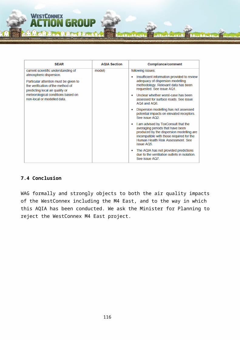
14.0 Objection to the destruction of Sydney’s heritage
WAG objects to large-scale destruction of heritage areas and buildings cited in the M4 East EIS that WestConnex, including the M4 East, will cause.
WestConnex will negatively impact on some of Sydney’s most important heritage sites, which are zoned as Heritage Conservation Areas by the NSW Government and are significant not only to local communities but to all Australians. Many homes and heritage items are slated for demolition in Ashfield and Haberfield as part of WestConnex Stage 1 and the heritage suburbs of Newtown, St. Peters and Enmore will all be hugely impacted by Stage 2 of the proposed project.
Haberfield was designated a State Conservation Area in 1985 and was added to the register of the National Estate in 1991. The M4 East EIS notes that 53 properties within the Haberfield Conservation Area will be demolished, “permanently (removing) a substantial portion of the built heritage items fronting Wattle Street.” This will have a detrimental effect on the heritage value of the area as a whole even before the impacts of the M4 East’s additional traffic, roadways, ventilation outlets and more - all of which will also negatively impact the area’s heritage value - are taken into account.
As Ashfield Council’s heritage consultant noted in their submission to this EIS:
“Haberfield’s gridded layout of development is like a patterned quilt, laid out upon the undulating topography of its broad peninsula landform. Within the pattern, individual squares are worked differently, but coalesce to make the whole.
The Wattle Street interchange, as much as it is possible to be appreciated from its current stage of design development, will create a large hole in the quilt, dismissing the pattern and the squares within it. It is difficult to see how this removal of a structural part of the significant pattern can be acceptably mitigated, to any acceptable degree. A disruptive patch is being sewn in.”
WAG agrees with this assessment.
14.1 Heritage items to be destroyed for the M4 East if built
According to the M4 East EIS, the following listed or potential heritage items will be demolished:
Listed heritage items
● 11 and 23 Sydney Street, Concord, Rare examples of Victorian houses in Canada Bay
116

● 64 Concord Road, Concord, example of transitional Victorian/Federation house
● 9 Wattle Street, Haberfield, an example of John Spencer-Stansfield’s Design No 1
● 19 Wattle Street, Haberfield
● 21 Wattle Street, Haberfield
● 23-25 Wattle Street, Haberfield
● 35 Wattle Street Haberfield
● 37-39 Wattle Street Haberfield
● 41-43 Wattle Street, Haberfield
● 51 Wattle Street, Haberfield
● 53 Wattle Street, Haberfield
● 46 Martin Street, Haberfield
● 164 Ramsey Street Haberfield.
● 92-94 Chandos Street, Haberfield
● 96 Chandos Street Haberfield
Potential heritage items to be demolished:
● 2 Short Street East, Homebush – a fine example of interwar bungalow with Arts and Crafts style details
● 15 Young Street, Concord – an example of a Federation Arts and Crafts style house with unusual decorative pressed metal oriel window apron
● 54C Sydney Street, Concord – an unusual example of an interwar bungalow with Arts and Crafts influences
● 56 Sydney Street, Concord – an example of a Federation bungalow
● 71 Concord Road, Concord – an example of a good intact transitional Federation/interwar bungalow
Properties proposed for demolition within the Haberfield Conservation Area
– 53 houses
– 29 of these contributory to the values of the Conservation Area
– 2 intact tree lined streets – Sydney & Edwards Streets
– Opening the back fences of other houses to the public domain
117
Properties proposed for demolition within the Powells Estate Conservation Area
– 11 dwellings
– 10 of these are contributory to the values of the Conservation Area
– 2 are individually listed Heritage Items
Partial demolition with major consequences
– Wesley Uniting Church, 81 Concord Road
This destruction will result in a permanent scar on the historic fabric of the world’s first garden suburb and also cut off the western corner of the suburb from the rest of this treasured precinct. The EIS states that this proposal will have a major adverse impact on Haberfield and the overall project will have a major cumulative impact on the Haberfield Conservation Area. It does not propose any mitigation or restitution for this loss. (Definition of Major Adverse Impact p 19-11, Table 19-4 EIS Section 1B: “Actions that would have a severe, long-term and possibly irreversible impact on a heritage item. Actions in this category would include partial or complete demolition of a heritage item or addition of new structures in its vicinity that destroy the visual setting of the item. These actions cannot be fully mitigated. ”)
WAG is also deeply concerned that full details of the extent of this destruction were only made public a few months before this EIS was released. Yet contracts may already have been signed and commitments made to commence construction when the full impacts of the development may only be coming to the public attention.
It is also important to note that the M4 East is only one section of WestConnex. If future stages of the project proceed, further heritage areas will be destroyed - including listed items on the site of the proposed St Peters Interchange and the Stage 3 tunnel between Haberfield and St Peters. No consideration is given in this EIS to the cumulative impacts of the heritage destruction WestConnex would cause across Sydney, even though the benefits of the entire WestConnex are repeatedly cited as justification for building the M4 East.
14.2 Concerns raised by National Trust of Australia (NSW)
118

The National Trust raised a number of concerns about heritage destruction in its 2014 submission to the M4 East concept design:
● Over the past fifteen years the Trust has continued to express concern at the heritage impacts of inner urban motorway proposals and has supported mass transport options such as light and heavy rail in preference to inner urban motorways.
● While acknowledging that the increased mobility and affluence of our society and an expanding population require much improved transport facilities, the National Trust opposes further motorways being brought into the inner suburbs and central business district if they threaten areas of historical, architectural, scenic and social importance.
● The National Trust believes that the provisions of public/private partnership agreements for urban motorways should be made public and that such agreements must not contain penalty provisions for compensation payments to a motorway operator if a public transport system competes effectively with the motorway.
● The National Trust would oppose public/private agreements that disadvantage the public who do not choose to use the toll roads constructed under those agreements and believes that massive expenditure on motorway development will divert much needed public and private investment away from public transport development which can move large numbers of people more effectively and with much less adverse heritage impact.
● The constant daily movement of large transport trucks severely degrades the urban environment and the National Trust urges that rail transport should be the preferred means for transporting container goods related to Port Botany and Sydney Airport. The Trust would oppose motorway proposals which promote increased large truck movements through urban precincts, particularly those with heritage significance.
● The National Trust acknowledges that inner city motorway development will be inextricably linked to residential/commercial redevelopment of higher densities in the zones adjoining the
● motorway and consequently, would oppose such development, or elements of that redevelopment when it: –
○ impacts upon, or degrades the values of adjoining, Heritage Conservation Areas
○ involves the demolition of Listed Heritage Items○ involves the demolition of places which have been removed from Heritage
Lists on non heritage-based grounds
119

○ involves the demolition of places which, in the Trust’s view are of indisputable heritage significance, but which have been denied statutory heritage recognition.
The National Trust has had a long history and involvement in campaigning with the community to protect inner urban heritage.
In 1972 the National Trust opposed the North-Western and Western Expressways which would have cut a swathe through Glebe, demolishing 800 homes and the property “Lyndhurst”, to the steps of the Sydney Town Hall.
On 26 February, 2014 the Board of the National Trust of Australia adopted a Policy on the Heritage Impacts of Urban Motorways. This Policy built on and reiterated earlier positions and policy statements including:
● National Trust: Policy Statement on Urban Freeways (1976)
● National Trust Policy on Urban Freeways (1981)
● National Trust Discussion Paper: Towards a Transport Policy for the National Trust (1989)
● National Trust Policy Paper: Transport – The Heritage Implications (1995)
● Trust Alert: Motorway proposals threaten inner city Urban Conservation Areas (2005)
The National Trust also has an extended policy on the heritage impacts of urban motorways. The following excerpt is taken from the 2014 version of this policy:
1. While acknowledging that the increased mobility and affluence of our society and an increasing population require much improved transport facilities, the National Trust will oppose further motorways being brought into the inner suburbs and central business district if they threaten areas of great historical, architectural, scenic and social importance.
2. The National Trust will oppose the loss of public parklands for inner urban motorway construction, including both permanent loss involved with a motorway route/connection ramps or shorter term alienation during the construction phase.
3. The National Trust believes that the provisions of public/private partnership agreements for urban motorways should be made public and that such agreements must not contain penalty provisions for compensation payments to a motorway operator if a public transport system competes effectively with the motorway.
120

4. The National Trust would oppose public/private agreements that disadvantage the public who do not choose to use the toll roads constructed under those agreements.
5. The National Trust believes that massive expenditure on motorway development will divert much needed public and private investment away from public transport development which can move large numbers of people more effectively and with much less adverse heritage impact.
6. The National Trust believes that the constant daily movement of large transport trucks severely degrades the urban environment and will urge that rail transport should be the preferred means for transporting container goods related to Port Botany and Sydney Airport. The Trust would oppose motorway proposals, which promote increased large truck movements through urban precincts, particularly those with heritage significance.
7. The National Trust acknowledges that inner city motorway development will be inextricably linked to residential/commercial redevelopment of higher densities in the zones adjoining the motorway and consequently would oppose such development or elements of that redevelopment when it:● impacts upon or degrades the values of adjoining Heritage Conservation
Areas,● involves the demolition of Listed Heritage Items,
● involves the demolition of places which have been removed from Heritage Lists on non heritage- based grounds,
● involves the demolition of places which, in the Trust’s view are of indisputable heritage significance but which have been denied statutory heritage recognition.
The National Trust’s view is that the heritage impacts of the WestConnex Motorway are severe. WAG agrees with this assessment.
We note that The National Trust also questioned whether the financial commitment for the total project in today’s dollars of $15 billion (inevitably set to rise) would be much better allocated to public transport, which in all its forms (heavy rail, light rail and buses) has much greater potential to remove motor vehicles from roadways, reducing traffic congestion. Again, WAG agrees with this.
14.3 Conclusion
WAG formally and strongly objects to large-scale destruction of heritage areas and buildings cited in the M4 East EIS that WestConnex, including the M4 East, will cause.
121

WAG also formally and strongly objects to the destruction of Sydney’s overall heritage that will be caused by WestConnex, including the M4 East, if it is built.
We ask the Minister for Planning to reject the WestConnex M4 East project.
122