3.2 land use, planning, and growth · 3.2 land use, planning, ... open space is the predominant...
TRANSCRIPT

Chapter 3 Affected Environment, Consequences, Avoidance, Minimization, and/or Mitigation Measures
HIGHWAY 101 HOV LANE WIDENING PROJECT: PETALUMA TO ROHNERT PARK 3-25 ENVIRONMENTAL ASSESSMENT/FINAL ENVIRONMENTAL IMPACT REPORT
3.2 Land Use, Planning, and Growth
3.2.1 Existing and Future Land Use
3.2.1.1 AFFECTED ENVIRONMENT
Existing land uses in the vicinity of the Highway 101 HOV Lane Widening Project are primarily rural and agricultural, with single- and multi-family residential, commercial and industrial land uses near city centers. These land uses are described from south to north below and shown in Figure 3.2-1.
In the southern segment of the Highway 101 corridor, from the southern project limit to the Highway 101/Petaluma Boulevard–Old Redwood Highway Interchange in Petaluma, existing land use is mostly commercial. The Petaluma Auto Mall is located southwest of the interchange.
Open space is the predominant land use between the Highway 101/Petaluma Boulevard–Old Redwood Highway and Highway 101/West Railroad Avenue interchanges. Residential and commercial uses are on both sides of Highway 101, north of Petaluma Boulevard. A golf driving range and a Quality Inn Motel are located northwest and northeast of the Highway 101/Petaluma Boulevard—Old Redwood Highway Interchange, respectively. The Leisure Lake Mobile Home Park is located adjacent to and west of Highway 101, north of the driving range.
Agricultural uses and single-family residential properties are located along both sides of Highway 101 between West Railroad Avenue and the Highway 101/West Sierra Avenue Interchange. The Sierra Mobile Home Park is located southeast of the Highway 101/West Sierra Avenue Interchange.
Single-family residences predominate between West Sierra Avenue and Gravenstein Highway (SR 116). Light industrial uses are located northwest of the Highway 101/West Sierra Avenue Interchange. A park-and-ride lot is located southeast of the Highway 101/SR 116 Interchange.
On the west side of Highway 101, between SR 116 and the northern project limit at Rohnert Park Expressway, land uses are predominately commercial and industrial. Single-family residential uses predominate on the east side of the highway. The Rancho Feliz Mobile Home Community and a park-and-ride lot are located southwest of the Highway 101/Rohnert Park Expressway Interchange. The Rohnert Park City Hall is located southeast of the interchange. A new park-and-ride lot is currently under construction in the northeast quadrant of the interchange.
3.2.1.2 DEVELOPABLE LAND AND DEVELOPMENT TRENDS
Based on the Association of Bay Area Government’s (ABAG) Projections 2005, Sonoma County is expected to gain over 40,000 households between 2000 and 2030. The City of Petaluma is projected to have the second highest growth rate in Sonoma County, adding 4,898 households during this period. The City of Cotati is expected to add approximately 888 households between 2000 and 2030. The City of Rohnert Park is projected to add approximately 2,567 households over the same period.

SONOMA MOUNTAIN PKWY.
EAST RAILROAD AVE.
ADOBE RD.
CORO
NA
SKILLMAN LN.
RAINSVILLE RD.
PE
TALU
MA
HIL
LR
D.
EXWY.
STONY POINT RD.
EAST COTATI
AVE.
N. McDOWELL BLVD.
PETALUMABLVD.
PEPPER RD.
BODEGA
AVE.
MEC
HAM
RD
.
RE
DW
OO
D
LIB
ER
TYRD
.
W.
W. SIERRA
JEW
ETT
RD
.
OLD
REDWOOD HWY.
HWY.D
R.
N.W
.P.P
.R.
BLV
D.
PARK
ROHNERT
N.
AVE.
Rohnert Park
KIN
GR
D.
SN
YDE
RLN
.
GRAVENSTEIN
RAINSVILLE RD.
RAILROAD A
VE.
W. SIERRA
OLDAVE.
LN.
BLVD.
SOUTHW STE
RD.
Cotati
Petaluma
CO
MM
ER
CE
116
NNot to Scale
EXISTING LAND USEFigure 3.2-1
SONOMA MOUNTAIN PKWY.
EAST RAILROAD AVE.
ADOBE RD.
CORO
NA
SKILLMAN LN.
RAINSVILLE RD.
PE
TALU
MA
HIL
LR
D.
EXWY.
STONY POINT RD.
EAST COTATI
AVE.
N. McDOWELL BLVD.
PETALUMABLVD.
PEPPER RD.
BODEGA
AVE.
MEC
HAM
RD
.
RE
DW
OO
D
LIB
ER
TYRD
.
W.
W. SIERRA
JEW
ETT
RD
.
OLD
REDWOOD HWY.
HWY.D
R.
N.W
.P.P
.R.
BLV
D.
PARK
ROHNERT
N.
AVE.
KIN
GR
D.
SN
YDE
RLN
.
GRAVENSTEIN
RAINSVILLE RD.
RAILROAD A
VE.
W. SIERRA
OLDAVE.
LN.
BLVD.
SOUTHW STE
RD.
Cotati
Petaluma
CO
MM
ER
CE
116
Legend:Residential
Commercial
Industrial
Institutional
Agriculture City BoundaryRailroad
Mixed Use
Parks/Open Spaces Study Area
S C T AS C T A Highway 101 HOV Lane Widening Project:Old Redwood Highway, Petaluma to Rohnert Park Expressway, Rohnert Park
3-26

Chapter 3 Affected Environment, Consequences, Avoidance, Minimization, and/or Mitigation Measures
HIGHWAY 101 HOV LANE WIDENING PROJECT: PETALUMA TO ROHNERT PARK 3-27 ENVIRONMENTAL ASSESSMENT/FINAL ENVIRONMENTAL IMPACT REPORT
The City of Petaluma General Plan: 1987-2005, adopted in March 1987, projected 16,831 dwelling units in 1990. Nearly 80 percent of the dwellings were single-family units (including mobile homes), with approximately 20 percent in multi-family developments. Buildout, according to the General Plan, of commercial and office, industrial, and public space sites (schools, parks and agricultural land) within the City of Petaluma would result in approximately 600,000 square meters (m2) [6.5 million square feet (ft2)] of commercial and office uses, 2.2 million m2 (23.7 million ft2) of industrial uses and 1.9 million m2 (20.6 million ft2) of public uses.
The City of Cotati General Plan projects approximately 800 new housing units within the city limits, for a total residential capacity of about 3,200 housing units in 2010. Approximately 55 percent of new housing units would be in multi-family developments with the remaining 45 percent being in single-family or mobile home developments. The General Plan also shows that buildout of commercial, residential, industrial, public facilities, and rural and vacant lands within the city limits would result in approximately 497,606 m2 (11 million ft2) of commercial uses, 1.6 million m2 (17.7 million ft2) of residential uses, 313,918 m2 (3.4 million ft2) of industrial uses, 250,907 m2 (2.7 million ft2) of public facilities use and 1.7 million m2 (18 million ft2) of rural and vacant lands.
The City of Rohnert Park General Plan projects a total residential development capacity of approximately 19,990 housing units at buildout. The General Plan indicates that buildout of commercial, office, industrial and park/open space sites within the City of Rohnert Park would result in approximately 404,690 m2 (4.4 million ft2) of commercial uses, 708,200 m2 (7.6 million ft2) of industrial uses, 121,400 m2 (1.3 million ft2) of office uses and 768,900 m2 (8.3 million ft2) of park/open space uses.
3.2.1.3 MAJOR APPROVED AND ACTIVE PROJECTS
Major approved and active projects in the cities of Petaluma, Cotati and Rohnert Park are listed in Table 3.2-1 and shown in Figure 3.2-2. Approximately 35 projects, including residential, commercial, office, and industrial are under construction, approved or pending approval. The majority of these projects are located in the City of Cotati, east of Highway 101 and west of Old Redwood Highway.

Chapter 3 Affected Environment, Consequences, Avoidance, Minimization, and/or Mitigation Measures
3-28 HIGHWAY 101 HOV LANE WIDENING PROJECT: PETALUMA TO ROHNERT PARK ENVIRONMENTAL ASSESSMENT/FINAL ENVIRONMENTAL IMPACT REPORT
Table 3.2-1: Major Approved and Active Projects in the Study Area
No. Project Name Address Approved
hectares/acres Approved Use Project Status Sonoma County (August 2007)
1 Stony Point Road Stage 5A Stony Point Road between Rainsville Road and Pepper Road N/A Transportation Completed
City of Petaluma (August 2007)
2 Petaluma Village Marketplace 2200 Petaluma Boulevard North 2.27 / 5.60 Commercial Certified Environmental
Document
3 The Redwood Technology Center
Old Redwood Highway and North McDowell Boulevard 5.83 / 14.40 Office Application Received for
Site Plan Changes
4 101 Casino 5151 Montero Way 0.13 / 0.33 Commercial Application Submitted 10/26/04
5 Traditions/Turnbridge Maria Drive and Sonoma Mountain Parkway 2.72 / 6.72 Residential Under Construction
City of Cotati (August 2007) 6 Twin Creeks Subdivision 8691 Water Road (Cervantes Court) 1.99 / 4.92 Residential Under Construction
7 Cypress Meadows Subdivision 8780 Cypress Avenue 1.91 / 4.71 Residential Nearing Completion
8 Durenberger Subdivision 8028 Gravenstein Highway 3.84 / 9.50 Residential/ Commercial
Tentative Map Approval Extension
9 Willowglen 789 East Cotati Avenue 0.40 / 1.00 Residential Nearing Completion
10 Heritage Gardens 251 & 203 East Cotati Avenue 1.66 / 4.10 Residential Completed
11 Ristad Subdivision 193 Eucalyptus Avenue 0.37 / 0.92 Residential Final Subdivision Map Approval Pending
12 Cotati Cottages 7510 Alder Avenue 1.29 / 3.20 Residential Completed
13 Gilman Subdivision 850 West Cotati Avenue N/A Residential Nearing Completion
14 Rancho Cotate Shopping Center 500 East Cotati Avenue 0.11 / 0.33 Commercial Completed
15 Park Village Subdivision Santero Way (west side) 0.51 / 1.27 Residential Completed
16 Cotati Courtyard Subdivision 910 East Cotati Avenue 0.48 / 1.18 Residential Final Design Review
Pending
17 Long / Moore 526 Portal Street 0.06 / 0.16 Industrial/ Office Permits Pending
18 Miller / Leys East Cotati Avenue and Ryan Lane 0.24 / 0.30 Residential Final Map Approval Pending
19 Village Park Subdivision, Phase 1B Santero Way (east side) 0.51 / 1.27 Residential Permits Pending
20 The Marketplace at Cotati Commons
Gravenstein Highway at Redwood Drive 9.31 / 23.00 Commercial Nearing Completion
21 Blom / Matulich for Norcal Geophysical 321 Blodgett Street 0.07 / 0.18 Industrial/
Office Permits Issued
22 P & L Specialties 373 Blodgett Street 0.21 / 0.52 Industrial Nearing Completion
23 Lasker Knolls 65 Lasker Lane 0.73 / 1.81 Residential Final Design Review Pending
24 Kandy Industrial Building 369 Blodgett Street 0.42 / 1.03 Industrial Final Design Review Pending
25 Cotati Meadows 343 East School Street N/A Residential In Planning
26 Santero Court Partners 690 East Cotati Avenue 1.57 / 3.88 Residential Final Design Review Pending

Chapter 3 Affected Environment, Consequences, Avoidance, Minimization, and/or Mitigation Measures
HIGHWAY 101 HOV LANE WIDENING PROJECT: PETALUMA TO ROHNERT PARK 3-29 ENVIRONMENTAL ASSESSMENT/FINAL ENVIRONMENTAL IMPACT REPORT
Table 3.2-1: Major Approved and Active Projects in the Study Area
No. Project Name Address Approved
hectares/acres Approved Use Project Status
27 The Village at Cotati Commons
Gravenstein Highway at Alder Avenue N/A Residential/
Office Final Design Review
Pending 28 Habitat for Humanity 20 Woodland Hills Drive 0.30 / 0.75 Residential In Planning
City of Rohnert Park (April 2007)
29 Creekwood Apartments/ Self Storage
Commerce Boulevard at Professional Center Drive N/A Commercial/
Residential Completed
30 Marchisiello Office-to-Apartment Conversion 6920 Commerce Boulevard N/A Residential Under Construction
31 Redwood Creek Apartments
Rohnert Park Expressway at Labath Avenue N/A Residential Under Construction
32 The Arbors Mixed-Use Project City Hall Drive N/A Residential/
Commercial Approved – No Building
Permits Applied For 33 City Center Townhomes State Farm Drive at Padre Parkway N/A Residential Nearing Completion
34 Expressway Marketplace Pad Building 565 Rohnert Park Expressway 0.04 / 0.11 Commercial Under Construction
35 Radius Development Group Project
Commerce Boulevard and Rohnert Park Expressway 0.24 / 0.60 Commercial Under Construction
Sources: Sonoma County Public Works Department, August 2007 City of Petaluma Community Development Department, August 2007 City of Cotati Planning and Building Department, December 2004 City of Rohnert Park Planning Department, August 2007

SONOMA MOUNTAIN PKWY.
EAST RAILROAD AVE.
ADOBE RD.
CORO
NA
SKILLMAN LN.
RAINSVILLE RD.
PE
TALU
MA
HIL
LR
D.
EXWY.
STONY POINT RD.
E. COTATI AVE.
N. McDOWELL BLVD.
PETALUMABLVD.
PEPPER RD.
BODEGA
AVE.
MEC
HAM
RD
.
RE
DW
OO
D
LIB
ER
TYRD
.
W.
W. SIERRA
JEW
ETT
RD
.
OLD
REDWOOD HWY.
HWY.
DR
.
N.W
.P.P
.R.
BLV
D.
PARK
ROHNERT
N.
AVE.
CO
MM
ER
CE
Rohnert Park
Cotati
KIN
GR
D.
SN
YDE
RLN
.
GRAVENSTEIN
RAINSVILLE RD.
RAILROAD A
VE.
W. SIERRA
OLDAVE.
LN.
RD.
SOUTHW STE
BLVD.
Petaluma
SONOMACOUNTY
116
NNot to Scale
MAJOR APPROVED AND ACTIVE DEVELOPMENTS IN THE PROJECT AREA
Figure 3.2-2
S C T AS C T A Highway 101 HOV Lane Widening Project:Old Redwood Highway, Petaluma to Rohnert Park Expressway, Rohnert Park
2
7
23
5
6
4 3
1
138
293332
2510
9
28
17
353134
12
21, 22, 2430
14
11
27 20
26 15, 1916
18
Legend:
RailroadCity Boundary 5 Projects Listed in Table 3.2-1
3-30

Chapter 3 Affected Environment, Consequences, Avoidance, Minimization, and/or Mitigation Measures
HIGHWAY 101 HOV LANE WIDENING PROJECT: PETALUMA TO ROHNERT PARK 3-31 ENVIRONMENTAL ASSESSMENT/FINAL ENVIRONMENTAL IMPACT REPORT
3.2.1.4 ENVIRONMENTAL CONSEQUENCES
Under the Build Alternative, land use changes would be associated with the acquisition of property for modifications to existing transportation facilities and construction of new facilities. There are two options under consideration for interchange improvements at the Highway 101/SR 116 Interchange, both of which require the same land use changes. The proposed project would convert approximately 1.49 ha (3.67 ac) of land to transportation use. Land use changes anticipated as a result of the Build Alternative (Options A and B) is provided in Table 3.2-2 below.
Within Sonoma County, land use changes would convert 0.0007 percent of the County’s agricultural land to transportation use. Land use changes in the City of Petaluma would convert 0.1 percent of the city’s total commercial land to transportation use. In the City of Cotati, the proposed project would convert 0.4 percent of the total governmental land (vacant), 0.3 percent of the total commercial land, and 0.2 percent of the total residential land to transportation use.
Table 3.2-2: Estimated Land Use Changes Anticipated as a Result of the Build Alternative (Options A and B)
Total Area Converted Land Use Converted
hectares (ha) acres (ac) Agriculture to Transportation 0.44 1.08 Vacant or Other to Transportation 0.07 0.17 Commercial to Transportation 0.61 1.51 Residential to Transportation 0.37 0.91 Total 1.49 3.67 Source: Parsons 2005
3.2.1.5 AVOIDANCE, MINIMIZATION AND/OR MITIGATION MEASURES
Compensation would be provided for land use impacts as a result of residential and nonresidential relocations as described in Section 3.4.3, Relocations. Project effects on agricultural land and proposed mitigation measures are described in Section 3.3, Farmlands/Agricultural Lands.
3.2.2 Consistency with Regional and Local Plans Planning goals and policies for the study area are guided by the Sonoma County General Plan 1989, the Sonoma County Comprehensive Transportation Plan for 2004, the City of Petaluma General Plan, the City of Cotati General Plan and the City of Rohnert Park General Plan.
3.2.2.1 AFFECTED ENVIRONMENT
Sonoma County General Plan (1989). Primary goals of the Land Use Element of the Sonoma County General Plan (1989) are to coordinate land use with growth projections, the phasing of rural and urban growth with availability of adequate services, open space separation between
Chapter 3 Affected Environment, Consequences, Avoidance, Minimization, and/or Mitigation Measures
3-32 HIGHWAY 101 HOV LANE WIDENING PROJECT: PETALUMA TO ROHNERT PARK ENVIRONMENTAL ASSESSMENT/FINAL ENVIRONMENTAL IMPACT REPORT
cities/communities, opportunities for diverse rural and urban residential environments, the protection of agricultural lands and the preservation of scenic features and biotic resource areas. The Sonoma County General Plan (2020), currently in process, will also contain the policies identified above.
Sonoma County Comprehensive Transportation Plan for 2004. The primary goal of the Sonoma County Comprehensive Transportation Plan for 2004 is to provide a well-integrated circulation system that supports “smart” growth principles and a city-centered growth philosophy, through a collaborative effort of all the cities and the County. Primary objectives to obtain this goal include:
• Focus commute and through traffic onto Highway 101 and designate major arterial routes to serve primarily as connectors between urban areas, and
• Provide east/west connectivity within each community, including interchange improvements and to improve access to Highway 101.
City of Petaluma General Plan: 1987-2005. Land use objectives in the City of Petaluma General Plan: 1987-2005 are to promote architectural and socioeconomic diversity within residential areas and to establish a realistic ratio between east side and west side growth. Policies set forth by the General Plan to obtain these objectives include:
• The City’s growth management system shall be updated and revised from time-to-time; • The City would not guarantee that any individual project will be able to achieve the maximum
densities shown on the Land Use Map; • Those parcels that are undevelopable shall continue to be identified and so designated on the
City’s plans; • Minimizing the impacts of future airport development on nearby residential areas; • Improving traffic flow; and • Long-range planning for needed roads and infrastructure.
The following transportation policies in the City of Petaluma General Plan are relevant to the proposed project:
• Monitoring regional developments and their effect on Highway 101 and on Petaluma; and • Maintaining an active role in the Highway 101 Corridor planning program with the purpose of
assuring that the improvements eventually provided will enhance intra-city movement in Petaluma.
City of Cotati General Plan. The overall land use goal, as put forth by the City of Cotati General Plan, adopted in June 1998, is to establish an efficient and environmentally sensitive land use pattern that provides adequate space to meet housing and economic needs while maintaining Cotati’s small town image. Objectives for meeting this goal include:
• Requiring all infrastructure improvements to occur concurrently with development; • Not allowing new growth to exceed the City’s ability to provide necessary public service;

Chapter 3 Affected Environment, Consequences, Avoidance, Minimization, and/or Mitigation Measures
HIGHWAY 101 HOV LANE WIDENING PROJECT: PETALUMA TO ROHNERT PARK 3-33 ENVIRONMENTAL ASSESSMENT/FINAL ENVIRONMENTAL IMPACT REPORT
• Developing a system of transportation facilities and services that provides safe and efficient access to all parts of the city;
• Providing convenient and safe movement within the city by establishing a traffic-way system in which the function and design of each street is consistent with the character and use of adjacent land;
• Identifying the areas where future development should occur; and • Providing a network of open space or neighborhoods, to preserve the small town identity, visual
amenities, and insure public safety.
The following transportation-related policy in the city of Cotati General Plan is relevant to the proposed project.
• Highest priority shall be given for improvements at the Highway 101/SR 116 Interchange to help reduce traffic congestion.
City of Rohnert Park General Plan. As stated in the City of Rohnert Park General Plan, July 2000, the overall land use goals for the City of Rohnert Park include;
• Increased connectivity between and within neighborhoods; • Developing a comprehensive transportation demand management program that preserves Rohnert
Park’s quality of life, while maintaining a positive business environment; • Reducing peak-hour traffic congestion and associated impacts, including air pollution, energy
consumption, and noise; • Providing for concentrations of activity and mixed-use and pedestrian-oriented development; • Maintaining mobility and reduce traffic in congested locations; • Improving connections between different parts of the city; • Maintaining land use patterns that maximize residents’ accessibility to parks, open space, and
neighborhood shopping centers, and; • Maintaining efficient land use patterns and ensuring that infill development maintains the scale
and character of established neighborhoods.
Three transportation policies as set forth by the City of Rohnert Park General Plan are pertinent to the proposed project, as follows:
• Encouraging Caltrans, MTC, and SCTA to plan, fund, and implement HOV lanes along Highway 101 between Santa Rosa Avenue and SR 116;
• Working with Caltrans to coordinate widening projects, interchange improvements, and other improvements along Highway 101; and
• Encouraging Caltrans, in cooperation with the City of Cotati, to relocate the northbound on-ramp at the Highway 101/SR 116 Interchange.

Chapter 3 Affected Environment, Consequences, Avoidance, Minimization, and/or Mitigation Measures
3-34 HIGHWAY 101 HOV LANE WIDENING PROJECT: PETALUMA TO ROHNERT PARK ENVIRONMENTAL ASSESSMENT/FINAL ENVIRONMENTAL IMPACT REPORT
3.2.2.2 ENVIRONMENTAL CONSEQUENCES
The proposed project would be consistent with local planning goals and policies and local jurisdictions’ stated objectives for adding HOV lanes and making interchange improvements along the Highway 101 corridor. The No-Build Alternative would not support achievement of these goals.
3.2.3 Growth Inducement and Other Indirect Effects
3.2.3.1 REGULATORY SETTING
The California Environmental Quality Act (CEQA) specifically requires that analysis and discussion of the growth inducing impacts of the project be included as part of an Environmental Impact Report. The National Environmental Policy Act (NEPA) requires consideration of indirect effects in environmental review. Indirect effects are defined as effects caused by the project and occurring later in time or farther removed in distance, but still reasonably foreseeable. Indirect effects may include growth-inducing effects and other effects related to changes in the pattern of land use, population density, or growth rate, and related effects on air and water and other natural systems, including ecosystems (40 CFR 1508.8).
3.2.3.2 AFFECTED ENVIRONMENT
The growth inducement and indirect effect assessment examines the relationship of the project to economic and population growth and the construction of additional housing in the project area. It focuses on the potential for a project to facilitate or accelerate growth beyond planned developments, or induce growth to shift from elsewhere in the region and addresses the following three sets of questions:
1. What is the reasonably foreseeable growth and land use change without the project? What is it with the project?
2. To what extent will the project influence the overall amount, type, location, or timing of that growth?
3. Will project-related growth put pressure on or cause impacts to environmental resources of concern?
The mechanism by which the proposed project would affect growth would be the region’s response to travel time savings during peak commute hours achieved with the project. In the present analysis, the project’s influence on area growth and other indirect effects due to travel time savings is considered within the context of other relevant factors such as the relative cost and availability of housing, availability of amenities, local and regional growth policies, and development constraints. The information presented in this section is taken from the technical report, Growth Inducement Study for Highway 101 HOV Lane Widening and Improvements Project: Old Redwood Highway, Petaluma to Rohnert Park Expressway, Rohnert Park (Parsons 2005).

Chapter 3 Affected Environment, Consequences, Avoidance, Minimization, and/or Mitigation Measures
HIGHWAY 101 HOV LANE WIDENING PROJECT: PETALUMA TO ROHNERT PARK 3-35 ENVIRONMENTAL ASSESSMENT/FINAL ENVIRONMENTAL IMPACT REPORT
County Commute Patterns Santa Rosa is the main regional employment center in Sonoma County. While there are many more jobs in Marin County, San Francisco, and rest of the Bay Area, these employment locations are far enough away from Sonoma County residential areas that Santa Rosa dominates the county’s employment market. According to 2000 Census Journey to Work Tables, 82 percent of Sonoma residents work within the county. Only about eight percent of the work force commutes to Marin County and about four percent commutes to San Francisco. Thus, the majority of Sonoma County commute trips are within the county. Commuter traffic contributes to vehicle volumes exceeding capacity, resulting in severe congestion and increased travel times along Highway 101 through the project area, mostly during peak hours. The heavy traffic and delays on Highway 101 also lead to traffic spill-over onto local streets, which affects the quality of life in communities along the highway. These traffic issues would tend to constrain development and growth, particularly for the more remote areas in the northern portion of the county.
Because the Highway 101 HOV Lane Widening Project would improve traffic conditions and travel times through the project area and vicinity, it would potentially remove this constraint on future growth or change the growth rate or location of growth. The growth inducement analysis evaluated whether the proposed project, individually or when combined with the other HOV lane widening projects in the Highway 101 corridor (see Section 1.3.3, Related Projects), would support or lead to unplanned growth. The growth inducing effect of the project on development in sample residential growth areas throughout the Highway 101 corridor was estimated by quantifying project-induced reductions in travel time (enhanced accessibility) to Bay Area employment from the sample residential growth areas. The enhanced accessibility was then evaluated in context of other factors influencing growth pressures in the sample areas, such as local and regional growth policies, growth constraints, the relative costs and availability of housing, and amenities available in the selected residential areas.
Expected Growth and Land Use Change The Association of Bay Area Governments (ABAG) is the regional agency with responsibility for defining and projecting land use in the San Francisco Bay Area. ABAG’s Projections 2003 define the current land use and expected future regional land use and growth for the region, including the Highway 101 corridor that is the focus of this analysis. The Metropolitan Transportation Commission (MTC) develops corresponding regional travel projections. While not specific to particular transportation improvement projects, ABAG’s projections generally assume a dynamic transportation environment in which the regional transportation network is adequate to maintain the economic vitality of the Bay Area. The projections generally balance the growth plans of the local jurisdictions with the expected economic and demographic trends of the region. MTC’s travel projections, on the other hand, are based on specific assumptions about transportation improvements. These two sets of regional projections are used throughout this document, for example, as the basis for the corridor traffic projections in Section 3.1. Traffic and Transportation, and for the cumulative impacts analysis in Chapter 4, Cumulative Impacts, as well as the basis for this analysis of growth and other indirect effects.

Chapter 3 Affected Environment, Consequences, Avoidance, Minimization, and/or Mitigation Measures
3-36 HIGHWAY 101 HOV LANE WIDENING PROJECT: PETALUMA TO ROHNERT PARK ENVIRONMENTAL ASSESSMENT/FINAL ENVIRONMENTAL IMPACT REPORT
Because ABAG’s Projections 2003 do not specifically include the proposed project, they define the reasonably foreseeable growth and land use change in the corridor without the project. See Chapter 3 of the Growth Inducement Study for Highway 101 HOV Lane Widening and Improvements Project: Old Redwood Highway, Petaluma to Rohnert Park Expressway, Rohnert Park (Parsons 2005) for population and job projections by corridor jurisdictions. The following section considers the other questions outlined above, including whether the proposed project would cause reasonably foreseeable changes in these land use and growth projections.
3.2.3.3 ENVIRONMENTAL CONSEQUENCES
Eight residential locations as shown in Figure 3.2-3 were selected for testing the growth inducement and other indirect effects of the project. These residential locations included the communities of Healdsburg, Windsor, Santa Rosa, Sebastopol, Rohnert Park, Cotati, Penngrove and Petaluma. All of the Highway 101 corridor communities included in the growth inducement/indirect effects study are planning for growth, with increases from 16 percent to 43 percent (ABAG Projections 2003) in population projected by 2030; see Section 3.2.1.2, Developable Land and Development Trends.
Travel time savings that would be obtained with the Build Alternative, from Rohnert Park Expressway to Petaluma Boulevard South, are described in Section 3.1.2.4, 2030 Peak Hour Traffic Conditions under the Build Alternative, ‘Travel Time’. Travel time savings would vary from five minutes to ten minutes, depending on direction and peak period. The travel time savings for trips between the eight residential zones and ten employment zones would vary from less than one minute to about eight minutes, depending on particular trip ends. Travel time savings for commuters from the selected residential areas to/from jobs in Sonoma County would vary from less than one minute to five minutes, while travel time savings to/from jobs in the rest of the Bay Area would vary from one minute to eight minutes.
The amount of travel time savings for trips within the county, from one to five minutes, although real and important, would reduce door-to-door work trip times by an average of only four percent. Also, providing HOV lanes would not solve all of Highway 101’s congestion problems. Even with the proposed project, some highway congestion would remain and would gradually build over time (see Section 3.1, Traffic and Transportation). Hence, while the proposed project would be very essential to support the planned growth in the area, it would not even fully accommodate planned growth, let alone induce unplanned growth.
The results of the growth inducement analysis of the changes in accessibility to jobs showed a very slight increase in growth pressure (less than half a percent change in the growth indices) due to the travel time savings in Santa Rosa, Sebastopol, Rohnert Park and Cotati. However, an increase of less than half a percent in these residential areas is negligibly small.
Other factors in addition to traffic conditions also influence the climate for growth. All four communities mentioned above plan to control the location and amount of growth in their community. For example, the City of Rohnert Park plans to adopt a growth management plan that includes components such as an average approximately one percent annual population growth rate. The City

Chapter 3 Affected Environment, Consequences, Avoidance, Minimization, and/or Mitigation Measures
HIGHWAY 101 HOV LANE WIDENING PROJECT: PETALUMA TO ROHNERT PARK 3-37 ENVIRONMENTAL ASSESSMENT/FINAL ENVIRONMENTAL IMPACT REPORT
of Santa Rosa has set urban growth boundaries to prevent urban sprawl. These types of actions would ensure that the proposed project would not stimulate unplanned growth.
Figure 3.2-3: Residential Areas Studied for Growth Inducement and Other Indirect Effects of the Project
Other primary factors that affect population growth pressures in outlying residential communities, in addition to commute time and growth plans of the residential areas, include the cost and availability of housing. Vacancy rate is defined as the percentage of total unoccupied housing units, which are either for sale or for rent. It provides a quantifiable measurement of housing demand. An overall vacancy rate of four to five percent indicates a healthy balance of supply and demand in the housing market. (See Section 3.4.3.2, Affected Environmental (Housing/Businesses) for more information on vacancy rates.) The housing vacancy rate for the four areas that could be affected by the proposed project varies between 0.7 and 1.2 percent, which indicates that the demand for housing in these residential areas is much higher than the available housing supply. High demand and low supply implies high housing costs, which are typical of Bay Area communities. High housing costs tend to act as growth deterrents that would outweigh minor travel time savings. Likewise, the time savings are too small to be an incentive for additional commercial or other job growth.
In summary, growth management policies, as well as moderately high housing prices in those areas where commuters would realize the greatest potential travel time savings, when compared to other study areas and the rest of Sonoma County, would tend to discourage accelerated residential growth,

Chapter 3 Affected Environment, Consequences, Avoidance, Minimization, and/or Mitigation Measures
3-38 HIGHWAY 101 HOV LANE WIDENING PROJECT: PETALUMA TO ROHNERT PARK ENVIRONMENTAL ASSESSMENT/FINAL ENVIRONMENTAL IMPACT REPORT
even with the improved travel times. The growth inducement study concluded that the Highway 101 HOV Lane Widening Project would support planned growth, but not induce unplanned growth in the area.
Because the change in growth pressures with the proposed project would be negligibly small, there would be no reasonably foreseeable change in the growth and land use for the corridor as compared with the baseline Projections 2003 from ABAG. The overall amount, type, location, or timing of the growth is expected to be the same with and without the project. Finally, because the project is not expected to influence growth, it would not put pressure on or cause growth-related indirect impacts to environmental resources of concern. The cumulative effects of the proposed project on specific environmental resources of concern are addressed in Chapter 4, Cumulative Impacts.
3.3 Farmlands/Agricultural Lands
3.3.1 Regulatory Setting
3.3.1.1 FARMLAND PROTECTION POLICY ACT
The Farmland Protection Policy Act (7 Code of Federal Regulations (CFR) Ch. VI Part 658) requires federal agencies to take into account the adverse effects of their projects on farmlands, in part, by requiring an inventory, description, and classification of affected farmlands as well as early consultation with the Natural Resources Conservation Service (NRCS) and processing of Form NRCS – Conservation Planning Application (CPA)-106 (Farmland Conversion Impact Rating Form).
Farmland means prime or unique farmlands as defined in Section 1540(c)(1) of the Act or farmland that is determined by the appropriate state or unit of local government agency or agencies with concurrence of the U.S. Secretary of Agriculture to be farmland of statewide or local importance.
3.3.1.2 WILLIAMSON ACT
Known formally as the California Land Conservation Act of 1965, the Williamson Act (California Government Code Section 51291) was designed as an incentive to retain prime agricultural land and open space in agricultural use, thereby slowing its conversion to urban and suburban development. The program entails a 10-year contract between the city and an owner of land whereby land kept in agricultural use is taxed on the basis of its agricultural use rather than its market value. Notification provisions of the Act require an agency to notify the Director of the California Department of Conservation of the possible acquisition of Williamson Act contracted land for a public improvement. The local governing body responsible for the administration of the agricultural preserve must also be notified.

Chapter 3 Affected Environment, Consequences, Avoidance, Minimization, and/or Mitigation Measures
HIGHWAY 101 HOV LANE WIDENING PROJECT: PETALUMA TO ROHNERT PARK 3-39 ENVIRONMENTAL ASSESSMENT/FINAL ENVIRONMENTAL IMPACT REPORT
3.3.1.3 SONOMA COUNTY GENERAL PLAN
The main agricultural goal for Sonoma County is to promote a healthy and competitive agricultural industry whose products are recognized as being produced in Sonoma County. Agricultural lands are predominantly in the unincorporated areas of the county. Within the project area, agricultural resources are primarily located from just north of Petaluma to south of Cotati.
3.3.1.4 CITY OF PETALUMA GENERAL PLAN
The City of Petaluma General Plan’s agricultural goal is to preserve and protect agricultural use on lands surrounding the City of Petaluma. Almost all the remaining agricultural land in the City of Petaluma is located in the northwest region of the city and adjacent to Sonoma County farmlands.
3.3.1.5 CITY OF COTATI GENERAL PLAN
Agricultural goals and policies as stated in the City of Cotati General Plan aim to preserve agricultural use on lands designated as rural by the City of Cotati land use map. The agricultural lands in the City of Cotati are located mostly in the western and southern sections of the city.
3.3.1.6 CITY OF ROHNERT PARK GENERAL PLAN
The City of Rohnert Park General Plan’s primary agricultural goal is to minimize conflicts between the agricultural areas in unincorporated Sonoma County and urban uses in the City of Rohnert Park. Agricultural lands are located to the east and north of the City of Rohnert Park.
3.3.2 Affected Environment
Existing land uses along the Highway 101 corridor are predominately rural, as described in Section 3.2, Land Use Characteristics. Agricultural resources in the project area are located along both sides of Highway 101 between just north of Petaluma and south of Cotati.
3.3.3 Environmental Consequences
No-Build Alternative. Under the No-Build Alternative, no right-of-way would be acquired for transportation facilities within the study area; therefore, no farmland would be affected.
Build Alternative. The Build Alternative would require approximately 0.44 hectares (ha) (1.08 acres [ac]) of farmland for the HOV widening. Affected farmland would account for approximately 0.0007 percent of the total farmland in the county. The locations, Williamson Act status, and size of the affected parcels are summarized in Table 3.3-1.

Chapter 3 Affected Environment, Consequences, Avoidance, Minimization, and/or Mitigation Measures
3-40 HIGHWAY 101 HOV LANE WIDENING PROJECT: PETALUMA TO ROHNERT PARK ENVIRONMENTAL ASSESSMENT/FINAL ENVIRONMENTAL IMPACT REPORT
Table 3.3-1: Farmland Impacts with the Build Alternative
APN# Location (kilopost) Williamson Act Contract Farmland Impact
(Hectares/Acres) 113-150-014 ±17.71(PM 10.99) No 0.36 ha / 0.89 ac 113-150-012 ±17.71(PM 10.99) Yes 0.08 ha / 0.19 ac
TOTAL 0.44 ha / 1.08 ac Source: Parsons 2004, Sonoma County Assessor’s Office.
In compliance with the Farmland Protection Policy Act, Parts I and III of Form NRCS-CPA-106 and maps for the proposed project were submitted to the NRCS for its determination of whether any part of the agricultural property that would be acquired for the project site is farmland subject to the Act. The NRCS review and completion on July 11, 2005 of Parts II, IV, and V of the form, indicates that the proposed project would acquire approximately 0.44 ha (1.08 ac) of statewide and local important farmland. This represents approximately 0.0007 percent of the total farmland subject to the Act in Sonoma County.
The total assessment criteria score for the farmland sites is 107. Based on federal regulation 7 CFR 658.4, sites receiving a total score of less than 160 points shall be given a minimal level of consideration for protection and no additional sites need be evaluated. Sites receiving a total score of 160 or greater, however, shall be given stronger consideration for protection including the evaluation of alternate sites, locations, and/or designs. The Farmland Conversion Impact Rating Form along with the Site Assessment Criteria and Point Rating are included in Appendix F.
The Sonoma County Tax Assessor’s Office was contacted in June 2004 to report that the proposed project would acquire a portion of one parcel of land currently under a Williamson Act contract. The total proposed acquisition of Williamson Act contracted land is approximately 0.08 ha (0.19 ac). The Williamson Act generally requires that a project proponent demonstrate that there is no other land on which it is reasonably feasible to locate a public improvement before converting land under Williamson Act contract. Because the proposed project would provide HOV lanes in the median of existing Highway 101, the use of alternative lands to avoid conversion of Williamson Act lands is not reasonably feasible. Construction of a three-meter-tall (9.8 ft), 50-meter-long (164 ft) retaining wall would avoid taking the Williamson Act land, but given the take is so small, this approach was also not reasonable.
In accordance with Government Code Section 51291(b), the Director of the California Department of Conservation and the Sonoma County Planning Department would be notified prior to acquisition of any farmland under a Williamson Act contract. All comments received (within 30 days thereafter) from the Department of Conservation and Sonoma county shall be considered.

Chapter 3 Affected Environment, Consequences, Avoidance, Minimization, and/or Mitigation Measures
HIGHWAY 101 HOV LANE WIDENING PROJECT: PETALUMA TO ROHNERT PARK 3-41 ENVIRONMENTAL ASSESSMENT/FINAL ENVIRONMENTAL IMPACT REPORT
3.3.4 Avoidance, Minimization and/or Mitigation Measures
Since adverse impacts to farmlands from the Build Alternative would be extremely minor, no mitigation is proposed.
3.4 Community Impacts
This section identifies and analyzes existing and projected study area social conditions in terms of population characteristics such as age distribution, income, race, ethnicity; household size and composition; employment and labor force; community/neighborhood characteristics including public services and facilities; and circulation and access for groups and populations.
3.4.1 Community Character
3.4.1.1 AFFECTED ENVIRONMENT (DEMOGRAPHIC/HOUSEHOLD/NEIGHBORHOOD CHARACTERISTICS)
Demographic characteristics of the affected environment are derived from 2000 U.S. Census Data and ABAG Projections 2005: Forecasts for the San Francisco Bay Area to the Year 2030. The study area is defined by census tract block groups adjacent to and within one-half mile of the proposed project alignment, as shown in Figure 3.4-1.
Ethnic Mix
An ethnic profile of the existing population is derived from U.S. Census Bureau 2000 data. The ethnic categories used are White, Black or African American, Hispanic, Asian, American Indian and Alaska Native, Native Hawaiian or Other Pacific Islander, Some Other Race and Two or More Races.
As shown in Table 3.4-1 below, 26 percent of the population in the study area is part of an ethnic minority group. Sonoma County and the City of Rohnert Park are comparable in their ethnic composition with 25 and 26 percent of residents, respectively, being part of an ethnic minority group. The ethnic composition in the cities of Petaluma and Cotati is slightly less diverse with an ethnic minority population of 23 percent. Persons of Hispanic origin represent the greatest percentage of ethnic minority populations in each area.

Chapter 3 Affected Environment, Consequences, Avoidance, Minimization, and/or Mitigation Measures
3-42 HIGHWAY 101 HOV LANE WIDENING PROJECT: PETALUMA TO ROHNERT PARK ENVIRONMENTAL ASSESSMENT/FINAL ENVIRONMENTAL IMPACT REPORT
Table 3.4-1: Ethnic Composition
Geographic Area Total Persons White % Black or African
American % Hispanic % Study Area 33,465 24,859 74 627 2 5,192 16
Sonoma County 458,614 341,686 75 6,116 1 79,511 17 City of Petaluma 54,548 41,996 77 581 1 7,985 15
City of Cotati 6,471 4,962 77 148 2 810 13 City of Rohnert Park 42,236 31,266 74 799 2 5,731 14
Geographic Area Asian %
American Indian/ Alaska
Native %
Native Hawaiian/ Other Pacific
Islander %
Some Other Race/Two or
More % Study Area 1,246 4 203 0.6 80 0.2 1,258 4
Sonoma County 13,786 3 3,477 0.8 828 0.2 13,210 3 City of Petaluma 2,089 4 173 0.3 85 0.2 1,639 3
City of Cotati 231 4 42 0.6 13 0.2 265 4 City of Rohnert Park 2,320 5 202 0.5 168 0.4 1,750 4
Source: 2000 U.S. Census Data

SONOMA MOUNTAIN PKWY.
EAST RAILROAD AVE.
ADOBE RD.
CORO
NA
SKILLMAN LN.
RAINSVILLE RD.
PE
TALU
MA
HIL
LR
D.
EXWY.
STONY POINT RD.
E. COTATI AVE.
N. McDOWELL BLVD.
PETALUMABLVD.
PEPPER RD.
BODEGA
AVE.
MEC
HAM
RD
.
RE
DW
OO
D
LIB
ER
TYRD
.
W.
W. SIERRA
JEW
ETT
RD
.
OLD
REDWOOD HWY.
HWY.
DR
.
N.W
.P.P
.R.
BLV
D.
PARK
ROHNERT
N.
AVE.
CO
MM
ER
CE
Rohnert Park
Cotati
KIN
GR
D.
SN
YDE
RLN
.
GRAVENSTEIN
RAINSVILLE RD.
RAILROAD A
VE.
W. SIERRA
OLDAVE.
LN.
RD.
SOUTHW STE
BLVD.
Petaluma
SONOMACOUNTY
116
NNot to Scale
1512.01(BG 1,2,4,5)
1510(BG 1,5)
1506.05(BG 2,7)
1511.01(BG 1)
1513.08(BG 5)
1513.05
1512.03
1512.04
1513.01
SOCIOECONOMIC STUDY AREACENSUS TRACTS
Figure 3.4-1
Legend:Census Tract Boundary 1511.01 Census Tract Number (BG 1) Block Group Number
RailroadCity Boundary
Source: 2000 U.S. Census Bureau
S C T AS C T A Highway 101 HOV Lane Widening Project:Old Redwood Highway, Petaluma to Rohnert Park Expressway, Rohnert Park
3-43

Chapter 3 Affected Environment, Consequences, Avoidance, Minimization, and/or Mitigation Measures
3-44 HIGHWAY 101 HOV LANE WIDENING PROJECT: PETALUMA TO ROHNERT PARK ENVIRONMENTAL ASSESSMENT/FINAL ENVIRONMENTAL IMPACT REPORT
Income
Table 3.4-2 provides information on income and poverty status for the study area, Sonoma County and the cities of Petaluma, Cotati and Rohnert Park. The 2000 median household income in these jurisdictions was $53,076 (Sonoma County), $61,679 (Petaluma), $52,808 (Cotati), and $51,942 (Rohnert Park). The median household income for the study area census tracts was $49,997. Approximately nine percent of study area households were below poverty level, slightly higher than the poverty levels for Sonoma County and the cities of Petaluma, Cotati and Rohnert Park.
Table 3.4-2: Household Income
Geographic Area Median Household Income
% Population Below Poverty Level
Study Area $49,997 9% Sonoma County $53,076 8%
City of Petaluma $61,679 6% City of Cotati $52,808 8% City of Rohnert Park $51,942 8% Source: 2000 U.S. Census Data
Population, Housing and Employment Growth
Existing and projected population, housing and employment for Sonoma County and the cities of Petaluma, Cotati and Rohnert Park are shown in Table 3.4-3.
Table 3.4-3: 2000-2030 Population, Housing and Employment Growth
Employment Population Households (Jobs)
Area 2000 2030 % Change 2000 2030 % Change 2000 2030 % ChangeSonoma County 458,614 558,400 22% 172,403 213,840 24% 221,490 328,310 48%
City of Petaluma 55,743 67,700 21% 20,386 25,360 24% 32,480 45,230 39%
City of Cotati 7,279 9,600 32% 2,839 3,840 35% 3,180 6,480 104%
City of Rohnert Park 43,148 49,400 14% 15,697 18,410 17% 17,940 39,340 119%
Source: 2000 U.S. Census Data, ABAG Projections 2005

Chapter 3 Affected Environment, Consequences, Avoidance, Minimization, and/or Mitigation Measures
HIGHWAY 101 HOV LANE WIDENING PROJECT: PETALUMA TO ROHNERT PARK 3-45 ENVIRONMENTAL ASSESSMENT/FINAL ENVIRONMENTAL IMPACT REPORT
Population and Housing. According to ABAG projections, total population in Sonoma County is expected to grow from 458,614 to 558,400 persons, an increase of 22 percent, between 2000 and 2030. Population in the City of Petaluma is expected to increase similarly with a growth rate of 21 percent. A substantial growth rate of 32 percent is projected for the City of Cotati. The growth rate for the City of Rohnert Park is expected to increase by approximately 14 percent. Households are projected to increase commensurately, with a 24 percent increase in Sonoma County and the City of Petaluma, a 17 percent increase in the City of Rohnert Park, and a 35 percent increase in the City of Cotati between 2000 and 2030.
Employment. Employment in Sonoma County and the City of Petaluma is projected to increase much more rapidly than population, with a 48 and 39 percent increase in jobs anticipated between 2000 and 2030, respectively. Employment in the City of Rohnert Park is expected to more than double over the same period. The City of Cotati expects a 104 percent increase in jobs, which is nearly three times greater than the expected growth in population. These employment increases may indicate an improvement in the jobs/housing balance within Sonoma County as a whole, but projections emphasize continued demand for travel along Highway 101 with more people commuting to jobs in to Sonoma County. Highway 101 is expected to continue being the primary north-south route to local and regional employment and commercial opportunities.
Community/Neighborhood Characteristics
The proposed project would pass through portions of neighborhoods in the planning subareas of Sonoma County and the cities of Cotati and Rohnert Park. Planning areas and neighborhoods in the project vicinity are described below.
Sonoma County Planning Areas
Rohnert Park-Cotati Planning Area. The Rohnert Park-Cotati Planning Area is located along the Highway 101 corridor in central Sonoma County and includes the cities of Rohnert Park and Cotati and the unincorporated area of Penngrove. Of the nine planning areas in Sonoma County, this is the smallest in area, but the highest in population density. Many residents in the Rohnert Park-Cotati Planning Area commute to work in Santa Rosa, Petaluma and the Bay Area.
Petaluma Planning Area. The Petaluma Planning Area is in the southwest portion of Sonoma County, extending along the Highway 101 corridor from the unincorporated area of Penngrove to the Marin County line. Historically, the area has been the production center for poultry and dairy products. This planning area has a relatively large share of financial, communications, business services and personal services employment.
City of Cotati Planning Areas
Gravenstein Highway Corridor Master Plan Area. The Gravenstein Highway Corridor Master Plan Area is located south of Gravenstein Highway (SR 116) between Madrone Avenue in the west

Chapter 3 Affected Environment, Consequences, Avoidance, Minimization, and/or Mitigation Measures
3-46 HIGHWAY 101 HOV LANE WIDENING PROJECT: PETALUMA TO ROHNERT PARK ENVIRONMENTAL ASSESSMENT/FINAL ENVIRONMENTAL IMPACT REPORT
and West Cotati Avenue in the east. The Master Plan provides for up to 49 new housing units and approximately 20 acres of commercial development.
La Plaza Specific Plan Area. Located in a 65-acre area surrounding La Plaza Park in downtown Cotati, the La Plaza Specific Plan Area was established to provide guidance on the revitalization of the downtown area as follows:
• Creating a long term vision for the 60 acres of public and private land within and adjacent to the Plaza;
• Establishing goals, objectives and policies that guide public and private development and conservation within the study area; and
• Identifying a range of implementation strategies and techniques to transform the vision of the La Plaza Park and downtown into reality.
City of Rohnert Park Planning Areas
Northwest Specific Plan Area. Located in the northwest boundaries of Rohnert Park, the Northwest Specific Plan Area is composed of an even mix of industrial, commercial, and high-density residential land uses.
Wilfred Dowdell Village Specific Plan Area. The Wilfred Dowdell Village Specific Plan Area is a 25-acre site located west of Highway 101 between Willis and Dowdell Avenues. The Specific Plan allows for the development of urban commercial uses.
3.4.1.2 ENVIRONMENTAL CONSEQUENCES
Community cohesion is defined as the degree to which residents have a sense of belonging to their neighborhood or experience attachment to community groups and institutions, as a result of continued association over time. The new transportation facilities would not constitute any new physical or psychological barriers that would divide, disrupt, or isolate neighborhoods, individuals, or community focal points in the corridor. Because the Highway 101 HOV lane would be widened within its median, the communities and neighborhoods adjacent to Highway 101 would not experience a disruption in cohesion.
As discussed in Section 3.4.3, Relocations, the proposed highway and interchange improvements would require both full and partial acquisition of residential, commercial, agricultural and existing transportation property along the Highway 101 corridor within the study area. In instances of partial property takes, access would be maintained to avoid long-term effects to residents and communities.
Right-of-way acquisition requirements for the Build Alternative would require the relocation of three residential properties on the northeast corner of the Highway 101/SR 116 Interchange in Cotati, and

Chapter 3 Affected Environment, Consequences, Avoidance, Minimization, and/or Mitigation Measures
HIGHWAY 101 HOV LANE WIDENING PROJECT: PETALUMA TO ROHNERT PARK 3-47 ENVIRONMENTAL ASSESSMENT/FINAL ENVIRONMENTAL IMPACT REPORT
one business on the northeast corner of the Highway 101/Petaluma Boulevard—Old Redwood Highway Interchange in Petaluma.
Additionally, the proposed project would acquire partial takes of other properties along the proposed alignment. These estimated acquisition requirements primarily would affect parking for some commercial businesses along the proposed right-of-way. An estimated 0.61 ha (1.51 ac) of commercial properties, 0.37 ha (0.91 ac) of residential property and 0.07 ha (0.17 ac) of vacant or other property would be acquired. As described in Section 3.1.2.6, Parking, the affected businesses would still have adequate parking as required by the standards of the City of Petaluma.
3.4.1.3 AVOIDANCE, MINIMIZATION, AND/OR MITIGATION MEASURES
As there would be no substantially adverse impacts to neighborhoods or community cohesion, no mitigation is proposed. Relocation assistance is discussed in Section 3.4.3.1. Measures to mitigate impacts to neighborhoods and businesses as a result of noise and vibration and visual changes are described in their respective sections.
3.4.2 Community Facilities and Public Services
3.4.2.1 AFFECTED ENVIRONMENT
Public services and facilities located in the study area, including police, fire, medical, educational and cultural are described below.
Police and Fire Services. Police protection and traffic enforcement in the study area are provided by the Sonoma County Sheriff’s Department, California Highway Patrol, and the police departments of the cities of Petaluma, Cotati and Rohnert Park. Precinct stations for the Cotati Police Department and the California Highway Patrol are located in the study area at 203 West Sierra Avenue in Cotati and 6100 Labath Avenue in Rohnert Park, respectively.
The Sonoma County Department of Emergency Services and the fire departments of the cities of Petaluma, Cotati and Rohnert Park provide fire protection services and emergency medical rescue services for the study area. Four fire stations are located in the study area.
Schools. Ten public and three private schools are located in the study area, including the University of Northern California. Public schools in the study area are within the jurisdiction of the Cotati-Rohnert Park Unified and Cinnabar School Districts.
Libraries. The Rohnert Park-Cotati Regional library is located in Rohnert Park within the study area.
Other Community Facilities. There are a number of cultural facilities within the study area, including the Rohnert Park Senior Center, Rohnert Park Boys and Girls Club, Northbay Veteran’s Center, and the Rohnert Park and Cotati city halls.

Chapter 3 Affected Environment, Consequences, Avoidance, Minimization, and/or Mitigation Measures
3-48 HIGHWAY 101 HOV LANE WIDENING PROJECT: PETALUMA TO ROHNERT PARK ENVIRONMENTAL ASSESSMENT/FINAL ENVIRONMENTAL IMPACT REPORT
Other public facilities in the study area include three post offices and two transportation facilities.
Houses of Worship and Cemeteries. There are 20 houses of worship of various denominations and two cemeteries located within the study area.
Recreational Facilities. As listed in Table 3.4-4 and shown in Figure 3.4-2, there are 22 park and recreational facilities within the study area. Numbers on the table are keyed to locations shown in the figure. With the exception of the Foxtail Willows Golf Course and the Petaluma Golf Center, all these facilities are operated by the cities of Petaluma’s, Cotati’s and Rohnert Park’s respective park and recreation departments. Of all recreational facilities shown, only the Petaluma Golf Center is adjacent to the project.
Table 3.4-4: Existing Park and Recreational Facilities in the Study Area
NO. NAME ADDRESS/LOCATION NO. NAME ADDRESS/LOCATION PARKS − CITY OF PETALUMA
1 BOND PARK BANFF WAY AT MARIA DRIVE 4 CAPRI PARK CAPRI AVENUE
2 GLENBROOK PARK LANCASTER DRIVE AT INVERNESS DRIVE 5 MEADOW VIEW YARBERRY DRIVE AT
DUPREE WAY
3 SUNRISE PARK MARIA DRIVE AT SUNRISE PARKWAY 6 MCDOWELL MEADOWS MORNING GLORY DRIVE AT
WOOD SORREL DRIVE PARKS − CITY OF COTATI
7 KOTATE PARK LA SALLE AND LINCOLN AVENUE 10 DELANO PARK PAGE STREET AND DELANO
COURT 8 HELEN PUTNAM PARK MYRTLE AVENUE 11 THE PLAZA LA PLAZA
9 VETERANS PARK OLD REDWOOD HIGHWAY AND PARK AVENUE
PARKS − CITY OF ROHNERT PARK 12 LADYBUG PARK 8517 LIMAN WAY 16 LA CROSSE MINI PARK LA CROSSE COURT 13 ALICIA PARK 300 ARLEN DRIVE 17 LYDIA MINI PARK LYDIA LANE
14 DOROTEA PARK 895 SANTA DOROTEA CIRCLE 18 BURTON AVENUE TOT LOT BURTON AVENUE
15 BENICIA PARK 7450 SANTA BARBARA DRIVE 19 LILAC TOT LOT LILAC WAY RECREATION CENTERS – CITY OF ROHNERT PARK
20 BURTON AVENUE RECREATION CENTER 7421 BURTON AVENUE
GOLF COURSES / DRIVING RANGES − PRIVATE 21 FOXTAIL GOLF CLUB 100 GOLF COURSE DRIVE 22 PETALUMA GOLF
CENTER 200 STONY POINT ROAD
SOURCE: PARSONS 2004.

SONOMA MOUNTAIN PKWY.
EAST RAILROAD AVE.
ADOBE RD.
CORO
NA
SKILLMAN LN.
RAINSVILLE RD.
PE
TALU
MA
HIL
LR
D.
EXWY.
STONY POINT RD.
E. COTATI AVE.
N. McDOWELL BLVD.
PETALUMABLVD.
PEPPER RD.
BODEGA
AVE.
MEC
HAM
RD
.
RE
DW
OO
D
LIB
ER
TYRD
.
W.
W. SIERRA
JEW
ETT
RD
.
OLD
REDWOOD HWY.
HWY.
DR
.
N.W
.P.P
.R.
BLV
D.
PARK
ROHNERT
N.
AVE.
CO
MM
ER
CE
Rohnert Park
Cotati
KIN
GR
D.
SN
YDE
RLN
.
GRAVENSTEIN
RAINSVILLE RD.
RAILROAD A
VE.
W. SIERRA
OLDAVE.
LN.
RD.
SOUTHW STE
BLVD.
Petaluma
SONOMACOUNTY
116
NNot to Scale
PARKS AND RECREATIONALFACILITIESFigure 3.4-2
15
13
20
21
14
11
98 127
1619
17
10
18
Parks RailroadCity Boundary
Legend:
6 5
4
1
2
3
S C T AS C T A Highway 101 HOV Lane Widening Project:Old Redwood Highway, Petaluma to Rohnert Park Expressway, Rohnert Park
22
3-49

Chapter 3 Affected Environment, Consequences, Avoidance, Minimization, and/or Mitigation Measures
3-50 HIGHWAY 101 HOV LANE WIDENING PROJECT: PETALUMA TO ROHNERT PARK ENVIRONMENTAL ASSESSMENT/FINAL ENVIRONMENTAL IMPACT REPORT
Public Utilities. Water service is provided by the Cities of Petaluma, Cotati, and Rohnert Park. The cities also provide wastewater collection and treatment within the study area. However, there are no wastewater facilities within the project limits.
3.4.2.2 ENVIRONMENTAL CONSEQUENCES The long-term effect of the proposed project would be to reduce congestion and diversion of freeway traffic to local streets. Thereby, it would enhance accessibility to the greater Highway 101 project area, which would benefit the community facilities identified in Section 3.4.2.1. None of these facilities would be adversely affected or displaced by the proposed project. As shown in Figure 3.4-3, a small strip of land along the Petaluma Golf Center, a private recreational facility, would be acquired by the proposed project; however, this property acquisition is not anticipated to have an adverse effect on the business. The Build Alternative would not constitute a “use” of publicly owned land under Section 4(f) of the U.S. Department of Transportation Act of 1966. Impacts during the construction phase are described in Section 3.16.4, Community Impacts.
Domestic water services, wastewater facilities and solid waste disposal would not be affected by the proposed project, which would not induce unplanned growth or substantially increase stormwater run-off.
3.4.2.3 AVOIDANCE, MINIMIZATION, AND/OR MITIGATION MEASURES As there would be no adverse effects on community facilities, no mitigation measures are proposed. Avoidance and minimization measures to be implemented during the construction phase are described in Section 3.16.4, Community Impacts.
3.4.3 Relocations
3.4.3.1 REGULATORY SETTING The Uniform Relocation Assistance and Real Property Acquisition Act of 1970, as amended, mandates that certain relocation services and payments be made available to eligible residents, businesses and non-profit organizations displaced by construction and operation of transit-related projects. The Act establishes uniform and equitable procedures for land acquisition, and provides for uniform and equitable treatment of persons displaced from their homes, businesses, or farms by federal and federally assisted programs.
Owners of private property have federal and state constitutional guarantees that their property will not be taken or damaged for public use unless they first receive just compensation. Just compensation is measured by the “fair market value” of the property to be taken. Where acquisition and relocation are proposed, Caltrans would follow provisions of the Uniform Act, as amended, and in conformance with all applicable regulations. All real property to be acquired would be appraised to determine its fair market value. An offer of just compensation, not less than the approved appraisal, would be made to each property owner.

PROPOSED PROPERTY ACQUISITIONAT THE PETALUMA GOLF CENTER
Figure 3.4-3
S C T AS C T A Highway 101 HOV Lane Widening Project:Old Redwood Highway, Petaluma to Rohnert Park Expressway, Rohnert Park
PETALUMAGOLF CENTER
PROPOSED PROPERTYACQUISITION
3-51

Chapter 3 Affected Environment, Consequences, Avoidance, Minimization, and/or Mitigation Measures
3-52 HIGHWAY 101 HOV LANE WIDENING PROJECT: PETALUMA TO ROHNERT PARK ENVIRONMENTAL ASSESSMENT/FINAL ENVIRONMENTAL IMPACT REPORT
Each homeowner, renter or business displaced as a result of the project would be given advance written notice and would be informed of eligibility requirements for relocation assistance and payments.
3.4.3.2 AFFECTED ENVIRONMENT (HOUSING/BUSINESSES)
Residential Characteristics
Residential characteristics in the project area are shown in Table 3.4-5. Housing statistics for neighborhoods and census tracts in the project study area indicate that while vacancy rates, housing types and costs vary somewhat within the study area, they are generally consistent. The City of Rohnert Park most closely resembles the study area as a whole. The percentages of single-unit structures is higher in the cities of Petaluma and Cotati, and vacancy percentages are lower in the City of Cotati.
Vacancy Rates. Vacancy rate is defined as the percentage of total unoccupied housing units, which are either for sale or for rent. Vacancy rates provide a quantifiable measurement of housing demand. An overall vacancy rate of four to five percent indicates a healthy balance of supply and demand in the housing market. According to U.S. Census Data, 2,379 units were for sale or for rent in Sonoma County in 2000, representing 1.3 percent of the total housing stock. The vacancy rates for the study area, cities of Petaluma, Cotati and Rohnert Park were one percent or less, indicating that the demand for housing is high for the study area and Sonoma County as a whole.
Housing Costs. The median housing value in 2000 for Sonoma County and the cities of Petaluma, Cotati and Rohnert Park was $265,200, $282,800, $217,100 and $222,000, respectively. As indicated in Table 3.4-5, the median household value for the study area census tracts was $211,200.
Housing Stock Projections. ABAG Projections 2005 forecast an additional 40,747 new housing units in Sonoma County over the 30-year period between 2000 and 2030. Approximately 4,254 new housing units are projected for the Petaluma area and 3,497 for Rohnert Park, a 21 and 23 percent increase, respectively. The Cotati area is forecast to acquire approximately 961 new housing units between 2000 and 2030, a 34 percent increase.

Chapter 3 Affected Environment, Consequences, Avoidance, Minimization, and/or Mitigation Measures
HIGHWAY 101 HOV LANE WIDENING PROJECT: PETALUMA TO ROHNERT PARK 3-53 ENVIRONMENTAL ASSESSMENT/FINAL ENVIRONMENTAL IMPACT REPORT
Table 3.4-5: Residential Characteristics
Geographic Area Total Housing
Units Single-Family Multi-Family Other Mobile Home Study Area 12,902 7,998 62% 3,329 26% 10 0.08% 1,565 12%
Sonoma County 183,153 139,420 76% 32,352 18% 596 0.33% 10,785 6% City of Petaluma 20,304 16,415 81% 2,992 15% 0 0.00% 933 5%
City of Cotati 2,585 1,863 72% 563 22% 0 0.00% 119 5% City of Rohnert Park 15,808 9,361 59% 5,045 32% 52 0.33% 1,362 9%
Geographic Area
Median Household
Value (2000$) Median
Gross RentOwner
Occupied Renter
Occupied Total Vacant Vacant/for Rent/
for Sale Only Study Area $211,200 $828 7,312 57% 5,331 41% 259 2% 103 0.80%
Sonoma County $265,200 $864 110,475 60% 61,928 34% 10,750 6% 2,379 1.30% City of Petaluma $282,800 $946 13,964 69% 5,968 29% 372 2% 194 0.96%
City of Cotati $217,100 $885 1,637 63% 895 35% 53 2% 12 0.46% City of Rohnert Park $222,000 $903 9,054 57% 6,449 41% 305 2% 160 1.01%
Source: 2000 U.S. Census Data.
Business Characteristics Tax Revenue. In the fiscal year 2002-2003, collected secured and unsecured property taxes for Sonoma County were approximately $114 million. The sales tax revenue for the cities of Petaluma, Cotati and Rohnert Park were $10,264,737, $1,132,005 and $6,089,367, respectively.
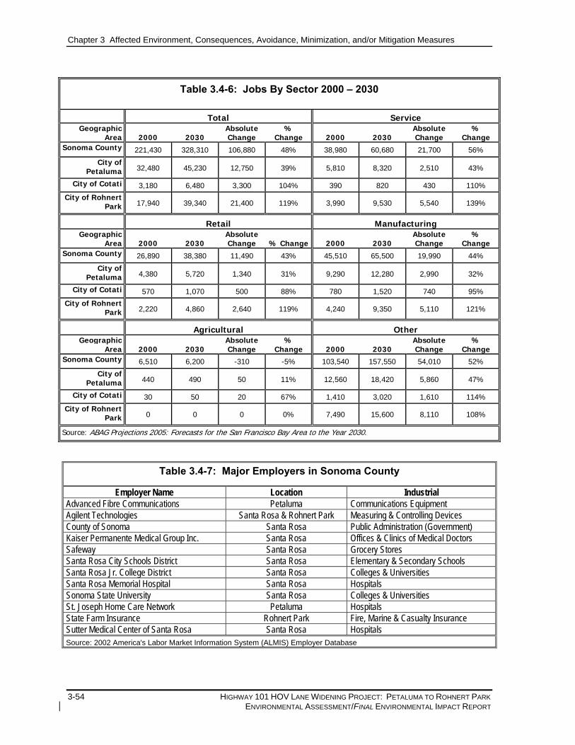
Employment. Total jobs by sector in Sonoma County and the cities of Petaluma, Cotati and Rohnert Park are shown in Table 3.4-6. Based on ABAG projections, the number of jobs in Sonoma County is anticipated to increase approximately 48 percent from 221,430 to 328,310, between 2000 and 2030. Sonoma County’s economic base is primarily supported by jobs in the service industry. The service sector will experience a growth rate of 56 percent; manufacturing 44 percent; retail 43 percent; other jobs 52 percent; and agriculture will have a decrease of five percent. Table 3.4-7 shows the major employers of Sonoma County according to the California Employment Development Department.
The City of Petaluma is expecting a lower growth rate (39 percent) in the number of jobs than Sonoma County between 2000 and 2030. Agricultural jobs will grow by only a modest 11 percent over the same time period. City of Petaluma’s highest growth will be in service industry jobs, which will grow by 43 percent.
Overall job growth in the City of Cotati is expected to nearly double between 2000 and 2030, with service and manufacturing industries jobs growing in a dramatic 110 and 95 percent, respectively. Agriculture will be the least affected industry in the City of Cotati with a growth rate of 67 percent between 2000 and 2030. In comparison, Cotati’s expected growth in agriculture jobs will be only 67 percent.
Job growth in the City of Rohnert Park will be the highest in the study area with a 119 percent growth from 2000 to 2030. Rohnert Park the service and retail industries will experience the highest growth rates with 139 percent and 119 percent, respectively. Agricultural jobs in Rohnert Park are not expected to increase as a proportion of total jobs between 2000 and 2030.
Chapter 3 Affected Environment, Consequences, Avoidance, Minimization, and/or Mitigation Measures
3-54 HIGHWAY 101 HOV LANE WIDENING PROJECT: PETALUMA TO ROHNERT PARK ENVIRONMENTAL ASSESSMENT/FINAL ENVIRONMENTAL IMPACT REPORT
Table 3.4-6: Jobs By Sector 2000 – 2030
Total Service Geographic
Area 2000 2030 AbsoluteChange
% Change 2000 2030
Absolute Change
% Change
Sonoma County 221,430 328,310 106,880 48% 38,980 60,680 21,700 56%
City of Petaluma 32,480 45,230 12,750 39% 5,810 8,320 2,510 43%
City of Cotati 3,180 6,480 3,300 104% 390 820 430 110%
City of Rohnert Park 17,940 39,340 21,400 119% 3,990 9,530 5,540 139%
Retail Manufacturing Geographic
Area 2000 2030 Absolute Change % Change 2000 2030
Absolute Change
% Change
Sonoma County 26,890 38,380 11,490 43% 45,510 65,500 19,990 44%
City of Petaluma 4,380 5,720 1,340 31% 9,290 12,280 2,990 32%
City of Cotati 570 1,070 500 88% 780 1,520 740 95%
City of Rohnert Park 2,220 4,860 2,640 119% 4,240 9,350 5,110 121%
Agricultural Other Geographic
Area 2000 2030 AbsoluteChange
% Change 2000 2030
Absolute Change
% Change
Sonoma County 6,510 6,200 -310 -5% 103,540 157,550 54,010 52%
City of Petaluma 440 490 50 11% 12,560 18,420 5,860 47%
City of Cotati 30 50 20 67% 1,410 3,020 1,610 114%
City of Rohnert Park 0 0 0 0% 7,490 15,600 8,110 108%
Source: ABAG Projections 2005: Forecasts for the San Francisco Bay Area to the Year 2030.
Table 3.4-7: Major Employers in Sonoma County
Employer Name Location Industrial Advanced Fibre Communications Petaluma Communications Equipment Agilent Technologies Santa Rosa & Rohnert Park Measuring & Controlling Devices County of Sonoma Santa Rosa Public Administration (Government) Kaiser Permanente Medical Group Inc. Santa Rosa Offices & Clinics of Medical Doctors Safeway Santa Rosa Grocery Stores Santa Rosa City Schools District Santa Rosa Elementary & Secondary Schools Santa Rosa Jr. College District Santa Rosa Colleges & Universities Santa Rosa Memorial Hospital Santa Rosa Hospitals Sonoma State University Santa Rosa Colleges & Universities St. Joseph Home Care Network Petaluma Hospitals State Farm Insurance Rohnert Park Fire, Marine & Casualty Insurance Sutter Medical Center of Santa Rosa Santa Rosa Hospitals Source: 2002 America's Labor Market Information System (ALMIS) Employer Database
Chapter 3 Affected Environment, Consequences, Avoidance, Minimization, and/or Mitigation Measures
HIGHWAY 101 HOV LANE WIDENING PROJECT: PETALUMA TO ROHNERT PARK 3-55 ENVIRONMENTAL ASSESSMENT/FINAL ENVIRONMENTAL IMPACT REPORT
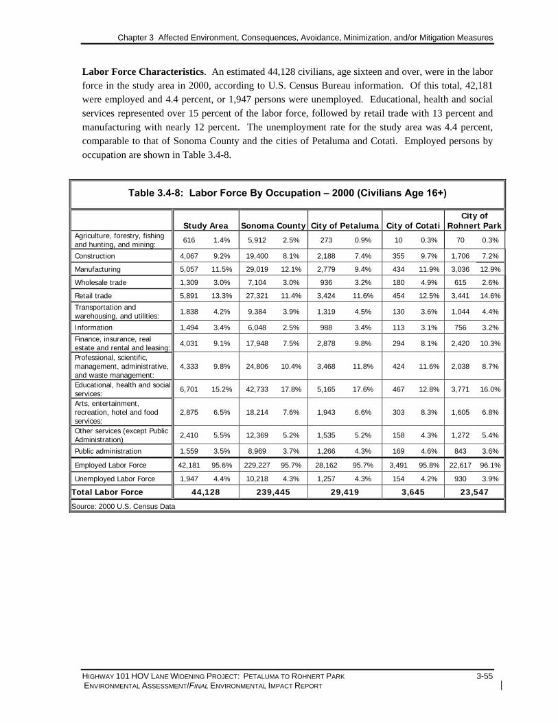
Labor Force Characteristics. An estimated 44,128 civilians, age sixteen and over, were in the labor force in the study area in 2000, according to U.S. Census Bureau information. Of this total, 42,181 were employed and 4.4 percent, or 1,947 persons were unemployed. Educational, health and social services represented over 15 percent of the labor force, followed by retail trade with 13 percent and manufacturing with nearly 12 percent. The unemployment rate for the study area was 4.4 percent, comparable to that of Sonoma County and the cities of Petaluma and Cotati. Employed persons by occupation are shown in Table 3.4-8.
Table 3.4-8: Labor Force By Occupation – 2000 (Civilians Age 16+)
Study Area Sonoma County City of Petaluma City of Cotati City of
Rohnert ParkAgriculture, forestry, fishing and hunting, and mining: 616 1.4% 5,912 2.5% 273 0.9% 10 0.3% 70 0.3%
Construction 4,067 9.2% 19,400 8.1% 2,188 7.4% 355 9.7% 1,706 7.2%
Manufacturing 5,057 11.5% 29,019 12.1% 2,779 9.4% 434 11.9% 3,036 12.9%
Wholesale trade 1,309 3.0% 7,104 3.0% 936 3.2% 180 4.9% 615 2.6%
Retail trade 5,891 13.3% 27,321 11.4% 3,424 11.6% 454 12.5% 3,441 14.6%
Transportation and warehousing, and utilities: 1,838 4.2% 9,384 3.9% 1,319 4.5% 130 3.6% 1,044 4.4%
Information 1,494 3.4% 6,048 2.5% 988 3.4% 113 3.1% 756 3.2%
Finance, insurance, real estate and rental and leasing: 4,031 9.1% 17,948 7.5% 2,878 9.8% 294 8.1% 2,420 10.3%
Professional, scientific, management, administrative, and waste management:
4,333 9.8% 24,806 10.4% 3,468 11.8% 424 11.6% 2,038 8.7%
Educational, health and social services: 6,701 15.2% 42,733 17.8% 5,165 17.6% 467 12.8% 3,771 16.0%
Arts, entertainment, recreation, hotel and food services:
2,875 6.5% 18,214 7.6% 1,943 6.6% 303 8.3% 1,605 6.8%
Other services (except Public Administration) 2,410 5.5% 12,369 5.2% 1,535 5.2% 158 4.3% 1,272 5.4%
Public administration 1,559 3.5% 8,969 3.7% 1,266 4.3% 169 4.6% 843 3.6%
Employed Labor Force 42,181 95.6% 229,227 95.7% 28,162 95.7% 3,491 95.8% 22,617 96.1%
Unemployed Labor Force 1,947 4.4% 10,218 4.3% 1,257 4.3% 154 4.2% 930 3.9%
Total Labor Force 44,128 239,445 29,419 3,645 23,547
Source: 2000 U.S. Census Data

Chapter 3 Affected Environment, Consequences, Avoidance, Minimization, and/or Mitigation Measures
3-56 HIGHWAY 101 HOV LANE WIDENING PROJECT: PETALUMA TO ROHNERT PARK ENVIRONMENTAL ASSESSMENT/FINAL ENVIRONMENTAL IMPACT REPORT
3.4.3.3 ENVIRONMENTAL CONSEQUENCES
Displacements that would result from the planned and programmed projects included in the No-Build Alternative would be addressed in the environmental documents for the respective projects. The Build Alternative for the proposed project would result in both residential and nonresidential relocations, as summarized in Table 3.4-9. A comprehensive description of relocation impacts is set forth in the Draft Relocation Impact Report (DRIR) prepared for this project.
Residential Displacement
Three residential units would be subject to relocation under the Build Alternative, as shown in Table 3.4-10. This represents less than one percent of the total occupied dwelling units in the study area. All potential residential displacements would occur in the City of Cotati and are located northeast of the Highway 101/SR 116 Interchange near the northbound Highway 101 on-ramp at Old Redwood Highway. Based on 2000 data for Census Tract 1512.03; Block 2016, approximately six residents would be relocated. Full appraisals to determine actual market value will be conducted for each property to be relocated based on current market conditions prior to acquisition.
Business Displacement
The one nonresidential relocation, as shown in Table 3.4-9, would be an automobile dealership located at the Highway 101/Old Redwood Highway Interchange within the City of Petaluma. The business employs approximately 10 people, which represents approximately 0.3 percent of the labor force in the retail industry.
The business identified for possible acquisition was subjected to a preliminary field survey to determine its general characteristics. Full assessment of the nonresidential use will be conducted prior to its acquisition to determine specific characteristics and values. The owner of the displaced business will be interviewed to determine the specific needs of this business.
Removal of this business would result in a temporary loss of sales tax revenue for the City of Petaluma. It is assumed that the business would be relocated within Petaluma and would resume payment of property-related taxes upon relocation.
Table 3.4-9: Residential and Nonresidential Relocation Under the Build Alternative
Multi-Family
Single Family Units
Mobile Homes Buildings Units
Estimated Total Residential Units (Units/Residents)1
Nonresidential Units (Businesses/
Employees)2
TOTALS 3 0 0 0 3 / 6 1 / 10 1 Estimate of residents based on an average of 2.00 residents per unit (2000 U.S. Census Data, Tract 1512.03; Block 2016). 2 Estimate of employees based on a visual survey of potentially affected parcels. Source: Parsons 2004

Chapter 3 Affected Environment, Consequences, Avoidance, Minimization, and/or Mitigation Measures
HIGHWAY 101 HOV LANE WIDENING PROJECT: PETALUMA TO ROHNERT PARK 3-57 ENVIRONMENTAL ASSESSMENT/FINAL ENVIRONMENTAL IMPACT REPORT
3.4.3.4 AVOIDANCE, MINIMIZATION, AND/OR MITIGATION MEASURES
Caltrans will observe the rights and services provided under Public Law 91-646, Uniform Relocation Assistance and Real Property Acquisition Policies Act of 1970 in accordance with its own relocation assistance policies. It is Caltrans’ policy that persons displaced as a result of highway programs shall receive fair and humane treatment and shall not suffer unnecessarily as a result of programs designed for the benefit of the public. A summary of relocation benefits is included in Appendix D.
Current market data (September 2005) indicate that there are adequate resources in the cities of Petaluma and Cotati to accommodate relocation of the displaced residential and nonresidential units. A full inventory of available relocation resources and a correlation with the units taken will be conducted and identified in the Final Relocation Impact Report.
3.4.4 Environmental Justice
3.4.4.1 REGULATORY SETTING
Executive Order (EO) 12898 (Federal Actions to Address Environmental Justice in Minority Populations and Low-Income Populations), dated February 11, 1994, calls on federal agencies to identify and address the disproportionately high and adverse human health or environmental effects of federal programs, policies, and activities on minority populations and low-income populations. The U.S. Department of Transportation (DOT) has published a Final DOT Order to establish procedures for use in complying with EO 12898 for its operating administrations, including FHWA. If disproportionately high and adverse impacts would result from the proposed action, mitigation measures or alternatives must be developed to avoid or reduce the impacts, unless the agency finds that such measures are not practicable.
Impacts and benefits of transportation projects result from the physical placement of such facilities, and also from their ability to improve or impede access to and from neighborhoods and other portions of the region. The environmental justice analysis examines whether ethnic minority and/or low-income populations in the project area would experience disproportionately adverse accessibility or other impacts, and if the impacts experienced by such populations would be inconsistent with the benefits created.
3.4.4.2 AFFECTED ENVIRONMENT
The project study area includes a variety of neighborhoods and a multi-ethnic population. The ethnic composition for the study area, as described in Section 3.4.1.1, is comparable to Sonoma County and the City of Rohnert Park. As shown in Table 3.4-10, the cities of Petaluma and Cotati are slightly less diverse than the study area with minority populations of 23 percent in each city. The study area, Sonoma County and the City of Rohnert Park each have a 26 percent minority population.

Chapter 3 Affected Environment, Consequences, Avoidance, Minimization, and/or Mitigation Measures
3-58 HIGHWAY 101 HOV LANE WIDENING PROJECT: PETALUMA TO ROHNERT PARK ENVIRONMENTAL ASSESSMENT/FINAL ENVIRONMENTAL IMPACT REPORT
Table 3.4-10 also shows that the percentage of persons below poverty level is slightly higher in the study area (approximately nine percent) than for Sonoma County and the cities of Cotati and Rohnert Park.
Table 3.4-10: Minority and Low-Income Populations in the Study Area
STUDY AREA SONOMA COUNTY
CITY OF PETALUMA CITY OF COTATI
CITY OF ROHNERT PARK
% MINORITY 26% 26% 23% 23% 26% % LOW-INCOME 9% 8% 6% 8% 8% SOURCE: 2000 U.S. CENSUS DATA
For the purposes of this analysis, the potential for environmental justice impacts was identified when the population in any census tract block group met or exceeded either of the following criteria:
1. The census tract block group contained 50 percent or more minority or low-income population; or
2. The percentage of minority or low-income population in any census tract block group was more than 10 percentage points greater than the average in the city and/or county in which the census tract block group is located.
Based on 2000 U.S. Census Data for the study area, populations in six out of 15 census block groups located adjacent to Highway 101 qualify as environmental justice communities based on income level. Low-income populations are defined as having a median household income at or below Department of Health and Human Service poverty guidelines. Environmental justice communities are shown in Figure 3.4-4.
• Census Tract 1506.05; Block Group 7–Located in northern Petaluma, east of the Highway 101/ Petaluma Boulevard–Old Redwood Highway Interchange, this block group has a low-income population rate of over 12 percent.
• Census Tract 1512.04; Block Group 3–Northeast of the Highway 101/West Sierra Avenue Interchange in the City of Cotati, the low-income population accounts for approximately 19 percent of the block group’s total population.
• Census Tract 1512.01; Block Groups 1 and 5–Located northwest of the Highway 101/Rohnert Park Expressway Interchange, low-income households account for approximately 12 percent of the population in both block groups.
• Census Tract 1513.05; Block Groups 1 and 3–Southeast of the Highway 101/Rohnert Park Expressway Interchange, these block groups have the highest incidence of low-income populations with nearly 14 and 20 percent, respectively.
Given that environmental justice communities were identified within the project study area, efforts were made to ensure that these communities were notified of all public informational meetings and the public hearing for this environmental document; see Section 6.1.4, Newspaper Notices and Flyers.

SONOMA MOUNTAIN PKWY.
EAST RAILROAD AVE.
ADOBE RD.
CORO
NA
SKILLMAN LN.
RAINSVILLE RD.
PE
TALU
MA
HIL
LR
D.
EXWY.
STONY POINT RD.
E. COTATI AVE.
N. McDOWELL BLVD.
PETALUMABLVD.
PEPPER RD.
BODEGA
AVE.
MEC
HAM
RD
.
RE
DW
OO
D
LIB
ER
TYRD
.
W.
W. SIERRA
JEW
ETT
RD
.
OLD
REDWOOD HWY.
HWY.
DR
.
N.W
.P.P
.R.
BLV
D.
PARK
ROHNERT
N.
AVE.
CO
MM
ER
CE
Rohnert Park
Cotati
KIN
GR
D.
SN
YDE
RLN
.
GRAVENSTEIN
RAINSVILLE RD.
RAILROAD A
VE.
W. SIERRA
OLDAVE.
LN.
RD.
SOUTHW STE
BLVD.
Petaluma
SONOMACOUNTY
116
NNot to Scale
1512.04(BG 3)
1513.05(BG 1)
ENVIRONMENTAL JUSTICECOMMUNITIES
Figure 3.4-4
S C T AS C T A Highway 101 HOV Lane Widening Project:Old Redwood Highway, Petaluma to Rohnert Park Expressway, Rohnert Park
1506.05(BG 7)
1512.01(BG 1)
1512.01(BG 5)
Legend:Census Tract Boundary 1511.01 Census Tract Number (BG 1) Block Group Number
RailroadCity Boundary Environmental Justice Community
1513.05(BG 3)
3-59

Chapter 3 Affected Environment, Consequences, Avoidance, Minimization, and/or Mitigation Measures
3-60 HIGHWAY 101 HOV LANE WIDENING PROJECT: PETALUMA TO ROHNERT PARK ENVIRONMENTAL ASSESSMENT/FINAL ENVIRONMENTAL IMPACT REPORT
3.4.4.3 ENVIRONMENTAL CONSEQUENCES The primary purpose of the proposed action is to complete the Highway 101 HOV system described by the Metropolitan Transportation Commission in the 2002 HOV Lane Master Plan Update. The Highway 101 HOV lane widening would encourage carpooling by providing HOV lanes along the length of the project corridor and reduce energy consumption by reducing single occupancy vehicle use and idling.
As discussed in Section 3.4.4.2, low-income and minority populations are found in the project area. Because the proposed project would alter an already existing freeway, it would not divide an established community. Potential impacts to neighboring populations include added noise and displacement and relocation impacts. These are impacts typically assessed to determine if there would be disproportionate impacts on low-income or minority populations.
Environmental impacts would be distributed evenly throughout the project area and would not be concentrated in neighborhoods with minority or low-income residents. Noise abatement measures are recommended wherever noise abatement criteria are met and would be expected to prevent disproportionate impacts to any particular area. The anticipated business displacements and the three residential displacements are in areas that are not identified as low-income or minority neighborhoods. Some partial takes of nonresidential properties, primarily affecting existing parking, would also result; however, these impacts would not be concentrated in areas with environmental justice communities.
SCTA has conducted public outreach to communicate with these communities throughout the environmental review process. Community members have provided substantive input into the current project design and construction approach, as discussed more fully in Chapter 6, Summary of Public and Agency Involvement and Tribal Coordination.
Based on the foregoing discussion, the proposed project would not cause disproportionately high and adverse effects on any minority or low-income populations as discussed in E.O. 12898 regarding environmental justice.
3.4.4.4 AVOIDANCE, MINIMIZATION, AND/OR MITIGATION MEASURES Caltrans would abate the long-term noise effects of the project with soundwalls consistent with FHWA noise abatement criteria. Relocation assistance would be provided to residential and business owners in accordance with the Uniform Relocation Assistance Act. Construction phase impacts would be minimized with best management practices (BMPs) to control noise and fugitive dust. Detour routes would be planned in coordination with Caltrans and the traffic departments of Petaluma, Cotati and Rohnert Park and would be noticed to emergency service providers, transit operators, and Highway 101 users in advance. These measures would serve to ensure that there would be no disproportionate adverse effects on minority and low-income residents. Impacts relating to construction are discussed in more detail in Section 3.16, Construction Impacts.

Chapter 3 Affected Environment, Consequences, Avoidance, Minimization, and/or Mitigation Measures
HIGHWAY 101 HOV LANE WIDENING PROJECT: PETALUMA TO ROHNERT PARK 3-61 ENVIRONMENTAL ASSESSMENT/FINAL ENVIRONMENTAL IMPACT REPORT
3.5 Utilities 3.5.1 Affected Environment Utilities within the Highway 101 HOV Lane Widening Project area include:
• overhead electrical and transmission lines; and • underground electrical, gas, water, sanitary sewer, TV/cable, fiberoptics, and telephone. Pacific Gas & Electric Company (PG&E) provides gas and electricity service in the study area. SBC maintains the local telephone service and Comcast provides cable service.
3.5.2 Impacts The majority of the utilities within the project area are transverse crossings that do not present conflicts to the proposed project Build Alternative. However, proposed embankment widening may require extension of existing protective casings for PG&E gas lines at five locations.
In addition, a 115 kV transmission and 12kV overhead electric lines adjacent to Commerce Boulevard and Redwood Drive, a 200-mm (8 in.) diameter gas transmission line (75 feet) crossing Copeland Creek, a 100-mm (4-in.) gas line crossing the freeway south of Laguna de Santa Rosa, an underground telephone line at Commerce and a fiber optics and CATV line on Redwood Drive would require relocation to accommodate the proposed improvements of the proposed project.
A 400-mm (16 in.) PG&E gas line that runs parallel to the westerly right-of-way line for approximately 550 m (1,640 ft.) from a transverse crossing of Highway 101 north to Pepper Road falls within the area of proposed right-of-way acquisition for the entrance ramp improvements. This line will require relocation into a new utility easement parallel to the proposed right-of-way line. This is a relocation of an existing gas line and there will be no adverse environmental impacts.
The relocated portion of the 200-mm (8-in.) diameter gas transmission line (75 feet) will likely be within the boundary lines of Redwood Drive (franchise), however, a portion of the relocated gas line may be within the boundary lines of a new private easement depending on the final design. This is a short relocation of an existing gas line and there will be no adverse environmental impacts. In addition, the relocation of the PG&E electrical transmission line will not cause an adverse impact.
Construction phase impacts are discussed in Section 3.16.5, Utilities/Service Systems.
3.5.3 Avoidance, Minimization, and/or Mitigation Measures Design, construction, and inspection of utilities relocated for the project would be done in accordance with Caltrans requirements. Where feasible, relocations would be undertaken in advance of project construction. Caltrans would coordinate with the affected service provider in each instance to ensure that work is in accordance with the appropriate requirements and criteria. In addition, coordination with the utility providers would be initiated during the preliminary engineering phase of the project and would continue through final design and construction.

Chapter 3 Affected Environment, Consequences, Avoidance, Minimization, and/or Mitigation Measures
3-62 HIGHWAY 101 HOV LANE WIDENING PROJECT: PETALUMA TO ROHNERT PARK ENVIRONMENTAL ASSESSMENT/FINAL ENVIRONMENTAL IMPACT REPORT
Coordination efforts would plan utility re-routes, identify potential conflicts, ensure that construction of the proposed project minimizes disruption to utility operations, and formulate strategies for overcoming problems that may arise. Measures to avoid or minimize disruptions to the emergency services and utilities during construction of the project are discussed in Section 3.16.5, Utilities/Service Systems.
3.6 Visual/Aesthetics
The Visual Impact Assessment (CirclePoint, June 2005) for the Highway 101 HOV Lane Widening project was conducted in accordance with the guidelines provided in the FHWA Approach to Visual Assessment of Highway Projects (FHWA, 1986). The visual analysis characterizes the project area in terms of “landscape units,” which are distinct segments of the corridor that have a consistent or cohesive visual or physical character, and identifies visual quality, prominent features, and scenic resources within the landscape units. Selected viewpoints along Highway 101 where the project could affect existing visual quality are identified and evaluated. In addition, physical changes attributable to the proposed project that would cause changes to views currently experienced by residents, motorists and other users of the area are evaluated. Avoidance, minimization and compensation measures to address visual effects are described in Section 3.6.4.
3.6.1 Regulatory Setting NEPA establishes that the federal government use all practicable means to ensure all Americans safe, healthful, productive and aesthetically and culturally pleasing surroundings (42 USC 4331[b] [2]). In its implementation of NEPA (23 USC 109[h]), the FHWA directs that final decisions regarding projects are to be made in the best overall public interest, taking into account adverse environmental impacts, including the destruction or disruption of aesthetic values.
Likewise, CEQA establishes that it is the policy of the state to take all action necessary to provide the people of the state “with…enjoyment of aesthetic, natural, scenic and historic environmental qualities.” [CA Public Resources Code Section 21001(b)].
3.6.2 Affected Environment The existing visual environment is characterized by the landscape components (visual resources) and viewer groups within the project area. Visual resources are described in terms of existing visual character and quality. Viewer groups are evaluated in terms of viewer exposure (the ability to see the project area), and viewer sensitivity, which refers to the viewers’ concern for scenic quality and their response to change in visual resources.
3.6.2.1 EXISTING VISUAL CHARACTER AND CONTEXT The Highway 101 HOV Lane Widening project corridor is located in Sonoma County, California, extending through the cities of Petaluma, Cotati, and Rohnert Park, and unincorporated areas within Sonoma County. The overall visual character of the project area is primarily rural, with open space/agricultural uses and mature native and non-native trees bordering the highway within the project limits, with developed areas near the city centers.

Chapter 3 Affected Environment, Consequences, Avoidance, Minimization, and/or Mitigation Measures
HIGHWAY 101 HOV LANE WIDENING PROJECT: PETALUMA TO ROHNERT PARK 3-63 ENVIRONMENTAL ASSESSMENT/FINAL ENVIRONMENTAL IMPACT REPORT
One characteristic that distinguishes Sonoma County from many parts of the San Francisco Bay Area is the continued existence of separate, identifiable cities and communities. The presence of open land helps retain the rural character and avoid corridor-style urbanization. These lands may not necessarily be highly scenic in their own right, but they provide visual relief from continuous urbanization and are a special type of scenic border, known as a community separator. The Petaluma/Rohnert Park community separator is located within the project area on the west side of Highway 101 between the cities of Cotati and Petaluma. This separator includes Liberty Valley, an area of high visual quality.
Another distinguishing characteristic of the existing visual character of the project vicinity resides in the redwood tree clusters that line the highway. These redwood tree clusters were planted at regular intervals to reinforce motorists’ perception of the regional landscape character and what was to be established as the “Redwood Highway.” Over the years they have become a dominant visual element of the highway corridor.
3.6.2.2 EXISTING VISUAL IMAGE TYPES AND VIEWER GROUPS For the purposes of the visual impact assessment, the study area was subdivided into two landscape units that encompass distinct spatial areas, the Southern Landscape Unit and the Northern Landscape Unit, as described in Section 3.6.2.3. Each landscape unit has a distinct visual character based upon the land uses and features that comprise it. These smaller scale land uses or features within each landscape unit are called “image types.” Nine visual image types are located within the project area: mature trees, including the redwood tree clusters planted to establish Highway 101 as the “Redwood Highway,” agricultural, vineyard, residential, institutional/religious, commercial, industrial/ manufacturing, hillsides/distant hills, and recreational.
“Viewer groups” are groups of people who regularly travel through the project area, or who have a certain degree of sensitivity to changes in the visual environment. Viewer groups may be present in some landscape units and not in others, as land uses and travel patterns may vary between landscape units within the project area. Three viewer groups were identified within the project area: 1) motorists who use Highway 101 and/or other local streets in the project vicinity as regional roads for commuting or commerce; 2) residents who have views of Highway 101 from properties along the project corridor; and 3) agricultural employees who have views of Highway 101 from farms along the project corridor.
3.6.2.3 LANDSCAPE UNITS The project corridor is divided into two landscape units (see Figure 3.6-1): the Southern Landscape Unit (Southern LU) and Northern Landscape Unit (Northern LU). Each landscape unit was determined based on visibility from other landscape units within the project area, topographical features, or other distinguishing features. The existing visual quality of the landscape units, including image types encompassed within each landscape unit, and viewer groups with a degree of sensitivity to the visual environment are described below and shown in Table 3.6-1.

LANDSCAPE UNIT LOCATIONSFigure 3.6-1
S C T AS C T A Highway 101 HOV Lane Widening Project:Old Redwood Highway, Petaluma to Rohnert Park Expressway, Rohnert Park
SOUTHERNLANDSCAPE
UNIT
NORTHERNLANDSCAPE
UNIT
SOUTHERNLANDSCAPE
UNIT
NORTHERNLANDSCAPE
UNIT
3-64

Chapter 3 Affected Environment, Consequences, Avoidance, Minimization, and/or Mitigation Measures
HIGHWAY 101 HOV LANE WIDENING PROJECT: PETALUMA TO ROHNERT PARK 3-65 ENVIRONMENTAL ASSESSMENT/FINAL ENVIRONMENTAL IMPACT REPORT
Southern Landscape Unit: The Southern Landscape Unit (Southern LU) includes the southern segment of the Highway 101 project corridor from Old Redwood Highway to West Sierra Avenue. Visual resources within the Southern LU include large hilltop estates surrounded by expansive front lots, agricultural fields, rolling hills dotted with grazing livestock, and distant wooded hillsides. Approximately 1,191 large and mature trees (trunks greater than 25 cm [10 in] in diameter at breast height) are located along Highway 101 at various locations in the Southern LU. Of these mature trees, approximately 1,067 are redwoods. These trees, although non-native, have become a dominant visual element of the roadside environment.
Existing visual quality at the southern end of the landscape unit near Old Redwood Highway is urbanized with industrial/commercial buildings on the east side of Highway 101. On the west side of the corridor, a row of trees screens a trailer park. A driving range is located just south of the trailer park. Large wooden utility poles are distinct visual elements along this segment of the corridor.
Heading north along Highway 101, the Southern LU becomes more rural with wide open views of agricultural land, dotted with farmhouses, barns and mature oak groves. The bucolic views of Liberty Valley and the rural character of the City of Cotati result in high visual quality within this landscape unit. Some residences on the hillsides in the distance are visible through dense woodland. Mature landscaping increases as the corridor approaches the northern limits of the Southern LU at West Sierra Avenue. Visual resources along this segment of Highway 101 include hills with vineyards and large residences, partially obscured by dense trees and foliage.
Table 3.6-1: Summary of Landscape Units
Landscape Unit Description Image Types Mature Trees (including redwoods and Valley oaks), Agricultural, Vineyard,
Residential, Industrial/Manufacturing, Hillsides/Distant Hills, Recreational Viewer Groups Motorists, Residents, and Agricultural Employees Visual Resources Golf course/driving range on south end of landscape unit, open agricultural
land and associated farmhouse structures. Cows graze on hillsides along highway, distant rolling hills visible throughout, and residences on large plots of land dot hillsides.
Southern
Overall Visual Character Rural area with farmhouses and rolling hills on north end of LU, transitioning to more industrial uses and more mature vegetation screening the highway from areas near Old Redwood Highway on south end.
Image Types Mature Trees, Vineyard, Residential, Institutional/Religious, Commercial, Industrial/Manufacturing
Viewer Groups Motorists, Residents, and Agricultural Employees Visual Resources Mature vegetation along 101, church steeple visible through vegetation
along highway. Commercial, industrial, and residential uses, particularly on the north end of this landscape unit east of the highway.
Northern
Overall Visual Character Wooded corridor, mature vegetation screens much of the development along the highway.

Chapter 3 Affected Environment, Consequences, Avoidance, Minimization, and/or Mitigation Measures
3-66 HIGHWAY 101 HOV LANE WIDENING PROJECT: PETALUMA TO ROHNERT PARK ENVIRONMENTAL ASSESSMENT/FINAL ENVIRONMENTAL IMPACT REPORT
Northern Landscape Unit: The Northern Landscape Unit (Northern LU) includes the northern segment of the Highway 101 project corridor, from West Sierra Avenue to the Rohnert Park Expressway. The dominant visual characteristic of the southern portion of the Northern LU is the dense screening provided by mature native and non-native trees and grassy berms along both sides of Highway 101. Approximately 1,174 large and mature trees are located along Highway 101 at various locations in the Northern LU. Of these mature trees, approximately 1,074 are redwoods, which as previously noted, have become a dominant visual element of the roadside environment. These trees screen motorist views of the commercial, industrial and residential uses adjacent to the highway alignment. Existing land uses are visible through breaks in the screening and over the tops of some of the smaller trees. At the southern limit of the landscape unit, views of a small vineyard west of Highway 101 are apparent. Heading north, a church steeple is visible above the tall trees on the east side of the freeway, creating a unique visual image. The extreme northern end of the landscape unit contains less screening and more of the adjacent land uses are visible. Visual quality in this segment is medium, overall.
Existing Visual Quality
Key viewpoints, as shown on Figure 3.6-2, were identified to represent the visual character of the landscape units and used to define visual quality. The existing visual quality for each of the landscape units was evaluated based on indicators of the level of visual relationships, rather than judgments of physical landscape components. This approach provides a set of three evaluative criteria: vividness, intactness, and unity. These criteria are defined as follows:
Vividness is the visual power or memorability of landscape components as they combine in striking and distinctive visual patterns.
Intactness is the visual integrity of the natural and man-made landscape of the immediate environs and its freedom from encroaching elements.
Unity is the visual coherence and compositional harmony of the viewshed. The viewshed entails all natural and man-made features found within the normal view range. In man-altered landscapes, it frequently attests to the careful design or fit of individual components in the landscape.

VIEWPOINT LOCATIONSFigure 3.6-2
S C T AS C T A Highway 101 HOV Lane Widening Project:Old Redwood Highway, Petaluma to Rohnert Park Expressway, Rohnert Park
2
1
2
1
3-67

Chapter 3 Affected Environment, Consequences, Avoidance, Minimization, and/or Mitigation Measures
3-68 HIGHWAY 101 HOV LANE WIDENING PROJECT: PETALUMA TO ROHNERT PARK ENVIRONMENTAL ASSESSMENT/FINAL ENVIRONMENTAL IMPACT REPORT
The key viewpoints are typical views that people would have of or from the project, as described below. Table 3.6-2 provides a summary of the existing visual quality for each viewpoint.
Table 3.6-2: Summary of Existing Visual Quality
Viewpoint Number Setting Vividness Intactness Unity
Overall Visual Quality
1 Looking south at approximately STA 67+00 High Medium Medium High
2 Looking east at the 101/116 interchange Medium Medium Medium Medium
Viewpoint 1
This viewpoint is looking south along Highway 101 towards the Petaluma/Rohnert Park community separator, at approximately Station 67+00, as shown below. In this view, Highway 101 begins with a decrease in elevation then rises over a hill, extending straight towards the hills in the distance. Mature trees and grassy hills line both sides of the freeway and a grassy median with metal guardrails is located between the northbound and southbound travel lanes. Motorists traveling on Highway 101 are the primary viewer group in this area.
Visual quality in this segment is characterized by the natural landscape, as it represents the rural character of the area. The scattered trees that run parallel to the freeway blend with the surrounding trees of varying sizes and types in the area. The combination of trees and hills although interrupted by the freeway create a highly vivid scene with medium intactness and unity, resulting in a high overall visual quality rating.
Viewpoint 1

Chapter 3 Affected Environment, Consequences, Avoidance, Minimization, and/or Mitigation Measures
HIGHWAY 101 HOV LANE WIDENING PROJECT: PETALUMA TO ROHNERT PARK 3-69 ENVIRONMENTAL ASSESSMENT/FINAL ENVIRONMENTAL IMPACT REPORT
Viewpoint 2
This viewpoint is looking east toward the Highway 101/SR 116 interchange from SR 116 (Gravenstein Highway), as shown below. Large redwood trees surround the Highway 101 overpass, screening views of the rest of the freeway. These redwoods were planted in clusters to reinforce motorists’ perception of the regional landscape character and to establish Highway 101 as the “Redwood Highway.” The ridgeline of the Sonoma Mountains is visible in the distance. Motorists traveling on SR 116 and local residents are the primary viewer groups in this area.
Visual quality in this segment is characterized by mature trees that parallel Highway 101. The Highway 101 overpass is perpendicular to the at-grade roadway, and creates a visual break in the row of trees, disrupting the continuity of the mature tree image type that is otherwise relatively consistent in size and scale. The break in the image type reduces the intactness and unity of the view; however, the mature landscaping and the ridgeline in the distance create a vivid scene resulting in a medium overall visual quality rating.
Viewpoint 2

Chapter 3 Affected Environment, Consequences, Avoidance, Minimization, and/or Mitigation Measures
3-70 HIGHWAY 101 HOV LANE WIDENING PROJECT: PETALUMA TO ROHNERT PARK ENVIRONMENTAL ASSESSMENT/FINAL ENVIRONMENTAL IMPACT REPORT
3.6.3 Environmental Consequences
The following section analyzes the visual impacts of the proposed project within the two landscape units that make up the project study area. The methodology used to assess visual impacts combines the two principal visual impact components: visual resource change and viewer response to that change. “Visual resource change” is analyzed in terms of visual dominance and other visual effects of facilities that would be constructed under the proposed project, together with the change in visual quality. “Viewer response” to these changes is interpreted on the basis of the viewer types identified.
The ratings used for determining the extent of impacts are defined as follows:
Low or negligible impacts are minor adverse changes to the existing visual resource, with low viewer response to change in the visual environment.
Slightly adverse impacts are slightly detectible within a localized area with increased viewer response.
Medium impacts are those that are readily apparent with moderate viewer response.
High impacts are highly detectible and would be substantial with a high viewer response level.
3.6.3.1 VISUAL RESOURCE CHANGE
Visual changes as a result of the Build Alternative in the Southern and Northern landscape units are described in this section. Boundaries for both landscape units are provided and their primary visual resource features are described in Section 3.6.2.3, Landscape Units.
Southern Landscape Unit: Visual changes due to realignment of interchange ramps at Old Redwood Highway would generally be negligible.
Grading of some of the rolling hills at the top of the incline near Railroad Avenue would be necessary to accommodate the widened shoulders and westward shift of the highway. This grading would be visible to both motorists and residents in the Liberty Valley area and would result in adverse impacts to the visual environment. Additional fill would be placed along the west facing slope of Cotati Grade. All material would be placed within the existing fill slope and the resulting land contour would be similar to the existing landform. Grading changes would be most noticeable immediately following construction; the visual impact would be negligible following maturation of the plants on the re-vegetated slope.
To accommodate the HOV lane widening and recommended soundwalls, approximately 289 to 6161 large and mature trees and other vegetation would require removal, primarily from within the northern portion of the Southern Landscape Unit. This would include removal of redwood trees near West Sierra Avenue. Of these mature trees, 280 to 470 are redwoods. Loss of these trees would adversely affect the landscape character of the highway and the aesthetics of the driving experience. 1 Range represents estimates of tree loss using all practicable avoidance measures versus maintaining clear recovery zone.

Chapter 3 Affected Environment, Consequences, Avoidance, Minimization, and/or Mitigation Measures
HIGHWAY 101 HOV LANE WIDENING PROJECT: PETALUMA TO ROHNERT PARK 3-71 ENVIRONMENTAL ASSESSMENT/FINAL ENVIRONMENTAL IMPACT REPORT
Soundwalls would be constructed in two locations within this landscape unit: north of Old Redwood Highway and north from Issel Court to West Sierra Avenue. The removal of some of the roadside landscaping north of Old Redwood Highway along the west side of Highway 101 within the right-of-way to construct the first of these two soundwalls, for the Leisure Lake Mobile Home Park community, would have only a negligible visual impact. The soundwall would be located at the roadway shoulder, and most of the redwood trees stand west of the shoulder outside the project limits. Therefore, the vegetation would continue to screen mobile home park residents’ views of the highway as well as of the soundwall.
A retaining wall associated with some roadside grading would be constructed in this vicinity, and the second soundwall would be built at the shoulder on the east side of the highway near Issel and Benedetti Courts. Construction of these walls would require the removal of vegetation and would detract from the rural character of the landscape unit. As shown in Figure 3.6-3, the visual prominence of soundwalls would relate to viewer proximity—that is, the farther away a viewer is from a soundwall, the less visually dominant it would appear. The new soundwalls would thus be more apparent to residents of Issel or Benedetti Courts than to those of Leisure Lake. The soundwalls would also be visually dominant to motorists traveling along Highway 101. On the other hand, soundwalls also help to screen residents’ views of the highway.
Overall, the removal of mature vegetation and construction of soundwalls to mitigate noise impacts would have adverse impacts to the visual environment, decreasing the wooded, rural character of some of the areas within the Southern Landscape Unit. The visual dominance of Highway 101 through this landscape unit would increase slightly as a result of the highway and bridge widening, but would not affect viewer orientation or disrupt existing communities, since the highway would basically remain in its current alignment. Specific mitigation proposed to address the removal of mature trees and other vegetation and to soften the appearance of the highway facilities is described in Section 3.6.4, Avoidance, Minimization, and/or Mitigation Measures.

S C T AS C T A Highway 101 HOV Lane Widening Project:Old Redwood Highway, Petaluma to Rohnert Park Expressway, Rohnert Park
TYPICAL SOUNDWALL CROSS-SECTIONFigure 3.6-3
N
A
ASoundwall S90
Soundwall S91
10.8 m 10.8 m3 mLanes Lanes
3 mShld Shld
3 m 3 mShld Shld
HIGHWAY 101CL
Righ
t of W
ay Righ
t of W
ay
3.7m
(12 F
t) So
undw
all
3.7m
(12 F
t) So
undw
allCROSS SECTION A(Schematic Drawing Only)
A A
3-72

Chapter 3 Affected Environment, Consequences, Avoidance, Minimization, and/or Mitigation Measures
HIGHWAY 101 HOV LANE WIDENING PROJECT: PETALUMA TO ROHNERT PARK 3-73 ENVIRONMENTAL ASSESSMENT/FINAL ENVIRONMENTAL IMPACT REPORT
Northern Landscape Unit: To accommodate the HOV lane widening, approximately 115 to 7152 large and mature trees and other vegetation within the highway corridor would be removed from this landscape unit. Of these mature trees, 107 to 591 are redwoods. Removal of redwood trees would constitute an adverse impact on the landscape character of the highway and the aesthetics of the driving experience within this landscape unit. In the southern portion of the landscape unit, from West Sierra Avenue northward to about Highway 116, removal of trees and vegetation would occur on both sides of the highway. In the northern portion of the landscape unit, north of Highway 116, vegetation loss would occur primarily on the west side of the highway. Removal of vegetation would decrease the existing visual buffer between the highway and the adjacent land uses.
The project proposes to construct soundwalls at two locations within this landscape unit: on the east side of Highway 101 from south of West Sierra Avenue to north of East Cotati Avenue; and on the west side of the highway from south of West Cotati Avenue through the Highway 116 interchange. A concrete barrier would be installed on the west side of the highway from Helman Lane to about Copeland Creek. The removal of vegetation and addition of soundwalls and the concrete barrier would result in an adverse effect on views from the adjacent land uses to the roadway by decreasing the rural character of the highway corridor. It should be noted that the area surrounding the proposed barrier is already urbanized. As shown in Figure 3.6-3, the visual effects would decrease with viewer distance from the soundwalls.
Under Interchange Option B, the profile of Highway 101 going over Highway 116 (Gravenstein Highway) would be raised between one and two meters (approximately 7+ feet). The raised area would be primarily limited to within the existing interchange ramps, but would be visible to residents on the west side of the highway and to churchgoers on the east side. The primary visual impact would be to motorists traveling along Highway 116. The soundwall on the raised Highway 101 profile was withdrawn from the proposed project to lessen the visual impact for motorists. All options for this interchange are shown in Figure 3.6-5. The roadway view for Highway 101 motorists would be smoother and more continuous as a result of Option B and visual changes due to realignment of Highway 116 interchange ramps would be negligible.
Construction of soundwalls and the concrete barrier requiring removal of roadside vegetation would result in an adverse effect for all viewer groups by reducing the wooded, rural character of the highway. The visual dominance of Highway 101 through the Northern Landscape Unit would increase slightly as a result of the HOV lane and bridge widening, but this would not affect viewer orientation or disrupt existing communities, as the highway would remain in its current alignment. Specific mitigation for these visual impacts is described in Section 3.6.4, Avoidance, Minimization, and/or Mitigation Measures.
2 Range represents estimates of tree loss using all practicable avoidance measures versus maintaining clear recovery zone.

Chapter 3 Affected Environment, Consequences, Avoidance, Minimization, and/or Mitigation Measures
3-74 HIGHWAY 101 HOV LANE WIDENING PROJECT: PETALUMA TO ROHNERT PARK ENVIRONMENTAL ASSESSMENT/FINAL ENVIRONMENTAL IMPACT REPORT
Visual Resource Change Summary: As described in the foregoing sections, the proposed HOV lane widening project would involve limited grading and placement of fill along the existing highway alignment, realign interchange ramps, construct soundwalls and retaining walls, modify the contour of the west facing slopes at the Cotati grade, raise the profile of the Highway 101/116 interchange, and require the removal of mature trees and vegetation. These various modifications would alter existing views and visual resources, increasing the visual dominance of Highway 101 somewhat for residents and agricultural employees, and changing the rural landscape character of the roadway for motorists. Cuts and fills would generally follow the existing highway grading. Visual impacts from such landform modifications and from realignment of interchange ramps are not expected to be substantially adverse. No widening or realignment of surface streets is anticipated. Widening of the Highway 101 structure over West Sierra Avenue and of the Highway 116 approach to the Old Redwood Highway intersection would also not have adverse visual impacts.
The primary change that would be noticeable to all viewer groups would be the removal of mature trees—including redwoods—and other mature vegetation. Tree surveys were conducted during the visual impact assessment conducted for this environmental document. Counts were made of all mature trees (10” dbh or greater) in the field by a biologist/botanist and an engineer. Estimates of tree loss were made using all practicable avoidance measures, including the use of guard rail adjacent to trees within the required clear recovery zone, and preservation of trees whose root systems would not be threatened by roadway cuts. Additional tree surveys have been conducted since then. These surveys estimated maximum tree loss, and included all trees within the clear recovery zone as well as trees whose root systems (as approximated by the canopies) were within either cut or fill lines. Based on the combined results, from 404 to 1,331 mature trees, including from 5 to 56 valley oaks and from 387 to 1,061 redwoods, would be taken under the Build Alternative. These redwood trees are outside of their biological range, do not provide habitat, and do not support redwood populations, however, they are considered important aesthetic resources. These redwoods were planted in clusters along Highway 101 to establish its character as the “Redwood Highway.” Avoidance and minimization approaches as identified in Section 3.6.4 will be incorporated during final design to reduce tree loss below the upper end of the reported ranges.
Avoidance, minimization and mitigation measures are described in Section 3.6.4. Anticipated effects of the project on valley oak trees are reported with their proposed avoidance, minimization and mitigation measures in Section 3.15, Biological Environment.
Highway 101 in the area of the proposed project is not a designated State Scenic Highway; however, segments of Highway 101 within the project limits are highly scenic. Views to the Sonoma Mountains and Liberty Valley would remain after implementation of the project. The proposed project would not introduce new sources of light to the project area. Construction of soundwalls would, however, introduce a new source of reflective light; thereby contributing to glare.

Chapter 3 Affected Environment, Consequences, Avoidance, Minimization, and/or Mitigation Measures
HIGHWAY 101 HOV LANE WIDENING PROJECT: PETALUMA TO ROHNERT PARK 3-75 ENVIRONMENTAL ASSESSMENT/FINAL ENVIRONMENTAL IMPACT REPORT
3.6.3.2 VISUAL CHANGES AND EFFECT ON VIEWER GROUPS
The following section discusses the impacts of the proposed project at the two viewpoints described in Section 3.6.2.3, Landscape Units.
Viewpoint 1
As shown in Figure 3.6-4, highway widening to accommodate an HOV lane at this location would extend into the existing open space to the west. A solid center median would also be added. The widening would slightly increase the visual dominance of the highway, and the center median would likely reduce to some degree views for northbound motorists, but would not substantially obstruct views to the surrounding vistas. The wider highway would slightly affect the intactness and unity of the view but would not have a noticeable affect on the view’s vividness. Since the surrounding natural landscape would remain, the proposed project would result in a minor adverse change in the overall visual quality of the view (see Table 3.6-3).
Table 3.6-3: Overall Visual Quality Change from Viewpoint 1
Alternative
Visual Dominance of Highway 101
View Obstruction
Community Disruption/ Orientation/
Privacy Vividness Intactness Unity
Overall Visual Quality
Existing/ No Build Medium Low Low High Medium Medium High
Change with Proposed Project
Slightly Adverse Negligible Negligible Negligible Slightly Adverse
Slightly Adverse
Slightly Adverse

Existing Condition / No Build Alternative
Visual Change with Project
1
VIEWPOINT 1Figure 3.6-4
S C T AS C T A Highway 101 HOV Lane Widening Project:Old Redwood Highway, Petaluma to Rohnert Park Expressway, Rohnert Park 3-76
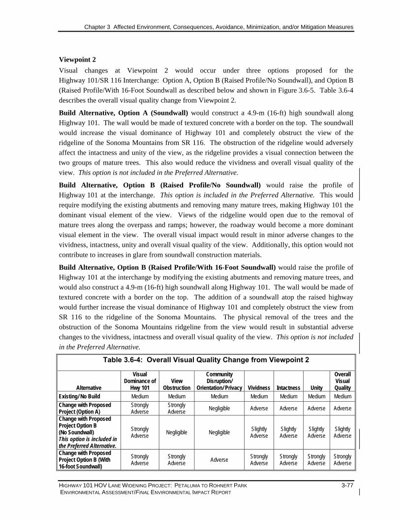
Chapter 3 Affected Environment, Consequences, Avoidance, Minimization, and/or Mitigation Measures
HIGHWAY 101 HOV LANE WIDENING PROJECT: PETALUMA TO ROHNERT PARK 3-77 ENVIRONMENTAL ASSESSMENT/FINAL ENVIRONMENTAL IMPACT REPORT
Viewpoint 2 Visual changes at Viewpoint 2 would occur under three options proposed for the Highway 101/SR 116 Interchange: Option A, Option B (Raised Profile/No Soundwall), and Option B (Raised Profile/With 16-Foot Soundwall as described below and shown in Figure 3.6-5. Table 3.6-4 describes the overall visual quality change from Viewpoint 2.
Build Alternative, Option A (Soundwall) would construct a 4.9-m (16-ft) high soundwall along Highway 101. The wall would be made of textured concrete with a border on the top. The soundwall would increase the visual dominance of Highway 101 and completely obstruct the view of the ridgeline of the Sonoma Mountains from SR 116. The obstruction of the ridgeline would adversely affect the intactness and unity of the view, as the ridgeline provides a visual connection between the two groups of mature trees. This also would reduce the vividness and overall visual quality of the view. This option is not included in the Preferred Alternative.
Build Alternative, Option B (Raised Profile/No Soundwall) would raise the profile of Highway 101 at the interchange. This option is included in the Preferred Alternative. This would require modifying the existing abutments and removing many mature trees, making Highway 101 the dominant visual element of the view. Views of the ridgeline would open due to the removal of mature trees along the overpass and ramps; however, the roadway would become a more dominant visual element in the view. The overall visual impact would result in minor adverse changes to the vividness, intactness, unity and overall visual quality of the view. Additionally, this option would not contribute to increases in glare from soundwall construction materials.
Build Alternative, Option B (Raised Profile/With 16-Foot Soundwall) would raise the profile of Highway 101 at the interchange by modifying the existing abutments and removing mature trees, and would also construct a 4.9-m (16-ft) high soundwall along Highway 101. The wall would be made of textured concrete with a border on the top. The addition of a soundwall atop the raised highway would further increase the visual dominance of Highway 101 and completely obstruct the view from SR 116 to the ridgeline of the Sonoma Mountains. The physical removal of the trees and the obstruction of the Sonoma Mountains ridgeline from the view would result in substantial adverse changes to the vividness, intactness and overall visual quality of the view. This option is not included in the Preferred Alternative.
Table 3.6-4: Overall Visual Quality Change from Viewpoint 2
Alternative
Visual Dominance of
Hwy 101 View
Obstruction
Community Disruption/
Orientation/ Privacy Vividness Intactness Unity
Overall Visual Quality
Existing/ No Build Medium Medium Medium Medium Medium Medium Medium Change with Proposed Project (Option A)
Strongly Adverse
Strongly Adverse Negligible Adverse Adverse Adverse Adverse
Change with Proposed Project Option B (No Soundwall) This option is included in the Preferred Alternative.
Strongly Adverse Negligible Negligible Slightly
Adverse Slightly Adverse
Slightly Adverse
Slightly Adverse
Change with Proposed Project Option B (With 16-foot Soundwall)
Strongly Adverse
Strongly Adverse Adverse Strongly
Adverse Strongly Adverse
Strongly Adverse
Strongly Adverse

Existing Condition / No Build Alternative Option A: 16 ft. Soundwall
Option B: Raised Profile/No SoundwallPreferred
Option B: Raised Profile/16 ft. Soundwall
2
VIEWPOINT 2Figure 3.6-5
S C T AS C T A Highway 101 HOV Lane Widening Project:Old Redwood Highway, Petaluma to Rohnert Park Expressway, Rohnert Park 3-78

Chapter 3 Affected Environment, Consequences, Avoidance, Minimization, and/or Mitigation Measures
HIGHWAY 101 HOV LANE WIDENING PROJECT: PETALUMA TO ROHNERT PARK 3-79 ENVIRONMENTAL ASSESSMENT/FINAL ENVIRONMENTAL IMPACT REPORT
As shown in Figure 3.6-5, Option B (included in the Preferred Alternative) would slightly increase the adverse effect on scenic vistas for viewers. As compared to Option A, the Option B soundwall would be slightly more visible from the heavily traveled Gravenstein Highway due to the increased profile of Highway 101. Similar to Option A, this impact would diminish in intensity with distance from the soundwall and would not be considered substantial. The soundwall would also contribute to a more urbanized feel for viewers in the vicinity of Highway 101 due to a reduction in screening vegetation and the soundwall structure itself. The soundwall materials would also become a new source of reflective light contributing to glare. The soundwall would not contribute to nighttime light; therefore, there would be no impacts to nighttime views in the area. Consistency with Scenic/Visual Resource Plans and Policies
The General Plans for Sonoma County and the cities of Petaluma, Cotati and Rohnert Park set forth scenic/visual resource goals and policies intended to preserve, enhance, restore and respect scenic vistas and visually important landscapes in each jurisdiction. The proposed project would be generally consistent with relevant scenic/visual resources policies, or mitigation would be applied to make it consistent, as shown in Table 3.6-5 below.
Table 3.6-5: Consistency with Scenic/Visual Resource Plans and Policies
Rohnert Park General Plan Goal CD-D: Preserve and enhance views of the eastern ridgeline. Views of the eastern ridgeline should be preserved from the existing neighborhoods, and should be emphasized in the orientation and design of new public spaces and streets.
Consistent. The project would not result in a visual impact to the eastern ridgeline of Rohnert Park. In addition, the removal of some vegetation may open views of the ridgeline for motorists traveling along Highway 101 southbound traveling toward Petaluma.
Goal CD-E: Preserve and enhance the visual character of scenic corridors.
Consistent. Although this portion of Highway 101 is not designated as a scenic corridor, portions of Highway 101 within the project limits are highly scenic. The project would not result in an adverse visual impact to scenic corridors within the City of Rohnert Park, as most of the grading and vegetation removal associated with the project would occur along the Highway 101 corridor just to the north of Petaluma.
Goal OS-A: Maintain a greenbelt around the city that provides a physical and visual space between Rohnert Park-Cotati and Santa Rosa, Petaluma, and Penngrove.
Consistent. The project would not result in a substantial impact to the number of acres of open space and agricultural land located on the southern border of the City and northern boundary of Petaluma, and therefore, it would not result in a significant visual change to the existing greenbelt.
Goal OS-B: Maintain land surrounding the city as open space for the enjoyment of scenic beauty, recreation, and protection of natural resources of the community.
Consistent. See above.
City of Petaluma General Plan Opportunity 5: A key to Petaluma’s identity is the rural and agricultural character of its setting. Urban separators are already in place to the northwest, northeast, and southeast of the City, and care should be taken to preserve the rolling hills surrounding it to the southwest as well.
Potentially Inconsistent. The project would involve grading, the removal of some mature vegetation, and construction of soundwalls along the Highway 101 corridor. This would result in a potentially adverse impact to the visual character of the rural, wooded areas.

Chapter 3 Affected Environment, Consequences, Avoidance, Minimization, and/or Mitigation Measures
3-80 HIGHWAY 101 HOV LANE WIDENING PROJECT: PETALUMA TO ROHNERT PARK ENVIRONMENTAL ASSESSMENT/FINAL ENVIRONMENTAL IMPACT REPORT
Table 3.6-5: Consistency with Scenic/Visual Resource Plans and Policies
City of Cotati General Plan Objective 12.1: Establish and maintain visual breaks between Cotati and Rohnert Park, Cotati, and Petaluma, and Cotati and Sebastopol.
Consistent. The project would not result in a substantial loss of acreage between the cities, and would therefore not visually affect the community separator between these cities.
Objective 13.1: Cotati’s scenic natural resources shall be preserved and development adjacent to these resources shall be visually unobtrusive and environmentally compatible.
Potentially Inconsistent. The removal of mature vegetation and construction of soundwalls within the corridor would affect the scenic natural resources of the corridor, resulting in an adverse visual impact unless mitigation is incorporated.
Objective 13.2: Improve the visual character along Cotati’s roads.
Potentially Inconsistent. The removal of mature vegetation and construction of soundwalls within the corridor would affect the rural character of the corridor, resulting in an adverse visual impact unless mitigation is incorporated.
Policy 13.2.1: Improve landscaping along Cotati’s roads.
Potentially Inconsistent. The removal of mature vegetation and construction of soundwalls within the corridor would affect the rural character of the corridor, resulting in an adverse visual impact unless mitigation is incorporated.
Sonoma County General Plan Goal OS-1: Preserve the visual identities of communities by maintaining open space areas between cities and communities.
Consistent. The project would not result in a substantial loss of acreage between the urbanized areas of Rohnert Park and Petaluma, and would therefore not visually affect the greenbelt separator between these cities.
Objective OS-1.1: Preserve important open space areas in the community separators shown on Figures OS-5a through OS-5i of the Open Space Element.
Consistent. The project would not result in increased development within the community separators, and would not affect the amount of open space between urbanized areas of neighboring cities.
Objective OS-1.2: Retain a rural character and promote low intensities of development in community separators. Avoid their annexation or inclusion in spheres of influence for sewer and water service providers.
Consistent. See above.
Objective OS-1.4: Preserve existing specimen trees and tree stands within community separator areas.
Potentially Inconsistent. The removal of mature vegetation would result in an adverse visual impact to the visual separator (the Highway 101 corridor) within the project area, unless mitigation is incorporated.
Goal OS-2: Retain the largely open, scenic character of important scenic landscape units.
Potentially Inconsistent. The removal of mature vegetation and construction of soundwalls within the project area would affect the rural character of the corridor, resulting in an adverse visual impact unless mitigation is incorporated.
Goal OS-3: Identify and preserve roadside landscapes which have a high visual quality as they contribute to the living environment of local residents and to the county's tourism economy.
Potentially Inconsistent. The removal of mature vegetation and construction of soundwalls within the project area would affect the roadside landscapes of the corridor, resulting in an adverse visual impact unless mitigation is incorporated.
Goal RC-4: Preserve, sustain and restore forestry resources for their economic, conservation, recreation, and open space values.
Potentially Inconsistent. The removal of mature vegetation along the highway would result in both increased visual exposure of the highway to adjacent land uses, as well as an impact to forestry resources in the project area unless mitigation is incorporated.

Chapter 3 Affected Environment, Consequences, Avoidance, Minimization, and/or Mitigation Measures
HIGHWAY 101 HOV LANE WIDENING PROJECT: PETALUMA TO ROHNERT PARK 3-81 ENVIRONMENTAL ASSESSMENT/FINAL ENVIRONMENTAL IMPACT REPORT
3.6.4 Avoidance, Minimization, and/or Mitigation Measures
It is Caltrans policy to replace vegetation damaged or removed due to highway improvement projects. A landscaping replacement plan would be implemented and replacement trees planted. The landscape replacement plan would be developed by Caltrans with input from Sonoma County and the cities of Petaluma, Cotati, and Rohnert Park to identify appropriate and feasible locations and species of trees for replacement within or near the project limits. Such replacement locations must meet safety requirements for sight distances, in addition to providing favorable conditions for tree establishment and survival. Avoidance and minimization approaches will be incorporated during final design to reduce tree loss below the upper end of the reported ranges. The following mitigation measures are proposed to reduce visual effects of the Build Alternative.
• In accordance with SCR 17, SB 1334, and Caltrans policies (see Section 3.15.4.1, Trees and Other Mature Vegetation), mature trees would be replaced at a ratio of 1:1 within the project limits and right of way, where feasible. This ratio and/or size may be increased based on consultation between Caltrans and the other agencies.
• Species, size, precise number, location, and spacing of replacement trees would ultimately be determined by Caltrans Office of Landscape Architecture at a future phase of the project.
• The landscape replacement plan would include landscaping and design elements, such as architectural treatments on soundwalls that would restore the corridor’s existing visual quality to the extent feasible. Where feasible, vines would be planted and allowed to grow on the walls to help visually integrate them with the overall landscape and to reduce the incidence of graffiti. New retaining walls would also be given aesthetic treatment.
• A three-year plant establishment period would be implemented.
• All disturbed areas will be re-vegetated according to Caltrans standards.
• Black vinyl clad chain link fence shall be installed on top of the proposed concrete barrier left of ML Line Station 99+20 to 109+00. A 12-18-inch wide plantable area will be provided between the concrete barrier and the frontage road to plant vines along the frontage road side of the barrier.
• Design exceptions will be prepared to:
1. Reduce the width of the standard “catch line” to minimize the loss of existing desirable vegetation.
2. Install guardrail around selected existing redwood tree groupings to retain the corridor image of being the “Redwood Highway.”
• Trees shall be planted within cut/fill slope transitional areas to break up the appearance of engineered slope planes.
• Provide slope rounding on cuts and fills for a more natural appearance. • Provide aesthetic surface treatments to structures that are consistent with the corridor-wide master
plan (to be developed).
• Redwood tree clusters and other mature vegetation will be reestablished where feasible within the project limits and right of way.

Chapter 3 Affected Environment, Consequences, Avoidance, Minimization, and/or Mitigation Measures
3-82 HIGHWAY 101 HOV LANE WIDENING PROJECT: PETALUMA TO ROHNERT PARK ENVIRONMENTAL ASSESSMENT/FINAL ENVIRONMENTAL IMPACT REPORT
Additional avoidance and minimization measures to be implemented during the construction phase of the project are discussed in Section 3.16.6, Visual/Aesthetics.
3.7 Cultural Resources
As used in this document, “cultural resources” refers to archaeological and historical resources including, but not necessarily limited to, districts, sites, buildings, structures, and objects. This section of the environmental document discusses the studies performed to identify and evaluate the potential for impacts to such resources.
3.7.1 Regulatory Setting
The primary federal laws dealing with archaeological and historic resources include:
National Historic Preservation Act of 1966 [16 U.S.C. 470 et seq.]:
The National Historic Preservation Act (NHPA), as amended, sets forth national policy and procedures regarding historic properties included in or eligible for the National Register of Historic Places (NRHP). Section 106 of the NHPA requires federal agencies to consider the effects of their undertakings on such properties, following regulations issued by the Advisory Council on Historic Preservation (36 CFR §800).
National Environmental Policy Act of 1969 [42 U.S.C. 4321 et seq.]:
The National Environmental Policy Act (NEPA), the broad environmental law that applies to federal agencies and their activities, includes the preservation of important historic, cultural, and natural aspects of our national heritage within its general policy for environmental protection. Meeting the requirements of Section 106 and the NEPA regulations (40 CFR §1500-1508.28) are separate compliance efforts that require coordination. The Section 106 compliance documents that are prepared to meet the requirements of the National Historic Preservation Act also provide the basis for the required assessment of cultural resources, project alternatives, and historic property impacts in the environmental document prepared pursuant to NEPA.
U.S. Department of Transportation Act of 1966 (49 U.S.C. 303 Section 4[F]):
Transportation projects must comply with the provisions of Section 4(f) of the U.S. Department of Transportation Act (23 CFR §771). Section 4(f) applies to U.S. Department of Transportation projects that involve the “use” (either actual take of land or a less tangible “constructive use”) of land from historic properties. A Section 4(f) evaluation, which requires documentation of completion of the Section 106 process, must demonstrate that there is no prudent and feasible alternative to the use, and that all possible planning has been done to minimize harm to Section 4(f) protected resource(s).

Chapter 3 Affected Environment, Consequences, Avoidance, Minimization, and/or Mitigation Measures
HIGHWAY 101 HOV LANE WIDENING PROJECT: PETALUMA TO ROHNERT PARK 3-83 ENVIRONMENTAL ASSESSMENT/FINAL ENVIRONMENTAL IMPACT REPORT
California Environmental Quality Act of 1970 (CEQA) [PRC §21000 et seq.]:
Cultural resources are protected by the California Environmental Quality Act (CEQA) (PRC Division 13, Sections 21000-21178), which requires state and local agencies to take into consideration the environmental effects of their actions. Cultural resources that are listed on or determined to be eligible for listing on the NRHP and/or the California Register of Historic Resources (CRHR), as well as city-designated historic resources are protected under CEQA.
Public Resources Code (PRC §5024.1):
Public Resources Code §5024.1 established the California Register of Historic Resources, a listing of historic properties within the state. Section §5024.5 requires state agencies to provide notice to and to confer with the State Historic Preservation Officer (SHPO) before altering, transferring, relocating, or demolishing state-owned historical resources.
3.7.2 Affected Environment
3.7.2.1 ARCHAEOLOGICAL RESOURCES
Archaeological resources possess both scientific and cultural values. The specific site locations are confidential in order to deter vandalism and desecration. Therefore, only generalized locations associated with the proposed project are provided in this section.
In accordance with both Section 106 of the National Historic Preservation Act and CEQA, Caltrans commenced archaeological investigations by delineating an archaeological Area of Potential Effect (APE) to include the maximum anticipated project footprint for areas that may be disturbed by the proposed project. Certain assumptions have been made, such as two meters (6.56 feet) of anticipated temporary construction easement beyond potential soundwall footing locations.
The Archaeological Survey Report (ASR) that was subsequently prepared documents the efforts to evaluate the potential for buried cultural deposits. This involved a sensitivity analysis for intact buried prehistoric and historic archaeological resources within the APE that relied on published maps, reports and databases. These included those generated by the U.S. Geological Survey (USGS), California Geological Survey (CGS), and the Natural Resources Conservation Service (NRCS). Additional information on previous archaeological survey findings and geological context was obtained through the Anthropological Studies Center and the Geography Department of Sonoma State University (SSU). The ASR also indicates that input regarding archaeological sensitivity was sought through consultation with local Native American tribes and individuals (see Chapter 6, Summary of Public and Agency Involvement and Tribal Coordination). The investigation also included a pedestrian field survey of all accessible portions (approximately 85 percent) of the archaeological APE.
Prehistoric Archaeological Resources: A records search at the Historical Resources Information System, Northwest Information Center (NWIC) indicates that no prehistoric archaeological sites are

Chapter 3 Affected Environment, Consequences, Avoidance, Minimization, and/or Mitigation Measures
3-84 HIGHWAY 101 HOV LANE WIDENING PROJECT: PETALUMA TO ROHNERT PARK ENVIRONMENTAL ASSESSMENT/FINAL ENVIRONMENTAL IMPACT REPORT
documented within the APE. However, seven recorded sites are located within 0.8 km [0.5 mile] from the archaeological APE. Also, three unsubstantiated ethnographic village locations may be situated within a mile radius from the project APE.
Based on a review of the geomorphological and archaeological records, there initially appeared to be a possibility that buried archaeological resources could be present within the project APE. Portions of the Santa Rosa Plain contain Holocene Age sediments deposited since the earliest known human use of the Sonoma County region. Various depositional processes (alluvial/colluvial sedimentation, stream channel migration, and seismic-induced ground movement) have buried stable land surfaces that could contain prehistoric archaeological deposits. Thus, there was a potential for buried prehistoric archaeological deposits in the valleys that are transected by the Highway 101 project and surroundings. Therefore, a thorough and systematic program of subsurface testing was conducted, which revealed little likelihood of encountering buried cultural materials within the project APE.
Historic Archaeological Resources: Reviews of project information, late-nineteenth century and twentieth-century maps, county and local histories, and cultural resource management reports were completed to determine the potential for encountering historical archaeological resources that might be eligible for the National Register of Historic Places. No known Hispanic or American period structures, features, or potential historical archaeological sites have been recorded or identified within or immediately adjacent to the archaeological APE, except for the Page family homeplace. The Page family homeplace consisted of a ranch house, a large hexagonal barn and additional outbuildings, all located at the east end of an east-west ridge with a view of the Cotati Valley and the Sonoma Mountains. Historical maps (Bower 1867; Thompson 1877) indicate that the homeplace stood either within or immediately adjacent to the archaeological APE. This site, however, was totally destroyed during the mid-1950s when the Highway 101 Cotati bypass was completed between Denman Flat and Helman Lane (DeClercq 1977:10). It is unlikely that any eligible historical resources remain; nevertheless, the archaeological APE at the general homeplace location was thoroughly field inspected for historic (and prehistoric) archaeological resources. No evidence of cultural resources was observed.
3.7.2.2 HISTORIC RESOURCES
Historic resources include districts, sites, buildings, structures, and objects included in or eligible for the National Register of Historic Places. To assess the impacts of the project on historic resources, both a Historic Property Survey Report (HPSR) and Historic Resource Evaluation Report (HRER) were completed for the project.
A HPSR was submitted to the State Historic Preservation Officer (SHPO) on September 12, 2005. The SHPO concurred in the negative eligibility findings on October 21, 2005. A copy of the SHPO’s letter is provided in Appendix E, Agency Correspondence.
The Area of Potential Effects (APE) for the project architectural survey was developed consistent with Caltrans policies and general cultural resource practices to include the area directly affected by
Chapter 3 Affected Environment, Consequences, Avoidance, Minimization, and/or Mitigation Measures
HIGHWAY 101 HOV LANE WIDENING PROJECT: PETALUMA TO ROHNERT PARK 3-85 ENVIRONMENTAL ASSESSMENT/FINAL ENVIRONMENTAL IMPACT REPORT
construction; it generally runs either with or one parcel beyond the proposed archaeological APE. In some instances, where there are proposed soundwalls or raised structures such as overpasses, the architectural APE extends beyond the one parcel to account for potential visual effects. Where the proposed project bisects a parcel, the boundary is generally drawn to include the whole parcel; however, where the architectural APE intersects large, vacant agricultural parcels where there is little potential for effects, the proposed architectural APE is generally aligned with the proposed or existing right of way. Where a viewshed is obscured by hillsides or vegetation, the proposed architectural APE is kept to the proposed or existing right-of-way. The APE includes locations for recommended soundwalls, permanent and temporary construction easements, new right-of-way acquisitions, and construction and staging areas. Recommended soundwalls are those that meet both the Caltrans feasibility criteria and preliminary determination for reasonableness (i.e. the Cost Allowance per Residence). Only those resources located within the architectural APE line were included in the survey. Any locations at soundwalls or temporary construction easements later identified and not included in the current APE will be reviewed as supplemental studies in accordance with the Section 106 Programmatic Agreement.
A reconnaissance survey was conducted in the field to account for all buildings, structures, and objects within the APE. This field reconnaissance helped to determine which buildings appeared to be more than 45 years of age and, therefore, would need more detailed study for this project. Background research included a review of the First Real Estate Solutions commercial database, historic and current USGS topographic maps, and resource-specific searches of archival and published records. Additional research was conducted at the California State Library; the Sonoma County Assessor’s and Recorder’s offices; the California Department of Transportation Library (Headquarters in Sacramento); Caltrans District 4 Maps and Plans Office (Oakland); Shields Library at University of California, Davis; Petaluma Museum Research Library; Solano County Library Annex in Santa Rosa; and the Healdsburg Museum and Historical Society.
A letter informing interested parties of this project was sent to area planning agencies, local governments, historical societies, and museums on June 25, 2003. No responses were received.
The architectural APE contains 115 buildings, groups of buildings, or structures, of which 14 required a formal evaluation on a DPR523 form. All of the survey resources formally evaluated are located within Sonoma County, in or near the cities of Petaluma, Cotati, Penngrove and Rohnert Park. The 14 survey resources were constructed in or before 1957 and were surveyed in the months of May and June 2003, and August 2004. Only one survey resource, the Trebino ranch located at 10 Helman Lane (Map Reference No. 14), was previously inventoried and evaluated in July 2000. Because that survey is less than five years old, specialists conducted a field verification of the site and completed an update to the previous evaluation. Access to one survey resource, 596 West Sierra Avenue, was not obtained for this study; however, it is evident from aerial photography and the county assessor records that this parcel contains at least two buildings.

Chapter 3 Affected Environment, Consequences, Avoidance, Minimization, and/or Mitigation Measures
3-86 HIGHWAY 101 HOV LANE WIDENING PROJECT: PETALUMA TO ROHNERT PARK ENVIRONMENTAL ASSESSMENT/FINAL ENVIRONMENTAL IMPACT REPORT
The remaining buildings, groups of buildings, or structures fall under one of the six property types exempt from evaluation as outlined in Attachment 4 of the Programmatic Agreement between Caltrans, FHWA, ACHP, and the SHPO, which became effective January 1, 2004.
Residential Properties: Of the 14 residential properties within the architectural APE, more than half were constructed as part of small farm complexes on land subdivided in the 1890s through the 1920s. Nearly all of these resources were built in the 1920s and 1930s and demonstrate the typical development pattern common to many small agricultural regions in California. The majority of these properties had their beginnings as small, family-owned chicken farms. As the region developed, land was subdivided and only remnant buildings from this period are extant. Within the architectural APE, there are no extant buildings such as brooding houses, hatcheries, or colony houses that are directly associated with the region’s poultry industry. The former agricultural properties within the APE ceased to function as farms in the second half of the twentieth century.
The remaining residential resources consist of a mixture of Minimal Traditional and small Ranch-style residences constructed in the 1940s and 1950s on semi-urban lots on the outskirts of Cotati. In general, the buildings on these residential properties are modified wood frame houses with simple plans. Only a few have escaped major alterations; most have been modified by the replacement of original windows, siding, or the construction of additions, all of which have compromised the historical integrity of the properties. Many of the farm complexes also have suffered a loss of feeling, association, and setting through the alteration of surrounding buildings, modern infill construction on nearby parcels, or the construction and widening of transportation features.
Transportation Features: The architectural APE also includes eight bridges and culverts constructed for Redwood Highway or Highway 101, and three bridges constructed by Sonoma County along adjacent county roads. All eleven bridges and culverts, constructed between 1918 and 1956, are listed as Category 5 structures (determined not eligible for listing in the National Register of Historic Places) in the California Historic Bridge Inventory completed by Caltrans in 1986 and they fall under one of the six property types exempt from evaluation as outlined in Attachment 4 of the Programmatic Agreement (PA) between Caltrans, FHWA, ACHP and the SHPO, which became effective January 1, 2004. Therefore, these structures were not formally evaluated for this project.
3.7.3 Environmental Consequences
3.7.3.1 IMPACTS ON ARCHAEOLOGICAL RESOURCES
An elevated level of effort, including a thorough and systematic subsurface testing program, has been conducted to evaluate the likelihood of encountering buried cultural resources during construction of the Highway 101 HOV Lane Widening Project. Based on the information collected during field surveys, documentary research, and subsurface testing, it is not anticipated that construction activities would encounter or disturb buried cultural resources. Measures are identified in Section 3.7.4, Avoidance, Minimization, and/or Mitigation Measures, to address late discovery of unanticipated buried cultural deposits.

Chapter 3 Affected Environment, Consequences, Avoidance, Minimization, and/or Mitigation Measures
HIGHWAY 101 HOV LANE WIDENING PROJECT: PETALUMA TO ROHNERT PARK 3-87 ENVIRONMENTAL ASSESSMENT/FINAL ENVIRONMENTAL IMPACT REPORT
3.7.3.2 IMPACTS ON HISTORIC ARCHAEOLOGICAL RESOURCES
As a result of the archival research and field reconnaissance, the project has little or no potential to affect historic archaeological resources. Therefore, no mitigation for such impacts is proposed.
3.7.3.3 IMPACTS ON ARCHITECTURAL RESOURCES
The resources within the architectural APE were evaluated in accordance with applicable sections of the NHPA and the implementing regulations of the ACHP as these pertain to federally funded undertakings and their impacts on historic properties. The resources also were evaluated in accordance with Section 15064.5(a) (2)-(3) of the CEQA Guidelines using the criteria outlined in Section 5024.1 of the California Public Resources Code. The State Historic Preservation Officer concurred by letter dated 21 October 2005 that the 14 evaluated resources do not meet criteria for listing in the NRHP or CRHR nor are they historical resources for the purposes of CEQA. Caltrans has determined that the only other resources present within the architectural APE, including state-owned resources, meet the criteria for Section 106 PA Attachment 4 (Properties Exempt from Evaluation); that is, Caltrans Professionally Qualified Staff (PQS) have determined that the resources within the architectural APE do not have demonstrable potential for historic significance. Therefore, there is no potential for impact to historic resources, and no mitigation is proposed.
As there are no eligible historic resources, there is no potential for impact to such resources and no mitigation is proposed.
3.7.4 Avoidance, Minimization and/or Mitigation Measures
3.7.4.1 PREHISTORIC ARCHAEOLOGICAL RESOURCES
In the unlikely event that previously unidentified buried cultural materials are unearthed during construction of the proposed project, Caltrans and FHWA would comply with 36 CFR §800.11, 36 CFR 800.13 (b)(3), and if applicable, (c), as stipulated in the Section 106 2004 Programmatic Agreement for Federal-aid Highway Programs in California.
3.8 Hydrology and Floodplains
This section summarizes the regulatory setting, existing environment, potential impacts, and measures to prevent or reduce impacts to hydrologic resources and floodplains as a result of the proposed project. A Draft Location Hydraulic Study and Floodplain Risk Assessment (MACTEC Engineering and Consulting, Inc.) was conducted in November 2005. Documents reviewed in support of this study include the PSR/PDS, Highway 101 as-built plans, Caltrans strip topographic data, USGS quadrangles, Petaluma River Watershed Master Drainage Plan, Sonoma County design criteria, and the Federal Emergency Management Agency (FEMA) Flood Insurance Rate Maps (FIRMs) and Flood Insurance Studies (FISs) for Sonoma County (FEMA, 1997), City of Rohnert Park (FEMA, 1980), and City of Petaluma (FEMA, 1989). Supplemental data were gathered during site investigations and meetings with Sonoma County Water Agency staff. The flood hydrograph data

Chapter 3 Affected Environment, Consequences, Avoidance, Minimization, and/or Mitigation Measures
3-88 HIGHWAY 101 HOV LANE WIDENING PROJECT: PETALUMA TO ROHNERT PARK ENVIRONMENTAL ASSESSMENT/FINAL ENVIRONMENTAL IMPACT REPORT
used for the hydraulic studies for this environmental document are based on the ultimate buildout according to the Sonoma County General Plan.
3.8.1 Regulatory Setting
The following federal, state, and local laws, ordinances, and guidelines provide the regulatory context for the project area:
National Flood Insurance Program (23 CFR §640, Subpart A, Section 650 et seq.) The National Environmental Policy Act (NEPA), 42 USC Section 4231, requires that all actions sponsored, funded, permitted, or approved by federal agencies undergo planning to ensure that environmental considerations are given due weight in project decision-making. Section 650.111 of the regulations calls for location hydraulic studies to be performed with detailed engineering design drawings to avoid and/or minimize hydrological and floodplain impacts. For work in floodplains that requires permit approval, environmental documentation must explain the impacts the project will have on these areas, and on the resources within those areas. Federal implementing regulations are at 23 CFR §771 (FHWA) and 40 CFR §1500-1508 (CEQ).
Executive Order 11988 (May 24, 1977) directs federal agencies to avoid to the extent possible adverse impacts associated with floodplains and to avoid direct or indirect support of incompatible development in floodplains.
3.8.2 Affected Environment
This section summarizes the surface water, groundwater, and floodplain studies that were carried out in support of this project.
3.8.2.1 HYDROLOGY
Hydrologic Resources: The primary hydrologic resources within the study area include Copeland Creek, Laguna de Santa Rosa, and Willow Brook. Copeland Creek and Laguna de Santa Rosa contribute run-off to the Russian River; drainage is generally in a northwesterly direction. These two watersheds range from alluvial to steeply mountainous, changing in elevation from approximately 29 m (95 ft) to 750 m (2,460 ft) mean sea level (msl). The Copeland Creek watershed is 1,270 ha (4.9 sq mi) in size, and the Laguna de Santa Rosa watershed is 984 ha (3.8 sq mi) in size. The Willow Brook watershed is 3,520 ha (13.6 sq mi) and contributes run-off to the Petaluma River. The watershed drains in a generally southwesterly direction. The Willow Brook watershed changes in elevation from approximately 12 m (40 ft) to 658 m (2,160 ft) msl.
Climate and Precipitation: The climatic characteristics in the vicinity of the project area are typical of basins protected from direct coastal winds by low hills. Precipitation generally occurs during a rainy season that extends from October to April. Summers are typically warm and dry, and winters are mild and wet. The average temperature for the area is approximately 14.4 degrees Celsius (58 degrees Fahrenheit). The average annual rainfall in the project area is approximately

Chapter 3 Affected Environment, Consequences, Avoidance, Minimization, and/or Mitigation Measures
HIGHWAY 101 HOV LANE WIDENING PROJECT: PETALUMA TO ROHNERT PARK 3-89 ENVIRONMENTAL ASSESSMENT/FINAL ENVIRONMENTAL IMPACT REPORT
64 centimeters (cm) (25.2 inches). The upper portions of the watersheds affected by the Highway 101 HOV Lane Widening Project receive up to 114 cm (45 inches) of rainfall annually (SCWA, 1983).
Roadside Drainage: Existing roadside drainage consists primarily of open grass-lined swales off the shoulders and within the unpaved highway median. In some locations the median is paved with a curb to convey roadside drainage to drop inlets and buried pipelines. In these instances, the buried pipelines are provided to convey run-off to receiving waters. Existing roadside drainage facilities were observed during site investigations and some deficiencies were found, as listed below:
• KP 16.7 to 18.8–On the west side of Highway 101 at the location of landslide mitigation performed in the late 1960s. At the toe of slope there exists a collector pipe that collects water from the hydro auger piping located on the bench above. Most of the “T”s have broken and there exists seepage along the toe.
• KP 16.7 to 16.84–On the east side of Highway 101, the V-ditch located at the top of slope is badly buckled and damaged, and surface water flows beneath it.
• KP 16.43–On the west side of Highway 101, severe erosion has occurred at the culvert outlet. Two pipe sections have fallen away, and near vertical exposures of fill/debris are exposed.
Cross-Drainage: Drainage is carried across and under Highway 101 at three stream crossings: Copeland Creek, Laguna de Santa Rosa, and Willow Brook. The current cross-drainage facilities have sufficient capacity to handle the design storm run-off flow rates. The 100-year flood elevations are contained in channels or culverts, as described below:
• Copeland Creek crosses Highway 101 approximately 590 meters (1,935 feet) south of the Rohnert Park Expressway overcrossing. Drainage from this watershed is conveyed under the highway in a twin 4.4-meter by 3-meter (14.5-foot by 10-foot) concrete box culvert.
• Laguna de Santa Rosa crosses Highway 101 approximately 640 meters (2,100 feet) north of Highway 116 (West). Drainage is conveyed under the highway by a 3-meter by 2.7-meter (10-foot by 9-foot) concrete box culvert.
• Willow Brook crosses the highway approximately 660 meters (2,165 feet) north of Old Redwood Highway in Petaluma. Drainage from this area is conveyed under the highway by twin bridges, approximately 21.3 meters (70 feet) long and 13 meters (42.5 feet) wide.
Erosion Prevention: All of the stream crossings potentially affected by the proposed project are protected by concrete linings or sack concrete that helps to alleviate the potential for bridge scour to occur at the abutments. In general, the channel sections upstream and downstream of the crossings are heavily vegetated or concrete-lined and appear stable. Although the Laguna de Santa Rosa channel is vegetated up and downstream of the affected reach of Highway 101, it is in a concrete-lined channel in the vicinity of the project.

Chapter 3 Affected Environment, Consequences, Avoidance, Minimization, and/or Mitigation Measures
3-90 HIGHWAY 101 HOV LANE WIDENING PROJECT: PETALUMA TO ROHNERT PARK ENVIRONMENTAL ASSESSMENT/FINAL ENVIRONMENTAL IMPACT REPORT
3.8.2.2 FLOODPLAINS
FEMA Floodplain Designations: The Flood Insurance Study (FIS) and Flood Insurance Rate Maps (FIRMs) prepared by FEMA for Sonoma County and for the cities of Rohnert Park and Petaluma were reviewed to identify areas that would be inundated by a 100-year flood. A 100-year floodplain is defined as “the area subject to flooding by the flood or tide having a one percent chance of being exceeded in any given year.” An encroachment is defined as an action within the limits of the 100-year floodplain.. The FIRM maps indicate that Highway 101 is within the 100-year flood zone at the Laguna de Santa Rosa and Willow Brook crossings.
The FIRMs identify the following flood zone designations:
• Copeland Creek: Zone C—Areas of minimal flooding. Not in the 100-year flood zone (Zone A).
• Laguna de Santa Rosa: Zone A5—Areas of 100-year flood. Laguna de Santa Rosa crossing is in the 100-year flood zone (Zone A), but the 100-year flood elevations are contained in the channel.
• Willow Brook: Zone AE—Areas where the base flood elevation is determined. Base flood elevations through the Willow Brook crossing are heavily influenced by the flood elevations from the Petaluma River due to its proximity. The Highway 101 approaches to the Willow Brook structures are in Zone X, areas where the 100-year flood is expected to have an average depth of less than one foot.
Flooding Risks: Flooding of the Russian and Petaluma Rivers and their tributaries is mentioned in the FISs (FEMA 1997, 1980, and 1989). Review of project vicinity FISs and interviews with Sonoma County staff indicate that Willow Brook floods regularly into the trailer park adjacent to the south bank of the creek. Site investigations indicated attempts to construct a narrow levee on the south bank of Willow Brook with the aim of containing the creek within its banks. The levee, consisting of poorly compacted soil, extends only to Stony Point Road on the west, and floodwaters can overtop the road and still inundate the existing trailer park, effectively bypassing the levee.
3.8.3 Environmental Consequences
3.8.3.1 CROSS DRAINAGE IMPACTS
Drainages that cross Highway 101 were evaluated for potential impacts against the 100-year flood.
Copeland Creek and Laguna de Santa Rosa are contained in twin box culverts with open medians between twin bridge spans. Evaluation addressed whether closing the open medians at these structures would result in hydraulic impacts as a result of construction of crossings that are longer in the direction of flow. Copeland Creek and Laguna de Santa Rosa use continuous pier walls for each culvert crossing that would be retained and extended to become one continuous pier wall along each side of each widened highway crossing. Because the wall would be continuous and have a lower coefficient of friction than the natural ground between the structures, the flows would be improved and would be anticipated to pass smoothly and at slightly lower levels.

Chapter 3 Affected Environment, Consequences, Avoidance, Minimization, and/or Mitigation Measures
HIGHWAY 101 HOV LANE WIDENING PROJECT: PETALUMA TO ROHNERT PARK 3-91 ENVIRONMENTAL ASSESSMENT/FINAL ENVIRONMENTAL IMPACT REPORT
The twin Willow Brook bridges are separated by an open median. Analysis was performed to determine whether closing the open median at this structure and adding support piers would cause hydraulic impacts. It was determined that the crossing would be longer in the direction of flow and the additional piers supporting the widened portion of the bridge would not have an adverse effect on the hydraulic conditions. Similar to the Copeland Creek and Laguna de Santa Rosa structures, one continuous long structure may actually improve flow conditions through the structure when compared to the two parallel structures separated by a rougher natural surface.
The proposed project would raise, grade, and pave the existing unpaved highway median. If the highway were widened using this approach through the floodplain areas in the vicinity of Willow Brook, the highway profile could be raised as much as 0.26 m (0.8 ft) and this would affect the ability of 100-year floodwater to sheet flow across the highway just north of the Old Redwood Highway-Petaluma Boulevard North Interchange; therefore, the existing highway profile is proposed to be maintained through all 100-year floodplain locations. Project modifications to avoid adverse cross drainage impacts at this location are discussed in Section 3.8.4.2; Avoidance, Minimization and/or Mitigation Measures; Cross Drainage. The existing guardrail in the median would be relocated or replaced in-kind in the median to avoid an adverse impact to flood waters crossing Highway 101.
3.8.3.2 FLOODPLAIN IMPACTS
Changes in Water Surface Elevations: Hydraulic analysis was performed for the Build Alternative to assess the potential for impacts to water surface elevations and flood risk for the 100-year flood (MACTEC, 2004). There is no measurable difference in water surface elevations between the existing structure and the addition of HOV and auxiliary lanes for Laguna de Santa Rosa, however, the addition of HOV lanes at the Copeland Creek crossing would produce a very slight increase in water surface elevation, 0.01 m (0.4 in.) during the 100-year flood. This increase is considered negligible as the very small increase is well within the accuracy of the hydrological and hydraulic modeling; it is, therefore, not considered an adverse impact. In addition, the slight increase is lost within the first 60 m (200 ft) upstream of the crossing. Water surface elevations for all three design storm run-off flow rates would remain within the channel, even with the slight increase, and no structures would be affected. Surface elevations within Willow Brook would not be affected by the Build Alternative. Because the flow rates analyzed are for build-out conditions per county standards, and because there would be negligible changes in water surface elevations for the bridges that would be modified as part of the Highway 101 Widening, no impact on the floodplain would result from the widening. Therefore, no mitigation is proposed.
Impacts on Natural and Beneficial Floodplain Values: The beneficial floodplain values at Copeland Creek, Laguna de Santa Rosa, and Willow Brook are natural moderation of floods, maintenance of water quality, fish and wildlife habitat, support of vegetative communities, open space and natural beauty, and groundwater recharge. The proposed project would not adversely affect these natural and beneficial floodplain values because it would cause negligible changes in water surface elevations. Therefore, no mitigation measures are proposed.

Chapter 3 Affected Environment, Consequences, Avoidance, Minimization, and/or Mitigation Measures
3-92 HIGHWAY 101 HOV LANE WIDENING PROJECT: PETALUMA TO ROHNERT PARK ENVIRONMENTAL ASSESSMENT/FINAL ENVIRONMENTAL IMPACT REPORT
Support of Incompatible Floodplain Development: Floodplain encroachment has already occurred with construction of the original Highway 101. Since the proposed project would provide HOV lanes by widening the existing highway median, no additional floodplain encroachment is expected to occur as a result of the project. Temporary channel obstructions can be expected to occur during construction, but all work in the channel would occur during the dry season (June 15th to October 15th) per California Department of Fish and Game 1602 Streambed Alteration Agreement requirements (see Section S-6, Agency Permits and Approvals).
The only new highway capacity to be provided by the proposed project is for high occupancy vehicles, carpools, and transit, and a climbing lane to improve operations associated with slow-moving vehicles on northbound Cotati Grade. Thus, the project would not be growth inducing (see Section 3.2.3, Growth) and would not support additional development in the floodplain.
3.8.3.3 OTHER HYDROLOGIC IMPACTS
There would be no other hydrologic impacts of the proposed project, which would not interrupt, divert, add to, or reduce hydrology in the project vicinity.
3.8.4 Avoidance, Minimization and/or Mitigation Measures
3.8.4.1 ROADSIDE DRAINAGE
The roadside drainage will be modified to accommodate the widened highway facility and the 100-year flood with the exception of allowing the floodwaters to continue to overtop the highway between Willow Brook and the Old Redwood Highway-Petaluma Boulevard Interchange. Culverts will be repaired or upgraded as necessary, including the previously mentioned deficiencies, and the new drainage facilities coordinated with the stormwater BMPs to provide a consistent and effective drainage system. The BMPs that will become an integral component of the drainage system will include open swales off of the outside shoulders that would be modified to accommodate the widened roadway run-off and detention basins.
3.8.4.2 CROSS-DRAINAGE
Because the culverts span only the width of the existing highway right-of-way, the culverts will need to be extended to accommodate the widening work. Also, in those instances where the traveled lanes traverse the stream crossing via bridge structures, these bridges will be widened within the currently open median, closing the median. Closing the median would not cause an adverse impact on bridge hydraulics at any crossing, therefore, no mitigation is proposed.
The effects of widening into the Highway 101 median will be mitigated to maintain the existing condition. The highway profile and current roadway elevations would be maintained from the Old Redwood Highway-Petaluma Boulevard North Interchange to a point at least 1400 m (4600 ft) north (actual location to be determined based upon detailed study during the design phase), and the guardrail barrier in the median would be relocated or replaced in-kind. These measures would allow

Chapter 3 Affected Environment, Consequences, Avoidance, Minimization, and/or Mitigation Measures
HIGHWAY 101 HOV LANE WIDENING PROJECT: PETALUMA TO ROHNERT PARK 3-93 ENVIRONMENTAL ASSESSMENT/FINAL ENVIRONMENTAL IMPACT REPORT
the 100-year floodwaters to continue to overtop the highway in sheet flow towards the Petaluma River as they currently do under 100-year floods. Because this approach would not result in a changed condition, no additional mitigation is proposed.
3.9 Water Quality and Stormwater Run-off
This section summarizes the regulatory setting, existing environment, potential impacts, and avoidance and mitigation measures proposed to prevent or reduce impacts to water quality from stormwater run-off as a result of the proposed project.
3.9.1 Regulatory Setting
The following federal, state, and local laws, ordinances, and guidelines provide the regulatory context for the project area:
• Federal Clean Water Act: The federal Clean Water Act (CWA) is the primary water resources protection statute. Three sections of the CWA, in particular, are the focus of construction-phase compliance. Sections 401 (certification of state water quality standards), 402 (provisions of the National Pollutant Discharge Elimination System [NPDES]), and 404 (discharge of fill material into waters of the United States and wetlands) apply to the proposed project. Sections 401 and 404 (see 3.15, Biological Environment) are related and result in coordinated permitting by the state Regional Water Quality Control Board (RWQCB) and the U.S. Army Corps of Engineers (USACE), respectively, because of the CWA’s authorization of state-adopted water quality standards.
• Clean Water Act, Section 401 (Certification of Compliance with State Water Quality Standards): Under Section 401 of the CWA, the RWQCB makes a certification of compliance with state water quality standards for the project. Such certification may involve the imposition of project-specific waste discharge requirements (WDRs). The USACE will not issue a 404 permit without satisfaction of RWQCB Section 401 requirements.
• Clean Water Act, Section 402 (NPDES Permits, California State Water Resources Control Board, National Pollutant Discharge Elimination System, Construction General Permit for Stormwater Discharges): The California State Water Resources Control Board (SWRCB) implements the National Pollutant Discharge Elimination System (NPDES) program, which was established by EPA to regulate discharges into receiving waters. One requirement of the NPDES program is to file a General Permit (Water Quality Order 99-08-DWQ) with the State to regulate the discharge of pollutants that arise from construction activities. An NPDES application requires the filing of a Notice of Construction (NOC) to comply with the Statewide General Permit (see next paragraph). Prior to the start of construction, a Storm Water Pollution Prevention Plan (SWPPP) must be prepared and submitted to the RWQCB. The SWPPP is normally prepared by the construction contractor. It identifies sources of pollutants that may be generated during construction activities and the measures that have been prescribed to reduce the potential for sediment and other pollutants from entering receiving waters.

Chapter 3 Affected Environment, Consequences, Avoidance, Minimization, and/or Mitigation Measures
3-94 HIGHWAY 101 HOV LANE WIDENING PROJECT: PETALUMA TO ROHNERT PARK ENVIRONMENTAL ASSESSMENT/FINAL ENVIRONMENTAL IMPACT REPORT
• California Department of Transportation (National Pollutant Discharge Elimination System Permit for Storm Water Discharges): Caltrans requires and has its own NPDES permit (Order No. 99-06-DWQ) to regulate stormwater run-off. As described above, one requirement of the NPDES program is to file a General Permit (Water Quality Order 99-08-DWQ) with the State to regulate the discharge of pollutants into receiving waters.
• Municipal Separate Storm Sewer System (MS4) Permit: Section 402 of the CWA also includes provisions relating to Municipal Separate Storm Sewer System (MS4) permits. In addition to the requirements of the NPDES Construction General Permit, above, construction-phase project impacts must be addressed within the framework of the MS4 permit by means of county-specific MS4 compliance programs that are approved by the RWQCB.
• California Porter-Cologne Water Quality Control Act: The California Porter-Cologne Water Quality Control Act of 1969 requires that each Regional Water Quality Control Board within the State formulate and adopt water quality control plans or basin plans for all areas in the region.
3.9.2 Affected Environment
The Highway 101 HOV Lane Widening Project is located mainly within the Water Quality Control Plan for the North Coast Region (Basin Plan) and jurisdiction of the North Coast Regional Water Quality Control Board. A small portion of the project (located at the south end) falls within the Basin Plan and jurisdiction of the San Francisco Bay Regional Water Quality Control Board. Regulations for discharges within the project area are included in the Basin Plan (December 1993) and the Water Quality Control Plan for the San Francisco Bay Basin (June 1995).
The north section of the project crosses two drainage courses, Copeland Creek and Laguna de Santa Rosa, which flow northwesterly toward the Russian River located approximately 20 km (12.5 mi) northwest of the project. The south section crosses one drainage course, Willow Brook, which flows southwesterly to the Petaluma River located approximately 0.3 km (1,000 ft) west of the project. Copeland Creek, Laguna de Santa Rosa, and Willow Brook are the direct receiving water bodies. Each of the watersheds includes an upper (eastern) portion located in relatively hilly terrain and a lower (western) portion located in alluvial valleys.
3.9.2.1 BENEFICIAL USES OF WATER RESOURCES
The beneficial uses for the hydrologic areas as described within the two Basin Plans include groundwater (referring to groundwater of the Santa Rosa Valley), which is used for municipal, agricultural, and industrial supply; and surface water (referring to the Laguna de Santa Rosa), which is used for agricultural, industrial, recreational, and commercial uses, and cold freshwater habitat. No specific beneficial use has been listed for Willow Brook, though its confluence with the Petaluma River is immediately downstream of the freeway crossing. The Petaluma River has beneficial uses that include cold and warm freshwater habitat, navigation, migration of aquatic organisms, recreation, fish spawning, and wildlife habitat. Beneficial uses of the Petaluma Valley Groundwater Basin include municipal and agricultural.

Chapter 3 Affected Environment, Consequences, Avoidance, Minimization, and/or Mitigation Measures
HIGHWAY 101 HOV LANE WIDENING PROJECT: PETALUMA TO ROHNERT PARK 3-95 ENVIRONMENTAL ASSESSMENT/FINAL ENVIRONMENTAL IMPACT REPORT
3.9.2.2 EXISTING DRAINAGE
Existing pavement drainage flows to open grass-lined swales off the shoulders of Highway 101 and within the unpaved highway median. The proposed widening will include median paving and widening of the pavement along the shoulders. In this way, the swales currently located in the median will be removed and the drainage will be routed to the outside shoulders of the freeway.
3.9.2.3 WATER QUALITY
Currently, the only stream crossing the freeway within the project area that is listed as an impaired water body is Laguna de Santa Rosa, which is affected by sedimentation/siltation, nitrogen, and phosphorus. In the southern section of the project area, Willow Brook outlets into the Petaluma River immediately downstream of the freeway crossing. Here, the Petaluma River is listed as being affected by nutrients, pathogens and sedimentation.
3.9.2.4 POLLUTANTS
Pollutants found on streets and freeways that could be constituents of stormwater run-off include heavy metals, organic compounds (including petroleum hydrocarbons), sediments, trash, debris, oil, and grease.
3.9.3 Environmental Consequences
3.9.3.1 STORMWATER RUN-OFF
The project would result in a minor increase in impervious surface in the project area, approximately 11 hectares (28 acres), or 0.2 percent, of the combined 5,800 hectares (14,500 acres) of the Copeland Creek, Laguna de Santa Rosa and Willow Brook watersheds. This can be expected to translate into minor localized increases in urban run-off; however, the existing drainage system has adequate capacity to accommodate the small increase in run-off. Due to the lag time between the peak run-off from major tributaries in each of the watersheds, and that from the freeway run-off, the peak flow from the freeway will have substantially subsided by the time the watershed peak occurs. This, coupled with the minor increase in impervious surface, results in an insignificant increase in peak flow in each of the overall watersheds due to this project.
3.9.3.2 WATER QUALITY
As described previously, run-off from highways has been found to contain numerous pollutants, including metals, hydrocarbons, solids, oil, and grease. These constituents are most highly concentrated in the “first flush” of run-off that occurs from the first major rainstorm in a given period or season. After this first flush, the concentrations of highway pollutants are greatly reduced. Freeway drainage systems that provide adequate drainage facilities, are correctly designed, and incorporate permanent Best Management Practices (BMPs), to the maximum extent practicable, would be expected to improve the quality of freeway run-off that enters adjacent surface waters. The relatively small increase in impervious surface would result in relatively minor amounts of increased
Chapter 3 Affected Environment, Consequences, Avoidance, Minimization, and/or Mitigation Measures
3-96 HIGHWAY 101 HOV LANE WIDENING PROJECT: PETALUMA TO ROHNERT PARK ENVIRONMENTAL ASSESSMENT/FINAL ENVIRONMENTAL IMPACT REPORT
run-off, and therefore, only a neglible additional amount of pollutants would be conveyed off of the roadway surface.
3.9.4 Avoidance, Minimization and/or Mitigation Measures
3.9.4.1 POLLUTANT REMOVAL AND REDUCTION
As described in the Caltrans Storm Water Management Plan (SWMP), BMPs are designed and implemented to reduce to the maximum extent practicable the discharge of pollutants from the storm drain system. Due to site constraints within the narrow Highway 101 project corridor, the drainage system must balance pollutant removal with economic factors related to maintenance, right-of-way, and construction costs. Treatment BMPs for this project will be refined during final design. The proposed BMPs are from an approved list of BMPs known to be effective at reducing sediments and pollutants from highway run-off and would adequately remove the increased amount of pollutants attributable to this project while also removing a substantial amount of pollutants associated with the existing facility. These BMPs combined with the on-site drainage system would result in a significant reduction in trash, debris, absorbed hydrocarbons and metals, in the freeway run-off that enters streams and channels crossing the freeway. Infiltration basins and infiltration trenches were deemed inappropriate due to the poor infiltration characteristics of the underlying soil and relatively high groundwater levels. Additionally, this project is located in a Municipal Separate Sewer System (MS4) and stenciling of drainage inlets would be required.
3.9.4.2 EROSION CONTROL MEASURES
Permanent erosion control measures also would be used to address site soil stabilization and reduce deposition of sediments in adjacent surface waters. Typical measures that would be applied include the application of soil stabilizers such as hydroseeding, netting, erosion control mats, rock slope protection, velocity dissipation devices, flared-end sections for culverts and others. Temporary erosion control measures would also be required for the construction phase of the proposed project and are discussed in Section 3.16.9, Water Quality and Stormwater Run-off.

Chapter 3 Affected Environment, Consequences, Avoidance, Minimization, and/or Mitigation Measures
HIGHWAY 101 HOV LANE WIDENING PROJECT: PETALUMA TO ROHNERT PARK 3-97 ENVIRONMENTAL ASSESSMENT/FINAL ENVIRONMENTAL IMPACT REPORT
3.10 Geology/Soils/Seismic/Paleontology/Topography
This section addresses geologic and seismic issues associated with project improvements as identified in the Project Study Report prepared by Caltrans (PSR, 2001). Conclusions are based on published and unpublished data, reports, and maps from federal, state, and county agencies; project files and as-built drawings of previous Caltrans projects in the area; published and online references from Sonoma County, the California Geologic Survey, the United States Geologic Survey; aerial photos and maps; and a geological reconnaissance of the project area.
3.10.1 Affected Environment
3.10.1.1 REGIONAL GEOLOGY
The project area lies within the topographic divide between the Santa Rosa Plain on the north and Petaluma Valley to the south. Elevations range from 154 meters (505 feet) above sea level on Meacham Hill to less than 20 meters (66 feet) at the southern project limit and less than 30 meters (98 feet) at the northern project limit. The higher relief of Meacham Hill has resulted in more incised stream channels and steeper slopes in the area. The Highway 101 alignment was graded through Meacham Hill in the late 1950s and required deep cuts and moderately high fill embankments. Cuts and fills are reduced north of SR 116 and south of Pepper Road.
3.10.1.2 SOILS AND SEDIMENTS
Within the right-of-way, surface soils generally consist of porous and stiff sandy silts and clays, with lesser sands and silty sands. Based on road cuts and exposures along the central portion of the project corridor these soils are underlain at shallow depth by mudstones and sandstones of the Petaluma formation of Pliocene age. Andesite flows and pyroclastic rocks of the Sonoma Volcanics overlie the Petaluma formation at higher elevations and develop more resistant topographic landforms. North of the SR 116 interchange and south of the Pepper Road on-ramp, bedrock is not exposed. The soils in these lowland areas consist of an upper layer of expansive “adobe” clay soils over thick sequences of quaternary alluvium, older fan deposits, and colluvium.
3.10.1.3 SEISMICITY
The California Coast Range province is characterized by a high level of seismic activity related to the San Andreas system of faults. Faults within this system generally strike northwesterly and exhibit right-lateral, strike-slip displacement. These faults result from the northwesterly movement of the Pacific Plate against the North American Plate. Major active faults have broken the region into numerous fault-bound blocks (an active fault is defined as one that has had surface displacement within the last 11,000 years [Holocene-age]). Much of Sonoma County, including the project site, is located within a relatively intact block bound on the west by the active San Andreas fault and on the east by the active Healdsburg/Rodgers Creek fault system.

Chapter 3 Affected Environment, Consequences, Avoidance, Minimization, and/or Mitigation Measures
3-98 HIGHWAY 101 HOV LANE WIDENING PROJECT: PETALUMA TO ROHNERT PARK ENVIRONMENTAL ASSESSMENT/FINAL ENVIRONMENTAL IMPACT REPORT
Faults within the San Andreas system that could induce strong ground shaking in the project vicinity include the north coast segment of the San Andreas fault (capable of Moment Magnitude [Mmax] 7.6), the Hayward fault (Mmax 6.9) and the Healdsburg/Rodgers Creek fault (Mmax 7.0). There is a 32 percent probability that an event magnitude greater than 6.7 will occur on the Healdsburg/Rodgers Creek fault within the next 30 years. An earthquake of Mmax 7.0 on the Healdsburg/Rodgers Creek fault would result in an estimated peak ground acceleration of .04, as indicated on Caltrans Hazard maps (Caltrans, 1996). Active faults in the proximity of the project are shown in Table 3.10-1.
3.10.1.4 PALEONTOLOGY The project area extends into consolidated bedrock units on Meacham Hill. These units consist of interbedded Miocene to Late Pliocene marine sandstone of the Wilson Grove Formation and non-marine conglomerate of the Petaluma Formation. Exposures of these units are pronounced in road cuts on the east and west sides of the highway. At one locality (designated USGS JA-1, USGS, 2004) indeterminate bivalve clasts were exposed in the Wilson Grove, but were of poor quality. Another locality (designated USGS M4511) contained 12 poorly-preserved mollusks (bivalves and gastropods) and crustacean fragments. Both of these exposures are poorly preserved, and represent Low Sensitivity resources. The Petaluma formation rarely contains significant fossils (USGS, 1983). Other areas of Meacham Hill contain pyroclastic deposits (tuff) of the Sonoma Volcanics that are devoid of any paleontological resources, and are, therefore, of Marginal Sensitivity.
Project areas in the lowlands north and south of Meacham Hill are overlain by Late Quaternary alluvial fans, alluvium and fill. West and south of Cotati, some surficial deposits have been termed “sand and gravel of Cotati.” Vertebrate fossils have been collected from these deposits, however, these have not been studied (Lettis & Associates, 1998). Any fossils eroded from the bedrock units that have been transported to and deposited in the alluvial fans in the project area are likely to be very degraded and are not expected to have any paleontological significance.
3.10.2 Environmental Consequences Geologic hazards that may affect the project include landsliding, expansive surficial soils, ground shaking, liquefaction-induced settlement, fault rupture, lateral spreading, and flooding. These geologic hazards are briefly described below.
Table 3.10-1: Major Bay Area Faults, Distance from Proposed Project Site and Maximum Earthquake Magnitudes at the Site
Fault Name Distance in Kilometers (Miles)
(Jennings, 1994) Earthquake
(Moment Magnitude) San Andreas (North Coast Segment) 24.0 (14.9) 7.6 Hayward (North Segment) 45.0 (28.0) 6.9 Healdsburg/Rodgers Creek 8.0 (5.0) 7.0 West Napa 40.0 (24.8) 6.5
Source: CDMG, 1996 [California Division of Mines and Geology, 1996. Probabilistic Seismic Hazard Assessment for the State of California, DMG Open-File Report 96-08 and USGS Open File Report 96-706].

Chapter 3 Affected Environment, Consequences, Avoidance, Minimization, and/or Mitigation Measures
HIGHWAY 101 HOV LANE WIDENING PROJECT: PETALUMA TO ROHNERT PARK 3-99 ENVIRONMENTAL ASSESSMENT/FINAL ENVIRONMENTAL IMPACT REPORT
3.10.2.1 LANDSLIDING Because a majority of the highway corridor within the project limits is of high relief with somewhat unstable geologic conditions, landsliding presents a geologic hazard to the project. Of the landsides mapped during the field reconnaissance, the largest is the Denman Flat landside, which occurs on the east side of Highway 101 near Stony Point Road. A second landslide is located on the west side of the highway and was repaired in 1969. A third landslide, located on the east side, extends well above the highway and mostly occupies the slope outside the project right-of-way. Lesser soil slips and slumping, which have resulted in minor accumulations of debris on the benches or on the roadway shoulders, were also observed during field reconnaissance. Sliding can be anticipated to recur during the rainy season when surficial soil or weathered rock becomes saturated and loses shear strength.
3.10.2.2 EXPANSIVE SURFICIAL SOILS The Santa Rosa Plain and Petaluma Valley contain expansive surface soils. These soils may extend down two meters (6.6 feet) or more. It is possible that some expansive soils remain following the initial grading of the four-lane freeway. Because expansive soil is subject to volume changes with seasonal changes in moisture content, certain structures or pavements could be damaged if placed directly on these expansive “adobe” soils.
3.10.2.3 GROUND SHAKING A principal seismic hazard at the site is the potential for moderate to severe ground shaking from earthquakes occurring on one or more regional active faults. The San Andreas fault system has displayed considerable activity in the past and is considered likely to induce strong ground shaking within the project vicinity in the future, particularly along the Healdsburg/Rodgers Creek fault, the controlling fault in this system (see Section 3.10.1.3, Seismicity).
3.10.2.4 LIQUEFACTION-INDUCED SETTLEMENT Liquefaction typically occurs in loose, cohesionless, saturated, granular soils below the groundwater table. Based on a review of available local soil borings, it appears that the flatter, low lying portions of the project area are underlain by potentially liquefiable soils, primarily north of the SR 116 interchange and south of Pepper Road. It is conceivable that some localized liquefaction may occur within the Meacham Hill area but, in general, these areas are underlain by dense and stiff soils and bedrock.
3.10.2.5 LATERAL SPREADING Lateral spreading is a phenomenon associated with liquefaction where lateral movement of a soil embankment occurs along a free face. There is a possibility that this situation may occur at the Laguna de Santa Rosa creek channel.
3.10.2.6 FAULT RUPTURE Historically, fault rupture accompanying severe earthquakes has generally occurred along preexisting fault traces. Because the closest active fault, the Healdsburg/Rodgers Creek fault, is eight kilometers (five miles) away, fault-related ground rupture is not likely to occur at the project site.

Chapter 3 Affected Environment, Consequences, Avoidance, Minimization, and/or Mitigation Measures
3-100 HIGHWAY 101 HOV LANE WIDENING PROJECT: PETALUMA TO ROHNERT PARK ENVIRONMENTAL ASSESSMENT/FINAL ENVIRONMENTAL IMPACT REPORT
3.10.3 Avoidance, Minimization and/or Mitigation Measures The following measures are proposed to avoid, minimize, and/or mitigate geologic and seismic impacts. To avoid, minimize, and/or mitigate seismic hazards in the proximity of the project, site specific investigations, seismic hazard engineering analysis, and engineering recommendations for retaining walls, landslide prevention, expansive soil treatment, cuts and fills, and bridge foundation elements would be conducted during final design using Guidelines for Geotechnical Foundation Investigations and Reports (Caltrans, 2002). Specifications for construction would conform to the Standard Specifications (Caltrans, 1999).
3.10.3.1 LANDSLIDING Site specific engineering recommendations to minimize impacts due to landsliding would be defined based upon field testing and implemented during the final design phase and construction process. For slope stability, it is anticipated that cut and fill slopes would be constructed with inclinations of a vertical to horizontal ratio of 1:2 or flatter.
3.10.3.2 EXPANSIVE SURFICIAL SOILS Treatment actions for potential settlement or shrink-swell potential of soils include the use of lime, cement, fly ash, compaction control measures, moisture control measures, and/or removal and replacement with non-expansive backfill. Implementation of these actions or a combination of these actions would be explored during the final design and construction process when site-specific subsurface investigations, borings, and field mapping would be performed.
3.10.3.3 GROUND SHAKING The maximum credible earthquake (MCE), defined as the largest earthquake reasonably likely to occur under presently known conditions, is used to determine the safety evaluation for freeway design. To minimize the potential damage from ground shaking, structures associated with this project must meet MCE standards, as established by the Caltrans Office of Earthquake Engineering. The MCE for this project is a magnitude 7.0 earthquake, on the controlling Healdsburg/Rodgers Creek fault. All project structures would be designed to this MCE in accordance with current Caltrans design standards.
3.10.3.4 LIQUEFACTION-INDUCED SETTLEMENT To minimize potential liquefaction impacts associated with the proposed project, stone columns, sub-excavation, dynamic compaction, or de-watering methods would be implemented during construction. The most suitable method(s) would be selected based on site-specific subsurface investigations to identify the potential for liquefaction.
3.10.3.5 LATERAL SPREADING Site specific engineering recommendations to minimize impacts from lateral spreading would be incorporated into the final design plans and construction contract documents.

Chapter 3 Affected Environment, Consequences, Avoidance, Minimization, and/or Mitigation Measures
HIGHWAY 101 HOV LANE WIDENING PROJECT: PETALUMA TO ROHNERT PARK 3-101 ENVIRONMENTAL ASSESSMENT/FINAL ENVIRONMENTAL IMPACT REPORT
3.10.3.6 FAULT RUPTURE Site specific seismic hazard engineering analysis would be conducted during the final design phase and construction process to minimize the impacts of fault rupture.
3.11 Hazardous Waste/Materials
This section summarizes potential impacts from pre-existing hazardous wastes that could expose construction workers or the general public to health risks and that may require the implementation of special soil and/or groundwater management procedures. Section 3.16.10 discusses the potential impacts of hazardous materials that may be used or stored in conjunction with construction activities.
3.11.1 Affected Environment Data sources used to identify previous and current land uses that could contribute to the contamination of the project area include the following:
• The Initial Site Assessment (ISA) for the Highway 101 from Old Redwood Highway to Rohnert Expressway Project Study Report (PSR) identified locations of known hazardous waste sites in the project vicinity. The ISA evaluation included searches of standard federal and state environmental “record sources” (e.g. the Federal Superfund list, a list of registered underground storage tanks [USTs]). The search area (greater than the project limits) was reported to begin 91 m (299 ft) north of the intersection of Highway 101 and Rohnert Park Expressway, and end 183 m (600 ft) south of the Highway 101 intersection with Old Redwood Highway, covering an area of 107 m (353 ft) on each side of the freeway center;
• The ISA for the Highway 101 Wilfred Avenue Interchange Project and the Site Investigation Report for the Highway 101 from Wilfred Avenue to Route 12 project, pertinent because of these projects’ proximity to the current project corridor;
• Property-specific reviews of properties that were identified in the Highway 101 from Old Redwood Highway to Rohnert Park Expressway project ISA as having the potential to impact the project area;
• Field or drive-by reconnaissance of the project area and vicinity; and • Project files and as-built drawings of previous Caltrans projects in the area.
3.11.1.1 IDENTIFIED HAZARDOUS WASTE SITES The ISA identified 22 hazardous waste sites within the search area and nine other incidences of potentially hazardous waste releases. Of these, six sites or incidences of releases were judged to have the potential to affect subsurface conditions along the corridor and, therefore, warranted additional assessment. A review of North Coast Regional Water Quality Control Board (RWQCB) and San Francisco RWQCB regulatory files was carried out for each the six properties identified as having any potential to affect the project. A summary of the file review identifying each site, its address, location within the project area, the type of hazardous material found, and its potential risk to the proposed project’s scope and schedule, is presented in Table 3.11-1.

Chapter 3 Affected Environment, Consequences, Avoidance, Minimization, and/or Mitigation Measures
3-102 HIGHWAY 101 HOV LANE WIDENING PROJECT: PETALUMA TO ROHNERT PARK ENVIRONMENTAL ASSESSMENT/FINAL ENVIRONMENTAL IMPACT REPORT
Caltrans’ hazardous materials risk classifications are as follows:
• High Risk: Issues that could cause project costs to rise more than 20 percent for remediation, could cause long-term project schedule delays, or could require a large commitment of staff time to handle long-term responsibilities caused by acquisition and becoming a responsible party to a remediation.
• Moderate Risk: Issues that are somewhat routine and would require investigation, but would not be anticipated to affect the scope, schedule, or cost of the project.
• Low Risk: Issues that are related mainly to contractor-worker safety and disposal of materials generated during the construction phase of the project that would not affect the scope, schedule, or cost of the project.
The Caltrans PSR identified two additional areas of concern based on a review of historical aerial photographs. The first area was the property at the proposed southbound Highway 101 on-ramp at Old Redwood Highway. The second was the proposed path for the northbound Highway 101 on-ramp from Highway 116. However, review of the City of Petaluma assessor records indicates that with the exception of aerially deposited lead, described in Section 3.11.1.3, it is unlikely that hazardous wastes from historical property uses in these areas have the potential to affect the project.
Table 3.11-1: Hazardous Waste Sites/Incidences With Potential to Affect Subsurface Conditions along the Highway 101 HOV Lane Widening Project Corridor
Identified Property Property Address Property Location Hazardous Material
Risk Assessment
Exxon Facility 5153 Old Redwood Highway, Petaluma
Approximately 400 meters (1,300 feet) northeast of project corridor (Station 16+00).
Release from a gasoline UST (underground storage tank); some impacted soil; groundwater investigation ongoing.
Low Risk
Cotati Maintenance Yard
9161 Water Road, Cotati
Approximately 300 meters (980 feet) east of the corridor (Station 78+40).
Release from a gasoline UST; no information on the initial extent of the release or whether remediation has been completed.
Low Risk
Sabek Tanker Spill Highway 101 Median
In the proposed widening corridor (KP 21.6/PM 13.5) (Station 104+00)
Release from a gasoline tanker truck in April 1991; clean-up activities have been completed and case closure received, but residual concentrations of gasoline compounds could remain
Medium Risk
Former Shell Facility
4675 Old Redwood Highway, Cotati
Adjacent east of the corridor (Station 95+50); upgradient of the proposed ROW expansion
Release from a gasoline UST; groundwater pumping and treatment and soil vapor extraction completed in the mid-1990s.
Low Risk
Royal Coach Car Wash
7360 Commerce Boulevard, Cotati
East of the corridor (Station 99+90).
Release from a gasoline UST; remediation completed in 2000.
Low Risk
Texaco Facility 6301 Commerce Boulevard, Rohnert Park
East of the corridor (Station 114+20)
Release from a gasoline UST; groundwater extraction currently being performed.
Low Risk
Source: MACTEC Engineering and Consulting, 2004.
3.11.1.2 LEAD-BASED PAINT AND ASBESTOS
The proposed Build Alternative includes upgrading several undercrossings and overpasses. Due to the age of these structures, hazardous wastes consisting of lead-based paint and asbestos may be present in the building materials. Lead-based paint (LBP) and asbestos in good condition do not

Chapter 3 Affected Environment, Consequences, Avoidance, Minimization, and/or Mitigation Measures
HIGHWAY 101 HOV LANE WIDENING PROJECT: PETALUMA TO ROHNERT PARK 3-103 ENVIRONMENTAL ASSESSMENT/FINAL ENVIRONMENTAL IMPACT REPORT
present an immediate health risk; however, lead particles and asbestos fibers could be emitted to the air during demolition or renovation activities.
Lead-Based Paint
Lead oxide and lead chromate commonly were used in paints until 1978, when regulations limited the allowable lead content in paint; therefore, exterior painted surfaces of the bridge crossings have the potential to contain LBP. Lead is a suspect carcinogen, a known teratogen (i.e., it has the potential to cause birth defects), and a reproductive toxin.
Asbestos-Containing Materials
Asbestos, a known human carcinogen, was commonly used in construction materials until the 1980s, when it was phased out. Therefore, utility lines, bridge expansion joints, concrete-asbestos water lines, and other bridge building materials have the potential to contain asbestos.
3.11.1.3 AERIALLY DEPOSITED LEAD
Various studies have been performed in the Bay Area that have identified aerially deposited lead (ADL) in soils near roadways, attributed to the use of lead in gasoline, a practice that was phased out beginning in the mid-1970s. Typically, ADL exists in the top 0.61 m (two ft) of soil in unpaved shoulder and median areas of many freeway corridors.
In addition, any yellow traffic paint, yellow thermoplastic paint/tape, or markings placed prior to 1990 contain lead chromate as the pigment, which, when removed, might generate heavy metal-contaminated waste that exceeds the threshold established by Title 22 California Code of Regulations.
3.11.2 Environmental Consequences
Reconnaissance and investigation of the project corridor identified various hazardous waste issues associated with the proposed project, described below.
3.11.2.1 HAZARDOUS WASTE RELEASES
No properties immediately adjacent to the project corridor were identified that exhibited obvious signs of hazardous wastes or waste releases. However, three facilities (Exxon, 5153 Old Redwood Highway, Petaluma; Royal Coach Car Wash, 7360 Commerce Boulevard, Cotati; and Former Shell, 4675 Old Redwood Highway, Cotati) immediately adjacent to the project corridor appear to have groundwater plumes that likely have migrated below the project corridor. At this time, it does not appear that the Build Alternative will require excavation to groundwater in these areas. If future changes to the project alternatives make excavation to groundwater in these areas necessary, additional investigation must be carried out.
Chapter 3 Affected Environment, Consequences, Avoidance, Minimization, and/or Mitigation Measures
3-104 HIGHWAY 101 HOV LANE WIDENING PROJECT: PETALUMA TO ROHNERT PARK ENVIRONMENTAL ASSESSMENT/FINAL ENVIRONMENTAL IMPACT REPORT
3.11.2.2 LEAD-BASED PAINT AND ASBESTOS
Field reconnaissance in the project area identified several bridges and overcrossings with the potential to contain LBP and/or asbestos, including the Railroad Avenue Undercrossing (Caltrans Bridge Nos. 20-166L and 20-166R) and the Laguna de Santa Rosa Bridge (Caltrans Bridge Nos. 20-16L and 20-16R).
3.11.2.3 AERIALLY DEPOSITED LEAD
Based on a review of the Site Investigation Report performed for the Wilfred Avenue to Route 12 project, selected because site conditions for this portion of Highway 101 are expected to be similar to those of the present project, it is anticipated that soil with elevated lead concentrations will be encountered during the project improvement activities. In addition, the presence of yellow traffic stripes and pavement markings in the project area creates a potential for the release of airborne contaminants during construction and renovation, which poses a possible health risk to construction workers and residents.
3.11.3 Avoidance, Minimization and/or Mitigation Measures
Protective measures to reduce or eliminate hazardous wastes-related impacts are described below.
3.11.3.1 HAZARDOUS WASTE RELEASES
The following general avoidance and prevention measures are proposed based on information identified to date:
• The construction contractor(s) will be required to prepare and implement a Worker Health and Safety Plan (to be approved by Caltrans prior to onset of construction activities).
• The construction contractor(s) will be required to prepare a Storm Water Pollution Prevention Plan (SWPPP) to be approved by Caltrans prior to the onset of construction activities.
• Any contaminated groundwater that is encountered during construction will be handled in accordance with the water quality provisions outlined in Section 3.9, Water Quality and Stormwater Run-off, of this document.
• In the event that a previously undocumented hazardous waste site or underground storage tank is uncovered during construction of the proposed project, Caltrans will consult with the appropriate federal and state regulatory agencies to determine what action, if any, is appropriate.
• Contract special provisions will be written and construction plans prepared so that any contaminated soil excavated during construction will be handled and disposed of in accordance with applicable federal and state laws, regulations, rules, and policies.
3.11.3.2 LEAD-BASED PAINT AND ASBESTOS
Sampling activities in locations where lead-based paint or asbestos-containing materials are anticipated (including the Railroad and West Sierra Avenue Undercrossings, Highway 101/116 Separation, and Laguna De Santa Rosa Bridge) will be conducted to identify whether potential hazards exist and whether special precautions are necessary during bridge/overcrossing renovation

Chapter 3 Affected Environment, Consequences, Avoidance, Minimization, and/or Mitigation Measures
HIGHWAY 101 HOV LANE WIDENING PROJECT: PETALUMA TO ROHNERT PARK 3-105 ENVIRONMENTAL ASSESSMENT/FINAL ENVIRONMENTAL IMPACT REPORT
and or/demolition. During the course of demolition or renovation activities, construction contractors and/or Caltrans will follow regulations requiring the abatement of lead-based paint and asbestos-containing materials to prevent exposure to nearby residents and workers.
Prior to any demolition work or upgrading or reconstruction of existing bridge structures, an asbestos-containing materials (ACM) survey would be conducted for these structures. In addition, any other structure (e.g. retaining or sound walls) requiring demolition would be tested for ACM prior to demolition. The ACM survey would be performed by an inspector who is Asbestos Hazardous Emergency Response Act (AHERA) certified under Toxic Substances Control Act (TSCA) Title II and California Occupational Safety and Health Administration (Cal OSHA) certified under Section 1529 of the California Code of Regulations. Prior to demolition, a notification along with the results of the ACM survey would be submitted to the Bay Area Air Quality Management District as part of the permitting process.
3.11.3.3 AERIALLY DEPOSITED LEAD
Sampling activities in locations where elevated lead concentrations are anticipated or petroleum hydrocarbon-contaminated soil and groundwater could be encountered will be conducted to identify whether potential hazards exist and whether special handling of soil is required. Short-term impacts of soil excavation will be mitigated through implementation of best management practices (BMPs), which may include preparation of a soils management plan (SMP) or section of the Worker Health and Safety Plan to prevent exposure of workers to potentially hazardous excavated soils and to comply with applicable waste handling and disposal regulations if offsite disposal of soil/rock is necessary. If ADL- or petroleum hydrocarbon-contaminated soil is present, a variance for re-use of soil can be invoked through the DTSC if contamination meets the extractable and total lead/petroleum hydrocarbon thresholds. The RWQCB will also need be notified and provisions for the re-use and storage of ADL- and petroleum hydrocarbon-contaminated soil will need to be addressed in the contract plans and specifications and in the SWPPP prepared by the contractor for the project.
It is recommended that shallow samples of soil be collected and analyzed for total lead. Any sample exceeding 400 milligrams/kilogram (mg/kg) should be tested using the Toxicity Characteristic Leaching Procedure (TCLP). Any soil containing 5 milligrams per liter (mg/l) or more of lead according to the TCLP is considered a RCRA hazardous waste for disposal purposes. Caltrans and SCTA would consult with DTSC and the San Francisco RWQCB regarding the specifics of the variance and management of lead-impacted soil. A detailed work plan and a sampling and testing program would be prepared in accordance with Caltrans guidelines during the design phase of the project.