312/1 geography paper 1 2 ¾ hours narok south … · kenya certificate of secondary ... name the...
TRANSCRIPT
N
312/1GEOGRAPHYPAPER 1JULY/AUGUST 20152 ¾ Hours
INSTRUCTIONS TO CANDIDATES
This paper has two sections: A and BAnswer all the questions in section A. In section B answer question 6 and any other two questions.
All answers must be written in the answer booklet provided
NAME ................................................................................... INDEX NO. .........................................
SCHOOL ................................................................................ SIGNATURE ......................................
DATE .................................................
NAROK SOUTH DISTRICT JOINT EVALUATION EXAMINATIONKenya Certificate of Secondary Education (K.C.S.E)
GEOGRAPHYPAPER 1
312/1 Geography312/1 Geography 4
This paper consists of 4 printed Pages
Candidates should check the question paper to ensure that all the pages are printed as indicated and no questions are missing.
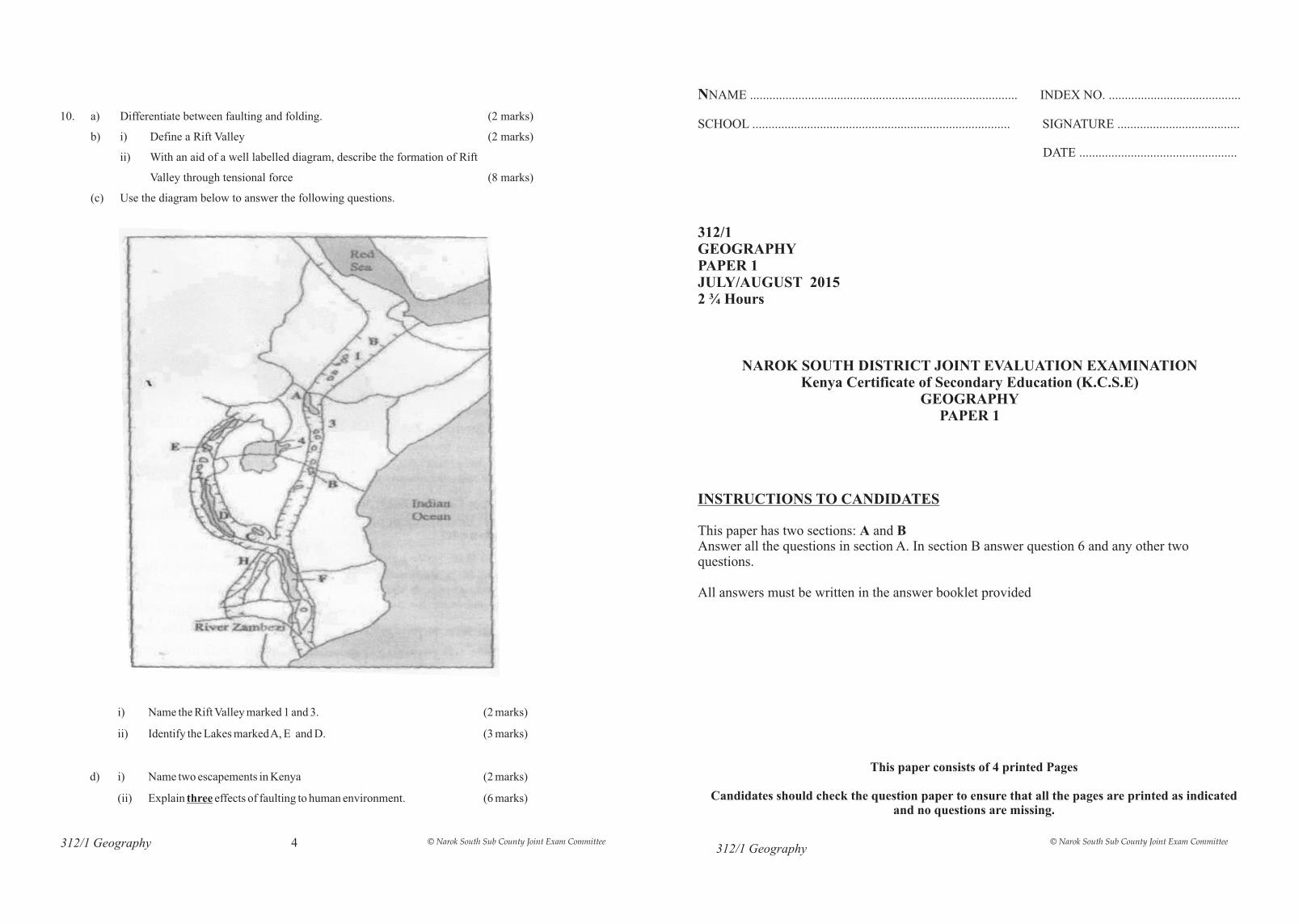
i) Name the Rift Valley marked 1 and 3. (2
ii) Identify the Lakes marked A, E and D. (3 marks)
d) i) Name two escapements in Kenya (2 marks)
(ii) Explain three effects of faulting to human environment. (6 marks)
marks)
10. a) Differentiate between faulting and folding. (2 marks)
b) i) Define a Rift Valley (2 marks)
ii) With an aid of a well labelled diagram, describe the formation of Rift
Valley through tensional force (8 marks)
(c) Use the diagram below to answer the following questions.
© Narok South Sub County Joint Exam Committee © Narok South Sub County Joint Exam Committee
(i) State three causes of salinity in Lake Magadi they are likely to have found out (3 marks)
(ii) State three ways they would have prepared for the field work (3 marks)
(d) (i) Why do ocean water vary in salinity (3 marks)
(ii) State three causes of horizontal movement of water in the ocean (3 marks)
8. (a) Define a karst scenery (2 marks)
(b) Explain two factors influencing development of the karst scenery (4 marks)
(c) Name three surface features formed in limestone areas (3 marks)
(d) Describe the formation of a stalagmite (6 marks)
(e) State three negative influence of karst landscape on human activities (3 marks)
(f) Your class have been asked to carry out a field study on a karst scenery
(i) Outline two recommendations you are likely to give about the conservation of the area
(2 marks)
(ii) State two challenges you are likely to face during the field study (2 marks)
9. (a) (i) What is vegetation ? (2 marks)
(ii) Explain three types of vegetation. (6 marks)
(b) (i) State three geomorphic factors that influence distribution of vegetation. (3 marks)
(ii) Differentiate between xerophytes and hydrophytes. (2 marks)
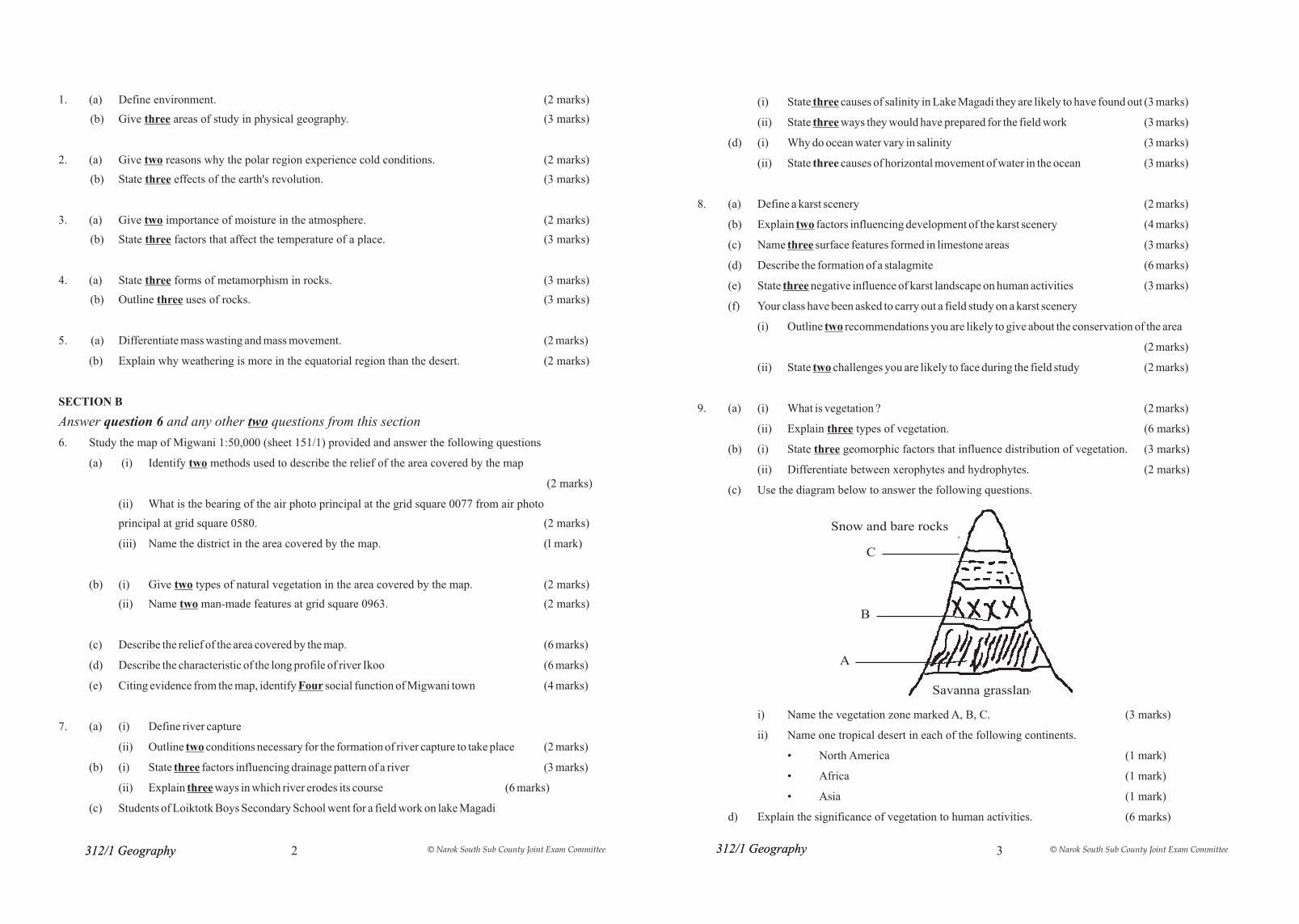
(c) Use the diagram below to answer the following questions.
i) Name the vegetation zone marked A, B, C. (3 marks)
ii) Name one tropical desert in each of the following continents.
• North America (1 mark)
• Africa (1 mark)
• Asia (1 mark)
d) Explain the significance of vegetation to human activities. (6 marks)
1. (a) Define environment. (2 marks)
(b) Give three areas of study in physical geography. (3 marks)
2. (a) Give two reasons why the polar region experience cold conditions. (2 marks)
(b) State three effects of the earth's revolution. (3 marks)
3. (a) Give two importance of moisture in the atmosphere. (2 marks)
(b) State three factors that affect the temperature of a place. (3 marks)
4. (a) State three forms of metamorphism in rocks. (3 marks)
(b) Outline three uses of rocks. (3 marks)
5. (a) Differentiate mass wasting and mass movement. (2 marks)
(b) Explain why weathering is more in the equatorial region than the desert. (2 marks)
SECTION B
Answer question 6 and any other two questions from this section
6. Study the map of Migwani 1:50,000 (sheet 151/1) provided and answer the following questions
(a) (i) Identify two methods used to describe the relief of the area covered by the map
(2 marks)
(ii) What is the bearing of the air photo principal at the grid square 0077 from air photo
principal at grid square 0580. (2 marks)
(iii) Name the district in the area covered by the map. (l mark)
(b) (i) Give two types of natural vegetation in the area covered by the map. (2 marks)
(ii) Name two man-made features at grid square 0963. (2 marks)
(c) Describe the relief of the area covered by the map. (6 marks)
(d) Describe the characteristic of the long profile of river Ikoo (6 marks)
(e) Citing evidence from the map, identify Four social function of Migwani town (4 marks)
7. (a) (i) Define river capture
(ii) Outline two conditions necessary for the formation of river capture to take place (2 marks)
(b) (i) State three factors influencing drainage pattern of a river (3 marks)
(ii) Explain three ways in which river erodes its course (6 marks)
(c) Students of Loiktotk Boys Secondary School went for a field work on lake Magadi
312/1 Geography312/1 Geography 312/1 Geography312/1 Geography 2 3
Savanna grassland
Snow and bare rocks
C
B
A
© Narok South Sub County Joint Exam Committee © Narok South Sub County Joint Exam Committee