3.1 geology 3.1.1 physiography and surface and ... physiography and surface and bedrock geology...
TRANSCRIPT
3.1 GEOLOGY
3.1.1 Physiography and Surface and Bedrock Geology
3.1.1.1 Affected Environment
Project Route
Montana
The proposed route enters Morgan, Montana along Montana’s northern border with Saskatchewan and traverses the state along a south-southeasterly corridor that extends to the southeast corner of the state. The route traverses the Great Plains physiographic province (Fenneman 1928) and is characterized by badlands, buttes, mesas, and includes the Black Hills mountain range. The route crosses the Glaciated Missouri Plateau and the Unglaciated Missouri Plateau. The glaciated section to the north is covered in glacial deposits and represents the furthest southern extent of the last ice age. In the vicinity of Circle, Montana, the proposed pipeline enters the Unglaciated Missouri Plateau. Surface elevations average around 3,000 feet above mean sea level (amsl). The route would cross six EPA Level IV Ecoregions, each with a distinct physiography (Omernik 2009). Regional physiographic characteristics are presented in detail within Montana in Table 3.1.1-1.
Surficial geological materials are composed of Quaternary alluvium, colluvium, and glacial till that consist of sand, gravel, and clay. Bedrock consists of Tertiary (Fort Union Formation) and Late Cretaceous-aged rocks (Hell Creek/Fox Hills Formation, Bearpaw Formation/Pierre Shale, Judith River Formation, and Claggett Shale). The Fort Union Formation (approximately 138 miles crossed between MP 105 and MP 286) consists primarily of sandstone, siltstone, mudstone, carbonaceous shale, and lignite. The proposed route crosses the Ludlow, Tongue River, Lebo, and Tullock members of this Formation. The Tongue River and Tullock members also contain thin coal beds. The Hell Creek/Fox Hills Formation (approximately 56 miles crossed between MP 91 and MP 116; and between MP 245 and MP 273) forms badland topography and consists of shale, mudstone, and lenticular coal beds. The Bearpaw/Pierre Shale (approximately 43 miles crossed between MP 31and MP 90) consists of bentonitic mudstone and shale, the Judith River Formation (approximately 16 miles crossed between MP 1 and MP 45) consists of sandstone, siltstone, mudstone, shale, and coal, while the Claggett Shale (MP 39 to MP 41) consists of shale and siltstone with beds of bentonite. Geology beneath the Steele City Segment is presented in Figure 3.1.1-1.
South Dakota
The proposed route enters South Dakota in the northwestern corner of the state. The route continues in a generally straight fashion in a southeastern direction south of Pierre in the southwest quarter of the state, exiting South Dakota in southeast Tripp County. The proposed route is located in the Unglaciated Missouri Plateau in the Great Plains physiographic province. Surface elevations range from 3,000 feet amsl in northwest South Dakota to 1,800 feet amsl in the White River Valley. The route would cross eight EPA Level IV Ecoregions, each with a distinct physiography (Bryce et al. 1996). Regional physiographic characteristics are presented in detail within South Dakota in Table 3.1.1-2.
Surficial geological materials are composed of Quaternary alluvium, colluvium, alluvial terraces, and aeolian deposits. The majority of bedrock in South Dakota consist of Upper Cretaceous rocks (Hell Creek/Fox Hills Formation, Pierre Shale), while Tertiary-aged (Ogallala Group and Ludlow Member of the Fort Union Formation) are present beneath the southern portion of the proposed route in South
3.1-1 Draft EIS Keystone XL Pipeline Project

Dakota. The Hell Creek/Fox Hills Formation (MP 285 to MP 418) forms badland topography and consists of shale, mudstone, and lenticular coal beds. The Pierre Shale occurs sporadically through the route in South Dakota and consists of bentonitic mudstone and shale. The Ogallala Group (MP 521 to 593) consists of well to poorly consolidated sandstone and conglomerate with occasional bentonite layers. The Ludlow Member of the Fort Union Formation (approximately 3 miles crossed between MP 283 and 376) consists primarily of sandstone, siltstone, mudstone, carbonaceous shale and lignite. Geology beneath the Steele City Segment is presented in Figure 3.1.1-1.
Several major structural features would be crossed by the proposed pipeline route in South Dakota. The Williston Basin covers northeast Montana, the majority of North Dakota, northwest South Dakota, and extends into Canada (Peterson and MacCary 1987). Regionally, the Williston Basin is a structural basin that contains approximately 15,000 feet of sedimentary bedrock. South of the Williston Basin, the Sioux Arch is a buried ridge that extends east to west from Minnesota through southeast South Dakota (Gries 1996). South of the White River, the proposed route would cross into the Salina Basin, a sedimentary basin that underlies southern South Dakota and the majority of eastern Nebraska.
Nebraska
The proposed route enters Nebraska in northern Keya Paha County and continues in a southeastern direction across the state. The pipeline route in Nebraska joins the Cushing Extension pipeline route in Steele City in southeastern Jefferson County. The majority of the proposed route in Nebraska lies in the High Plains portion of the Great Plains Physiographic Province. In northern Nebraska, the Unglaciated Missouri Plateau underlies the pipeline route, while the southern portion of the route lies in the Plains Border Region. Surface elevations range from 2,200 feet amsl in Northern Nebraska to 1,400 at the Kansas state line. The route would cross nine EPA Level IV Ecoregions, each with a distinct physiography (Chapman et al. 2001). Regional physiographic characteristics are presented in detail within Nebraska in Table 3.1.1-3.
The majority of the state is covered by Quaternary deposits along with glacial till, loess, and the Sand Hills. Glacial till is present in southeast Nebraska, south of the Loup River to the Kansas state line. Loess is present from the town of Greeley to the Loup River. Between Stuart and Greeley, the proposed route would cross the eastern extent of the Sand Hills. The Sand Hills are composed mainly of well-sorted sands that are present in dunes and sand sheets and are stabilized by existing vegetation.
The underlying bedrock consists of Tertiary-aged Ogallala Group (approximately 135 miles crossed between MP 597 and MP 745) and Cretaceous sedimentary rocks (Pierre Shale, Niobrara Formation, Carlisle Shale, Greenhorn Limestone and Graneros Shale, and Dakota Group). The Niobrara Formation (approximately 28 miles crossed between MP 738 and MP 777), Carlisle Shale (approximately 34 miles crossed between MP 759 and MP 819), and Greenhorn Limestone and Graneros Shale (approximately 14 miles crossed between MP 797 to MP 823) contain varying amounts of limestone which potentially contain karst formations, causing surface subsidence. The Pierre Shale (MP 599 to MP 605 and MP 614 to MP 617) is exposed in Northern Nebraska and is composed of fissile clay shale, claystone, shaly sandstone, and sandy shale. This formation is prone to slumping and is especially weak where layers of volcanic ash are present. The Dakota Group (approximately 33 miles crossed between MP 798 to MP 851) consists of sandstone and shale. Geology beneath the Steele City Segment is presented in Figure 3.1.1-1.
Kansas
In Kansas, two new pump stations would be constructed along the Cushing Extension of the previously permitted Keystone pipeline (ENTRIX 2008). These pump stations (PS-27 and PS-29) are located in
3.1-2 Draft EIS Keystone XL Pipeline Project

Clay and Butler counties at Cushing Extension MP 49 and MP 145, respectively. These pump stations are located in the Flint Hills Ecoregion and contain outcrops of Permian sedimentary rocks. Elevations in this area range from 1,150 to 1,400 feet amsl. Surficial materials in the vicinity of the Clay County pump station include thick deposits of loess (greater than 30 feet) (Frye and Leonard 1952). In the vicinity of the Butler County pump station, surficial deposits consist of alluvium, colluvium, and cherty gravels in upland areas (KGS 1999). Karst is not present in either of these locations (Davies et al. 1984).
Oklahoma
In Oklahoma, the proposed Gulf Coast Segment pipeline route connects to the southern terminus of the Cushing Extension of the previously permitted Keystone pipeline (ENTRIX 2008). The segment begins at the border between Payne and Lincoln counties and continues in a south-southeastern direction, where the proposed route enters Texas in southeast Bryan County. The proposed pipeline segment in Oklahoma is present in the Central Lowland physiographic province beginning in Cushing to northern Atoka County, where the Gulf Coastal Plains physiographic province begins and continues into Texas. Surface elevations range from 900 feet amsl in central Oklahoma to 450 at the Texas state line. The route would cross six EPA Level IV Ecoregions, each with a distinct physiography (Woods et al. 2005). Regional physiographic characteristics are presented in detail within Oklahoma in Table 3.1.1-4.
Upper Paleozoic (Permian) rock lies beneath the proposed route beginning at Cushing to MP 121. These rocks consist of alternating beds of sandstone, shale, and occasional limestone formed under both marine and non-marine conditions. In southeast Oklahoma, non-marine river and flood plain sands, silts, and clays are present (Johnson 1996). Beneath these surface sediments lie Cretaceous sedimentary rocks. Geology beneath the Gulf Coast Segment is presented in Figure 3.1.1-2.
Texas
The proposed Gulf Coast Segment pipeline route enters Texas in northeast Bannin County and continues in a south to southeast direction. In Liberty County, at the junction with the Houston Lateral, the Gulf Coast Segment continues in an east to southeast direction and terminates in Port Arthur. The Houston Lateral begins in Liberty County and continues in a west to southwest direction, ending in central Harris County. The proposed pipeline route is present in the Gulf Coastal Plains physiographical province, which includes the Coastal Prairies, Interior Coastal Plains, and the Blackland Prairies subprovinces. Surface elevations range from 450 feet amsl in northern Texas to near seal level at the conclusion of the proposed pipeline route. The route would cross 11 EPA Level IV Ecoregions, each with a distinct physiography (Griffith et al. 2004). Regional physiographic characteristics are presented in detail within Texas in Table 3.1.1-5 (Gulf Coast Segment) and Table 3.1.1-6 (Houston Lateral).
In northern Texas along the proposed route, the Blackland Prairie is characterized by black, sandy, calcareous soil originating from the underlying glauconitic sands and clays. The topography is undulating with few bedrock outcroppings (Wermund 2008). The Interior Coastal Plains subprovince is characterized by low-relief bands of eroded shale and sandy ridges. Eocene sandstone bedrock is present where exposed by rivers (Spearing 1991). The Coastal Prairies subprovince in southern Texas is underlain by young deltaic sands, silts, and clays that have eroded to a relatively flat landscape and are present as a grassland (Wermund 2008). Geology beneath the Gulf Coast Segment and Houston Lateral is presented in Figure 3.1.1-2.
3.1-3 Draft EIS Keystone XL Pipeline Project

TABLE 3.1.1-1 Physiographic Characteristics of Ecoregions Crossed in Montana
by the Project – Steele City Segment
MP Range
Physiographic Description
Elevation Range
(ft AMSL)
Local Relief
(ft) Surface Geology Bedrock Geology
Northwestern Glaciated Plains – Cherry Patch Morainesa
0 - 8 Glaciated, undulating to strongly sloping topography containing bouldery knolls, gravelly ridges, kettle lakes, and wetlands. Prominent end moraine.
2,300 - 3,600
50 - 375 Quaternary drift. Cretaceous Claggett Formation, Judith River Formation.
Northwestern Glaciated Plains – Glaciated Northern Grasslandsa
8 - 90, 109 - 116
Glaciated, dissected, rolling to strongly rolling drift plains.
1,990 - 4,000
50 - 600 Quaternary glacial drift deposits.
Cretaceous Bearpaw Shale, Judith River Formation, Claggett Formation, Hell Creek Formation, Fox Hills Formation, Tongue River Member of Fort Union Formation, and Flaxville Gravels.
Northwestern Great Plains – River Breaksa
90 - 104, 192 - 197
Unglaciated, rugged, very highly dissected terrain adjacent to rivers.
1,900 - 3,450
200 - 500
Erodible, clayey soils; gravelly soils on slopes.
Tongue River, Lebo, Slope, and Tullock members of the Tertiary Fort Union Formation, Hell Creek Formation, Fox Hills Sandstone, and Pierre Shale.
Northwestern Great Plains – Central Grasslanda
104 - 109, 116 - 133, 198 - 282
Unglaciated, dissected rolling plains containing buttes. Areas of gravel, clinker, and salt flats. Streams are intermittent.
2,200 -5,000
125 - 600
Quaternary terrace deposits and alluvium along channels.
Tertiary Fort Union, Hell Creek Formation, Pierre Shale.
Northwestern Great Plains – Missouri Plateaua
133 - 192 Unglaciated rolling hills and gravel covered benches. Some areas are subject to wind erosion.
2,000 -3,550
50 - 500 Quaternary terrace deposits.
Tongue River and Slope members of the Tertiary Fort Union Formation, Tertiary Flaxville Gravels.
Northwestern Great Plains – Sagebrush Steppea
282 - 282.3
Unglaciated, level to rolling plains. Landscape contains buttes, badlands, scoria mounds and salt pans.
2,300 -4,200
50 - 600 Quaternary alluvium along channels. Upper Cretaceous sandstone and shale.
Colorado Group, Pierre Shale, Hell Creek Formation, Fox Hills Sandstone, and Fort Union Formation.
a EPA Level III-IV Ecoregion name.
Source: Omernik 2009.
3.1-4 Draft EIS Keystone XL Pipeline Project
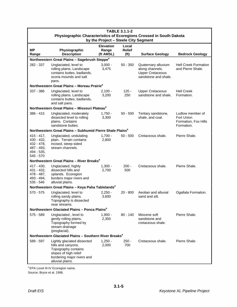
TABLE 3.1.1-2 Physiographic Characteristics of Ecoregions Crossed in South Dakota
by the Project – Steele City Segment
MP Range
Physiographic Description
Elevation Range
(ft AMSL)
Local Relief
(ft) Surface Geology Bedrock Geology
Northwestern Great Plains – Sagebrush Steppea
282 - 337 Unglaciated, level to rolling plains. Landscape contains buttes, badlands, scoria mounds and salt pans.
3,000 - 3,475
50 - 350 Quaternary alluvium along channels. Upper Cretaceous sandstone and shale.
Hell Creek Formation and Pierre Shale.
Northwestern Great Plains – Moreau Prairiea
337 - 386 Unglaciated, level to rolling plains. Landscape contains buttes, badlands, and salt pans.
2,100 - 3,200
120 - 250
Upper Cretaceous sandstone and shale.
Hell Creek Formation.
Northwestern Great Plains – Missouri Plateaua
386 - 415 Unglaciated, moderately dissected level to rolling plains. Contains sandstone buttes.
1,750 - 3,300
50 - 500 Tertiary sandstone, shale, and coal.
Ludlow member of Fort Union Formation, Fox Hills Formation.
Northwestern Great Plains – Subhumid Pierre Shale Plainsa
415 - 417, 430 - 432, 432 - 478, 487 - 493, 494 - 535, 545 - 570
Unglaciated, undulating plain. Terrain contains incised, steep-sided stream channels.
1,700 - 2,800
50 - 500 Cretaceous shale. Pierre Shale.
Northwestern Great Plains – River Breaksa
417 - 430, 431 - 432, 478 - 487, 493 - 494, 535 - 546
Unglaciated, highly dissected hills and uplands. Ecoregion borders major rivers and alluvial plains.
1,300 - 2,700
200 - 500
Cretaceous shale. Pierre Shale.
Northwestern Great Plains – Keya Paha Tablelandsa
570 - 575 Unglaciated, level to rolling sandy plains. Topography is dissected near streams.
2,250 - 3,600
20 - 800 Aeolian and alluvial sand and silt.
Ogallala Formation.
Northwestern Glaciated Plains – Ponca Plainsa
575 - 589 Unglaciated , level to gently rolling plains. Topography formed by stream drainage (preglacial).
1,900 - 2,350
80 - 140 Miocene soft sandstone and cretaceous shale.
Pierre Shale.
Northwestern Glaciated Plains – Southern River Breaksa
589 - 597 Lightly glaciated dissected hills and canyons. Topography contains slopes of high relief bordering major rivers and alluvial plains.
1,250 - 2,000
250 - 700
Cretaceous shale. Pierre Shale.
a EPA Level III-IV Ecoregion name.
Source: Bryce et al. 1996.
3.1-5 Draft EIS Keystone XL Pipeline Project

TABLE 3.1.1-3 Physiographic Characteristics of Ecoregions Crossed in Nebraska
by the Project – Steele City Segment
MP Range
Physiographic Description
Elevation Range
(ft AMSL)
Local Relief
(ft) Surface Geology Bedrock Geology
Northwestern Glaciated Plains – Southern River Breaksa
597 - 600
Dissected hills and canyons. Topography contains slopes of high relief bordering major rivers and alluvial plains.
1,400 - 2,000 250 - 500
Cretaceous shale. Pierre Shale.
Northwestern Great Plains – Keya Paha Tablelandsa
600 - 613
Unglaciated, level to rolling sandy plains. Topography is dissected near streams; contains isolated gravelly buttes.
1,900 - 2,400 20 - 400
Aeolian and alluvial sand and silt.
Ogallala Sandstone.
Northwestern Great Plains – Niobrara River Breaksa
613 - 617
Unglaciated, dissected canyons. Contains slopes of high relief adjacent to river.
1,700 - 2,700 200 - 600
Sandy residuum. Miocene soft sandstone over Pierre Shale.
Nebraska Sand Hills – Wet Meadow and Marsh Plaina
617 - 664
Flat, sandy plain with numerous marshes and wetlands.
1,900 - 2,400 10 - 50 Aeolian sand dunes and sand sheets, alluvial silt, sand and gravel.
Ogallala Sandstone.
Nebraska Sand Hills – Sand Hillsa
664 - 708
Sand sheets and extensive fields of sand dunes.
2,200 - 3,900 50 - 400
Aeolian sand dunes and alluvial silt, sand and gravel.
Ogallala Sandstone.
Central Great Plains – Central Nebraska Loess Plainsa
708 - 738
Rolling dissected plains with deep layer of loess. Contains perennial and intermittent streams.
1,600 - 3,100 50 - 275
Calcareous loess, alluvial sand, gravel, and lacustrine sand and silt.
Ogallala Sandstone.
Central Great Plains – Platte River Valleya
738 - 758
Flat, wide alluvial valley. Contains shallow, interlacing streams on a sandy bed.
1,300 - 2,900 2 - 75 Alluvial, sand, silt, clay, and gravel deposits.
Quaternary and Tertiary unconsolidated sand and gravel.
Central Great Plains – Rainwater Basin Plainsa
758 - 847
Flat to gently rolling loess covered plains. Historical rainwater basins and wetlands.
1,300 - 2,400 5 - 100 Loess and mixed loess and sandy alluvium.
Ogallala Sandstone, Niobrara Formation, and Carlisle Shale.
Central Great Plains – Smoky Hillsa
847 - 851
Undulating to hilly dissected plain with broad belt of low hills formed by dissection of Cretaceous rock layers.
1,200 - 1,800 100 - 250
Sandstone and shale, loamy colluvium, chalky limestone, and thin loess.
Cretaceous sandstone of Dakota Group.
a EPA Level III-IV Ecoregion name.
Source: Chapman et al. 2001.
3.1-6 Draft EIS Keystone XL Pipeline Project

TABLE 3.1.1-4 Physiographic Characteristics of Ecoregions Crossed in Oklahoma
by the Project – Gulf Coast Segment
MP Range
Physiographic Description
Elevation Range
(ft AMSL)
Local Relief
(ft) Surface Geology Bedrock Geology
Central Great Plains – Cross Timbers Transitiona
0 - 16 Rough Plains that is sometimes broken. Topography contains incised streams.
750 -1,950 30 - 300
Quaternary alluvium, terrace deposits, and residuum.
Permian and Pennsylvanian sandstone and shale, limestone and mudstone conglomerate.
Cross Timbers – Northern Cross Timbersa
16 - 78 Rolling hills, cuestas, ridges, and ledges. Contains shallow streams with sandy substrates and sometimes deep pools, riffles, and bedrock, cobble, or gravel substrates.
600 - 1,3 00 100 - 350
Uplands contain Quaternary clayey silt to silty clay residuum. Valleys contain Quaternary alluvium. Rock outcrops are common.
Pennsylvanian and Permian sandstone, shale, and limestone.
Arkansas Valley – Lower Canadian Hillsa
78 - 119
Hill and valley topography in structural Arkoma Basin with scattered ridges and ponds. Streams contain pools and have substrated composed of cobbles, gravel, and sand.
500 - 1,000 50 - 300
Quaternary terrace deposits, alluvium, and sandy to silty clay loam residuum.
Pennsylvanian shale and sandstone.
South Central Plains – Cretaceous Dissected Uplandsa
119 - 138, 139 - 155
Level to hilly, dissected uplands and low cuestas. Large streams are deep and slow moving and have muddy or sandy bottoms. Smaller streams contain gravel, cobble and boulder substrates.
310 – 700 Less than 50 - 200
Quaternary alluvium in valleys. Uplands contain poorly consolidated, calcareous sands, clays, gravels, and limestone.
Calcareous sands, clays, gravels, and limestone.
Cross Timbers – Eastern Cross Timbersa
138 - 139
Rolling hills, cuestas, long narrow ridges with few strongly dissected areas. Stream substrates consist of quartz sand.
640 - 1,100 100 - 200
Uplands are composed of Quaternary sand, gravel, silt, and clay residuum. Valleys consist of Quaternary alluvium.
Cretaceous sand, shale, clay, sandstone, calcareous shale, and limestone.
South Central Plains – Red River Bottomlandsa
154.9 - 155.3
Broad, level floodplains and low terraces. Topography contains oxbow lakes, meander scars, back swamps, and natural levees.
300 – 530 10 - 50 Holocene alluvium. Holocene alluvium.
a EPA Level III-IV Ecoregion name.
Source: Woods et al. 2005.
3.1-7 Draft EIS Keystone XL Pipeline Project
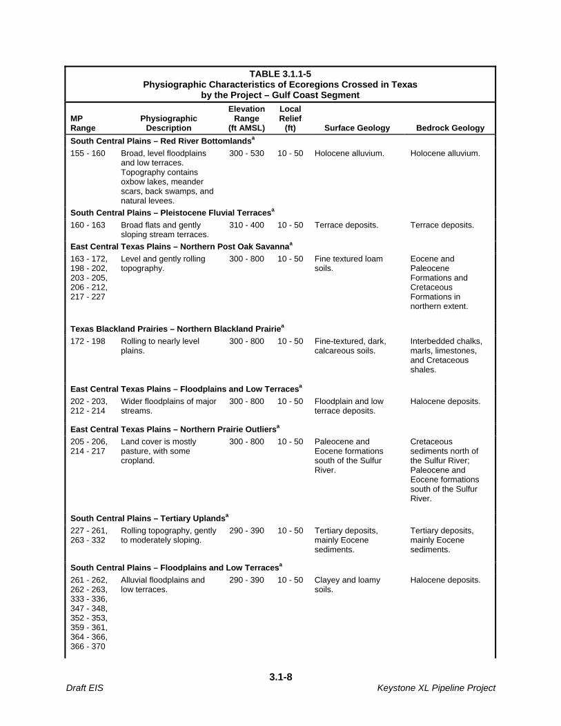
TABLE 3.1.1-5 Physiographic Characteristics of Ecoregions Crossed in Texas
by the Project – Gulf Coast Segment
MP Range
Physiographic Description
Elevation Range
(ft AMSL)
Local Relief
(ft) Surface Geology Bedrock Geology
South Central Plains – Red River Bottomlandsa
155 - 160 Broad, level floodplains and low terraces. Topography contains oxbow lakes, meander scars, back swamps, and natural levees.
300 - 530 10 - 50 Holocene alluvium. Holocene alluvium.
South Central Plains – Pleistocene Fluvial Terracesa
160 - 163 Broad flats and gently sloping stream terraces.
310 - 400 10 - 50 Terrace deposits. Terrace deposits.
East Central Texas Plains – Northern Post Oak Savannaa
163 - 172, 198 - 202, 203 - 205, 206 - 212, 217 - 227
Level and gently rolling topography.
300 - 800 10 - 50 Fine textured loam soils.
Eocene and Paleocene Formations and Cretaceous Formations in northern extent.
Texas Blackland Prairies – Northern Blackland Prairiea
172 - 198 Rolling to nearly level plains.
300 - 800 10 - 50 Fine-textured, dark, calcareous soils.
Interbedded chalks, marls, limestones, and Cretaceous shales.
East Central Texas Plains – Floodplains and Low Terracesa
202 - 203, 212 - 214
Wider floodplains of major streams.
300 - 800 10 - 50 Floodplain and low terrace deposits.
Halocene deposits.
East Central Texas Plains – Northern Prairie Outliersa
205 - 206, 214 - 217
Land cover is mostly pasture, with some cropland.
300 - 800 10 - 50 Paleocene and Eocene formations south of the Sulfur River.
Cretaceous sediments north of the Sulfur River; Paleocene and Eocene formations south of the Sulfur River.
South Central Plains – Tertiary Uplandsa
227 - 261, 263 - 332
Rolling topography, gently to moderately sloping.
290 - 390 10 - 50 Tertiary deposits, mainly Eocene sediments.
Tertiary deposits, mainly Eocene sediments.
South Central Plains – Floodplains and Low Terracesa
261 - 262, 262 - 263, 333 - 336, 347 - 348, 352 - 353, 359 - 361, 364 - 366, 366 - 370
Alluvial floodplains and low terraces.
290 - 390 10 - 50 Clayey and loamy soils.
Halocene deposits.
3.1-8 Draft EIS Keystone XL Pipeline Project

TABLE 3.1.1-5 Physiographic Characteristics of Ecoregions Crossed in Texas
by the Project – Gulf Coast Segment
MP Range
Physiographic Description
Elevation Range
(ft AMSL)
Local Relief
(ft) Surface Geology Bedrock Geology
South Central Plains – Southern Tertiary Uplandsa
332 - 333, 336 - 347, 348 - 352, 353 - 359, 361 - 364, 365.8 - 366.2, 370 - 408
Consists of longleaf pine range north of Flatwoods EcoRegion. Forested topography is hilly and dissected.
290 - 390 10 - 50 Tertiary sediments. Tertiary sediments.
South Central Plains – Flatwoodsa
408 - 452, 456 - 457
Topography is flat to gently sloping. Streams are low gradient and sluggish.
290 - 390 10 - 50 Pleistocene sediments. Pleistocene sediments.
Western Gulf Coastal Plain – Northern Humid Gulf Coastal Prairiesa
452 - 456, 457 - 480
Gently sloping coastal plain.
0 – 400 10 - 50 Fine-textured clay to sandy clay loam soils.
Quaternary deltaic sands, silts, and clays.
a EPA Level III-IV Ecoregion name.
Source: Griffith et al. 2004.
TABLE 3.1.1-6
Physiographic Characteristics of Ecoregions Crossed in Texas by the Project – Houston Lateral
Milepost Range Physiographic Description
Elevation Range
(feet above mean sea
level)
Local Relief (feet) Surface Geology Bedrock Geology
South Central Plains – Flatwoodsa
0 -3, 15.9 - 16.4
Topography is flat to gently sloping. Streams are low gradient and sluggish.
290 - 390 10 - 50 Pleistocene sediments.
Pleistocene sediments.
Western Gulf Coastal Plain – Northern Humid Gulf Coastal Prairiesa
3 - 16, 23 - 49
Gently sloping coastal plain. 0 - 400 10 - 50 Fine-textured clay to sandy clay loam soils.
Quaternary deltaic sands, silts, and clays.
South Central Plains – Floodplains and Low Terracesa
16 - 23 Alluvial floodplains and low terraces.
290 - 390 10 - 50 Clayey and loamy soils.
Halocene deposits.
a EPA Level III-IV Ecoregion name.
Source: Griffith et al. 2004.
3.1-9 Draft EIS Keystone XL Pipeline Project
3.1.1.2 Potential Impacts and Mitigation
Construction Impacts
The proposed Project would not involve substantial long- or short-term, large scale alteration of topography. Most of the proposed route would be within areas where bedrock is buried by unconsolidated sediments consisting of glacial till, alluvium, colluvium, loess and/or aeolian deposits. In these areas, impacts to bedrock would be expected to be minimal, and limited to areas where bedrock is within 8 feet of the surface. Trench excavation would typically be to depths of between seven to eight feet. Potential impacts to surface sediments and topography due to accelerated erosion or soil compaction are described in Section 3.2.
During construction, blasting could be required at locations where shallow bedrock (lithic or very strongly cemented rock) is present within 8 feet of the ground surface. Rock ripping could be necessary where dense material, paralithic bedrock, abrupt textural change, or strongly contrasting textural stratification is present within 8 feet of the ground surface. Over the entire proposed Project route, approximately 9 miles would cross areas identified as potential blasting locations and approximately 166 miles would cross areas identified as potential ripping locations. Table 3.1.1-7 and Table 3.1.1-8 summarize the approximate locations of expected blasting and ripping operations respectively, by state, county, and approximate milepost.
3.1-10 Draft EIS Keystone XL Pipeline Project

TABLE 3.1.1-7
Potential Blasting Locations for the Project
MP Range State County Total Length (miles)
Steele City Segment
848.2 – 849.0 NE Jefferson 0.32 miles
Steele City Segment Subtotal 0.32 miles
Gulf Coast Segment
18.6 – 18.8 OK Creek 0.06 miles
20.8 – 20.9 OK Creek 0.12 miles
59.2 – 59.9 OK Hughes 0.14 miles
61.7 – 62.3 OK Hughes 0.52 miles
63.8 – 76.7 OK Hughes 2.51 miles
81.3 – 92.2 OK Hughes/Coal 2.99 miles
93.9 – 94.1 OK Coal 0.18 miles
95.8 – 95.9 OK Coal 0.15 miles
97.3 – 97.4 OK Coal 0.07 miles
99.8 – 101.5 OK Coal 0.2 miles
104.1 – 109.7 OK Coal 0.55 miles
131.3 – 137.7 OK Atoka/Bryan 0.93 miles
Gulf Coast Segment Subtotal 8.42 miles
Houston Lateral
None - - 0 miles
Houston Lateral Subtotal 0 miles
Keystone XL Project Total 8.74 miles
Source: Keystone 2009a.
TABLE 3.1.1-8
Potential Ripping Locations for the Project
MP Range State County Length (miles)
Steele City Segment
11.0 – 19.7 MT Phillips 1.72 miles
26.0 – 82.4 MT Valley 4.33 miles
90.0 – 155.5 MT McCone 17.59 miles
156.0 – 196.4 MT Dawson 8.81 miles
197.5 – 217.6 MT Prairie 2.70 miles
218.1 – 282.2 MT Fallon 17.99 miles
282.2 – 352.4 SD Harding 4.68 miles
354.4 – 355.0 SD Butte 0.44 miles
357.3 – 372.4 SD Perkins 1.22 miles
3.1-11 Draft EIS Keystone XL Pipeline Project
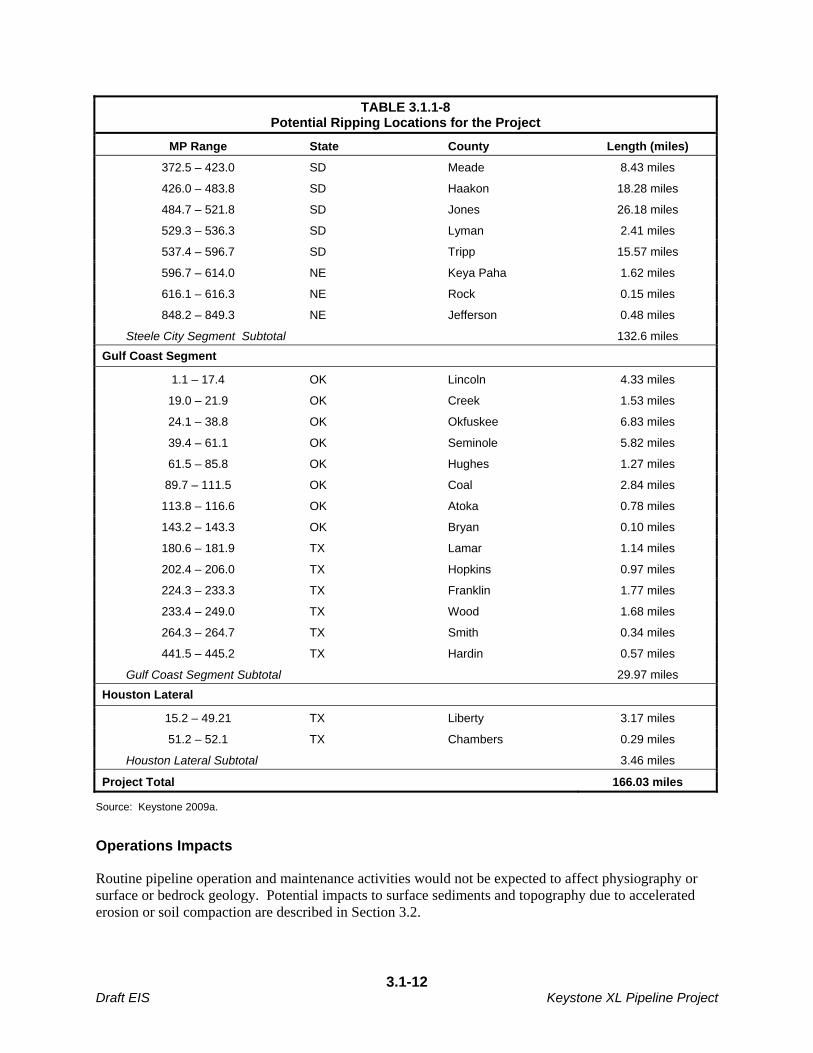
TABLE 3.1.1-8 Potential Ripping Locations for the Project
MP Range State County Length (miles)
372.5 – 423.0 SD Meade 8.43 miles
426.0 – 483.8 SD Haakon 18.28 miles
484.7 – 521.8 SD Jones 26.18 miles
529.3 – 536.3 SD Lyman 2.41 miles
537.4 – 596.7 SD Tripp 15.57 miles
596.7 – 614.0 NE Keya Paha 1.62 miles
616.1 – 616.3 NE Rock 0.15 miles
848.2 – 849.3 NE Jefferson 0.48 miles
Steele City Segment Subtotal 132.6 miles
Gulf Coast Segment
1.1 – 17.4 OK Lincoln 4.33 miles
19.0 – 21.9 OK Creek 1.53 miles
24.1 – 38.8 OK Okfuskee 6.83 miles
39.4 – 61.1 OK Seminole 5.82 miles
61.5 – 85.8 OK Hughes 1.27 miles
89.7 – 111.5 OK Coal 2.84 miles
113.8 – 116.6 OK Atoka 0.78 miles
143.2 – 143.3 OK Bryan 0.10 miles
180.6 – 181.9 TX Lamar 1.14 miles
202.4 – 206.0 TX Hopkins 0.97 miles
224.3 – 233.3 TX Franklin 1.77 miles
233.4 – 249.0 TX Wood 1.68 miles
264.3 – 264.7 TX Smith 0.34 miles
441.5 – 445.2 TX Hardin 0.57 miles
Gulf Coast Segment Subtotal 29.97 miles
Houston Lateral
15.2 – 49.21 TX Liberty 3.17 miles
51.2 – 52.1 TX Chambers 0.29 miles
Houston Lateral Subtotal 3.46 miles
Project Total 166.03 miles
Source: Keystone 2009a.
Operations Impacts
Routine pipeline operation and maintenance activities would not be expected to affect physiography or surface or bedrock geology. Potential impacts to surface sediments and topography due to accelerated erosion or soil compaction are described in Section 3.2.
3.1-12 Draft EIS Keystone XL Pipeline Project

3.1.2 Paleontological Resources
3.1.2.1 Affected Environment
The potential for fossil or other paleontological resources to be unearthed during pipeline construction was evaluated along the proposed pipeline route. Field surveys were conducted along the proposed route on federal lands in Montana and South Dakota; for the remainder of the route, a review of published literature was conducted. Fossil potential is designated from very low to very high in Montana, low to high in South Dakota, and not scaled for Nebraska, Oklahoma, and Texas.
Formations in Montana that contain a high or very high fossil potential include: Ludlow Member of the Fort Union Formation (occurs sporadically between MP 200.9 to MP 282.5) for mammals; the Tongue River Member of the Fort Union Formation (MP 129.0 to MP 200.9; MP 203.6 to MP 240.7) for plants; mammals, and mollusks; the Lebo Member of the Fort Union Formation (sporadically between MP 119.7 to MP 129.0) for mammals; the Tullock Member of the Fort Union Formation (sporadically between MP 105.4 to MP 128.0) for invertebrates and vertebrates; the Hell Creek Formation (sporadically between MP 91.5 to MP 114.9) for plants, vertebrates, and invertebrates; and the Judith River Formation (sporadically between MP 1.1 to MP 45.1) for vertebrates.
Formations in South Dakota that contain a high fossil potential include the Ludlow Member of the Fort Union Formation (MP 282.5 to 284.7) for mammals, plants, and invertebrates, and the Hell Creek Formation (MP 284.7 to 387.1) for reptiles (including dinosaurs) and mammals.
Formations in Nebraska that contain fossil potential include: the Tertiary Ogallala Group (occurs sporadically from MP 595 to 744) for horses, rhinoceroses, proboscideans, mammoths, and other ruminants; the upper Cretaceous Pierre Shale, Niobrara, Carlisle, Greenhorn Limestone and Graneros Shale Formations (sporadically between MP 595 to MP 823) for ammonites, gastropods, bivalves, mosasaurs, fish, bivalves, sea turtles, and sharks; and the lower Cretacous Dakota Group (occurs sporadically from MP 798 to MP 850) for flowering plants.
In Kansas, where two new pump stations are proposed, Permian sedimentary rocks may contain fossils of shark and invertebrates including corals, brachiopods, ammonoids, and gastropods (KGS, 2005). Surficial unconsolidated deposits have the potential to contain large vertebrate fossils such as mammoths, mastodons, camels, and saber-toothed tigers; and invertebrates such as mollusks (Paleontology Portal, 2003).
In Oklahoma, Permian rocks in Payne and Lincoln counties may contain invertebrates. Carboniferous rocks in Creek, Okfuskee, Seminole, Hughes, and Coal counties may contain invertebrates, plants, and fish. Cretaceous rocks in Atoka and Bryan counties may contain fish, reptiles (including dinosaur), and invertebrates.
In Texas, Cretaceous rocks in Fannin, Lamar, and Delta counties may contain invertebrate and fish fossils. Tertiary rocks in Hopkins, Franklin, Smith, Rusk, Upshur, Nacogdoches, Cherokee, Wood, Angelina, and Polk counties may contain invertebrates, reptiles, fish, mammals, and plant fossils. Quaternary rocks in Liberty, Jefferson, Chambers, and Harris counties may contain land mammals, birds, and reptiles.
3.1-13 Draft EIS Keystone XL Pipeline Project

3.1.2.2 Potential Impacts and Mitigation
Construction Impacts
Potential impacts to paleontological resources during construction includes damage to or destruction of fossils due to excavation activities and/or blasting, erosion of fossil beds due to grading, and unauthorized collection of fossils by construction personnel or the public.
Because there is potential for discovery of fossils during trench excavation and pipeline installation activities, Keystone would prepare a Paleontological Mitigation Plan prior to beginning construction on federal and certain state and local government lands. Fossils or other paleontological resources found on private land would only be recovered with approval of the landowner, and therefore, may be unavailable for scientific study. Additionally, prior to initiation of excavation and pipeline installation, Keystone would consult with the appropriate regulatory agencies in each state on the requirements for the Paleontological Mitigation Plan for federal, certain state and local government lands. There is currently an effort led by MDEQ and other agencies to develop a Memorandum of Understanding (MOU) in Montana for the identification, evaluation and protection of paleontological resources. This MOU will be completed prior to the FEIS.
The BLM uses the Potential Fossil Yield Classification System (PFYC ) for identifying fossil potential on federal lands based on the potential of occurrence of significant paleontological resources in a geologic unit, and the associated risk for impacts to the resource based on federal management actions. The PFYC along with BLM field survey and monitoring procedures helps minimize impacts from construction activities to important paleontological resources. Keystone shall provide a paleontological monitor for each construction spread in Montana and South Dakota that includes an area assigned moderate to high probability (3-5) based on the PFYC. The paleontological monitor must satisfy the qualifications established by the BLM required for permit approval on federal lands. Paleontological resources identified on Federal lands are managed and protected under the Paleontological Resources Preservation Act (PRSA) as part of the Omnibus Public Land Management Act of 2009. This law requires the Secretaries of the Interior and Agriculture to manage and protect paleontological resources on lands under their jurisdiction using scientific principles and expertise. The Act affirms the authority for many of the policies the Federal land managing agencies already have in place such as issuing permits for collecting paleontological resources, curation of paleontological resources, and confidentiality of locality data. The statute also establishes criminal and civil penalties for fossil theft and vandalism on Federal lands. The states of Montana and South Dakota have enacted legislation to manage and protect paleontological resources on state-managed lands. In Montana, the Montana Antiquities Act, as amended (1995), requires the Department of Natural Resources and Conservation (DNRC) and other state agencies to avoid or mitigate damage to important paleontological resources (when feasible) on state trust lands. The Montana Department of Fish, Wildlife and Parks have written rules for implementing the State Antiquities Act. The SHPO also issues antiquities permits for the collection of paleontological resources on state owned lands. In Montana, Keystone is required to obtain a certificate of compliance authorizing construction of the proposed pipeline from the Montana Department of Environmental Quality (MDEQ). Issuance of the certificate of compliance is a state action for which MDEQ is required to comply with the Montana Environmental Policy Act (MEPA). MDEQ is the lead agency for compliance with the MEPA.
3.1-14 Draft EIS Keystone XL Pipeline Project

As a conditional requirement for the issuance of the certificate of compliance, Keystone is required to implement mitigation actions when significant paleontological resources are inadvertently discovered on lands under the jurisdiction of the State of Montana or a federal agency and on private land during the construction period of the proposed pipeline. The requirements are set forth in the document entitled Conditional Requirements for the Treatment of Inadvertently Discovered Significant Paleontological Resources for the Keystone XL Pipeline (and the proposed Paleontological Treatment Plan). The requirements are designed to minimize and mitigate the adverse effects of pipeline construction activities on significant paleontological materials. In South Dakota, a permit is required from the Commissioner of School and Public Lands to survey, excavate or remove paleontological resources from state lands. The Commissioner also determines the repository or curation facility for paleontological collections from state lands. In Nebraska, the State Department of Roads has contracted with the University of Nebraska Museum for a highway salvage paleontologist to identify and collect important paleontological resources that may be impacted by the maintenance and construction of federal highways and roads. While directed to investigate paleontological resources on federally funded road projects, the salvage operations are also conducted on state and county road projects. Kansas and Oklahoma have no state regulations concerning the management and protection of paleontological resources on state lands. In Texas, there are no state regulations concerning the management and protection of paleontological resources on state lands except on lands administered by state forests and state parks. Operations Impacts
Routine pipeline operations and maintenance activities are not expected to affect paleontological resources. However, collection of these resources for scientific or other purposes would not be possible within the permanent ROW during project operations.
3.1.3 Mineral and Fossil Fuel Resources
3.1.3.1 Affected Environment
Montana
In the Project area, oil, natural gas, and coal comprise the major energy resources (Montana Bureau of Mines and Geology 1963). Sand, gravel and bentonite are also mined (Montana Bureau of Mines and Geology/USGS 2004). The proposed route would cross few oil and gas producing areas. There are 23 oil and gas producing wells within one-quarter mile (1,320 feet) of the proposed ROW (Appendix F).
The proposed pipeline route does not cross any coal (lignite) mines. Historically, bentonite has been mined and processed in the area southeast of Glasgow and south of the proposed pipeline route; however, bentonite is not currently being mined and processed in the project area (Montana Bureau of Mines and Geology/USGS 2004).
Aggregate mining of sand and gravel deposits is also conducted in the region; although the proposed pipeline route would not cross any aggregate mines.
3.1-15 Draft EIS Keystone XL Pipeline Project
South Dakota
In the Project area, sand, gravel, oil, gas, and coal comprise the major energy resources (South Dakota Geological Survey/USGS 2005). A gravel pit is present approximately 0.5 mile from the proposed route, northeast of MP 552. The proposed pipeline route would traverse the Buffalo Field, an oil and gas producing area in Hardin County. Fifteen oil and gas producing wells are located within one-quarter mile of the proposed ROW (Appendix F).
The proposed pipeline route would not cross any known coal mines. The proposed route would cross approximately 2 miles of coal-bearing formations (Fort Union Formation and Hell Creek Formation), but potential for mining of these formations is low.
Nebraska
There is no known active oil, natural gas, coal, or mineral mining operations along the proposed pipeline route in Nebraska. The main mineral resource in the Project area is aggregate (sand and gravel) used for road and building construction, and concrete. Along the northern portion of the route, sandstone has been quarried for road construction. In southern Nebraska, near the proposed route, shales and clays have been mined for producing bricks. Near Tobias in Salina County, limestone has been mined for agricultural lime.
Kansas
Mineral resources in the area of the proposed two new pump stations include sand, gravel, and crushed stone (USGS 2004); however, construction of the two new pump stations would not affect current mining operations.
Oklahoma
Oil and natural gas represent important natural resources in the area of the proposed pipeline route in Oklahoma. Along the Gulf Coast Segment in Oklahoma there are 364 oil and gas wells within one-quarter mile of the proposed pipeline route (Appendix F). Sand, gravel, and crushed stone are also mined along the proposed route in Okfuskee, Seminole, Hughes, Clay, Coal, Atoka, and Bryan counties (Johnson 1998, USGS 2004). Coal resources are present in eastern Oklahoma. The proposed ROW would cross areas of documented coal resources in Coal County in southeastern Oklahoma (Johnson 1998).
Texas
Along the Gulf Coast Segment in Texas, there are 276 oil and gas wells within one-quarter mile of the proposed pipeline route (Appendix F). Crushed stone, coal (lignite), clay, iron, peat, and sand are other mineral resources present in the project area (Garner 2008).
Along the proposed Houston Lateral in Texas, there are 48 oil and gas wells within one-quarter mile of the proposed pipeline route (Appendix F). Clay, sand, and gravel are also present in the project area (Garner 2008).
3.1.3.2 Potential Impacts and Mitigation
Although the proposed route would not cross any active surface mines or quarries, construction and operation of the Project would limit access to sand, gravel, clay, and stone resources that are within the
3.1-16 Draft EIS Keystone XL Pipeline Project

width of the permanent pipeline ROW. As summarized above, the proposed route would cross deposits of sand, gravel, clay, and stone; however, the acreage of deposits covered by the proposed ROW is minimal when compared to the amounts available for extraction throughout the project area. As summarized in Section 2.1.4.2, approximately 1,066,205 cubic yards of gravel and other borrow materials would be utilized for temporary sites such as storage sites, contractor yards, temporary access roads, and to stabilize the land for permanent facilities including pump stations, mainline valves, permanent access roads, and the pipeline trench bottom. Borrow materials would be obtained from an existing, previously permitted commercial source located as close to the pipeline or contractor yard as possible.
The proposed route would cross underlying coal bearing formations in South Dakota and in Coal County, Oklahoma. Although not currently planned, if surface mining was proposed for this area in the future, the pipeline could limit access to these resources.
While there are numerous oil and gas wells within one-quarter mile of the proposed ROW in Oklahoma and Texas, the proposed route would not cross the well-pads of any active oil and gas wells. Accordingly, extraction of oil and gas resources would not be affected by operation of the proposed pipeline.
3.1.4 Geologic Hazards
3.1.4.1 Affected Environment
At certain locations along the proposed route, seismic hazards, landsliding, subsidence, or flooding would be possible. Since the proposed pipeline ROW would be located in the relatively flat and stable continental interior, the potential for impacts from geologic hazards is lower than for facilities located in active mountain belts or coastal areas. Table 3.1.4-1 summarizes by state the miles of proposed pipeline that would cross areas of potential geologic hazards.
TABLE 3.1.4-1 Summary of Geological Hazard Areas for the Project (miles)
State High Seismic
Hazarda Flood Landslide Subsidence
Montana 0 22 102 0
South Dakota 0 23 202 0
Nebraska 0 10 18 30
Oklahoma 0 51 7 9
Texas 0 89 30 12
Keystone XL Project Total 0 175 360 51
a Peak ground acceleration with 2 percent probability of exceedance in 50 years >0.5 g.
Source: Keystone 2009a.
Seismic Hazards
Seismic hazards include faults, seismicity, and ground motion hazards. Collectively, these three phenomena are associated with seismic hazard risk. Faults are defined as a fracture along which blocks of earth materials on either side of the fault have moved relative to each other. An active fault is one in which movement has demonstrated to have taken place within the last 10,000 years (USGS 2008b). Seismicity refers to the intensity and the geographic and historical distribution of earthquakes. Ground
3.1-17 Draft EIS Keystone XL Pipeline Project
motion hazards are defined as movement of the earth’s surface as a result of earthquakes (USGS 2008a). Figure 3.1.4-1 presents the earthquake hazard rank map which shows earthquake hazard risk along the proposed Project route. The map indicates that there is low seismic hazard risk along the entire proposed route.
Minor faults are present in the vicinity of the proposed pipeline route. In Montana, the Brockton-Froid Fault is mapped in the Weldon-Brockton fault zone approximately 50 miles east of the proposed route in Roosevelt County, just north of Culbertson, Montana (Wheeler 1999). Based on exploration and field data, there is no indication that this is an active fault (Wheeler 1999). No other information regarding historic earthquakes in the Weldon-Brockton fault zone was identified.
Historic earthquake activity in the vicinity of the proposed pipeline was reviewed using USGS’s National Earthquake Information Center on-line database search. Records were available from 1973 to the present time.
Eastern Montana historically contains little earthquake activity. From 1973 to 2007, 14 earthquakes have been recorded with magnitudes 4.1 or less in the eastern half of Montana (USGS 2008b).
In South Dakota, 30 earthquakes have been recorded since 1973, with magnitudes 4.2 or less (USGS 2008b); however, none of these earthquakes occurred along or adjacent to the proposed route (Keystone 2008).
In eastern Nebraska, 11 earthquakes have been recorded since 1973, with magnitudes ranging from 2.8 to 4.3 (USGS 2008b). These earthquakes are believed to be associated with either the Humboldt fault zone or deep seated faults in the Salinas Basin (Keystone 2008). There are no active surficial faults along the proposed route (Crone and Wheeler 2000, USGS 2006).
In Oklahoma, approximately 50 minor earthquakes occur each year. The majority of these earthquakes range in magnitude from 1.8 to 2.5, and would not be expected to damage the buried pipeline. In general, earthquake activity in Oklahoma in the vicinity of the pipeline occurs north of the Ouachita Mountains in the Arkoma Basin.
In Texas, surface faults have been mapped in the project area. There is little evidence of ground movement along these faults and as such, they pose very minimal risk to the pipeline (Crone and Wheeler 2000). Epicenter maps show only sparse, low magnitude seismicity (USGS 2008a).
Landslides
Landslide potential is greatest where steep slopes are present adjacent to stream and river crossings. Landslides may cause increased soil erosion where underlying soils are exposed and may also cause increased input of sediment and/or in-stream turbidity in adjacent water bodies, if present. Landslides typically occur on steep terrain during conditions of partial or total soil saturation, or during seismic-induced ground shaking. Given the low likelihood of significant seismically-induced ground shaking along the proposed pipeline corridor, earthquake induced landslide potential is very minor. Stream erosion, undercutting or undermining topography during the construction of roads or other structures also can cause instability leading to increased landslide potential. The majority of the proposed pipeline route is not located in landslide-prone terrain. However, the proposed route does cross areas of high landslide potential due to other factors, as presented in Table 3.1.4-2.
In addition to steep terrain, certain formations are susceptible to increased landslide potential due to the makeup of the soil and/or geological materials. Along the Steele City Segment, the Claggett, Bearpaw,
3.1-18 Draft EIS Keystone XL Pipeline Project

Pierre Shale, Fort Union shales, and Hell Creek Formation may contain appreciable amounts of bentonite. Bentonite is soft, plastic, light colored clay that expands when exposed to water and may cause soil and/or geologic formations to become unstable. Cretaceous and Tertiary rocks in the Missouri River Plateau have the potential for slumping due to high clay content. Along the proposed route, potentially unstable soils or geologic formations is present at the Missouri River, Willow Creek, Keya Paha River, and Niobrara River crossings.
In the Gulf Coast Segment, landslide potential is highest where shale formations weather to clayey colluviums and is highest in areas where slopes exceed a 2:1 gradient (Luza & Johnson 2005). The Houston Lateral does not contain any areas of high risk for landslides.
TABLE 3.1.4-2 Areas with High Landslide Potential Crossed by the Project
Area Start (MP) End (MP) Length (miles)
Steele City Segment
Montana 0.0 101.6 101.6
South Dakota 308.0 313.3 5.3
354.9 370.2 15.2
388.5 425.7 37.3
425.7 569.7 144.0
Nebraska 595.6 607.1 11.5
614.3 620.8 6.5
848.7 850.3 1.6
Steele City Segment Subtotal 323.0
Gulf Coast Segment
Oklahoma 134.6 141.8 7.1
Texas 162.1 167.4 5.3
182.1 203.6 21.5
260.4 260.7 0.3
260.8 261.9 1.1
475.8 478.2 2.4
Gulf Coast Segment Subtotal 37.7
Houston Lateral
None - - 0
Houston Lateral Subtotal 0
Keystone XL Project Total 360.7
Source: PHMSA-NPMS http://www.npms.phmsa.dot.gov/ (adapted from Response to U.S. Department of State Data Request 1).
Subsidence
Subsidence hazards along the proposed pipeline route would most likely be associated with the presence of karst features, such as sinkholes and fissures. Keystone reviewed national karst maps to determine areas of potential karst terrain (i.e., areas where limestone bedrock is near the surface) along the proposed pipeline route (US National Atlas 2009). These areas are summarized in Table 3.1.4-3. Because
3.1-19 Draft EIS Keystone XL Pipeline Project

national-scale karst maps may not incorporate the most recent field data or be of sufficient resolution to determine local subsidence risk due to karst features, prior to construction, Keystone would consult with the respective state geological survey departments to identify the most up-to-date sources of data on karst-related subsidence hazards along the proposed route.
TABLE 3.1.4-3 Karst Areas Crossed by the Project
Location Start (MP) End (MP) Length (miles)
Steele City Segment a
Nance and Merrick Counties, Nebraska 739.7 750.7 11.0
Hamilton and York Counties, Nebraska 757.3 776.1 18.8
Steele City Segment Subtotal 29.8
Gulf Coast Segment b
Atoka and Bryan Counties, Oklahoma 125.1 134.0 8.9
Lamar County, Texas 177.5 184.7 7.2
Delta County, Texas 190.6 195.0 4.4
Gulf Coast Segment Subtotal 20.5
Houston Lateral
None - - 0
Houston Lateral Subtotal 0
Keystone XL Project Total 50.3
a Type: Fissures, tubes and caves generally less than 1,000 feet (300 meters long; 50 feet (15 meters) or less vertical extent; in gently dipping to flat-lying beds of carbonate rock beneath an overburden of noncarbonate material 10 to 200 feet (3 to 60 meters) thick. b Type: Fissures, tubes, and caves generally less than 1,000 feet (300 meters) long, 50 feet (15 meters) or less vertical extent, in gently dipping to flat-lying beds of carbonate rock.
Source: US National Atlas (adapted from Response to U.S. Department of State Data Request 1).
In Nebraska, potential karst features are present in the Niobrara Formation; however, these potential hazards are considered minimal since approximately 50 feet of sediment typically covers this formation. In southeastern Oklahoma and Texas, the proposed route crosses potential karst features present in flat-lying carbonate rock.
Floods
In active channel crossings, flooding can cause lateral and vertical scour that can expose and damage the pipeline. At 38 major river crossings, Keystone plans to use horizontal directional drilling (HDD). At the other crossings, the pipeline would be buried under at least 5 feet of cover for at least 15 feet on either side of the bank-full width. An assessment of hazards and potential environmental impacts related to Keystone’s proposed stream crossing procedures can be found in Section 3.3.
3.1-20 Draft EIS Keystone XL Pipeline Project

3.1.4.2 Potential Impacts and Mitigation
Seismic
Based on the evaluation of potential seismic hazards along the proposed ROW, the risk of pipeline rupture from earthquake ground motion would be considered to be minimal. The proposed route would not cross any known active faults and is located outside of known zones of high seismic hazard.
In accordance with federal regulations (49 CFR 195), Keystone would conduct an internal inspection of the pipeline if an earthquake, landslide, or soil liquefaction event were suspected of causing abnormal pipeline movement or rupture. If damage to the pipeline was evident, the pipeline would be inspected and repaired as necessary.
Landslides
During construction activities, vegetation clearing and alteration of surface-drainage patterns could increase landslide risk. Implementation of temporary erosion control structures would reduce the likelihood of construction-triggered landslides. In addition, Keystone plans to revegetate areas disturbed by construction along the pipeline ROW.
Revegetation would also help reduce the risk of landslides during the operational phase of the project. The proposed pipeline would be designed and constructed in accordance with 49 CFR, Parts 192 and 193. These specifications require that pipeline facilities are designed and constructed in a manner to provide adequate protection from washouts, floods, unstable soils, landslides, or other hazards that may cause the pipeline facilities to move or sustain abnormal loads. Proposed pipeline installation techniques, especially padding and use of rock-free backfill, are designed to effectively insulate the pipeline from minor earth movements.
To reduce landslide risk, Keystone would employ erosion and sediment control and reclamation procedures described in Section 4.11 of its CMR Plan (Appendix B). These procedures are expected to limit the potential for erosion, and maintain slope stability after the construction phase. Additionally, the potential for landslide activity would be monitored during pipeline operation through aerial and ground patrols and through landowner awareness programs designed to encourage reporting from local landowners. Keystone would implement TransCanada’s Integrated Public Awareness (IPA) Plan. TransCanada’s IPA Plan is consistent with the recommendations of API RP-1162 (Public Awareness Programs for Pipeline Operators). The plan includes the distribution of educational materials to inform landowners of potential threats and information on how to identify threats to the pipeline including the potential for landslides. Landowners would be able to report potential threats to the integrity of the pipeline and other emergencies using TransCanada’s toll-free telephone number (Keystone 2008).
Subsidence
There is a risk of subsidence where the proposed route crosses karst formations in Nebraska, Oklahoma, and Texas. Table 3.1.4-3 shows the locations by milepost where karst may be present. Keystone would conduct site-specific studies as necessary to characterize the karst features, and would evaluate and modify construction techniques as necessary in these areas. The overall risk to the pipeline from karst-related subsidence is expected to be minimal.
3.1-21 Draft EIS Keystone XL Pipeline Project

Floods
There is a risk of pipeline exposure due to lateral or vertical scour at water crossings and during floods. An assessment of potential environmental impacts and protection measures related to Keystone’s proposed stream crossing procedures can be found in Section 3.3 and for Montana in Appendix I.
3.1.5 Connected Actions
The construction and operation of electrical distribution lines and substations associated with the proposed pump stations, and the Lower Brule to Witten 230-kV electrical transmission line would have negligible effects on geological resources.
3.1.6 References
Bryce, S.A., Omernik, J.M., Pater, D.A., Ulmer, M., Schaar, J., Freeouf, J., Johnson, R., Kuck, P., and Azevedo, S.H. 1996. Ecoregions of North Dakota and South Dakota, (color poster with map, descriptive text, summary tables, and photographs): Reston, Virginia, U.S. Geological Survey (map scale 1:1,500,000).
Chapman, Shannen S., Omernik, James M., Freeouf, Jerry, A., Huggins, Donald G., McCauley, James R.,
Freeman, Craig C., Steinauer, Gerry, Angelo, Robert T., and Schlepp, Richard L., 2001. Ecoregions of Nebraska and Kansas (color poster with map, descriptive text, summary tables, and photographs): Reston, Virginia, U.S. Geological Survey (map scale 1:1,950,000).
Crone, A.J. and R.L. Wheeler. 2000. Data for Quaternary faults, liquefaction features, and possible tectonic features in the Central and Eastern United States, east of the Rocky Mountain front. U.S. Geological Survey Open File Report 00-260. U.S. Geological Survey, Reston, VA. Retrieved July 31, 2008: http://pubs.usgs.gov/of/2000/ofr-00-0260/ofr-00-0260.pdf
Davies, W.E., Simpson, J.H., Ohlmacher, G.C., Kirk, W.S., and E.G. Newton. 1984. Engineering Aspects of Karst. U.S. Geological Survey, National Atlas, scale 1:7, 5000
ENTRIX. 2008. Final Environmental Impact Statement for the Keystone Oil Pipeline Project.
Fenneman, N.H. 1928. Physiographic Divisions of the United States. Annals of the Association of American Geographers, Vol. 18, No. 4, (Dec., 1928), pp.261-353.
Frye and Leonard. 1952. Pleistocene Geology of Kansas. Kansas Geological Survey, Bulletin 99. http://www.kgs.ku.edu/Publications/Bulletins/99/index.html
Garner, L.E. 2008. Handbook of Texas Online, s.v., Mineral Resources and Mining. Retrieved July 31, 2008: http://www.tshaonline.org/handbook/online/articles/MM/gpm1.html
Gries, J.P. 1996. Roadside Geology of South Dakota. Mountain Press Publishing Company, Missoula, Montana, 358 p.
Griffith, G.E., Bryce, S.A., Omernik, J.M., Comstock, J.A., Rogers, A.C., Harrison, B., Hatch, S.L., and Bezanson, D. 2004. Ecoregions of Texas (color poster with map, descriptive text, and photographs): Reston, Virginia, U.S. Geological Survey (map scale 1:2,500,000).
3.1-22 Draft EIS Keystone XL Pipeline Project
Johnson, K.S. 1996. Geology of Oklahoma p. 1-9. In K.S. Johnson and N.H. Suneson (eds.), Rock hounding and Earth-Science Activities in Oklahoma. Oklahoma Geological Survey Special Publication, 96-5.
Johnson, K.S. 1998. Industrial-Mineral Sources of Oklahoma. Oklahoma Geological Survey Information Series #4, Norman, Oklahoma, 9 p.
Johnson, K.S. 1998. Geology and Mineral Resources of Oklahoma. Oklahoma Geological Survey Information Series #2, Norman, Oklahoma, 4 p.
Kansas Geological Society (KGS). 1999. Flint Hills: Rock and Minerals. Geofacts. Retrieved February 2, 2006: http://www.kgs.ku.edu/Extension/flinthills/FH_factsheet1.pdf
Keystone (TransCanada Keystone Pipeline, LP). 2008. Keystone XL Project Environmental Report (ER). November 2008. Document No. 10623-006. Submitted to the U.S. Department of State and the Bureau of land Management by Keystone.
Keystone. 2009a. Response to United States Department of State Data Request 1.0. May 1, 2009. Submitted to U.S. Department of State by TransCanada Keystone Pipeline, L.P.
Luza K.V. and K.S. Johnson. 2005. Geological Hazards in Oklahoma. Reprinted from Oklahoma Geology Notes. Oklahoma Geological Survey, Vol. 63, no. 2, p. 52-70.
Montana Bureau of Mines and Geology. 1963. Mineral and Water Resources of Montana, Montana Bureau of Mines and Geology Special Publication 28, May 1963. Digital version prepared in 2002-2003. Retrieved July 30, 2008: http://www.mbmg.mtech.edu/sp28/intro.htm
Montana Bureau of Mines and Geology/U.S. Geological Survey. 2004. Mineral Industry of Montana. Retrieved July 1, 2008: http://minerals.usgs.gov/minerals/pubs/state/mt.html
Omernik, James M. and Glenn E. Griffith (Lead Authors); Environmental Protection Agency (Content source); Mark McGinley (Topic Editor). 2009. “Ecoregions of Montana (EPA).” In: Encyclopedia of Earth. Eds. Cutler J. Cleveland (Washington, D.C.: Environmental Information Coalition, National Council for Science and the Environment). [Published in the Encyclopedia of Earth February 3, 2009; Retrieved May 15, 2009]. <http://www.eoearth.org/article/Ecoregions_of_Montana_(EPA)
Peterson, J.A. and L.M. McCary. 1987. Regional Stratigraphy and General Petroleum Geology of the U.S. Portion of the Williston Basin and Adjacent Areas, in Longman, J.A. (ed.), Williston Basin: Anatomy of a Cratonic Oil Province, Papers collected and edited by J.A. Peterson, D.M. Kent, S.B. Anderson, R.H. Pilaske, and M.W. Longman. The Rocky Mountain Association of Geologists, Denver, Colorado, 1987, p. 9-43.
South Dakota Geological Survey/U.S. Geological Survey. 2005. Mineral Industry in South Dakota, 2005 Minerals Yearbook. Retrieved August 11, 2008: http://minerals.usgs.gov/minerals/pubs/state/2005/myb2-2005-sd.pdf
Spearing, D. 1991. Roadside Geology of Texas. Montana: Mountain Press Publishing Company.
U.S. Geological Society (USGS). 2004. The Mineral Industry of Oklahoma. (2003). Retrieved January 18, 2006: http://minerals.usgs.gov/minerals/pubs/state/2003/okstmyb03.pdf
3.1-23 Draft EIS Keystone XL Pipeline Project

3.1-24 Draft EIS Keystone XL Pipeline Project
U.S. Geological Survey. 2008a. Visual Glossary. Retrieved August 14, 2008: http://earthquake.usgs.gov/learning/glossary.php?term=active%20fault
U.S. Geological Survey. 2008b. National Earthquake Information Center Earthquake Search; U.S. Geological Survey/National Earthquake Information Center 1973 to present Database. Retrieved August 14, 2008: http://neic.usgs.gov/neis/epic/epic_rect.html
United States National Atlas, 2009. Accessed via: http://www.nationalatlas.gov/maplayers.html?openChapters=chpgeol#chpgeol. Wermund, E.G. 2008. Physiography of Texas. Bureau of Economic Geology, Austin, Texas. Retrieved July 31, 2008: http://www.beg.utexas.edu/UTopia/images/pagesizemaps/physiography.pdf
Wheeler, R.L. (compiler). 1999. Fault number 707, Brockton-Froid fault zone, in Quaternary Fault and Fold Database of the United States. Retrieved July 31, 2008: http://earthquakes.usgs.gov/regional/qfaults
Woods, A.J., Omernik, J.M., Butler, D.R., Ford, J.G., Henley, J.E., Hoagland, B.W., Arndt, D.S., and Moran, B.C., 2005. Ecoregions of Oklahoma (color poster with map, descriptive text, summary tables, and photographs): Reston, Virginia, U.S. Geological Survey (map scale 1:1,250,000).