309 cherry street - zoning amendment application ......schedule a hearing on the appeal of the...
TRANSCRIPT
STAFF REPORT ACTION REQUIRED
309 Cherry Street - Zoning Amendment Application - Preliminary Report
Date: March 17, 2017
To: Toronto and East York Community Council
From: Director, Community Planning, Toronto and East York District
Wards: Ward 30 – Toronto-Danforth
Reference Number: 16 271912 STE 30 OZ
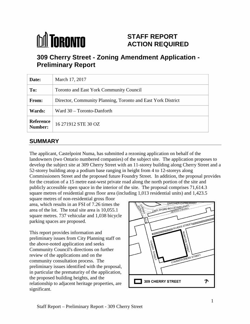
SUMMARY The applicant, Castelpoint Numa, has submitted a rezoning application on behalf of the landowners (two Ontario numbered companies) of the subject site. The application proposes to develop the subject site at 309 Cherry Street with an 11-storey building along Cherry Street and a 52-storey building atop a podium base ranging in height from 4 to 12-storeys along Commissioners Street and the proposed future Foundry Street. In addition, the proposal provides for the creation of a 15 metre east-west private road along the north portion of the site and publicly accessible open space in the interior of the site. The proposal comprises 71,614.3 square metres of residential gross floor area (including 1,013 residential units) and 1,423.5 square metres of non-residential gross floor area, which results in an FSI of 7.26 times the area of the lot. The total site area is 10,055.1 square metres. 737 vehicular and 1,038 bicycle parking spaces are proposed. This report provides information and preliminary issues from City Planning staff on the above-noted application and seeks Community Council's directions on further review of the applications and on the community consultation process. The preliminary issues identified with the proposal, in particular the prematurity of the application, the proposed building heights, and the relationship to adjacent heritage properties, are significant.
1 Staff Report – Preliminary Report - 309 Cherry Street
A Community Consultation meeting is anticipated to be held in the spring of 2017. The final report is targeted for the summer of 2017. The target date assumes that the applicant will provide all required information in a timely manner. RECOMMENDATIONS The City Planning Division recommends that: 1. Staff be directed to schedule a community consultation meeting for the lands at 309
Cherry Street together with the Ward Councillor. 2. Notice for the community consultation meeting be given to landowners and residents
within 120 metres of the site. 3. Staff be requested to report further regarding the results of the community consultation
and further assessment of the application upon City Council's consideration of the Port Lands Planning Framework in 2017.
Financial Impact The recommendations in this report have no financial impact. DECISION HISTORY At its meeting of July 6-8, 2010, City Council adopted the staff report from the Deputy City Manager, entitled "Lower Don Lands Project", dated May 31, 2010. This report sought City Council support for a number of studies and plans completed by Waterfront Toronto and the TRCA for the lands south of the rail corridor, east of Small Street, West of the Don Roadway and north of the Ship Channel known as the "Lower Don Lands". City Council adopted the following recommendations: 1. Support the preferred alternative of the Don Mouth Naturalization and Port Lands Flood
Protection Environmental Assessment and its submission to the Minister of the Environment for approval;
2. Endorse the Lower Don Lands Framework Plan (May 2010) to guide the revitalization of
the Lower Don Lands and endorse the Keating Channel Precinct Plan (May 2010) as it relates to lands west of and including Cherry Street;
3. Authorize Waterfront Toronto to put the Lower Don Lands Class EA Infrastructure Master
Plan (May 2010) in the public record in accordance with the requirements of the Municipal Class Environment Assessment; and
4. Authorize Waterfront Toronto to put the Keating Channel Precinct Class EA
Environmental Study Report (May 2010), as it relates to lands west of and including Cherry Street, in the public record in accordance with the requirements of the Municipal Class Environmental Assessment while addressing the need for the lowering of Cherry Street north of the CN rail underpass.
2 Staff Report – Preliminary Report - 309 Cherry Street
The City Council decision and staff report are available here: http://app.toronto.ca/tmmis/viewAgendaItemHistory.do?item=2010.EX45.15 At its meeting of August 25-27, 2010, City Council adopted Official Plan Amendment (OPA) 388 (and 389) for the Lower Don Lands (including lands north of Keating Channel) and By-law 1174-2010 which facilitates the development of the Keating Channel Precinct West. OPA 388 includes policies intended to preserve the proposed alignment of the Lower Don Lands EA and to provide for phasing and controlled development. It was premised in part on the Don Mouth Naturalization and Port Lands Flood Protection EA, as well as other Environmental Assessments to facilitate the development of the Keating Channel. The City Council decision and staff report are available here: http://app.toronto.ca/tmmis/viewAgendaItemHistory.do?item=2010.TE36.19 At its meeting of September 21 and 22, 2011, City Council endorsed the protocol for the revitalization of the Port Lands, which initiated the Port Lands Acceleration Initiative (PLAI), a joint effort involving the City of Toronto, Waterfront Toronto and Toronto and Region Conservation Authority (TRCA). The Council direction included a review of the studies previously endorsed by City Council related to the above-mentioned "Lower Don Lands Project" and the development of a business and implementation plan. The City Council decision and staff report are available here: http://app.toronto.ca/tmmis/viewAgendaItemHistory.do?item=2011.EX9.6 At its meeting of October 2-4, 2012, City Council adopted the staff report entitled "Port Lands Acceleration Initiative – Final Report", dated August 24, 2012. City Council endorsed the Summary of Findings of the initial phase of the PLAI process and adopted recommendations and directions to amend the Don Mouth and Lower Don Lands environmental assessments, based on a revised flood protection scheme. The Council decision also initiated the Port Lands Planning Framework and precinct planning for three areas within the Port Lands. The applicant of the current proposal deputed at Executive Committee and provided a written submission to City Council requesting that the 309 Cherry Street site be included within the boundaries of the Cousins Quay precinct. City Council directed City staff to consider expansion of precinct boundaries to address the applicant's submissions to Community Council. Additionally, staff were directed to address a number of issues identified by Lafarge Canada Inc., including land use compatibility issues associated with their continued operation. The City Council decision and staff report are available here: http://app.toronto.ca/tmmis/viewAgendaItemHistory.do?item=2012.EX22.1 The written submission from the applicant's deputation is available here: http://www.toronto.ca/legdocs/mmis/2012/cc/comm/communicationfile-32025.pdf
3 Staff Report – Preliminary Report - 309 Cherry Street
At its meeting of May 7, 2013 City Council adopted the staff report entitled "Port Lands Acceleration Initiative – Update", dated April 9, 2013. City Council adopted recommendations that revised the precinct boundaries for Cousins Quay (now referred to as Villiers Island) and the Film Studio District, ensured coordination of the Port Lands Planning Framework with the South of Eastern Strategic Direction and approved a review of TPLC agreements, policies and practices in the Film Studio District. The City Council decision and staff report are available here: http://app.toronto.ca/tmmis/viewAgendaItemHistory.do?item=2013.EX31.8 At its meeting of July 8-11, 2014, City Council adopted the staff report entitled, Port Lands Acceleration Initiative Phase 2 – Progress Report, dated June 5, 2014. Among 13 recommendations adopted by City Council, three had direct implications for the subject property of this report: 1. City Council directed the Deputy City Manager Cluster B and the Chief Planner and
Executive Director, City Planning, with Waterfront Toronto, to complete the development of the Port Lands Planning Framework, Port Lands and South of Eastern Transportation and Servicing Class EA Master Plan, Film Studio District and Cousins Quay/Villiers Island precinct plans, based on the Land Use Direction in Appendix 3 to the report (June 5, 2014) from the Deputy City Manager, Cluster B including any amendments recommended for the Central Waterfront Secondary Plan and implementing planning instruments such as Zoning By-laws or a Development Permit System, and report back to Planning and Growth Management Committee in the first half of 2015.
2. City Council authorized City staff and Waterfront Toronto to complete revisions to the Lower Don Lands Class EA Infrastructure Master Plan Environmental Study Report and file the report in the public record, in accordance with the requirements of the Municipal Class Environment Assessment process.
3. City Council authorized the City Manager, the Deputy City Manager Cluster B, and the Deputy City Manager and Chief Financial Officer, in consultation with Waterfront Toronto, to initiate discussions with federal and provincial officials regarding one-third funding contributions to accelerate the design and construction of Port Lands flood protection and related infrastructure, and report back to City Council in the first half of 2015.
The City Council decision and staff report are available here: http://app.toronto.ca/tmmis/viewAgendaItemHistory.do?item=2014.PG34.11 At its meeting of March 31, 2015, City Council adopted the staff report entitled 309 Cherry Street – Zoning Amendment Application – Request for Direction Report, dated January 14, 2015. The recommendations adopted by City Council were as follows: 1. City Council direct the City Solicitor to request that the Ontario Municipal Board not
schedule a hearing on the appeal of the zoning amendment application for 309 Cherry Street, as the application and its appeal are considered premature until such time as the Province has approved the Lower Don Lands Infrastructure Environmental Assessment,
4 Staff Report – Preliminary Report - 309 Cherry Street
and City Council has made decisions on the Port Lands Planning Framework and Villiers Island Precinct Plan.
2. City Council direct City Planning staff to evaluate this application in the context of the Port
Lands Planning Framework and Villiers Island Precinct Plan currently under development, and report to City Council on the evaluation and review of the application shortly after the completion of these planning initiatives.
The City Council decision and staff report are available here: http://app.toronto.ca/tmmis/viewAgendaItemHistory.do?item=2015.TE4.12 At its meeting of July 7, 2015, City Council adopted the staff report entitled Waterfront Strategic Review, dated June 19, 2015, which contained recommendations to support, in principle, the undertaking of a second phase of waterfront revitalization supported by tri-government funding and governance. Flood protection was identified as a priority capital project. The City Council decision and staff report are available here: http://app.toronto.ca/tmmis/viewAgendaItemHistory.do?item=2015.EX7.6 At its meeting of November 8, 2016, City Council adopted the staff report entitled Port Lands Flood Protection – Due Diligence Review and Next Steps, dated October 21, 2016. City staff recommended next steps for the Port Lands Flood Protection project. The recommendations pertain to the subject application as the site is within the flood plain and requires full flood protection prior to development. The City Council decision and staff report are available here: http://app.toronto.ca/tmmis/viewAgendaItemHistory.do?item=2016.EX18.3
Pre-Application Consultation An informal pre-application consultation meeting was held on April 14, 2016 with the applicant to discuss complete application submission requirements. The applicant presented a general summary of their development plans. City staff indicated that comments and concerns provided on the first phase of development proposed for 309 Cherry Street apply for the second phase of development. A key message also delivered by City staff emphasized staff's preference for the applicant to further refine a concept plan for the site that considers a comprehensive approach to developing the entire site, based on the emerging planning direction (i.e. Port Lands Planning Framework/Villiers Island Precinct Plan) for the area and with sufficient detail to offer substantive pre-application advice. City staff offered to schedule another pre-application consultation meeting to review and provide feedback on a refined concept plan. The applicant decided to submit a development application to City Planning for Phase 2 of the site (detailed in this report), rather than refine a concept for further discussion, and/or wait until the planning work for the Port Lands Planning Framework and Villiers Island Precinct Plan was substantially complete and adopted by City Council.
5 Staff Report – Preliminary Report - 309 Cherry Street
ISSUE BACKGROUND
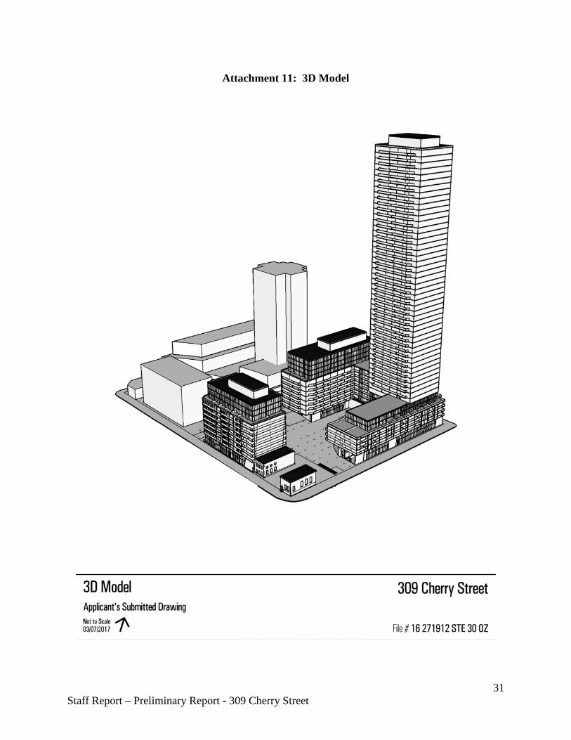
Proposal The application, submitted by Castlepoint Numa on behalf of landowners 2034055 Ontario Limited and 1337194 Ontario Inc., seeks to amend City of Toronto Zoning By-law 438-86 to permit a mixed-used development on the southern half of the subject site at 309 Cherry Street. The proposal consists of an 11-storey, 36.8 metre high mixed-use building with retail at grade fronting Cherry Street and a 52-storey, 161.1 metre high mixed-use building atop a podium base ranging in height from 4 (16.1 metres) to 12-storeys (39.8 metres) and fronting Commissioners Street and Foundry Street (a proposed north-south road). Specifically, the 4-storey portion of the podium is proposed to front onto Commissioners Street and the 12-storey portion of the podium is proposed to front onto a future east-west road. Additionally, there are three heritage buildings adjacent to the subject site and two heritage buildings on the northern portion of the 309 Cherry Street site, detailed as follows:
- 275 Cherry Street is a one-storey building, formerly the Dominion Bank (current Cherry Street restaurant), at the northeast corner of Cherry Street and Commissioners Street. This building was added to the City of Toronto Heritage Inventory in February 2003;
- 281 Cherry Street is a two-storey building, and is the former Toronto Hydro Substation,
fronting Cherry Street and north of Commissioners Street. This building was added to the City of Toronto Heritage Inventory in June 2003 and was designated through Part IV of the Ontario Heritage Act in June 2013;
- 16 Munition Street is a one-storey building, and is the former Queen's City Foundry,
fronting Munition Street and south of Villiers Street. This building was added to the City of Toronto Heritage Inventory in July 2003;
- 309 Cherry Street (I), the former Bank of Montreal, is a one-storey building that is
situated at the southeast corner of Cherry Street and Villiers Street. The building was added to the City of Toronto Heritage Inventory in August 1976;
- 309 Cherry Street (II), the former William McGill Company Building, is a partial one-
and two-storey building that fronts onto Cherry Street, south of Villiers Street. The building was added to the City of Toronto Heritage Inventory in February 2003.
The south wall of the proposed 11-storey building will abut the existing designated building at 281 Cherry Street. A total combined gross floor area of 73,037.8 square metres is proposed for the two buildings, comprising 71,614.3 square metres of residential gross floor area and 1,423.5 square metres of non-residential gross floor area. The total density proposed is 7.26 times the area of the lot (the lot area is 10,055.1 square metres). 1,013 residential units, 737 vehicular parking spaces and 1,038 bicycle parking spaces are proposed within the development. The vehicular and bicycle parking is proposed to be located within three levels of below grade parking, excluding 112
6 Staff Report – Preliminary Report - 309 Cherry Street

bicycle spaces which are to be located at grade. Vehicular access to the below grade parking is from the future proposed north-south road (Foundry Street) that is located east of the subject site. The interior of the subject site is proposed to be a publicly-accessible open space, which will have a range of hard and soft landscaping and is currently intended to provide a range of programming opportunities. In addition to the publicly-accessible open space, the proposal includes indoor and outdoor amenity space associated with the mixed-use buildings. Based on the number of units proposed (1,013), the applicant is required to provide a minimum of 2,026 square metres of indoor and 2,026 square metres of outdoor amenity space. The applicant is proposing 2,037 square metres of indoor amenity and 1,065 square metres of outdoor amenity. Pedestrian access to the 11-storey mixed-use building is proposed to be from the east-west road on the northern portion of the site, while access for the 52-storey tower is proposed to be from the east-west road to the north and the proposed Foundry Street to the east. This application is for the southern half of the subject site. A previous rezoning application (#12 131809 STE 30 OZ) was submitted that contemplated the development of a 26-storey residential tower on an 8-storey base podium for the northern half of the site. That application is currently before the Ontario Municipal Board. For further information on that application, please refer to the City staff Request for Directions Report, available at the following link: http://www.toronto.ca/legdocs/mmis/2015/te/bgrd/backgroundfile-75119.pdf Attachments 1 through 5 provide the site plan and elevations for the proposal. A 3D perspective drawing is found in Attachment 11, and a summary of the statistics for the submitted application is provided in Appendix 12. The applicant is also proposing that a holding symbol ("H") be placed on the amended zoning for the subject property, pending resolution of various matters, including the provision of appropriate infrastructure and servicing for the lot.
Site and Surrounding Area The site is located within the 325 hectare (800 acres) Port Lands area, a man-made industrial area created through fill in the early 1900s, located east of Toronto's downtown area between the Inner Harbour and Leslie Street and south of Lake Shore Boulevard. The Port Lands are a challenging area to redevelop due to the requirements for flood protection, infrastructure, soil remediation and geotechnical considerations. The subject property for this application is the southern portion of the larger 309 Cherry Street site. The 309 Cherry Street site comprises the majority of the block bounded by Villiers Street to the north, Cherry Street to the west, Commissioners Street to the south and Munition Street to the east. It has a total area of 20,150 square metres or just over two hectares. The portion of the site subject to the application comprises 10,055.1 square meters or 1 hectare – half of the total site area. The portion of the site subject to this application has 45 metres of frontage along Cherry Street and a depth of 118.7 metres. Both the subject property and larger site are essentially flat. The west and south frontages of the 309 Cherry Street site are lined by several non-native trees and shrubs.
7 Staff Report – Preliminary Report - 309 Cherry Street
At present, the 309 Cherry Street site is occupied by an environmental waste management company, which has been operating on the premises since 1999. Prior to this use, the site had been used as an oil refinery. Most of the northern portion of the site is vacant and used as storage and surface parking for trucks and larger vehicles. Several large former oil storage silos and tank structures are situated on the south portion of the site, none of which are any longer in use, and are, therefore, being decommissioned over time. At the southwest corner of the 309 Cherry Street, though not subject to this application, are two heritage buildings (275 Cherry Street, listed in the City's Inventory, and 281 Cherry Street, designated through Part IV of the Ontario Heritage Act). The larger Port Lands area contains a diverse mix of both vacant and active industrial lands, a film studio complex, offices, recreation facilities, entertainment uses and parks. The following is a description of the uses surrounding the subject property. North: Immediately north of the site, at the northeast corner of Cherry Street and Villiers
Street, is a one-story restaurant (2 Villiers Street) surrounded by surface parking and landscaped open space. North of the restaurant is the Keating Channel, a man-made, east-west outlet of the Don River. Further east are the listed one-storey Toronto Harbour Commissioners storage buildings (62 Villiers Street) with associated surface parking and loading facilities for barges and other boats using the Keating Channel.
West: On the west side of Cherry Street opposite the 309 Cherry Street site is Cousins Quay, a
man-made quay constructed in the 1930s (242 Cherry Street). A recycling operator, Toronto Port Authority dry dock, and boat docking services generally occupy the area; Marine Terminal 35 (MT35), a large, rectangular warehouse building abutting the lake with access for freighter docking, abuts the Inner Harbour. MT35 is listed on the City’s Inventory of Heritage Properties. To the northwest of the subject property are the former Essroc silos (312 Cherry Street), also listed on the City’s Inventory of Heritage Properties, that are currently vacant with Essroc’s recent relocation to the East Port area of the Port Lands.
South: South of the 309 Cherry Street site, on the south side of Commissioners Street is a large
(8 hectare) vacant site (51 Commissioners Street) that is used on a temporary basis for film crews and entertainment productions such as the Cirque de Soleil. East of this site at Munition Street is a two-storey brick building that was formerly a fire hall and now houses the Toronto Fire Fighters Association Headquarters (39 Commissioners Street); this building was listed on the City's Inventory of Heritage Properties in 2003. Southwest of the subject property are two other listed heritage properties: 275 Cherry Street, a one-storey red brick building at the northeast corner of Cherry and Commissioners Streets that is now a restaurant, but was formerly occupied by the Dominion Bank (listed in 2003); and 281 Cherry Street, a two-storey, red brick building (listed in 2003) that houses a Toronto Hydro substation and was designated in 2013. Southwest of the subject site across Polson Quay is Lafarge’s concrete operation at 54 Polson Street; Lafarge has indicated that it will continue its port and industrial operations at this site for the foreseeable future.
8 Staff Report – Preliminary Report - 309 Cherry Street
East: On the same block as the 309 Cherry Street site, at the southwest corner of Villiers Street
and Munition Street, is the former Queen’s City Foundry building listed on the City’s Inventory of Heritage properties in 2003. The building/site is privately owned and houses sound/rehearsal studios. Immediately south is a white, two-storey warehouse building (54 Commissioners Street) owned by Waterfront Toronto. On the east side of Munition Street are various one and two-storey office, warehouse and industrial production buildings, as well as extensive ancillary surface parking for vehicles and transport trucks and vacant lands.
Provincial Policy Statement and Provincial Plans The Provincial Policy Statement (PPS) 2014 provides policy direction on matters of provincial interest related to land use planning and development. These policies support the goal of enhancing the quality of life for all Ontarians. Key policy objectives include: building strong healthy communities; wise use and management of resources and protecting public health and safety. The PPS recognizes that local context and character are important. Policies are outcome-oriented, and some policies provide flexibility in their implementation provided that provincial interests are upheld. City Council's planning decisions are required to be consistent with the PPS. Section 1.6 of the PPS speaks to the requirement for coordinated, strategically located and integrated sewage, water and transportation infrastructure. Section 3.1 addresses development in Natural Hazard areas, particularly those in Special Policy Areas associated with flood plains. The Growth Plan for the Greater Golden Horseshoe provides a framework for managing growth in the Greater Golden Horseshoe including: directions for where and how to grow; the provision of infrastructure to support growth; and protecting natural systems and cultivating a culture of conservation. City Council’s planning decisions are required to conform, or not conflict, with the Growth Plan for the Greater Golden Horseshoe. Section 3 of the Growth Plan contains policy requirements for new infrastructure to support growth. Staff will review the proposed development for consistency with the PPS and for conformity with the Growth Plan for the Greater Golden Horseshoe.
Official Plan The former City of Toronto Official Plan is in force in the Port Lands and designates the site General Industrial Area on Map 1. Further, the site is located within the Port Industrial District on Map 9 of the former City of Toronto Official Plan. In addition, the site is located partially within the Lower Don Lands Special Policy Area, as shown on Map 3 of the former City of Toronto Official Plan, and is subject to flood risk. Development on lands designated Special Policy Area (SPA) within the Port Lands may not be permitted until flood remedial works through the Don Mouth Naturalization and Port Lands Flood Protection Environmental Assessment (DMNP EA) are completed to flood protect the lands and enable comprehensive renewal and then the lands are flood protected to at least the level of a 1:350 flood, subject to review and approval by the Toronto and Region Conservation Authority. Further details regarding development within the flood plain lands are discussed
9 Staff Report – Preliminary Report - 309 Cherry Street
below, including more recent policies adopted through OPA 388 that better define Council's vision for development within a flood plain and the SPA. The Central Waterfront Secondary Plan (CWSP), which was adopted by City Council in 2003 as an amendment to the former City of Toronto Official Plan, represents Council policy to guide revitalization in the Central Waterfront. The CWSP was appealed to the Ontario Municipal Board by numerous appellants and is not currently in force for the Port Lands. Nonetheless, the CWSP is utilized to guide and inform planning in the Central Waterfront. The CWSP was amended for the Port Lands through Official Plan 388 in 2010. OPA 388 was also appealed to the Ontario Municipal Board by numerous parties, including the applicant of the subject application, and is not currently in force. Additional amendments to the CWSP, including to OPA 388, are anticipated to implement the outcomes of the second phase of the PLAI and current planning underway in the Port Lands. The CWSP is premised on four key principles:
- Removing barriers and making connections; - Building a network of spectacular waterfront parks and public Spaces; - Promoting a clean and green environment; and - Creating dynamic and diverse new communities.
Under the original 2003 CWSP, the subject property was designated as Parks and Open Space Areas. The site and surrounding lands north of Commissioners Street were re-designated to Regeneration Areas through OPA 388 in 2010. The Regeneration Areas designation in the CWSP allows for a wide variety of mixed-use development, including housing, offices and retail uses. The CWSP identifies that the Port Lands will generally be developed at a medium-scale with some lower elements and higher buildings in appropriate locations. Lower buildings are to be located along the water’s edge, with retail and community activities concentrated at accessible locations to form a focus for the area. The Plan also identifies that rezoning individual sites within Regeneration Areas will generally only be entertained once a context has been established for the evaluation of specific rezoning applications, through Precinct Implementation Strategies, or precinct plans as they are more commonly referred to. The purpose and objective for requiring these plans prior to considering a rezoning is to ensure the comprehensive and orderly development of an area. The majority of the Port Lands north of the Ship Channel are subject to flood risk. In 1994, the City implemented the Lower Don Special Policy Area (SPA) in the former City of Toronto Official Plan. Special Policy Areas recognize areas that have historically developed within a flood plain and provide for the continued viability of existing uses. A small portion of the subject is located within the Special Policy Area boundary. The balance of the site is considered to be within a one zone concept under the Provincial Policy Statement. Development is not permitted within a one zone concept. OPA 388, which included the subject site, introduced a Two Zone Concept for floodplain management, as well as site and environmental planning policies. The Two-Zone Concept proposes a 'Floodway' and 'Flood Fringe', highlighting areas both not capable (floodway) and potentially capable (flood fringe) of accommodating
10 Staff Report – Preliminary Report - 309 Cherry Street
development. Policy D_26 was also introduced and identifies that development will not be permitted until specific criteria, such as the completion of flood protection works, are fulfilled. The subject site in relation to the most recent flood plain map, provided by TRCA, and the SPA is shown in Attachment 8 and 9. Under the Toronto Official Plan (approved by the OMB in 2006), the subject property is within the Downtown and Central Waterfront on Map 2 – Urban Structure and is designated Regeneration Areas on Map 18 – Land Use Plan. The subject property is also partially covered under Special Policy Area 7 – Lower Don: Don River, on Map 11. Policies 3.4.5 and 3.4.11 b) within Chapter 3 of the Official Plan address development criteria within this floodplain Special Policy Area. The Toronto Official Plan is not in force for the Central Waterfront, inclusive of the Port Lands. Further, the Plan’s Special Policy Area (SPA) policies are currently under appeal and the SPA policies of former municipalities continue to be in effect. Although the policies of the Toronto Official Plan do not technically apply to the subject property, staff will consider them, where appropriate, during the review of this application, as they reflect much of the recent planning policy direction from both the City and the Province.
Urban Design Guidelines City-wide Tall Building Design Guidelines In May 2013, Toronto City Council adopted the updated city-wide Tall Building Design Guidelines and directed City Planning staff to use these Guidelines in the evaluation of all new and current tall building development applications. The Guidelines establish a unified set of performance measures for the evaluation of tall building proposals to ensure they fit within their context and minimize their local impacts. The city-wide Tall Building Design Guidelines are available at: http://www1.toronto.ca/city_of_toronto/city_planning/urban_design/files/pdf/tall-buildings.pdf Avenues and Mid-Rise Buildings Guidelines In 2010, City Council adopted the Avenues and Mid-Rise Buildings Study. The study included guidelines which are intended to encourage the construction of better designed mid-rise buildings on the City’s Avenues. The guidelines typically apply to sites designated Mixed Use Areas. While the guidelines technically do not apply to the Central Waterfront or lands designated Regeneration Areas, given that development in the Port Lands under the CWSP is generally to be of a medium-scale, the guidelines will be considered in any evaluation of the application. The city-wide Mid-Rise Design Guidelines are available at: http://www1.toronto.ca/wps/portal/contentonly?vgnextoid=7238036318061410VgnVCM10000071d60f89RCRD Toronto City Council at its meeting on June 7, 2016 adopted the revised Mid-Rise Building Performance Standards Addendum for City staff to use together with the previously approved Mid-Rise Building Performance Standards in the preparation of area studies and during the evaluation of development applications where mid-rise buildings are proposed and the
11 Staff Report – Preliminary Report - 309 Cherry Street

Performance Standards are applicable. The Addendum will be in use until such time as City Council considers and adopts updated Mid-Rise Building Design Guidelines in Q4, 2017. The Mid-Rise Building Performance Standards Addendum incorporates a number of revisions that reflect and respond to the additional feedback concerning the Mid-rise Building Performance Standards received at the recent meetings of Committee and Council and based upon the monitoring review process. Key revisions contained within the Addendum include:
- clarification concerning the relationship between Secondary Plan Areas and the use of the Performance Standards (Applicability of Performance Standards);
- the addition of recommended actions for Consultation, Context and Infrastructure; - extensive clarification regarding the definition and determination of mid-rise building
height (Performance Standard #1); and - clarification on the presence and integration of rooftop equipment and mechanical
penthouses (Performance Standard #13)
Zoning The harmonized city-wide Zoning By-law does not apply to the subject the site. The former City of Toronto Zoning By-law 438-86 is in force, and zones the subject site Industrial (I3 D2). The zoning permits industrial, commercial and institutional uses at a maximum density of two times the area of the lot. Residential uses are not permitted. A map of the existing zoning for the area can be found in Attachment 6.
Site Plan Control The subject property is subject to Site Plan Control. An application for site plan control has not been submitted with this zoning amendment application. Staff will not be requiring a site plan application to be submitted until all outstanding policy and zoning matters associated with the Port Lands and Villiers Island Precinct have been resolved.
Tree Preservation The applicant has provided an Arborist Report, which identifies all of the existing trees on the site. There are a total of 35 trees, 20 on the City's road allowance and 15 on the subject property. The arborist report proposes the removal of all but four of the 35 trees. Tree removal will be evaluated in consultation with the appropriate staff in Urban Forestry when all other matters associated with this application are ready to be reviewed.
Toronto and Region Conservation Authority (TRCA) – Floodplain The Toronto and Region Conservation Authority (TRCA) recently completed updated flood modeling and mapping for the Lower Don floodplain. The subject site is within the floodplain, but will be removed from flooding upon implementation of various phases of the Don Mouth Naturalization and Port Lands Flood Protection EA (DMNP EA). The majority of the DMNP EA implementation is unfunded, and detailed design work needs to be completed to fully understand the final finished grade of the 309 Cherry Street and surrounding sites. The TRCA
12 Staff Report – Preliminary Report - 309 Cherry Street
has requested that the applicant provide a Flood Study outlining how the proposal meets the requirements of the DMNP EA. As of the writing of this report, the Flood Study has not been provided; however, the applicant has indicated that it will be submitted to the City and to the TRCA shortly.
Reasons for the Application The application was submitted as the proposed residential uses, densities and heights are not permitted under the existing Industrial (I3 D2) zoning for the site. The applicant is also requesting that a holding symbol ("H") be placed on the proposed amended zoning for the subject property. In addition, the application does not conform with the in force, former City of Toronto Official Plan policies, particularly with respect to the site being designated General Industrial Areas and located within the Port Industrial District. The intent of the policies related to the land use designation and the site's location within the Port Industrial District is clearly indicated to continue the growth of industrial uses in this area. While this does not reflect Council's current vision for the Port Lands, the proposal does not conform with the in force, former City of Toronto Official Plan and an Official Plan Amendment application is required to be submitted by the applicant. Any Official Plan Amendment that contemplates amending the boundaries of a Special Policy Area, amending any of the Special Policy Area policies, or redesignation of lands within a Special Policy Area will need to be approved by the Ontario Ministers of Municipal Affairs and Natural Resources and Forestry per the Provincial Policy Statement, 2014. The TRCA will also need to review and advise on any proposed Official Plan Amendment. COMMENTS
Application Submission The following drawings, reports and studies were submitted with the application: - Architectural Plans; - Sun/shadow Study; - Topographical and Boundary Survey; - Planning Rationale Report; - Draft Zoning By-law Amendment; - Transportation Impact Study and Parking/Loading Study; - Landscape Master Plan; - Arborist Report; - Preliminary Geotechnical Study; - Contaminated Site Assessment; - Heritage Impact Statement; - Pedestrian Wind Study; - Noise and Vibration Study; - Air Quality Study; - Functional Servicing and Stormwater Management Report; - Site Grading Plan;
13 Staff Report – Preliminary Report - 309 Cherry Street

- Flood Study (to be submitted by the applicant); - Building Mass Model; - Public Consultation Plan; - Toronto Green Standards Checklist and Template; and - A digital copy of all of the above. A Notification of Complete Application was issued on January 26, 2017, acknowledging the application being complete as of December 31, 2016.
Port Lands Acceleration Initiative (PLAI) Projects As referenced in the Decision History section above, there are several on-going PLAI projects and studies, which provide an emerging planning framework and context within which the application will be properly and thoroughly evaluated. Key projects applicable to this application include: 1. Don Mouth Naturalization and Port Lands Flood Protection Environmental
Assessment (DMNP EA): This EA is a flood control remedial works plan for the Port Lands undertaken to “make an ecologically functional river mouth, remove flood risk and provide opportunities to revitalize the Port Lands area of Toronto’s waterfront”. The EA was finalized and formally submitted to the Ontario Ministry of the Environment in March 2014. The DMNP EA received Ministerial Approval on January 28, 2015. After approval by the Ministry of the Environment and Climate Change, a due-diligence review was conducted by Waterfront Toronto, in collaboration with the City of Toronto, the Toronto and Region Conservation Authority and the Toronto Port Lands Company, to confirm and refine the project scope, budget and schedule. The revised cost to implement the DMNP EA (in nominal dollars), including associated enabling infrastructure, is $1.25 billion in year-of-expenditure dollars. The revised scope of the project includes permanent flood protection through the creation of a new, naturalized mouth of the Don River and other significant flood protection measures, as well as essential municipal services, streets, bridges, parkland development and environmental remediation in the Port Lands. Funding requests and business cases have been submitted to the Province and Federal government for one-third funding by each order of government, including the City of Toronto. No funding commitments have been made by the Province or Federal Government at this time.
2. Lower Don Lands Infrastructure EA: The Lower Don Lands Infrastructure EA identifies the location and design of roads and bridges, transit, servicing and stormwater management in the Lower Don Lands. This Environmental Study Report and EA addendum completed the Municipal Class EA process for applicable projects within the Lower Don Lands and amended the original Infrastructure Master Plan completed in 2010. The Environmental Study Report and addendum document was placed on the public record for comment in September 2014. No Part II bump-up orders were requested.
14 Staff Report – Preliminary Report - 309 Cherry Street
3. Port Lands Planning Framework: The Port Lands Planning Framework is a
comprehensive, high-level plan for the Port Lands that aligns all major aspects required for redevelopment and renewal over the long-term. As part of the Port Lands Planning Framework, a Community Infrastructure Strategy was developed to identify a full range of community facilities to respond to a new resident and worker population within the various precincts. The framework will support amendments to the Central Waterfront Secondary Plan, and inform precinct planning and community infrastructure needs, and the development review process. The Port Lands is approximately 325 hectares (800 acres) in area. It is Toronto’s only working port and there are a number of important city-serving uses and film/media uses located in the area. The emerging directions for the Framework recognizes these uses, their importance and the maintenance of the existing uses, including film, and will also identify the preferred locations for new mixed-use communities in portions of the Port Lands, including the desired mix of uses in each new community to support achievement of the overall vision. Given the size of the area, the planning framework will be a long term plan. Some areas are anticipated to redevelop in the near- and medium-terms. These areas include the Villiers Island precinct and portions of the Film Studio District. Additionally, and in support of broader revitalization in the Port Lands and South of Eastern areas, lands south of the Ship Channel are anticipated to intensify with port and industrial uses, including relocating city serving uses to these areas which would open up redevelopment opportunities in other areas
4. Villiers Island Precinct Plan: The precinct plan for Villiers Island has been advancing in
tandem with the Port Lands Planning Framework and will establish more detailed design and development objectives, local street patterns, a block structure, linkages between local parks and open spaces, and built form controls (heights, densities etc.). Following the April 2013 report, which expanded the precinct area to include the 309 Cherry Street site, the precinct plan boundaries were further expanded to comprehensively plan all lands to the north of the new river valley. 309 Cherry Street is located within Villiers Island.
City Staff and relevant agencies/divisions have been in regular discussions with the applicant on all of the above projects. More detailed engagement and discussions occurred with the applicant on a regular basis for the Villiers Island Precinct Plan and Port Lands Planning Framework. The current expectation is that the majority of work on these initiatives will be completed by the third quarter 2017. The subject application of this report is substantially inconsistent with the draft Port Lands Planning Framework/Villiers Island Precinct Plan presented to the public on November 14, 2015. These inconsistencies are detailed in the comments below. Further consideration and reporting of the significant concerns set out below is best undertaken against the final form of the Port Lands Planning Framework.
15 Staff Report – Preliminary Report - 309 Cherry Street
Issues to be Resolved After conducting a preliminary review of this application, City Planning staff have several major concerns with the proposal. Prematurity of the Proposed Development Application As discussed above, a planning framework for future development in the Port Lands, and particularly within Villiers Island, is currently being finalized. Once completed, these works will provide an appropriate planning framework and context within which the application can be properly and thoroughly evaluated. The Port Lands Acceleration Initiative was approved in 2012 in order to advance the revitalization of the Port Lands. Part of this work has involved major public consultations, the last of which was undertaken in November of 2015. Proceeding with this application prior to the completion of the Port Lands Planning Framework and the Villiers Island Precinct Plan is not appropriate from a planning perspective and would potentially negate the many years of planning work that has been undertaken for this important, city-building initiative. Flood Plain and Future Flood Protection As noted in Attachment 8, the entirety of the subject site is located within, and is surrounded by, an existing Regulatory Flood Plain. The Regulatory Flood Plain is the approved standard used to define the limit of the flood plain in a particular watershed. Within the Toronto and Region Conservation Authority's jurisdiction, the Regulatory Flood Plain is based on the Regional Storms event (Hurricane Hazel), or the 100 year flood, whichever is greater. Development is generally prohibited within the flood plain. A small portion of the eastern side of the site is within a Special Policy Area (SPA). Lands within the SPA may develop under the existing Official Plan permissions subject to flood proofing, but any proposals for intensified land uses, in this case from the existing in-force Official Plan, must go through a comprehensive review process and receive approval from the provincial Ministries of Municipal Affairs and Natural Resources and Forestry. New uses, like residential uses, including all buildings, structures and associated uses, and future development would require amending the SPA that impacts the subject site. To remove the lands from the SPA, and permit new residential uses, the lands must be flood protected. Until the lands are flood protected, through the phased completion of the Don Mouth Naturalization and Port Lands Flood Protection Environmental Assessment (DMNP EA), residential development cannot proceed on the subject site. Future Right-of-Way and Conformity with the Lower Don Lands Infrastructure EA As part of precinct planning for Villiers Island, a continuous future, public east-west right-of-way (ROW) is proposed that would bisect the full site municipally known as 309 Cherry Street. The applicant is proposing a substandard 15 metre private east-west road. Further, the proposal
16 Staff Report – Preliminary Report - 309 Cherry Street
does not consider appropriate setbacks for future built form adjacent to the future ROW or an appropriate built form in consideration of the width of the proposed ROW. Proposed Built Form and Massing City staff have significant concerns with the proposed built form and massing. Any future development will be required to conform to the Port Lands Planning Framework and adhere to the development guidelines of the Villiers Island Precinct Plan. The proposed built form is entirely inconsistent with the draft Port Lands Planning Framework and Villiers Island Precinct Plan that was presented to the public in November 2015. From a built form perspective, the Island was identified as having a mid-rise character in good proportion to streets, parks and open spaces, with a limited number of tall buildings, generally in the mid-20 stories, in strategic locations. The built form direction for the Island is currently being revised based on public feedback received during the November 2015 consultation. It is anticipated that the proposal will continue to be entirely inconsistent with the final recommended built form and massing for the Island. For example, the applicant's proposal includes a 15 metre private, east-west ROW that bisects the entirety of the property at 309 Cherry Street. While staff have concerns with the proposed width and private nature of the ROW, the proposed built form and massing is not appropriate given the ROW width proposed either by the applicant or the Villiers Island precinct planning exercise. The 11-storey building on the northwest portion of the subject site maintains a full height of 36.8 metres, whereby an appropriate mid-rise building height would be generally within a 1:1 ratio between the width of the adjacent ROW and the height of the building. In addition, the proposed streetwall height adjacent to the future ROW is 27.8 metres, well above the typical standard of 80% of the ROW width that is recommended in the Avenues and Mid-Rise Buildings Guidelines. The 52-storey building located on the eastern portion of the subject site presents an inappropriate and undesirable scenario for appropriate built form and massing adjacent to the future ROW. The podium in this location maintains a height of 39.8 metres, which is 165% above the 1:1 ratio of the applicant's proposed ROW width. The actual 52-storey portion of the proposed building is located on the southeast portion of the subject site and is inconsistent with the intended vision for this section of Villiers Island. The proposed built form and massing, in its entirety, has the potential to set a negative precedent for future development of the Villiers Island Precinct and major refinements to the proposed built form and massing are required. Additional Issues In addition to the above, staff have identified additional issues based on their preliminary review of the proposal, shown in the numerical list below. These issues, as well as any others that may
17 Staff Report – Preliminary Report - 309 Cherry Street
be identified by staff, various relevant agencies/divisions and the public, will need to be reviewed and addressed. 1. consistency with the Provincial Policy Statement and conformity with the Growth Plan
for the Greater Golden Horseshoe; 2. conformity with the in-force (former) City of Toronto Official Plan including the Lower
Don Special Policy Area provisions and provincial requirements;
3. conformity with the Central Waterfront Secondary Plan (OPA 257), and in particular the requirement for precinct planning under Sections 2.1 and 2.2;
4. having regard for the current City of Toronto Official Plan; 5. consistency with the Don Mouth Naturalization and Port Lands Flood Protection
Environmental Assessment; 6. consistency with the Lower Don Lands Infrastructure Environmental Assessment; 7. consistency with the Port Lands Planning Framework and conformity with any resulting
Official Plan policies; 8. consistency with the Villiers Island Precinct Plan and adherence to permissions or
performance standards under any implementing zoning by-law; 9. compliance with any of the applicable City of Toronto's Urban Design Guidelines;
10. proposed street and lane alignment/configuration;
11. location, height, stepbacks, separation distance and floorplate size of the proposed tower,
should a tower be permitted as part of this application;
12. skyline impact of the proposed tower, should a tower be permitted as part of this application;
13. sun/shadow impact of the proposed buildings;
14. acceptability of heritage impacts, including conformity with Parks Canada’s “Standards
and Guidelines for the Conservation of Historic Places in Canada”, approved by City Council as the official document guiding planning, stewardship and conservation approach for all listed and designated heritage resources within the City (March 3, 4, and 5, 2008);
15. appropriate commemoration and interpretation of the heritage buildings on the subject
property;
18 Staff Report – Preliminary Report - 309 Cherry Street

16. sensitivity of the proposed built form and massing on the heritage buildings abutting the
site at 275 and 281 Cherry Street;
17. other built form and massing issues including, but not limited to: setbacks, stepbacks, sky view, light penetration, privacy, wind mitigation, and pedestrian realm weather protection;
18. assessment of traffic and parking impacts generated by the proposed commercial and
residential uses; 19. location and size of the proposed amenity space, particularly the ground floor area and its
interaction with the public realm;
20. compatibility of the proposed landscape plan with the broader public realm plan associated with the Villiers Island Precinct Plan;
21. unit mix, including the provision of family-sized units;
22. provision of affordable rental housing;
23. servicing capacity;
24. conformity with grading requirements across the Port Lands;
25. compatibility of the proposed residential use and heights of buildings, from a noise and
air quality perspective, with existing industrial operations both on-site and in the vicinity of the subject property;
26. the provision of community facilities in the area to service the proposed development;
27. the proposed sustainability strategy for the project, including green roof requirements and other requires of the final form of the Port Lands Planning Framework and Villiers Island Precinct Plan;
28. review of the Toronto Green Standard (TGS) Checklist submitted by the applicant for
compliance with the Tier 1 performance measures, and the potential for the applicant to pursue Tier 2 performance measures, pending completion of the Port Lands Planning Framework and Villiers Island Precinct Plan;
29. provision of public art;
30. comment from NAV Canada regarding any impacts with neighbouring flight paths and
the Billy Bishop Island Airport; and 31. identification and securing of public benefits pursuant to Section 37 of the
Planning Act should there be a recommendation for approval of any form of development
19 Staff Report – Preliminary Report - 309 Cherry Street
Conclusion City staff have serious and major concerns with the proposal as submitted. City staff regard this application as premature, given the as of yet to be completed Port Lands Planning Framework and Villiers Island Precinct Plan, and have concerns with the proposal's location within the flood plain and its lack of consistency with the Lower Don Lands EA. In addition, City staff have serious concerns with the proposed built form and massing of the development, especially given its inconsistency with the draft Port Lands Planning Framework and Villiers Island Precinct Plan that was presented to the public in November 2015. Notwithstanding its prematurity, City staff are recommending further review of the application, which will include consultation with the public as outlined in the recommendations to this report. Further consideration and reporting of the significant concerns set out in this report is best undertaken against the final form of the Port Lands Planning Framework. City staff are anticipating the completion of the Port Lands Planning Framework in the second quarter of 2017. CONTACT Daniel Woolfson, Planner Tel. No. 416-392-7574 E-mail: [email protected] SIGNATURE _______________________________ Gregg Lintern MCIP RPP Director, Community Planning Toronto and East York District (P:\2017\Cluster B\pln\TEYCC\8788113077.doc) - vc ATTACHMENTS Attachment 1: Site Plan Attachment 2: South Elevation [as provided by applicant] Attachment 3: North Elevation [as provided by applicant] Attachment 4: East Elevation [as provided by applicant] Attachment 5: West Elevation [as provided by applicant] Attachment 6: Zoning Attachment 7: Official Plan Attachment 8: Flood Plain Attachment 9: SPA Map Attachment 10: Context Map and Heritage Buildings Attachment 11: 3D Model Attachment 12: Application Data Sheet
20 Staff Report – Preliminary Report - 309 Cherry Street
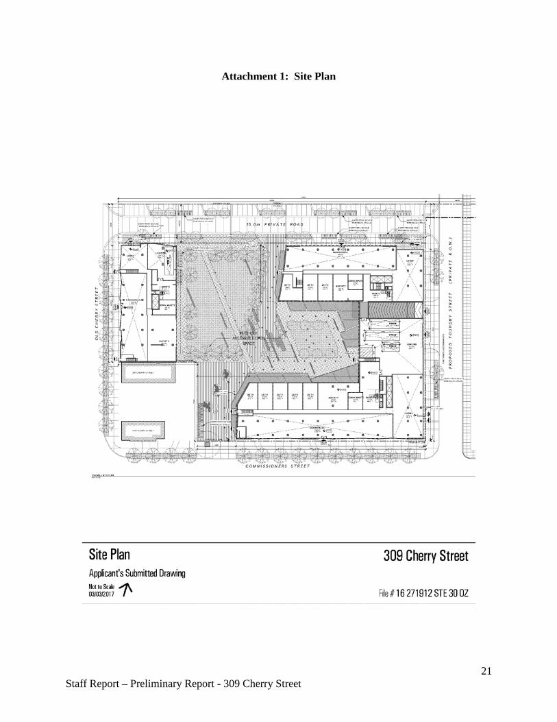
Attachment 1: Site Plan
21 Staff Report – Preliminary Report - 309 Cherry Street
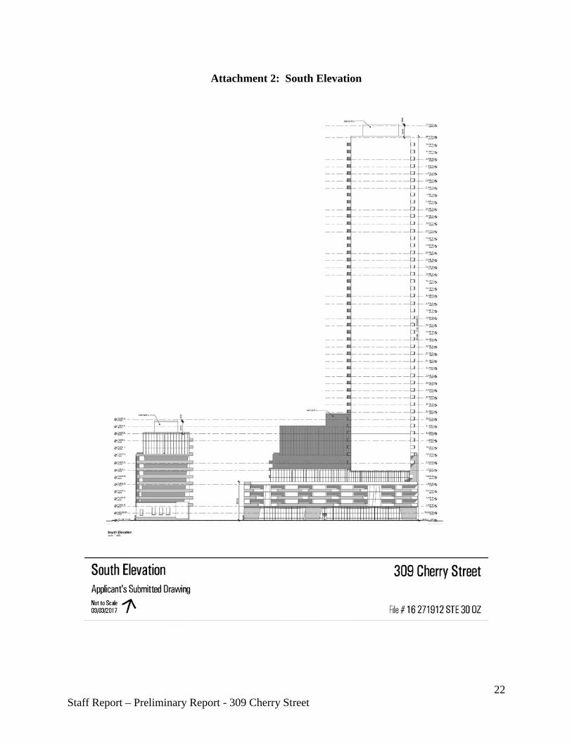
Attachment 2: South Elevation
22 Staff Report – Preliminary Report - 309 Cherry Street
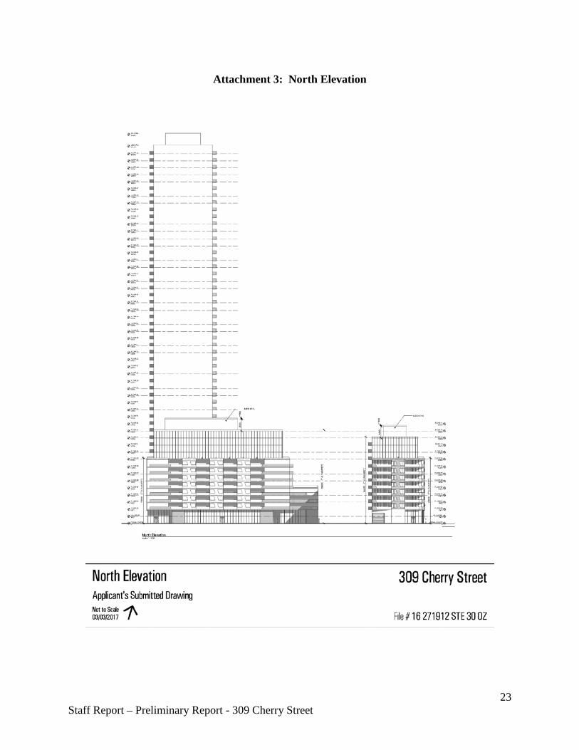
Attachment 3: North Elevation
23 Staff Report – Preliminary Report - 309 Cherry Street
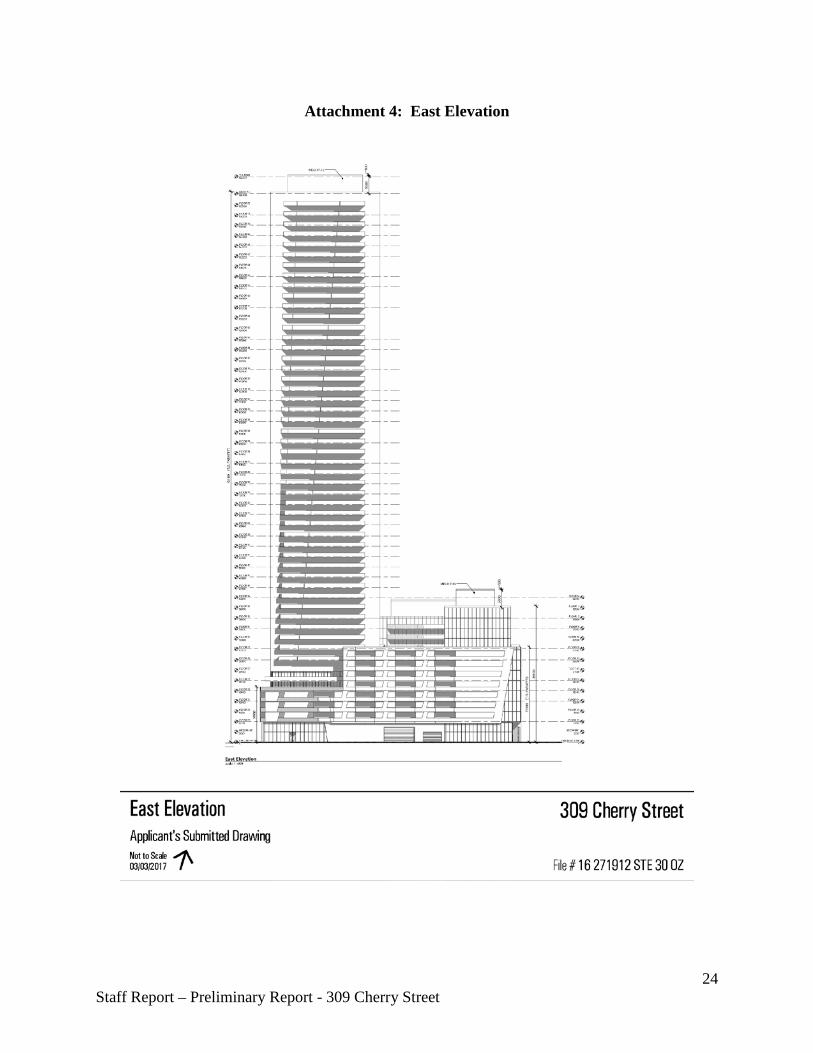
Attachment 4: East Elevation
24 Staff Report – Preliminary Report - 309 Cherry Street
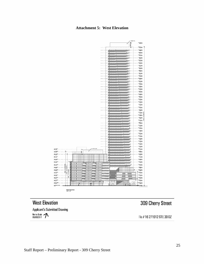
Attachment 5: West Elevation
25 Staff Report – Preliminary Report - 309 Cherry Street
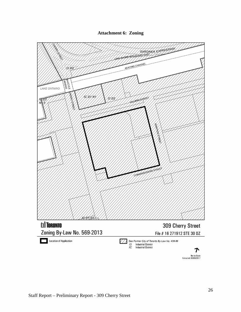
Attachment 6: Zoning
26 Staff Report – Preliminary Report - 309 Cherry Street
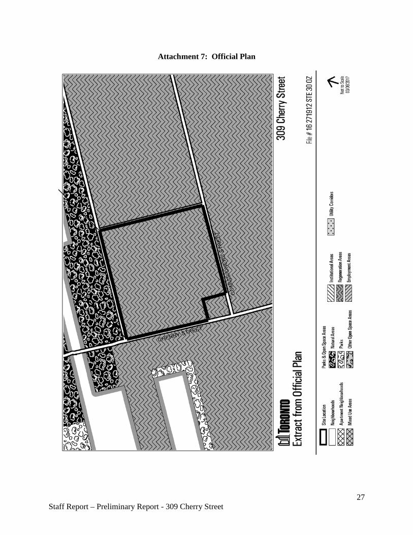
Attachment 7: Official Plan
27 Staff Report – Preliminary Report - 309 Cherry Street
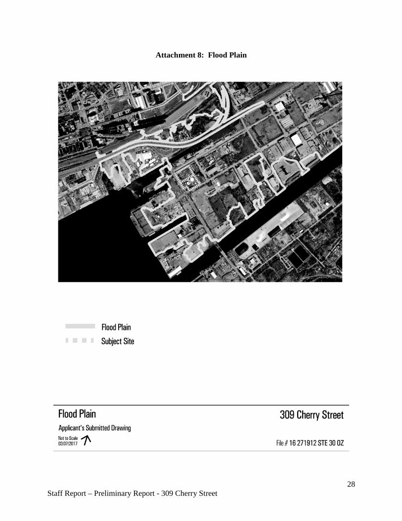
Attachment 8: Flood Plain
28 Staff Report – Preliminary Report - 309 Cherry Street
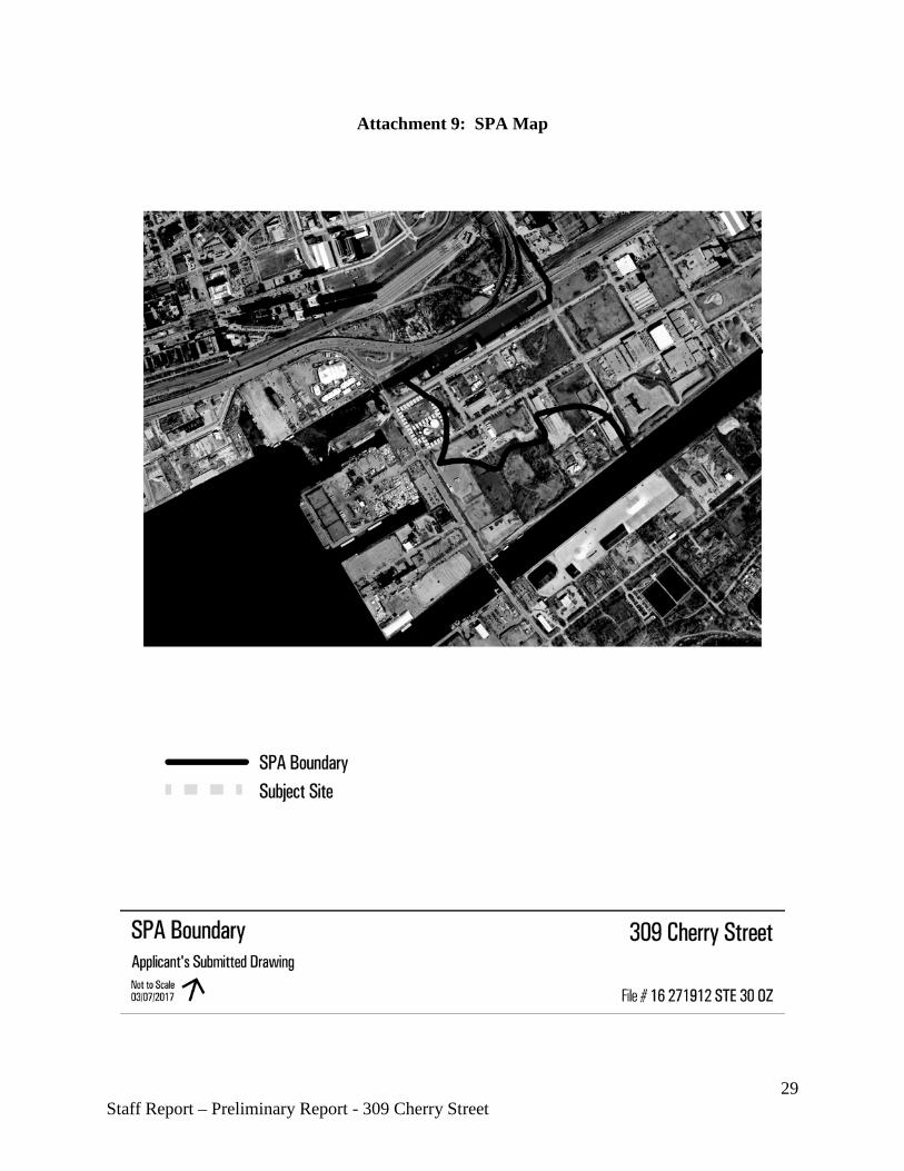
Attachment 9: SPA Map
29 Staff Report – Preliminary Report - 309 Cherry Street

Attachment 10: Context Map and Heritage Buildings
30 Staff Report – Preliminary Report - 309 Cherry Street
Attachment 11: 3D Model
31 Staff Report – Preliminary Report - 309 Cherry Street
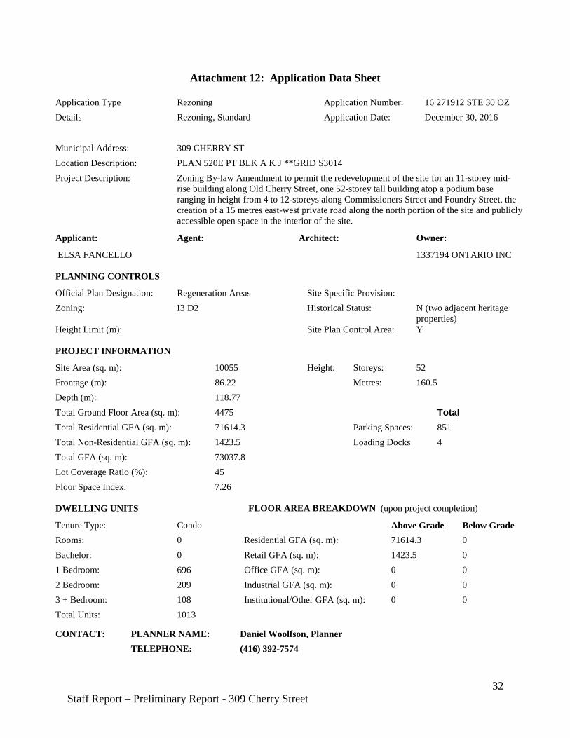
Attachment 12: Application Data Sheet
Application Type Rezoning Application Number: 16 271912 STE 30 OZ Details Rezoning, Standard Application Date: December 30, 2016
Municipal Address: 309 CHERRY ST Location Description: PLAN 520E PT BLK A K J **GRID S3014 Project Description: Zoning By-law Amendment to permit the redevelopment of the site for an 11-storey mid-
rise building along Old Cherry Street, one 52-storey tall building atop a podium base ranging in height from 4 to 12-storeys along Commissioners Street and Foundry Street, the creation of a 15 metres east-west private road along the north portion of the site and publicly accessible open space in the interior of the site.
Applicant: Agent: Architect: Owner:
ELSA FANCELLO 1337194 ONTARIO INC
PLANNING CONTROLS
Official Plan Designation: Regeneration Areas Site Specific Provision: Zoning: I3 D2 Historical Status: N (two adjacent heritage
properties) Height Limit (m): Site Plan Control Area: Y
PROJECT INFORMATION
Site Area (sq. m): 10055 Height: Storeys: 52 Frontage (m): 86.22 Metres: 160.5 Depth (m): 118.77 Total Ground Floor Area (sq. m): 4475 Total Total Residential GFA (sq. m): 71614.3 Parking Spaces: 851 Total Non-Residential GFA (sq. m): 1423.5 Loading Docks 4 Total GFA (sq. m): 73037.8 Lot Coverage Ratio (%): 45 Floor Space Index: 7.26
DWELLING UNITS FLOOR AREA BREAKDOWN (upon project completion)
Tenure Type: Condo Above Grade Below Grade Rooms: 0 Residential GFA (sq. m): 71614.3 0 Bachelor: 0 Retail GFA (sq. m): 1423.5 0 1 Bedroom: 696 Office GFA (sq. m): 0 0 2 Bedroom: 209 Industrial GFA (sq. m): 0 0 3 + Bedroom: 108 Institutional/Other GFA (sq. m): 0 0 Total Units: 1013
CONTACT: PLANNER NAME: Daniel Woolfson, Planner TELEPHONE: (416) 392-7574
32 Staff Report – Preliminary Report - 309 Cherry Street