3.0 lwr downstream area effects and manitoba hydro responses · 3.0 lwr downstream area effects and...
TRANSCRIPT
34
3.0 LWR Downstream Area Effects and Manitoba Hydro Responses
3.1 Historic Context of DevelopmentAboriginal peoples have a strong cultural and spiritual connection to the land and water. Manitoba Hydro has large investments in areas where Aboriginal peoples live and harvest resources, practise their culture and traditional way of life, and exercise their legal and constitutional rights. The development of the Manitoba Hydro system including LWR has affected the environment upon which Aboriginal peoples and communities in northern Manitoba rely. While northern communities have benefited from access to a reliable, low-cost, and convenient energy source, many have also experienced substantial negative effects on their traditional way of life and, as communities have indicated, a sense of powerlessness and marginalization in decision-making processes affecting their lives.
LWR was evaluated, debated, and constructed during a time when the social, political, and legal environment was quite different from today. Decisions about LWR occurred in an era when there was much less understanding of the effects of developments on people and the environment, and when there were fewer environmental regulations and legislation. Notably, approval of LWR predated the Constitution Act (1982), the Environment Act (Manitoba) [1987], the Canadian Environmental Assessment Act (1992), and the Sustainable Development Act (Manitoba) [1997]. Development occurred at a time when economic and other interests (i.e., flood reduction on Lake Winnipeg) of predominantly southern society took precedence over the interests of potentially affected northern populations.
As a result, Canada’s, Manitoba’s, and Manitoba Hydro’s approach to development during this time period was very different than today. While in line with practices of the day and consistent with government requirements, past projects involved much less engagement and consultation than what would be considered appropriate today, and considerably less upfront planning with respect to reducing environmental impacts. Measures to avoid or reduce negative effects were not always identified in advance of project construction nor were they included in capital cost estimates.
During the 1970s and 1980s, public environmental awareness and media attention about the environment began to increase dramatically. Scientific research confirmed that people and the environment were being affectedbyindustrialdevelopmentinmorewaysthanpreviouslythought.Globally,therewasincreasedpressure on governments and corporations to protect the environment. Respect for Aboriginal peoples and appreciation of their experiences with the development process were also growing. Affected communities were asserting their rights and seeking restitution for the adverse effects they experienced as a result of development. The Constitution Act, which was passed in 1982, provided constitutional protection of Aboriginal and treaty rights for Aboriginal peoples in Canada.
As society’s understanding and appreciation advanced, Manitoba Hydro became increasingly involved in environmental initiatives and in efforts to understand and address Aboriginal grievances and claims about past projects. Manitoba Hydro has established a range of measures to correct damage that resulted from its activities, to reduce the number of new effects, and to compensate those people and communities who have been affected. Today, Manitoba Hydro is working towards long-term relationships with Aboriginal peoples founded on trust and shared interests. This includes the implementation of policies, programs, and activities aimed at increasing Aboriginal participation in employment; providing business and partnership opportunities in new developments; maintaining regular contact with communities; and managing community-specific issues, including supporting and promoting the safety of people using affected waterways, and others.
Manitoba Hydro acknowledges that some of the changes brought about by LWR are irreversible and that, as would be expected, some members of various communities may not feel that measures taken to address or compensate for effects are sufficient to address losses that were experienced.

35
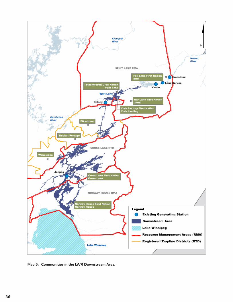
3.1.1 Communities in the Downstream AreaMap 5 highlights the location of communities located in the Downstream Area as well as their Resource Management Areas (RMAs) and Registered Trapline Districts (RTDs). Communities in northern Manitoba fall into three distinct types: First Nations; Northern Affairs Communities (NACs); and industrial towns and cities. The vast majority of the population in the region live in these three types of communities, with only a very small portion living in remote areas.
As the map shows, there are a total of six First Nations and six NACs downstream of Lake Winnipeg that have been identified as being affected by LWR. The impacts experienced by each of these communities vary in nature and extent. These communities are listed in Table 4.
There are Métis people who live in communities in the Downstream Area. Adverse effects experienced by Métis residing in the LWR Downstream Area have been addressed through mitigation programs and works and the various community and resource user group settlement agreements discussed in the pages that follow.
First Nations Northern Affairs Communities
Norway House Cree Nation (NHCN) Norway House
Cross Lake First Nation (CLFN) Cross Lake
York Factory First Nation (YFFN) Wabowden
Tataskweyak Cree Nation (TCN) Pikwitonei
War Lake First Nation (WLFN) Ilford
Fox Lake Cree Nation (FLCN) Thicket Portage
Table 4: Communities in the Downstream Area.
36
Map 5: Communities in the LWR Downstream Area.
NelsonRiver
BurntwoodRiver
Kelsey
Kettle
Limestone
Long Spruce
ChurchillRiver
Lake Winnipeg
Split Lake
Wabowden
Thicket Portage
Pikwitonei
War Lake First NationIlford
Norway House First NationNorway House
York Factory First NationYork Landing
Tataskweyak Cree NationSplit Lake
NORWAY HOUSE RMA
CROSS LAKE RTD
SPLIT LAKE RMA
Cross Lake First NationCross Lake
Existing Generating StationLegend
Downstream Area
Lake Winnipeg
Resource Management Areas (RMA)
Registered Trapline Districts (RTD)
Jenpeg
$Fox Lake First NationBird
37
3.1.2 The History of Settlement AgreementsThe following sections summarize the various collective settlement processes in which Manitoba Hydro has participated as part of its efforts to resolve historic grievances. Information is provided that is relevant to LWR, including the Northern Flood Agreement (NFA), Comprehensive Implementation Agreements (CIAs), ongoing NFA implementation at Cross Lake First Nation (CLFN), and other settlement agreements. In addition to these collective settlement arrangements, Manitoba Hydro has entered into individual settlements for personal property loss and damage.
Northern Flood AgreementAs planning for the LWR and CRD projects proceeded in the early 1970s, the potential impacts on northern Aboriginal communities came to the forefront. At the same time, the Lake Winnipeg, Churchill and Nelson Rivers Study Board was commissioned by Canada and Manitoba to undertake consultation on and an environmental review of the two projects, including potential impacts on northern Aboriginal communities. The Study Board Report was published in April 1975.
As construction got underway, five affected First Nations formed the Northern Flood Committee (NFC) to undertake joint discussions with Manitoba Hydro and the federal and provincial governments about the projects. The five First Nations represented by the NFC were the Cross Lake First Nation (Pimicikamak); Nelson House First Nation (Nisichawayasihk Cree Nation); Norway House Cree Nation; Split Lake First Nation (Tataskweyak Cree Nation); and York Factory First Nation. Cross Lake First Nation (CLFN) takes the position that its rights under the NFA are properly the rights of Pimicikamak and the proper representative is the traditional government of Pimicikamak Okimawin. Canada and Manitoba view the CLFN as the signatory to the agreement. The NFC, funded by the federal government, negotiated the NFA in 1977. The signatories to the agreement included Canada, the Province of Manitoba, Manitoba Hydro, and the NFC as representative of the First Nations noted above.
The NFA was intended to be a comprehensive framework agreement among the governments of Canada and Manitoba, Manitoba Hydro, and the NFC (on behalf of the five NFA First Nations). The agreement established principles, processes, and obligations among the parties. It was designed to address effects on First Nation lands, pursuits, activities, and lifestyles arising from the construction and operation of CRD, LWR, and all existing and planned generating stations on the Nelson and Burntwood Rivers.
The NFA established a process by which easements (rights to use someone else’s land) could be granted to Manitoba Hydro over Reserve Land to facilitate the construction and ongoing operation of hydroelectric developments. As part of the easement process, First Nations would be entitled to select replacement land on the basis of four replacement acres for every acre of land taken up by the easement. Hold areas were established for each First Nation, which prevented land within the area from being developed or otherwise granted for a five-year period. Other NFA articles provided for the establishment of committees, priority for First Nation members in the allocation of resources, programming to provide for and encourage ongoing traditional land use, trapping and fishing programs, and cultural preservation. The NFA also provided for a range of measures to mitigate negative effects to the extent possible and to compensate those affected. These measures were intended to address water regime management, erosion, travel safety, cemeteries, and other cultural and heritage issues. The NFA introduced the concept of resource areas and community planning processes. The resource areas included the registered traplines, which were next to each First Nation, and the rivers and lakes traditionally used.
38
Despite the significant amount of work carried out by the Lake Winnipeg, Churchill and Nelson Rivers Study Board, not all of the effects of LWR and CRD were known at the time the NFA was negotiated and signed. This uncertainty resulted in the creation of an arbitration process to resolve unsettled claims. The NFA notes that the costs of these processes would be borne by Canada and Manitoba governments and Manitoba Hydro. The NFA also requires Manitoba Hydro to prove that it did not cause any alleged effects or damage.
Implementation of the NFA proved challenging. As written, the NFA left much room for interpretation by all parties. This resulted in disagreement on the spirit and intent of various clauses. The implementation process was costly and, with the exception of resolving most issues of quantifiable losses, resulted in few issues being resolved. It also led to mistrust and adversarial working relationships. In the wake of an initial limitation period, the NFA resulted in the filing of a large number of claims in the early 1980s.
The NFA claims process resulted in a significant number of retroactive and interim compensation arrangements and/or settlement agreements, as well as related programming. These agreements and arrangements addressed claims from the communities related to commercial and domestic trapping, commercial and domestic fishing, personal property loss and damage, recreational impacts, cultural impacts, and impacts on navigation and transportation.
Comprehensive Implementation AgreementsIn 1986, the NFC recommended that CIAs or settlements be developed with each First Nation, thereby resolvingalloutstandingclaimsundertheNFA.TheNFCproposedGlobalNegotiations.TheGlobalNegotiations resulted in the Proposed Basis of Settlement, which did not proceed. At that point, Split Lake (now TCN) suggested that it was prepared to proceed alone with a comprehensive agreement to resolve the NFA consistent with the approach in the Proposed Basis of Settlement. This led to the 1992 Split Lake First Nation Settlement Agreement. Subsequently, negotiations resulted in the signing of agreements with three of the other four NFA communities: YFFN in 1995; NCN in 1996; and NHCN in 1997 (the agreement with NHCN is known as a Master Implementation Agreement [MIA]).
While each CIA/MIA is unique, they each include common elements relating back to the NFA. The agreements resolved each community’s outstanding NFA claims as a whole rather than on a claim-by-claim basis. The CIAs also put decision-making and resources into the hands of the First Nations who assumed responsibility for managing compensation monies and program implementation within their communities. The agreements all include compensation (including funding and processes for economic development), trust indentures for the protection of funds, land exchanges (of significantly greater magnitude than under the NFA), the establishment of RMAs, consultation processes for any proposed future developments, and environmental monitoring.
Ongoing Implementation of the NFA at Cross LakeFrom 1994 to 1997, Canada, Manitoba, and Manitoba Hydro negotiated with CLFN to reach a CIA. In 1997, CLFN indicated that it did not wish to enter into a CIA and decided instead to proceed with implementation of the specific terms of the NFA. Manitoba Hydro continues to work with CLFN, Manitoba, and Canada to implement the NFA.

39
Obligations to the CLFN outlined in the NFA have been addressed through various cash settlements, the construction of remediation or mitigation works at Cross Lake, and ongoing programming. Examples of these initiatives and programs include:
• shoreline maintenance;• dock installation;• maintenance of dog sled trails;• an Elders fuel wood program;• emergency response and safety patrols;• safe water and ice travel programs;• a safe portage initiative;• personal property damage claims;• archaeology assistance; • resource harvesting agreements; • a gardening and alternative foods program;• a school hot lunch program;• the establishment of a community information centre; and • various recreational initiatives such as an indoor skating arena.
In addition, under the NFA, CLFN and its members can make claims to be compensated for adverse effects if they are not otherwise resolved.
Other Settlement AgreementsAround the same time Manitoba Hydro was negotiating the CIAs with the NFA communities, efforts were also underway to resolve grievances over project impacts with other communities. Agreements were negotiated between Manitoba Hydro and the Province of Manitoba with the Fox Lake Cree Nation (FLCN) [2004] and War Lake First Nation (WLFN) [2005], as well as the NACs of Cross Lake (1990 and 2010) and Wabowden (1992). Manitoba Hydro is continuing to work with the Mayor and Councils from Thicket Portage and Pikwitonei to resolve outstanding grievances. As well, an Agreement-in-Principle (AIP) was signed with the Norway House NAC in 2003 that sets out principles and understandings to guide the ongoing settlement negotiations.
Manitoba Hydro has also entered into agreements with various resource user groups, and individual resource users. As noted above, a number of these were completed in the context of NFA claims. In addition, Manitoba Hydro has entered into subsequent agreements with the CIA communities and the CLFN on other issues. This would include providing for pre-determined compensation clauses, which govern the amount of compensation paid when water levels or flows go outside established water regime parameters.
40
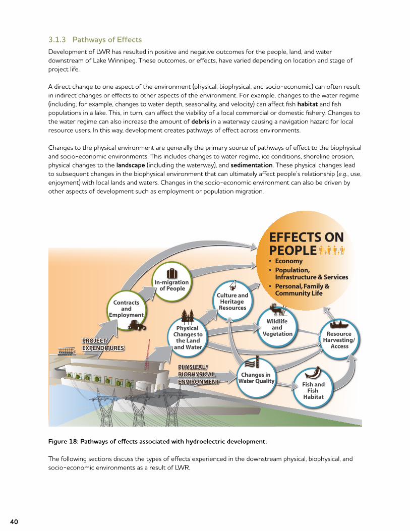
3.1.3 Pathways of EffectsDevelopment of LWR has resulted in positive and negative outcomes for the people, land, and water downstream of Lake Winnipeg. These outcomes, or effects, have varied depending on location and stage of project life.
A direct change to one aspect of the environment (physical, biophysical, and socio-economic) can often result in indirect changes or effects to other aspects of the environment. For example, changes to the water regime (including, for example, changes to water depth, seasonality, and velocity) can affect fish habitat and fish populations in a lake. This, in turn, can affect the viability of a local commercial or domestic fishery. Changes to the water regime can also increase the amount of debris in a waterway causing a navigation hazard for local resource users. In this way, development creates pathways of effect across environments.
Changes to the physical environment are generally the primary source of pathways of effect to the biophysical and socio-economic environments. This includes changes to water regime, ice conditions, shoreline erosion, physical changes to the landscape (including the waterway), and sedimentation. These physical changes lead to subsequent changes in the biophysical environment that can ultimately affect people’s relationship (e.g., use, enjoyment) with local lands and waters. Changes in the socio-economic environment can also be driven by other aspects of development such as employment or population migration.
Figure 18: Pathways of effects associated with hydroelectric development.
The following sections discuss the types of effects experienced in the downstream physical, biophysical, and socio-economic environments as a result of LWR.
Resource Harvesting/
Access
Wildlife and
Vegetation
Culture andHeritage
Resources
In-migration of People
Contracts and
Employment
Fish andFish
Habitat
EFFECTS ON PEOPLE• Economy• Population,
Infrastructure & Services• Personal, Family &
Community Life
Changes in Water Quality
Physical Changes to
the Landand Water
PROJECT EXPENDITURESPROJECT EXPENDITURES
PHYSICAL/ BIOPHYSICAL ENVIRONMENT
PHYSICAL/ BIOPHYSICAL ENVIRONMENT

41
3.2 Physical Effects
3.2.1 Water RegimeThe water regime is driven by the amount of precipitation in a river system’s drainage basin or watershed. Some of the factors that can affect the water regime include upstream water regulation, water withdrawals, evaporation, and groundwater flow. LWR’s diversion channels and Jenpeg also affect the water regime.
The effect of LWR on the water regime in the Downstream Area (as shown on Map 6) is described in this section. For more details see Appendix 3.
Map 6: Downstream Area.
SouthernIndian Lake
NelsonRiver
Burntwood River
Churchillriver
Split Lake
Kiskittogisu Lake
Kiskitto Lake
Walker Lake
Cross Lake
Sipiwesk Lake
Nelson River(East Channel)
Gull Rapids
Pipestone Lake
Two-Mile Channel
Playgreen Lake
Ominawin BypassChannel $Eight-Mile Channel
Existing Generating StationLegend
Downstream Area
Lake Winnipeg
Lake Winnipeg
Jenpeg
Kelsey
Limestone
Long SpruceKettle
42
LWR also has the potential to affect the ice regimes, including increased water level fluctuations that can potentially contribute to the formation of slush ice. Although operating decisions are made in a manner that attempt to reduce the potential to create slush ice, other factors such as heavy snowfall can also contribute to slush ice conditions.
Playgreen and Kiskittogisu LakesWater levels on Playgreen and Kiskittogisu Lakes are influenced by upstream water levels on Lake Winnipeg as well as downstream Jenpeg operations. To better assess and communicate the effects of LWR, Manitoba Hydro undertook a study for the period 1977–2013 that compares Lake Winnipeg water levels and flows with and without regulation under the same hydraulic and climatic conditions. The results from this study can be further used to develop a comparison of Playgreen Lake water levels with and without LWR. The detailed study called An Assessment of Regulation Effects on Lake Winnipeg is located in Appendix 4.
LWR has reduced the range of water levels on Playgreen Lake. Water levels haven’t been as high since regulation and they haven’t been as low. Study results estimate that the average Playgreen Lake water level is between 0.1 feet lower and 0.5 feet higher with LWR than it would have been without LWR.
Water levels on Kiskittogisu Lake are within the historic range; however LWR has increased the minimum water levels and the mean water levels by about 1 to 2 feet.
Kiskitto LakeKiskitto Lake is isolated from LWR operations by the Kiskitto Dam and a series of dykes. The lake is regulated within its natural range by operation of separate inlet and outlet control structures.
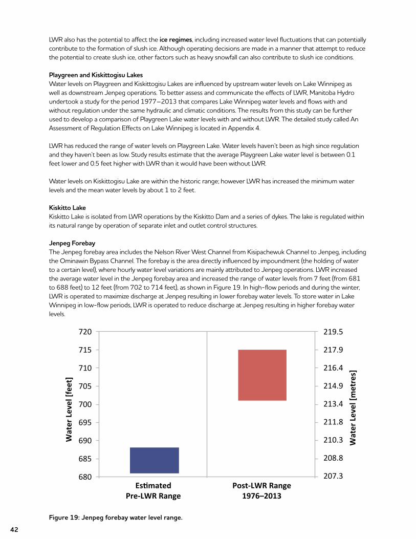
Jenpeg Forebay The Jenpeg forebay area includes the Nelson River West Channel from Kisipachewuk Channel to Jenpeg, including the Ominawin Bypass Channel. The forebay is the area directly influenced by impoundment (the holding of water to a certain level), where hourly water level variations are mainly attributed to Jenpeg operations. LWR increased the average water level in the Jenpeg forebay area and increased the range of water levels from 7 feet (from 681 to 688 feet) to 12 feet (from 702 to 714 feet), as shown in Figure 19. In high-flow periods and during the winter, LWR is operated to maximize discharge at Jenpeg resulting in lower forebay water levels. To store water in Lake Winnipeg in low-flow periods, LWR is operated to reduce discharge at Jenpeg resulting in higher forebay water levels.
Figure 19: Jenpeg forebay water level range.
Wat
er L
evel
[fee
t]
EstimatedPre-LWR Range
Post-LWR Range1976–2013
Wat
er L
evel
[met
res]
720
715
710
705
700
695
690
685
680
219.5
217.9
216.4
214.9
213.4
211.8
210.3
208.8
207.3
43
Nelson River East ChannelThe East Channel of the Nelson River is not regulated as part of the LWR project and carries about 15% of the total Lake Winnipeg outflow. It is estimated that the average flow through the East Channel is similar to what is would have been without LWR because the average water level on Little Playgreen Lake is within 0.5 feet of what it would be without LWR. However, the timing and variability of flows has been affected. For example, in higher-flow years when Lake Winnipeg and Playgreen Lake water levels are lowered by maximizing discharge at Jenpeg, less water flows down the East Channel. Conversely, in lower-flow years when Lake Winnipeg and Playgreen Lake are held higher by decreasing discharge at Jenpeg, more water flows down the East Channel.
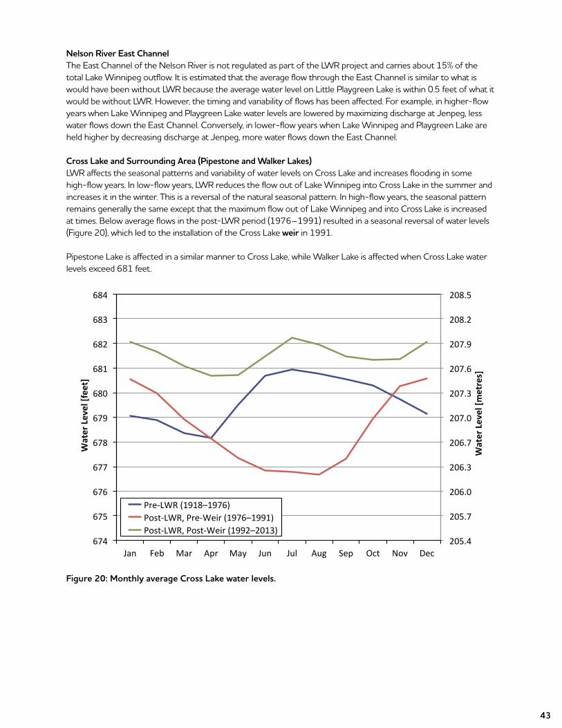
Cross Lake and Surrounding Area (Pipestone and Walker Lakes)LWR affects the seasonal patterns and variability of water levels on Cross Lake and increases flooding in some high-flow years. In low-flow years, LWR reduces the flow out of Lake Winnipeg into Cross Lake in the summer and increases it in the winter. This is a reversal of the natural seasonal pattern. In high-flow years, the seasonal pattern remains generally the same except that the maximum flow out of Lake Winnipeg and into Cross Lake is increased at times. Below average flows in the post-LWR period (1976–1991) resulted in a seasonal reversal of water levels (Figure 20), which led to the installation of the Cross Lake weir in 1991.
Pipestone Lake is affected in a similar manner to Cross Lake, while Walker Lake is affected when Cross Lake water levels exceed 681 feet.
Figure 20: Monthly average Cross Lake water levels.
205.4
205.7
206.0
206.3
206.7
207.0
207.3
207.6
207.9
208.2
208.5
674
675
676
677
678
679
680
681
682
683
684
Jan Feb Mar Apr May Jun Jul Aug Sep Oct Nov Dec
Wat
er L
evel
[met
res]
Wat
er L
evel
[fee
t]
Pre-LWR (1918–1976)Post-LWR, Pre-Weir (1976–1991)Post-LWR, Post-Weir (1992–2013)
44
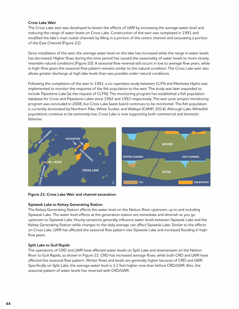
Cross Lake WeirThe Cross Lake weir was developed to lessen the effects of LWR by increasing the average water level and reducing the range of water levels on Cross Lake. Construction of the weir was completed in 1991 and modified the lake’s main outlet channels by filling in a portion of the centre channel and excavating a portion of the East Channel (Figure 21).
Since installation of the weir, the average water level on the lake has increased while the range in water levels has decreased. Higher flows during this time period has caused the seasonality of water levels to more closely resemble natural conditions (Figure 20). A seasonal flow reversal still occurs in low to average flow years, while in high-flow years the seasonal flow pattern remains similar to the natural condition. The Cross Lake weir also allows greater discharge at high lake levels than was possible under natural conditions.
Following the completion of the weir in 1991, a co-operative study between CLFN and Manitoba Hydro was implemented to monitor the response of the fish population to the weir. The study was later expanded to include Pipestone Lake (at the request of CLFN). The monitoring program has established a fish population database for Cross and Pipestone Lakes since 1992 and 1993 respectively. The weir post-project monitoring program was concluded in 2008, but Cross Lake (west basin) continues to be monitored. The fish population is currently dominated by Northern Pike, White Sucker, and Walleye (CAMP, 2014). Although Lake Whitefish populations continue to be extremely low, Cross Lake is now supporting both commercial and domestic fisheries.
Figure 21: Cross Lake Weir and channel excavation.
Sipiwesk Lake to Kelsey Generating StationTheKelseyGeneratingStationaffectsthewaterlevelontheNelsonRiverupstream,uptoandincludingSipiwesk Lake. The water level effects at the generation station are immediate and diminish as you go upstream to Sipiwesk Lake. Hourly variations generally influence water levels between Sipiwesk Lake and the KelseyGeneratingStationwhilechangestothedailyaveragecanaffectSipiweskLake.Similartotheeffectson Cross Lake, LWR has affected the seasonal flow pattern into Sipiwesk Lake and increased flooding in high-flow years.
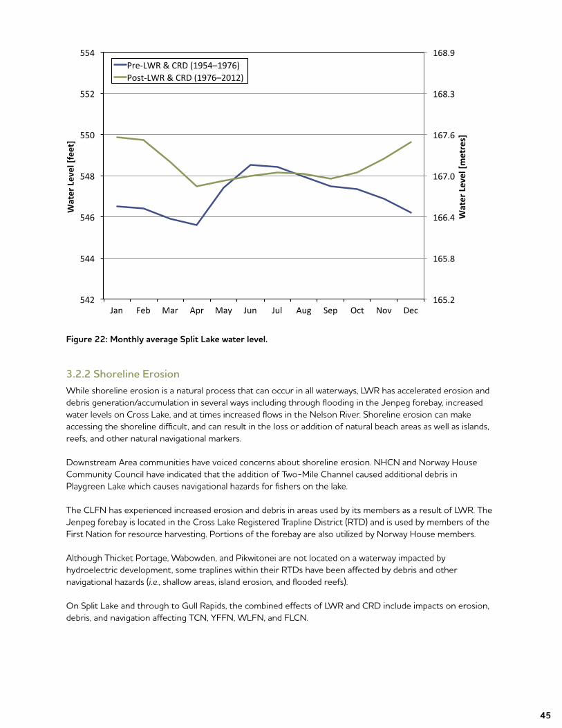
Split Lake to Gull RapidsThe operations of CRD and LWR have affected water levels on Split Lake and downstream on the Nelson RivertoGullRapids,asshowninFigure22.CRDhasincreasedaverageflows,whilebothCRDandLWRhaveaffected the seasonal flow pattern. Winter flows and levels are generally higher because of CRD and LWR. Specifically on Split Lake, the average water level is 1.2 feet higher now than before CRD/LWR. Also, the seasonal pattern of water levels has reversed with CRD/LWR.
WES
T CHANNEL
CEN
TRE
CHAN
NEL
EAST CHANNEL
EXCAVATION
WEIR
CROSS LAKE
BEFORE
AFTER
EAST CHANNELCENTRE CHANNEL
FILL EXCAVATION
45
Figure 22: Monthly average Split Lake water level.
3.2.2 Shoreline ErosionWhile shoreline erosion is a natural process that can occur in all waterways, LWR has accelerated erosion and debris generation/accumulation in several ways including through flooding in the Jenpeg forebay, increased water levels on Cross Lake, and at times increased flows in the Nelson River. Shoreline erosion can make accessing the shoreline difficult, and can result in the loss or addition of natural beach areas as well as islands, reefs, and other natural navigational markers.
Downstream Area communities have voiced concerns about shoreline erosion. NHCN and Norway House Community Council have indicated that the addition of Two-Mile Channel caused additional debris in Playgreen Lake which causes navigational hazards for fishers on the lake.
The CLFN has experienced increased erosion and debris in areas used by its members as a result of LWR. The Jenpeg forebay is located in the Cross Lake Registered Trapline District (RTD) and is used by members of the First Nation for resource harvesting. Portions of the forebay are also utilized by Norway House members.
Although Thicket Portage, Wabowden, and Pikwitonei are not located on a waterway impacted by hydroelectric development, some traplines within their RTDs have been affected by debris and other navigational hazards (i.e., shallow areas, island erosion, and flooded reefs).
OnSplitLakeandthroughtoGullRapids,thecombinedeffectsofLWRandCRDincludeimpactsonerosion,debris, and navigation affecting TCN, YFFN, WLFN, and FLCN.
165.2
165.8
166.4
167.0
167.6
168.3
168.9
542
544
546
548
550
552
554
Wat
er L
evel
[met
res]
Wat
er L
evel
[fee
t]Pre-LWR & CRD (1954–1976)Post-LWR & CRD (1976–2012)
Jan Feb Mar Apr May Jun Jul Aug Sep Oct Nov Dec
46
Manitoba Hydro understands LWR’s effect on shoreline erosion, navigation hazards, and debris as follows:
• Two-Mile Channel provides a second flow path for debris from the north shore of Lake Winnipeg to enter Playgreen Lake.
• Erosion has been ongoing in Two-Mile and Eight-Mile Channels and is regularly monitored by Manitoba Hydro as part of a program that was established in 1978.
• LWR does not significantly contribute to shoreline erosion on Playgreen and Little Playgreen Lakes because the average water level is similar to what it would have been without LWR. LWR has also reduced the range of water levels on these lakes. Previous studies support this conclusion (MacLaren Plansearch Inc., 1985; J.D. Mollard and Associates Ltd., 1994).
• LWR has resulted in increased rates of shoreline erosion and increased debris in the Jenpeg forebay. LWR caused about 25 square miles of flooding, which is confined to the Jenpeg forebay area.
• The Cross Lake shoreline is mostly bedrock during most water levels. However, during extreme high- flow events, significant erosion can occur on susceptible shorelines, as it did during the 2011 flood. LWR may increase shoreline erosion by increasing the timing and magnitude of high-flow events. The increase in average water level as a result of the Cross Lake weir may have also increased erosion rates in areas susceptible to erosion.
• Downstream from Cross Lake, LWR along with other projects contribute to shoreline erosion and debris.
For more information on Downstream Area shoreline erosion see Appendix 5. Manitoba Hydro’s efforts to address navigational hazards and debris is discussed in Section 3.4.4.
3.3 Environmental Effects
Manitoba Hydro has heard and acknowledged the concerns that have been expressed about the impact LWR has had on water quality, fish populations, mercury levels, and wildlife downstream of (north of) Lake Winnipeg. In this section, these concerns are reviewed and the most recent knowledge is provided.
Manitoba Hydro and Manitoba have developed a systematic, system-wide aquatic monitoring program that monitors key physical, chemical, and biological parameters associated with waterways affected by Manitoba Hydro’s hydraulic generation system, including LWR, CRD, the Winnipeg River, and the Saskatchewan River. The Coordinated Aquatic Monitoring Program (CAMP) creates a basis to better understand the environmental effects of hydroelectric development. For additional CAMP information refer to Section 5.3.
For a more detailed environmental analysis, readers are encouraged to review Appendix 6.
3.3.1 Water QualityChanges in water quality have been a major concern of most communities located in the area affected by LWR. The primary concerns expressed include: increased turbidity (cloudiness of water caused by small particles) and a corresponding decrease in water clarity; increased algae in the water; increased mercury in the water; and decreased oxygen in the winter which in some areas (such as Cross Lake prior to the construction of the weir) has killed fish. Overall, there is a general feeling among the community that water quality has deteriorated and that the poorer water quality has affected aquatic life.
The LWCNRSB report made a number of predictions related to water quality resulting from LWR (see Appendix 6 for more details). Potential pathways of effects to water quality are primarily related to changes to flow rates and patterns due to construction of various channels and regulation of water levels. Potential effects of these physical changes on water quality include increased turbidity due to increased shoreline erosion; decreased turbidity due to increased sedimentation in reservoirs; increased nutrients and metals from erosion,
47
transport and flooding, and decreased pH and dissolved oxygen due to decomposition of flooded organic materials; decreased dissolved oxygen due to increased water residence times and/or changed ice regime; and changed water temperature due to changed water levels, flows, residence times, and velocities.
Studies of water quality have been conducted prior to and following LWR. Most water quality parameters were within Manitoba water quality objectives and guidelines for the protection of aquatic life prior to and following LWR. This means that most parameters were at concentrations over the long term necessary to support a healthy aquatic ecosystem (including plants, invertebrates, and fish).
However, some changes in water quality were noted in some waterbodies after LWR. Changes in Cross and Sipiwesk Lakes were assessed by Playle and Williamson (1986) and Williamson and Ralley (1993) and the conclusions of these studies were largely in agreement. For Cross Lake, these assessments concluded no changes to a number of parameters including total suspended solids (TSS), hardness, conductivity, pH, alkalinity, calcium, magnesium, sulphate, and coliform bacteria, increases in total inorganic and organic carbon, and chloride and decreases in colour and nitrogen. Other changes are less clear as the findings and trends in the scientific literature are inconsistent or contradictory. Overall, Williamson, and Ralley (1993) wrote that changes in water quality following LWR were of “small magnitude and should not have significantly affected water uses.”
For Sipiwesk Lake, these assessments concluded no changes to a number of parameters including phosphorus, hardness, pH, alkalinity, calcium, magnesium, sulphate, decreases in colour and nitrogen, and increases in some major ions (chloride, sodium, and potassium), carbon (inorganic and organic forms), and fecal coliform bacteria. Williamson and Ralley (1993) concluded that water quality changes in Sipiwesk Lake after LWR “probably had little effect on vegetation and aquatic organisms since all statistically significant changes were below the Manitoba Surface Water Quality Objectives.”
Despite the existence of a comprehensive database, the effects of LWR on water quality downstream of KelseyGeneratingStationaredifficult,ifnotimpossible,toseparatefromtheeffectsoftheCRD.Whileitisclear that water quality effects did occur including decreased conductivity (the extent to which water can pass an electrical current), the effects are much more closely related to the effects of CRD than LWR and cannot be separated.
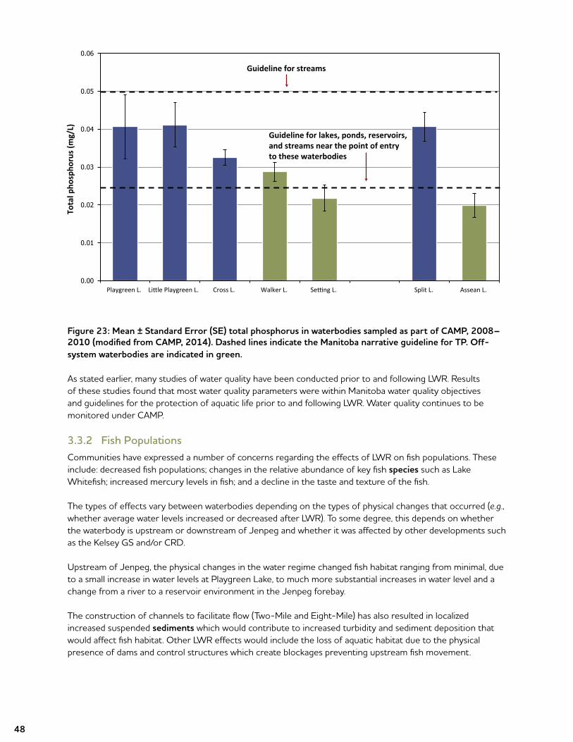
In recent years, water quality has been monitored regularly by the Province of Manitoba and Manitoba Hydro under CAMP. Seven sites in the LWR area were sampled over the period of 2008 through 2010, including both on-system and off-system waterbodies. Consistent with earlier studies, the results showed that mostwaterqualityparameterswerewithinManitobaWaterQualityStandards,ObjectivesandGuidelines(MWQSOGs)fortheprotectionofaquaticlife(PAL);includingimportantparameterssuchaspH,ammonia,nitrate/nitrite,andmostmetals.TherewereafewparametersthatexceededtheMWQSOGsforbothon-system and off-system waterbodies. Total phosphorus concentrations on average exceeded the Manitoba narrative guideline for nutrients (0.025 mg/L for lakes, reservoirs, and ponds) in Playgreen, Little Playgreen, Cross, Walker, and Split Lakes (Figure 23). Dissolved oxygen was also below the most stringent PAL guideline at depth in an on-system lake (Cross Lake) and two off-system lakes (Walker and Setting Lakes) in some winters. Exceedances of Manitoba guidelines for aluminum and iron were observed in a number of waterbodies in the Downstream Area, including off-system lakes. Several other metals occasionally (i.e., one sample at one site) marginally exceeded the PAL objectives or guidelines including mercury and silver.
While past studies indicate there were changes in some water quality parameters resulting from LWR, water quality monitoring conducted from 2008–2010 indicates that most water quality parameters are currently withinMWQSOGsfortheprotectionofaquaticlife.Inmanycaseswheretheobjectivesandguidelineswereexceeded, the parameters were also exceeded in off-system waterbodies indicating these exceedances or conditions may result from factors other than LWR. Further, at least some parameters that are currently above guidelines for PAL were above these guidelines at some sites prior to LWR (e.g., total phosphorus in Cross and Sipiwesk Lakes [Williamson and Ralley, 1993]).
48
Figure 23: Mean ± Standard Error (SE) total phosphorus in waterbodies sampled as part of CAMP, 2008–2010 (modified from CAMP, 2014). Dashed lines indicate the Manitoba narrative guideline for TP. Off-system waterbodies are indicated in green.
As stated earlier, many studies of water quality have been conducted prior to and following LWR. Results of these studies found that most water quality parameters were within Manitoba water quality objectives and guidelines for the protection of aquatic life prior to and following LWR. Water quality continues to be monitored under CAMP.
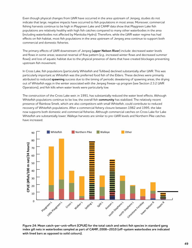
3.3.2 Fish PopulationsCommunities have expressed a number of concerns regarding the effects of LWR on fish populations. These include: decreased fish populations; changes in the relative abundance of key fish species such as Lake Whitefish; increased mercury levels in fish; and a decline in the taste and texture of the fish.
The types of effects vary between waterbodies depending on the types of physical changes that occurred (e.g., whether average water levels increased or decreased after LWR). To some degree, this depends on whether the waterbody is upstream or downstream of Jenpeg and whether it was affected by other developments such astheKelseyGSand/orCRD.
Upstream of Jenpeg, the physical changes in the water regime changed fish habitat ranging from minimal, due to a small increase in water levels at Playgreen Lake, to much more substantial increases in water level and a change from a river to a reservoir environment in the Jenpeg forebay.
The construction of channels to facilitate flow (Two-Mile and Eight-Mile) has also resulted in localized increased suspended sediments which would contribute to increased turbidity and sediment deposition that would affect fish habitat. Other LWR effects would include the loss of aquatic habitat due to the physical presence of dams and control structures which create blockages preventing upstream fish movement.
0.00
0.01
0.02
0.03
0.04
0.05
0.06
Playgreen L. Little Playgreen L. Cross L. Walker L. Setting L. Split L. Assean L.
Tota
l pho
spho
rus (
mg/
L)Guideline for streams
Guideline for lakes, ponds, reservoirs, and streams near the point of entry to these waterbodies
49
Even though physical changes from LWR have occurred in the area upstream of Jenpeg, studies do not indicate that large, negative impacts have occurred to fish populations in most areas. Moreover, commercial fishing harvests continue to be high in Playgreen Lake and CAMP data show that Playgreen Lake fish populations are relatively healthy with high fish catches compared to many other waterbodies in the area (including waterbodies not affected by Manitoba Hydro). Therefore, while the LWR water regime has had effects on fish habitat, most fish populations in the area upstream of Jenpeg area continue to support both commercial and domestic fisheries.
The primary effects of LWR downstream of Jenpeg (upper Nelson River) include: decreased water levels and flows in some areas; seasonal reversal of flow pattern (e.g., increased winter flows and decreased summer flows); and loss of aquatic habitat due to the physical presence of dams that have created blockages preventing upstream fish movement.
In Cross Lake, fish populations (particularly Whitefish and Tullibee) declined substantially after LWR. This was particularly important as Whitefish was the preferred food fish of the Elders. These declines were primarily attributed to reduced spawning success due to the timing of periodic dewatering of spawning areas, the drying out of Whitefish eggs in the winter associated with the Jenpeg freeze-up program (see Section 2.3.2 LWR Operations), and fish kills when water levels were particularly low.
The construction of the Cross Lake weir, in 1991, has substantially reduced the water level effects. Although Whitefish populations continue to be low, the overall fish community has stabilized. The relatively recent presence of Rainbow Smelt, which are also competitors with small Whitefish, could contribute to reduced recovery of Whitefish populations. After a commercial fishery closure between 1982 and 1995, the lake now supports both domestic and commercial fisheries. Although commercial catches on Cross Lake for Lake Whitefish are substantially lower, Walleye harvests are similar to pre-LWR levels and Northern Pike catches have increased.
Figure 24: Mean catch-per-unit-effort (CPUE) for the total catch and select fish species in standard gang index gill nets in waterbodies sampled as part of CAMP, 2008–2010 (off-system waterbodies are indicated with lined bars as opposed to solid colours).
0
Whitefish Northern Pike Walleye Other
10
20
30
40
50
60
70
80
90
CPU
E (#
fish/
100
m n
et/2
4 ho
urs)
Playgre
en L
Little Play
green L
Cross L
Walker L
Setting L
Split
L
Assean
L
south St
ephens L
north St
ephens L
Limesto
ne Forebay
lower Nelso
n R
Hayes R
50
Overall it is difficult to separate the effects of LWR from other factors that are also affecting fish populations in the area including: the introduction of Rainbow Smelt which has significantly altered fish communities in someareas;theeffectsofotherprojectssuchastheKelseyGeneratingStationandCRD;andclimatechangeamongothers.However,currentconditionsonanumberwaterbodiesbetweenPlaygreenLakeandGullRapids will continue to be monitored as part of CAMP to determine the overall health of the waterbody and what changes, if any, are occurring.
Information on the domestic and commercial fisheries is discussed in Section 3.4.3.
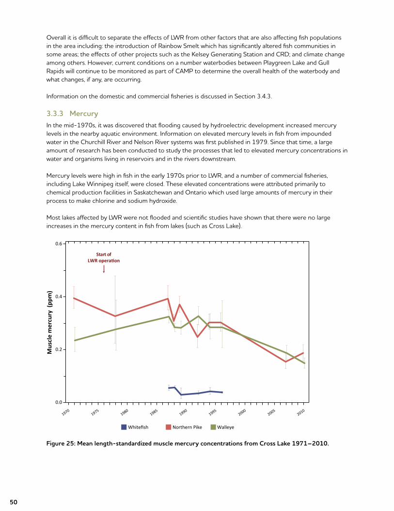
3.3.3 MercuryIn the mid-1970s, it was discovered that flooding caused by hydroelectric development increased mercury levels in the nearby aquatic environment. Information on elevated mercury levels in fish from impounded water in the Churchill River and Nelson River systems was first published in 1979. Since that time, a large amount of research has been conducted to study the processes that led to elevated mercury concentrations in water and organisms living in reservoirs and in the rivers downstream.
Mercury levels were high in fish in the early 1970s prior to LWR, and a number of commercial fisheries, including Lake Winnipeg itself, were closed. These elevated concentrations were attributed primarily to chemical production facilities in Saskatchewan and Ontario which used large amounts of mercury in their process to make chlorine and sodium hydroxide.
Most lakes affected by LWR were not flooded and scientific studies have shown that there were no large increases in the mercury content in fish from lakes (such as Cross Lake).
Figure 25: Mean length-standardized muscle mercury concentrations from Cross Lake 1971–2010.
19701975
19801985
19901995
20002005
2010
Mus
cle
mer
cury
(pp
m)
0.0
0.2
0.4
0.6
Start ofLWR operation
Whitefish Northern Pike Walleye
51
Figure 26: Mean length-standardized muscle mercury concentrations from Split Lake 1971–2010.
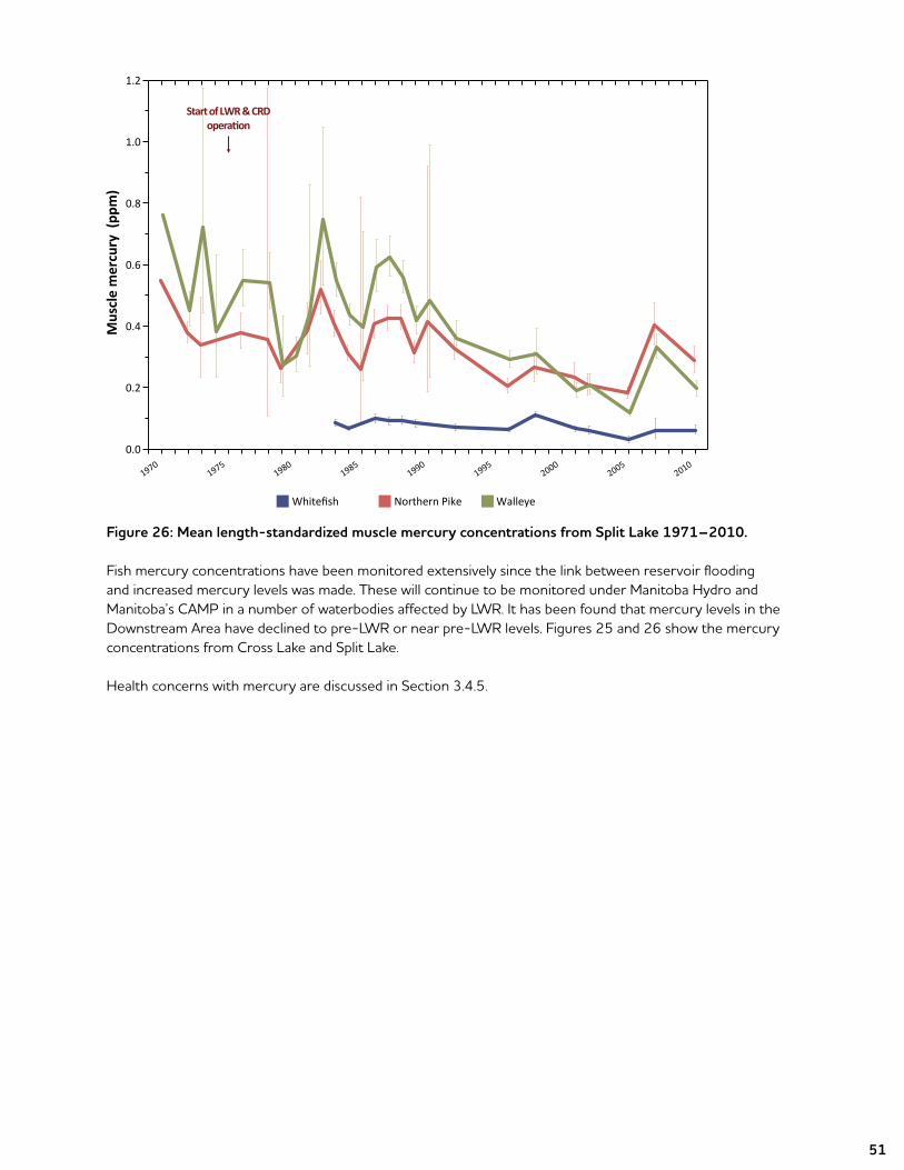
Fish mercury concentrations have been monitored extensively since the link between reservoir flooding and increased mercury levels was made. These will continue to be monitored under Manitoba Hydro and Manitoba’s CAMP in a number of waterbodies affected by LWR. It has been found that mercury levels in the Downstream Area have declined to pre-LWR or near pre-LWR levels. Figures 25 and 26 show the mercury concentrations from Cross Lake and Split Lake.
Health concerns with mercury are discussed in Section 3.4.5.
19701975
19801985
19901995
20002005
2010
Mus
cle
mer
cury
(pp
m)
0.0
0.2
0.4
0.6
0.8
1.0
1.2
Start of LWR & CRDoperation
Whitefish Northern Pike Walleye
52
3.3.4 WildlifeCommunities along LWR that rely on wildlife resources have expressed concerns that there has been a reduction in waterfowl, aquatic furbearers (like beavers and muskrat), and moose populations since regulation.
As with fish populations, the effects of LWR on wildlife populations vary according to the species of wildlife and the specific physical changes that occurred. Since most of the changes were on or near the water, those species most closely associated with riparian habitat (near the shoreline) would be most affected by the change in water regime. Upland species that don’t utilize shoreline habitats would be less affected.
More specifically, upstream of Jenpeg some wildlife would likely have been affected by direct loss of terrestrial habitat due to flooding and the physical presence of hydro structures. However, it is difficult to assign an amount of impact in this area due to a lack of pre-and post-LWR population data and in most cases, commercial harvesting data (particularly for trapping) do not accurately reflect animal abundance. Other factors, such as fur prices, have a large effect on the amount of harvesting activity that takes place.
Waterfowl data suggest LWR may have affected the distribution of some diving duck species, but the link to LWR is unclear. Natural variability in North American waterfowl populations over the last several decades along with broader regional habitat alterations and flyway pattern changes, makes quantifying local impacts very difficult. For example, wet conditions on the Canadian Prairies are believed to have contributed to record high duck counts in 2012 and this sort of external factor could be contributing to local abundances.
Factors such as increased access and harvest pressure along with land use management activities have contributed to the impacts on moose populations and changes to the ecosystem on which they depend. This confounds quantification of the impact of LWR’s physical changes.
Downstream of Jenpeg, fluctuating water levels likely affect aquatic furbearers like muskrat and beaver in the winter, and moose through loss of shoreline access and a reduction in available food. Changes to shoreline habitat may also have affected the distribution or use of an area by nesting waterfowl.
The post-LWR seasonal reversal of water levels in the Cross Lake area negatively affected shoreline habitat for waterfowl, aquatic furbearers, and moose. Increased water level fluctuations in the late fall and winter also reduced muskrat and beaver populations and, to a lesser extent, mink and otter populations. Moose were affected by the loss of aquatic vegetation along the shoreline in the spring and increased harvesting pressure caused by increased road access along with habitat fragmentation due to various development activities.
Construction of the Cross Lake weir improved conditions on Cross Lake for wildlife by reducing the water level range and increasing minimum levels in the spring and summer. However, as with in the area upstream of Jenpeg, quantifying the amount of change due to LWR and the benefits of the weir are difficult given the large natural variability in wildlife populations (especially waterfowl), the impacts from increased access and harvest pressure on animal populations, and the changes to terrestrial ecosystems associated with land management practices and other forms of development.
TheeffectsofLWRonwildlifeintheSipiwesktoGullRapidsareaisdifficulttodetermineduetotheeffectsofotherfacilitiessuchasKelseyGSandCRDaswellasotherfactorssuchasharvestingpressureandclimatechange.
53
3.4 Socio-economic Effects
Development of LWR has resulted in positive and negative effects on individuals and communities. While Manitobans in general gained from access to reliable and low-cost power as well as economic development opportunities (training, employment, and business opportunities), people downstream of Lake Winnipeg have experienced negative effects arising from environmental changes, an increased rate of modernization, and inadequate participation in decision making.
To understand the effects of LWR on the socio-economic environment, a number of factors that play a part in the well-being of people, families, and communities are considered. Changes in the physical environment can directly affect the health and well-being of people. For example, changes in water levels and flows can affect the safety of water and ice conditions for travel. Physical changes can also affect heritage resources. Changes to the habitat for plants, animals, and fish can affect the land and resources that are used by people for sustenance, as well as to support their overall way of life. While not the focus of this document, project construction activities and related expenditures can affect local populations through short-term employment, business opportunities, and the in-migration of workers. Some of these effects can continue beyond construction.
This section describes Manitoba Hydro’s understanding of and response to effects in the Downstream Area on:
• culture, way of life, and heritage resources;• the way the landscape looks;• resource use;• reserve land;• navigation, transportation, and public safety;• health issues and concerns;• personal property loss and damage;• employment, training, and business opportunities.
The socio-economic environment in the Downstream Area has also been affected by non-hydroelectric development activities including commercial and domestic resource use, industrial development (i.e., mining and forestry), and the development of infrastructure such as roads, railways, and airstrips. As well, government policies and programs (i.e., the residential school system, the welfare system, and Registered Trapline System) have had significant impact on the communities, families, and individuals living in the area. Looking back, it is not always possible to separate the impacts of these other developments, events, and policies from the impacts of LWR.
3.4.1 Culture, Way of Life, and Heritage ResourcesDevelopment of waterways can result in the physical loss or destruction of cultural resources, the loss of culturally important places (such as buildings or places of cultural, spiritual, or religious meaning), and general changes to the landscape (physical and aesthetic). Such loss and change can affect attachments to the land that have been forged over generations, and one’s ability to exercise customs, practices and traditions. Because of their inherent link to place, cultural practices and pursuits are not always replaceable or transferable to other locations and, as such, related effects cannot always be mitigated.
In the Downstream Area, water regime changes and related flooding and exacerbated shoreline erosion have negatively affected culture, ways of life, and heritage and archeological resources for people living along and using affected waterways. This has resulted in the reduction of traditional, cultural, social, and recreational opportunities, and related infrastructure that relied on unregulated waterways and shorelines, including losses of traditional spiritual sites, burial grounds (and exposure of human remains), meeting places, beaches, and seasonal family campgrounds.
54
Addressing Effects on Culture, Way of Life, and Heritage Resources
Settlement AgreementsVarious settlement agreements contain specific provisions addressing impacts on culture, way of life, and heritage resources. This includes related impacts on resource use and recreation. Specific related claims were submitted through the NFA arbitration process, and settled either through settlement agreements or through the negotiated CIAs.
Archaeological ProgrammingSince the development of LWR, Manitoba Hydro has been conducting or participating in a variety of archaeological programs to address impacts from past development and to prepare for future developments. Agreements are also in place committing additional resources for the future. As well, communities have negotiated agreements directly with government regarding heritage resources of importance to them.The identification and protection of potentially at-risk heritage resources and found human remains are a requirement of provincial legislation and Article 7 of the NFA. Manitoba Hydro has worked closely with Aboriginal communities and the provincial Historic Resources Branch (HRB), which enforces the Heritage Resources Act (1986). In addition to the Heritage Resources Act, Manitoba Hydro’s projects adhere to the provincial Policy Concerning the Reporting, Exhumation and Reburial of Found Human Remains (1987).
Archaeological activities being funded by Manitoba Hydro in relation to LWR include:
• Archaeological mitigation efforts for the Hunting River Burial Site (Nelson River) in collaboration with the Province, Pikwitonei Community Council, and CLFN;
• The Sipiwesk Lake Archaeological Program, which is funded by Manitoba Hydro through the Cross Lake Action Plan and delivered by the HRB. Sipiwesk Lake comprises a large area, has upwards of 3,200 km of shoreline, and is virtually unknown archaeologically. The program is a cooperative venture that also includes the participation of the Manitoba Museum and the Manitoba Department of Aboriginal and Northern Affairs. The objective of this program is to identify the locations of archaeological sites on Sipiwesk Lake and to provide a preliminary assessment of the cultural resources on a site-by-site basis to be integrated into a plan for the management of the area’s heritage resources;
• A System-Wide Archaeological Project (SWAP) being conducted by HRB for areas not covered by the above programs. This 10-year $950,000 agreement was signed in 2006. The purpose of this program is to assist Manitoba Hydro in managing the impact on heritage resources within specific areas of Manitoba affected by past hydroelectric development, but not already managed under other established Manitoba Hydro supported archaeological programs. The SWAP encompasses the Winnipeg River in the southeast, the Laurie River in the northwest, portions of the Nelson River in the northeast, and the Saskatchewan River-Cedar Lake area in central-western Manitoba;
• Shoreline protection initiatives for a number of at-risk sites along developed waterways, such as cemeteries, burial sites, and other culturally important sites; and
• Work undertaken in partnership with the Community at the Chipiy Naya site and cemetery around the Anglican Church on TCN Reserve Land to protect human remains threatened by erosion.

55
3.4.2 The Way the Landscape LooksLWR has resulted in physical and visual changes to the landscape, including the water and waterways. The presence of new physical infrastructure can influence the visual landscape, particularly in sensitive settings. The way the landscape looks (aesthetics) does, to a certain extent, differ according to a person’s values and perspectives. An individual’s response to visual changes on the landscape and the magnitude of the concern related to a particular viewscape is a function of the types of views involved, the distance, perspective, and duration of view. The way the landscape looks will depend on:
• the physical relationship of the viewer (e.g., living in the area, driving through, sightseeing); and • the contrast between the project and the surrounding environment.
Manitoba Hydro has heard concerns from communities affected by LWR regarding changes to the way the land and water look. This has included, for example, concerns that the water is no longer clear (or is “muddy”), that sandy beaches and islands have been lost, and that physical infrastructure in the water caused disruption. Visual impacts are strongly related to impacts on culture, spirituality, and way-of-life.
3.4.3 Resource UseDevelopment of waterways can affect resource use in a number of ways. Examples include enhancement or reduction of access to resources, loss of harvesting and gathering areas through flooding and reduced wildlife or plant populations.
LWR resulted in negative effects on domestic and commercial resource harvesting including fishing, hunting, trapping, gathering of medicinal and other plants/berries, and fuel wood. Effects on resource harvesting have resulted in negative effects on the connection of communities to the land, patterns of traditional food consumption and food security, and the ability of communities to practise their customs and traditions and transmit traditional teachings to younger generations.
Effects on resource use are among the most commonly raised concerns by communities and resource user groups. This is reflected in the negotiation of a large number of related settlement agreements (both through the NFA arbitration process and other settlements with other communities and resource user groups). It is also reflected in the significant number of studies that have been completed on resource use. For further information on fish population refer to Section 3.3.2 and Appendix 6.
The sections below broadly describe effects on domestic and commercial fisheries, trapping, and hunting.
Domestic and Commercial FisheriesImpacts on fish populations are among the most studied effects of northern hydroelectric development, from both an environmental and a socio-economic perspective. The volume of study on this topic, as well as the extent of community concerns that have been voiced, reflects the importance of fish to local communities. Domestic and commercial fishing are vital to the people of northern Manitoba. Commercial harvesting data and fish population research have been extensively analyzed in response to claims launched against Manitoba Hydro – which have generally been resolved.
As noted in Section 3.3.2, fish communities in areas affected by the LWR have responded differently depending on the effects on the water regime. As a result, related project effects on associated domestic and commercial fisheries have varied as well.
In addition to concerns about the fisheries, communities affected by LWR have expressed concerns regarding the taste, texture, and quality of fish caught for domestic consumption. Manitoba Hydro has worked with communities to understand these concerns and has engaged outside assistance (Fisheries and Oceans Canada
56
[DFO] in one study and University of Manitoba in three studies) to test the fish in several communities. The study conducted by DFO at Norway House included taste tests (a simple pass or fail) by their fish quality lab as well as tests for various contaminants. All fish passed all tests. In the studies conducted by the University of Manitoba, panelists from all three communities (Bird, Split Lake, and York Landing) showed some preference for fish from lakes that have not been previously affected by hydroelectric development. However, the difference in mean palatability scores to on-system waterbodies was not statistically significant. It was noted that the results of the palatability study, particularly at York Landing, do not reflect the views of most community members on the taste of fish species used in the study. In particular, there was a concern that no fish were tested that were captured when water temperatures were warmer and taste differences would be more noticeable.
Addressing Effects on Fisheries (Domestic and Commercial)
Settlement AgreementsManitoba Hydro has entered into several settlement agreements that specifically address effects on commercial and domestic fishing activities. Implementation of the NFA resulted in a significant number of retroactive and interim compensation arrangements and/or settlement agreements addressing fishery impacts. For NCN, YFFN, TCN, and NHCN, these agreements, as well as any related outstanding claims, were fully and finally resolved through the negotiation of CIAs. The CIAs include provisions regarding resource use impacts, including impacts on fishery activities. At Cross Lake, ongoing implementation of the NFA includes implementation of a summer and winter domestic fishing program that pays domestic fishers to fish on Cross Lake and some off-system lakes and to bring the fish back into the community where it is made available for members. As part of a settlement of a specific claim under the NFA, the Province and Manitoba Hydro provided funds for the delivery of programming to encourage and support commercial fishing at Cross Lake.
Settlement agreements with other groups related to the fisheries have been negotiated as well. This includes, for example, agreements with the Sipiwesk Lake Commercial Fishermen’s Association and the Ilford Community Council.
Lake Sturgeon Stewardship and Enhancement ProgramManitoba Hydro has implemented the Lake Sturgeon Stewardship and Enhancement Program as a commitment to maintain and enhance Lake Sturgeon populations in areas affected by Manitoba Hydro’s operations, now and in the future. Program activities include:
• determining the status of Lake Sturgeon populations throughout areas affected by Manitoba Hydro’s operations and identifying factors that may be limiting populations;
• funding and conducting research relating to hydroelectric facilities and Lake Sturgeon in Manitoba;• reducing the effects of new and existing facilities on Lake Sturgeon populations;• participating in the management and recovery of existing stocks by promoting education and
community participation through sturgeon management boards;• educating the public and raising awareness; and• rearing and stocking of Lake Sturgeon.
Nelson River Sturgeon BoardThe Nelson River Sturgeon Board was established in 1993 for an initial 10-year term to fulfill a sturgeon-related claim under the NFA. Community representatives from the Board reside at Norway House, Cross Lake, Split Lake, York Landing, Wabowden, Thicket Portage, and Pikwitonei. Now that the original term is complete, the program relies on funding from Manitoba Hydro and the Province of Manitoba that is not based on claims. TheworkoftheBoardcoversthereachoftheNelsonRiverbetweenCrossLakeandtheKelseyGeneratingStation.

57
The mandate of the Board is to: (a) to provide for the subsistence and cultural needs of the communities as it relates to Lake Sturgeon; and (b) to provide for the preservation of declining Lake Sturgeon stock. As part of a five-year review of the initiative, education programming in both schools and the communities related to cultural and traditional ties to sturgeon will be expanded. Through education, the goal is to curtail harvesting by increasing awareness about the Nelson River Lake Sturgeon population.
Kischi Sipi Namao (Formerly Lower Nelson River Sturgeon Stewardship Committee (2013–present)Kischi Sipi Namao comprises interested stakeholders committed to implementing measures to protect and enhancesturgeonpopulationsinthelowerNelsonRiverfromtheKelseyGeneratingStationtoHudsonBay,aswellastheHayes,Gods,andEchoingRiversandtributaries along the Nelson River that are important to these fish. The Kischi Sipi Namao was established in May 2013 under the lower Nelson River Sturgeon Stewardship Agreement. It includes representation from the Lower Nelson First Nations of FLCN, YFFN, TCN, WLFN and the Shamattawa First Nation, along with Manitoba Hydro and the Keeyask Hydro Limited Partnership. Manitoba Conservation and Water Stewardship also participates as a non-voting member. Committee activities will consider the Lake Sturgeon Management Strategy for Manitoba developed by Manitoba Conservation and Water Stewardship. Funding for the Kischi Sipi Namao is provided by Manitoba Hydro and is guaranteed for a 20 year term, after which funding may be renegotiated.
Hunting, Trapping, and GatheringThe effects of waterway development on activities such as hunting, trapping, and gathering of medicinal plants/berries are caused by changes to habitat and disruption/loss of plant species of importance, and changes to the number and location of species. Project operations also can increase access which can result in loss of resources through pressure on the resource by non-community members. Effects can also occur as a result of navigational challenges created for hunters, trappers, and gatherers (e.g., fluctuating water levels in summer time, debris and other navigational hazards along affected waterways, and poor ice conditions in winter). These pathways have reduced opportunities and increased costs and time for trappers and hunters to undertake this traditional pursuit in the Downstream Area.
Addressing Effects on Hunting, Trapping, and GatheringManitoba Hydro has entered into several settlement agreements that specifically address impacts on commercial and domestic hunting and trapping activities, and impacts on community traplines. In some cases these agreements stem from claims under the NFA, and include related programming and support measures.
In addition, the NFA and CIAs deal with impacts on wildlife in several ways. Article 10 of the NFA indicates that Manitoba will have regard to minimizing the destruction of wildlife caused by controlling water levels and flows on project-influenced waterways to the extent that is practical. Article 15 of the NFA gave priority over wildlife harvesting to the NFA First Nations within areas most commonly used by them for those purposes, or alternate areas, and includes provisions to support the continued opportunity to hunt, fish, and trap. As well, Resource Management Boards (RMBs) were established under the CIAs to consider broader resource management issues specific to each First Nation’s resource area and to develop resource management plans.
Schedule D of the NFA established the Registered Trapline Program to provide for, over a certain time period, the relocation of traplines where necessary and compensation for the loss of fur production resulting from development, and to encourage the efficient use of existing fur resources. The program also provided for, where appropriate, improvements to portages and the establishment of additional access routes should the remaining or new trapline area substantially increase the travelling distance required. A Committee was established to administer the program and included representatives from Manitoba Hydro, a Conservation Officer, the President of the Local Fur Council, and a representative from Manitoba Aboriginal and Northern Affairs.
58
As part of a settlement of a specific claim under the NFA the Province and Manitoba Hydro continue to fund, manage, and deliver programming to encourage and support trapping in the Cross Lake RTD (to September 30, 2025). Programming has included the following components:
• Aquatic Fur and Incremental Effort Subsidy;• GrubstakeLoan;• Registered Trapline Improvement Funding;• Trapline Rehabilitation and Habitat Enhancement;• Youth/Elders Trapping Training; and• Annual Review and Consultation.
Settlement agreements with other groups related to trapping have been negotiated as well. This includes, for example, agreements with the Pikwitonei Trappers Association and trappers from Thicket Portage and Wabowden.
3.4.3 Loss of Reserve LandInundation of Reserve Land due to flooding, and the potential future loss of land due to erosion, have been addressed through the granting of an easement over land below a “severance” line in accordance with provisions set out in the NFA, CIAs, and other settlement agreements. Reserves were generally established with the title right to the water’s edge. Severance line in the NFA/CIA context is defined as the boundary of the easement area granted to Manitoba Hydro by Canada for inundation and storage of water. The easement area is based on engineering criteria of a 100-year water level, wind and wave events, and shoreline composition which determines the likelihood and extent of erosion.
Under the NFA, any Reserve Land taken was to be compensated by replacement land at a ratio of 4:1. Under the CIAs, the ratio of replacement land to taken land was substantially higher. As well, if any of the compensation land was subject to easement, that acreage did not count against the total.
Addressing Effects on Reserve LandManitoba Hydro monitors shoreline erosion and installs shoreline protection along affected Reserve Lands, cemeteries, and identified burial sites. Other remedial works undertaken have included, for example, replacement recreation opportunities, causeways, and beach restoration.
59
3.4.4 Navigation, Transportation, and Public SafetyChanges to water levels and flows caused by LWR have had a direct effect on navigation, transportation, and public safety in the Downstream Area. Changes to water levels and flows resulted in shoreline erosion (which makes accessing the shoreline difficult in certain locations), debris generation/accumulation, and navigation dangers (e.g., floating debris, like driftwood). While these natural processes occur in all waterways, hydroelectric development can increase the rate at which they occur. Woody debris resulting from hydroelectric development and water regime changes has inhibited access to shorelines and bays and has created navigational hazards in the water. In some locations, debris has clogged or inhibited access to portages required by community members, fishers, and trappers following traditional or current lifestyles. Additionally, debris has impeded access and use of traditional gathering areas, beaches, or other shorelines having special value to local communities.
Changes in natural rates of water flow and water levels in LWR-affected waterways have altered the quality and timing of ice cover, which can adversely affect winter travel for resource harvesting and recreation. Shorter periods of ice cover, along with slush ice and ice jams have caused hazards for travellers and for wildlife in some areas. Winter travel for trapping, subsistence and commercial fishing, hunting, and general recreation is important to northern communities as a traditional and current lifestyle.
Addressing Impacts on Navigation, Transportation, and Public SafetyMaintaining public safety is very important to Manitoba Hydro. As a result, significant effort has been made to establish related mitigation measures to ensure the ongoing and safe use of affected waterways and areas.
Settlement AgreementsVarious settlement agreements contain specific provisions addressing water regime, predetermined compensation, and, in some cases, transportation safety measures and environmental monitoring.
Waterways Management ProgramManitoba Hydro’s Waterways Management Program (WMP) supports and promotes the safety of people travelling on waterways affected by Manitoba Hydro’s operations. The program includes boat patrols, debris management, and safe ice travel. The program extends beyond the communities in the Downstream Area.
In the early stages of the WMP, there were a number of community requests for access to safe harbours as a refuge during severe storm events. Marking of these sites and clearing of debris to allow unencumbered access provides boaters with a safe alternative. Removal of debris provides safe unhindered access to facilitate travel within traditional resource use areas.
Boat PatrolsThe purpose of the boat patrol program is to reduce floating debris hazards to make waterways safer for users. The patrols work during the open water season until just prior to freeze-up, usually from June to October. Boat patrols map and record daily routes, mark deadheads and reefs, identify debris work areas, place hazard markers identifying safe travel routes for resource users, and gather floating debris, deadheads, and old nets relocating them to safe areas.
Each boat patrol consists of two workers. Boat patrol workers are seasonal Manitoba Hydro or contract employees hired from northern Aboriginal communities. In 2012, a total of 19 patrols were deployed under the program (extending beyond the communities affected by LWR). Thirty-five seasonal Manitoba Hydro employees and five contract employees were hired in 2012. In addition to regular patrols and debris removal, boat patrol crews provide assistance to waterway users in emergency situations.
60
Debris ManagementFollowing construction of LWR, Manitoba Hydro undertook a number of initiatives designed to respond to the individual concerns and needs of affected communities regarding debris management and clearing.
In 1998, Manitoba Hydro formalized debris clearing efforts into a single Debris Management Program (DMP). The program establishes priorities for debris clearing activities and includes a range of activities to enhance safety on impacted waterways. The guidelines for the program were developed through discussions with the province and affected Aboriginal communities.
The DMP includes identifying debris work locations, and collecting and burning debris. The program only deals with debris accumulated on shore. Floating debris is collected by the boat patrol crews. All debris collected is piled above the high-water mark to prevent it from going back into the water. Debris piles accumulated throughout the summer are usually burned late in the season, typically after the first snowfall, to minimize the risk of forest fire. The burning piles are monitored and water pumps are on stand-by. Burning permits are obtained from Manitoba Conservation and Water Stewardship.
Safe Ice TravelManitoba Hydro works with northern communities to develop and maintain a Safe Ice Travel Program. Safe ice trails are installed by seasonal contract workers, typically experienced resource users hired from northern Aboriginal communities. Trails are then monitored by local Manitoba Hydro employees who map the trails, test for ice thickness, clear obstructions, and routinely monitor and patrol the trails. The program’s ice trails provide a safe alternative to travelling on unchecked routes. Safe cabins that can be used in emergency situations have been built into the trail network. The trails may vary slightly from year to year because of water levels, weather, and the quality of ice. Safe ice trails are generally monitored twice a week.
Water Level Forecast Notice ProgramManitoba Hydro’s Water Level Forecast Notice Program informs people living next to waterways affected by Manitoba Hydro’s operations of projected water level and flow conditions. Public safety is always the main consideration in any notification decision. The program began in the late 1970s as a result of NFA obligations to provide water level forecast notices to the five NFA First Nations. Since then, and through various negotiated settlement agreements with communities, the process has grown to include an increasing number of forecast notice sites, recipients, and copy requests. Notices are issued in both Cree and English. The frequency of notifications is increased in the event of rapidly changing conditions. These forecasts have been publicly available on the Manitoba Hydro website since the late 1990s.

61
3.4.5 Health Issues and ConcernsHydroelectric development can result in both positive and negative effects on human health. Positive effects can result from an improved standard of living generated by project training, employment, and business opportunities. Health can also improve as a result of improved regional infrastructure resulting from direct and indirect government investments. Negative health effects can flow from biophysical pathways such as potential increased mercury exposure, potential changes in water quality, changes to patterns of traditional food consumption, food security, and stress and anxiety brought about by social change. The following sections summarize health effects documented in relation to LWR.
Water Quality and Potable WaterChanges to water quality can have a direct impact on the people and communities that rely on the affected waterway for drinking water, transportation, recreation, and a variety of other uses. Details on water quality were discussed earlier in Section 3.3.1.
ConcernsregardingpotablewaterraisedbytheNFAcommunitiesareacknowledgedbytheGovernmentofCanada as its responsibility. Article 6 of the NFA reinforced the federal government’s responsibility and states that “Canada accepts responsibility to ensure the continuous availability of a potable water supply on each of the Reserves. The quality of the water shall meet the health and safety standards set by Canada to protect the public health.”
Addressing Impacts on Water Quality and Potable WaterAt the time the NFA was signed, it was expected that changes in water quality resulting from hydroelectric development could increase water treatment costs (e.g., to address increased total suspended solids levels). To address this, Article 6 of the NFA set out that “Canada shall be reimbursed by Hydro to the extent of 50% of its reasonable expenditures incurred in providing potable water to any Reserve to the extent that such expenditures are attributable to adverse effects of the Project, or to the risk of such adverse effects.” In other words, Manitoba Hydro would reimburse 50% of the incremental costs associated with providing potable water if additional expenditures were incurred because of hydroelectric impacts. Disputes between Canada and Manitoba Hydro about what this meant and the costs eligible for reimbursement were resolved. Manitoba Hydro has met, and continues to meet, its reimbursement obligations to Canada.
Ongoing concerns raised by the NFA communities regarding potable water are appropriately deferred to the federal government.
MercuryChanges in mercury can negatively impact the commercial and domestic fisheries in affected communities, as well as the suitability of fish for consumption (due to the risk to human health). LWR effects on mercury were discussed earlier in Section 3.3.3.
As there was no Cree word for “mercury,” some of the information provided by government sources to the affected communities shortly after LWR, used the word “poison,” which increased concerns regarding mercury in all areas regardless of whether mercury levels had increased or not. Concerns regarding elevated mercury levels in fish can be a source of stress and anxiety for local residents. If not addressed, such concerns could result in residents seeking to avoid foods they believe to be contaminated with mercury. While it has been found that current fish mercury concentrations are generally similar to pre-LWR levels it remains an issue of concern in many communities.
62
Addressing Community Concerns Regarding MercuryMitigationoptionsformercuryarelimitedandhavefocusedonconsumptionrecommendations.Guidelinesregarding safe consumption levels were developed in the 1980s through the Federal Ecological Monitoring Program (FEMP) and shared with affected communities.
FEMP was launched in 1986 by DFO as a joint five-year program of research and monitoring in northern Manitoba. FEMP was the result of Claim 18 (1981) under the NFA. Claim 18, which was filed by the five NFAFirstNationsandtheNFC,allegedthattheGovernmentofCanada,theProvinceofManitoba,andManitoba Hydro had not met the responsibility of the NFA “to implement a long-term coordinated ecological monitoring and research program that would allow evaluation of impacts on the communities.” One of the programs focused on mercury. FEMP was initiated to look at the effects of Manitoba Hydro projects including LWR, CRD, and hydroelectric projects along the Nelson River.
The 1992 FEMP Final Report reported on mercury testing in First Nations across Canada done by Health Canada between 1976 and 1990 as part of a national program to test First Nations. LWR communities in northern Manitoba that were included in the program were Split Lake and York Landing, Norway House, and Cross Lake. Health Canada tested First Nations until 1999. Following that, testing was conducted at the request of a community.
Summary level FEMP results indicate that all of the communities had levels in the normal range. Split Lake, York Landing, and Cross Lake showed that of the members tested, 98 % had values in the normal range which is 0–19 parts per billion (ppb). In Norway House, 97 % had values in the normal range. The Health Canada Final Report did note a limitation with respect to the data in terms of trends including that individuals couldn’t be followed from year to year in published records and changes in the number of community members tested annually. The percentage of members tested in communities ranged from 15 to 33 %. Another limitation to the data noted is that the annual reporting of test results obscured any seasonal patterns that may have occurred.

63
3.4.6 Personal Property Loss and DamageLWR-induced changes to the water regime have resulted in personal property loss and damage, and personal injury to individuals. Property damage includes, but is not limited to, damages to snowmobiles, outboard motors, nets and traps, boats, and other personal items.
Addressing Personal Property Loss and DamageUnder the NFA, members of the five participating First Nations were eligible to make claims for losses associated with LWR. Under the agreement, Manitoba Hydro has to establish that it did not cause nor contribute to a negative effect where any claim is made either by the First Nation or by an individual because of an actual or perceived negative effect. The intent of the NFA was that no affected party would be left in a worse position than they would have been in the absence of the negative effect. While CLFN is the only remaining community covered under the NFA, these principles have been carried over into the CIAs, as well as other settlement agreements with communities and resource user groups. Unlike the NFA, however, responsibility for managing the claims process was transferred to the community level and funds were provided to do so. Addressing individual claims of personal property loss and damage includes compensation and/or repair or replacement of damaged equipment and property.
In addition to the claims process, the Water Level Forecast Notice Program and the WMP are also in place to reduce personal property loss and damage, and contribute to personal safety.
3.4.7 Employment, Training, and Business OpportunitiesDevelopment of LWR has presented both short- and long-term employment and business opportunities. This includes operational employment, operational business opportunities, seasonal employment under the WMP, shorter-term employment and business opportunities associated with construction of projects and various mitigation measures (e.g., the Cross Lake weir), and employment associated with the implementation of settlement agreements.
Enhancing Employment, Training, and Business OpportunitiesManitoba Hydro has a range of programs and policies designed to encourage and enhance Aboriginal representation in Manitoba Hydro’s projects and operational work force, and to promote the participation of northern Aboriginal businesses in construction and operations activities.