3. site 172 - deep sea drilling
TRANSCRIPT
3. SITE 172
The Shipboard Scientific Party1
ABSTRACTSite 172 was continuously cored to a depth of 24 meters in a
sediment pond 140 kilometers south of the Murray fracture zone.The upper 9 meters consist of a moderate brown pelagic claywhich changes to a zeolite-rich brown clay, brown clay zeolititeand zeolitite in the lower 9 to 24 meters. An Early Oligocene (35to 38 my) nannofossil horizon occurs near an extrusive basaltencountered at 24 meters. These sediments are older than the 29my age indicated by a recent identification of magnetic anomaly8 in the "disturbed" zone. The age discrepancy suggests that themagnetic anomalies in the "disturbed" zone are still notidentified correctly.
SITE SUMMARY
Date Occupied: 5-6 June 1971.Position (Satellite):
Latitude: 31°32.23'NLongitude: 133°22.36'W.
Number of Holes: Two.Water Depth: 4767 meters.Penetration: 24 meters below sea floor.
Number of Cores:Hole 172: Four.Hole 172A: One.
Total Core Recovered:Hole 172: 24 meters, 100 percent (26.5 meters wereactually recovered because of repeated sampling by Core3; see Operations, Drilling Program (Appendix A) forexplanation).Hole 172A: Core catcher, fragments.
Age of Oldest Sediment: Lower Oligocene near basement.
Acoustic Basement:Depth: Obscure, but basalt encountered at 4790 metersbelow sea floor.Nature: Extrusive basalt.
Basement: Obscure, but probably basalt.
*L. D. Xulm, Oregon State University, Corvallis, Oregon; R. vonHuene, U. S. Geological Survey, Menlo Park, California; J. R.Duncan, ESSO Production and Research Company, Houston, Texas;J. C. Ingle, Stanford University, Palo Alto, California; S. A. Kung,City Service Oil Company, Tulsa, Oklahoma; L. F. Musich, ScrippsInstitution of Oceanography, La Jolla, California; D. J. W. Piper,Dalhousie University, Halifax, Nova Scotia; R. M. Pratt, NOAA,Rockville, Maryland; Hans-Joachim Schrader, Geologisch Institutund Museum der Universitàt Kiel, Kiel, Germany; O. Weser, ScrippsInstitution of Oceanography, La Jolla, California, and S. W. Wise,Jr., Geologisches Institut-Zurich, Zurich, Switzerland.
30°
BACKGROUND AND OBJECTIVES
Site Description
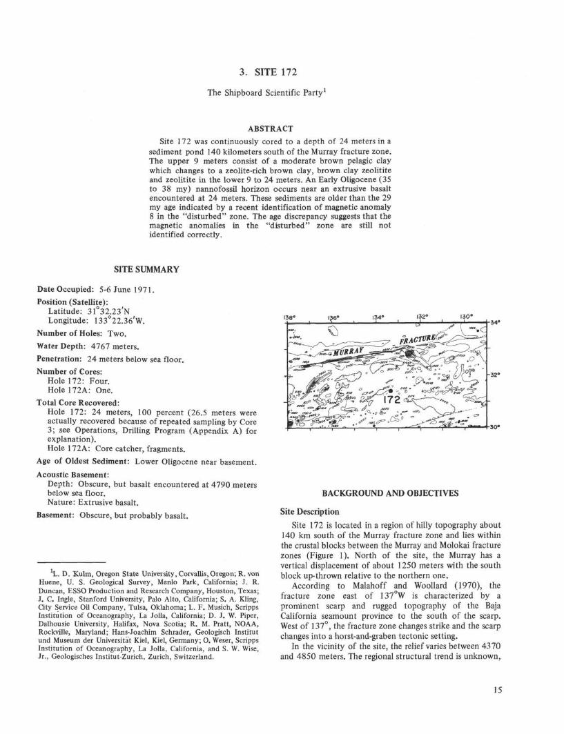
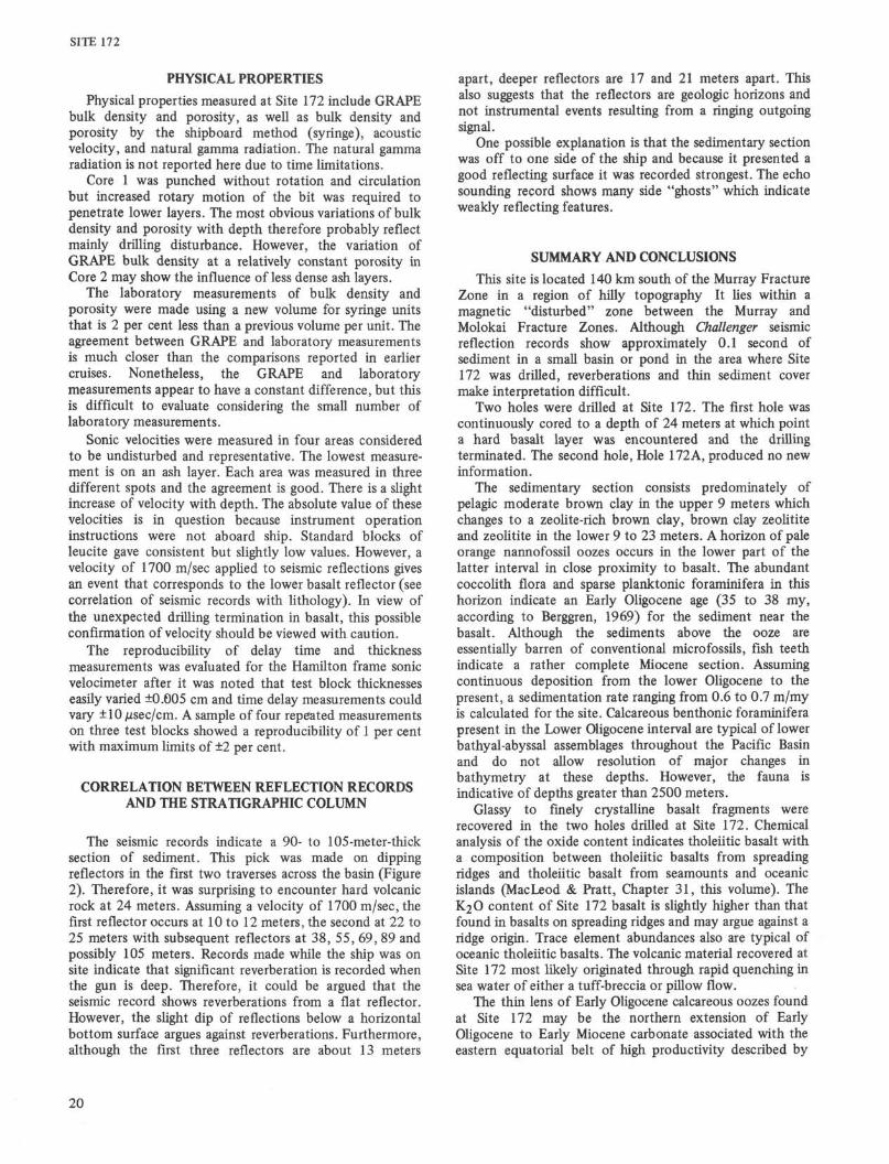
Site 172 is located in a region of hilly topography about140 km south of the Murray fracture zone and lies withinthe crustal blocks between the Murray and Molokai fracturezones (Figure 1). North of the site, the Murray has avertical displacement of about 1250 meters with the southblock up-thrown relative to the northern one.
According to Malahoff and Woollard (1970), thefracture zone east of 137°W is characterized by aprominent scarp and rugged topography of the BajaCalifornia seamount province to the south of the scarp.West of 137°, the fracture zone changes strike and the scarpchanges into a horst-and-graben tectonic setting.
In the vicinity of the site, the relief varies between 4370and 4850 meters. The regional structural trend is unknown,
15
SITE 172
138 130'
Figure 1. Bathymetry in the vicinity of Site 172 (Chase etal, 1970). Contours in fathoms.
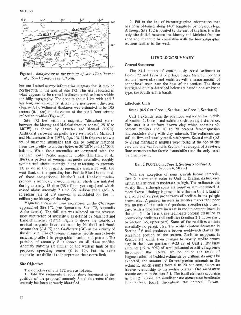
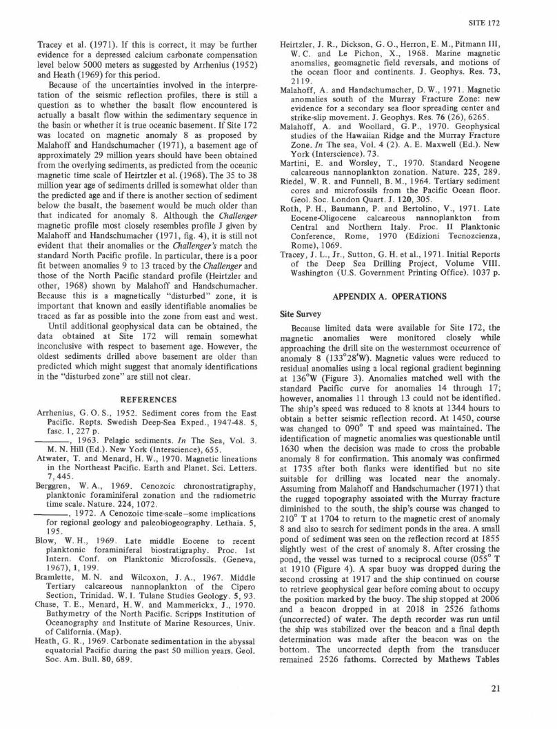
but our limited survey information suggests that it may benorth-south in the area of Site 172. This site is located inwhat appears to be a small sediment pond or basin withinthe hilly topography. The pond is about 1 km wide and 3km long and apparently strikes in a north-south direction(Figure Al). Sediment thickness was estimated to be 105meters (0.1 sec) in the center of the pond from seismicreflection profiles (Figure 2).
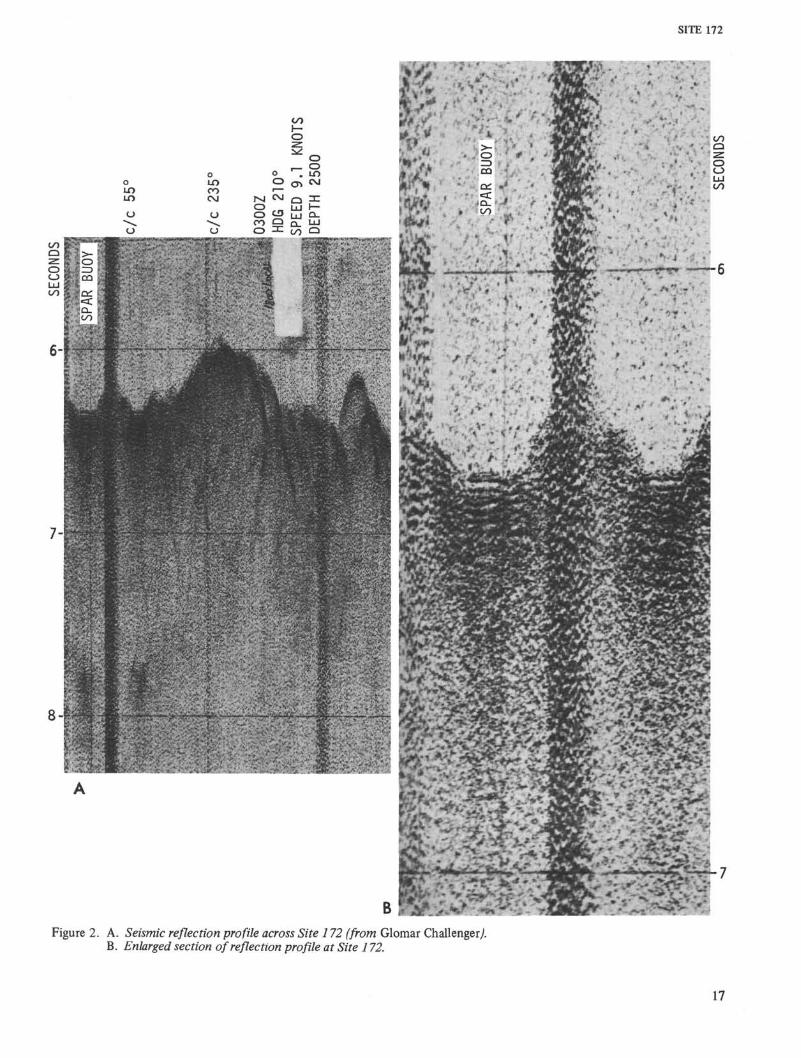
Site 172 lies within a magnetic "disturbed zone"between the Murray and Molokai fracture zones (128°W to140°W) as shown by Atwater and Menard (1970).Additional east-west magnetic traverses made by Malahoffand Handschumacher (1971, figs. 1 & 4) in this area show aset of magnetic anomalies that can be roughly matchedfrom one profile to another between 3O°2θ'N and 32°2θ'Nlatitude. When these anomalies are compared with thestandard north Pacific magnetic profile (Heirtzler, et al.,1968), a pattern of younger magnetic anomalies, roughlysymmetrical about anomaly 7 and extending to anomaly13, is set in the magnetic anomalies associated with thewest flank of the spreading East Pacific Rise. On the basisof these comparisons. Malahoff and Handschumacherpropose a secondary spreading center which was initiatedduring anomaly 13 time (38 million years ago) and whichceased about anomaly 7 time (27 million years ago). Aspreading rate of 2.9 cm/year is calculated for the 11million year history of the ridge.
Magnetic anomalies were monitored as the Challengerapproached Site 172 (see Operations—Site 172, AppendixA for details). The drill site was selected on the western-most occurrence of anomaly 8 as defined by Malahoff andHandschumacher (1971). Figure 3 shows the total-forceresidual magnetic lineations made by Malahoff and Hand-schumacher (J & K) and Challenger (GC) in the vicinity ofthe drill site. The Challenger magnetic profile most closelymatches profile J in geographic location and pattern. Theposition of anomaly 8 is shown on all three profiles.Anomaly patterns are similar on the western limb of theproposed spreading center (8 to 10), but the sameanomalies are difficult to interpret on the eastern limb.
Site Objectives
The objectives of Site 172 were as follows:1. Date the sediments directly above basement at the
position of the proposed anomaly 8 and determine if thisanomaly has been correctly identified.
2. Fill in the line of biostratigraphic information thathas been obtained along 140° longitude by previous legs.Although Site 172 is located to the east of the line, it is theonly site drilled between the Murray and Molokai fracturezone and it should be correlative with the biostratigraphicsections farther to the west.
LITHOLOGIC SUMMARY
General Statement
The 23.5 meters of continuously cored sediment atHoles 172 and 172A is of pelagic origin. Main componentsinclude brown clays and zeolitites with a minor amount ofnannofossil ooze near the base of the section. The threestratigraphic units described below are based upon sedimenttype; the fourth unit is basalt.
Lithologic Units
Unit 1 (0-9.0 m; Core 1, Section 1 to Core 1, Section 5)
Unit 1 extends from the sea floor surface to the middleof Section 5, Core 1 and exhibits slight coring disturbance.This unit is a uniform brown clay which contains <4percent zeolites and 10 to 20 percent ferromagnesianmicronodules along with clay minerals. The sediments aresoft to firm and usually moderate brown. Several small (0.5to 2 cm) manganese nodules were found at the top of thecore and one was found in Section 4 at a depth of 5 meters.Rare arenaceous benthonic foraminifera are the only fossilmaterial present.
Unit 2 (9.0-23.0 m; Core 1, Section 5 to Core 3,Section 4, 50 cm)
With the exception of some grayish brown intervals,Unit 2 is similar in color to Unit 1. Drilling disturbancewithin this interval is moderate to high. The sediments aremostly firm, although some are soupy or semi-indurated. Amore diverse lithology is present here than in Unit 1, largelyas a result of varying proportions of zeolites in the pelagicbrown clay. A gradual increase in zeolites marks the upperfew meters of this unit and produces a zeolite-rich brownclay. With a progressive increase in zeolite content lower inthe unit (11 to 16 m), the sediments become classified asbrown clay zeolitites and zeolitites (Section 2-2, lower part,to Section 2-6, upper part). Some of the zeolitites containessentially no pelagic clay. The zeolite content decreased inSection 2-6 and produces a brown zeolite-rich clay in theremaining portion of the section. Zeolitite reappears inSection 3-1 which then changes to mostly zeolite brownclay in the lower portion (19-23 m) of Unit 2. The largeamounts (15 to 20%) of semi-indurated zeolitite fragmentsthroughout this interval are no doubt the result offragmentation of bedded sediments by drilling. As might beexpected, the amount of ferromagnesian minerals in thesediment, which ranges from 0 to 20 per cent, shows aninverse relationship to the zeolite content. One manganesenodule occurs in Section 2-1. The fossil elements occurringin Unit 2 include rare nondiagnostic arenaceous benthonicforaminifera, found throughout the interval. Lower,
16
SITE 172
Figure 2. A. Seismic reflection profile across Site 172 (from Glomar Challenger/B. Enlarged section of reflection profile at Site 172.
17
SITE 172
σ
| 5O0σ° IOOOL
/V
A-Λ i
V|135°
ANOMALY
\
\ /V\J v
i134°
V
' \t
l133°
"^SNPP
1132°
0
500
-K>OO
Oo
ow
Figure 3. Total-force residual magnetic anomaly lineationsin the disturbed magnetic zone south of the MurrayFracture Zone. SNPP = Standard North Pacific MagneticProfile. J and K = magnetic profiles after Malahoff andHandschumacher (1971). GC magnetic profile madeby Glomar Challenger near the drilling site. Interpreta-tion of anomaly 8 from Malahoff and Handschumacher(1971).
Oligocene nannofossils occur in one 50-cm-thick bed and asrare thin streaks and scattered individual fossils. As will beshown later, these nannofossils are not believed to beage-significant for this unit. A few radiolarians and diatomsfound in the upper portion of Unit 2 (core catcher of Core1) are believed to be displaced by drilling from the topportion of Unit 1.
Unit 3 (23.0-23.5 m; Core 3, Section 4, 50 cm toCore 3, Section 4, 100 cm)
Unit 3 occupies a half-meter interval in Section 3-4 andshows only slight coring deformation. The top of this unitis marked by approximately 10 cm of pale orange nanno-fossil ooze which also contains planktonic foraminifera.Both the faunal and floral material indicate an EarlyOligocene age for the ooze. The ooze is in sharp contactwith a 40-cm-thick layer of brown clay which constitutesthe lower portion of Unit 2. This brown clay, which has ahigh ferromagnesian content (30 to 40%), is composition-ally unique to this hole. It is also a darker brown than anyof the overlying brown clays. The base of Unit 3, which isbelieved to represent the lowermost stratigraphic intervalpenetrated, exhibits no effects of contact metamorphism.
Beneath Unit 3 are approximately 3.5 meters of sedi-ment which are believed to be displaced by drilling (seeAppendix A, Site 172), and therefore not in stratigraphicsuccession. Lithologically, this sediment interval containshighly deformed and soupy sediments plus microfossilsalready encountered higher in the hole. These sedimentsoccupy the interval from 23.5 to 26.5 meters (Section 3-4,100 cm to Section 3-6).
Unit 4 (23.5-24 m; Core 4)
Basalt fragments up to 3mm in diameter were recoveredfrom the core catcher of Holes 172 and 172 A. About 80per cent of the fragments are fine-grained, gray basalt.About 20 per cent are composed of black glass with angularedges and conchoidal fracture surfaces. Orange yellowpalagonite is commonly associated with the glass and whitezeolite crusts are rare.
Thin sections were made of twelve of the fragmentsonboard the Challenger. The fine-grained gray basaltconsists of pyroxene, Plagioclase, and rare olivinephenocrysts in a holocrystalline groundmass of Plagioclase,pyroxene and much cloudy nondescript material. In two ofthe fragments, the groundmass contained many fragmentsof opaque minerals. The pyroxene has very poor crystalform and shows no indication of alternation. Crystalsaverage 0.1 to 0.4 mm in diameter. The Plagioclasephenocrysts occur in euhedral to subhedral laths with anaverage length of 0.5 to 0.6 mm. They are clear andprogressively zoned with well-defined twinning and have acomposition of approximately An 54 to An 75. Plagioclasein the groundmass is very fine-grained and cloudy. In mostsections, the pyroxene and Plagioclase phenocrysts tend togroup together into aggregates, but there are also isolatedindividual crystals. In two sections, prismatic, stubby crys-tal forms of orange brown altered olivine were observed.Other thin sections have small, clear olivine pseudomorphsof a mineral that is probably iddingsite.
The glassy phase of the basalt has phenocrysts of olivineand Plagioclase in glomeroporphyritic aggregates similar tothat of the holocrystalline phase. The glass is yellowishbrown with microfracturing and is completely extinct undercross-polarized light. Two of the glassy fragments haveyellowish, low-relief palagonite rims and one chip is nearlyall palagonite except for dark, nearly opaque bordersaround the phenocrysts.
In four sections, rare vesicles occur with a maximumdiameter of 0.20 mm and a minimum size of 0.03 mm.Their total volume is less than 0.5 percent of the rock.They appear to be filled with a radiating low-birefringent,fine-grained mineral that is probably a zeolite.
In general, the basalt fragments are similar incomposition to typical deep-sea tholeiitic basalts describedby other workers (see MacLeod and Pratt, Chapter 31, thisvolume, for complete descriptions).
PALEONTOLOGIC SUMMARY
Introduction
Microfossils (except fish remains and arenaceousbenthonic foraminifera) are essentially absent from most ofthe 24 meters cored at Site 172 with the exception of athin (15 cm) coccolith-rich carbonate ooze at 22 meters.Abundant, moderately well- to poorly preserved coccolithfloras and several solution-resistant species of planktonicforaminifera indicate that this horizon is of early Oligoceneage; the coccolith flora is assigned to the Ericsoniasubdistichus Zone of Roth, Baumann, and Bertolino (1971)and the sparse planktonic foraminifera to Blow's (1969)zones PI8 or P19 equivalent to an estimated radiometric
18

SITE 172
age of 32 to 38 my BJ\ based on the time scale of Berggren(1969; 1972). Greatest reliance is placed upon thewell-preserved coccolith floras at this site further narrowingthe estimated radiometric age to 35 to 38 my BJP.Additional horizons within the 17 to 24 meter interval atSite 172 yield sparse calcareous microfossils; however,species composition and abundance indicate that theyrepresent contaminants from the lower Oligocene carbonateooze encountered at 22 meters.
It is important to note that the presence of afossiliferous Oligocene calcareous ooze beneath an upperTertiary sequence of brown clays is typical of other abyssalportions of the eastern Pacific area adjacent to and withinthe equatorial region. This characteristic sequence oflithologies has been interpreted as evidence of a depressionof the calcium carbonate compensation zone below about5000 meters during portions of the Oligocene (Arrhenius,1963; Heath, 1969) and alternately as an expression of apostulated change in the rate and site of maximumplanktonic productivity during this interval (Reidel andFunnel, 1964). A detailed discussion of this widespreadearly Oligocene-early Miocene sedimentary event is given inthis volume by Wise (Chapter 15).
Diatoms
Diatoms are absent from almost all sediments cored atSite 172. The only specimens recovered in the acid-cleanedfraction coarser than 63 microns are badly corrodedfragments of Coscinodiscus marginatus, C. lineatus, andEthonodiscus rex. All three species exhibit long biostrati-graphic ranges and are resistant to dissolution; none havebiostratigraphic significance in this instance.
Calcareous Nannofossils
Calcareous nannofossils at Site 172 are essentiallyrestricted to the 15-cm-thick calcareous coccolith-rich oozeoccurring at 22 meters. This horizon represents a nearlypure nannofossil ooze yielding small amounts of zeolite ininsoluble residues {Fide H.J. Schrader). The preservation ofnannofossils is good to poor with discoasters in a good stateof preservation but with many placoliths heavily etched inthe central areas. The assemblage is dominated byReticulofenestra bisectus with abundant Discoaster aster (5and 6 rays), D. woodringi, and large (20µ) specimens ofReticulofenestra umbilica. Bramlettius serraculoides,Coccolithus eopelagicus, Cyclococcolithus foπnosus, Sphe-nalithus predistentus, and S. pseudoradians are alsocommon. This assemblage is characteristic of the lowerOligocene Helicopontosphaera reticulata zone of Bramletteand Wilcoxon (1967). This interval has been further studiedand subdivided by Roth et al. (1971) into two zones, thelower-most of which is the Ericsonia subdistica zone. Thenannoflora in Sample 173-3-4(48) can be readily referred tothis zone and is roughly equivalent to nannofossil zoneNN21 of Martini and Worsley (1970) and to Blow's (1969)planktonic foraminiferal zones PI7 through PI8.
Foraminifera
Planktonic foraminifera are absent throughout most ofthe sediments cored at Site 172 with the exception of a
sparse lower Oligocene assemblage occurring within thecoccolith-rich ooze horizon at 22 meters. A total of onlyseven solution-resistant species were identified from thishorizon attesting to the severe dissolution of these forms.Moreover, fragments of planktonic species are common andthe few complete tests recovered exhibit severe solutioneffects in the form of thin test walls, pitting, and loss ofinternal structure.
The reduced nature of the planktonic fauna found at 22meters precludes precise biostratigraphic resolution of thishorizon. However, five of the species recognized,Globorotalia opima nana, Catapoydrax unicava primativa,Catapsydrax unicava unicava, Globigerina prasaepsis, andGlobigerina cf. angiporoides, suggest this horizon is withinBlow's (1969) zones P18 or P19 of the lower Oligocene.
Scattered and rare specimens of broken and completearenaceous benthonic foraminifera occur throughout allcores recovered at Site 172. Calcareous benthonic specieswere found only within the lower Oligocene calcareousooze at 22 meters. A total of more than 20 benthonicspecies are present at this particular horizon; however, noneof these species are stratigraphically diagnostic and allrepresent typical elements of mid-Tertiary to Recent lowerbathyal-abyssal benthonic foraminiferal biofacies of theNorth Pacific Ocean.
Radiolaria
Core 1 at this site contains rare well-preserved species ofradiolaria including Theocorythium sp. cf. T. trachelium,Siphonosphaera polysiphonia, Heliodiscus asteriscus, Eucyr-tidium acuminatum, Arstrobium miralestense, and Euchi-tonia elegans. Although the lower stratigraphic limits ofthese species are not accurately kown, they are all knownfrom living samples and/or from Recent sediments. Nodiagnostic Tertiary species were seen and the assemblage isprobably Quaternary.
Very rare, poorly preserved fragments of radiolarianswere found in Core 3. Other portions of cores at Site 172are barren of radiolarians.
Spores and Pollen
Palynomorphs are entirely absent from sedimentsrecovered at Site 172. The absence of pollen and spores islikely due to the isolation of this site from a major landmass or the result of oxidation of the sediment afterdeposition.
Fish Remains
Cursory examination of relatively abundant andwell-preserved fish remains (mainly fish teeth) in sedimentsat Site 172 was made by Phyllis B. Helms of ScrippsInstitution of Oceanography. This preliminary analysissuggests that Sections 172-3(CC) through 172-16-2 containa complete Miocene section with transitional UpperOligocene and Lower Pliocene sediments present at eitherend of the column (Helms, personal communication to S.Kling, February 7, 1972).
19
SITE 172
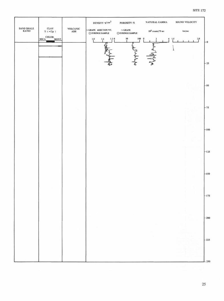
PHYSICAL PROPERTIES
Physical properties measured at Site 172 include GRAPEbulk density and porosity, as well as bulk density andporosity by the shipboard method (syringe), acousticvelocity, and natural gamma radiation. The natural gammaradiation is not reported here due to time limitations.
Core 1 was punched without rotation and circulationbut increased rotary motion of the bit was required topenetrate lower layers. The most obvious variations of bulkdensity and porosity with depth therefore probably reflectmainly drilling disturbance. However, the variation ofGRAPE bulk density at a relatively constant porosity inCore 2 may show the influence of less dense ash layers.
The laboratory measurements of bulk density andporosity were made using a new volume for syringe unitsthat is 2 per cent less than a previous volume per unit. Theagreement between GRAPE and laboratory measurementsis much closer than the comparisons reported in earliercruises. Nonetheless, the GRAPE and laboratorymeasurements appear to have a constant difference, but thisis difficult to evaluate considering the small number oflaboratory measurements.
Sonic velocities were measured in four areas consideredto be undisturbed and representative. The lowest measure-ment is on an ash layer. Each area was measured in threedifferent spots and the agreement is good. There is a slightincrease of velocity with depth. The absolute value of thesevelocities is in question because instrument operationinstructions were not aboard ship. Standard blocks ofleucite gave consistent but slightly low values. However, avelocity of 1700 m/sec applied to seismic reflections givesan event that corresponds to the lower basalt reflector (seecorrelation of seismic records with lithology). In view ofthe unexpected drilling termination in basalt, this possibleconfirmation of velocity should be viewed with caution.
The reproducibility of delay time and thicknessmeasurements was evaluated for the Hamilton frame sonicvelocimeter after it was noted that test block thicknesseseasily varied ±0.005 cm and time delay measurements couldvary ±10 µsec/cm. A sample of four repeated measurementson three test blocks showed a reproducibility of 1 per centwith maximum limits of ±2 per cent.
CORRELATION BETWEEN REFLECTION RECORDSAND THE STRATIGRAPHIC COLUMN
The seismic records indicate a 90- to 105-meter-thicksection of sediment. This pick was made on dippingreflectors in the first two traverses across the basin (Figure2). Therefore, it was surprising to encounter hard volcanicrock at 24 meters. Assuming a velocity of 1700 m/sec, thefirst reflector occurs at 10 to 12 meters, the second at 22 to25 meters with subsequent reflectors at 38, 55, 69,89 andpossibly 105 meters. Records made while the ship was onsite indicate that significant reverberation is recorded whenthe gun is deep. Therefore, it could be argued that theseismic record shows reverberations from a flat reflector.However, the slight dip of reflections below a horizontalbottom surface argues against reverberations. Furthermore,although the first three reflectors are about 13 meters
apart, deeper reflectors are 17 and 21 meters apart. Thisalso suggests that the reflectors are geologic horizons andnot instrumental events resulting from a ringing outgoingsignal.
One possible explanation is that the sedimentary sectionwas off to one side of the ship and because it presented agood reflecting surface it was recorded strongest. The echosounding record shows many side "ghosts" which indicateweakly reflecting features.
SUMMARY AND CONCLUSIONS
This site is located 140 km south of the Murray FractureZone in a region of hilly topography It lies within amagnetic "disturbed" zone between the Murray andMolokai Fracture Zones. Although Challenger seismicreflection records show approximately 0.1 second ofsediment in a small basin or pond in the area where Site172 was drilled, reverberations and thin sediment covermake interpretation difficult.
Two holes were drilled at Site 172. The first hole wascontinuously cored to a depth of 24 meters at which pointa hard basalt layer was encountered and the drillingterminated. The second hole, Hole 172A, produced no newinformation.
The sedimentary section consists predominately ofpelagic moderate brown clay in the upper 9 meters whichchanges to a zeolite-rich brown clay, brown clay zeolititeand zeolitite in the lower 9 to 23 meters. A horizon of paleorange nannofossil oozes occurs in the lower part of thelatter interval in close proximity to basalt. The abundantcoccolith flora and sparse planktonic foraminifera in thishorizon indicate an Early Oligocene age (35 to 38 my,according to Berggren, 1969) for the sediment near thebasalt. Although the sediments above the ooze areessentially barren of conventional micro fossils, fish teethindicate a rather complete Miocene section. Assumingcontinuous deposition from the lower Oligocene to thepresent, a sedimentation rate ranging from 0.6 to 0.7 m/myis calculated for the site. Calcareous benthonic foraminiferapresent in the Lower Oligocene interval are typical of lowerbathyal-abyssal assemblages throughout the Pacific Basinand do not allow resolution of major changes inbathymetry at these depths. However, the fauna isindicative of depths greater than 2500 meters.
Glassy to finely crystalline basalt fragments wererecovered in the two holes drilled at Site 172. Chemicalanalysis of the oxide content indicates tholeiitic basalt witha composition between tholeiitic basalts from spreadingridges and tholeiitic basalt from seamounts and oceanicislands (MacLeod & Pratt, Chapter 31, this volume). TheK2O content of Site 172 basalt is slightly higher than thatfound in basalts on spreading ridges and may argue against aridge origin. Trace element abundances also are typical ofoceanic tholeiitic basalts. The volcanic material recovered atSite 172 most likely originated through rapid quenching insea water of either a tuff-breccia or pillow flow.
The thin lens of Early Oligocene calcareous oozes foundat Site 172 may be the northern extension of EarlyOligocene to Early Miocene carbonate associated with theeastern equatorial belt of high productivity described by
20
SITE 172
Tracey et al. (1971). If this is correct, it may be furtherevidence for a depressed calcium carbonate compensationlevel below 5000 meters as suggested by Arrhenius (1952)and Heath (1969) for this period.
Because of the uncertainties involved in the interpre-tation of the seismic reflection profiles, there is still aquestion as to whether the basalt flow encountered isactually a basalt flow within the sedimentary sequence inthe basin or whether it is true oceanic basement. If Site 172was located on magnetic anomaly 8 as proposed byMalahoff and Handschumacher (1971), a basement age ofapproximately 29 million years should have been obtainedfrom the overlying sediments, as predicted from the oceanicmagnetic time scale of Heirtzler et al. (1968). The 35 to 38million year age of sediments drilled is somewhat older thanthe predicted age and if there is another section of sedimentbelow the basalt, the basement would be much older thanthat indicated for anomaly 8. Although the Challengermagnetic profile most closely resembles profile J given byMalahoff and Handschumacher (1971, fig. 4), it is still notevident that their anomalies or the Challenger's match thestandard North Pacific profile. In particular, there is a poorfit between anomalies 9 to 13 traced by the Challenger andthose of the North Pacific standard profile (Heirtzler andother, 1968) shown by Malahoff and Handschumacher.Because this is a magnetically "disturbed" zone, it isimportant that known and easily identifiable anomalies betraced as far as possible into the zone from east and west.
Until additional geophysical data can be obtained, thedata obtained at Site 172 will remain somewhatinconclusive with respect to basement age. However, theoldest sediments drilled above basement are older thanpredicted which might suggest that anomaly identificationsin the "disturbed zone" are still not clear.
REFERENCES
Arrhenius, G. O. S., 1952. Sediment cores from the EastPacific. Repts. Swedish Deep-Sea Exped., 1947-48. 5,fasc. 1, 227 p.
., 1963. Pelagic sediments. In The Sea, Vol. 3.M. N. Hill (Ed.). New York (Interscience), 655.
Atwater, T. and Menard, H. W., 1970. Magnetic lineationsin the Northeast Pacific. Earth and Planet. Sci. Letters.7,445.
Berggren, W. A., 1969. Cenozoic chronostratigraphy,planktonic foraminiferal zonation and the radiometrictime scale. Nature. 224, 1072.
, 1972. A Cenozoic time-scale—some implicationsfor regional geology and paleobiogeography. Lethaia. 5,195.
Blow, W. H., 1969. Late middle Eocene to recentplanktonic foraminiferal biostratigraphy. Proc. 1stIntern. Conf, on Planktonic Microfossils. (Geneva,1967), 1, 199.
Bramlette, M. N. and Wilcoxon, J. A., 1967. MiddleTertiary calcareous nannoplankton of the CiperoSection, Trinidad. W. I. Tulane Studies Geology. 5, 93.
Chase, T. E., Menard, H. W. and Mammerickx, J., 1970.Bathymetry of the North Pacific. Scripps Institution ofOceanography and Institute of Marine Resources, Univ.of California. (Map).
Heath, G. R., 1969. Carbonate sedimentation in the abyssalequatorial Pacific during the past 50 million years. Geol.Soc. Am. Bull. 80, 689.
Heirtzler, J. R., Dickson, G. O., Herron, E. M., Pitmann III,W. C. and Le Pichon, X., 1968. Marine magneticanomalies, geomagnetic field reversals, and motions ofthe ocean floor and continents. J. Geophys. Res. 73,2119.
Malahoff, A. and Handschumacher, D. W., 1971. Magneticanomalies south of the Murray Fracture Zone: newevidence for a secondary sea floor spreading center andstrike-slip movement. J. Geophys. Res. 76 (26), 6265.
Malahoff, A. and Woollard, G.P., 1970. Geophysicalstudies of the Hawaiian Ridge and the Murray FractureZone. In The sea, Vol. 4 (2). A. E. Maxwell (Ed.). NewYork (Interscience). 73.
Martini, E. and Worsley, T., 1970. Standard Neogenecalcareous nannoplankton zonation. Nature. 225, 289.
Riedel, W. R. and Funnell, B. M., 1964. Tertiary sedimentcores and microfossils from the Pacific Ocean floor.Geol. Soc. London Quart. J. 120, 305.
Roth, P. H., Baumann, P. and Bertolino, V., 1971. LateEocene-Oligocene calcareous nannoplankton fromCentral and Northern Italy. Proc. II PlanktonicConference, Rome, 1970 (Edizioni Tecnozcienza,Rome), 1069.
Tracey, J. L., Jr., Sutton, G. H. et al., 1971. Initial Reportsof the Deep Sea Drilling Project, Volume VIII.Washington (U.S. Government Printing Office). 1037 p.
APPENDIX A. OPERATIONS
Site Survey
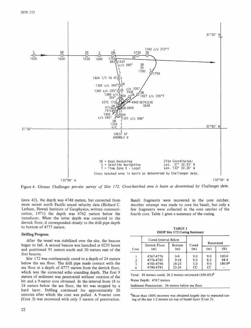
Because limited data were available for Site 172, themagnetic anomalies were monitored closely whileapproaching the drill site on the westernmost occurrence ofanomaly 8 (133°28'W). Magnetic values were reduced toresidual anomalies using a local regional gradient beginningat 136°W (Figure 3). Anomalies matched well with thestandard Pacific curve for anomalies 14 through 17;however, anomalies 11 through 13 could not be identified.The ship's speed was reduced to 8 knots at 1344 hours toobtain a better seismic reflection record. At 1450, coursewas changed to 090° T and speed was maintained. Theidentification of magnetic anomalies was questionable until1630 when the decision was made to cross the probableanomaly 8 for confirmation. This anomaly was confirmedat 1735 after both flanks were identified but no sitesuitable for drilling was located near the anomaly.Assuming from Malahoff and Handschumacher (1971) thatthe rugged topography assoiated with the Murray fracturediminished to the south, the ship's course was changed to210° T at 1704 to return to the magnetic crest of anomaly8 and also to search for sediment ponds in the area. A smallpond of sediment was seen on the reflection record at 1855slightly west of the crest of anomaly 8. After crossing thepond, the vessel was turned to a reciprocal course (055° Tat 1910 (Figure 4). A spar buoy was dropped during thesecond crossing at 1917 and the ship continued on courseto retrieve geophysical gear before coming about to occupythe position marked by the buoy. The ship stopped at 2006and a beacon dropped in at 2018 in 2526 fathoms(uncorrected) of water. The depth recorder was run untilthe ship was stabilized over the beacon and a final depthdetermination was made after the beacon was on thebottom. The uncorrected depth from the transducerremained 2526 fathoms. Corrected by Mathews Tables
21
SITE 172
31°30'-
1345 c/c 0251340 c/c
355°SITE 172
DR = Dead ReckoningS = Satel i te NavigationT = Time Zone 9 - Local
Site Coordinates:Lat. 31° 32.33' NLon. 133° 22.35' W
Cross hatched area is basin as determined by Challenger data.
133°00' W 133°30' W
Figure 4. Glomar Challenger pre-site survey of Site 172. Cross-hatched area is basin as determined by Challenger data.
(area 42), the depth was 4748 meters, but corrected frommore recent north Pacific sound velocity data (Richard C.Latham, Hawaii Institute of Geophysics, written communi-cation, 1971) the depth was 4762 meters below thetransducer. When the latter depth was corrected to thederrick floor, it corresponded closely to the drill pipe depthto bottom of 4777 meters.
Drilling Program
After the vessel was stabilized over the site, the beaconbegan to fail. A second beacon was launched at 0235 hoursand positioned 91 meters south and 30 meters east of thefirst beacon.
Site 172 was continuously cored to a depth of 24 metersbelow the sea floor. The drill pipe made contact with thesea floor at a depth of 4777 meters from the derrick floor,which was the corrected echo sounding depth. The first 9meters of sediment was penetrated without rotation of thebit and a 9-meter core obtained. In the interval from 18 to24 meters below the sea floor, the bit was stopped by ahard layer. Drilling continued for approximately 20minutes after which the core was pulled. A 9-meter core(Core 3) was recovered with only 5 meters of penetration.
Basalt fragments were recovered in the core catcher.Another attempt was made to core the basalt, but only afew fragments were collected in the core catcher of thefourth core. Table 1 gives a summary of the coring.
TABLE 1DSDP Site 172 Coring Summary
Core
1234
Cored Interval Below
Derrick Floor(m)
4767-47764776-47854785-479047904791
Bottom(m)
0-99-18
18-2323-24
Cored(m)
9.09.05.0CC
Recovered
(m)
9.08.59.0CC
(%)
100.094.4
180.0a
Total: 24 meters cored, 26.5 meters recovered (100.0%)a
Water Depth: 4767 meters
Sediment Penetration: 24 meters below sea floor
aMore than 100% recovery was obtained largely due to repeated cor-ing of the last 1-2 meters on top of basalt layer (Core 3).
22
SITE 172
An examination of the sediments in Core 3 shows thatthe top 430 cm contain abundant fragments ofsemi-indurated zeolitite, representing beds of zeolitite,broken up by the coring process. Below this level, there was60 cm of sediment consisting of a nannofossil ooze and abrown clay which has about 40 per cent ferromagnesianminerals and no zeolites. Both lithologies are different fromthose cored higher in the section. The base of this materiallies at a depth of 24 meters below the sea floor or at adepth of 5 meters in Core 3. The sediments recovered from5 to 9 meters in Core 3 represent a highly deformedmixture of material similar in lithology and age to thatrecovered in the previous 5 meters of Core 3. This indicatesthat the lowermost 4 meters of sediment in Core 3represent a duplication of previous lithologies and repeatedsampling of the sediment lying directly above the basalt.
The vessel was moved to a position 457 meters southand 30 meters east of the first site. A hole was jetted downto a depth of 24 meters below the sea floor at Hole 172Abefore encountering a hard layer. After 45 minutes ofdrilling the drill pipe and core were pulled. Only a fewbasalt fragments were recovered in the core catcher.
Because there was insufficient sediment cover tostabilize the bottom hole assembly, Hole 172A wasabandoned.
Drilling Specifications
A standard bottom hole assembly was run on this sitebecause of the expected thin layer of sediment. The coringassembly consisted of a 9-1 IS" Smith 4 cone insert core bit,a core barrel, three 8-1/4" drill collars, a bumper sub, three8-1/4" drill collars, two bumper subs, two 8-1/4" drillcollars, and a 7-1/4" drill collar.
Post-drilling Site Survey
A post-drilling survey was made at Site 172 to (a)determine if the drill did bottom in oceanic basement or ina lava flow on top of a 100 meter thick section of sediment,
and (b) determine if the magnetic anomaly identified as 8was actually an older anomaly as indicated by the basementage of 32-38 million years obtained with fossils.
An answer to the first question was sought by making aclearer seismic record along the axis of what was thought tobe a north-south striking basin, using lower frequencies ofthe seismic signal. During the drilling, a series of tests wererun with the seismic system which indicated that filteringthe return signals to exclude frequencies between 10 and 40or 10 and 80 cycles made much clearer records thanprevious underway filter settings of 80 and 160 cycles. Thegeophysical gear was streamed at 1245, while the ship wason a course of 180° T and speed of 4 knots. The systemused was a 20 in.3 and an 80 in.3 air gun firing at 5 secondintervals and held near the water surface to reducereverberation. Soon after we departed the site, the echosounder recorded rough topography and this, in addition toother factors, made it impossible to obtain a clear seismicrecord. At 1301, the course was changed to a nearreciprocal, 005° T, for a pass over the beacon. During thistime, it became apparent that even at 4 knots the 10-phoneEVP 23 eel does not have the low frequency noisecancellation capabilities that the 100-phone Recon andMP-7, 8- or 16-hydrophone arrays have, and that the higherfrequency settings commonly used with the Challengerseismic system are necessary to reject low frequency waternoise. The seismic record was therefore no better than theone made in the pre-drilling site survey. About 9 minutesafter crossing the beacon, the records showed the wall ofthe basin and the course was changed to 008° T, then025° T, and finally 340° T in a sawtooth search pattern,but only rough topography was encountered. Thus, itappears that Hole 172 was drilled at the edge of a smallbasin and that Hole 172A was probably on or close to theflank of the basin.
The character of the magnetic anomaly pattern wasfurther investigated by continuing the previous 090° Ttrack to about anomaly 10. This bracketed anomaly 8 bymagnetic information both east and west of Site 172. A090° course change was made at 1437. Magnetic anomalieswere identified across the spreading center proposed byMalahoff and Handschumacher to anomaly 10 or 11. Thenthe ship proceeded on a course of 038° T to the next site.
23
SITE 172
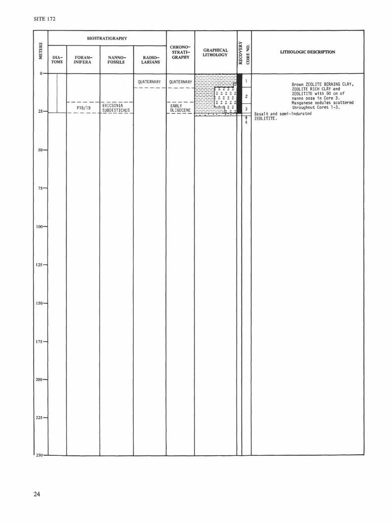
BIOSTRATIGRAPHY
DIA-TOMS
FORAM-INIFERA
NANNO-FOSSILS
RADIO-LARIANS
CHRONO-STRATI-GRAPHY
GRAPHICALLITHOLOGY I 1
O al
a s
UTHOLOGIC DESCRIPTION
25—
QUATERNARY
P18/19 ERICSONIASUBDISTICHUS
QUATERNARY
EARLYOLIGOCENE
50—
75—
100—
125 —
150—
175 —
200 —
225 —
250-
Brown ZEOLITE BERAING CLAY,ZEOLITE RICH CLAY andZEOLITITE with 50 cm ofnanno ooze in Core 3.Manganese nodules scatteredthroughout Cores 1-3.
Basalt and semi-induratedZEOLITITE.
24
SITE 172
SAND SHALERATIO
CLAY( < 2 µ
CHLOR.MICA MONT.
VOLCANICASH
DENSITY -g/cm3 POROSITY -%
-GRAPE ASECTIONWT. ~GRAPED SYRINGE SAMPLE O SYRINGE SAMPLE
NATURAL GAMMA
I03 counts/75 sec
SOUND VELOCITY
km/sec
4 ISJ I
2.0I I 1 - 0
- 2 5
- 5 0
-75
- 1 0 0
-125
-150
-175
-200
-225
-250
25
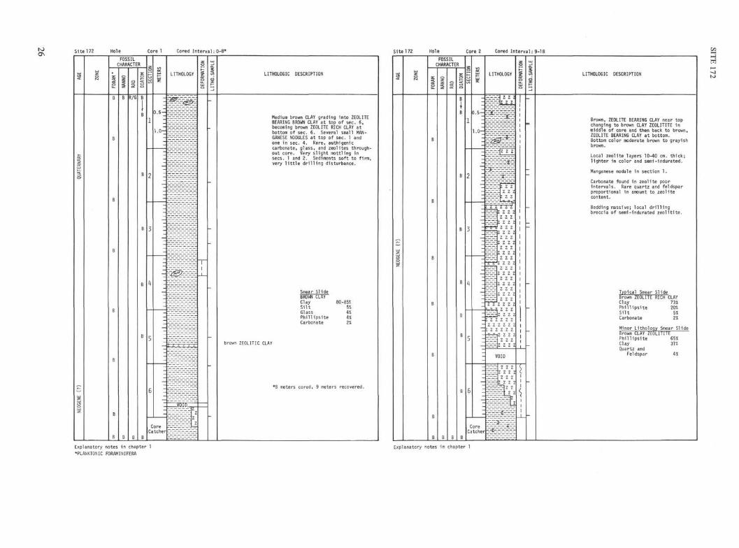
Site 172 Hole Core 1 Cored Interval: 0-8* Site 172 Cored In te rva l : 9-18
LITHOLOGIC DESCRIPTION
Medium brown CLAY grading into ZEOLITEBEARING BROWN CLAY at top of sec. 6,becoming brown ZEOLITE RICH CLAY atbottom of sec. 6. Several small MAN-GANESE NODULES at top of sec. 1 andone in sec. 4. Rare, authigeniccarbonate, glass, and zeolites through-out core. Very s l igh t mottling insees. 1 and 2. Sediments soft to f i rm,very l i t t l e d r i l l i n g disturbance.
Smear S1ide
Clay (SiltGlassPhillipsiteCarbonate
iO-85%5%• i°;
2%
brown ZEOLITIC CLAY
*8 meters cored, 9 meters recovered.
LITHOLOGIC DESCRIPTION
Brown, ZEOLITE BEARING CLAY near topchanging to brown CLAY ZEOLITITE inmiddle of core and then back to brown,ZEOLITE BEARING CLAY at bottom.Bottom color moderate brown to grayishbrown.
Local zeol i te layers 10-40 cm. th ick ;l igh ter in color and semi-indurated.
Manganese nodule in section 1.
Carbonate found in zeol i te poorin tervals. Rare quartz and feldsparproportional in amount to zeol i tecontent.
Bedding massive; local d r i l l i n gbreccia of semi-indurated z e o l i t i t e .
Typical Smear SlideBrown ZEOLITE RICH CLAYClay 73%Phill ipsite 20%Silt 5%Carbonate 2%
Minor Lithology Smear SlideBrown CLAY ZEOLITITEPhi l l ips i te 65«Clay 31%Quartz and
Feldspar 43!
Explanatory notes in chapter 1
*PLANKTONIC FORAMINIFERA
Explanatory notes in chapter 1
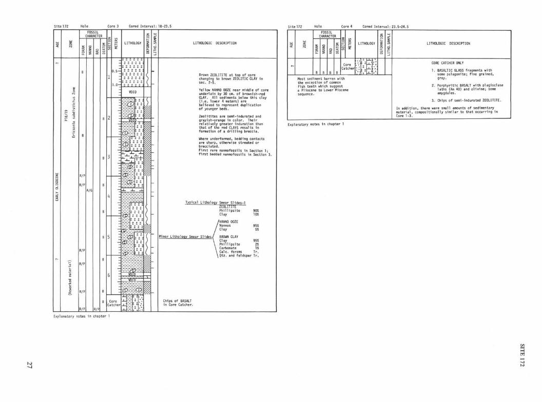
Site 172 Hole Core 3 Cored Interval: 18-23.5 Site 172 Hole Core 4 Cored Interval: 23.5-24.5
z z z z zz z z z z z
Z Z Z Z Z 1z z z z z z
Z Z Z Z Z 3z z z z z zz z z z z
LITHOLOGIC DESCRIPTION
Brown ZEOLITITE at top of corechanging to brown ZEOLITIC CLAY insec. 2-5.
Yellow NANNO OOZE near middle of coreunderlain by 30 cm. of brownish-redCLAY. Al l sediments below this clay( i . e . lower 4 meters) arebelieved to represent duplicationof younger beds.
Zeol i t i tes are semi-indurated andgrayish-orange in color. Theirre la t ive ly greater induration thanthat of the red CLAYS results information of a d r i l l i n g breccia.
Where underformed, bedding contactsare sharp, otherwise streaked orbrecciated.F i rs t rare nannofossils in Section 1 ;f i r s t bedded nannofossils in Section 3.
Typical Lithology Smear SHdes-1
ZEOLITITEPhillipsiteClay
/NANNO OOZENannosClay
Minor Lithology Smear Slides/ BROWN CLAYClayPhillipsiteCarbonateCalc. forams
90%10%
95%5%
95%2%1%
Tr.iQtz. and feldspar Tr.
Chips of BASALTin Core Catcher.
AGE
ZONE
FOSSILCHARACTER
FORA
M
B
NANN
O
B
RAD
B
DIAT
OM
B
SECT
ION
METE
RS
CoreCatcher
LITHOLOGY
: zz: z
V.
DEFO
RMAT
ION
LITH
O.SA
MPLE
Most sediment barren withthe exception of commonfish teeth which suggesta Pliocene to Lower Miocenesequence.
LITHOLOGIC DESCRIPTION
CORE CATCHER ONLY
1. BASALTIC GLASS fragments withsome palagonite; fine grained,gray.
2. Porphyritic BASALT with Plagioclaselaths (An 40) and olivine; someamygdules.
1. Chips of semi-indurated ZEOLITITE.
In addition, there were small amounts of sedimentarymaterial, compositionally similar to that occurring inCore 1-3.
Explanatory notes in chapter 1
Explanatory notes in chapter 1
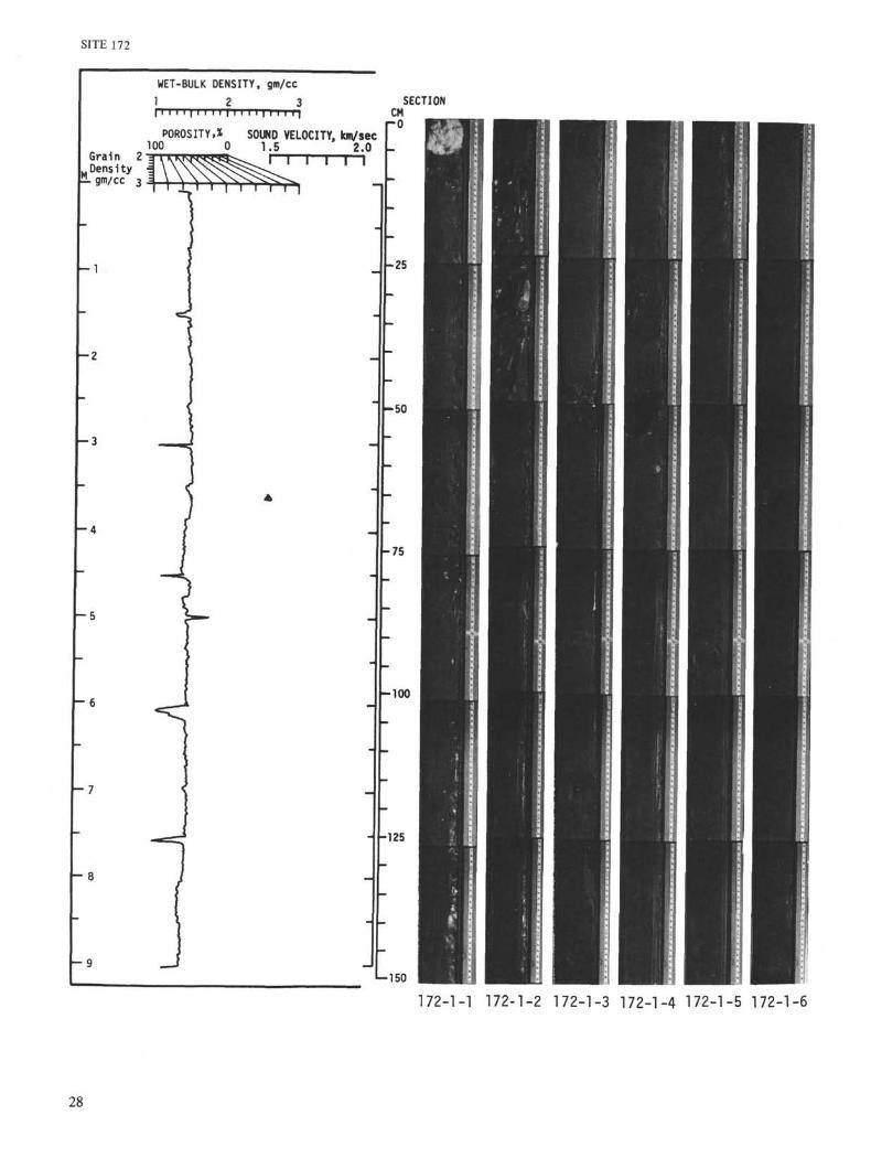
SITE 172
WET-BULK DENSITY, gm/cc1_ 2 3
Grain 2Density
[± gm/cc 3
POROSITY,% SOUND VELOCITY, km/sec100 0 1.5 2.0
\-z
CMro
SECTION
Moo
125
150
I
172-1-1 172-1-2 172-1-3 172-1-4 172-1-5 172-1-6
28
Grain 2
WET-BULK DENSITY, g m / c c
1 2 3
POROSITY,% SOUND VELOCITY, km/sec100 0 1.5 2.0
-50
CM
ro
SE
-25
-75
-100
125
L-150
29
SITE 172
TION
I
n
172-2-1 172-2-2 172-2-3 172-2-4 172-2-5 172-2-6
SITE 172
Grain 2
WET-BULK DENSITY, gm/cc
1 2 3
POROSITY,* SOUND VELOCITY, km/sec100 0 1.5 2.0
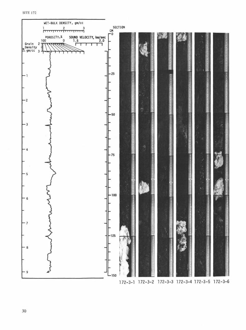
SECTION
- 1
- 2
- 3
- 5
6
- 7
- 8
- 9
CM- 0
50
75
-100
-150
172-3-1 172-3-2 172-3-3 172-3-4 172-3-5 172-3-6
30