2.the potential of tsunami generation …. the potential...pakistan journal of meteorology vol. 4...
TRANSCRIPT
Pakistan Journal of Meteorology Vol. 4 Issue 7: July, 2007
25
THE POTENTIAL OF TSUNAMI GENERATION ALONG KARACHI AND THE MAKRAN COAST OF PAKISTAN Humeira Hafeez1
Abstract: Tsunamis are being more frequent in and around Pacific Ocean but it is also observed frequently in South East Asia, Japan and western coast of North and South America. Most often the release and transfer of energy cause it during a tectonic type of an earthquake as being the case in December 26, 2004 destructive tsunami. Although large earthquakes along the Makran Subduction Zone are infrequent, the potential for the generation of destructive tsunami along the Makran coast of Pakistan and in the Northern Arabian Sea cannot be ruled out. This region has already suffered a devastating earthquake triggered tsunami in November 28, 1945 that caused more than 4000 deaths and a great loss of property not only along the Makran coast of Pakistan but also along the coasts of Western India, Iran and Oman.
Tectonic collisions are actively taking place along the Southern and Southeastern boundary of Eurasian plate and entire Indian plate and adjacent micro plates which are responsible for October 8, 2005 earthquake in Northern Pakistan. Transfer of tectonic stress to other stress loaded tectonic regions can cause tsunamigenic earthquake in the Northern part of Arabian Sea along the coast of Makran.
Study shows that Oman oceanic lithosphere is undergoing Subduction and it is moving northward beneath the Iranian micro-plate at a very shallow angle at very high rate. This activity is causing uplift, which is turning Makran Coast both in Baluchistan and Sindh provinces into a very densely faulted belt. This tectonic activity has also created offshore thrust faults and as in the past, large devastating tsunami is always a possibility along major faults in east Makran region, near Karachi as well as along the western end of the subduction zone.
Moreover, this subduction has accumulated thick sediments particularly along the Eastern Sindh region near the Indus River delta. As submarine landslides can also cause tsunami, this region has the potential to cause a large submarine tsunamigenic landslide. Submarine landslides don’t need an earthquake of high magnitude; even smaller magnitudes can also trigger such under water landslides causing tsunami.
Current study is based on the propagation of tsunami to the 50 m depth of water; it does not cover the tsunami run-up and its inundation on the coasts. The areas of focus for this study were coastal cities of Pakistan mainly Karachi, Ormara, Pasni, and Gawadar. The selected locations are very important because of the fact that Karachi is the mega city of Pakistan, Ormara is the Naval base of Pakistan Navy, Pasni has suffered heavy amount of destruction in 1945 and Gawadar due to the fact that it is 1 Pakistan Meteorological Department.
Pakistan Journal of Meteorology Vol. 4 Issue 7: July, 2007
26
Pakistan’s upcoming most important port city. Expected tsunami wave height and its arrival time at the coast as well as potential threat to these cities have been studied. AVINAMI software has been used for simulation and modeling of tsunami in this study.
Introduction: Pakistan has 1050 km of coastline, 350 km in Sindh and 700 km in Baluchistan. Makran ranges cover a vast area that is about 400 km long and 250 km wide. A dangerous Subduction region is located about 100 km away from Makran coast that can be a cause of tsunami. This Subduction region was responsible for catastrophic earthquake triggered tsunami in 1945. The Murray ridge lies southwest of Karachi in Arabian Sea.
Figure 1
Recent studies show that Subduction of Oman oceanic lithosphere northward beneath the Iranian micro-plate and a tri-junction of tectonic plates at Somiani Bay can be a potential source of future tsunami that can be a major threat to the coastal cities of Pakistan such as Karachi, Gawadar, Pasni, Ormara etc.
Tectonic Setting of the Region: Indian tectonic plate is continuously moving towards the Eurasian plate and its collision with the Eurasian plate has turned this region an active region of seismicity. Moreover, convergence along the Himalayas is causing thrust faulting and upward displacement of Indian plate. Destructive earthquake of October 08, 2005 in Pakistan was a result of the same active collisions along the foothills of Himalayas. This continental convergence

Pakistan Journal of Meteorology Vol. 4 Issue 7: July, 2007
27
has created a complex pattern of micro faults, areas of Subduction and also the areas with up thrust characterization. Although, the earthquakes along the Makran coast are not being frequent, they have great potential for any future disaster like tsunami.
Figure 2: (A photograph by USGS)
Tsunami Generation Mechanism and Size of Tsunami: Initiation: Whenever sea floor is disturbed & deformed, it causes displacement of overlying water from its equilibrium position hence originating tsunami. Although, submarine landslides, volcanic eruptions or earthquake can be a possible cause but earthquake is the most likely cause.
Once the event initiating tsunami occurs, the potential energy that results from pushing water above mean sea level is then transferred into the horizontal propagation (Kinetic energy of the tsunami waves).
Split: Within several minutes of the initiation, tsunami splits into two parts, one is called “distant tsunami” and other is called “local tsunami”. Distant tsunami travels towards the deep Ocean and local tsunami heads to the coastal areas. As the speed of tsunami is directly related to the depth of water; distant tsunamis travel at much faster speed than the local tsunamis.
Pakistan Journal of Meteorology Vol. 4 Issue 7: July, 2007
28
Amplification: As tsunami reaches near coast, its velocity decreases as well as its wavelength. As the velocity decreases, its energy that was spread over the deep ocean column, must be squeezed into a now shallow water layer, hence the wave amplitude increases considerably often to several meters or tens of meters as it interacts the coastline.
gHv = H= water depth
Run-up: As the tsunami wave travels from deep-water continental slope region to the near-shore region, tsunami run-up occurs. Run-up is a measurement of height of water onshore observed above reference sea level. Run-up height “h” is an important parameter of determining the intensity of tsunami;
I = log2 ( 2 h) (Soloviev and Go 1974)
After run-up part of the tsunami energy is reflected back to the open sea. In addition, a tsunami can generate a particular type of waves called “edge waves” that travel back and forth, parallel to the shore. These affect result in many arrivals of the tsunami at a particular point on the coast. These edge waves often carry debris along with them which severely enhances the destructive nature of tsunami.
Size of Tsunami: The size of tsunami depends mainly upon amount of vertical sea floor deformation that is controlled by the earthquake’s magnitude, depth, fault characteristics and coincident slumping of sediments or secondary faulting. Other features which influence the size of tsunami along the coast are shoreline and bathymetric configuration, the velocity of the sea floor deformation, the water depth near the earthquake source, and the efficiency which energy is transferred from the earth’s crust to the water column.
Propagation of Tsunami Along Makran Coast and Karachi: Over 50 earthquakes of magnitude 8 and above have been reported in last 75 years along the coastline of Pakistan. Out of these, four were accompanied by tsunamis 1919, 1943, 1945 and 1956. The earthquakes that affected Karachi in the past mostly generated along the Kirher-PAB range, Sarjan-Jhampir-Jati-Alabund range and Murray ridge of mostly minor of moderate magnitudes. Murray ridge is located at 100-200 km southwest of Karachi in North Arabian Sea and extending up to Somiani Bay (triple plate junction). Although it has experienced more than 25 earthquakes (1904 onward) of

Pakistan Journal of Meteorology Vol. 4 Issue 7: July, 2007
29
intensity about 7-8 on modified Mecalli scale and it is an active area of seismicity but this fault is a “spreading plate boundaries” hence it cannot create a tsunami of any significant effect to any of the coastal city of Pakistan.
Figure 3
The real threat to the Pakistan’s coastal areas is the “Makran Subduction Zone” as Subduction zones can create a destructive tsunami. This Subduction zone is located to the south west of Makran coast in Arabian Sea, this zone and its associated thrust fault are oriented in the east west direction which is in alignment with Karachi. Any thrusting in the Arabian Sea may generate tsunami, the distance between Makran coast and this Subduction zone is approximately 100 km and the generated tsunami will take few minutes to reach this coast line which can prove destructive to the coastal cities like Gawadar, Pasni and Ormara. Karachi has much less threat of even a tsunami generated from the Makran Subduction Zone because of the geographical location of the mega city. Karachi is East-West oriented and it is separated from North-South trending Gadani coast, by the Cape Mounze promontory that provides a barrier to the city and second is the location and the direction of the fault in the Arabian Sea. Tsunami generated from the Makran Subduction zone or its associated thrust faults (East-West oriented) will hit Gadani coast at very high angle but it may strike Karachi at low angle because East-West propagating waves will be very weak and will be parallel to the Karachi coast. Hence, probably Karachi is in least danger to the devastation of tsunami as compared to the cities like Gawadar, Pasni and Ormara. That was the reason why an earthquake triggered tsunami of 1945 was recorded even at the Australian coast and caused heavy destruction at the coast of Makran but had a very little effect at Karachi.

Pakistan Journal of Meteorology Vol. 4 Issue 7: July, 2007
30
Case Studies: This study has been conducted by considering earthquake of magnitudes 7.5, 8.0 and 8.5. The areas considered are Pasni, Ormara, Gawadar and Karachi. Makran Subduction Zone has been considered as the fault line prone to the earthquake triggered tsunamis. Results obtained from these cases confirm our argument based on the bathymetry of the coasts of these cities of Pakistan that Karachi is in least danger if any of the earthquake triggered tsunami generates along the Makran Subduction Zone. In this study, wave height and reaching time of the tsunami at the concerned locations is also considered at different magnitudes.
Magnitude 7.5: At magnitude of 7.5, a very weak tsunami is generated the wave height at Ormara is 0.15 meters and first tsunami create wave reaches Ormara in 25 minutes. At Gawadar, first tsunami create wave reaches within 24 minutes with a maximum wave height of 0.1 meters, while it reaches Pasni within 30 minutes with a maximum wave height of 0.16 meters. In this case no tsunami is reaching Karachi coast at all.
Ormara at magnitude 7.5
-0.2
-0.1
0
0.1
0.2
0.0
7.7
15.3
23.0
30.6
38.3
45.9
53.6
61.2
68.9
76.5
84.2
91.8
99.5
107.
1
114.
8
Time(min)
Wav
e H
eigh
t(m)
Figure 4

Pakistan Journal of Meteorology Vol. 4 Issue 7: July, 2007
31
Gawadar at magnitude 7.5
-0.2
-0.1
0
0.1
0.20.
0
7.7
15.3
23.0
30.6
38.3
45.9
53.6
61.2
68.9
76.5
84.2
91.8
99.5
107.
1
114.
8
time(min)
wav
e he
ight
(m)
Pasni at 7.5 magnitude
-0.15
-0.1
-0.05
0
0.05
0.1
0.15
0.2
t ime(min)
Figure 6
Figure 5

Pakistan Journal of Meteorology Vol. 4 Issue 7: July, 2007
32
In figure 7a, it has been demonstrated that how tsunami is generated when an earthquake of magnitude 7.5 occurs. Figure 7b is showing the final stage of the tsunami waves after 120 minutes.
Figure 7a: Initiation at 0 sec
Figure 7b: Final stage of 120 minutes
In Figure 7c, generation of tsunami from an earthquake has been demonstrated through AVINAMI software and in figure 7d final stage within 120 minutes of the tsunami waves can be observed through AVINAMI software.
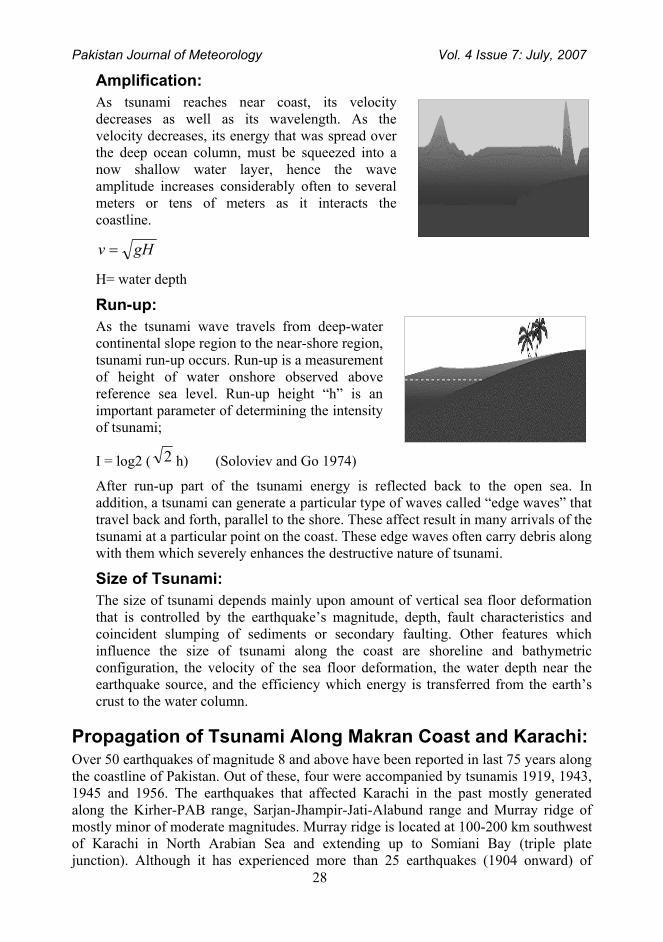
In Figure 7e, we can observe maximum height of the tsunami wave within selected period of time (120 minutes) at different locations, while figure 7f can be used to locate the minimum height of the tsunami waves. This view can provide us very useful information that what will be the maximum/minimum height of tsunami waves at the required location. It should be considered that this maximum or minimum height is not the average wave height rather it is the maximum/minimum possible wave height in the selected period of time.
Figure 7c: Initiation at 0 sec
Figure 7d: Final Stage of 120 minutes
Pakistan Journal of Meteorology Vol. 4 Issue 7: July, 2007
33
Figure 7g is showing maximum surface elevation in AVINAMI while figure 7h is showing minimum surface elevation of tsunami waves using AVINAMI.
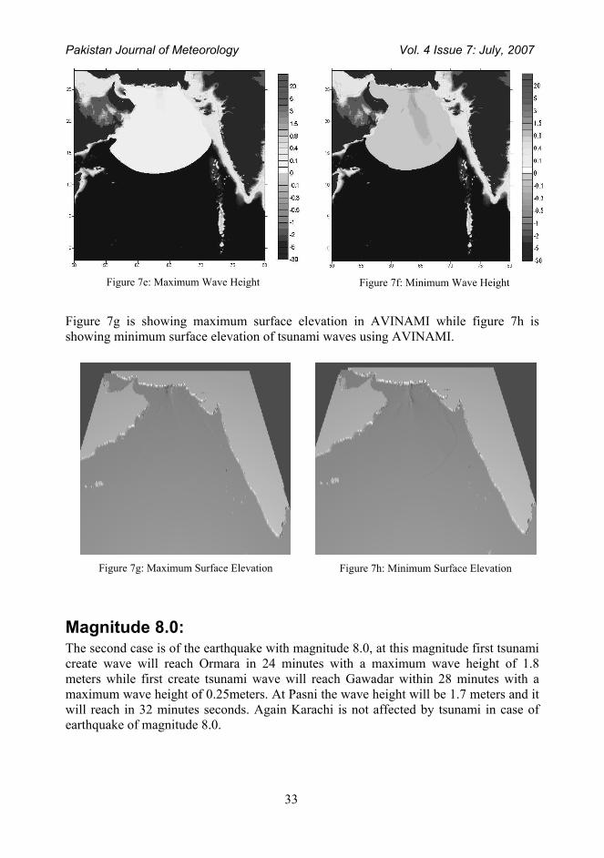
Magnitude 8.0: The second case is of the earthquake with magnitude 8.0, at this magnitude first tsunami create wave will reach Ormara in 24 minutes with a maximum wave height of 1.8 meters while first create tsunami wave will reach Gawadar within 28 minutes with a maximum wave height of 0.25meters. At Pasni the wave height will be 1.7 meters and it will reach in 32 minutes seconds. Again Karachi is not affected by tsunami in case of earthquake of magnitude 8.0.
Figure 7e: Maximum Wave Height
Figure 7f: Minimum Wave Height
Figure 7g: Maximum Surface Elevation
Figure 7h: Minimum Surface Elevation

Pakistan Journal of Meteorology Vol. 4 Issue 7: July, 2007
34
ormara at 8.0
-2
-1
0
1
20
6.8
13.6
20.4
27.2 34
40.8
47.6
54.4
61.2 68
74.8
81.6
88.4
95.2
102
109
116
gawadar at 8.0
-0.3-0.2-0.1
00.10.20.3
0
7.08
14.2
21.3
28.3
35.4
42.5
49.6
56.7
63.8
70.8
77.9 85
92.1
99.2
106
113
Pasni at 8.0 magnitude
-1.5
-1
-0.5
0
0.5
1
1.5
2
0 5 10 15 20 25 30 35 40 45 50 55 60 65 70 75 80 85 90 95 100
105
110
115
time(min)
wav
e he
ight
(m)

Pakistan Journal of Meteorology Vol. 4 Issue 7: July, 2007
35
In figure 8a, it has been demonstrated that how tsunami is generated when an earthquake of magnitude 8.0 occurs. Figure 8b is showing the stage of the tsunami waves after 120 minutes.
In figure 8c, generation of tsunami has been demonstrated by using AVINAMI software while in figure 8d stage of tsunami is demonstrated after 120 minutes by using AVINAMI.
Figure 8e, is showing maximum wave height of tsunami at a magnitude of 8.0 along the coastal areas while figure 8f is demonstrating minimum wave height of the tsunami waves at the earthquake magnitude 8.0.
Figure 8a: Initiation at 0 Sec Figure 8b: Final Stage at 120 minutes
Figure 8c: Initiation at 0 Sec
Figure 8d: Final Stage at 120 Minutes

Pakistan Journal of Meteorology Vol. 4 Issue 7: July, 2007
36
Figure 8g is showing maximum surface elevation in AVINAMI while figure 8h is showing minimum surface elevation of tsunami waves using AVINAMI.
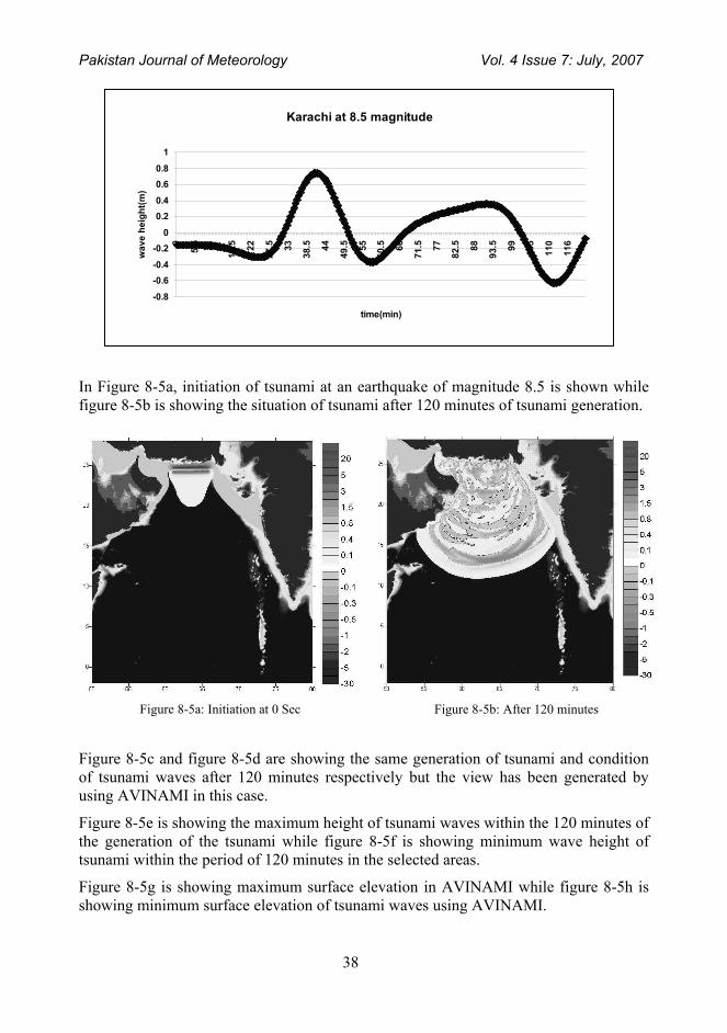
Magnitude 8.5: Earthquake with a magnitude of 8.5 presents the worst case. It is the same magnitude that caused havoc in 1945 along the Makran coast of Pakistan. In this case, Ormara will receive a maximum wave height of 5 meters and first create wave will reach Ormara within 22.7 minutes, at Gawadar the wave height will be 3.5 meters and first create wave will reach Gawadar in 21.5 minutes, Pasni will be the worse case with a wave height of 4.3 meters and first create wave reaching in 30 minutes. While in this case Karachi will also suffer with a wave height of 0.75 meters and first create wave reaching within 33 minutes.
Figure 8e: Maximum Wave Height
Figure 8f: Minimum Wave Height
Figure 8g: Maximum Surface Elevation
Figure 8h: Minimum Surface Elevation

Pakistan Journal of Meteorology Vol. 4 Issue 7: July, 2007
37
Pasni at 8.5 magnitude
- 3
- 2
- 1
0
1
2
3
4
5
t ime(min)
Gawadar at 8.5 magnitude
-5
-4
-3
-2
-1
0
1
2
3
4
time(min)
Ormara at 8.5 magnitude
-6
-4
-2
0
2
4
6
0
5.95
11.9
17.9
23.8
29.8
35.7
41.7
47.6
53.6
59.5
65.5
71.4
77.4
83.3
89.3
95.2
101
107
113
119
time(min)
wav
e he
ight
(m)
Pakistan Journal of Meteorology Vol. 4 Issue 7: July, 2007
38
In Figure 8-5a, initiation of tsunami at an earthquake of magnitude 8.5 is shown while figure 8-5b is showing the situation of tsunami after 120 minutes of tsunami generation.
Figure 8-5c and figure 8-5d are showing the same generation of tsunami and condition of tsunami waves after 120 minutes respectively but the view has been generated by using AVINAMI in this case.
Figure 8-5e is showing the maximum height of tsunami waves within the 120 minutes of the generation of the tsunami while figure 8-5f is showing minimum wave height of tsunami within the period of 120 minutes in the selected areas.
Figure 8-5g is showing maximum surface elevation in AVINAMI while figure 8-5h is showing minimum surface elevation of tsunami waves using AVINAMI.
Karachi at 8.5 magnitude
-0.8
-0.6-0.4
-0.20
0.20.4
0.60.8
1
0
5.5 11
16.5 22
27.5 33
38.5 44
49.5 55
60.5 66
71.5 77
82.5 88
93.5 99 105
110
116
time(min)
wav
e he
ight
(m)
Figure 8-5a: Initiation at 0 Sec
Figure 8-5b: After 120 minutes

Pakistan Journal of Meteorology Vol. 4 Issue 7: July, 2007
39
Figure 8-5c: Initiation at 0 Sec
Figure 8-5d: After 120 Minutes
Figure 8-5e: Maximum Wave Height
Figure 8-5f: Minimum Wave Height
Figure 8-5g: Maximum Surface Elevation
Figure 8-5h: Minimum Surface Elevation.

Pakistan Journal of Meteorology Vol. 4 Issue 7: July, 2007
40
Conclusion: In this study, it has been found that in case of tsunami generated by an earthquake along the Makran Subduction Zone, Pasni, Ormara and Gawadar are the areas in most danger while Karachi is having least danger of such a disaster. History of tsunami as well as the bathymetry of this region also supports this argument. It should be considered that the current study is considering effect of tsunami up to the 50 meter depth of water not up to the coast. The “shoaling” effect that will cause an enormous increase in wave height is not considered in this study that means these cases will be even worse upon reaching the coast.
Moreover, sediments accumulated along the Indus River delta can also take a crucial part in tsunami, because an earthquake with even a weaker magnitude can trigger a submarine landslide in these sediments causing tsunami or effect of an earthquake triggered tsunami can be amplified by the consequent submarine landslide in these sediments.
Acknowledgement: I would like to thank Dr. Qamar-uz-Zaman Chaudhary, Director General, Pakistan Meteorological Department for his confidence in my abilities and valuable support in this regard. I would also like to thank Mr. Abdul Hameed, Director Maintenance, Pakistan Meteorological Department for his encouragement and for providing necessary tools for this study. I would also like to acknowledge the co-operation of Mr. Asif Hussain, Assistant Programmer and Mr. Nadeem Faisal, Meteorologist in this regard and at last the co-operation and guidance of Mr. Muhammad Heider Zaideh, University of Tehran, Iran and Mr. Zia-ur-Rehman, University of Karachi, Pakistan.
References: Ambrasseys, N. and Bilham, R., 2003, "Earthquakes and Associated Deformation in North Baluchistan 1892-2001", Bulletin of the Seismological Society of America, Vol .93, No. 4, p. 1573 - 1605. Bakht S. M. 2000. An Overview of Geothermal Resources of Pakistan. Proceedings World Geothermal Congress 2000, Kyushu - Tohoku, Japan, May 28 - June 10, 2000 Berninghausen, W.H., 1966. "Tsunamis and Seismic Seiches reported from regions adjacent to the Indian Ocean", BSSA, Vol 56, No.1, 1966. Fruehn, J., White, R. S. and Minshull, T. A., 1997. Internal deformation and compaction of the Makran accretionary wedge, Terra Nova, 9: 101-104. Minshull, T. A., White, R. S., Barton, P. J. and Collier, J. S., 1992. Deformation at plate boundaries around the Gulf of Oman, Marine Geology, 104: 265-277. A. H. Kazmi & M Qasim Jan “Geology and tectonics of Pakistan” Graphics of Pakistan, 1997, pp 39-40, 184-185, 414-415. T. Harinarayana & N. Hirata, “Destructive earthquake and Disastrous Tsunami in the Indian Ocean, What next?” International Association for Gondwana Research, Japan Earthquake Research Institute, University of Tokyo, 2005.. Brohi, “Degradation of Indus Delta & its impact on local community”, Pakistan Fisher Forum, Action Aid Pakistan, 2004, pp1-3