2g . oooi8 · 52j03nw0001w9630-00018 badshot lake q10 noranda mining and exploration inc. report on...
TRANSCRIPT

52J03NW0001W9630-00018 BADSHOT LAKE Q10
NORANDA MINING AND EXPLORATION INC.
REPORT ON 1995 DIAMOND DRILLING
MCDOUGALL BAY - WARD LAKE PROPERTY
MARCHINGTON PROJECT
N.T.S.52J/04
WESTERN CANADA REGION
PROJECT NO. 325 AL SMITH THUNDER BAY. ONTARIO PROJECT GEOLOGIST MARCH 8.1998 REG FELIX
SR. GEOLOGIST
NOISSA1G C". :*
:|d M LV/: 2G
. oooi8

S2J03NWV0001 W9630-00018 BADSHOT LAKE
Table of Contents
List of Attachments
Figure 1 Property Location MapFigure 2 Claim Location MapFigured Drill Hole Location Map (BackPocket)Figure 4 Ward Lake Drill Section 100E (Back Pocket)Figures McDougaU Bay Drill Section 400E (Back Pocket)
List of Appendices
Appendix l Diamond Drill LogsAppendix II Sample Analysis SheetsAppendix III List of Personnel
01OC
Page
1.0 INTRODUCTION.......................................................................................................................3
2.0 LOCATION AND ACCESS........................................................................................................ 3
3.0 PROPERTY DESCRIPTION...................................................................................................... 3
4.0 PREVIOUS WORK....................................................................................................................3
5.0 REGIONAL GEOLOGY............................................................................................................. 4
6.0 PROPERTY GEOLOGY............................................................................................................. 4
7.0 DIAMOND DRILL PROGRAM..................................................................................................... 4
8.0 CONCLUSIONS AND RECOMMENDATIONS...........................................................................^
Scale12.000.000r-Kmite
1:15001:5001:500
1.0 INTRODUCTION
A two hole (173m) diamond drill program was completed between March 8-12, 1995. The purpose of the drill program was two-fold. The first hole (WL-95-1) was designed to intersect an untested *700m long HLEM anomaly with co-incident anomalous magnetics detected during 1994 geophysical surveying on the Ward Lake grid. The second hole (MB-94-2) was designed to further test the base metal zone encountered on the McDougall Bay grid discovered during 1994 diamond drilling. This zone, located approximately 2 km southwest of the Ward Lake Grid, previously returned 1-241* Zn and 2.4g AgS0.75m from a 10m thick sulphide zone intersected in drill hole MB-94-1.
2.0 LOCATION AND ACCESS
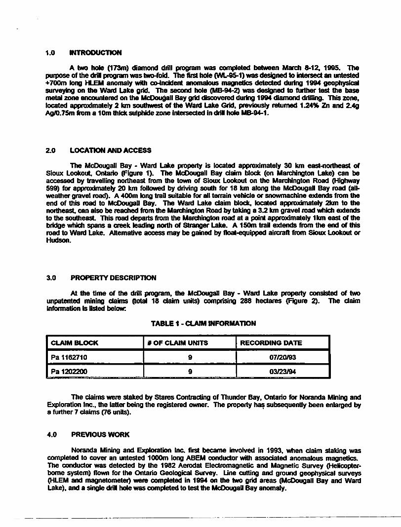
The McDougall Bay - Ward Lake property is located approximately 30 km east-northeast of Sioux Lookout. Ontario (Figure 1). The McDougall Bay daim block (on Marchington Lake) can be accessed by travelling northeast from the town of Sioux Lookout on the Marchington Road (Highway 599) for approximately 20 km followed by driving south for 18 km along the McDougall Bay road (all- weather gravel road). A 400m long trail suitable for all terrain vehicle or snowmachine extends from the end of this road to McDougall Bay. The Ward Lake daim block, located approximately 2km to the northeast, can also be reached from the Marchington Road by taking a 3.2 km gravel road which extends to the southeast This road departs from the Marchington road at a point approximately 1km east of the bridge which spans a creek leading north of Stranger Lake. A 150m trail extends from the end of this road to Ward Lake. Alternative access may be gained by float-equipped aircraft from Sioux Lookout or Hudson.
3.0 PROPERTY DESCRIPTION
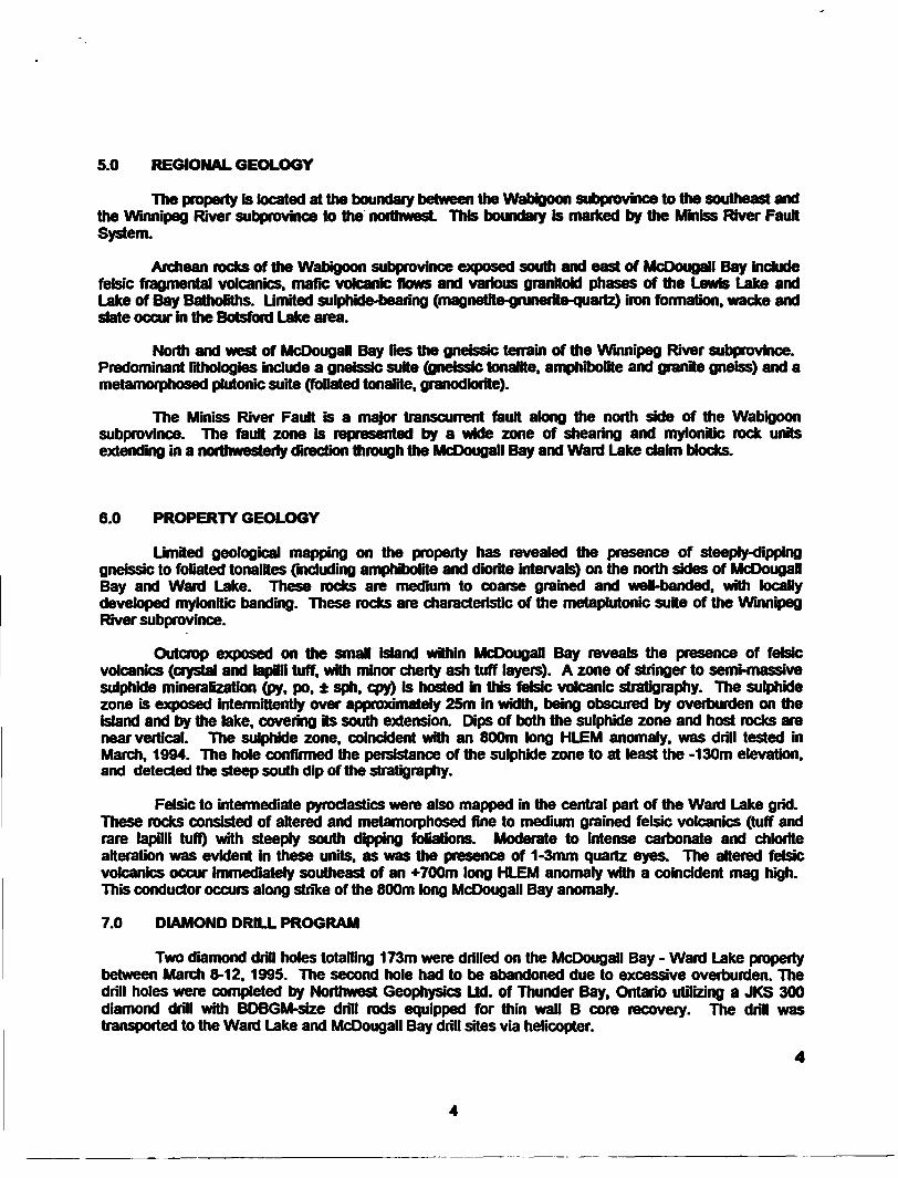
At the time of the drill program, the McDougall Bay - Ward Lake property consisted of two unpatented mining claims (total 18 daim units) comprising 288 hectares (Figure 2). The daim information is listed below:
TABLE 1 - CLAIM INFORMATION
CLAIM BLOCK
Pa 1162710
Pa 1202200
* OF CLAIM UNITS
9
9
RECORDING DATE
07/20/93
03723794
The claims were staked by Stares Contracting of Thunder Bay. Ontario for Noranda Mining and Exploration Inc.. the latter being the registered owner. The property has subsequently been enlarged by a further 7 claims (76 units).
4.0 PREVIOUS WORK
Noranda Mining and Exploration Inc. first became involved in 1993. when daim staking was completed to cover an untested 1000m long ABEM conductor with associated anomalous magnetics. The conductor was detected by the 1982 Aerodat Electromagnetic and Magnetic Survey (Helicopter- borne system) flown for the Ontario Geological Survey. Line cutting and ground geophysical surveys (HLEM and magnetometer) were completed in 1994 on the two grid areas (McDougall Bay and Ward Lake), and a single drill hole was completed to test the McDougall Bay anomaly.

49
MCDOUGALL WARD LAKE PROPERTY
*
Biudltlt
Fig 1
LOCATION MAP

N
60OO
O TOOMETRES
REVISED
FIG.2
PROJLNo.--
N.T.S.:
SCALE:
\"- ± ̂ . W
1000 2000 11 KM! (7 KM)
CLAIM LOCATION MAP
PROJECT'
mum MI, , oat t
nofondoMNNG AND EXPLORATION MC
5.0 REGIONAL GEOLOGY
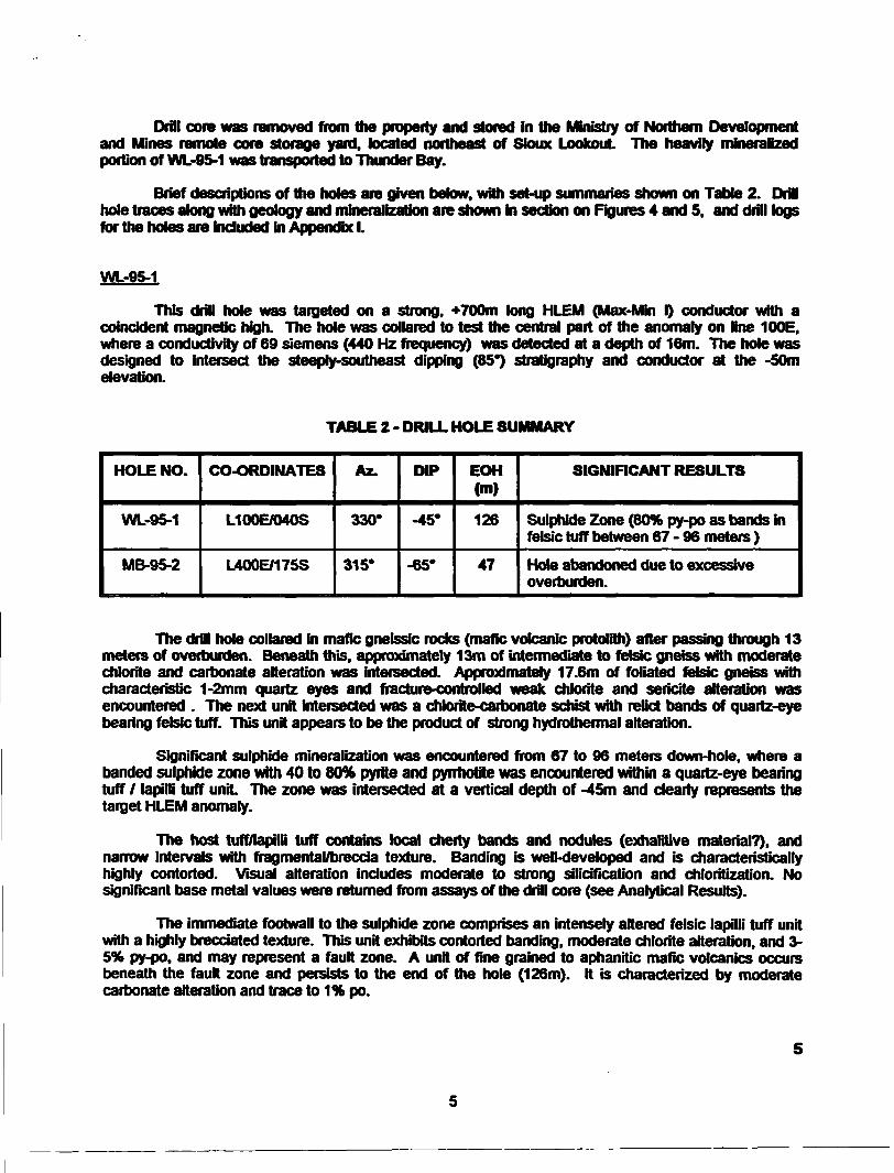
The property is located at the boundary between the Wabigoon subprovince to the southeast and the Winnipeg River subprovince to the northwest This boundary is marked by the Miniss River Fault System.
Archean rocks of the Wabigoon subprovince exposed south and east of McDougall Bay include felsic fragmental volcanics, mafic volcanic flows and various granitoid phases of the Lewis Lake and Lake of Bay Batholiths. Limited sulphide-bearing (magnetite-grunerite-quartz) iron formation, wacke and slate occur in the Botsford Lake area.
North and west of McDougall Bay lies the gneissic terrain of the Winnipeg River subprovince. Predominant lithologies include a gneissic suite (gneissic tonalite, amphibolite and granite gneiss) and a metamorphosed plutonic suite (foliated tonalite, granodiorite).
The Miniss River Fault is a major transcurrent fault along the north side of the Wabigoon subprovince. The fault zone is represented by a wide zone of shearing and mylonitic rock units extending in a northwesterly direction through the McDougall Bay and Ward Lake daim blocks.
6.0 PROPERTY GEOLOGY
Limited geological mapping on the property has revealed the presence of steeply-dipping gneissic to foliated tonalites (including amphibolite and diorite intervals) on the north sides of McDougall Bay and Ward Lake. These rocks are medium to coarse grained and well-banded, with locally developed mylonitic banding. These rocks are characteristic of the metaplutonic suite of the Winnipeg River subprovince.
Outcrop exposed on the small island within McDougall Bay reveals the presence of felsic volcanics (crystal and lapilli tuff, with minor cherty ash tuff layers). A zone of stringer to semi-massive sulphide mineralization (jpy. po. sph. cpy) is hosted in this felsic volcanic stratigraphy. The sulphide zone is exposed intermittently over approximately 25m in width, being obscured by overburden on the island and by the lake, covering its south extension. Dips of both the sulphide zone and host rocks are near vertical. The sulphide zone, coincident with an 800m long HLEM anomaly, was drill tested in March. 1994. The hole confirmed the persistance of the sulphide zone to at least the -130m elevation, and detected the steep south dip of the stratigraphy.
Felsic to intermediate pyroclastics were also mapped in the central part of the Ward Lake grid. These rocks consisted of altered and metamorphosed fine to medium grained felsic volcanics (tuff and rare lapilli tuff) with steeply south dipping foliations. Moderate to intense carbonate and chlorite alteration was evident in these units, as was the presence of 1-3mm quartz eyes. The altered felsic volcanics occur immediately southeast of an *700m long HLEM anomaly with a coincident mag high. This conductor occurs along strike of the 800m long McDougall Bay anomaly.
7.0 DIAMOND DRILL PROGRAM
Two diamond drill holes totalling 173m were drilled on the McDougall Bay - Ward Lake property between March 8-12,1995. The second hole had to be abandoned due to excessive overburden. The drill holes were completed by Northwest Geophysics Ltd. of Thunder Bay, Ontario utilizing a JKS 300 diamond drill with BDBGM-size drill rods equipped for thin wall B core recovery. The drill was transported to the Ward Lake and McDougall Bay drill sites via helicopter.
Drill core was removed from the property and stored in the Ministry of Northern Development and Mines remote core storage yard, located northeast of Sioux Lookout The heavily mineralized portion of WL-95-1 was transported to Thunder Bay.
Brief descriptions of the holes are given below, with set-up summaries shown on Table 2. Drill hole traces along with geology and mineralization are shown in section on Figures 4 and 5. and drill logs for the holes are included in Appendix l.
WL-9S-1
This drill note was targeted on a strong. *700m long HLEM (Max-Min O conductor with a coincident magnetic high. The hole was collared to test the central part of the anomaly on line 100E. where a conductivity of 69 Siemens (440 Hz frequency) was detected at a depth of 16m. The hole was designed to intersect the steeply-southeast dipping (BS") stratigraphy and conductor at the -50m elevation.
TABLE 2 - DRILL HOLE SUMMARY
HOLE NO.
WL-95-1
MB-95-2
CO-ORDINATES
L100E/040S
L400E/175S
Az.
330*
315*
DIP
-45*
-65*
EOH (m)
126
47
SIGNIFICANT RESULTS
Sulphide Zone (8W py-po as bands in felsic tuff between 67-96 meters )
Hole abandoned due to excessive overburden.
The drill hole collared in mafic gneissic rocks (mafic volcanic protolith) after passing through 13 meters of overburden. Beneath this, approximately 13m of intermediate to felsic gneiss with moderate chlorite and carbonate alteration was intersected. Approximately 17.6m of foliated felsic gneiss with characteristic 1-2mm quartz eyes and fracture-controlled weak chlorite and sericite alteration was encountered . The next unit intersected was a chlorite-carbonate schist with relict bands of quartz-eye bearing felsic tuff. This unit appears to be the product of strong hydrothermal alteration.
Significant sulphide mineralization was encountered from 67 to 96 meters down-hole, where a banded sulphide zone with 40 to WWfe pyrite and pyrrhotite was encountered within a quartz-eye bearing tuff l lapilli tuff unit The zone was intersected at a vertical depth of -45m and dearly represents the target HLEM anomaly.
The host tuff/lapilli tuff contains local cherty bands and nodules (exhalitive material?), and narrow intervals with fragmental/breccia texture. Banding is well-developed and is characteristically highly contorted. Visual alteration includes moderate to strong silicification and chloritization. No significant base metal values were returned from assays of the drill core (see Analytical Results).
The immediate footwall to the sulphide zone comprises an intensely altered felsic lapilli tuff unit with a highly brecciated texture. This unit exhibits contorted banding, moderate chlorite alteration, and 3- 5*K py-po. and may represent a fault zone. A unit of fine grained to aphanitic mafic volcanics occurs beneath the fault zone and persists to the end of the hole (126m). It is characterized by moderate carbonate alteration and trace to 1** po.
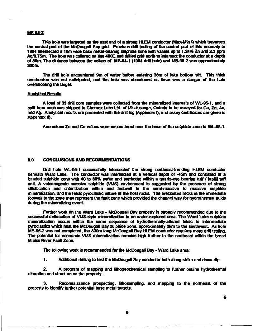
MB-9S-2
This hole was targeted on the east end of a strong HLEM conductor (Max-Min O which travers the central part of the McOougall Bay grid. Previous drill testing of the central part of this anomaly in 1994 intersected a 10m wide base metal-bearing sulphide zone with values up to 1.24% Zn and 2.3 pom Agfl).75m. The hole was collared on Ine 400E and driled grid north to intersect the conductor at a depth of 38m. The distance between the coflars of MB-94-1 (1994 dril hole) and MB-95-2 was approximately 300m.
The drill hole encountered 9m of water before entering 38m of lake bottom sflL This thick overburden was not anticipated, and the hole was abandoned as there was a danger of the hole overshooting the target
Analytical Results
A total of 33 drill core samples were collected from the mineralized intervals of WL-95-1. and a split from each was shipped to Chemex Labs Ltd. of Mississauga. Ontario to be assayed for Cu. Zn, Au. and Ag. Analytical results are presented with the drill tog (Appendix F). and assay certificates are given in Appendix 10.
Anomalous Zn and Cu values were encountered near the base of the sulphide zone in WL-95-1.
8.0 CONCLUSIONS AND RECOMMENDATIONS
Drill hole WL-95-1 successfully intersected the strong northeast-trending HLEM conductor beneath Ward Lake. The conductor was intersected at a vertical depth of -45m and consisted of a banded sulphide zone with 40 to 80"* pyrite and pyrrhotite within a quartz-eye bearing tuff l lapilli tuff uniL A volcanogenic massive sulphide (VMS) environment is suggested by the presence of strong silicification and chloritization within and footwall to the semi-massive to massive sulphide mineralization, and the felsic pyroclastic nature of the host rocks. The brecciated rocks in the immediate footwall to the zone may represent the fault zone which provided the channel way for hydrothermal fluids during the mineralizing event
Further work on the Ward Lake - McDougall Bay property is strongly recommended due to the successful delineation of VMS-style mineralization in an under-explored area. The Ward Lake sulphide mineralization occurs within the same sequence of hydrothermally-altered felsic to intermediate pyroclastics which host the McDougall Bay sulphide zone, approximately 2km to the southwest As hole MB-95-2 was not completed, the 800m long McDougall Bay HLEM conductor requires more drill testing. The potential for economic VMS mineralization remains high further to the northeast within the broad Miniss River Fault Zone.
The following work is recommended for the McDougall Bay - Ward Lake area:
1. Additional drilling to test the McDougall Bay conductor both along strike and down-dip.
2. A program of mapping and lithogeochemical sampling to further outline hydrothermal alteration and structure on the property.
3. Reconnaissance prospecting, lithosampling. and mapping to the northeast of the property to identify further potential base metal targets.
6
6

Respectfully!
O^ 4NORANDA MINING AND EXPLORATION INC.
Al Smith Reg FelixTliunder Bay. Ontario Project Geologist ST. GeologistMarch 8.1996 Western Canada Region Western Canada Region

APPENDIX l
DIAMOND DRILL LOGS
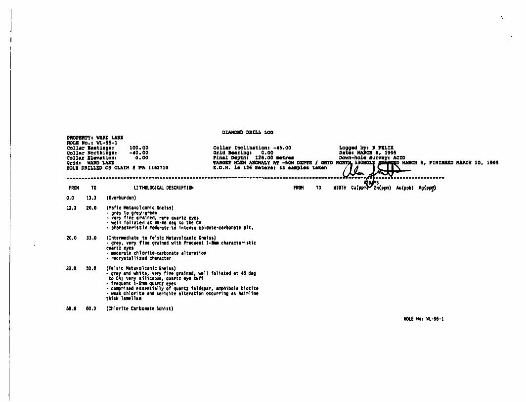
PROPERTY: WARD LAKEHOLE NO.l WL-95-1Collar Eastings: 100.00Collar Northings i -40.00Collar Elevation: 0.00Oridt WARD LAKEHOLE DRILLED ON CLAIM # PA 1162710
DIAMOND DRILL LOO
Collar Inclinationt -45.00 Orid Bearingi 0.00 Final Depth! 126.00 HMtrMTARGET HLEM ANOMALY AT -50M DEPTH l GRID NORTH* 330E E.O.K. li 126 meters; 3 3 sample* taken
Logged byi R FELIX Datei MARCH 8, 1995 Down-hole Survey: ACID
FROM TO LITHOLOGICAL DESCRIPTION
MARCH 8, FINISHED MARCH 10, 1995
FROM TO WIDTH Cu(ppmFzn(ppm) Au(ppb) Ag(ppot)
0.0 13.3 (Overburden)
13.3 20.0 (Mafic Metavolcanic Gneiss)- grey to grey-oreen- very fine grained, rare quartz eyes- well foliated at 40-45 deg to the CA- characteristic moderate to Intense epldote-carbonate alt.
20.0 33.0 (Intermediate to Felsic Hetavolcanlc Gneiss)- grey, very fine grained with frequent l-Bun characteristic quartz eyet- moderate chloHte-carbonate alteration- reerystalll zed character
33.0 50.0 (Felsic Hetavolcanlc Gneiss)- grey and white, very fine grained, well foliated at 45 deg to CA; very siliceous, quartz eye tuff
- frequent l-2mm quartz eyes- comprised essentially of quartz feldspar, amphibole biotite- weak chlorite and sericite alteration occurring as hairline thick lamellae
50.6 60.0 (Chlorite Carbonate Schist)
HOLE No: WL-95-1

PROPERTY! WARD LAKE HOLE No.i WL-95-1
DIAMOND DRILL LOO
Pag* 2
FROM TO LITHOLOGICAL DESCRIPTION
- very fine grained, greenlih-black and white; highly contorted and variable banding- well foliated at 30-49 deg to CA- Intense chlorlte-carbonate alteration- occasional quartz-feldspar segregations and velnlng
80.0 64.0 (Felsic Metavolcanlc/Quartz Eye Tuff)- similar to 33-50.6- highly variable banding at 20-45 deg to CA but generally 40-45 deg to the CA
64.0 67.0 (Quartz-Chlorlte-Carbonate Schist)- finely banded with up to lcm wide pyrite bands- generally mineralized with finely disseminated and banded pyrite S-10%, locally 20-354 at 64.5-65.5- highly variable and contorted banding from 0-45 deg to CA
67.0 96.0 (Sulphide Zone)67.0 72.0 banded sulphide lapilli tuff; quartz-chlorlte- pyrlte-- very- 40-504 pyrlte-pyrrhotlte, 1-24 magnetite72.0 89.5 quartz-ch1or1te-pyrite*y-pyrrhot1te breccia- characteristically white and green, highly contorted banding and chloritic fragments throughout- 50-604 pyrite-pyrrhotite, traces of magnetite 69.5 93.0 quartz sulphide lapilli tuff- 70-604 banded pyrlte+Apyrrhotlte at 50-60 deg to CA
e-pyrrhotite schlst/laptlll tuffy siliceous with several cherty bands and nodules
FROM TOASSAYS
WIDTH Cu(ppm) Zn(ppm) Au(ppb) Ag(ppm)
64.0065.0066.00
67.0068.0009.0070.0071.0072.0073.0074.0075.0076.0077.00
65.0066.0067.00
68.0060.0070.0071.0072.0073.0074.0075.0076.0077.0078.00
1.001.001.00
.00
.00
.00
.00
.00
.00
.00
.00
.00
.00
.00
57.00042.00028.000
62.00045.00083.00081.00056.00052.00061.00068.00070.00042.00046.000
68.00080.000152.000
78.00071.000
148.000100.000108.00097.000105.000100.00088.000120.00082.000
10.0005.000TRACE
19.00010.00015.00010.000TRACE
20.00010.00015.00020.00015.00015.000
TRACETRACETRACE
TRACETRACETRACETRACETRACETRACETRACETRACETRACETRACETRACE
HOLE No: WL-95-1

PROPERTY l WARD LAXB HOLE No.t WL-95-1
DIAMOND DRILL LOO
Pag* 3
FROM TO LITHOLOGICAL DESCRIPTION FROM
- grey to grey-green 78.0093.0 96.0 same as before 79.00- fragmental /breed a texture with siliceous fragments up to 80.002cm In size 81.00- 13-20* pyrlte-pyrrhotlte 82.00
83.0084.0085.0086.0087.008B.OO89.0090.0091.0092.0093.0094.0095.00
TO WIDTH
79.00 1.0080.0061.0082.0083.0084.0085.0086.0087.0088.0089.0090.0091.0092.0093.0094.0095.0096.00
.00
.00
.00
.00
.00
.00
.00
.00
.00
.00
.00
.00
.00
.00
.00
.00
.00
ASSAYS Cu(ppm) Zn(ppm)
1 52.00024.00057.00072.00036.00028.00023.00020.00048.00030.00039.00040.00071.00044.00070.00081.00029.000112.000
92.00063.00041.00074.00095.00086.000104.00070.000
154.000140.00095.00056.000152.000166.000144.000230.00065.000154.000
Au(ppb)
10.0005.000
35.00025.00010.00010.0005.000TRACE15.000TRACE5.00015.00040.00015.00010.00010.000TRACE15.000
Ag(ppm)
TRACETRACETRACETRACETRACETRACETRACETRACETRACETRACETRACETRACETRACETRACETRACETRACETRACETRACE
96.0 69.0 (Intensely Altered Felsic Lapilli Tuff/Breccia)- possible fault zone- grey to grey-gree- very fine grained with occasional siliceous fragments- schistose at 50-60 deg to CA but occasionally exhibits contorted banding- 3-5* disseminated and blebs of pyr1te-pyrrhot1te
gg.O 126.0 (Mafic Hetavolcanlc)
96.00 97.00 1.00 46.000 N.A. TRACE TRACE
HOLE No: WL-95-1

PROPERTY: WARD LAKE HOLE No.l WL-95-1
DIAMOND DRILL LOO
Pag* 4
FROM TO LITHOLOGICAL DESCRIPTION
- flnt grained to aphanitic- massive to wMkly foliated- moderate carbonate alteration local at brecciated sections at gg-101, 107-108, 119-126- tr-1% pyrrhotite
Core stored In Sioux Lookout at MNOM core storage
126.0 END OF HOLE
DOWN-HOLE SURVEY DATA
DEPTH INCLINATION BEARING
126.00 -45.00 0.00
FROM TOASSAYS
WIDTH Cu(ppra) Zn(ppm) Au(ppb) Ag(ppm)
HOLE No: WL-95-1
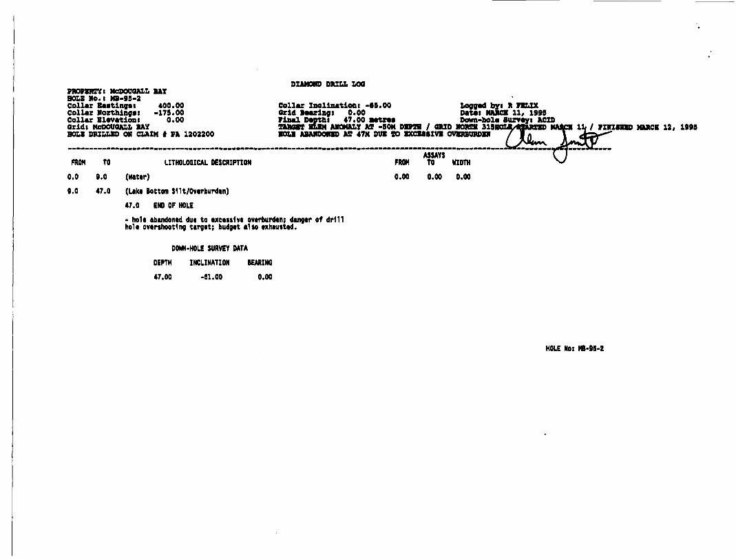
PROPERTY t MODOUQALL BAY HOLE NO.l NB-93-2Collar Bastingsi 400.00Collar Northingsi -179.00Collar Elevationi 0.00Oridl MODOUQALL BAYBOLE DRILLED ON CLAIM f PA 1202200
DIAMOND DRILL LOO
Collar Inclinationt -65.00 Logged by i R FBLIX Orid Bearlngt 0.00 Dataii MARCH 11, 1993 Final D*ptht 47.00 natTM Down-hole) Surveys ACID TARGET BUM ANOMALY AT -SON DEPTH l GRID NORTH 313BOLI BOLE ABANDONED AX 47M DUB TO BXCBMIVE OV1
FROM TO LITHOLOQICAL DESCRIPTION
0.0 0.0 (Water)
g.O 47.0 (Lake Bottom Silt/Overburden)
47.0 END OF HOLE
- hole abandoned due to excessive overburden; danger of drill hole overshooting target; budget also exhausted.
DOWN-HOLE SURVEY DATA
DEPTH INCLINATION BEARING
47.00 -61.00 0.00
FROM
0.00
ASSAYSTO WIDTH
0.00 0.00
FINISHED MARCH 12, 199S
HOLE No: HB-9S-2

APPENDIX II
SAMPLE ANALYSIS SHEETS

Chemex Labs Ltd,Analylloil CtwmWi * GwcramWi' RcgMtrad Atuym
6176 Tlmberlea Blvd., MiaslasaugaOntario, Canada UW 283PHONE: 905-624-2806 FAX: 906-624-6163
To: NORANDA MINING AND EXPLORATION INC.
960 ALLOY DRIVE THUNDER BAY, ONTARIO P7B6A4
Project: 336Comment* ATTN: REQ FELIX
Page Number : 1 Total Pages :1 Certificate Date: 23-MAR-95 Invoice No. : 19513646 P.O. Number :TB10136 Account : BUF
CERTIFICATE OF ANALYSIS A951 3646
SAMPLE
32(938 64-65B33*939 65-66m336940 66-67m326941 67-68m336942 68-69B
33C943 69-70B336944 70-71B336945 71-73B336946 72-73a336947 7 3 -74m
336948 74-7SB336949 75-76B336950 76-77B77-7BB78-79m
79-eOmBO-81B81-83m82-83B83-84m
B4-85BB6-B6B86-B7B87-88*88-89m
B9-90B90-91B91-92a92-93B93-94a
94-95B95-96B96-97a
PREPCODE
305305305305305
305305305305305
305205305305305
305305305305305
305305305305305
305305305205305
305305305
336336336336236
336336236236226
236226226226226
236226226226226
226226226226226
226226226236336
336336336
Au ppbFA+AA
105
* 51510
1510
< 53010
1530151510
535351010
5< 5
15< 5
5
1540151010
< S15
< 5
CUppB
5743386345
8381565361
6870424653
3457733638
2320483039
4071447081
29112
46
znppm
6880
1527871
148100108
97105
10088
120103
82
9263417495
86104
70154140
9556
153166144
33065
154
Ag ppmAqua R
0.30.30.20.20.2
0.20.20.20.20.2
0.20.20.2
< 0.2< 0.2
< 0.2< 0.2< 0 .2< 0.2< 0.2
< 0.2x 0.2< 0 .2< 0.2K 0.2
< 0.2< 0.2< 0 .2< 0.2< 0.2
< 0.2< 0.2< 0.2
CERTIFICATION^!

Chemex Labs Ltd.Analytical ChamMa * Qaochamlata *
5175 Timbariaa Blvd., Ontario, Canada
agMaMiaalaaauga
\^IIIMIV, WOliaVNI WW 2S3
PHONE: 906-624-2806 FAX: 905-624-6163
To: NORANDA MINING AND EXPLORATION INC.
960 ALLOY DRIVE THUNDER BAY, ONTARIO P7B6A4
Comments: ATTN: REG FELIX
3l .^9513646
CERTIFICATE A9513646
(BUF) - NORANDA MINING AND EXPLORATION INC.
Project 336 P.O. #: TB10136
•enplea auhmltted to our lab in Vancouver/ Thia report waa printed on 23-MAR-95.
SAMPLE PREPARATION
W20122C231
tun333333
DESCRIPTION
QeoeheB ring to approx ISO aaeh0-3 Kg oruah and aplit itrio-mqua-regia, digeetion
ANALYTICAL PROCEDURES
CHEMEX CODE
100 2 S t
NUMBERSAMPLES!
33333333
DESCRIPTION METHOD
Au ppbt FUM 10 g MUttjie FA-AAICu ppBi HN03-*qu* regi* digeatIn ppau HM03-equ* regie, digeatAg ppau HM03-e.qum regie, digeat AM-BKQD com
DETECTION LIMIT
Sl l
0.2
UPPER LIMIT
100001000010000100.0
(X,

APPENDIX III
LIST OF PERSONNEL
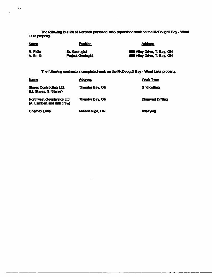
The following is a list of Moranda personnel who supervised work on the McOougall Bay - Ward Lake property.
Name Position Address
R. Felix ST. Geologist 960 AHoy Drive. T. Bay, ON A. Smith Project Geologist 960 Alloy Drive, T. Bay. ON
The following contractors completed work on the McDougall Bay - Ward Lake property.
Name Address Work Type
Stares Contracting Ltd. Thunder Bay. ON Grid cutting (M. Stares. S. Stares)
Northwest Geophysics Ltd. Thunder Bay. ON Diamond Drilling (A. Lambert and drill crew)
Chemex Labs Mississauga. ON Assaying
Ministry ofNorthern Developmentand Mines
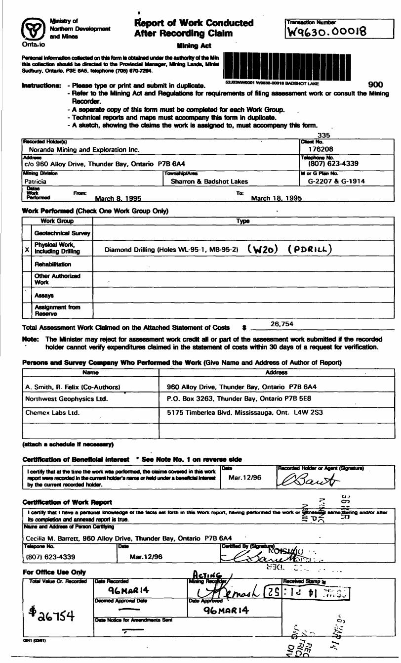
Report of Work Conducted After Recording Claim
TB^w^a^KdrftWaK UB B^idk^iwiraraaction rauinoof
Onta.io Mining Act
Personal Information coftacted on this formtoobtalrieduno^theaiitlwrityoftheMin this oollsctiof) should bo directed to ths Provflncefll MSIMQOT, MMnQ Lsnds, Sudbury. Ontario. P3E SA5. telephone (705) 670-72S4.
Instructions: - Please type or print and submit in duplicate. "OO- Refer to the Mining Act and Regulations for requirements of filing assessment work or consult the Mining
Recorder.- A separate copy of this form must be completed for each Work Group.- Technical reports and maps must accompany this form in duplicate.- A sketch, showing the claims the work is assigned to. must accompany this form.
335Recorded HoUar(a)
Noranda Mining and Exploration Inc.Addien c/o 960 Alloy Drive, Thunder Bay, Ontario P7B 6A4Mining Dnriann
Patricia
Work From: Pwtomied March 8. 1995
Township/Area
Sharron ft Badshot Lakes
Client No. 176208
Ta lain final n *̂ * i6Mpnon0 NO.(807) 623-4339
M or G Plan No. G-2207 S G-1914
March 18. 1995
Work Performed (Check One Work Group Only)WorkGroup
X
Geotechnical Survey
Physical Work. Including Drilling
Rehabilitation
Other Authorized Work
Assays
Assignment fromrieservo
Type
Diamond Drilling (Holes WL-95-1 , MB-95-2) ( W2o) ( P D* ILL)
Total Assessment Work Claimed on the Attached Statement of Costs 26.754
Note: The Minister may reject for assessment work credit all or part of the assessment work submitted if the recorded holder cannot verify expenditures claimed in the statement of costs within 30 days of a request for verification.
Persons and Survey Company Who Performed the Work (Give Name and Address of Author of Report)Name
A. Smith. R. Felix (Co- Authors)
Northwest Geophysics Ltd.
Chemex Labs Ltd.
Address
960 Alloy Drive, Thunder Bay. Ontario P7B 6A4
P.O. Box 3263. Thunder Bay. Ontario P7B 5E8
5175 Timberlea Blvd. Mississauga. Ont. L4W 2S3
(attach a schedule If necessary)
Certification of Beneficial Interest * See Note No. 1 on reverse side
1 certify that at the time the work was performed, the claims covered in this work report were recorded in the currant holder's name or held under a beneficial interest
Data
Mar. 12/96
Recorded Holder or Agent (Signature)
^^D^^-f^^~~
Certification of Work Report ^ m1 certify that l have a personal knowkits completion and annexed report is
*dge of the facts eat forth in this Work repc true. Vf- ^
Name and Address of Pereon Certifying
Cecilia M. Barrett. 960 Alloy Drive. Thunder Bay, Ontario P7B 6A4TetaponeNo.
(807) 623-4339
Date
Mar. 12/96 ^jSsfc...For Office Use Only
0241(09*1)
Uetai is tor uonc Kepon f
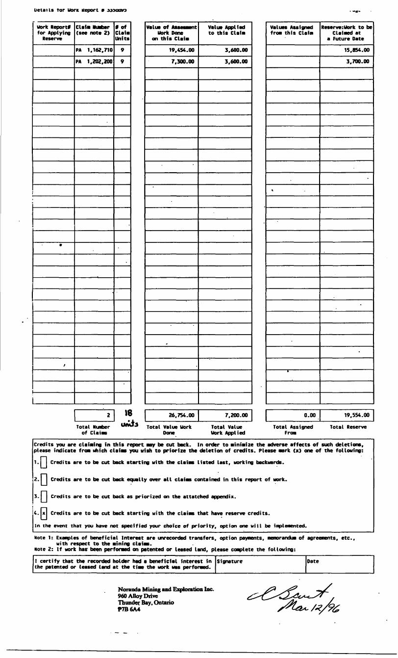
work Report* for Applying Reserve
*
i
Claim Number (see note Z)
PA 1,162,710
PA 1,202,200
2
Total Number of Claims
t of Claim Units
9
9
-
.
18 umfo
Value of Auesment work Done
on this Claim
19.454.00
7.300.00
f
Value Applied to this Claim
3.600.00
3.600.00
26.7S4.00 7.200.00
Total Value Work Total Value Done work Applied
-
Values Assigned from this Claim
\
ft
Reserve:Uork to be Claimed at
a Future Date
15,854.00
3.700.00
-
-
-
0.00 19.554.00
Total Assigned Total Reserve From
Credits you are claiaring in this report may be cut back. In order to minimize the adverse affects of such deletions, please indicate fro* which claias you wish to priorize the deletion of credits. Please mark (x) one of the following:
1.1 Credits are to be cut back starting with the claims listed last, working backwards.
2.1 1 Credits are to be cut back equally over all claias contained in this report of work.
3.1 Credits are to be cut back as prior i zed on the attatched appendix.
4. x Credits are to be cut back starting with the claims that have reserve credits.
In the event that you have not specified your choice of priority, option one will be iiqplenented.
Mote 1: Examples of beneficial Interest are unrecorded transfers, option payments, memorandua of agreements, etc..with respect to the mining claims.
Note 2: If work has- been performed on patented or leased land, please complete the following:
I certify that the recorded holder had a beneficial interest in the patented or leased land at the time the work was performed.
Signature Date
Noranda Mining and Exploration Inc. 960 Alloy Drive Thunder Bay. Ontario P7B6A4
Ontaro
Ministry ofNorthern Developmentand Mines
Ministere du Oevetoppement du Nord et des mines
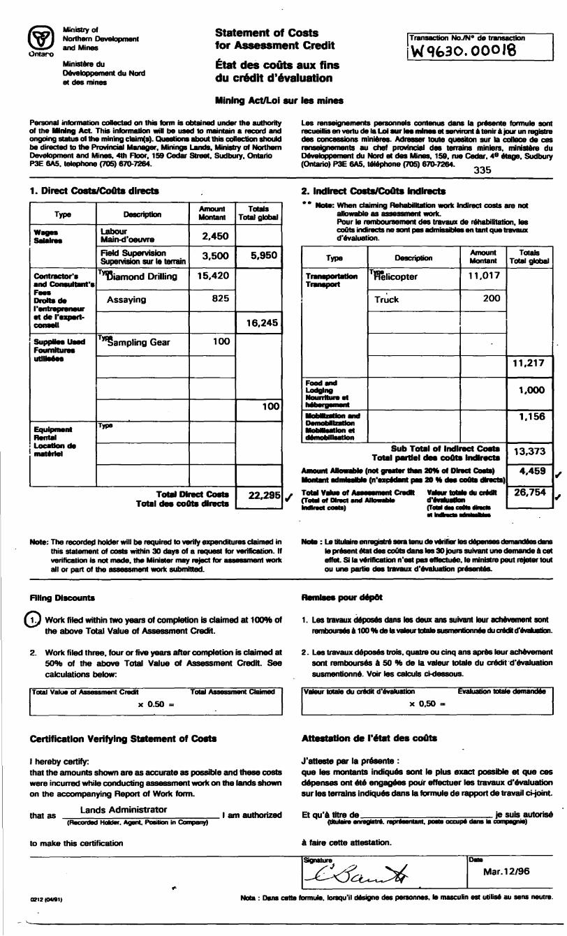
Statement of Costs for Assessment Credit
Etat des couts aux fins du credit devaluation
Mining Act/Loi sur les mines
Transaction NoJN" de transaction
Personal information collected on this form is obtained under the authority of the Mining Act. This information will be used to maintain a record and ongoing status of the mining clainXs). Questions about this collection should be directed to the Provincial Manager. Minings Lands. Ministry of Northern Development and Mines. 4th Floor. 159 Cedar Street. Sudbury. Ontario P3E GAS. telephone (705) 670-7264.
Les renseignements personnels contenus dans to presente fbrmuto sont recueillis en vertu de la Loi sur tos mines et senriront a. tenir a jour un registre des concessions minieres. Adresser touta quesiton sur la coitoce de ces renseignements au chef provincial des terrains mintors. ministere du Devetoppement du Moid et des Mines. 159. me Cedar. 4* etage. Sudbury (Ontario) P3E 6A5. telephone (705) 670-7264.
O O i)
1. Direct Costs/CoQts directs
Type
Wagea SaJalree
Contractor's and Consultant's Fees Drafts de ( entrepreneuret de I'expert- consell
SuppHesusad FoumNures utMsses
Equipment RentalLocation (to
Description
Labour Main-d'oeuvre
Reid Supervision Supervision sur le terrain
TyiBiamond Drilling
Assaying
"Sampling Gear
Type
Amount Montant
2,450
3,500
15,420
825
100
Total Direct Costs Total des coots directs
Totals Total global
5,950
16,245
100
22,295
2. Indirect Costs/CoQts indirects* * Note: When claiming Rehabilitation work Indirect costs are not
allowable as assessment work.Pour to remboursement des travaux de rehabilitation, tos couts indirects ne sont pas admissibtos en taut qua travaux d'evaluation.
Type
Transportation Transport
Food snd Lodging Nourrttureet
MobHtoatlon et demobilisation
Description
Helicopter
Truck
Amount Montant
11,017
200
Sub Total of Indirect Costs Total partlel des couts Indirects
not greater than 209k of Direct Costs) (n'sxcfdaiit pas 20 H des couls directs)
(ToW of Direct and Allowable d'tvataaHo bvflraet coatsl rTaM du tt
to du credit m
Totals Total global
11,217
1,000
1.156
13.373
4,459
26.754
The recorded holder will be required to verify expenditures claimed in this statement of costs within 30 days of a request for verification. If verification is not made, the Minister may reject for assessment work all or part of the assessment work submitted.
: Le tilt age i tenu de verifier tos deto present etat des couts dans tos 30 jours suivant une demande a cet effet. Si to verification n'est pas effectuee. to ministre peut retoler tout ou une partto des travaux d'evaluation presentes.
Filing Discounts pour depot
1J Work filed within two years of completion is claimed at lOOTb of the above Total Value of Assessment Credit.
1. Les travaux deposes dans les deux ans suivant tour achievement sont rembourses a 100 "Mi de la vateur tolato susmenbonnee du crooH d'evaluation.
2. Work filed three, four or five years after completion is claimed at 50*fc of the above Total Value of Assessment Credit. See calculations below:
Total Value of Assessment Credit Total Assessment Claimed
x 0.50
2. Les travaux deposes bois, quatre ou cinq ans apres leur achevement sont rembourses a 50 to de la valeur totale du credit d'evaluation susmentionne. Voir tos calculs ckJessous.
Valeur tolato du credit d'evaluation
x 0.50 ~
Evaluation totato demandte
Certification Verifying Statement of Costs Attestation de I'etat des couts
l hereby certify:that the amounts shown are as accurate as possible and these costs were incurred while conducting assessment work on the lands shown on the accompanying Report of Work form.
Lands Administratorthat as
(He ir. Agent. Position in Company)
J'atteste par la presente :que les montants indiques sont le plus exact possible et que ces depenses ont ete engagees pour effectuer les travaux d'evaluation sur les terrains indiques dans la formula de rapport de travail ci-joint.
l am authorized Et qu'a litre de(tftulaire anregjsM. reprteantant. poste occupa dans to
suis autorise pagnie)
to make this certification a faire cette attestation.
Signature
0212 IOM1)
Mar. 12/96
Note : Dans cette formuto. lorequ'il designe des personnes. to masculin est utilise au sens neutre.

FOREST ACTIVITY INFORMATIONTHIS TOWNSHIP/AREA FALLS WITHIN THE
RT-t Cf CNR TRACKS
FOREST ACTIVITY INFORMATIONTHIS TOWNSHIP/AREA FALLS WITHIN THE SOUTH OF CNR TRACKS
KIMMEWIN LAKE G-2090At- .'J REC 9I 0 30'
AND MAY BE SUBJECT TO FORESTRY OPERATIONS THE M N.R UNIT FORESTER FOR THIS AREA CAN BE CONTACTED AT
P O BOX 309SIOUX LOOKOUT. ONTARIO POV2TO(807)737-1140
AND MAY BE SUBJECT TO FORESTRY OPERATIONS THE M N R UNIT FORESTER FOR THIS AREA CAN BE CONTACTED AT
PO BOX 309SIOUX LOOKOUT. ONTARIO POV 2TO(807)737-1140
9I 0 I5'
50 0 I5' i
O CVJ CVJ
l
O
UJ
Ottcr <C/)
THE INFORMATION THAT APPEARS ON THIS MAP HAS BEEN COMPILED FROM VARIOUS SOURCES, AND ACCURACY IS NOT GUARANTEED. THOSE WISHING TO STAKE MIN ING CLAIMS SHOULD CON SULT WITH THE MINING RECORDER. MINISTRY OF NORTHERN DEVELOP MENT AND MINES, FOR AD DITIONAL INFORMATION ON THE STATUS OF THE LANDS SHOWN HEREON
50 W SO'1-1
-50 0 I5'
14
13
12'
V
10'
l—50 0 07'30"
9I 0 30'29' 27' 26' 25' 24' 23' 22' 21' 20 19 IB' 17' 16' l9I 0 I5'
Do LAU.Z
502912
LEGEND
r-'.
HIGHWAY AND ROUTE No
OTHER ROADS
TRAILS
SURVEYED LINESTOWNSHIPS, BASE LINES, ETCLOTS, MINING CLAIMS, PARCELS, ETC
UNSURVEYED LINESLOT LINESPARCEL BOUNDARYMINING CLAIMS ETC
RAl LWAY AND RIGHT OF WAY *
UTILITY LINES
NON-PERENNIAL STREAM
FLOODING OR FLOODING RIGHTS
SUBDIVISION OR COMPOSITE PLAN
RESERVATIONS
ORIGINAL SHORELINE
MARSH OR MUSKEG
MINES
TRAVERSE MONUMENT REMOTE TOURIST SET-UP
DISPOSITION OF CROWN LANDS
TYEE OF DOCUMENT SYMBOLPATENT. SU RF ACE 6 MINING RIGHTS-;——....Jfe.er 0
" .lURFACE RIGHTS ONLY.____._......__ 6" .MINING RIGHTS ONLY___......-......__. O
LEASE,SURFACE 6 MINING RIGHTS————....,™. B" .SURFACE RIGHTS ONLY._.... ............m B
" .MINING RIGHTS ONLY............... ......_. O
LICENCE OF OCCUPATION .._............. ......... TORDER-IN-COUNCIL -._..............————.......,.. OCRESERVATION __-———————..................m (*)CANCELLED ___———.__——.———.,............ 9SAND ft GRAVEL .......,..._........................... (J)REMOTE COTTAGE__________ MOTE: MINING RIGHTS IN PARCELS PATENTED PAlOft TO MAVS
1013. VESTED IN ORIGINAL PATENTEE *Y THE PUBLIC LANDS ACT, R S.O 1970, CHAP MO, SEC S3. SUSS t C 1
REFERENCESAREAS WITHDRAWN FROM DISPOSITION
M.R.O. -MINING RIGHTS ONLY
t.R.O. -SURFACE RIGHTS ONLY
M.+ S.-f INING AND SURFACE RIGHTS
Description ^*d*r Ne Data Owpecition
sec ss/soSEC 36/80
W Si/**
wIt/ll/ttl? /l 1/82
H U S
MAS
FOREST ACTIVITY INFORMATIONTHIS TOWNSHIP/AREA FALLS WITHIN THE
ABITIBI BLOCK#9 FOREST MGT. UNITAND MAY BE SUBJECT TO FORESTRY OPERATIONS THE M N R UNIT FORESTER FOR THIS AREA CAN BE CONTACTED AT
P O BOX 309SIOUX LOOKOUT, ONTARIO POV 2TO(607)737-1140
SCALE: 1 INCH * 40 CHAINS
FEETO 1000 2OOO 4000 6OOO
O 200 METRES
100011 KM)
2000(7 KM)
AREA
BADSHOT LAKEM.N.R. ADMINISTRATIVE DISTRICT
SIOUX LOOKOUTMINING DIVISION
PATRICIALAND TITLES/ REGISTRY DIVISION '
KENORAMinistryof und Natural ~
K
S2J03NW0001 W0630.Q0018 BADSHOT UAKE 200
CO
CO
l
•lo V-
HOLGER LAKE AREA G*2O69•1*48' 9I 0 30*
80*18' —
137*1.20(3)
94MAR23 REG
O IT 12/98 R
UJ
-J
ft O
14'
13'
12'
^-._l
BLOCK
1202143
r- 500 I5'
O)i o
yj
II' *
(O O
10'
MNR ORAVEL PIT N9 IF -22
MNR ORAVEL PIT Nf 90 FILE 179728
MTC ORAVEU PIT Nf IP-26
MTC GRAVEL PIT N0 IF-25
DREST ACTIVITY INFORMATIONIS TOWNSHIP/AREA FALLS WITHIN THE
;ROWN FORCGT MGT. UNr
9'THE INFORMATION fHA APPEARS On THIS MAP HAS BEEN COMPILED FROM VARIOUS SOURCES AND ACCURACY IS NOT GUARANTEED THOSE WISHING TO STAKE MIN ING CLAIMS SHOULD CON SULT WITH THE FINING RECORDER, MINISTRY OF NORTHERN DEVELOP MENT AND MINES, FOR AD DITIONAL INFORMAT'ON ON THE STATUS OF THE.AN OS SHOWN HEREON8'
80 0 OT'80"
tt***' SO1
ZARN LAKE AREA 6-2277
0 QUARRY PERMIT
ORAVEL
SAND AND GRAVEL
DCMAY BE SUBJECT TO FORESTRY OPERATIONS E M N R. UNIT FORESTER FOR THIS AREA CAN BE NJACTEDAT
P O BOX 309SIOUX LOOKOUT. ONTARIO POV2TO(807)737-1140
LEGEND
PATENTED LAND CROWN LAND SALELEASES •S"-*i*u*LOCATED LANDLICENSE OF OCCUPATIONMINING RIGHTS ONLYSURFACE RIOHTS ONLYROADSIMPROVED ROADSKttttt HIGHWAYSRAILWAYSPOWER LINESMARSH OR MUSKtS S3?CANCELLEDREMOTE COTTAGE
REFERENCESWltHOftAWN FROM DISFOSfROei
M.R.O. - MINING RIGHTS ONLYM.Q. - SURFACE RIGHTS ONLYH.+ t. - MINING AND SURFACE* RIGHTS
(5) SEC 43/70 W 24/78 IS/5/78 S ft O I7972S*
FLOODINGLAC SEUL RESERVING RIGHT TO FLOOD
AND OVERFLOW TO CONTOUR ELEV. 1172
FILE 149.90
SCALE; 11NCH - 40CHAINS
ftfT9__1C
e aoeMiTMM M KM) KM)
MM
SHARRON LAKEH.M.R. AMHItMMTm
SIOUX LOOKOUT•HIM 8IVMIM
PATRICIAtAM TITLU/ IHISTIIT 8l*ltlMKENORA
Ministry of Land
FEBRUARY . 1964
Gr2207
COen
-, 30:2
2 *- m 00
^^o w 22 o g^ 30
52J03NW0001 W9830-00018 BADSHOT LAKE
i' 1
210

iOOE
inwS Oin
WL-95-1e-
o o
NW
N
-25
OVERBURDEN
Mafic Hetavolcanic Gneiss
Intermediate to Felsic Metavolcanic Gneiss
-25
-50
-75
-100
Felsic Metevolcanic Gneiss
Ihlorite - Carbonate Schist
Quartz Eye TuffQuartz Chlorite Cartonate Schist 15-10X py)
Banded luartz Chlorite Py Po (40-81K) Lapilli Tuff
Intensely Altered Fels
Mafic Metavolcanic
-Sin
c Breccia (3-5X py-po)
-50
-75
Figure 4
26.00 n. tL-95-1
-100
NORANDA MINING AND EXPLORATION
325 - MARCHINGTON
SECTION IOOE
NL-9S-1 KAflO LAKE MIO
l C* * 1(0 M* it
DATE m/n/tt l iOLt 1/900
J03NW0001 W9830-00018 BADSHOT LAKE 220

o o(V
to in W Oin
400EMB-95-2
-25
-50
-75
OVERBURDEN(S
47.(O m. MB-!5-2
LT-MUDI
52J03NW0001 W9630.00016 BADSHOT LAKE 230
in in t\jw o o
in in in o in
\
NW
400E
N
FigureS
-25
-50
-75
NOflANDA MINING AND EXPLORATION^
325 - MAHCHINGTON
SECTION 400E
DRILL MOLE W-9S-Z
NCOOUCAU. BAY BRIO
LOOKING SW

MAFICGNEISS
STRANGE LAKE
ALTERATION
202200"
MCDOUGALLBAY ROAD
GRANITE.
ENGLISH RIVER GNEISS oi \ MARCHINGTON
FELSIC VOLCANICS(QTZ EYE TUFF) MCDOUGALL
BAY
MAFIC VOLCANICS
GRANITE
LEGENDFigure3
MAG HIGH
HLEM CONDUCTOR1994 DDH
1995 DDH
MARCHINGTONPROJECT
DRILL HOLE LOCATIONS
noronda