273 walkers road, corobimilla, nsw
TRANSCRIPT

Statement of
Environmental Effects
2021
REPORT REFERENCE [210064]
Proposed micro solar farm
273 Walkers Road, Corobimilla, NSW
Prepared for Narrandera Solar Project No 2 Pty Ltd
Proposed micro solar farm ▪ 273 Walkers Road, Corobimilla, NSW | March 2021
MJM Consulting Engineers i
Document Verification Schedule
Project
Proposed micro solar farm
273 Walkers Road, Corobimilla, NSW
Revision Date Prepared By Checked By Approved By
Draft 23.02.21 Name Jenna Amos Name Jenna Amos Name Jenna Amos
Draft 1.2 16.03.21 Name Jenna Amos Name Michael McFeeters Name Michael McFeeters
Final 22.03.21 Name Jenna Amos Name Michael McFeeters Name Michael McFeeters
MJM CONSULTING ENGINEERS
Wagga Wagga
Level 1, 37 Johnston St
(02) 6921 8333
Griffith
Level 1, 130 Banna Ave
(02) 6962 9922
Email [email protected]
Web www.mjm-solutions.com

Proposed micro solar farm ▪ 273 Walkers Road, Corobimilla, NSW | March 2021
MJM Consulting Engineers ii
CONTENTS
1 EXECUTIVE SUMMARY ......................................................................................................................... 1
2 INTRODUCTION .................................................................................................................................. 1
2.1 OVERVIEW ............................................................................................................................................................. 1
2.2 DEVELOPER OVERVIEW ........................................................................................................................................ 2
2.3 SCOPE OF STATEMENT OF ENVIRONMENTAL EFFECTS ..................................................................................... 3
3 SITE DESCRIPTION .............................................................................................................................. 3
3.1 DEVELOPMENT SITE ............................................................................................................................................. 3
3.2 SUBJECT LOT ......................................................................................................................................................... 7
3.3 PRESENT AND PREVIOUS USES OF THE SITE ....................................................................................................... 8
3.1 LOCALITY ............................................................................................................................................................... 9
4 PROPOSED DEVELOPMENT ................................................................................................................. 10
4.1 DEVELOPMENT OBJECTIVE ................................................................................................................................. 10
4.2 DEVELOPMENT DESCRIPTION ............................................................................................................................ 10
EQUIPMENT ................................................................................................................................................... 11
4.2.1.1 TRACKERS AND SOLAR PANELS ............................................................................................................................. 11 4.2.1.2 CENTRAL POWER STATION AND CONNECTIONS .................................................................................................. 12 4.2.1.3 ENERGY STORAGE CONTAINERS ............................................................................................................................ 13
FENCING AND LANDSCAPING ..................................................................................................................... 13
SITE ACCESS .................................................................................................................................................. 14
4.2.3.1 LABOUR .................................................................................................................................................................. 14
OPERATION ................................................................................................................................................... 14
DECOMMISSIONING ..................................................................................................................................... 15
4.3 COUNCIL PRE-DA ADVICE ............................................................................................................................... 15
5 IMPACTS .......................................................................................................................................... 17
5.1 CONTEXT AND SETTING ..................................................................................................................................... 17
5.2 VISUAL IMPACTS ................................................................................................................................................. 18
GLINT AND GLARE ........................................................................................................................................ 18
5.3 NOISE & VIBRATION .......................................................................................................................................... 19
5.4 AIR AND MICROCLIMATE ................................................................................................................................... 22
5.5 SOILS AND SURFACE WATER.............................................................................................................................. 22
5.6 GROUNDWATER ................................................................................................................................................. 23
5.7 LAND AND SOIL CAPABILITY ............................................................................................................................. 24
5.8 WASTE AND EFLLUENT DISPOSAL ..................................................................................................................... 24
WASTE ........................................................................................................................................................... 24
EFFLUENT ....................................................................................................................................................... 25
5.9 FLORA AND FAUNA IMPACTS ........................................................................................................................... 25
5.10 HERITAGE ............................................................................................................................................................ 26
ABORIGINAL CULTURAL HERITAGE ............................................................................................................. 26

Proposed micro solar farm ▪ 273 Walkers Road, Corobimilla, NSW | March 2021
MJM Consulting Engineers iii
EUROPEAN HERITAGE .................................................................................................................................. 27
5.11 NATURAL HAZARDS ........................................................................................................................................... 27
BUSHFIRE ....................................................................................................................................................... 27
FLOODING ..................................................................................................................................................... 27
5.12 TECHNOLOGICAL HAZARDS ............................................................................................................................... 28
5.13 ACCESS, TRANSPORT AND TRAFFIC .................................................................................................................. 29
ACCESS .......................................................................................................................................................... 29
TRAFFIC .......................................................................................................................................................... 29
5.14 SERVICING ........................................................................................................................................................... 30
5.15 PUBLIC DOMAIN ................................................................................................................................................. 31
5.16 OTHER LAND RESOURCES .................................................................................................................................. 31
5.17 SAFETY, SECURITY AND CRIME PREVENTION .................................................................................................... 32
5.18 SOCIAL AND ECONOMIC IMPACTS .................................................................................................................... 33
5.19 SITE DESIGN AND INTERNAL DESIGN ................................................................................................................ 33
5.20 CUMULATIVE IMPACTS ....................................................................................................................................... 33
6 PLANNING PROVISIONS .................................................................................................................... 34
6.1 ENVIRONMENTAL PLANNING AND ASSESSMENT ACT 1979 ........................................................................ 34
6.2 STATE ENVIRONMENTAL PLANNING POLICIES ................................................................................................ 36
6.3 STRATEGIC FRAMEWORK ................................................................................................................................... 38
RIVERINA MURRAY REGIONAL PLAN ......................................................................................................... 38
6.4 NARRANDERA LOCAL ENVIRONMENTAL PLAN 2013 .................................................................................... 39
6.1 NARRANDERA DEVELOPMENT CONTROL PLAN 2013 .................................................................................. 45
7 CONCLUSION ................................................................................................................................... 45
8 LIST OF APPENDICES .......................................................................................................................... 45
9 LIST OF SEPARATE COVER ATTACHMENTS ............................................................................................. 45
APPENDIX A: AHIMS RESULTS ............................................................................................................................................ 47
TABLES
TABLE 1 PRE-DA ADVICE RECEIVED FROM COUNCIL ............................................................................................................................................. 15
TABLE 2 OPERATIONAL NOISE SOURCES .................................................................................................................................................................. 20
TABLE 3 MINIMUM RBLS, PROJECT INTRUSIVENESS NOISE LEVELS AND PROJECT AMENITY NOISE LEVELS (SOURCE: NPFL) .......................... 21
TABLE 4 CPTED PRINCIPLES .................................................................................................................................................................................... 32
TABLE 5 BC ACT SECTION 7.3 TEST OF SIGNIFICANCE .......................................................................................................................................... 34
TABLE 6 RELEVANT STATE ENVIRONMENTAL PLANNING POLICY REQUIREMENTS .............................................................................................. 36
TABLE 7 RIVERINA MURRAY REGIONAL PLAN 2036 DIRECTIONS ....................................................................................................................... 38
TABLE 8 OBJECTIVES OF THE RU1 PRIMARY PRODUCTION ZONE ........................................................................................................................ 40
TABLE 9 NLEP 2013 CLAUSES APPLICABLE TO THE SUBJECT DEVELOPMENT ....................................................................................................... 40
F IGURES
FIGURE 1 AERIAL IMAGE OF DEVELOPMENT SITE AND SURROUNDS (SOURCE: NSW PLANNING PORTAL) ........................................................ 1
FIGURE 2 APPROXIMATE DEVELOPMENT PROPOSAL AREA (SOURCE: NSW PLANNING PORTAL) ....................................................................... 2

Proposed micro solar farm ▪ 273 Walkers Road, Corobimilla, NSW | March 2021
MJM Consulting Engineers iv
FIGURE 3 LOCATION OF DEVELOPMENT SITE FROM NARRANDERA TOWNSHIP (SOURCE: GOOGLE MAPS) ........................................................ 3
FIGURE 4 LOCALITY PLAN (SOURCE: SIXMAPS) ........................................................................................................................................................ 4
FIGURE 5 AERIAL IMAGERY OF DEVELOPMENT SITE (SOURCE: SIXMAPS) ............................................................................................................... 5
FIGURE 6 NARRANDERA LOCAL ENVIRONMENTAL PLAN 2013 ZONING PLAN OF SUBJECT SITE AND SURROUNDS (SOURCE: NSW
PLANNING PORTAL) ..................................................................................................................................................................................................... 5
FIGURE 7 SITE TOPOGRAPHY (SOURCE: SIXMAPS) ................................................................................................................................................... 6
FIGURE 8 BUSHFIRE PRONE LAND MAP OF DEVELOPMENT SITE (SOURCE: NSW PLANNING PORTAL) ............................................................... 6
FIGURE 9 EXTRACT FROM LOCATION DIAGRAM (SOURCE: ACENERGY) ................................................................................................................ 7
FIGURE 10 SURROUNDING DWELLING LOCATIONS (SOURCE: SIXMAPS) ............................................................................................................... 8
FIGURE 11 2KM RADIUS FROM APPROXIMATE DEVELOPMENT SITE (SOURCE: GOOGLE EARTH PRO) ................................................................. 9
FIGURE 12 TYPICAL TRACKER LAYOUT (SOURCE: ACENERGY) .............................................................................................................................. 11
FIGURE 13 TYPICAL SOLAR TRACKING SYSTEM (SOURCE: GOOGLE) ..................................................................................................................... 11
FIGURE 14 TYPICAL INVERTER, TRANSFORMER AND SWITCHGEARS (SOURCE: ACENERGY) ............................................................................... 12
FIGURE 15 TYPICAL HV SWITCHBOARD AND PLATFORM (SOURCE: ACENERGY) ................................................................................................ 12
FIGURE 16 TYPICAL DC COUPLED ENERGY STORAGE CONTAINER (SOURCE: ACENERGY) ................................................................................. 13
FIGURE 17 LAND CAPABILITY OF DEVELOPMENT AREA (SOURCE: NSW SEED MAP) ........................................................................................ 24
FIGURE 18 TERRESTRIAL BIODIVERSITY MAPPING FOR ENTIRE PROPERTY (SOURCE: NSW PLANNING PORTAL) ............................................ 26
FIGURE 19 MAXIMUM 11KV OVERHEAD LINE ELECTRIC FIELD (SOURCE: WWW.EMFS.INFO/SOURCES/OVERHEAD/SPECIFIC/11-KV) ........... 28
FIGURE 20 MAXIMUM 11KV OVERHEAD LINE MAGNETIC FIELD (SOURCE: WWW.EMFS.INFO/SOURCES/OVERHEAD/SPECIFIC/11-KV) ........ 29
FIGURE 21 HEAVY VEHICLE LENGTHS (SOURCE: HTTPS://WWW.RMS.NSW.GOV.AU) .......................................................................................... 30
FIGURE 22 DEFENCE COMMUNICATIONS FACILITY BUFFER MAP (SOURCE: NARRANDERA LEP 2013).......................................................... 42

Proposed micro solar farm ▪ 273 Walkers Road, Corobimilla, NSW | March 2021
MJM Consulting Engineers 1
1 EXECUTIVE SUMMARY
The proposal is for development of a micro solar farm at 273 Walkers Road, Corobimilla, a site
which is zoned RU1 Primary Production and is currently utilised for agricultural purposes.
Construction of the solar farm would be undertaken over a 6-month period with the site to operate
over a 31-year lease period from the beginning of construction.
Although Electricity generating works are prohibited in the RU1 Primary Production zone under the
Narrandera Local Environmental Plan 2013, the project is permitted with consent under the State
Environmental Planning Policy (Infrastructures) 2007 (ISEPP).
The development and its potential impacts are described in detail throughout this report and it is
considered that it is permissible due to consistency with the applicable legislation, plans and
policies. As demonstrated throughout this report the proposal would not have any significant
adverse environmental consequences during either construction or operation which could not be
managed on the site. Further to this, the site is ideally located due to the lack of surrounding
sensitive receptors and the proximity to existing Essential Energy infrastructure required for
connection to the electrical network which is a requisite for the project to succeed.
It is considered that the development can be approved subject to a merits assessment.
2 INTRODUCTION
2.1 OVERVIEW
This Statement of Environmental Effects (SEE) has been prepared on behalf of Narrandera Solar
Project No 2 Pty Ltd (the applicant) to form part of a Development Application for a micro solar
farm to be developed at 273 Walkers Road, Corobimilla, New South Wales (NSW). An aerial image
of the site and surrounds is provided in the below figure.
Figure 1 Aerial image of development site and surrounds (Source: NSW Planning Portal)

Proposed micro solar farm ▪ 273 Walkers Road, Corobimilla, NSW | March 2021
MJM Consulting Engineers 2
The micro solar farm model involves the construction of smaller solar farms that integrate into the
existing Essential Energy electrical network. As such, the subject site has been chosen due to its
abuttal to existing Essential Energy 11KV transmission lines. Due to the existing substation and
power lines, the site is immediately proximate to assets that service local population centres and
commercial operators which ensures electricity is most efficiently transferred from the source
facility.
The site is currently utilised for agricultural purposes and contains a dwelling and associated farm
structures within the south western portion. The development would be located within a previously
cultivated portion of the site adjacent to the western property boundary as identified in the below
figure.
Figure 2 Approximate development proposal area (Source: NSW Planning Portal)
The proposal would include the installation of approximately 16,128 450 watt solar panels which
would be mounted on single-axis tracking systems. The solar panels would be supported by
ancillary aspects including a power station consisting of an inverter, transformers and switch gear;
a HV switchboard consisting of HV switch gear; battery storage; electrical poles; hardstand vehicle
areas and site fencing and landscaping.
The solar farm would have a 31 year lifespan from the beginning of construction with the project
to be decommissioned and the site rehabilitated at the conclusion of its use which would allow the
development footprint area to be re-utilised for agricultural undertakings as appropriate.
2.2 DEVELOPER OVERVIEW
Narrandera Solar Project No 2 Pty Ltd (the applicant) is a subsidiary of ACEnergy Pty Ltd (ACEnergy).
ACEnergy is a company that specialises in renewable energy development and have extensive
experience with post renewable projects across most of Australia. In addition to the micro solar
farm network, ACEnergy has been involved in other renewable projects which have included solar
and wind power stations. They hold a portfolio of utility-scale solar farm projects across regional
Australia including Stanhope, Echuca, Girgarre and Numurkah as well as a number of upcoming
projects within New South Wales.
Approximate
development
location

Proposed micro solar farm ▪ 273 Walkers Road, Corobimilla, NSW | March 2021
MJM Consulting Engineers 3
2.3 SCOPE OF STATEMENT OF ENVIRONMENTAL EFFECTS
This Statement of Environmental Effects accompanies a development application for the proposed
development. It has been prepared on behalf of the client and includes the matters referred to in
Section 4.15 of the Environmental Planning and Assessment Act 1979 (the Act) and the matters
required to be considered by the consent authority.
The purpose of this SEE is to:
• Describe the land to which the DA relates to and the character of the surrounding area;
• Describe the proposed development;
• Define the statutory planning framework within which the DA is to be assessed and
determined; and
• Assess the proposal against the relevant heads of consideration as defined by Section 4.15
of the Environmental Planning & Assessment Act 1979.
3 S ITE DESCRIPTION
3.1 DEVELOPMENT SITE
The development site is known as 273 Walkers Road, Corobimilla. It is located approximately 21 km
south west of the Narrandera township as shown in the below figure.
Figure 3 Location of development site from Narrandera township (Source: Google Maps)
Proposed micro solar farm ▪ 273 Walkers Road, Corobimilla, NSW | March 2021
MJM Consulting Engineers 4
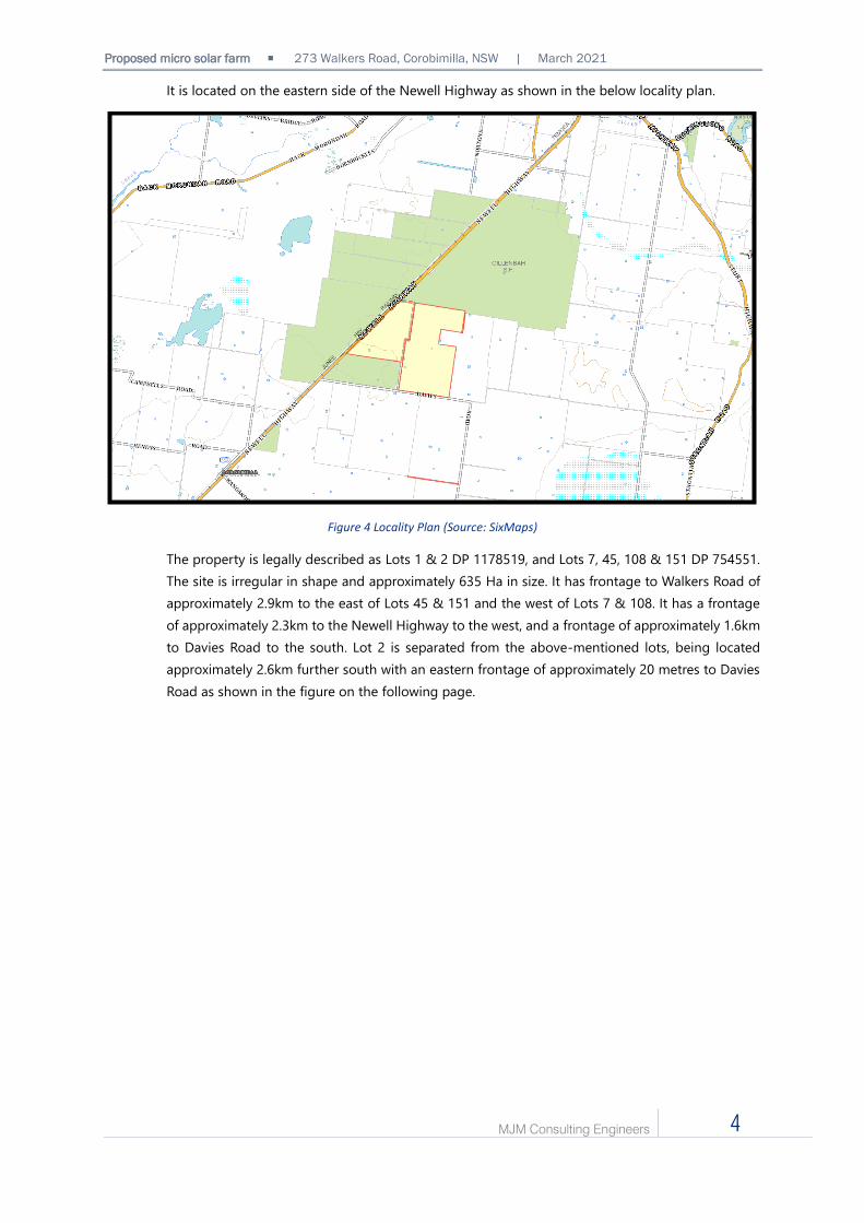
It is located on the eastern side of the Newell Highway as shown in the below locality plan.
Figure 4 Locality Plan (Source: SixMaps)
The property is legally described as Lots 1 & 2 DP 1178519, and Lots 7, 45, 108 & 151 DP 754551.
The site is irregular in shape and approximately 635 Ha in size. It has frontage to Walkers Road of
approximately 2.9km to the east of Lots 45 & 151 and the west of Lots 7 & 108. It has a frontage
of approximately 2.3km to the Newell Highway to the west, and a frontage of approximately 1.6km
to Davies Road to the south. Lot 2 is separated from the above-mentioned lots, being located
approximately 2.6km further south with an eastern frontage of approximately 20 metres to Davies
Road as shown in the figure on the following page.

Proposed micro solar farm ▪ 273 Walkers Road, Corobimilla, NSW | March 2021
MJM Consulting Engineers 5
Figure 5 Aerial imagery of development site (Source: SixMaps)
Please note Lot 2 is not discussed further in this report as it is located over 3km south of the
proposed development area and is therefore not affected by the development.
The site is zoned RU1 Primary Production, consistent with all adjoining land to the east, and the
majority of adjoining land to the south. Land to the north is zoned RU3 Forestry, as well as a portion
of land to the south of Lot 45 as shown in the below figure.
Figure 6 Narrandera Local Environmental Plan 2013 Zoning Plan of subject site and surrounds (Source: NSW Planning Portal)
Lot 2 DP 1178519
Lot 1 DP 1178519

Proposed micro solar farm ▪ 273 Walkers Road, Corobimilla, NSW | March 2021
MJM Consulting Engineers 6
The property generally has a gentle slope to the south west as shown in the below figure, however
due to the area of the site, visually it appears almost level.
Figure 7 Site topography (Source: SixMaps)
The site is currently utilised for agricultural purposes in the form of grazing and arable cultivation.
Due to the past agricultural use the proposal area has been cleared and contains remnant vegetation
from previous cultivation activities. The site is identified as being bushfire prone land as shown in
the below figure.
Figure 8 Bushfire prone land map of development site (Source: NSW Planning Portal)

Proposed micro solar farm ▪ 273 Walkers Road, Corobimilla, NSW | March 2021
MJM Consulting Engineers 7
Although the mapped bushfire prone vegetation is located around the boundary of the site and
not within the vicinity of the proposal area, it is noted that the vegetation within 140 metres of the
proposal area would be classified as ‘grassland’ as discussed in the accompanying Bushfire
Assessment and Bushfire Emergency Management and Operations Plan.
Council has advised that the site is not identified as flood prone land. The property contains
approximately 5 dams however these are not associated with any waterways, being utilised for
stock purposes only.
3.2 SUBJECT LOT
The proposed development would be located on Lot 7 DP 754551 (subject lot) only as shown in
the below figure and accompanying development plans.
Figure 9 Extract from Location Diagram (Source: ACEnergy)
A dwelling is located on the subject lot approximately 355 metres south of the proposal area. The
nearest neighbouring dwelling is located on a property situated on Davies Road approximately 1km
south of the proposal area as shown in the figure on the following page.

Proposed micro solar farm ▪ 273 Walkers Road, Corobimilla, NSW | March 2021
MJM Consulting Engineers 8
Figure 10 Surrounding dwelling locations (Source: SixMaps)
As shown in the accompanying survey plan, the subject lot falls to the south west. It is noted the
survey shows an existing paddock tree bordering the north eastern portion of the development
area. Since the survey was undertaken this tree has been removed by the landowner as it was in
poor condition and identified to be an imminent risk to persons and property. The tree was
removed in accordance with Schedule 5A Allowable activities clearing of native vegetation of the
Local Land Services Act NSW 2013.
It is noted that portions of the site are identified as bushfire prone land. Although the subject lot is
not mapped as containing bushfire prone vegetation, the vegetation within 140sqm of the proposal
area is identified as ‘grassland’ and as such this hazard is considered in the accompanying Bushfire
Assessment and Bushfire Emergency Management and Operations Plan.
3.3 PRESENT AND PREVIOUS USES OF THE SITE
The site is currently utilised, and has been for a number of decades, for agricultural purposes in the
form of grazing and arable cultivation. It contains an associated dwelling and other ancillary farm
structures.
Although the previous and present uses of the site include agricultural activities, these are limited
to grazing and arable cultivation. There is visually no evidence on site of contamination and the land is
considered to be in a suitable state for solar farm development.
Approximate proposal area
Dwelling on subject lot
Dwelling on neighbouring property

Proposed micro solar farm ▪ 273 Walkers Road, Corobimilla, NSW | March 2021
MJM Consulting Engineers 9
3.1 LOCALITY
The majority of surrounding land is rural in nature with only one neighbouring dwelling being
located within a two-kilometre radius of the development area as shown in the below figure.
Figure 11 2km Radius from approximate development site (Source: Google Earth Pro)
The nearby rural land is mostly cleared for agricultural uses with scattered paddock trees
throughout. Forestry land is the only other land use located within the two kilometre radius of the
development area and contains significant stands of vegetation. The Newell Highway is located to
the west of the site providing access between Narrandera to the north east, and Morundah to the
south west. There are no other significant land uses within the vicinity of the subject lot.
Dwelling on neighbouring property

Proposed micro solar farm ▪ 273 Walkers Road, Corobimilla, NSW | March 2021
MJM Consulting Engineers 10
4 PROPOSED DEVELOPMENT
4.1 DEVELOPMENT OBJECTIVE
The objective of the development is to provide renewable energy to regional Australia, where it is
most needed, at a scale which is responsive to the surrounding environment including nearby
agricultural and other sensitive land uses. The intention is to functionally generate the equivalent
output of larger conventional farms through a network of smaller facilities that can be rolled out in
a site-sensitive manner and deliver renewable energy to different regions of New South Wales.
These micro sites can be located on rural land without requiring extensive works to be undertaken
on the landform and therefore can avoid the most productive agricultural land.
4.2 DEVELOPMENT DESCRIPTION
The development proposal is for a micro solar farm and associated infrastructure including
photovoltaic panels and a power station consisting of inverter, transformer and switchgears. The
power station would act as the primary conduit for electricity from the facility prior to it being
transferred via overhead powerlines to the nearby Essential Energy transformer.
A ‘micro’ solar farm differs from a conventional solar farm in that it occupies less land area and has
a maximum output of less than 5 megawatts. The project would include the installation of a total
of approximately 16,128 PV panels with the entire development having a footprint of approximately
15 hectares. It is noted that the entire property has an area of approximately 635 hectares and as
such the proposal will still allow agricultural land uses to continue to be undertaken on other areas
of the property. Further to this, the solar farm would have a life span of 31 years from construction,
after which it would be decommissioned and all assets removed from the site. The site would then
be rehabilitated as required and the development area could easily be returned to agricultural use
should this be desired by the landowner.
The solar farm area would be surrounded by a fully secured 1.8-metre-high steel wire fence with a
landscaped vegetation located on the interior of the southern boundary. The landscape buffer
would take the form of two rows of plantings, row one being offset approximately 3.5 metres from
the site fence, and row two being offset approximately 1.5 metres from the southern site fence.
The buffer would have an expected combined width at maturity of approximately 5 metres. The
vegetation would include shrubs with a mature height of approximately 3 metres, and understorey
plantings with a mature height of approximately 1.5 metres which would assist in lessening visual
impacts of the proposal on the nearby residences.
The solar farm would be remotely monitored allowing for constant surveillance without the
requirement of ongoing staff, however a maximum of two staff would attend the site a maximum
of three times per month for general inspections and maintenance of equipment or landscaping
or for security inspection purposes.

Proposed micro solar farm ▪ 273 Walkers Road, Corobimilla, NSW | March 2021
MJM Consulting Engineers 11
EQUIPMENT
4.2.1.1 TRACKERS AND SOLAR PANELS
A total of approximately 16,128 non-reflective solar panels, with approximate
dimensions of 2100mm by 1050mm and a depth of 40mm, would be mounted to array
tracking systems. A typical array would comprise approximately 80 – 90 individual solar
panels.
The tracking system utilises small electric motors to tilt the arrays to ensure maximum
solar radiation is received at all times throughout the day. The solar arrays will be
mounted with the central axis being approximately 1.5m from ground level. The array
and tilted panel would have a maximum height of approximately 2.5m when tilted to
its sharpest angle as shown in the below figure.
Figure 12 Typical tracker layout (Source: ACEnergy)
A typical solar tracking system including solar panels and arrays is shown in the below
figure.
Figure 13 Typical solar tracking system (Source: Google)

Proposed micro solar farm ▪ 273 Walkers Road, Corobimilla, NSW | March 2021
MJM Consulting Engineers 12
4.2.1.2 CENTRAL POWER STATION AND CONNECTIONS
The facility contains a central power station consisting of an inverter, transformer and
switchgears similar to that shown in the below figure.
Figure 14 Typical inverter, transformer and switchgears (Source: ACEnergy)
The power station will be prefabricated off-site and have dimensions of approximately
13m long, 3m wide and 3m high. It will be located within the compound, as identified
in the accompanying ACEnergy development plans, and will be utilised as the primary
conduit for electricity generated from the solar panels to a HV switch board.
The HV switchboard, which would house the HV switch gear and associated safety
features, would receive electricity from the power station via underground cables. The
HV switchboard platform would measure approximately 5m wide, 5m long and 4m
high. The switchboard would be fixed on the platform beams and the platform would
be placed on footings as identified in the accompanying ACEnergy plans. The below
figure depicts a typical HV switchboard and associated platform.
Figure 15 Typical HV switchboard and platform (Source: ACEnergy)
The HV switchboard would connect via underground cables to one of the three new
power poles constructed within the compound which would then transfer the electrical
load via overhead powerlines to the nearby Essential Energy substation.
As described above, one underground/overhead power pole and two overhead power
poles are planned to be installed within the compound, with a fourth single overhead
pole being installed to the south of the compound to support the installation of
approximately 183 metres of overhead powerlines which would connect the facility to
the existing Essential Energy network infrastructure to the south east. Each pole will
measure approximately 10 metres in height above ground.

Proposed micro solar farm ▪ 273 Walkers Road, Corobimilla, NSW | March 2021
MJM Consulting Engineers 13
The accompanying development plans prepared by ACEnergy provide additional
details of the proposed power station including typical elevations, footings and
connection details.
4.2.1.3 ENERGY STORAGE CONTAINERS
Five (5) DC-coupled energy storage containers (ESC) would also be included in the
development and would be installed on concrete footings as depicted in the
accompanying plans prepared by ACEnergy. They would physically resemble a
mounted shipping container measuring approximately 13m long, 3m wide and 3m
high and will have a powder-coated grey finish similar to that depicted in the figure
below.
Figure 16 Typical DC coupled energy storage container (Source: ACEnergy)
The energy storage containers would allow generated energy to be stored as required
and utilised during times of high demand. They can also perform grid management
functions such as frequency and voltage control.
FENCING AND LANDSCAPING
Although the subject site is fenced by typical rural post and wire fencing, the
development area would also be enclosed by a 1.8-metre-high chain mesh fence. A
landscape buffer would be included inside the southern side of the site fencing. The
buffer would take the form of two rows of plantings, row one being offset
approximately 3.5 metres from the site fence, and row two being offset approximately
1.5 metres from the site fence. The buffer would have an expected combined width at
maturity of approximately 5 metres. The vegetation would include shrubs with a mature
height of approximately 3 metres, and understorey plantings with a mature height of
approximately 1.5 metres which would assist in lessening visual impacts of the proposal
on the nearby residences.
The proposed landscaping is considered appropriate due to the rural location of the
development site and the relative absence of nearby visual receptors excepting one
neighbouring dwelling on Davies Road to the south. Further to this, the surrounding
forestry land, and vegetation contained within, assists in providing a natural visual
buffer between the site and traffic utilising the Newell Highway to the west.

Proposed micro solar farm ▪ 273 Walkers Road, Corobimilla, NSW | March 2021
MJM Consulting Engineers 14
The landscape buffer will be maintained for the duration of operation of the facility as
necessary.
SITE ACCESS
Access to the solar farm would be via a security gate with a width of approximately 8
metres on the southern side of the compound. An all-weather internal access track,
with a width of approximately 4 metres, would connect the development area to the
Walkers Road property access to the south west. The property access to the internal
track from Walkers Road will be modified as necessary to Council requirements to
facilitate the development.
A desktop analysis confirms the access is likely to conform to safe sight distance
requirements for vehicles leaving the site however this would be able to be confirmed
at Construction Certificate application stage.
4.2.3.1 LABOUR
Construction is likely to occur over an approximate six (6) month period. Civil
earthworks and fencing would begin first, with material delivery, installation, testing,
commissioning, and site clean up, landscaping and demobilisation to occur in turn.
During the construction period the amount of workers on the site would depend on
the stage of works however a maximum of 50 workers would be on site at any one
time. Positions would include Project Manager, Construction Manager, Health and
Safety Manager, electrical contractors, plant operators, fencing contractors, heavy
vehicle drivers, general labourers and the like.
OPERATION
As described previously in this report, once operational the solar farm would be
remotely monitored allowing for constant surveillance without the requirement of
ongoing staff. A maximum of two staff would attend the site a maximum of three times
per month for general inspections and maintenance of equipment or landscaping or
for security inspection purposes.
It is noted that the majority of technical issues which could arise during operation are
able to be solved remotely by engineers who oversee the remote monitoring of the
site. Any aspects which require on site attention would be attended by a local
contractor who would also undertake the regular maintenance described above.

Proposed micro solar farm ▪ 273 Walkers Road, Corobimilla, NSW | March 2021
MJM Consulting Engineers 15
DECOMMISSIONING
Decommissioning of the facility would occur at the end of the useful life of the
infrastructure, anticipated to be approximately 31 years from commencement of
construction. At the end of the project lifecycle the facility will be decommissioned in
a manner to ensure the land is left in a suitable state for a return to primary production
purposes based on the current zoning.
It would be proposed that not later than 12 months prior to the proposed cessation of
operation a decommissioning plan be prepared and provided to Council for review and
approval. The objective of such a plan would be to restore the land to its pre-existing
state suitable for agricultural use. It would include, but not be limited to, the following
details:
• Expected timeline for rehabilitation completion;
• Decommissioning of all solar panels, above and below the ground infrastructure,
inverter stations, fencing and any other structures or infrastructure relating to the
approved development; and
• Programme of site restoration to return the land back to a suitable state for
agricultural production.
4.3 COUNCIL PRE-DA ADVICE
A meeting was held with Council on 5th February 2021 to discuss the proposal. An overview of
advice provided by Council and comments in response to this advice is provided in the below table.
Table 1 Pre-DA advice received from Council
COUNCIL ADVICE COMMENTS
Acoustic assessment would not be required due
to lack of surrounding receptors however this
needs to be addressed in the SEE.
Noted. This is addressed further on in this report.
Property not flood affected. Noted.
Bushfire to be addressed as required by Planning
for Bushfire guide 2019.
Noted. A Bushfire Assessment and Bushfire
Emergency Management and Operations Plan
accompanies this report as a separate cover
attachment.
Clause 5.15 of LEP to be addressed in SEE
regarding electromagnetic emissions.
Noted. This is addressed further on in this report.
Proposal area not biodiversity affected but other
parts of property are. Address biodiversity,
including Biodiversity Conservation Act 2016
requirements, in SEE.
Noted. This is addressed further on in this report.
Council’s Manager Roads provided the following
advice:
• Access preferred to the site from the
Noted. These aspects are addressed further on in
this report.

Proposed micro solar farm ▪ 273 Walkers Road, Corobimilla, NSW | March 2021
MJM Consulting Engineers 16
Newell Highway via Walkers Road rather
than Davies Road
• Traffic will only need to be addressed in
the SEE rather than a standalone report
so long as construction vehicles are of a
size permitted for that road (i.e. smaller
than B-Doubles).
• Traffic aspects to address as a minimum
in the SEE to include expected numbers
and types of vehicles during construction

Proposed micro solar farm ▪ 273 Walkers Road, Corobimilla, NSW | March 2021
MJM Consulting Engineers 17
5 IMPACTS
5.1 CONTEXT AND SETTING
The site is located in a majority RU1 Primary Production zoned area with RU3 Forestry zoned
land also within proximity as shown previously in Figure 6 on page 5 of this report.
Although topographic mapping confirms the area has a minor slope to the south west,
visually it appears mostly level. Two residential dwellings are located within 2km of the site,
one being located on the subject lot and the other on a neighbouring property on Davies
Road therefore there is a relative absence of potential visual and acoustic receptors in the
area.
The proposal is not considered out of context or incompatible with the setting as agricultural
areas have historically been the preferred location for electrical infrastructure, including
substations and high voltage overhead transmission lines. Further to this electrical
infrastructure, including renewable energy infrastructure and ancillary structures, are
common within rural and agricultural areas.
The proposal, being defined as electricity generating works, is permissible within the zone
according to Part 3, Division 4 Electricity generating works or solar energy systems of State
Environmental Planning Policy (Infrastructure) 2007 (ISEPP).
The majority of impacts on surrounding land uses would be experienced during the
construction period however these impacts would be managed to minimise impacts as
outlined in the Construction Management Plan (CMP), a draft of which accompanies this
report as a separate cover attachment. The CMP would be amended as necessary and
finalised for submission with a future Construction Certificate application for the project
should development consent be forthcoming.
Ongoing operation is unlikely to cause detrimental impacts on the surrounding area due to
the relative absence of residential receptors, the proposed landscape buffer and the natural
screening provided by the surrounding forestry land which would provide a buffer between
the site and the traffic utilising the Newell Highway to the west. Further to this all other areas
of the property can continue to be utilised for agricultural purposes throughout the life of
the development, with the footprint area of the solar farm being able to continue agricultural
use following decommissioning of the infrastructure at the end of the 31 year lease period.
The site is suitably located to obtain the required solar access for the facility to operate as
intended without resulting in unreasonable impacts on adjacent properties, while also being
located in proximity to Essential Energy infrastructure, a core requirement for the project to
succeed.

Proposed micro solar farm ▪ 273 Walkers Road, Corobimilla, NSW | March 2021
MJM Consulting Engineers 18
5.2 VISUAL IMPACTS
Due to the location of the development it is not expected to affect the visual privacy of
residential uses within the area. The development does not require any after dark lighting
as it will be operated remotely. Security cameras with night vision capabilities will be
installed near the access gate however these will not result in detrimental visual impacts.
Due to the rural location and relative lack of surrounding visual receptors, the development
is not expected to result in detrimental impacts on the landscape or surroundings. It is noted
that a landscape buffer will be provided within the southern side of the development
boundary to assist in reducing visual impacts of the proposal however the surrounding
forestry land also provides a natural visual buffer to passing traffic utilising the Newell
Highway to the west. Further to this, it is noted that the proposal has an expected lifespan
of 31 years, after which it will be decommissioned and the landscape will be returned to the
current agricultural use.
GLINT AND GLARE
Glint and glare refers to the human experience of reflected light with glint being defined
as a momentary flash of bright light, and glare being defined as a continuous source of
bright light. Glare assessments for solar farms are generally based on the following
factors:
• the tilt, orientation, and optical properties of the PV modules in the solar array;
• sun position over time, taking into account geographic location;
• the location of sensitive receptors (viewers); and
• Screening potential of surrounding topography and vegetation.
PV modules are designed to maximise the absorption of solar energy and therefore
minimise the extent of solar energy reflected. PV modules have low levels of reflectivity
between 0.03 and 0.20 depending on the specific materials, anti‐reflective coatings, and
angle of incidence. The higher reflectivity values of 0.20, that is 20% of incident light
being reflected, can occur when the angle of incidence is greater than 50 degrees.
A single axis tracking system has a fixed maximum angle of rotation. Once the tracking
mechanism reaches this maximum angle the PV modules position relative to the sun
becomes fixed and therefore the angle of incidence increases and the potential for glare
increases. The tracking system rotates the PV panels across an east to west arc, following
the sun’s trajectory across the sky. The purpose of the tracking system is to optimize
solar energy collection by holding the PV module perpendicular to the sun. The tracking
system is capable of a maximum rotation range of 120o (+/‐ 60o).
The maximum height of the PV modules above natural ground would be approximately
2.25 metres (1.5 metres when the panels are held at 0 degrees (flat) and 2.25 metres at
maximum tilt). An assumed maximum height of 2.4 metres would allow for any slight
variation in the height of the mounting system and maximum angle of the PV modules.
The sun changes its east‐west orientation throughout the day, and the sun’s north‐south
position in the sky changes throughout the year. The sun reaches its highest position at
noon on the Summer Solstice (21 December in the Southern Hemisphere) and its lowest

Proposed micro solar farm ▪ 273 Walkers Road, Corobimilla, NSW | March 2021
MJM Consulting Engineers 19
position at sunrise and sunset on the Winter Solstice (21 June in the Southern
Hemisphere).
As described throughout this report, there are two residences located within a 2km
radius of the development, both to the south of the proposal area. The residence on the
subject property would be located on a slight rise when compared to the solar farm
location. It is noted that the solar farm will include a landscape buffer within its southern
boundary fence comprising two rows of plantings to obtain a matured vegetation
combined width of approximately 5 metres and height of approximately 3 metres. Due
to the direction of the development from this dwelling and the inclusion of the
vegetation buffer, it is considered that the potential for glint and glare impacts on this
receptor to be minimal.
The residence located on Davies Road would be buffered from the development by a
topographical rise between the dwelling and the solar farm location with an elevation
difference of approximately 5 metres between the residence and the rise. Further to this,
the direction of the dwelling from the development and the included vegetation buffer
would ensure the potential for glint and glare impacts on this receptor to be minimal.
Davies Road, Walkers Road and a section of the Newell Highway are located within a
2km radius of the proposal area. It is considered that due to the direction of the
development from Davies Road (ranging from north east, north and north west), as well
as the landscape buffer, would ensure minimal opportunities for glint and glare impacts
on passing traffic.
Walkers Road is located to the north west, west and south west of the proposal site and
as such would have the potential to be impacted by glint and glare due to its direction
in relation to the development. It is noted that the topography is relatively level between
Walkers Road and the development site however mature vegetation exists within the
road reserve along Walkers Road which would provide a buffer of sorts and as such it is
considered that the potential for glint and glare impacts on passing traffic would be
minimal.
A portion of the Newell Highway is located to the west of the development area. It is
noted that the topography between the project area and the highway ranges from
approximately level to slight rises separating the two. It is considered that the
topographic buffering and the heavily vegetated adjacent forestry land would assist in
reducing potential glint and glare impacts on users of the highway.
5.3 NOISE & VIBRATION
The nearest sensitive receptors include the dwelling on the subject site, located
approximately 355 metres south of the proposal area, and the nearest neighbouring
dwelling on Davies Road, located approximately 1km south of the proposal area as shown
in Figure 10 on page 8 of this report.
Given the nearest receptor is located on the subject property, it is anticipated that any
potential noise and vibration impacts will not be unexpected by the residents given their
understanding of the project at hand and their consent to its development on their property.

Proposed micro solar farm ▪ 273 Walkers Road, Corobimilla, NSW | March 2021
MJM Consulting Engineers 20
Acoustic impacts are expected during construction of the development in terms of traffic
and general onsite construction generated noise. Major civil works, materials delivery and
other heavy vehicle movements will only occur between the hours of 7am - 6pm Monday to
Friday, and 8am – 1pm Saturday. To maximise productivity less noise intensive activities
including electrical work, testing and commissioning may be conducted outside these hours
and between 7am – 7pm Monday to Sunday as required.
Given the majority of adjacent land is zoned RU1 Primary Production, the anticipated noise
generation from construction activities is not considered to be above and beyond that which
would be expected during intensive agricultural activities such as harvesting. It is noted that
construction would be undertaken over a 6 month period however earthworks are
anticipated to be undertaken over the first 4 weeks, with delivery of large materials to be
undertaken intermittently over the construction period, with a maximum of two heavy
vehicles expected to attend the site daily on average.
In relation to vibration impacts, it is noted that there will be vibratory equipment used within
the boundaries of the compound including an impact piling rig. The Transport for NSW –
Construction Noise Strategy document recommends a separation distance of 15 metres
when addressing cosmetic response, and 50 metres when addressing human comfort. It is
noted that both sensitive receptors are located well over this distance from the proposal
area.
In relation to operational noise, it is anticipated that this would be below noise generated
during construction. The facility will operate 24 hours per day, 7 days per week with
operational equipment to include the inverter, AC/DC converter, transformer, battery
storage air conditioning unit and the array tracker motors. The potential noise emitted from
the equipment has been retrieved from supplier specifications for typical versions of the
equipment and is reproduced in the table below.
Table 2 Operational noise sources
EQUIPMENT NOISE LEVEL MEASUREMENT DISTANCE
Central Inverter Unit
(Sungrow SG2475HV) – per
unit
73 - 79 LAeq 1 metre
Inverter Unit Transformer –
5MVA 56 LWA – sound power N/A
Sungrow SD1250HV DC / DC
Converter Unit – per unit 67 - 71 LAeq 1 metre
SMA Battery Storage
Container Air Conditioning
Unit – per unit
58 LAeq 10 metres
NEXTracker Motor – per unit < 60 LWA – sound power N/A
The NSW Environment Protection Authority Noise Policy for Industry (NPfI) provides suitable
criterion for addressing operational noise emissions associated with the proposal at sensitive
receptors. The Policy was released in 2017 and includes methodologies for assessment and
management of typical operational noise emissions from industrial premises within NSW.
Within the NPfI, noise emissions are considered in various assessment periods defined as
the day, evening, and night to reflect the sensitivity associated within the impacts of noise.

Proposed micro solar farm ▪ 273 Walkers Road, Corobimilla, NSW | March 2021
MJM Consulting Engineers 21
When addressing noise emissions associated with the commercial / industrial uses, the NPfi
defines project trigger levels which are used to consider potential impacts at sensitive
receptors. The levels are determined based on consideration of what the NPfI refers to as
the ‘Project Intrusiveness Noise Level’, and the ‘Project Amenity Noise Levels’.
The intent of the project intrusiveness noise level is to minimise the potential change in
acoustic environment at sensitive receptors by ensuring that impacts associated within a
new source are controlled to values 5 dB above a minimum threshold noise level. The
attributable noise levels are defined as LAeq values assessed over a 15 minute period.
The intent of the project amenity noise level is to limit continuing increases in noise level at
sensitive receptors through consideration of independent commercial / industrial
operations in accordance with the Intrusiveness Noise Level criteria alone.
It is noted that the Newell Highway is located within proximity of the site, and therefore may
have some influence on the background noise levels at noise sensitive receptors located
within proximity of the site, particularly during the day when traffic volumes will be at their
highest. However, in the absence of site measured data, the minimum ‘rating background
levels’ (RBLs) included within the below table have been adopted as the basis of this desktop
assessment.
Table 3 Minimum RBLs, project intrusiveness noise levels and project amenity noise levels (Source: NPfl)
DESCRIPTOR NPFI DEFINED ASSESSMENT PERIOD
DAY EVENING NIGHT
Minimum RBLs 35 LA90 30 LA90 30 LA90
Project Intrusiveness
Noise Levels 40 LA90 35 LA90 35 LA90
Project Amenity Noise
Levels (based on the
rural area)
50 LAeq
45 LAeq
40 LAeq
In accordance with the methodologies contained within the NPfI, project noise trigger levels
are determined based on whichever of the project intrusiveness level and the project
amenity level is the lower or more stringent. As such, the project intrusiveness noise levels
would apply to this development.
Based on the potential acoustic impacts of the project equipment identified in Table 2, the
likely background noise levels generated from the nearby highway and surrounding rural
land uses, and the distance of the two sensitive receptors located within a 2km radius of the
site, it is unlikely that detrimental acoustic impacts would be experienced during operation
of the development.
In relation to operational vibration impacts, it is noted that no vibration intense activities will
occur during the operational phase of the development and therefore no adverse vibration
impacts are expected on sensitive receptors.
Decommissioning noise is anticipated to mirror that of construction noise and as such is
considered to be in line with anticipated agricultural use acoustic impacts within the vicinity.
Proposed micro solar farm ▪ 273 Walkers Road, Corobimilla, NSW | March 2021
MJM Consulting Engineers 22
5.4 AIR AND MICROCLIMATE
The site is located within the Riverina Bioregion which includes southwest NSW, and
extends into central-north Victoria (Vic). The bioregion climate is dominated by a
persistently dry semi-arid climate characterised by hot summers and cool winters.
The site has proximity to the Newell Highway, a national highway in NSW which provides
a major road link between south eastern Queensland (QLD) and Vic, and central NSW and
as such facilitates a large amount of road freight. Air quality is expected to be impacted in
existing conditions by traffic fumes to some extent as well as agricultural practices from
the subject and surrounding sites.
Available climate data identifies the region receives unpredictable amounts of rainfall with
the average ranging from 238 – 617mm per year with drought periods not being unusual.
The average monthly maximum temperature ranges from 31.1 - 33.6 degrees, with the
minimum ranging from 3.2 – 3.9 degrees.
In previous high-profile solar energy facility developments there has been community
concern around the potential heat generated by solar energy facilities leading to a ‘micro-
climate’ in the immediate vicinity. In cases of significantly larger solar facilities of over 100
hectares, the impact of such an effect has been proven to be negligible. In considering the
significantly smaller size of this proposal, this is even more so. Additionally, there is very
little evidence to support a supposed ‘heat island’ affect from solar facilities. Any ambient
heat from panels would have wholly dissipated by the time it reaches the facility’s fence
line.
The primary air quality impacts associated with the development are anticipated to be
experienced during the construction and decommissioning phases. These impacts would
include the potential for dust generation from vehicle movements to, from, and about the
site. Potential air quality impacts are considered manageable with the implementation of
mitigation measures as outlined in the accompanying draft CMP.
Detrimental air quality impacts are not expected during operation due to the nature of the
facility however minor impacts may be experienced via maintenance vehicle movements.
Any such impacts are anticipated to be negligible due to limited site attendance.
The impact of the overall development, being solar energy generation, is anticipated to be
positive as it would contribute to a reduction in greenhouse gas emissions related to
conventional energy generation methods.
Cumulative air quality impacts are expected to be negligible due to the existing use of
surrounding land and the relatively limited construction timeframe.
5.5 SOILS AND SURFACE WATER
The potential to impact upon soils and surface water quality on the site is greatest during
the construction and decommissioning phases. During these periods the soils will be
subject to disturbance associated with site preparation and infrastructure
installation/removal. Construction works for the proposed solar farm include removal of
minor areas of groundcover and soil during site preparation and minor excavation for

Proposed micro solar farm ▪ 273 Walkers Road, Corobimilla, NSW | March 2021
MJM Consulting Engineers 23
footings for the proposed substation, battery energy storage system, access road, vehicle
movement areas, temporary laydown area, parking area and underground cabling.
The upper layer of soil would be subject to temporary disturbance which may lead to
erosion and potential sedimentation in runoff during periods of rainfall. Extensive cut and
fill is not proposed as part of the development. Minor earthworks will be undertaken to
form the vehicle movement and unloading areas as well as to clear area for footings of
infrastructure containers. These works would not require cut and fill of any areas over a
maximum of 300mm and would not require any retaining walls or similar.
The use of fuels, lubricants and herbicides during construction pose a risk of surface water
contamination in the event of a spill. Management of contained sewage disposal facilities
also pose a risk to surface water quality should spills occur.
During construction and decommissioning, erosion and sediment control mitigation
measures will be implemented as required by applicable policies, guidelines and
legislation. Standard mitigation measures around refuelling, maintenance and weed
clearing will minimise the risk of spills. Water, which will be sourced externally, will be
utilised as required for dust suppression.
The potential for the proposed solar farm to impact upon soils and surface water quality
during the operational phase, after the disturbed areas and construction compound have
been rehabilitated, is minimal. The site will not be staffed during operation with routine
maintenance and monitoring being the extent of regular activities which are unlikely to
have any impact to surface water quality. During operation the site will be under
permanent pasture which will result in lower level of soil erosion relative to the current
land use practice of grazing and arable cultivation. A rainwater tank with a capacity of
22,500L is proposed to be located on the site as a static water supply to be utilised for
bushfire fighting purposes if required.
It is considered that the potential surface water quality impacts do not present any major
constraints that cannot be managed. All construction and decommissioning activities for
the proposed solar farm will be undertaken in a manner that prevents erosion and
sediment impacts at the subject site and those surrounding. Post approval, a Construction
Environmental Management Plan (CEMP) will be prepared to identify erosion and
sediment control mitigation measures prior to works commencing on the site.
5.6 GROUNDWATER
No groundwater will be used by the development. Water quality impacts to groundwater
during construction, operation and decommissioning are considered very unlikely as the
site is not identified as having groundwater sensitivities. Further to this, limited excavation
is proposed for the installation of panel tracking systems and ancillary infrastructure.
Panels will be installed on driven piles installed not more than 2.5 m below the ground
surface, while minor excavation works would be undertaken for trenching for underground
cabling as well as internal access roads and construction of hardstand areas.

Proposed micro solar farm ▪ 273 Walkers Road, Corobimilla, NSW | March 2021
MJM Consulting Engineers 24
5.7 LAND AND SOIL CAPABILITY
Land capability is the inherent physical capacity of the land to sustain a range of land uses
and management practices in the long term without degradation to soil, land, air and water
resources. Failure to manage land in accordance with its capability risks degradation of
resources both on- and off-site, leading to a decline in natural ecosystem values,
agricultural productivity and infrastructure functionality.
The development site is identified on the Land and Soil Management Capability Mapping
for NSW as Class 4 as shown in the below figure.
Figure 17 Land capability of development area (Source: NSW SEED Map)
Class 4 lands are described as having moderate to severe limitations for some land uses
and need to be consciously managed to prevent soil and land degradation. Such lands are
generally used for grazing, and are suitable for pasture improvement. It can be cultivated
occasionally for sowing of pastures and crops however it has cropping limitations. It is only
suitable for intermittent cultivation with specialised practices including maintenance of
ground cover.
It is noted that that groundcover within the development area will be maintained for the
life of the solar farm and as such it is considered that the development will have less impact
on the affected land and soil than the agricultural use to date. It will also ensure the land
can easily be returned to agricultural use in future.
5.8 WASTE AND EFFLUENT DISPOSAL
WASTE
During construction waste is likely to be generated in the form of general waste from
materials packaging and general project construction.
All general waste will be collected, sorted and stored appropriately in labelled waste
containers. Two waste bins will be located in the management hub area of the site, one of
which will house general waste while the other will be for recyclable material only. The bins
will be checked and logged daily by assigned personnel and once nearing capacity, these

Proposed micro solar farm ▪ 273 Walkers Road, Corobimilla, NSW | March 2021
MJM Consulting Engineers 25
will be collected from the site by a licensed waste contractor and disposed of
appropriately.
Mobile wheeled waste bins will also be available on the site to dispose of waste while
unpacking materials. Once full, the waste from these bins will be transferred to the bins in
the management hub area. The site will be monitored regularly to ensure all waste is
disposed of appropriately and not left about the site.
It is anticipated that little waste will be generated during operation due to the site being
unstaffed for the majority of the time, excepting monitoring and maintenance contractors
as required. Waste management during operation will however be similar to that during
construction, with general and recycling waste bins residing on the site with waste logged
once per month and the bins collected by a licensed waste contractor when required.
Waste generated during decommissioning is expected to take similar form to that
generated during construction, being general in nature. Waste during the
decommissioning phase will be dealt with in the same manner as that generated during
the construction phase.
EFFLUENT
During construction effluent will be generated from the portable amenities. Effluent from
the site facilities will be pumped to a temporary waste holding tank which will be pumped
out and serviced regularly by a suitably qualified and licensed local liquid waste contractor.
It is anticipated that emptying and maintenance frequency will be dependent on the stage
of construction and the associated number of workers on the site at the time.
Effluent will not be generated during operation as the site will be remotely monitored and
will not include sanitary facilities as maintenance contractors will only attend the site a
maximum of three (3) times per month.
Effluent generation during decommissioning would be similar to that as described above
for the construction period and as such it would be managed in the same manner.
5.9 FLORA AND FAUNA IMPACTS
The site has been historically utilised for agricultural purposes including grazing and arable
cultivation, including the development footprint area. The property is identified as ‘Terrestrial
Biodiversity’ as shown in the figure on the following page.

Proposed micro solar farm ▪ 273 Walkers Road, Corobimilla, NSW | March 2021
MJM Consulting Engineers 26
Figure 18 Terrestrial Biodiversity Mapping for entire property (Source: NSW Planning Portal)
It is however noted that the development footprint area does not contain native vegetation
and is not identified as terrestrial biodiversity.
The property and surrounds are not identified as containing high biodiversity value
vegetation and a search of the Biotnet Atlas for threatened and endangered species did not
identify any threated or endangered flora or fauna within the site. It is therefore considered
that the development is unlikely to result in detrimental impacts on flora and fauna.
5.10 HERITAGE
ABORIGINAL CULTURAL HERITAGE
A Due Diligence assessment was undertaken in accordance with the Due Diligence Code of
Practice for the Protection of Aboriginal Objects in NSW. Step 1 of the Due Diligence process
relates to whether the activity will disturb the ground surface. Due to the nature of the
proposal the site will be disturbed by the footings of the proposed solar panel trackers and
the central inverter, battery containers, overhead electrical poles, material laydown area, and
vehicle movement areas including the site access track.
Step 2a requires for a search of the AHIMS database to be undertaken and for any other
sources of information of which we are aware to be considered. An AHIMs search was
undertaken on 2nd March 2021 with a buffer of 1,000 metres. The search concluded that no
aboriginal sites are recorded in or near the subject lot, nor have any aboriginal places been
Approximate proposal area

Proposed micro solar farm ▪ 273 Walkers Road, Corobimilla, NSW | March 2021
MJM Consulting Engineers 27
declared in or near the subject lot. A copy of the AHIMs search results are attached to this
report as Appendix A.
Step 2B advises that regardless of the outcome of an AHIMS search, it still needs to be
considered whether aboriginal objects are likely to be in the area of the proposed activity
when considering specified landscape features. Specified landscape features include rock
shelters, sand dunes, waterways, waterholes and wetlands.
Given the absence of significant landscape features on the site, it is unlikely for aboriginal
objects to be located in the area, and, further to this, the site would be classified as ‘disturbed
land’. The Code of Practice defines disturbed land as “having been the subject of a human
activity that has changed the land’s surface, being changes that remain clear and
observable”. Due to the extensive past and present agricultural use of the land, it is our
opinion that it is clearly observable that the land would be defined as disturbed land. As
such, the Code advises it is reasonable to conclude that there are no known Aboriginal
objects or low probability of objects occurring in the area of the proposed development and
as such the development can proceed with caution.
EUROPEAN HERITAGE
The site is not located in a heritage conservation area, nor does it or any neighbouring
properties contain a heritage item.
5.11 NATURAL HAZARDS
BUSHFIRE
As described previously in this report, portions of the property are identified as bushfire
prone land however the subject lot is not identified as being affected. It is however noted
that the vegetation located within 140 metres of the proposal area would be classified as
‘grassland’ and as such a Bushfire Assessment and Bushfire Emergency Management and
Operations Plan has been prepared and accompanies this report as a separate cover
attachment.
FLOODING
The property is not identified as flood prone land according to advice from Narrandera
Shire Council.

Proposed micro solar farm ▪ 273 Walkers Road, Corobimilla, NSW | March 2021
MJM Consulting Engineers 28
5.12 TECHNOLOGICAL HAZARDS
The development would include battery energy storage in the form of five (5) DC-coupled
energy storage containers measuring 13 metres long, 3 metres wide and 3 metres high.
These would be managed in accordance with AS/NZS 5139-2017: Electrical installations –
Safety of battery systems for use with power conversion equipment as appropriate.
Electrical equipment of all sizes and voltages produce electric and magnetic fields (EMF).
Both fields drop away rapidly with distance from the source, or due to shielding by
insulation or earth (in the case of buried installations).
The International Commission on Non-Ionizing Radiation Protection (ICNIRP) has issued
Guidelines for Limiting Exposure to Time-Varying Electric and Magnetic Fields. The
Australian Radiation Protection and Nuclear Safety Agency (ARPNSA) refer to the ICNIRP
guidelines which provide limits for the general public for 50 Hz sources as identified below:
• Electrical Field Strength (E): 5 kilo Volts per metre (kV/m)
• Magnetic Flux Density (B): 200 micro Teslas (μT)
The maximum electric field generated by an 11kV overhead line is depicted in the below
figure which shows that the maximum EMF would be emitted between the area directly
under the line and 20 metres either side and would measure just over 0.2 kV/m which is
well under the ICNIRP EMF guideline limit of 5 kV/m.
Figure 19 Maximum 11kV overhead line electric field (Source: www.emfs.info/sources/overhead/specific/11-kv)
In relation to magnetic fields produced by 11kV overhead lines, the figure on the following
page shows that the maximum EMF would be emitted between the area directly under the
line and 20 metres either side and would measure 10µT which is well under the ICNIRP
EMF guideline limit of 200μT.

Proposed micro solar farm ▪ 273 Walkers Road, Corobimilla, NSW | March 2021
MJM Consulting Engineers 29
Figure 20 Maximum 11kV overhead line magnetic field (Source: www.emfs.info/sources/overhead/specific/11-kv)
The proposed 11kV overhead lines connecting the facility to the existing Essential Energy
infrastructure in the area would be the portion of the development which would emit the
most EMF, and as described above, these emissions would be well below the limits
specified by the ICNIRP for the general public
5.13 ACCESS, TRANSPORT AND TRAFFIC
ACCESS
The development would be accessed via an internal access track connecting the compound
to an existing access at the subject lot’s Walker’s Road frontage as shown in the
accompanying plans. This existing site access would be modified as required to Council
standards to support construction traffic in terms of maximum vehicle size and number of
expected movements during construction.
TRAFFIC
Traffic will be generated during the 6 month construction period in the form of delivery of
materials to site and attendance of construction staff. A maximum of 50 field crew workers
would be on site during peak construction, which is proposed to be undertaken between
7am – 7pm Monday – Sunday. It is expected that arrival and departure of workers to and
from the site would be within an hour of the proposed operating hours identified previously.
Minivans will be utilised to transport workers to and from Narrandera and as such the
maximum number of vehicle movements expected to and from the site during the peak of
construction is 15 vehicles per day, or 12 vehicles per hour.
Material delivery will be undertaken by a number of 5 axle semi-trailers and 3 axle rigid
trucks with dimensions as shown in the figure on the following page.

Proposed micro solar farm ▪ 273 Walkers Road, Corobimilla, NSW | March 2021
MJM Consulting Engineers 30
Figure 21 Heavy vehicle lengths (Source: https://www.rms.nsw.gov.au)
The majority of material would be transported to the site via rigid trucks, with only the power
station requiring transport via a semi-trailer. The majority of deliveries will be undertaken
over a three week period averaging two deliveries per day with the first delivery at
approximately 8am. A site traffic controller will ensure materials can be offloaded to the
designated material loading zone.
Access to and from the site will be via the access from Walker’s Road only as shown in the
accompanying plans. Speed signs will be erected on the site fencing to ensure vehicle
speeds within the site are limited.
It is noted that vehicles would travel to the site via the Newell Highway, only needing to
travel via Walkers Road for a distance of approximately 2.5km. As described previously in
this report, the Newell Highway is a national highway which facilitates a large amount of
road freight between NSW, Vic and QLD. Due to its capacity it is considered that the road
network will not be detrimentally affected by the additional traffic generated during the
peak construction period.
Traffic generation during decommissioning is expected to be similar to that generated
during construction and as such it is considered that the impacts on the associated road
network would not be detrimental.
Operational traffic would be limited to one to two small vehicles two to three times per
month for maintenance activities only.
5.14 SERVICING
As described previously in this report, the proposal area is located within proximity to
existing Essential Energy infrastructure in the form of overhead 11kV powerlines which
would provide connection of the proposed development to the energy grid.
The local area has the capacity and catchment to provide sufficient workforce numbers to
enable the construction of the solar farm with minimal likelihood of attracting large numbers
of external workers.

Proposed micro solar farm ▪ 273 Walkers Road, Corobimilla, NSW | March 2021
MJM Consulting Engineers 31
5.15 PUBLIC DOMAIN
There is the potential for short-term impacts on the public domain related to the
public road system as a result of construction traffic, as well as the possibility of visual
impacts on the environment from the solar farm itself. It is however noted that
construction traffic will involve no more than two heavy vehicle movements per day
and no more than thirteen light vehicle movements per day. Given the capacity of the
Newell Highway, this is not anticipated to have a negative impact on the public domain
noting that the traffic impacts would be short term only.
It is considered that the proposed structures and the associated changes to landscape
character will be generally insignificant for major transport corridors (the Newell
Highway), with nil to transient, interrupted views of the project site.
Given the location of the proposal, there are a very limited number of residential
receptors and therefore low to negligible visual impacts are expected. The potential
impact of the proposal on the public domain is therefore considered to be negligible.
5.16 OTHER LAND RESOURCES
A review of the Minview online database confirms that there are no mineral titles or
exploration licenses affecting the subject land. A review of the Biophysical Strategic
Agricultural Land (BSAL) map confirms the development site is not BSAL land.
As described previously in Section 5.7 of this report, the land has a land capability of
Class 4 which is defined as having moderate to severe limitations and as such the
proposal will not impact on high capability land. Notwithstanding this, it is noted that
the site would be returned to a suitable state for continued agricultural use post
decommissioning of the facility, expected to occur approximately 31 years from
commencement of construction. It is therefore considered that the proposal would
not result in a loss of any significant land resources.

Proposed micro solar farm ▪ 273 Walkers Road, Corobimilla, NSW | March 2021
MJM Consulting Engineers 32
5.17 SAFETY, SECURITY AND CRIME PREVENTION
The safety, security and crime prevention aspects of the proposal have been assessed
against the Crime Prevention Through Environmental Design (CPTED) principles as detailed
in the below table.
Table 4 CPTED Principles
PRINCIPLE COMMENTS
Principle 1: Natural Surveillance
Providing opportunities for effective
surveillance, both natural and technical, can
reduce the attractiveness of crime targets. Good
surveillance means that people can see what
others are doing thereby deterring ‘would-be
offenders’ from committing crime in areas with
high levels of surveillance.
The development is consistent with this principle as
detailed below:
• The property is located within a rural area with
the primary road frontage likely to provide local
access or to support harvest traffic only. It is
therefore considered that the opportunity for
the facility to be the target of crime to be low.
• The facility will be real-time remotely
monitored with the site being attended by the
operator a few times a month for maintenance
and security purposes.
• The development would be visible to passing
local traffic utilising Walker’s Road and as such
would be passively surveyed.
• The site entry would be clearly identifiable from
the Walker’s Road access.
• Due to the type of construction (tracker
systems) there would be limited places for
offenders to hide on the site.
• Night vision capable security cameras will be
placed at the compound entrance to assist in
surveillance of the facility.
Principle 2: Access Control
Physical and symbolic barriers can be used to
attract, channel or restrict the movement of
people, and in turn, minimise opportunities for
crime.
The development is consistent with this principle
through:
• Provision of clear signage at the site entry
which identifies the site as privately operated.
• Provision of a clear entry point from the
roadway to the site.
• Provision of a clear egress point from the site
to the roadway.
• Provision of signage to channel users to
appropriate areas.
• Restriction of access to the site through the
provision of one entry point and fencing of the
entire development area.
• Clear signage to prevent unintended access.
Principle 3: Territorial Reinforcement
This principle relies on the users of spaces or
areas feeling that they have some ownership of
public space and therefore are more likely to
gather and enjoy that space. The ownership of
The development is consistent with this principle
through provision of a distinct boundary and clear
definition of the proposal area in relation to the

Proposed micro solar farm ▪ 273 Walkers Road, Corobimilla, NSW | March 2021
MJM Consulting Engineers 33
space increases the likelihood that people who
witness crime in or adjacent to that space will
respond by quickly reporting it or by attempting
to prevent it.
overall property which reduces opportunity for
illegitimate use or entry.
Principle 4: Space Management
Public space that is attractive and well
maintained is inviting to users and becomes a
well used space. Linked to the principle of
territorial reinforcement, space management
ensures that the space is appropriately utilised
and well cared for.
The development is consistent with this principle
through:
• Ensuring maintenance of the site area and
included landscaping to create a ‘cared for’
image.
• Rapid repair of decaying physical elements
throughout the lifecycle of the development.
5.18 SOCIAL AND ECONOMIC IMPACTS
The NSW Government Office on Social Policy defines social impacts as significant events
experienced by people as changes in their way of life, their culture, or their community are
experienced. The potential social impacts of the development may therefore include impacts
on traffic and visual amenity, services, as well as on employment opportunities in the area.
Potential traffic and visual impacts have been discussed previously in this report and are
considered acceptable.
The proposal would also provide solar energy to the surrounding rural area, with all
electricity generated being utilised within the LGA. Potential impacts on employment,
through the short-term creation of a number of jobs during the construction period, is also
considered positive.
Potential economic impacts are considered positive in the respect of creation of
approximately 50 jobs within the locality over approximately 6 months during construction.
Further to this, local contractors will be employed for landscape maintenance and security
purposes during the long term operation period.
5.19 SITE DESIGN AND INTERNAL DESIGN
The site and internal design have been carefully determined considering the site constraints
and opportunities, as well as those of the surrounding area and existing infrastructure. Given
the location and lack of residential receptors, the internal and site design are considered
appropriate for the proposal.
5.20 CUMULATIVE IMPACTS
Cumulative impacts associated with the development could include individual impacts so
close in time that the effects of one are not dissipated before the next or so close in space
that the effects overlap. They could also include repetitive, often minor, impacts eroding
environmental conditions or different types of disturbances interacting to produce an effect
which is greater or different than the sum of the separate effects.

Proposed micro solar farm ▪ 273 Walkers Road, Corobimilla, NSW | March 2021
MJM Consulting Engineers 34
In relation to the proposal, the potential cumulative impacts could include cumulative visual
impacts associated with the development of multiple solar developments in the general
locality; or cumulative noise, air quality or traffic impacts associated with construction.
It is noted that there are no other solar farm developments located within close proximity
of the development site nor are there any other developments which would result in
cumulative construction impacts including noise, air quality or traffic. It is therefore
considered that cumulative impacts associated with the project would be negligible.
6 PLANNING PROVISIONS
6.1 ENVIRONMENTAL PLANNING AND ASSESSMENT ACT 1979
In NSW the Environmental Planning and Assessment Act 1979 (the Act) institutes a system
of environmental planning and assessment in NSW and is administered by the Department
of Planning & Environment (DP&E). It is noted that the proposed development is consistent
with the objectives of the Act.
Section 1.7 of the Act requires consideration of Part 7 of the Biodiversity Conservation Act
2016 (BC Act). Part 7 of the BC Act relates to Biodiversity assessment and approvals under
the Planning Act. Section 7.3 outlines the test for determining whether a proposed
development or activity is likely to significantly affect threatened species or ecological
communities or their habitats. The development is assessed against the matters outlined in
Section 7.3 in the below table.
Table 5 BC Act Section 7.3 Test of Significance
SECTION 7.3 PART COMMENTS
(a) in the case of a threatened species, whether the proposed
development or activity is likely to have an adverse effect
on the life cycle of the species such that a viable local
population of the species is likely to be placed at risk of
extinction
A search of Bionet Atlas of NSW did not
identify any threatened species within, or
adjacent to, the development site. Given no
tree removal is proposed it would be unlikely
to have an adverse effect on threatened
species.
(b) in the case of an endangered ecological community or
critically endangered ecological community, whether the
proposed development or activity—
i. is likely to have an adverse effect on the extent of the
ecological community such that its local occurrence
is likely to be placed at risk of extinction, or
ii. is likely to substantially and adversely modify the
composition of the ecological community such that
its local occurrence is likely to be placed at risk of
extinction,
A search of Bionet Atlas of NSW did not
identify an endangered ecological community
or critically endangered ecological community
within, or adjacent to, the development site.
Given no tree removal is proposed, as well as
the absence of any recorded endangered flora
or fauna on site, there is not anticipated to be
any adverse impacts upon an endangered
ecological community or critically endangered
ecological community.
(c) in relation to the habitat of a threatened species or
ecological community—
i. the extent to which habitat is likely to be removed or
modified as a result of the proposed development or
activity, and
A search of Bionet Atlas of NSW did not
identify the habitat of a threatened species or
ecological community within, or adjacent to,
the development site. Given no tree removal
is proposed, as well as the absence of any
recorded endangered flora or fauna on site,

Proposed micro solar farm ▪ 273 Walkers Road, Corobimilla, NSW | March 2021
MJM Consulting Engineers 35
ii. whether an area of habitat is likely to become
fragmented or isolated from other areas of habitat as
a result of the proposed development or activity, and
iii. the importance of the habitat to be removed,
modified, fragmented, or isolated to the long-term
survival of the species or ecological community in
the locality,
there is not anticipated to be any adverse
impacts upon the habitat of a threatened
species or ecological community.
(d) whether the proposed development or activity is likely to
have an adverse effect on any declared area of
outstanding biodiversity value (either directly or
indirectly),
The published biodiversity values map does
not include any declared areas at the subject
site.
(e) whether the proposed development or activity is or is part
of a key threatening process or is likely to increase the
impact of a key threatening process.
Given no tree removal is proposed the
development is unlikely to be part of a key
threatening process or to increase the impact
of a key threatening process.
Based on the information in the above table, it is considered that the proposed development
is unlikely to significantly affect threatened species or ecological communities or their
habitats. A biodiversity assessment report is therefore not required.
As consent is required for the proposed development to be carried out, it is noted that
Division 4.3 of the Act applies to the proposal.
Other legislation relevant to the proposal includes:
• State Environmental Planning Policy No. 33 – Hazardous and Offensive Development
• State Environmental Planning Policy (Koala Habitat Protection) 2020;
• State Environmental Planning Policy (Primary Production and Rural Development) 2019
• State Environmental Planning Policy (Infrastructure) 2007;
• State Environmental Planning Policy (State and Regional Development) 2011;
• Narrandera Local Environmental Plan 2013; and
• Narrandera Development Control Plan 2013.
The requirements of these are discussed further on in this report.

Proposed micro solar farm ▪ 273 Walkers Road, Corobimilla, NSW | March 2021
MJM Consulting Engineers 36
6.2 STATE ENVIRONMENTAL PLANNING POLICIES
The below table outlines the SEPPs applicable to this development.
Table 6 Relevant State Environmental Planning Policy Requirements
SEPP COMMENTS
SEPP33 (Hazardous
and Offensive
Industry)
The proposed micro solar farm does not pose a significant risk to the locality
in relation to human health, life or property, or to the biophysical environment
and is therefore not defined as a potentially hazardous industry.
The proposal will not emit a polluting discharge which would have a significant
adverse impact in the locality or on the existing or likely future development
on other land and is therefore not defined as a potentially offensive industry.
SEPP (Koala Habitat
Protection) 2020
This policy aims to encourage the proper conservation and management of
areas of natural vegetation that provide habitat for koalas to ensure a
permanent free-living population over their present range and to reverse the
current trend of koala population decline. This policy applies to all land within
the Narrandera Local Government Area.
Part 2 of the policy requires that the land be assessed to determine if it is
potential koala habitat or core koala habitat. It is noted that the property has
been historically, and is currently, utilised for agricultural purposes in the form
of grazing and arable cultivation. The proposal area is cleared due to the past
agricultural use and the proposal does not include the removal of any trees.
A search of the Bionet Atlas does not identify koalas in the development area
or within the site or surrounds. The NSW SEED Mapping layer Koala Habitat
Information Base Koala Likelihood Map (Aug 2019), both the likelihood and
confidence layers, identify the site and surrounds as no koala records.
It is therefore considered that the site is not identified as potential or core koala
habitat and therefore the development can proceed without the need for
preparation of a Koala Plan of Management.
SEPP55 – Remediation
of Land
When assessing an application for development the consent authority must
consider whether the land is contaminated, and if so, that it is suitable in its
contaminated state (or will be after remediation) for the purposes of the
development.
As described previously in this report, the subject site is within a rural area and
is not identified as contaminated or potentially contaminated land according
to available records. It is noted that agriculture is listed as a land use which has
the potential to lead to contamination, however the historical agricultural
practices have included grazing and arable cultivation. There is no evidence on
site of contamination and the land is considered to be in a suitable state for a
solar farm development. Further contamination investigation is considered
unnecessary for the proposal.
SEPP (Primary
Production and Rural
Development) 2019
This policy aims, amongst other things, to facilitate the orderly economic use
and development of lands for primary production. A review of the provisions
of this policy confirms it does not apply to the proposed development and
therefore further consideration is not required.
SEPP (Infrastructure)
2007
The aim of this Policy is to facilitate the effective delivery of infrastructure
across the State through a number of mechanisms. The proposal would be
defined as electricity generating works being a building or place used for the
purpose of making or generating electricity or electricity storage.

Proposed micro solar farm ▪ 273 Walkers Road, Corobimilla, NSW | March 2021
MJM Consulting Engineers 37
Part 3, Division 4 Electricity generating works or solar energy systems is
relevant to the proposal. Under this division, development for the purpose of
electricity generating works may be carried out with consent on the subject
site given its RU1 Primary Production zoning.
Clause 45 of the ISEPP relates to the determination of a DA which has the
potential to affect an electricity transmission line. Before determining a DA,
which meets the relevant criteria provided by Clause 45, the consent authority
must first notify the relevant electricity supply authority and consider any
comments made by this authority within 21 days of the notice.
Clause 104 of the ISEPP relates to development that constitutes traffic
generating development. Schedule 3 of the ISEPP provides a list of
developments that must be referred to the NSW Roads and Maritime Services
(RMS). Electricity generating works are not listed as a development in Schedule
3.
Section 104 applies where a development has capacity to accommodate 200
or more vehicles. The development would not have capacity to accommodate
200 or more vehicles either during construction or operation and therefore the
development does not represent traffic generating development.
SEPP (State and
Regional
Development) 2011
This policy aims to identify development that is State significant development;
State significant infrastructure; critical State significant infrastructure and
regionally significant development.
It is noted that the development does not meet the criteria to be classified as
State significant development, State significant infrastructure or critical State
significant infrastructure due to the capital investment value and the fact the
development is being proposed by a private developer.
Schedule 7 outlines the development types which are declared to be regionally
significant development for the purpose of this Act. The schedule identifies
development that has a capital investment value of more than $5 million for
the purposes of electricity generating works as regionally significant
development. As such the consent authority for the proposal is the Western
Regional Planning Panel.

Proposed micro solar farm ▪ 273 Walkers Road, Corobimilla, NSW | March 2021
MJM Consulting Engineers 38
6.3 STRATEGIC FRAMEWORK
RIVERINA MURRAY REGIONAL PLAN
The Riverina Murray Regional Plan 2036 (RMRP2036) provides a strategic framework for
development within the Riverina Murray region. The vision for the RMRP2036 is:
A diversified economy founded on Australia’s food bowl, iconic waterways and a network of
vibrant connected communities
The vision is supported by the following four regionally focussed goals:
• A growing and diverse economy
• A healthy environment with pristine waterways
• Efficient transport and infrastructure networks
• Strong, connected and healthy communities
These goals are in turn supported by a range of local directions that provide context and detail
to the overarching goals. The directions relevant to the proposed development are described
in further detail in the below table.
Table 7 Riverina Murray Regional Plan 2036 Directions
DIRECTION COMMENTS
1: Protect the region’s diverse and
productive agricultural land
The proposed development will utilise the agricultural land for
a set period of time, after which the project will be
decommissioned and the land returned to a suitable standard
for continued agricultural use as required. The development will
therefore be consistent with this direction and relevant
associated actions.
11: Promote the diversification of energy
supplies through renewable energy
generation
The proposal will facilitate renewable energy supply within the
region, located so as to take advantage of ready access to the
existing electrical network. The development will therefore be
consistent with this direction and relevant associated actions.
12: Sustainably manage mineral resources The development site does not contain any mineral resources
and therefore the development will not impact on such. The
development will therefore be consistent with this direction and
relevant associated actions.
13: Manage and conserve water resources
for the environment
The development is located so as to minimise impacts on water
catchments including downstream and groundwater sources. It
will also have no impact on fish habitat, aquaculture and
waterways. The development will therefore be consistent with
this direction and relevant associated actions.
15: Protect and manage the region’s many
environmental assets
The development area is not identified as having high
environmental value and will not result in any unavoidable
environmental impacts. The development will therefore be
consistent with this direction and relevant associated actions.
16: Increase resilience to natural hazards The development will be located away from areas of high

Proposed micro solar farm ▪ 273 Walkers Road, Corobimilla, NSW | March 2021
MJM Consulting Engineers 39
and climate change biodiversity value, high bushfire and flood hazards,
contaminated land and designated waterways. The
development will therefore be consistent with this direction and
relevant associated actions.
21: Align and protect utility infrastructure
development
The proposal has been located to take advantage of existing
infrastructure which minimises costs and maximises benefits.
The development will therefore be consistent with this direction
and relevant associated actions.
The proposal is therefore considered to be consistent with the RMRP2036.
6.4 NARRANDERA LOCAL ENVIRONMENTAL PLAN 2013
The subject site is zoned RU1 Primary Production under the provisions of the Narrandera Local
Environmental Plan 2013 (NLEP2013), as detailed previously in Figure 6 on page 5 of this report.
Although electricity generating works are not a listed permitted use within the zone, Part 3,
Division 4 Electricity generating works or solar energy systems of the ISEPP states development
for the purpose of electricity generating works may be carried out with consent on the subject
site given its RU1 Primary Production zoning. It is noted that ISEPP takes precedence over the
NLEP2013 in this instance.
An extract from the Land Use Table for the RU1 Primary Production zone is provided below for
information.
Zone RU1 Primary Production
1 Objectives of zone
• To encourage sustainable primary industry production by maintaining and enhancing
the natural resource base.
• To encourage diversity in primary industry enterprises and systems appropriate for the
area.
• To minimise the fragmentation and alienation of resource lands.
• To minimise conflict between land uses within this zone and land uses within adjoining
zones.
2 Permitted without consent
Environmental protection works; Extensive agriculture; Home-based child care; Home
occupations; Roads
3 Permitted with consent
Agriculture; Air transport facilities; Airstrips; Animal boarding or training establishments;
Aquaculture; Bed and breakfast accommodation; Boat launching ramps; Boat sheds;
Building identification signs; Business identification signs; Camping grounds; Cellar door
premises; Cemeteries; Community facilities; Correctional centres; Depots; Dual
occupancies (attached); Dwelling houses; Eco-tourist facilities; Environmental facilities;
Extractive industries; Farm buildings; Farm stay accommodation; Forestry; Freight
transport facilities; Heavy industrial storage establishments; Heavy industries; Helipads;
Home businesses; Home industries; Home occupations (sex services); Industrial training
facilities; Information and education facilities; Intensive livestock agriculture; Intensive
plant agriculture; Jetties; Landscaping material supplies; Mooring pens; Moorings; Open
cut mining; Plant nurseries; Recreation areas; Recreation facilities (major); Recreation
facilities (outdoor); Research stations; Roadside stalls; Rural industries; Rural workers’
dwellings; Sewerage systems; Veterinary hospitals; Waste or resource management
facilities; Water recreation structures; Water supply systems
4 Prohibited
Any development not specified in item 2 or 3

Proposed micro solar farm ▪ 273 Walkers Road, Corobimilla, NSW | March 2021
MJM Consulting Engineers 40
As shown previously in the zoning map extract (Figure 6) the surrounding area is zoned a
combination of RU1 Primary Production and RU3 Forestry.
The objectives of the RU1 Primary Production zone are outlined in the below table.
Table 8 Objectives of the RU1 Primary Production zone
ZONE OBJECTIVES COMMENTS
To encourage sustainable primary
industry production by maintaining
and enhancing the natural resource
base.
This objective is not relevant to the proposal.
To encourage diversity in primary
industry enterprises and systems
appropriate for the area.
This objective is not relevant to the proposal.
To minimise the fragmentation and
alienation of resource lands.
This objective is satisfied by the proposal as it would not result in the
fragmentation or alienation of resource lands. The land would be able
to continue to be utilised for agricultural purposes in future following
decommissioning of the project at the end of its lifecycle.
To minimise conflict between land
uses within this zone and land uses
within adjoining zones.
This objective is satisfied by the proposal as it would not result in a
conflict between land uses within the RU1 zone and landuses within the
adjoining RU3 zone as described in previous sections of this report.
The below table considers the clauses of the NLEP2013 applicable to the subject development.
Table 9 NLEP 2013 clauses applicable to the subject development
PART 2: PERMITTED OR PROHIBITED DEVELOPMENT
CLAUSE COMMENTS APPLICABLE
2.4 Unzoned Land Not applicable. N/A
2.5 Additional permitted uses for particular
land
Not applicable. N/A
2.6 Subdivision – consent requirements Not applicable. N/A
2.7 Demolition requires development
consent
Not applicable N/A
2.8 Temporary use of land Not applicable. N/A
PART 3: EXEMPT AND COMPLYING DEVELOPMENT
CLAUSE COMMENTS APPLICABLE
3.1 Exempt development Not applicable. N/A
3.2 Complying development Not applicable. N/A
3.3 Environmentally sensitive land Not applicable. N/A
PART 4: PRINCIPAL DEVELOPMENT STANDARDS
CLAUSE COMMENTS APPLICABLE
4.1 Minimum subdivision lot size Not applicable. N/A

Proposed micro solar farm ▪ 273 Walkers Road, Corobimilla, NSW | March 2021
MJM Consulting Engineers 41
4.1AA Minimum subdivision lot size for
community title schemes
Not applicable. N/A
4.2 Rural subdivision Not applicable. N/A
4.2A Minimum subdivision lot size for strata
plan schemes in certain rural zones
Not applicable. N/A
4.2B Rural subdivisions and erection of
dwelling houses for intensive plant
agriculture
Not applicable. N/A
4.2C Erection of dwelling houses on land in
certain rural and environmental
protection zones
Not applicable. N/A
4.2D Erection of rural workers’ dwellings Not applicable. N/A
4.3 Height of buildings Not applicable. N/A
4.4 Floor space ratio Not applicable. N/A
4.5 Calculation of floor space ratio and site
area
Not applicable. N/A
4.6 Exceptions to development standards Not applicable. N/A
PART 5: MISCELLANEOUS PROVISIONS
CLAUSE COMMENTS APPLICABLE
5.1 Relevant acquisition authority Not applicable. N/A
5.2 Classification and reclassification of
public land
Not applicable. N/A
5.3 Development near zone boundaries Not applicable. N/A
5.4 Controls relating to miscellaneous
permissible uses
Not applicable. N/A
5.6 Architectural roof features Not applicable. N/A
5.7 Development below mean high water
mark
Not applicable. N/A
5.8 Conversion of fire alarms Not applicable. N/A
5.10 Heritage conservation Not applicable. N/A
5.11 Bush fire hazard reduction Not applicable. N/A
5.12 Infrastructure development and use of
existing buildings of the Crown
Not applicable. N/A
5.13 Eco-tourist facilities Not applicable. N/A
5.14 Siding Spring Observatory –
maintaining dark sky
Not applicable. N/A
5.15 Defence communications facility The objective of this clause is to preserve the
optimum operational capability of the
defence receiver station established by the
✓

Proposed micro solar farm ▪ 273 Walkers Road, Corobimilla, NSW | March 2021
MJM Consulting Engineers 42
Commonwealth Department of Defence on
land near Morundah.
The subject property is identified as being
located within the Defence Communications
Facility Buffer as depicted in the below figure.
Figure 22 Defence Communications Facility Buffer Map (Source: Narrandera LEP 2013)
Before determining a development
application for development on defence
communications facility buffer land, the
consent authority must consider Australian
and New Zealand Standard AS/NZS
5070.1:2008, Siting and operation of
radiocommunications facilities - General
guidelines for fixed, mobile and broadcasting
facilities including fixed location satellite earth
stations independent of the operating
frequency.
It is noted that the development is not for a
purpose listed under 3.a of this clause nor
does it involve an industry which causes or
results in any electromagnetic emission which
is likely to cause degradation to radio
reception at the defence communication
facility. The development does not include
power transmission lines of 66 kV or greater.
Electromagnetic emission testing has been
undertaken on the inverter which confirms the
above. Copies of the testing documentation
(which is extensive) are available upon
request.
5.16 Subdivision of, or dwellings on, land in
certain rural, residential or
environmental protection zones
Not applicable. N/A
5.17 Artificial waterbodies in environmentally
sensitive areas in areas of operation of
irrigation corporations
Not applicable. N/A
Approximate
development location

Proposed micro solar farm ▪ 273 Walkers Road, Corobimilla, NSW | March 2021
MJM Consulting Engineers 43
5.18 Intensive livestock agriculture Not applicable. N/A
5.19 Pond-based, tank-based and oyster
aquaculture
Not applicable. N/A
5.20 Standards that cannot be used to refuse
consent – playing and performing
music
Not applicable. N/A
PART 6: ADDITIONAL LOCAL PROVISIONS
6.1 Earthworks Earthworks are required to be carried out to
construct footings for various inclusions in the
proposal and for construction of hardstand
areas for vehicle movements.
The earthworks are not likely to have
detrimental impacts on existing drainage
patterns and soil stability on the site. The
development will not affect the likely future
use or redevelopment potential of the land as
it will be decommissioned at the end of the
expected 31-year lifespan. Any material
excavated from the site is not expected to be
of poor quality and would be reused onsite for
any filling, if required. The development is not
likely to detrimentally affect the amenity of
adjoining properties.
Any required fill material would take the form
of material excavated during works or
certified clean fill would be imported if
required.
It is unlikely that any relics would be
discovered within the footprint of the
development. Should relics be found during
construction works, all works on site would
cease until appropriate notification,
investigation and reporting had been
undertaken to the appropriate authority and
advice received as to how to proceed.
The proposal would not adversely impact on
any waterway, drinking water catchment or
environmentally sensitive area.
Appropriate sediment and erosion controls
would be in place during construction works.
✓
6.2 Flood planning Not applicable. N/A
6.3 Stormwater management Not applicable. N/A
6.4 Terrestrial biodiversity As noted previously in this report, portions of
the site are identified as “Terrestrial
Biodiversity” as shown in Figure 18 on page 26
of this report.
N/A

Proposed micro solar farm ▪ 273 Walkers Road, Corobimilla, NSW | March 2021
MJM Consulting Engineers 44
It is however noted that the development
footprint area is not identified as “Terrestrial
Biodiversity” and does not contain native
vegetation.
Further to this it is considered that the
development would not have any adverse
impact on the condition, ecological value and
significance of the fauna and flora on the land,
or any adverse impact on the importance of
the vegetation on the land to the habitat and
survival of native fauna.
It would not have any potential to fragment,
disturb or diminish the biodiversity structure,
function and composition of the land nor
would it have any adverse impact on the
habitat elements providing connectivity on
the land.
It is noted that the development area has
been cleared as part of past agricultural
undertakings. The proposal does not require
the removal of any native vegetation and as
such it is considered that the development has
been designed, sited and will be managed to
avoid any significant environmental impact.
6.5 Groundwater vulnerability Not applicable. N/A
6.6 Riparian land and watercourses Not applicable. N/A
6.7 Wetlands Not applicable. N/A
6.8 Salinity Not applicable. N/A
6.9 Development on river front areas Not applicable. N/A
6.10 Development on riverbeds and banks Not applicable. N/A
6.11 Airspace operations Not applicable. N/A
6.12 Development in areas subject to aircraft
noise
Not applicable. N/A
6.13 Essential services As described previously in this report, potable
water will be made available on the site as
required during construction, with ongoing
operation only requiring water in the form of
a static source for bushfire fighting purposes.
An electrical generator will be operated for
power supply during construction. Sewage
during construction will be pumped from
temporary facilities to a holding tank which
will be pumped out as necessary on a regular
Proposed micro solar farm ▪ 273 Walkers Road, Corobimilla, NSW | March 2021
MJM Consulting Engineers 45
basis and disposed of at a suitably registered
facility.
Sewage disposal is not required for the
projects ongoing operation.
Vehicle access will be from the nominated
access point on Walker’s Road.
6.1 NARRANDERA DEVELOPMENT CONTROL PLAN 2013
It is noted that the Narrandera Development Control Plan 2013 (NDCP2013) does not include any
controls relevant to the proposed development type.
7 CONCLUSION
This SEE report has been prepared to support a development application for a proposed micro solar
farm to be located at 273 Walkers Road, Corobimilla.
The proposal has been described and discussed in previous sections of this report, and has been
considered in respect of the relevant planning provisions applicable to the proposed development.
The proposal is considered to be permissible for the following reasons:
• The proposal satisfies the relevant and applicable legislative and State Environmental Planning
Policy provisions;
• The proposal is consistent with the aim and directions of the Riverina Murray Regional Plan
2036;
• The proposal is permissible under the provisions of ISEPP;
• The proposal would not have any significant adverse environmental consequences during
operation, including adverse air quality or acoustic impacts over and above the existing
conditions, as discussed previously in this SEE report; and
• The proposal is not likely to have detrimental effects on the surrounding area.
As demonstrated throughout this report, the development is permissible with consent, subject to a
merits assessment.
8 L IST OF APPENDICES
Appendix A: AHIMs Results
9 L IST OF SEPARATE COVER ATTACHMENTS
Development Plan set prepared by ACEnergy
Construction Management Plan draft prepared by ACLE Services
Site Feature Survey prepared by PHL Surveyors

Proposed micro solar farm ▪ 273 Walkers Road, Corobimilla, NSW | March 2021
MJM Consulting Engineers 46
Bushfire Assessment and Bushfire Emergency Management and Operations Plan prepared by MJM
Consulting Engineers

Proposed micro solar farm ▪ 273 Walkers Road, Corobimilla, NSW | March 2021
MJM Consulting Engineers 47
APPENDIX A: AHIMS RESULTS

Proposed micro solar farm ▪ 273 Walkers Road, Corobimilla, NSW | March 2021
MJM Consulting Engineers 48