26.10. 2006 | folie 1 classification and assessment of representativeness of air quality monitoring...
TRANSCRIPT

26.10. 2006 | Folie 1
Classification and Assessment of Representativeness
of Air Quality Monitoring Stations
La Rochelle, 26.10.2006
Wolfgang Spangl
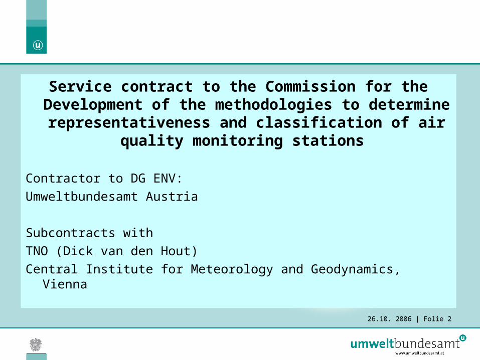
26.10. 2006 | Folie 2
Service contract to the Commission for the Development of the methodologies to
determine representativeness and classification of air quality monitoring
stations
Contractor to DG ENV: Umweltbundesamt Austria
Subcontracts withTNO (Dick van den Hout)Central Institute for Meteorology and Geodynamics, Vienna

26.10. 2006 | Folie 3
Contents
Purpose of Classification Purpose of Assessment of Representativeness Classification methods Test of Classification Definition of Representativeness Method for Determination of
Representativeness Validation of the method for the Determination
of Representativeness

26.10. 2006 | Folie 4
Purpose of Classification
Classification of Air Quality Monitoring Stations (AQMS) is a key instrument for the interpretation and assessment of AQ data – especially for large data-sets covering large areas with a wide variety of types of locations – providing the following information:
Basic information about (different) causes/sources of air pollution (primarily emissions);
Basic information about the affected receptors such as humans (related to exposure);
Support of spatial AQ assessment, including the determination of the area of representativeness.

26.10. 2006 | Folie 5
Assessment of Representativeness
AQ monitoring data are available at certain locations, but it is of major interest to know the spatial distribution of air quality.
Assessment of representativeness means the “extension” of point (measurement) information to “spatial information”.
For this task it is necessary to delimitate areas of the concentration field with “similar characteristics” as specific monitoring stations.

26.10. 2006 | Folie 6
Purpose of Assessment of Representativeness
Compliance assessment based on data from monitoring stations
Delimitation of areas where limit or target values (incl. margin of tolerance) are exceeded or not
Exposure assessment (human health, ecosystems, specific plant species …)
Delimitation of areas with homogeneous concentrations with respect to the exposure relevant limit/target values – in areas where the respective receptor is located
Information of the public Delimitation of areas with homogeneous concentrations with respect to the relevant limit/threshold/alert values, including maps

26.10. 2006 | Folie 7
Purpose of Assessment of Representativeness
Analysis of causes of air pollution: Emissions, dispersion conditions, atmospheric chemistry, deposition, …
Delimitation of areas where AQ is influenced/triggered by similar parameters – emission sources (i.e. with similar temporal variations and triggered by common legal regulations) and other similar influencing factors – important for the development of abatement measures
Model validation and input
Selection of monitoring stations representative for geographical areas related to the spatial model resolution
Monitoring network design
Identification of geographical areas which are not sufficiently covered by monitoring stations or which are covered by several redundant monitoring stations. Monitoring network design, of course, serves the other purposes listed above.

26.10. 2006 | Folie 8
Classification methods
Classification methods for the following parameters are developed:
Emissions – specific for different pollutants
Population

26.10. 2006 | Folie 9
Classification according to Emissions
The classification criterion is the absolute contribution of emissions from the sectors
Road traffic Domestic heating Industry/commercial emissions
The classification of AQ MS is pollutant-specific in any case for industrial emissions, it is recommended to classify also domestic heating and traffic emissions pollutant-specifically.

26.10. 2006 | Folie 10
Classification of Road traffic emissions
The classification parameter is theEmission (g/km.year) divided by the root of the
distance road - monitoring station. This parameters is to be summed up for all streets of
relevance. The root of the distance is an approximation of the
concentration distribution assessed by simple modelling (MISKAM, ADMS).
To deal with buildings between monitoring site and road, the respective emissions are weighted with 0 for close buildings, and 0.5 for almost close buildings or locations in narrow cross lanes.

26.10. 2006 | Folie 11
Classification of Road traffic emissions
Levels of sophistication for assessment of road traffic emissions
Level Approximation of emissions
0 Total vehicle number, uniform emission factor, estimate of share of HDV
1 Vehicle number for passenger cars and HDVs, emission factors for each
2 Vehicle number for passenger cars and HDVs, specific emission factors for different traffic situations (highway, stop&go, ….)
3 Complete emission inventory

26.10. 2006 | Folie 12
Classification of Road traffic emissions
This classification parameter (level 1) covers – for Austrian AQ MS – a range between 0 and 60 000(g/km.year).m-1/2.
Example for 181 Austrian AQ MS: Three classes are separated by boundaries at 4000(g/km.year).m-1/2 and 10 000(g/km.year).m-1/2, which comprise 135, 60 and 35 stations, resp.
Class boundaries are in any case deliberate

26.10. 2006 | Folie 13
Classification of Austrian AQ MSs according to Road traffic emissions
0
5000
10000
15000
20000
25000
30000
35000
40000
45000
50000
55000
60000
Gru
ndlsee
Nordk
ette
Stolza
lpe
Wie
smat
h
Hauns
berg
Schön
eben
Hochg
össn
itz
Höfen
Mist
elba
ch
Himbe
rg
Ziersd
orf
Deuts
chla
ndsb
erg
Kloste
rneub
urg
Gra
z Sch
lossb
erg
Hohe
War
te
Vöckla
bruc
k
Purke
rsdo
rf
Leob
en Z
entru
m
Hartb
erg
Gra
twein
Florid
sdor
f
Stadla
u
Kufste
in F
estu
ng
Bad V
öslau
Liez
en
Salzb
urg
Lehe
n
Kapfe
nber
g
Kufste
in P
raxm
arers
tr.
Brixle
gg
Salzb
urg
Mira
bellp
l.
Laae
rber
g
Linz
Röm
erbe
rg
St. Pölt
en Eur
opap
l.
Vomp
a.d.
L.
Hallei
n A10
Enns
Su
mm
e N
Ox_
Em
i/ro
ot
d

26.10. 2006 | Folie 14
Relation between NO and NOx concentrations and “Traffic parameter”
0
20
40
60
80
100
120
140
160
180
0 5000 10000 15000 20000 25000 30000 35000 40000 45000 50000 55000 60000
Road traffic emission parameter
NO
(µ
g/m
³)
0
40
80
120
160
200
240
280
320
360
NO
x (
µg
NO
2/m
³)
NO mean 2005
NOx mean 2005
Vomp A12
Wien Hietzinger Kai
Enns A1
Salzburg Rudolfspl.
Gärberbach A13
Deviations from a linear relation are partly caused by different local or regional) dispersion conditions.

26.10. 2006 | Folie 15
Classification of Domestic heating emissions
The classification of domestic heating emissions is based upon the emissions in a surrounding of 1 km radius and 5 km radius around the monitoring site.
The emissions within 5 km circle are weighted by 0.1% (derived from dispersion profiles for Switzerland, SAEFL, 2003)
Swiss Agency for the Environment, Forests and Landscape (2003): Modelling of PM10 and PM2.5 ambient concentrations in Switzerland 2000 and 2010.

26.10. 2006 | Folie 16
Classification of Domestic heating emissions
Levels of sophistication for assessment of road traffic emissions
Level Approximation of emissions
0 Population at administrative units
1 Population within 1 km and 5 km derived from GIS data
2 Population within 1 km and 5 km derived from GIS data, emission factors for specific heating structure and fuel use
3 Complete emission inventory

26.10. 2006 | Folie 17
Classification of Domestic heating emissions
This classification parameter (level 1) covers – for Austrian AQ MS – a range between 0 and 143 000 inh.
Example for 181 Austrian AQ MS: Three classes are separated by boundaries at 5000 inh. and 20 000 inh., which comprise 108, 41 and 32 stations, resp.
Class “high” comprises most stations in towns with >100 000 inh., class “medium” suburban sites (related to those large towns) and medium towns.

26.10. 2006 | Folie 18
Classification of Industrial emissions
The classification of industrial emissions (including commercial areas and power plants) can be either based upon modelling or on expert judgement.
No classification method based upon surrogate information can be given.

26.10. 2006 | Folie 19
Classification of Population
The classification scheme according to the population distribution gives information about population and ecosystems in the vicinity of the AQ MS which can be used for exposure assessment.
It is orientated by “common” classification schemes used e.g. in AirBase.
It can be used as a surrogate for the classification of domestic heating emissions.

26.10. 2006 | Folie 20
Classification of Population
Classification scheme according to the population distribution:
Agglomeration (>250 000 inh.) Central urbanSuburban
Large town (50 000 – 250 000 inh.)
Central urbanSuburban
Small town (10 000 – 50 000 inh.)
Rural Near cityregional remote

26.10. 2006 | Folie 21
Test of ClassificationThe proposed Classification method will be tested by application on selected AQ
MSs in Austria, the Netherlands and Mediterranean France (to cover different climatic and topographic situations).
The availability of required emission data or surrogate data will be investigated.

26.10. 2006 | Folie 22
Definition of Representativeness
The area of representativeness is defined by the criteria:
1.The pollution level – described by statistic parameters related to EC AQ regulation – is within a certain range
2.The pollution level is determined by similar reasons.

26.10. 2006 | Folie 23
Definition of Representativeness
Statistic parameters related to EC AQ regulations to determine representativeness:PM10: Annual mean, 93.2-percentile of daily mean values (equivalent to 35 days per year above 50µg/m³)NO2: Annual mean(The exceedances of 200µg/m³ as 1-hour mean are too “rare” and statistically not significant)Ozone: 90.4-percentile of daily maximum 8-hour mean values

26.10. 2006 | Folie 24
Definition of Representativeness
The concentration in the area of representativeness of a certain AQ MS shall be within a range of +10% of the total concentration range observed in Europe.
PM10: Annual mean: 4µg/m³, 93.2-percentile of daily mean values: 7µg/m³
NO2: Annual mean: 4µg/m³, which shall also be applied to NOx
Ozone: 90.4-percentile of daily maximum 8-hour mean values: 4µg/m³
(Preliminary numbers derived from Austrian data)

26.10. 2006 | Folie 25
Example: Ozone 90.4 percentile - concentration range in Austria
Austria, Ozone 2002-04
y = 0.04x2 - 8.15x + 414.76R2 = 0.92
0
10
20
30
40
50
60
70
80
90
100
110
0 10 20 30 40 50 60 70 80 90 100 110 120 130 140 150 160 170 180
93.2Percentile (µg/m³)
Day
s 8h
max
> 1
20 µ
g/m
³

26.10. 2006 | Folie 26
Definition of Representativeness
Further criteria for Representativeness: The area of representativeness is constant over
time (for several years) A certain number of years (proposal: 3 years)
must fulfil the concentration range criterion - in order to take into account inter-annual variations of the pollution level by meteorological influences.
The area of representativeness may change over time (after several years) due to changes in emissions.
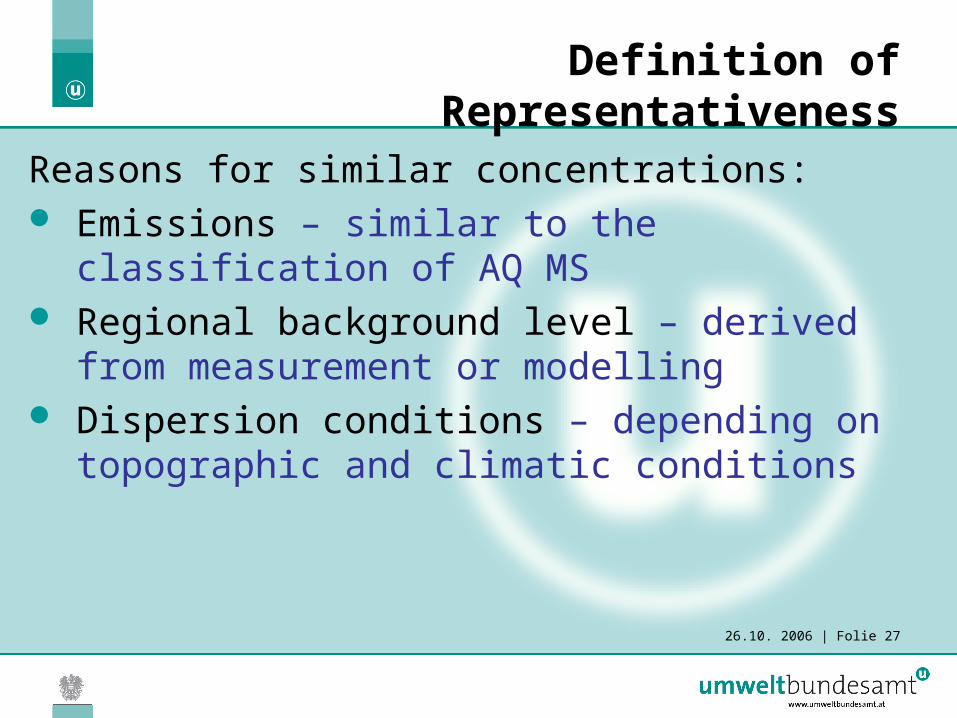
26.10. 2006 | Folie 27
Definition of Representativeness
Reasons for similar concentrations: Emissions – similar to the classification of
AQ MS Regional background level – derived from
measurement or modelling Dispersion conditions – depending on
topographic and climatic conditions
26.10. 2006 | Folie 28
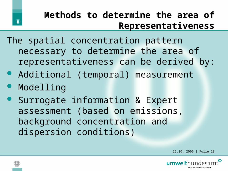
Methods to determine the area of Representativeness
The spatial concentration pattern necessary to determine the area of representativeness can be derived by:
Additional (temporal) measurement Modelling Surrogate information & Expert assessment
(based on emissions, background concentration and dispersion conditions)

26.10. 2006 | Folie 29
Methods to determine the area of Representativeness
Criteria for the determination of representativeness based upon surrogate information:
Emissions: same class related to road traffic, domestic heating and industrial emissions
Regional background: Concentration range related to definition of Representativeness
26.10. 2006 | Folie 30
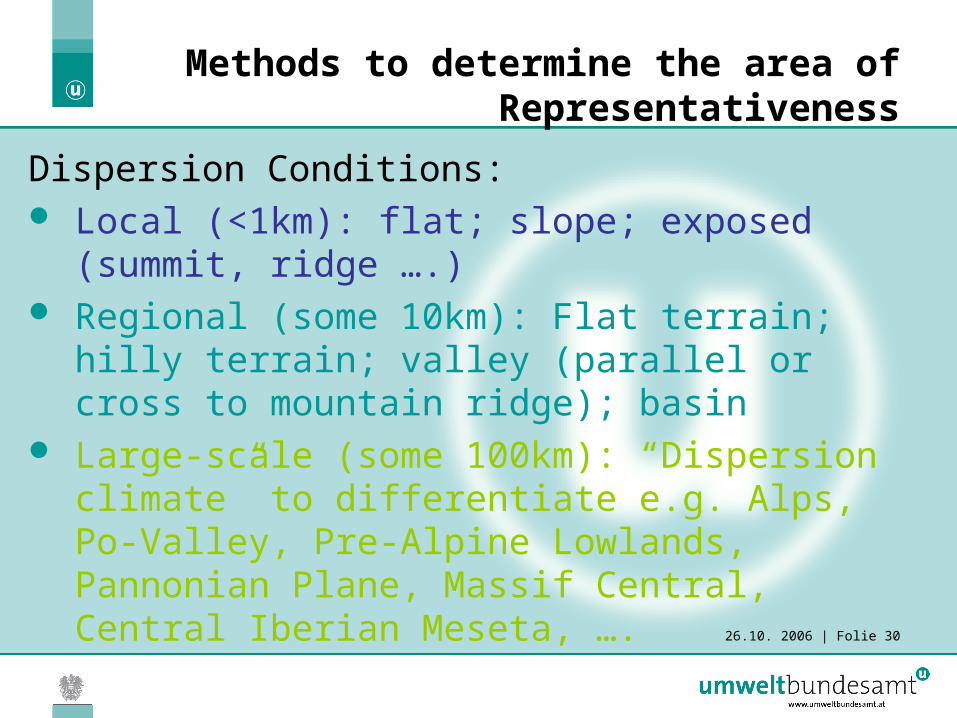
Methods to determine the area of Representativeness
Dispersion Conditions: Local (<1km): flat; slope; exposed (summit,
ridge ….) Regional (some 10km): Flat terrain; hilly
terrain; valley (parallel or cross to mountain ridge); basin
Large-scale (some 100km): “Dispersion climate” to differentiate e.g. Alps, Po-Valley, Pre-Alpine Lowlands, Pannonian Plane, Massif Central, Central Iberian Meseta, ….

26.10. 2006 | Folie 31
Methods to determine the area of Representativeness
To develop operational methods for the determination of the area of representativeness, appropriate data sources (GIS data-bases) are investigated.

26.10. 2006 | Folie 32
Validation of the Methods to determine the area of Representativeness
The validation of the methods for the determination of representativeness will cover a thorough test with selected AQ MSs from Austria, the Netherlands and Mediterranean France (to cover different climate and topographic conditions).
The validation will include a sensitivity analysis of “definition parameters”, i.e. the concentration range for each pollutant and statistical parameter, and the criteria for emissions and dispersion conditions.