2.3 estimation of forest characteristics
TRANSCRIPT
Applications of Laserscanning in Forestry
byChristoph Straub
Dr. Holger Weinacker Yunsheng Wang
Prof. Dr. Barbara Koch
Department of Remote Sensingand Landscape Information Systems
University of Freiburg
Applications of Laserscanning in Forestry 2
Overview
1. Introduction to ALS in Forestry
2. Applications of Laserscanning
2.1 Single Tree Delineation
2.2 Forest Stand Mapping
2.3 Estimation of Forest Characteristics
3. Software DemonstrationTreesVis - processing, analyzing and visualisation of laserscanning data

Applications of Laserscanning in Forestry 3
• Faculty of Forest and Environmental Sciences
• University of Freiburg i. Breisgau, Germany
• Teaching and Research:
���� Remote sensing applications in forestry and relevant neighbouring disciplines (e.g. nature conservation, landscape planning)
Freiburg
GERMANY
Applications of Laserscanning in Forestry 4
1. Introduction
Why is Airborne Laserscanning (ALS) interresting
for forestry?

Applications of Laserscanning in Forestry 5
1. Introduction
Raw Data - Profile:
Fullwave, IGI LiteMapper 5600, Summer 2005
Applications of Laserscanning in Forestry 6
1. Introduction
DSM:
Active Surface Algorithm (Weinacker 2004)

Applications of Laserscanning in Forestry 7
1. Introduction
DTM:
Active Surface Algorithm (Weinacker 2004)
Applications of Laserscanning in Forestry 8
1. Introduction
Tree Height
Tree Top
Crown Diamater
Crown Volume
Base of the Crown
Single Tree Delineation
���� Estimation of DBH (The stemdiameter of a tree measured at breast height (1.3 metersabove ground level))
���� Estimation of h/d proportion
���� Estimation of stem volume
���� For single trees high point density is required!
Tree Height
Shape
Single Trees:
���� Classification into conifers and deciduous trees; (during winter: penetration rate);
In boreal forest: differentiation of birch, spruce, pine
���� Species with spectral image data (RGB and CIR)

Applications of Laserscanning in Forestry 9
1. Introduction
Tree Height
1
2
34
� Estimation of Average DBH (cm)
� Estimation of Timber Volume (m³/ha)
� Estimation of Biomass (t/ha)
Percentage of conifers
and deciduous trees
Top Height
Canopy Closure
Forest Stands (management units):
Tree Number and Stand Density
Applications of Laserscanning in Forestry 10
1. Introduction
Tree Height
1
2
34
Forest Stands (management units):
Average Slope

Applications of Laserscanning in Forestry 11
1. Introduction
���� Applicability of automated harvesting methods
���� Harvester (machine that fells trees, delimbs them and crosscuts
them into logs):
1470D Rad Harvester
Forsttechnik GmbH (John Deere)
http://www.forstgmbh.at
� Steepness of terrain and DBH arelimiting factors for highly automatedharvesters (Heisig et al. 2005)
Applications of Laserscanning in Forestry 12
1. Introduction
Forest Roads:
Local Slope in %:
low high
The documentation of the road and path network in the forest: ���� precondition for an optimization of timber transport���� high importance for soil conservation

Applications of Laserscanning in Forestry 13
1. Introduction
Orthoimage Orthoimage with roads
as digitized line features
Applications of Laserscanning in Forestry 14
1. Introduction
Slope image from LIDAR � Accuracy can be improved
� With LIDAR additional attributes can be collectede.g. slope per road segment, road width ...

Applications of Laserscanning in Forestry 15
1. Introduction
Nature Conservation – Biodiversity / Stand Structure:
���� Gaps in forest stands areimportant ecological elementsand can support thebiodiversity of forestecosystems
���� Multi-storied forest standssupport high diversity and thusbiodiversity
���� Modelling of habitat quality
Applications of Laserscanning in Forestry 16
1. Introduction
� In Scandinavia (Norway): LIDAR is already used for forestinventories (Næsset 2002)
� In Germany: LIDAR for forest inventories is still a researchtopic; in the moment: terrestrial surveys ���� expensive���� LIDAR as an alternative to support or even replace fieldmeasurements (?)
� Orthoimages are used for forest stand mapping (costs arereduced 30-40%)
� Monitoring of forest damages e.g. bavarian national park (insects, fire, windstorm…)
Applications of Laserscanning in Forestry
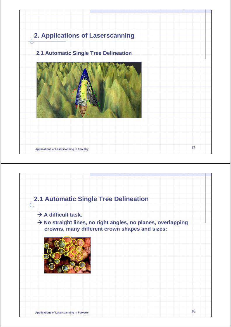
2. Applications of Laserscanning
2.1 Automatic Single Tree Delineation
17
Applications of Laserscanning in Forestry
2.1 Automatic Single Tree Delineation
���� A difficult task.���� No straight lines, no right angles, no planes, overlapping
crowns, many different crown shapes and sizes:
18

Applications of Laserscanning in Forestry
2.1 Automatic Single Tree Delineation
Different approaches for automatic single tree delineation – some examples:
• HIGH-SCAN Project: First European wide attempt to derive single tree information from laserscanner data (Hyyppä 2001)
• Swedish Defence Research Agency: Algorithm for boreal trees (Persson 2001, Persson et al. 2002)
• FeLIS: Algorithm developed under German conditions (Koch et al. 2006)
���� “Watershed Segmentation”: Segmentation of an image by means of a flooding simulation (Soille 1999)
19
Applications of Laserscanning in Forestry
2.1 Automatic Single Tree Delineation
FeLIS - Single Tree Delineation (main processing steps):
1. INPUT: Rasterized laser data (DSM/DTM)
2. DSM is smoothed (Gaussian Smoothing)
3. Tree tops are extracted (Local Maxima)
4. „Pouring Algorithm“ (raindrop model)
5. Final detection of crown edges by searching vectors from thetree tops ���� „Ray Algorithm“
6. Knowledge-based assumptions on the shape of trees
� Minimum size
� Minimum distance between tree tops
� Crown shape (compactness, circularity)
20

Applications of Laserscanning in Forestry
2.1 Automatic Single Tree Delineation
Profile of DSM (individual trees are expected within each salient curve)
21
Applications of Laserscanning in Forestry
2.1 Automatic Single Tree Delineation
Pouring (first step) - Local Maxima detection:
22

Applications of Laserscanning in Forestry
2.1 Automatic Single Tree Delineation
Pouring (second step) – expansion:
1. Maxima are the starting points for an expansion until „valley bottoms“ are reached.
2. The expansion is done as long as there are chains of pixels in which the gray value gets
smaller (like raindrops running downhill from the maxima in all directions)
23
Applications of Laserscanning in Forestry
2.1 Automatic Single Tree Delineation
Local Maximum
Smoothed DSM
Result after
„Pouring Operator“(Individual crowns can be expected within each segment. Further analysis are needed to extract the exact shape of crowns)
„exact shape“
24

Applications of Laserscanning in Forestry
2.1 Automatic Single Tree Delineation
Extraction of individual crowns (ray algorithm)
1. Assumption: The height change within an individual crown must be continuous2. Virtual rays between the tree tops and border points are generated3. New border points of the tree crown are created if there is an interruption of the continuous
height changes by pixels with high difference in elevation
Start Point:
Tree Top
End Point:
Border of Crown
New Point
25
Applications of Laserscanning in Forestry
2.1 Automatic Single Tree Delineation
Verification of the algorithm (field measurements):
Red: Positions of trees measured with GPS during field work
Blue: Segmentation result
26
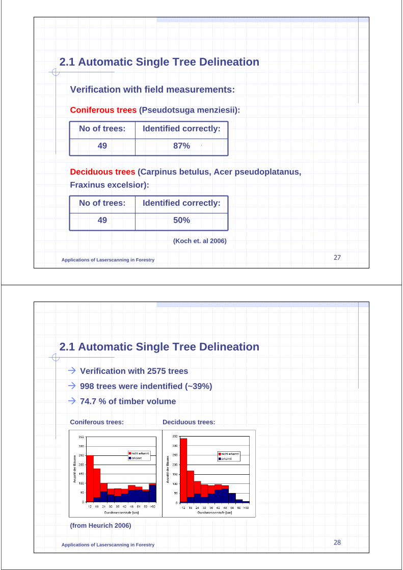
Applications of Laserscanning in Forestry
2.1 Automatic Single Tree Delineation
Verification with field measurements:
Coniferous trees (Pseudotsuga menziesii):
No of trees: Identified correctly:
49 87%
Deciduous trees (Carpinus betulus, Acer pseudoplatanus,
Fraxinus excelsior):
No of trees: Identified correctly:
49 50%
(Koch et. al 2006)
27
Applications of Laserscanning in Forestry 28
2.1 Automatic Single Tree Delineation
� Verification with 2575 trees
� 998 trees were indentified (~39%)
� 74.7 % of timber volume
(from Heurich 2006)
Coniferous trees: Deciduous trees:

Applications of Laserscanning in Forestry
2.1 Automatic Single Tree Delineation
Summary of the verification:
- Good results for conifers
- Problems with small and suppressed trees
- Stem numbers are underestimated
- Most dominant trees are found (���� trees with high timber volume)
- Crown areas are overestimated
Mean crown area forsegmented trees:
Mean crown area forreference trees:
11m² 8.2m²
(Koch et. al 2006)
29
Applications of Laserscanning in Forestry
2.1 Automatic single tree delineation
“New Ideas” (Wang 2007) :
„Voxel-Model“ of point cloud
(dividing the area into small three-dimensional cells).
Layers are created and number of lasercanner points is
calculated in each voxel and stored into 2d image.
Tree structure is traced from top to
bottom:
Layer 1
Layer 2…
30

Applications of Laserscanning in Forestry 31
2.2 Forest Stand Mapping
Size
Age
Main Tree Species
…
Digital Forest Stand Maps:
Forest Area is classified into
„management units“ based on:
• species
• age
• structure
• composition
Applications of Laserscanning in Forestry 32
2.2 Forest Stand Mapping
Subdivision of study area into cells (20x20m,
nDSM in the background):
Classification of the cells based on:
1. Percentage of conifers, deciduous trees and forest floor
���� Classes: Conifers-, Deciduous-, Mixed, Forest Floor
2. Surface Roughness (variation of height values):
���� Classes: homogeneous, inhomogeneous
3. Height Classes: Dev. Stage Height
Sapling 3-10 m
Pole 10-15 m
Mature Trees 15-25 m
Old Trees > 25 m

Applications of Laserscanning in Forestry 33
PR
OC
ES
SIN
G S
TE
PS
:2.2 Forest Stand Mapping
1. Cells 20x20m
2. Coniferous Deciduous Mixed Forest Floor
3. Homogeneous Inhomogeneous
4. Height Classes
5. Creation of preliminary forest stands (grouping)
6. Selection of small regions (<0.1ha)
7. Assigning of small regions (<0.1ha) to neighbours
Classification
Classification
Classification
14 classes
1. CellClassification
2. Grouping intostand units
Applications of Laserscanning in Forestry 34
2.2 Forest Stand Mapping
Example for stand mapping (during winter (leaf-off) conditions):
„Quellgebiet Wieslauter“ in the biosphere reserve „Pfälzerwald“
DSM DTM
- =
nDSM
Vegetation Height:
0m 40m

Applications of Laserscanning in Forestry 35
2.2 Forest Stand Mapping
STEP 1: Modelling of deciduous and coniferous stands during
winter (leaf-off) conditions:
Winter: First Echo Winter: Last Echo
Deciduousstand
Coniferousstand
Deciduousstand
Coniferousstand
Applications of Laserscanning in Forestry 36
2.2 Forest Stand Mapping
Last Echo (nDSM):First Echo (nDSM):
STEP 1: Modelling of deciduous and coniferous stands during
winter (leaf-off) conditions:
Coniferous treesAll trees
- =
Deciduous trees
���� Regions with forest floor
���� Regions with coniferous trees
���� Regions with deciduous trees
…used for classification of cells
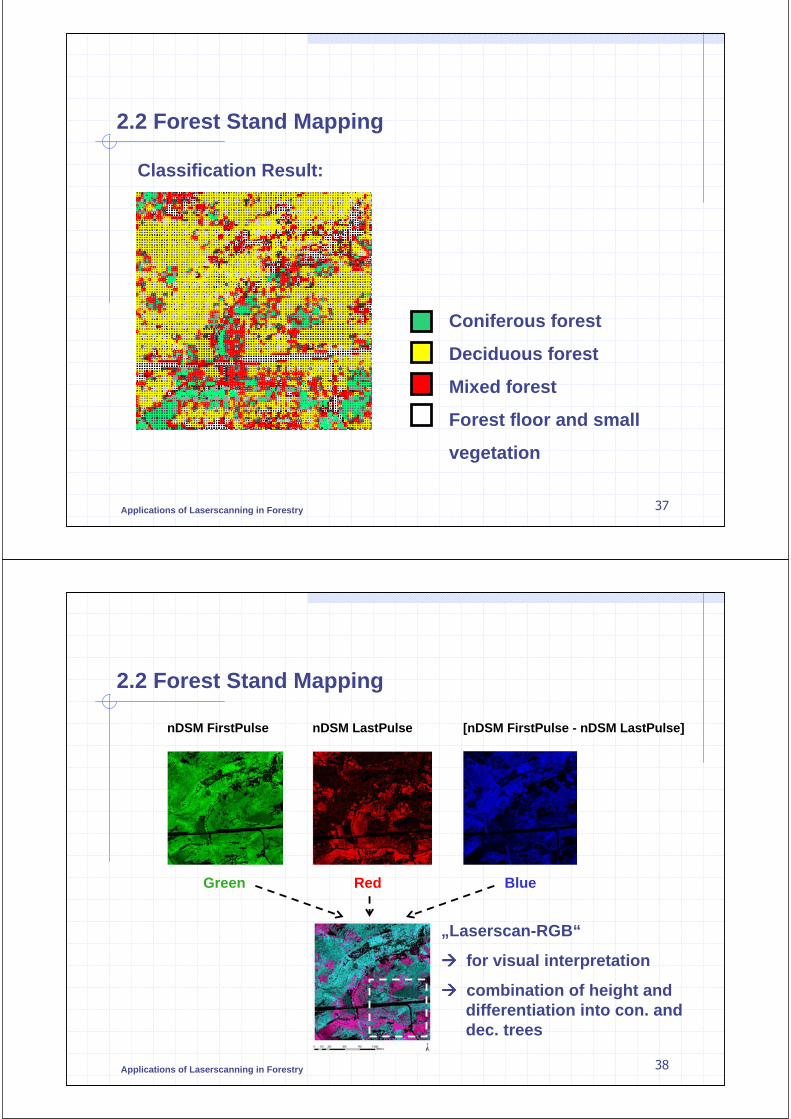
Applications of Laserscanning in Forestry 37
2.2 Forest Stand Mapping
Coniferous forest
Deciduous forest
Mixed forest
Forest floor and small
vegetation
Classification Result:
Applications of Laserscanning in Forestry 38
2.2 Forest Stand Mapping
nDSM FirstPulse nDSM LastPulse [nDSM FirstPulse - nDSM LastPulse]
Green Red Blue
„Laserscan-RGB“
���� for visual interpretation
���� combination of height and differentiation into con. and dec. trees
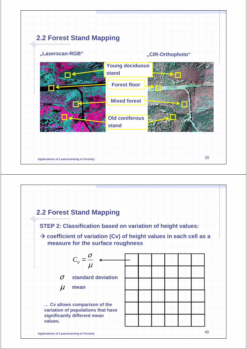
Applications of Laserscanning in Forestry 39
2.2 Forest Stand Mapping
„Laserscan-RGB“ „CIR-Orthophoto“
Forest floor
Young deciduousstand
Old coniferousstand
Mixed forest
Applications of Laserscanning in Forestry 40
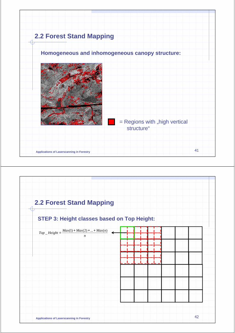
2.2 Forest Stand Mapping
µσ
υ =C
STEP 2: Classification based on variation of height values:
���� coefficient of variation (Cv) of height values in each cell as a measure for the surface roughness
σµ
standard deviation
mean
… Cv allows comparison of thevariation of populations that havesignificantly different meanvalues.
Applications of Laserscanning in Forestry 41
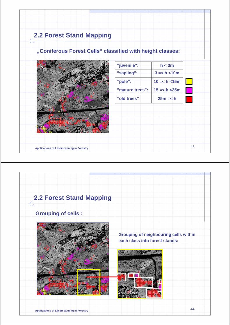
2.2 Forest Stand Mapping
Homogeneous and inhomogeneous canopy structure:
= Regions with „high verticalstructure“
Applications of Laserscanning in Forestry 42
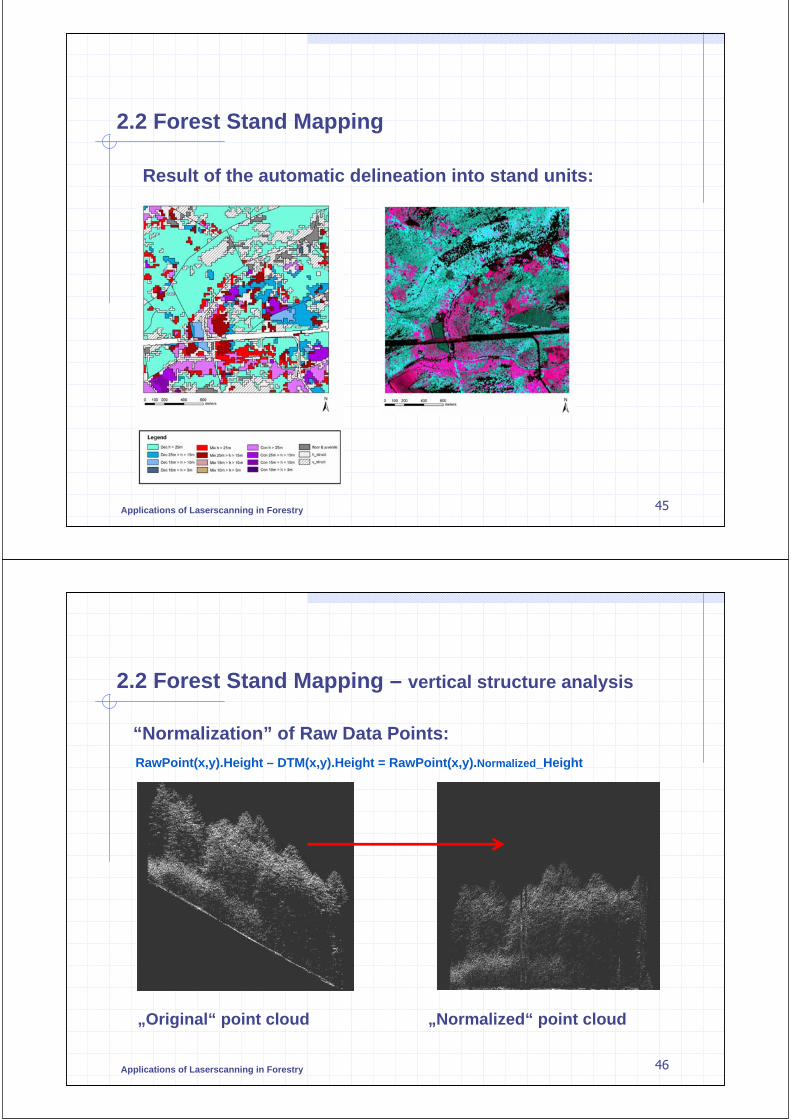
2.2 Forest Stand Mapping
STEP 3: Height classes based on Top Height:
n
nMaxMaxMaxHeightTop
)(...)2()1(_
+++=
Applications of Laserscanning in Forestry 43
2.2 Forest Stand Mapping
„Coniferous Forest Cells“ classified with height classes:
“juvenile”: h < 3m
“sapling”: 3 =< h <10m
“pole”: 10 =< h <15m
“mature trees”: 15 =< h <25m
“old trees” 25m =< h
Applications of Laserscanning in Forestry 44
2.2 Forest Stand Mapping
Grouping of cells :
Grouping of neighbouring cells within each class into forest stands:
Applications of Laserscanning in Forestry 45
2.2 Forest Stand Mapping
Result of the automatic delineation into stand units:
Applications of Laserscanning in Forestry
2.2 Forest Stand Mapping – vertical structure analysis
“Normalization” of Raw Data Points:
RawPoint(x,y).Height – DTM(x,y).Height = RawPoint(x,y).Normalized_Height
„Original“ point cloud „Normalized“ point cloud
46

Applications of Laserscanning in Forestry
2.2 Forest Stand Mapping – vertical structure analysis
Height Distribution Function:
ф(h): Height distribution functionS(h): Smoothed height distribution
functionS’’(h): Second derivative of S(h)
At the intervals of h where S’’(h)<0, there must be salient curves of function S(h);� The intervals of h are
considered as height ranges of tree canopy layers.
ф(h)
S(h)
S’’(h)
h (Height, m)
Numberof Points
47
Applications of Laserscanning in Forestry 48
2.3 Estimation of Forest Characteristics
Field Measurements vs. LIDAR
440m³Volume:
99%Canopy Closure:
3 %Slope:
MatureDevelopmental Stage:
23.4mTop Height:
1.84haSize:
Applications of Laserscanning in Forestry
2.3 Estimation of Forest Characteristics
Two possibilities to analyze the data:
1. High resolution data ���� single tree variables can be estimated
2. Low resolution data ���� plot or forest stand characteristics can be estimated
49
Applications of Laserscanning in Forestry 50
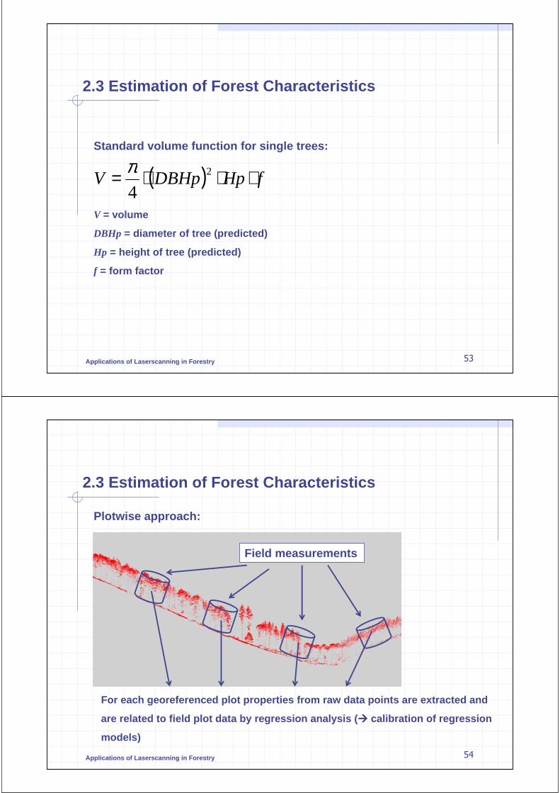
2.3 Estimation of Forest Characteristics
(From Heurich 2006)
Coniferous trees: Deciduous trees:
Tree Height (single trees):

Applications of Laserscanning in Forestry 51
2.3 Estimation of Forest Characteristics
(From Heurich 2006)
Coniferous trees: Deciduous trees:
Crown Radius (single trees):
Applications of Laserscanning in Forestry 52
2.3 Estimation of Forest Characteristics
(From Heurich 2006)
Coniferous trees: Deciduous trees:
DBH (single trees):
Applications of Laserscanning in Forestry 53
2.3 Estimation of Forest Characteristics
Standard volume function for single trees:
V = volume
DBHp = diameter of tree (predicted)
Hp = height of tree (predicted)
f = form factor
( ) fHpDBHpV ⋅⋅⋅= 2
4
π
Applications of Laserscanning in Forestry 54
2.3 Estimation of Forest Characteristics
Plotwise approach:
For each georeferenced plot properties from raw data points are extracted and
are related to field plot data by regression analysis (���� calibration of regression
models)
Field measurements

Applications of Laserscanning in Forestry
2.3 Estimation of Forest Characteristics
Height related variables: Density related variables:
Properties which may be extracted from ALS data (Næsset 2003):
Height-related variables:
Percentiles of the heights: hp0, hp10, ….,
hp90 , hcv, hmean …
Densities of 10 vertical layers: d0, d1, …., d9Proportions of points above percentiles of the heights for 0%, 10%, …90% to total numberof points
55
Applications of Laserscanning in Forestry 56
2.3 Estimation of Forest Characteristics
Results of study in Norway (Næsset 2002):
R²=0.91 R²=0.91
Stand Height: Timber Volume:

Applications of Laserscanning in Forestry 57
2.3 Estimation of Forest Characteristics
Forest Inventories (plotwise) proposed by (Næsset 2003), modified:
Field measurements
Laserscanning data
Study area subdivided
into cells
Stand boundaries Computingstand values
Computing standcharacteristics withingrid cells
Relating laser data to fieldplot data by regressionanalysis
Applications of Laserscanning in Forestry 58
3.0 Software Demonstration
TreesVis - processing, analyzing and visualisation of laserscanning data

Applications of Laserscanning in Forestry 59
Literature
Heurich, M. (2006): Evaluierung und Entwicklung von Methoden zur automatisierten Erfassung von Waldstrukturen aus Daten flugzeuggetragenerFernerkundungssensoren, Forstliche Forschungsberichte, München
Heisig (2005): GIS based Forest Biomass Exploitation for Energy Supply in the Northern Black Forest Region, PFG, Schweizerbart‘scheVerlagsbuchhandlung, Stuttgart
Hyyppä, J. ; Hyyppä, H. (2001): Assessing forest stand attributes by integrated use of high-resolution satellite imagery and laserscanner, High-Scan, Final Report –prepared for European Commission Directorate General XII, Helsinki
Koch, B., Heyder U., Weinacker, H., (2006): Detection of individual tree crowns in airborne LIDAR data. An approach to delineate tree crowns in mixed and deciduous temperate forests. Photogrammetric Engineering and Remote Sensing, 72, (4), pp. 357 – 363
Næsset (2002): Data Acquisition for Forest Planning Using Airborne Laser Scanning, presented at ForestSAT Symposium Heriot Watt University, Edinburgh
Næsset (2003): „Laser scanning in practical forest inventories: the Norwegianinventories: the Norwegian experience", Online: http://portal.uni-freiburg.de/felis/skripte/download/NLH/view
Applications of Laserscanning in Forestry 60
Literature
Persson, A. (2001): Extraction of individual trees using laser radar data. Master Thesis EX013, Chalmers University of Technology, Göteborg, Sweden, 28 p.
Persson, A., Holmgren, J. and Södermann, U. (2002): Detecting and measuring individualtrees using an airborne laser scanner, Photogrammetric Engineering & RemoteSensing; Vol. 68. No. 9. September 2002. S. 925-932.
Persson, A., Holmgren, J., Södermann, U. (2006): Identification of tree specious of individual trees by combining very high resolution laser data with multi-spectralimages, In: Proceedings of the international workshop on 3D remote sensing in forestry, 14th -15th Feb., Vienna
Soille, P. (1999): Morphological Image Analysis, Springer, BerlinWang, Y. (2007): Development of a procedure for vertical structure analysis and 3D-single
tree extraction within forests based on LIDAR point cloud, ISPRS workshop on Laser Scanning 2007, accepted (20th June 07), Finland
Weinacker, H., Koch, B., Heyder, U., Weinacker, R. , (2004): Development of filtering, segementation and modelling modules for LIDAR and multispectral data as a fundament of an automatic forest inventory system In: Laser-Scanners for Forest and Landscape Assessment, International Archives of Photogrammetry, Remote Sensing and Spatial Information Sciences, Vol. XXXVI, 8/W2, Freiburg

Applications of Laserscanning in Forestry 61
Literature
Weinacker, H. ; Koch, B. ; Weinacker, R. (2004): TreesVis – A software system for simultaneous 3D-real-time visualization of DTM, DSM, Laser raw data, multispectral data, simple tree and building models, In: Laser-Scanners for Forest and Landscape Assessment, International Archives of Photogrammetry, Remote Sensing and Spatial Information Sciences, Vol. XXXVI, 8/W2, Freiburg