2.10 mineral resources 2.10.1 existing conditions 2.10.1.1
TRANSCRIPT
2.10 Mineral Resources
San Diego County General Plan Update EIR Page 2.10-1 August 2011
2.10
Mineral Resources
This section of the EIR evaluates the potential for impacts to mineral resources associated with implementation of the General Plan Update. It identifies known and potential mineral resources within the County, and analyzes the potential for the General Plan Update to result in the loss of availability of a known mineral resource or the loss of availability of a locally important mineral resource recovery site. The majority of information in this section is from the County of San Diego General Plan, Conservation and Open Space Element Background Report (DPLU 2007b) and the County of San Diego Guidelines for Determining Significance, Mineral Resources (DPLU 2008c). A summary of the mineral resources impacts identified in Section 2.10.3 is provided below.
Mineral Resources Summary of Impacts
Issue Number Issue Topic Project Direct Impact
Project Cumulative Impact
Impact After Mitigation
1 Mineral Resource Availability Potentially Significant Potentially Significant
Significant and Unavoidable
2 Mineral Resource Recovery Sites Potentially Significant Potentially Significant
Significant and Unavoidable
2.10.1 Existing Conditions Mineral resources located in San Diego County serve various public, commercial, scientific, and recreational purposes. Mineral resources are used in both private developments and public projects. Local extraction sites are valuable assets used to help facilitate the continual growth of the region. Locally important mineral resources in the County include construction materials, rocks that can be used for dimension stones, and also minerals of historical significance including precious metals and gemstones. 2.10.1.1 Geologic Environments Geologic processes in San Diego County such as intrusive emplacement of magma, volcanism, erosion, sedimentation, and hydrothermal processes determine the type, location, and concentration of all mineral resources. There is a direct association between specific types of mineral deposits and the host rock that contains those deposits. For example, in San Diego County, gold and tungsten occur mainly in metamorphic rocks, while concrete quality sand is found in the floodplains of the major river valleys. Gem and specimen minerals are found in the County’s pegmatites. Pegmatites are rocks from water-rich magma that cooled slowly as it moved through fractures in the host rock. Large crystals formed in these slow-cooling magmas. The pegmatites are important sources of gem material and crystal specimens. A geological environment is made up of the physical constituents of an area, including rocks, sediments, soils, fluids, and landforms, as well as the processes that shaped the environment over time (Howari 2003). The following general geologic environments are the most important to mineral resources that are found within the County, including the Mineral Resource Zone

2.10 Mineral Resources
San Diego County General Plan Update EIR Page 2.10-2 August 2011
(MRZ) areas discussed below. Figure 2.10-1 shows the distribution of the geologic environments in the County. Mesozoic age [65 to 248 million years ago (mya)] metamorphic rocks include marble, schist, and gneiss outcrops that are found in the western foothills of the Peninsular Range and in the desert east of the mountains. The local supply of marble and gneiss are used mainly for dimension stone in buildings. Cretaceous Age (65 to 135 mya) crystalline rocks, including granites, diorites, and gabbros and Upper Jurassic (135 to 160 mya) metavolcanics underlie most of the mountainous terrain in the central portion of the County. These rocks are associated with the Peninsular Ranges batholith that underlies southern California and Baja California. A batholith is a large body of igneous rock formed beneath the Earth’s surface by the intrusion and solidification of magma (Britannica 2008). This rock type is primarily quarried for coarse aggregates that are needed for concrete, riprap (broken rock) for breakwaters and bank protection, and decorative and dimension stone, as described in greater detail below. Tertiary Age (1.8 to 65 mya) sedimentary rocks include sandstone, conglomerate, and mudstone and are found in the western portion of the County. Deposits of recent alluvium, including sand, gravel, silt, and clay are found in river and stream valleys, around lagoons, in intermountain valleys, and in the desert basins. Both tertiary age rocks and recent alluvium can be mined and processed for construction materials, as described further below. Sand and gravel are plentiful in the desert, but costs to transport the material make mining infeasible to serve the needs of the metropolitan areas of western San Diego County. 2.10.1.2 Mining Economics Although geologic considerations are the dominant factors determining the ultimate availability of most minerals, economic factors usually determine when and if a mineral deposit will be mined. To be financially feasible (that is, profitable in a business sense), sale proceeds must exceed the costs of mining, processing, and distribution. In both dollar value and tonnage, the extraction of sand and gravel materials is the most productive type of mining in San Diego County. The deposits are vital to community development. To be of use, deposits must be close enough to urban centers for extraction and transport to be economical. For this reason, past studies on sand and gravel have focused on the western portion of the County where most of the development has been. The conservation of potential mineral resource sites in the unincorporated County ensures future supplies will be available when they are needed and when improved technology makes their mining economically feasible. Rapid changes in the market value, as well as advances in mining technology have major impacts on the economic feasibility of mining a particular mineral deposit. Economics are also of great consideration in determining the unit value of the resource as it usually determines when and if a deposit will be mined. Bulk aggregate products of low unit value such as sand or gravel must be mined near the point of use to avoid high transportation costs, whereas gem-products of high unit value such as tourmaline can be shipped anywhere at a low distribution cost.
2.10 Mineral Resources
San Diego County General Plan Update EIR Page 2.10-3 August 2011
Some basic considerations for determination of the economic feasibility for potential mining locations in San Diego County include:
• Supply and Demand. As described further in Section 2.10.1.4, as of January 2006, the number and output of permitted quarries in the County has not kept pace with the increasing demand for sand and aggregate. The shortage of local PCC sand has partially contributed to the San Diego region having the highest price for aggregate of any regional market in California. The total amount of permitted aggregate resources in western San Diego County represents only 17 percent of the 50-year estimated demand for the County. Prices will continue to increase due to the imbalance between supply and demand, and any new permitted aggregate mines in the local market will likely benefit economically from this situation. Supply of gemstones and other rare minerals is low and as a result, demand and cost for these types of minerals will continue to remain high.
• On-site Mining and Processing Costs. On-site mining and processing of sand and gravel aggregate derived from alluvial deposits is less expensive than crushing rock. Crushed rock requires higher mining and processing costs due to ripping, drilling, blasting, and crushing of the rock. Mining of dimension stone is also expensive. Mining for gemstones is labor intensive and the resulting volume of minerals is small. It is also costly to extract gemstones and other rare minerals.
• Transportation Costs. Transportation plays an important role in the cost of mineral resources to the consumer, and is the principal constraint in defining the market area for an aggregate mining operation. Due to the expensive mining and processing costs of crushed rock, proximity to urban centers is important to reduce transportation costs. According to the local mining community, this currently restricts crushed rock operations to urbanized areas within the western portion of San Diego County. However, it is economically feasible for alluvial sand and gravel mines to be potentially permitted in the eastern portion of the County provided there is efficient freeway or railway access to get the materials to market in the urbanized western portion of the County.
2.10.1.3 Existing Resources In mining and conservation, economists, engineers, and scientists use the term “mineral resources” to mean a concentration or occurrence of natural, solid, inorganic or fossilized organic material in or on the earth’s crust in such form and quantity and of such a grade or quality that it has reasonable prospects for economic extraction. For purposes of this document, there are three general categories of mineral resources important to San Diego County:
• Construction Materials. These include sand, gravel, and crushed rock. This is economically the most important category of mineral resources to the region.
• Industrial and Chemical Mineral Materials. These include limestone, dolomite, and marble (except where used as construction aggregate), specialty sands, clays, phosphate, borates and gypsum, feldspar, talc, building stone and dimension stone.
• Metallic and Rare Minerals. These include precious metals (silver, platinum), iron and other ferro-alloy metals, copper, lead, zinc, gemstones and semi-precious materials, and optical–grade calcite.
2.10 Mineral Resources
San Diego County General Plan Update EIR Page 2.10-4 August 2011
These three general categories of mineral resources are discussed further below. The locations of the existing mineral resources in the County are shown on Figure 2.10-2. 2.10.1.4 Construction Materials The County’s supply of mineral resources is exhaustible and the mineral resource deposits are essentially non-renewable. There is, however, a vast amount of mineral deposits. Mining has been authorized in only a fraction of the area that technically could be mined. In the case of alluvial deposits, the rate of consumption dramatically outweighs natural rates of replenishment. Erosion of the foothills and mountains, transport by gravity and water, and deposition of this new material into the County’s alluvial river valleys and basins replenishes sands and gravels. However, upstream dams restrict the flow of water in all but one of the rivers in the County, thereby reducing the replenishment of these materials. Conservation of the County’s remaining mineral resources, especially construction aggregates, is important to ensure that resources are available for future generations.
Construction Materials
Sand, gravel, and crushed rock provide essential construction aggregate material for modern society and comprise the most important mineral resource category in San Diego County. Aggregate is used in one form or another for the construction of roads, parking lots, buildings, homes, schools, hospitals, shopping centers and other essential infrastructure. In the natural state, sand and gravel are usually loose, easily handled, and readily compacted, while retaining good internal drainage characteristics. These characteristics make them a preferred material for fills and a base for pavements and other structures. When combined with a cement binder, these materials become the principal ingredient in concrete, whether used in its fresh (plastic) state and placed in forms, or pre-cast as pipe, block and other structural components. When combined with asphalt, sand and gravel become the aggregate forming the major element of asphaltic concrete, which is widely used as a paving material. The highest grade aggregate is used to provide the bulk and strength to Portland Concrete Cement (PCC) and Asphalt Cement (AC). PCC and AC Aggregate Rigid specifications for PCC and AC have been established by several agencies including the U.S. Bureau of Reclamation, the U.S. Army Corps of Engineers, and the California Department of Transportation to ensure the construction of strong, durable structures capable of withstanding the physical and chemical effects of weathering and use. As an example, specifications for PCC prohibit or limit the use of rock materials which contain gypsum, pyrite, zeolite, opal, chalcedony, chert, siliceous shale, volcanic glass, and some high-silica volcanic rocks. Each can cause physical and/or chemical effects which make the rock unsuitable for use as PCC. These restrictive specifications make PCC or AC aggregate the scarcest and most valuable form of aggregate. Within the County, crushed rock is the primary source of locally mined PCC aggregate. PCC sand is very scarce in the County due in part to environmental and regulatory constraints of permitting and extracting sand and gravel from in-stream and floodplain areas.

2.10 Mineral Resources
San Diego County General Plan Update EIR Page 2.10-5 August 2011
Alluvial Sand and Gravel Within the unincorporated portion of the County, alluvial sand and gravel deposits are generally found in river and stream valleys, alluvial fans, and in intermountain alluvial valleys. Alluvial materials are generally composed of a range of grain sizes that make them readily compactable while retaining good internal drainage. These deposits are typically preferred to crush stone for PCC aggregate because the rounded particles of alluvial sand and gravel result in a wet mix that is easier to work with than a mix made of angular fragments (CGS 2006). In addition, alluvial gravel deposits are usually loose, easily handled, and require minimal ripping, drilling, blasting, and crushing as compared to rock quarries. The locations of sand and gravel deposits in San Diego County are shown in Figure 2.10-2. Crushed Rock Within the unincorporated portion of the County, potential deposits for crushed rock are extensive (hundreds of square miles) and include Cretaceous granitic rocks of the Peninsular Ranges batholith that underlie approximately 70 percent of the unincorporated portion of the County, along with Upper Jurassic and Lower Cretaceous Santiago Peak metavolcanics, and Tertiary marine and non-marine sedimentary formations. To produce crushed rock, significant mining and processing activities are required, including ripping, drilling, blasting, and crushing of the rock. These activities make crushed rock materials more costly to produce than naturally occurring alluvial sand and gravel deposits. However, PCC can be made with crushed rock aggregate that is generally satisfactory and can supplement the local supply of alluvial sand and gravel. Construction Aggregate Shortage Ensuring that industrial mineral resources production can keep pace with rapid population expansion has been a planning issue in San Diego County for many years. The County’s supply of aggregate materials is large and could meet County demands for mineral resources over the next several generations. However, the western portion of the County has undergone rapid development that has encroached upon existing and potential future mining sites. As the population has grown, development has spread eastward and up the river valleys where mineral resources, especially aggregate and sand, were mined. The encroachment of urbanization caused mines to close or move to more remote locations, which then resulted in more encroachment as the population and development continued to grow around the mines. In this way, much of the aggregate mineral resources in the County became unavailable to the construction industry. The mineral resources available for construction in the County have dwindled; however, continued development requires more resources. As a result, the locally permitted construction aggregate supply has not kept up with demand, resulting in San Diego now having the highest prices for aggregate of any region in the State. Due primarily to the short supply of aggregate materials, the price of PCC-grade aggregate ranges from $20 to $22 per ton (CGS 2006). To meet demand, aggregate is now being imported into the County from locations throughout southern California and is also being brought in by barge from Mexico. Reliance upon imported aggregate has become necessary to keep up with demand, even though transportation increases the cost of mineral resources for all users.
2.10 Mineral Resources
San Diego County General Plan Update EIR Page 2.10-6 August 2011
Conservation of the remaining areas from which mineral resources can be extracted is necessary to avoid shortfalls in construction aggregate supply. The use of construction materials recycled from demolished buildings, roadways or other facilities can lengthen the time that existing permitted mineral resources extraction facilities will last, and reduce the urgency for permitting new mining facilities. Current Planning Issues To keep the price of mineral resources as low as possible, and thus keep the cost of housing and supporting infrastructure as low as possible, mines need to be close to the area where development is expected to occur. Construction mineral resources are heavy, and their cost increases with travel distance. Balancing the need for construction materials with urbanization, competing and incompatible land uses, public perception of mines, and permitting requirements is a planning challenge. Urbanization and Permanent Resource Loss Despite society’s dependence on construction materials, urban expansion often works to the detriment of the potential future extraction and use of those essential raw materials. Extraction of mineral resources for construction is often precluded by another existing land use. For example, aggregate resources that exist under a housing development or shopping center cannot be extracted. Also, if a housing development was allowed to be built adjacent to an area with suitable aggregate for extraction, land use compatibility issues arise that also could preclude the extraction of the aggregate. Cumulatively, vast areas of potentially mineable mineral resources within the western region of the County have been permanently lost due to urbanization. Noise Setbacks and Other Public Concerns Noise from mining activities is typically the most recognizable environmental impact that would affect nearby sensitive land uses (such as residential developments, industrial developments, commercial developments, and major public facilities). In order to meet the standards outlined in the Noise Ordinance (County Code Section 36.401 et. seq), an adequate setback between noise-generating activities associated with extractive uses and sensitive land uses is necessary. Although setback distances would vary from project to project, a general noise setback area of approximately 1,300 feet is an adequate distance for most extractive operations to avoid exceedance of allowable noise levels (in compliance with the Noise Ordinance). For example, 1,300 feet would usually attenuate typical heavy equipment noise levels of 75 to 90 dBA to the Noise Ordinance standard of 50 dBA for daytime residential land use. It is important to note that the setback is relative to the property line of a noise sensitive land use. The range of the setback area would vary, depending on the noise levels produced by the quarry, proposed blasting, production methods, extent of crushing and screening activities, topographic and site conditions, etc. Setback distance will also depend on the applicable sound level limits at the property line as determined by the Noise Ordinance. The size of the setback would also vary depending on the presence of natural or man-made noise barriers between the noise source and the property line. For example, significant topography could attenuate noise associated with extractive activities at the property line, allowing for a reduced setback to achieve Noise Ordinance compliance. Residents are also concerned about potential dust, blasting vibrations, truck traffic, unsightly scars on the land, and loss of habitat caused by aggregate mining.
2.10 Mineral Resources
San Diego County General Plan Update EIR Page 2.10-7 August 2011
Open Space for Sensitive Environmental Resources Permanent open space easements placed on parcels for the protection of sensitive environmental resources permanently preclude future extraction of mineral resources. Such open spaces often exist in prime aggregate extraction areas such as river valleys and constitute an impediment to finding suitable sites for new mines. Aggregate Production in San Diego County Available Resources In 1982, the CDMG, now known as the California Geological Survey (CGS), classified lands for PCC-grade aggregate and in 1985 these lands were designated by the State Mining and Geology Board (SMGB) as having aggregate resources of regional significance. The most recent relevant publication is the Aggregate Availability in California Report, published in 2006 as part of Map Sheet 52 by the CGS. According this report, in 2001, there were 275 million tons of permitted aggregate resources in San Diego County. By 2006, there were only 198 million tons of permitted aggregate resources. Between 2001 and 2006, the amount of permitted aggregate resources decreased approximately 28 percent. This is due to a variety of factors including new mining regulations, closure of previously operational mines, a decrease in new mining permits, and increased continued consumption of resources. An additional 5,740 million tons of unpermitted resources are estimated to be available in the western portion of the County. This is the estimated amount of aggregate that is available for future extraction. However, urbanization and conservation measures restrict access to these aggregate resources, making it difficult to permit new mining operations. An increasing amount of aggregate continues to be lost due to urbanization. In addition to urbanization, adoption of competing resource conservation measures, such as the Multiple Species Conservation Program and the Multiple Habitat Conservation Plan, could substantially restrict access to aggregate resources. Permitted Mining Operations As of 2009, 18 mines were permitted and active within the unincorporated County, as shown in Table 2.10-2. The exposed areas in the 18 active mines totaled approximately 900 acres. Some of these mines had reached the reclamation phase of the extraction operation. Reclamation is the process of closing a mine and returning it to pre-mining conditions or a new use such as cropland. The process must conform to the requirements of the Surface Mining and Reclamation Act (SMARA), described below in Section 2.10.2, Regulatory Framework. According to the California Department of Conservation, reclamation includes maintaining water and air quality, minimizing flooding, erosion and damage to wildlife and aquatic habitats caused by surface mining. The final step in this process is often topsoil replacement and revegetation with suitable plant species (OMR 2008). The County of San Diego Department of Public Works (DPW) operates three active mines in the unincorporated County, including Buckman Springs Borrow Pit in the Mountain Empire Subregion, Warner Borrow Pit in the North Mountain Subregion, and Olive Street Borrow Pit in Ramona CPA. These mines produce aggregate materials for use by DPW. The County of San Diego’s Department of Planning and Land Use (DPLU) reviews existing mines for compliance with the approved plans of operation on an annual basis. Table 2.10-1 indicates the types of minerals being commercially mined within the entire County. Table 2.10-2 lists extraction sites within the unincorporated areas of San Diego County.
2.10 Mineral Resources
San Diego County General Plan Update EIR Page 2.10-8 August 2011
Projected Aggregate Demand
The 2006 CGS report provides an estimate of project aggregate consumption in the western San Diego region through the year 2055. Estimates were generated using industry projection records, population data, aggregate consumption indicators, and historical per capita consumption rates to develop project consumption rates. In order to satisfy the future demand of aggregate through the year 2055, it is estimated that 1,164 million tons of aggregate will be needed. Of this total, approximately 70 percent, or 815 million tons, must be PCC-grade aggregate. As described above, 198 million tons of permitted aggregate resources are available in the County, which would provide only 17 percent of projected demand. Based on the aggregate reserve estimates of 1995, PCC-grade aggregate reserves would be exhausted by 2016 (DMG 1996). However, the San Diego region will continue to grow well beyond this timeframe. Therefore, San Diego County will have to rely even more on imported aggregate resources as the County builds out. 2.10.1.5 Other Mineral Resources
Industrial and Chemical Mineral Materials
Industrial and chemical mineral materials found within the County include, but are not limited to, ash, boron, clay, bentonite, kaolinite, dolomite, feldspar, graphite, gypsum, mica, perlite, phosphorous, pumice, quartz, specialty sands, sodium, gypsum, calcite, silica, limestone, and dimension stone. Dimension stone consists of large, round, relatively flawless blocks or slabs of stone used for items such as buildings, monuments, paving, and countertops. In San Diego County, dimension stone of granite, gabbro, marble, and limestone are quarried. Gypsum is a major rock forming mineral that produces massive beds, usually from precipitation out of highly saline waters. Gypsum deposits are located in the eastern part of San Diego County. Moreover, gypsum is used in concrete for highways, bridges, buildings, and many other structures. Gypsum also is used extensively as a soil conditioner to improve the workability and the water penetration of soils and to overcome the corrosive effect of alkalinity. It is also a component of plaster of paris used in surgical and orthopedic casts (Gypsum 2008). Clay deposits, including bentonite and montmorillonite, are also found in San Diego County. Derived from weathered volcanic ash, bentonite is a material composed of montmorillonite clay and other minerals, and is commonly used in drilling mud. Bentonite swells considerably when exposed to water, making it ideal for protecting formations from invasion by drilling fluids (Schlumberger 2008). It is also used in cosmetics (facial masks) and internally as a detoxifying agent (CureZone 2008). Calcite mines can be found in the badlands of the Anza-Borrego Desert State Park. In the building industry, calcite is used as a component in cement, a filler in paint, and as a structural and ornamental stone. Crushed calcite (lime) is used to mark the lines on a playing field. Clear crystals were once used to make polarizing prisms, and they are still used today in optical instruments. During World War II, at the Calcite Mine site above Palm Canyon, optical-grade calcite crystals were extracted for use in gun sights and targeting instrumentation. This was the only site in the U.S. that produced optical-grade calcite crystals (Schad 1998). Mining was halted when a synthetic material replacing calcite was invented.

2.10 Mineral Resources
San Diego County General Plan Update EIR Page 2.10-9 August 2011
Cryptocrystalline silica, composed of extremely fine silica (quartz) crystals, occurs throughout the Peninsular Ranges and foothills from Orange County southward to the Santa Ana range in Baja California. Trace elements and impurities give cryptocrystalline silica, chemically identical to quartz, distinctive colors. The names given to this mineral are generally based on the differences in translucence, color, texture, or presumed geological origin, and include agate, chalcedony, chert, flint, jasper, and silicified (petrified) wood. Limestones are sedimentary rocks made from calcite that came from shallow reef environments. It was formed by the evaporation of seas and lakes and from sea animal shells. Fossilized limestone is used for building materials, lime production and aggregate. This rock is used in concrete and is an excellent building stone for humid regions. Limestone is found in limited quantities in San Diego County. Most of the unincorporated portion of the County, especially east of the urbanized areas, is underlain by granitic rocks. Granite is one of the most versatile stone types because it is capable of taking a wide variety of finishes, which allows designers to custom-tailor the stone to specific aesthetic or performance requirements. Composed mostly of quartz and feldspars, granite is scratch resistant and durable. Granite is a choice material for high precision applications such as surface plates, and machine mounts and press rolls.
Metallic and Rare Minerals
No gold and only a few gemstone mines are currently active in the County, but both gold and gemstones played a very important historic role in the settlement of several towns in the backcountry of eastern San Diego County. Historical mining sites are important for their scientific, educational, and recreational uses. In addition, some historical mines still contain resources of commercial value. Gold potentially exists in the County, and could be locatable or extractible with future technology. Gemstones are not a necessary commodity for an expanding population, but they provide other benefits to the region, such as worldwide recognition. Mindat.org, a mineralogy database, lists 185 gem and specimen minerals from 655 locations San Diego County. San Diego County’s gems are found in sheetlike pegmatite bodies that are typical of the southern California-northern Baja California region (Mindat 2008). Gem producing pegmatites in San Diego County are found in the Pala, Mesa Grande, Ramona, Coahuila, Rincon, McCain Valley and Jacumba Districts, which are the major pegmatite districts of California. Approximately 13 gem mines are currently active at four locations in the County including Pala, Mesa Grande, Warner Springs and Ramona, as shown in Table 2.10-3. 2.10.1.6 Mineral Resource Zones
Classification and Designation
In 1975, SMARA required the classification of land into MRZs, according to the land’s known or inferred mineral resource potential. The process was based solely on geology, without regard to existing land use or land ownership. The primary goal of classification is to ensure that the mineral potential of land is recognized by local government decision-makers and considered before they make land-use decisions that could preclude mining. The intent was that when resources were identified and the scarcity was verified, those lands would be protected for future extraction. However, many local governments must choose between mining and its most common competing land use, residential development.
2.10 Mineral Resources
San Diego County General Plan Update EIR Page 2.10-10 August 2011
The SMGB prioritizes areas to be classified and/or designated. The highest priority areas are those within the State that are subject to urban expansion or other irreversible land uses that would preclude mineral extraction. Areas where such a possibility is perceived to be most severe, such as in western San Diego County, are given highest priority. Approximately the western one-third of the County was classified into distinct MRZs according to the California Mineral Land Classification System in 1982. The lands classified in San Diego County are known as the Western San Diego County Production-Consumption (P-C) Zone and extend from the southern Camp Pendleton boundary, south to the International Border, and from the ocean to an irregular boundary approximately one-third of the way across the County. The P-C Zone takes in all of the incorporated areas of the County, and the unincorporated communities of Jamul, Alpine, Ramona, Valley Center, and Rainbow. Along the San Luis Rey River the boundary extends to Pauma Valley. The remaining lands to the east are referred to as uncategorized zones. The MRZs are discussed below and shown graphically on Figure 2.10-3. Mineral Resource Zone 1 (MRZ-1) MRZ-1 areas are defined as areas where adequate geologic information indicates that no significant mineral deposits are present, or where it is judged that little likelihood exists for their presence. This zone is applied by the CGS to lands where well developed lines of reasoning, based on economic-geologic principles and adequate data, indicate that the likelihood for occurrence of significant mineral deposits is nil or slight. Six areas in the unincorporated County are designated as MRZ-1. Five are in the North Metro Community Planning Area (CPA), just north of the City of Escondido, and one is at the intersection of State Route (SR) 94 and SR-54, in the Rancho San Diego area of the Valle de Oro CPA. Mineral Resource Zone 2 (MRZ-2) MRZ-2 areas are defined as areas underlain by mineral deposits where geologic information shows that significant measured or indicated resources are present. A typical MRZ-2 area would include an operating mine, or an area where extensive sampling has indicated the presence of a significant mineral deposit. The 1982 classification identified 22 sectors in the unincorporated County as having aggregate deposits, of which 19 are still economically extractable. Sectors are defined as MRZ-2 areas that meet the SMGB guidelines as eligible to be designated as having regional or statewide significance. Additional deposits have been classified or reclassified as MRZ-2 for PCC-grade aggregate in the unincorporated County since 1982. Table 2.10-4 lists the aggregate resource sectors in the County. Table 2.10-5 lists lands classified since 1982. Mineral Resource Zone 3 (MRZ-3) MRZ-3 areas contain known mineral deposits that could qualify as mineral resources. Further exploration work within these areas could result in the reclassification of specific localities into the MRZ-2 category. Most of the remaining land in the Western San Diego P-C Region is classified as MRZ-3, with exception of a few small areas that are MRZ-4.
2.10 Mineral Resources
San Diego County General Plan Update EIR Page 2.10-11 August 2011
Mineral Resource Zone 4 (MRZ-4) MRZ-4 areas are those where geologic information is not conclusive on the presence or absence of mineral resources. The distinction between the MRZ-1 and MRZ-4 categories is important for land-use considerations. The MRZ-4 classification does not imply that there is little likelihood for the presence of mineral resources but rather that there is a lack of knowledge regarding mineral occurrence. Further exploration could result in the reclassification of MRZ-4 lands. Uncategorized Zones Uncategorized zones are all the lands in the County outside the Western San Diego County P-C Region. 2.10.1.7 Oil and Gas Production Oil and gas are formed from the decomposed remains of ancient life, especially plankton that accumulated on the bottom of the seabed. Pressure, heat, and time turn these remains into fossil fuels. Over time, sediments build up over the remains and trap them in rock, then as pressure and temperature increase, the organic material breaks down into a simpler hydrocarbon (chains of carbon and hydrogen atoms) form. Complex rock structures trap gas and oil, the most common of which is called an anticline, an arched layer of rock that is impermeable by oil and gas. Underneath this barrier, a reservoir builds up. Fossil fuels are extracted from these reservoirs (Chughtai 2008). San Diego County does not have any onshore or offshore fossil fuel (e.g., oil or gas) production facilities. 2.10.1.8 Asbestos Naturally occurring asbestos (NOA) is the name for several types of naturally occurring fibrous minerals that are a human health hazard when airborne. Asbestos deposits are located in many parts of California and are commonly (but not exclusively) found in areas with ultramafic and serpentine rocks and near fault zones (Cal EPA 2008). Asbestos is commonly found in the Coastal Ranges; however the General Location Guide for Ultramafic Rocks in California–Areas More Likely to Contain Naturally Occurring Asbestos, prepared for the Department of Conservation (DMG 2000), does not identify any areas of risk in San Diego County. 2.10.1.9 Geothermal Resources Geothermal steam power occurs when water deep below the earth’s surface is heated by exposure to hot porous rock, and the resulting dry steam is tapped at depth by geothermal wells that pipe the steam directly into steam turbine generators to create electricity. Wells, some greater than two miles deep, have been drilled to tap this natural steam. Geothermal resources in San Diego County consist of hot water springs found at or below the earth’s surface. Hot springs in the County include De Luz Hot Springs, Warner Hot Springs, Vallecitos Spring, Agua Caliente Springs, and Jacumba Hot Springs (Hodgson 2002). Warner

2.10 Mineral Resources
San Diego County General Plan Update EIR Page 2.10-12 August 2011
Hot Springs and Agua Caliente Springs have historically been used as baths/pools and for space heating. 2.10.2 Regulatory Framework 2.10.2.1 Federal There are no federal regulations, authorities, or administering agencies pertaining to mineral resources that regulate the proposed project. 2.10.2.2 State
Surface Mining and Reclamation Act of 1975
Urban preemption of prime mineral deposits and conflicts between mining and other uses throughout California, as well as the need to adequately reclaim mining sites, led to the passage of SMARA. The Act establishes policies for conservation and development of mineral lands, and contains specific provisions for the classification of mineral lands by the State Geologist. SMARA requires all cities and counties to incorporate into their general plans the mapped designations approved by DMG. These designations are to include lands categorized as MRZs. MRZ classifications are set forth in the Guidelines for Classification and Designation of Mineral Lands (SMGB 2008) developed by SMGB and is used to communicate information concerning the existence of mineral resources. The State has not mapped roughly two-thirds of San Diego County because SMARA was only designed to classify lands designated as urban areas (i.e., P-C Region) when it was passed in 1975. In 1980, SMARA was amended to provide for the classification of non-urban areas as well, however, this updated mapping has not been completed as of June 2009.
Integrated Waste Management Act
AB 939, the Integrated Waste Management Act, mandates that each jurisdiction reduce the amount of waste entering landfills each year. This is beneficial in lengthening the lifespan of available mineral resources within the County by recycling materials from demolished buildings, roadways or other facilities. 2.10.2.3 Local
San Diego County Zoning Ordinance, Sections 2820-2835, S82 Extractive Use Regulations
San Diego County Zoning Ordinance, Section 2820 et seq., are known as the S82 Extractive Use Regulations and are intended to identify and create areas within the County where mining, quarrying, or oil extractive uses are permitted. Typically, the S82 Extractive Use Regulations would be applied to areas of mineral deposits, to signify the presence of such deposit and notify adjacent or affected properties of the intention to allow extraction of minerals within the zone. They would be used to preserve areas with valuable mineral deposits until extraction can take place.
2.10 Mineral Resources
San Diego County General Plan Update EIR Page 2.10-13 August 2011
San Diego County Zoning Ordinance, Sections 6550-6556, Extractive Use Regulations
San Diego County Zoning Ordinance, Section 6550 et seq., are known as the Extractive Use Regulations and provide the means for public review and regulation of mineral extraction and associated on-site processing operations.
County of San Diego Code of Regulatory Ordinances Section 87.701-87.714, Surface Mining
In 2003, the Board of Supervisors added Sections 87.701 through 87.714, entitled Surface Mining, to County of San Diego Code of Regulatory Ordinances to regulate all surface mining operations in the unincorporated area of the County of San Diego as authorized by the San Diego County Zoning Ordinance and SMARA to ensure that:
a. The continued mining of minerals will be permitted in a manner which will protect the public health and safety and will provide for the protection and subsequent beneficial use of mined and reclaimed land; and
b. The possible adverse effects of surface mining operations on the environment, including air pollution, impedance of groundwater movement, water quality degradation, damage to aquatic or wildlife habitat, flooding, erosion and sedimentation, will be prevented or minimized; and
c. The production and conservation of minerals will be encouraged while giving consideration to values relating to recreation, watershed, wildlife, range and forage, and aesthetic enjoyment.
This Ordinance is intended to implement the minimum requirements of SMARA as well as to specify local requirements (County 2008b). County Code Sections 87.701 through 87.714 require that no person shall conduct surface mining unless a MUP is obtained; a Reclamation Plan is approved as provided by the Zoning Ordinance and SMARA; and financial assurances for reclamation have been approved by the County. Grading performed pursuant to such MUP or Reclamation Plan shall be in accordance with a plot plan and conditions approved therewith. Where surface mining has been conducted in violation of this or other ordinances, a Reclamation Plan shall be obtained for the restoration of the site. 2.10.3 Analysis of Project Impacts and Determination of
Significance 2.10.3.1 Issue 1: Mineral Resource Availability
Guidelines for Determination of Significance
Based on Appendix G of the CEQA Guidelines and County Guidelines for Determining Significance, Mineral Resources, the proposed County General Plan Update would have a significant impact if it would result in the loss of availability of a known mineral resource that would be of value to the region and the residents of the State, such as proposing incompatible development:

2.10 Mineral Resources
San Diego County General Plan Update EIR Page 2.10-14 August 2011
• On or within the vicinity (generally up to 1,300 feet from the site) of an area classified as MRZ-2;
• On land classified as MRZ-3;
• On land underlain by Quaternary alluvium; or
• On or within the vicinity of areas containing industrial material and gemstone resources.
Impact Analysis
The primary adverse effect to mineral resources in San Diego County is the loss of their availability by the placement of incompatible land uses, which either directly or indirectly make the resource inaccessible for future extraction. Mining operations require an adequate setback from these land uses due to the variety of environmental issues associated with mining, which include, but are not limited to, noise, traffic, air quality, and visual resources impacts. Compatible land uses are defined in Article 6, Section 3675, of the State Mining and Geology Board Reclamation Regulations (SMGB 2007) as land uses that require a minimum public or private investment in structures, land improvements and would allow mining because of the relative economic value of the land and its improvements. Examples of such uses include, but are not limited to, very low density residential, geographically extensive but low impact industrial, recreational, agricultural, timber harvesting, grazing, and open space land uses. Incompatible land uses are also defined in Article 6, Section 3675, of the State Mining and Geology Board Reclamation Regulations as land uses that require public or private investment in structures, land improvements, and landscaping and that would prevent mining because of the greater economic value of the land and its improvements. Examples of such uses would include, but are not limited to, high density residential, low density residential with high unit value, public facilities, geographically limited but impact intensive industrial and commercial land uses. Table 2.10-6 shows the total acreage of land uses in the County located in areas designated as having resources present (MRZ-2). As shown in this table, the most common proposed land use in these areas is semi-rural residential. As described above, residential land uses other than very low density are generally considered incompatible with mineral resources extraction. Table 2.10-7 presents the acres of land uses within MRZ-2 designations within each CPA. Most of the land within the Alpine CPA that contains resources is designated for National Forest and State Parks, where the County does not have jurisdiction; however, future mining in these areas is not foreseeable due to biological constraints. The Bonsall, Crest/Dehesa, Fallbrook, and Valle de Oro communities contain large areas within MRZ-2 areas that are designated for semi-rural residential uses. The Lakeside CPA and Pala/Pauma Valley Subregion include areas designated for village residential densities. Therefore, the proposed project would allow the development of incompatible land uses in areas of known mineral resources that would impede the availability of known resources. Table 2.10-8 presents the acreage of land uses in the unincorporated County that would be located in areas designated MRZ-3. As shown in this table, the majority of MRZ-3 areas are designated for semi-rural or village residential uses. As described above, residential uses are generally considered incompatible with mineral resource extraction. Therefore, the proposed
2.10 Mineral Resources
San Diego County General Plan Update EIR Page 2.10-15 August 2011
project would allow the development of incompatible land uses in areas that potentially contain mineral resources that would impede the availability of these mineral resources. Areas in the eastern portion of the County have not been mapped for mineral resources availability. However, as shown in Figure 2.10-1, several communities are underlain by Quaternary alluvium, which is known to contain mineral resources. Additionally, as shown in Figure 2.10-2 and Table 2.10-2, several active quarries currently exist in the eastern portion of the County. The communities that have not been mapped for mineral resource potential but contain areas underlain by Quaternary Alluvium are the Desert Subregion, Mountain Empire Subregion, North Mountain Subregion, and Pala/Pauma Valley Subregion. While these areas are proposed for lower intensity development than the western portion of the County, residential uses are proposed in these areas that would reduce the availability of mineral resources and result in a potentially significant impact. As shown in Figure 2.10-2, the County also contains semiprecious, diamond, and quartz mines, as well as other industrial material and gemstone resources that are not included in the MRZ classifications, which are primarily for aggregate resources. These resources are located throughout the County. As shown in this figure, semiprecious, diamond, and quartz resources are known to occur in Pala/Pauma Valley Subregion, Bonsall CPA, Ramona CPA, Crest/Dehesa CPA, Desert Subregion, Mountain Empire Subregion, and North Mountain Subregion. Uses near these resources in Pala/Pauma Valley Subregion, Crest/Dehesa CPA, North Mountain Subregion, Desert Subregion, and Mountain Empire Subregion are primarily open space and low density rural land, which are considered compatible uses with resource extraction. However, in Bonsall CPA, the location of these resources is proposed for semi-rural residential use. Additionally, semi-rural residential and commercial uses are proposed near a portion of these resources in Ramona CPA. These are incompatible uses that would reduce the availability of mineral resources. Most of the unincorporated portion of the County, especially east of the urbanized areas, is underlain by granitic rock, which is an industrial material resource. Though these resources are generally located outside of the western area of the County where development would be concentrated, development in the backcountry consistent with the General Plan Update would result in incompatible uses. Additional industrial materials and gemstone resources are potentially available throughout the County that has not been mapped. Therefore, the proposed project has the potential to reduce the availability of non-aggregate mineral resources and would result in a potentially significant impact. Federal, State, and Local Regulations and Existing Regulatory Processes At the State level, SMARA establishes policies for conservation and development of mineral-containing lands, and it requires all cities and counties to incorporate into their general plans the mapped MRZs. At the local level, the County screens development projects for the potential loss of availability of mineral resources using MRZ classification data within the County’s GIS mapping applications. Mineral resource potential is evaluated for project sites, and land use compatibility is reviewed for sites on or near important MRZs. Using the County’s Guidelines for Determining Significance, Mineral Resources, and County decision makers can limit the encroachment of incompatible land uses in areas containing mineral resources. Additionally, Sections 2820 through 2825 of the County of San Diego Zoning Ordinance preserve areas with valuable mineral deposits until the deposits can be extracted. These

2.10 Mineral Resources
San Diego County General Plan Update EIR Page 2.10-16 August 2011
sections are known as the Extractive Use Regulations and would be applied to areas of known mineral deposits, to signify the presence of such a deposit and notify adjacent or affected properties of the intention to allow extraction of minerals within the area. These regulations identify and create zones within the County where mining and quarrying uses are permitted. Special regulations governing the conduct of mineral extraction, associated operating characteristics, and care of the site at the conclusion of the extraction operation are also imposed. The following use types are permitted by the Extractive Use Regulations: essential public services, fire protection services, and agricultural uses. Additionally, Section 6550 of the San Diego County Zoning Ordinance provides the means for public review and regulation of mineral extraction and associated on-site processing operations. However, as described above, the General Plan Update designates land uses in areas that contain or potentially contain mineral resources which would not be compatible uses. Proposed General Plan Update Goals and Policies The General Plan Update contains several policies in the Conservation and Open Space Element to protect the availability of mineral resources in the County. The mineral resources goal and supporting policies are intended to assure an adequate supply of mineral resources to support the economic activity projected to occur under the General Plan Update, and to comply with the requirements of the SMARA with regard to the conservation of mineral resources, and the permitting and reclamation of mining sites. Goal COS-10 is to sustain the long-term production of mineral materials adequate to meet the local County annual demand, while maintaining permitted reserves, using operational techniques and site reclamation methods consistent with SMARA standards such that adverse effects on surrounding land uses, public health, and the environment are minimized. Eight policies support Goal COS-10, six of which protect against the loss of mineral resource availability. Policy COS-10.1 encourages potential new resource areas to be protected from incompatible land uses and prohibits new development that would preclude the future development of mining facilities where mineral resources are found to be significant. Policy COS-10.2 discourages incompatible land uses on or adjacent to areas classified or designated MRZ-2. Incompatible development or uses would be designed to minimize the potential conflict with existing or potential future mining facilities. These goals are intended to avoid encroachment of urbanization on aggregate resource extraction. Policy COS-10.3 requires new development to maintain road access to existing mining facilities, areas classified MRZ-2 or MRZ-3 by the State Geologist, or areas identified in the County Zoning Ordinance for potential extractive use. This policy avoids loss of a resource due restricted access that would make extraction less economical. Policy COS-10.4 discourages the development of land uses that are not compatible with mining or recreational access to non-aggregate mineral deposits. This policy protects non-aggregate resources from encroachment. Policy COS-10.6 promotes the conservation of construction aggregate within the County to ensure a minimum of 50 years supply. Policy COS-10.8 would develop specific permit types and procedures for the authorization of new mining facilities that recognize the inherent physical effects of mining operations and the public necessity for available mineral resources adequate to meet local demand. This policy protects against the loss of availability by making the permitting process for mines more efficient and less time-consuming. Additionally, Policy COS-10.9 requires zoning overlays for MRZ-2 designated lands and a 1,500 foot wide buffer area adjacent to such lands.

2.10 Mineral Resources
San Diego County General Plan Update EIR Page 2.10-17 August 2011
Summary The General Plan Update proposes land uses in areas designated MRZ-2, MRZ-3, or those areas underlain by Quaternary alluvium that would be incompatible with these resources and would result in the loss of availability of known or suspected mineral resources that would be of value to the region and the residents of the State. While existing County policies and regulations and proposed General Plan Update goals and policies are intended to reduce impacts associated with mineral resources, specific measures that implement these policies and regulations are proposed to ensure that the intended environmental protections are achieved. Therefore, the proposed project is concluded to result in a potentially significant impact associated with mineral resource availability and specific implementation programs are identified as mitigation. 2.10.3.2 Issue 2: Mineral Resource Recovery Sites
Guidelines for Determination of Significance
Based on Appendix G of the CEQA Guidelines, the proposed County General Plan Update would have a significant impact if it would result in the loss of availability of a locally important mineral resource recovery site delineated on a local general plan, specific plan, or other land use plan. Resource recovery sites are areas where mineral resources could be extracted for use. Locally important resource recovery sites or areas where important resource recovery sites could potentially be located, are designated by the CGS as MRZ-2 or MRZ-3, or as being underlain by Quaternary alluvium.
Impact Analysis
Important mineral resource recovery sites are not identified in the General Plan Update; however, areas designated as MRZ-2 by the CGS are areas where mines currently operate and other areas where resources are known or likely to be present. The existing General Plan includes an extractive land use designation and an impact-sensitive land use designation which were applied to areas with economically extractable mineral resources. However, the impact-sensitive land use designation was not only applied as a designation for mineral resources but was also used to designate biological resources and other environmentally sensitive resources. The proposed General Plan Update does not include the extractive or impact-sensitive land use designations; however, the previous designations are generally within areas that have been designated as containing or potentially containing mineral resources by the CGS. Under the General Plan Update, MRZ-2 and MRZ-3 classifications or, in unmapped areas, those areas underlain by Quaternary alluvium, are delineated as having the potential to contain important mineral resources in the unincorporated County. As described above in Section 2.10.3.1, the General Plan Update proposes land uses that would be incompatible with mining and resource recovery operations in areas designated MRZ-2, MRZ-3, or areas underlain by Quaternary alluvium, that contain or potentially contain important aggregate resources. The General Plan Update also proposes potentially incompatible land uses in areas that are known or likely to contain other industrial materials or gemstone mineral resources. Future development under the proposed General Plan Update would have the potential to encroach on areas where mines are active or where future resource recovery sites would have otherwise been permitted. The development of incompatible land
2.10 Mineral Resources
San Diego County General Plan Update EIR Page 2.10-18 August 2011
uses would preclude the extraction of mineral resources, thus resulting in a potentially significant impact with regard to the loss of availability of mineral resource recovery sites. Federal, State, and Local Regulations and Existing Regulatory Ordinances As described above in Section 2.10.3.1, relevant regulations that help reduce mineral resource losses include SMARA and the County of San Diego Zoning Ordinance. Proposed General Plan Update Goals and Policies As described above in Section 2.10.3.1, Policies COS-10.1 through COS-10.8 that support Goal COS-10 are intended to protect against the loss of mineral resource availability in the County. Summary The General Plan Update proposes potentially incompatible land uses that would have the potential to encroach on areas where mines are active or where future resource recovery sites would have otherwise been permitted. While existing County policies and regulations and proposed General Plan Update goals and policies are intended to reduce impacts associated with mineral resource recovery sites, specific measures that implement these policies and regulations are proposed to ensure that the intended environmental protections are achieved. Therefore, the proposed project is concluded to result in a potentially significant impact associated with mineral resource recovery sites and specific implementation programs are identified as mitigation. 2.10.4 Cumulative Impacts The geographic scope of cumulative impact analysis for minerals includes the entire unincorporated County and immediately adjacent areas, depending on the location of mineral deposits or operations. 2.10.4.1 Issue 1: Mineral Resource Availability Construction and operation of cumulative projects identified in Section 1.14 of Chapter 1.0, Project Description, would have the potential to result in the loss of availability of known mineral resources. Urbanization and growth in the jurisdictions adjacent to the unincorporated County would have the potential to result in land uses that are incompatible with mining and resource recovery and would result in a cumulative loss of available resources. Similar to portions of the unincorporated County, the CGS has classified land in Riverside County, Orange County, and the incorporated cities in the County of San Diego into MRZs. MRZs have not been identified for Imperial County (DMG 2001). Adjacent jurisdictions have included protections in their general plans or other planning documents to protect these and other mineral resources. However, planned and projected growth in the region would result in a reasonably foreseeable loss of mineral resources due to the encroachment of incompatible uses that would limit future areas from being permitted for mining operations. Therefore, a significant cumulative impact to mineral resource availability would occur. As discussed in Section 2.10.3.1, the General Plan Update would result in a potentially significant direct impact to mineral resource availability because it proposes land uses in areas designated MRZ-2, MRZ-3, or those areas underlain by

2.10 Mineral Resources
San Diego County General Plan Update EIR Page 2.10-19 August 2011
Quaternary alluvium. Therefore, in combination with other cumulative projects, the proposed project would result in a potentially significant cumulative impact. 2.10.4.2 Issue 2: Mineral Resource Recovery Sites As described in Section 2.10.4.1, urbanization and growth in the jurisdictions adjacent to the unincorporated County would have the potential to result in land uses that are incompatible with mineral resource recovery. Projected growth in the region would result in a reasonably foreseeable loss of mineral resource recovery sites due to the encroachment of incompatible uses that would preclude the extraction of mineral resources. It is reasonably foreseeable that other cumulative projects in the region would also result in the loss of availability of known mineral resources. Therefore, a significant cumulative impact to mineral resource recovery sites would occur. As discussed in Section 2.10.3.2, the General Plan Update would result in a potentially significant direct impact to mineral resource recovery sites because would preclude the extraction of resources by proposing land uses in areas known or likely resource locations. Therefore, in combination with other cumulative projects, the proposed project would result in a cumulatively considerable contribution to a significant cumulative impact. 2.10.5 Significance of Impact Prior to Mitigation The proposed project would result in potentially significant impacts associated with mineral resource availability and mineral resource recovery sites. 2.10.6 Mitigation 2.10.6.1 Issue 1: Mineral Resource Availability The General Plan Update policies and mitigation measures provided below under the Mitigation Measures section would minimize the proposed project’s potentially significant impact associated with the loss of availability of mineral resources. However, even with mitigation measures in place, continued development and growth under the General Plan Update would occur in areas that are known or likely to contain mineral resources, such as MRZ-2, MRZ-3 and areas underlain by Quaternary alluvium. The loss of availability of mineral resources would be greater in the western portion of the County where both growth and mineral resources are concentrated. In addition, incompatible land uses in some areas of the backcountry would be increased and result in constraints that would make permitting new mines more difficult. The General Plan Update policies and feasible mitigation measures described below would be implemented to reduce impacts associated with mineral resources; however, not to below a significant level. Additional mitigation measures have been identified that would fully reduce impacts to below a level of significance; however, the County has determined that their implementation would be infeasible. A discussion of infeasible mitigation measures, as well as General Plan policies and feasible mitigation measures is provided below.
Infeasible Mitigation Measures
The following measures were considered in attempting to reduce impacts associated with mineral resources to below a level of significance. However, the County has determined that

2.10 Mineral Resources
San Diego County General Plan Update EIR Page 2.10-20 August 2011
these measures would be infeasible as described below; therefore, these mitigation measures would not be implemented.
• Prohibit incompatible uses that would be located on or near significant mineral resource sites. This measure would result in restrictions on future development in areas identified for increased growth in the General Plan Update because significant or potentially significant mineral resources sites have been identified throughout the western portion of the unincorporated County, where the majority of development under the General Plan Update would take place. Thus, this measure would conflict with goal of the Housing Element to provide sufficient housing stock and would not achieve one of the primary objectives of the proposed project which is to accommodate a reasonable amount of growth.
• For projects that propose incompatible uses near significant mineral resource sites,
require the applicants to mine the site prior to project development. This measure would result in undue hardship on the entitlement process as extraction activities often take decades to complete and may make the site unusable for the proposed land use. In some cases, incompatible land uses may already exist in the vicinity of the mineral resource site that would make extraction at the site infeasible.
• Use public funds to initiate new mineral extraction operations. This measure would
require voter or BOS approval to appropriate funds toward mineral extraction operations, which cannot be guaranteed. Moreover, this would initiate extraction sites in many areas of the County, which would potentially result in numerous environmental impacts and conflict with the project objective to minimize public costs and infrastructure.
Because the measure listed above has been found to be infeasible, impacts would remain significant and unavoidable. Chapter 4.0, Project Alternatives, provides a discussion of several land use alternatives to the proposed project that would result in some reduced impacts associated with the loss of availability of mineral resources as compared to the proposed project.
General Plan Update Policies
The following policies would reduce impacts associated with mineral resource availability, although not to below a significant level. Policy COS-10.1: Siting of Development. Encourage the conservation (i.e., protection from incompatible land uses) of areas designated as having substantial potential for mineral extraction. Discourage development that would substantially preclude the future development of mining facilities in these areas. Design development or uses to minimize the potential conflict with existing or potential future mining facilities. For purposes of this policy, incompatible land uses are defined by SMARA Section 3675. Policy COS-10.2: Protection of State-Classified or Designated Lands. Discourage development or the establishment of other incompatible land uses on or adjacent to areas classified or designated by the State of California as having important mineral resources (MRZ-2), as well as potential mineral lands identified by other government agencies. The potential for the extraction of substantial mineral resources from lands classified by the State of

2.10 Mineral Resources
San Diego County General Plan Update EIR Page 2.10-21 August 2011
California as areas that contain mineral resources (MRZ-3) shall be considered by the County in making land use decisions. Policy COS-10.3: Road Access. Prohibit development from restricting road access to existing mining facilities, areas classified MRZ-2 or MRZ-3 by the State Geologist, or areas identified in the County Zoning Ordinance for potential extractive use in accordance with SMARA Section 2764.a. Policy COS-10.4: Compatible Land Uses. Discourage the development of land uses that are not compatible with the retention of mining or recreational access to non-aggregate mineral deposits. Policy COS-10.6: Conservation of Construction Aggregate. Encourage the continued operation of existing mining facilities and streamline the permitting of new mining facilities consistent with the goal to establish permitted aggregate resources that are sufficient to satisfy 50 years of County demand. Policy COS-10.8: New Mining Facilities. Develop specific permit types and procedures for the authorization of new mining facilities that recognize the inherent physical effects of mining operations and the public necessity for available mineral resources adequate to meet local demand, in accordance with PRC Section 2762. Policy COS-10.9: Overlay Zones. Provide zoning overlays for MRZ-2 designated lands and a 1,500 foot wide buffer area adjacent to such lands. Within these overlay zones, the potential effects of proposed land use actions on potential future extraction of mineral resources shall be considered by the decision-makers.
Mitigation Measures
The following mitigation measures would reduce impacts associated with mineral resource availability, although not to below a significant level. Min-1.1 Assess the impact of new development on mineral resources as required by the
County Guidelines for Determining Significance for Mineral Resources. Update the CEQA Guidelines for Determining Significance (Mineral Resources) to include the requirement to evaluate whether access is being maintained to existing mining sites.
Min-1.2 Revise and update the County ordinances to designate areas of known
importance for mineral resources as follows:
• Update the Zoning Ordinance with the addition of a Mining Compatibility Designator or Overlay that identifies parcels with a high potential for mineral resources. The purpose is to take into account the potential mineral resources not to preclude the potential mining use. In addition, specify that notification of potential mining use is provided to all parcels within a 1,500 foot radius of parcels with a Mining Compatibility Designator/Overlay.
• Revise the Zoning Ordinance to facilitate recycling of salvaged concrete, asphalt, and rock at permitted mining facilities.
2.10 Mineral Resources
San Diego County General Plan Update EIR Page 2.10-22 August 2011
• Revise the Zoning Ordinance and Grading Ordinance to authorize surface mining operations with a Surface Mining Permit rather than a MUP. Incorporate findings of approval that reflect Mineral Compatibility Designator, SMARA Sections 2762 and 2763, and the inherent nature of surface mining operations. Parcels with a high potential for mineral resources could include those areas designated as MRZ-2 or other areas identified as containing mineral resources that are located where a sufficient buffer is available so that extraction activities are feasible.
Min-1.3 Request that the State Geologist identify mineral resources in previously unmapped areas of East and North County.
2.10.6.2 Issue 2: Mineral Resource Recovery Sites The General Plan Update policies and mitigation measures identified in Section 2.10.6.1 would also reduce impacts associated with the reasonably foreseeable loss of mineral resource recovery sites, although not to below a level of significance, for the same reasons as are identified in that section. In addition, the infeasible mitigation measures identified in Section 2.10.6.1 would also reduce impacts to the loss of mineral resource recovery sites to below a level of significance; however, they have been found to be infeasible by the County and would not be implemented. Therefore, impacts would be significant and unavoidable. Chapter 4.0, Project Alternatives, provides a discussion of several land use alternatives to the proposed project that would result in some reduced impacts associated with the reasonably foreseeable loss of mineral resource recovery sites as compared to the proposed project. 2.10.7 Conclusion The discussion below provides a synopsis of the conclusion reached in each of the above impact analyses, and the level of impact that would occur after General Plan Update policies and mitigation measures are implemented. 2.10.7.1 Issue 1: Mineral Resource Availability Implementation of the proposed General Plan Update would have the potential to result in potentially significant impacts associated with the loss of availability of mineral resources. Implementation of the proposed General Plan Update policies and mitigation measures would reduce impacts, although not to below a level of significance. Impacts would remain significant and unavoidable. Additionally, the proposed project would result in a cumulatively considerable and unavoidable contribution to a significant cumulative impact associated with the loss of mineral resource availability. Alternatives that would reduce this impact are discussed in Chapter 4.0, Project Alternatives.
2.10 Mineral Resources
San Diego County General Plan Update EIR Page 2.10-23 August 2011
2.10.7.2 Issue 2: Mineral Resource Recovery Sites Implementation of the proposed General Plan Update would have the potential to result in potentially significant impacts associated with the loss of locally important mineral resource recovery sites. Implementation of the proposed General Plan Update policies and mitigation measures would reduce impacts, but not to below a level of significance. Impacts would remain significant and unavoidable. Additionally, the proposed project would result in a cumulatively considerable and unavoidable contribution to a significant cumulative impact associated with the loss of mineral resource recovery sites. Alternatives that would reduce this impact are discussed in Chapter 4.0, Project Alternatives.
2.10 Mineral Resources
San Diego County General Plan Update EIR Page 2.10-24 August 2011
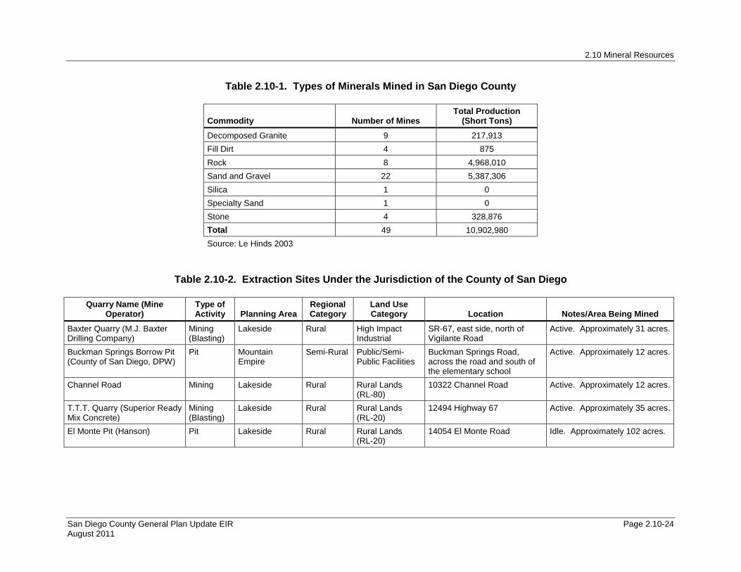
Table 2.10-1. Types of Minerals Mined in San Diego County
Commodity Number of Mines Total Production
(Short Tons)
Decomposed Granite 9 217,913 Fill Dirt 4 875 Rock 8 4,968,010 Sand and Gravel 22 5,387,306 Silica 1 0 Specialty Sand 1 0 Stone 4 328,876 Total 49 10,902,980 Source: Le Hinds 2003
Table 2.10-2. Extraction Sites Under the Jurisdiction of the County of San Diego
Quarry Name (Mine Operator)
Type of Activity Planning Area
Regional Category
Land Use Category Location Notes/Area Being Mined
Baxter Quarry (M.J. Baxter Drilling Company)
Mining (Blasting)
Lakeside
Rural
High Impact Industrial
SR-67, east side, north of Vigilante Road
Active. Approximately 31 acres.
Buckman Springs Borrow Pit (County of San Diego, DPW)
Pit
Mountain Empire
Semi-Rural
Public/Semi-Public Facilities
Buckman Springs Road, across the road and south of the elementary school
Active. Approximately 12 acres.
Channel Road Mining Lakeside
Rural
Rural Lands (RL-80)
10322 Channel Road Active. Approximately 12 acres.
T.T.T. Quarry (Superior Ready Mix Concrete)
Mining (Blasting)
Lakeside Rural Rural Lands (RL-20)
12494 Highway 67 Active. Approximately 35 acres.
El Monte Pit (Hanson) Pit Lakeside Rural Rural Lands (RL-20)
14054 El Monte Road Idle. Approximately 102 acres.
2.10 Mineral Resources
San Diego County General Plan Update EIR Page 2.10-25 August 2011
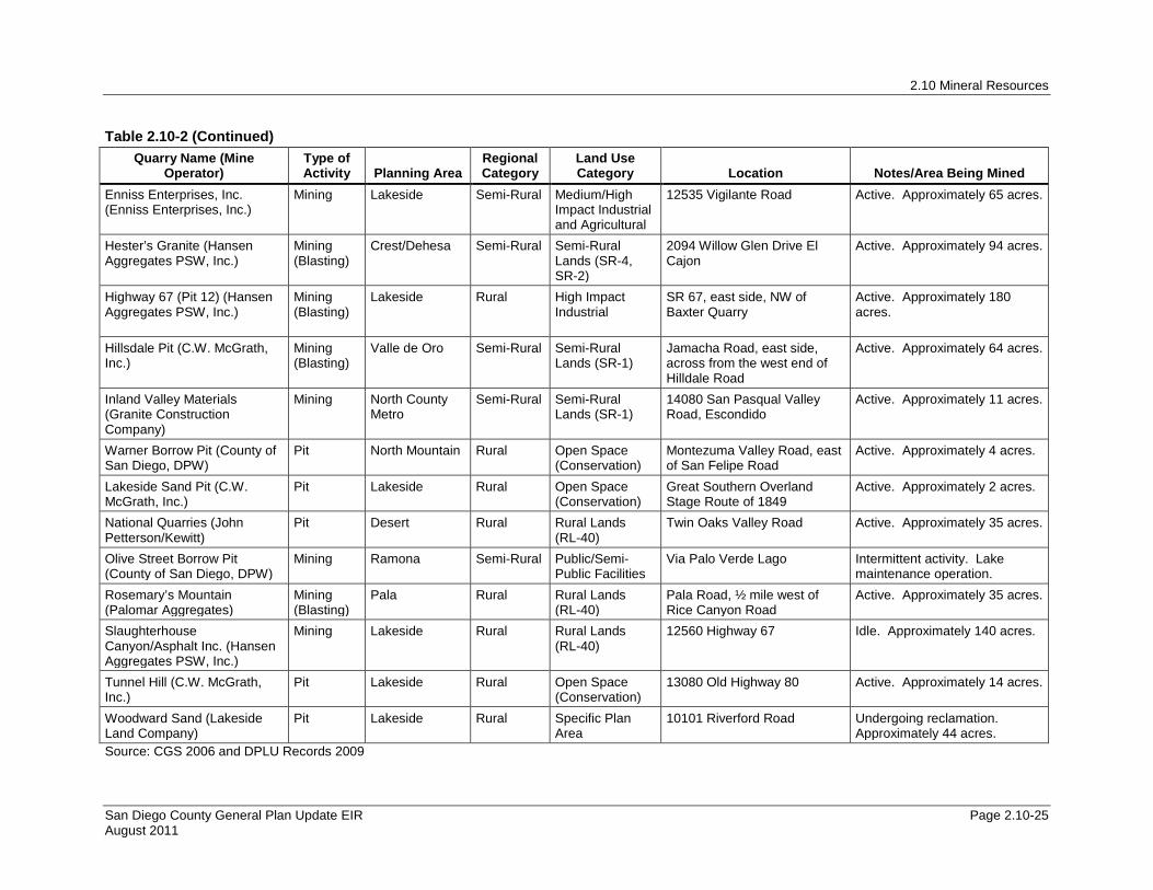
Table 2.10-2 (Continued) Quarry Name (Mine
Operator) Type of Activity Planning Area
Regional Category
Land Use Category Location Notes/Area Being Mined
Enniss Enterprises, Inc. (Enniss Enterprises, Inc.)
Mining
Lakeside
Semi-Rural
Medium/High Impact Industrial and Agricultural
12535 Vigilante Road
Active. Approximately 65 acres.
Hester’s Granite (Hansen Aggregates PSW, Inc.)
Mining (Blasting)
Crest/Dehesa
Semi-Rural
Semi-Rural Lands (SR-4, SR-2)
2094 Willow Glen Drive El Cajon
Active. Approximately 94 acres.
Highway 67 (Pit 12) (Hansen Aggregates PSW, Inc.)
Mining (Blasting)
Lakeside
Rural
High Impact Industrial
SR 67, east side, NW of Baxter Quarry
Active. Approximately 180 acres.
Hillsdale Pit (C.W. McGrath, Inc.)
Mining (Blasting)
Valle de Oro
Semi-Rural
Semi-Rural Lands (SR-1)
Jamacha Road, east side, across from the west end of Hilldale Road
Active. Approximately 64 acres.
Inland Valley Materials (Granite Construction Company)
Mining
North County Metro
Semi-Rural
Semi-Rural Lands (SR-1)
14080 San Pasqual Valley Road, Escondido
Active. Approximately 11 acres.
Warner Borrow Pit (County of San Diego, DPW)
Pit North Mountain Rural Open Space (Conservation)
Montezuma Valley Road, east of San Felipe Road
Active. Approximately 4 acres.
Lakeside Sand Pit (C.W. McGrath, Inc.)
Pit
Lakeside
Rural
Open Space (Conservation)
Great Southern Overland Stage Route of 1849
Active. Approximately 2 acres.
National Quarries (John Petterson/Kewitt)
Pit
Desert
Rural Rural Lands (RL-40)
Twin Oaks Valley Road Active. Approximately 35 acres.
Olive Street Borrow Pit (County of San Diego, DPW)
Mining Ramona Semi-Rural Public/Semi-Public Facilities
Via Palo Verde Lago Intermittent activity. Lake maintenance operation.
Rosemary’s Mountain (Palomar Aggregates)
Mining (Blasting)
Pala Rural Rural Lands (RL-40)
Pala Road, ½ mile west of Rice Canyon Road
Active. Approximately 35 acres.
Slaughterhouse Canyon/Asphalt Inc. (Hansen Aggregates PSW, Inc.)
Mining
Lakeside
Rural
Rural Lands (RL-40)
12560 Highway 67
Idle. Approximately 140 acres.
Tunnel Hill (C.W. McGrath, Inc.)
Pit
Lakeside
Rural
Open Space (Conservation)
13080 Old Highway 80
Active. Approximately 14 acres.
Woodward Sand (Lakeside Land Company)
Pit
Lakeside
Rural
Specific Plan Area
10101 Riverford Road Undergoing reclamation. Approximately 44 acres.
Source: CGS 2006 and DPLU Records 2009
2.10 Mineral Resources
San Diego County General Plan Update EIR Page 2.10-26 August 2011
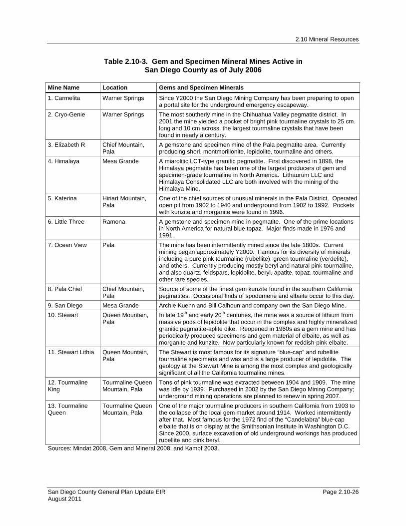
Table 2.10-3. Gem and Specimen Mineral Mines Active in San Diego County as of July 2006
Mine Name Location Gems and Specimen Minerals
1. Carmelita Warner Springs Since Y2000 the San Diego Mining Company has been preparing to open a portal site for the underground emergency escapeway.
2. Cryo-Genie Warner Springs The most southerly mine in the Chihuahua Valley pegmatite district. In 2001 the mine yielded a pocket of bright pink tourmaline crystals to 25 cm. long and 10 cm across, the largest tourmaline crystals that have been found in nearly a century.
3. Elizabeth R Chief Mountain, Pala
A gemstone and specimen mine of the Pala pegmatite area. Currently producing shorl, montmorillonite, lepidolite, tourmaline and others.
4. Himalaya Mesa Grande A miarolitic LCT-type granitic pegmatite. First discovered in 1898, the Himalaya pegmatite has been one of the largest producers of gem and specimen-grade tourmaline in North America. Lithaurum LLC and Himalaya Consolidated LLC are both involved with the mining of the Himalaya Mine.
5. Katerina Hiriart Mountain, Pala
One of the chief sources of unusual minerals in the Pala District. Operated open pit from 1902 to 1940 and underground from 1902 to 1992. Pockets with kunzite and morganite were found in 1996.
6. Little Three Ramona A gemstone and specimen mine in pegmatite. One of the prime locations in North America for natural blue topaz. Major finds made in 1976 and 1991.
7. Ocean View Pala The mine has been intermittently mined since the late 1800s. Current mining began approximately Y2000. Famous for its diversity of minerals including a pure pink tourmaline (rubellite), green tourmaline (verdelite), and others. Currently producing mostly beryl and natural pink tourmaline, and also quartz, feldspars, lepidolite, beryl, apatite, topaz, tourmaline and other rare species.
8. Pala Chief Chief Mountain, Pala
Source of some of the finest gem kunzite found in the southern California pegmatites. Occasional finds of spodumene and elbaite occur to this day.
9. San Diego Mesa Grande Archie Kuehn and Bill Calhoun and company own the San Diego Mine. 10. Stewart Queen Mountain,
Pala In late 19th and early 20th centuries, the mine was a source of lithium from massive pods of lepidolite that occur in the complex and highly mineralized granitic pegmatite-aplite dike. Reopened in 1960s as a gem mine and has periodically produced specimens and gem material of elbaite, as well as morganite and kunzite. Now particularly known for reddish-pink elbaite.
11. Stewart Lithia Queen Mountain, Pala
The Stewart is most famous for its signature “blue-cap” and rubellite tourmaline specimens and was and is a large producer of lepidolite. The geology at the Stewart Mine is among the most complex and geologically significant of all the California tourmaline mines.
12. Tourmaline King
Tourmaline Queen Mountain, Pala
Tons of pink tourmaline was extracted between 1904 and 1909. The mine was idle by 1939. Purchased in 2002 by the San Diego Mining Company; underground mining operations are planned to renew in spring 2007.
13. Tourmaline Queen
Tourmaline Queen Mountain, Pala
One of the major tourmaline producers in southern California from 1903 to the collapse of the local gem market around 1914. Worked intermittently after that. Most famous for the 1972 find of the “Candelabra” blue-cap elbaite that is on display at the Smithsonian Institute in Washington D.C. Since 2000, surface excavation of old underground workings has produced rubellite and pink beryl.
Sources: Mindat 2008, Gem and Mineral 2008, and Kampf 2003.
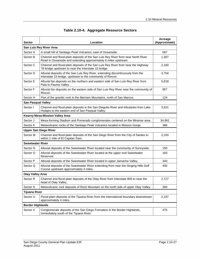
2.10 Mineral Resources
San Diego County General Plan Update EIR Page 2.10-27 August 2011
Table 2.10-4. Aggregate Resource Sectors
Sector Location Acreage
(Approximate) San Luis Rey River Area Sector A A small hill of Santiago Peak Volcanics, east of Oceanside. 587 Sector B Channel and flood-plain deposits of the San Luis Rey River from near North River
Road in Oceanside and extending approximately 6 miles upstream. 1,307
Sector C Channel and flood-plain deposits of the San Luis Rey River from near the Highway 78 bridge upstream to near the Interstate 15 bridge.
2,160
Sector D Alluvial deposits of the San Luis Rey River, extending discontinuously from the Interstate 15 bridge, upstream to the community of Rincon.
3,704
Sector E Alluvial fan deposits on the northern and eastern side of San Luis Rey River from Pala to Pauma Valley.
5,818
Sector F Alluvial fan deposits on the eastern side of San Luis Rey River near the community of Rincon.
857
Sector H Part of the granitic rock in the Merriam Mountains, north of San Marcos. 124
San Pasqual Valley Sector I Channel and flood-plain deposits in the San Dieguito River and tributaries from Lake
Hodges to the eastern end of San Pasqual Valley. 3,521
Kearny Mesa-Mission Valley Area Sector J Mesa-forming Stadium and Pomerado conglomerates centered on the Miramar area. 34,961 Sector K Metavolcanic rocks of the Santiago Peak Volcanics located in Mission Gorge. 386
Upper San Diego River Sector M Channel and flood-plain deposits of the San Diego River from the City of Santee to
within 1 mile of El Capitan Dam. 2,150
Sweetwater River Sector N Alluvial deposits of the Sweetwater River located near the community of Sunnyside. 150 Sector O Alluvial deposits of the Sweetwater River located at the upper end Sweetwater
Reservoir. 183
Sector P Alluvial deposits of the Sweetwater River located in upper Jamacha Valley. 343 Sector Q Alluvial deposits of the Sweetwater River extending from near the Singing Hills Golf
Course upstream approximately 4 miles. 400
Otay Valley Area Sector R Channel and flood-plain deposits of the Otay River from Interstate 805 to near the
head of Otay Valley. 2,727
Sector S Metavolcanic rock deposits of Rock Mountain on the north side of upper Otay Valley. 360
Tijuana River Sector U Flood-plain deposits of the Tijuana River from the international boundary downstream
approximately 4 miles. 2,197
Border Highlands Sector V Conglomerate deposits of the San Diego Formation in the Border Highlands,
immediately south of the Tijuana River. 475

2.10 Mineral Resources
San Diego County General Plan Update EIR Page 2.10-28 August 2011
Table 2.10-4 (Continued)
Sector Location Acreage
(Approximate) San Luis Rey River Area Sector A A small hill of Santiago Peak Volcanics, east of Oceanside. 587 Sector B Channel and flood-plain deposits of the San Luis Rey River from near North River
Road in Oceanside and extending approximately 6 miles upstream. 1,307
Sector C Channel and flood-plain deposits of the San Luis Rey River from near the Highway 78 bridge upstream to near the Interstate 15 bridge.
2,160
Sector D Alluvial deposits of the San Luis Rey River, extending discontinuously from the Interstate 15 bridge, upstream to the community of Rincon.
3,704
Sector E Alluvial fan deposits on the northern and eastern side of San Luis Rey River from Pala to Pauma Valley.
5,818
Sector F Alluvial fan deposits on the eastern side of San Luis Rey River near the community of Rincon.
857
Sector H Part of the granitic rock in the Merriam Mountains, north of San Marcos. 124
San Pasqual Valley Sector I Channel and flood-plain deposits in the San Dieguito River and tributaries from Lake
Hodges to the eastern end of San Pasqual Valley. 3,521
Kearny Mesa-Mission Valley Area Sector J Mesa-forming Stadium and Pomerado conglomerates centered on the Miramar
area. 34,961
Sector K Metavolcanic rocks of the Santiago Peak Volcanics located in Mission Gorge. 386
Upper San Diego River Sector M Channel and flood-plain deposits of the San Diego River from the City of Santee to
within 1 mile of El Capitan Dam. 2,150
Sweetwater River Sector N Alluvial deposits of the Sweetwater River located near the community of Sunnyside. 150 Sector O Alluvial deposits of the Sweetwater River located at the upper end Sweetwater
Reservoir. 183
Sector P Alluvial deposits of the Sweetwater River located in upper Jamacha Valley. 343 Sector Q Alluvial deposits of the Sweetwater River extending from near the Singing Hills Golf
Course upstream approximately 4 miles. 400
Otay Valley Area Sector R Channel and flood-plain deposits of the Otay River from Interstate 805 to near the
head of Otay Valley. 2,727
Sector S Metavolcanic rock deposits of Rock Mountain on the north side of upper Otay Valley.
360
Tijuana River Sector U Flood-plain deposits of the Tijuana River from the international boundary
downstream approximately 4 miles. 2,197
Border Highlands Sector V Conglomerate deposits of the San Diego Formation in the Border Highlands,
immediately south of the Tijuana River. 475
Source: DMG 1982
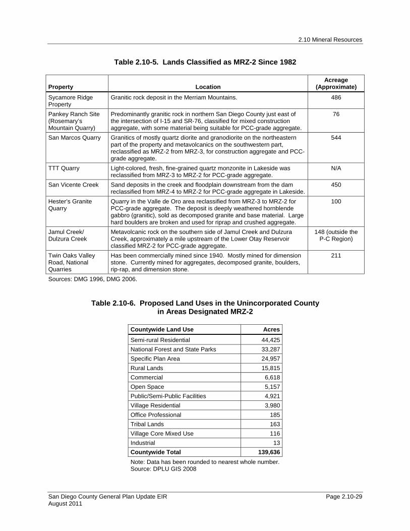
2.10 Mineral Resources
San Diego County General Plan Update EIR Page 2.10-29 August 2011
Table 2.10-5. Lands Classified as MRZ-2 Since 1982
Property Location Acreage
(Approximate)
Sycamore Ridge Property
Granitic rock deposit in the Merriam Mountains. 486
Pankey Ranch Site (Rosemary’s Mountain Quarry)
Predominantly granitic rock in northern San Diego County just east of the intersection of I-15 and SR-76, classified for mixed construction aggregate, with some material being suitable for PCC-grade aggregate.
76
San Marcos Quarry
Granitics of mostly quartz diorite and granodiorite on the northeastern part of the property and metavolcanics on the southwestern part, reclassified as MRZ-2 from MRZ-3, for construction aggregate and PCC-grade aggregate.
544
TTT Quarry Light-colored, fresh, fine-grained quartz monzonite in Lakeside was reclassified from MRZ-3 to MRZ-2 for PCC-grade aggregate.
N/A
San Vicente Creek Sand deposits in the creek and floodplain downstream from the dam reclassified from MRZ-4 to MRZ-2 for PCC-grade aggregate in Lakeside.
450
Hester’s Granite Quarry
Quarry in the Valle de Oro area reclassified from MRZ-3 to MRZ-2 for PCC-grade aggregate. The deposit is deeply weathered hornblende gabbro (granitic), sold as decomposed granite and base material. Large hard boulders are broken and used for riprap and crushed aggregate.
100
Jamul Creek/ Dulzura Creek
Metavolcanic rock on the southern side of Jamul Creek and Dulzura Creek, approximately a mile upstream of the Lower Otay Reservoir classified MRZ-2 for PCC-grade aggregate.
148 (outside the P-C Region)
Twin Oaks Valley Road, National Quarries
Has been commercially mined since 1940. Mostly mined for dimension stone. Currently mined for aggregates, decomposed granite, boulders, rip-rap, and dimension stone.
211
Sources: DMG 1996, DMG 2006.
Table 2.10-6. Proposed Land Uses in the Unincorporated County
in Areas Designated MRZ-2
Countywide Land Use Acres
Semi-rural Residential 44,425 National Forest and State Parks 33,287 Specific Plan Area 24,957 Rural Lands 15,815 Commercial 6,618 Open Space 5,157 Public/Semi-Public Facilities 4,921 Village Residential 3,980 Office Professional 185 Tribal Lands 163 Village Core Mixed Use 116 Industrial 13 Countywide Total 139,636 Note: Data has been rounded to nearest whole number. Source: DPLU GIS 2008

2.10 Mineral Resources
San Diego County General Plan Update EIR Page 2.10-30 August 2011
Table 2.10-7. Proposed Land Uses in Areas Designated MRZ-2 by CPA and Subregion
CPA/Subregion Land Use Acres
Alpine National Forest and State Parks 33,287 Open Space 808 Alpine Total 34,095
Bonsall
Commercial 504 Office Professional 185 Open Space 2,199 Public/Semi-Public Facilities 99 Rural Lands 2,471 Semi-rural Residential 19,283 Specific Plan Area 22,829 Village Residential 70 Bonsall Total 47,639
County Islands Public/Semi-Public Facilities 19 Rural Lands 11 County Islands Total 30
Crest/Dehesa
Open Space 95 Rural Lands 59 Semi-rural Residential 347 Specific Plan Area 1,398 Crest/Dehesa Total 1,899
Fallbrook
Commercial 802 Open Space 20 Public/Semi-Public Facilities 1,399 Rural Lands 24 Semi-rural Residential 20,815 Specific Plan Area 17 Village Core Mixed Use 116 Village Residential 76 Fallbrook Total 23,269
Jamul/Dulzura Rural Lands 8,703 Jamul/Dulzura Total 8,703
Lakeside
Commercial 129 Industrial 13 Open Space 90 Public/Semi-Public Facilities 10 Rural Lands 252 Semi-rural Residential 378 Specific Plan Area 4 Village Residential 406 Lakeside Total 1,283
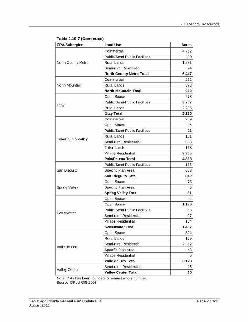
2.10 Mineral Resources
San Diego County General Plan Update EIR Page 2.10-31 August 2011
Table 2.10-7 (Continued) CPA/Subregion Land Use Acres
North County Metro
Commercial 4,712 Public/Semi-Public Facilities 430 Rural Lands 1,281 Semi-rural Residential 24 North County Metro Total 6,447
North Mountain Commercial 212 Rural Lands 398 North Mountain Total 610
Otay
Open Space 278 Public/Semi-Public Facilities 2,707 Rural Lands 2,285 Otay Total 5,270
Pala/Pauma Valley
Commercial 259 Open Space 6 Public/Semi-Public Facilities 11 Rural Lands 151 Semi-rural Residential 953 Tribal Lands 163 Village Residential 3,325 Pala/Pauma Total 4,868
San Dieguito Public/Semi-Public Facilities 183 Specific Plan Area 658 San Dieguito Total 842
Spring Valley Open Space 73 Specific Plan Area 8 Spring Valley Total 81
Sweetwater
Open Space 4 Open Space 1,190 Public/Semi-Public Facilities 63 Semi-rural Residential 97 Village Residential 104 Sweetwater Total 1,457
Valle de Oro
Open Space 394 Rural Lands 179 Semi-rural Residential 2,512 Specific Plan Area 43 Village Residential 0 Valle de Oro Total 3,128
Valley Center Semi-rural Residential 16 Valley Center Total 16
Note: Data has been rounded to nearest whole number. Source: DPLU GIS 2008

2.10 Mineral Resources
San Diego County General Plan Update EIR Page 2.10-32 August 2011
Table 2.10-8. Proposed Land Uses in the Unincorporated County in Areas Designated MRZ-3
Land Use Acres
Semi-rural Residential 367,298 Village Residential 115,393 Rural Lands 89,565 Office Professional 69,047 Tribal Lands 55,184 Public/Semi-Public Facilities 44,336 Open Space 40,368 Commercial 27,775 Industrial 14,118 Specific Plan Area 13,998 National Forest and State Parks 13,317 Village Core Mixed Use 5,414 Military Installations 310 Countywide Total 856,123 Note: Data has been rounded to nearest whole number. Source: DPLU GIS 2008

Pine Valley
Boulevard
Borrego Springs
Cuyamaca
Palomar Mountain
Potrero
Lake Morena / Campo
Jacumba
Descanso
Tecate
TwinOaks
HiddenMeadows
Desert
North Mountain
Mountain Empire
Central Mountain
Alpine
Ramona
Pendleton/De Luz
Jamul/Dulzura
Pala/Pauma
Otay
Julian
Lakeside
Valley Center
Fallbrook
Bonsall
San Dieguito
Crest/Dehesa
Rainbow
Valle De Oro
NorthCountyMetro
Sweetwater
SpringValley
OR
AN
GE C O U N
TY
PA
CI
FI
C
OC
EA
N
R I V E R S I D E C O U N T Y
IM
PE
RI
AL
CO
UN
TY
ME
XI
CO
C O U N T YS A N D I E G O
SA
ND
IE
GO
CO
UN
TY
56
76
78
94
7879
78
79
76
67
52
78
67
94
125
163
125
905
5
8
5
8
15
15
805
805
SAN DIEGO COUNTY GEOLOGIC ENVIRONMENTS FIGURE 2.10-1
0 2 4 6 8 10
Miles
Source: County of San Diego, 2008
Legend
Geologic Environments
Cretaceous Crystalline Rocks and UpperJurassic Metavolcanics
Quaternary Alluvium
Tertiary Sedimentary Deposits
Community/SubregionalPlanning Areas
Subareas
Incorporated Areas
Freeways
Major Highways
San Diego County WaterAuthority Service Boundary
Rivers
Lakes/Reservoirs

Pine Valley
Boulevard
Borrego Springs
Cuyamaca
Palomar Mountain
Potrero
Lake Morena / Campo
Jacumba
Descanso
Tecate
TwinOaks
HiddenMeadows
Desert
North Mountain
Mountain Empire
Central Mountain
Alpine
Ramona
Pendleton/De Luz
Jamul/Dulzura
Pala/Pauma
Otay
Julian
Lakeside
Valley Center
Fallbrook
Bonsall
San Dieguito
Crest/Dehesa
Rainbow
Valle De Oro
NorthCountyMetro
Sweetwater
SpringValley
OR
AN
GE
C O U NT
Y
PA
CI
FI
C
OC
EA
N
R I V E R S I D E C O U N T Y
IM
PE
RI
AL
CO
UN
TY
ME
XI
CO
C O U N T YS A N D I E G O
SA
ND
IE
GO
CO
UN
TY
56
76
78
94
7879
78
79
76
67
52
78
67
94
125
163
125
905
5
8
5
8
15
15
805
805
EXISTING MINERAL RESOURCES IN SAN DIEGO COUNTY FIGURE 2.10-2
0 2 4 6 8 10
Miles
Legend
Sand and Gravel
Active Quarries
Semiprecious, Diamond, Quartz
Military Facilities
Community/SubregionalPlanning Areas
Subareas
Incorporated Areas
Freeways
Major Highways
San Diego County WaterAuthority Service Boundary
Rivers
Lakes/Reservoirs
Source: County of San Diego, 2008
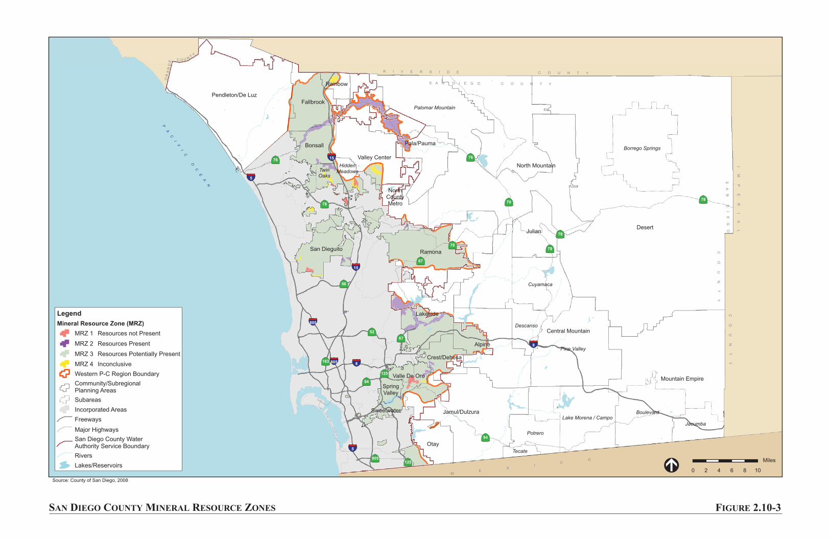
Pine Valley
Boulevard
Borrego Springs
Cuyamaca
Palomar Mountain
Potrero
Lake Morena / Campo
Jacumba
Descanso
Tecate
TwinOaks
HiddenMeadows
Desert
North Mountain
Mountain Empire
Central Mountain
Alpine
Ramona
Pendleton/De Luz
Jamul/Dulzura
Pala/Pauma
Otay
Julian
Lakeside
Valley Center
Fallbrook
Bonsall
San Dieguito
Crest/Dehesa
Rainbow
Valle De Oro
NorthCountyMetro
Sweetwater
SpringValley
OR
AN
GE
C O U NT
Y
PA
CI
FI
C
OC
EA
N
R I V E R S I D E C O U N T Y
IM
PE
RI
AL
CO
UN
TY
ME
XI
CO
C O U N T YS A N D I E G O
SA
ND
IE
GO
CO
UN
TY
56
76
78
94
7879
78
79
76
67
52
78
67
94
125
163
125
905
5
8
5
8
15
15
805
805
SAN DIEGO COUNTY MINERAL RESOURCE ZONES FIGURE 2.10-3
0 2 4 6 8 10
Miles
Legend
Mineral Resource Zone (MRZ)
MRZ 1 Resources not Present
MRZ 2 Resources Present
MRZ 3 Resources Potentially Present
MRZ 4 Inconclusive
Western P-C Region Boundary
Community/SubregionalPlanning Areas
Subareas
Incorporated Areas
Freeways
Major Highways
San Diego County WaterAuthority Service Boundary
Rivers
Lakes/Reservoirs
Source: County of San Diego, 2008