2.1. highways and bridges 2.1 - new york state department ... · highway from interchange 21a to...
TRANSCRIPT

HIGHWAYS AND BRIDGES Existing Corridor Conditions & Opportunities
I-87 Multimodal Corridor Study
2.1. HIGHWAYS AND BRIDGES 2.1.1. Introduction Interstate 87 (I-87) provides a direct connection between New York City, the largest metropolitan area in the United States and Montreal, the second largest metropolitan area in Canada through the Champlain/Lacolle border crossing. The I-87 Corridor serves a key role as the major north-south transportation and commerce corridor that connects crossing highways that serve a broad geographic and demographic region, which includes the Mid-Atlantic States, New England, and Eastern Canada representing a total of about 80 million people.
As shown in Exhibit 2.1-1, the 350-mile I-87 Corridor starts in Montreal as Autoroute 15 and continues south as the Adirondack Northway from the U.S./Canadian Border to Albany, where is becomes the New York State Thruway and continues south to the Tappan Zee Bridge near New York City. The Primary Study Area along I-87 extends from the U.S./Canadian Border at Exit 43 of the Adirondack Northway to just south of Albany at Interchange 21A of the New York State Thruway. The Primary Study Area also includes US Route 9 and NYS Route 22 that run north-south along the I-87 corridor. East-west connector highways that were evaluated as part of this study include NYS Routes 3, 73, 74, 149, 7, 2, and I-90 through Albany. The following sections define the Primary and Secondary Study areas used in these assessments, and then review the infrastructure and operational conditions found along highways and secondary roadways within these areas. Based on those assessments, areas potentially requiring further studies under Phase II of the I-87 Multimodal Corridor Study are identified, along with a list of improvement concepts for consideration. 2.1.2. Highway Network Analysis Areas (Primary and Secondary) Exhibits 2.1-2 through 2.1-4 provide greater detail regarding the location of the highways and secondary roadways within the Study Area. The Primary Study Area includes the following Interstate segments: 1
• I-87, from the Champlain/Lacolle Border Crossing through Albany to Interchange 21A with the NYS Thruway
• International zone, extending about one mile on the Canadian side • I-90 Berkshire Spur of the NYS Thruway • I-90 (non-toll section), from I-787 to I-87 • I-90 (Thruway), from Interchange 25A to Interchange 24 • I-787, from Interchange 23 (NYS Thruway) to NYS Route 32
The secondary roadway network within the Primary Study Area includes:
• NYS Route 3, from NYS Route 374 to US Route 9
1
Parsons-Clough Harbour Page 2.1-1
For the purposes of this study, access points on the NYS Thruway portion of I-87, on I-90 and on I-787 will be identified by “Interchange” designations; access points on the Adirondack Northway portion of I-87 will be identified by “Exit” designations. Exit 1 of the Adirondack Northway is coincident with Interchange 24 of the NYS Thruway in Albany.
HIGHWAYS AND BRIDGES Existing Corridor Conditions & Opportunities
I-87 Multimodal Corridor Study
• NYS Route 73, from Lake Placid to I-87 (Northway) • NYS Route 74, from I-87 (Northway) to NYS Route 22 • NYS Route 149, from US Route 9 to Vermont State Line • NYS Route 396, from County Route 53 (CR53) to NYS Route 144 • US Route 9, from the U.S./Canadian Border to NYS Route 7 • NYS Route 22, from the U.S./Canadian Border to NYS Route 7 • US Route 4, between NYS 149 and the Vermont state line
Parsons-Clough Harbour Page 2.1-2

Parsons-Clough Harbour
I-87 Multimodal Corridor Study
Existing Corridor Conditions & OpportunitiesHIGHWAYS AND BRIDGES
Seco
ndar
y St
udy
Are
a
Plattsburgh
Albany
NYC
Montreal
Prim
ary
Stud
y A
rea
PRIMARY AREA• I-87 from Exit 21A to
Champlain border crossing• Routes 9 and 22• East/west connectors• I-90• Routes 3, 73, 74, 149• Route 396
SECONDARY AREA• I-87 from Exit 9 (Tappan Zee
Bridge) to Exit 21A• Autoroute 15 from US/Canada
border to Montreal
Exhibit 2.1-1: Primary & Secondary Highway Study Areas
HIGHWAY STUDY AREAS
Page 2.1-3

Parsons-Clough Harbour
I-87 Multimodal Corridor Study
Existing Corridor Conditions & OpportunitiesHIGHWAYS AND BRIDGES
Exhibit 2.1-2: Highways & Roads in Study Area
Page 2.1-4

Parsons-Clough Harbour
I-87 Multimodal Corridor Study
Existing Corridor Conditions & OpportunitiesHIGHWAYS AND BRIDGES
Exhibit 2.1-3: Highways & Roads in Study Area
Page 2.1-5

Parsons-Clough Harbour
I-87 Multimodal Corridor Study
Existing Corridor Conditions & OpportunitiesHIGHWAYS AND BRIDGES
Exhibit 2.1-4: Highways & Roads in Study Area
Page 2.1-6

HIGHWAYS AND BRIDGES Existing Corridor Conditions & Opportunities
I-87 Multimodal Corridor Study
The Secondary Study Area consists of the following roadway sections:
• I-87 (Thruway), from Interchange 21A just south of Albany to Interchange 9 at the Tappan Zee Bridge
• Autoroute 15, from the Champlain/Lacolle border crossing to Montreal.
2.1.3. Existing Conditions Data • Highway/Pavement Conditions The following section presents the assessment of existing highway and pavement conditions in the Primary and Secondary Study Areas. Information regarding these segments was obtained from (1) NYSDOT databases and discussions with NYSDOT and NYSTA staff and with other transportation agency officials, (2) available reports or studies completed for portions of these highways, and (3) drive-through field observations by Study Team members (primarily for the secondary roadways). Interstate Segments Starting at the U.S./Canadian Border, Interstate 87 (Adirondack Northway) is typically a four-lane divided asphalt highway for approximately 125 miles (200 kilometers) to Exit 22 near Lake George, where it becomes a six-lane divided highway for about 60 miles (95 kilometers) to Exit 1 in Albany. Exit 1 of the Adirondack Northway is coincident with Interchange 24 of the New York State Thruway. South of Albany, I-87 becomes the New York State Thruway starting at Interchange 24 and extends south to Interchange 21A in New Baltimore as a four-lane, divided toll system highway. I-87 continues south as primarily a typical four-lane, divided toll highway from Interchange 21A to Interchange 15 where it intersects with I-287 in Suffern. At the I-287 Interchange, I-87 turns east as a shared Interstate with I-287 to Interchange 9 (Tappan Zee Bridge in New York City) as a 6 or 8-lane, divided highway.
Based on the New York State Department of Transportation’s (NYSDOT) 2002 Highway Sufficiency Ratings, the general pavement condition of the asphalt pavement along I-87 between the U.S./Canadian Border and the Tappan Zee Bridge is in good to excellent condition. However, there are sections of I-87 that have fair to poor pavement conditions. Fair pavement conditions are those areas where pavement distress is clearly visible. Poor pavement conditions are sections where pavement distress is frequent and may be severe. Poor pavement condition locations have been flagged by the NYSDOT’s computers for further investigation and possible action. Table 2.1-1 summarizes the areas along I-87 with fair to poor pavement condition:
Parsons-Clough Harbour Page 2.1-7

HIGHWAYS AND BRIDGES Existing Corridor Conditions & Opportunities
I-87 Multimodal Corridor Study
Table 2.1-1
Locations on I-87 Corridor with Fair/Poor Pavement Ratings
Interstate 87 Pavement Condition Rating
1 U.S./Canadian Border to Exit 36 (Plattsburgh) Fair 2 At Essex County Line b/w Exitss 34 and 33 Fair 3 Exit 30 (at Route 73) Fair 4 Between Exits 29 and 28 (North Hudson) Poor 5 Between Exits 27 and 25 (Schroon Lake) Fair 6 Between Exits 17 and 15 (Saratoga County) Fair 7 Near Exit 13 (Saratoga Springs) Fair 8 Exit 5 (Route 155) Fair 9 Between Exits 2 and 1 Fair 10 Between Interchanges 24 and 23 on Thruway (Albany) Fair 11 Interchange 18 on Thruway (New Paltz) Fair
Source: NYSDOT 2002 Highway Sufficiency Ratings.
Interstate 90 (non-toll section) is primarily an east/west route across Albany and Rensselaer Counties providing toll-free access from the New York State Thruway/Adirondack Northway interchange to Berkshire Spur section of the Thruway and on to the Massachusetts Turnpike. This 20-mile section of I-90 is typically a six-lane divided highway for approximately 15 miles from its westerly starting point to east of Interchange 11 (providing access to Routes 9 and 20) in Schodack, Rensselaer County. The remaining 5 miles is a four-lane divided highway between Interchange 11 and the toll barrier at the Berkshire Spur. The interchanges on the non-toll section of I-90 are designated as Interchanges 1 through 12 before terminating at Interchange B1. At Interchange B1, the non-toll section of I-90 terminates at the Berkshire Spur section of the Thruway. The Berkshire Spur is the segment of the Thruway System which runs in an east/west direction between Interchange 21A of the NYS Thruway and the end of the non-toll section of I-90. From Interchange B1, I-90 continues in an east/west direction toward Hartford, Connecticut and Boston, Massachusetts. At the New York/Massachusetts state line and heading toward the east I-90 is typically known as the Massachusetts Turnpike. From Interchange 24 at the New York State Thruway to the I-787 Interchange/Patroon Island crossing of the Hudson River, the Portland cement concrete pavement condition is poor with many defects. The pavement surface changes to asphalt east of the Patroon Island Crossing and generally improves to good condition to the Berkshire Spur at Interchange B1. The Berkshire Spur and I-90 between Interchange 21A and Massachusetts are typically four-lane divided highways with asphalt driving surfaces. The pavement quality is in good condition. The section of I-90 between Interchange 5A (Corporate Woods Boulevard) and the Patroon Island Bridge at I-787 is currently under construction (PIN 1528.52) to address pavement and bridge deficiencies. The section of I-90 from Interchange 5A to Interchange 1 (at the NYS Thruway) is scheduled for reconstruction (PIN 1528.55) in 2005. Interstate 787 is a north/south route which parallels the Hudson River from its southerly terminus in the City of Albany at Thruway Interchange 23 to its northerly terminus as Cohoes Boulevard at NYS Route 32 in the City of Cohoes. From Interchange 23 proceeding northerly, the first section of I-787 is typically a six-lane divided highway/elevated highway constructed of Portland cement pavement in good condition. As I-787 interchanges with I-90 within the City of Albany the six-lane divided highway cross-section continues as an asphalt interstate facility
Parsons-Clough Harbour Page 2.1-8

HIGHWAYS AND BRIDGES Existing Corridor Conditions & Opportunities
Parsons-Clough Harbour Page 2.1-9
I-87 Multimodal Corridor Study
between I-90 and NYS Route 7 (aka Alternate Route 7). Between the interchange with NYS Route 7 (Alternate Route 7) and I-787’s northern terminus in the City of Cohoes the cross-section is reduced to a four-lane divided highway and the facility is designated as NYS Route 787. This section of NYS Route 787 has been recently identified as Cohoes Boulevard. The asphalt pavement on all of I-787 and NYS Route 787 is in very good to excellent condition. Secondary Roadway Network NYS Route 3 is generally an east/west roadway that extends from the City of Plattsburgh westerly to Lake Ontario and then southerly to Lake Ontario in central New York. The easterly portion of this route connects from I-87 to US Route 9. It is primarily a 4-lane roadway between Route 22B and Broad Street (within City of Plattsburgh). It then changes to a 2-lane roadway from Broad Street to US Route 9. The asphalt roadway surface is in excellent condition. Route 3 is one of the primary commercial vehicle routes in the northern part of the state. NYS Route 73 is a 2-lane asphalt roadway that provides access from Lake Placid to US Route 9 and Exit 30 on I-87. It is a scenic roadway that traverses through the High Peaks Region of the Adirondack Park over mountainous terrain that can limit traffic flow. The roadway surface is in fair to poor condition with frequent defects that include minimal or non-existent shoulders or pull-off areas, poor geometrics for its function and minimal climbing lanes. NYS Route 73 is a popular traveler route for tourists accessing the High Peaks and Lake Placid Olympic Regions. NYS Route 74 is a scenic 2-lane roadway that extends from I-87 east towards Vermont and ends near Fort Ticonderoga. It passes through the Adirondack Park, providing access to many recreational areas within the Park and along Lake Champlain. NYS Route 74 intersects NYS Route 22 which provides access to the Crown Point Bridge into Vermont. NYS Route 74 also provides access to the Schroon Lake Airport near the I-87 interchange. The roadway surface is in good condition and shows little signs of deterioration. There are several parking and pull-off areas. NYS Route 74 is a primary east-west commercial route between the International Paper Company plant in Vermont for delivery of raw materials. NYS Route 149 is a 2-lane roadway that extends from I-87 at Exit 20 east to NYS Route 22 and US Route 4, providing a corridor to the Vermont State Line, where it becomes US Route 4 to Rutland. It has evolved into an important east/west arterial link
Rt. 73
Rt. 4 at Rt. 149
Route 3

HIGHWAYS AND BRIDGES Existing Corridor Conditions & Opportunities
Parsons-Clough Harbour Page 2.1-10
I-87 Multimodal Corridor Study
between I-87, US Route 4, and NYS Route 22 to Vermont, particularly for trucks traveling between I-87 and central Vermont. In general, the roadway is in fair condition with some minor defects, especially near I-87 and the Vermont State Line. The first five miles of NYS Route 149 from I-87 and from Baldwin Corners (Junction of Routes 4 and 149) to the Vermont State Line have terrain, alignment and roadway conditions that make it inadequate for high volumes of commercial vehicles. A section of NYS Route 149 from US Route 9 extending easterly was recently reconstructed under a NYSDOT Capital Improvement Project (PIN 1248.10). US Route 4 is primarily a 2-lane roadway that provides a north/south connection between the Capital District, in Rensselaer County, and the State of Vermont. Along its length through Rensselaer, Saratoga and Washington Counties, Route 4 varies from a congested multiple lane urban arterial through downtown Troy to a two-lane rural arterial with few constraints as it connects Fort Ann to Whitehall. US Route 4 has historically been a primary surface arterial for commercial and passenger traffic along the Champlain Canal and the Hudson River providing service and access to and from the economic, industrial and natural resource centers in Troy, Mechanicville, Stillwater, Schuylerville, Fort Edwards, Hudson Falls and Whitehall. It continues to function as a vital link and heavily traveled commercial and passenger (tourist/recreation) route for these economic centers, providing arterial access as well as local commutation between the population centers within the three counties and to the City of Rutland in central Vermont. The pavement conditions are generally fair or good throughout the corridor, although sections of the roadway in older urban areas (Troy, Schuylerville, Fort Edward) are rated in poor condition. NYS Route 67 is a 2-lane roadway that extends in an east/west direction across central Saratoga County, intersecting I-87 at Exit 12 within the corridor. Route 67 serves as an east/west arterial/collector roadway between NYS Route 50, I-87 and Mechanicville to Bennington, Vermont. Commercial vehicle accessibility and maneuvering on Route 67 within Mechanicville is limited by its narrow width and tight intersections. The pavement is in fair condition. NYSDOT currently has a project proposed (PIN 1188.21) to improve NYS Route 67 between Exit 12 and US Route 9 with the construction of multiple roundabouts. NYS Route 7 within the corridor varies from a 6-lane divided to a 2-lane conventional roadway that extends from I-87 at Exit 7 east to the Vermont State Line. Between I-87 and the City of Troy NYS Route 7 is typically Portland cement concrete. Within the City of Troy NYS Route 7 (Hoosick Street) becomes a four lane asphalt arterial heading in an east/west direction between Troy and Town of Brunswick. East of the Troy city limits NYS Route 7 is a two-lane asphalt roadway providing access to Bennington, Vermont. Between Brunswick and the New York/Vermont state line NYS Route 7 intersect NYS Route 22 in the Town of Hoosick. In general, the roadway pavement is in good condition. There are passing areas along sections of the route to accommodate slower vehicles. The alignment, terrain, and roadway conditions along NYS Route 7 east of Brunswick, providing access to Vermont and to NYS Route 22 are consistent with geometrics which can accommodate over the road commercial vehicle travel. Within the City of Troy the character of NYS Route 7 changes considerably to a more urban arterial facility with geometric constraints and high population densities (including a reduced speed school zone) abutting the corridor. The easterly limit of NYS Route 7 is scheduled to be realigned and reconstructed in 2004 and 2005 as part of the Bennington Bypass Project currently being advanced by the Vermont Agency of Transportation. The sections of NYS Route

HIGHWAYS AND BRIDGES Existing Corridor Conditions & Opportunities
Parsons-Clough Harbour Page 2.1-11
I-87 Multimodal Corridor Study
7 from I-87 to the I-787 interchange, within Troy and extending to Brunswick have been recently improved or are scheduled to be improved in 2004 as NYSDOT Capital Improvement projects. The upcoming project to reconstruct Hoosick Street within the City is identified as PIN 1306.74. NYS Route 2 changes from a 4-lane roadway between I-87 and 15th Street in Troy to a 2-lane roadway that extends to the Massachusetts State Line. It becomes a scenic roadway along the two-lane section with hiking areas and a scenic overlook that traverses mountainous terrain near the New York/Vermont border. The asphalt pavement condition is poor. The alignment, terrain, and roadway conditions are not conducive to commercial vehicle travel. NYS Route 396 is generally an east/west directional roadway that extends from South Bethlehem through Selkirk to the east where it ends at NYS Route 144. It is a 2-lane roadway with good pavement conditions. Although the facility is heavily used by commercial vehicles accessing the NYS Thruway, the alignment and terrain conditions are not conducive to heavy commercial vehicle travel. NYS Route 22 is primarily a 2-lane north/south directional roadway that begins at the Canadian Border, traverses through the Adirondack Park, to the east of the Capital District, and continues south into New York City. In general, the pavement is in good condition with minor defects between its intersection with US Route 9 in Keeseville and NYS Route 9N in Westport. The alignment, terrain and roadway conditions are adequate to handle commercial vehicles, except between its intersection with US Route 9 in Keeseville and NYS Route 9N in Westport. US Route 9 varies from a 2 to 5-lane north/south directional roadway that begins near the Canadian border and continues south into New York City. US Route 9 is a heavily used north/south, arterial/collector roadway, especially within the major cities along the I-87 corridor (e.g., Albany, Saratoga Springs and Glens Falls). An inventory of US Route 9 found that the pavement conditions are generally good throughout the corridor, and that its terrain, alignment and roadway conditions are conducive to commercial vehicle travel. • Traffic Volumes Interstate Segments The Study Team compiled historical Average Annual Daily Traffic (AADT) volume data for the I-87 corridor from NYSDOT available sources. Approximately 25 years (1976 to 2001) of historical Average Annual Daily Traffic (AADT) volumes were reviewed. The traffic volume growth rates experienced in the corridor are presented below. In general, it is an accepted industry guideline that under ideal conditions a rural Interstate-type travel lane can typically accommodate 2,400 passenger car equivalents per hour and an urban Interstate-type travel lane can typically accommodate 2,300 passenger car equivalents. Using industry accepted factors for mixes of commercial vehicles with the passenger cars this equates to approximately 1,900 vehicles (passenger cars and trucks) per hour per lane. Ideal conditions are characterized as a travel lane with a free-flow travel speed of 60 miles per hour (mph), a standard 12 foot travel lane, and no heavy vehicles in the traffic stream, level terrain, and no impediments to through traffic due to traffic control or turning vehicles. A change to
Rt. 9 at Rt. 7

HIGHWAYS AND BRIDGES Existing Corridor Conditions & Opportunities
Parsons-Clough Harbour Page 2.1-12
I-87 Multimodal Corridor Study
any of the factors that affect ideal travel lane conditions reduces the number of vehicles per hour that can be accommodated. The information relating to traffic volumes is not intended to assess every roadway element in the corridor, but to typically identify key areas of significant growth in the context of the overall corridor system. Along I-87 (Adirondack Northway) from the Canadian Border to Exit 24 near Chestertown (see chart for growth rates), the AADT volumes have remained fairly consistent with northbound and southbound combined traffic volumes less than 20,000 vehicles per day (vpd) over the past 25 years. The Champlain/Lacolle Canadian Border Crossing is an exception to this segment. The Border Crossing approach has experienced a significant increase (more than a 50% increase) in the AADT volumes during this time period. The portion of I-87 in Plattsburgh experiences the highest traffic volumes in the northern region, but these volumes are still less
than 20,000 vehicles per day on average. The AADT volumes gradually increase between Exit 24 in the Town of Chester (Adirondack Northway) and the end of the Adirondack Northway at Exit 1 (NYS Thruway Interchange 24) in Albany at the New York State Thruway during all time periods reviewed. However, the data specifically shows significant traffic volume increases (40 to 60%) experienced from the 1980’s to 2001 between Interchange 10 (Mechanicville) and the end of the I-87 Adirondack Northway at the New York State Thruway Interchange 24 in Albany.
I-87 from Exit 21A to Canadian Border% Growth in ADT: 1972-76 to 2001
20%
70%
120%
170%
220%
270%
320%
Exit 21
A - Exit
22
Exit 23
- Exit
24
Exit 1
- Exit
2
Exit 4
- Exit
5
Exit 6
- Exit
7
Exit 8
- Exit
8A
Exit 9
- Exit
10
Exit 11
- Exit
12
Exit 13
- Exit
14
Exit 15
- Exit
16
Exit 17
- Exit
18
Exit 19
- Exit
20
Exit 21
- Exit
22
Exit 23
- Exit
24
Exit 25
- Exit
26
Exit 27
- Exit
28
Exit 29
- Exit
30
Exit 31
- Exit
32
Exit 33
- Exit
34
Exit 35
- Exit
36
Exit 37
- Exit
38
Exit 39
- Exit
40
Exit 41
- Exit
42
Exit 43
- Bord
er
% G
row
th

HIGHWAYS AND BRIDGES Existing Corridor Conditions & Opportunities
Parsons-Clough Harbour Page 2.1-13
I-87 Multimodal Corridor Study
US-Canada truck volumes, like those in many other border crossings, were substantially increased by the passage of NAFTA and the resultant increase in trade activity. Over the 1994-2000 period, truck volumes at Champlain–Rouses Point grew by 43%, approximately the same as the average for all US-Canada crossings and higher than the 37% growth at all New York State crossings. The economic slowdown since 2000 and, to some extent, the aftermath of September 11th, resulted in a slight decrease over the 2001-2002 period, which has since been
reversed. Similar patterns occurred along the I-287/Tappen Zee Bridge corridor at the southern end of the project’s study area, with steady truck and general traffic growth since the Tappan Zee Bridge’s opening in the 1950s, including a rise of over 60% over the past 20 years. Continued strong growth is projected in the future, driven by population and employment growth in the Lower Hudson Valley expected
to be among the highest in the state. Truck volumes along the I-87 corridor have generally increased at annual rates that are consistent with the overall trends of total traffic over the past 5 years. Locations where increases in truck volume have surpassed general vehicle increases include the links between Interchanges 23 and 24 of the NYS Thruway, and between Exits 35 and 36 of the Adirondack Northway. The percentage of trucks on these links has increased by approximately 40% during the past 5 years. The AADT volumes starting at Interchange 24 on I-87 (NYS Thruway) remain generally consistent and less than 50,000 vpd to Interchange 16 (near Harriman) for all years presented. At Interchange 16, the daily traffic volumes steadily increase to Interchange 9 (Tappan Zee Bridge) to approximately 140,000 vpd on average. The AADT volumes on the section of the NYS Thruway (I-90) between Interchange 25A (I-88 in Rotterdam) and Interchange 25 (I-890 in Schenectady) have increased significantly over the past 25 years, from 12,300 vpd to 45,700 vpd – a 272% increase. Similar increases in volume have occurred on the section from Interchange 25 to Interchange 24 (I-87 in Albany), where the AADT volumes have increased 220% over the past 25 years from 23,700vpd to 75,800 vpd. The AADT volumes on the section of I-90 (non-toll) between the Interchange 24/NYS Thruway toll plaza and the I-787 interchange in the City of Albany had been fairly consistent between the mid-1970’s and the mid-1980’s. Between the mid-1980’s and today, the traffic volumes have increased by approximately 65%, with AADT volumes exceeding 105,000 vpd along this section of I-90 to the west of the Patroon Island Bridge Hudson River crossing. On I-90 (non-toll section) east of the Hudson River, between the Patroon Island Bridge and Interchange 12 in the Town of Schodack, traffic volumes have increased by 90% over the past 15 years, from approximately 21,700 vpd to 41,600 vpd.
Truck Crossings at Champlain-Rouses Point1994-2003 (Source: USDOT & Customs Bureau)
0
100,000
200,000
300,000
400,000
1994 1995 1996 1997 1998 1999 2000 2001 2002 2003

HIGHWAYS AND BRIDGES Existing Corridor Conditions & Opportunities
Parsons-Clough Harbour Page 2.1-14
I-87 Multimodal Corridor Study
Secondary Roadway Network The AADT volumes on NYS Route 3 between NYS Route 374 and US Route 9 have increased by approximately 33% over the past 25 years. However, the most significant traffic volume increases experienced along NYS Route 3 have been near the I-87 interchange (Exit 37), where traffic volumes have more than doubled (10,400 vpd to 22,800 vpd) over the past 25 years.
Along NYS Route 73, the AADT volumes between NYS Route 86 and US Route 9 have increased by approximately 83% over the past 25 years. However, the most significant traffic volume increases along NYS Route 73 are in Lake Placid (3,950 vpd to 6,460 vpd) and near US Route 9 (1,700 vpd to 3,960 vpd), where traffic volumes have more than doubled over the past 25 years. The NYS Route 74 AADT volumes have more than doubled over the past 25 years. The most significant traffic volume increases are near US Route 9, which show that the traffic volumes have more than tripled (800 vpd to 3,210 vpd) over the past 25 years. The AADT volumes on NYS Route 149 between I-87 and the Vermont State Line have more than doubled over the past 25 years. The most significant traffic volume increases have occurred near I-87, where traffic volumes have more than tripled (2,950 vpd to 11,500 vpd) over the past 25 years. The AADT volumes on US Route 4 are generally between 15,000 and 20,000 vehicles per day. The highest volume is in Hudson Falls near the junction with Route 254, where the volume is 31,200 vehicles per day. The lowest volume segment is between Schuylerville and Stillwater, where the daily volume is less than 5,000 vehicles per day. Volumes within the corridor have increased at an annual rate of approximately 2 percent over the past 10 years. NYS Route 67 AADT volumes between NYS Route 50 and NYS Route 67 in Mechanicville have more than doubled over the past 25 years. The most significant traffic volume increases have occurred near I-87 in Malta (Exit 12), where traffic volumes have more than tripled (4,100 vpd to 15,000 vpd) over the past 25 years. The AADT volumes have more than doubled along NYS Route 7 over the past 25 years. The most significant traffic volume increases have occurred along the following three sections of NYS Route 7 (see chart):
• Near I-87 (Exit 7), traffic volumes have more than tripled (25,500 vpd to 80,000 vpd) over the past 25 years.
• At NYS Route 40 (Oakwood Avenue) in Troy traffic volumes have increased from 8,600 vpd to 29,100 vpd over the past 25 years.

HIGHWAYS AND BRIDGES Existing Corridor Conditions & Opportunities
I-87 Multimodal Corridor Study
• Traffic volumes have increased from 3,300 vpd to 10,800 vpd between NYS Route 22 in
Hoosick to the Vermont State Line. The AADT volumes along NYS Route 2 have experienced minimal growth (approximately 15 % increase) over the past 25 years.
% Growth on Rt. 7 In Study Area - 1975 - 2000
0% 20% 40% 60% 80% 100% 120% 140% 160% 180% 200% 220% 240%
I-87 SB to I-87 NB/Rte. 2 JCT
I-87 NB/Rte. 2 JCT to I-87 NB OLAP Ends
I-87 NB OLAP Ends to Rte. 9 Over
Rte. 9 Over to Rte. 9 Access Rds.
Rte. 9 Access Rds. To I-787
I-787 to Rte. 4
Rte. 4 to End I-787 OLAP 8th St. Troy
End I-787 OLAP 8th St. Troy to Rte. 40
Rte. 40 to 15th St.
15th St. to Town of Brunswick
Town of Brunswick to Rte. 142
Rte. 142 to Rte. 278 JCT
Rte. 278 JCT to CR 115 (Reservoir Lake Rd.)
CR 115 (Reservoir Lake Rd.) to CR 111
CR 111 to Start Rte. 22 OLAP
Start Rte. 22 OLAP to End Rte. 22 OLAP
End Rte. 22 OLAP to Vt. State Line
% Change: 1975 - 2000
Along NYS Route 396, the AADT volumes between County Route 53 and NYS Route 144 have minimally increased by approximately 17% over the past 25 years. NYS Route 22 between NYS Route 40 in North Granville and CR 6 just north of Whitehall have experienced AADT volumes that have more than doubled (1,300 vpd to 2,920 vpd) over the past 25 years. On US Route 9 the most significant AADT volume increases have occurred along the following sections in Albany, Saratoga Springs and Glens Falls over the past 25 years:
• Within Albany, at the access to NYS Route 7 EB and I-87 (17,300 vpd to 33,600 vpd). • Within Saratoga Springs, at Exit 13 with I-87 (3,900 vpd to 9,380 vpd) and between NYS
Route 50 and Saratoga Springs City Line (4,550 vpd to 11,300 vpd). • Within Glens Falls, section of US Route 9 that overlaps NYS Route 149 traffic volumes
have more than doubled (7,600 vpd to 18,500 vpd), and between NYS Routes 9L and 9N traffic volumes have more than tripled (5,650 vpd to 21,100 vpd).
As indicated, for most of these highways, while traffic growth in percentage terms has been significant over the past 25 years, the actual volumes are generally relatively low and well below capacity.
Parsons-Clough Harbour Page 2.1-15

HIGHWAYS AND BRIDGES Existing Corridor Conditions & Opportunities
I-87 Multimodal Corridor Study
• Highway Capacities
Roadway capacities are measured based on level of service (LOS) criteria, which is used to denote the different operating conditions that occur on a given roadway segment under various traffic volume loads. It is a qualitative measure that considers a number of factors including roadway geometry, speed, travel delay, freedom to maneuver, and safety. Level of service designations range from LOS A to F, with LOS A representing an essentially unimpeded flow condition, and LOS F representing a congested, forced-flow condition. LOS F conditions for controlled-access expressways such as I-87 describe breakdowns in vehicular flow that are usually associated with disruptions caused by bottlenecks or traffic incidents in combination with heavy traffic flow. Based on the NYSDOT’s peak period traffic volume data and field observations, the LOS of the Interstate systems within the study area are described below and are shown graphically in Appendix 2. Corridor wide LOS operations cannot be determined for non-interstate routes within the study area because of the interruption in the traffic flow by signalized and unsignalized intersections. However, the following section summarizes any congested segments of the non-interstate routes within the study area based on volume to capacity data provided by the NYSDOT.
The information relating to level of service is not intended to assess every roadway element in the corridor, but to identify key areas of congestion that may be correlated to the traffic volume concerns previously identified.
Interstate Segments Interstate 87 (Adirondack Northway) experiences traffic congestion at the Champlain/ Lacolle Border Crossing due to vehicles queuing for security screenings and checks by the Customs Services. Between the Champlain Border Crossing and Glens Falls, I-87 operates well in both directions with little to no congestion. Between Glens Falls and the end of the Adirondack Northway at Exit 1 (Interchange 24) with the New York State Thruway, traffic volumes steadily increase. Traffic congestion in this area of the corridor occurs primarily in the section of I-87 between Exit 9 in Clifton Park and Interchange 24 with the New York State Thruway in Albany. Peak direction traffic volumes in this segment of the corridor are at saturation thresholds during morning and afternoon commuter peak periods. These volume conditions are highly sensitive to disruptions of the traffic stream caused by merge/weave locations and lane changing, which can cause significant queue formation. Traffic incidents, weather conditions, and seasonal traffic variations, in combination with the substantial traffic flow, also are significant factors affecting traffic operations. Geometric factors, such as compact interchange configurations and short spacing of interchanges, also contribute to the peak-hour congestion as a result of the effect of shock waves created by vehicle speed differentials under high-volume conditions. The combination of vertical and horizontal geometrics approaching and departing the Mohawk River crossing (Twin Bridges), and driver perception of these conditions, produce speed variations that also contribute to congestion in the area. Congested operations in the a.m. peak commuter period is typically found in the southbound direction between Exit 8A and Exit 7, and also in the area of Exit 1 (I-90). During the p.m. peak commuting period, congestion in the northbound direction typically originates in the area between Exit 6 and the Mohawk River crossing. The effects of breakdowns in this area often
Parsons-Clough Harbour Page 2.1-16

HIGHWAYS AND BRIDGES Existing Corridor Conditions & Opportunities
I-87 Multimodal Corridor Study
create queues that extend to Exit 1. The reverse direction operations during these peak periods are usually not congested. The NYS Thruway segment of I-87 south of Albany, between Interchange 24 and Interchange 21A (Berkshire Spur) operates at LOS D. As you continue south on I-87, the Thruway operates at LOS B and C, and then degrades to LOS D, E, and F starting at the toll barrier at Interchange 16, continuing south to the Tappan Zee Bridge crossing into Westchester County.
The Thruway portion of Interstate 90 between Interchange 25A and 25 operates at LOS B with little to no congestion. As you travel east on I-90 (Thruway) from Interchange 25 to 24, the commuter peak period congestion level increases with operating conditions at LOS E. The section of I-90 (i.e., the toll-free section) from Interchange 24 at the New York State Thruway to Interchange 5 at Everett Road experiences significant traffic congestion, with frequent LOS F conditions during the morning and evening commuter peak hours. Continuing east, I-90 from Interchange 5 to the I-787 interchange and over the Hudson River to Interchange 7 also experiences commuter peak period traffic congestion with operating conditions at LOS D and E. Traveling east on I-90 from Interchange 7 to Interchange B1 at the Berkshire Spur, the highway operates with little to no congestion (LOS A and B) throughout the day.
Secondary Roadway Network
In general, NYS Route 3 between NYS Route 374 and US Route 9 does not experience significant peak period traffic congestion, except near the I-87 interchange (Exit 37). The section of NYS Route 3 between NYS Route 190 (Military Road) and the Plattsburgh City Line, which includes the I-87 interchange, operates near or at capacity during the commuter peak hours.
NYS Route 73 generally does not experience traffic congestion, except where it functions as the main thoroughfare within Lake Placid. The traffic congestion in Lake Placid is primarily due to tourism traffic or large influxes of traffic volumes during special events within the Region.
NYS Route 74 does not experience any significant traffic congestion.
NYS Route 149 experiences significant traffic congestion at and near the I-87 interchange (Exit 20). As you travel east along NYS Route 149 to Route 4, the peak hour volumes on the roadway are near capacity levels. Much of the traffic congestion within the Route 149 corridor is a function of tourism traffic visiting the region competing with commercial traffic traveling the corridor between central Warren and Washington Counties, central Vermont and I-87. US Route 4 experiences moderate traffic congestion at its southerly limits which correspond to its urban arterial function through Troy and East Greenbush in Rensselaer County. Continuing north on Route 4, congestion is neither significant nor long in duration when it occurs, and is primarily limited to the populace centers along the route. North of the in the intersection with NYS Route 149 in Fort Ann, US Route 4 does experience significant recreational traffic increases on the weekends (Friday pm through Sunday pm) comprised heavily of recreational travelers using the route to access central Vermont. Route 4 does experience a significant percentage of commercial vehicle traffic indicative of its functionality as a primary route for the
Parsons-Clough Harbour Page 2.1-17

HIGHWAYS AND BRIDGES Existing Corridor Conditions & Opportunities
I-87 Multimodal Corridor Study
transportation of natural resources and manufactured goods along the Hudson River and Champlain Canal corridors. NYS Route 67 experiences significant traffic congestion between NYS Route 50 and the I-87 interchange (Exit 12). It is also nearing capacity at the NYS Route 67 intersection with US Route 4 in Mechanicville. NYS Route 7 experiences significant traffic congestion at and near the I-87 interchange (Exit 7), between US Route 4 and NYS Route 278, and at NYS Route 22. The only section of NYS Route 2 with any significant traffic congestion is at and near US Route 4. NYS Route 396 does not experience any significant traffic congestion during the commuter peak hours. In general, the NYS Route 22 corridor operates well within capacity based on the NYSDOT 2002 Highway Sufficiency Report, except for the section between NYS Route 40 and CR 6 in Washington County. Traffic congestion typically occurs along US Route 9 between I-90 and NYS Route 7/I-87 in Albany, between Exit 13 on I-87 and end of NYS Route 50 in Saratoga Springs and between Exit 17 on I-87 and end of NYS Route 9N in Lake George.
• Accident Data
The NYSDOT provided the Study Team with High Accident Locations (HAL) for the Primary and Secondary Study Area roadways. The Statewide thresholds for determining HALs are set within each region of the State as a function of the traffic volume densities. If a location experiences slightly higher (one standard deviation) than the statewide average threshold, then it is identified as a Safety Deficient Location (SDL). If the location’s accident experience is much higher (two or more standard deviations) than the statewide threshold, it is then identified as a Priority Investigation Location (PIL) for segments of roadways or Priority Investigation Intersection (PII) for intersecting roadways.
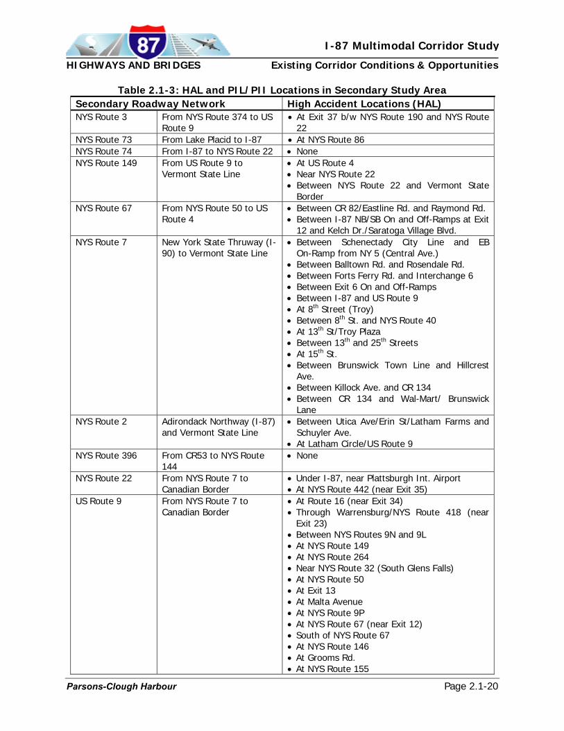
The New York State Thruway Authority (NYSTA) also categorizes HALs similar to NYSDOT for roadways under their jurisdiction. However, the NYSTA does not further prioritize their identified HAL locations as a PIL or PII. Within the I-87 Corridor from the Champlain/Lacolle Border Crossing to Albany, 11 priority HAL locations exist, with a concentration of HALs in the Lake George area of Warren County and in central Saratoga County. From Albany to the Tappan Zee Bridge in New York City, 12 priority HAL locations have been identified along I-87, with no discernable concentration. However, the HAL identification pattern does repeat itself at almost every interchange on the Thruway in the Secondary Study Area. Tables 2.1-2 and 2.1-3 show the specific priority HAL locations within the Primary and Secondary Study Areas, respectively. Comprehensive graphic representations of the HALs and PILs within the corridor are presented in Appendix 3.
Parsons-Clough Harbour Page 2.1-18

HIGHWAYS AND BRIDGES Existing Corridor Conditions & Opportunities
I-87 Multimodal Corridor Study
Table 2.1-2: HAL and PIL/PII Locations in Primary Study Area Primary Study Area High Accident Locations (HAL) Adirondack Northway (I-87)
From Champlain Border Crossing to Plattsburgh
• Champlain Border Crossing • Exit 40 (NYS Route 456)
Adirondack Northway (I-87)
From Plattsburgh to Glens Falls
• Exit 37 NB ramps in Plattsburgh • Exit 34 at NYS Route 9N in Keeseville • Exit 25 at Route 8 near Chestertown • Lake George Area
o Exit 22 o Exit 21 at NYS Route 9N o Between Exits 21 and 20
Adirondack Northway (I-87)
From Glens Falls to Saratoga
• Exit 16 at Ballard Road
Adirondack Northway (I-87)
From Saratoga to Albany • Exit 9 at NYS Route 146 • Between Exits 1 and 2
New York State Thruway (-87)
South of Albany • Interchange 24 • Interchange 23 • Interchange 18 • Interchange 17 • Interchange 16 and Woodbury Toll Barrier • Interchange 14A • Interchange 14 • Interchange 13 • Interchange 12 • Interchange 11 • Interchange 10 • Interchange 9, including Tarrytown Toll
Barrier New York State Thruway (I-90)
West of Albany • Interchange 25
New York State Thruway (Berkshire Spur)
South of Albany • Interchange B1
Interstate 90 (Toll-Free Section)
North of Albany • Between Interchanges 1 and 2 • Between Interchanges 3 and 4 • Between Interchanges 4 and 5 • Between Interchanges 5 and 5A • Interchange 5 ramps • I-90 Between I-787 and Interchange 6 • I-90 at I-787 Interchange
Interstate 787 East of Albany • Interchange 1 (I-787) at Interchange 23 on Thruway
• Interchange 2 at Port of Albany • Interchange at Madison Avenue • Interchange with Colonie & Columbia
Streets • Interchange 5 at I-90 (free section)
Parsons-Clough Harbour Page 2.1-19
HIGHWAYS AND BRIDGES Existing Corridor Conditions & Opportunities
I-87 Multimodal Corridor Study
Table 2.1-3: HAL and PIL/PII Locations in Secondary Study Area
Secondary Roadway Network High Accident Locations (HAL) NYS Route 3 From NYS Route 374 to US
Route 9 • At Exit 37 b/w NYS Route 190 and NYS Route
22 NYS Route 73 From Lake Placid to I-87 • At NYS Route 86 NYS Route 74 From I-87 to NYS Route 22 • None NYS Route 149 From US Route 9 to
Vermont State Line • At US Route 4 • Near NYS Route 22 • Between NYS Route 22 and Vermont State
Border NYS Route 67 From NYS Route 50 to US
Route 4 • Between CR 82/Eastline Rd. and Raymond Rd. • Between I-87 NB/SB On and Off-Ramps at Exit
12 and Kelch Dr./Saratoga Village Blvd. NYS Route 7 New York State Thruway (I-
90) to Vermont State Line • Between Schenectady City Line and EB
On-Ramp from NY 5 (Central Ave.) • Between Balltown Rd. and Rosendale Rd. • Between Forts Ferry Rd. and Interchange 6 • Between Exit 6 On and Off-Ramps • Between I-87 and US Route 9 • At 8th Street (Troy) • Between 8th St. and NYS Route 40 • At 13th St/Troy Plaza • Between 13th and 25th Streets • At 15th St. • Between Brunswick Town Line and Hillcrest
Ave. • Between Killock Ave. and CR 134 • Between CR 134 and Wal-Mart/ Brunswick
Lane NYS Route 2 Adirondack Northway (I-87)
and Vermont State Line • Between Utica Ave/Erin St/Latham Farms and
Schuyler Ave. • At Latham Circle/US Route 9
NYS Route 396 From CR53 to NYS Route 144
• None
NYS Route 22 From NYS Route 7 to Canadian Border
• Under I-87, near Plattsburgh Int. Airport • At NYS Route 442 (near Exit 35)
US Route 9 From NYS Route 7 to Canadian Border
• At Route 16 (near Exit 34) • Through Warrensburg/NYS Route 418 (near
Exit 23) • Between NYS Routes 9N and 9L • At NYS Route 149 • At NYS Route 264 • Near NYS Route 32 (South Glens Falls) • At NYS Route 50 • At Exit 13 • At Malta Avenue • At NYS Route 9P • At NYS Route 67 (near Exit 12) • South of NYS Route 67 • At NYS Route 146 • At Grooms Rd. • At NYS Route 155
Parsons-Clough Harbour Page 2.1-20

HIGHWAYS AND BRIDGES Existing Corridor Conditions & Opportunities
I-87 Multimodal Corridor Study
Exhibits 2.1-5 through 2.1-7 graphically present only those areas along I-87 where HALS are identified within areas of high traffic congestion. The information presented in Exhibits 2.1-5 through 2.1-7 is derived from the LOS data shown in Appendix 2 and the HAL data shown in Appendix 3.
Parsons-Clough Harbour Page 2.1-21

Parsons-Clough Harbour
I-87 Multimodal Corridor Study
Existing Corridor Conditions & OpportunitiesHIGHWAYS AND BRIDGES
Exhibit 2.1-5: HALs Within Areas of Peak Congestion – Northern Zone
Page 2.1-22

Parsons-Clough Harbour
I-87 Multimodal Corridor Study
Existing Corridor Conditions & OpportunitiesHIGHWAYS AND BRIDGES
Page 2.1-23
Exhibit 2.1-6: HALs Within Areas of Peak Congestion – Central Zone

Parsons-Clough Harbour
I-87 Multimodal Corridor Study
Existing Corridor Conditions & OpportunitiesHIGHWAYS AND BRIDGES
Page 2.1-24
Exhibit 2.1-7: HALs Within Areas of Peak Congestion – Southern Zone

HIGHWAYS AND BRIDGES Existing Corridor Conditions & Opportunities
I-87 Multimodal Corridor Study
Bridge Conditions and Clearances
The Study Team reviewed and compiled bridge sufficiency and clearance data provided by NYSDOT and NYSTA. Bridge conditions are classified by their sufficiency ratings. A bridge with a sufficiency rating between 100% and 81% is considered in good condition. Bridges with a sufficiency rating between 80% and 51% are considered in fair condition, and are eligible for rehabilitation, and bridges with a sufficiency rating between 50% and 0% are considered in poor condition, and are eligible for replacement or rehabilitation. Approximately 460 bridges were identified on the Interstate System and the primary non-Interstate roadways within the Primary and Secondary Study Areas. The sufficiency ratings revealed that 40 are rated in poor condition (less than 50%), 179 are rated between 80% and 51%, and the remaining 241 are rated in good condition (greater than 81%). Table 2.1-4 summarizes the location, BIN number, and description of the 40 bridges that have poor sufficiency ratings. The Primary and Secondary Study Area bridge locations and sufficiency ratings are also shown graphically in the Appendix 4.
Table 2.1-4: Location and BIN # of Bridges With Poor Sufficiency Rating
BIN Feature Carried Feature Crossed County 7033980 D & H Railroad I-87 Clinton 7033970 D & H Railroad I-87 Clinton 7712160 Erie Railroad I-87 Rockland 5514170 Pedestrian Overpass I-87 Rockland 1033520 Prospect Mountain Trail I-87 Warren 5514200 Southfield Pedestrian Overpass I-87 Orange 7712110 CSX Transportation (West Shore) I-87 Rockland 1045270 Route 300 I-87 Orange 1033310 Malta Avenue I-87 Saratoga 5515520 Sawkill Road Co. Rd. #42 I-87 Ulster 5513349 I-90 I-87 Albany 1022270 Plattekill-Modena NYS Route 32 I-87 Ulster 1033330 Kaydeross Avenue I-87 Saratoga 5513970 Mountain View Avenue I-87 Rockland 1005639 NYS Route 9 I-87 Saratoga 1029190 NYS Route 67 I-87 Saratoga 1005782 I-87 NYS Route 9 Warren 5513200 Leeds-Old Kings Highway I-87 Greene 1004250 NYS Route 7 I-87 Albany 7713280 CSX / AMTRAK I-90 Columbia 7513690 D & H Railroad I-90 Schenectady 1045110 NYS Route 295 I-90 Columbia 3366990 Bike Path NYS Route 149 Warren 7047500 CSX Transportation NYS Route 396 Albany 7017010 Vermont Railway NYS Route 22 Rensselaer 7017230 D & H Railroad NYS Route 22 Essex 7005600 B & M Railroad NYS Route 9 Saratoga 7005610 D & H Railroad NYS Route 9 Saratoga 7005650 D & H Railroad NYS Route 9 Saratoga
Parsons-Clough Harbour Page 2.1-25

HIGHWAYS AND BRIDGES Existing Corridor Conditions & Opportunities
I-87 Multimodal Corridor Study
Table 2.1-4: Location and BIN # of Bridges
With Poor Sufficiency Rating BIN Feature Carried Feature Crossed County
7005980 D & H Railroad NYS Route 9 Clinton 7006010 D & H Railroad NYS Route 9 Clinton 7053590 D & H Railroad NYS Route 9N Essex 7006040 D & H Railroad NYS Route 9 Clinton 7006870 LC & Moriah RR NYS Route 9N Essex 5516340 Tappan Zee Bridge (I-87) River Road & Hudson
River Rockland
7092900 CSX Transportation Water Street Albany 7092890 CSX Transportation Frontage Rd Albany 7092960 D & H Railroad B’ Way-Quay Street Albany 7093000 D & H Railroad Broadway Albany 1093010 Pedestrian Bridge On Ramp 787 NB Albany
The vertical clearances of the existing bridges within the Primary and Secondary Study Areas were also reviewed for their effect on mobility in the corridor. Based on Federal Highway Administration clearance guidelines, the minimum clearance requirements for typical Interstate facilities and State trunk highway systems in rural areas are established at 16 feet. All other secondary facilities are established at a 14 foot minimum vertical clearance. However, because I-87 is part of the National Strategic Highway Network (STRAHNET), the 61,000-mile system of designated roads throughout the US that have been identified for emergency mobilization and peacetime movement by the Department of Defense, all bridges that cross over I-87 have a minimum vertical clearance requirement of 16.5 feet. A review of the bridge clearance data of structures crossing over I-87 identified 117 of the 162 bridges that cross over I-87 have vertical clearances less than 16.5 feet. The Study Team also reviewed the remaining bridges within the Primary and Secondary Study Area that do not cross over I-87, which are on the key non-Interstate roadway system, and have a minimum vertical clearance requirement of 14.5 feet. The results of this effort identified that 83 bridges do not meet the 14.5 feet vertical clearance requirement of the 295 bridges not crossing over I-87. The location and vertical clearances of the Primary and Secondary Study Area bridges are shown graphically in Appendix 5. In summary, it is common for Interstate highway segments designed and built in the 1950s and 1960s to have a number of geometric design elements that are inconsistent with present-day standards, including bridge clearances. Due to the high cost of addressing these problems, the general approach is to solve such problems as bridges and underpasses are fully reconstructed or replaced. While some of the identified bridges are scheduled to be addressed as part of NYSTA and NYSDOT capital programs, there are no such plans for the vast majority of these structures. However, the general indication is that these problems do not pose a significant problem for the viability of the corridor as a major truck route.
Parsons-Clough Harbour Page 2.1-26

HIGHWAYS AND BRIDGES Existing Corridor Conditions & Opportunities
I-87 Multimodal Corridor Study
2.1.4. Projected Increases in Corridor Traffic Volumes
The Study Team compiled and reviewed historic Average Annual Daily Traffic (AADT) volumes for the I-87 corridor provided by the NYSDOT and NYSTA. The historic traffic volume growth trends were used to project anticipated future traffic volumes within the Northern, Central and Southern Economic Zones. Using the historic AADT volumes, best-fit trend lines were developed and projected 25 years into the future to estimate future AADT volumes within each economic zone. Future capacity issues along the I-87 corridor were identified based on a comparison of these volumes to the existing highway capacity within each zone. This trend analysis indicates that traffic volumes in the Northern Economic Zone are estimated to increase by approximately 85% over the next 25 years, reaching a daily volume of approximately 35,000 vehicles per day. A comparison of these projected volumes to existing highway capacity indicates that I-87 will have adequate mainline capacity to accommodate the volume demand through this 25-year period.
Traffic Volume TrendsNorthern Economic Zone
0
10,000
20,000
30,000
40,000
50,000
1970 1980 1990 2000 2010 2020 2030
Year
An
nu
al A
vera
ge D
aily
Tra
ffic
Vol
um
e(A
AD
T -
vpd)
Plattsburgh
Traffic VolumeTrend Line Projection
Parsons-Clough Harbour Page 2.1-27

HIGHWAYS AND BRIDGES Existing Corridor Conditions & Opportunities
I-87 Multimodal Corridor Study
Traffic volumes along the sections of I-87 within the Saratoga and Glens Falls areas of the Central Economic Zone are currently in the range of 40,000 to 60,000 vehicles per day. Based on projections of historic trends, these volumes are estimated to increase at an annualized rate of approximately 1.5 percent, with AADT volumes reaching approximately 90,000 in the Saratoga area and 65,000 in the Glens Falls area at the 25-year planning horizon. The general system capacity of I-87 is estimated to be sufficient to accommodate these future volume conditions. However, localized congestion at interchange ramps may emerge as a long-range issue, particularly during periods of peak tourism. Traffic volumes along some sections of I-87 within the Capital Region area of the Central Economic Zone have reached saturation thresholds during the morning and evening commuter peak hours. These volume conditions are highly sensitive to disruptions of the traffic stream, such as at heavy weave/merge areas, and as a result of even minor incidents (disabled vehicles, etc.), which can cause significant queue formation upstream of the bottleneck or breakdown location.
Traffic Volume Trends Central Economic Zone
0
20,000
40,000
60,000
80,000
100,000
120,000
140,000
160,000
1970 1975 1980 1985 1990 1995 2000 2005 2010 2015 2020 2025 2030
Year
Ann
ual A
vera
ge D
aily
Tra
ffic
Vol
ume
(AA
DT
- vp
d)
Albany
Saratoga
Glens Falls
Traffic Volume Trend Line Projection
Trend analyses of historic AADT volumes along I-87 in the Capital Region suggest the potential for significant increases in daily volume over the next 25 years. However, local planning efforts of the Capital District Regional Planning Commission (CDRPC) and the Capital District Transportation Committee (CDTC) indicate a lower rate of traffic growth. Reasons for this include moderation of demographic factors that they identified as major contributors to growth of the past 25 years, such as: increased participation of women in the labor force, increased vehicle availability, smaller household size, reduced fuel costs and population migration to suburban towns, particularly in Saratoga County. Based on these considerations, it is estimated
Parsons-Clough Harbour Page 2.1-28

HIGHWAYS AND BRIDGES Existing Corridor Conditions & Opportunities
I-87 Multimodal Corridor Study
by CDTC that traffic volumes on I-87 will increase at an annualized rate of approximately 1.6 percent. Traffic volumes in the 25-year planning horizon are estimated to increase to about 150,000 vehicles per day based on this growth projection. This increase of traffic is likely to be manifested by an expansion of the duration of congested operations as drivers will adjust trips to other hours of the peak period and eventually into the peak shoulders, given the constrained conditions that currently exist during the commuter peak hours. This trend of peak spreading could increase the number of hours each day that operate under unstable, saturated conditions. This condition will also exacerbate the effects of bottlenecks or breakdowns in traffic flow and will extend the length of time for traffic flow to recover from these conditions. These conditions indicate the need for substantial investment in strategies to manage congestion on I-87 within the Central Economic Zone. These strategies include more expansive applications of ITS technologies to maximize the efficient utilization of the existing infrastructure, such as investments in real-time traveler information systems, incident response systems and integrated closed-loop signal control systems for parallel and connecting routes. Opportunity to expand the role of transit in the corridor, such as Bus Rapid Transit, is also a recommended strategy for managing congestion in this zone of the corridor. Capital investments for improvements at bottleneck locations may also be included to address congestion. This sort of capacity improvement would likely include integration with technology solutions (such as HOV/HOT lanes, congestion pricing, etc) to manage the created corridor capacity. A trend analysis of historic volumes in the Southern Economic Zone indicates that traffic volumes are projected to increase by 45-50 percent over the next 25 years. This projected rate of growth is less than the explosive growth that occurred in areas like Orange and Rockland Counties since the mid-1970s – a projection that the recent report, Long-Term Needs Assessment and Alternatives Analysis, I-287/Tappan Zee Bridge Corridor (2000), confirms. However, this growth would still add approximately 60,000 vehicles per day to the corridor, which would significantly aggravate existing saturation-level congestion in this segment of the corridor. The on-going Tappan Zee Bridge/I-287 Corridor study, which is analyzing conditions in the section of I-87 between Suffern and Westchester County, is addressing these significant future mobility needs. Major highway capacity expansion, as well as light- and heavy-rail transit, BRT and HOT Lane concepts are all being considered as part of the study’s alternatives assessment process. Possible expansion or replacement of the Tappan Zee Bridge with a new bridge, a tunnel, and various combinations (e.g., new bridge with commuter rail in a separate tunnel) is also being studied.
Parsons-Clough Harbour Page 2.1-29

HIGHWAYS AND BRIDGES Existing Corridor Conditions & Opportunities
I-87 Multimodal Corridor Study
Traffic Volume TrendsSouthern Economic Zone
0
50,000
100,000
150,000
200,000
250,000
1970 1980 1990 2000 2010 2020 2030
Year
Ann
ual
Ave
rage
Dai
ly T
raff
ic V
olu
me
(AA
DT
- vp
d)
Tappan Zee
Harriman
Traffic Volume Trend Line Projection
2.1.5. Planning/Construction in Road/Bridge Systems The Study Team reviewed and compiled the NYSDOT’s Capital Programs to gain an understanding of the projects that are planned or under construction within the I-87 Corridor Primary Study Area. Tables 2.1-5 and 2.1-6 summarize the projects within the Primary Study Area that are included in NYSDOT’s Capital Program in Region 7 and 1, respectively.
Table 2.1-5: Existing Capital Programs: NYSDOT Region 7
PIN Project Title Type of Work Cost ($ million)
Scheduled Letting Date
7720.95 Port of Excellence Customs Improvements 6.0 SFY 03-04 7720.77 Cumberland – Chazy Rehabilitate 10.1 miles 7.91 SFY 03-04 7720.55 I-87 over Abandoned Railroad Remove 2 Structures 1.5 SFY 04-05 7720.91 Chazy – Canadian Border Rehabilitate 9.1 miles 7.0 SFY 07-08 7720.80 Tom Miller Road over I-87 Replace Structure 0.95 SFY 07-08 7720.74 I-87 over D&H Railroad Replace 2 Structures 3.6 SFY 07-08 7720.83 Ausable Chasm Road over I-87 Replace Structure 1.26 SFY 08-09 7720.86 I-87 over Salmon River Replace 2 Structures 2.5 SFY 09-10 7720.75 Essex County – Salmon River Rehabilitate 10.4 miles 9.0 SFY 09-10 7720.79 Route 11 over I-87 Replace Structure 1.5 SFY 09-10 7720.84 Route 348 over I-87 Replace Structure 1.5 SFY 09-10 7720.85 Route 191 over I-87 Replace Structure 1.55 SFY 09-10 7720.87 S. Junction Road over I-87 Replace Structure 1.5 SFY 10-11 7720.88 Route 22 over I-87 Replace Structure 1.3 SFY 10-11
Parsons-Clough Harbour Page 2.1-30

HIGHWAYS AND BRIDGES Existing Corridor Conditions & Opportunities
I-87 Multimodal Corridor Study
Table 2.1-5: Existing Capital Programs: NYSDOT Region 7
7720.82 D & H Railroad over I-87 Remove Structure 0.75 SFY 12-13 7720.89 Route 442 over I-87 Replace 2 Structures 1.6 SFY 12-13 7720.81 I-87 over Little Ausable River Replace 2 Structures 1.78 SFY 13-14 7720.90 Stratton Road over I-87 Replace Structure 1.2 SFY 14-15 7720.96 D&H Railroad over I-87 Replace Structure 2.5 SFY 14-15
Table 2.1-6: Existing Capital Program – NYSDOT Region 1
PIN Project Title Type of Work Cost ($ million)
Scheduled Letting Date
1721.50 Lewis SB Rest Area Rest Area Improvements 5.0 SFY 15-16 1721.51 Exit 3 Airport Connector, Pt. 1 New Interchange/Access 27.0 SFY 08-09 1721.56 I-87 over D&H Railroad Replace 2 Structures 6.0 SFY 05-06 1721.60 Rte. 20 to Saratoga Co. Pavement Resurfacing 8.0 SFY 04-05 1721.74 Kinns Road over I-87 Replace Structure 3.5 SFY 05-06 1721.78 I-87 over W’vliet-Shkr Rd. Replace 2 Structures 4.5 SFY 06-07 1721.80 I-87 over Albany-Shkr Rd. Replace 2 Structures 6.0 SFY 09-10 1721.81 Exit 26 to Exit 28 Pavement Resurfacing 14.0 SFY 05-06 1721.83 Exit 24 to Exit 26 Pavement Resurfacing 8.0 SFY 10-11 1721.84 Exit 29 to Exit 31 Pavement Resurfacing 13.0 SFY 12-13 1721.85 Exit 31 to Clinton Co. Line Pavement Resurfacing 12.0 SFY 12-13 1721.88 I-87 over Mohawk River Rehabilitate 2 Structures 10.0 SFY 08-09 1721.89 Exit 6 to Saratoga Co. Pavement Resurfacing 15.0 SFY 09-10 1721.90 Exit 3 Airport Connector, Pt. 2 New Interchange/Access 15.0 SFY 13-14
1721.99 Exit 18 Interchange Interchange Reconstruction 4.5 SFY 08-09
1722.00 I-87 over Branch River Replace 2 Structures 6.0 SFY 11-12 1722.01 I-87 over CR10/Schroon R Replace 2 Structures 8.0 SFY 11-12 1722.02 I-87 over Megsville Road Replace 2 Structures 6.0 SFY 12-13 1722.03 I-87 over N. Br. Boquet R Replace 2 Structures 7.0 SFY 08-09 1722.04 I-87 over Rte 9 (P’ville) Replace 2 Structures 7.0 SFY 11-12 1722.05 Exit 13 to Exit 15 Pavement Rehabilitation 10.0 SFY 11-12 1722.06 Exit 15 to Warren Co. Line Pavement Rehabilitation 10.0 SFY 13-14 1722.07 Spier Falls Road over I-87 Replace 1 Structure 5.0 SFY 11-12 1722.08 Augar Lake Road over I-87 Replace 1 Structure 3.0 SFY 12-13 1722.09 Diamond Point Rd over I-87 Replace 1 Structure 3.0 SFY 12-13 1722.12 Exit 15 to Exit 16 Pavement Resurfacing 3.6 SFY 03-04 1722.13 Exit 16 to Warren Co. Line Pavement Resurfacing 3.6 SFY 05-06 1722.17 Exit 11A Interchange New Interchange/Access 25.0 SFY 07-08 1753.80 Exit 18 Corinth Road Pavement Widening 4.5 SFY 04-05
1528.55 I-90 Interchange 1 (NYS Thruway) to Interchange 5A Pavement Rehabilitation 33.5 SFY 04-05
1528.62 I-90 Schodack Rest Area Rest Area Improvements 6.0 SFY 08-09 1528.64 I-90 over I-787 Replace 2 Structures 1.5 SFY 13-14 1528.65 I-90 Int 10 to Int 11 Pavement Resurfacing 2.0 SFY 07-08 1528.66 I-90 Int 11 to NYS Thruway Pavement Resurfacing 6.5 SFY 07-08 1528.68 I-90 over Hudson River Replace 2 Structures 75.0 SFY 14-15 TBD NYS Thruway Int 23 to Int 24 Pavement Reconstruction 10.0 SFY 06-07 TBD I-87/Exit 20 TBD TBD Post 10 years TBD Rte. 20 to Saratoga Co. Pavement Reconstruction TBD Post 10 years
Parsons-Clough Harbour Page 2.1-31

HIGHWAYS AND BRIDGES Existing Corridor Conditions & Opportunities
I-87 Multimodal Corridor Study
NYSDOT currently has a major capital improvement project (PIN 1528.52) under construction to address the I-90 deficiencies between the Interchange 5A (Corporate Woods Boulevard) and the I-787 Interchange. This project was started in the Fall of 2003 and will be under construction throughout 2004. A second project (PIN 1528.55) from Interchange 5A to Interchange 1 at the NYS Thruway is scheduled to begin construction in 2005 (see Table 2.1-6). 2.1.6. Stakeholder Input Regarding Existing Highway and Bridge Conditions
In order for the Study Team to complete the comprehensive highway and bridge assessment and to identify key areas of concern, the data collected through the existing conditions inventory was supplemented with stakeholder meetings in the corridor. Starting with the members of the Study Advisory Group, the Study Team reached out to a number of diverse interest groups within the corridor through regional and local transportation and economic development agencies, municipal representatives and affiliates, and public and private tourism and commerce organizations. These efforts provided a diverse composition of opinions and perspectives from a wide-range of view points and interests, all of whom have a vested interest in the I-87 Corridor.
For the purposes of coordinating and scheduling stakeholder input sessions, the Study Team divided the corridor into three regional components or economic zones. Two of the economic zones comprised the Primary Study Area and the third economic zone corresponded to the New York State Thruway portion of the Secondary Study Area. This development of three regional components was done to expedite and more efficiently manage the data collection effort. As discussed in the Introduction section of this report, the Northern Economic Zone extended along I-87 from the US/Canadian Border to the Southern Adirondack/Glens Falls area, while the Central Economic Zone included the Southern Adirondack/Glens Falls area through the Capital Region to Interchange 21A of the Thruway. The Southern Economic Zone corresponded to the Secondary Study Area, but focused on the four northern counties within that zone – Greene, Columbia, Dutchess and Ulster.
The Study Team’s interpretation of the stakeholder input is summarized in the following sections.
• Primary Study Area
• Northern Economic Zone (Canadian Border to Glens Falls – Clinton, Essex, Warren &
Washington Counties) Primary Highways • Extensive delays occur at the Champlain/Lacolle Border Crossing and are a key
factor in reliability and overall travel time for over-the-road freight movements. • The Champlain Port of Excellence Project is currently in the first phase of a multi-
phase project. Major construction is planned to begin in 2005 and includes construction of a new state-of-the-art U.S. customs warehouse and truck processing facility. Further construction phases will then proceed through 2008,
Parsons-Clough Harbour Page 2.1-32

HIGHWAYS AND BRIDGES Existing Corridor Conditions & Opportunities
I-87 Multimodal Corridor Study
when the new facility is expected to be fully operational and to serve as a model for other crossings across the country.
• The NEXUS and FAST (Free and Secure Trade) Systems being implemented to help decrease travel time delays for vehicles crossing the Champlain Border and warrant continued funding.
• Exits 29 and 28 are already programmed by the NYSDOT to be reconstructed. • I-87 at Exit 19 needs capacity improvements, because it currently experiences
significant traffic congestion. • A “Roof Top” east-west highway has been discussed/planned for years and is still
needed. • The interchange at Exit 18 and the surrounding land uses and available parcels are
important economic catalysts for Warren and Washington Counties. The interchange provides access along CR 28 (Corinth Road) to the City of Glens Falls in southern Warren County and to central Washington County. Build Now-NY sites are immediately accessible from I-87 at Exit 18. Exit 18 and CR 28 have been previously identified by A/GFTC as needing capacity improvements.
• The interchange at Exit 20 is a primary access point for east-west commercial and non-commercial traffic into Warren and Washington Counties from I-87. Exit 20 to NYS Route 149 and US Route 4 is a heavily traveled commercial and tourist/recreationalist route between I-87 and central Vermont via Warren and Washington Counties. The interchange also provides direct access to the Lake George outlet shopping district and tourist facilities/accommodations south of Lake George Village. The interchange and primary access roads experience significant congestion and delays on weekends, particularily during the tourist seasons. The congestion is further exacerbated by the high percentage of commercial vehicles (ie. tractor trailers) using the interchange and east-west primary roadway corridor.
• The interchange at Exit 19 provides direct access between I-87 and the commercial business/retail shopping district in Queensbury. The interchange and adjoining roadways experience significant traffic congestion.
• US Route 4 is the primary north-south highway through central Washington County, and also provides access directly into central Vermont (Rutland). The function of Route 4 to the economic and recreational sustainability and growth of central Washington County is vital. The capabilities of Route 4 as an expanded commercial corridor are limited by its constraints within the population centers that it travels through and services.
Secondary Highways • East/west roadway connections are inadequate, especially in the Plattsburgh,
Saranac Lake and Lake Placid areas. Improvements to the east/west connections in this area would help to relieve traffic congestion related to tourism.
• NYS Route 22 needs infrastructure improvements between I-87 and the ferry service at Port Kent to Burlington, Vermont.
• US Route 11 needs infrastructure improvements, which could significantly support the regional economy.
• NYS Route 73 has significant deficiencies that need to be addressed. Traffic congestion along this route near NYS Route 9N is a major concern. NYS Route 73 also has inadequate safety turnouts and roadside parking for hikers.
Parsons-Clough Harbour Page 2.1-33

HIGHWAYS AND BRIDGES Existing Corridor Conditions & Opportunities
I-87 Multimodal Corridor Study
• NYS Route 74 needs infrastructure improvements to accommodate redevelopment of
Fort Ticonderoga. • Military Road, which extends from NYS Route 73 in Lake Placid to Saranac Lake,
needs improvement. • US Route 9 north of Schroon Lake is in need of infrastructure improvements. • NYS Route 149 has a significant amount of truck traffic. • Need access improvements at Exit 29 (Frontier Town). • Lack of public transportation.
• Central Economic Zone (Glens Falls to New York State Thruway Interchange 21A – Warren, Saratoga, Schenectady, Albany and Rensselaer Counties) Primary Highways • Direct interstate access to Albany International Airport is essential for the region.
Lack of direct interstate access is creating a disincentive for airlines to expand operations at the airport. • The I-87, Exit 3 Airport Connector Project is an existing NYSDOT project that is
currently in the project scoping phase prior to preliminary design development. • Exit 16 (Wilton) needs infrastructure improvements. • Exit 15 (Saratoga Springs to the Hudson River Crossing) is the first of a series of
resurfacing projects that began this year in the Saratoga Springs area. • The reconstruction of Exit 12 (Malta) is programmed to begin in 2004. • Interchange improvements at Exits 11 and 12 are needed to accommodate growth
potential in the area and the proposed Luther Forest Technology Campus. • Morning and evening commuter peak period congestion between Exits 9 and 1
needs to be addressed. • The free section of Interstate 90 between I-87 and I-787 experiences significant
traffic congestion, especially during the morning and evening commuter peak periods. “Thruway or Turnpike Tandems” (tandem trucks with twin 48-foot trailers) are not permitted on the free section of I-90 between I-87 and the Berkshire Spur; tandem trucks with twin 28-foot trailers are permitted on the toll-free section of I-90.
• Access improvements are needed between the Port of Albany and I-787, and along I-787 to Thruway Interchange 23. Grade differentials along I-787 are a key limiting factor that prohibits tandem truck access.
• There are significant driver confusion and capacity issues at the interchanges that connect I-90 (Interchange 24 – Thruway) and I-87 (Exit 1 - Adirondack Northway) in Albany. • The NYSTA is currently conducting the Albany Corridor Study, which is
investigating mainline and interchanges capacity improvements, and improved access to truck tandem lots between Interchanges 25A on I-90 and 21A on I-87.
Secondary Highways • East/west roadway connections are inadequate. Therefore, the interstate facilities in
the Capital District are being used as regional arterials. • NYS Route 67 (west of Exit 12 on I-87) experiences significant traffic congestion,
which extends beyond the commuter peak periods.
Parsons-Clough Harbour Page 2.1-34

HIGHWAYS AND BRIDGES Existing Corridor Conditions & Opportunities
I-87 Multimodal Corridor Study
• Need an alternate route between Mechanicville and Malta, which has been
investigated in the past as the Round Lake By-pass. • Need improved access to SUNY Albany’s East Campus (Nanotech Facility).
• Secondary Study Area
• Southern Economic Zone (New York State Thruway Interchange 21A to Interchange
9 – focused on Greene, Columbia, Ulster and Dutchess Counties) Secondary Highways • Improvements will be needed at Interchange 21 to support Home Depot
development. • Cross-Hudson bridge or ferry (Hudson-Catskill or Hudson-Coxsackie) would provide
better access to passenger train service for Greene County residents. • Need improved tourist/recreation access (e.g., dedicated “ski buses” providing direct
service to Hunter and Wyndham). • Better tourist information is needed to help drivers decipher roadway network and
gauge distances. Frequent confusion regarding nomenclature (e.g., Thruway vs. Northway), Interchange numbering system (e.g., Interchange 24 on Thruway vs. Interchange 24 on Northway), etc.
2.1.7. Highway Network Improvement Concepts Key Factors The initial phases of the Study’s development and assessment process involved a comprehensive data collection and review process to establish existing traffic, highway and bridge conditions. These baseline data were then evaluated against the following three primary screening criteria to identify critical analysis areas in the corridor.
• Traffic volumes and congestion • Safety and clearances, and • Linkages to economic activity nodes.
Traffic volumes and congestion were assessed based upon Average Annual Daily Traffic (AADT) volumes and Levels of Service (LOS) for I-87 and key non-Interstate roadways.
Safety and clearances were identified based upon High Accident Locations (HALs) data, Highway and Bridge Sufficiency Ratings, and bridge clearance assessments. “Windshield survey” visual observations were also used to assess general pavement conditions, lane types and numbers, geometrics, adjacent land uses or environs, and typically observed traffic flow composition and characteristics. Linkage to economic activity nodes was based upon the physical transportation infrastructure and the proximity or access to significant hubs of commercial activity or development. This was facilitated and supported by data from the NYSDOT databases and other sources provided to, or collected by the Study Team.
Parsons-Clough Harbour Page 2.1-35

HIGHWAYS AND BRIDGES Existing Corridor Conditions & Opportunities
I-87 Multimodal Corridor Study
The next step in the existing conditions assessment was the integration of the stakeholder input with the existing conditions inventory information. This step in the corridor refinement process was essential to the identification of common corridor issues and concerns, and the recognition of stakeholder priorities. Through this interactive process the Study Team was able to further refine the corridor into four critical assessment area, each of which has key highway and/or bridge related components.
Identified Problem Areas • I-87 in the Capital District. After the I-287 corridor in Rockland County at the southern
end of the Secondary Study Area, the highway segment most widely recognized as problematic in the corridor was I-87 from Central Saratoga County through the Capital District. The deficiencies in the Capital Region focused primarily on commuter capacity and congestion on I-87 and its impacts on mobility and the ability of this key region to respond to economic growth possibilities and competition from other areas across the country and worldwide. There were additional Capital Region deficiencies in its local network, including access to I-87 and the role of secondary roads as collector/distributors, and as a bypass road during congested periods.
Based upon the Study Team’s assessment of the remaining stakeholder input, the Study Team identified three other critical analysis areas within the corridor: • The US/Canadian Border region was identified as a significant traffic safety and security
concern on I-87. The prevalence of traffic queues extending onto I-87 from the border crossing and the occurrence of vehicular accidents attributable to high-speed traffic encountering unexpected traffic stoppages is an impediment to the safety and efficiency of the corridor users as they approach or depart the border facilities.
• Key Interstate highway locations within the southern portion of the Secondary Study Area focusing primarily on access and mobility improvements between I-87 and Stewart International Airport and I-87/I-287 and the Tappan Zee Bridge.
• Key non-Interstate roadways and I-87 connections throughout the Primary Study Area, with particular emphasis on maintaining, supporting and expanding economic development and tourist related activities. The specific roadways quantified under this critical analysis area were typically identified as the primary commercial and tourism routes in the southern and central Adirondack Regions and the alternate routes to I-87 in the Capital District Region. Particularly in the southern and central Adirondack Regions, the conditions and geometrics of the primary secondary road networks were identified as a barrier to economic development. A frequently noted theme was that the existing, often dated local highway network was servicing significantly higher volumes of commercial vehicle traffic than the roadways were designed to handle. This increase in commercial vehicle traffic coupled with increases in traditional passenger vehicle traffic and seasonal increases from recreational (tourism) traffic results in competition and congestion in some otherwise relatively rural areas. Interchanges in those areas between the secondary network and I-87 were also a consistent problem, as that was where local economic development (especially retail) wanted to be, and where traffic naturally congregated due to the need to access the highway.
Parsons-Clough Harbour Page 2.1-36

HIGHWAYS AND BRIDGES Existing Corridor Conditions & Opportunities
Parsons-Clough Harbour Page 2.1-37
I-87 Multimodal Corridor Study
In the Capital Region the noted concerns were in the condition of the secondary roadway systems and their inability to effectively accommodate the projected growth and mobility expectations in the area.
A wide range of non-Interstate roadways was identified through the stakeholder meeting process throughout the corridor. The Study Team used an evaluation process to narrow the breadth of the possible improvement needs that were identified as part of this study. This process first looked at the proximity of the identified need to I-87 or the direct and immediate relationship between overall I-87 corridor mobility needs and the identified need along a given secondary road segment. Secondly, the Team identified whether the roadway limitations in question posed a significant impediment to local economic development, or raised substantial quality-of-life issues. Based on this review, needs or conditions which were determined to be outside the limits of the I-87 corridor, or inconsistent with the scope of this study were dismissed form further consideration under this study. However, identification of these conditions or needs is included in other project-related documentation or records (most typically identified in meeting summaries or notes) for reference as necessary, and for inclusion in the Study’s final report as important factors for future consideration. Of the identified deficiencies or needs which remained, the Study Team then assessed those opportunities against NYSDOT’s own Capital Improvement Programs for the three Regions along the corridor, equivalent information from the NYS Thruway Authority, and corridor MPO Transportation Improvement Programs were consulted. The more traditional infrastructure improvement and maintenance projects included within, for example, the Capital Improvement Programs were typically dismissed from further evaluation under this Study, while those which contained or would support multi-modal or inter-modal functions or commerce related initiatives (i.e. economic, security) warranted further evaluation and screening. The Study also reviewed some of the longer-term highway improvements for possible implementation at an earlier stage.
Exhibit 2.1-8 lists the candidate concepts within the Highway category that are recommended for further consideration within each of the four critical highway study areas, and indicates the approximate location of each within the Primary and Secondary Study Areas. Brief write-ups of each concept are then provided.

HIGHWAYS AND BRIDGES Existing Corridor Conditions & Opportunities
Parsons-Clough Harbour Page 2.1-38
I-87 Multimodal Corridor Study
Exhibit 2.1-8: Highway Improvement ConceptsNo. Project Concept Location H-1 Interchange 3
(Airport Connector) Town of Colonie, Albany County
H-2 Albany Corridor Study Thruway Interchanges 21A to 25A, Albany and Schenectady Counties
H-3 NYS Route 73 I-87 to Lake Placid, Essex County
H-4 Adirondack Northway Interchange 1 to 8, Albany and Saratoga Counties
H-5 Luther Forest Technology Campus (LFTC) Access
Town of Malta, Saratoga County
H-6 Access Improvements to SUNY technology hub
City of Albany, Albany County
H-7 Northway Interchange 18 (Corinth Road)
Town of Queensbury, Warren County
H-8 Rts. 4, 9, 149 from Northway Int. 20 to Vermont State Line
Warren and Washington Counties
H-9 Port of Excellence Improvements
Champlain/Lacolle Border Crossing
H-10 Tappan Zee Bridge/I-287-I-87 Corridor Study, I-287
Westchester & Rockland Counties
H-11 Selkirk Yard Access Improvements
Albany County
H-12 Commercial Vehicle Access Improvements to the Port of Albany
City of Albany, Albany County
Plattsburgh
Albany
NYC
Seco
nda
ry
Pri
mar
y
H-5
H-8
H-2
H-9
H-3
H-7
H-4 H-1
H-6
H-10
H-12H-11
H-12

HIGHWAYS AND BRIDGES Existing Corridor Conditions & Opportunities
Parsons-Clough Harbour Page 2.1-39
I-87 Multimodal Corridor Study
Improvement Concept: H-1 Name and Location: Interchange 3 (Airport Connector), Town of Colonie, Albany County Purpose: Improve Interstate access to Albany International Airport and the surrounding Capital District roadway network. Problem: Currently, direct access between the Albany International Airport and I-87 is not provided. The existing Interchange 4, Wolf Road, and Albany-Shaker Road corridor that provides access to the Airport experiences significant traffic congestion and has accident rates that exceed the statewide averages. Backups at Interchange 4 extend onto the mainline during the evening commuter peak hour.
Description: This concept is a significant long-term capital investment that will link two of the major transportation facilities in the Capital District: I-87 and the Albany International Airport. The following concepts have been identified to improve mobility:
• Provide direct airport access to minimize passenger and commercial vehicle delays • Improve geometric and operational deficiencies to the adjoining roadway network • Provide a gateway between I-87 and the Albany International Airport • Enhance access to the airport through the selective application of feasible, cost effective
ITS and transit/intermodal measures Strategy: The NYSDOT and Capital District Transportation Committee (CDTC) have placed a high value on the ability to accommodate projected traffic increases associated with increases in airport activity and economic development in the immediate area. NYSDOT completed a 1995 Northway Corridor Study that supported the merits of a new connection or improved access to the Albany International Airport. The project is also included in the Capital District Transportation Committee’s New Visions plan. Benefit: This concept will provide direct and improved access to the Albany International Airport, which will improve intermodal access and support economic development potential in the Capital District. Status: The NYSDOT is currently in the preliminary design phase for this concept. The concept is currently in the NYSDOT’s Capital Program (PIN 1721.51) and included on CDTC’s TIP.

HIGHWAYS AND BRIDGES Existing Corridor Conditions & Opportunities
Parsons-Clough Harbour Page 2.1-40
I-87 Multimodal Corridor Study
Improvement Concept: H-2 Name and Location: Albany Corridor Study, Thruway Interchanges 21A to 25A, Albany and Schenectady Counties Purpose: Address structural, safety, operational and capacity needs for the Thruway Corridor in the Capital District.
Problem: This portion of the New York State Thruway has pavement conditions that are deficient and have exceeded their projected life span. The Corridor’s traffic volumes already exceed or are anticipated to exceed acceptable levels within the next 10 years. There are also traffic congestion issues at Interchange 23, 24, and 25 toll plazas and a need for improved access to tandem truck parking lots within the corridor. Description: This concept is a long-term capital investment to address current and future structural, safety, operational, and capacity needs of the Thruway Corridor within the Capital District. The following concepts are being evaluated to improve the corridor:
• Reconstruct Interchanges 23 and 24 • Provide nonstop, high speed EZ-Pass at
Interchanges 23 and 24 • Add a third travel lane in each direction on the
Thruway mainline between Interchanges 23 and 24 • Improve Interchange geometrics wherever possible
Strategy: The New York State Thruway Authority (NYSTA) has placed a high value on the ability to accommodate existing and projected traffic volumes within its facilities. Benefit: This concept will improve the overall operations of the Thruway Corridor within the Capital District, which will support additional economic development. Status: The NYSTA expects to complete the study report by Spring 2004.

HIGHWAYS AND BRIDGES Existing Corridor Conditions & Opportunities
Parsons-Clough Harbour Page 2.1-41
I-87 Multimodal Corridor Study
Improvement Concept: H-3 Name and Location: New York State (NYS) Route 73, I-87 to Lake Placid, Essex County Purpose: Address physical and operational roadway conditions to improve access to the Central High Peaks Region and enhance recreational, tourism and economic activities, and protection of scenic vistas and environmentally sensitive features.
Problem: The existing roadway geometrics and terrain hinder access to the Central High Peaks Region. The lack of adequate safety turnouts and roadside parking along NYS Route 73 contribute to pedestrian and traffic safety issues. Increased promotion and support for tourism are resulting in traffic congestion near NYS Route 9N and within Lake Placid during special events.
Description: NYS Route 73 is the gateway to the Adirondack Park High Peaks Region and provides primary access from I-87 to Lake Placid and Saranac Lake, via NYS Route 86. A comprehensive Scenic Corridor Management Plan has been developed. The following concepts were recommended in the Scenic Corridor Management Plan:
• Improve physical roadway conditions and geometrics • Provide safety turnouts and roadside parking areas at trailhead locations • Implement public transportation demonstration programs to provide an alternative to
automobile access to trailheads with park and ride facilities at key locations along the corridor
• Provide bicycle parking facilities at trailheads • Implement erosion control measures to minimize pollution to lakes and rivers near the
roadway • Realign the Route 73 and Route 9 intersection to reduce motorist confusion
Strategy: The NYSDOT and FHWA have recognized the functional importance of this corridor through its designation as a National Scenic Byway. Benefit: This concept will improve roadway conditions for increased commercial vehicle activity along the corridor, which will support the growth of tourism and economic development. Status: The NYSDOT (PIN 1383.20) has identified the project need. A Scenic Corridor Management Plan was previously prepared by NYSDOT in coordination with NYSDEC, the APA and the affected Towns. Capital improvements and initiatives from the Plan have yet to be implemented.

HIGHWAYS AND BRIDGES Existing Corridor Conditions & Opportunities
Parsons-Clough Harbour Page 2.1-42
I-87 Multimodal Corridor Study
Improvement Concept: H-4 Name and Location: Adirondack Northway between Interchanges 1 and 8, Albany and Saratoga Counties Purpose: Improve mainline infrastructure and operating conditions within this corridor. Problem: The underlying pavement conditions of the Adirondack Northway (I-87) are deteriorating rapidly and will reach their life expectancy within the next 5 to 10 years. This section of the I-87 also experiences significant traffic congestion southbound during the morning commuter peak hours and northbound during the evening commuter peak hours.
Description: The improvement concept would address the physical deficiencies of the mainline and interchange pavements and bridges to maintain the integrity and serviceability of the interstate system between the Capital District and Southern Saratoga County to provide a service life of between 30 and 50 years. The project would also address the capacity deficiencies and related constraints that hinder the operational characteristics and serviceability of the system particularly during the weekday AM and PM commuting hours. Due to the high volumes of traffic along this segment and the physical constraints within the interstate corridor itself, as well as the prevalent land use constraints abutting the interstate corridor, the evaluation and implementation of non-traditional construction methods and non-traditional capacity improvement strategies is warranted. Capacity improvement concepts could involve the implementation of integrated ITS systems, public transit systems, dedicated or designated physical improvements of limited scope and scale (refer to ITS Concept I-10). Strategy: Coordinate and combine the required reconstruction of the highway with “Smart Highway” capacity expansion and ITS initiatives. Benefit: This concept will extend and improve the useful service life of the interstate system between Interchanges 1 and 8 by reconstructing deficient pavement and bridges. Additional capacity improvements would address congestion and long-term growth demands of this critical corridor while supporting the use of more efficient travel modes. Status: The reconstruction portion of this concept is currently included in NYSDOT’s Capital Improvement Program (PIN 1721.60) with construction scheduled in 2006-2007.

HIGHWAYS AND BRIDGES Existing Corridor Conditions & Opportunities
Parsons-Clough Harbour Page 2.1-43
I-87 Multimodal Corridor Study
Improvement Concept: H-5 Name and Location: Luther Forest Technology Campus (LFTC) Access, Town of Malta, Saratoga County Purpose: Improve access to the proposed LFTC (nanotechnology manufacturing center) site between the Northway Interchanges 11 and 12, and surrounding local roadway network.
Problem: The existing Interchanges 11 and 12, and their connections to the local roadway network cannot accommodate the traffic demands predicted for the proposed LFTC site at the time of full “build out”. In the interim condition, the traffic volumes generated from the initial phases of the project can be accommodated at Interchanges 11 and 12 with improvements to the secondary roadway network providing access between I-87 and the proposed site.
Description: This concept would address improved access to the proposed nanotechnology manufacturing campus located between Interchanges 11 and 12 to the east of the Northway. The following concepts have been identified to improve access to the proposed high-technology facility:
• Provide a new access roadway around the Village of Round Lake to Route 9 • Construct a new interchange between 11 and 12 to provide a more direct connection
between I-87 and the LFTC site • Implement public transportation to provide an alternative to automobile access to the
proposed LFTC site with connections to Albany International Airport, downtown Albany, and the Nanotech facility on the SUNY Albany campus.
Strategy: Advance preliminary development of improved access scenarios using the Conceptual Access Management Plan as a basis. Formulate an Interchange Justification Report development strategy. Benefit: This concept will provide improved access between I-87 and the proposed nanotechnology manufacturing center at the LFTC site. Improved access would increase the development potential of this site and the surrounding area, and reduces the traffic burden that would otherwise be placed on the existing infrastructure. Status: The Town of Malta is currently in the environmental review stages for the proposed LFTC site.

HIGHWAYS AND BRIDGES Existing Corridor Conditions & Opportunities
Parsons-Clough Harbour Page 2.1-44
I-87 Multimodal Corridor Study
Improvement Concept: H-6 Name and Location: Access Improvements to the State University of New York (SUNY) technology hub, City of Albany, Albany County Purpose: Improve access to the SUNY technology hub and improve operations on I-90 and the arterials connecting the campus to I-90 and I-87.
Problem: The expanding SUNY technology hub will place excessive demands on the arterial system, connecting the campus to I-90 and I-87. The existing arterial network (Washington Avenue and Fuller Road) accessing the technology hub has reached its useful service life and is experiencing significant traffic congestion and operational deficiencies, which will be exacerbated by the growth of the technology hub. Description: This concept would address the deficiencies within the arterial roadway network that provide access to the Interstate System and the technology hub. Complimentary to this concept would be the establishment or improvement of connectivity between the SUNY technology hub and the primary multi-modal facilities within the Region as well as other existing or proposed technology initiatives.
• Implement alternative transportation programs to provide efficient access between the SUNY technology hub and the Albany International Airport, downtown Albany, the Rensselaer train station, RPI, and the proposed Luther Forest Technology Campus.
• Implement infrastructure improvement strategies to ensure the integrity and longevity of the primary existing surface roadway network surrounding the SUNY technology hub.
• Integrate technology based initiatives (ITS) into the infrastructure improvement strategies to enhance traffic operational characteristics and serviceability.
Strategy: The MPO places a high priority on improved multi-modal mobility within the Region. Advance development of a comprehensive project that is consistent with the regional importance of the technology hub. Benefit: This concept will improve the overall transportation effectiveness and quality of life. Status: Opportunity identification.

HIGHWAYS AND BRIDGES Existing Corridor Conditions & Opportunities
Parsons-Clough Harbour Page 2.1-45
I-87 Multimodal Corridor Study
Improvement Concept: H-7 Name and Location: Northway Interchange 18 (Corinth Road), Town of Queensbury, Warren County Purpose: Improve commercial access from Interchange 18 to the west of I-87. Problem: The lack of adequate commercial vehicle access to the industrial or economic development areas to the west of I-87 at Interchange 18 is a limiting factor to the site growth opportunities. Interchange 18 also experiences capacity related congestion problems between I-87 and Glens Falls. The current condition of Exit 18 and CR 28 (Corinth Road) hinder the efficient movement of traffic through the corridor to the opportunities within the Glens Falls central business district to the east of I-87, and to the available commercial sites in close proximity to I-87 (both east and west of I-87).
Description: This concept would address commercial vehicle access to the west of Interchange 18 on I-87. There currently exists an approved 40 acre site to the west of Interchange 18 that is designated as a Build Now-NY site. The ability to attract tenants or commercial ventures to this site is hindered by the lack of adequate direct commercial access to I-87. Interchange 18 is currently being evaluated for improvements as part of an on-going project to improve the infrastructure and enhance traffic operational characteristics into the City of Glens Falls. Improvements to the interchange and to CR 28 can provide a gateway to downtown Glens Falls to compliment the economic vitality experienced in southeastern Warren County and extending into Washington County. This on-going project addresses a need that will aid in supporting the biotechnology and medical device industry within the Region. Strategy: To balance improvements to the east of the Interchange, which are already under study by NYSDOT. Benefit: This concept will promote the marketability of the Build Now-NY site. Status: This concept is on the Adirondack/Glens Falls Transportation Committee’s Transportation Improvement Program. Project is not yet fully funded.

HIGHWAYS AND BRIDGES Existing Corridor Conditions & Opportunities
Parsons-Clough Harbour Page 2.1-46
I-87 Multimodal Corridor Study
Improvement Concept: H-8 Name and Location: Improvements to Routes 4, 9 and 149 from Northway Interchange 20 to Vermont State Line, Warren and Washington Counties Purpose: Improve access within Warren and Washington Counties along the Route 9, Route 149, Route 4 and Route 22 corridor between Interchange 20 of the Adirondack Northway and the New York/Vermont State Line.
Problem: This corridor provides the primary east-west interstate commerce routes connecting Warren and Washington Counties with Central/Northern Vermont and I-87 at Interchange 20. Increasing interstate commerce demands on the corridor are not consistent with its intended function and are competing with tourism demands, resulting in consequences to the abutting communities. The inadequacies of the existing roadway network within this corridor are hindering the commercial access to, and expansion potential of, technology-based, manufacturing support and direct manufacturing facilities in Warren and Washington Counties. Description: This concept would evaluate the entire corridor as a primary interstate commerce link between Warren and Washington Counties and Vermont and I-87. Conclusions drawn from the evaluation would identify specific areas of improvements which may include, but not be limited to:
• Bypass routes or alternate routes around the most heavily impacted communities • Geometric improvements to facilitate more efficient movement of commercial vehicles • Limited areas of capacity improvements or access improvements at the Northway • ITS initiatives to improve commercial travel efficiency within the corridor through
improved management of the existing infrastructure and coordination to reduce competition with tourism related traffic.
Strategy: NYSDOT has done some improvements along portions of Rt. 149 but further corridor assessments are needed. Benefit: This concept will improve the ability for commercial/technological/industrial and manufacturing ventures in the Southern Adirondack Region to be more efficiently serviced, as well as promote economic development, interstate commerce, and tourism in the Glens Falls area. Status: This concept is on the Adirondack/Glens Falls Transportation Committee’s Transportation Improvement Program. Not yet fully funded.

HIGHWAYS AND BRIDGES Existing Corridor Conditions & Opportunities
Parsons-Clough Harbour Page 2.1-47
I-87 Multimodal Corridor Study
Improvement Concept: H-9 Name and Location: Port of Excellence, Champlain/Lacolle Border Crossing Purpose: Address short-term traffic congestion and queues and the associated safety related issues at the termination of I-87 at the Border Crossing, and support implementation of Port of Excellence project. Problem: The end of I-87 at the U.S./Canada Border Crossing has been identified as a High Accident Location. The increased security screening requirements at the border in conjunction with increased traffic crossing between the U.S. and Canada has resulted in the prevalence of traffic queues backing up onto the highway mainline.
Description: This concept would address the safety deficiencies which are occurring approaching the Border Crossing from both directions; the northbound direction has been designated a High Accident Location by NYSDOT. The high accident rates are primarily the result of rear-end type accidents, caused by driver inattentiveness and sudden changes from free-flow to congested conditions. In addition, a significant number of trucks will need to change lanes just before the Border Crossing to enter dedicated lanes for FAST. This concept would incorporate several improvements into the approaches to the Border Crossing in an effort to improve safety. Traffic calming devices, such as “rumble strips”, would be incorporated to alert drivers to the approaching crossing facilities and variable message signs (VMS), triggered by real-time congestion sensors, and would alert them to approaching congestion and delays at the Border Crossing. Additional signage would be added to advise travelers about peak hours at the border and ways to expedite the crossing process. Finally, bilingual signs would be added to inform vehicles early as to which lanes are dedicated for FAST and NEXUS use. Strategy: The DOT places a strong emphasis on High Accident Locations and means by which to address them. This concept could be implemented readily and with a modest investment, addressing current problems related to border delays that should be lessened upon full implementation of the Port of Excellence program. Benefit: This concept will help meet the short-term transportation safety needs at the approach to the Border Crossing, and complement the on-going Port of Excellence Project. Status: Opportunity identification. NYSDOT has initiated the placement of multi-lingual signs on I-87 and placed variable message signs (VMS) with integrated queue detectors at Interchange 42. The Canadian officials are planning for bilingual lane signage approaching the Border Crossing.

HIGHWAYS AND BRIDGES Existing Corridor Conditions & Opportunities
Parsons-Clough Harbour Page 2.1-48
I-87 Multimodal Corridor Study
Improvement Concepts: H-10 Name and Location: Tappan Zee Bridge/I-287-I-87 Corridor Study, Westchester & Rockland Counties Purpose: Address structural, safety, operational, and capacity needs along a 30-mile corridor, including the 3.1-mile Tappan Zee Bridge. Problem: The corridor has the typical array of problems common to fast-growing suburban corridors – highway congestion, often-extensive delays and a lack of modal alternatives. The Tappan Zee Bridge is reaching the end of its useful life and has insufficient capacity to meet present and future traffic demands, with its narrow lanes and lack of shoulders making it susceptible to accidents and delays.
Description: The concept being considered by the New York State Thruway Authority (NYSTA) and the Metro-North Railroad (MNR) is a major capital investment to improve accessibility and mobility in the corridor, maintaining this vital corridor and developing feasible, cost-effective solutions implementable in a reasonable time frame. Major public transit concepts, including east-west commuter rail lines connecting to existing north-south Metro-North service, as well as light-rail or bus rapid transit concepts, are being considered in combination with improving or replacing the existing river crossing and related highway improvements. Improvements to the Cross Westchester Expressway portion of I-287 have been approved, with portions already being implemented. Highway improvements being considered along I-287/I-87 in Rockland County include additional general traffic or priority treatment lanes (i.e., for buses, carpools, etc.), along with a broad array of travel demand and transportation systems management programs and initiatives. Strategy: The NYSTA, in cooperation with Metro-North Railroad, recognizes the critical importance of improving its facilities to better meet the future mobility needs of the traveling public. Benefit: This concept would reduce delay, improve traffic safety, increase mobility by enhancing public transit modes, and ensure the corridor’s ability to meet future travel demands Status: The NYSTA and the MNR are in the Alternatives Analysis study phase, leading to selection of highway/transit alternatives for consideration in the Environmental Impact Statement

HIGHWAYS AND BRIDGES Existing Corridor Conditions & Opportunities
Parsons-Clough Harbour Page 2.1-49
I-87 Multimodal Corridor Study
Potential Improvement Concepts: H-11 Name and Location: Access Improvements Between I-87 and the Selkirk RR Yard, Albany County Purpose: Improve commercial vehicle access between I-87 and the Selkirk RR Yard to facilitate intermodal transportation and goods transfers. Provide an access connection with US Route 9W to further enhance opportunities for commercial distribution development and intermodal transfers (refer to Intermodal Concept I-6).
Problem: Currently access between I-87 and the Selkirk RR Yard requires commercial vehicles to use the local roadway network through residential areas in southern Albany County. The local roadway system (NYS Route 396 and NYS Route 144) that is typically used for commercial vehicle access between US Route 9W and the Thruway is geometrically deficient to accommodate significant volumes of commercial vehicle traffic. The viability of the Selkirk RR Yard as an intermodal hub for rail to road and road to rail transfers is heavily dependent on improved and more direct access to an existing Thruway Interchange (Interchange 22) or to a new Thruway Interchange north of Interchange 22. Description: This concept would evaluate alternatives to improve highway access between the Thruway, the Selkirk RR Yard and US Route 9W. By providing a more direct highway connection than currently exists between the Thruway, US Route 9W and the Selkirk RR Yard, commercial vehicle traffic could move efficiently between the rail facility and the Interstate. This would also divert commercial vehicle traffic from the local roadway network and away from residential areas. Strategy: Develop concept alternatives, including possible need for new or expanded interchange, to link the Selkirk RR Yard to US Route 9W and the Thruway. Benefit: A commercial connector roadway that provides access to US Route 9W near the Selkirk RR Yard could be a catalyst to support the development of commercial distribution opportunities, which could take advantage of an intermodal facility in Selkirk. Status: Opportunity identification stage.

HIGHWAYS AND BRIDGES Existing Corridor Conditions & Opportunities
Parsons-Clough Harbour Page 2.1-50
I-87 Multimodal Corridor Study
Potential Improvement Concepts: H-12 Name and Location: Commercial Vehicle Access Improvements Between I-87 and the Port of Albany; City of Albany Purpose: Improve commercial vehicle access between I-87, I-787 and the Port of Albany to facilitate intermodal transportation and goods transfers (refer to Intermodal Concept I-5).
Problem: Currently access between I-87 Interchange 23 and the Port of Albany is via I-787 to the local street network in the South End of Albany. This route requires commercial vehicles to use the local roadway network through urban commercial and residential areas. I-787 is a restricted Interstate facility which does not allow tandem trailer access. The viability of the Port of Albany as an intermodal hub for water to road, road to water, rail to road and road to rail transfers is heavily dependent on improved and more direct access to the Thruway Interchange 23. Description: This concept would evaluate alternatives to improve highway access between the Thruway at Interchange 23 and the Port of Albany via I-787. By providing a more direct highway connection from I-787 into the Port facilities, commercial vehicle traffic could move efficiently between the Port and the Interstate and could be diverted from the local network (NYS Route 32 and Broadway) and away from the urban commercial and residential areas. The concept would also evaluate the designation I-787 as a non-restrictive Interstate facility to allow tandem trailers access between the Thruway and the Port. Strategy: Evaluate alternatives with the specific goal of providing a direct commercial vehicle access connection between I-787 and the Port of Albany. The alternative would also evaluate improvements to or development of additional lanes on I-787 and into the Interchange 23 toll facility and improved circulation routing within the Port facility proper. Benefit: Improved commercial access and the designation of I-787 as a non-restrictive Interstate to accommodate tandem trailers between the Thruway and the Port of Albany is essential to the viability and success of the Port of Albany as an intermodal hub. This concept supports the Port Inland Development Network by improving access to promote truck to water and water to truck transfers. Status: Opportunity identification.