2020 integrated 305(b)/303(d) list - streams
TRANSCRIPT
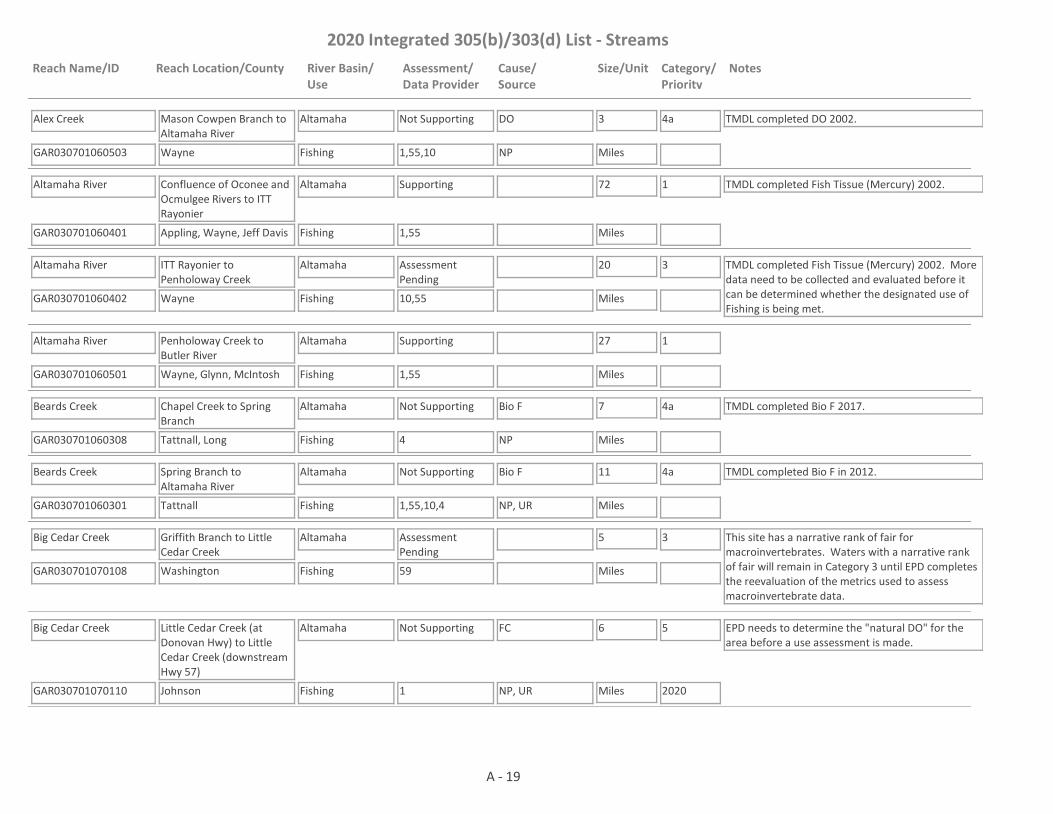
2020 Integrated 305(b)/303(d) List - Streams
Reach Name/ID Reach Location/County River Basin/Use
Assessment/Data Provider
Cause/Source
Size/Unit Category/Priority
Notes
Alex Creek
GAR030701060503 1,55,10
Mason Cowpen Branch to Altamaha River
Wayne
Altamaha
Fishing
Not Supporting DO 3
Miles
4a TMDL completed DO 2002.
NP
Altamaha River
GAR030701060401 1,55
Confluence of Oconee and Ocmulgee Rivers to ITT Rayonier
Appling, Wayne, Jeff Davis
Altamaha
Fishing
Supporting 72
Miles
1 TMDL completed Fish Tissue (Mercury) 2002.
Altamaha River
GAR030701060402 10,55
ITT Rayonier to Penholoway Creek
Wayne
Altamaha
Fishing
Assessment Pending
20
Miles
3 TMDL completed Fish Tissue (Mercury) 2002. More data need to be collected and evaluated before it can be determined whether the designated use of Fishing is being met.
Altamaha River
GAR030701060501 1,55
Penholoway Creek to Butler River
Wayne, Glynn, McIntosh
Altamaha
Fishing
Supporting 27
Miles
1
Beards Creek
GAR030701060308 4
Chapel Creek to Spring Branch
Tattnall, Long
Altamaha
Fishing
Not Supporting Bio F 7
Miles
4a TMDL completed Bio F 2017.
NP
Beards Creek
GAR030701060301 1,55,10,4
Spring Branch to Altamaha River
Tattnall
Altamaha
Fishing
Not Supporting Bio F 11
Miles
4a TMDL completed Bio F in 2012.
NP, UR
Big Cedar Creek
GAR030701070108 59
Griffith Branch to Little Cedar Creek
Washington
Altamaha
Fishing
Assessment Pending
5
Miles
3 This site has a narrative rank of fair for macroinvertebrates. Waters with a narrative rank of fair will remain in Category 3 until EPD completes the reevaluation of the metrics used to assess macroinvertebrate data.
Big Cedar Creek
GAR030701070110 1
Little Cedar Creek (at Donovan Hwy) to Little Cedar Creek (downstream Hwy 57)
Johnson
Altamaha
Fishing
Not Supporting FC 6
Miles
5
2020
EPD needs to determine the "natural DO" for the area before a use assessment is made.
NP, UR
A - 19

2020 Integrated 305(b)/303(d) List - Streams
Reach Name/ID Reach Location/County River Basin/Use
Assessment/Data Provider
Cause/Source
Size/Unit Category/Priority
Notes
Big Cedar Creek
GAR030701070102 10
Little Cedar Creek to Ohoopee River
Johnson
Altamaha
Fishing
Not Supporting DO, FC 3
Miles
4a TMDLs completed DO 2002 & FC (2002 & 2007).
NP, M
Brazells Creek
GAR030701070507 1,4
Unnamed tributary approximately 2 mi d/s SR 292 to the Ohoopee River
Tattnall
Altamaha
Fishing
Not Supporting Bio F 10
Miles
4a TMDL completed Bio F 2012. pH is being put in Category 3 due to there being less than a full year of data being available for assessment (data available Jan - May and December)NP, UR
Bullard Creek
GAR030701060104 4
~0.25 mi u/s Altamaha Road to Altamaha River
Jeff Davis
Altamaha
Fishing
Not Supporting Bio F 8
Miles
4a TMDL completed Bio F 2007.
NP
Cobb Creek
GAR030701060102 1,10,55
Oconee Creek to Altamaha River
Toombs
Altamaha
Fishing
Not Supporting FC 13
Miles
4a TMDLs completed DO (2002), FC (2012).
NP
Crooked Creek
GAR030701070307 1
Hammock Branch to Yam Grandy Creek
Emanuel
Altamaha
Fishing
Assessment Pending
1
Miles
3 EPD needs to determine the "natural DO" for the area before it can be determined whether the dissolved oxygen criteria are being met.
Cypress Creek
GAR030701070104 10
Rolands Pond to Ohoopee River
Johnson
Altamaha
Fishing
Not Supporting DO 4
Miles
4a TMDL completed DO 2007.
NP
Doctors Creek
GAR030701060405 1,10,55
Upstream Jones Creek
Long
Altamaha
Fishing
Not Supporting DO, FC 5
Miles
4a TMDLs completed DO 2002 & FC (2002 & 2007).
NP
Five Mile Creek
GAR030701060303 4
Headwaters to Altamaha River
Appling, Wayne
Altamaha
Fishing
Not Supporting Bio F 9
Miles
4a TMDL completed Bio F 2007.
NP
Flat Creek
GAR030701070208 10
Headwaters to Little Ohoopee River
Johnson, Emanuel
Altamaha
Fishing
Not Supporting FC 10
Miles
4a TMDL completed FC 2007.
NP
A - 20

2020 Integrated 305(b)/303(d) List - Streams
Reach Name/ID Reach Location/County River Basin/Use
Assessment/Data Provider
Cause/Source
Size/Unit Category/Priority
Notes
Goose Creek
GAR030701060302 1,10,52,55
Upstream Rd. S1922 (Walton Griffis Rd.) to Little Goose Creek
Wayne
Altamaha
Fishing
Not Supporting FC 8
Miles
4a TMDL completed FC (2002 & 2007).
UR
Hurricane Branch
GAR030701070209 1
Pond 0.3 miles downstream Pringle Road to the Little Ohoopee River
Johnson
Altamaha
Fishing
Not Supporting Pb 4
Miles
5
2025NP
Jacks Creek
GAR030701070303 4,10
U.S. Hwy. 1 to Ohoopee River
Emanuel
Altamaha
Fishing
Not Supporting DO, FC, Bio F 9
Miles
4a TMDLs completed DO (2002), FC (2002 & 2007), Bio F(2007).
NP
Jones Creek
GAR030701060404 1,10,55
Still Creek to Doctors Creek
Long
Altamaha
Fishing
Not Supporting DO 11
Miles
4a TMDL completed DO 2002.
UR
Little Creek
GAR030701060408 1
Gum Branch to Honey Camp Branch
Wayne
Altamaha
Fishing
Assessment Pending
4
Miles
3 EPD needs to determine the "natural DO" for the area before it can be determined whether the dissolved oxygen criteria are being met.
Little Ohoopee River
GAR030701070201 10
Gully Branch to Neeley Creek
Washington
Altamaha
Fishing
Not Supporting DO 14
Miles
4a TMDL completed DO 2002.
NP
Little Ohoopee River
GAR030701070202 10
Neeley Creek to Sardis Creek
Johnson
Altamaha
Fishing
Not Supporting DO, FC 15
Miles
4a TMDL completed DO (2002) & FC (2002 & 2007).
NP
Little Ohoopee River
GAR030701070203 1,4,10,55
Sardis Creek to Ohoopee River
Emanuel
Altamaha
Fishing
Not Supporting Bio F, FC, DO 18
Miles
4a, 5
2025
TMDLs completed DO (2002) & FC 2002 (revised 2017).
NP
Magruda Creek
GAR030701070205 10
Headwaters to Little Ohoopee River
Johnson, Emanuel
Altamaha
Fishing
Not Supporting FC 6
Miles
4a TMDL completed FC 2007.
NP
A - 21
2020 Integrated 305(b)/303(d) List - Streams
Reach Name/ID Reach Location/County River Basin/Use
Assessment/Data Provider
Cause/Source
Size/Unit Category/Priority
Notes
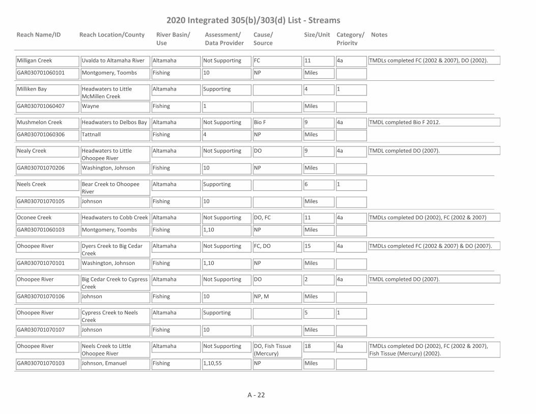
Milligan Creek
GAR030701060101 10
Uvalda to Altamaha River
Montgomery, Toombs
Altamaha
Fishing
Not Supporting FC 11
Miles
4a TMDLs completed FC (2002 & 2007), DO (2002).
NP
Milliken Bay
GAR030701060407 1
Headwaters to Little McMillen Creek
Wayne
Altamaha
Fishing
Supporting 4
Miles
1
Mushmelon Creek
GAR030701060306 4
Headwaters to Delbos Bay
Tattnall
Altamaha
Fishing
Not Supporting Bio F 9
Miles
4a TMDL completed Bio F 2012.
NP
Nealy Creek
GAR030701070206 10
Headwaters to Little Ohoopee River
Washington, Johnson
Altamaha
Fishing
Not Supporting DO 9
Miles
4a TMDL completed DO (2007).
NP
Neels Creek
GAR030701070105 10
Bear Creek to Ohoopee River
Johnson
Altamaha
Fishing
Supporting 6
Miles
1
Oconee Creek
GAR030701060103 1,10
Headwaters to Cobb Creek
Montgomery, Toombs
Altamaha
Fishing
Not Supporting DO, FC 11
Miles
4a TMDLs completed DO (2002), FC (2002 & 2007)
NP
Ohoopee River
GAR030701070101 1,10
Dyers Creek to Big Cedar Creek
Washington, Johnson
Altamaha
Fishing
Not Supporting FC, DO 15
Miles
4a TMDLs completed FC (2002 & 2007) & DO (2007).
NP
Ohoopee River
GAR030701070106 10
Big Cedar Creek to Cypress Creek
Johnson
Altamaha
Fishing
Not Supporting DO 2
Miles
4a TMDL completed DO (2007).
NP, M
Ohoopee River
GAR030701070107 10
Cypress Creek to Neels Creek
Johnson
Altamaha
Fishing
Supporting 5
Miles
1
Ohoopee River
GAR030701070103 1,10,55
Neels Creek to Little Ohoopee River
Johnson, Emanuel
Altamaha
Fishing
Not Supporting DO, Fish Tissue (Mercury)
18
Miles
4a TMDLs completed DO (2002), FC (2002 & 2007), Fish Tissue (Mercury) (2002).
NP
A - 22

2020 Integrated 305(b)/303(d) List - Streams
Reach Name/ID Reach Location/County River Basin/Use
Assessment/Data Provider
Cause/Source
Size/Unit Category/Priority
Notes
Ohoopee River
GAR030701070304 1,10
Little Ohoopee River to U.S. Highway 292
Emanuel, Candler, Tattnall
Altamaha
Fishing
Not Supporting Fish Tissue (Mercury), FC
23
Miles
4a TMDLs completed Fish Tissue (Mercury) 2002, DO 2002, FC 2002 (revised 2017).
NP
Ohoopee River
GAR030701070501 1,9,10,55
Hwy 292 to Hwy 147
Tattnall
Altamaha
Fishing
Not Supporting FC, Fish Tissue (Mercury)
12
Miles
4a, 5
2020
TMDL completed Fish Tissue (Mercury) 2002
NP
Ohoopee River
GAR030701070502 1,9,55
Ga. Hwy 147 to Confluence with Altamaha River
Tattnall
Altamaha
Fishing
Not Supporting Fish Tissue (Mercury)
13
Miles
4a TMDL completed Fish Tissue (Mercury) 2002.
NP
Pendleton Creek
GAR030701070401 1,10
Sand Hill Lake to Reedy Creek
Treutlen
Altamaha
Fishing
Not Supporting FC 7
Miles
4a TMDLs completed FC (2002 & 2007), DO (2002).
NP
Pendleton Creek
GAR030701070402 1,10
Wildwood Lake to Tiger Creek
Treutlen, Toombs
Altamaha
Fishing
Not Supporting DO, FC 12
Miles
4a TMDLs completed DO (2002), FC (2002 & 2007).
NP
Pendleton Creek
GAR030701070407 1,55
Reedy Creek to Swift Creek
Toombs
Altamaha
Fishing
Not Supporting FC 5
Miles
4a TMDL completed FC 2017. EPD needs to determine the "natural DO" for the area before it can be determined whether the dissolved oxygen criteria are being met.
NP
Pendleton Creek
GAR030701070405 1,10,55
Swift Creek to Ohoopee River
Toombs
Altamaha
Fishing
Not Supporting FC 9
Miles
4a TMDL completed FC 2017.
NP
Penholoway Creek
GAR030701060403 1,10,55
Little Creek to Altamaha River
Wayne
Altamaha
Fishing
Not Supporting DO 13
Miles
4a TMDL completed DO (2002).
NP
Rocky Creek
GAR030701070505 1,10
Ga. Hwy. 130 to Little Rocky Creek
Toombs
Altamaha
Fishing
Not Supporting FC, DO 10
Miles
4a TMDLs completed FC (2002 & 2007), DO (2002).
NP
A - 23

2020 Integrated 305(b)/303(d) List - Streams
Reach Name/ID Reach Location/County River Basin/Use
Assessment/Data Provider
Cause/Source
Size/Unit Category/Priority
Notes
Rocky Creek
GAR030701070504 1,10,55
Little Rocky Creek to Ohoopee River
Toombs, Tattnall
Altamaha
Fishing
Not Supporting DO, FC 11
Miles
4a TMDLs completed DO 2002, FC 2017.
NP
Sardis Creek
GAR030701070207 10
Headwaters to Little Ohoopee River
Emanuel
Altamaha
Fishing
Not Supporting DO, FC 10
Miles
4a TMDLs completed DO 2007, FC 2007.
NP
Spring Branch
GAR030701060309 1
Tributary 0.6 miles upstream of Rogers Road to Beards Creek
Tattnall
Altamaha
Fishing
Not Supporting FC, DO 1
Miles
5
2020, 2025
The DO TMDL is scheduled to be drafted in 2025 while the FC TMDL is scheduled to be drafted in 2020. The source for DO is NP and M, while the source for FC is NP.NP, M
Swift Creek
GAR030701070404 10
Old Normantown Rd. to Pendleton Creek
Toombs
Altamaha
Fishing
Not Supporting FC, DO 5
Miles
4a TMDLs completed DO (2002), FC (2002 & 2007).
UR, M
Ten Mile Creek
GAR030701060201 1,4,10,55
Little Ten Mile Creek to Altamaha River
Appling
Altamaha
Fishing
Not Supporting Bio F, FC 13
Miles
4a TMDLs completed DO 2002, Bio F 2012, FC 2017.
NP
Thomas Creek
GAR030701070506 1,4,10,55
Downstream CR203 to Ohoopee River
Tattnall
Altamaha
Fishing
Not Supporting DO, Bio F, FC 12
Miles
4a TMDLs completed DO (2002), Bio F (2012), FC (2017).
UR
Tiger Creek
GAR030701070403 10
Little Creek to Pendleton Creek
Treutlen, Montgomery, Toombs
Altamaha
Fishing
Not Supporting FC 16
Miles
4a TMDLs completed FC (2002 & 2007), DO (2002).
NP
Tributary to Beards Creek
GAR030701060307 4
Headwaters to Beards Creek
Long
Altamaha
Fishing
Not Supporting Bio F 3
Miles
4a TMDL completed Bio F 2017.
NP
Tributary to Little Cedar Creek
GAR030701070109 1
Headwaters to Little Cedar Creek
Washington
Altamaha
Fishing
Assessment Pending
1
Miles
3 EPD needs to determine the "natural DO" for the area before a use assessment is made.
A - 24
2020 Integrated 305(b)/303(d) List - Streams
Reach Name/ID Reach Location/County River Basin/Use
Assessment/Data Provider
Cause/Source
Size/Unit Category/Priority
Notes
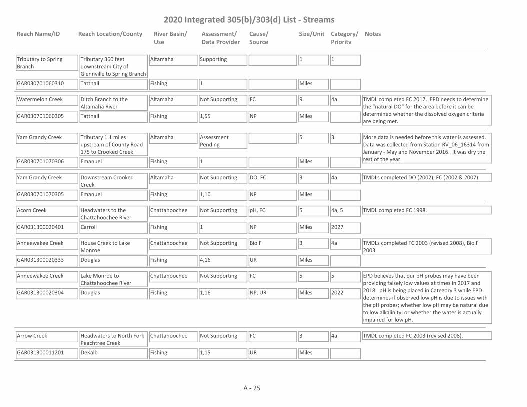
Tributary to Spring Branch
GAR030701060310 1
Tributary 360 feet downstream City of Glennville to Spring Branch
Tattnall
Altamaha
Fishing
Supporting 1
Miles
1
Watermelon Creek
GAR030701060305 1,55
Ditch Branch to the Altamaha River
Tattnall
Altamaha
Fishing
Not Supporting FC 9
Miles
4a TMDL completed FC 2017. EPD needs to determine the "natural DO" for the area before it can be determined whether the dissolved oxygen criteria are being met.
NP
Yam Grandy Creek
GAR030701070306 1
Tributary 1.1 miles upstream of County Road 175 to Crooked Creek
Emanuel
Altamaha
Fishing
Assessment Pending
5
Miles
3 More data is needed before this water is assessed. Data was collected from Station RV_06_16314 from January - May and November 2016. It was dry the rest of the year.
Yam Grandy Creek
GAR030701070305 1,10
Downstream Crooked Creek
Emanuel
Altamaha
Fishing
Not Supporting DO, FC 3
Miles
4a TMDLs completed DO (2002), FC (2002 & 2007).
NP
Acorn Creek
GAR031300020401 1
Headwaters to the Chattahoochee River
Carroll
Chattahoochee
Fishing
Not Supporting pH, FC 5
Miles
4a, 5
2027
TMDL completed FC 1998.
NP
Anneewakee Creek
GAR031300020333 4,16
House Creek to Lake Monroe
Douglas
Chattahoochee
Fishing
Not Supporting Bio F 3
Miles
4a TMDLs completed FC 2003 (revised 2008), Bio F 2003
UR
Anneewakee Creek
GAR031300020304 1,16
Lake Monroe to Chattahoochee River
Douglas
Chattahoochee
Fishing
Not Supporting FC 5
Miles
5
2022
EPD believes that our pH probes may have been providing falsely low values at times in 2017 and 2018. pH is being placed in Category 3 while EPD determines if observed low pH is due to issues with the pH probes; whether low pH may be natural due to low alkalinity; or whether the water is actually impaired for low pH.
NP, UR
Arrow Creek
GAR031300011201 1,15
Headwaters to North Fork Peachtree Creek
DeKalb
Chattahoochee
Fishing
Not Supporting FC 3
Miles
4a TMDL completed FC 2003 (revised 2008).
UR
A - 25

2020 Integrated 305(b)/303(d) List - Streams
Reach Name/ID Reach Location/County River Basin/Use
Assessment/Data Provider
Cause/Source
Size/Unit Category/Priority
Notes
Baldridge Creek
GAR031300010822 1
Headwaters to Lake Lanier
Forsyth
Chattahoochee
Fishing
Supporting 5
Miles
1
Baldwin Creek
GAR031300020308 16
Headwaters to Little Bear Creek
Douglas
Chattahoochee
Fishing
Supporting 4
Miles
1 TMDL completed FC 1998.
Ball Mill Creek
GAR031300010905 1,15,17,81
Headwaters to the Chattahoochee River
Fulton, DeKalb
Chattahoochee
Fishing
Supporting 3
Miles
1 TMDL completed FC 2003 (revised 2008).
Balus Creek
GAR031300010802 1,20
Headwaters to Lake Lanier (Gainesville)
Hall
Chattahoochee
Fishing
Supporting 3
Miles
1 TMDL completed FC 2003 (revised 2008).
Barnes Creek
GAR031300021203 4,59
Headwaters to Little Branch
Harris
Chattahoochee
Fishing
Assessment Pending
4
Miles
3 This site has a narrative rank of fair for macroinvertebrates. When EPD completes the reevaluation of the metrics used to assess macroinvertebrate data it will be determined if the macroinvertebrate criteria are being met.
Bear Creek
GAR031300010406 10
Headwaters to West Fork Little River near Clermont
Hall
Chattahoochee
Fishing
Supporting 3
Miles
1
Bear Creek
GAR031300020311 4,10,17
Little Bear Creek to Chattahoochee River
Fulton
Chattahoochee
Fishing
Not Supporting FC 4
Miles
4a TMDLs completed Bio F (2008), FC (2013).
NP
Bear Creek
GAR031300020313 1,16
Dorsett Shoals Rd. to Little Bear Creek
Douglas
Chattahoochee
Fishing
Supporting 3
Miles
1 TMDL completed FC 1998.
Beech Creek
GAR031300020704 4
U/S Ross Keith Road
Meriwether
Chattahoochee
Fishing
Supporting 10
Miles
1
A - 26

2020 Integrated 305(b)/303(d) List - Streams
Reach Name/ID Reach Location/County River Basin/Use
Assessment/Data Provider
Cause/Source
Size/Unit Category/Priority
Notes
Beech Creek
GAR031300020711 1,4
Downstream Ross Keith Road
Meriwether
Chattahoochee
Fishing
Not Supporting FC 17
Miles
4a TMDL completed FC 2013.
NP
Big Branch
GAR031300021009 4
Headwaters to Flat Shoals Creek
Troup
Chattahoochee
Fishing
Not Supporting Bio F 4
Miles
5
2022NP
Big Creek
GAR031300011008 67
Hwy 400 to Hog Waller Creek
Fulton
Chattahoochee
Fishing, Drinking Water
Supporting 3
Miles
1
Big Creek
GAR031300011006 1,60,61
Headwaters to Cheatham Creek
Forsyth
Chattahoochee
Fishing
Not Supporting FC 3
Miles
4a TMDLs completed FC 2003 (revised 2008), Cu 2003.
UR
Big Creek
GAR031300010813 26
Tributary to Lake Lanier
Hall
Chattahoochee
Fishing
Not Supporting FC 2
Miles
4a TMDL completed FC 1998.
NP
Big Creek
GAR031300011009 1
Hog Waller Creek to the Chattahoochee River
Fulton
Chattahoochee
Drinking Water, Fishing
Not Supporting FC 2
Miles
4a TMDL completed FC 2003 (revised 2008).
UR
Big Springs Creek
GAR031300021008 4
Tributary to Flat Shoals Creek
Troup
Chattahoochee
Fishing
Supporting 6
Miles
1
Bishop Creek
GAR031300011108 2
Headwaters to Sope Creek
Cobb
Chattahoochee
Fishing
Not Supporting FC 2
Miles
4a TMDL completed FC 2003 (revised 2008).
UR
Black Creek
GAR031300030703 4
Headwaters to Hannahatchee Creek
Stewart
Chattahoochee
Fishing
Not Supporting Bio F 6
Miles
4a TMDL completed Bio F 2003.
NP
A - 27

2020 Integrated 305(b)/303(d) List - Streams
Reach Name/ID Reach Location/County River Basin/Use
Assessment/Data Provider
Cause/Source
Size/Unit Category/Priority
Notes
Blue Creek
GAR031300010115 1
Pond 0.6 miles upstream Hwy 255 to Chattahoochee River
White
Chattahoochee
Fishing
Supporting 6
Miles
1
Blue Creek
GAR031300020707 1,4
Headwaters to Yellowjacket Creek
Meriwether
Chattahoochee
Drinking Water, Fishing
Not Supporting FC 6
Miles
4a TMDL completed FC 2018.
NP
Blue John Creek
GAR031300020905 1,21
Headwaters to Troup Branch - LaGrange
Troup
Chattahoochee
Fishing
Not Supporting FC 5
Miles
4a TMDLs completed FC 2003 (revised 2008).
UR
Blue John Creek
GAR031300020910 1,4
Troup Branch to Long Cane Creek
Troup
Chattahoochee
Fishing
Not Supporting Bio F, FC 3
Miles
4a TMDL completed Bio F 2003 (revised 2018). TMDL completed FC 2003 (revised 2008).
UR
Blue Springs Branch
GAR031300021210 4
Headwaters to Mulberry Creek
Harris
Chattahoochee
Fishing
Supporting 3
Miles
1
Bluff Creek
GAR031300020331 16
Headwaters to Crawfish Creek
Douglas
Chattahoochee
Fishing
Supporting 4
Miles
1
Boggs Creek
GAR031300010506 4
Headwaters to Chestatee River
Lumpkin
Chattahoochee
Fishing
Supporting 4
Miles
1
Box Springs Creek (aka Bay Springs Creek)
GAR031300020322 4
Headwaters to Crawfish Creek
Carroll
Chattahoochee
Fishing
Supporting 5
Miles
1
Brasstown Creek
GAR031300010117 4
Headwaters to the Chattahoochee River
White
Chattahoochee
Fishing
Supporting 6
Miles
1
A - 28

2020 Integrated 305(b)/303(d) List - Streams
Reach Name/ID Reach Location/County River Basin/Use
Assessment/Data Provider
Cause/Source
Size/Unit Category/Priority
Notes
Brown Creek
GAR031300021209 4
Headwaters to Dowdell Creek
Harris
Chattahoochee
Fishing
Supporting 2
Miles
1
Browns Creek
GAR031300020416 4
Headwaters to Cedar Creek
Coweta
Chattahoochee
Fishing
Not Supporting Bio F 5
Miles
4a TMDL completed Bio F 2008
NP
Brush Creek
GAR031300020605 1,4
Tributary to West Point Lake
Heard
Chattahoochee
Fishing
Not Supporting FC 10
Miles
5
2022
EPD believes that our pH probes may have been providing falsely low values at times in 2017 and 2018. Waters that would normally be listed as impaired for low pH are being placed in Category 3 while EPD determines if observed low pH is due to issues with the pH probes; whether low pH may be natural due to low alkalinity; or whether the water is actually impaired for low pH.
NP
Brushy Creek
GAR031300010915 4
Headwaters to the Chattahoochee River
Gwinnett
Chattahoochee
Fishing
Not Supporting Bio F 5
Miles
4a TMDL completed Bio F 2018
NP, UR
Bubbling Creek
GAR031300011210 2
Headwaters to Nancy Creek
DeKalb
Chattahoochee
Fishing
Not Supporting FC 2
Miles
4a TMDL completed FC 2013.
UR
Bull Creek
GAR031300030112 37
Headwaters to Flat Rock Creek
Harris, Muscogee
Chattahoochee
Fishing
Supporting 10
Miles
1 TMDL completed FC 2003 (revised 2008).
Bull Creek
GAR031300030111 4
Flat Rock Creek to Cooper Creek, Columbus
Muscogee
Chattahoochee
Fishing
Not Supporting Bio F 3
Miles
4a TMDL completed Bio F 2008. TMDL completed FC 2003 (revised 2008).
UR
Bull Creek
GAR031300030114 38
Cooper Creek to Dram Branch
Muscogee
Chattahoochee
Fishing
Not Supporting FC 2
Miles
4a TMDL completed FC 2018.
UR
Burnt Fork Creek
GAR031300011211 2,15
Headwaters to South Fork Peachtree Creek
DeKalb
Chattahoochee
Fishing
Not Supporting FC 6
Miles
4a TMDL completed FC 2003 (revised 2008).
UR
A - 29

2020 Integrated 305(b)/303(d) List - Streams
Reach Name/ID Reach Location/County River Basin/Use
Assessment/Data Provider
Cause/Source
Size/Unit Category/Priority
Notes
Bustahatchee Creek
GAR031300030901 4
Confluence with North Fork to Lake Walter F. George
Quitman
Chattahoochee
Fishing
Supporting 1
Miles
1 TMDL completed Bio F 2003.
Buttermilk Creek
GAR031300020209 14
Headwaters to Sweetwater Creek
Cobb
Chattahoochee
Fishing
Not Supporting FC 4
Miles
4a TMDL completed FC 2003 (revised 2008).
UR
Camp Creek
GAR031300010206 56
North Tributary to Wells Pond Tributary
Habersham
Chattahoochee
Fishing
Not Supporting Trichloroethane 1
Miles
4b Data from EPD's Harzardous Waste Branch. Facility under a corrective action plan.
I2
Camp Creek
GAR031300020332 10,17
Unnamed tributary downstream of Cowart Lake to the Chattahoochee River
Fulton
Chattahoochee
Fishing, Drinking Water
Not Supporting FC 4
Miles
4a TMDL completed FC 2003 (revised 2008).
UR
Camp Creek
GAR031300010212 4
Cornelia Branch to pond 0.3 miles downstream College Drive
Habersham
Chattahoochee
Drinking Water, Fishing
Assessment Pending
2
Miles
2 The water is supporting its Fishing Use. Data are not available to assess the Drinking Water Use.
Cane Creek
GAR031300010613 4
Tributary 1 mile upstream Camp Wahsega Road to Cane Creek Falls
Lumpkin
Chattahoochee
Fishing
Not Supporting Bio F 3
Miles
4a TMDL completed Bio F 2018.
NP
Cane Creek
GAR031300010614 1,4
Cane Creek Falls to Chestatee River near Dahlonega
Lumpkin
Chattahoochee
Fishing
Supporting 8
Miles
1 TMDL completed Bio F 2018.
Caney Creek
GAR031300020417 4
Headwaters to Whooping Creek
Carroll
Chattahoochee
Fishing
Supporting 5
Miles
1
A - 30

2020 Integrated 305(b)/303(d) List - Streams
Reach Name/ID Reach Location/County River Basin/Use
Assessment/Data Provider
Cause/Source
Size/Unit Category/Priority
Notes
Carthbody Creek
GAR031300020418 4
Headwaters to Whooping Creek
Carroll
Chattahoochee
Fishing
Supporting 3
Miles
1
Cauley Creek
GAR031300010914 4,17
Headwaters to Chattahoochee River
Fulton
Chattahoochee
Fishing
Not Supporting FC, Bio F 2
Miles
4a TMDL completed FC 2013, Bio F 2018.
NP, UR
Cavender Creek
GAR031300020419 4
Headwaters to Whooping Creek
Carroll
Chattahoochee
Fishing
Not Supporting Bio F 2
Miles
4a TMDL completed Bio F 2003
NP
Cavenders Creek
GAR031300010605 4
Headwaters to Chestatee River
Lumpkin
Chattahoochee
Fishing
Supporting 2
Miles
1 Bio F TMDL completed 2018.
Cedar Creek
GAR031300020604 4
Tributary to Hillabahatchee Creek
Heard
Chattahoochee
Fishing
Supporting 9
Miles
1
Cedar Creek
GAR031300020420 10,72
Browns Creek to the Chattahoochee River (Formerly Coweta County)
Coweta
Chattahoochee
Fishing
Not Supporting DO 6
Miles
4a TMDLs completed DO 2003, FC 1998.
NP
Cemochechobee Creek
GAR031300040105 4
Headwaters to Hog Creek
Randolph, Clay
Chattahoochee
Fishing
Supporting 11
Miles
1
Centralhatchee Creek
GAR031300020421 1,10
Headwaters to the Chattahoochee River
Heard
Chattahoochee
Fishing
Not Supporting FC 19
Miles
4a TMDL completed FC 1998.
NP
Chattahoochee River
GAR031300010108 1,4
Upstream Jasus Creek
Union, White
Chattahoochee
Recreation, Fishing
Assessment Pending
7
Miles
2 The water is supporting its Fishing Use. Data are not available to assess the Recreation Use. E. coli is being placed into Category 3 until E. coli data can be collected and assessed.
A - 31

2020 Integrated 305(b)/303(d) List - Streams
Reach Name/ID Reach Location/County River Basin/Use
Assessment/Data Provider
Cause/Source
Size/Unit Category/Priority
Notes
Chattahoochee River
GAR031300010106 1,59
Jasus Creek to Ga. Hwy. 17, Helen
White
Chattahoochee
Recreation, Fishing
Assessment Pending
8
Miles
2 The water is supporting its Fishing Use. Data are not available to assess the Recreation Use. E. coli is being placed into Category 3 until E. coli data can be collected and assessed.
Chattahoochee River
GAR031300010107 1,10
Ga. Hwy. 17, Helen to SR255
White, Habersham
Chattahoochee
Recreation, Fishing
Not Supporting E Coli, Bio F 8
Miles
4a, 5
2027
TMDL completed FC 2003 (revised 2008), Bio F 2018. E. coli and FC are both indicators for pathogens. In the future, EPD may use the FC TMDL for the E coli impairment with a translator for FC to E. coli. EPD believes that our pH probes may have been providing falsely low values at times in 2017 and 2018. Waters that would normally be listed as impaired for low pH are being placed in Category 3 while EPD determines if observed low pH is due to issues with the pH probes; whether low pH may be natural due to low alkalinity; or whether the water is actually impaired for low pH.
UR
Chattahoochee River
GAR031300010105 1,9,10
SR255 to Soquee River
White, Habersham
Chattahoochee
Recreation, Fishing
Not Supporting E Coli 11
Miles
5
2027
TMDL completed FC 1998. E. coli and FC are both indicators for pathogens. In the future, EPD may use the FC TMDL for the E coli impairment with a translator for FC to E. coli. The water is supporting its Fishing Use, but not its Recreation Use.
NP
Chattahoochee River
GAR031300010313 1,10
Soquee River to Mossy Creek
Habersham, White, Hall
Chattahoochee
Drinking Water, Recreation, Fishing
Not Supporting E Coli, FC 5
Miles
4a, 5
2027
TMDL completed Fish Tissue (Mercury) 2003. TMDL completed FC 2008. The Recreation Use is impaired for E. coli and the Drinking Water Use is impaired for FC. E. coli and FC are both indicators for pathogens. In the future, EPD may use the FC TMDL for the E coli impairment with a translator for FC to E. coli.
NP
Chattahoochee River
GAR031300010314 1,10
Mossy Creek to Lake Lanier
Hall
Chattahoochee
Drinking Water, Recreation, Fishing
Not Supporting E Coli, FC 8
Miles
4a, 5
2027
TMDL completed FC 2008. TMDL completed Fish Tissue (Mercury) 2003. The Designated Use of Drinking Water is not being met for FC. The Recreation Use is impaired for E. coli. E. coli and FC are both indicators for pathogens. In the future, EPD may use the FC TMDL for the E coli impairment with a translator for FC to E. coli.
NP
A - 32

2020 Integrated 305(b)/303(d) List - Streams
Reach Name/ID Reach Location/County River Basin/Use
Assessment/Data Provider
Cause/Source
Size/Unit Category/Priority
Notes
Chattahoochee River
GAR031300010908 1
Buford Dam to Dicks Creek
Gwinnett, Forsyth
Chattahoochee
Drinking Water, Recreation, Fishing
Assessment Pending
8
Miles
2 The water is supporting its Fishing and Drinking Water Uses. Data are not available to assess the Recreation Use. E. coli is being placed into Category 3 until E. coli data can be collected and assessed.
Chattahoochee River
GAR031300010913 1,18
Dicks Creek to Johns Creek
Forsyth, Fulton, Gwinnett
Chattahoochee
Drinking Water, Recreation, Fishing
Not Supporting FC, E. Coli 12
Miles
5
2022
The Recreation Use is impaired for E. coli and the Drinking Water and Fishing Uses are impaired for FC.UR
Chattahoochee River
GAR031300011114 1,18
Johns Creek to Morgan Falls Dam
Gwinnett, Fulton, Cobb
Chattahoochee
Drinking Water, Recreation, Fishing
Not Supporting E Coli, FC 17
Miles
4a, 5
2027
TMDL completed FC 2008. The Drinking Water and Fishing Uses are impaired for FC and the Recreation Use is impaired for E. coli. E. coli and FC are both indicators for pathogens. In the future, EPD may use the FC TMDL for the E coli impairment with a translator for FC to E. coli.
UR
Chattahoochee River
GAR031300011113 1
Morgan Falls Dam to Peachtree Creek
Fulton, Cobb
Chattahoochee
Drinking Water, Recreation, Fishing
Not Supporting E Coli, FC, Fish Tissue (PCBs)
12
Miles
4a, 5
2027
TMDLs completed FC 2003 (revised 2008), Fish Tissue (PCBs) 2003. The Drinking Water and Fishing Uses are impaired for FC and the Recreation Use is impaired for E. coli. E. coli and FC are both indicators for pathogens. In the future, EPD may use the FC TMDL for the E coli impairment with a translator for FC to E. coli.
UR
Chattahoochee River
GAR031300020107 1,2,9,10,28
Peachtree Creek to Utoy Creek
Fulton, Cobb
Chattahoochee
Fishing
Not Supporting FC, Fish Tissue (PCBs)
9
Miles
4a TMDLs completed Temp 2003, FC 2003 (revised 2008), Fish Tissue (PCBs) 2003
UR, CSO, NP
Chattahoochee River
GAR031300020323 1,9
Utoy Creek to Pea Creek
Fulton, Douglas
Chattahoochee
Fishing
Not Supporting Fish Tissue (PCBs), FC
14
Miles
4a TMDLs completed FC 2003 (revised 2008), Fish Tissue (PCBs) 2003
UR, CSO
Chattahoochee River
GAR031300020337 1,10
Pea Creek to Snake Creek
Fulton, Douglas, Carroll, Coweta
Chattahoochee
Fishing
Not Supporting Fish Tissue (PCBs), FC
16
Miles
4a TMDLs completed FC 2003 (revised 2008), Fish Tissue (PCBs) 2003.
UR
Chattahoochee River
GAR031300020609 1,10
Wahoo Creek to Franklin (West Point Lake)
Coweta, Carroll, Heard
Chattahoochee
Fishing, Drinking Water
Not Supporting Fish Tissue (PCBs), FC
21
Miles
4a TMDLs completed FC 2003 (revised 2008) & Fish Tissue (PCBs) 2003
NP, UR
A - 33

2020 Integrated 305(b)/303(d) List - Streams
Reach Name/ID Reach Location/County River Basin/Use
Assessment/Data Provider
Cause/Source
Size/Unit Category/Priority
Notes
Chattahoochee River
GAR031300020432 1,10
Snake Creek to Wahoo Creek
Coweta, Carroll
Chattahoochee
Fishing
Not Supporting Fish Tissue (PCBs) 5
Miles
4a TMDLs completed FC 2003 (revised 2008), Fish Tissue (PCBs) 2003.
UR
Chattahoochee River
GAR031300020906 1
West Point Dam to Johnson Island
Troup, Harris
Chattahoochee
Fishing, Drinking Water
Supporting 13
Miles
1 TMDL completed DO 2000.
Chattahoochee River
GAR031300030113 1
Oliver Dam to N. Highland Dam
Muscogee
Chattahoochee
Drinking Water, Recreation, Fishing
Not Supporting Fish Tissue (PCBs) 2
Miles
4a TMDL completed Fish Tissue (PCBs) 2003. The water is not supporting its Fishing Use. Data are not available to assess the Drinking Water and Recreation Uses.
UR
Chattahoochee River
GAR031300030115 1,38
North Highland Dam to Bull Creek
Muscogee
Chattahoochee
Fishing
Not Supporting Fish Tissue (PCBs) 5
Miles
4a TMDLs completed FC 2003 (revised 2008) & Fish Tissue (PCBs) 2003
UR
Chattahoochee River
GAR031300030116 1,37
Bull Creek to Upatoi Creek
Muscogee
Chattahoochee
Fishing
Not Supporting Fish Tissue (PCBs), FC
7
Miles
4a TMDLs completed FC 2003 (revised 2008) & Fish Tissue (PCBs) 2003
UR
Chattahoochee River
GAR031300030604 1,37
Upatoi Creek to Chattahoochee/Stewart County Line
Chattahoochee
Chattahoochee
Fishing
Supporting 18
Miles
1 TMDL completed FC 2003 (revised 2008).
Chattahoochee River
GAR031300030605 1,10,37
Chattahoochee/Stewart Co. line to Hannahatchee Creek
Stewart
Chattahoochee
Fishing
Supporting 10
Miles
1 TMDL completed FC 2008.
Chattahoochee River
GAR031300030902 10
Hannahatchee Creek to Hatchechubbee Creek (Alabama)
Stewart
Chattahoochee
Fishing
Supporting 3
Miles
1
Chattahoochee River
GAR031300040101 1,11
Downstream W.F. George Dam
Clay
Chattahoochee
Fishing
Not Supporting DO, FC 2
Miles
4a TMDLs completed DO 2000, FC 2003 (revised 2008). Source for DO is Dam Release. Source for FC is NP.Dam, NP
A - 34
2020 Integrated 305(b)/303(d) List - Streams
Reach Name/ID Reach Location/County River Basin/Use
Assessment/Data Provider
Cause/Source
Size/Unit Category/Priority
Notes
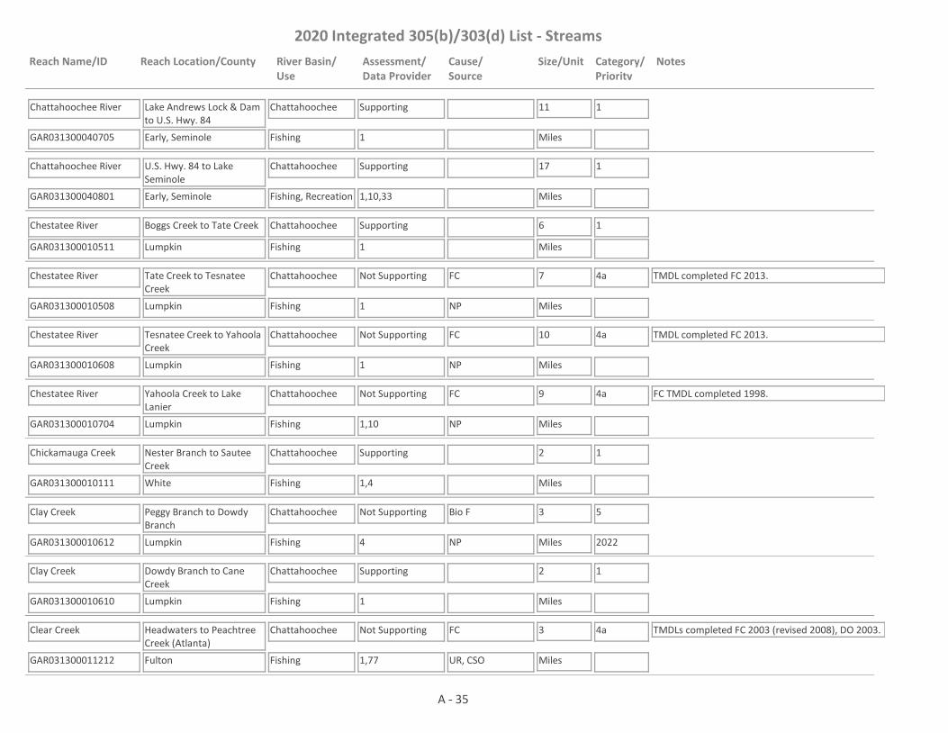
Chattahoochee River
GAR031300040705 1
Lake Andrews Lock & Dam to U.S. Hwy. 84
Early, Seminole
Chattahoochee
Fishing
Supporting 11
Miles
1
Chattahoochee River
GAR031300040801 1,10,33
U.S. Hwy. 84 to Lake Seminole
Early, Seminole
Chattahoochee
Fishing, Recreation
Supporting 17
Miles
1
Chestatee River
GAR031300010511 1
Boggs Creek to Tate Creek
Lumpkin
Chattahoochee
Fishing
Supporting 6
Miles
1
Chestatee River
GAR031300010508 1
Tate Creek to Tesnatee Creek
Lumpkin
Chattahoochee
Fishing
Not Supporting FC 7
Miles
4a TMDL completed FC 2013.
NP
Chestatee River
GAR031300010608 1
Tesnatee Creek to Yahoola Creek
Lumpkin
Chattahoochee
Fishing
Not Supporting FC 10
Miles
4a TMDL completed FC 2013.
NP
Chestatee River
GAR031300010704 1,10
Yahoola Creek to Lake Lanier
Lumpkin
Chattahoochee
Fishing
Not Supporting FC 9
Miles
4a FC TMDL completed 1998.
NP
Chickamauga Creek
GAR031300010111 1,4
Nester Branch to Sautee Creek
White
Chattahoochee
Fishing
Supporting 2
Miles
1
Clay Creek
GAR031300010612 4
Peggy Branch to Dowdy Branch
Lumpkin
Chattahoochee
Fishing
Not Supporting Bio F 3
Miles
5
2022NP
Clay Creek
GAR031300010610 1
Dowdy Branch to Cane Creek
Lumpkin
Chattahoochee
Fishing
Supporting 2
Miles
1
Clear Creek
GAR031300011212 1,77
Headwaters to Peachtree Creek (Atlanta)
Fulton
Chattahoochee
Fishing
Not Supporting FC 3
Miles
4a TMDLs completed FC 2003 (revised 2008), DO 2003.
UR, CSO
A - 35

2020 Integrated 305(b)/303(d) List - Streams
Reach Name/ID Reach Location/County River Basin/Use
Assessment/Data Provider
Cause/Source
Size/Unit Category/Priority
Notes
Clear Creek
GAR031300031506 59
Headwaters to Lime Springs Branch
Stewart
Chattahoochee
Fishing
Assessment Pending
4
Miles
3 This site has a narrative rank of fair for macroinvertebrates. Waters with a narrative rank of fair will remain in Category 3 until EPD completes the reevaluation of the metrics used to assess macroinvertebrate data.
Coheelee Creek
GAR031300040502 1,4,59
Chancy Mill Creek to Chattahoochee River
Early
Chattahoochee
Fishing
Not Supporting FC, Bio F 5
Miles
4a, 5
2022
TMDL completed Bio F 2003.
NP
Colochee/Frog Bottom Creek
GAR031300030702 4
Hightower Branch to Hannahatchee Creek
Stewart
Chattahoochee
Fishing
Supporting 5
Miles
1
Cooper Creek
GAR031300030107 38
Headwaters to Bull Creek - Columbus
Muscogee
Chattahoochee
Fishing
Supporting 6
Miles
1
Copeland Creek
GAR031300020606 4
Headwaters to Hillabahatchee Creek
Heard
Chattahoochee
Fishing
Supporting 3
Miles
1
Cox Creek
GAR031300010513 1
Headwaters to Tesnatee Creek
White
Chattahoochee
Fishing
Supporting 3
Miles
1
Cox Creek
GAR031300030202 38
Cox Lake to Upatoi Creek
Muscogee
Chattahoochee
Fishing
Supporting 4
Miles
1
Cracker Creek
GAR031300020210 1
Headwaters to Gothard's Creek
Douglas
Chattahoochee
Fishing
Not Supporting FC 3
Miles
4a TMDL completed FC 2003 (revised 2008).
UR
Crawfish Creek
GAR031300020324 16
Tributary to the Dog River
Douglas
Chattahoochee
Fishing
Supporting 3
Miles
1 TMDL completed FC 2003 (revised 2008).
Crawford Creek
GAR031300021010 1,4
Tributary to Sulphur Creek
Meriwether, Troup
Chattahoochee
Fishing
Not Supporting FC 6
Miles
5
2022NP
A - 36

2020 Integrated 305(b)/303(d) List - Streams
Reach Name/ID Reach Location/County River Basin/Use
Assessment/Data Provider
Cause/Source
Size/Unit Category/Priority
Notes
Crews Creek
GAR031300020325 4
Headwaters to Snake Creek
Carroll
Chattahoochee
Fishing
Supporting 5
Miles
1
Crooked Creek
GAR031300010909 1,4,18
Tributary to Chattahoochee River
Gwinnett
Chattahoochee
Fishing
Not Supporting FC, Bio F 2
Miles
4a TMDL completed FC 2003 (revised 2008), Bio F 2018.
UR
Cry Creek
GAR031300010310 20
Tributary to Lake Lanier (Gainesville)
Hall
Chattahoochee
Fishing
Supporting 1
Miles
1
Day Creek
GAR031300031405 59
Headwaters to Bluff Springs Branch
Stewart
Chattahoochee
Fishing
Assessment Pending
5
Miles
3 This site has a narrative rank of fair for macroinvertebrates. Waters with a narrative rank of fair will remain in Category 3 until EPD completes the reevaluation of the metrics used to assess macroinvertebrate data.
Day Creek
GAR031300031404 4
Bluff Springs Branch to Hodchodkee Creek
Stewart
Chattahoochee
Fishing
Not Supporting Bio F 1
Miles
4a TMDL completed Bio F 2003.
NP
Dean Creek
GAR031300010316 4
Headwaters to Mossy Creek
White
Chattahoochee
Fishing
Supporting 5
Miles
1 TMDL completed Bio F 2008.
Deep Creek
GAR031300020326 4
Line Creek to Chattahoochee River
Fulton
Chattahoochee
Fishing
Not Supporting Bio F 3
Miles
4a TMDL completed Bio F 2008.
NP, UR
Deep Creek
GAR031300010203 4,10
Headwaters to Soquee River
Habersham
Chattahoochee
Fishing
Not Supporting Bio F 8
Miles
5
2022NP
Deer Creek
GAR031300020422 1,4
Headwaters to Centralhatchee Creek
Heard
Chattahoochee
Fishing
Not Supporting FC 10
Miles
5
2022NP
A - 37

2020 Integrated 305(b)/303(d) List - Streams
Reach Name/ID Reach Location/County River Basin/Use
Assessment/Data Provider
Cause/Source
Size/Unit Category/Priority
Notes
Denny Creek
GAR031300020433 1
Headwaters to Centralhatchee Creek
Heard
Chattahoochee
Fishing
Not Supporting FC 4
Miles
5
2022
EPD believes that our pH probes may have been providing falsely low values at times in 2017 and 2018. Waters that would normally be listed as impaired for low pH are being placed in Category 3 while EPD determines if observed low pH is due to issues with the pH probes; whether low pH may be natural due to low alkalinity; or whether the water is actually impaired for low pH.
NP
Dick Creek
GAR031300010916 1,4
Headwaters to the Chattahoochee River
Forsyth
Chattahoochee
Fishing
Supporting 5
Miles
1
Dicks Creek
GAR031300010507 10
Headwaters to Waters Creek
Lumpkin
Chattahoochee
Fishing
Supporting 5
Miles
1
Dixie Creek
GAR031300020709 46
Tributary to West Point Lake - LaGrange
Troup
Chattahoochee
Fishing
Not Supporting FC 3
Miles
4a TMDL completed FC 1998.
UR
Dog River
GAR031300020329 16
Upstream Hwy 5
Douglas
Chattahoochee
Drinking Water, Fishing
Supporting 3
Miles
1
Dog River
GAR031300020328 4,16
Hwy 5 to Dog River Reservoir
Douglas
Chattahoochee
Drinking Water, Fishing
Supporting 3
Miles
1
Double Branch
GAR031300030108 38
Tributary to Weracoba Creek - Columbus
Muscogee
Chattahoochee
Fishing
Supporting 1
Miles
1
Dozier Creek
GAR031300030311 38
Headwaters to Randall Creek
Muscogee
Chattahoochee
Fishing
Supporting 7
Miles
1
A - 38

2020 Integrated 305(b)/303(d) List - Streams
Reach Name/ID Reach Location/County River Basin/Use
Assessment/Data Provider
Cause/Source
Size/Unit Category/Priority
Notes
Drag Nasty Creek
GAR031300031301 1,4,59
Tributary to W. F. George
Quitman, Clay
Chattahoochee
Fishing
Not Supporting FC 7
Miles
4a TMDL completed FC 1998. This site has a narrative rank of fair for macroinvertebrates. When EPD completes the reevaluation of the metrics used to assess macroinvertebrate data it will be determined if the macroinvertebrate criteria are being met.
NP
Dram Creek
GAR031300030109 38
Tributary to Bull Creek - Columbus
Muscogee
Chattahoochee
Fishing
Not Supporting FC 2
Miles
4a TMDL completed FC 2018.
UR
Dukes Creek
GAR031300020423 4
Headwaters to Centralhatchee Creek
Heard
Chattahoochee
Fishing
Supporting 3
Miles
1
Dukes Creek
GAR031300010109 1,4,59
Headwaters(Hwy. 348) to Chattahoochee River
White
Chattahoochee
Fishing
Supporting 10
Miles
1
East Double Branch
GAR031300030117 38
Headwaters to Double Branch
Muscogee
Chattahoochee
Fishing
Not Supporting FC 2
Miles
4a TMDL completed FC 2018.
UR
East Fork Little River
GAR031300010405 1,4
Downstream Hwy 52 to Lake Lanier
Hall
Chattahoochee
Fishing
Not Supporting FC 6
Miles
4a TMDL completed FC 1998 (revised) 2008.
NP
East Trammel Branch
GAR031300020716 1
Headwaters to Yellowjacket Creek
Coweta, Meriwether
Chattahoochee
Fishing
Not Supporting FC 3
Miles
5
2022NP
Etta Vista Creek
GAR031300010817 20
Tributary to Lake Lanier (Gainesville)
Hall
Chattahoochee
Fishing
Supporting 1
Miles
1 TMDL completed FC 1998.
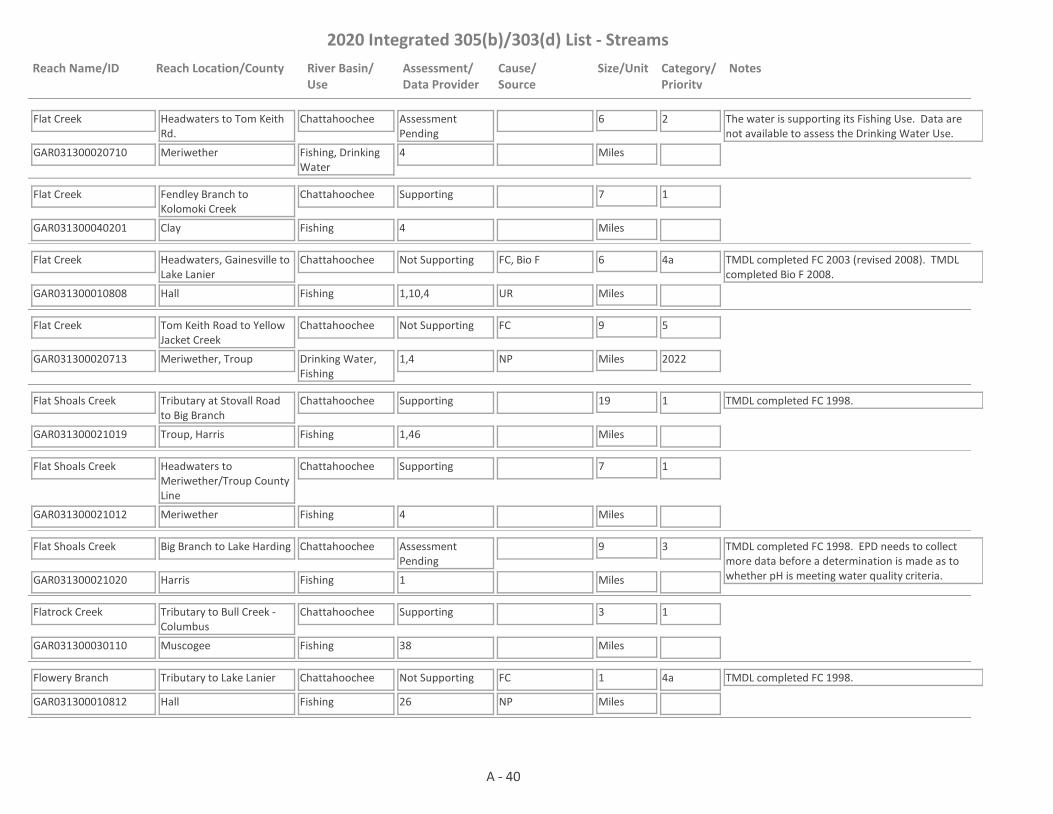
Flat Creek
GAR031300010320 1,4
Headwaters near Clermont to Lake Lanier
White, Hall
Chattahoochee
Fishing
Not Supporting Bio F 9
Miles
4a TMDL completed Bio F 2008.
NP, UR
A - 39
2020 Integrated 305(b)/303(d) List - Streams
Reach Name/ID Reach Location/County River Basin/Use
Assessment/Data Provider
Cause/Source
Size/Unit Category/Priority
Notes
Flat Creek
GAR031300020710 4
Headwaters to Tom Keith Rd.
Meriwether
Chattahoochee
Fishing, Drinking Water
Assessment Pending
6
Miles
2 The water is supporting its Fishing Use. Data are not available to assess the Drinking Water Use.
Flat Creek
GAR031300040201 4
Fendley Branch to Kolomoki Creek
Clay
Chattahoochee
Fishing
Supporting 7
Miles
1
Flat Creek
GAR031300010808 1,10,4
Headwaters, Gainesville to Lake Lanier
Hall
Chattahoochee
Fishing
Not Supporting FC, Bio F 6
Miles
4a TMDL completed FC 2003 (revised 2008). TMDL completed Bio F 2008.
UR
Flat Creek
GAR031300020713 1,4
Tom Keith Road to Yellow Jacket Creek
Meriwether, Troup
Chattahoochee
Drinking Water, Fishing
Not Supporting FC 9
Miles
5
2022NP
Flat Shoals Creek
GAR031300021019 1,46
Tributary at Stovall Road to Big Branch
Troup, Harris
Chattahoochee
Fishing
Supporting 19
Miles
1 TMDL completed FC 1998.
Flat Shoals Creek
GAR031300021012 4
Headwaters to Meriwether/Troup County Line
Meriwether
Chattahoochee
Fishing
Supporting 7
Miles
1
Flat Shoals Creek
GAR031300021020 1
Big Branch to Lake Harding
Harris
Chattahoochee
Fishing
Assessment Pending
9
Miles
3 TMDL completed FC 1998. EPD needs to collect more data before a determination is made as to whether pH is meeting water quality criteria.
Flatrock Creek
GAR031300030110 38
Tributary to Bull Creek - Columbus
Muscogee
Chattahoochee
Fishing
Supporting 3
Miles
1
Flowery Branch
GAR031300010812 26
Tributary to Lake Lanier
Hall
Chattahoochee
Fishing
Not Supporting FC 1
Miles
4a TMDL completed FC 1998.
NP
A - 40
2020 Integrated 305(b)/303(d) List - Streams
Reach Name/ID Reach Location/County River Basin/Use
Assessment/Data Provider
Cause/Source
Size/Unit Category/Priority
Notes
Flybow Creek
GAR031300020330 4
Headwaters to the Dog River
Douglas
Chattahoochee
Fishing
Supporting 3
Miles
1
Foe Killer Creek
GAR031300011003 4,17,67,68
Headwaters to Big Creek
Fulton
Chattahoochee
Fishing
Not Supporting FC, Bio F 7
Miles
4a TMDL completed FC 2003 (revised 2008), Bio F 2018.
UR
Fort Creek
GAR031300021216 1
Headwaters to Dowdell Creek
Harris
Chattahoochee
Fishing
Not Supporting FC 3
Miles
5
2022NP
Fourmile Creek
GAR031300010809 1,7
Lake Lanier Tributary
Forsyth
Chattahoochee
Fishing
Not Supporting FC 3
Miles
4a TMDL completed FC 1998.
NP
Fromby Creek
GAR031300020501 4
Headwaters to Redbud Creek
Heard
Chattahoochee
Fishing
Supporting 3
Miles
1
Glade Branch
GAR031300010514 1
Headwaters to Town Creek
Lumpkin, White
Chattahoochee
Fishing
Assessment Pending
2
Miles
3 The water is in Category 3 for FC. Quarterly samples (total of 4 data points) were collected in 2018 at RV_12_17280. This number is far below our preferred minimum data set of 16 samples (for the calculation of 4 geometric means). More data needs to be collected before an assessment is made.
Glade Creek
GAR031300010210 4
Deep Creek to Deep Creek
Habersham
Chattahoochee
Fishing
Supporting 1
Miles
1
Gothard's Creek
GAR031300020201 4
Headwaters to Sweetwater Creek
Douglas
Chattahoochee
Fishing
Supporting 11
Miles
1
Grass Creek
GAR031300030904 59
Headwaters to Walter F. George Reservoir
Stewart
Chattahoochee
Fishing
Assessment Pending
6
Miles
3 This site has a narrative rank of fair for macroinvertebrates. Waters with a narrative rank of fair will remain in Category 3 until EPD completes the reevaluation of the metrics used to assess macroinvertebrate data.
A - 41
2020 Integrated 305(b)/303(d) List - Streams
Reach Name/ID Reach Location/County River Basin/Use
Assessment/Data Provider
Cause/Source
Size/Unit Category/Priority
Notes
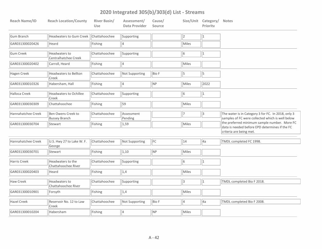
Gum Branch
GAR031300020426 4
Headwaters to Gum Creek
Heard
Chattahoochee
Fishing
Supporting 2
Miles
1
Gum Creek
GAR031300020402 4
Headwaters to Centralhatchee Creek
Carroll, Heard
Chattahoochee
Fishing
Supporting 6
Miles
1
Hagen Creek
GAR031300010326 4
Headwaters to Bellton Creek
Habersham, Hall
Chattahoochee
Fishing
Not Supporting Bio F 5
Miles
5
2022NP
Halloca Creek
GAR031300030309 59
Headwaters to Ochillee Creek
Chattahoochee
Chattahoochee
Fishing
Supporting 6
Miles
1
Hannahatchee Creek
GAR031300030704 1,59
Ben Owens Creek to Bussey Branch
Stewart
Chattahoochee
Fishing
Assessment Pending
7
Miles
3 The water is in Category 3 for FC. In 2018, only 3 samples of FC were collected which is well below the preferred minimum sample number. More FC data is needed before EPD determines if the FC criteria are being met.
Hannahatchee Creek
GAR031300030701 1,10
U.S. Hwy 27 to Lake W. F. George
Stewart
Chattahoochee
Fishing
Not Supporting FC 14
Miles
4a TMDL completed FC 1998.
NP
Harris Creek
GAR031300020403 1,4
Headwaters to the Chattahoochee River
Heard
Chattahoochee
Fishing
Supporting 6
Miles
1
Haw Creek
GAR031300010901 1,4
Headwaters to Chattahoochee River
Forsyth
Chattahoochee
Fishing
Supporting 3
Miles
1 TMDL completed Bio F 2018.
Hazel Creek
GAR031300010204 4
Reservoir No. 12 to Law Creek
Habersham
Chattahoochee
Fishing
Not Supporting Bio F 4
Miles
4a TMDL completed Bio F 2008.
NP
A - 42

2020 Integrated 305(b)/303(d) List - Streams
Reach Name/ID Reach Location/County River Basin/Use
Assessment/Data Provider
Cause/Source
Size/Unit Category/Priority
Notes
Hazel Creek
GAR031300010205 9
Law Creek to the Soque River
Habersham
Chattahoochee
Fishing, Drinking Water
Not Supporting Bio M 5
Miles
4a TMDL completed Bio M 2003. The water is not supporting its Fishing Use. Data are not available to assess the Drinking Water Use.NP
Heiferhorn Creek
GAR031300021301 38
Columbus
Muscogee
Chattahoochee
Fishing
Supporting 3
Miles
1
Hichitee Creek
GAR031300030606 59
Stevens Branch to Little Hitchitee Creek
Chattahoochee
Chattahoochee
Fishing
Assessment Pending
2
Miles
3 This site has a narrative rank of fair for macroinvertebrates. Waters with a narrative rank of fair will remain in Category 3 until EPD completes the reevaluation of the metrics used to assess macroinvertebrate data.
Hichitee Creek
GAR031300030603 4
Caney Creek to Sand Branch
Chattahoochee, Stewart
Chattahoochee
Fishing
Supporting 5
Miles
1 TMDL completed Bio F 2003.
Hillabahatchee Creek
GAR031300020602 1,4,59
Headwaters to Tollieson Branch, Franklin
Heard
Chattahoochee
Fishing
Not Supporting FC 17
Miles
5
2022NP
Hillabahatchee Creek
GAR031300020608 1,10
Tollieson Branch to West Point Lake (Formerly Tollieson Branch to Glovers Road)
Heard
Chattahoochee
Drinking Water, Fishing
Not Supporting FC 3
Miles
4a TMDL completed FC 2013.
NP
Hilly Mill Creek
GAR031300020404 1,4
Heard/Coweta Counties
Heard, Coweta
Chattahoochee
Fishing
Not Supporting FC, Bio F 6
Miles
4a TMDLs completed FC 2003 (revised 2008), Bio F 2003.
NP
Hodchodkee Creek
GAR031300031401 4
SR 27 to Wimberly Mill Branch
Stewart
Chattahoochee
Fishing
Not Supporting Bio F 3
Miles
4a TMDL completed Bio F 2003.
NP
Hodchodkee Creek
GAR031300031402 4
Day Creek to Foreman Mill Branch
Stewart
Chattahoochee
Fishing
Not Supporting Bio F 5
Miles
4a TMDL completed Bio F 2003.
NP
A - 43

2020 Integrated 305(b)/303(d) List - Streams
Reach Name/ID Reach Location/County River Basin/Use
Assessment/Data Provider
Cause/Source
Size/Unit Category/Priority
Notes
Hodchodkee Creek
GAR031300031406 10
Bladen Creek to Smithee Jack Creek
Quitman
Chattahoochee
Fishing
Not Supporting FC 8
Miles
4a TMDL completed FC 2013.
NP
Hog Creek
GAR031300040102 1,4
Headwaters to Cemochechobee Creek
Randolph, Clay
Chattahoochee
Fishing
Not Supporting FC, Bio F 9
Miles
4a TMDLs completed Bio F (2003), FC (2013).
NP
Hog Waller Creek
GAR031300011001 17,67
Tributary to Big Creek (Roswell)
Fulton
Chattahoochee
Fishing
Not Supporting FC 4
Miles
4a TMDL completed FC 2003 (revised 2008).
UR
Holanna Creek
GAR031300031505 4,10
Hog Creek to Pataula Creek
Randolph, Quitman
Chattahoochee
Fishing
Not Supporting FC 7
Miles
4a TMDL completed FC 2013.
NP
Hollis Creek
GAR031300030308 59
Headwaters to Ochillee Creek
Chattahoochee
Chattahoochee
Fishing
Assessment Pending
4
Miles
3 This site has a narrative rank of fair for macroinvertebrates. Waters with a narrative rank of fair will remain in Category 3 until EPD completes the reevaluation of the metrics used to assess macroinvertebrate data.
Horton Creek
GAR031300010114 1
Headwaters to the Chattahoochee River
White
Chattahoochee
Fishing
Assessment Pending
3
Miles
3 EPD believes that our pH probes may have been providing falsely low values at times in 2017 and 2018. Waters that would normally be listed as impaired for low pH are being placed in Category 3 while EPD determines if observed low pH is due to issues with the pH probes; whether low pH may be natural due to low alkalinity; or whether the water is actually impaired for low pH.
House Creek
GAR031300021015 1,4
Headwaters to Sand Creek
Harris
Chattahoochee
Fishing
Not Supporting FC 11
Miles
5
2022NP
House Creek
GAR031300020334 16
Headwaters to Anneewakee Creek
Douglas
Chattahoochee
Fishing
Supporting 2
Miles
1 TMDL completed FC 1998.
A - 44

2020 Integrated 305(b)/303(d) List - Streams
Reach Name/ID Reach Location/County River Basin/Use
Assessment/Data Provider
Cause/Source
Size/Unit Category/Priority
Notes
Hurricane Creek
GAR031300020302 1,4
Headwaters to the Chattahoochee River
Douglas, Carroll
Chattahoochee
Fishing
Supporting 7
Miles
1
Ingram Creek
GAR031300021014 4
Headwaters to Wildcat Creek
Troup
Chattahoochee
Fishing
Supporting 4
Miles
1
Ivy Creek
GAR031300010911 4
Headwaters to Suwannee Creek
Gwinnett
Chattahoochee
Fishing
Not Supporting Bio F 10
Miles
4a TMDL completed Bio F 2008.
UR
James Creek
GAR031300010902 1,4
Daves Creek to the Chattahoochee River
Forsyth
Chattahoochee
Fishing
Not Supporting FC 2
Miles
4a TMDL completed FC 1998.
NP, UR
Jasus Creek
GAR031300010101 1
Headwaters to the Chattahoochee River (Northwest of Helen)
White
Chattahoochee
Fishing
Supporting 3
Miles
1
Johns Creek
GAR031300010903 4,10,17
Headwaters to Chattahoochee River
Fulton, Forsyth
Chattahoochee
Fishing
Not Supporting FC, Bio F 4
Miles
4a TMDLs completed FC 2003 (revised 2008), Bio F 2018.
UR
Keaton Creek
GAR031300020303 16
Tributary to the Dog River
Douglas
Chattahoochee
Fishing
Supporting 5
Miles
1
Kelly Mill Branch
GAR031300011004 1
Headwaters to Orr Creek
Forsyth
Chattahoochee
Fishing
Not Supporting FC 2
Miles
4a TMDL completed FC 2003 (revised 2008).
UR
Kendall Creek
GAR031300030203 38
Boyd Branch to Upatoi Creek
Muscogee
Chattahoochee
Fishing
Supporting 5
Miles
1
Kirkland Creek
GAR031300040706 4
Dry Creek to Chattahoochee River
Early
Chattahoochee
Fishing
Supporting 4
Miles
1
A - 45
2020 Integrated 305(b)/303(d) List - Streams
Reach Name/ID Reach Location/County River Basin/Use
Assessment/Data Provider
Cause/Source
Size/Unit Category/Priority
Notes
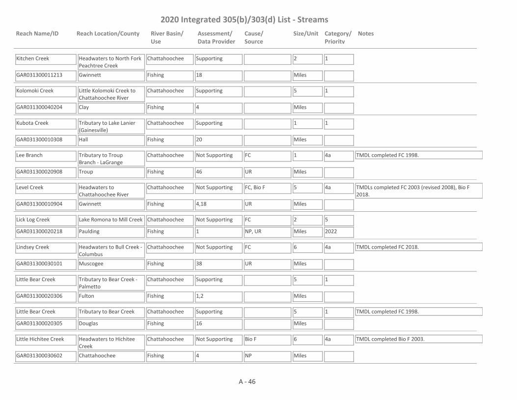
Kitchen Creek
GAR031300011213 18
Headwaters to North Fork Peachtree Creek
Gwinnett
Chattahoochee
Fishing
Supporting 2
Miles
1
Kolomoki Creek
GAR031300040204 4
Little Kolomoki Creek to Chattahoochee River
Clay
Chattahoochee
Fishing
Supporting 5
Miles
1
Kubota Creek
GAR031300010308 20
Tributary to Lake Lanier (Gainesville)
Hall
Chattahoochee
Fishing
Supporting 1
Miles
1
Lee Branch
GAR031300020908 46
Tributary to Troup Branch - LaGrange
Troup
Chattahoochee
Fishing
Not Supporting FC 1
Miles
4a TMDL completed FC 1998.
UR
Level Creek
GAR031300010904 4,18
Headwaters to Chattahoochee River
Gwinnett
Chattahoochee
Fishing
Not Supporting FC, Bio F 5
Miles
4a TMDLs completed FC 2003 (revised 2008), Bio F 2018.
UR
Lick Log Creek
GAR031300020218 1
Lake Romona to Mill Creek
Paulding
Chattahoochee
Fishing
Not Supporting FC 2
Miles
5
2022NP, UR
Lindsey Creek
GAR031300030101 38
Headwaters to Bull Creek - Columbus
Muscogee
Chattahoochee
Fishing
Not Supporting FC 6
Miles
4a TMDL completed FC 2018.
UR
Little Bear Creek
GAR031300020306 1,2
Tributary to Bear Creek - Palmetto
Fulton
Chattahoochee
Fishing
Supporting 5
Miles
1
Little Bear Creek
GAR031300020305 16
Tributary to Bear Creek
Douglas
Chattahoochee
Fishing
Supporting 5
Miles
1 TMDL completed FC 1998.
Little Hichitee Creek
GAR031300030602 4
Headwaters to Hichitee Creek
Chattahoochee
Chattahoochee
Fishing
Not Supporting Bio F 6
Miles
4a TMDL completed Bio F 2003.
NP
A - 46

2020 Integrated 305(b)/303(d) List - Streams
Reach Name/ID Reach Location/County River Basin/Use
Assessment/Data Provider
Cause/Source
Size/Unit Category/Priority
Notes
Little Juniper Creek
GAR031300030201 4
Headwaters to Kings Mill Pond
Marion, Chattahoochee
Chattahoochee
Fishing
Not Supporting Bio F 7
Miles
4a TMDL completed Bio F 2003.
NP
Little Mud Creek
GAR031300010323 1,4
Confluence of North and South Fork Little Mud Creeks to Mud Creek
Habersham, Hall
Chattahoochee
Fishing
Not Supporting Bio F, FC 9
Miles
4a, 5
2022
TMDL completed FC 2008. EPD believes that our pH probes may have been providing falsely low values at times in 2017 and 2018. Waters that would normally be listed as impaired for low pH are being placed in Category 3 while EPD determines if observed low pH is due to issues with the pH probes; whether low pH may be natural due to low alkalinity; or whether the water is actually impaired for low pH.
NP
Little Pine Knot Creek
GAR031300030307 4
Headwaters to Pine Knot Creek
Chattahoochee
Chattahoochee
Fishing
Not Supporting Bio F 4
Miles
4a TMDL completed Bio F 2003.
NP
Little Snake Creek
GAR031300020307 4
Headwaters to Snake Creek
Carroll
Chattahoochee
Fishing
Supporting 4
Miles
1
Little Taylor Creek
GAR031300020405 4
Headwaters to Centralhatchee Creek
Heard
Chattahoochee
Fishing
Supporting 4
Miles
1
Little Tesnatee Creek
GAR031300010501 4
Freeman Creek to upstream Hwy. 129
White
Chattahoochee
Fishing
Not Supporting Bio F 3
Miles
4a TMDL completed Bio F 2018.
NP
Long Branch
GAR031300010611 4
Tributary 1.6 miles upstream S Chesatee St. to the Chestatee River
Lumpkin
Chattahoochee
Fishing
Supporting 2
Miles
1
Long Branch
GAR031300020502 4
Headwaters to Caney Creek
Coweta
Chattahoochee
Fishing
Not Supporting Bio F 4
Miles
4a TMDL completed Bio F 2003.
NP
A - 47

2020 Integrated 305(b)/303(d) List - Streams
Reach Name/ID Reach Location/County River Basin/Use
Assessment/Data Provider
Cause/Source
Size/Unit Category/Priority
Notes
Long Cane Creek
GAR031300020902 4
Headwaters to Panther Creek
Troup
Chattahoochee
Fishing
Supporting 9
Miles
1
Long Cane Creek
GAR031300020911 1,4,10
Panther Creek to Chattahoochee River
Troup
Chattahoochee
Fishing
Not Supporting Bio F, FC 18
Miles
4a TMDLs completed Bio F 2003 (revised 2008), FC 2003. EPD needs to collect more data before a determination is made as to whether pH is meeting water quality criteria.
UR
Long Indian Creek
GAR031300011007 17
Headwaters to Big Creek
Fulton
Chattahoochee
Fishing
Not Supporting FC 4
Miles
4a TMDL completed FC 2013.
NP, UR
Long Island Creek
GAR031300011101 10,17,4
Headwaters to Chattahoochee River
Fulton
Chattahoochee
Fishing
Not Supporting FC 5
Miles
4a TMDL completed FC 2003 (revised 2008). TMDL completed Bio F 2008.
UR
Longwood Park Creek
GAR031300010816 20
Tributary to Lake Lanier (Gainesville)
Hall
Chattahoochee
Fishing
Not Supporting FC 1
Miles
4a TMDL completed FC 1998.
UR
Low Gap Creek
GAR031300010102 9
Headwaters to the Chattahoochee River (Northwest of Helen)
White
Chattahoochee
Fishing
Supporting 4
Miles
1
Lullwater Creek
GAR031300011202 15
Headwaters to Peavine Creek
DeKalb
Chattahoochee
Fishing
Not Supporting FC 2
Miles
4a TMDL completed FC 2003 (revised 2008).
UR
Maple Branch
GAR031300020503 4
Headwaters to Mountain Creek
Coweta
Chattahoochee
Fishing
Not Supporting Bio F 4
Miles
4a TMDL completed Bio F 2008.
NP
Marsh Creek (aka March Creek)
GAR031300011102 1,4,17
Headwaters to Chattahoochee River
Fulton
Chattahoochee
Fishing
Not Supporting FC, Bio F 4
Miles
4a TMDL completed FC 2003 (revised 2008), Bio F 2018.
UR
A - 48

2020 Integrated 305(b)/303(d) List - Streams
Reach Name/ID Reach Location/County River Basin/Use
Assessment/Data Provider
Cause/Source
Size/Unit Category/Priority
Notes
Mauldin Mill Creek
GAR031300010116 4
Pond off Windvane Lane to the Chattahoochee River
Habersham, White
Chattahoochee
Fishing
Supporting 4
Miles
1
Messiers Creek
GAR031300020504 4
Headwaters to the New River
Coweta
Chattahoochee
Fishing
Supporting 7
Miles
1
Mill Branch
GAR031300030118 38
Headwaters to Bull Creek
Muscogee
Chattahoochee
Fishing
Not Supporting FC 2
Miles
4a TMDL completed FC 2018.
UR
Milligan Creek
GAR031300020428 1
Headwaters to Pond 0.9 miles upstream of the Heard County Line
Carroll
Chattahoochee
Fishing
Not Supporting FC 5
Miles
5
2022
EPD believes that our pH probes may have been providing falsely low values at times in 2017 and 2018. Waters that would normally be listed as impaired for low pH are being placed in Category 3 while EPD determines if observed low pH is due to issues with the pH probes; whether low pH may be natural due to low alkalinity; or whether the water is actually impaired for low pH.
NP
Mineral Springs Branch
GAR031300020505 1,4
Newnan Upstream from Bonnell
Coweta
Chattahoochee
Fishing
Not Supporting Bio F 1
Miles
4a TMDL completed Bio F 2003.
UR
Mineral Springs Branch
GAR031300020506 1,2,4
Newnan Downstream from Bonnell
Coweta
Chattahoochee
Fishing
Not Supporting Bio F 3
Miles
4a TMDLs completed Bio F 2003 & Tox 2003.
UR
Mobley Creek
GAR031300020309 16
Headwaters to the Dog River
Douglas
Chattahoochee
Fishing
Supporting 7
Miles
1 TMDL completed FC 2003 (revised 2008).
Moore Creek
GAR031300020406 1
Headwaters to the Chattahoochee River
Coweta
Chattahoochee
Fishing
Supporting 4
Miles
1
A - 49

2020 Integrated 305(b)/303(d) List - Streams
Reach Name/ID Reach Location/County River Basin/Use
Assessment/Data Provider
Cause/Source
Size/Unit Category/Priority
Notes
Mossy Creek
GAR031300010303 1,4,10
Totherow Rd. near Clermont to Chattahoochee River
White, Hall
Chattahoochee
Fishing
Not Supporting Bio F, FC 7
Miles
4a, 5
2022
TMDL completed FC 1998. EPD believes that our pH probes may have been providing falsely low values at times in 2017 and 2018. Waters that would normally be listed as impaired for low pH are being placed in Category 3 while EPD determines if observed low pH is due to issues with the pH probes; whether low pH may be natural due to low alkalinity; or whether the water is actually impaired for low pH.
NP
Mountain Creek
GAR031300021017 4
Mountain Creek Lake to Mountain Oak Creek
Harris
Chattahoochee
Fishing
Supporting 12
Miles
1
Mountain Creek
GAR031300020513 4
Tributary to Mountain Creek (downstream SR 34) to Maple Branch
Coweta
Chattahoochee
Fishing
Not Supporting Bio F 4
Miles
4a TMDL completed Bio F 2008.
NP
Mountain Creek
GAR031300020514 1,46
Maple Branch to Sandy Creek
Coweta
Chattahoochee
Fishing
Supporting 4
Miles
1
Mountain Oak Creek
GAR031300021016 4
Mountain Creek to Little Creek
Harris
Chattahoochee
Fishing
Supporting 5
Miles
1
Mountain Oak Creek
GAR031300021101 1,10
Hamilton
Harris
Chattahoochee
Fishing
Not Supporting FC 5
Miles
4a TMDL completed FC 2003 (revised 2008).
NP
Mt. Hope Branch
GAR031300021001 4
Headwaters to White Sulfur Creek
Meriwether
Chattahoochee
Fishing
Not Supporting Bio F 4
Miles
4a TMDL completed Bio F 2003.
NP
Mud Creek
GAR031300021002 4
Tributary to Flat Shoals Creek
Troup
Chattahoochee
Fishing
Supporting 9
Miles
1
A - 50

2020 Integrated 305(b)/303(d) List - Streams
Reach Name/ID Reach Location/County River Basin/Use
Assessment/Data Provider
Cause/Source
Size/Unit Category/Priority
Notes
Mud Creek
GAR031300010801 1
Headwaters to Lake Lanier
Hall
Chattahoochee
Fishing
Not Supporting FC 2
Miles
4a TMDL completed FC 2003 (revised 2008).
NP
Mud Creek
GAR031300020202 14
Ga. Hwy. 120 to Noses Creek
Cobb
Chattahoochee
Fishing
Not Supporting FC 5
Miles
4a TMDL completed FC 2003 (revised 2008).
UR
Mud Creek
GAR031300010311 1,4
Headwaters to Little Mud Creek
Habersham, Hall
Chattahoochee
Fishing
Not Supporting FC, Bio F 13
Miles
4a TMDLs completed FC & Bio F 2008.
NP
Mud Creek
GAR031300010321 1
Little Mud Creek to the Chattahoochee River
Hall
Chattahoochee
Fishing
Supporting 3
Miles
1
Mulberry Creek
GAR031300021208 4
Sparks Creek to Dowdell Creek
Harris
Chattahoochee
Fishing
Supporting 3
Miles
1
Mulberry Creek
GAR031300021218 1
Dowdell Creek to Williams Creek
Harris
Chattahoochee
Fishing
Supporting 4
Miles
1
Mulberry Creek
GAR031300021213 1
Palmetto Creek to Ossahatchie Creek
Harris
Chattahoochee
Fishing
Supporting 4
Miles
1
Mulberry Creek
GAR031300021202 1,10
Ossahatchie Creek to Five Points Branch West near Mulberry Grove
Harris
Chattahoochee
Fishing
Not Supporting FC 8
Miles
4a TMDL completed FC 2003 (revised 2008).
NP
Nancy Creek
GAR031300011203 1,4,10,56
Headwaters to Peachtree Creek, Atlanta
DeKalb, Fulton
Chattahoochee
Fishing
Not Supporting FC, Bio F 16
Miles
4a TMDL completed FC 2003 (revised 2008). TMDL completed Bio F 2008. pH is in Category 3. More data is needed before making an assessment.UR
A - 51
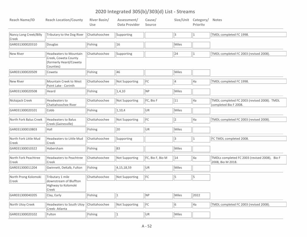
2020 Integrated 305(b)/303(d) List - Streams
Reach Name/ID Reach Location/County River Basin/Use
Assessment/Data Provider
Cause/Source
Size/Unit Category/Priority
Notes
Nancy Long Creek/Billy Creek
GAR031300020310 16
Tributary to the Dog River
Douglas
Chattahoochee
Fishing
Supporting 3
Miles
1 TMDL completed FC 1998.
New River
GAR031300020509 46
Headwaters to Mountain Creek, Coweta County (formerly Heard/Coweta Counties)
Coweta
Chattahoochee
Fishing
Supporting 24
Miles
1 TMDL completed FC 2003 (revised 2008).
New River
GAR031300020508 1,4,10
Mountain Creek to West Point Lake - Corinth
Heard
Chattahoochee
Fishing
Not Supporting FC 4
Miles
4a TMDL completed FC 1998.
NP
Nickajack Creek
GAR031300020101 1,10,4
Headwaters to Chattahoochee River
Cobb
Chattahoochee
Fishing
Not Supporting FC, Bio F 11
Miles
4a TMDL completed FC 2003 (revised 2008). TMDL completed Bio F 2008.
UR
North Fork Balus Creek
GAR031300010803 20
Headwaters to Balus Creek (Gainesville)
Hall
Chattahoochee
Fishing
Not Supporting FC 2
Miles
4a TMDL completed FC 2003 (revised 2008).
UR
North Fork Little Mud Creek
GAR031300010322 83
Headwaters to Little Mud Creek
Habersham
Chattahoochee
Fishing
Supporting 3
Miles
1 FC TMDL completed 2008.
North Fork Peachtree Creek
GAR031300011204 4,15,18,59
Headwaters to Peachtree Creek
Gwinnett, DeKalb, Fulton
Chattahoochee
Fishing
Not Supporting FC, Bio F, Bio M 14
Miles
4a TMDLs completed FC 2003 (revised 2008), Bio F 2008, Bio M 2018.
UR
North Prong Kolomoki Creek
GAR031300040205 1
Tributary 1 mile downstream of Bluffton Highway to Kolomoki Creek
Clay, Early
Chattahoochee
Fishing
Not Supporting FC 5
Miles
5
2022NP
North Utoy Creek
GAR031300020102 1
Headwaters to South Utoy Creek- Atlanta
Fulton
Chattahoochee
Fishing
Not Supporting FC 6
Miles
4a TMDL completed FC 2003 (revised 2008).
UR
A - 52

2020 Integrated 305(b)/303(d) List - Streams
Reach Name/ID Reach Location/County River Basin/Use
Assessment/Data Provider
Cause/Source
Size/Unit Category/Priority
Notes
Noses Creek
GAR031300020215 1,4
Headwaters to Ward Creek
Cobb
Chattahoochee
Fishing
Not Supporting Bio F 7
Miles
4a TMDL completed Bio F 2008.
NP
Noses Creek
GAR031300020214 1,14,56
Ward Creek to Sweetwater Creek
Cobb
Chattahoochee
Fishing
Supporting 7
Miles
1
Nutt Creek
GAR031300020407 1
Headwaters to the Chattahoochee River
Heard
Chattahoochee
Fishing
Supporting 3
Miles
1
Ochillee Creek
GAR031300030304 4
Hollis Creek to Spring Creek
Chattahoochee
Chattahoochee
Fishing
Not Supporting Bio F 5
Miles
5
2022NP
Odum Creek
GAR031300040504 1
Headwaters to the Chattahoochee River
Early
Chattahoochee
Fishing
Supporting 5
Miles
1
Olley Creek
GAR031300020204 1,14,59
Headwaters to Sweetwater Creek
Cobb
Chattahoochee
Fishing
Not Supporting FC, Bio M 11
Miles
4a TMDLs completed FC 2003 (revised 2008), Bio M 2018.
UR
Ollie Creek
GAR031300020701 4
Tributary to Bear Creek
Meriwether
Chattahoochee
Fishing
Not Supporting Bio F, DO 1
Miles
4a TMDLs completed Bio F 2003, DO 2003.
NP
Orchard Knob Creek
GAR031300011116 1
Headwaters to Chattahoochee River
Cobb
Chattahoochee
Fishing
Supporting 2
Miles
1
Orr Creek
GAR031300011005 1,61
Upstream Castleberry Rd. (Tyson Foods) to Big Creek
Forsyth
Chattahoochee
Fishing
Not Supporting FC 3
Miles
4a TMDLs completed FC 2003 (revised 2008) & Cu 2003.
UR
Ossahatchie Creek
GAR031300021201 10
Hwy 85 to Hwy 1 near Cataula
Harris
Chattahoochee
Fishing
Supporting 7
Miles
1
A - 53
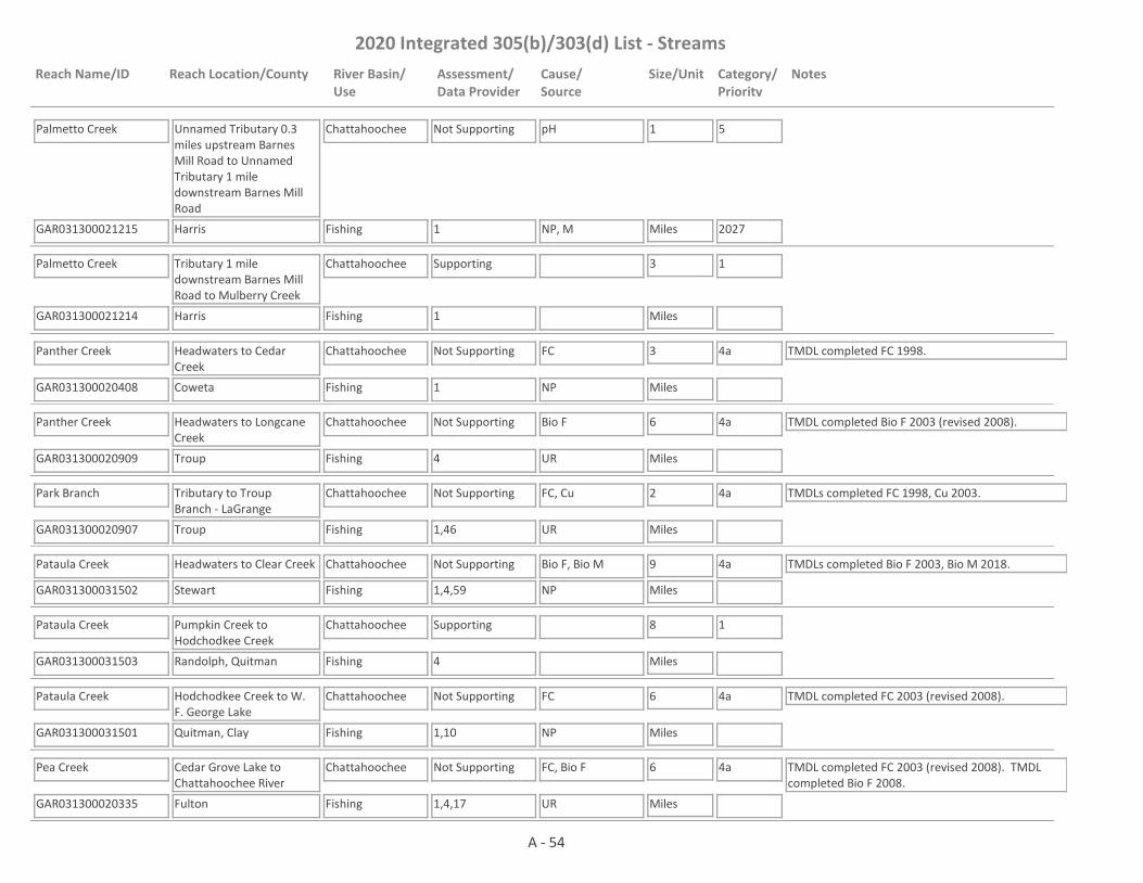
2020 Integrated 305(b)/303(d) List - Streams
Reach Name/ID Reach Location/County River Basin/Use
Assessment/Data Provider
Cause/Source
Size/Unit Category/Priority
Notes
Palmetto Creek
GAR031300021215 1
Unnamed Tributary 0.3 miles upstream Barnes Mill Road to Unnamed Tributary 1 mile downstream Barnes Mill Road
Harris
Chattahoochee
Fishing
Not Supporting pH 1
Miles
5
2027NP, M
Palmetto Creek
GAR031300021214 1
Tributary 1 mile downstream Barnes Mill Road to Mulberry Creek
Harris
Chattahoochee
Fishing
Supporting 3
Miles
1
Panther Creek
GAR031300020408 1
Headwaters to Cedar Creek
Coweta
Chattahoochee
Fishing
Not Supporting FC 3
Miles
4a TMDL completed FC 1998.
NP
Panther Creek
GAR031300020909 4
Headwaters to Longcane Creek
Troup
Chattahoochee
Fishing
Not Supporting Bio F 6
Miles
4a TMDL completed Bio F 2003 (revised 2008).
UR
Park Branch
GAR031300020907 1,46
Tributary to Troup Branch - LaGrange
Troup
Chattahoochee
Fishing
Not Supporting FC, Cu 2
Miles
4a TMDLs completed FC 1998, Cu 2003.
UR
Pataula Creek
GAR031300031502 1,4,59
Headwaters to Clear Creek
Stewart
Chattahoochee
Fishing
Not Supporting Bio F, Bio M 9
Miles
4a TMDLs completed Bio F 2003, Bio M 2018.
NP
Pataula Creek
GAR031300031503 4
Pumpkin Creek to Hodchodkee Creek
Randolph, Quitman
Chattahoochee
Fishing
Supporting 8
Miles
1
Pataula Creek
GAR031300031501 1,10
Hodchodkee Creek to W. F. George Lake
Quitman, Clay
Chattahoochee
Fishing
Not Supporting FC 6
Miles
4a TMDL completed FC 2003 (revised 2008).
NP
Pea Creek
GAR031300020335 1,4,17
Cedar Grove Lake to Chattahoochee River
Fulton
Chattahoochee
Fishing
Not Supporting FC, Bio F 6
Miles
4a TMDL completed FC 2003 (revised 2008). TMDL completed Bio F 2008.
UR
A - 54

2020 Integrated 305(b)/303(d) List - Streams
Reach Name/ID Reach Location/County River Basin/Use
Assessment/Data Provider
Cause/Source
Size/Unit Category/Priority
Notes
Peachtree Creek
GAR031300011205 1,43
I-85 to Chattahoochee River, Atlanta
Fulton
Chattahoochee
Fishing
Not Supporting FC 7
Miles
4a TMDL completed FC 2003 (revised 2008).
UR, CSO
Peavine Creek
GAR031300011206 15
Headwaters to South Fork Peachtree Creek
DeKalb
Chattahoochee
Fishing
Not Supporting FC 3
Miles
4a TMDL completed FC 2003 (revised 2008).
UR
Pepperell Creek
GAR031300020702 2
LaGrange
Troup
Chattahoochee
Fishing
Not Supporting FC 1
Miles
4a TMDL completed FC 1998.
UR
Pine Knot Creek
GAR031300030305 4,59
Parkers Mill Creek to Little Pine Knot Creek
Marion, Chattahoochee
Chattahoochee
Fishing
Not Supporting Bio F 6
Miles
4a TMDL completed Bio F 2003.
NP
Piney Woods Branch
GAR031300020712 4
Headwaters to Tom Keith Rd.
Meriwether
Chattahoochee
Fishing
Not Supporting Bio F 2
Miles
4a TMDL completed Bio F 2003.
NP
Pink Creek
GAR031300020409 1,4
Tributary to the Chattahoochee River
Heard
Chattahoochee
Fishing
Supporting 3
Miles
1
Polecat Creek
GAR031300021003 4
Tributary to Flat Shoals Creek
Troup
Chattahoochee
Fishing
Supporting 9
Miles
1
Powder Springs Creek
GAR031300020205 14
Headwaters to Sweetwater Creek
Cobb
Chattahoochee
Fishing
Supporting 7
Miles
1
Proctor Creek
GAR031300020103 1,59
Headwaters to Chattahoochee River, Atlanta
Fulton
Chattahoochee
Fishing
Not Supporting Algae, FC 9
Miles
4a, 5
2027
TMDL completed FC 2003 (revised 2008). This site has a narrative rank of fair for macroinvertebrates. When EPD completes the reevaluation of the metrics used to assess macroinvertebrate data it will be determined if the macroinvertebrate criteria are being met.
UR, CSO
A - 55
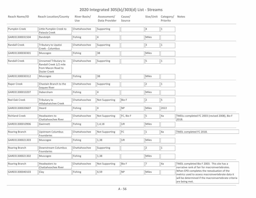
2020 Integrated 305(b)/303(d) List - Streams
Reach Name/ID Reach Location/County River Basin/Use
Assessment/Data Provider
Cause/Source
Size/Unit Category/Priority
Notes
Pumpkin Creek
GAR031300031504 4
Little Pumpkin Creek to Pataula Creek
Randolph
Chattahoochee
Fishing
Supporting 4
Miles
1
Randall Creek
GAR031300030301 38
Tributary to Upatoi Creek - Columbus
Muscogee
Chattahoochee
Fishing
Supporting 3
Miles
1
Randall Creek
GAR031300030312 38
Unnamed Tributary to Randall Creek 1/2 mile from Macon Road to Dozier Creek
Muscogee
Chattahoochee
Fishing
Supporting 5
Miles
1
Raper Creek
GAR031300010207 4
Chastain Branch to the Soquee River
Habersham
Chattahoochee
Fishing
Supporting 2
Miles
1
Red Oak Creek
GAR031300020607 4
Tributary to Hillabahatchee Creek
Heard
Chattahoochee
Fishing
Not Supporting Bio F 2
Miles
5
2022NP
Richland Creek
GAR031300010906 1,4,18
Headwaters to Chattahoochee River
Gwinnett
Chattahoochee
Fishing
Not Supporting FC, Bio F 5
Miles
4a TMDLs completed FC 2003 (revised 2008), Bio F 2018.
UR
Roaring Branch
GAR031300021303 1,38
Upstream Columbus Foundaries
Muscogee
Chattahoochee
Fishing
Not Supporting FC 1
Miles
4a TMDL completed FC 2018.
UR
Roaring Branch
GAR031300021302 1,38
Downstream Columbus Foundaries
Muscogee
Chattahoochee
Fishing
Supporting 2
Miles
1
Roaring Branch
GAR031300040103 4,59
Headwaters to Chattahoochee River
Clay
Chattahoochee
Fishing
Not Supporting Bio F 7
Miles
4a TMDL completed Bio F 2003. This site has a narrative rank of fair for macroinvertebrates. When EPD completes the reevaluation of the metrics used to assess macroinvertebrate data it will be determined if the macroinvertebrate criteria are being met.
NP
A - 56

2020 Integrated 305(b)/303(d) List - Streams
Reach Name/ID Reach Location/County River Basin/Use
Assessment/Data Provider
Cause/Source
Size/Unit Category/Priority
Notes
Rock Creek
GAR031300010814 20
Tributary to Lake Lanier (Gainesville)
Hall
Chattahoochee
Fishing
Supporting 1
Miles
1 TMDL completed FC 1998.
Rocky Branch
GAR031300030102 37,38
Tributary to the Chattahoochee River - Columbus
Muscogee
Chattahoochee
Fishing
Supporting 2
Miles
1 TMDL completed FC 2003 (revised 2008).
Rottenwood Creek
GAR031300011103 1,10,14,59
Headwaters to Chattahoochee River
Cobb
Chattahoochee
Fishing
Not Supporting Bio M 9
Miles
4a TMDLs completed FC 2003 (revised 2008), Bio M 2018.
UR
Sally Branch
GAR031300030310 59
Headwaters to Pine Knot Creek
Chattahoochee
Chattahoochee
Fishing
Supporting 6
Miles
1
Sand Creek
GAR031300021018 1,4
Headwaters to House Creek
Troup, Harris
Chattahoochee
Fishing
Not Supporting FC, Bio F 9
Miles
4a, 5
2022
TMDL completed Bio F 2018.
NP
Sandy Creek
GAR031300020511 4
Newnan Waterworks Lakes to Mountain Creek
Coweta
Chattahoochee
Fishing, Drinking Water
Assessment Pending
9
Miles
2 The water is supporting its Fishing Use. Data are not available to assess the Drinking Water Use.
Sandy Creek
GAR031300020314 4
Headwaters to Crawfish Creek
Carroll
Chattahoochee
Fishing
Supporting 3
Miles
1
Sandy Creek (also known as Cooper Sandy Creek)
GAR031300020104 10
I-285 to Chattahoochee River
Fulton
Chattahoochee
Fishing
Not Supporting FC 2
Miles
4a TMDL completed FC 2003 (revised 2008).
UR
Sautee Creek
GAR031300010103 1,4
U/S Chattahoochee River
Habersham, White
Chattahoochee
Fishing
Supporting 5
Miles
1
A - 57

2020 Integrated 305(b)/303(d) List - Streams
Reach Name/ID Reach Location/County River Basin/Use
Assessment/Data Provider
Cause/Source
Size/Unit Category/Priority
Notes
Sawhatchee Creek
GAR031300040707 4
Headwaters to Weaver Creek
Early
Chattahoochee
Fishing
Not Supporting Bio F 9
Miles
5
2022NP
Sawhatchee Creek
GAR031300040703 4
Weaver Creek to Sheffield Mill Creek
Early
Chattahoochee
Fishing
Supporting 2
Miles
1
Sawnee Creek
GAR031300010804 7
Lake Lanier Tributary
Forsyth
Chattahoochee
Fishing
Not Supporting FC 2
Miles
4a TMDL completed FC 1998.
NP
Sewell Mill Creek
GAR031300011104 10,14
Tributary to Sope Creek
Cobb
Chattahoochee
Fishing
Not Supporting FC 4
Miles
4a TMDL completed FC 2003 (revised 2008).
UR
Shoal Creek
GAR031300010209 4
Nerve Branch to the Soquee River
Habersham
Chattahoochee
Fishing
Not Supporting Bio F 2
Miles
5
2022NP
Shoal Creek
GAR031300010510 1,4
Headwaters to Tesnatee Creek
White
Chattahoochee
Fishing
Not Supporting Bio F 6
Miles
5
2022NP
Shoal Creek
GAR031300020708 4
Headwaters (Mountville) to I-85/Ga. Hwy. 403
Troup
Chattahoochee
Fishing
Not Supporting Bio F 3
Miles
4a TMDL completed Bio F 2003.
NP
Shoal Creek
GAR031300020703 4
I-85/Ga Hwy 403 to West Point Lake (formerly Troup County)
Troup
Chattahoochee
Fishing
Supporting 7
Miles
1
Six Mile Creek
GAR031300010805 1,4
Headwaters to Lake Lanier
Forsyth
Chattahoochee
Fishing
Not Supporting FC, Bio F 2
Miles
4a TMDL completed FC 1998. TMDL completed Bio F 2008.
NP, UR
Slater Mill Creek
GAR031300020315 4
Tributary to Little Anneewakee Creek
Douglas
Chattahoochee
Fishing
Supporting 2
Miles
1
A - 58

2020 Integrated 305(b)/303(d) List - Streams
Reach Name/ID Reach Location/County River Basin/Use
Assessment/Data Provider
Cause/Source
Size/Unit Category/Priority
Notes
Slaughterhouse Creek
GAR031300010815 20
Tributary to Lake Lanier (Gainesville)
Hall
Chattahoochee
Fishing
Not Supporting FC 1
Miles
4a TMDL completed FC 1998.
UR
Smith Creek
GAR031300010104 1,4
Headwaters to Chattahoochee River near Helen
White
Chattahoochee
Fishing
Not Supporting Bio F 6
Miles
5
2022
EPD believes that our pH probes may have been providing falsely low values at times in 2017 and 2018. Waters that would normally be listed as impaired for low pH are being placed in Category 3 while EPD determines if observed low pH is due to issues with the pH probes; whether low pH may be natural due to low alkalinity; or whether the water is actually impaired for low pH.
NP
Smithee Jack Creek
GAR031300031403 4
Headwaters to Hodchodkee Creek
Quitman
Chattahoochee
Fishing
Supporting 5
Miles
1
Snake Creek
GAR031300020316 1,4
Upstream Chattahoochee River
Carroll
Chattahoochee
Fishing, Drinking Water
Not Supporting FC 12
Miles
4a TMDL completed FC 1998.
NP
Snake Creek
GAR031300020410 4
Headwaters to Wahoo Creek
Coweta
Chattahoochee
Fishing
Not Supporting Bio F 4
Miles
4a TMDL completed Bio F 2003.
UR
Sope Creek
GAR031300011105 1,4,10,14,59
Headwaters to Chattahoochee River
Cobb
Chattahoochee
Fishing
Not Supporting Bio F 11
Miles
4a TMDLs completed FC 2003 (revised 2008), Bio F 2018. This site has a narrative rank of fair for macroinvertebrates. When EPD completes the reevaluation of the metrics used to assess macroinvertebrate data it will be determined if the macroinvertebrate criteria are being met.
UR
Soquee River
GAR031300010202 1,4,10,76
Goshen Creek to SR 17, Clarkesville
Habersham
Chattahoochee
Fishing, Drinking Water
Not Supporting Bio F 29
Miles
4a TMDLs completed FC 2003 (revised 2008), Bio F 2018. The water is supporting its Drinking Water Use, but not its Fishing Use.NP
A - 59
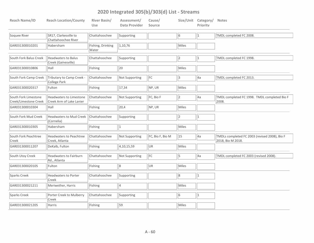
2020 Integrated 305(b)/303(d) List - Streams
Reach Name/ID Reach Location/County River Basin/Use
Assessment/Data Provider
Cause/Source
Size/Unit Category/Priority
Notes
Soquee River
GAR031300010201 1,10,76
SR17, Clarkesville to Chattahoochee River
Habersham
Chattahoochee
Fishing, Drinking Water
Supporting 6
Miles
1 TMDL completed FC 2008.
South Fork Balus Creek
GAR031300010806 20
Headwaters to Balus Creek (Gainesville)
Hall
Chattahoochee
Fishing
Supporting 2
Miles
1 TMDL completed FC 1998.
South Fork Camp Creek
GAR031300020317 17,34
Tributary to Camp Creek - College Park
Fulton
Chattahoochee
Fishing
Not Supporting FC 3
Miles
4a TMDL completed FC 2013.
NP, UR
South Fork Limestone Creek/Limestone Creek
GAR031300010304 20,4
Headwaters to Limestone Creek Arm of Lake Lanier
Hall
Chattahoochee
Fishing
Not Supporting FC, Bio F 2
Miles
4a TMDL completed FC 1998. TMDL completed Bio F 2008.
NP, UR
South Fork Mud Creek
GAR031300010305 1
Headwaters to Mud Creek (Cornelia)
Habersham
Chattahoochee
Fishing
Supporting 2
Miles
1
South Fork Peachtree Creek
GAR031300011207 4,10,15,59
Headwaters to Peachtree Creek, Atlanta
DeKalb, Fulton
Chattahoochee
Fishing
Not Supporting FC, Bio F, Bio M 15
Miles
4a TMDLs completed FC 2003 (revised 2008), Bio F 2018, Bio M 2018.
UR
South Utoy Creek
GAR031300020105 8
Headwaters to Fairburn Rd., Atlanta
Fulton
Chattahoochee
Fishing
Not Supporting FC 5
Miles
4a TMDL completed FC 2003 (revised 2008).
UR
Sparks Creek
GAR031300021211 4
Headwaters to Porter Creek
Meriwether, Harris
Chattahoochee
Fishing
Supporting 8
Miles
1
Sparks Creek
GAR031300021205 59
Porter Creek to Mulberry Creek
Harris
Chattahoochee
Fishing
Supporting 6
Miles
1
A - 60

2020 Integrated 305(b)/303(d) List - Streams
Reach Name/ID Reach Location/County River Basin/Use
Assessment/Data Provider
Cause/Source
Size/Unit Category/Priority
Notes
Spoilcane Creek
GAR031300010112 1
Andrews Creek to the Chattahoochee River
White
Chattahoochee
Fishing
Supporting 3
Miles
1
Squirrel Creek
GAR031300010401 22
Tributary to Lake Lanier
Hall
Chattahoochee
Fishing
Supporting 2
Miles
1
Standing Boy Creek
GAR031300021308 1
Striblin Creek to Mobleys Lake
Harris
Chattahoochee
Fishing
Not Supporting FC 5
Miles
5
2022NP
Standing Boy Creek
GAR031300021307 38
Douglas Creek to Heiferhorn Creek
Muscogee
Chattahoochee
Fishing
Supporting 2
Miles
1
Sutton Mill Creek
GAR031300010211 4
Beaverdam Creek to the Soquee River
Habersham
Chattahoochee
Fishing
Not Supporting Bio F 1
Miles
5
2022NP
Suwanee Creek
GAR031300010912 1,4
Suwanee Creek Lake (near Buford) to Ivy Creek
Gwinnett
Chattahoochee
Fishing
Not Supporting Bio F 6
Miles
4a TMDL completed Bio F 2008.
UR
Suwanee Creek
GAR031300010918 1,10,18
Mill Creek to Bennett Creek
Gwinnett
Chattahoochee
Fishing
Not Supporting FC 1
Miles
4a TMDL completed FC 2003 (revised 2008).
UR
Suwanee Creek
GAR031300010919 79
Bennett Creek to Chattahoochee River
Gwinnett
Chattahoochee
Fishing
Supporting 3
Miles
1 TMDL completed FC 2003 (revised 2008).
Sweetwater Creek
GAR031300020213 1,10,14
U/S Pine Valley Rd. To Noses Creek
Paulding, Cobb
Chattahoochee
Fishing
Not Supporting FC 10
Miles
4a TMDL completed FC 2003 (revised 2008).
NP, UR
A - 61

2020 Integrated 305(b)/303(d) List - Streams
Reach Name/ID Reach Location/County River Basin/Use
Assessment/Data Provider
Cause/Source
Size/Unit Category/Priority
Notes
Sweetwater Creek
GAR031300020216 14
Noses Creek to an unnamed tributary approximately 0.25 mile u/s of I-20
Cobb, Douglas
Chattahoochee
Fishing, Drinking Water
Supporting 7
Miles
1 TMDL completed FC 2003 (revised 2008).
Sweetwater Creek
GAR031300020219 1,10
Unnamed Tributary approximately 0.25 miles u/s of I-20 to Unnamed Tributary 1 mile downstream of Blairs Bridge Road.
Douglas
Chattahoochee
Drinking Water, Fishing
Not Supporting FC 1
Miles
4a TMDL completed FC 2003 (revised 2008).
UR
Sweetwater Creek
GAR031300020220 16
Unnamed tributary 1 mile downstream Blairs Bridge Road to the Chattahoochee River
Douglas
Chattahoochee
Drinking Water, Fishing
Supporting 6
Miles
1 TMDL completed FC 2003 (revised 2008).
Talipahoga Rum Creek
GAR031300030903 1,59
Headwaters to Bradley Lake Tributary
Stewart
Chattahoochee
Fishing
Not Supporting pH, Bio M 4
Miles
4a, 5
2027
TMDL completed Bio M 2018.
NP
Tanyard Branch
GAR031300011208 1
Headwaters to Peachtree Creek - Atlanta
Fulton
Chattahoochee
Fishing
Not Supporting FC 2
Miles
4a TMDL completed FC 2003 (revised 2008).
UR, CSO
Tanyard Creek
GAR031300020318 4,16
Headwaters to Little Bear Creek
Douglas
Chattahoochee
Fishing
Supporting 2
Miles
1
Tanyard Creek
GAR031300020903 1,21
Headwaters to Blue John Creek - LaGrange
Troup
Chattahoochee
Fishing
Not Supporting FC 2
Miles
4a TMDL completed FC 2003 (revised 2008).
UR
A - 62

2020 Integrated 305(b)/303(d) List - Streams
Reach Name/ID Reach Location/County River Basin/Use
Assessment/Data Provider
Cause/Source
Size/Unit Category/Priority
Notes
Tar River
GAR031300030204 38
Headwaters to Montarella Lake
Muscogee, Talbot, Harris
Chattahoochee
Fishing
Supporting 4
Miles
1
Tate Creek
GAR031300010512 4
Headwaters to Chestatee River
Lumpkin
Chattahoochee
Fishing
Not Supporting Bio F 4
Miles
4a TMDL completed Bio F 2018.
NP
Taylor Creek
GAR031300010701 26
Headwaters to Lake Lanier
Dawson, Forsyth
Chattahoochee
Fishing
Not Supporting FC 3
Miles
4a TMDL completed FC 1998.
NP
Tesnatee Creek
GAR031300010502 1,4
Upstream Hwy 129 to Town Creek, Cleveland
White
Chattahoochee
Fishing
Not Supporting FC 5
Miles
4a TMDL completed FC 2003 (revised 2008). EPD believes that our pH probes may have been providing falsely low values at times in 2017 and 2018. Waters that would normally be listed as impaired for low pH are being placed in Category 3 while EPD determines if observed low pH is due to issues with the pH probes; whether low pH may be natural due to low alkalinity; or whether the water is actually impaired for low pH.
UR
Tesnatee Creek
GAR031300010503 1,10
Town Creek to Chestatee River
White, Lumpkin
Chattahoochee
Fishing
Not Supporting FC 5
Miles
4a TMDL completed FC 2003 (revised 2008).
NP
Thomas Creek
GAR031300020411 1,4
Headwaters to the Chattahoochee River
Coweta
Chattahoochee
Fishing
Supporting 4
Miles
1
Tiger Creek
GAR031300030306 4,38
Headwaters to Upatoi Creek, Columbus
Muscogee
Chattahoochee
Fishing
Not Supporting Bio F, FC 5
Miles
4a TMDLs completed Bio F 2003 & FC 2018.
NP
Tobannee Creek
GAR031300031303 4
Headwaters to Walter F. George Lake
Quitman
Chattahoochee
Fishing
Supporting 3
Miles
1
Toto Creek
GAR031300010702 1,26
Headwaters to Lake Lanier
Dawson
Chattahoochee
Fishing
Not Supporting FC 1
Miles
4a TMDL completed FC 1998.
NP
A - 63

2020 Integrated 305(b)/303(d) List - Streams
Reach Name/ID Reach Location/County River Basin/Use
Assessment/Data Provider
Cause/Source
Size/Unit Category/Priority
Notes
Town Branch
GAR031300020211 1
Lake Val-Do Mar to Mud Creek - Villa Rica
Carroll, Douglas
Chattahoochee
Fishing
Not Supporting FC 1
Miles
5
2022NP, UR
Town Creek
GAR031300020603 1,4,59
Headwaters to Little Creek
Heard
Chattahoochee
Fishing
Not Supporting DO, Bio F, FC 6
Miles
4a, 5
2022, 2027
TMDL completed Bio F 2003. The TMDL for FC is scheduled to be drafted in 2022 and the one for DO in 2027.NP
Town Creek
GAR031300010504 1,4
Headwaters to Tesnatee Creek
White
Chattahoochee
Fishing
Assessment Pending
10
Miles
3 EPD believes that our pH probes may have been providing falsely low values at times in 2017 and 2018. Waters that would normally be listed as impaired for low pH are being placed in Category 3 while EPD determines if observed low pH is due to issues with the pH probes; whether low pH may be natural due to low alkalinity; or whether the water is actually impaired for low pH.
Tributary #1 to the Chattahoochee River
GAR031300010917 4
Headwaters to the Chattahoochee River
Gwinnett
Chattahoochee
Fishing
Not Supporting Bio F 3
Miles
4a TMDL completed Bio F 2018.
UR
Tributary #2 to the Chattahoochee River
GAR031300011117 4
Headwaters to the Chattahoochee River
Fulton
Chattahoochee
Fishing
Supporting 2
Miles
1 TMDL completed Bio F 2018.
Tributary to Bull Creek
GAR031300030119 38
Headwaters to Bull Creek
Muscogee
Chattahoochee
Fishing
Not Supporting FC 1
Miles
4a TMDL completed FC 2018.
UR
Tributary to Cemochechobee Creek
GAR031300040107 1
Headwaters to Cemochechobee Creek
Clay
Chattahoochee
Fishing
Not Supporting FC 3
Miles
5
2022
EPD believes that our pH probes may have been providing falsely low values at times in 2017 and 2018. Waters that would normally be listed as impaired for low pH are being placed in Category 3 while EPD determines if observed low pH is due to issues with the pH probes; whether low pH may be natural due to low alkalinity; or whether the water is actually impaired for low pH.
NP
Tributary to Flat Shoal Creek
GAR031300021013 4
Headwaters to Flat Shoal Creek
Meriwether
Chattahoochee
Fishing
Supporting 2
Miles
1 TMDL completed Bio F 2003.
A - 64

2020 Integrated 305(b)/303(d) List - Streams
Reach Name/ID Reach Location/County River Basin/Use
Assessment/Data Provider
Cause/Source
Size/Unit Category/Priority
Notes
Tributary to Limestone Creek
GAR031300010301 20
U/S Brenau Lake
Hall
Chattahoochee
Fishing
Supporting 1
Miles
1 TMDL completed FC 1998.
Tributary to Limestone Creek
GAR031300010318 4
Breneau Lake to Limestone Creek
Hall
Chattahoochee
Fishing
Not Supporting Bio F 1
Miles
4a TMDL completed Bio F 2008. TMDL completed FC 1998.
NP, UR
Tributary to Mossy Creek
GAR031300010325 4
Tributary 200 feet upstream Airport Road to Mossy Creek
White
Chattahoochee
Fishing
Supporting 2
Miles
1
Tributary to Mountain Creek
GAR031300021103 1
Callaway Gardens WPCP to Mountain Creek
Harris
Chattahoochee
Fishing
Not Supporting FC 2
Miles
5
2022NP
Tributary to Mud Creek
GAR031300020207 14
Cobb County
Cobb
Chattahoochee
Fishing
Not Supporting FC 3
Miles
4a TMDL completed FC 2003 (revised 2008).
UR
Tributary to Snake Creek
GAR031300020427 56
Headwaters to Snake Creek (Newnan)
Coweta
Chattahoochee
Fishing
Supporting 1
Miles
1
Tributary to Sope Creek #1
GAR031300011106 14
Cobb County - Marietta
Cobb
Chattahoochee
Fishing
Supporting 1
Miles
1
Tributary to Sope Creek #2
GAR031300011115 56
Headwaters to Sope Creek (East of Marietta)
Cobb
Chattahoochee
Fishing
Not Supporting Tetrachloroethylene
2
Miles
4b Data from EPD's Harzardous Waste Branch. Facility under a corrective action plan.
I2
Tributary to Sope Creek #3
GAR031300011120 56
Headwaters to Sope Creek (near Pickens Industrial Drive)
Cobb
Chattahoochee
Fishing
Not Supporting Tetrachloroethylene
1
Miles
4b Data from EPD's Hazardous Waste Branch. Facility under a corrective action plan.
I2
A - 65

2020 Integrated 305(b)/303(d) List - Streams
Reach Name/ID Reach Location/County River Basin/Use
Assessment/Data Provider
Cause/Source
Size/Unit Category/Priority
Notes
Tributary to the Chestatee River
GAR031300010515 1
Headwaters to the Chestatee River
Lumpkin
Chattahoochee
Fishing
Assessment Pending
2
Miles
3 EPD believes that our pH probes may have been providing falsely low values at times in 2017 and 2018. Waters that would normally be listed as impaired for low pH are being placed in Category 3 while EPD determines if observed low pH is due to issues with the pH probes; whether low pH may be natural due to low alkalinity; or whether the water is actually impaired for low pH.
Tributary to Wahoo Creek
GAR031300020429 4
Headwaters to Wahoo Creek
Coweta
Chattahoochee
Fishing
Not Supporting Bio F 3
Miles
5
2022UR
Tributary to West Fork Little River
GAR031300010407 1,7
Headwaters to West Fork Little River in Clermont
Hall
Chattahoochee
Fishing
Not Supporting FC 1
Miles
4a TMDL completed FC 1998.
NP
Tributary to Williams Creek
GAR031300021207 4,59
Headwaters to Williams Creek
Harris
Chattahoochee
Fishing
Supporting 2
Miles
1 TMDL completed Bio F 2018.
Tributary to Woodall Creek
GAR031300011214 56
Headwaters to Woodall Creek
Fulton
Chattahoochee
Fishing
Not Supporting Cu, Zn, a-BHC-Alpha, b-BHC-Beta
1
Miles
4b Contamination is being handled by EPD's Hazardous Waste Branch (Category 4b). Corrective action plans underway.I2
Troup Branch
GAR031300020904 46
Tributary to Blue John Creek - LaGrange
Troup
Chattahoochee
Fishing
Not Supporting FC 1
Miles
4a TMDL completed FC 1998.
UR
Tuggle Creek
GAR031300020319 1
Headwaters to the Chattahoochee River
Fulton
Chattahoochee
Fishing
Supporting 3
Miles
1
Turkey Creek
GAR031300030103 38
Tributary to Bull Creek - Columbus
Muscogee
Chattahoochee
Fishing
Not Supporting FC 1
Miles
4a TMDL completed FC 2018.
UR
A - 66

2020 Integrated 305(b)/303(d) List - Streams
Reach Name/ID Reach Location/County River Basin/Use
Assessment/Data Provider
Cause/Source
Size/Unit Category/Priority
Notes
Turner Creek
GAR031300010509 1,4
Headwaters to Tesnatee Creek
White
Chattahoochee
Drinking Water, Fishing
Not Supporting Bio F 6
Miles
4a TMDL completed Bio F 2008. The water is not supporting its Fishing Use. Data are not available to assess the Drinking Water Use.NP
Two Mile Creek
GAR031300010807 26
Headwaters to Lake Lanier
Forsyth
Chattahoochee
Fishing
Not Supporting FC 5
Miles
4a TMDL completed FC 1998.
NP
Upatoi Creek
GAR031300030303 1
Upstream Chattahoochee River, Columbus
Muscogee, Chattahoochee
Chattahoochee
Fishing, Drinking Water
Not Supporting FC 14
Miles
4a TMDL completed FC 2013.
NP, UR
Utoy Creek
GAR031300020106 1,10,17,56
North and South Utoy Creeks to the Chattahoochee River - Atlanta
Fulton
Chattahoochee
Fishing
Not Supporting FC, Zn 5
Miles
4a TMDLs completed FC 2003 (revised 2008), Cu 2003, Zn 2003.
UR
Wahoo Creek
GAR031300010403 1,4
SR 52 to Lake Lanier
Lumpkin, Hall
Chattahoochee
Fishing
Not Supporting Bio F, FC 5
Miles
4a, 5
2022
TMDL completed FC 1998
NP
Wahoo Creek
GAR031300020413 4
Upstream Arnco Mills Lake
Coweta
Chattahoochee
Fishing
Not Supporting Bio F 7
Miles
4a TMDL completed Bio F 2003.
UR
Wahoo Creek
GAR031300020412 1,46
Downstream Arnco Mills Lake
Coweta
Chattahoochee
Fishing
Not Supporting FC 5
Miles
4a TMDL completed FC 1998.
NP
Ward Creek
GAR031300020208 14,4
Headwaters to Noses Creek
Cobb
Chattahoochee
Fishing
Not Supporting FC, Bio F 6
Miles
4a TMDL completed FC 2003 (revised 2008). TMDL completed Bio F 2008.
UR
Waters Creek
GAR031300010505 4
Headwaters to Dicks Creek
Lumpkin
Chattahoochee
Fishing
Supporting 6
Miles
1
A - 67

2020 Integrated 305(b)/303(d) List - Streams
Reach Name/ID Reach Location/County River Basin/Use
Assessment/Data Provider
Cause/Source
Size/Unit Category/Priority
Notes
Waukeefriskee Creek
GAR031300040106 59
Headwaters to Cemochechobee Creek
Randolph, Clay
Chattahoochee
Fishing
Assessment Pending
8
Miles
3 This site has a narrative rank of fair for macroinvertebrates. Waters with a narrative rank of fair will remain in Category 3 until EPD completes the reevaluation of the metrics used to assess macroinvertebrate data.
Weaver Creek
GAR031300040704 4
Headwaters to Sawhatchee Creek
Early
Chattahoochee
Fishing
Not Supporting Bio F 5
Miles
4a TMDL completed Bio F 2003.
NP
Wehadkee Creek (aka Little Wehadkee Creek)
GAR031300020802 4
Heard County
Heard
Chattahoochee
Fishing
Supporting 2
Miles
1
Weracoba Creek
GAR031300030120 38
Headwaters to Wynnton Road
Muscogee
Chattahoochee
Fishing
Not Supporting FC 4
Miles
4a TMDL completed FC 2018.
UR
Weracoba Creek
GAR031300030104 1,38,59
Columbus (0.2 miles upstream Cusseta Road to Bull Creek)
Muscogee
Chattahoochee
Fishing
Not Supporting pH, FC, Bio M 3
Miles
4a, 5
2025
TMDLs completed FC 2003 (revised 2008), Bio M 2018.
UR
West Fork Little River
GAR031300010404 1,4,10
Headwaters to above Lake Lanier
White, Hall
Chattahoochee
Fishing
Not Supporting FC 11
Miles
4a TMDL completed FC 1998.
NP
White Creek
GAR031300010319 4,9
Headwaters to Webster Lake, Cleveland
White
Chattahoochee
Fishing
Not Supporting Bio M, Bio F 6
Miles
4a TMDL completed Bio M 2003. TMDL completed Bio(F) 2008.
NP
White Oak Creek
GAR031300020320 1,17
Tributary to the Chattahoochee River
Fulton
Chattahoochee
Fishing
Not Supporting FC 2
Miles
4a TMDL completed FC 2003 (revised 2008).
UR
A - 68

2020 Integrated 305(b)/303(d) List - Streams
Reach Name/ID Reach Location/County River Basin/Use
Assessment/Data Provider
Cause/Source
Size/Unit Category/Priority
Notes
White Sulfur Creek
GAR031300021006 1,4
Headwaters to Sulphur Creek
Meriwether
Chattahoochee
Fishing
Not Supporting FC 9
Miles
5
2022
EPD believes that our pH probes may have been providing falsely low values at times in 2017 and 2018. Waters that would normally be listed as impaired for low pH are being placed in Category 3 while EPD determines if observed low pH is due to issues with the pH probes; whether low pH may be natural due to low alkalinity; or whether the water is actually impaired for low pH.
NP
Whitewater Creek
GAR031300020801 1,4
Headwaters to West Point Lake
Heard, Troup
Chattahoochee
Fishing
Not Supporting FC, DO 17
Miles
5
2022, 2027
The TMDL for FC is scheduled to be drafted in 2022 and the one for DO in 2027.
NP
Whooping Creek
GAR031300020430 1,4,59
Headwaters to Carthbody Creek
Carroll
Chattahoochee
Fishing
Not Supporting pH, FC 8
Miles
4a, 5
2027
TMDL completed FC 1998. This site has a narrative rank of fair for macroinvertebrates. When EPD completes the reevaluation of the metrics used to assess macroinvertebrate data it will be determined if the macroinvertebrate criteria are being met. Bio F TMDL to be drafted by 2022 and pH by 2027.
NP
Whooping Creek
GAR031300020431 1,4,59
Carthbody Creek to the Chattahoochee River
Carroll
Chattahoochee
Fishing
Not Supporting pH, FC 5
Miles
4a, 5
2027
TMDL completed FC 1998. This site has a narrative rank of fair for macroinvertebrates. When EPD completes the reevaluation of the metrics used to assess macroinvertebrate data it will be determined if the macroinvertebrate criteria are being met.
NP
Wildcat Creek
GAR031300021007 4
Ingram Creek to Flat Shoals Creek
Troup
Chattahoochee
Fishing
Supporting 4
Miles
1
Willeo Creek
GAR031300011118 67
Gilhams Lake to Unnamed tributary 250 ft d/s Willeo Rd
Cobb, Fulton
Chattahoochee
Fishing
Supporting 3
Miles
1 TMDL completed FC 2003 (revised 2008)
Willeo Creek
GAR031300011119 1,10,14
Unnamed tributary 250 ft downstream Willeo Road to the Chattahoochee River
Cobb, Fulton
Chattahoochee
Fishing
Not Supporting FC 2
Miles
4a TMDL completed FC 2003 (revised 2008).
UR
A - 69

2020 Integrated 305(b)/303(d) List - Streams
Reach Name/ID Reach Location/County River Basin/Use
Assessment/Data Provider
Cause/Source
Size/Unit Category/Priority
Notes
Williams Creek
GAR031300021212 4
Headwaters to Mulberry Creek
Harris
Chattahoochee
Fishing
Supporting 4
Miles
1 TMDL completed Bio F 2018.
Wolf Creek
GAR031300020321 1,4
Headwaters to Chattahoochee River
Douglas, Carroll
Chattahoochee
Fishing
Not Supporting Bio F, FC 10
Miles
4a, 5
2022
TMDL completed FC 1998.
NP
Woodall Creek
GAR031300011209 1,10,56
Headwaters to Peachtree Creek - Atlanta
Fulton
Chattahoochee
Fishing
Not Supporting Tetrachloroethylene, FC, Cu, Zn, Pb
3
Miles
4a, 4b TMDLs completed FC 2003 (revised 2008) Cu (2013), Pb (2013), Zn (2013). Source of Tetrachloroethylene contamination is I2. Contamination is being handled by EPD's Hazardous Waste Branch (Category 4b). Corrective action plans underway. Source for FC, Cu, Pb, Zn is UR.
I2, UR
Yahoola Creek
GAR031300010615 4
Walden Creek to Bryant Creek
Lumpkin
Chattahoochee
Fishing
Not Supporting Bio F 4
Miles
5
2022NP
Yahoola Creek
GAR031300010616 4
Bryant Creek to U.S. Hwy 19/SR60 Business
Lumpkin
Chattahoochee
Drinking Water, Fishing
Assessment Pending
6
Miles
2 The water is supporting its Fishing Use. Data are not available to assess the Drinking Water Use.
Yahoola Creek
GAR031300010606 1,4,9,10
U.S. 19/Business SR 60 to Chestatee River
Lumpkin
Chattahoochee
Drinking Water, Fishing
Not Supporting FC 9
Miles
4a TMDL completed FC 2008.
NP
Yellow Creek
GAR031300010706 1,4
Headwaters to Lake Lanier
Hall, Lumpkin
Chattahoochee
Fishing
Supporting 5
Miles
1
Yellowbank Creek
GAR031300010208 4
Headwaters to the Soquee River
Habersham
Chattahoochee
Fishing
Supporting 6
Miles
1
Yellowdirt Creek
GAR031300020415 1,4
Headwaters to water storage reservoir
Carroll
Chattahoochee
Fishing
Supporting 5
Miles
1
A - 70

2020 Integrated 305(b)/303(d) List - Streams
Reach Name/ID Reach Location/County River Basin/Use
Assessment/Data Provider
Cause/Source
Size/Unit Category/Priority
Notes
Yellowjacket Creek
GAR031300020715 4
Headwaters to Blue Creek
Coweta, Meriwether, Troup
Chattahoochee
Fishing
Supporting 12
Miles
1
Yellowjacket Creek
GAR031300020714 4,10,46
Hogansville to West Point Lake
Troup
Chattahoochee
Fishing
Not Supporting Bio F, FC 5
Miles
4a, 5
2022
TMDL completed FC 1998.
NP
Acworth Creek
GAR031501040908 14,35
Tributary to Lake Acworth
Cobb
Coosa
Fishing
Not Supporting FC 1
Miles
4a TMDL completed FC 2004.
UR
Allatoona Creek
GAR031501040905 4,10,14
Headwaters to Little Allatoona Creek
Cobb
Coosa
Fishing
Not Supporting FC 9
Miles
4a TMDLs completed FC (2004) & Bio F (2009).
UR
Allen Creek
GAR031501050404 4
Headwaters to Harrisburg Creek
Walker
Coosa
Fishing
Supporting 4
Miles
1
Allgood Branch
GAR031501050405 4
Headwaters to CR 252
Chattooga
Coosa
Fishing
Supporting 4
Miles
1
Alpine Creek
GAR031501050513 1,4,59
Headwaters to Unnamed Tributary at Peach Orchard Road
Chattooga
Coosa
Fishing
Not Supporting Bio F, Bio M 3
Miles
4a TMDL completed Bio F 2009 & Bio M 2016.
NP
Alpine Creek
GAR031501050514 1,4,59
Unnamed tributary at Peach Orchard Road to Stateline
Chattooga
Coosa
Fishing
Not Supporting DO, Bio F, Bio M 3
Miles
4a, 5
2023
TMDL completed Bio F 2009 & Bio M 2016. Causes for DO are NP and M, cause for Bio F and Bio M is NP
NP, M
Amicalola Creek
GAR031501040205 4,10,47
Headwaters to Fausett Lake
Dawson
Coosa
Fishing
Not Supporting FC, Bio F 5
Miles
4a TMDL completed FC 2004 & Bio F 2016.
NP
A - 71

2020 Integrated 305(b)/303(d) List - Streams
Reach Name/ID Reach Location/County River Basin/Use
Assessment/Data Provider
Cause/Source
Size/Unit Category/Priority
Notes
Amicalola Creek
GAR031501040206 4,10,47
Fausett Lake to Etowah River
Dawson
Coosa
Fishing
Not Supporting FC 23
Miles
4a TMDL completed FC 2004.
NP
Anderson Creek
GAR031501020102 4
Headwaters to Tickonetley Creek
Gilmer
Coosa
Fishing
Supporting 13
Miles
1
Armuchee Creek
GAR031501030501 3,10
Oostanaula River Tributary
Floyd
Coosa
Fishing
Not Supporting Fish Tissue (PCBs) 20
Miles
4a TMDLs completed FCB(PCBs) (aka CFB) 2005 (revised 2009 & 2014), FC 2004. There is a commercial fishing ban in place due to historical PCB contamination in the area (Rules and Regulations for Wildlife Resources Division 391-4-3-.04).
NP, I2
Avery Creek
GAR031501040814 4
Bradshaw Lake to Mill Creek
Cherokee
Coosa
Fishing
Not Supporting Bio F 2
Miles
4a TMDL completed Bio F 2009.
NP
Badger Creek
GAR031501040822 1
Pond 370 feet upstream South Holly Springs Rd to Mill Creek
Cherokee
Coosa
Fishing
Supporting 2
Miles
1
Ball Creek
GAR031501020519 4
Headwaters to Talking Rock Creek
Gilmer, Pickens
Coosa
Fishing
Supporting 5
Miles
1
Bannister Creek
GAR031501040307 1,4,9
Reservoir #4 to the Etowah River
Forsyth
Coosa
Fishing
Not Supporting Bio M 2
Miles
4a TMDL completed Bio M 2004.
NP
Beamer Creek
GAR031501010514 1
Headwaters to Polecat Creek
Murray
Coosa
Fishing
Assessment Pending
2
Miles
3 EPD needs to determine if the low DO observed was due to the presence of a beaver dam.
Bear Branch
GAR031501010101 12
Headwaters to Jacks River
Fannin
Coosa
Fishing
Supporting 2
Miles
1
A - 72
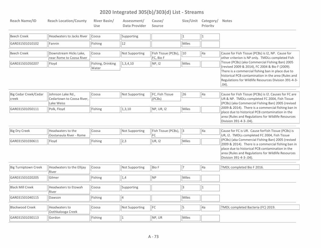
2020 Integrated 305(b)/303(d) List - Streams
Reach Name/ID Reach Location/County River Basin/Use
Assessment/Data Provider
Cause/Source
Size/Unit Category/Priority
Notes
Beech Creek
GAR031501010102 12
Headwaters to Jacks River
Fannin
Coosa
Fishing
Supporting 1
Miles
1
Beech Creek
GAR031501050207 1,3,4,10
Downstream Hicks Lake, near Rome to Coosa River
Floyd
Coosa
Fishing, Drinking Water
Not Supporting Fish Tissue (PCBs), FC, Bio F
10
Miles
4a Cause for Fish Tissue (PCBs) is I2, NP. Cause for other criterion is NP only. TMDLs completed Fish Tissue (PCBs) (aka Commercial Fishing Ban) 2005 (revised 2009 & 2014), FC 2004 & Bio F (2009). There is a commercial fishing ban in place due to historical PCB contamination in the area (Rules and Regulations for Wildlife Resources Division 391-4-3-.04).
NP, I2
Big Cedar Creek/Cedar creek
GAR031501050111 1,3,10
Johnson Lake Rd., Cedartown to Coosa River, Lake Weiss
Polk, Floyd
Coosa
Fishing
Not Supporting FC, Fish Tissue (PCBs)
26
Miles
4a Cause for Fish Tissue (PCBs) is I2. Causes for FC are UR & NP. TMDLs completed FC 2004, Fish Tissue (PCBs) (aka Commercial Fishing Ban) 2005 (revised 2009 & 2014). There is a commercial fishing ban in place due to historical PCB contamination in the area (Rules and Regulations for Wildlife Resources Division 391-4-3-.04).
NP, UR, I2
Big Dry Creek
GAR031501030611 2,3
Headwaters to the Oostanaula River - Rome
Floyd
Coosa
Fishing
Not Supporting Fish Tissue (PCBs), FC
3
Miles
4a Cause for FC is UR. Cause forFish Tissue (PCBs) is UR, I2. TMDLs completed FC 2004, Fish Tissue (PCBs) (aka Commercial Fishing Ban) 2005 (revised 2009 & 2014). There is a commercial fishing ban in place due to historical PCB contamination in the area (Rules and Regulations for Wildlife Resources Division 391-4-3-.04).
UR, I2
Big Turniptown Creek
GAR031501020205 1,4
Headwaters to the Ellijay River
Gilmer
Coosa
Fishing
Not Supporting Bio F 7
Miles
4a TMDL completed Bio F 2016.
NP
Black Mill Creek
GAR031501040115 4
Headwaters to Etowah River
Dawson
Coosa
Fishing
Supporting 3
Miles
1
Blackwood Creek
GAR031501030113 1
Headwaters to Oothkalooga Creek
Gordon
Coosa
Fishing
Not Supporting FC 5
Miles
4a TMDL completed Bacteria (FC) 2019.
NP, UR
A - 73

2020 Integrated 305(b)/303(d) List - Streams
Reach Name/ID Reach Location/County River Basin/Use
Assessment/Data Provider
Cause/Source
Size/Unit Category/Priority
Notes
Blankets Creek
GAR031501040807 24
Lake Allatoona Tributary
Cherokee
Coosa
Fishing
Supporting 3
Miles
1
Blue Springs Creek
GAR031501030210 4
Headwaters to Camp Creek
Gordon
Coosa
Fishing
Supporting 3
Miles
1
Bluff Creek
GAR031501040507 4
Moore Lake to Soap Creek
Cherokee
Coosa
Fishing
Supporting 7
Miles
1
Bluffy Creek
GAR031501041110 1
Goldmine Lake to Pumpkinvine Creek
Paulding
Coosa
Fishing
Supporting 4
Miles
1
Board Tree Creek
GAR031501040304 4
Headwaters to Etowah River
Cherokee
Coosa
Fishing
Supporting 5
Miles
1
Boardtown Creek
GAR031501020209 4
Headwaters to Jones Creek/Bryant Creek
Fannin, Gilmer
Coosa
Fishing
Not Supporting Bio F 6
Miles
4a TMDL completed Bio F 2016.
NP
Boardtown Creek
GAR031501020206 1,4
Jones Creek/Bryant Creek to the Ellijay River
Gilmer
Coosa
Fishing
Supporting 1
Miles
1
Booze Creek
GAR031501041608 4
Headwaters to Silver Creek
Floyd
Coosa
Fishing
Supporting 5
Miles
1
Boston Creek
GAR031501041005 4,24
Lake Allatoona Tributary
Barrow, Cherokee
Coosa
Fishing
Supporting 6
Miles
1 TMDL completed Bio F 2016.
Bow Creek
GAR031501030207 1,4
Headwaters to Oostanula River
Gordon
Coosa
Fishing
Not Supporting FC, Bio F 5
Miles
4a, 5
2023
TMDL completed Bio F 2009.
NP
A - 74

2020 Integrated 305(b)/303(d) List - Streams
Reach Name/ID Reach Location/County River Basin/Use
Assessment/Data Provider
Cause/Source
Size/Unit Category/Priority
Notes
Brewton Creek
GAR031501040305 4
Etowah River Subwatershed No. 1 Dam to Bannister Creek
Forsyth
Coosa
Fishing
Supporting 2
Miles
1
Briar Creek
GAR031501020210 4
Headwaters to the Ellijay River
Gilmer
Coosa
Fishing
Supporting 4
Miles
1
Bryant Creek
GAR031501020523 4
Headwaters to Scarecorn Creek
Pickens
Coosa
Fishing
Not Supporting Bio F 4
Miles
4a TMDL completed Bio F 2016.
NP
Burt Creek
GAR031501040101 4
Headwaters to Shoal Creek
Dawson
Coosa
Fishing
Supporting 4
Miles
1
Burwell Creek
GAR031501030601 3
Tributary to the Oostanaula River - Rome
Floyd
Coosa
Fishing
Not Supporting Fish Tissue (PCBs) 3
Miles
4a TMDL completed Fish Tissue (PCBs) (aka Commercial Fishing Ban) 2005 (revised 2009 & 2014). There is a commercial fishing ban in place due to historical PCB contamination in the area (Rules and Regulations for Wildlife Resources Division 391-4-3-.04).
I2
Butler Creek
GAR031501040901 4,14
Headwaters to Lake Acworth
Cobb
Coosa
Fishing
Not Supporting Bio F 6
Miles
4a TMDLs completed FC (2004) & Bio F (2009).
UR
Byrd Creek
GAR031501040702 4
Headwaters to McCanless Creek
Cherokee
Coosa
Fishing
Supporting 4
Miles
1
Caldwell Mills Creek (aka Mills Creek)
GAR031501010302 4
Tenn. State Line to Coahulla Creek
Whitfield
Coosa
Fishing
Supporting 3
Miles
1
Camp Creek
GAR031501040111 4
Headwaters to Etowah River
Lumpkin
Coosa
Fishing
Supporting 3
Miles
1
A - 75

2020 Integrated 305(b)/303(d) List - Streams
Reach Name/ID Reach Location/County River Basin/Use
Assessment/Data Provider
Cause/Source
Size/Unit Category/Priority
Notes
Camp Creek
GAR031501030209 1,4
Dry Creek to Oostanaula River
Gordon
Coosa
Fishing
Not Supporting FC 3
Miles
4a TMDL completed FC 2009.
NP
Cane Creek
GAR031501050412 4,59
Headwaters to Dry Creek
Walker
Coosa
Fishing
Supporting 10
Miles
1
Cane Creek
GAR031501050410 10
Dry Creek to Chattooga River
Walker, Chattooga
Coosa
Fishing
Not Supporting FC 7
Miles
4a TMDL completed FC 2004.
UR
Canton Creek
GAR031501040603 4
Mill Canton Creek Structure No. Seven Dam to Scott Mill Creek
Cherokee
Coosa
Fishing
Supporting 7
Miles
1
Cartecay River
GAR031501020110 1
Licklog Creek to Clear Creek
Gilmer
Coosa
Fishing
Not Supporting pH 5
Miles
5
2028NP
Cartecay River
GAR031501020101 1,10
Owltown Creek to Coosawattee River
Gilmer
Coosa
Fishing
Not Supporting FC 3
Miles
4a TMDL completed FC 2004.
NP
Cedar Creek
GAR031501020703 4
Ballard Creek to Pine Log Creek
Bartow, Gordon
Coosa
Fishing
Not Supporting Bio F 5
Miles
4a TMDL completed Bio F 2009.
NP
Cedar Creek
GAR031501050112 4
Headwaters to Johnson Lake Road
Polk
Coosa
Fishing
Supporting 7
Miles
1
Champion Creek
GAR031501040404 4
Grandview Lake to Hinton Creek
Pickens
Coosa
Fishing
Supporting 2
Miles
1
A - 76

2020 Integrated 305(b)/303(d) List - Streams
Reach Name/ID Reach Location/County River Basin/Use
Assessment/Data Provider
Cause/Source
Size/Unit Category/Priority
Notes
Chappel Creek
GAR031501050406 4
Headwaters to unnamed trib. near Halls Valley Rd.
Chattooga, Walker
Coosa
Fishing
Supporting 7
Miles
1
Chappel Creek
GAR031501050402 2,4
Upstream Chattooga River, Trion
Chattooga
Coosa
Fishing
Not Supporting FC 2
Miles
4a TMDL completed FC 1998.
NP
Chastain Branch
GAR031501040805 14
Tributary to Noonday Creek
Cobb
Coosa
Fishing
Supporting 2
Miles
1 TMDL completed FC 1998.
Chattooga River
GAR031501050403 1,4,10
Towns Creek to Duck Creek
Walker
Coosa
Fishing
Not Supporting Bio F 10
Miles
4a TMDL completed Bio F 2009.
NP
Chattooga River
GAR031501050415 1
Spring Creek to Cane Creek
Chattooga
Coosa
Fishing
Not Supporting DO 4
Miles
5
2023NP
Chattooga River
GAR031501050608 1,40
Cane Creek, Trion to Henry Branch
Chattooga
Coosa
Fishing
Not Supporting FC 7
Miles
4a TMDL completed FC 2004.
NP
Chattooga River
GAR031501050609 1,10
Henry Branch to Lyerly
Chattooga
Coosa
Fishing
Not Supporting FC 8
Miles
4a TMDL completed FC 2004.
NP
Chattooga River
GAR031501050603 1,10
Lyerly to Stateline
Chattooga
Coosa
Fishing
Not Supporting FC 7
Miles
4a TMDL completed FC 2009.
NP
Chelsea Creek
GAR031501050407 4
Headwaters to Teloga Creek
Chattooga
Coosa
Fishing
Not Supporting Bio F 4
Miles
4a TMDL completed Bio F 2009.
NP
Cherry Log Creek (aka Ellijay River)
GAR031501020211 4
Headwaters to Laurel Creek
Fannin, Gilmer
Coosa
Fishing
Not Supporting Bio F 5
Miles
4a TMDL completed Bio F 2016.
NP, UR
A - 77

2020 Integrated 305(b)/303(d) List - Streams
Reach Name/ID Reach Location/County River Basin/Use
Assessment/Data Provider
Cause/Source
Size/Unit Category/Priority
Notes
Cherry Log Creek (aka Ellijay River)
GAR031501020212 4
Laurel Creek to Rock Creek
Gilmer
Coosa
Fishing
Not Supporting Bio F 3
Miles
4a TMDL completed Bio F 2016.
NP, UR
Chicken Creek
GAR031501040818 1
Headwaters to Little River
Fulton, Forsyth
Coosa
Fishing
Supporting 9
Miles
1
Clark Creek
GAR031501040912 1
Headwaters to Lake Allatoona
Cobb, Cherokee
Coosa
Fishing
Not Supporting FC 5
Miles
5
2023UR
Clear Creek
GAR031501041006 24
Lake Allatoona Tributary
Bartow
Coosa
Fishing
Supporting 2
Miles
1
Clear Creek
GAR031501020104 4
Headwaters to Cartecay River
Pickens, Gilmer
Coosa
Fishing
Not Supporting Bio F 13
Miles
5
2023NP
Clear Creek
GAR031501020114 1
Headwaters to Cartecay River
Gilmer
Coosa
Fishing
Not Supporting pH 2
Miles
5
2028NP
Clear Creek
GAR031501041507 4
Clear Lake to Mud Creek
Bartow
Coosa
Fishing
Supporting 2
Miles
1
Coahulla Creek
GAR031501010303 4
Tenn. State Line to CR 183
Whitfield
Coosa
Fishing
Supporting 4
Miles
1
Coahulla Creek
GAR031501010312 1
Wilson Creek (aka Little Creek) to Kenyon Creek/Station Branch
Whitfield
Coosa
Fishing
Supporting 4
Miles
1
Coahulla Creek
GAR031501010301 1,10
Below 728 Road to Mill Creek
Whitfield
Coosa
Drinking Water, Fishing
Not Supporting FC 5
Miles
4a TMDL completed FC 2004.
NP
A - 78
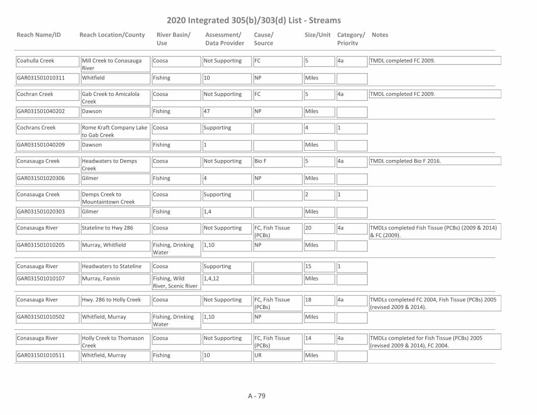
2020 Integrated 305(b)/303(d) List - Streams
Reach Name/ID Reach Location/County River Basin/Use
Assessment/Data Provider
Cause/Source
Size/Unit Category/Priority
Notes
Coahulla Creek
GAR031501010311 10
Mill Creek to Conasauga River
Whitfield
Coosa
Fishing
Not Supporting FC 5
Miles
4a TMDL completed FC 2009.
NP
Cochran Creek
GAR031501040202 47
Gab Creek to Amicalola Creek
Dawson
Coosa
Fishing
Not Supporting FC 5
Miles
4a TMDL completed FC 2009.
NP
Cochrans Creek
GAR031501040209 1
Rome Kraft Company Lake to Gab Creek
Dawson
Coosa
Fishing
Supporting 4
Miles
1
Conasauga Creek
GAR031501020306 4
Headwaters to Demps Creek
Gilmer
Coosa
Fishing
Not Supporting Bio F 5
Miles
4a TMDL completed Bio F 2016.
NP
Conasauga Creek
GAR031501020303 1,4
Demps Creek to Mountaintown Creek
Gilmer
Coosa
Fishing
Supporting 2
Miles
1
Conasauga River
GAR031501010205 1,10
Stateline to Hwy 286
Murray, Whitfield
Coosa
Fishing, Drinking Water
Not Supporting FC, Fish Tissue (PCBs)
20
Miles
4a TMDLs completed Fish Tissue (PCBs) (2009 & 2014) & FC (2009).
NP
Conasauga River
GAR031501010107 1,4,12
Headwaters to Stateline
Murray, Fannin
Coosa
Fishing, Wild River, Scenic River
Supporting 15
Miles
1
Conasauga River
GAR031501010502 1,10
Hwy. 286 to Holly Creek
Whitfield, Murray
Coosa
Fishing, Drinking Water
Not Supporting FC, Fish Tissue (PCBs)
18
Miles
4a TMDLs completed FC 2004, Fish Tissue (PCBs) 2005 (revised 2009 & 2014).
NP
Conasauga River
GAR031501010511 10
Holly Creek to Thomason Creek
Whitfield, Murray
Coosa
Fishing
Not Supporting FC, Fish Tissue (PCBs)
14
Miles
4a TMDLs completed for Fish Tissue (PCBs) 2005 (revised 2009 & 2014), FC 2004.
UR
A - 79

2020 Integrated 305(b)/303(d) List - Streams
Reach Name/ID Reach Location/County River Basin/Use
Assessment/Data Provider
Cause/Source
Size/Unit Category/Priority
Notes
Conasauga River
GAR031501010512 1,10
Thomason Creek to the Oostanaula River
Whitfield, Murray, Gordon
Coosa
Fishing
Not Supporting Fish Tissue (PCBs) 11
Miles
4a TMDLs completed for Fish Tissue (PCBs) 2005 (revised 2009 & 2014), FC 2004.
UR
Concord Creek
GAR031501030503 4
Headwaters to East Armuchee Creek
Walker
Coosa
Fishing
Supporting 5
Miles
1
Conn Creek
GAR031501040309 4
Headwaters to the Etowah River
Pickens, Cherokee
Coosa
Fishing
Supporting 6
Miles
1
Connesena Creek
GAR031501041508 1,3,4,9,10
Sipsey Creek to Etowah River
Bartow
Coosa
Fishing
Not Supporting Fish Tissue (PCBs), Bio F, Bio M, FC
6
Miles
4a Causes of Fish Tissue (PCBs) are I2 & NP. Cause for Bio F, Bio M & FC is NP. TMDLs completed Fish Tissue (PCBs) (aka Commerical Fishing Ban) 2005 (revised 2009 & 2014), Bio M 2004, Bio F 2009, Bacteria (FC) 2019. There is a commercial fishing ban in place due to historical PCB contamination in the area (Rules and Regulations for Wildlife Resources Division 391-4-3-.04).
NP, I2
Cooper Creek
GAR031501041007 24
Lake Allatoona Tributary
Bartow
Coosa
Fishing
Supporting 1
Miles
1
Cooper Sandy Creek
GAR031501040823 4
Headwaters to Tributary 0.6 miles upstream of New Providence Road
Fulton
Coosa
Fishing
Not Supporting Bio F 6
Miles
4a TMDL completed Bio F 2016.
NP, UR
Cooper Sandy Creek
GAR031501040824 4
Tributary 0.6 miles upstream of New Providence Road to Little River
Fulton
Coosa
Fishing
Supporting 1
Miles
1 TMDL completed Bio F 2016.
Coosa River
GAR031501050208 1,3,10
Rome to Beach Creek
Floyd
Coosa
Fishing
Not Supporting Fish Tissue (PCBs) 14
Miles
4a TMDLs completed Fish Tissue (PCBs) (2005 (revised 2009 & 2014), FC 2004. There is a commercial fishing ban in place due to historical PCB contamination in the area (Rules and Regulations for Wildlife Resources Division 391-4-3-.04).
UR, I2
A - 80

2020 Integrated 305(b)/303(d) List - Streams
Reach Name/ID Reach Location/County River Basin/Use
Assessment/Data Provider
Cause/Source
Size/Unit Category/Priority
Notes
Coosa River
GAR031501050209 1,3,10
Beach Creek to Stateline
Floyd
Coosa
Fishing, Recreation
Not Supporting E Coli, Fish Tissue (PCBs), Temp
17
Miles
4a, 4b, 5
2023
The Recreation use is impaired for E. coli. Cause for Temp is I1. Cause for other parameters is I2 except for E. coli which has a cause of NP. TMDLs completed Fish Tissue (PCBs) 2005 (revised 2009 & 2014) & DO 2004. There is a commercial fishing ban in place due to historical PCB contamination in the area (Rules and Regulations for Wildlife Resources Division 391-4-3-.04). The NPDES permit for GA Power Plant Hammond addresses the Temperature issue. The facility retired all units at the end of July 2019 and no longer contribute a thermal load.
NP, I2, I1
Coosawattee River
GAR031501020411 1,10
Confluence with Ellijay River to unnamed tributary 250 ft downstream of Newport Dr. & Legion Rd. intersection
Gilmer
Coosa
Fishing
Not Supporting FC 3
Miles
4a TMDL completed FC 2004.
UR
Coosawattee River
GAR031501020412 1
Unnamed tributary 250 ft d/s of Newport Dr & Legion Rd. intersection to Mountaintown Creek
Gilmer
Coosa
Fishing
Supporting 6
Miles
1 TMDL completed FC 2004.
Coosawattee River
GAR031501020801 1
U.S. Hwy. 411 to Noblet Creek, downstream Carters Lake
Murray, Gordon
Coosa
Drinking Water, Fishing
Not Supporting Fish Tissue (PCBs) 10
Miles
4a TMDL completed Fish Tissue (PCBs) 2014. The water is in Category 3 for Fish Tissue (Mercury) because the concentration = 0.3 mg/kg. The water is supporting its Drinking Water Use, but not its Fishing Use.
NP, UR
Coosawattee River
GAR031501020811 1
Noblet Creek to Salacoa Creek
Gordon
Coosa
Drinking Water, Fishing
Not Supporting Fish Tissue (PCBs) 5
Miles
4a TMDL completed Fish Tissue (PCBs) 2014. The water is in Category 3 for Fish Tissue (Mercury) because the concentration = 0.3 mg/kg. The water is not supporting its Fishing Use. Data are not available to assess the Drinking Water Use.
NP, UR
A - 81

2020 Integrated 305(b)/303(d) List - Streams
Reach Name/ID Reach Location/County River Basin/Use
Assessment/Data Provider
Cause/Source
Size/Unit Category/Priority
Notes
Coosawattee River
GAR031501020802 1,10
Salacoa Creek to Oostanaula River
Gordon
Coosa
Drinking Water, Fishing
Not Supporting Fish Tissue (PCBs) 10
Miles
4a TMDL completed Fish Tissue (PCBs) (2009 & 2014). The water is in Category 3 for Fish Tissue (Mercury) because the concentration = 0.3 mg/kg. The water is supporting its Drinking Water Use, but not its Fishing Use.
NP, UR
Cox Creek
GAR031501020202 57
Headwaters to Ellijay River
Gilmer
Coosa
Fishing
Not Supporting FC 3
Miles
4a TMDL completed FC 1998.
UR
Crane Eater Creek
GAR031501020806 1,4
Headwaters to Coosawattee River
Gordon
Coosa
Fishing
Not Supporting FC, Bio F 3
Miles
5
2023NP
Darnell Creek
GAR031501040401 4
Headwaters to East Branch
Pickens
Coosa
Fishing
Supporting 4
Miles
1
Davis Creek
GAR031501020304 1,4
Rainbow Lake to Conasauga Creek
Gilmer
Coosa
Fishing
Not Supporting Bio F 5
Miles
5
2023NP
Dead Mans Branch
GAR031501010513 1
Headwaters to Polecat Creek
Gordon
Coosa
Fishing
Not Supporting FC 2
Miles
5
2023
EPD needs to determine if the low DO observed was due to the presence of a beaver dam.
NP
Dill Creek
GAR031501010403 4
Headwaters to Holly Creek
Murray
Coosa
Fishing
Supporting 3
Miles
1
Downing Creek
GAR031501041008 1,24
Lake Allatoona Tributary
Cherokee
Coosa
Fishing
Supporting 2
Miles
1
Dozier Creek
GAR031501030602 1,3,10,59
Oostanaula River Tributary
Floyd
Coosa
Fishing
Not Supporting FC, Fish Tissue (PCBs)
3
Miles
4a Cause for Fish Tissue (PCBs) is I2. Cause for FC is NP. TMDLs completed Fish Tissue (PCBs) (aka Commercial Fishing Ban) 2005 (revised 2009 & 2014) & FC (2009). There is a commercial fishing ban in place due to historical PCB contamination in the area (Rules and Regulations for Wildlife Resources Division 391-4-3-.04).
NP, I2
A - 82
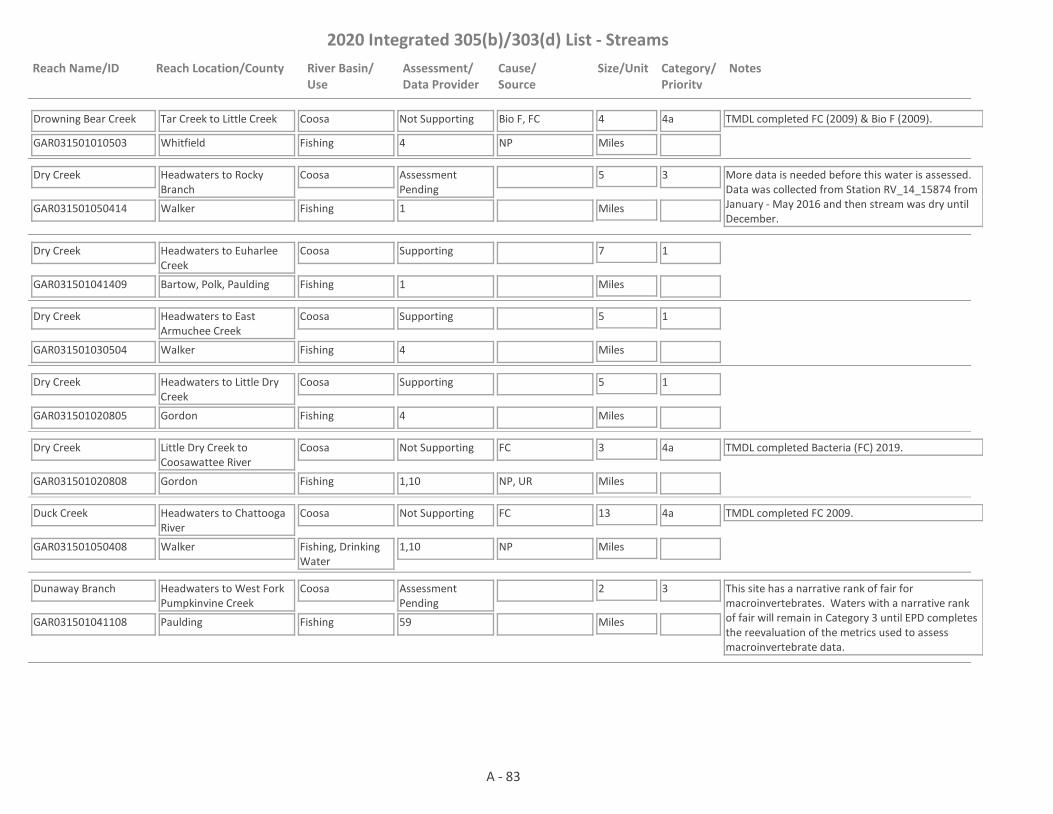
2020 Integrated 305(b)/303(d) List - Streams
Reach Name/ID Reach Location/County River Basin/Use
Assessment/Data Provider
Cause/Source
Size/Unit Category/Priority
Notes
Drowning Bear Creek
GAR031501010503 4
Tar Creek to Little Creek
Whitfield
Coosa
Fishing
Not Supporting Bio F, FC 4
Miles
4a TMDL completed FC (2009) & Bio F (2009).
NP
Dry Creek
GAR031501050414 1
Headwaters to Rocky Branch
Walker
Coosa
Fishing
Assessment Pending
5
Miles
3 More data is needed before this water is assessed. Data was collected from Station RV_14_15874 from January - May 2016 and then stream was dry until December.
Dry Creek
GAR031501041409 1
Headwaters to Euharlee Creek
Bartow, Polk, Paulding
Coosa
Fishing
Supporting 7
Miles
1
Dry Creek
GAR031501030504 4
Headwaters to East Armuchee Creek
Walker
Coosa
Fishing
Supporting 5
Miles
1
Dry Creek
GAR031501020805 4
Headwaters to Little Dry Creek
Gordon
Coosa
Fishing
Supporting 5
Miles
1
Dry Creek
GAR031501020808 1,10
Little Dry Creek to Coosawattee River
Gordon
Coosa
Fishing
Not Supporting FC 3
Miles
4a TMDL completed Bacteria (FC) 2019.
NP, UR
Duck Creek
GAR031501050408 1,10
Headwaters to Chattooga River
Walker
Coosa
Fishing, Drinking Water
Not Supporting FC 13
Miles
4a TMDL completed FC 2009.
NP
Dunaway Branch
GAR031501041108 59
Headwaters to West Fork Pumpkinvine Creek
Paulding
Coosa
Fishing
Assessment Pending
2
Miles
3 This site has a narrative rank of fair for macroinvertebrates. Waters with a narrative rank of fair will remain in Category 3 until EPD completes the reevaluation of the metrics used to assess macroinvertebrate data.
A - 83

2020 Integrated 305(b)/303(d) List - Streams
Reach Name/ID Reach Location/County River Basin/Use
Assessment/Data Provider
Cause/Source
Size/Unit Category/Priority
Notes
Dykes Creek
GAR031501041605 1,4,9,10,59
Headwaters to Etowah River
Floyd
Coosa
Fishing
Not Supporting Bio M, Fish Tissue (PCBs)
7
Miles
4a TMDLs completed Bio M (2004), Fish Tissue (PCBs) (aka Commercial Fishing Ban) (2009 & 2014) & FC (2009). There is a commercial fishing ban in place due to historical PCB contamination in the area (Rules and Regulations for Wildlife Resources Division 391-4-3-.04).
NP
East Armuchee Creek
GAR031501030505 4
Headwaters to Dry Creek (formerly Headwaters to Furnace Creek)
Walker
Coosa
Fishing
Supporting 5
Miles
1
East Armuchee Creek
GAR031501030512 59
Dry Creek to West Armuchee Creek (formerly Furnace Creek to West Armuchee Creek)
Walker, Chattooga
Coosa
Fishing
Assessment Pending
15
Miles
3 This site has a narrative rank of fair for macroinvertebrates. Waters with a narrative rank of fair will remain in Category 3 until EPD completes the reevaluation of the metrics used to assess macroinvertebrate data.
East Branch Long Swamp Creek
GAR031501040407 1,4
Headwaters to Cox Lake
Pickens
Coosa
Fishing
Not Supporting Bio F 3
Miles
4a TMDL completed Bio F 2016.
NP
East Branch Long Swamp Creek
GAR031501040408 4
Cox Lake to Long Swamp Creek
Pickens
Coosa
Fishing
Supporting 5
Miles
1
East Fork Little River
GAR031501050701 1,4,10,59
Headwaters to Alabama State Line (near Menlo, GA)
Chattooga
Coosa
Fishing
Not Supporting Bio M 10
Miles
4a TMDL completed Bio M 2016.
NP
East Fork Little River
GAR031501050703 10
Headwaters to Alabama State Line
Walker, Dade
Coosa
Fishing
Supporting 5
Miles
1
Edward Creek
GAR031501040604 4
Headwaters to the Etowah River
Cherokee
Coosa
Fishing
Supporting 3
Miles
1 TMDL completed Bio F 2016.
A - 84
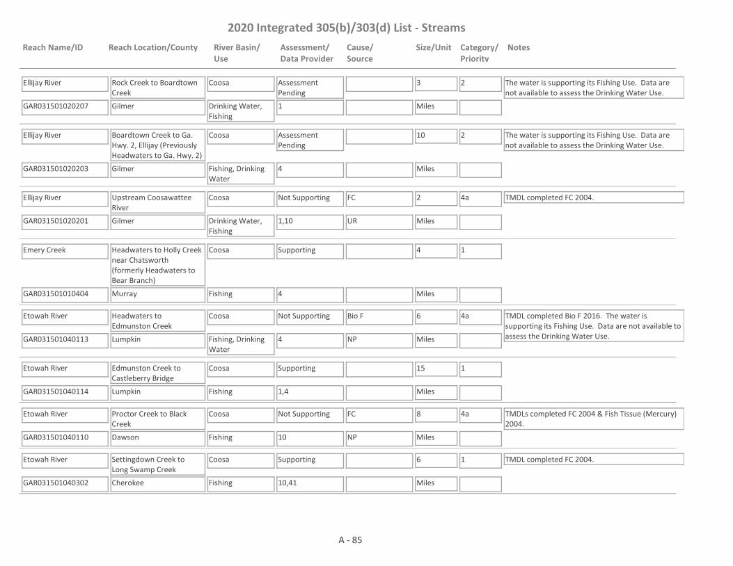
2020 Integrated 305(b)/303(d) List - Streams
Reach Name/ID Reach Location/County River Basin/Use
Assessment/Data Provider
Cause/Source
Size/Unit Category/Priority
Notes
Ellijay River
GAR031501020207 1
Rock Creek to Boardtown Creek
Gilmer
Coosa
Drinking Water, Fishing
Assessment Pending
3
Miles
2 The water is supporting its Fishing Use. Data are not available to assess the Drinking Water Use.
Ellijay River
GAR031501020203 4
Boardtown Creek to Ga. Hwy. 2, Ellijay (Previously Headwaters to Ga. Hwy. 2)
Gilmer
Coosa
Fishing, Drinking Water
Assessment Pending
10
Miles
2 The water is supporting its Fishing Use. Data are not available to assess the Drinking Water Use.
Ellijay River
GAR031501020201 1,10
Upstream Coosawattee River
Gilmer
Coosa
Drinking Water, Fishing
Not Supporting FC 2
Miles
4a TMDL completed FC 2004.
UR
Emery Creek
GAR031501010404 4
Headwaters to Holly Creek near Chatsworth (formerly Headwaters to Bear Branch)
Murray
Coosa
Fishing
Supporting 4
Miles
1
Etowah River
GAR031501040113 4
Headwaters to Edmunston Creek
Lumpkin
Coosa
Fishing, Drinking Water
Not Supporting Bio F 6
Miles
4a TMDL completed Bio F 2016. The water is supporting its Fishing Use. Data are not available to assess the Drinking Water Use.NP
Etowah River
GAR031501040114 1,4
Edmunston Creek to Castleberry Bridge
Lumpkin
Coosa
Fishing
Supporting 15
Miles
1
Etowah River
GAR031501040110 10
Proctor Creek to Black Creek
Dawson
Coosa
Fishing
Not Supporting FC 8
Miles
4a TMDLs completed FC 2004 & Fish Tissue (Mercury) 2004.
NP
Etowah River
GAR031501040302 10,41
Settingdown Creek to Long Swamp Creek
Cherokee
Coosa
Fishing
Supporting 6
Miles
1 TMDL completed FC 2004.
A - 85

2020 Integrated 305(b)/303(d) List - Streams
Reach Name/ID Reach Location/County River Basin/Use
Assessment/Data Provider
Cause/Source
Size/Unit Category/Priority
Notes
Etowah River
GAR031501040608 41
Long Swamp Creek to Sharp Mountain Creek
Cherokee
Coosa
Drinking Water, Fishing
Supporting 5
Miles
1
Etowah River
GAR031501040601 10,41
Sharp Mountain Creek to Lake Allatoona
Cherokee
Coosa
Fishing, Drinking Water
Not Supporting FC 16
Miles
4a TMDL completed FC 2009.
NP, UR
Etowah River
GAR031501041309 1,10
Lake Allatoona to Pumpkinvine Creek
Bartow
Coosa
Drinking Water, Fishing
Not Supporting Fish Tissue (PCBs), DO, pH
6
Miles
4a, 5
2028
TMDLs completed FC 2004, Fish Tissue (PCBs) 2005 (revised 2009 & 2014), DO 2000. The water is supporting its Drinking Water Use, but not its Fishing Use.
NP
Etowah River
GAR031501041310 1,10
Pumpkinvine Creek to Richland Creek
Bartow
Coosa
Fishing, Drinking Water
Not Supporting FC, Fish Tissue (PCBs)
7
Miles
4a TMDLs completed FC 2004, Fish Tissue (PCBs) 2005 (revised 2009 & 2014), DO 2000
NP
Etowah River
GAR031501041303 1
Richland Creek to Euharlee Creek
Bartow
Coosa
Fishing
Not Supporting Fish Tissue (PCBs) 4
Miles
4a TMDL completed Fish Tissue (PCBs) 2005 (revised 2009 & 2014).
NP
Etowah River
GAR031501041503 1,10
Euharlee Creek to US Hwy 411
Bartow
Coosa
Fishing
Not Supporting Fish Tissue (PCBs), FC
10
Miles
4a TMDLs completed FC 2004, Fish Tissue (PCBs) 2005 (revised 2009 & 2014).
UR
Etowah River
GAR031501041601 1,3,10
Hwy. 411 to Coosa River
Bartow, Floyd
Coosa
Fishing, Drinking Water
Not Supporting Fish Tissue (PCBs), FC
21
Miles
4a TMDLs completed FC 2004, Fish Tissue (PCBs) 2005 (revised 2009 & 2014). There is a commercial fishing ban in place due to historical PCB contamination in the area (Rules and Regulations for Wildlife Resources Division 391-4-3-.04).
NP, I2, UR
Euharlee Creek
GAR031501041404 1,4
Parham Springs to Simpson Creek
Polk
Coosa
Drinking Water, Fishing
Supporting 5
Miles
1
A - 86
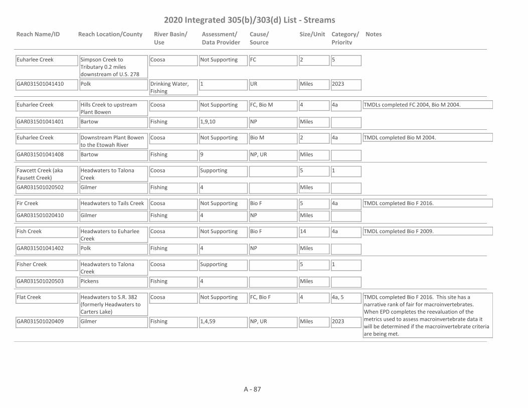
2020 Integrated 305(b)/303(d) List - Streams
Reach Name/ID Reach Location/County River Basin/Use
Assessment/Data Provider
Cause/Source
Size/Unit Category/Priority
Notes
Euharlee Creek
GAR031501041410 1
Simpson Creek to Tributary 0.2 miles downstream of U.S. 278
Polk
Coosa
Drinking Water, Fishing
Not Supporting FC 2
Miles
5
2023UR
Euharlee Creek
GAR031501041401 1,9,10
Hills Creek to upstream Plant Bowen
Bartow
Coosa
Fishing
Not Supporting FC, Bio M 4
Miles
4a TMDLs completed FC 2004, Bio M 2004.
NP
Euharlee Creek
GAR031501041408 9
Downstream Plant Bowen to the Etowah River
Bartow
Coosa
Fishing
Not Supporting Bio M 2
Miles
4a TMDL completed Bio M 2004.
NP, UR
Fawcett Creek (aka Fausett Creek)
GAR031501020502 4
Headwaters to Talona Creek
Gilmer
Coosa
Fishing
Supporting 5
Miles
1
Fir Creek
GAR031501020410 4
Headwaters to Tails Creek
Gilmer
Coosa
Fishing
Not Supporting Bio F 5
Miles
4a TMDL completed Bio F 2016.
NP
Fish Creek
GAR031501041402 4
Headwaters to Euharlee Creek
Polk
Coosa
Fishing
Not Supporting Bio F 14
Miles
4a TMDL completed Bio F 2009.
NP
Fisher Creek
GAR031501020503 4
Headwaters to Talona Creek
Pickens
Coosa
Fishing
Supporting 5
Miles
1
Flat Creek
GAR031501020409 1,4,59
Headwaters to S.R. 382 (formerly Headwaters to Carters Lake)
Gilmer
Coosa
Fishing
Not Supporting FC, Bio F 4
Miles
4a, 5
2023
TMDL completed Bio F 2016. This site has a narrative rank of fair for macroinvertebrates. When EPD completes the reevaluation of the metrics used to assess macroinvertebrate data it will be determined if the macroinvertebrate criteria are being met.
NP, UR
A - 87

2020 Integrated 305(b)/303(d) List - Streams
Reach Name/ID Reach Location/County River Basin/Use
Assessment/Data Provider
Cause/Source
Size/Unit Category/Priority
Notes
Flat Creek
GAR031501020402 1,4,59
S.R. 382 to the Coosawattee River (formerly u/s Coosawattee River)
Gilmer
Coosa
Fishing
Not Supporting FC, Bio F 1
Miles
4a TMDLs completed FC 2004 & Bio F 2016. This site has a narrative rank of fair for macroinvertebrates. When EPD completes the reevaluation of the metrics used to assess macroinvertebrate data it will be determined if the macroinvertebrate criteria are being met.
NP
Fourmile Creek
GAR031501040402 4
Headwaters to Long Swamp Creek
Pickens
Coosa
Fishing
Not Supporting Bio F 5
Miles
4a TMDL completed Bio F 2016.
NP
Fuller Branch
GAR031501020611 1
Brannon Lake to Salacoa Creek
Gordon, Bartow
Coosa
Fishing
Not Supporting FC 1
Miles
5
2023NP
Furnace Creek
GAR031501030506 4
Headwaters to East Armuchee Creek
Walker
Coosa
Fishing
Supporting 2
Miles
1
Goldmine Branch/Rock Creek
GAR031501010409 4
Fort Mountain Lake to Holly Creek
Murray
Coosa
Fishing
Supporting 4
Miles
1 TMDL completed Bio F 2016.
Griffin/Lawrence Creek
GAR031501041107 4
Braly Lake to Pumpkinvine Creek
Paulding
Coosa
Fishing
Not Supporting Bio F 4
Miles
4a TMDL completed Bio F 2009.
NP, UR
Haig Mill Creek
GAR031501010306 4
Haig Mill Lake to Mill Creek
Whitfield
Coosa
Fishing
Not Supporting Bio F 1
Miles
4a TMDL completed Bio F 2009.
NP
Hamilton Creek
GAR031501050210 3
Coosa River Tributary
Floyd
Coosa
Fishing
Not Supporting Fish Tissue (PCBs) 5
Miles
4a TMDL completed Fish Tissue (PCBs) (aka Commercial Fishing Ban) 2005 (revised 2009 & 2014). There is a commercial fishing ban in place due to historical PCB contamination in the area (Rules and Regulations for Wildlife Resources Division 391-4-3-.04).
I2
Harris Creek
GAR031501020404 1,4
Upstream Carters Lake
Gilmer
Coosa
Fishing
Not Supporting Bio F 3
Miles
4a TMDL completed Bio F 2016.
NP
A - 88

2020 Integrated 305(b)/303(d) List - Streams
Reach Name/ID Reach Location/County River Basin/Use
Assessment/Data Provider
Cause/Source
Size/Unit Category/Priority
Notes
Harrisburg Creek
GAR031501050409 59
Headwaters (Allen Creek) to Spring Creek
Walker
Coosa
Fishing
Assessment Pending
2
Miles
3 This site has a narrative rank of fair for macroinvertebrates. When EPD completes the reevaluation of the metrics used to assess macroinvertebrate data it will be determined if the macroinvertebrate criteria are being met.
Heath Creek
GAR031501030401 1
Upstream Rocky Mtn. Project
Floyd
Coosa
Fishing
Supporting 1
Miles
1
Heath Creek
GAR031501030402 1,4,10
Downstream Rocky Mountain Project
Floyd
Coosa
Fishing
Not Supporting FC 5
Miles
4a TMDL completed FC 2009.
NP
Hickory Creek
GAR031501010103 12
Headwaters to Conasauga River
Murray, Fannin
Coosa
Fishing
Supporting 4
Miles
1
Hickory Log Creek
GAR031501040605 4
Headwaters to the Etowah River
Cherokee
Coosa
Fishing
Supporting 8
Miles
1
Hills Creek
GAR031501041406 4
Coots Lake to Euharlee Creek
Polk, Bartow
Coosa
Fishing
Supporting 13
Miles
1 TMDL completed Bio F 2009.
Hinton Creek
GAR031501050604 4
Headwaters to Chattooga River
Chattooga
Coosa
Fishing
Supporting 5
Miles
1
Hinton Creek
GAR031501040405 4
Champion Creek to Long Swamp Creek
Pickens
Coosa
Fishing
Supporting 2
Miles
1
Hobson Creek
GAR031501020504 4
Tributary to Mill Creek (formerly Tributary to Talking Rock Creek)
Pickens
Coosa
Fishing
Not Supporting Bio F 2
Miles
4a TMDL completed Bio F 2016.
NP
A - 89

2020 Integrated 305(b)/303(d) List - Streams
Reach Name/ID Reach Location/County River Basin/Use
Assessment/Data Provider
Cause/Source
Size/Unit Category/Priority
Notes
Holly Creek
GAR031501040203 4,47
Headwaters to Amicalola Creek
Dawson
Coosa
Fishing
Not Supporting FC, Bio F 4
Miles
4a TMDLs completed FC (2009) & Bio F (2009).
NP
Holly Creek
GAR031501010405 1,4,59
Headwaters to Dill Creek (previously Headwaters to Bear Branch)
Murray
Coosa
Fishing
Assessment Pending
7
Miles
3 This site has a narrative rank of fair for macroinvertebrates. When EPD completes the reevaluation of the metrics used to assess macroinvertebrate data it will be determined if the macroinvertebrate criteria are being met. pH is being placed in Category 3 based on 2013 data from RV_14_4447. The sonde was not working correctly for several months and more data is needed before making an assessment.
Holly Creek
GAR031501010402 10
Downstream Chatsworth
Murray
Coosa
Fishing, Drinking Water
Not Supporting FC 4
Miles
4a TMDL completed FC 2009.
UR
Holly Creek
GAR031501010401 10
Rock Creek to Conasauga River
Murray
Coosa
Fishing
Not Supporting FC 8
Miles
4a TMDL completed FC 2004. Fish Tissue (Mercury) is in Category 3 because the concentration = 0.3 mg/kgNP
Horseleg Creek
GAR031501050211 3,10
Headwaters to Coosa River - Rome
Floyd
Coosa
Fishing
Not Supporting Fish Tissue (PCBs), FC
4
Miles
4a Cause for Fish Tissue (PCBs) is I2. Cause for FC is NP. TMDLs completed Fish Tissue (PCBs) (aka Commercial Fishing Ban) 2005 (revised 2009 & 2014) & FC (2009). There is a commercial fishing ban in place due to historical PCB contamination in the area (Rules and Regulations for Wildlife Resources Division 391-4-3-.04).
I2, NP
Hurricane Creek
GAR031501040109 4
Mill Creek to Etowah River
Lumpkin
Coosa
Fishing
Not Supporting Bio F 3
Miles
4a TMDL completed Bio F 2009.
NP
Illinois Creek
GAR031501041009 24
Lake Allatoona Tributary
Bartow, Cherokee
Coosa
Fishing
Supporting 2
Miles
1
Jacks Creek
GAR031501020704 4
Headwaters to Pine Log Creek
Gordon
Coosa
Fishing
Not Supporting Bio F 6
Miles
4a TMDL completed Bio F 2009.
NP
A - 90
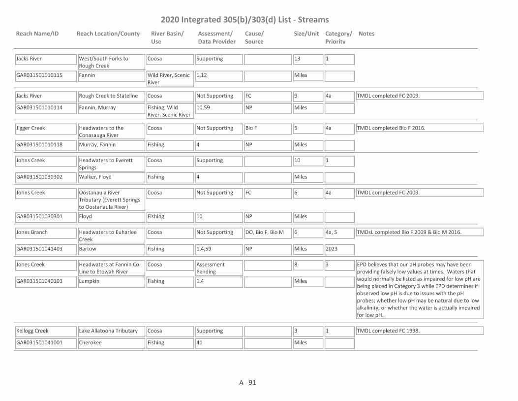
2020 Integrated 305(b)/303(d) List - Streams
Reach Name/ID Reach Location/County River Basin/Use
Assessment/Data Provider
Cause/Source
Size/Unit Category/Priority
Notes
Jacks River
GAR031501010115 1,12
West/South Forks to Rough Creek
Fannin
Coosa
Wild River, Scenic River
Supporting 13
Miles
1
Jacks River
GAR031501010114 10,59
Rough Creek to Stateline
Fannin, Murray
Coosa
Fishing, Wild River, Scenic River
Not Supporting FC 9
Miles
4a TMDL completed FC 2009.
NP
Jigger Creek
GAR031501010118 4
Headwaters to the Conasauga River
Murray, Fannin
Coosa
Fishing
Not Supporting Bio F 5
Miles
4a TMDL completed Bio F 2016.
NP
Johns Creek
GAR031501030302 4
Headwaters to Everett Springs
Walker, Floyd
Coosa
Fishing
Supporting 10
Miles
1
Johns Creek
GAR031501030301 10
Oostanaula River Tributary (Everett Springs to Oostanaula River)
Floyd
Coosa
Fishing
Not Supporting FC 6
Miles
4a TMDL completed FC 2009.
NP
Jones Branch
GAR031501041403 1,4,59
Headwaters to Euharlee Creek
Bartow
Coosa
Fishing
Not Supporting DO, Bio F, Bio M 6
Miles
4a, 5
2023
TMDsL completed Bio F 2009 & Bio M 2016.
NP
Jones Creek
GAR031501040103 1,4
Headwaters at Fannin Co. Line to Etowah River
Lumpkin
Coosa
Fishing
Assessment Pending
8
Miles
3 EPD believes that our pH probes may have been providing falsely low values at times. Waters that would normally be listed as impaired for low pH are being placed in Category 3 while EPD determines if observed low pH is due to issues with the pH probes; whether low pH may be natural due to low alkalinity; or whether the water is actually impaired for low pH.
Kellogg Creek
GAR031501041001 41
Lake Allatoona Tributary
Cherokee
Coosa
Fishing
Supporting 3
Miles
1 TMDL completed FC 1998.
A - 91

2020 Integrated 305(b)/303(d) List - Streams
Reach Name/ID Reach Location/County River Basin/Use
Assessment/Data Provider
Cause/Source
Size/Unit Category/Priority
Notes
Kells Creek
GAR031501020208 1,4
Gibson Lake to the Ellijay River
Gilmer
Coosa
Fishing
Supporting 3
Miles
1
Kenyon Creek/Station Branch
GAR031501010309 4
Headwaters (Varnell) to Coahulla Creek
Whitfield
Coosa
Fishing
Supporting 4
Miles
1
Ketchum Branch
GAR031501010314 1
Headwaters to Coahula Creek
Whitfield
Coosa
Fishing
Not Supporting FC 1
Miles
5
2023
DO is being placed in Category 3 until it can be determined if the low DO's observed were due to natural conditions.NP, M
Kings Creek
GAR031501050212 3,4,10,59
Coosa River Tributary
Floyd
Coosa
Fishing
Not Supporting Fish Tissue (PCBs), Bio F, FC
4
Miles
4a Causes for Fish Tissue (PCBs) & Bio F are I2 & NP. Cause for FC is NP. TMDL completed Fish Tissue (PCBs) (aka Commercial Fishing Ban) 2005 (revised 2009 & 2014), FC (2009), & Bio F (2009). There is a commercial fishing ban in place due to historical PCB contamination in the area (Rules and Regulations for Wildlife Resources Division 391-4-3-.04).
NP, I2
Lake Creek
GAR031501050117 1
Unnamed Tributary 0.12 miles d/s of Lake Creek Road to Big Cedar Creek/Cedar Creek
Floyd, Polk
Coosa
Fishing
Supporting 7
Miles
1
Lavendar Creek
GAR031501030502 1,4
Headwaters to Armuchee Creek
Floyd
Coosa
Fishing
Not Supporting Bio F 7
Miles
5
2023
TMDL completed FC 1998.
NP
Lick Creek
GAR031501020604 1,4
Headwaters to Redbud Creek
Gordon
Coosa
Fishing
Not Supporting Bio F 7
Miles
4a TMDL completed Bio F 2009.
NP
A - 92

2020 Integrated 305(b)/303(d) List - Streams
Reach Name/ID Reach Location/County River Basin/Use
Assessment/Data Provider
Cause/Source
Size/Unit Category/Priority
Notes
Lick Creek
GAR031501020605 1,4,59
Redbud Creek to Salacoa Creek
Gordon
Coosa
Fishing
Not Supporting FC, Bio F 4
Miles
4a, 5
2023
TMDL completed Bio F 2009. This site has a narrative rank of fair for macroinvertebrates. When EPD completes the reevaluation of the metrics used to assess macroinvertebrate data it will be determined if the macroinvertebrate criteria are being met.
NP
Licklog Creek
GAR031501020112 1,4
Postell Lake to the Cartecay River
Gilmer
Coosa
Fishing
Supporting 3
Miles
1
Little Allatoona Creek
GAR031501040906 14
Tributary to Allatoona Creek
Cobb
Coosa
Fishing
Supporting 3
Miles
1 TMDL completed FC 2004.
Little Amicalola Creek
GAR031501040204 4,47
Headwaters to Amicalola Creek
Dawson
Coosa
Fishing
Not Supporting FC 5
Miles
4a TMDL completed FC 2009.
NP
Little Armuchee Creek
GAR031501030403 4
Headwaters to Storey Mill Creek
Chattooga
Coosa
Fishing
Supporting 10
Miles
1
Little Armuchee Creek
GAR031501030405 1
Storey Mill Creek to Heath Creek
Chattooga, Floyd
Coosa
Fishing
Supporting 4
Miles
1
Little Cedar Creek
GAR031501050114 6
U/S Cedar Rock Lake
Polk
Coosa
Fishing
Supporting 1
Miles
1
Little Cedar Creek
GAR031501050113 4,59
Cedar Rock Lake to Cedar Creek (formerly Headwaters to Cedar Creek)
Polk, Floyd
Coosa
Fishing
Not Supporting Bio F 10
Miles
4a TMDL completed Bio F 2009. This site has a narrative rank of fair for macroinvertebrates. When EPD completes the reevaluation of the metrics used to assess macroinvertebrate data it will be determined if the macroinvertebrate criteria are being met.
NP
A - 93

2020 Integrated 305(b)/303(d) List - Streams
Reach Name/ID Reach Location/County River Basin/Use
Assessment/Data Provider
Cause/Source
Size/Unit Category/Priority
Notes
Little Dry Creek
GAR031501030603 3
Tributary to the Oostanaula River - Rome
Floyd
Coosa
Fishing
Not Supporting Fish Tissue (PCBs) 6
Miles
4a TMDL completed Fish Tissue (PCBs) (aka Commercial Fishing Ban) 2005 (revised 2009 & 2014). There is a commercial fishing ban in place due to historical PCB contamination in the area (Rules and Regulations for Wildlife Resources Division 391-4-3-.04).
I2
Little Mountaintown Creek
GAR031501020305 1,4
Gibson Lake to Mountaintown Creek
Gilmer
Coosa
Fishing
Supporting 5
Miles
1
Little Noonday Creek
GAR031501040801 14
Tributary to Noonday Creek
Cobb
Coosa
Fishing
Supporting 3
Miles
1 TMDL completed FC 2004.
Little River
GAR031501040817 1
Headwaters to Chicken Creek
Fulton, Cherokee
Coosa
Fishing
Supporting 10
Miles
1
Little River
GAR031501040802 1,10,17,41
Hwy 140 to Lake Allatoona
Fulton, Cherokee
Coosa
Fishing
Not Supporting FC 12
Miles
4a TMDL completed FC 2009.
NP
Little Scarecorn Creek
GAR031501020505 1,4,59
Headwaters to Talking Rock Creek
Pickens
Coosa
Fishing
Not Supporting Bio M, Bio F 6
Miles
4a TMDLs completed Bio F & Bio M 2016.
NP
Long Branch
GAR031501020506 4
Headwaters to Talking Rock Creek
Pickens, Gordon
Coosa
Fishing
Supporting 5
Miles
1
Long Swamp Creek
GAR031501040409 4
Lake Tamarack to Hinton Creek
Pickens
Coosa
Drinking Water, Fishing
Not Supporting Bio F 3
Miles
4a TMDL completed Bio F 2016. The water is not supporting its Fishing Use. Data are not available to assess the Drinking Water Use.NP, UR
Long Swamp Creek
GAR031501040403 1,4,10,41
Hwy 53 to Etowah River, near Ball Ground
Pickens, Cherokee
Coosa
Fishing
Supporting 8
Miles
1 TMDL completed FC 2004.
A - 94

2020 Integrated 305(b)/303(d) List - Streams
Reach Name/ID Reach Location/County River Basin/Use
Assessment/Data Provider
Cause/Source
Size/Unit Category/Priority
Notes
Long Swamp Creek (aka Cove Creek)
GAR031501040406 4
Hinton Creek to Cox Creek
Pickens
Coosa
Drinking Water, Fishing
Assessment Pending
4
Miles
2 The water is supporting its Fishing Use. Data are not available to assess the Drinking Water Use.
Lovejoy Creek
GAR031501030610 4
Headwaters to Muck Creek
Floyd
Coosa
Fishing
Not Supporting Bio F 4
Miles
4a TMDL completed Bio F 2009.
NP
Lynn Creek
GAR031501030112 4
Headwaters to Oothkalooga Creek
Gordon
Coosa
Fishing
Not Supporting Bio F 5
Miles
4a TMDL completed Bio F 2009.
NP
Macedonia Slough
GAR031501041505 1,4
Headwaters to Etowah River
Bartow
Coosa
Fishing
Not Supporting Bio F 7
Miles
4a TMDL completed Bio F 2009.
NP
Marlowe Branch
GAR031501020612 1
Headwaters to U.S. 411
Gordon
Coosa
Fishing
Supporting 1
Miles
1
Marlowe Branch
GAR031501020608 1
U.S. 411 to Salacoa Creek
Gordon
Coosa
Fishing
Not Supporting DO 2
Miles
5
2028NP
McKasKey Creek
GAR031501041010 24
Lake Allatoona Tributary
Bartow
Coosa
Fishing
Supporting 3
Miles
1
Middle Fork Little River
GAR031501050702 4
Headwaters to Alabama State Line
Chattooga
Coosa
Fishing
Supporting 4
Miles
1
Mill Creek
GAR031501010408 4
Headwaters to Holly Creek
Murray
Coosa
Fishing
Not Supporting Bio F 5
Miles
4a TMDL completed Bio F 2016.
NP
Mill Creek
GAR031501040813 4
Mill Canton Creek Structure Number Four Dam to Avery Creek
Cherokee
Coosa
Fishing
Supporting 8
Miles
1
A - 95

2020 Integrated 305(b)/303(d) List - Streams
Reach Name/ID Reach Location/County River Basin/Use
Assessment/Data Provider
Cause/Source
Size/Unit Category/Priority
Notes
Mill Creek
GAR031501010310 4
Headwaters to Hurricane Creek
Walker, Whitfield
Coosa
Fishing
Supporting 5
Miles
1
Mill Creek
GAR031501010315 1
Hiawassee Land Company Lake to North Fork Mil Creek
Whitfield
Coosa
Drinking Water, Fishing
Supporting 4
Miles
1
Mill Creek
GAR031501010316 1
North Fork Mill Creek to Haig Mill Creek
Whitfield
Coosa
Drinking Water, Fishing
Not Supporting FC 3
Miles
5
2023UR
Mill Creek
GAR031501010305 4,56
Haig Mill Creek to Coahulla Creek
Whitfield
Coosa
Fishing, Drinking Water
Not Supporting Bio F 7
Miles
4a TMDL completed Bio F 2009. The water is supporting its Drinking Water Use, but not its Fishing Use.NP
Mill Creek
GAR031501010201 1,4,59
Murray County
Murray
Coosa
Fishing
Not Supporting Bio F 9
Miles
4a TMDL completed Bio F 2016.
NP
Mill Creek
GAR031501010209 10
Crandall Ellijay Rd (C.R. 27) to Conasauga River
Murray
Coosa
Fishing
Not Supporting FC 10
Miles
4a TMDL completed FC 2009.
UR
Montgomery Creek
GAR031501040104 4
Headwaters to Etowah River
Lumpkin
Coosa
Fishing
Supporting 4
Miles
1
Moore Creek
GAR031501040703 4
Headwaters to Shoal Creek
Cherokee
Coosa
Fishing
Supporting 4
Miles
1
Moss Creek
GAR031501030410 59
Headwaters to Storey Mill Creek
Chattooga
Coosa
Fishing
Supporting 7
Miles
1
A - 96
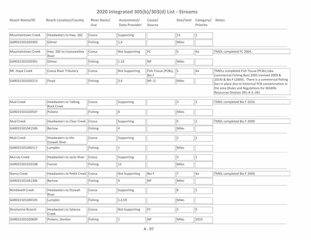
2020 Integrated 305(b)/303(d) List - Streams
Reach Name/ID Reach Location/County River Basin/Use
Assessment/Data Provider
Cause/Source
Size/Unit Category/Priority
Notes
Mountaintown Creek
GAR031501020302 1,4
Headwaters to Hwy. 282
Gilmer
Coosa
Fishing
Supporting 15
Miles
1
Mountaintown Creek
GAR031501020301 1,10
Hwy. 282 to Coosawattee River
Gilmer
Coosa
Fishing
Not Supporting FC 5
Miles
4a TMDL completed FC 2004.
NP
Mt. Hope Creek
GAR031501050213 3,4
Coosa River Tributary
Floyd
Coosa
Fishing
Not Supporting Fish Tissue (PCBs), Bio F
5
Miles
4a TMDLs completed Fish Tissue (PCBs) (aka Commercial Fishing Ban) 2005 (revised 2009 & 2014) & Bio F (2009). There is a commercial fishing ban in place due to historical PCB contamination in the area (Rules and Regulations for Wildlife Resources Division 391-4-3-.04).
NP, I2
Mud Creek
GAR031501020507 4
Headwaters to Talking Rock Creek
Pickens
Coosa
Fishing
Supporting 3
Miles
1 TMDL completed Bio F 2016.
Mud Creek
GAR031501041506 4
Headwaters to Clear Creek
Bartow
Coosa
Fishing
Supporting 5
Miles
1 TMDL completed Bio F 2009.
Mud Creek
GAR031501040117 1
Headwaters to the Etowah River
Lumpkin
Coosa
Fishing
Supporting 2
Miles
1
Murray Creek
GAR031501010108 12
Headwaters to Jacks River
Fannin
Coosa
Fishing
Supporting 3
Miles
1
Nancy Creek
GAR031501041306 4
Headwaters to Pettit Creek
Bartow
Coosa
Fishing
Not Supporting Bio F 7
Miles
4a TMDL completed Bio F 2009.
NP
Nimblewill Creek
GAR031501040105 1,4,59
Headwaters to Etowah River
Lumpkin
Coosa
Fishing
Supporting 8
Miles
1
Ninetynine Branch
GAR031501020609 1
Headwaters to Salacoa Creek
Pickens, Gordon
Coosa
Fishing
Not Supporting FC 5
Miles
5
2023NP
A - 97

2020 Integrated 305(b)/303(d) List - Streams
Reach Name/ID Reach Location/County River Basin/Use
Assessment/Data Provider
Cause/Source
Size/Unit Category/Priority
Notes
Noblet Creek
GAR031501020804 4,59
Headwaters to Coosawattee River
Murray, Gordon
Coosa
Fishing
Not Supporting Bio F 5
Miles
4a TMDL completed Bio(F) 2009. This site has a narrative rank of fair for macroinvertebrates. When EPD completes the reevaluation of the metrics used to assess macroinvertebrate data it will be determined if the macroinvertebrate criteria are being met.
NP
Noonday Creek
GAR031501040811 1,4
Headwaters to Little Noonday Creek
Cobb
Coosa
Fishing
Not Supporting Bio F 10
Miles
4a TMDL completed Bio F 2009.
NP
Noonday Creek
GAR031501040819 4,14,59
Little Noonday Creek to Tate Creek
Cobb
Coosa
Fishing
Not Supporting Bio M, Bio F 1
Miles
4a TMDL completed FC (2009), Bio F (2009) & Bio M (2016).
NP
Noonday Creek
GAR031501040820 4,10,41,59
Tate Creek to Lake Allatoona
Cherokee
Coosa
Fishing
Not Supporting FC, Bio F, Bio M 6
Miles
4a TMDLs completed FC (2009), Bio F (2009) & Bio M (2016).
NP
North Prong Sumac Creek
GAR031501010202 4
Headwaters to Sumac Creek
Murray
Coosa
Fishing
Supporting 7
Miles
1
Oostanaula River
GAR031501030205 1,10
Conasauga/Coosawattee to Oothkalooga Creek
Gordon
Coosa
Drinking Water, Fishing
Not Supporting Fish Tissue (PCBs), FC
11
Miles
4a TMDLs completed Fish Tissue (PCBs) 2005 (revised 2009 & 2014) & FC (2009).
NP, UR
Oostanaula River
GAR031501030204 1,10
Oothkalooga Creek to Hwy 156
Gordon
Coosa
Fishing
Not Supporting FC, Fish Tissue (PCBs)
5
Miles
4a TMDLs completed FC 2004, Fish Tissue (PCBs) 2005 (revised 2009 & 2014).
UR
Oostanaula River
GAR031501030609 1,10
Hwy 156 to Hwy 140
Gordon, Floyd
Coosa
Fishing
Not Supporting Fish Tissue (PCBs) 18
Miles
4a TMDLs completed FC 2004, Fish Tissue (PCBs) 2005 (revised 2009 & 2014).
UR
A - 98
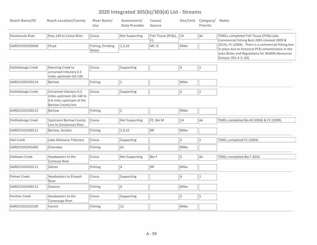
2020 Integrated 305(b)/303(d) List - Streams
Reach Name/ID Reach Location/County River Basin/Use
Assessment/Data Provider
Cause/Source
Size/Unit Category/Priority
Notes
Oostanaula River
GAR031501030608 1,3,10
Hwy 140 to Coosa River
Floyd
Coosa
Fishing, Drinking Water
Not Supporting Fish Tissue (PCBs), FC
14
Miles
4a TMDLs completed Fish Tissue (PCBs) (aka Commercial Fishing Ban) 2005 (revised 2009 & 2014), FC (2004). There is a commercial fishing ban in place due to historical PCB contamination in the area (Rules and Regulations for Wildlife Resources Division 391-4-3-.04).
NP, I2
Oothkalooga Creek
GAR031501030114 1
Manning Creek to unnamed tributary 0.3 miles upstream GA-140
Bartow
Coosa
Fishing
Supporting 3
Miles
1
Oothkalooga Creek
GAR031501030115 1
Unnamed tributary 0.3 miles upstream GA-140 to 0.6 miles upstream of the Bartow County line
Bartow
Coosa
Fishing
Supporting 2
Miles
1
Oothkalooga Creek
GAR031501030111 1,9,10
Upstream Bartow County Line to Oostanaula River
Bartow, Gordon
Coosa
Fishing
Not Supporting FC, Bio M 14
Miles
4a TMDL completed Bio M (2004) & FC (2009).
NP
Owl Creek
GAR031501041002 41
Lake Allatoona Tributary
Cherokee
Coosa
Fishing
Supporting 2
Miles
1 TMDL completed FC (2004).
Owltown Creek
GAR031501020111 4
Headwaters to the Cartecay River
Gilmer
Coosa
Fishing
Not Supporting Bio F 5
Miles
4a TMDL completed Bio F 2016.
NP
Palmer Creek
GAR031501040112 4
Headwaters to Etowah River
Dawson
Coosa
Fishing
Supporting 4
Miles
1
Panther Creek
GAR031501010109 12
Headwaters to the Conasauga River
Fannin
Coosa
Fishing
Supporting 2
Miles
1
A - 99

2020 Integrated 305(b)/303(d) List - Streams
Reach Name/ID Reach Location/County River Basin/Use
Assessment/Data Provider
Cause/Source
Size/Unit Category/Priority
Notes
Panther Creek
GAR031501050512 1
Headwaters to Alabama State Line
Chattooga
Coosa
Fishing
Supporting 5
Miles
1
Pegamore Creek
GAR031501041203 59
Corley Lake to Raccoon Creek
Paulding
Coosa
Fishing
Assessment Pending
2
Miles
3 This site has a narrative rank of fair for macroinvertebrates. Waters with a narrative rank of fair will remain in Category 3 until EPD completes the reevaluation of the metrics used to assess macroinvertebrate data.
Penitentiary Branch
GAR031501010110 12
Headwaters to Jacks River
Fannin
Coosa
Fishing
Supporting 2
Miles
1
Perennial Spring
GAR031501050605 4
Headwaters near CR 82 to Raccoon Creek
Chattooga
Coosa
Fishing
Supporting 5
Miles
1
Perry Creek
GAR031501010117 4
Headwaters to Conasauga River
Murray
Coosa
Fishing
Supporting 5
Miles
1
Pettit Creek
GAR031501041311 1
Aubrey Lake to Satterfield Branch
Bartow
Coosa
Fishing
Not Supporting FC 6
Miles
5
2023UR
Pettit Creek
GAR031501041308 10
Satterfield Branch to Nancy Creek
Bartow
Coosa
Fishing
Not Supporting FC 3
Miles
4a TMDL completed FC 2009.
UR
Picketts Mill Creek
GAR031501041105 4
Headwaters to Little Pumpkinvine Creek
Paulding
Coosa
Fishing
Supporting 6
Miles
1
Pin Hook Creek
GAR031501020601 4
Pickens Co. Line to Salacoa Creek
Gordon
Coosa
Fishing
Not Supporting Bio F 7
Miles
5
2023NP
A - 100

2020 Integrated 305(b)/303(d) List - Streams
Reach Name/ID Reach Location/County River Basin/Use
Assessment/Data Provider
Cause/Source
Size/Unit Category/Priority
Notes
Pine Log Creek
GAR031501020702 1,4
Headwaters near Hwy 140 to Cedar Creek
Cherokee, Bartow
Coosa
Fishing
Supporting 19
Miles
1
Pine Log Creek
GAR031501020701 1,9,10
Cedar Creek to Salacoa Creek
Gordon
Coosa
Fishing
Not Supporting FC, Bio M 6
Miles
4a TMDLs completed FC 2004 & Bio M 2004.
NP
Pitner Branch
GAR031501010307 4
Headwaters to Little Creek
Whitfield
Coosa
Fishing
Supporting 4
Miles
1
Polecat Branch (aka Polecat Creek)
GAR031501040501 1,4,59
Headwaters to Sharp Mountain Creek
Pickens
Coosa
Fishing
Not Supporting Bio M 6
Miles
4a TMDL completed Bio M 2016.
NP
Polecat Creek
GAR031501010504 1,4,59
Headwaters to Conasauga River
Murray, Gordon
Coosa
Fishing
Not Supporting Bio F, FC, Bio M 10
Miles
4a TMDL completed FC (2009), Bio F (2009) & Bio M (2016).
NP
Poplar Camp Creek
GAR031501010111 12
Headwaters to Conasauga River
Fannin
Coosa
Fishing
Supporting 2
Miles
1
Possum Creek
GAR031501041102 4
Paulding County
Paulding
Coosa
Fishing
Supporting 3
Miles
1
Price Creek
GAR031501020520 4
Headwaters to Fawcett Creek (Fausett Creek)
Gilmer, Pickens
Coosa
Fishing
Supporting 6
Miles
1
Proctor Creek
GAR031501040902 4,14
Headwaters to Lake Acworth
Cobb
Coosa
Fishing
Not Supporting FC, Bio F 4
Miles
4a TMDL completed FC (2004) & Bio F (2009)
UR
Pumpkinpile Creek
GAR031501050115 4
Polk County
Polk
Coosa
Fishing
Supporting 7
Miles
1
A - 101
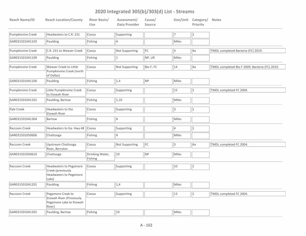
2020 Integrated 305(b)/303(d) List - Streams
Reach Name/ID Reach Location/County River Basin/Use
Assessment/Data Provider
Cause/Source
Size/Unit Category/Priority
Notes
Pumpkinvine Creek
GAR031501041103 4
Headwaters to C.R. 231
Paulding
Coosa
Fishing
Supporting 7
Miles
1
Pumpkinvine Creek
GAR031501041109 1
C.R. 231 to Weaver Creek
Paulding
Coosa
Fishing
Not Supporting FC 4
Miles
4a TMDL completed Bacteria (FC) 2019.
NP, UR
Pumpkinvine Creek
GAR031501041106 1,4
Weaver Creek to Little Pumpkinvine Creek (north of Dallas)
Paulding
Coosa
Fishing
Not Supporting Bio F, FC 14
Miles
4a TMDL completed Bio F 2009, Bacteria (FC) 2019.
NP
Pumpkinvine Creek
GAR031501041101 1,10
Little Pumpkinvine Creek to Etowah River
Paulding, Bartow
Coosa
Fishing
Supporting 15
Miles
1 TMDL completed FC 2004.
Pyle Creek
GAR031501041304 4
Headwaters to the Etowah River
Bartow
Coosa
Fishing
Supporting 3
Miles
1
Raccoon Creek
GAR031501050606 4
Headwaters to Ga. Hwy 48
Chattooga
Coosa
Fishing
Supporting 4
Miles
1
Raccoon Creek
GAR031501050610 10
Upstream Chattooga River, Berryton
Chattooga
Coosa
Drinking Water, Fishing
Not Supporting FC 3
Miles
4a TMDL completed FC 2004.
NP
Raccoon Creek
GAR031501041201 1,4
Headwaters to Pegamore Creek (previously Headwaters to Pegamore Lake)
Paulding
Coosa
Fishing
Supporting 10
Miles
1
Raccoon Creek
GAR031501041202 10
Pegamore Creek to Etowah River (Previously Pegamore Lake to Etowah River)
Paulding, Bartow
Coosa
Fishing
Supporting 13
Miles
1 TMDL completed FC 2004.
A - 102
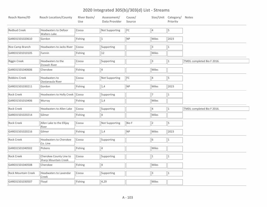
2020 Integrated 305(b)/303(d) List - Streams
Reach Name/ID Reach Location/County River Basin/Use
Assessment/Data Provider
Cause/Source
Size/Unit Category/Priority
Notes
Redbud Creek
GAR031501020610 1
Headwaters to Defoor Walters Lake
Gordon
Coosa
Fishing
Not Supporting FC 4
Miles
5
2023NP
Rice Camp Branch
GAR031501010105 12
Headwaters to Jacks River
Fannin
Coosa
Fishing
Supporting 3
Miles
1
Riggin Creek
GAR031501040606 4
Headwaters to the Etowah River
Cherokee
Coosa
Fishing
Supporting 3
Miles
1 TMDL completed Bio F 2016.
Robbins Creek
GAR031501030211 1,4
Headwaters to Oostanaula River
Gordon
Coosa
Fishing
Not Supporting FC 4
Miles
5
2023NP
Rock Creek
GAR031501010406 1,4
Headwaters to Holly Creek
Murray
Coosa
Fishing
Supporting 7
Miles
1
Rock Creek
GAR031501020214 4
Headwaters to Allen Lake
Gilmer
Coosa
Fishing
Supporting 4
Miles
1 TMDL completed Bio F 2016.
Rock Creek
GAR031501020216 1,4
Allen Lake to the Ellijay River
Gilmer
Coosa
Fishing
Not Supporting Bio F 2
Miles
5
2023NP
Rock Creek
GAR031501040502 4
Headwaters to Cherokee Co. Line
Pickens
Coosa
Fishing
Supporting 6
Miles
1
Rock Creek
GAR031501040508 4
Cherokee County Line to Sharp Mountain Creek
Cherokee
Coosa
Fishing
Supporting 1
Miles
1
Rock Mountain Creek
GAR031501030507 4,29
Headwaters to Lavendar Creek
Floyd
Coosa
Fishing
Supporting 3
Miles
1
A - 103
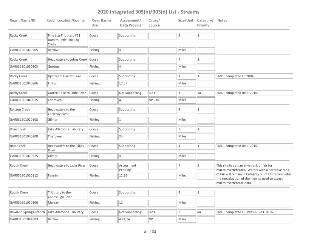
2020 Integrated 305(b)/303(d) List - Streams
Reach Name/ID Reach Location/County River Basin/Use
Assessment/Data Provider
Cause/Source
Size/Unit Category/Priority
Notes
Rocky Creek
GAR031501020705 4
Pine Log Tributary #21 Dam to Little Pine Log Creek
Bartow
Coosa
Fishing
Supporting 3
Miles
1
Rocky Creek
GAR031501030303 4
Headwaters to Johns Creek
Gordon
Coosa
Fishing
Supporting 4
Miles
1
Rocky Creek
GAR031501040806 17,67
Upstream Garrett Lake
Fulton
Coosa
Fishing
Supporting 1
Miles
1 TMDL completed FC 2004.
Rocky Creek
GAR031501040815 4
Garrett Lake to Little River
Cherokee
Coosa
Fishing
Not Supporting Bio F 1
Miles
4a TMDL completed Bio F 2016.
NP, UR
Rolston Creek
GAR031501020108 1
Headwaters to the Cartecay River
Gilmer
Coosa
Fishing
Supporting 5
Miles
1
Rose Creek
GAR031501040808 24
Lake Allatoona Tributary
Cherokee
Coosa
Fishing
Supporting 3
Miles
1
Ross Creek
GAR031501020215 4
Headwaters to the Ellijay River
Gilmer
Coosa
Fishing
Supporting 4
Miles
1 TMDL completed Bio F 2016.
Rough Creek
GAR031501010112 12,59
Headwaters to Jacks River
Fannin
Coosa
Fishing
Assessment Pending
7
Miles
3 This site has a narrative rank of fair for macroinvertebrates. Waters with a narrative rank of fair will remain in Category 3 until EPD completes the reevaluation of the metrics used to assess macroinvertebrate data.
Rough Creek
GAR031501010106 12
Tributary to the Conasauga River
Murray
Coosa
Fishing
Supporting 2
Miles
1
Rowland Springs Branch
GAR031501041003 4,24,74
Lake Allatoona Tributary
Bartow
Coosa
Fishing
Not Supporting Bio F 2
Miles
4a TMDL completed FC 1998 & Bio F 2016.
NP
A - 104
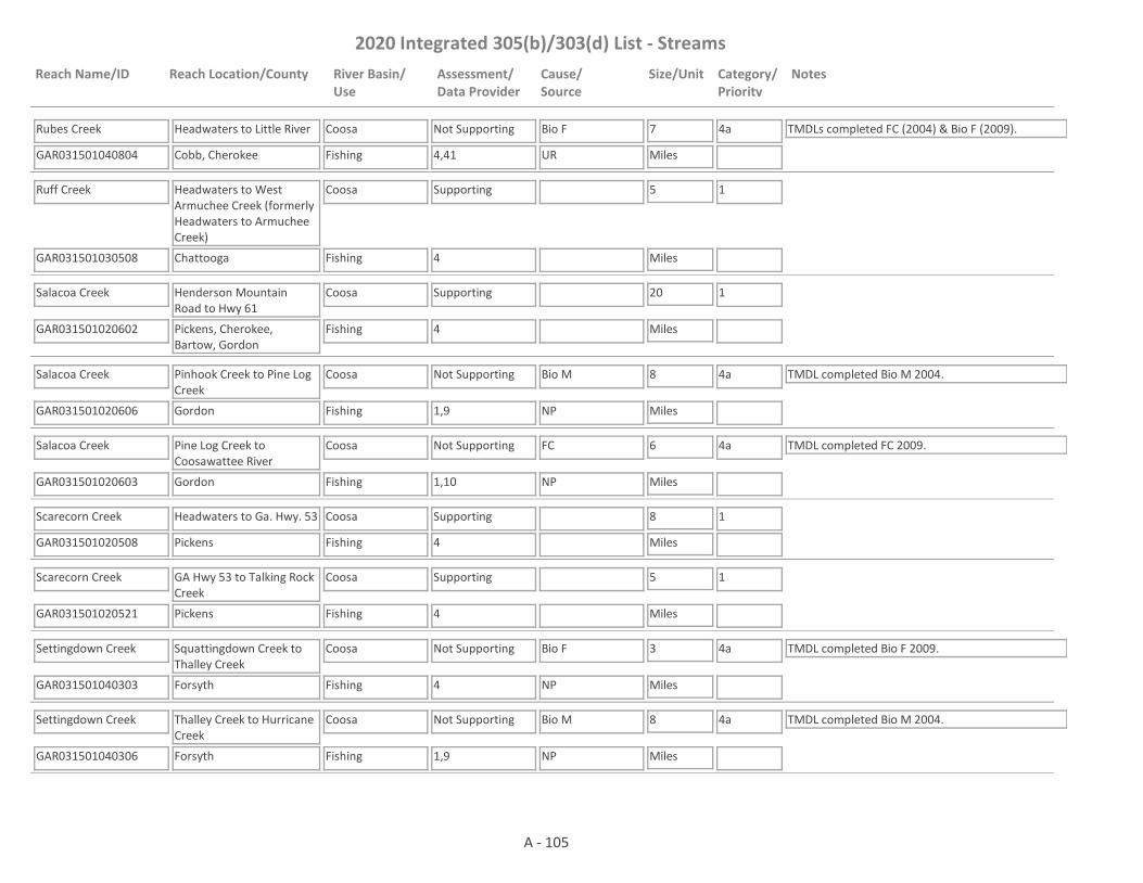
2020 Integrated 305(b)/303(d) List - Streams
Reach Name/ID Reach Location/County River Basin/Use
Assessment/Data Provider
Cause/Source
Size/Unit Category/Priority
Notes
Rubes Creek
GAR031501040804 4,41
Headwaters to Little River
Cobb, Cherokee
Coosa
Fishing
Not Supporting Bio F 7
Miles
4a TMDLs completed FC (2004) & Bio F (2009).
UR
Ruff Creek
GAR031501030508 4
Headwaters to West Armuchee Creek (formerly Headwaters to Armuchee Creek)
Chattooga
Coosa
Fishing
Supporting 5
Miles
1
Salacoa Creek
GAR031501020602 4
Henderson Mountain Road to Hwy 61
Pickens, Cherokee, Bartow, Gordon
Coosa
Fishing
Supporting 20
Miles
1
Salacoa Creek
GAR031501020606 1,9
Pinhook Creek to Pine Log Creek
Gordon
Coosa
Fishing
Not Supporting Bio M 8
Miles
4a TMDL completed Bio M 2004.
NP
Salacoa Creek
GAR031501020603 1,10
Pine Log Creek to Coosawattee River
Gordon
Coosa
Fishing
Not Supporting FC 6
Miles
4a TMDL completed FC 2009.
NP
Scarecorn Creek
GAR031501020508 4
Headwaters to Ga. Hwy. 53
Pickens
Coosa
Fishing
Supporting 8
Miles
1
Scarecorn Creek
GAR031501020521 4
GA Hwy 53 to Talking Rock Creek
Pickens
Coosa
Fishing
Supporting 5
Miles
1
Settingdown Creek
GAR031501040303 4
Squattingdown Creek to Thalley Creek
Forsyth
Coosa
Fishing
Not Supporting Bio F 3
Miles
4a TMDL completed Bio F 2009.
NP
Settingdown Creek
GAR031501040306 1,9
Thalley Creek to Hurricane Creek
Forsyth
Coosa
Fishing
Not Supporting Bio M 8
Miles
4a TMDL completed Bio M 2004.
NP
A - 105

2020 Integrated 305(b)/303(d) List - Streams
Reach Name/ID Reach Location/County River Basin/Use
Assessment/Data Provider
Cause/Source
Size/Unit Category/Priority
Notes
Shanty Creek
GAR031501010410 1
Headwaters to Holly Creek
Murray
Coosa
Fishing
Supporting 3
Miles
1
Sharp Mountain Creek
GAR031501040510 4
Headwaters to Town Creek
Pickens
Coosa
Fishing
Supporting 5
Miles
1
Sharp Mountain Creek
GAR031501040504 1,4,59
Town Creek to Polecat Branch
Pickens
Coosa
Fishing
Not Supporting Bio M 6
Miles
4a TMDL completed Bio M 2016.
NP
Sharp Mountain Creek
GAR031501040503 1,10,41,47
Rock Creek to Etowah River
Cherokee
Coosa
Fishing
Supporting 14
Miles
1 TMDL completed FC 2004.
Shoal Creek
GAR031501040106 4
Headwaters to Flat Creek
Lumpkin, Dawson
Coosa
Fishing
Supporting 8
Miles
1
Shoal Creek
GAR031501040704 4
Cline Lake to Hwy 140
Cherokee
Coosa
Fishing
Supporting 3
Miles
1
Shoal Creek
GAR031501040701 1,4,10,41
Hwy 140 to Lake Allatoona
Cherokee
Coosa
Fishing
Not Supporting FC 17
Miles
4a TMDL completed FC 1998.
NP
Silver Creek
GAR031501041602 1,3,4,10
Headwaters to Etowah River, Rome
Floyd
Coosa
Fishing
Not Supporting Fish Tissue (PCBs), FC, Bio F
15
Miles
4a Causes of Fish Tissue (PCBs) & Bio F are I2 & UR. Cause of FC is UR. TMDLs completed Fish Tissue (PCBs) (aka Commercial Fishing Ban) 2005 (revised 2009 & 2014), FC 2004 & Bio F 2009. There is a commercial fishing ban in place due to historical PCB contamination in the area (Rules and Regulations for Wildlife Resources Division 391-4-3-.04).
UR, I2
Simpson Creek
GAR031501041407 1,59
Headwaters to Hutchings Creek
Polk
Coosa
Fishing
Supporting 3
Miles
1
A - 106
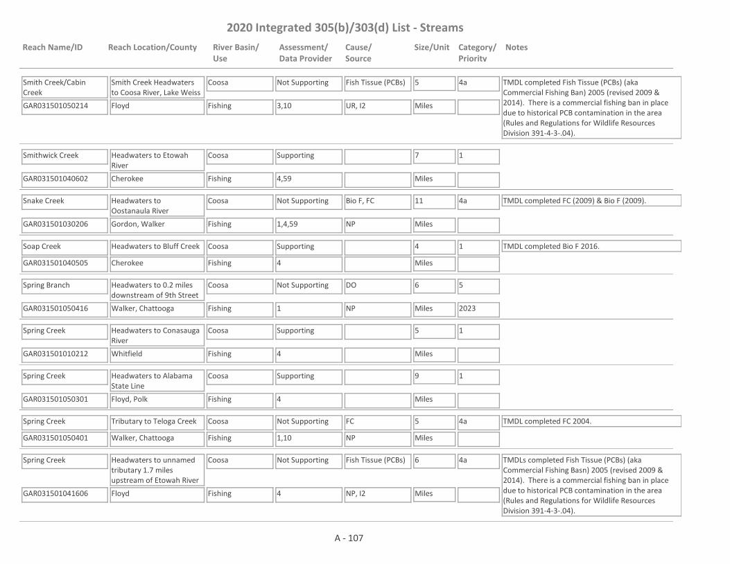
2020 Integrated 305(b)/303(d) List - Streams
Reach Name/ID Reach Location/County River Basin/Use
Assessment/Data Provider
Cause/Source
Size/Unit Category/Priority
Notes
Smith Creek/Cabin Creek
GAR031501050214 3,10
Smith Creek Headwaters to Coosa River, Lake Weiss
Floyd
Coosa
Fishing
Not Supporting Fish Tissue (PCBs) 5
Miles
4a TMDL completed Fish Tissue (PCBs) (aka Commercial Fishing Ban) 2005 (revised 2009 & 2014). There is a commercial fishing ban in place due to historical PCB contamination in the area (Rules and Regulations for Wildlife Resources Division 391-4-3-.04).
UR, I2
Smithwick Creek
GAR031501040602 4,59
Headwaters to Etowah River
Cherokee
Coosa
Fishing
Supporting 7
Miles
1
Snake Creek
GAR031501030206 1,4,59
Headwaters to Oostanaula River
Gordon, Walker
Coosa
Fishing
Not Supporting Bio F, FC 11
Miles
4a TMDL completed FC (2009) & Bio F (2009).
NP
Soap Creek
GAR031501040505 4
Headwaters to Bluff Creek
Cherokee
Coosa
Fishing
Supporting 4
Miles
1 TMDL completed Bio F 2016.
Spring Branch
GAR031501050416 1
Headwaters to 0.2 miles downstream of 9th Street
Walker, Chattooga
Coosa
Fishing
Not Supporting DO 6
Miles
5
2023NP
Spring Creek
GAR031501010212 4
Headwaters to Conasauga River
Whitfield
Coosa
Fishing
Supporting 5
Miles
1
Spring Creek
GAR031501050301 4
Headwaters to Alabama State Line
Floyd, Polk
Coosa
Fishing
Supporting 9
Miles
1
Spring Creek
GAR031501050401 1,10
Tributary to Teloga Creek
Walker, Chattooga
Coosa
Fishing
Not Supporting FC 5
Miles
4a TMDL completed FC 2004.
NP
Spring Creek
GAR031501041606 4
Headwaters to unnamed tributary 1.7 miles upstream of Etowah River
Floyd
Coosa
Fishing
Not Supporting Fish Tissue (PCBs) 6
Miles
4a TMDLs completed Fish Tissue (PCBs) (aka Commercial Fishing Basn) 2005 (revised 2009 & 2014). There is a commercial fishing ban in place due to historical PCB contamination in the area (Rules and Regulations for Wildlife Resources Division 391-4-3-.04).
NP, I2
A - 107
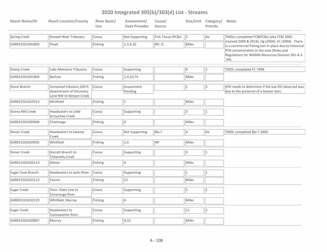
2020 Integrated 305(b)/303(d) List - Streams
Reach Name/ID Reach Location/County River Basin/Use
Assessment/Data Provider
Cause/Source
Size/Unit Category/Priority
Notes
Spring Creek
GAR031501041603 1,3,4,10
Etowah River Tributary
Floyd
Coosa
Fishing
Not Supporting Fish Tissue (PCBs) 2
Miles
4a TMDLs completed FCB(PCBs) (aka CFB) 2005 (revised 2009 & 2014), Hg (2004), FC (2004). There is a commercial fishing ban in place due to historical PCB contamination in the area (Rules and Regulations for Wildlife Resources Division 391-4-3-.04).
NP, I2
Stamp Creek
GAR031501041004 1,4,10,74
Lake Allatoona Tributary
Bartow
Coosa
Fishing
Supporting 9
Miles
1 TMDL completed FC 1998.
Stone Branch
GAR031501010313 1
Unnamed tributary 200 ft downstream of Discovery Lane NW to Kenyon Creek
Whitfield
Coosa
Fishing
Assessment Pending
1
Miles
3 EPD needs to determine if the low DO observed was due to the presence of a beaver dam.
Storey Mill Creek
GAR031501030404 4
Headwaters to Little Armuchee Creek
Chattooga
Coosa
Fishing
Supporting 3
Miles
1
Stover Creek
GAR031501010505 1,4
Headwaters to Swamp Creek
Whitfield
Coosa
Fishing
Not Supporting Bio F 4
Miles
4a TMDL completed Bio F 2009.
NP
Stover Creek
GAR031501020113 4
Garrett Branch to Tickanetly Creek
Gilmer
Coosa
Fishing
Supporting 3
Miles
1
Sugar Cove Branch
GAR031501010113 12
Headwaters to Jacks River
Fannin
Coosa
Fishing
Supporting 1
Miles
1
Sugar Creek
GAR031501010119 4
Tenn. State Line to Conasauga River
Whitfield, Murray
Coosa
Fishing
Supporting 5
Miles
1
Sugar Creek
GAR031501020807 4,10
Headwaters to Coosawattee River
Murray
Coosa
Fishing
Supporting 11
Miles
1
A - 108
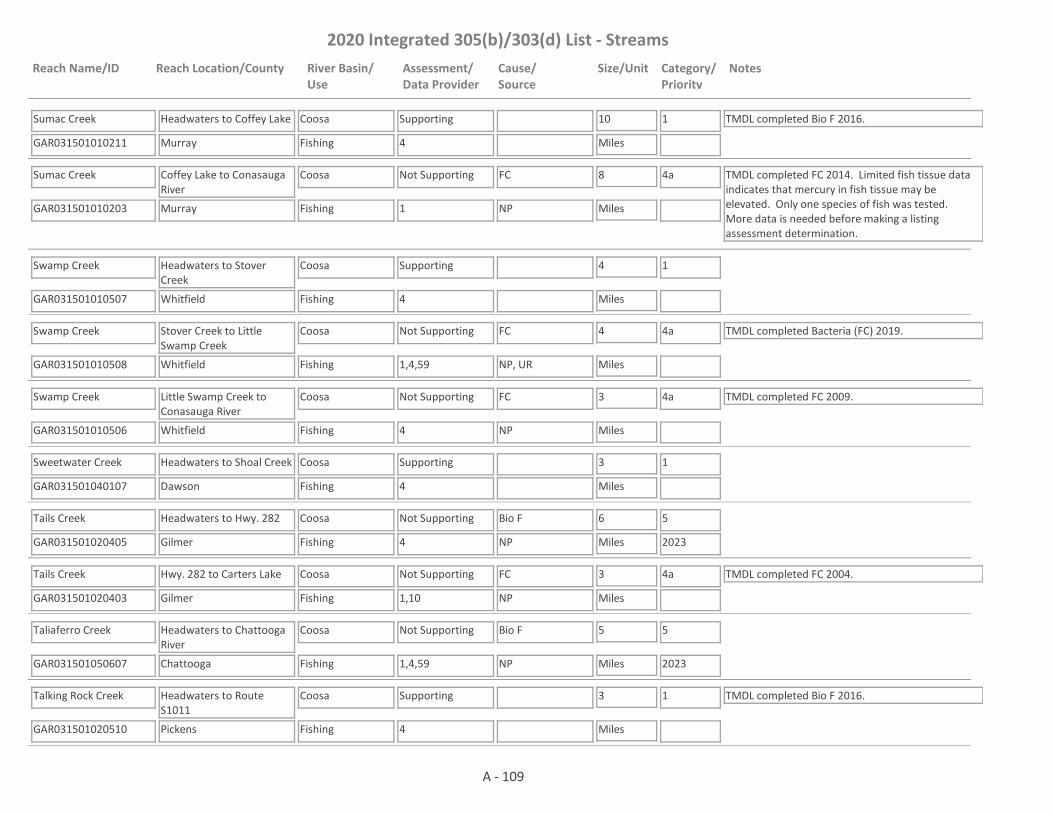
2020 Integrated 305(b)/303(d) List - Streams
Reach Name/ID Reach Location/County River Basin/Use
Assessment/Data Provider
Cause/Source
Size/Unit Category/Priority
Notes
Sumac Creek
GAR031501010211 4
Headwaters to Coffey Lake
Murray
Coosa
Fishing
Supporting 10
Miles
1 TMDL completed Bio F 2016.
Sumac Creek
GAR031501010203 1
Coffey Lake to Conasauga River
Murray
Coosa
Fishing
Not Supporting FC 8
Miles
4a TMDL completed FC 2014. Limited fish tissue data indicates that mercury in fish tissue may be elevated. Only one species of fish was tested. More data is needed before making a listing assessment determination.
NP
Swamp Creek
GAR031501010507 4
Headwaters to Stover Creek
Whitfield
Coosa
Fishing
Supporting 4
Miles
1
Swamp Creek
GAR031501010508 1,4,59
Stover Creek to Little Swamp Creek
Whitfield
Coosa
Fishing
Not Supporting FC 4
Miles
4a TMDL completed Bacteria (FC) 2019.
NP, UR
Swamp Creek
GAR031501010506 4
Little Swamp Creek to Conasauga River
Whitfield
Coosa
Fishing
Not Supporting FC 3
Miles
4a TMDL completed FC 2009.
NP
Sweetwater Creek
GAR031501040107 4
Headwaters to Shoal Creek
Dawson
Coosa
Fishing
Supporting 3
Miles
1
Tails Creek
GAR031501020405 4
Headwaters to Hwy. 282
Gilmer
Coosa
Fishing
Not Supporting Bio F 6
Miles
5
2023NP
Tails Creek
GAR031501020403 1,10
Hwy. 282 to Carters Lake
Gilmer
Coosa
Fishing
Not Supporting FC 3
Miles
4a TMDL completed FC 2004.
NP
Taliaferro Creek
GAR031501050607 1,4,59
Headwaters to Chattooga River
Chattooga
Coosa
Fishing
Not Supporting Bio F 5
Miles
5
2023NP
Talking Rock Creek
GAR031501020510 4
Headwaters to Route S1011
Pickens
Coosa
Fishing
Supporting 3
Miles
1 TMDL completed Bio F 2016.
A - 109

2020 Integrated 305(b)/303(d) List - Streams
Reach Name/ID Reach Location/County River Basin/Use
Assessment/Data Provider
Cause/Source
Size/Unit Category/Priority
Notes
Talking Rock Creek
GAR031501020514 59
Jones Lake to Town Creek
Pickens
Coosa
Fishing
Assessment Pending
5
Miles
3 This site has a narrative rank of fair for macroinvertebrates. Waters with a narrative rank of fair will remain in Category 3 until EPD completes the reevaluation of the metrics used to assess macroinvertebrate data.
Talking Rock Creek
GAR031501020513 10
Town Creek to Scarecorn Creek
Pickens
Coosa
Fishing
Not Supporting FC 8
Miles
4a TMDLs completed FC 2004, Fish Tissue (Mercury) 2004.
NP
Talking Rock Creek
GAR031501020509 1
Upstream Carters Lake
Gordon
Coosa
Fishing
Supporting 3
Miles
1
Talona Creek
GAR031501020511 4
Headwaters to Fisher Creek
Gilmer
Coosa
Fishing
Supporting 6
Miles
1
Talona Creek
GAR031501020516 4
Gilmer County Line to Fisher Creek
Pickens
Coosa
Fishing
Supporting 2
Miles
1
Talona Creek
GAR031501020524 1
Fishing Creek to Talking Rock Creek
Pickens
Coosa
Fishing
Supporting 2
Miles
1
Tanyard Branch
GAR031501050118 1
Tributary 200 feet upstream of U.S. 278 to Big Cedar Creek/Cedar Creek
Polk
Coosa
Fishing
Not Supporting FC 1
Miles
5
2023NP, UR
Tanyard Creek
GAR031501040903 14
White Lake to Lake Allatoona
Cobb
Coosa
Fishing
Not Supporting FC 4
Miles
4a TMDL completed FC 2004.
UR
Teloga Creek
GAR031501050417 4
Allgood Branch to Chelsea Creek
Chattooga
Coosa
Fishing
Supporting 2
Miles
1
A - 110
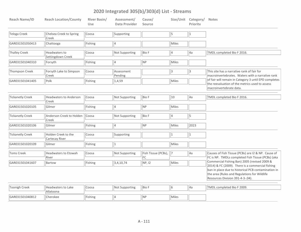
2020 Integrated 305(b)/303(d) List - Streams
Reach Name/ID Reach Location/County River Basin/Use
Assessment/Data Provider
Cause/Source
Size/Unit Category/Priority
Notes
Teloga Creek
GAR031501050413 4
Chelsea Creek to Spring Creek
Chattooga
Coosa
Fishing
Supporting 5
Miles
1
Thalley Creek
GAR031501040310 4
Headwaters to Settingdown Creek
Forsyth
Coosa
Fishing
Not Supporting Bio F 4
Miles
4a TMDL completed Bio F 2016.
NP
Thompson Creek
GAR031501041405 1,4,59
Forsyth Lake to Simpson Creek
Polk
Coosa
Fishing
Assessment Pending
3
Miles
3 This site has a narrative rank of fair for macroinvertebrates. Waters with a narrative rank of fair will remain in Category 3 until EPD completes the reevaluation of the metrics used to assess macroinvertebrate data.
Tickanetly Creek
GAR031501020105 4
Headwaters to Anderson Creek
Gilmer
Coosa
Fishing
Not Supporting Bio F 10
Miles
4a TMDL completed Bio F 2016.
NP
Tickanetly Creek
GAR031501020106 4
Anderson Creek to Holden Creek
Gilmer
Coosa
Fishing
Not Supporting Bio F 4
Miles
5
2023NP
Tickanetly Creek
GAR031501020109 1
Holden Creek to the Cartecay River
Gilmer
Coosa
Fishing
Supporting 1
Miles
1
Toms Creek
GAR031501041607 3,4,10,74
Headwaters to Etowah River
Bartow
Coosa
Fishing
Not Supporting Fish Tissue (PCBs), FC
7
Miles
4a Causes of Fish Tissue (PCBs) are I2 & NP. Cause of FC is NP. TMDLs completed Fish Tissue (PCBs) (aka Commercial Fishing Ban) 2005 (revised 2009 & 2014) & FC (2009). There is a commercial fishing ban in place due to historical PCB contamination in the area (Rules and Regulations for Wildlife Resources Division 391-4-3-.04).
NP, I2
Toonigh Creek
GAR031501040812 4
Headwaters to Lake Allatoona
Cherokee
Coosa
Fishing
Not Supporting Bio F 6
Miles
4a TMDL completed Bio F 2009.
NP
A - 111
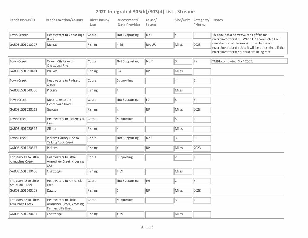
2020 Integrated 305(b)/303(d) List - Streams
Reach Name/ID Reach Location/County River Basin/Use
Assessment/Data Provider
Cause/Source
Size/Unit Category/Priority
Notes
Town Branch
GAR031501010207 4,59
Headwaters to Conasauga River
Murray
Coosa
Fishing
Not Supporting Bio F 4
Miles
5
2023
This site has a narrative rank of fair for macroinvertebrates. When EPD completes the reevaluation of the metrics used to assess macroinvertebrate data it will be determined if the macroinvertebrate criteria are being met.
NP, UR
Town Creek
GAR031501050411 1,4
Queen City Lake to Chattooga River
Walker
Coosa
Fishing
Not Supporting Bio F 3
Miles
4a TMDL completed Bio F 2009.
NP
Town Creek
GAR031501040506 4
Headwaters to Padgett Creek
Pickens
Coosa
Fishing
Supporting 4
Miles
1
Town Creek
GAR031501030212 4
Moss Lake to the Oostanaula River
Gordon
Coosa
Fishing
Not Supporting FC 3
Miles
5
2023NP
Town Creek
GAR031501020512 4
Headwaters to Pickens Co. Line
Gilmer
Coosa
Fishing
Supporting 5
Miles
1
Town Creek
GAR031501020517 4
Pickens County Line to Talking Rock Creek
Pickens
Coosa
Fishing
Not Supporting Bio F 3
Miles
5
2023NP
Tributary #1 to Little Armuchee Creek
GAR031501030406 4,59
Headwaters to Little Armuchee Creek, crossing CR5
Chattooga
Coosa
Fishing
Supporting 2
Miles
1
Tributary #2 to Little Amicalola Creek
GAR031501040208 1
Headwaters to Amicalola Lake
Dawson
Coosa
Fishing
Not Supporting pH 2
Miles
5
2028NP
Tributary #2 to Little Armuchee Creek
GAR031501030407 4,59
Headwaters to Little Armuchee Creek, crossing Farmersville Road
Chattooga
Coosa
Fishing
Supporting 3
Miles
1
A - 112

2020 Integrated 305(b)/303(d) List - Streams
Reach Name/ID Reach Location/County River Basin/Use
Assessment/Data Provider
Cause/Source
Size/Unit Category/Priority
Notes
Tributary to Allatoona Creek
GAR031501040904 14
Headwaters to Allatoona Creek
Cobb
Coosa
Fishing
Not Supporting FC 2
Miles
4a TMDL completed FC 2004.
UR
Tributary to Armuchee Creek
GAR031501030510 1,4,59
Headwaters to Armuchee Creek
Floyd
Coosa
Fishing
Not Supporting Bio F 5
Miles
4a TMDL completed Bio F 2009.
NP
Tributary to Becky Creek
GAR031501020607 1
Headwaters to Patterson Lake
Gordon
Coosa
Fishing
Supporting 2
Miles
1
Tributary to Canton Creek
GAR031501040607 1
Headwaters to Canton Creek
Cherokee
Coosa
Fishing
Supporting 2
Miles
1 TMDL completed Bio F 2016.
Tributary to Cedar Creek
GAR031501050116 4
Headwaters to Cedar Creek
Polk
Coosa
Fishing
Not Supporting Bio F 5
Miles
4a TMDL completed Bio F 2009.
NP
Tributary to Conasauga River
GAR031501010509 56
DOW Chemical Co. to Conasauga River near Nance Springs
Whitfield
Coosa
Fishing
Supporting 1
Miles
1
Tributary to Etowah River
GAR031501040108 4
Headwaters to Etowah River
Lumpkin
Coosa
Fishing
Not Supporting Bio F 3
Miles
4a TMDL completed Bio F 2009.
NP
Tributary to Jobs Creek
GAR031501010510 56
Headwaters to Jobs Creek
Whitfield
Coosa
Fishing
Not Supporting Tetrachloroethylene, Trichloroethylene, Vinyl Chloride
1
Miles
4b Data from EPD's Harzardous Waste Branch. Facility under a corrective action plan.
I2
Tributary to Little Amicalola Creek
GAR031501040207 4
Lake Laurel to Little Amicalola Creek
Dawson
Coosa
Fishing
Supporting 1
Miles
1
A - 113
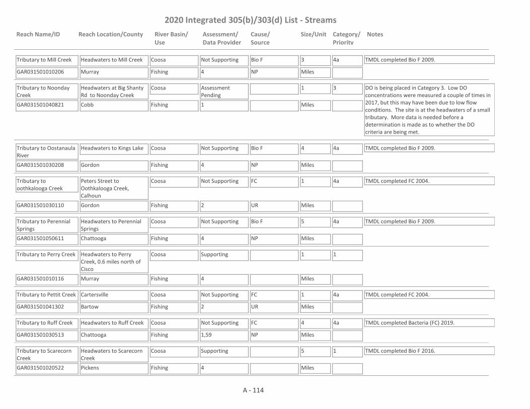
2020 Integrated 305(b)/303(d) List - Streams
Reach Name/ID Reach Location/County River Basin/Use
Assessment/Data Provider
Cause/Source
Size/Unit Category/Priority
Notes
Tributary to Mill Creek
GAR031501010206 4
Headwaters to Mill Creek
Murray
Coosa
Fishing
Not Supporting Bio F 3
Miles
4a TMDL completed Bio F 2009.
NP
Tributary to Noonday Creek
GAR031501040821 1
Headwaters at Big Shanty Rd to Noonday Creek
Cobb
Coosa
Fishing
Assessment Pending
1
Miles
3 DO is being placed in Category 3. Low DO concentrations were measured a couple of times in 2017, but this may have been due to low flow conditions. The site is at the headwaters of a small tributary. More data is needed before a determination is made as to whether the DO criteria are being met.
Tributary to Oostanaula River
GAR031501030208 4
Headwaters to Kings Lake
Gordon
Coosa
Fishing
Not Supporting Bio F 4
Miles
4a TMDL completed Bio F 2009.
NP
Tributary to oothkalooga Creek
GAR031501030110 2
Peters Street to Oothkalooga Creek, Calhoun
Gordon
Coosa
Fishing
Not Supporting FC 1
Miles
4a TMDL completed FC 2004.
UR
Tributary to Perennial Springs
GAR031501050611 4
Headwaters to Perennial Springs
Chattooga
Coosa
Fishing
Not Supporting Bio F 5
Miles
4a TMDL completed Bio F 2009.
NP
Tributary to Perry Creek
GAR031501010116 4
Headwaters to Perry Creek, 0.6 miles north of Cisco
Murray
Coosa
Fishing
Supporting 1
Miles
1
Tributary to Pettit Creek
GAR031501041302 2
Cartersville
Bartow
Coosa
Fishing
Not Supporting FC 1
Miles
4a TMDL completed FC 2004.
UR
Tributary to Ruff Creek
GAR031501030513 1,59
Headwaters to Ruff Creek
Chattooga
Coosa
Fishing
Not Supporting FC 4
Miles
4a TMDL completed Bacteria (FC) 2019.
NP
Tributary to Scarecorn Creek
GAR031501020522 4
Headwaters to Scarecorn Creek
Pickens
Coosa
Fishing
Supporting 5
Miles
1 TMDL completed Bio F 2016.
A - 114

2020 Integrated 305(b)/303(d) List - Streams
Reach Name/ID Reach Location/County River Basin/Use
Assessment/Data Provider
Cause/Source
Size/Unit Category/Priority
Notes
Tributary to Sharp Mountain Creek
GAR031501040509 4
Headwaters to Sharp Mountain Creek
Cherokee
Coosa
Fishing
Supporting 3
Miles
1 TMDL completed Bio F 2016.
Tributary to Sumac Creek
GAR031501010208 4
Headwaters to Sumac Creek
Murray
Coosa
Fishing
Supporting 1
Miles
1
Tributary to Talking Rock Creek
GAR031501020515 59
Sevenmile Creek to Talking Rock Creek
Gilmer
Coosa
Fishing
Assessment Pending
1
Miles
3 This site has a narrative rank of fair for macroinvertebrates. Waters with a narrative rank of fair will remain in Category 3 until EPD completes the reevaluation of the metrics used to assess macroinvertebrate data.
Tributary to Willbanks Branch
GAR031501020812 1
Headwaters to Willbanks Branch
Murray
Coosa
Fishing
Supporting 3
Miles
1
Tributary to Woodward Branch
GAR031501030612 1
Headwaters to Woodward Branch
Floyd
Coosa
Fishing
Supporting 2
Miles
1
Turkey Creek
GAR031501020107 4
Montag Lake to Clear Creek
Gilmer
Coosa
Fishing
Supporting 5
Miles
1
Two Run Creek
GAR031501041504 4
Headwaters to Clear Creek, U/S Fishing Ban Area
Bartow
Coosa
Fishing
Supporting 6
Miles
1
Two Run Creek
GAR031501041502 1,3,4,10
Clear Creek to Etowah River
Bartow
Coosa
Fishing
Not Supporting Fish Tissue (PCBs), FC
10
Miles
4a Causes Fish Tissue (PCBs) are I2 & NP. Cause FC is NP. TMDLs completed Fish Tissue (PCBs) (aka Commercial Fishing Ban) 2005 (revised 2009 & 2014), FC (2004). There is a commercial fishing ban in place due to historical PCB contamination in the area (Rules and Regulations for Wildlife Resources Division 391-4-3-.04).
NP, I2
A - 115

2020 Integrated 305(b)/303(d) List - Streams
Reach Name/ID Reach Location/County River Basin/Use
Assessment/Data Provider
Cause/Source
Size/Unit Category/Priority
Notes
Vanns Creek
GAR031501020809 10
Jackson Branch to Coosawattee River
Gordon
Coosa
Fishing
Supporting 2
Miles
1
Ward Creek
GAR031501030606 1
Shannon
Floyd
Coosa
Fishing
Supporting 1
Miles
1
Ward Creek
GAR031501041305 4
Headwaters to Etowah River
Paulding, Bartow
Coosa
Fishing
Supporting 6
Miles
1
Webb Creek
GAR031501050215 3,4,10
Coosa River Tributary
Floyd
Coosa
Fishing
Not Supporting Fish Tissue (PCBs) 4
Miles
4a TMDLs completed Fish Tissue (PCBs) (aka Commercial Fishing Ban) 2005 (revised 2009 & 2014), FC (2004). There is a commercial fishing ban in place due to historical PCB contamination in the area (Rules and Regulations for Wildlife Resources Division 391-4-3-.04).
NP, I2
West Armuchee Creek
GAR031501030509 4
Headwaters to Dick Creek
Walker
Coosa
Fishing
Supporting 10
Miles
1
West Armuchee Creek
GAR031501030511 4
Dick Creek to Ruff Creek
Walker, Chattooga
Coosa
Fishing
Supporting 4
Miles
1
West Fork Little River
GAR031501050704 4,59
Headwaters to Alabama State Line
Walker, Dade
Coosa
Fishing
Assessment Pending
6
Miles
3 This site has a narrative rank of fair for macroinvertebrates. Waters with a narrative rank of fair will remain in Category 3 until EPD completes the reevaluation of the metrics used to assess macroinvertebrate data.
West Fork Montgomery Creek
GAR031501040116 1
Headwaters to Montgomery Creek
Lumpkin
Coosa
Fishing
Supporting 3
Miles
1
Westbrook Creek
GAR031501041104 4
Headwaters to Pumpkinvine Creek
Paulding
Coosa
Fishing
Supporting 3
Miles
1
A - 116
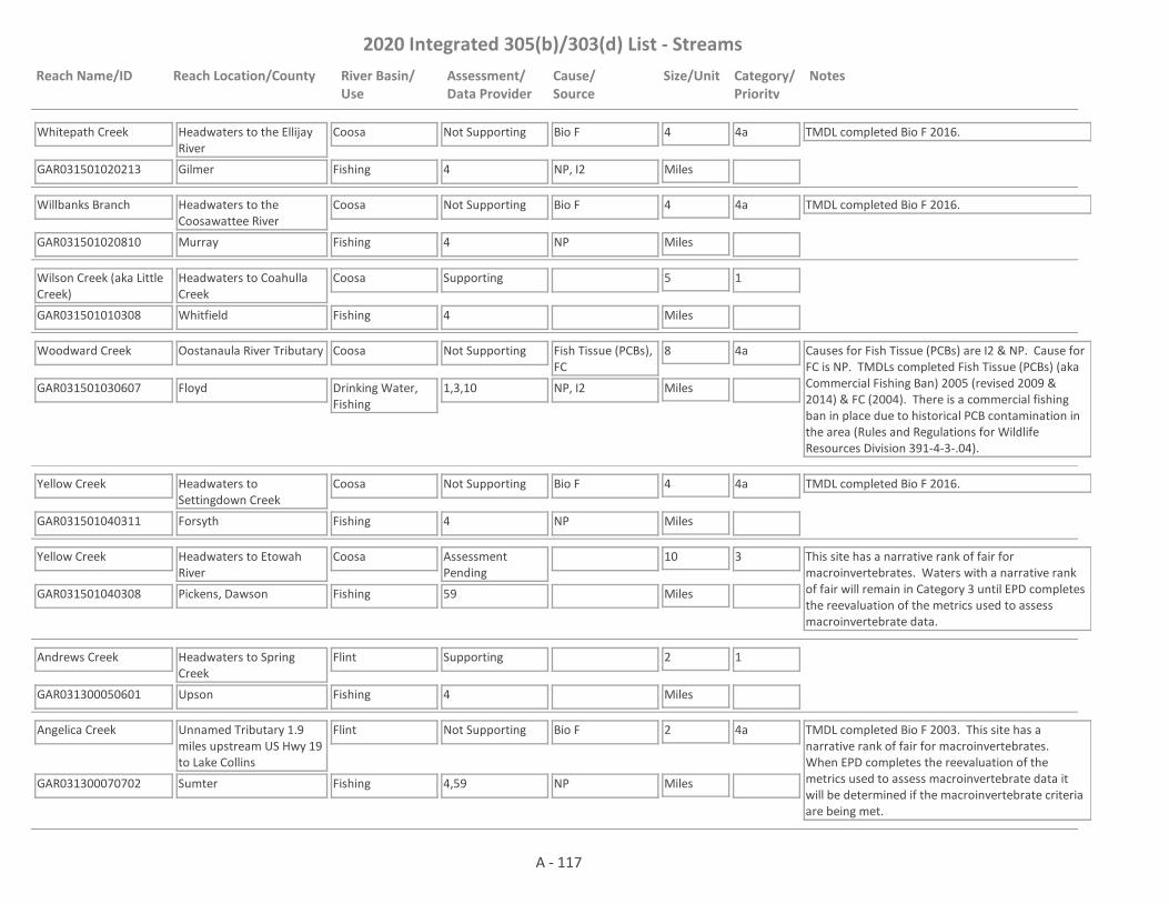
2020 Integrated 305(b)/303(d) List - Streams
Reach Name/ID Reach Location/County River Basin/Use
Assessment/Data Provider
Cause/Source
Size/Unit Category/Priority
Notes
Whitepath Creek
GAR031501020213 4
Headwaters to the Ellijay River
Gilmer
Coosa
Fishing
Not Supporting Bio F 4
Miles
4a TMDL completed Bio F 2016.
NP, I2
Willbanks Branch
GAR031501020810 4
Headwaters to the Coosawattee River
Murray
Coosa
Fishing
Not Supporting Bio F 4
Miles
4a TMDL completed Bio F 2016.
NP
Wilson Creek (aka Little Creek)
GAR031501010308 4
Headwaters to Coahulla Creek
Whitfield
Coosa
Fishing
Supporting 5
Miles
1
Woodward Creek
GAR031501030607 1,3,10
Oostanaula River Tributary
Floyd
Coosa
Drinking Water, Fishing
Not Supporting Fish Tissue (PCBs), FC
8
Miles
4a Causes for Fish Tissue (PCBs) are I2 & NP. Cause for FC is NP. TMDLs completed Fish Tissue (PCBs) (aka Commercial Fishing Ban) 2005 (revised 2009 & 2014) & FC (2004). There is a commercial fishing ban in place due to historical PCB contamination in the area (Rules and Regulations for Wildlife Resources Division 391-4-3-.04).
NP, I2
Yellow Creek
GAR031501040311 4
Headwaters to Settingdown Creek
Forsyth
Coosa
Fishing
Not Supporting Bio F 4
Miles
4a TMDL completed Bio F 2016.
NP
Yellow Creek
GAR031501040308 59
Headwaters to Etowah River
Pickens, Dawson
Coosa
Fishing
Assessment Pending
10
Miles
3 This site has a narrative rank of fair for macroinvertebrates. Waters with a narrative rank of fair will remain in Category 3 until EPD completes the reevaluation of the metrics used to assess macroinvertebrate data.
Andrews Creek
GAR031300050601 4
Headwaters to Spring Creek
Upson
Flint
Fishing
Supporting 2
Miles
1
Angelica Creek
GAR031300070702 4,59
Unnamed Tributary 1.9 miles upstream US Hwy 19 to Lake Collins
Sumter
Flint
Fishing
Not Supporting Bio F 2
Miles
4a TMDL completed Bio F 2003. This site has a narrative rank of fair for macroinvertebrates. When EPD completes the reevaluation of the metrics used to assess macroinvertebrate data it will be determined if the macroinvertebrate criteria are being met.
NP
A - 117

2020 Integrated 305(b)/303(d) List - Streams
Reach Name/ID Reach Location/County River Basin/Use
Assessment/Data Provider
Cause/Source
Size/Unit Category/Priority
Notes
Auchumpkee Creek
GAR031300051202 1,4
Headwaters to Ulcohatchee Creek
Upson
Flint
Fishing
Supporting 23
Miles
1
Avera Creek (aka Spring Creek)
GAR031300051410 4
Headwaters to Beaver Creek
Crawford
Flint
Fishing
Not Supporting pH 4
Miles
4a TMDL completed Bio F (2003) & pH (2003).
NP
Aycocks Creek
GAR031300100402 1,10
Kaney Head Creek to Spring Creek
Miller
Flint
Fishing
Supporting 15
Miles
1 TMDL completed FC 1998.
Bailey Branch
GAR031300060515 4
Headwaters to Browns Millpond
Sumter
Flint
Fishing
Not Supporting Bio F 6
Miles
4a TMDL completed Bio F 2003.
NP
Bailey Creek
GAR031300051203 4
Headwaters to Ulcohatchee Creek
Crawford
Flint
Fishing
Supporting 4
Miles
1
Baptist Branch
GAR031300100201 1,4
Downstream Blakely
Early
Flint
Fishing
Not Supporting Bio F 2
Miles
4a TMDL completed Bio F 2003.
UR
Barfield Creek
GAR031300051104 1
Headwaters to Richland Creek
Talbot, Taylor
Flint
Fishing
Supporting 6
Miles
1
Baroucho Creek
GAR031300050920 4
Headwaters (New Lake Dam) to Potato Creek
Upson
Flint
Fishing
Supporting 3
Miles
1
Basin Creek
GAR031300050903 1,4
Headwaters to Hightower Lake
Upson
Flint
Fishing
Not Supporting FC, pH 6
Miles
5
2022, 2027
TMDL completed Bio F 2003. The TMDL for FC is scheduled to be drafted in 2022 and the one for pH in 2027.NP
Bear Creek
GAR031300050102 2
Downstream Lake Amah Lee- Hampton
Henry
Flint
Fishing
Supporting 2
Miles
1
A - 118

2020 Integrated 305(b)/303(d) List - Streams
Reach Name/ID Reach Location/County River Basin/Use
Assessment/Data Provider
Cause/Source
Size/Unit Category/Priority
Notes
Bear Creek
GAR031300070405 1
Headwaters to Pond 1 mile upstream Center Point Rd
Stewart
Flint
Fishing
Assessment Pending
0.3
Miles
3 More data is needed before this water is assessed. Data was collected from Station RV_11_16296 from January - May 2016 and then the stream was dry the rest of the year.
Bear Creek
GAR031300070404 1
Pond 1 mile upstream Center Point Rd to Little Bear Creek
Stewart, Webster
Flint
Fishing
Not Supporting DO, pH 5
Miles
5
2027NP, M
Bear Creek
GAR031300070401 4
Long Branch to Reedy Creek
Terrell
Flint
Fishing
Supporting 9
Miles
1
Beaver Creek
GAR031300051411 1,4
Headwaters to Spring Creek
Crawford
Flint
Fishing
Not Supporting FC 11
Miles
4a TMDLs completed Bio F (2003), DO (2003), FC (2013).
NP
Beaver Creek
GAR031300051313 1,4
Headwaters to Patsiliga Creek, Butler
Taylor
Flint
Fishing
Not Supporting Fish Tissue (Mercury), FC
6
Miles
4a, 5
2022
TMDL completed Fish Tissue (Mercury) 2003.
NP
Beaver Creek
GAR031300050301 4
Headwaters to White Oak Creek
Meriwether
Flint
Fishing
Supporting 6
Miles
1
Beaver Creek
GAR031300060101 1,48
Headwaters to Spring Hill Creek, SW Marshallville
Macon
Flint
Fishing
Supporting 4
Miles
1 TMDL completed FC 1998.
Beaver Creek
GAR031300060108 1,10
Spring Hill Creek to Flint River
Macon
Flint
Fishing
Not Supporting FC 9
Miles
4a TMDL completed FC 2003.
UR
Beaver Dam Creek
GAR031300050119 4,42
Lake Joy to Flint River
Clayton
Flint
Fishing
Not Supporting FC 3
Miles
4a TMDLs completed FC (2008) & Bio F (2018).
NP
A - 119
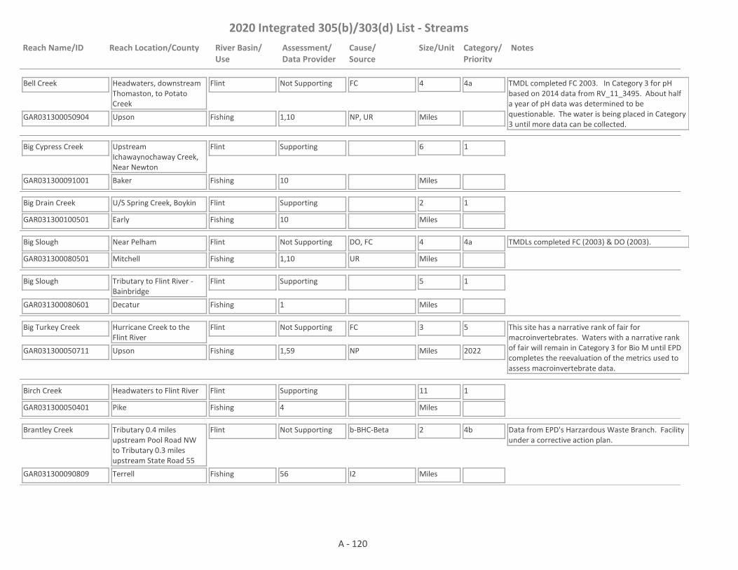
2020 Integrated 305(b)/303(d) List - Streams
Reach Name/ID Reach Location/County River Basin/Use
Assessment/Data Provider
Cause/Source
Size/Unit Category/Priority
Notes
Bell Creek
GAR031300050904 1,10
Headwaters, downstream Thomaston, to Potato Creek
Upson
Flint
Fishing
Not Supporting FC 4
Miles
4a TMDL completed FC 2003. In Category 3 for pH based on 2014 data from RV_11_3495. About half a year of pH data was determined to be questionable. The water is being placed in Category 3 until more data can be collected.
NP, UR
Big Cypress Creek
GAR031300091001 10
Upstream Ichawaynochaway Creek, Near Newton
Baker
Flint
Fishing
Supporting 6
Miles
1
Big Drain Creek
GAR031300100501 10
U/S Spring Creek, Boykin
Early
Flint
Fishing
Supporting 2
Miles
1
Big Slough
GAR031300080501 1,10
Near Pelham
Mitchell
Flint
Fishing
Not Supporting DO, FC 4
Miles
4a TMDLs completed FC (2003) & DO (2003).
UR
Big Slough
GAR031300080601 1
Tributary to Flint River - Bainbridge
Decatur
Flint
Fishing
Supporting 5
Miles
1
Big Turkey Creek
GAR031300050711 1,59
Hurricane Creek to the Flint River
Upson
Flint
Fishing
Not Supporting FC 3
Miles
5
2022
This site has a narrative rank of fair for macroinvertebrates. Waters with a narrative rank of fair will remain in Category 3 for Bio M until EPD completes the reevaluation of the metrics used to assess macroinvertebrate data.
NP
Birch Creek
GAR031300050401 4
Headwaters to Flint River
Pike
Flint
Fishing
Supporting 11
Miles
1
Brantley Creek
GAR031300090809 56
Tributary 0.4 miles upstream Pool Road NW to Tributary 0.3 miles upstream State Road 55
Terrell
Flint
Fishing
Not Supporting b-BHC-Beta 2
Miles
4b Data from EPD's Harzardous Waste Branch. Facility under a corrective action plan.
I2
A - 120

2020 Integrated 305(b)/303(d) List - Streams
Reach Name/ID Reach Location/County River Basin/Use
Assessment/Data Provider
Cause/Source
Size/Unit Category/Priority
Notes
Brantley Creek
GAR031300090808 1,4
Downstream Dawson WPCP to Chickasawhatchee Creek
Terrell
Flint
Fishing
Not Supporting Bio F, FC 6
Miles
4a, 5
2022
TMDL completed FC 2013.
NP
Brittens Creek
GAR031300050501 4
Tributary to Red Oak Creek
Meriwether
Flint
Fishing
Supporting 5
Miles
1
Bryants Swamp
GAR031300051603 1
Headwaters to the Flint River
Macon
Flint
Fishing
Assessment Pending
7
Miles
3 EPD believes that our pH probes may have been providing falsely low values at times in 2017 and 2018. Waters that would normally be listed as impaired for low pH are being placed in Category 3 while EPD determines if observed low pH is due to issues with the pH probes; whether low pH may be natural due to low alkalinity; or whether the water is actually impaired for low pH.
Buck Creek
GAR031300060201 1,10,4
Fox Branch to Flint River near Oglethorpe
Schley, Macon
Flint
Fishing
Not Supporting FC 16
Miles
4a TMDL completed FC 1998.
NP
Camp Creek
GAR031300050216 4
Brown Lake to Whitewater Creek
Fayette
Flint
Fishing
Supporting 3
Miles
1
Camp Creek
GAR031300050131 34
Headwaters to Cater Creek
Clayton
Flint
Fishing
Supporting 1
Miles
1 TMDL completed FC 2003.
Camp Creek
GAR031300050130 1,42
Cater Creek to Flint River
Clayton
Flint
Fishing
Not Supporting FC 9
Miles
4a TMDL completed FC 2003.
NP, UR
Camp Creek
GAR031300060111 4
Headwaters to Toteover Creek
Schley, Macon
Flint
Fishing
Supporting 6
Miles
1
Camp Creek
GAR031300060112 4
Toteover Creek to Triple Creek
Macon
Flint
Fishing
Not Supporting Bio F 8
Miles
5
2022NP
A - 121

2020 Integrated 305(b)/303(d) List - Streams
Reach Name/ID Reach Location/County River Basin/Use
Assessment/Data Provider
Cause/Source
Size/Unit Category/Priority
Notes
Camp Creek
GAR031300060102 1
Triple Creek to Flint River, Oglethorpe
Macon
Flint
Fishing
Supporting 4
Miles
1
Cane Creek
GAR031300050702 4
Cold Springs Branch to the Flint River
Meriwether
Flint
Fishing
Supporting 9
Miles
1
Carter Creek
GAR031300090402 1
Town Creek to Pachitla Creek
Randolph, Calhoun
Flint
Fishing
Supporting 9
Miles
1
Cater Creek
GAR031300050104 34
College Park
Fulton
Flint
Fishing
Supporting 1
Miles
1
Cedar Creek
GAR031300060603 1
Crisp County
Crisp
Flint
Fishing
Supporting 3
Miles
1
Cedar Creek
GAR031300051504 1,4
Turkey Branch to Whitewater Creek
Macon
Flint
Fishing
Supporting 10
Miles
1
Chandlers Creek
GAR031300050302 4
Headwaters to White Oak Creek
Coweta
Flint
Fishing
Supporting 5
Miles
1
Chickasawhatchee Creek
GAR031300090805 4
Brantley Creek to Herod Creek
Terrell
Flint
Fishing
Supporting 4
Miles
1
Chickasawhatchee Creek
GAR031300090804 1
Dougherty County
Dougherty
Flint
Fishing
Not Supporting FC 12
Miles
4a TMDL completed FC 1998.
NP
Chickasawhatchee Creek
GAR031300091002 1,4,10
Dougherty Co. Line to Ichawaynochaway Creek, Elmodel
Baker
Flint
Fishing
Supporting 10
Miles
1
A - 122

2020 Integrated 305(b)/303(d) List - Streams
Reach Name/ID Reach Location/County River Basin/Use
Assessment/Data Provider
Cause/Source
Size/Unit Category/Priority
Notes
Chokee Creek
GAR031300060701 4
Mill Creek to Flint River
Lee
Flint
Fishing
Supporting 6
Miles
1
Chokeelagee Creek
GAR031300070501 4
Headwaters to Kinchafoonee Creek
Lee
Flint
Fishing
Supporting 10
Miles
1
Clear Creek
GAR031300070203 1,59
Headwaters to Kinchafoonee Creek
Stewart, Webster
Flint
Fishing
Not Supporting pH, Bio M 7
Miles
4a, 5
2027
TMDL completed Bio M 2018.
NP
Cold Springs Branch
GAR031300050703 4
Tributary to Cane Creek
Meriwether
Flint
Fishing
Supporting 4
Miles
1
Coleoatchee Creek
GAR031300050802 59
Headwaters to Copeland Lake Tributary
Talbot
Flint
Fishing
Not Supporting Bio M 3
Miles
4a TMDL completed Bio M 2018.
NP
Cooleewahee Creek
GAR031300080301 1,4,10
Piney Woods Branch to Flint River near Newton
Dougherty, Baker
Flint
Fishing
Not Supporting FC, Bio F 16
Miles
4a TMDLs completed FC (2003) & Bio F (2003).
NP
Culpepper Creek
GAR031300051409 4
Headwaters to Lewis Creek
Crawford
Flint
Fishing
Supporting 6
Miles
1
Culpepper Creek (aka Spring Creek)
GAR031300051408 4
Lewis Creek to Beaver Creek
Crawford
Flint
Fishing
Supporting 3
Miles
1
Cypress Creek
GAR031300100401 10
U/S Aycocks Creek near Colquitt
Miller
Flint
Fishing
Supporting 4
Miles
1
Dead Oak Creek
GAR031300050204 1
Upstream Line Creek
Coweta
Flint
Fishing
Supporting 2
Miles
1
A - 123
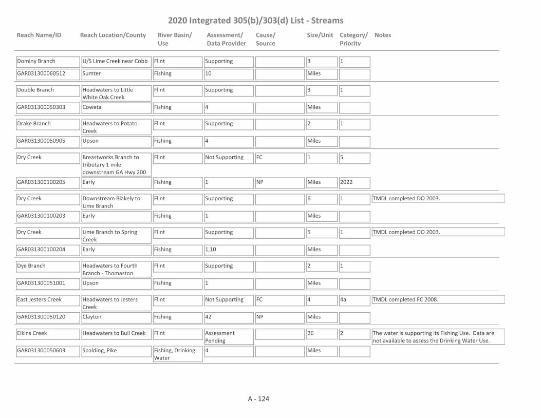
2020 Integrated 305(b)/303(d) List - Streams
Reach Name/ID Reach Location/County River Basin/Use
Assessment/Data Provider
Cause/Source
Size/Unit Category/Priority
Notes
Dominy Branch
GAR031300060512 10
U/S Lime Creek near Cobb
Sumter
Flint
Fishing
Supporting 3
Miles
1
Double Branch
GAR031300050303 4
Headwaters to Little White Oak Creek
Coweta
Flint
Fishing
Supporting 3
Miles
1
Drake Branch
GAR031300050905 4
Headwaters to Potato Creek
Upson
Flint
Fishing
Supporting 2
Miles
1
Dry Creek
GAR031300100205 1
Breastworks Branch to tributary 1 mile downstream GA Hwy 200
Early
Flint
Fishing
Not Supporting FC 1
Miles
5
2022NP
Dry Creek
GAR031300100203 1
Downstream Blakely to Lime Branch
Early
Flint
Fishing
Supporting 6
Miles
1 TMDL completed DO 2003.
Dry Creek
GAR031300100204 1,10
Lime Branch to Spring Creek
Early
Flint
Fishing
Supporting 5
Miles
1 TMDL completed DO 2003.
Dye Branch
GAR031300051001 1
Headwaters to Fourth Branch - Thomaston
Upson
Flint
Fishing
Supporting 2
Miles
1
East Jesters Creek
GAR031300050120 42
Headwaters to Jesters Creek
Clayton
Flint
Fishing
Not Supporting FC 4
Miles
4a TMDL completed FC 2008.
NP
Elkins Creek
GAR031300050603 4
Headwaters to Bull Creek
Spalding, Pike
Flint
Fishing, Drinking Water
Assessment Pending
26
Miles
2 The water is supporting its Fishing Use. Data are not available to assess the Drinking Water Use.
A - 124

2020 Integrated 305(b)/303(d) List - Streams
Reach Name/ID Reach Location/County River Basin/Use
Assessment/Data Provider
Cause/Source
Size/Unit Category/Priority
Notes
Elkins Creek
GAR031300050602 1,10
Bull Creek to Flint River near Molena
Pike, Upson
Flint
Fishing
Supporting 11
Miles
1 TMDL completed FC 2003.
Fishpond Drain
GAR031300100704 1,10,59
U.S. Hwy. 84, Donalsonville to Wash Pond
Seminole
Flint
Fishing
Not Supporting Algae, FC, DO 7
Miles
4a, 5
2027
TMDLs completed FC (1998) & DO (2003).
NP, UR
Fishpond Drain
GAR031300100705
Wash Pond to Lake Seminole
Seminole
Flint
Fishing
Assessment Pending
10
Miles
3 This water is in Category 3 because there is currently no water quality data available to use to assess it.
Five Mile Creek
GAR031300050907 4
Headwaters to Potato Creek
Upson
Flint
Fishing
Supporting 3
Miles
1
Five Mile Creek (aka Three Mile Creek)
GAR031300050906 4,59
Tributary to Potato Creek
Pike, Upson
Flint
Fishing
Assessment Pending
4
Miles
3 This site has a narrative rank of fair for macroinvertebrates. When EPD completes the reevaluation of the metrics used to assess macroinvertebrate data it will be determined if the macroinvertebrate criteria are being met.
Flat Creek
GAR031300050105 4
Headwaters to Flint River
Spalding
Flint
Fishing
Supporting 11
Miles
1
Flat Creek
GAR031300050205 1
Lake Peachtree To Line Creek, Peachtree City
Fayette
Flint
Drinking Water, Fishing
Not Supporting FC 4
Miles
4a TMDLs completed DO 2003 & FC 2018.
NP
Flint River
GAR031300050110 1,42
Upstream Hartsfield Airport
Clayton
Flint
Fishing
Supporting 1
Miles
1 TMDLs completed FC (2003), Cu (2003), Zn (2003)
Flint River
GAR031300050106 1,10,42,59
Hartsfield Airport to Hwy 138
Clayton
Flint
Fishing
Not Supporting Cu, FC, Bio M 8
Miles
4a, 5
2027
TMDLs completed FC (2003) & Bio M (2018).
UR
A - 125
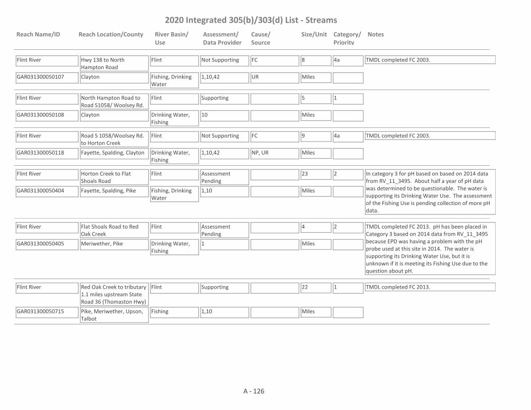
2020 Integrated 305(b)/303(d) List - Streams
Reach Name/ID Reach Location/County River Basin/Use
Assessment/Data Provider
Cause/Source
Size/Unit Category/Priority
Notes
Flint River
GAR031300050107 1,10,42
Hwy 138 to North Hampton Road
Clayton
Flint
Fishing, Drinking Water
Not Supporting FC 8
Miles
4a TMDL completed FC 2003.
UR
Flint River
GAR031300050108 10
North Hampton Road to Road S1058/ Woolsey Rd.
Clayton
Flint
Drinking Water, Fishing
Supporting 5
Miles
1
Flint River
GAR031300050118 1,10,42
Road S 1058/Woolsey Rd. to Horton Creek
Fayette, Spalding, Clayton
Flint
Drinking Water, Fishing
Not Supporting FC 9
Miles
4a TMDL completed FC 2003.
NP, UR
Flint River
GAR031300050404 1,10
Horton Creek to Flat Shoals Road
Fayette, Spalding, Pike
Flint
Fishing, Drinking Water
Assessment Pending
23
Miles
2 In category 3 for pH based on based on 2014 data from RV_11_3495. About half a year of pH data was determined to be questionable. The water is supporting its Drinking Water Use. The assessment of the Fishing Use is pending collection of more pH data.
Flint River
GAR031300050405 1
Flat Shoals Road to Red Oak Creek
Meriwether, Pike
Flint
Drinking Water, Fishing
Assessment Pending
4
Miles
2 TMDL completed FC 2013. pH has been placed in Category 3 based on 2014 data from RV_11_3495 because EPD was having a problem with the pH probe used at this site in 2014. The water is supporting its Drinking Water Use, but it is unknown if it is meeting its Fishing Use due to the question about pH.
Flint River
GAR031300050715 1,10
Red Oak Creek to tributary 1.1 miles upstream State Road 36 (Thomaston Hwy)
Pike, Meriwether, Upson, Talbot
Flint
Fishing
Supporting 22
Miles
1 TMDL completed FC 2013.
A - 126

2020 Integrated 305(b)/303(d) List - Streams
Reach Name/ID Reach Location/County River Basin/Use
Assessment/Data Provider
Cause/Source
Size/Unit Category/Priority
Notes
Flint River
GAR031300051105 1,10
Tributary 1.1 miles upstream State Road 36 (Thomaston Hwy)to Taylor County Line
Upson, Talbot
Flint
Fishing
Not Supporting FC 15
Miles
4a TMDL completed FC 2013. EPD believes that our pH probes may have been providing falsely low values at times in 2017 and 2018. Waters that would normally be listed as impaired for low pH are being placed in Category 3 while EPD determines if observed low pH is due to issues with the pH probes; whether low pH may be natural due to low alkalinity; or whether the water is actually impaired for low pH.
NP
Flint River
GAR031300051106 1,10
Taylor County Line to Auchumpkee Creek
Taylor, Upson, Crawford
Flint
Fishing
Supporting 10
Miles
1
Flint RIver
GAR031300051316 1
Auchumpkee Creek to Patsiliga Creek
Taylor, Crawford
Flint
Fishing
Supporting 20
Miles
1
Flint River
GAR031300051604 1
Patsiliga Creek to Horse Creek
Taylor, Macon, Crawford, Peach
Flint
Fishing
Not Supporting FC 20
Miles
5
2022NP
Flint River
GAR031300060103 10
Horse Creek to Spring Creek
Macon
Flint
Fishing
Not Supporting FC 16
Miles
4a TMDL completed FC 2013.
NP
Flint River
GAR031300060513 1,10
Spring Creek to Hwy 27
Dooly
Flint
Fishing
Supporting 24
Miles
1
Flint River
GAR031300060702 1
Jones Creek to Abrams Creek
Lee, Worth
Flint
Recreation, Fishing
Supporting 6
Miles
1
Flint River
GAR031300080101 10
Muckafoonee Creek to Raccoon Creek
Dougherty, Mitchell
Flint
Fishing
Supporting 23
Miles
1
A - 127

2020 Integrated 305(b)/303(d) List - Streams
Reach Name/ID Reach Location/County River Basin/Use
Assessment/Data Provider
Cause/Source
Size/Unit Category/Priority
Notes
Flint River
GAR031300080401 10
Raccoon Creek to Ichawaynochaway Creek
Mitchell
Flint
Fishing
Supporting 28
Miles
1
Flint River
GAR031300080801 1,10
Big Slough to 1 mi. downstream State docks
Decatur
Flint
Fishing
Supporting 5
Miles
1
Fourmile Creek
GAR031300080802 59
Headwaters to Spring Creek
Decatur
Flint
Fishing
Supporting 4
Miles
1
Fowltown Creek
GAR031300070603 1,10
Downstream Armena Rd. to Kinchafoonee Creek
Lee
Flint
Fishing
Not Supporting FC 6
Miles
4a TMDL completed FC 2003.
NP
Ginger Cake Creek
GAR031300050202 4
Headwaters to Whitewater Creek - Fayette County
Fayette
Flint
Fishing
Not Supporting Bio F 7
Miles
4a TMDL Completed Bio F 2018.
UR
Grape Creek
GAR031300050909 2
Headwaters to Potato Creek - Griffin
Spalding
Flint
Fishing
Supporting 2
Miles
1
Grape Creek
GAR031300050908 4
Headwaters to Potato Creek
Lamar
Flint
Fishing
Supporting 3
Miles
1
Gulley Creek
GAR031300060601 10,59
Upstream Lake Blackshear
Crisp
Flint
Fishing
Not Supporting DO 4
Miles
4a TMDL completed DO 2003.
NP
Gum Creek
GAR031300060606 1,4,10
Downstream Cordele to Lake Blackshear
Crisp
Flint
Fishing
Not Supporting FC, Bio F 6
Miles
4a TMDLs completed FC (2003), Bio F (2003).
UR
A - 128

2020 Integrated 305(b)/303(d) List - Streams
Reach Name/ID Reach Location/County River Basin/Use
Assessment/Data Provider
Cause/Source
Size/Unit Category/Priority
Notes
Haddock Creek
GAR031300050203 4
Headwaters to Whitewater Creek
Fayette
Flint
Fishing
Supporting 4
Miles
1
Harrel Mill Creek
GAR031300070204 1
Headwaters to Kinchafoonee Creek
Webster
Flint
Fishing
Not Supporting FC 3
Miles
5
2022NP
Heads Creek
GAR031300050101 4
Downstream Griffin Reservoir to Wildcat Creek
Spalding
Flint
Drinking Water, Fishing
Not Supporting Bio F 2
Miles
4a TMDL completed Bio F 2003. The water is not supporting its Fishing Use. Data are not available to assess the Drinking Water Use.NP
Hog Crawl Creek
GAR031300060301 1,10
U/S Flint River, NW Cordele
Dooly
Flint
Fishing
Supporting 8
Miles
1
Horse Creek
GAR031300051602 1,10
Taylor Mill Lake to Flint River
Macon
Flint
Fishing
Not Supporting FC 10
Miles
5
2022NP
Horse Creek
GAR031300051204 4
Headwaters to Ulcohatchee Creek
Crawford
Flint
Fishing
Supporting 6
Miles
1
Horsehead Creek
GAR031300060302 59,1
Headwaters to Hogcrawl Creek
Macon
Flint
Fishing
Not Supporting Bio M 6
Miles
4a TMDL completed Bio M 2018. EPD needs to determine the "natural DO" for the area before it can be determined whether the dissolved oxygen criteria are being met.
NP
Horseley Creek
GAR031300051201 4
Headwaters to Auchumpkee Creek
Upson
Flint
Fishing
Supporting 2
Miles
1
Hurricane Branch
GAR031300050709 4
Headwaters to Pigeon Creek (Meriwether County)
Meriwether
Flint
Fishing
Supporting 3
Miles
1
A - 129
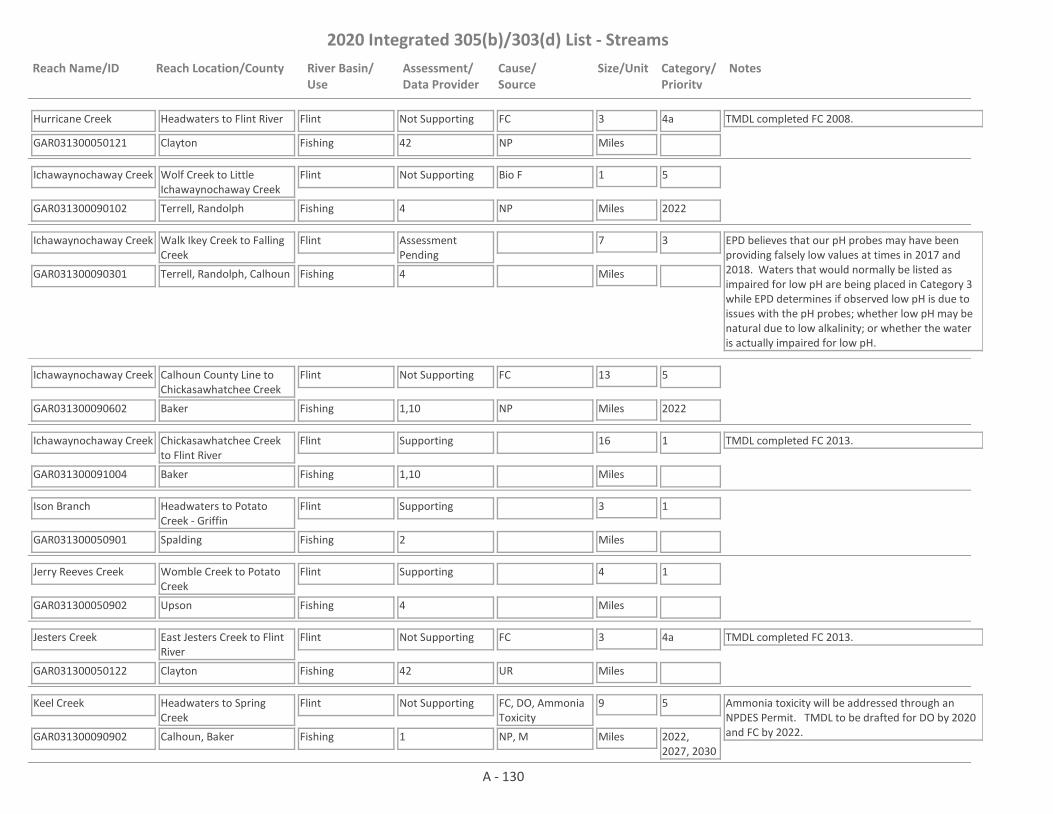
2020 Integrated 305(b)/303(d) List - Streams
Reach Name/ID Reach Location/County River Basin/Use
Assessment/Data Provider
Cause/Source
Size/Unit Category/Priority
Notes
Hurricane Creek
GAR031300050121 42
Headwaters to Flint River
Clayton
Flint
Fishing
Not Supporting FC 3
Miles
4a TMDL completed FC 2008.
NP
Ichawaynochaway Creek
GAR031300090102 4
Wolf Creek to Little Ichawaynochaway Creek
Terrell, Randolph
Flint
Fishing
Not Supporting Bio F 1
Miles
5
2022NP
Ichawaynochaway Creek
GAR031300090301 4
Walk Ikey Creek to Falling Creek
Terrell, Randolph, Calhoun
Flint
Fishing
Assessment Pending
7
Miles
3 EPD believes that our pH probes may have been providing falsely low values at times in 2017 and 2018. Waters that would normally be listed as impaired for low pH are being placed in Category 3 while EPD determines if observed low pH is due to issues with the pH probes; whether low pH may be natural due to low alkalinity; or whether the water is actually impaired for low pH.
Ichawaynochaway Creek
GAR031300090602 1,10
Calhoun County Line to Chickasawhatchee Creek
Baker
Flint
Fishing
Not Supporting FC 13
Miles
5
2022NP
Ichawaynochaway Creek
GAR031300091004 1,10
Chickasawhatchee Creek to Flint River
Baker
Flint
Fishing
Supporting 16
Miles
1 TMDL completed FC 2013.
Ison Branch
GAR031300050901 2
Headwaters to Potato Creek - Griffin
Spalding
Flint
Fishing
Supporting 3
Miles
1
Jerry Reeves Creek
GAR031300050902 4
Womble Creek to Potato Creek
Upson
Flint
Fishing
Supporting 4
Miles
1
Jesters Creek
GAR031300050122 42
East Jesters Creek to Flint River
Clayton
Flint
Fishing
Not Supporting FC 3
Miles
4a TMDL completed FC 2013.
UR
Keel Creek
GAR031300090902 1
Headwaters to Spring Creek
Calhoun, Baker
Flint
Fishing
Not Supporting FC, DO, Ammonia Toxicity
9
Miles
5
2022, 2027, 2030
Ammonia toxicity will be addressed through an NPDES Permit. TMDL to be drafted for DO by 2020 and FC by 2022.NP, M
A - 130

2020 Integrated 305(b)/303(d) List - Streams
Reach Name/ID Reach Location/County River Basin/Use
Assessment/Data Provider
Cause/Source
Size/Unit Category/Priority
Notes
Keg Creek
GAR031300050201 1
Hutchins Lake to Line Creek
Coweta
Flint
Drinking Water, Fishing
Assessment Pending
3
Miles
2 The water is supporting its Fishing Use. Data are not available to assess the Drinking Water Use.
Kendall Creek
GAR031300050507 4
Hill Lake to Wright Branch
Meriwether
Flint
Fishing
Supporting 3
Miles
1
Kinchafoonee Creek
GAR031300070102 4
Headwaters to Lanahasee Creek
Marion
Flint
Fishing
Supporting 10
Miles
1
Kinchafoonee Creek
GAR031300070205 1,10
Marion County Line to Lanahassee Creek
Webster
Flint
Fishing
Not Supporting FC 18
Miles
5
2022
EPD believes that our pH probes may have been providing falsely low values at times in 2017 and 2018. Waters that would normally be listed as impaired for low pH are being placed in Category 3 while EPD determines if observed low pH is due to issues with the pH probes; whether low pH may be natural due to low alkalinity; or whether the water is actually impaired for low pH.
NP
Kinchafoonee Creek
GAR031300070305 1
Lanahassee Creek to Terrell County Line
Webster
Flint
Fishing
Not Supporting FC 8
Miles
5
2022NP
Kinchafoonee Creek
GAR031300070604 1,9
Ga. Hwy. 45 (Webster Co. Line) to Lake Chehaw/Worth
Terrell, Sumter, Lee, Dougherty
Flint
Fishing
Supporting 40
Miles
1 TMDLs completed FC (1998), Fish Tissue (Mercury) (2003).
Kiokee Creek
GAR031300090707 1
Unnamed tributary 0.25 miles upstream of Old Dawson Road to Tallahassee Creek
Dougherty
Flint
Fishing
Not Supporting FC 5
Miles
5
2022NP
Kiokee Creek
GAR031300090706 10
Mud Creek to Hwy 62
Dougherty
Flint
Fishing
Supporting 3
Miles
1
A - 131

2020 Integrated 305(b)/303(d) List - Streams
Reach Name/ID Reach Location/County River Basin/Use
Assessment/Data Provider
Cause/Source
Size/Unit Category/Priority
Notes
Lanahassee Creek
GAR031300070202 1,59
Headwaters to West Fork Lanahassee Creek
Marion, Webster
Flint
Fishing
Not Supporting FC 8
Miles
5
2022
This site has a narrative rank of fair for macroinvertebrates. Waters with a narrative rank of fair will remain in Category 3 until EPD completes the reevaluation of the metrics used to assess macroinvertebrate data.
NP
Lanahassee Creek
GAR031300070201 1,4,10
W. Fork Lanahassee Creek to Kinchafoonee Creek
Webster
Flint
Fishing
Not Supporting FC 6
Miles
4a TMDL completed FC 2003.
NP
Lazar Creek (aka Lazer Creek)
GAR031300050803 1,59
Mossy Branch to Rush Creek
Talbot
Flint
Drinking Water, Fishing
Not Supporting FC 4
Miles
5
2022
This site has a narrative rank of fair for macroinvertebrates. When EPD completes the reevaluation of the metrics used to assess macroinvertebrate data it will be determined if the macroinvertebrate criteria are being met. In Category 3 for pH based on 2014 data from RV_11_3800. About half a year of pH data was determined to be questionable. The water is being placed in Category 3 for pH until more data can be collected.
NP
Lazer Creek
GAR031300050804 4
Rush Creek to Marshall Creek
Talbot
Flint
Fishing, Drinking Water
Assessment Pending
5
Miles
2 The water is supporting its Fishing Use. Data are not available to assess the Drinking Water Use.
Lazer Creek
GAR031300050801 4,10
Marshall Creek to Flint River near Talbotton
Talbot
Flint
Fishing
Supporting 17
Miles
1 TMDL completed FC 1998.
Lee Creek
GAR031300051405 4
Downstream Lake Henry to Beaver Creek
Crawford
Flint
Fishing
Not Supporting Bio F 1
Miles
4a TMDL completed Bio F 2003.
NP
Lewis Creek
GAR031300050604 4
Lake Lewis to Elkins Creek
Pike
Flint
Fishing
Supporting 2
Miles
1 TMDL completed Bio F 2003.
Lime Creek
GAR031300060514 1,10,4
Little Lime Creek to Lake Blackshear
Sumter
Flint
Fishing
Not Supporting FC 5
Miles
4a TMDL completed FC 2003.
NP
A - 132
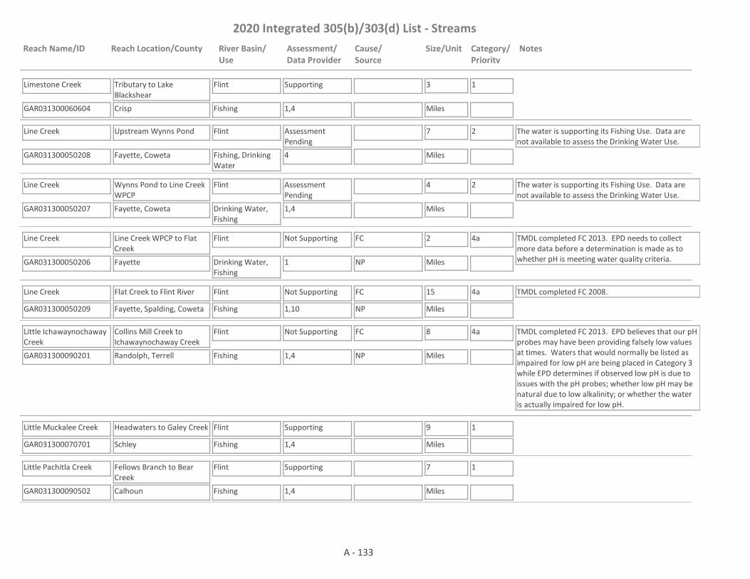
2020 Integrated 305(b)/303(d) List - Streams
Reach Name/ID Reach Location/County River Basin/Use
Assessment/Data Provider
Cause/Source
Size/Unit Category/Priority
Notes
Limestone Creek
GAR031300060604 1,4
Tributary to Lake Blackshear
Crisp
Flint
Fishing
Supporting 3
Miles
1
Line Creek
GAR031300050208 4
Upstream Wynns Pond
Fayette, Coweta
Flint
Fishing, Drinking Water
Assessment Pending
7
Miles
2 The water is supporting its Fishing Use. Data are not available to assess the Drinking Water Use.
Line Creek
GAR031300050207 1,4
Wynns Pond to Line Creek WPCP
Fayette, Coweta
Flint
Drinking Water, Fishing
Assessment Pending
4
Miles
2 The water is supporting its Fishing Use. Data are not available to assess the Drinking Water Use.
Line Creek
GAR031300050206 1
Line Creek WPCP to Flat Creek
Fayette
Flint
Drinking Water, Fishing
Not Supporting FC 2
Miles
4a TMDL completed FC 2013. EPD needs to collect more data before a determination is made as to whether pH is meeting water quality criteria.NP
Line Creek
GAR031300050209 1,10
Flat Creek to Flint River
Fayette, Spalding, Coweta
Flint
Fishing
Not Supporting FC 15
Miles
4a TMDL completed FC 2008.
NP
Little Ichawaynochaway Creek
GAR031300090201 1,4
Collins Mill Creek to Ichawaynochaway Creek
Randolph, Terrell
Flint
Fishing
Not Supporting FC 8
Miles
4a TMDL completed FC 2013. EPD believes that our pH probes may have been providing falsely low values at times. Waters that would normally be listed as impaired for low pH are being placed in Category 3 while EPD determines if observed low pH is due to issues with the pH probes; whether low pH may be natural due to low alkalinity; or whether the water is actually impaired for low pH.
NP
Little Muckalee Creek
GAR031300070701 1,4
Headwaters to Galey Creek
Schley
Flint
Fishing
Supporting 9
Miles
1
Little Pachitla Creek
GAR031300090502 1,4
Fellows Branch to Bear Creek
Calhoun
Flint
Fishing
Supporting 7
Miles
1
A - 133

2020 Integrated 305(b)/303(d) List - Streams
Reach Name/ID Reach Location/County River Basin/Use
Assessment/Data Provider
Cause/Source
Size/Unit Category/Priority
Notes
Little Patsiliga Creek
GAR031300051315 1
Tributary 0.8 miles upstream GA -3/US 19 to Patsiliga Creek
Taylor
Flint
Fishing
Supporting 6
Miles
1
Little Potato Creek
GAR031300050910 4
Lake Myrtle to Potato Creek near Barnesville
Lamar
Flint
Fishing
Supporting 8
Miles
1
Little Redoak Creek (aka Sandy Creek)
GAR031300050502 4
Headwaters to Red Oak Creek
Meriwether
Flint
Fishing
Supporting 6
Miles
1
Little Turkey Creek
GAR031300050704 4
Upson County
Upson
Flint
Fishing
Supporting 2
Miles
1
Little Vine Creek
GAR031300051412 1,59
Headwaters to Beaver Creek
Taylor
Flint
Fishing
Not Supporting Bio M 7
Miles
4a TMDL completed Bio M 2018.
NP
Little White Oak Creek
GAR031300050304 4
Upstream White Oak Creek
Coweta
Flint
Fishing
Supporting 6
Miles
1
Little White Oak Creek
GAR031300050305 4
Downstream Linch Creek
Coweta, Meriwether
Flint
Fishing
Supporting 8
Miles
1
Little Whitewater Creek (aka Big Whitewater Creek)
GAR031300051502 4,59
Black Creek to Whitewater Creek
Taylor
Flint
Fishing
Not Supporting Bio F 6
Miles
4a TMDL completed Bio F 2003.
NP
Long Branch
GAR031300070403 59
Headwaters to Bear Creek
Webster
Flint
Fishing
Assessment Pending
3
Miles
3 This site has a narrative rank of fair for macroinvertebrates. Waters with a narrative rank of fair will remain in Category 3 until EPD completes the reevaluation of the metrics used to assess macroinvertebrate data.
A - 134
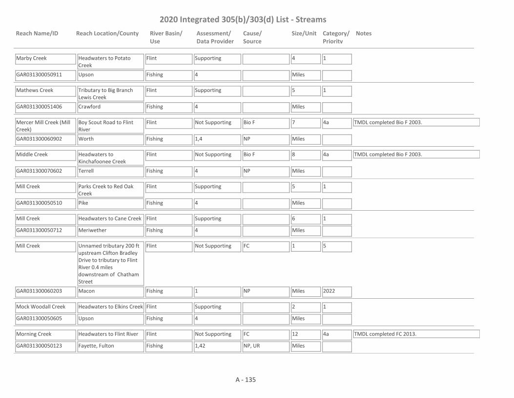
2020 Integrated 305(b)/303(d) List - Streams
Reach Name/ID Reach Location/County River Basin/Use
Assessment/Data Provider
Cause/Source
Size/Unit Category/Priority
Notes
Marby Creek
GAR031300050911 4
Headwaters to Potato Creek
Upson
Flint
Fishing
Supporting 4
Miles
1
Mathews Creek
GAR031300051406 4
Tributary to Big Branch Lewis Creek
Crawford
Flint
Fishing
Supporting 5
Miles
1
Mercer Mill Creek (Mill Creek)
GAR031300060902 1,4
Boy Scout Road to Flint River
Worth
Flint
Fishing
Not Supporting Bio F 7
Miles
4a TMDL completed Bio F 2003.
NP
Middle Creek
GAR031300070602 4
Headwaters to Kinchafoonee Creek
Terrell
Flint
Fishing
Not Supporting Bio F 8
Miles
4a TMDL completed Bio F 2003.
NP
Mill Creek
GAR031300050510 4
Parks Creek to Red Oak Creek
Pike
Flint
Fishing
Supporting 5
Miles
1
Mill Creek
GAR031300050712 4
Headwaters to Cane Creek
Meriwether
Flint
Fishing
Supporting 6
Miles
1
Mill Creek
GAR031300060203 1
Unnamed tributary 200 ft upstream Clifton Bradley Drive to tributary to Flint River 0.4 miles downstream of Chatham Street
Macon
Flint
Fishing
Not Supporting FC 1
Miles
5
2022NP
Mock Woodall Creek
GAR031300050605 4
Headwaters to Elkins Creek
Upson
Flint
Fishing
Supporting 2
Miles
1
Morning Creek
GAR031300050123 1,42
Headwaters to Flint River
Fayette, Fulton
Flint
Fishing
Not Supporting FC 12
Miles
4a TMDL completed FC 2013.
NP, UR
A - 135
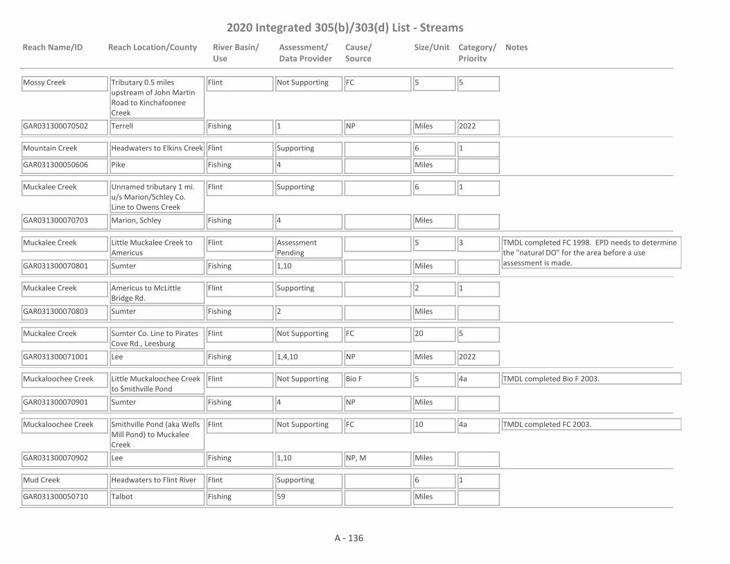
2020 Integrated 305(b)/303(d) List - Streams
Reach Name/ID Reach Location/County River Basin/Use
Assessment/Data Provider
Cause/Source
Size/Unit Category/Priority
Notes
Mossy Creek
GAR031300070502 1
Tributary 0.5 miles upstream of John Martin Road to Kinchafoonee Creek
Terrell
Flint
Fishing
Not Supporting FC 5
Miles
5
2022NP
Mountain Creek
GAR031300050606 4
Headwaters to Elkins Creek
Pike
Flint
Fishing
Supporting 6
Miles
1
Muckalee Creek
GAR031300070703 4
Unnamed tributary 1 mi. u/s Marion/Schley Co. Line to Owens Creek
Marion, Schley
Flint
Fishing
Supporting 6
Miles
1
Muckalee Creek
GAR031300070801 1,10
Little Muckalee Creek to Americus
Sumter
Flint
Fishing
Assessment Pending
5
Miles
3 TMDL completed FC 1998. EPD needs to determine the "natural DO" for the area before a use assessment is made.
Muckalee Creek
GAR031300070803 2
Americus to McLittle Bridge Rd.
Sumter
Flint
Fishing
Supporting 2
Miles
1
Muckalee Creek
GAR031300071001 1,4,10
Sumter Co. Line to Pirates Cove Rd., Leesburg
Lee
Flint
Fishing
Not Supporting FC 20
Miles
5
2022NP
Muckaloochee Creek
GAR031300070901 4
Little Muckaloochee Creek to Smithville Pond
Sumter
Flint
Fishing
Not Supporting Bio F 5
Miles
4a TMDL completed Bio F 2003.
NP
Muckaloochee Creek
GAR031300070902 1,10
Smithville Pond (aka Wells Mill Pond) to Muckalee Creek
Lee
Flint
Fishing
Not Supporting FC 10
Miles
4a TMDL completed FC 2003.
NP, M
Mud Creek
GAR031300050710 59
Headwaters to Flint River
Talbot
Flint
Fishing
Supporting 6
Miles
1
A - 136
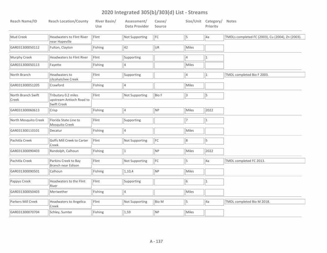
2020 Integrated 305(b)/303(d) List - Streams
Reach Name/ID Reach Location/County River Basin/Use
Assessment/Data Provider
Cause/Source
Size/Unit Category/Priority
Notes
Mud Creek
GAR031300050112 42
Headwaters to Flint River near Hapeville
Fulton, Clayton
Flint
Fishing
Not Supporting FC 5
Miles
4a TMDLs completed FC (2003), Cu (2004), Zn (2003).
UR
Murphy Creek
GAR031300050113 4
Headwaters to Flint River
Fayette
Flint
Fishing
Supporting 4
Miles
1
North Branch
GAR031300051205 4
Headwaters to Ulcohatchee Creek
Crawford
Flint
Fishing
Supporting 4
Miles
1 TMDL completed Bio F 2003.
North Branch Swift Creek
GAR031300060613 4
Tributary 0.2 miles upstream Antioch Road to Swift Creek
Crisp
Flint
Fishing
Not Supporting Bio F 3
Miles
5
2022NP
North Mosquito Creek
GAR031300110101 4
Florida State Line to Mosquito Creek
Decatur
Flint
Fishing
Supporting 7
Miles
1
Pachitla Creek
GAR031300090403 1
Goffs Mill Creek to Carter Creek
Randolph, Calhoun
Flint
Fishing
Not Supporting FC 8
Miles
5
2022NP
Pachitla Creek
GAR031300090501 1,10,4
Parkins Creek to Bay Branch near Edison
Calhoun
Flint
Fishing
Not Supporting FC 5
Miles
4a TMDL completed FC 2013.
NP
Pappys Creek
GAR031300050403 4
Headwaters to the Flint River
Meriwether
Flint
Fishing
Supporting 6
Miles
1
Parkers Mill Creek
GAR031300070704 1,59
Headwaters to Angelica Creek
Schley, Sumter
Flint
Fishing
Not Supporting Bio M 5
Miles
4a TMDL completed Bio M 2018.
NP
A - 137
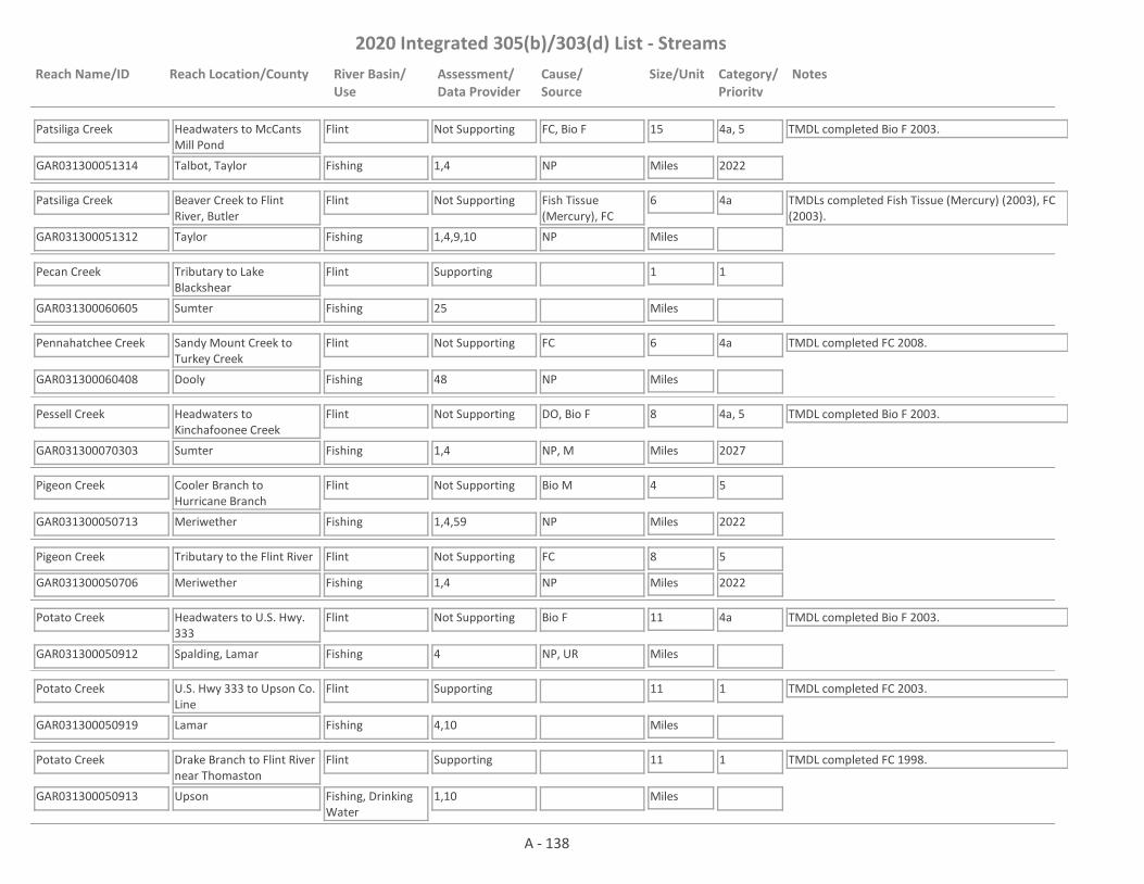
2020 Integrated 305(b)/303(d) List - Streams
Reach Name/ID Reach Location/County River Basin/Use
Assessment/Data Provider
Cause/Source
Size/Unit Category/Priority
Notes
Patsiliga Creek
GAR031300051314 1,4
Headwaters to McCants Mill Pond
Talbot, Taylor
Flint
Fishing
Not Supporting FC, Bio F 15
Miles
4a, 5
2022
TMDL completed Bio F 2003.
NP
Patsiliga Creek
GAR031300051312 1,4,9,10
Beaver Creek to Flint River, Butler
Taylor
Flint
Fishing
Not Supporting Fish Tissue (Mercury), FC
6
Miles
4a TMDLs completed Fish Tissue (Mercury) (2003), FC (2003).
NP
Pecan Creek
GAR031300060605 25
Tributary to Lake Blackshear
Sumter
Flint
Fishing
Supporting 1
Miles
1
Pennahatchee Creek
GAR031300060408 48
Sandy Mount Creek to Turkey Creek
Dooly
Flint
Fishing
Not Supporting FC 6
Miles
4a TMDL completed FC 2008.
NP
Pessell Creek
GAR031300070303 1,4
Headwaters to Kinchafoonee Creek
Sumter
Flint
Fishing
Not Supporting DO, Bio F 8
Miles
4a, 5
2027
TMDL completed Bio F 2003.
NP, M
Pigeon Creek
GAR031300050713 1,4,59
Cooler Branch to Hurricane Branch
Meriwether
Flint
Fishing
Not Supporting Bio M 4
Miles
5
2022NP
Pigeon Creek
GAR031300050706 1,4
Tributary to the Flint River
Meriwether
Flint
Fishing
Not Supporting FC 8
Miles
5
2022NP
Potato Creek
GAR031300050912 4
Headwaters to U.S. Hwy. 333
Spalding, Lamar
Flint
Fishing
Not Supporting Bio F 11
Miles
4a TMDL completed Bio F 2003.
NP, UR
Potato Creek
GAR031300050919 4,10
U.S. Hwy 333 to Upson Co. Line
Lamar
Flint
Fishing
Supporting 11
Miles
1 TMDL completed FC 2003.
Potato Creek
GAR031300050913 1,10
Drake Branch to Flint River near Thomaston
Upson
Flint
Fishing, Drinking Water
Supporting 11
Miles
1 TMDL completed FC 1998.
A - 138
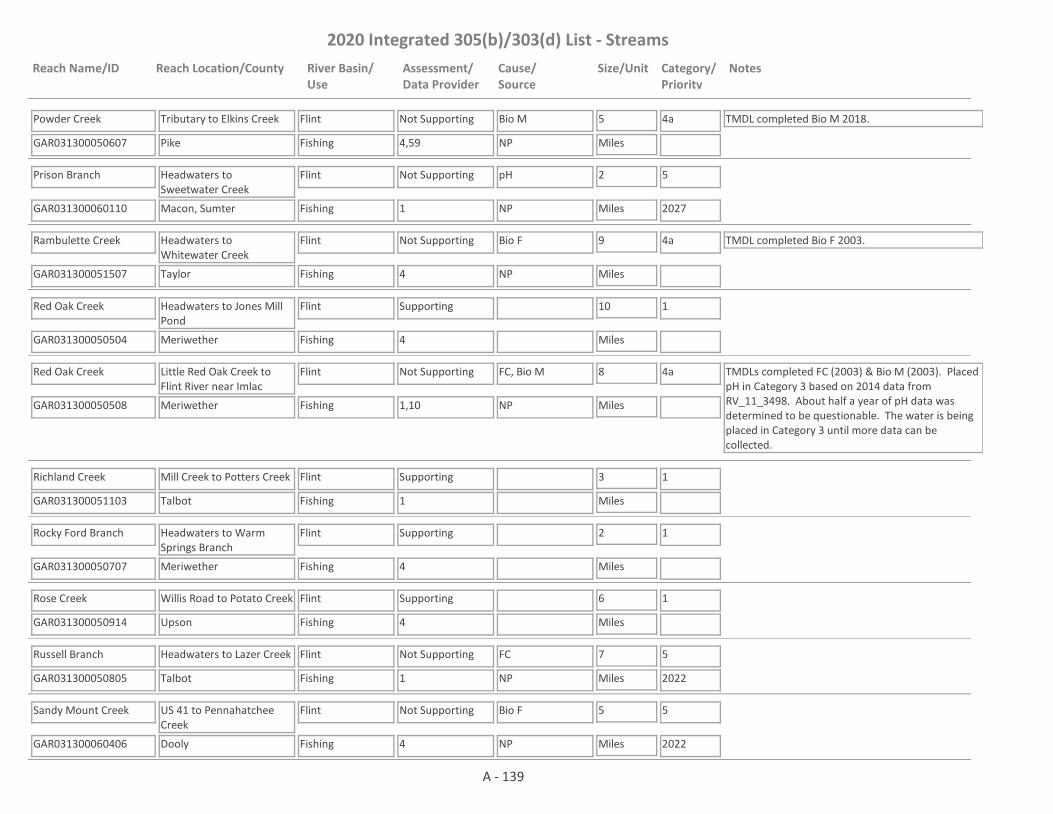
2020 Integrated 305(b)/303(d) List - Streams
Reach Name/ID Reach Location/County River Basin/Use
Assessment/Data Provider
Cause/Source
Size/Unit Category/Priority
Notes
Powder Creek
GAR031300050607 4,59
Tributary to Elkins Creek
Pike
Flint
Fishing
Not Supporting Bio M 5
Miles
4a TMDL completed Bio M 2018.
NP
Prison Branch
GAR031300060110 1
Headwaters to Sweetwater Creek
Macon, Sumter
Flint
Fishing
Not Supporting pH 2
Miles
5
2027NP
Rambulette Creek
GAR031300051507 4
Headwaters to Whitewater Creek
Taylor
Flint
Fishing
Not Supporting Bio F 9
Miles
4a TMDL completed Bio F 2003.
NP
Red Oak Creek
GAR031300050504 4
Headwaters to Jones Mill Pond
Meriwether
Flint
Fishing
Supporting 10
Miles
1
Red Oak Creek
GAR031300050508 1,10
Little Red Oak Creek to Flint River near Imlac
Meriwether
Flint
Fishing
Not Supporting FC, Bio M 8
Miles
4a TMDLs completed FC (2003) & Bio M (2003). Placed pH in Category 3 based on 2014 data from RV_11_3498. About half a year of pH data was determined to be questionable. The water is being placed in Category 3 until more data can be collected.
NP
Richland Creek
GAR031300051103 1
Mill Creek to Potters Creek
Talbot
Flint
Fishing
Supporting 3
Miles
1
Rocky Ford Branch
GAR031300050707 4
Headwaters to Warm Springs Branch
Meriwether
Flint
Fishing
Supporting 2
Miles
1
Rose Creek
GAR031300050914 4
Willis Road to Potato Creek
Upson
Flint
Fishing
Supporting 6
Miles
1
Russell Branch
GAR031300050805 1
Headwaters to Lazer Creek
Talbot
Flint
Fishing
Not Supporting FC 7
Miles
5
2022NP
Sandy Mount Creek
GAR031300060406 4
US 41 to Pennahatchee Creek
Dooly
Flint
Fishing
Not Supporting Bio F 5
Miles
5
2022NP
A - 139

2020 Integrated 305(b)/303(d) List - Streams
Reach Name/ID Reach Location/County River Basin/Use
Assessment/Data Provider
Cause/Source
Size/Unit Category/Priority
Notes
Sheep Rock Hollow
GAR031300050714 1
Headwaters to the Flint River
Meriwether
Flint
Fishing
Not Supporting FC 3
Miles
5
2022NP
Shoal Creek
GAR031300050210 4
Headwaters to Whitewater Creek
Fayette
Flint
Fishing
Supporting 5
Miles
1
Shoal Creek
GAR031300050215 4
Unnamed Tributary 1 mile upstream Andrew Bailey Road to Rock Branch
Coweta
Flint
Fishing
Supporting 4
Miles
1
Shoal Creek
GAR031300060202 4,59
Little Shoal Creek to Little Creek
Marion
Flint
Fishing
Not Supporting Bio F 3
Miles
4a TMDL completed Bio F 2003. This site has a narrative rank of fair for macroinvertebrates. When EPD completes the reevaluation of the metrics used to assess macroinvertebrate data it will be determined if the macroinvertebrate criteria are being met.
NP
Slaughter Creek
GAR031300070101 4
Christmas Branch to Kinchafoonee Creek
Webster
Flint
Fishing
Supporting 1
Miles
1
Spring Creek
GAR031300060104 1,4,9
Headwaters to Flint River near Montezuma
Macon
Flint
Fishing
Not Supporting Bio F, Bio M, FC, Algae
5
Miles
4a, 5
2022, 2027
TMDLs completed Bio M 2003, FC 2018. EPD needs to determine the "natural DO" for the area before it can be determined whether the dissolved oxygen criteria are being met.
NP, UR
Spring Creek
GAR031300050608 1,4
Upson County
Upson
Flint
Fishing
Not Supporting FC 3
Miles
4a
NP
Spring Creek
GAR031300060607 10,25
Tributary to Lake Blackshear
Sumter
Flint
Fishing
Not Supporting Zn, Pb 2
Miles
4a TMDLs completed Pb (2003), Zn (2003).
NP
Spring Creek
GAR031300100101 1,4,10
SR 62 to Dry Creek
Early
Flint
Fishing
Not Supporting Bio F 15
Miles
4a TMDLs completed DO (2003), Bio F (2003), FC (2013).
UR
A - 140
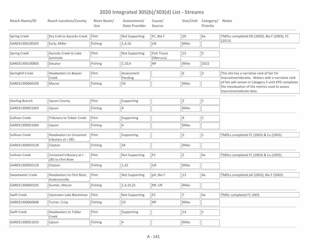
2020 Integrated 305(b)/303(d) List - Streams
Reach Name/ID Reach Location/County River Basin/Use
Assessment/Data Provider
Cause/Source
Size/Unit Category/Priority
Notes
Spring Creek
GAR031300100503 1,4,10
Dry Crek to Aycocks Creek
Early, Miller
Flint
Fishing
Not Supporting FC, Bio F 20
Miles
4a TMDLs completed DO (2003), Bio F (2003), FC (2013).
UR
Spring Creek
GAR031300100803 1,10,4
Aycocks Creek to Lake Seminole
Decatur
Flint
Fishing
Not Supporting Fish Tissue (Mercury)
15
Miles
5
2022NP
Springhill Creek
GAR031300060109 59
Headwaters to Beaver Creek
Macon
Flint
Fishing
Assessment Pending
6
Miles
3 This site has a narrative rank of fair for macroinvertebrates. Waters with a narrative rank of fair will remain in Category 3 until EPD completes the reevaluation of the metrics used to assess macroinvertebrate data.
Starling Branch
GAR031300051003 4
Upson County
Upson
Flint
Fishing
Supporting 2
Miles
1
Sullivan Creek
GAR031300051004 4
Tributary to Tobler Creek
Upson
Flint
Fishing
Supporting 4
Miles
1
Sullivan Creek
GAR031300050128 34
Headwaters to Unnamed tributary at I-285
Clayton
Flint
Fishing
Supporting 2
Miles
1 TMDLs completed FC (2003) & Cu (2003).
Sullivan Creek
GAR031300050129 1,42
Unnamed tributary at I-285 to Flint River
Clayton
Flint
Fishing
Not Supporting FC 2
Miles
4a TMDLs completed FC (2003) & Cu (2003).
UR
Sweetwater Creek
GAR031300060105 1,4,10,25
Headwaters to Flint River, Andersonville
Sumter, Macon
Flint
Fishing
Not Supporting pH, Bio F 13
Miles
4a TMDLs completed pH (2003), Bio F (2003).
NP, UR
Swift Creek
GAR031300060608 10
Upstream Lake Blackshear
Turner, Crisp
Flint
Fishing
Not Supporting FC 7
Miles
4a TMDL completed FC 2003.
NP
Swift Creek
GAR031300051010 4
Headwaters to Tobler Creek
Upson
Flint
Fishing
Supporting 14
Miles
1
A - 141

2020 Integrated 305(b)/303(d) List - Streams
Reach Name/ID Reach Location/County River Basin/Use
Assessment/Data Provider
Cause/Source
Size/Unit Category/Priority
Notes
Swift Creek
GAR031300051009 1,10
Tobler Creek to Flint River
Upson
Flint
Fishing
Not Supporting FC 5
Miles
4a TMDL completed FC 2003. In Category 3 for pH based on 2014 data from RV_11_3443. About half a year of pH data was determined to be questionable. The water is being placed in Category 3 until more data can be collected.
NP
Ten Mile Creek
GAR031300050915 4
Smyrna Road to Potato Creek
Upson
Flint
Fishing
Supporting 8
Miles
1
Tobler Creek
GAR031300051006 1,4
Headwaters to Swift Creek
Upson
Flint
Fishing
Not Supporting FC 23
Miles
5
2022
EPD believes that our pH probes may have been providing falsely low values at times in 2017 and 2018. Waters that would normally be listed as impaired for low pH are being placed in Category 3 while EPD determines if observed low pH is due to issues with the pH probes; whether low pH may be natural due to low alkalinity; or whether the water is actually impaired for low pH.
NP
Town Branch
GAR031300050916 4
Headwaters to Bell Creek - Thomaston
Upson
Flint
Fishing
Not Supporting Bio F 4
Miles
4a TMDL completed Bio F 2003.
UR
Town Branch
GAR031300050610 1
Zebulon WPCP to Elkins Creek
Pike
Flint
Fishing
Not Supporting FC 1
Miles
5
2022NP
Town Creek
GAR031300090401 4
Headwaters to Carter Creek
Randolph
Flint
Fishing
Supporting 7
Miles
1
Town Creek
GAR031300070802 1,4,59
Rigas Road to Muckalee Creek
Sumter
Flint
Fishing
Not Supporting Bio M 2
Miles
4a TMDL completed Bio M 2018.
NP
Tributary to Baptist Branch
GAR031300100206 1
Headwaters to Baptist Branch
Early
Flint
Fishing
Supporting 1
Miles
1
A - 142

2020 Integrated 305(b)/303(d) List - Streams
Reach Name/ID Reach Location/County River Basin/Use
Assessment/Data Provider
Cause/Source
Size/Unit Category/Priority
Notes
Tributary to Bay Branch
GAR031300090504 1
Headwaters to pond 0.3 miles downstream Bay Street
Calhoun
Flint
Fishing
Assessment Pending
2
Miles
3 The water is being placed into Category 3 until more data is collected. Data was collected from RV_11_16293 January - May and December 2016. The stream was dry the rest of the year.
Tributary to Bay Branch
GAR031300090505 1
Pond 0.3 miles downstream Bay Street to Bay Branch
Calhoun
Flint
Fishing
Not Supporting FC, DO 2
Miles
5
2022, 2027
The TMDL for FC is scheduled to be drafted in 2022 and the one for DO in 2027.
NP, M
Tributary to Bear Creek
GAR031300070402 1,59
Headwaters to Bear Creek
Terrell, Webster
Flint
Fishing
Not Supporting pH, Bio M 3
Miles
4a, 5
2027
TMDL completed Bio M 2018.
NP
Tributary to Elkins Creek
GAR031300050611 1
0.8 miles upstream Fossett Road to Elkins Creek
Pike
Flint
Fishing
Assessment Pending
2
Miles
3 EPD believes that our pH probes may have been providing falsely low values at times in 2017 and 2018. Waters that would normally be listed as impaired for low pH are being placed in Category 3 while EPD determines if observed low pH is due to issues with the pH probes; whether low pH may be natural due to low alkalinity; or whether the water is actually impaired for low pH.
Tributary to Flint River #2
GAR031300051102 1,59
Headwaters to Flint River (near Talbot, Upson County lines)
Taylor
Flint
Fishing
Supporting 3
Miles
1
Tributary to Kinchafoonee Creek
GAR031300070304 1,59
Headwaters to Kinchafoonee Creek
Webster
Flint
Fishing
Assessment Pending
3
Miles
3 This site has a narrative rank of fair for macroinvertebrates. When EPD completes the reevaluation of the metrics used to assess macroinvertebrate data it will be determined if the macroinvertebrate criteria are being met.
Tributary to Morning Creek
GAR031300050132 1
Phillips Lake to Morning Creek
Fayette
Flint
Fishing
Supporting 1
Miles
1
Tributary to Nash Creek
GAR031300050116 2
Fayetteville
Fayette
Flint
Fishing
Not Supporting FC 1
Miles
4a TMDL completed FC 1998.
UR
A - 143
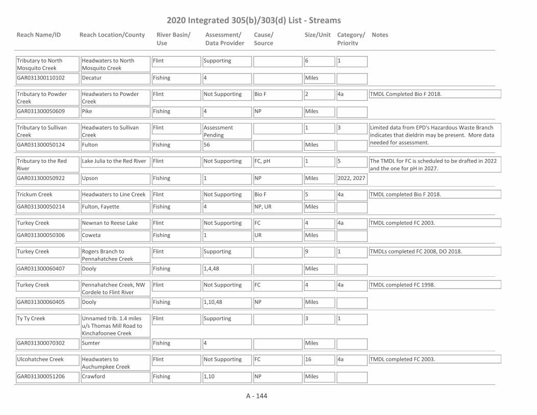
2020 Integrated 305(b)/303(d) List - Streams
Reach Name/ID Reach Location/County River Basin/Use
Assessment/Data Provider
Cause/Source
Size/Unit Category/Priority
Notes
Tributary to North Mosquito Creek
GAR031300110102 4
Headwaters to North Mosquito Creek
Decatur
Flint
Fishing
Supporting 6
Miles
1
Tributary to Powder Creek
GAR031300050609 4
Headwaters to Powder Creek
Pike
Flint
Fishing
Not Supporting Bio F 2
Miles
4a TMDL Completed Bio F 2018.
NP
Tributary to Sullivan Creek
GAR031300050124 56
Headwaters to Sullivan Creek
Fulton
Flint
Fishing
Assessment Pending
1
Miles
3 Limited data from EPD's Hazardous Waste Branch indicates that dieldrin may be present. More data needed for assessment.
Tributary to the Red River
GAR031300050922 1
Lake Julia to the Red River
Upson
Flint
Fishing
Not Supporting FC, pH 1
Miles
5
2022, 2027
The TMDL for FC is scheduled to be drafted in 2022 and the one for pH in 2027.
NP
Trickum Creek
GAR031300050214 4
Headwaters to Line Creek
Fulton, Fayette
Flint
Fishing
Not Supporting Bio F 5
Miles
4a TMDL completed Bio F 2018.
NP, UR
Turkey Creek
GAR031300050306 1
Newnan to Reese Lake
Coweta
Flint
Fishing
Not Supporting FC 4
Miles
4a TMDL completed FC 2003.
UR
Turkey Creek
GAR031300060407 1,4,48
Rogers Branch to Pennahatchee Creek
Dooly
Flint
Fishing
Supporting 9
Miles
1 TMDLs completed FC 2008, DO 2018.
Turkey Creek
GAR031300060405 1,10,48
Pennahatchee Creek, NW Cordele to Flint River
Dooly
Flint
Fishing
Not Supporting FC 4
Miles
4a TMDL completed FC 1998.
NP
Ty Ty Creek
GAR031300070302 4
Unnamed trib. 1.4 miles u/s Thomas Mill Road to Kinchafoonee Creek
Sumter
Flint
Fishing
Supporting 3
Miles
1
Ulcohatchee Creek
GAR031300051206 1,10
Headwaters to Auchumpkee Creek
Crawford
Flint
Fishing
Not Supporting FC 16
Miles
4a TMDL completed FC 2003.
NP
A - 144

2020 Integrated 305(b)/303(d) List - Streams
Reach Name/ID Reach Location/County River Basin/Use
Assessment/Data Provider
Cause/Source
Size/Unit Category/Priority
Notes
Vallhalla Branch
GAR031300060609 1
Tributary to Lake Blackshear
Crisp
Flint
Fishing
Supporting 1
Miles
1
Walnut Creek
GAR031300050509 4
Meriwether County
Meriwether
Flint
Fishing
Supporting 4
Miles
1
Wasp Creek
GAR031300050921 4
Headwaters to Little Wasp Creek
Spalding, Pike
Flint
Fishing
Not Supporting Bio F 5
Miles
4a TMDL completed Bio F 2008.
NP
White Oak Creek
GAR031300050308 4,10
Newnan - I-85 to Chandlers Creek
Coweta
Flint
Drinking Water, Fishing
Not Supporting FC 6
Miles
4a TMDL completed FC 1998.
NP
White Oak Creek
GAR031300050311 10
Chandlers Creek to Bear Creek
Coweta, Meriwether
Flint
Fishing
Supporting 14
Miles
1 TMDL completed DO 2003.
White Oak Creek
GAR031300050307 1,10
Little White Oak Creek to Flint River near Alvaton
Meriwether
Flint
Fishing
Not Supporting FC 9
Miles
4a TMDL completed FC 1998.
NP
Whitewater Creek
GAR031300050213 4,17
Headwaters to Lees Lake
Fulton, Fayette
Flint
Fishing
Not Supporting FC, Bio F 6
Miles
4a TMDLs completed Bio F (2003), FC (2013).
UR
Whitewater Creek
GAR031300050212 4
Lake Bennett to Starrs Mill Pond
Fayette
Flint
Drinking Water, Fishing
Not Supporting Bio F 8
Miles
4a TMDL completed Bio F 2018. The water is supporting its Fishing Use. Data are not available to assess the Drinking Water Use.NP, UR
Whitewater Creek
GAR031300050211 10
Starr's Millpond to Line Creek
Fayette
Flint
Fishing, Drinking Water
Supporting 5
Miles
1
A - 145

2020 Integrated 305(b)/303(d) List - Streams
Reach Name/ID Reach Location/County River Basin/Use
Assessment/Data Provider
Cause/Source
Size/Unit Category/Priority
Notes
Whitewater Creek
GAR031300051503 1,4
Headwaters to Little Whitewater Creek
Taylor
Flint
Fishing
Not Supporting Bio F 9
Miles
4a TMDL completed Bio F 2003. The water is in Category 3 for pH. EPD needs to determine if the low pH observed is natural due to natural conditions (blackwater and/or low alkalinity) or if low pH is a cause of impairment.
NP
Whitewater Creek
GAR031300051506 1,10
Big Whitewater Creek to Cedar Creek
Taylor, Macon
Flint
Fishing
Not Supporting FC 17
Miles
4a TMDLs completed FC (2003), pH (2003).
NP
Whitewater Creek
GAR031300051505 10
Cedar Creek to Flint River
Macon
Flint
Fishing
Not Supporting FC 13
Miles
4a TMDLs completed FC (2003), pH (2003)
UR
Wildcat Creek
GAR031300050117 10
Heads Creek to Flint River
Spalding
Flint
Fishing
Not Supporting FC 2
Miles
4a TMDL completed FC 2003.
UR
Willingham Spring Creek
GAR031300050917 4
Headwaters to Ten Mile Creek
Upson
Flint
Fishing
Not Supporting Bio F 3
Miles
4a TMDL completed Bio F 2003.
NP
Winky Branch
GAR031300050309 4
Tributary to White Oak Creek
Meriwether
Flint
Fishing
Supporting 4
Miles
1
Wolf Creek
GAR031300051007 4
Headwaters to Swift Creek
Upson
Flint
Fishing
Supporting 5
Miles
1
Wolf Creek
GAR031300090101 4
Headwaters to Ichawaynochaway Creek
Terrell
Flint
Fishing
Not Supporting Bio F 9
Miles
4a TMDL completed Bio F 2003.
NP
Wolf Creek (aka Shoals Creek)
GAR031300050310 4
Headwaters to White Oak Creek
Meriwether
Flint
Fishing
Supporting 5
Miles
1
A - 146

2020 Integrated 305(b)/303(d) List - Streams
Reach Name/ID Reach Location/County River Basin/Use
Assessment/Data Provider
Cause/Source
Size/Unit Category/Priority
Notes
Womble Creek
GAR031300050918 1,4
Headwaters to Jerry Reeves Creek
Upson
Flint
Fishing
Not Supporting FC 6
Miles
5
2022
EPD believes that our pH probes may have been providing falsely low values at times in 2017 and 2018. Waters that would normally be listed as impaired for low pH are being placed in Category 3 while EPD determines if observed low pH is due to issues with the pH probes; whether low pH may be natural due to low alkalinity; or whether the water is actually impaired for low pH.
NP
Woolsey Creek
GAR031300050109 4
Headwaters to Horton Creek
Fayette
Flint
Fishing
Supporting 6
Miles
1
Attapulgus Creek
GAR031200030203 1,10
Callahan Branch to Little Attapulgus Creek
Decatur
Ochlockonee
Fishing
Assessment Pending
8
Miles
3 TMDL completed FC 2006. EPD believes that our pH probes may have been providing falsely low values at times in 2017 and 2018. Waters that would normally be listed as impaired for low pH are being placed in Category 3 while EPD determines if observed low pH is due to issues with the pH probes; whether low pH may be natural due to low alkalinity; or whether the water is actually impaired for low pH.
Aucilla River
GAR031101030102 1,10
Masse Branch to Brooks County line near Boston
Thomas
Ochlockonee
Fishing
Not Supporting DO, FC 10
Miles
4a TMDLs completed DO (2001), FC (2006).
NP
Barnetts Creek
GAR031200020501 10
West Branch to Ochlockonee River, W. of Thomasville
Thomas, Grady
Ochlockonee
Fishing
Supporting 8
Miles
1 TMDL completed DO 2001.
Bay Pole Branch
GAR031200020203 1
Pond 400 feet upstream Bay Pole School Road to Bridge Creek
Colquitt
Ochlockonee
Fishing
Not Supporting FC 3
Miles
5
2021
EPD needs to determine the "natural DO" for the area before it can be determined whether the dissolved oxygen criteria are being met.
NP
Big Creek
GAR031200020302 10
Woodhaven Rd. East of Coolidge to Ochlockonee River
Thomas
Ochlockonee
Fishing
Not Supporting FC 12
Miles
4a TMDLs completed DO (2001), FC (2006).
NP
A - 147

2020 Integrated 305(b)/303(d) List - Streams
Reach Name/ID Reach Location/County River Basin/Use
Assessment/Data Provider
Cause/Source
Size/Unit Category/Priority
Notes
Big Creek
GAR031200020402 1,10
Headwaters to Little Creek near Meigs
Mitchell, Thomas
Ochlockonee
Fishing
Not Supporting FC, DO 12
Miles
4a TMDLs completed FC (2006), DO (2001).
NP
Bridge Creek
GAR031200020202 10
Mill Creek to upstream Ga. Hwy. 111 near Moultrie
Colquitt
Ochlockonee
Fishing
Not Supporting FC 7
Miles
4a TMDLs completed FC (2006), DO (2001).
NP
Bridge Creek
GAR031200020201 1,10
Upstream Ga. Hwy 111 near Moultrie to Ochlockonee River
Colquitt, Thomas
Ochlockonee
Fishing
Assessment Pending
10
Miles
3 TMDL completed DO 2001. EPD believes that our pH probes may have been providing falsely low values at times in 2017 and 2018. Waters that would normally be listed as impaired for low pH are being placed in Category 3 while EPD determines if observed low pH is due to issues with the pH probes; whether low pH may be natural due to low alkalinity; or whether the water is actually impaired for low pH.
Callahan Branch
GAR031200030204 59
Headwaters to Attapulgus Creek
Decatur
Ochlockonee
Fishing
Supporting 4
Miles
1
Connell Creek
GAR031101030202 1
Headwaters to the Florida State Line
Thomas
Ochlockonee
Fishing
Assessment Pending
10
Miles
3 The water is being placed in Category 3 due to a lack of data. Data was available from January - June 2014, but the stream was dry the rest of the year. It is being placed in Category 3 until more data is obtained.
East Branch Barnetts Creek
GAR031200020502 1,10
Horse Creek to Barnetts Creek near Ochlocknee
Thomas
Ochlockonee
Fishing
Not Supporting FC 3
Miles
4a TMDLs completed FC (2011), DO (2001).
NP
Hadley Creek
GAR031200030102 59
Headwaters to Ochlockonee River
Grady
Ochlockonee
Fishing
Supporting 4
Miles
1
Horse Creek
GAR031200020503 1
Headwaters to East Branch Barnetts Creek
Thomas
Ochlockonee
Fishing
Assessment Pending
7
Miles
3 EPD needs to determine the "natural DO" for the area before a use assessment is made.
A - 148
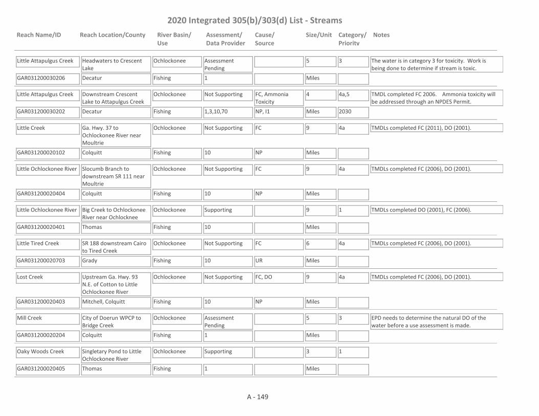
2020 Integrated 305(b)/303(d) List - Streams
Reach Name/ID Reach Location/County River Basin/Use
Assessment/Data Provider
Cause/Source
Size/Unit Category/Priority
Notes
Little Attapulgus Creek
GAR031200030206 1
Headwaters to Crescent Lake
Decatur
Ochlockonee
Fishing
Assessment Pending
5
Miles
3 The water is in category 3 for toxicity. Work is being done to determine if stream is toxic.
Little Attapulgus Creek
GAR031200030202 1,3,10,70
Downstream Crescent Lake to Attapulgus Creek
Decatur
Ochlockonee
Fishing
Not Supporting FC, Ammonia Toxicity
4
Miles
4a,5
2030
TMDL completed FC 2006. Ammonia toxicity will be addressed through an NPDES Permit.
NP, I1
Little Creek
GAR031200020102 10
Ga. Hwy. 37 to Ochlockonee River near Moultrie
Colquitt
Ochlockonee
Fishing
Not Supporting FC 9
Miles
4a TMDLs completed FC (2011), DO (2001).
NP
Little Ochlockonee River
GAR031200020404 10
Slocumb Branch to downstream SR 111 near Moultrie
Colquitt
Ochlockonee
Fishing
Not Supporting FC 9
Miles
4a TMDLs completed FC (2006), DO (2001).
NP
Little Ochlockonee River
GAR031200020401 10
Big Creek to Ochlockonee River near Ochlocknee
Thomas
Ochlockonee
Fishing
Supporting 9
Miles
1 TMDLs completed DO (2001), FC (2006).
Little Tired Creek
GAR031200020703 10
SR 188 downstream Cairo to Tired Creek
Grady
Ochlockonee
Fishing
Not Supporting FC 6
Miles
4a TMDLs completed FC (2006), DO (2001).
UR
Lost Creek
GAR031200020403 10
Upstream Ga. Hwy. 93 N.E. of Cotton to Little Ochlockonee River
Mitchell, Colquitt
Ochlockonee
Fishing
Not Supporting FC, DO 9
Miles
4a TMDLs completed FC (2006), DO (2001).
NP
Mill Creek
GAR031200020204 1
City of Doerun WPCP to Bridge Creek
Colquitt
Ochlockonee
Fishing
Assessment Pending
5
Miles
3 EPD needs to determine the natural DO of the water before a use assessment is made.
Oaky Woods Creek
GAR031200020405 1
Singletary Pond to Little Ochlockonee River
Thomas
Ochlockonee
Fishing
Supporting 3
Miles
1
A - 149
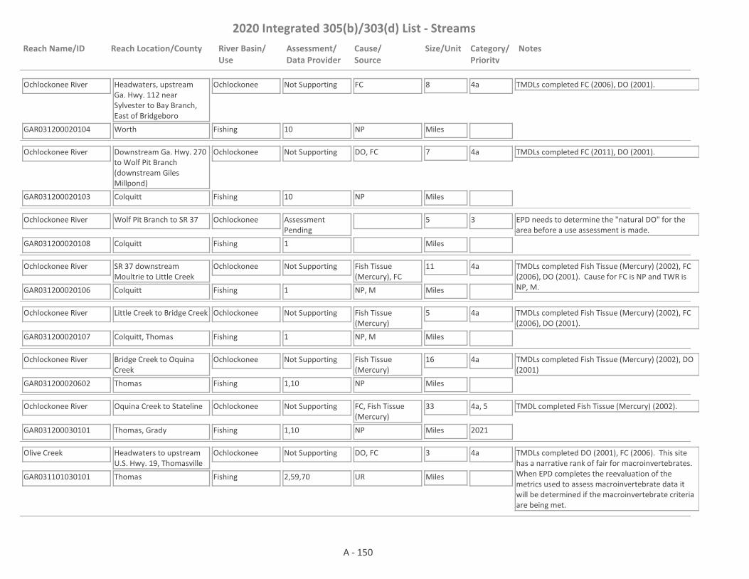
2020 Integrated 305(b)/303(d) List - Streams
Reach Name/ID Reach Location/County River Basin/Use
Assessment/Data Provider
Cause/Source
Size/Unit Category/Priority
Notes
Ochlockonee River
GAR031200020104 10
Headwaters, upstream Ga. Hwy. 112 near Sylvester to Bay Branch, East of Bridgeboro
Worth
Ochlockonee
Fishing
Not Supporting FC 8
Miles
4a TMDLs completed FC (2006), DO (2001).
NP
Ochlockonee River
GAR031200020103 10
Downstream Ga. Hwy. 270 to Wolf Pit Branch (downstream Giles Millpond)
Colquitt
Ochlockonee
Fishing
Not Supporting DO, FC 7
Miles
4a TMDLs completed FC (2011), DO (2001).
NP
Ochlockonee River
GAR031200020108 1
Wolf Pit Branch to SR 37
Colquitt
Ochlockonee
Fishing
Assessment Pending
5
Miles
3 EPD needs to determine the "natural DO" for the area before a use assessment is made.
Ochlockonee River
GAR031200020106 1
SR 37 downstream Moultrie to Little Creek
Colquitt
Ochlockonee
Fishing
Not Supporting Fish Tissue (Mercury), FC
11
Miles
4a TMDLs completed Fish Tissue (Mercury) (2002), FC (2006), DO (2001). Cause for FC is NP and TWR is NP, M.NP, M
Ochlockonee River
GAR031200020107 1
Little Creek to Bridge Creek
Colquitt, Thomas
Ochlockonee
Fishing
Not Supporting Fish Tissue (Mercury)
5
Miles
4a TMDLs completed Fish Tissue (Mercury) (2002), FC (2006), DO (2001).
NP, M
Ochlockonee River
GAR031200020602 1,10
Bridge Creek to Oquina Creek
Thomas
Ochlockonee
Fishing
Not Supporting Fish Tissue (Mercury)
16
Miles
4a TMDLs completed Fish Tissue (Mercury) (2002), DO (2001)
NP
Ochlockonee River
GAR031200030101 1,10
Oquina Creek to Stateline
Thomas, Grady
Ochlockonee
Fishing
Not Supporting FC, Fish Tissue (Mercury)
33
Miles
4a, 5
2021
TMDL completed Fish Tissue (Mercury) (2002).
NP
Olive Creek
GAR031101030101 2,59,70
Headwaters to upstream U.S. Hwy. 19, Thomasville
Thomas
Ochlockonee
Fishing
Not Supporting DO, FC 3
Miles
4a TMDLs completed DO (2001), FC (2006). This site has a narrative rank of fair for macroinvertebrates. When EPD completes the reevaluation of the metrics used to assess macroinvertebrate data it will be determined if the macroinvertebrate criteria are being met.
UR
A - 150
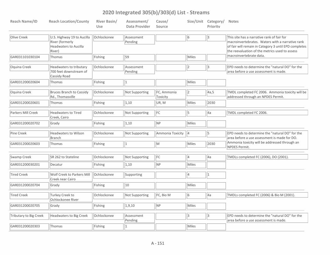
2020 Integrated 305(b)/303(d) List - Streams
Reach Name/ID Reach Location/County River Basin/Use
Assessment/Data Provider
Cause/Source
Size/Unit Category/Priority
Notes
Olive Creek
GAR031101030104 59
U.S. Highway 19 to Aucilla River (formerly Headwaters to Aucilla River)
Thomas
Ochlockonee
Fishing
Assessment Pending
6
Miles
3 This site has a narrative rank of fair for macroinvertebrates. Waters with a narrative rank of fair will remain in Category 3 until EPD completes the reevaluation of the metrics used to assess macroinvertebrate data.
Oquina Creek
GAR031200020604 1
Headwaters to tributary 700 feet downstream of Cassidy Road
Thomas
Ochlockonee
Fishing
Assessment Pending
2
Miles
3 EPD needs to determine the "natural DO" for the area before a use assessment is made.
Oquina Creek
GAR031200020601 1,10
Bruces Branch to Cassidy Rd., Thomasville
Thomas
Ochlockonee
Fishing
Not Supporting FC, Ammonia Toxicity
2
Miles
4a,5
2030
TMDL completed FC 2006. Ammonia toxicity will be addressed through an NPDES Permit.
UR, M
Parkers Mill Creek
GAR031200020702 1,10
Headwaters to Tired Creek, Cairo
Grady
Ochlockonee
Fishing
Not Supporting FC 5
Miles
4a TMDL completed FC 2006.
NP
Pine Creek
GAR031200020603 1
Headwaters to Wilson Branch
Thomas
Ochlockonee
Fishing
Not Supporting Ammonia Toxicity 4
Miles
5
2030
EPD needs to determine the "natural DO" for the area before a use assessment is made for DO. Ammonia toxicity will be addressed through an NPDES Permit.
M
Swamp Creek
GAR031200030201 1,10
SR 262 to Stateline
Decatur
Ochlockonee
Fishing
Not Supporting FC 4
Miles
4a TMDLs completed FC (2006), DO (2001).
NP
Tired Creek
GAR031200020704 10
Wolf Creek to Parkers Mill Creek near Cairo
Grady
Ochlockonee
Fishing
Supporting 4
Miles
1
Tired Creek
GAR031200020705 1,9,10
Turkey Creek to Ochlockonee River
Grady
Ochlockonee
Fishing
Not Supporting FC, Bio M 6
Miles
4a TMDLs completed FC (2006) & Bio M (2001).
NP
Tributary to Big Creek
GAR031200020303 1
Headwaters to Big Creek
Thomas
Ochlockonee
Fishing
Assessment Pending
3
Miles
3 EPD needs to determine the "natural DO" for the area before a use assessment is made.
A - 151
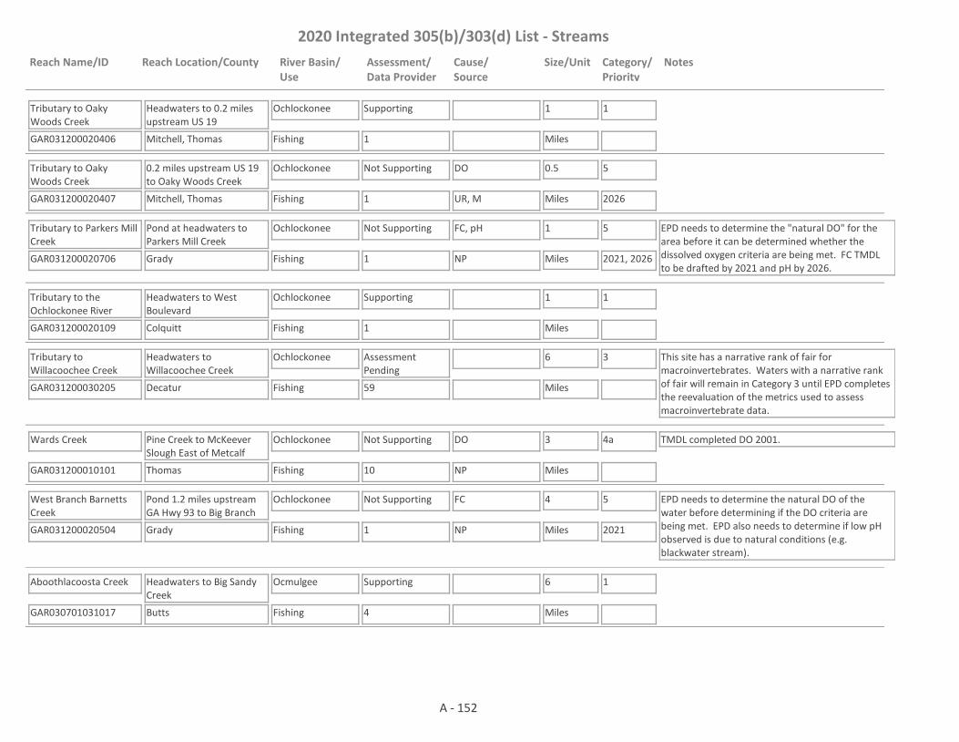
2020 Integrated 305(b)/303(d) List - Streams
Reach Name/ID Reach Location/County River Basin/Use
Assessment/Data Provider
Cause/Source
Size/Unit Category/Priority
Notes
Tributary to Oaky Woods Creek
GAR031200020406 1
Headwaters to 0.2 miles upstream US 19
Mitchell, Thomas
Ochlockonee
Fishing
Supporting 1
Miles
1
Tributary to Oaky Woods Creek
GAR031200020407 1
0.2 miles upstream US 19 to Oaky Woods Creek
Mitchell, Thomas
Ochlockonee
Fishing
Not Supporting DO 0.5
Miles
5
2026UR, M
Tributary to Parkers Mill Creek
GAR031200020706 1
Pond at headwaters to Parkers Mill Creek
Grady
Ochlockonee
Fishing
Not Supporting FC, pH 1
Miles
5
2021, 2026
EPD needs to determine the "natural DO" for the area before it can be determined whether the dissolved oxygen criteria are being met. FC TMDL to be drafted by 2021 and pH by 2026.
NP
Tributary to the Ochlockonee River
GAR031200020109 1
Headwaters to West Boulevard
Colquitt
Ochlockonee
Fishing
Supporting 1
Miles
1
Tributary to Willacoochee Creek
GAR031200030205 59
Headwaters to Willacoochee Creek
Decatur
Ochlockonee
Fishing
Assessment Pending
6
Miles
3 This site has a narrative rank of fair for macroinvertebrates. Waters with a narrative rank of fair will remain in Category 3 until EPD completes the reevaluation of the metrics used to assess macroinvertebrate data.
Wards Creek
GAR031200010101 10
Pine Creek to McKeever Slough East of Metcalf
Thomas
Ochlockonee
Fishing
Not Supporting DO 3
Miles
4a TMDL completed DO 2001.
NP
West Branch Barnetts Creek
GAR031200020504 1
Pond 1.2 miles upstream GA Hwy 93 to Big Branch
Grady
Ochlockonee
Fishing
Not Supporting FC 4
Miles
5
2021
EPD needs to determine the natural DO of the water before determining if the DO criteria are being met. EPD also needs to determine if low pH observed is due to natural conditions (e.g. blackwater stream).
NP
Aboothlacoosta Creek
GAR030701031017 4
Headwaters to Big Sandy Creek
Butts
Ocmulgee
Fishing
Supporting 6
Miles
1
A - 152

2020 Integrated 305(b)/303(d) List - Streams
Reach Name/ID Reach Location/County River Basin/Use
Assessment/Data Provider
Cause/Source
Size/Unit Category/Priority
Notes
Alcovy River
GAR030701030701 18
Headwaters to Cedar Creek (Formerly Headwaters to Walton County Line)
Gwinnett
Ocmulgee
Fishing
Not Supporting FC 16
Miles
4a TMDL completed FC 2007.
NP
Alcovy River
GAR030701030709 1
Cedar Creek to Bay Creek
Walton
Ocmulgee
Fishing, Drinking Water
Not Supporting FC 4
Miles
4a TMDL completed FC (2002 & 2007). EPD believes that our pH probes may have been providing falsely low values at times in 2017 and 2018. Waters that would normally be listed as impaired for low pH are being placed in Category 3 while EPD determines if observed low pH is due to issues with the pH probes; whether low pH may be natural due to low alkalinity; or whether the water is actually impaired for low pH.
NP
Alcovy River
GAR030701030711 1
Mountain Creek to Big Flat Creek
Walton, Newton
Ocmulgee
Drinking Water, Fishing
Not Supporting FC 7
Miles
4a TMDL completed FC 2007.
NP
Alcovy River
GAR030701030716 1
Big Flat Creek to Cornish Creek
Newton
Ocmulgee
Drinking Water, Fishing
Assessment Pending
5
Miles
2 The water is supporting its Fishing Use. Data are not available to assess the Drinking Water Use.
Alcovy River
GAR030701030803 1,10
Wrights Creek to Bear Creek/Jackson Lake
Newton
Ocmulgee
Fishing, Recreation
Not Supporting E Coli 13
Miles
5
2025
TMDL completed FC 2018. The Designated Use of Fishing is being met. The Designated Use of Recreation is impaired for E. coli. E. coli and FC are both indicators for pathogens. In the future, EPD may use the FC TMDL for the E coli impairment with a translator for FC to E. coli.
NP
Alligator Creek
GAR030701040703 10
Headwaters to Horse Creek
Telfair
Ocmulgee
Fishing
Supporting 14
Miles
1
Alligator Creek
GAR030701050206 9,10
Batson Creek to Lime Sink Creek
Dodge, Laurens
Ocmulgee
Fishing
Not Supporting FC 12
Miles
4a TMDLs completed DO (2002), FC (2002 & 2007).
NP
A - 153

2020 Integrated 305(b)/303(d) List - Streams
Reach Name/ID Reach Location/County River Basin/Use
Assessment/Data Provider
Cause/Source
Size/Unit Category/Priority
Notes
Alligator Creek
GAR030701050207 1
Lime Sink Creek to Whitewater Creek
Laurens, Dodge
Ocmulgee
Fishing
Assessment Pending
4
Miles
3 EPD believes that our pH probes may have been providing falsely low values at times in 2017 and 2018. Waters that would normally be listed as impaired for low pH are being placed in Category 3 while EPD determines if observed low pH is due to issues with the pH probes; whether low pH may be natural due to low alkalinity; or whether the water is actually impaired for low pH.
Alligator Creek
GAR030701050205 1,4,55
1 mile d/s U.S. Hwy. 280 to Little Ocmulgee River
Wheeler
Ocmulgee
Fishing
Supporting 16
Miles
1
Almand Branch
GAR030701030610 1
Tanyard Branch to Snapping Shoals
Rockdale
Ocmulgee
Fishing
Not Supporting FC 5
Miles
4a TMDL completed FC (2002 & 2007).
UR
Barbershela Creek
GAR030701030117 4
Headwaters to Snapfinger Creek
DeKalb
Ocmulgee
Fishing
Not Supporting Bio F 6
Miles
4a TMDL completed Bio F 2007.
UR
Bay Creek
GAR030701030712 1,18
Headwaters to Alcovy River
Gwinnett, Walton
Ocmulgee
Fishing
Assessment Pending
9
Miles
3 TMDL completed FC 2007. EPD believes that our pH probes may have been providing falsely low values at times in 2017 and 2018. Waters that would normally be listed as impaired for low pH are being placed in Category 3 while EPD determines if observed low pH is due to issues with the pH probes; whether low pH may be natural due to low alkalinity; or whether the water is actually impaired for low pH.
Bay Creek
GAR030701040201 4,10
Headwaters to Beaver Creek
Peach, Houston
Ocmulgee
Fishing
Not Supporting Bio F, FC, DO 9
Miles
4a TMDLs completed Bio F (2002 & 2007), FC (2002 & 2007) & DO (2007).
UR, M
Bay Creek
GAR030701040202 1,56
Beaver Creek to Big Indian Creek
Peach, Houston
Ocmulgee
Fishing
Supporting 3
Miles
1
A - 154
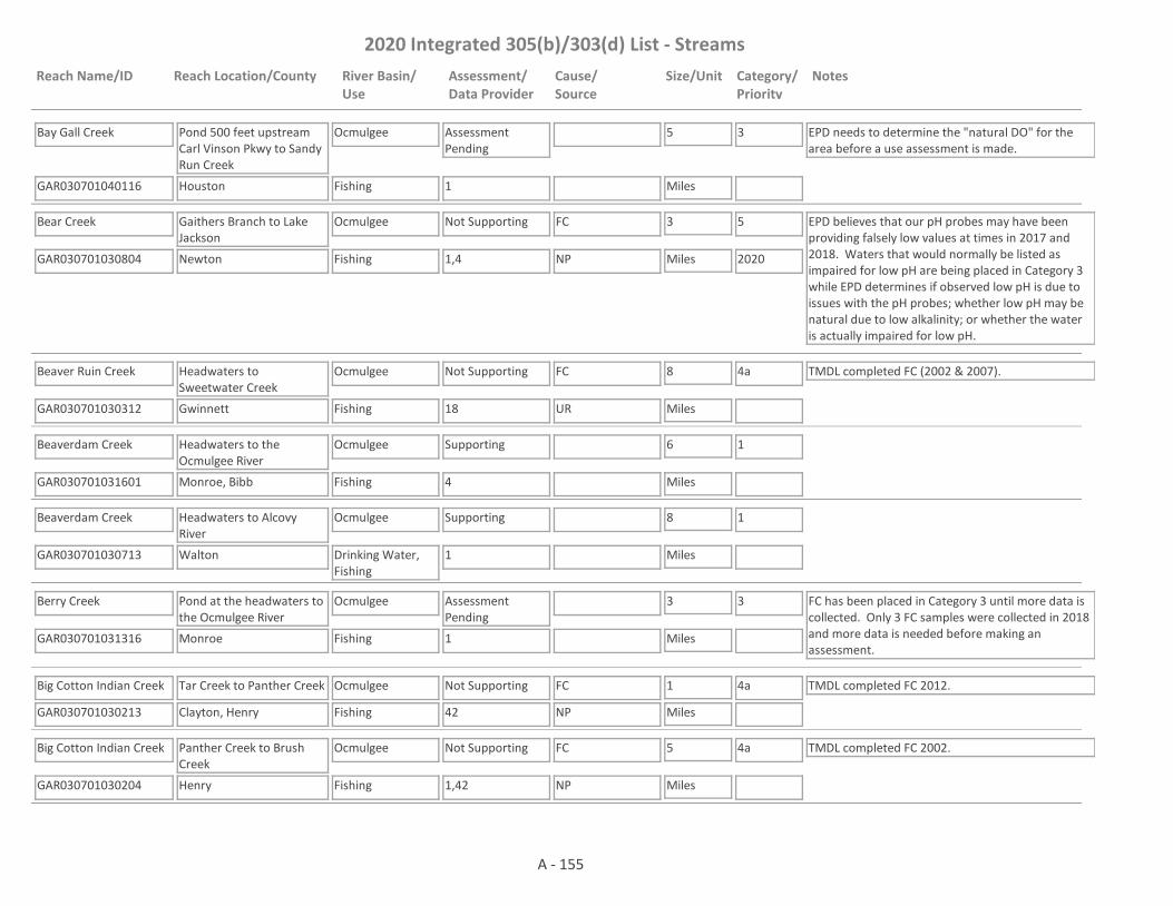
2020 Integrated 305(b)/303(d) List - Streams
Reach Name/ID Reach Location/County River Basin/Use
Assessment/Data Provider
Cause/Source
Size/Unit Category/Priority
Notes
Bay Gall Creek
GAR030701040116 1
Pond 500 feet upstream Carl Vinson Pkwy to Sandy Run Creek
Houston
Ocmulgee
Fishing
Assessment Pending
5
Miles
3 EPD needs to determine the "natural DO" for the area before a use assessment is made.
Bear Creek
GAR030701030804 1,4
Gaithers Branch to Lake Jackson
Newton
Ocmulgee
Fishing
Not Supporting FC 3
Miles
5
2020
EPD believes that our pH probes may have been providing falsely low values at times in 2017 and 2018. Waters that would normally be listed as impaired for low pH are being placed in Category 3 while EPD determines if observed low pH is due to issues with the pH probes; whether low pH may be natural due to low alkalinity; or whether the water is actually impaired for low pH.
NP
Beaver Ruin Creek
GAR030701030312 18
Headwaters to Sweetwater Creek
Gwinnett
Ocmulgee
Fishing
Not Supporting FC 8
Miles
4a TMDL completed FC (2002 & 2007).
UR
Beaverdam Creek
GAR030701031601 4
Headwaters to the Ocmulgee River
Monroe, Bibb
Ocmulgee
Fishing
Supporting 6
Miles
1
Beaverdam Creek
GAR030701030713 1
Headwaters to Alcovy River
Walton
Ocmulgee
Drinking Water, Fishing
Supporting 8
Miles
1
Berry Creek
GAR030701031316 1
Pond at the headwaters to the Ocmulgee River
Monroe
Ocmulgee
Fishing
Assessment Pending
3
Miles
3 FC has been placed in Category 3 until more data is collected. Only 3 FC samples were collected in 2018 and more data is needed before making an assessment.
Big Cotton Indian Creek
GAR030701030213 42
Tar Creek to Panther Creek
Clayton, Henry
Ocmulgee
Fishing
Not Supporting FC 1
Miles
4a TMDL completed FC 2012.
NP
Big Cotton Indian Creek
GAR030701030204 1,42
Panther Creek to Brush Creek
Henry
Ocmulgee
Fishing
Not Supporting FC 5
Miles
4a TMDL completed FC 2002.
NP
A - 155
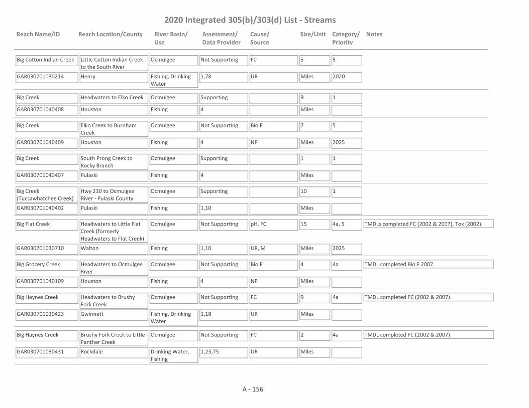
2020 Integrated 305(b)/303(d) List - Streams
Reach Name/ID Reach Location/County River Basin/Use
Assessment/Data Provider
Cause/Source
Size/Unit Category/Priority
Notes
Big Cotton Indian Creek
GAR030701030214 1,78
Little Cotton Indian Creek to the South River
Henry
Ocmulgee
Fishing, Drinking Water
Not Supporting FC 5
Miles
5
2020UR
Big Creek
GAR030701040408 4
Headwaters to Elko Creek
Houston
Ocmulgee
Fishing
Supporting 9
Miles
1
Big Creek
GAR030701040409 4
Elko Creek to Burnham Creek
Houston
Ocmulgee
Fishing
Not Supporting Bio F 7
Miles
5
2025NP
Big Creek
GAR030701040407 4
South Prong Creek to Rocky Branch
Pulaski
Ocmulgee
Fishing
Supporting 1
Miles
1
Big Creek (Tucsawhatchee Creek)
GAR030701040402 1,10
Hwy 230 to Ocmulgee River - Pulaski County
Pulaski
Ocmulgee
Fishing
Supporting 10
Miles
1
Big Flat Creek
GAR030701030710 1,10
Headwaters to Little Flat Creek (formerly Headwaters to Flat Creek)
Walton
Ocmulgee
Fishing
Not Supporting pH, FC 15
Miles
4a, 5
2025
TMDLs completed FC (2002 & 2007), Tox (2002).
UR, M
Big Grocery Creek
GAR030701040109 4
Headwaters to Ocmulgee River
Houston
Ocmulgee
Fishing
Not Supporting Bio F 4
Miles
4a TMDL completed Bio F 2007.
NP
Big Haynes Creek
GAR030701030423 1,18
Headwaters to Brushy Fork Creek
Gwinnett
Ocmulgee
Fishing, Drinking Water
Not Supporting FC 9
Miles
4a TMDL completed FC (2002 & 2007).
UR
Big Haynes Creek
GAR030701030431 1,23,75
Brushy Fork Creek to Little Panther Creek
Rockdale
Ocmulgee
Drinking Water, Fishing
Not Supporting FC 2
Miles
4a TMDL completed FC (2002 & 2007).
UR
A - 156

2020 Integrated 305(b)/303(d) List - Streams
Reach Name/ID Reach Location/County River Basin/Use
Assessment/Data Provider
Cause/Source
Size/Unit Category/Priority
Notes
Big Haynes Creek
GAR030701030430 1,23
Big Haynes Creek Reservoir to Little Haynes Creek
Rockdale
Ocmulgee
Drinking Water, Fishing
Supporting 1
Miles
1
Big Haynes Creek
GAR030701030434 23
Little Haynes Creek to Yellow River
Rockdale
Ocmulgee
Drinking Water, Fishing
Not Supporting FC 5
Miles
4a TMDL completed FC (2002 & 2007).
UR
Big Horse Creek
GAR030701040702 1,4,10,55
Alligator Creek to Ocmulgee River
Telfair
Ocmulgee
Fishing
Not Supporting Bio F, DO 15
Miles
4a TMDL completed Bio F (2007) & DO (2002).
NP
Big Indian Creek
GAR030701040207 4
Baptist Creek to Bay Creek
Houston
Ocmulgee
Fishing
Supporting 6
Miles
1
Big Indian Creek
GAR030701040208 4
Flat Creek to Mossy Creek
Houston
Ocmulgee
Fishing
Not Supporting Bio F 7
Miles
4a TMDL completed Bio F 2007.
NP
Big Indian Creek
GAR030701040210 1,73
Mossy Creek to Ocmulgee River
Houston
Ocmulgee
Fishing
Supporting 7
Miles
1 TMDL completed FC (2002 & 2007).
Big Sandy Creek
GAR030701031001 4
Upstream Indian Springs
Butts
Ocmulgee
Fishing
Not Supporting Bio F 8
Miles
4a TMDL completed Bio F (2002 & 2007).
NP
Big Sandy Creek
GAR030701031002 4,10
Aboothlacoosta Creek to Ocmulgee River
Butts, Monroe
Ocmulgee
Fishing
Not Supporting FC 10
Miles
4a TMDL completed FC (2002 & 2007).
NP
Big Towaliga Creek
GAR030701031210 4
Headwaters to the Little Towaliga River
Lamar
Ocmulgee
Drinking Water, Fishing
Assessment Pending
7
Miles
2 The water is supporting its Fishing Use. Data are not available to assess the Drinking Water Use.
A - 157

2020 Integrated 305(b)/303(d) List - Streams
Reach Name/ID Reach Location/County River Basin/Use
Assessment/Data Provider
Cause/Source
Size/Unit Category/Priority
Notes
Bluff Creek
GAR030701040501 4
Ten Mile Creek to Ocmulgee River
Pulaski
Ocmulgee
Fishing
Not Supporting Bio F 4
Miles
4a TMDL completed Bio F 2007.
NP
Boar Tusk Creek
GAR030701030424 10
Headwaters to Yellow River
Rockdale
Ocmulgee
Fishing
Not Supporting pH 3
Miles
4a TMDLs completed pH (2002), FC (1998).
UR
Bromolow Creek
GAR030701030313 1,18
Headwaters to Beaver Ruin Creek
Gwinnett
Ocmulgee
Fishing
Not Supporting FC 5
Miles
4a TMDL completed FC (2002 & 2007).
UR
Brown Branch
GAR030701030902 4
Headwaters (Locust Grove) to Wolf Creek
Henry
Ocmulgee
Drinking Water, Fishing
Not Supporting Bio F 5
Miles
4a TMDL completed Bio F (2002 & 2007). The water is not supporting its Fishing Use. Data are not available to assess the Drinking Water Use.NP
Brush Creek
GAR030701030216 1
Tributary 0.3 miles downstream of Taylor Drive to Big Cotton Indian Creek
Henry
Ocmulgee
Fishing
Supporting 2
Miles
1
Brushy Fork Creek
GAR030701030425 10,18
Lake Carlton to Big Haynes Creek
Gwinnett
Ocmulgee
Fishing
Supporting 5
Miles
1 TMDL completed FC (1998 & 2007).
Buck Creek
GAR030701031102 4
Tributary to High Falls Lake
Lamar, Spalding
Ocmulgee
Fishing
Supporting 14
Miles
1
Butlers Creek
GAR030701031602 4
Tributary to Ocmulgee River
Jones
Ocmulgee
Fishing
Not Supporting Bio F 5
Miles
4a TMDL completed Bio F (2002 & 2007).
NP
Cabin Creek
GAR030701031103 1,3,4,10
Headwaters, Griffin to Towaliga River
Spalding
Ocmulgee
Fishing
Not Supporting Bio F, FC 16
Miles
4a TMDLs completed Bio F (2002 & 2007), Tox (2002), FC (2002 & 2007), DO (2002).
UR
A - 158
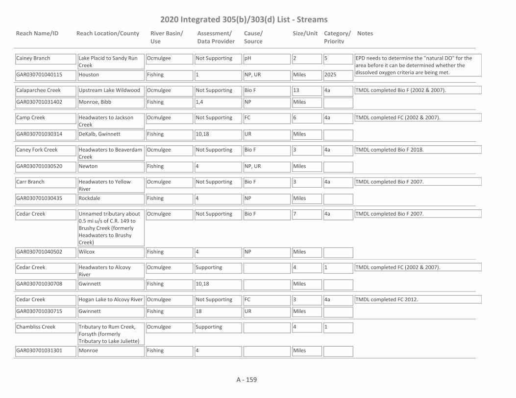
2020 Integrated 305(b)/303(d) List - Streams
Reach Name/ID Reach Location/County River Basin/Use
Assessment/Data Provider
Cause/Source
Size/Unit Category/Priority
Notes
Cainey Branch
GAR030701040115 1
Lake Placid to Sandy Run Creek
Houston
Ocmulgee
Fishing
Not Supporting pH 2
Miles
5
2025
EPD needs to determine the "natural DO" for the area before it can be determined whether the dissolved oxygen criteria are being met.NP, UR
Calaparchee Creek
GAR030701031402 1,4
Upstream Lake Wildwood
Monroe, Bibb
Ocmulgee
Fishing
Not Supporting Bio F 13
Miles
4a TMDL completed Bio F (2002 & 2007).
NP
Camp Creek
GAR030701030314 10,18
Headwaters to Jackson Creek
DeKalb, Gwinnett
Ocmulgee
Fishing
Not Supporting FC 6
Miles
4a TMDL completed FC (2002 & 2007).
UR
Caney Fork Creek
GAR030701030520 4
Headwaters to Beaverdam Creek
Newton
Ocmulgee
Fishing
Not Supporting Bio F 3
Miles
4a TMDL completed Bio F 2018.
NP, UR
Carr Branch
GAR030701030435 4
Headwaters to Yellow River
Rockdale
Ocmulgee
Fishing
Not Supporting Bio F 3
Miles
4a TMDL completed Bio F 2007.
NP
Cedar Creek
GAR030701040502 4
Unnamed tributary about 0.5 mi u/s of C.R. 149 to Brushy Creek (formerly Headwaters to Brushy Creek)
Wilcox
Ocmulgee
Fishing
Not Supporting Bio F 7
Miles
4a TMDL completed Bio F 2007.
NP
Cedar Creek
GAR030701030708 10,18
Headwaters to Alcovy River
Gwinnett
Ocmulgee
Fishing
Supporting 4
Miles
1 TMDL completed FC (2002 & 2007).
Cedar Creek
GAR030701030715 18
Hogan Lake to Alcovy River
Gwinnett
Ocmulgee
Fishing
Not Supporting FC 3
Miles
4a TMDL completed FC 2012.
UR
Chambliss Creek
GAR030701031301 4
Tributary to Rum Creek, Forsyth (formerly Tributary to Lake Juliette)
Monroe
Ocmulgee
Fishing
Supporting 4
Miles
1
A - 159

2020 Integrated 305(b)/303(d) List - Streams
Reach Name/ID Reach Location/County River Basin/Use
Assessment/Data Provider
Cause/Source
Size/Unit Category/Priority
Notes
Champion Creek
GAR030701031215 4
Unnamed tributary approximately 0.6 mils u/s of Abernathy Road to the Towaliga River
Monroe
Ocmulgee
Fishing
Supporting 3
Miles
1
Cobbs Creek
GAR030701030101 1,4
Headwaters to Shoal Creek
DeKalb
Ocmulgee
Fishing
Not Supporting FC, Bio F 7
Miles
4a TMDLs completed FC (2002 & 2007) & Bio F (2007).
UR
Cole Creek
GAR030701031413 4
Tributary to Tobesofkee Creek
Lamar, Monroe
Ocmulgee
Fishing
Supporting 6
Miles
1 TMDL completed Bio F (2002 & 2007).
Coley Creek
GAR030701040105 4
Headwaters to South Shellstone Creek
Bleckley
Ocmulgee
Fishing
Supporting 4
Miles
1
Conley Creek
GAR030701030102 1,42
Headwaters to South River
Clayton, DeKalb
Ocmulgee
Fishing
Not Supporting FC 9
Miles
4a TMDL completed FC (2002 & 2007).
UR
Coppas Branch
GAR030701031504 4
Bibb County
Bibb
Ocmulgee
Fishing
Supporting 2
Miles
1
Cornish Creek
GAR030701030717 1,4
Headwaters to Upper Williams Lake
Walton
Ocmulgee
Drinking Water, Fishing
Not Supporting Bio F, FC 7
Miles
5
2020NP, UR
Crooked Creek
GAR030701040114 1,59
Headwaters to Ocmulgee River
Twiggs
Ocmulgee
Fishing
Assessment Pending
6
Miles
3 This site has a narrative rank of fair for macroinvertebrates. When EPD completes the reevaluation of the metrics used to assess macroinvertebrate data it will be determined if the macroinvertebrate criteria are being met.
Crooked Creek
GAR030701040504 4
Cypress Lake to Ocmulgee River
Dodge
Ocmulgee
Fishing
Not Supporting Bio F 4
Miles
4a TMDL completed Bio F 2007.
NP
A - 160
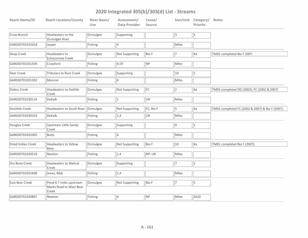
2020 Integrated 305(b)/303(d) List - Streams
Reach Name/ID Reach Location/County River Basin/Use
Assessment/Data Provider
Cause/Source
Size/Unit Category/Priority
Notes
Crow Branch
GAR030701031018 4
Headwaters to the Ocmulgee River
Jasper
Ocmulgee
Fishing
Supporting 3
Miles
1
Deep Creek
GAR030701031509 4,59
Headwaters to Echeconnee Creek
Crawford
Ocmulgee
Fishing
Not Supporting Bio F 7
Miles
4a TMDL completed Bio F 2007.
NP
Deer Creek
GAR030701031302 4
Tributary to Rum Creek
Monroe
Ocmulgee
Fishing
Supporting 10
Miles
1
Doless Creek
GAR030701030116 1
Headwaters to Dolittle Creek
DeKalb
Ocmulgee
Fishing
Not Supporting FC 2
Miles
4a TMDL completed DO (2002), FC (2002 & 2007)
UR
Doolittle Creek
GAR030701030103 1,4
Headwaters to South River
DeKalb
Ocmulgee
Fishing
Not Supporting FC, Bio F 5
Miles
4a TMDL completed FC (2002 & 2007) & Bio F (2007).
UR
Douglas Creek
GAR030701031005 4
Upstream Little Sandy Creek
Butts
Ocmulgee
Fishing
Supporting 4
Miles
1
Dried Indian Creek
GAR030701030519 1,4
Headwaters to Yellow River
Newton
Ocmulgee
Fishing
Not Supporting Bio F 10
Miles
4a TMDL completed Bio F (2007).
NP, UR
Dry Bone Creek
GAR030701031608 1,4
Headwaters to Walnut Creek
Jones, Bibb
Ocmulgee
Fishing
Supporting 7
Miles
1
East Bear Creek
GAR030701030807 4
Pond 0.7 miles upstream Marks Road to West Bear Creek
Newton
Ocmulgee
Fishing
Not Supporting Bio F 7
Miles
5
2020NP
A - 161
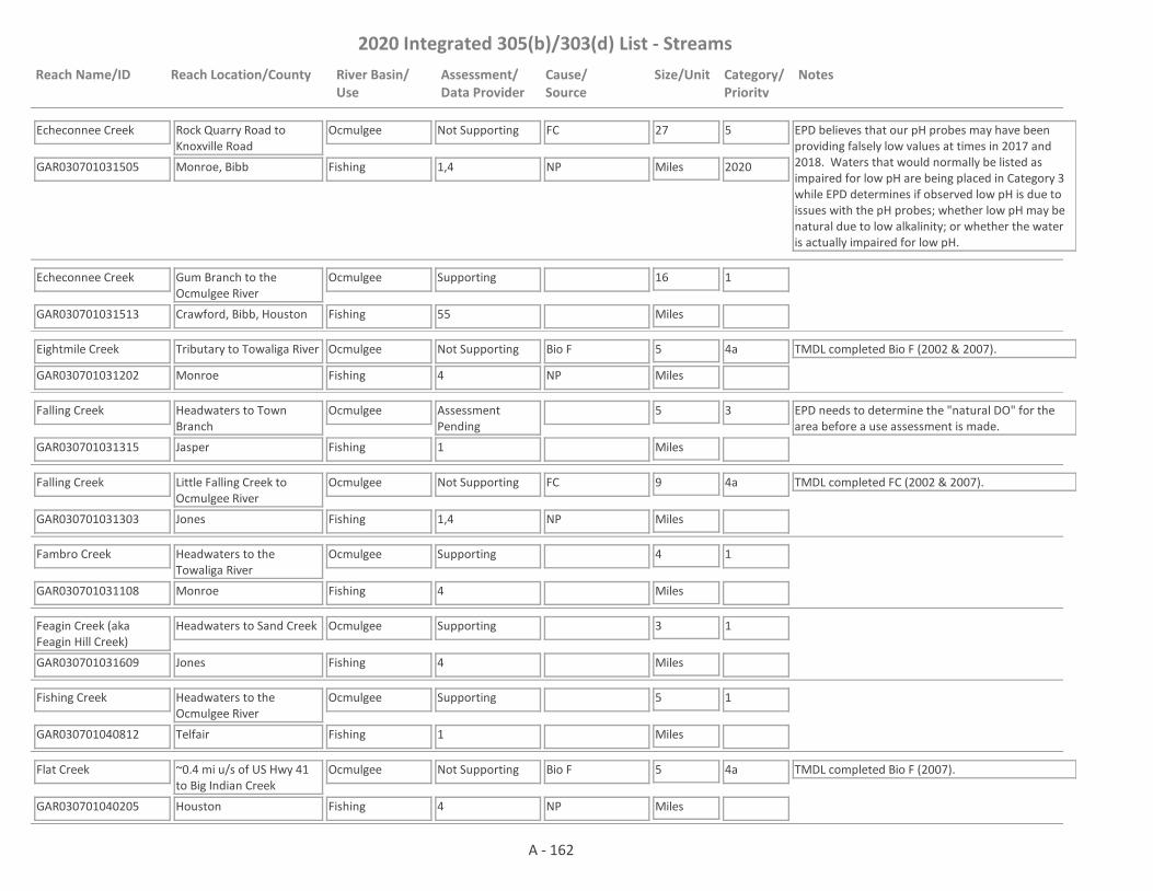
2020 Integrated 305(b)/303(d) List - Streams
Reach Name/ID Reach Location/County River Basin/Use
Assessment/Data Provider
Cause/Source
Size/Unit Category/Priority
Notes
Echeconnee Creek
GAR030701031505 1,4
Rock Quarry Road to Knoxville Road
Monroe, Bibb
Ocmulgee
Fishing
Not Supporting FC 27
Miles
5
2020
EPD believes that our pH probes may have been providing falsely low values at times in 2017 and 2018. Waters that would normally be listed as impaired for low pH are being placed in Category 3 while EPD determines if observed low pH is due to issues with the pH probes; whether low pH may be natural due to low alkalinity; or whether the water is actually impaired for low pH.
NP
Echeconnee Creek
GAR030701031513 55
Gum Branch to the Ocmulgee River
Crawford, Bibb, Houston
Ocmulgee
Fishing
Supporting 16
Miles
1
Eightmile Creek
GAR030701031202 4
Tributary to Towaliga River
Monroe
Ocmulgee
Fishing
Not Supporting Bio F 5
Miles
4a TMDL completed Bio F (2002 & 2007).
NP
Falling Creek
GAR030701031315 1
Headwaters to Town Branch
Jasper
Ocmulgee
Fishing
Assessment Pending
5
Miles
3 EPD needs to determine the "natural DO" for the area before a use assessment is made.
Falling Creek
GAR030701031303 1,4
Little Falling Creek to Ocmulgee River
Jones
Ocmulgee
Fishing
Not Supporting FC 9
Miles
4a TMDL completed FC (2002 & 2007).
NP
Fambro Creek
GAR030701031108 4
Headwaters to the Towaliga River
Monroe
Ocmulgee
Fishing
Supporting 4
Miles
1
Feagin Creek (aka Feagin Hill Creek)
GAR030701031609 4
Headwaters to Sand Creek
Jones
Ocmulgee
Fishing
Supporting 3
Miles
1
Fishing Creek
GAR030701040812 1
Headwaters to the Ocmulgee River
Telfair
Ocmulgee
Fishing
Supporting 5
Miles
1
Flat Creek
GAR030701040205 4
~0.4 mi u/s of US Hwy 41 to Big Indian Creek
Houston
Ocmulgee
Fishing
Not Supporting Bio F 5
Miles
4a TMDL completed Bio F (2007).
NP
A - 162
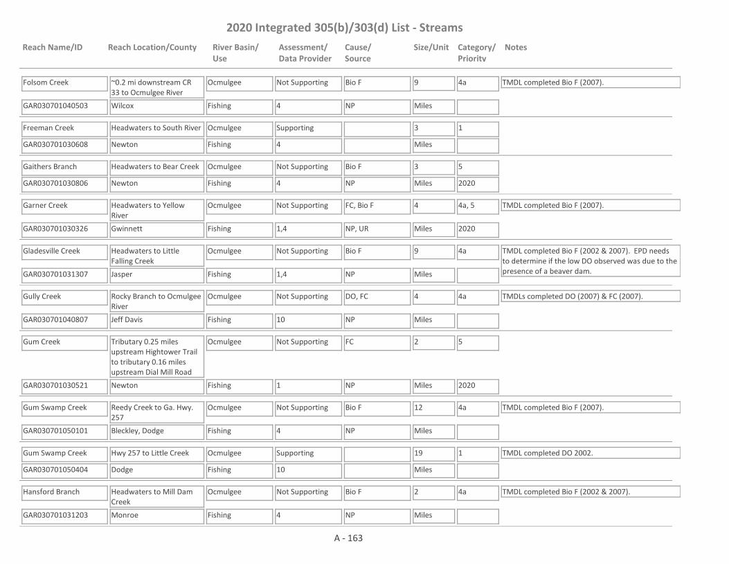
2020 Integrated 305(b)/303(d) List - Streams
Reach Name/ID Reach Location/County River Basin/Use
Assessment/Data Provider
Cause/Source
Size/Unit Category/Priority
Notes
Folsom Creek
GAR030701040503 4
~0.2 mi downstream CR 33 to Ocmulgee River
Wilcox
Ocmulgee
Fishing
Not Supporting Bio F 9
Miles
4a TMDL completed Bio F (2007).
NP
Freeman Creek
GAR030701030608 4
Headwaters to South River
Newton
Ocmulgee
Fishing
Supporting 3
Miles
1
Gaithers Branch
GAR030701030806 4
Headwaters to Bear Creek
Newton
Ocmulgee
Fishing
Not Supporting Bio F 3
Miles
5
2020NP
Garner Creek
GAR030701030326 1,4
Headwaters to Yellow River
Gwinnett
Ocmulgee
Fishing
Not Supporting FC, Bio F 4
Miles
4a, 5
2020
TMDL completed Bio F (2007).
NP, UR
Gladesville Creek
GAR030701031307 1,4
Headwaters to Little Falling Creek
Jasper
Ocmulgee
Fishing
Not Supporting Bio F 9
Miles
4a TMDL completed Bio F (2002 & 2007). EPD needs to determine if the low DO observed was due to the presence of a beaver dam.NP
Gully Creek
GAR030701040807 10
Rocky Branch to Ocmulgee River
Jeff Davis
Ocmulgee
Fishing
Not Supporting DO, FC 4
Miles
4a TMDLs completed DO (2007) & FC (2007).
NP
Gum Creek
GAR030701030521 1
Tributary 0.25 miles upstream Hightower Trail to tributary 0.16 miles upstream Dial Mill Road
Newton
Ocmulgee
Fishing
Not Supporting FC 2
Miles
5
2020NP
Gum Swamp Creek
GAR030701050101 4
Reedy Creek to Ga. Hwy. 257
Bleckley, Dodge
Ocmulgee
Fishing
Not Supporting Bio F 12
Miles
4a TMDL completed Bio F (2007).
NP
Gum Swamp Creek
GAR030701050404 10
Hwy 257 to Little Creek
Dodge
Ocmulgee
Fishing
Supporting 19
Miles
1 TMDL completed DO 2002.
Hansford Branch
GAR030701031203 4
Headwaters to Mill Dam Creek
Monroe
Ocmulgee
Fishing
Not Supporting Bio F 2
Miles
4a TMDL completed Bio F (2002 & 2007).
NP
A - 163

2020 Integrated 305(b)/303(d) List - Streams
Reach Name/ID Reach Location/County River Basin/Use
Assessment/Data Provider
Cause/Source
Size/Unit Category/Priority
Notes
Hardy's Creek
GAR030701031019 4
Headwaters to Herds Creek
Jasper
Ocmulgee
Fishing
Supporting 6
Miles
1
Harmon Pye Branch
GAR030701031006 4
Tributary to Wise Creek
Jasper
Ocmulgee
Fishing
Supporting 1
Miles
1 TMDL completed Bio F (2002 & 2007).
Hartley Branch
GAR030701031501 4
Tributary to Deep Creek
Crawford
Ocmulgee
Fishing
Not Supporting Bio F 1
Miles
4a TMDL completed Bio F (2002 & 2007).
NP
Herds Creek
GAR030701031004 1,4
Headwaters to Ga. Hwy. 212
Jasper
Ocmulgee
Fishing
Supporting 3
Miles
1
Herds Creek
GAR030701031023 4
Downstream Ga. Hwy. 212 to Ocmulgee River
Jasper
Ocmulgee
Fishing
Not Supporting Bio F 6
Miles
4a TMDL completed Bio F (2002 & 2007).
NP
Honey Creek
GAR030701030110 1
Headwaters to South River
DeKalb, Rockdale
Ocmulgee
Fishing
Not Supporting FC 13
Miles
4a TMDL completed FC (2002 & 2007).
NP
Hopkins Creek
GAR030701030702 1,18,80
Headwaters to Alcovy River
Gwinnett
Ocmulgee
Fishing
Supporting 4
Miles
1 TMDL completed FC (2002 & 2007).
Horse Creek
GAR030701040701 4
Headwaters to Alligator Creek
Dodge, Telfair
Ocmulgee
Fishing
Not Supporting Bio F 17
Miles
4a TMDL completed Bio F 2007.
NP
Horse Creek
GAR030701040101 9,10
Headwaters to Ocmulgee River, Warner Robins
Houston
Ocmulgee
Fishing
Supporting 4
Miles
1
House Creek
GAR030701040602 4
Headwaters to Haw Pond Creek
Wilcox
Ocmulgee
Fishing
Not Supporting Bio F 7
Miles
4a TMDL completed Bio F 2007.
NP
A - 164
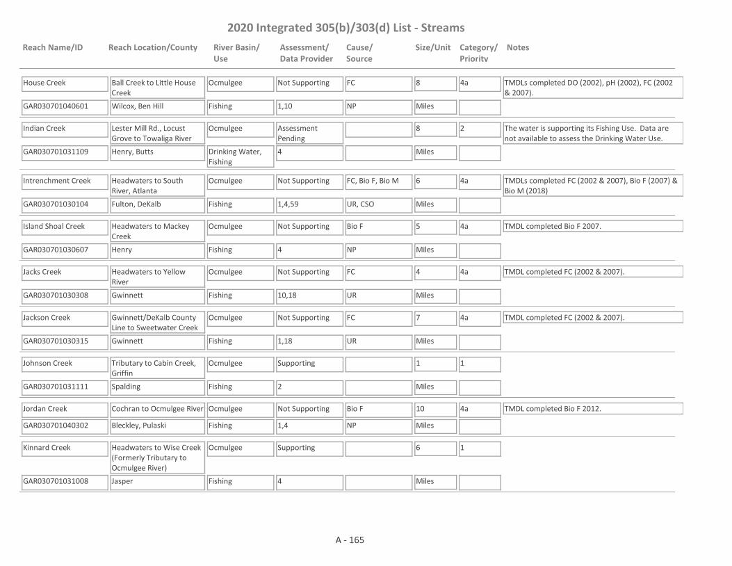
2020 Integrated 305(b)/303(d) List - Streams
Reach Name/ID Reach Location/County River Basin/Use
Assessment/Data Provider
Cause/Source
Size/Unit Category/Priority
Notes
House Creek
GAR030701040601 1,10
Ball Creek to Little House Creek
Wilcox, Ben Hill
Ocmulgee
Fishing
Not Supporting FC 8
Miles
4a TMDLs completed DO (2002), pH (2002), FC (2002 & 2007).
NP
Indian Creek
GAR030701031109 4
Lester Mill Rd., Locust Grove to Towaliga River
Henry, Butts
Ocmulgee
Drinking Water, Fishing
Assessment Pending
8
Miles
2 The water is supporting its Fishing Use. Data are not available to assess the Drinking Water Use.
Intrenchment Creek
GAR030701030104 1,4,59
Headwaters to South River, Atlanta
Fulton, DeKalb
Ocmulgee
Fishing
Not Supporting FC, Bio F, Bio M 6
Miles
4a TMDLs completed FC (2002 & 2007), Bio F (2007) & Bio M (2018)
UR, CSO
Island Shoal Creek
GAR030701030607 4
Headwaters to Mackey Creek
Henry
Ocmulgee
Fishing
Not Supporting Bio F 5
Miles
4a TMDL completed Bio F 2007.
NP
Jacks Creek
GAR030701030308 10,18
Headwaters to Yellow River
Gwinnett
Ocmulgee
Fishing
Not Supporting FC 4
Miles
4a TMDL completed FC (2002 & 2007).
UR
Jackson Creek
GAR030701030315 1,18
Gwinnett/DeKalb County Line to Sweetwater Creek
Gwinnett
Ocmulgee
Fishing
Not Supporting FC 7
Miles
4a TMDL completed FC (2002 & 2007).
UR
Johnson Creek
GAR030701031111 2
Tributary to Cabin Creek, Griffin
Spalding
Ocmulgee
Fishing
Supporting 1
Miles
1
Jordan Creek
GAR030701040302 1,4
Cochran to Ocmulgee River
Bleckley, Pulaski
Ocmulgee
Fishing
Not Supporting Bio F 10
Miles
4a TMDL completed Bio F 2012.
NP
Kinnard Creek
GAR030701031008 4
Headwaters to Wise Creek (Formerly Tributary to Ocmulgee River)
Jasper
Ocmulgee
Fishing
Supporting 6
Miles
1
A - 165

2020 Integrated 305(b)/303(d) List - Streams
Reach Name/ID Reach Location/County River Basin/Use
Assessment/Data Provider
Cause/Source
Size/Unit Category/Priority
Notes
Lee Creek
GAR030701031009 4
Tributary to Ocmulgee River
Monroe
Ocmulgee
Fishing
Supporting 6
Miles
1
Limestone Creek
GAR030701040303 1
Headwaters to Ocmulgee River
Pulaski
Ocmulgee
Fishing
Supporting 7
Miles
1 TMDL completed DO 2002.
Limestone Creek
GAR030701040206 4,59
Okeetuck Creek to Big Indian Creek
Houston
Ocmulgee
Fishing
Not Supporting Bio F 3
Miles
4a TMDL completed Bio F 2007.
NP
Little Buck Creek
GAR030701031105 4
Headwaters to Buck Creek
Lamar
Ocmulgee
Fishing
Supporting 6
Miles
1
Little Chehaw Creek
GAR030701031612 4
Headwaters to Chehaw Creek
Jones
Ocmulgee
Fishing
Not Supporting Bio F 3
Miles
4a TMDL completed Bio F (2002 & 2007).
NP
Little Cotton Indian Creek
GAR030701030212 42,78
Confluence of Reeves and Rum Creeks to Clayton Co. Hooper Reservoir
Henry
Ocmulgee
Drinking Water, Fishing
Supporting 2
Miles
1 TMDL completed FC 2012.
Little Deer Creek
GAR030701031304 4
Headwaters to Deer Creek
Monroe
Ocmulgee
Fishing
Not Supporting Bio F 6
Miles
4a TMDL completed Bio F (2002 & 2007).
NP
Little Echeconnee Creek
GAR030701031511 10
Headwaters to Echeconnee Creek
Crawford
Ocmulgee
Fishing
Not Supporting DO 8
Miles
4a TMDL completed DO 2007.
NP
Little Falling Creek
GAR030701031305 4,59
Gladesville Creek to Falling Creek
Jasper, Jones
Ocmulgee
Fishing
Supporting 5
Miles
1
A - 166
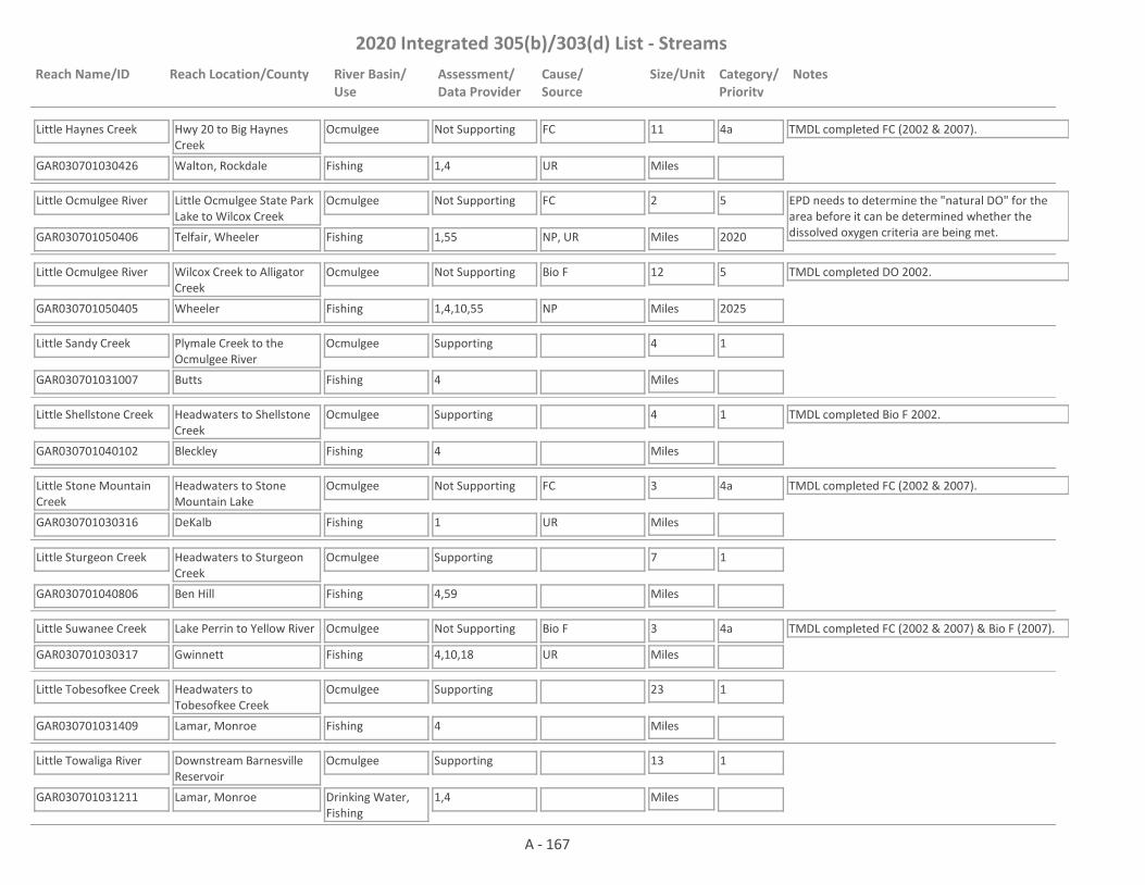
2020 Integrated 305(b)/303(d) List - Streams
Reach Name/ID Reach Location/County River Basin/Use
Assessment/Data Provider
Cause/Source
Size/Unit Category/Priority
Notes
Little Haynes Creek
GAR030701030426 1,4
Hwy 20 to Big Haynes Creek
Walton, Rockdale
Ocmulgee
Fishing
Not Supporting FC 11
Miles
4a TMDL completed FC (2002 & 2007).
UR
Little Ocmulgee River
GAR030701050406 1,55
Little Ocmulgee State Park Lake to Wilcox Creek
Telfair, Wheeler
Ocmulgee
Fishing
Not Supporting FC 2
Miles
5
2020
EPD needs to determine the "natural DO" for the area before it can be determined whether the dissolved oxygen criteria are being met.NP, UR
Little Ocmulgee River
GAR030701050405 1,4,10,55
Wilcox Creek to Alligator Creek
Wheeler
Ocmulgee
Fishing
Not Supporting Bio F 12
Miles
5
2025
TMDL completed DO 2002.
NP
Little Sandy Creek
GAR030701031007 4
Plymale Creek to the Ocmulgee River
Butts
Ocmulgee
Fishing
Supporting 4
Miles
1
Little Shellstone Creek
GAR030701040102 4
Headwaters to Shellstone Creek
Bleckley
Ocmulgee
Fishing
Supporting 4
Miles
1 TMDL completed Bio F 2002.
Little Stone Mountain Creek
GAR030701030316 1
Headwaters to Stone Mountain Lake
DeKalb
Ocmulgee
Fishing
Not Supporting FC 3
Miles
4a TMDL completed FC (2002 & 2007).
UR
Little Sturgeon Creek
GAR030701040806 4,59
Headwaters to Sturgeon Creek
Ben Hill
Ocmulgee
Fishing
Supporting 7
Miles
1
Little Suwanee Creek
GAR030701030317 4,10,18
Lake Perrin to Yellow River
Gwinnett
Ocmulgee
Fishing
Not Supporting Bio F 3
Miles
4a TMDL completed FC (2002 & 2007) & Bio F (2007).
UR
Little Tobesofkee Creek
GAR030701031409 4
Headwaters to Tobesofkee Creek
Lamar, Monroe
Ocmulgee
Fishing
Supporting 23
Miles
1
Little Towaliga River
GAR030701031211 1,4
Downstream Barnesville Reservoir
Lamar, Monroe
Ocmulgee
Drinking Water, Fishing
Supporting 13
Miles
1
A - 167

2020 Integrated 305(b)/303(d) List - Streams
Reach Name/ID Reach Location/County River Basin/Use
Assessment/Data Provider
Cause/Source
Size/Unit Category/Priority
Notes
Long Branch
GAR030701031010 4
Tributary to Ocmulgee River
Jasper
Ocmulgee
Fishing
Supporting 3
Miles
1 TMDL completed Bio F (2002 & 2007).
Long Branch
GAR030701031011 4
Upstream Big Sandy Creek
Butts
Ocmulgee
Fishing
Supporting 4
Miles
1
Malholms Creek
GAR030701030903 4
Headwaters (Jenkinsburg) to Tussahaw Creek
Butts
Ocmulgee
Fishing
Not Supporting Bio F 6
Miles
4a TMDL completed Bio F (2002 & 2007).
NP
McClain Branch
GAR030701030111 1
Headwaters to Honey Creek
Rockdale
Ocmulgee
Fishing
Not Supporting FC 2
Miles
4a TMDL completed FC (2002 & 2007).
UR
Mill Dam Creek
GAR030701031204 4
Headwaters to Hansford Branch
Monroe
Ocmulgee
Fishing
Supporting 4
Miles
1 TMDL completed Bio F (2002 & 2007).
Mosquito Creek
GAR030701040507 10
Headwaters to Ocmulgee River
Dodge, Pulaski
Ocmulgee
Fishing
Not Supporting FC, DO 18
Miles
4a TMDLs completed FC (2007) & DO (2007).
NP
Mossy Creek
GAR030701040209 4
Taylors Mill Pond to Mule Creek
Peach
Ocmulgee
Fishing
Supporting 6
Miles
1
Mossy Creek
GAR030701040211 4
Mule Creek to Lake Joy
Peach, Houston
Ocmulgee
Fishing
Not Supporting Bio F 8
Miles
4a TMDL completed Bio F 2007.
NP
Mossy Creek
GAR030701040213 1
Mossy Lake to Big Indian Creek
Houston
Ocmulgee
Fishing
Supporting 5
Miles
1
Mountain Creek
GAR030701030714 4
Headwaters to Sewage Treatment Pond #2 (South of Monroe)
Walton
Ocmulgee
Fishing
Supporting 5
Miles
1 TMDL completed Bio F 2007.
A - 168

2020 Integrated 305(b)/303(d) List - Streams
Reach Name/ID Reach Location/County River Basin/Use
Assessment/Data Provider
Cause/Source
Size/Unit Category/Priority
Notes
Mountain Creek
GAR030701030719 1
Tributary at Ammons Bridge Road to tributary 0.7 miles downstream Monroe Jersey Road SE
Walton
Ocmulgee
Fishing
Not Supporting FC 2
Miles
5
2020NP, UR
No Business Creek
GAR030701030427 1,4,18
Headwaters to Norris Lake
Gwinnett
Ocmulgee
Fishing
Not Supporting FC 6
Miles
4a TMDL completed FC (2002 & 2007).
UR
North Branch South River (aka McDaniel Branch)
GAR030701030112 2
Headwaters to the South River (Atlanta)
Fulton
Ocmulgee
Fishing
Not Supporting FC 3
Miles
4a TMDL completed FC (2002 & 2007).
UR, CSO
Ocmulgee River
GAR030701031020 1
Downstream Lloyd Shoals Dam
Butts, Jasper
Ocmulgee
Drinking Water, Fishing
Supporting 3
Miles
1
Ocmulgee River
GAR030701031021 1
3 Miles Downstream Lloyd Shoals Dam to Towaliga River
Butts, Jasper, Monroe
Ocmulgee
Fishing, Drinking Water
Supporting 14
Miles
1
Ocmulgee River
GAR030701031616 28
Hwy 18 to Beaverdam Creek
Monroe, Jones, Bibb
Ocmulgee
Fishing, Drinking Water
Assessment Pending
9
Miles
2 The water is supporting its Fishing Use. Data are not available to assess the Drinking Water Use.
Ocmulgee River
GAR030701031617 1,10
Beaverdam Creek to Walnut Creek
Jones, Bibb
Ocmulgee
Drinking Water, Fishing
Supporting 10
Miles
1 TMDL completed FC 2002.
Ocmulgee River
GAR030701031614 1
Walnut Creek to Tobesofkee Creek
Bibb
Ocmulgee
Fishing
Supporting 11
Miles
1 TMDL completed Fish Tissue (PCBs) 2007.
A - 169
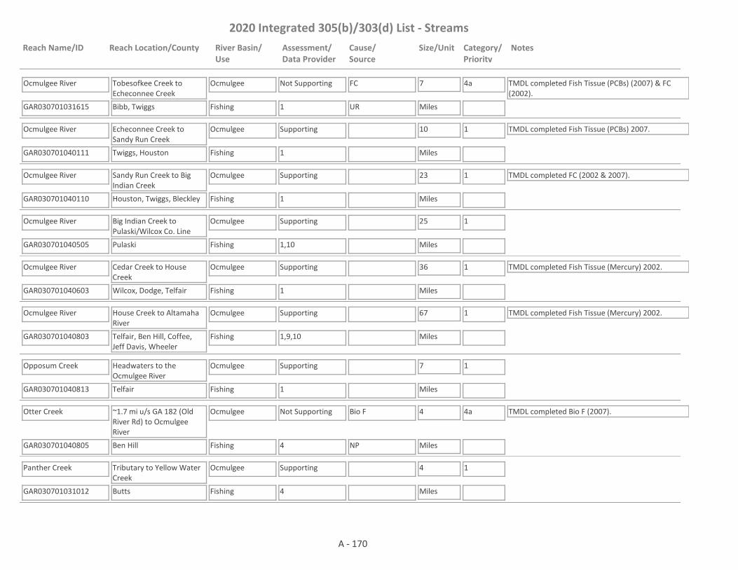
2020 Integrated 305(b)/303(d) List - Streams
Reach Name/ID Reach Location/County River Basin/Use
Assessment/Data Provider
Cause/Source
Size/Unit Category/Priority
Notes
Ocmulgee River
GAR030701031615 1
Tobesofkee Creek to Echeconnee Creek
Bibb, Twiggs
Ocmulgee
Fishing
Not Supporting FC 7
Miles
4a TMDL completed Fish Tissue (PCBs) (2007) & FC (2002).
UR
Ocmulgee River
GAR030701040111 1
Echeconnee Creek to Sandy Run Creek
Twiggs, Houston
Ocmulgee
Fishing
Supporting 10
Miles
1 TMDL completed Fish Tissue (PCBs) 2007.
Ocmulgee River
GAR030701040110 1
Sandy Run Creek to Big Indian Creek
Houston, Twiggs, Bleckley
Ocmulgee
Fishing
Supporting 23
Miles
1 TMDL completed FC (2002 & 2007).
Ocmulgee River
GAR030701040505 1,10
Big Indian Creek to Pulaski/Wilcox Co. Line
Pulaski
Ocmulgee
Fishing
Supporting 25
Miles
1
Ocmulgee River
GAR030701040603 1
Cedar Creek to House Creek
Wilcox, Dodge, Telfair
Ocmulgee
Fishing
Supporting 36
Miles
1 TMDL completed Fish Tissue (Mercury) 2002.
Ocmulgee River
GAR030701040803 1,9,10
House Creek to Altamaha River
Telfair, Ben Hill, Coffee, Jeff Davis, Wheeler
Ocmulgee
Fishing
Supporting 67
Miles
1 TMDL completed Fish Tissue (Mercury) 2002.
Opposum Creek
GAR030701040813 1
Headwaters to the Ocmulgee River
Telfair
Ocmulgee
Fishing
Supporting 7
Miles
1
Otter Creek
GAR030701040805 4
~1.7 mi u/s GA 182 (Old River Rd) to Ocmulgee River
Ben Hill
Ocmulgee
Fishing
Not Supporting Bio F 4
Miles
4a TMDL completed Bio F (2007).
NP
Panther Creek
GAR030701031012 4
Tributary to Yellow Water Creek
Butts
Ocmulgee
Fishing
Supporting 4
Miles
1
A - 170

2020 Integrated 305(b)/303(d) List - Streams
Reach Name/ID Reach Location/County River Basin/Use
Assessment/Data Provider
Cause/Source
Size/Unit Category/Priority
Notes
Panther Creek
GAR030701030207 1,42
Headwaters to Big Cotton Indian Creek
Clayton, Henry
Ocmulgee
Fishing
Not Supporting FC 6
Miles
4a TMDL completed FC 2012.
NP, UR
Pates Creek
GAR030701030208 42
Blalock Water Reservoir to Little Cotton Indian Creek
Henry
Ocmulgee
Drinking Water, Fishing
Supporting 5
Miles
1
Peeksville Creek
GAR030701030908 4
Headwaters to Tussahaw Creek
Henry, Butts
Ocmulgee
Fishing
Not Supporting Bio F 6
Miles
4a TMDL completed Bio F 2018.
NP
Pew Creek
GAR030701030309 1,18
Headwaters to the Yellow River
Gwinnett
Ocmulgee
Fishing
Not Supporting FC 4
Miles
4a TMDL completed FC (2002 & 2007). pH was added to Category 3. Less than a full year of data was taken at RV_04_857 in 2016 and more data is needed to make an assessment.
UR
Phinazee Creek
GAR030701031205 4
Headwaters to White Creek
Lamar, Monroe
Ocmulgee
Fishing
Not Supporting Bio F 6
Miles
4a TMDL completed Bio F (2002 & 2007)
NP
Plymale Creek
GAR030701031022 4
Butts County
Butts
Ocmulgee
Fishing
Supporting 7
Miles
1
Pole Bridge Creek
GAR030701030114 1,15
Headwaters to the South River
DeKalb
Ocmulgee
Fishing
Supporting 10
Miles
1
Pounds Creek
GAR030701030318 1,18
Upstream Lakeview Ct. Lake
Gwinnett
Ocmulgee
Fishing
Supporting 1
Miles
1
Pounds Creek
GAR030701030323 1,18
Downstream Lakeview Court Lake
Gwinnett
Ocmulgee
Fishing
Not Supporting pH 1
Miles
5
2025UR
A - 171
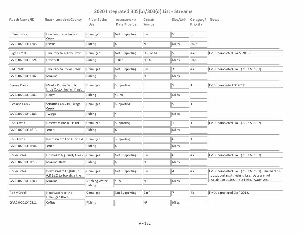
2020 Integrated 305(b)/303(d) List - Streams
Reach Name/ID Reach Location/County River Basin/Use
Assessment/Data Provider
Cause/Source
Size/Unit Category/Priority
Notes
Prairie Creek
GAR030701031206 4
Headwaters to Turner Creek
Lamar
Ocmulgee
Fishing
Not Supporting Bio F 5
Miles
5
2025NP
Pughs Creek
GAR030701030324 1,18,59
Tributary to Yellow River
Gwinnett
Ocmulgee
Fishing
Not Supporting FC, Bio M 5
Miles
4a, 5
2020
TMDL completed Bio M 2018.
NP, UR
Red Creek
GAR030701031207 4
Tributary to Rocky Creek
Monroe
Ocmulgee
Fishing
Not Supporting Bio F 3
Miles
4a TMDL completed Bio F (2002 & 2007).
NP
Reeves Creek
GAR030701030206 42,78
Minska Pinska Dam to Little Cotton Indian Creek
Henry
Ocmulgee
Fishing
Supporting 5
Miles
1 TMDL completed FC 2012.
Richland Creek
GAR030701040108 4
Schuffle Creek to Savage Creek
Twiggs
Ocmulgee
Fishing
Supporting 5
Miles
1
Rock Creek
GAR030701031613 4
Upstream Lite-N-Tie Rd.
Jones
Ocmulgee
Fishing
Supporting 1
Miles
1 TMDL completed Bio F (2002 & 2007).
Rock Creek
GAR030701031604 4
Downstream Lite-N-Tie Rd.
Jones
Ocmulgee
Fishing
Supporting 6
Miles
1
Rocky Creek
GAR030701031013 4
Upstream Big Sandy Creek
Monroe, Butts
Ocmulgee
Fishing
Not Supporting Bio F 6
Miles
4a TMDL completed Bio F (2002 & 2007).
NP
Rocky Creek
GAR030701031208 4,59
Downstream English Rd (CR 152) to Towaliga River
Monroe
Ocmulgee
Drinking Water, Fishing
Not Supporting Bio F 4
Miles
4a TMDL completed Bio F (2002 & 2007). The water is not supporting its Fishing Use. Data are not available to assess the Drinking Water Use.NP
Rocky Creek
GAR030701040811 4
Headwaters to the Ocmulgee River
Coffee
Ocmulgee
Fishing
Not Supporting Bio F 7
Miles
4a TMDL completed Bio F 2012.
NP
A - 172

2020 Integrated 305(b)/303(d) List - Streams
Reach Name/ID Reach Location/County River Basin/Use
Assessment/Data Provider
Cause/Source
Size/Unit Category/Priority
Notes
Rocky Creek
GAR030701030802 1,4
Headwaters to Lake Jackson
Jasper
Ocmulgee
Fishing
Not Supporting FC, Bio F 5
Miles
4a, 5
2020
TMDL completed Bio F (2002 & 2007).
NP
Rocky Creek
GAR030701031404 4
Upstream Lake Wildwood
Monroe, Bibb
Ocmulgee
Fishing
Not Supporting Bio F 7
Miles
4a TMDL completed Bio F (2002 & 2007).
NP
Rocky Creek
GAR030701031412 1,4
Downstream Lake Wildwood
Bibb
Ocmulgee
Fishing
Supporting 4
Miles
1
Rocky Creek
GAR030701031414 1
1 mi. u/s Rocky Creek Rd to Tobesofkee Creek, Macon
Bibb
Ocmulgee
Fishing
Not Supporting FC 5
Miles
4a TMDL completed FC (2002 & 2007).
UR
Rum Creek
GAR030701030205 42,78
Lake Spivey to Little Cotton Indian Creek
Henry
Ocmulgee
Fishing
Supporting 4
Miles
1 TMDL completed FC 2012.
Rum Creek
GAR030701031306 4,10
Headwaters to Lake Juliette
Monroe
Ocmulgee
Fishing
Not Supporting Bio F, FC 5
Miles
4a TMDL completed Bio F (2002 & 2007) & FC (2007).
NP, M
Rum Creek
GAR030701031310 4
Downstream Lake Juliette
Monroe
Ocmulgee
Fishing
Supporting 2
Miles
1
Sabbath Creek
GAR030701031605 4
Tributary to Ocmulgee River
Bibb
Ocmulgee
Fishing
Supporting 4
Miles
1
Sand Branch
GAR030701031106 4
Tributary to Towaliga River
Monroe
Ocmulgee
Fishing
Supporting 2
Miles
1 TMDL completed Bio F (2002 & 2007).
Sand Creek
GAR030701031610 4
Feagin Hill Creek to Walnut Creek
Jones
Ocmulgee
Fishing
Supporting 7
Miles
1
A - 173

2020 Integrated 305(b)/303(d) List - Streams
Reach Name/ID Reach Location/County River Basin/Use
Assessment/Data Provider
Cause/Source
Size/Unit Category/Priority
Notes
Sandy Run Creek
GAR030701040112 9,10
Headwaters to Bay Gall Creek
Peach, Houston
Ocmulgee
Fishing
Not Supporting DO 7
Miles
4a TMDL completed DO 2007.
UR
Sandy Run Creek
GAR030701040113 1,2,4,10
Bay Gall Creek to Ocmulgee River
Houston
Ocmulgee
Fishing
Not Supporting Cu 5
Miles
4a TMDLs completed DO (2007) & Cu (2007).
UR, M
Savage Creek
GAR030701040106 4
Headwaters to Ocmulgee River
Twiggs
Ocmulgee
Fishing
Supporting 18
Miles
1
Scoggins Creek
GAR030701031308 1,4
Tributary to Ocmulgee River
Jones
Ocmulgee
Fishing
Not Supporting Bio F 2
Miles
4a TMDL completed Bio F (2002 & 2007).
NP
Scott Creek
GAR030701030115 23
Headwaters to Deer Run Lake
Rockdale
Ocmulgee
Fishing
Supporting 1
Miles
1
Shellstone Creek
GAR030701040104 4
U.S. Hwy. 23 to Ocmulgee River
Twiggs, Bleckley
Ocmulgee
Fishing
Not Supporting Bio F 8
Miles
4a TMDL completed Bio F 2002.
NP
Shetley Creek
GAR030701030319 1,10,18
Headwaters to Bromolow Creek
Gwinnett
Ocmulgee
Fishing
Not Supporting FC 2
Miles
4a TMDL completed FC (2002 & 2007).
UR
Shoal Creek
GAR030701030704 1,18
Headwaters to Alcovy River, Lawrenceville
Gwinnett
Ocmulgee
Fishing
Not Supporting FC 5
Miles
4a TMDL completed FC (2002 & 2007).
UR
Shoal Creek
GAR030701030105 1,4
Headwaters to South River
DeKalb
Ocmulgee
Fishing
Not Supporting FC, Bio F 7
Miles
4a TMDLs completed FC (2002 & 2007) & Bio F (2007).
UR
Snapfinger Creek
GAR030701030106 1,59
Headwaters to South River
DeKalb
Ocmulgee
Fishing
Not Supporting FC, Bio M 18
Miles
4a TMDLs completed FC (2002 & 2007), Bio M 2018.
UR
A - 174

2020 Integrated 305(b)/303(d) List - Streams
Reach Name/ID Reach Location/County River Basin/Use
Assessment/Data Provider
Cause/Source
Size/Unit Category/Priority
Notes
Snapping Shoals Creek
GAR030701030603 1,4
Almand Branch to South River
Rockdale, Newton
Ocmulgee
Fishing
Not Supporting FC, Bio F 10
Miles
4a TMDL completed FC (2002 & 2007) & Bio F (2007). pH is in Category 3. More data is needed to confirm low pH observed in 2015.UR
South Prong Creek
GAR030701040404 4
Headwaters to Big (Tucsawhatchee) Creek
Dooly, Pulaski
Ocmulgee
Fishing
Supporting 12
Miles
1
South River
GAR030701030119 1,4,10,43,59
Headwaters to North Fork South River
Fulton
Ocmulgee
Fishing
Not Supporting FC, Bio F, Bio M, Fish Tissue (PCBs), pH, Cd, Cu, Zn
3
Miles
4a, 5
2025
TMDLs completed FC (2002 & 2007), Bio F (2007), Fish Tissue (PCBs) 2002 & Bio M (2018).
UR, I2, CSO
South River
GAR030701030120 1,4,10,43,59
North Fork South River to Flakes Mill Road
Fulton, DeKalb
Ocmulgee
Fishing
Not Supporting FC, Bio F, Bio M, Fish Tissue (PCBs)
13
Miles
4a TMDLs completed FC (2002 & 2007), Bio F (2007), Fish Tissue (PCBs) 2002 & Bio M (2018).
UR, CSO
South River
GAR030701030108 1,10
Flakes Mill Road to Pole Bridge Creek
DeKalb
Ocmulgee
Fishing
Not Supporting Fish Tissue (PCBs), FC
9
Miles
4a TMDLs completed FC (2002 & 2007), Fish Tissue (PCBs) (2002).
UR, CSO
South River
GAR030701030113 1,10
Pole Bridge Creek to Hwy 20
Rockdale, Henry
Ocmulgee
Fishing
Not Supporting Fish Tissue (PCBs), FC
15
Miles
4a TMDLs Completed FC (2002 & 2007), Fish Tissue (PCBs) 2002.
UR, CSO
South River
GAR030701030604 1
Hwy 20 to Snapping Shoals Creek
Henry, Newton
Ocmulgee
Fishing
Not Supporting Fish Tissue (PCBs), FC
11
Miles
4a TMDLs completed FC (2002 & 2007), Fish Tissue (PCBs) (2002).
NP
South RIver
GAR030701030606 1,10
Snapping Shoals to Jackson Lake
Newton
Ocmulgee
Fishing
Not Supporting FC 7
Miles
4a TMDL completed FC (2002 & 2007).
NP, UR
South Shellstone Creek
GAR030701040107 1
Coley Creek to Magnolia Road, NW Cochran
Bleckley
Ocmulgee
Fishing
Supporting 4
Miles
1
A - 175

2020 Integrated 305(b)/303(d) List - Streams
Reach Name/ID Reach Location/County River Basin/Use
Assessment/Data Provider
Cause/Source
Size/Unit Category/Priority
Notes
Spring Branch
GAR030701031014 4
Tributary to Wise Creek
Jasper
Ocmulgee
Fishing
Supporting 1
Miles
1
Stalking Head Creek
GAR030701031311 4
Headwaters to Falling Creek
Jones, Jasper
Ocmulgee
Fishing
Supporting 7
Miles
1
Standard Creek
GAR030701031212 4
GA Hwy 83 to the Towaliga River
Monroe
Ocmulgee
Fishing
Supporting 2
Miles
1
Stone Mountain Creek
GAR030701030320 1,75
Headwaters to Stone Mountain Lake
DeKalb
Ocmulgee
Fishing
Not Supporting FC 4
Miles
4a TMDL completed FC (2002 & 2007) & Cu (2018).
UR
Stone Mountain Creek
GAR030701030325 15
Downstream Stone Mountain Lake
DeKalb
Ocmulgee
Fishing
Supporting 5
Miles
1
Strouds Creek
GAR030701030707 2
Social Circle
Walton, Newton
Ocmulgee
Fishing
Supporting 3
Miles
1
Sturgeon Creek
GAR030701040804 4
Dickson Mill Creek to Ocmulgee River
Ben Hill
Ocmulgee
Fishing
Not Supporting Bio F 6
Miles
4a TMDL completed Bio F 2007.
NP
Sugar Creek
GAR030701030109 1
Upstream Memorial Drive to South River
DeKalb
Ocmulgee
Fishing
Not Supporting FC 6
Miles
4a TMDL completed FC (2002 & 2007).
UR
Sugar Creek
GAR030701050305 1,10,55
Headwaters to Turnpike Creek
Dodge, Telfair
Ocmulgee
Fishing
Supporting 38
Miles
1
Sugar Creek
GAR030701050304 1,4,10,55
Turnpike Creek to Little Ocmulgee River
Telfair
Ocmulgee
Fishing
Not Supporting Bio F, pH, FC 5
Miles
4a, 5
2025
TMDLs completed pH (2002), FC (2007) & DO (2002).
NP
A - 176

2020 Integrated 305(b)/303(d) List - Streams
Reach Name/ID Reach Location/County River Basin/Use
Assessment/Data Provider
Cause/Source
Size/Unit Category/Priority
Notes
Swan Creek
GAR030701031213 4
Headwaters to Little Towaliga River
Lamar
Ocmulgee
Fishing
Supporting 4
Miles
1 TMDL completed Bio F 2018.
Sweetwater Creek
GAR030701030310 1,10,18
Lee Daniel Creek to Yellow River
Gwinnett
Ocmulgee
Fishing
Not Supporting FC 6
Miles
4a TMDL completed FC (2002 & 2007).
UR
Swift Creek
GAR030701030428 1
Headwaters to Yellow River
DeKalb
Ocmulgee
Fishing
Not Supporting FC 5
Miles
4a TMDL completed FC (2002 & 2007).
UR
Ten Mile Creek
GAR030701040506 4
~0.7 mi upstream GA Hwy 257 to Bluff Creek
Pulaski
Ocmulgee
Fishing
Not Supporting Bio F 7
Miles
4a TMDL completed Bio F 2007.
NP
Third Branch
GAR030701031309 4
Tributary to Ocmulgee River
Jones
Ocmulgee
Fishing
Not Supporting Bio F 3
Miles
4a TMDL completed Bio F (2002 & 2007).
NP
Tobesofkee Creek
GAR030701031416 4,9,10
Barnesville to Cole Creek
Lamar, Monroe
Ocmulgee
Fishing, Drinking Water
Not Supporting Bio M, FC 8
Miles
4a TMDLs completed Bio F (2002 & 2007), Bio M (2002) & FC (2007).
NP
Tobesofkee Creek
GAR030701031415 4,9,10
Cole Creek to Todd Creek
Monroe
Ocmulgee
Drinking Water, Fishing
Not Supporting Bio F, FC, Bio M 8
Miles
4a, 5
2020
TMDLs completed FC (2002 & 2007), Bio M (2002).
NP
Tobesofkee Creek
GAR030701031419 1,4,9
Todd Creek to Little Tobesofkee Creek
Monroe
Ocmulgee
Fishing, Drinking Water
Not Supporting Bio M 13
Miles
4a TMDL completed Bio M 2002. The water is not supporting its Fishing Use. Data are not available to assess the Drinking Water Use.NP
Tobesofkee Creek
GAR030701031422 1
Little Tobesofkee Creek to Tobesofkee Lake
Monroe, Bibb
Ocmulgee
Fishing, Recreation
Assessment Pending
3
Miles
2 The water is supporting its Fishing Use. Data are not available to assess the Recreation Use. E. coli is being placed into Category 3 until E. coli data can be collected and assessed.
A - 177
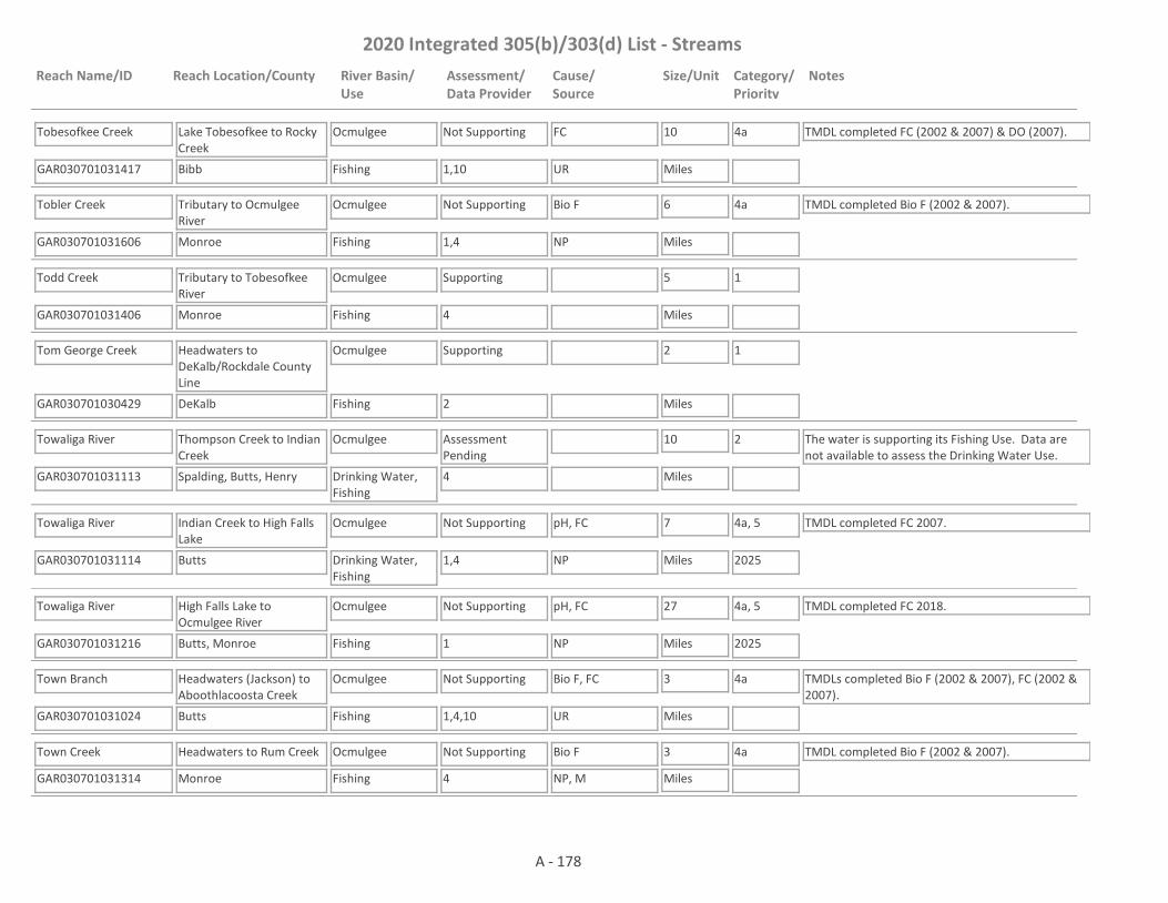
2020 Integrated 305(b)/303(d) List - Streams
Reach Name/ID Reach Location/County River Basin/Use
Assessment/Data Provider
Cause/Source
Size/Unit Category/Priority
Notes
Tobesofkee Creek
GAR030701031417 1,10
Lake Tobesofkee to Rocky Creek
Bibb
Ocmulgee
Fishing
Not Supporting FC 10
Miles
4a TMDL completed FC (2002 & 2007) & DO (2007).
UR
Tobler Creek
GAR030701031606 1,4
Tributary to Ocmulgee River
Monroe
Ocmulgee
Fishing
Not Supporting Bio F 6
Miles
4a TMDL completed Bio F (2002 & 2007).
NP
Todd Creek
GAR030701031406 4
Tributary to Tobesofkee River
Monroe
Ocmulgee
Fishing
Supporting 5
Miles
1
Tom George Creek
GAR030701030429 2
Headwaters to DeKalb/Rockdale County Line
DeKalb
Ocmulgee
Fishing
Supporting 2
Miles
1
Towaliga River
GAR030701031113 4
Thompson Creek to Indian Creek
Spalding, Butts, Henry
Ocmulgee
Drinking Water, Fishing
Assessment Pending
10
Miles
2 The water is supporting its Fishing Use. Data are not available to assess the Drinking Water Use.
Towaliga River
GAR030701031114 1,4
Indian Creek to High Falls Lake
Butts
Ocmulgee
Drinking Water, Fishing
Not Supporting pH, FC 7
Miles
4a, 5
2025
TMDL completed FC 2007.
NP
Towaliga River
GAR030701031216 1
High Falls Lake to Ocmulgee River
Butts, Monroe
Ocmulgee
Fishing
Not Supporting pH, FC 27
Miles
4a, 5
2025
TMDL completed FC 2018.
NP
Town Branch
GAR030701031024 1,4,10
Headwaters (Jackson) to Aboothlacoosta Creek
Butts
Ocmulgee
Fishing
Not Supporting Bio F, FC 3
Miles
4a TMDLs completed Bio F (2002 & 2007), FC (2002 & 2007).
UR
Town Creek
GAR030701031314 4
Headwaters to Rum Creek
Monroe
Ocmulgee
Fishing
Not Supporting Bio F 3
Miles
4a TMDL completed Bio F (2002 & 2007).
NP, M
A - 178
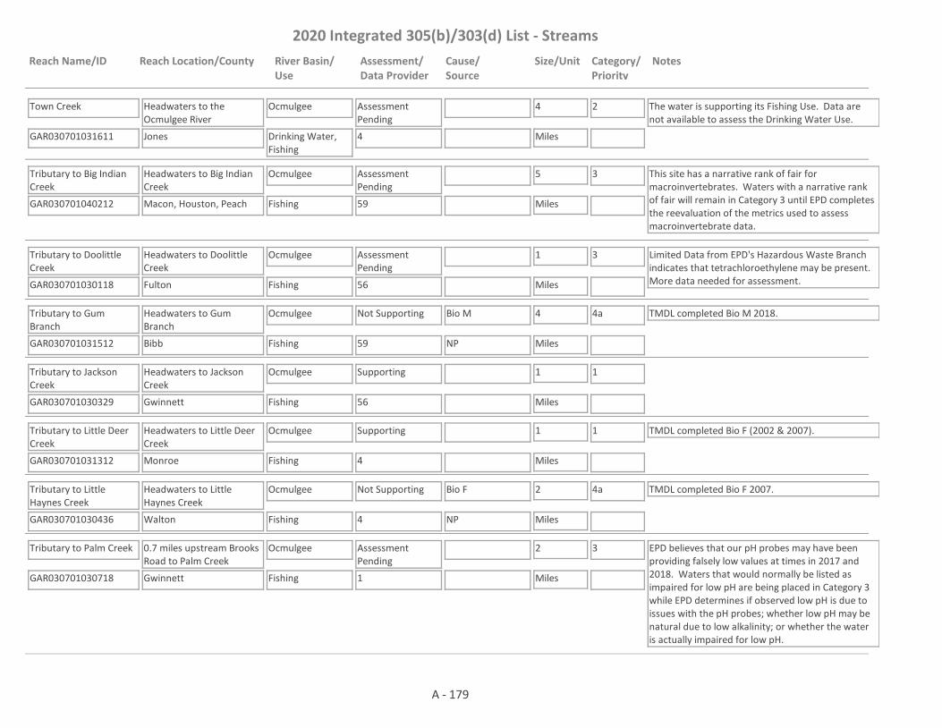
2020 Integrated 305(b)/303(d) List - Streams
Reach Name/ID Reach Location/County River Basin/Use
Assessment/Data Provider
Cause/Source
Size/Unit Category/Priority
Notes
Town Creek
GAR030701031611 4
Headwaters to the Ocmulgee River
Jones
Ocmulgee
Drinking Water, Fishing
Assessment Pending
4
Miles
2 The water is supporting its Fishing Use. Data are not available to assess the Drinking Water Use.
Tributary to Big Indian Creek
GAR030701040212 59
Headwaters to Big Indian Creek
Macon, Houston, Peach
Ocmulgee
Fishing
Assessment Pending
5
Miles
3 This site has a narrative rank of fair for macroinvertebrates. Waters with a narrative rank of fair will remain in Category 3 until EPD completes the reevaluation of the metrics used to assess macroinvertebrate data.
Tributary to Doolittle Creek
GAR030701030118 56
Headwaters to Doolittle Creek
Fulton
Ocmulgee
Fishing
Assessment Pending
1
Miles
3 Limited Data from EPD's Hazardous Waste Branch indicates that tetrachloroethylene may be present. More data needed for assessment.
Tributary to Gum Branch
GAR030701031512 59
Headwaters to Gum Branch
Bibb
Ocmulgee
Fishing
Not Supporting Bio M 4
Miles
4a TMDL completed Bio M 2018.
NP
Tributary to Jackson Creek
GAR030701030329 56
Headwaters to Jackson Creek
Gwinnett
Ocmulgee
Fishing
Supporting 1
Miles
1
Tributary to Little Deer Creek
GAR030701031312 4
Headwaters to Little Deer Creek
Monroe
Ocmulgee
Fishing
Supporting 1
Miles
1 TMDL completed Bio F (2002 & 2007).
Tributary to Little Haynes Creek
GAR030701030436 4
Headwaters to Little Haynes Creek
Walton
Ocmulgee
Fishing
Not Supporting Bio F 2
Miles
4a TMDL completed Bio F 2007.
NP
Tributary to Palm Creek
GAR030701030718 1
0.7 miles upstream Brooks Road to Palm Creek
Gwinnett
Ocmulgee
Fishing
Assessment Pending
2
Miles
3 EPD believes that our pH probes may have been providing falsely low values at times in 2017 and 2018. Waters that would normally be listed as impaired for low pH are being placed in Category 3 while EPD determines if observed low pH is due to issues with the pH probes; whether low pH may be natural due to low alkalinity; or whether the water is actually impaired for low pH.
A - 179
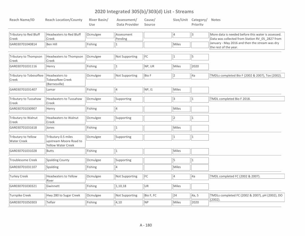
2020 Integrated 305(b)/303(d) List - Streams
Reach Name/ID Reach Location/County River Basin/Use
Assessment/Data Provider
Cause/Source
Size/Unit Category/Priority
Notes
Tributary to Red Bluff Creek
GAR030701040814 1
Headwaters to Red Bluff Creek
Ben Hill
Ocmulgee
Fishing
Assessment Pending
4
Miles
3 More data is needed before this water is assessed. Data was collected from Station RV_05_2827 from January - May 2016 and then the stream was dry the rest of the year.
Tributary to Thompson Creek
GAR030701031116 1
Headwaters to Thompson Creek
Henry
Ocmulgee
Fishing
Not Supporting FC 1
Miles
5
2020NP, UR
Tributary to Tobesofkee Creek
GAR030701031407 4
Headwaters to Tobesofkee Creek (Barnesville)
Lamar
Ocmulgee
Fishing
Not Supporting Bio F 2
Miles
4a TMDLs completed Bio F (2002 & 2007), Tox (2002).
NP, I1
Tributary to Tussahaw Creek
GAR030701030907 4
Headwaters to Tussahaw Creek
Henry
Ocmulgee
Fishing
Supporting 3
Miles
1 TMDL completed Bio F 2018.
Tributary to Walnut Creek
GAR030701031618 1
Headwaters to Walnut Creek
Jones
Ocmulgee
Fishing
Supporting 2
Miles
1
Tributary to Yellow Water Creek
GAR030701031028 1
Tributary 0.5 miles upstream Moore Road to Yellow Water Creek
Butts
Ocmulgee
Fishing
Supporting 1
Miles
1
Troublesome Creek
GAR030701031107 4
Spalding County
Spalding
Ocmulgee
Fishing
Supporting 5
Miles
1
Turkey Creek
GAR030701030321 1,10,18
Headwaters to Yellow River
Gwinnett
Ocmulgee
Fishing
Not Supporting FC 4
Miles
4a TMDL completed FC (2002 & 2007).
UR
Turnpike Creek
GAR030701050303 4,10
Hwy 280 to Sugar Creek
Telfair
Ocmulgee
Fishing
Not Supporting Bio F, FC 24
Miles
4a, 5
2020
TMDLs completed FC (2002 & 2007), pH (2002), DO (2002).
NP
A - 180
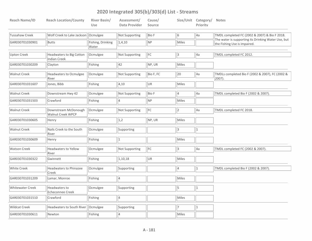
2020 Integrated 305(b)/303(d) List - Streams
Reach Name/ID Reach Location/County River Basin/Use
Assessment/Data Provider
Cause/Source
Size/Unit Category/Priority
Notes
Tussahaw Creek
GAR030701030901 1,4,10
Wolf Creek to Lake Jackson
Butts
Ocmulgee
Fishing, Drinking Water
Not Supporting Bio F 6
Miles
4a TMDL completed FC (2002 & 2007) & Bio F 2018. The water is supporting its Drinking Water Use, but the Fishing Use is impaired.NP
Upton Creek
GAR030701030209 42
Headwaters to Big Cotton Indian Creek
Clayton
Ocmulgee
Fishing
Not Supporting FC 3
Miles
4a TMDL completed FC 2012.
NP, UR
Walnut Creek
GAR030701031607 4,10
Headwaters to Ocmulgee River
Jones, Bibb
Ocmulgee
Fishing
Not Supporting Bio F, FC 20
Miles
4a TMDLs completed Bio F (2002 & 2007), FC (2002 & 2007).
UR
Walnut Creek
GAR030701031503 4
Downstream Hwy 42
Crawford
Ocmulgee
Fishing
Not Supporting Bio F 4
Miles
4a TMDL completed Bio F (2002 & 2007).
NP
Walnut Creek
GAR030701030605 1,2
Downstream McDonough Walnut Creek WPCP
Henry
Ocmulgee
Fishing
Not Supporting FC 2
Miles
4a TMDL completed FC 2018.
NP, UR
Walnut Creek
GAR030701030609 1
Nails Creek to the South River
Henry
Ocmulgee
Fishing
Supporting 3
Miles
1
Watson Creek
GAR030701030322 1,10,18
Headwaters to Yellow River
Gwinnett
Ocmulgee
Fishing
Not Supporting FC 3
Miles
4a TMDL completed FC (2002 & 2007).
UR
White Creek
GAR030701031209 4
Headwaters to Phinazee Creek
Lamar, Monroe
Ocmulgee
Fishing
Supporting 4
Miles
1 TMDL completed Bio F (2002 & 2007).
Whitewater Creek
GAR030701031510 4
Headwaters to Echeconnee Creek
Crawford
Ocmulgee
Fishing
Supporting 5
Miles
1
Wildcat Creek
GAR030701030611 4
Headwaters to South River
Newton
Ocmulgee
Fishing
Supporting 7
Miles
1
A - 181

2020 Integrated 305(b)/303(d) List - Streams
Reach Name/ID Reach Location/County River Basin/Use
Assessment/Data Provider
Cause/Source
Size/Unit Category/Priority
Notes
Wise Creek
GAR030701031015 4,10
Headwaters to the Ocmulgee River
Jasper
Ocmulgee
Fishing
Not Supporting Bio F, FC 7
Miles
4a TMDLs completed Bio F (2002 & 2007), FC (2002 & 2007).
NP
Wolf Creek
GAR030701031411 4
Tucker Road to Rocky Creek
Bibb
Ocmulgee
Fishing
Supporting 2
Miles
1
Wolf Creek
GAR030701030215 4
Headwaters to Little Cotton Indian Creek
Henry
Ocmulgee
Fishing
Not Supporting Bio F 4
Miles
4a TMDL completed Bio F 2018.
UR
Wood Creek
GAR030701031508 4
Headwaters to downstream Ga. Hwy. 83
Lamar, Monroe
Ocmulgee
Fishing
Supporting 3
Miles
1 TMDL completed Bio F (2002 & 2007).
Wood Creek
GAR030701031507 4
Downstream Ga. Hwy. 83 to Echeconnee Creek
Monroe
Ocmulgee
Fishing
Supporting 4
Miles
1
Yellow River
GAR030701030327 1,9,18
Headwaters to Harris Lake
Gwinnett
Ocmulgee
Fishing
Not Supporting FC 3
Miles
4a TMDL completed FC 2007.
UR
Yellow River
GAR030701030328 1,18
Harris Lake to Pew Creek
Gwinnett
Ocmulgee
Fishing
Not Supporting FC 7
Miles
4a TMDL completed FC 2007.
UR
Yellow River
GAR030701030311 1,18
Sweetwater Creek to Centerville Creek
Gwinnett
Ocmulgee
Fishing
Supporting 15
Miles
1 TMDL completed FC (2002 & 2007)
Yellow River
GAR030701030433 1,18
Centerville Creek to Hammock Creek
Gwinnett, DeKalb, Rockdale
Ocmulgee
Fishing
Not Supporting FC, Cu 8
Miles
4a TMDL completed FC 2007 & Cu 2018.
UR
Yellow River
GAR030701030432 1
Hammock Creek to Big Haynes Creek
Rockdale
Ocmulgee
Drinking Water, Fishing
Not Supporting FC 9
Miles
4a TMDL completed FC (2002 & 2007).
UR
A - 182

2020 Integrated 305(b)/303(d) List - Streams
Reach Name/ID Reach Location/County River Basin/Use
Assessment/Data Provider
Cause/Source
Size/Unit Category/Priority
Notes
Yellow River
GAR030701030518 1,10
Big Haynes Creek to Jackson Lake
Newton
Ocmulgee
Fishing, Drinking Water
Not Supporting FC 25
Miles
4a TMDL completed FC (2002 & 2007).
UR
Yellow Water Creek
GAR030701031016 1
1 mile d/s Stark Road (Rd. S763), Jackson to Ocmulgee RIver
Butts
Ocmulgee
Fishing
Supporting 7
Miles
1 TMDL completed FC 2002.
Allen Creek
GAR030701010104 1,20
Monroe Drive to 1 mile downstream GA. Hwy. 11, Gainesville
Hall, Jackson
Oconee
Fishing
Not Supporting FC 9
Miles
4a TMDL completed FC (2002 & 2007).
UR
Allen Creek
GAR030701010116 1,4,10
1 mile downstream Georgia Hwy 11 to Middle Oconee River
Jackson
Oconee
Fishing
Not Supporting FC 8
Miles
4a TMDL completed FC 2007.
NP
Alligator Creek
GAR030701020601 4
Headwaters to Ugly Creek
Twiggs
Oconee
Fishing
Not Supporting Bio F 6
Miles
4a TMDL completed Bio F (2002 & 2007).
NP
Anne Court Branch
GAR030701010301 10
Headwaters to Middle Oconee River, Athens
Clarke
Oconee
Fishing
Supporting 1
Miles
1 TMDL completed FC 1998.
Apalachee River
GAR030701010803 4,18
Headwaters to unnamed tributary 1500 ft upstream Apalachee Road
Gwinnett
Oconee
Fishing
Not Supporting FC 6
Miles
4a TMDL completed FC 2007.
UR
Apalachee River
GAR030701010802 18
Unnamed tributary 1500 ft u/s Apalachee Road to Williamson Creek
Gwinnett, Barrow, Walton
Oconee
Fishing
Supporting 10
Miles
1
A - 183
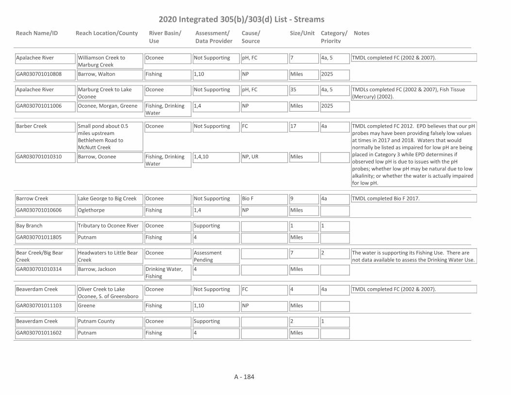
2020 Integrated 305(b)/303(d) List - Streams
Reach Name/ID Reach Location/County River Basin/Use
Assessment/Data Provider
Cause/Source
Size/Unit Category/Priority
Notes
Apalachee River
GAR030701010808 1,10
Williamson Creek to Marburg Creek
Barrow, Walton
Oconee
Fishing
Not Supporting pH, FC 7
Miles
4a, 5
2025
TMDL completed FC (2002 & 2007).
NP
Apalachee River
GAR030701011006 1,4
Marburg Creek to Lake Oconee
Oconee, Morgan, Greene
Oconee
Fishing, Drinking Water
Not Supporting pH, FC 35
Miles
4a, 5
2025
TMDLs completed FC (2002 & 2007), Fish Tissue (Mercury) (2002).
NP
Barber Creek
GAR030701010310 1,4,10
Small pond about 0.5 miles upstream Bethlehem Road to McNutt Creek
Barrow, Oconee
Oconee
Fishing, Drinking Water
Not Supporting FC 17
Miles
4a TMDL completed FC 2012. EPD believes that our pH probes may have been providing falsely low values at times in 2017 and 2018. Waters that would normally be listed as impaired for low pH are being placed in Category 3 while EPD determines if observed low pH is due to issues with the pH probes; whether low pH may be natural due to low alkalinity; or whether the water is actually impaired for low pH.
NP, UR
Barrow Creek
GAR030701010606 1,4
Lake George to Big Creek
Oglethorpe
Oconee
Fishing
Not Supporting Bio F 9
Miles
4a TMDL completed Bio F 2017.
NP
Bay Branch
GAR030701011805 4
Tributary to Oconee River
Putnam
Oconee
Fishing
Supporting 1
Miles
1
Bear Creek/Big Bear Creek
GAR030701010314 4
Headwaters to Little Bear Creek
Barrow, Jackson
Oconee
Drinking Water, Fishing
Assessment Pending
7
Miles
2 The water is supporting its Fishing Use. There are not data available to assess the Drinking Water Use.
Beaverdam Creek
GAR030701011103 1,10
Oliver Creek to Lake Oconee, S. of Greensboro
Greene
Oconee
Fishing
Not Supporting FC 4
Miles
4a TMDL completed FC (2002 & 2007).
NP
Beaverdam Creek
GAR030701011602 4
Putnam County
Putnam
Oconee
Fishing
Supporting 2
Miles
1
A - 184

2020 Integrated 305(b)/303(d) List - Streams
Reach Name/ID Reach Location/County River Basin/Use
Assessment/Data Provider
Cause/Source
Size/Unit Category/Priority
Notes
Beaverdam Creek
GAR030701011201 4
Northwest of Smyrna Church
Hancock
Oconee
Fishing
Supporting 2
Miles
1
Beaverdam Creek
GAR030701011213 1,4
Headwaters to tributary to Beaverdam Creek 300 feet downstream of Log Cabin Creek
Hancock
Oconee
Fishing
Supporting 1
Miles
1
Beaverdam Creek
GAR030701010910 4,59
Headwaters to Big Sandy Creek
Morgan
Oconee
Fishing
Not Supporting Bio F 9
Miles
5
2020NP
Beaverdam Creek
GAR030701011203 4
Hancock County
Hancock
Oconee
Fishing
Supporting 4
Miles
1
Big Cedar Creek
GAR030701011701 1,10,36
Hog Creek to Lake Sinclair
Jones, Putnam, Baldwin
Oconee
Fishing
Not Supporting FC 11
Miles
4a TMDL completed FC (2002 & 2007).
NP
Big Creek
GAR030701010607 4
Moss Creek to Oconee River
Oglethorpe
Oconee
Fishing
Supporting 5
Miles
1
Big Creek and a tributary (water previously known as Wolf Creek)
GAR030701020508 4
Polands Lake to Wolf Creek (Gray)
Jones
Oconee
Fishing
Supporting 3
Miles
1
Big Indian Creek
GAR030701011405 1
I-20 to Little Indian Creek
Morgan
Oconee
Fishing
Not Supporting FC 11
Miles
4a TMDL completed FC 2002.
NP
Big Indian Creek
GAR030701011406 1,36
Little Indian Creek to Little River
Morgan, Putnam
Oconee
Fishing
Supporting 7
Miles
1
A - 185

2020 Integrated 305(b)/303(d) List - Streams
Reach Name/ID Reach Location/County River Basin/Use
Assessment/Data Provider
Cause/Source
Size/Unit Category/Priority
Notes
Big Sandy Creek
GAR030701020607 1
Alligator Creek to Clear Creek
Twiggs, Wilkinson
Oconee
Fishing
Supporting 8
Miles
1
Big Sandy Creek
GAR030701020604 4
Clear Creek to Porter Creek
Wilkinson
Oconee
Fishing
Supporting 6
Miles
1
Big Sandy Creek
GAR030701020703 1,10
Porter Creek to Oconee River
Wilkinson, Laurens
Oconee
Fishing
Not Supporting FC 14
Miles
4a TMDL completed FC (2002 & 2007).
NP
Big Sandy Creek
GAR030701010913 4
Little Sandy Creek to Little Creek
Morgan
Oconee
Fishing
Supporting 4
Miles
1
Big Sandy Creek
GAR030701010907 10,59
Headwaters to Little Sandy Creek (near Good Hope)
Morgan, Walton
Oconee
Fishing
Not Supporting FC 10
Miles
4a TMDL completed FC 2007.
NP
Big Sandy Creek
GAR030701010908 10
Little Sandy Creek (near Madison) to Hard Labor Creek
Morgan
Oconee
Fishing
Not Supporting FC 6
Miles
4a TMDL completed FC 2007.
NP
Black Spring Branch
GAR030701020101 4
Baldwin County
Baldwin
Oconee
Fishing
Supporting 4
Miles
1
Bluewater Creek
GAR030701021106 1,4
Headwaters to Reedy Springs Branch
Laurens
Oconee
Fishing
Not Supporting Bio F 7
Miles
4a TMDL completed Bio F 2012.
NP, UR
Bluff Creek
GAR030701020201 10
Downstream Wiggins Road to Oconee River
Washington
Oconee
Fishing
Not Supporting DO, pH, FC 4
Miles
4a TMDLs completed DO (2002), pH (2002) & FC (2007).
NP
A - 186

2020 Integrated 305(b)/303(d) List - Streams
Reach Name/ID Reach Location/County River Basin/Use
Assessment/Data Provider
Cause/Source
Size/Unit Category/Priority
Notes
Bottoms Branch
GAR030701010111 20,22
Tributary 5 to North Walnut Creek, Gainesville
Hall
Oconee
Fishing
Supporting 1
Miles
1 TMDL completed DO (2002).
Bowden Creek
GAR030701011108 4
Unnamed tributary at I-20 to Beaverdam Creek
Greene
Oconee
Fishing
Not Supporting Bio F 4
Miles
5
2020NP, I2
Briar Creek
GAR030701010909 1,4
Headwaters to Hard Labor Creek
Morgan
Oconee
Fishing
Supporting 4
Miles
1 TMDL completed Bio F 2007.
Brooklyn Creek
GAR030701010302 1,10,82
Headwaters to Middle Oconee River, Athens
Clarke
Oconee
Fishing
Not Supporting FC 2
Miles
4a TMDL completed FC (1998 & 2007).
UR
Bruce Creek
GAR030701011211 4
Unnamed tributary 0.7 miles downstream White Plains-Veazey Road to Pierce Creek
Greene
Oconee
Fishing
Supporting 4
Miles
1
Buck Creek
GAR030701020104 4
Tributary to Oconee River
Baldwin
Oconee
Fishing
Supporting 4
Miles
1
Buckeye Creek
GAR030701020802 4
Fords Creek to Kellams Creek
Johnson, Laurens
Oconee
Fishing
Not Supporting Bio F 5
Miles
5
2020NP
Buffalo Creek
GAR030701020302 1,4
St. Road 787 to Swift Creek
Hancock
Oconee
Fishing
Supporting 9
Miles
1
Buffalo Creek
GAR030701020405 1,4,10
Keg Creek to Oconee River
Washington
Oconee
Fishing
Not Supporting FC 10
Miles
4a TMDLs completed pH (2002), Zn (2002) & FC (2007).
NP
A - 187

2020 Integrated 305(b)/303(d) List - Streams
Reach Name/ID Reach Location/County River Basin/Use
Assessment/Data Provider
Cause/Source
Size/Unit Category/Priority
Notes
Calls Creek
GAR030701010311 4,10
Lumpkin Branch (aka Lampkin Branch) to Middle Oconee River
Oconee
Oconee
Fishing
Not Supporting FC 4
Miles
4a TMDL completed FC 2007.
UR
Camp Creek
GAR030701020105 4
Tributary to Oconee River
Baldwin
Oconee
Fishing
Supporting 7
Miles
1
Campbell Creek
GAR030701011408 4
Headwaters to the Little River
Morgan
Oconee
Fishing
Supporting 5
Miles
1
Cane Creek
GAR030701010518 1,4
Tributary 0.25 miles upstream Mary Collier Rd to Crooked Creek
Jackson
Oconee
Fishing
Assessment Pending
2
Miles
3 EPD believes that our pH probes may have been providing falsely low values at times in 2017 and 2018. Waters that would normally be listed as impaired for low pH are being placed in Category 3 while EPD determines if observed low pH is due to issues with the pH probes; whether low pH may be natural due to low alkalinity; or whether the water is actually impaired for low pH.
Carr Creek
GAR030701010501 1,4,10,82
Headwaters to North Oconee River, Athens
Clarke
Oconee
Fishing
Not Supporting pH, Bio F, FC, Bio M
2
Miles
4a TMDLs completed Bio F & M (2002 & 2007), FC (2002 & 2007), pH (2002). Sources for pH includes I2 along with I1 and UR. Sources for other pollutants just I1 and UR.
UR, I1, I2
Carters Mill Creek
GAR030701020401 4
Headwaters to Keg Creek
Washington
Oconee
Fishing
Not Supporting Bio F 6
Miles
4a TMDL completed Bio F 2002.
NP
Cedar Creek
GAR030701010410 1
Pond 1.3 miles upstream Joe Chandler Road to the North Oconee River
Hall
Oconee
Drinking Water, Fishing
Assessment Pending
3
Miles
2 DO is in Category 3. Observed low DO's at the site may have been a result of low flow due to a blocked culvert. More information is needed before making a listing decision. The water is supporting its Drinking Water Use, but it is not known if it is supporting its Fishing use.
Cedar Creek
GAR030701010601 1,4,10,82
Headwaters to Oconee River, Athens
Clarke
Oconee
Fishing
Not Supporting Bio F, FC 4
Miles
4a, 5
2020
TMDL completed FC (2002 & 2007).
UR
A - 188
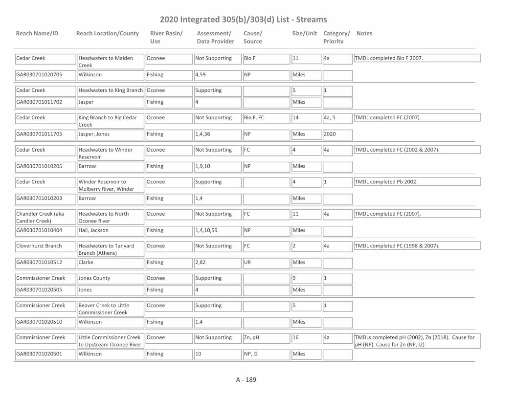
2020 Integrated 305(b)/303(d) List - Streams
Reach Name/ID Reach Location/County River Basin/Use
Assessment/Data Provider
Cause/Source
Size/Unit Category/Priority
Notes
Cedar Creek
GAR030701020705 4,59
Headwaters to Maiden Creek
Wilkinson
Oconee
Fishing
Not Supporting Bio F 11
Miles
4a TMDL completed Bio F 2007.
NP
Cedar Creek
GAR030701011702 4
Headwaters to King Branch
Jasper
Oconee
Fishing
Supporting 5
Miles
1
Cedar Creek
GAR030701011705 1,4,36
King Branch to Big Cedar Creek
Jasper, Jones
Oconee
Fishing
Not Supporting Bio F, FC 14
Miles
4a, 5
2020
TMDL completed FC (2007).
NP
Cedar Creek
GAR030701010205 1,9,10
Headwaters to Winder Reservoir
Barrow
Oconee
Fishing
Not Supporting FC 4
Miles
4a TMDL completed FC (2002 & 2007).
NP
Cedar Creek
GAR030701010203 1,4
Winder Reservoir to Mulberry River, Winder
Barrow
Oconee
Fishing
Supporting 4
Miles
1 TMDL completed Pb 2002.
Chandler Creek (aka Candler Creek)
GAR030701010404 1,4,10,59
Headwaters to North Oconee River
Hall, Jackson
Oconee
Fishing
Not Supporting FC 11
Miles
4a TMDL completed FC (2007).
NP
Cloverhurst Branch
GAR030701010512 2,82
Headwaters to Tanyard Branch (Athens)
Clarke
Oconee
Fishing
Not Supporting FC 2
Miles
4a TMDL completed FC (1998 & 2007).
UR
Commissioner Creek
GAR030701020505 4
Jones County
Jones
Oconee
Fishing
Supporting 9
Miles
1
Commissioner Creek
GAR030701020510 1,4
Beaver Creek to Little Commissioner Creek
Wilkinson
Oconee
Fishing
Supporting 5
Miles
1
Commissioner Creek
GAR030701020501 10
Little Commissioner Creek to Upstream Oconee River
Wilkinson
Oconee
Fishing
Not Supporting Zn, pH 16
Miles
4a TMDLs completed pH (2002), Zn (2018). Cause for pH (NP). Cause for Zn (NP, I2)
NP, I2
A - 189
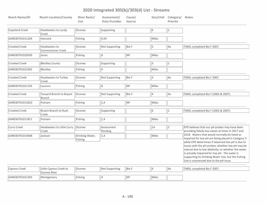
2020 Integrated 305(b)/303(d) List - Streams
Reach Name/ID Reach Location/County River Basin/Use
Assessment/Data Provider
Cause/Source
Size/Unit Category/Priority
Notes
Copeland Creek
GAR030701011204 4,59
Headwaters to Lundy Creek
Hancock
Oconee
Fishing
Supporting 6
Miles
1
Crooked Creek
GAR030701020509 4
Headwaters to Commissioner Creek
Jones
Oconee
Fishing
Not Supporting Bio F 5
Miles
4a TMDL completed Bio F 2007.
NP
Crooked Creek
GAR030701021002 4
Bleckley County
Bleckley
Oconee
Fishing
Supporting 3
Miles
1
Crooked Creek
GAR030701021105 4
Headwaters to Turkey Creek
Laurens
Oconee
Fishing
Not Supporting Bio F 3
Miles
4a TMDL completed Bio F 2007.
NP
Crooked Creek
GAR030701011810 1,4
Tanyard Branch to Bryant Branch
Putnam
Oconee
Fishing
Not Supporting Bio F 4
Miles
4a TMDL completed Bio F (2002 & 2007).
NP
Crooked Creek
GAR030701011811 1,4
Bryant Branch to Rush Creek
Putnam
Oconee
Fishing
Supporting 6
Miles
1 TMDL completed Bio F (2002 & 2007).
Curry Creek
GAR030701010408 1,4
Headwaters to Little Curry Creek
Jackson
Oconee
Drinking Water, Fishing
Assessment Pending
14
Miles
2 EPD believes that our pH probes may have been providing falsely low values at times in 2017 and 2018. Waters that would normally be listed as impaired for low pH are being placed in Category 3 while EPD determines if observed low pH is due to issues with the pH probes; whether low pH may be natural due to low alkalinity; or whether the water is actually impaired for low pH. The water is supporting its Drinking Water Use, but the Fishing Use is unassessed due to the pH issue.
Cypress Creek
GAR030701021303 4
Little Cypress Creek to Oconee River
Montgomery
Oconee
Fishing
Not Supporting Bio F 4
Miles
4a TMDL completed Bio F 2007.
NP
A - 190

2020 Integrated 305(b)/303(d) List - Streams
Reach Name/ID Reach Location/County River Basin/Use
Assessment/Data Provider
Cause/Source
Size/Unit Category/Priority
Notes
Deaton Creek
GAR030701010212 1,4
Headwaters to the Mulberry River
Hall
Oconee
Fishing
Supporting 5
Miles
1
Deep Creek
GAR030701020801 4
Hodges Pond to Washington/Johnson County Line
Washington
Oconee
Fishing
Supporting 5
Miles
1
Drowning Creek
GAR030701010811 4
Headwaters to the Apalachee River
Gwinnett
Oconee
Fishing
Supporting 4
Miles
1
E. T. Creek
GAR030701010105 1,20
Headwaters to North Walnut Creek, Gainesville
Hall
Oconee
Fishing
Not Supporting FC 1
Miles
4a TMDL completed FC (1998 & 2007).
UR
East Fork Trail Creek
GAR030701010511 1,63,82
Headwaters to West Fork Trail Creek, Athens
Clarke
Oconee
Fishing
Not Supporting FC 3
Miles
4a TMDL completed FC (2002 & 2007).
UR
East Sandy Creek
GAR030701010516 1,4
Long Branch to Sandy Creek
Madison, Clarke
Oconee
Fishing
Not Supporting pH 4
Miles
5
2025NP
Falling Creek
GAR030701010605 1,4
Headwaters to the Oconee River
Oglethorpe
Oconee
Fishing
Not Supporting Bio F 9
Miles
4a TMDL completed Bio F 2017.
NP
Fishing Creek
GAR030701020106 4
Tributary to Oconee River
Baldwin
Oconee
Fishing
Supporting 12
Miles
1
Fishing Creek
GAR030701010708 1,4
Pond at headwaters to McWhorter Creek
Oglethorpe, Greene
Oconee
Fishing
Not Supporting Bio F 6
Miles
5
2020NP
A - 191

2020 Integrated 305(b)/303(d) List - Streams
Reach Name/ID Reach Location/County River Basin/Use
Assessment/Data Provider
Cause/Source
Size/Unit Category/Priority
Notes
Fishing Creek
GAR030701010701 1,10
McWhorter Creek to Lake Oconee
Greene
Oconee
Fishing
Not Supporting FC 4
Miles
4a TMDL completed FC (1998 & 2007).
NP
Ford Creek
GAR030701011205 4
Hancock County
Hancock
Oconee
Fishing
Supporting 2
Miles
1
Freeman Creek
GAR030701011008 4
Headwaters to Apalachee River
Oconee
Oconee
Fishing
Not Supporting Bio F 4
Miles
4a TMDL completed Bio F 2007.
NP
Gap Creek
GAR030701011404 4
Jasper County
Jasper
Oconee
Fishing
Supporting 3
Miles
1
Glady Creek
GAR030701011505 4,36
Putnam County
Putnam
Oconee
Fishing
Supporting 3
Miles
1
Glady Creek
GAR030701011712 1
Marshal Creek to Cedar Creek
Jones
Oconee
Fishing
Supporting 5
Miles
1
Greenbriar Creek
GAR030701010704 1,4,28
Salem Scull Shoals Road to Lake Oconee
Oconee, Greene
Oconee
Fishing
Not Supporting Bio F 8
Miles
5
2020
TMDL completed FC 1998.
NP
Hard Labor Creek
GAR030701010906 1,28
Big Sandy Creek to Apalachee River
Morgan
Oconee
Fishing
Supporting 4
Miles
1
Hardeman Creek
GAR030701010520 1,4
Pond 0.2 miles upstream Berea Road to Sandy Creek
Jackson
Oconee
Fishing
Assessment Pending
3
Miles
3 TMDL completed Bio F 2007. EPD believes that our pH probes may have been providing falsely low values at times in 2017 and 2018. Waters that would normally be listed as impaired for low pH are being placed in Category 3 while EPD determines if observed low pH is due to issues with the pH probes; whether low pH may be natural due to low alkalinity; or whether the water is actually impaired for low pH.
A - 192

2020 Integrated 305(b)/303(d) List - Streams
Reach Name/ID Reach Location/County River Basin/Use
Assessment/Data Provider
Cause/Source
Size/Unit Category/Priority
Notes
Harris Creek
GAR030701010707 4
Headwaters to the Oconee River
Greene
Oconee
Fishing
Not Supporting Bio F 7
Miles
4a TMDL completed Bio F 2017.
NP
Hitchcock Branch
GAR030701011603 4
Putnam County
Putnam
Oconee
Fishing
Supporting 1
Miles
1
Hog Creek
GAR030701011706 4
Tributary to Big Cedar Creek
Jones
Oconee
Fishing
Supporting 7
Miles
1
Horse Branch
GAR030701011314 1,4
Headwaters to North Sugar Creek
Morgan
Oconee
Fishing
Not Supporting Bio F 4
Miles
5
2020NP, UR
Hunger and Hardship Creek
GAR030701020903 4
Headwaters to Strawberry Creek
Laurens
Oconee
Fishing
Supporting 6
Miles
1
Hunnicutt Creek (aka Mitchell Bridge Branch)
GAR030701010304 1,63,82
Headwaters to Middle Oconee River, Athens
Clarke
Oconee
Fishing
Not Supporting FC 1
Miles
4a TMDL completed FC (1998 & 2007).
UR
Indian Creek
GAR030701011011 1,4
Headwaters to Jacks Creek
Walton
Oconee
Fishing
Assessment Pending
5
Miles
3 EPD believes that our pH probes may have been providing falsely low values at times in 2017 and 2018. Waters that would normally be listed as impaired for low pH are being placed in Category 3 while EPD determines if observed low pH is due to issues with the pH probes; whether low pH may be natural due to low alkalinity; or whether the water is actually impaired for low pH.
Indian Creek
GAR030701010210 1,59
Headwaters to Mulberry River (formerly Headwaters to Mulberry Creek)
Jackson, Barrow
Oconee
Fishing
Assessment Pending
7
Miles
3 This site has a narrative rank of fair for macroinvertebrates. When EPD completes the reevaluation of the metrics used to assess macroinvertebrate data it will be determined if the macroinvertebrate criteria are being met. The water is in Category 3 for pH. Sonde data was questionable for a couple of months. More data is needed to confirm if a pH issue exists.
A - 193

2020 Integrated 305(b)/303(d) List - Streams
Reach Name/ID Reach Location/County River Basin/Use
Assessment/Data Provider
Cause/Source
Size/Unit Category/Priority
Notes
Jacks Creek
GAR030701011005 1
Monroe to Grubby Creek/ D/S abandoned Monroe Jacks Creek Pond
Walton
Oconee
Drinking Water, Fishing
Assessment Pending
3
Miles
2 The water is supporting its Fishing Use. Data are not available to assess the Drinking Water Use.
Jacks Creek
GAR030701011007 1,10
Grubby Creek to Indian Creek
Walton
Oconee
Fishing
Not Supporting pH, FC 9
Miles
4a, 5
2025
TMDL completed FC 2012.
NP, UR
Jenkins Branch
GAR030701011806 4
Tributary to Oconee River
Putnam
Oconee
Fishing
Supporting 1
Miles
1
Keg Creek
GAR030701020410 4
Little Keg Creek to Buffalo Creek
Washington
Oconee
Fishing
Not Supporting Bio F 8
Miles
4a TMDL completed Bio F 2007.
NP
Kimbro Creek
GAR030701011210 1,4
Headwaters to Hightower Creek
Greene
Oconee
Fishing
Not Supporting Bio F, pH 4
Miles
5
2020, 2025
The TMDL for Bio F is scheduled to be drafted in 2020 and the TMDL for pH is scheduled to be drafted in 2025.NP
Kingswood Branch
GAR030701010306 1,2,10,63,82
Tributary to McNutt Creek, Athens
Clarke
Oconee
Fishing
Not Supporting FC 1
Miles
4a TMDLs completed FC (1998 & 2007), pH (2002).
UR
Lamars Creek
GAR030701020407 4
Headwaters to Buffalo Creek
Washington
Oconee
Fishing
Not Supporting Bio F 8
Miles
4a TMDL completed Bio F 2007.
NP
Lane Creek
GAR030701011010 4
Pond 0.6 miles upstream of Snows Mill Road to pond 0.9 miles downstream of Lane Creek Road
Oconee
Oconee
Fishing
Not Supporting Bio F 2
Miles
5
2020NP
Lick Creek
GAR030701011310 4
Upstream Lake Oconee
Putnam
Oconee
Fishing
Supporting 4
Miles
1
A - 194

2020 Integrated 305(b)/303(d) List - Streams
Reach Name/ID Reach Location/County River Basin/Use
Assessment/Data Provider
Cause/Source
Size/Unit Category/Priority
Notes
Limestone Creek
GAR030701020402 4
Kings Pond/Political Pond at Kaolin Road to Keg Creek
Washington
Oconee
Fishing
Not Supporting Bio F 8
Miles
4a TMDL completed Bio F (2002 & 2007).
NP, I1, I2
Limestone Creek
GAR030701021406 1
Pond 0.5 miles upstream E Church Street to Mount Vernon WPCP
Montgomery
Oconee
Fishing
Supporting 2
Miles
1
Limestone Creek
GAR030701021404 1,4
Mount Vernon to Oconee River
Montgomery
Oconee
Fishing
Not Supporting FC, BioF 2
Miles
4a TMDL completed Bio F 2007 & FC 2017. EPD needs to determine the "natural DO" for the area before it can be determined whether the dissolved oxygen criteria are being met.
NP
Little Buffalo Creek
GAR030701020303 4
Hancock County
Hancock
Oconee
Fishing
Supporting 1
Miles
1
Little Camp Creek
GAR030701020107 4
Tributary to Camp Creek
Baldwin
Oconee
Fishing
Supporting 4
Miles
1
Little Cedar Creek
GAR030701011707 4
Headwaters to Lake Sinclair
Jones, Baldwin
Oconee
Fishing
Supporting 9
Miles
1
Little Commissioner Creek
GAR030701020503 4,10
Ga. Hwy. 18 to Commissioner Creek
Wilkinson
Oconee
Fishing
Not Supporting Bio F, FC, Cd, Zn 9
Miles
4a TMDLs completed Bio F (2002 & 2007), FC (2002 & 2007), Zn (2018) & Cd (2018). Cause for Cd & Zn (I2, NP)NP, I1, I2
Little Creek
GAR030701010912 4
Headwaters to Big Sandy Creek
Morgan
Oconee
Fishing
Not Supporting Bio F 5
Miles
5
2020NP
Little Creek
GAR030701020506 4
Jones County
Jones
Oconee
Fishing
Supporting 3
Miles
1
A - 195

2020 Integrated 305(b)/303(d) List - Streams
Reach Name/ID Reach Location/County River Basin/Use
Assessment/Data Provider
Cause/Source
Size/Unit Category/Priority
Notes
Little Creek
GAR030701011105 4
Headwaters to Richland Creek
Greene
Oconee
Fishing
Not Supporting Bio F 3
Miles
4a TMDL completed Bio F 2007.
NP
Little Creek
GAR030701020204 4
Tributary to Town Creek
Hancock
Oconee
Fishing
Supporting 1
Miles
1
Little Fishing Creek
GAR030701020102 4,56
Baldwin County
Baldwin
Oconee
Fishing
Not Supporting Bio F 5
Miles
4a TMDL completed Bio F (2002 & 2007).
NP
Little Glady Creek
GAR030701011507 36
Rock Eagle Lake to Glady Creek
Putnam
Oconee
Fishing
Supporting 3
Miles
1
Little Indian Creek
GAR030701011409 4
Headwaters to Fourmile Branch
Morgan
Oconee
Fishing
Supporting 7
Miles
1
Little Keg Creek
GAR030701020408 4
Washington County
Washington
Oconee
Fishing
Supporting 5
Miles
1
Little Mulberry River
GAR030701010206 1,4,10,18
Headwaters to Mulberry River
Gwinnett, Barrow
Oconee
Fishing
Supporting 11
Miles
1 TMDL completed FC (2007).
Little Red Bluff Creek
GAR030701021204 4
Headwaters to Red Bluff Creek
Treutlen
Oconee
Fishing
Supporting 4
Miles
1
Little River
GAR030701011410 1,4
Social Circle to I-20
Walton, Newton
Oconee
Fishing
Not Supporting Bio F, FC 4
Miles
4a, 5
2020
TMDL completed FC (2002 & 2007).
UR
Little River
GAR030701011411 1,4
I-20 to Nelson Creek
Newton
Oconee
Fishing
Not Supporting FC 1
Miles
4a TMDL completed FC (2002 & 2007).
UR
A - 196
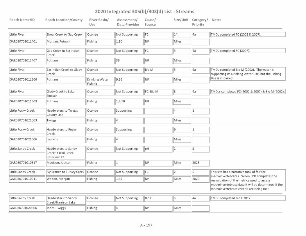
2020 Integrated 305(b)/303(d) List - Streams
Reach Name/ID Reach Location/County River Basin/Use
Assessment/Data Provider
Cause/Source
Size/Unit Category/Priority
Notes
Little River
GAR030701011401 1,10
Shoal Creek to Gap Creek
Morgan, Putnam
Oconee
Fishing
Not Supporting FC 14
Miles
4a TMDL completed FC (2002 & 2007).
NP
Little River
GAR030701011407 36
Gap Creek to Big Indian Creek
Putnam
Oconee
Fishing
Not Supporting FC 5
Miles
4a TMDL completed FC (2007).
UR
Little River
GAR030701011506 9,36
Big Indian Creek to Glady Creek
Putnam
Oconee
Drinking Water, Fishing
Not Supporting Bio M 5
Miles
4a TMDL completed Bio M (2002). The water is supporting its Drinking Water Use, but the Fishing Use is impaired.NP
Little River
GAR030701011503 1,9,10
Glady Creek to Lake Sinclair
Putnam
Oconee
Fishing
Not Supporting FC, Bio M 8
Miles
4a TMDLs completed FC (2002 & 2007) & Bio M (2002).
UR
Little Rocky Creek
GAR030701021003 4
Headwaters to Twiggs County Line
Twiggs
Oconee
Fishing
Supporting 4
Miles
1
Little Rocky Creek
GAR030701021006 4
Headwaters to Rocky Creek
Laurens
Oconee
Fishing
Supporting 9
Miles
1
Little Sandy Creek
GAR030701010517 1
Headwaters to Sandy Creek O Trail Creek Reservoir #2
Madison, Jackson
Oconee
Fishing
Not Supporting pH 2
Miles
5
2025NP
Little Sandy Creek
GAR030701010911 1,59
Ivy Branch to Turkey Creek
Walton, Morgan
Oconee
Fishing
Not Supporting FC 2
Miles
5
2020
This site has a narrative rank of fair for macroinvertebrates. When EPD completes the reevaluation of the metrics used to assess macroinvertebrate data it will be determined if the macroinvertebrate criteria are being met.
NP
Little Sandy Creek
GAR030701020606 4
Headwaters to Sandy Creek/Harrison Lake
Jones, Twiggs
Oconee
Fishing
Not Supporting Bio F 5
Miles
4a TMDL completed Bio F 2012.
NP
A - 197

2020 Integrated 305(b)/303(d) List - Streams
Reach Name/ID Reach Location/County River Basin/Use
Assessment/Data Provider
Cause/Source
Size/Unit Category/Priority
Notes
Little Sandy Hill Creek
GAR030701020409 4
Washington County
Washington
Oconee
Fishing
Supporting 3
Miles
1
Little Sugar Creek
GAR030701011309 10
Headwaters to Lake Oconee
Morgan
Oconee
Fishing
Not Supporting FC 9
Miles
4a TMDL completed FC (2002 & 2007).
NP
Log Dam Creek
GAR030701011803 4
Tributary to Oconee River
Hancock
Oconee
Fishing
Supporting 5
Miles
1
Lollis Creek
GAR030701010214 1,4
Mitchell Creek to Sherwood Creek
Hall
Oconee
Fishing
Assessment Pending
2
Miles
3 EPD believes that our pH probes may have been providing falsely low values at times in 2017 and 2018. Waters that would normally be listed as impaired for low pH are being placed in Category 3 while EPD determines if observed low pH is due to issues with the pH probes; whether low pH may be natural due to low alkalinity; or whether the water is actually impaired for low pH.
Long Creek
GAR030701020205 4
Hancock County
Hancock
Oconee
Fishing
Supporting 1
Miles
1
Lotts Creek
GAR030701021402 4
Headwaters to Oconee River
Wheeler
Oconee
Fishing
Not Supporting Bio F 5
Miles
4a TMDL completed Bio F (2007).
NP
Lowry Branch
GAR030701011604 4
Jasper County
Jasper
Oconee
Fishing, Drinking Water
Not Supporting Bio F 3
Miles
5
2020
The water is not supporting its Fishing Use. Data are not available to assess the Drinking Water Use.
NP
Lundy Creek
GAR030701011206 4
Hancock County
Hancock
Oconee
Fishing
Supporting 2
Miles
1
Maiden Creek
GAR030701020702 4,59
Wilkinson County
Wilkinson
Oconee
Fishing
Supporting 2
Miles
1
A - 198

2020 Integrated 305(b)/303(d) List - Streams
Reach Name/ID Reach Location/County River Basin/Use
Assessment/Data Provider
Cause/Source
Size/Unit Category/Priority
Notes
Marburg Creek (aka Marbury Creek)
GAR030701010810 4
Marbury Lake to Masseys Lake
Barrow
Oconee
Fishing
Not Supporting Bio F 1
Miles
4a TMDL completed Bio F 2007.
NP
Marburg Creek (aka Marbury Creek)
GAR030701010806 1,4,10
Masseys Lake to Apalachee River
Barrow
Oconee
Fishing
Not Supporting Bio F, FC 7
Miles
4a, 5
2020
TMDLs completed FC (2002 & 2007), Tox (2002).
NP, UR
McNutt Creek
GAR030701010309 1,10,82
Headwaters at GA 316 & Dials Mill Road to Middle Oconee River
Clarke, Oconee
Oconee
Fishing
Not Supporting FC 12
Miles
4a TMDL completed FC 2012.
NP, UR
Mercer Creek
GAR030701021203 1
Downstream Graham Pond to Red Hill Creek
Laurens, Treutlen
Oconee
Fishing
Supporting 9
Miles
1
Middle Oconee River
GAR030701010117 1,10
Dosters Creek to Mulberry River
Jackson
Oconee
Fishing
Not Supporting FC 8
Miles
4a TMDL completed FC (2007).
UR
Middle Oconee River
GAR030701010303 9,10
Mulberry River to Bear Creek (formerly Mulberry River to Big Bear Creek)
Jackson, Clarke
Oconee
Fishing, Drinking Water
Not Supporting FC, Bio M 11
Miles
4a TMDLs completed FC (2002 & 2007), Bio M (2002).
NP
Middle Oconee River
GAR030701010305 1,10,63,82
Bear Creek to McNutt Creek (formerly Big Bear Creek to McNutt Creek)
Clarke
Oconee
Fishing, Drinking Water
Not Supporting FC 12
Miles
4a TMDL completed FC (2002 & 2007).
NP
Middle Oconee River
GAR030701010312 10,82
McNutt Creek to North Oconee River
Clarke, Oconee
Oconee
Fishing
Not Supporting FC 4
Miles
4a TMDL completed FC (2007).
UR
Mikes Mill Creek
GAR030701020411 1
Headwaters to Sandy Hill Creek
Washington
Oconee
Fishing
Assessment Pending
4
Miles
3 EPD needs to determine the "natural DO" for the area before a use assessment is made.
A - 199
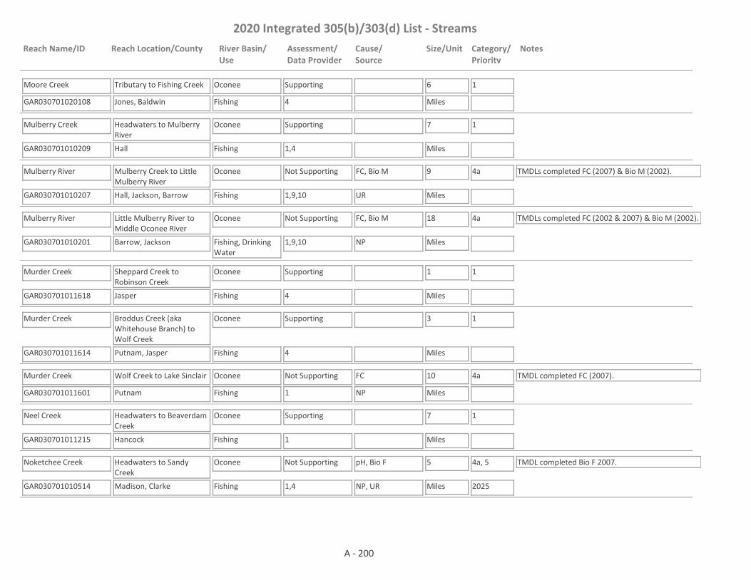
2020 Integrated 305(b)/303(d) List - Streams
Reach Name/ID Reach Location/County River Basin/Use
Assessment/Data Provider
Cause/Source
Size/Unit Category/Priority
Notes
Moore Creek
GAR030701020108 4
Tributary to Fishing Creek
Jones, Baldwin
Oconee
Fishing
Supporting 6
Miles
1
Mulberry Creek
GAR030701010209 1,4
Headwaters to Mulberry River
Hall
Oconee
Fishing
Supporting 7
Miles
1
Mulberry River
GAR030701010207 1,9,10
Mulberry Creek to Little Mulberry River
Hall, Jackson, Barrow
Oconee
Fishing
Not Supporting FC, Bio M 9
Miles
4a TMDLs completed FC (2007) & Bio M (2002).
UR
Mulberry River
GAR030701010201 1,9,10
Little Mulberry River to Middle Oconee River
Barrow, Jackson
Oconee
Fishing, Drinking Water
Not Supporting FC, Bio M 18
Miles
4a TMDLs completed FC (2002 & 2007) & Bio M (2002).
NP
Murder Creek
GAR030701011618 4
Sheppard Creek to Robinson Creek
Jasper
Oconee
Fishing
Supporting 1
Miles
1
Murder Creek
GAR030701011614 4
Broddus Creek (aka Whitehouse Branch) to Wolf Creek
Putnam, Jasper
Oconee
Fishing
Supporting 3
Miles
1
Murder Creek
GAR030701011601 1
Wolf Creek to Lake Sinclair
Putnam
Oconee
Fishing
Not Supporting FC 10
Miles
4a TMDL completed FC (2007).
NP
Neel Creek
GAR030701011215 1
Headwaters to Beaverdam Creek
Hancock
Oconee
Fishing
Supporting 7
Miles
1
Noketchee Creek
GAR030701010514 1,4
Headwaters to Sandy Creek
Madison, Clarke
Oconee
Fishing
Not Supporting pH, Bio F 5
Miles
4a, 5
2025
TMDL completed Bio F 2007.
NP, UR
A - 200
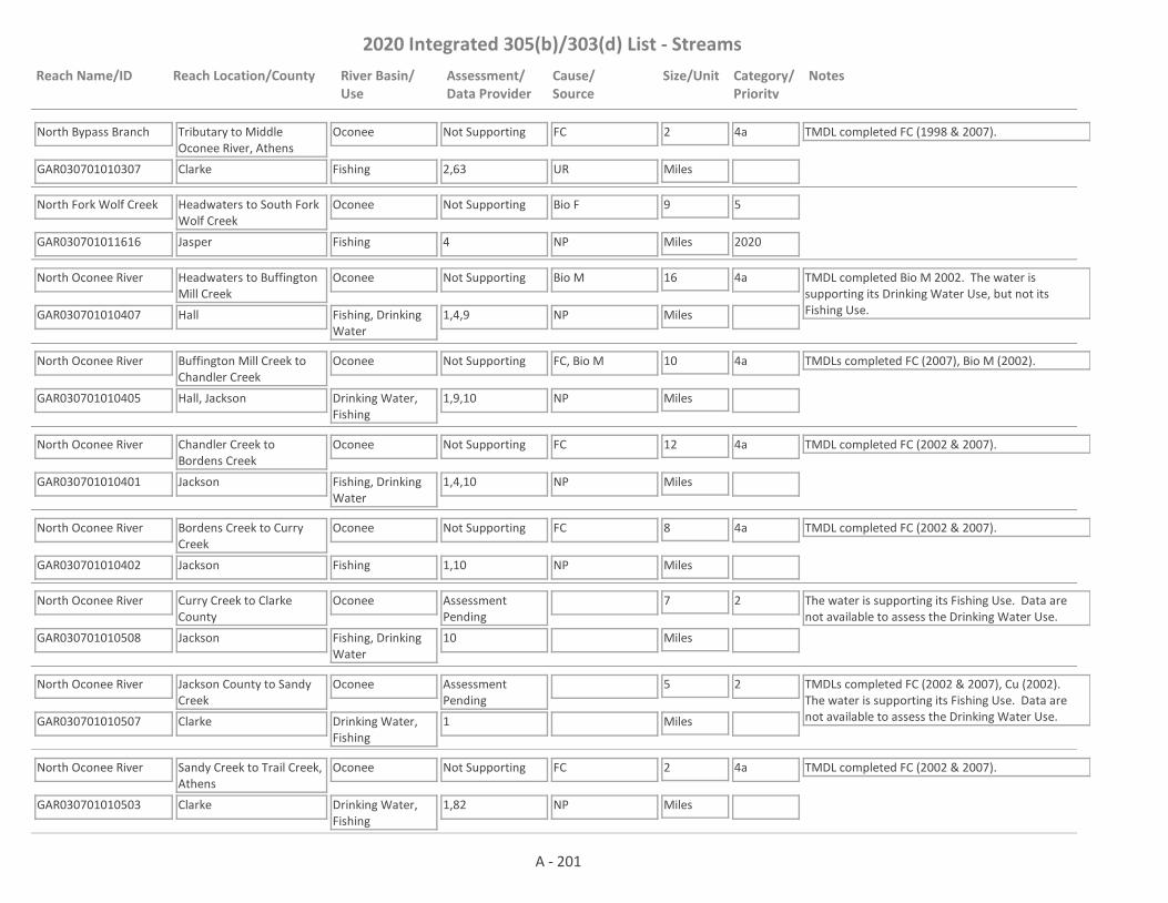
2020 Integrated 305(b)/303(d) List - Streams
Reach Name/ID Reach Location/County River Basin/Use
Assessment/Data Provider
Cause/Source
Size/Unit Category/Priority
Notes
North Bypass Branch
GAR030701010307 2,63
Tributary to Middle Oconee River, Athens
Clarke
Oconee
Fishing
Not Supporting FC 2
Miles
4a TMDL completed FC (1998 & 2007).
UR
North Fork Wolf Creek
GAR030701011616 4
Headwaters to South Fork Wolf Creek
Jasper
Oconee
Fishing
Not Supporting Bio F 9
Miles
5
2020NP
North Oconee River
GAR030701010407 1,4,9
Headwaters to Buffington Mill Creek
Hall
Oconee
Fishing, Drinking Water
Not Supporting Bio M 16
Miles
4a TMDL completed Bio M 2002. The water is supporting its Drinking Water Use, but not its Fishing Use.NP
North Oconee River
GAR030701010405 1,9,10
Buffington Mill Creek to Chandler Creek
Hall, Jackson
Oconee
Drinking Water, Fishing
Not Supporting FC, Bio M 10
Miles
4a TMDLs completed FC (2007), Bio M (2002).
NP
North Oconee River
GAR030701010401 1,4,10
Chandler Creek to Bordens Creek
Jackson
Oconee
Fishing, Drinking Water
Not Supporting FC 12
Miles
4a TMDL completed FC (2002 & 2007).
NP
North Oconee River
GAR030701010402 1,10
Bordens Creek to Curry Creek
Jackson
Oconee
Fishing
Not Supporting FC 8
Miles
4a TMDL completed FC (2002 & 2007).
NP
North Oconee River
GAR030701010508 10
Curry Creek to Clarke County
Jackson
Oconee
Fishing, Drinking Water
Assessment Pending
7
Miles
2 The water is supporting its Fishing Use. Data are not available to assess the Drinking Water Use.
North Oconee River
GAR030701010507 1
Jackson County to Sandy Creek
Clarke
Oconee
Drinking Water, Fishing
Assessment Pending
5
Miles
2 TMDLs completed FC (2002 & 2007), Cu (2002). The water is supporting its Fishing Use. Data are not available to assess the Drinking Water Use.
North Oconee River
GAR030701010503 1,82
Sandy Creek to Trail Creek, Athens
Clarke
Oconee
Drinking Water, Fishing
Not Supporting FC 2
Miles
4a TMDL completed FC (2002 & 2007).
NP
A - 201
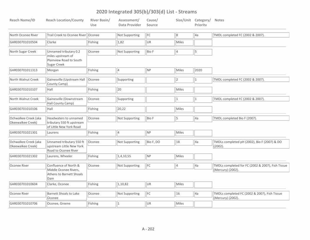
2020 Integrated 305(b)/303(d) List - Streams
Reach Name/ID Reach Location/County River Basin/Use
Assessment/Data Provider
Cause/Source
Size/Unit Category/Priority
Notes
North Oconee River
GAR030701010504 1,82
Trail Creek to Oconee River
Clarke
Oconee
Fishing
Not Supporting FC 8
Miles
4a TMDL completed FC (2002 & 2007).
UR
North Sugar Creek
GAR030701011313 4
Unnamed tributary 0.2 miles upstream of Plainview Road to South Sugar Creek
Morgan
Oconee
Fishing
Not Supporting Bio F 4
Miles
5
2020NP
North Walnut Creek
GAR030701010107 20
Gainesville (Upstream Hall County Camp)
Hall
Oconee
Fishing
Supporting 2
Miles
1 TMDL completed FC (2002 & 2007).
North Walnut Creek
GAR030701010106 20,22
Gainesville (Downstream Hall County Camp)
Hall
Oconee
Fishing
Supporting 1
Miles
1 TMDL completed FC (2002 & 2007).
Ochwalkee Creek (aka Okeewalkee Creek)
GAR030701021301 4
Headwaters to unnamed tributary 550 ft upstream of Little New York Road
Laurens
Oconee
Fishing
Not Supporting Bio F 5
Miles
4a TMDL completed Bio F (2007).
NP
Ochwalkee Creek (aka Okeewalkee Creek)
GAR030701021302 1,4,10,55
Unnamed tributary 550 ft upstream Little New York Road to Oconee River
Laurens, Wheeler
Oconee
Fishing
Not Supporting Bio F, DO 18
Miles
4a TMDLs completed pH (2002), Bio F (2007) & DO (2002).
NP
Oconee River
GAR030701010604 1,10,82
Confluence of North & Middle Oconee Rivers, Athens to Barnett Shoals Dam
Clarke, Oconee
Oconee
Fishing
Not Supporting FC 4
Miles
4a TMDLs completed for FC (2002 & 2007), Fish Tissue (Mercury) (2002).
UR
Oconee River
GAR030701010706 1
Barnett Shoals to Lake Oconee
Oconee, Greene
Oconee
Fishing
Not Supporting FC 16
Miles
4a TMDLs completed FC (2002 & 2007), Fish Tissue (Mercury) (2002).
UR
A - 202
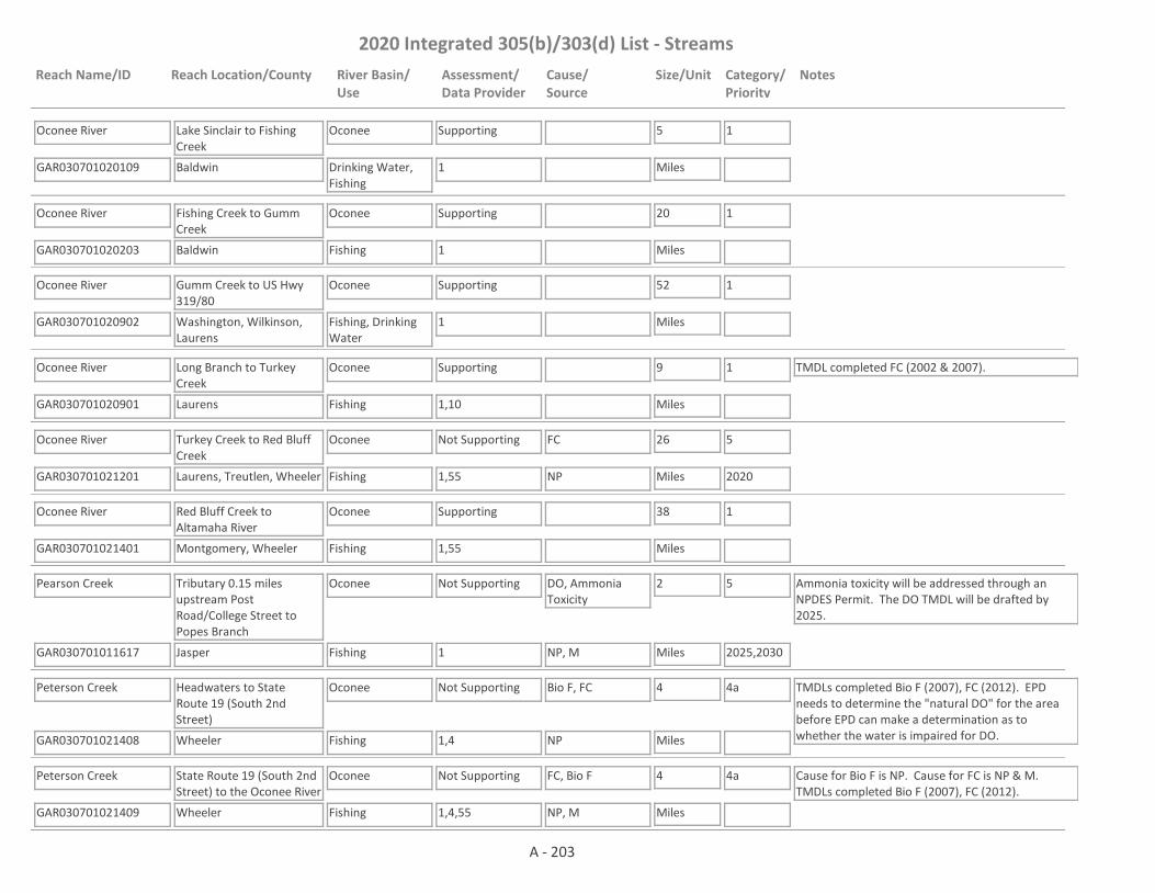
2020 Integrated 305(b)/303(d) List - Streams
Reach Name/ID Reach Location/County River Basin/Use
Assessment/Data Provider
Cause/Source
Size/Unit Category/Priority
Notes
Oconee River
GAR030701020109 1
Lake Sinclair to Fishing Creek
Baldwin
Oconee
Drinking Water, Fishing
Supporting 5
Miles
1
Oconee River
GAR030701020203 1
Fishing Creek to Gumm Creek
Baldwin
Oconee
Fishing
Supporting 20
Miles
1
Oconee River
GAR030701020902 1
Gumm Creek to US Hwy 319/80
Washington, Wilkinson, Laurens
Oconee
Fishing, Drinking Water
Supporting 52
Miles
1
Oconee River
GAR030701020901 1,10
Long Branch to Turkey Creek
Laurens
Oconee
Fishing
Supporting 9
Miles
1 TMDL completed FC (2002 & 2007).
Oconee River
GAR030701021201 1,55
Turkey Creek to Red Bluff Creek
Laurens, Treutlen, Wheeler
Oconee
Fishing
Not Supporting FC 26
Miles
5
2020NP
Oconee River
GAR030701021401 1,55
Red Bluff Creek to Altamaha River
Montgomery, Wheeler
Oconee
Fishing
Supporting 38
Miles
1
Pearson Creek
GAR030701011617 1
Tributary 0.15 miles upstream Post Road/College Street to Popes Branch
Jasper
Oconee
Fishing
Not Supporting DO, Ammonia Toxicity
2
Miles
5
2025,2030
Ammonia toxicity will be addressed through an NPDES Permit. The DO TMDL will be drafted by 2025.
NP, M
Peterson Creek
GAR030701021408 1,4
Headwaters to State Route 19 (South 2nd Street)
Wheeler
Oconee
Fishing
Not Supporting Bio F, FC 4
Miles
4a TMDLs completed Bio F (2007), FC (2012). EPD needs to determine the "natural DO" for the area before EPD can make a determination as to whether the water is impaired for DO.NP
Peterson Creek
GAR030701021409 1,4,55
State Route 19 (South 2nd Street) to the Oconee River
Wheeler
Oconee
Fishing
Not Supporting FC, Bio F 4
Miles
4a Cause for Bio F is NP. Cause for FC is NP & M. TMDLs completed Bio F (2007), FC (2012).
NP, M
A - 203
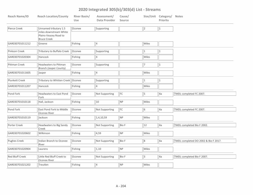
2020 Integrated 305(b)/303(d) List - Streams
Reach Name/ID Reach Location/County River Basin/Use
Assessment/Data Provider
Cause/Source
Size/Unit Category/Priority
Notes
Pierce Creek
GAR030701011212 4
Unnamed tributary 1.5 miles downstream White Plains-Veazey Road to Bruce Creek
Greene
Oconee
Fishing
Supporting 2
Miles
1
Pinkson Creek
GAR030701020304 4
Tributary to Buffalo Creek
Hancock
Oconee
Fishing
Supporting 1
Miles
1
Pittman Creek
GAR030701011605 4
Headwaters to Pittman Branch (Jasper County)
Jasper
Oconee
Fishing
Supporting 7
Miles
1
Plunkett Creek
GAR030701011207 4
Tributary to Whitten Creek
Hancock
Oconee
Fishing
Supporting 1
Miles
1
Pond Fork
GAR030701010118 10
Headwaters to East Pond Fork
Hall, Jackson
Oconee
Fishing
Not Supporting FC 5
Miles
4a TMDL completed FC 2007.
NP
Pond Fork
GAR030701010119 1,4,10,59
East Pond Fork to Middle Oconee River
Jackson
Oconee
Fishing
Not Supporting FC 6
Miles
4a TMDL completed FC 2007.
NP
Porter Creek
GAR030701020602 4,59
Headwaters to Big Sandy Creek
Wilkinson
Oconee
Fishing
Not Supporting Bio F 12
Miles
4a TMDL completed Bio F 2002.
NP
Pughes Creek
GAR030701020904 1,10
Indian Branch to Oconee River
Laurens
Oconee
Fishing
Not Supporting Bio F 8
Miles
4a TMDL completed DO 2002 & Bio F 2017.
NP
Red Bluff Creek
GAR030701021202 4
Little Red Bluff Creek to Oconee River
Treutlen
Oconee
Fishing
Not Supporting Bio F 3
Miles
4a TMDL completed Bio F 2007.
NP
A - 204

2020 Integrated 305(b)/303(d) List - Streams
Reach Name/ID Reach Location/County River Basin/Use
Assessment/Data Provider
Cause/Source
Size/Unit Category/Priority
Notes
Redstone Creek
GAR030701010316 1,4
Headwaters to the Middle Oconee River
Jackson
Oconee
Fishing
Assessment Pending
4
Miles
3 EPD believes that our pH probes may have been providing falsely low values at times in 2017 and 2018. Waters that would normally be listed as impaired for low pH are being placed in Category 3 while EPD determines if observed low pH is due to issues with the pH probes; whether low pH may be natural due to low alkalinity; or whether the water is actually impaired for low pH.
Reedy Creek
GAR030701021103 4
Headwaters to Turkey Creek
Laurens
Oconee
Fishing
Not Supporting Bio F 7
Miles
4a TMDL completed Bio F 2007.
NP
Richland Creek
GAR030701011101 1,10
Upstream Greensboro to Interstate 20
Greene
Oconee
Fishing
Not Supporting FC 9
Miles
4a TMDL completed FC (1998 & 2007).
NP, UR
Richland Creek
GAR030701011106 10
Interstate 20 to Little Creek (formerly I-20 to Beaverdam Creek)
Greene
Oconee
Fishing
Not Supporting FC 3
Miles
4a TMDL completed FC (1998 & 2002 & 2007).
UR
Robinson Creek
GAR030701011009 4
Headwaters to the Apalachee River
Oconee
Oconee
Fishing
Supporting 5
Miles
1
Robinson Creek
GAR030701011606 4
Headwaters to Murder Creek (Jasper County)
Jasper
Oconee
Fishing
Supporting 4
Miles
1
Rock Creek
GAR030701010213 1,4
Tributary 0.5 miles downstream Parks Mill Road to the Little Mulberry River
Barrow
Oconee
Fishing
Supporting 3
Miles
1
Rock Creek
GAR030701011708 1,4
Putnam County
Putnam
Oconee
Fishing
Not Supporting pH 1
Miles
5
2025NP
A - 205

2020 Integrated 305(b)/303(d) List - Streams
Reach Name/ID Reach Location/County River Basin/Use
Assessment/Data Provider
Cause/Source
Size/Unit Category/Priority
Notes
Rocky Creek
GAR030701011807 4
Tributary to Lake Sinclair
Baldwin
Oconee
Fishing
Supporting 2
Miles
1
Rocky Creek
GAR030701010208 4
Headwaters to Mulberry River
Barrow
Oconee
Fishing
Supporting 4
Miles
1
Rocky Creek
GAR030701021004 4
Twiggs/Bleckley County Line to Little Rocky Creek
Bleckley
Oconee
Fishing
Supporting 3
Miles
1
Rocky Creek
GAR030701021007 4
Bay Branch to Buckhorn Branch
Laurens
Oconee
Fishing
Not Supporting Bio F 6
Miles
4a TMDL completed Bio F (2007).
NP
Rocky Creek
GAR030701021005 10
Little Rocky Creek to Turkey Creek
Laurens
Oconee
Fishing
Supporting 6
Miles
1
Rooty Creek
GAR030701011801 1,4,10
Rd. S926, Eatonton to Little Creek
Putnam
Oconee
Fishing
Not Supporting FC 9
Miles
4a TMDLs completed FC (2002 & 2007), Bio F (2002 & 2007).
NP, UR
Rose Creek
GAR030701010603 1,4
Headwaters to the Oconee River
Oconee
Oconee
Fishing
Not Supporting FC 9
Miles
5
2020NP
Sand Creek
GAR030701011709 4
Tributary to Lake Sinclair
Baldwin
Oconee
Fishing
Supporting 3
Miles
1
Sandy Creek
GAR030701010515 1
Hardeman Creek to Little Sandy Creek
Jackson
Oconee
Fishing
Supporting 5
Miles
1
Sandy Creek
GAR030701020603 4
Headwaters to Harrison's Lake/Little Sandy Creek
Jones, Twiggs
Oconee
Fishing
Not Supporting Bio F 6
Miles
4a TMDL completed Bio F (2002 & 2007).
NP
A - 206

2020 Integrated 305(b)/303(d) List - Streams
Reach Name/ID Reach Location/County River Basin/Use
Assessment/Data Provider
Cause/Source
Size/Unit Category/Priority
Notes
Sandy Hill Creek
GAR030701020403 4
Headwaters to Oconee River
Washington
Oconee
Fishing
Supporting 9
Miles
1 TMDL completed Bio F 2002.
Sandy Run Creek
GAR030701020305 4
Tributary to Buffalo Creek
Hancock
Oconee
Fishing
Supporting 2
Miles
1
Sandy Run Creek
GAR030701011804 4
Tributary to Lake Sinclair (formerly Hancock County)
Hancock
Oconee
Fishing
Not Supporting Bio F 5
Miles
4a TMDL completed Bio F (2002 & 2007).
NP
Sheppard Creek
GAR030701011607 4
Headwaters to Murder Creek (Jasper County)
Jasper
Oconee
Fishing
Supporting 5
Miles
1
Shoal Creek
GAR030701011608 4
Jasper County
Jasper
Oconee
Fishing
Supporting 3
Miles
1
Shoal Creek
GAR030701010807 1
Little Shoal Creek to Apalachee River
Walton
Oconee
Fishing
Assessment Pending
2
Miles
3 The water is in Category 3 for FC and pH. There was a very limited data set taken in 2018 for FC (only 3 points) from RV_03_17303 and more data is needed before an assessment is made. In addition, EPD believes that our pH probes may have been providing falsely low values at times in 2017 and 2018. Waters that would normally be listed as impaired for low pH are being placed in Category 3 while EPD determines if observed low pH is due to issues with the pH probes; whether low pH may be natural due to low alkalinity; or whether the water is actually impaired for low pH.
Shoal Creek
GAR030701010602 4
Headwaters to the Oconee River
Clarke, Oconee
Oconee
Fishing
Supporting 12
Miles
1
Shoulderbone Creek
GAR030701011208 1,4
Tributary to Oconee River
Hancock
Oconee
Fishing
Supporting 1
Miles
1
A - 207

2020 Integrated 305(b)/303(d) List - Streams
Reach Name/ID Reach Location/County River Basin/Use
Assessment/Data Provider
Cause/Source
Size/Unit Category/Priority
Notes
South Fork Wolf Creek
GAR030701011609 4
Jasper County
Jasper
Oconee
Fishing
Supporting 6
Miles
1
South Sandy Creek
GAR030701020704 4
Chappells Pond to Big Sandy Creek
Laurens, Wilkinson
Oconee
Fishing
Supporting 5
Miles
1
South Sugar Creek
GAR030701011312 4
Headwaters to North Sugar Creek
Morgan
Oconee
Fishing
Supporting 8
Miles
1
Stewarts Creek
GAR030701011107 1,4
Pond 0.5 miles downstream of Billy Merritt Road to Lake Oconee
Greene
Oconee
Fishing
Not Supporting Bio F 6
Miles
5
2020NP
Stitchihatchie Creek
GAR030701021010 1
Little Stitchihatchie Creek to tributary 0.35 miles downstream of Taylor Rowland Road
Laurens
Oconee
Fishing
Supporting 5
Miles
1
Stitchihatchie Creek
GAR030701021011 1
Whitley Branch to Rocky Creek
Laurens
Oconee
Fishing
Supporting 4
Miles
1
Sugar Creek
GAR030701011311 1,10
South Sugar Creek to Lake Oconee
Morgan
Oconee
Fishing
Not Supporting FC 7
Miles
4a TMDL completed FC (1998 & 2007).
NP
Swift Creek
GAR030701020306 4
Tributary to Buffalo Creek
Hancock
Oconee
Fishing
Supporting 1
Miles
1
Tanyard Branch
GAR030701010315 56
Headwaters to Calls Creek
Oconee
Oconee
Fishing
Supporting 1
Miles
1
A - 208
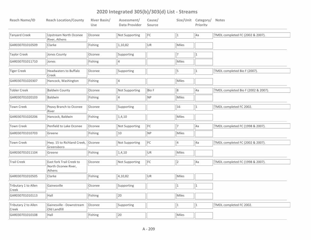
2020 Integrated 305(b)/303(d) List - Streams
Reach Name/ID Reach Location/County River Basin/Use
Assessment/Data Provider
Cause/Source
Size/Unit Category/Priority
Notes
Tanyard Creek
GAR030701010509 1,10,82
Upstream North Oconee River, Athens
Clarke
Oconee
Fishing
Not Supporting FC 1
Miles
4a TMDL completed FC (2002 & 2007).
UR
Taylor Creek
GAR030701011710 4
Jones County
Jones
Oconee
Fishing
Supporting 7
Miles
1
Tiger Creek
GAR030701020307 4
Headwaters to Buffalo Creek
Hancock, Washington
Oconee
Fishing
Supporting 5
Miles
1 TMDL completed Bio F (2007).
Tobler Creek
GAR030701020103 4
Baldwin County
Baldwin
Oconee
Fishing
Not Supporting Bio F 8
Miles
4a TMDL completed Bio F (2002 & 2007).
NP
Town Creek
GAR030701020206 1,4,10
Peavy Branch to Oconee River
Hancock, Baldwin
Oconee
Fishing
Supporting 16
Miles
1 TMDL completed FC 2002.
Town Creek
GAR030701010703 10
Penfield to Lake Oconee
Greene
Oconee
Fishing
Not Supporting FC 7
Miles
4a TMDL completed FC (1998 & 2007).
NP
Town Creek
GAR030701011104 1,4,10
Hwy. 15 to Richland Creek, Greensboro
Greene
Oconee
Fishing
Not Supporting FC 4
Miles
4a TMDL completed FC (2002 & 2007).
UR
Trail Creek
GAR030701010505 4,10,82
East fork Trail Creek to North Oconee River, Athens
Clarke
Oconee
Fishing
Not Supporting FC 2
Miles
4a TMDL completed FC (1998 & 2007).
UR
Tributary 1 to Allen Creek
GAR030701010113 20
Gainesville
Hall
Oconee
Fishing
Supporting 1
Miles
1
Tributary 2 to Allen Creek
GAR030701010108 20
Gainesville - Downstream Old Landfill
Hall
Oconee
Fishing
Supporting 1
Miles
1 TMDL completed FC 2002.
A - 209

2020 Integrated 305(b)/303(d) List - Streams
Reach Name/ID Reach Location/County River Basin/Use
Assessment/Data Provider
Cause/Source
Size/Unit Category/Priority
Notes
Tributary 4 to Allen Creek
GAR030701010114 20
Gainesville
Hall
Oconee
Fishing
Supporting 1
Miles
1
Tributary 5 to Allen Creek
GAR030701010115 20
Gainesville
Hall
Oconee
Fishing
Supporting 1
Miles
1 TMDL completed FC 2002.
Tributary 7 to Allen Creek
GAR030701010101 20
Gainesville
Hall
Oconee
Fishing
Supporting 1
Miles
1 TMDL completed FC 2002.
Tributary 8 to Allen Creek
GAR030701010102 20
Gainesville
Hall
Oconee
Fishing
Supporting 1
Miles
1 TMDL completed FC 2002.
Tributary 9 to Allen Creek
GAR030701010109 20
Gainesville
Hall
Oconee
Fishing
Supporting 1
Miles
1
Tributary to Hardeman Creek (Formerly Hardeman Creek)
GAR030701010519 4
Headwaters to Hardeman Creek
Jackson
Oconee
Fishing
Not Supporting Bio F 4
Miles
4a TMDL completed Bio F 2007.
NP
Tributary to Limestone Creek
GAR030701021407 1
400 ft downstream Mt. Vernon Alston Road to Limestone Creek
Montgomery
Oconee
Fishing
Supporting 1
Miles
1
Tributary to Limestone Creek
GAR030701021405 1
Headwaters to Limestone Creek
Montgomery
Oconee
Fishing
Not Supporting FC 1
Miles
5
2020NP, UR
Tributary to Little Indian Creek
GAR030701011412 1,4
Pond 1 mile upstream of Pierce Dairy Road to Little Indian Creek
Morgan
Oconee
Fishing
Supporting 2
Miles
1
A - 210

2020 Integrated 305(b)/303(d) List - Streams
Reach Name/ID Reach Location/County River Basin/Use
Assessment/Data Provider
Cause/Source
Size/Unit Category/Priority
Notes
Tributary to Little River (#2)
GAR030701011501 1,4,9,10
Eatonton to Little River
Putnam
Oconee
Fishing
Not Supporting Bio F, FC 3
Miles
4a, 5
2020
TMDL completed Tox (2002) & FC (2007).
NP
Tributary to Middle Oconee River
GAR030701010308 1,56,82
Downstream closed UGA Botanical Gardens Landfill (Milledgeville Ave. Site), Athens
Clarke
Oconee
Fishing
Not Supporting FC 1
Miles
4a TMDL completed FC 2017.
NP, UR
Tributary to Mulberry River
GAR030701010211 1,4
Headwaters to Mulberry River
Jackson
Oconee
Fishing
Not Supporting Bio F 5
Miles
5
2020NP, UR
Tributary to Murder Creek
GAR030701011613 1,4,59
Headwaters to Murder Creek
Jasper, Putnam
Oconee
Fishing
Supporting 5
Miles
1
Tributary to North Oconee River
GAR030701010403 20
Gainesville
Hall
Oconee
Fishing
Supporting 3
Miles
1
Tributary to North Oconee River
GAR030701010406 59
Headwaters to North Oconee River
Jackson
Oconee
Fishing
Assessment Pending
3
Miles
3 This site has a narrative rank of fair for macroinvertebrates. Waters with a narrative rank of fair will remain in Category 3 until EPD completes the reevaluation of the metrics used to assess macroinvertebrate data.
Tributary to North Walnut Creek
GAR030701010112 20,22
Gainesville
Hall
Oconee
Fishing
Supporting 1
Miles
1 TMDL completed FC (2002 & 2007).
Tributary to Pittman Branch
GAR030701011615 1
Headwaters to Pittman Branch
Newton
Oconee
Fishing
Not Supporting FC 1
Miles
5
2020NP
Tributary to the North Oconee River
GAR030701010409 1,4
Headwaters to tributary 0.3 miles downstream of Eberhart Cemetery Road
Hall
Oconee
Fishing
Supporting 4
Miles
1
A - 211

2020 Integrated 305(b)/303(d) List - Streams
Reach Name/ID Reach Location/County River Basin/Use
Assessment/Data Provider
Cause/Source
Size/Unit Category/Priority
Notes
Tributary to Turkey Creek
GAR030701021101 4
Headwaters to Turkey Creek
Twiggs
Oconee
Fishing
Supporting 2
Miles
1
Tributary to Whitten Creek
GAR030701011214 1
Headwaters to Whitten Creek
Hancock
Oconee
Fishing
Supporting 3
Miles
1
Turkey Creek
GAR030701011012 1,4
Headwaters to the Apalachee River
Walton
Oconee
Fishing
Assessment Pending
5
Miles
3 EPD believes that our pH probes may have been providing falsely low values at times in 2017 and 2018. Waters that would normally be listed as impaired for low pH are being placed in Category 3 while EPD determines if observed low pH is due to issues with the pH probes; whether low pH may be natural due to low alkalinity; or whether the water is actually impaired for low pH.
Turkey Creek
GAR030701021108 4
Walnut Creek to Palmetto Branch
Laurens
Oconee
Fishing
Supporting 3
Miles
1
Turkey Creek
GAR030701021107 1
Palmetto Branch to Horse Branch
Laurens
Oconee
Fishing
Supporting 5
Miles
1
Turkey Creek
GAR030701021104 1,10
Horse Branch to Rocky Creek
Laurens
Oconee
Fishing
Not Supporting FC 10
Miles
4a TMDL completed FC (2002 & 2007).
NP, M
Turkey Creek
GAR030701021102 1
Rocky Creek to Oconee River
Laurens
Oconee
Fishing
Not Supporting FC 11
Miles
4a TMDL completed FC (2002 & 2007).
NP
Ugly Creek
GAR030701020605 4
Twiggs County
Twiggs
Oconee
Fishing
Supporting 4
Miles
1
Walnut Creek
GAR030701010120 1,4,9
Headwaters to Caney Fork Creek
Hall
Oconee
Fishing
Not Supporting Bio M 10
Miles
4a TMDL completed Bio M 2002.
NP
A - 212

2020 Integrated 305(b)/303(d) List - Streams
Reach Name/ID Reach Location/County River Basin/Use
Assessment/Data Provider
Cause/Source
Size/Unit Category/Priority
Notes
Walnut Creek
GAR030701010103 1,4,9
Caney Fork to Middle Oconee River
Hall, Jackson
Oconee
Fishing
Not Supporting FC, Bio M 14
Miles
4a TMDLs completed FC (2002 & 2007) & Bio M (2002).
NP
West Fork Trail Creek
GAR030701010506 1,4,10,82
Athens
Clarke
Oconee
Fishing
Not Supporting FC 3
Miles
4a TMDL completed FC (1998 & 2007). EPD believes that our pH probes may have been providing falsely low values at times in 2017 and 2018. Waters that would normally be listed as impaired for low pH are being placed in Category 3 while EPD determines if observed low pH is due to issues with the pH probes; whether low pH may be natural due to low alkalinity; or whether the water is actually impaired for low pH.
UR
Wheeler Creek
GAR030701010204 4,18
Headwaters to Duncan Creek
Gwinnett, Barrow
Oconee
Fishing
Not Supporting FC 5
Miles
4a TMDL completed FC (2007).
NP
Whitehouse Branch
GAR030701011610 4
Jasper County
Jasper
Oconee
Fishing
Supporting 3
Miles
1
Whiteoak Creek
GAR030701011611 1,4
Jasper County
Jasper
Oconee
Fishing
Not Supporting DO, Ammonia Toxicity
4
Miles
5
2025, 2030
Ammonia toxicity will be addressed by limits in an NPDES Permit. The DO TMDL is to be drafted by 2025.NP, UR, M
Whitewater Creek
GAR030701021205 1
Headwaters to Unnamed tributary 0.8 miles downstream of GA Hwy 19 South
Laurens
Oconee
Fishing
Assessment Pending
6
Miles
3 EPD needs to determine the "natural DO" for the area before a use assessment is made.
Whitten Creek
GAR030701011209 1,4
Hancock County
Hancock
Oconee
Fishing
Not Supporting FC 2
Miles
5
2020NP
Wildcat Branch
GAR030701020507 4
Wilkinson County
Wilkinson
Oconee
Fishing
Supporting 1
Miles
1
A - 213

2020 Integrated 305(b)/303(d) List - Streams
Reach Name/ID Reach Location/County River Basin/Use
Assessment/Data Provider
Cause/Source
Size/Unit Category/Priority
Notes
Wildcat Creek
GAR030701010609 4
Headwaters to tributary 0.8 miles downstream of Kirkland Rd
Oconee
Oconee
Fishing
Not Supporting Bio F 2
Miles
5
2025NP
Wildcat Creek
GAR030701010610 4
Tributary 0.8 miles downstream of Kirkland Rd to the Oconee River
Oconee
Oconee
Fishing
Supporting 3
Miles
1
Will Hunter Branch
GAR030701010510 2
Tributary to North Oconee River, Athens
Clarke
Oconee
Fishing
Supporting 1
Miles
1
Wolf Creek (previously known as Milsap Creek
GAR030701020504 4
Pond 0.1 miles upstream GA Hwy 22 East to Big Creek (Jones County)
Jones
Oconee
Fishing
Supporting 5
Miles
1
Zoie Brown Creek
GAR030701020301 4
Tributary to Buffalo Creek
Hancock
Oconee
Fishing
Not Supporting Bio F 3
Miles
4a TMDL completed Bio F (2002 & 2007).
NP
Ash Branch
GAR030602020504 55
Futch Branch to Lower Black Creek
Bulloch
Ogeechee
Fishing
Not Supporting FC 8
Miles
4a TMDL completed FC 2010. EPD needs to determine the "natural DO" for the area before it can be determined whether the dissolved oxygen criteria are being met.
NP
Battle Branch
GAR030602010106 4
Headwaters to the Ogeechee River
Warren
Ogeechee
Fishing
Not Supporting Bio F 3
Miles
5
2024NP
Beaverdam Creek
GAR030602010111 4
Hunnon Branch to the Ogeechee River
Hancock
Ogeechee
Fishing
Not Supporting Bio F 4
Miles
5
2024NP
Big Creek
GAR030602010202 1
Headwaters to the Ogeechee River
Glascock
Ogeechee
Fishing
Assessment Pending
8
Miles
3 EPD needs to determine the "natural DO" for the area before a use assessment is made.
A - 214
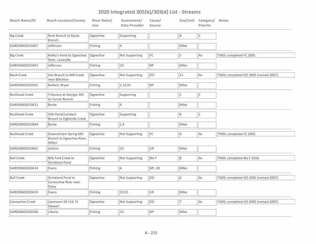
2020 Integrated 305(b)/303(d) List - Streams
Reach Name/ID Reach Location/County River Basin/Use
Assessment/Data Provider
Cause/Source
Size/Unit Category/Priority
Notes
Big Creek
GAR030602010407 4
Rock Branch to Rocky Branch
Jefferson
Ogeechee
Fishing
Supporting 4
Miles
1
Big Creek
GAR030602010401 10
Kelley's Pond to Ogeechee River, Louisville
Jefferson
Ogeechee
Fishing
Not Supporting FC 5
Miles
4a TMDL completed FC 2005.
NP
Black Creek
GAR030602020501 1,10,55
Ash Branch to Mill Creek near Blitchton
Bulloch, Bryan
Ogeechee
Fishing
Not Supporting DO 11
Miles
4a TMDL completed DO 2005 (revised 2007).
NP
Buckhead Creek
GAR030602010611 4
Tributary at Georgia 305 to Turner Branch
Burke
Ogeechee
Fishing
Supporting 2
Miles
1
Buckhead Creek
GAR030602010604 1,4
Hills Pond/Lambert Branch to Eightmile Creek
Burke
Ogeechee
Fishing
Supporting 8
Miles
1
Buckhead Creek
GAR030602010601 10
Downstream Spring Mill Branch to Ogeechee River, Millen
Jenkins
Ogeechee
Fishing
Not Supporting FC 4
Miles
4a TMDL completed FC 2005.
UR
Bull Creek
GAR030602030414 4
Billy Fork Creek to Strickland Pond
Evans
Ogeechee
Fishing
Not Supporting Bio F 8
Miles
4a TMDL completed Bio F 2016.
NP, UR
Bull Creek
GAR030602030410 10,55
Strickland Pond to Canoochee River near Daisy
Evans
Ogeechee
Fishing
Not Supporting DO 6
Miles
4a TMDL completed DO 2005 (revised 2007).
UR
Canoochee Creek
GAR030602030506 10
Upstream SR 119, Ft. Stewart
Liberty
Ogeechee
Fishing
Not Supporting DO 7
Miles
4a TMDL completed DO 2005 (revised 2007).
NP
A - 215

2020 Integrated 305(b)/303(d) List - Streams
Reach Name/ID Reach Location/County River Basin/Use
Assessment/Data Provider
Cause/Source
Size/Unit Category/Priority
Notes
Canoochee Creek
GAR030602030501 1
Taylors Creek to Canoochee River, Fort Stewart
Liberty
Ogeechee
Fishing
Not Supporting DO 4
Miles
4a TMDL completed DO 2005 (revised 2007).
M
Canoochee River
GAR030602030101 1,10
Ga. Hwy. 192 to Fifteen Mile Creek near Metter
Emanuel, Candler
Ogeechee
Fishing
Not Supporting Pb, FC, Fish Tissue (Mercury), DO
21
Miles
4a
2019
TMDLs completed DO 2005 (revised 2007), FC 2005, Fish Tissue (Mercury) 2005, Pb (2020).
UR
Canoochee River
GAR030602030411 1,4,55
Fifteen Mile Creek to Cedar Creek
Candler, Evans
Ogeechee
Fishing
Not Supporting Fish Tissue (Mercury)
14
Miles
4a TMDL completed Fish Tissue (Mercury) 2005.
NP
Canoochee River
GAR030602030409 1,55
Cedar Creek to Lotts Creek
Evans
Ogeechee
Fishing
Not Supporting Fish Tissue (Mercury), DO
13
Miles
4a TMDLs completed Fish Tissue (Mercury) 2005 & DO 2005 (revised 2007).
NP
Canoochee River
GAR030602030602 1
Lotts Creek to Savage Creek
Bryan, Evans, Liberty
Ogeechee
Fishing
Not Supporting Fish Tissue (Mercury)
38
Miles
4a TMDL completed Fish Tissue (Mercury) 2005.
NP
Canoochee River
GAR030602030603 1,55
Savage Creek to Ogeechee River
Bryan, Liberty
Ogeechee
Fishing
Not Supporting FC, Fish Tissue (Mercury)
18
Miles
4a TMDLs completed TWR 2005, DO 2005 (revised 2007), FC 2016.
NP
Cason Branch
GAR030602010308 4
Pond 1.3 miles upstream Clarks Mill Road to Rocky Comfort Creek
Jefferson
Ogeechee
Fishing
Supporting 2
Miles
1
Cedar Creek
GAR030602030407 4,10,55
Water Hole Creek to Canoochee River, Claxton
Evans
Ogeechee
Fishing
Not Supporting DO, FC 6
Miles
4a TMDLs completed DO 2005 (revised 2007), FC 2005.
UR
Clear Spring Creek
GAR030602010702 4
Bull Branch to tributary 0.6 miles downstream of U.S. 17
Burke
Ogeechee
Fishing
Supporting 2
Miles
1
A - 216
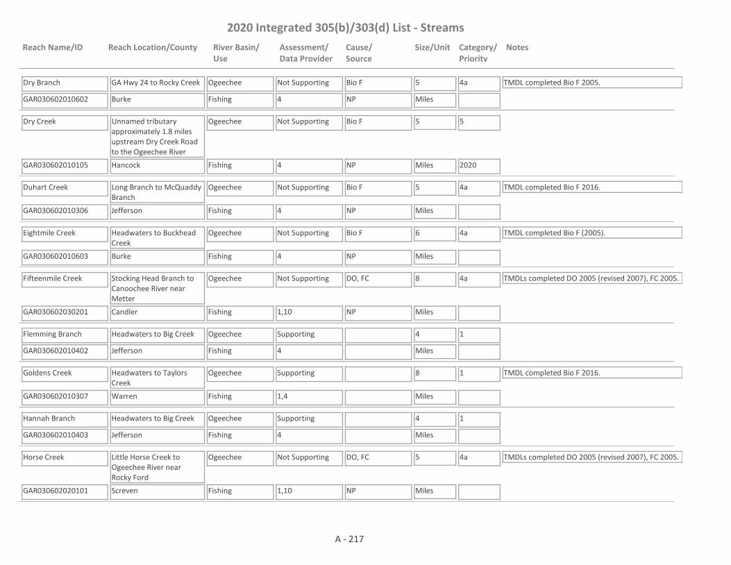
2020 Integrated 305(b)/303(d) List - Streams
Reach Name/ID Reach Location/County River Basin/Use
Assessment/Data Provider
Cause/Source
Size/Unit Category/Priority
Notes
Dry Branch
GAR030602010602 4
GA Hwy 24 to Rocky Creek
Burke
Ogeechee
Fishing
Not Supporting Bio F 5
Miles
4a TMDL completed Bio F 2005.
NP
Dry Creek
GAR030602010105 4
Unnamed tributary approximately 1.8 miles upstream Dry Creek Road to the Ogeechee River
Hancock
Ogeechee
Fishing
Not Supporting Bio F 5
Miles
5
2020NP
Duhart Creek
GAR030602010306 4
Long Branch to McQuaddy Branch
Jefferson
Ogeechee
Fishing
Not Supporting Bio F 5
Miles
4a TMDL completed Bio F 2016.
NP
Eightmile Creek
GAR030602010603 4
Headwaters to Buckhead Creek
Burke
Ogeechee
Fishing
Not Supporting Bio F 6
Miles
4a TMDL completed Bio F (2005).
NP
Fifteenmile Creek
GAR030602030201 1,10
Stocking Head Branch to Canoochee River near Metter
Candler
Ogeechee
Fishing
Not Supporting DO, FC 8
Miles
4a TMDLs completed DO 2005 (revised 2007), FC 2005.
NP
Flemming Branch
GAR030602010402 4
Headwaters to Big Creek
Jefferson
Ogeechee
Fishing
Supporting 4
Miles
1
Goldens Creek
GAR030602010307 1,4
Headwaters to Taylors Creek
Warren
Ogeechee
Fishing
Supporting 8
Miles
1 TMDL completed Bio F 2016.
Hannah Branch
GAR030602010403 4
Headwaters to Big Creek
Jefferson
Ogeechee
Fishing
Supporting 4
Miles
1
Horse Creek
GAR030602020101 1,10
Little Horse Creek to Ogeechee River near Rocky Ford
Screven
Ogeechee
Fishing
Not Supporting DO, FC 5
Miles
4a TMDLs completed DO 2005 (revised 2007), FC 2005.
NP
A - 217
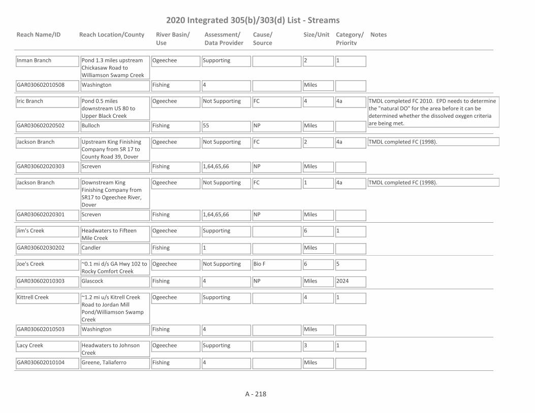
2020 Integrated 305(b)/303(d) List - Streams
Reach Name/ID Reach Location/County River Basin/Use
Assessment/Data Provider
Cause/Source
Size/Unit Category/Priority
Notes
Inman Branch
GAR030602010508 4
Pond 1.3 miles upstream Chickasaw Road to Williamson Swamp Creek
Washington
Ogeechee
Fishing
Supporting 2
Miles
1
Iric Branch
GAR030602020502 55
Pond 0.5 miles downstream US 80 to Upper Black Creek
Bulloch
Ogeechee
Fishing
Not Supporting FC 4
Miles
4a TMDL completed FC 2010. EPD needs to determine the "natural DO" for the area before it can be determined whether the dissolved oxygen criteria are being met.NP
Jackson Branch
GAR030602020303 1,64,65,66
Upstream King Finishing Company from SR 17 to County Road 39, Dover
Screven
Ogeechee
Fishing
Not Supporting FC 2
Miles
4a TMDL completed FC (1998).
NP
Jackson Branch
GAR030602020301 1,64,65,66
Downstream King Finishing Company from SR17 to Ogeechee River, Dover
Screven
Ogeechee
Fishing
Not Supporting FC 1
Miles
4a TMDL completed FC (1998).
NP
Jim's Creek
GAR030602030202 1
Headwaters to Fifteen Mile Creek
Candler
Ogeechee
Fishing
Supporting 6
Miles
1
Joe's Creek
GAR030602010303 4
~0.1 mi d/s GA Hwy 102 to Rocky Comfort Creek
Glascock
Ogeechee
Fishing
Not Supporting Bio F 6
Miles
5
2024NP
Kittrell Creek
GAR030602010503 4
~1.2 mi u/s Kitrell Creek Road to Jordan Mill Pond/Williamson Swamp Creek
Washington
Ogeechee
Fishing
Supporting 4
Miles
1
Lacy Creek
GAR030602010104 4
Headwaters to Johnson Creek
Greene, Taliaferro
Ogeechee
Fishing
Supporting 3
Miles
1
A - 218

2020 Integrated 305(b)/303(d) List - Streams
Reach Name/ID Reach Location/County River Basin/Use
Assessment/Data Provider
Cause/Source
Size/Unit Category/Priority
Notes
Little Lotts Creek
GAR030602030309 1
Downstream South Main Street, Statesboro
Bulloch
Ogeechee
Fishing
Supporting 1
Miles
1
Little Lotts Creek
GAR030602030316 1
Bird Pond to Unnamed tributary at Burkhalter Road
Bulloch
Ogeechee
Fishing
Supporting 3
Miles
1
Little Lotts Creek
GAR030602030313 1,4,55
Unnamed tributary @ Burkhalter Road to Lotts Creek
Bulloch
Ogeechee
Fishing
Not Supporting Bio F, FC 8
Miles
4a, 5
2020
TMDL completed FC 2016. EPD needs to determine the "natural DO" for the area before it can be determined whether the dissolved oxygen criteria are being met.NP
Little Ogeechee River
GAR030602010201 1,4,10
Two Mile Creek to Hamburg Mill Pond near Culverton
Hancock, Washington
Ogeechee
Fishing
Not Supporting Bio F, FC, Pb 9
Miles
4a, 5
2019, 2024
TMDLs completed FC (2005) & Pb (2020). Cause for FC is NP and for Pb it is NP and I2.
NP, I2
Little Ogeechee River
GAR030602040209 55
Ogeechee Run to Little Ogeechee Pond
Effingham, Chatham
Ogeechee
Fishing
Assessment Pending
14
Miles
3 EPD needs to determine the "natural DO" for the area before a use assessment is made.
Little Ogeechee River
GAR030602040208 10,50
Little Ogeechee Pond to below US Hwy. 17 near Burroughs
Chatham
Ogeechee
Fishing
Not Supporting Se, FC, DO 6
Miles
4a
2019
TMDLs completed FC 2005, DO 2005 (revised 2007), Se 2020.
NP, UR
Long Branch
GAR030602030508 1
Headwaters to Canoochee Creek
Evans, Liberty
Ogeechee
Fishing
Assessment Pending
8
Miles
3 EPD needs to determine the "natural DO" for the area before a use assessment is made.
Long Branch
GAR030602010311 4
Headwaters to Rocky Comfort Creek
Warren
Ogeechee
Fishing
Not Supporting Bio F 3
Miles
5
2024NP
Lotts Creek
GAR030602030312 55
Big Branch to Cypress Lake
Bulloch, Candler
Ogeechee
Fishing
Supporting 6
Miles
1
A - 219

2020 Integrated 305(b)/303(d) List - Streams
Reach Name/ID Reach Location/County River Basin/Use
Assessment/Data Provider
Cause/Source
Size/Unit Category/Priority
Notes
Lotts Creek
GAR030602030310
U.S. Hwy. 301 to Little Lotts Creek near Register
Bulloch
Ogeechee
Fishing
Assessment Pending
8
Miles
3 TMDL completed DO 2005 (revised 2007) & FC 2016. The station previously used to assess this site is actually not located within this reach . The water will remain in Category 3 until data is collected within the reach.
Lotts Creek
GAR030602030315 1,4,10
Little Lotts Creek to Reedy Branch
Bulloch
Ogeechee
Fishing
Not Supporting DO, FC, pH 3
Miles
5
2020, 2024
TMDL for FC drafted 2020. TMDLs for DO and pH to be drafted 2024.
NP
Lower Black Creek
GAR030602020505 1,55
Luke Swamp Branch to Ash Branch
Bulloch
Ogeechee
Fishing
Assessment Pending
6
Miles
3 EPD needs to determine the "natural DO" for the area a use assessment is made.
Magtail Branch
GAR030602010304 59
Headwaters to Deep Creek
Glascock
Ogeechee
Fishing
Assessment Pending
4
Miles
3 This site has a narrative rank of fair for macroinvertebrates. Waters with a narrative rank of fair will remain in Category 3 until EPD completes the reevaluation of the metrics used to assess macroinvertebrate data.
McQuaddy Branch
GAR030602010305 59
Headwaters to Duhart Creek
Jefferson
Ogeechee
Fishing
Assessment Pending
5
Miles
3 This site has a narrative rank of fair for macroinvertebrates. Waters with a narrative rank of fair will remain in Category 3 until EPD completes the reevaluation of the metrics used to assess macroinvertebrate data.
Mill Creek
GAR030602030504 1
Upstream Taylors Creek, Fort Stewart
Liberty
Ogeechee
Fishing
Supporting 2
Miles
1
Mill Creek
GAR030602010610 4
Jenkins Lake to Carswell Lake
Burke, Jenkins
Ogeechee
Fishing
Not Supporting Bio F 4
Miles
5
2024NP
Mill Creek
GAR030602020508 55
George Branch to Black Creek
Bryan
Ogeechee
Fishing
Not Supporting FC 6
Miles
4a TMDL completed FC 2010. EPD needs to determine the "natural DO" for the area before it can be determined whether the dissolved oxygen criteria are being met.
NP
A - 220

2020 Integrated 305(b)/303(d) List - Streams
Reach Name/ID Reach Location/County River Basin/Use
Assessment/Data Provider
Cause/Source
Size/Unit Category/Priority
Notes
Mill Creek
GAR030602020510 1
Headwaters to unnamed tributary 1 mile downstream C C Road
Bryan
Ogeechee
Fishing
Supporting 7
Miles
1
Mill Creek
GAR030602020402 55
Akins Pond to Newsome Branch
Bulloch
Ogeechee
Fishing
Assessment Pending
9
Miles
3 EPD needs to determine the "natural DO" for the area before a use assessment is made.
Mill Creek
GAR030602020401 1,10,55
Newsome Branch to Ogeechee River near Statesboro
Bulloch
Ogeechee
Fishing
Not Supporting FC 16
Miles
5
2020
TMDL completed DO 2005 (revised 2007). TMDL for FC drafted 2020.
NP
Mount Hope Creek
GAR030602040530 1
Raccoon Branch to Jerico River
Liberty, Bryan
Ogeechee
Fishing
Assessment Pending
4
Miles
3 EPD needs to determine the "natural DO" for the area before it can be determined whether the dissolved oxygen criteria are being met.
Nevills Creek
GAR030602020302 4,10
Bay Gull Creek to Ogeechee River near Rocky Ford
Bulloch
Ogeechee
Fishing
Not Supporting DO, FC 3
Miles
4a TMDLs completed DO 2005 (revised 2007), FC 2005.
NP
North Fork Ogeechee River
GAR030602010101 1,4,10
Hwy. 77 to Ogeechee River near Crawfordville
Greene, Taliaferro
Ogeechee
Fishing
Not Supporting Bio F, FC 13
Miles
4a, 5
2024
TMDL completed FC (2005).
NP
Ogeechee Creek
GAR030602020201 1,10
Rd. S2178 to Ogeechee River near Oliver
Screven
Ogeechee
Fishing
Not Supporting FC, DO 7
Miles
4a, 5
2020
TMDL completed DO 2005 (revised 2007 & 2014). TMDL for FC drafted 2020. Cause for DO is NP and for FC is NP and M.NP, M
Ogeechee River
GAR030602010102 10
Powell Creek to Beaverdam Creek near Powelton
Hancock
Ogeechee
Fishing
Supporting 5
Miles
1 TMDL completed FC 2005.
Ogeechee River
GAR030602010103 1,4
Long Creek to Hwy. 102 near Jewell
Hancock, Washington
Ogeechee
Fishing
Supporting 12
Miles
1
A - 221
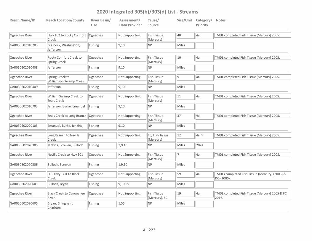
2020 Integrated 305(b)/303(d) List - Streams
Reach Name/ID Reach Location/County River Basin/Use
Assessment/Data Provider
Cause/Source
Size/Unit Category/Priority
Notes
Ogeechee River
GAR030602010203 9,10
Hwy 102 to Rocky Comfort Creek
Glascock, Washington, Jefferson
Ogeechee
Fishing
Not Supporting Fish Tissue (Mercury)
40
Miles
4a TMDL completed Fish Tissue (Mercury) 2005.
NP
Ogeechee River
GAR030602010408 9,10
Rocky Comfort Creek to Spring Creek
Jefferson
Ogeechee
Fishing
Not Supporting Fish Tissue (Mercury)
10
Miles
4a TMDL completed Fish Tissue (Mercury) 2005.
NP
Ogeechee River
GAR030602010409 9,10
Spring Creek to Williamson Swamp Creek
Jefferson
Ogeechee
Fishing
Not Supporting Fish Tissue (Mercury)
9
Miles
4a TMDL completed Fish Tissue (Mercury) 2005.
NP
Ogeechee River
GAR030602010703 9,10
William Swamp Creek to Seals Creek
Jefferson, Burke, Emanuel
Ogeechee
Fishing
Not Supporting Fish Tissue (Mercury)
11
Miles
4a TMDL completed Fish Tissue (Mercury) 2005.
NP
Ogeechee River
GAR030602020105 9,10
Seals Creek to Long Branch
Emanuel, Burke, Jenkins
Ogeechee
Fishing
Not Supporting Fish Tissue (Mercury)
37
Miles
4a TMDL completed Fish Tissue (Mercury) 2005.
NP
Ogeechee River
GAR030602020305 1,9,10
Long Branch to Nevills Creek
Jenkins, Screven, Bulloch
Ogeechee
Fishing
Not Supporting FC, Fish Tissue (Mercury)
12
Miles
4a, 5
2024
TMDL completed Fish Tissue (Mercury) 2005.
NP
Ogeechee River
GAR030602020306 1,9,10
Nevills Creek to Hwy 301
Bulloch, Screven
Ogeechee
Fishing
Not Supporting Fish Tissue (Mercury)
7
Miles
4a TMDL completed Fish Tissue (Mercury) 2005.
NP
Ogeechee River
GAR030602020601 9,10,55
U.S. Hwy. 301 to Black Creek
Bulloch, Bryan
Ogeechee
Fishing
Not Supporting Fish Tissue (Mercury)
59
Miles
4a TMDLs completed Fish Tissue (Mercury) (2005) & DO (2000).
NP
Ogeechee River
GAR030602020605 1,55
Black Creek to Canoochee River
Bryan, Effingham, Chatham
Ogeechee
Fishing
Not Supporting Fish Tissue (Mercury), FC
19
Miles
4a TMDL completed Fish Tissue (Mercury) 2005 & FC 2016.
NP
A - 222
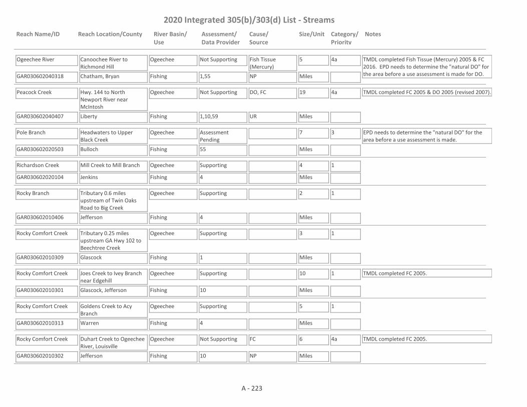
2020 Integrated 305(b)/303(d) List - Streams
Reach Name/ID Reach Location/County River Basin/Use
Assessment/Data Provider
Cause/Source
Size/Unit Category/Priority
Notes
Ogeechee River
GAR030602040318 1,55
Canoochee River to Richmond Hill
Chatham, Bryan
Ogeechee
Fishing
Not Supporting Fish Tissue (Mercury)
5
Miles
4a TMDL completed Fish Tissue (Mercury) 2005 & FC 2016. EPD needs to determine the "natural DO" for the area before a use assessment is made for DO.NP
Peacock Creek
GAR030602040407 1,10,59
Hwy. 144 to North Newport River near McIntosh
Liberty
Ogeechee
Fishing
Not Supporting DO, FC 19
Miles
4a TMDL completed FC 2005 & DO 2005 (revised 2007).
UR
Pole Branch
GAR030602020503 55
Headwaters to Upper Black Creek
Bulloch
Ogeechee
Fishing
Assessment Pending
7
Miles
3 EPD needs to determine the "natural DO" for the area before a use assessment is made.
Richardson Creek
GAR030602020104 4
Mill Creek to Mill Branch
Jenkins
Ogeechee
Fishing
Supporting 4
Miles
1
Rocky Branch
GAR030602010406 4
Tributary 0.6 miles upstream of Twin Oaks Road to Big Creek
Jefferson
Ogeechee
Fishing
Supporting 2
Miles
1
Rocky Comfort Creek
GAR030602010309 1
Tributary 0.25 miles upstream GA Hwy 102 to Beechtree Creek
Glascock
Ogeechee
Fishing
Supporting 3
Miles
1
Rocky Comfort Creek
GAR030602010301 10
Joes Creek to Ivey Branch near Edgehill
Glascock, Jefferson
Ogeechee
Fishing
Supporting 10
Miles
1 TMDL completed FC 2005.
Rocky Comfort Creek
GAR030602010313 4
Goldens Creek to Acy Branch
Warren
Ogeechee
Fishing
Supporting 5
Miles
1
Rocky Comfort Creek
GAR030602010302 10
Duhart Creek to Ogeechee River, Louisville
Jefferson
Ogeechee
Fishing
Not Supporting FC 6
Miles
4a TMDL completed FC 2005.
NP
A - 223

2020 Integrated 305(b)/303(d) List - Streams
Reach Name/ID Reach Location/County River Basin/Use
Assessment/Data Provider
Cause/Source
Size/Unit Category/Priority
Notes
Rocky Creek
GAR030602010608 1,4
Unnamed tributary 0.2 miles downstream Gough Spur Road to Reubens Branch
Burke
Ogeechee
Fishing
Not Supporting Bio F 5
Miles
5
2024NP
Rocky Creek
GAR030602010507 4
Sand Branch to tributary 0.25 miles downstream Kennedy Road
Jefferson, Emanuel
Ogeechee
Fishing
Not Supporting Bio F 6
Miles
5
2020NP
Rocky Creek
GAR030602010607 4
Reubens Branch to Dry Branch
Burke
Ogeechee
Fishing
Not Supporting Bio F 7
Miles
4a TMDL completed Bio F 2016..
NP
Schaffer Creek
GAR030602010404 4
Headwaters to Big Creek (Kellys Pond)
Burke, Jefferson
Ogeechee
Fishing
Supporting 10
Miles
1
Sculls Creek
GAR030602020102 10
Richardson Creek to Ogeechee River near Scarboro
Jenkins
Ogeechee
Fishing
Not Supporting DO, FC 4
Miles
4a TMDLs completed DO 2005 (revised 2007), FC 2005.
NP
Short Creek
GAR030602010112 4
Short Creek to the Ogeechee River
Warren
Ogeechee
Fishing
Not Supporting Bio F 3
Miles
5
2024NP
South Fork Ogeechee River
GAR030602010109 4
Moores Creek to unnamed tributary 0.7 miles upstream Margarets Grove SW
Greene, Taliaferro
Ogeechee
Fishing
Not Supporting Bio F 3
Miles
5
2024NP
South Newport River
GAR030602040628 1,10
Upstream US Hwy. 17, South Newport
Liberty, McIntosh
Ogeechee
Fishing
Not Supporting DO 3
Miles
4a TMDL completed DO 2005 (revised 2007)
NP
A - 224

2020 Integrated 305(b)/303(d) List - Streams
Reach Name/ID Reach Location/County River Basin/Use
Assessment/Data Provider
Cause/Source
Size/Unit Category/Priority
Notes
Spring Creek
GAR030602010405 4
Tributary 1.2 miles upstream State Route 17 to the Ogeechee River
Jenkins
Ogeechee
Fishing
Supporting 3
Miles
1
Spring Mill Branch
GAR030602010609 4
Magnolia Springs State Park Lake to Buckhead Creek
Jenkins
Ogeechee
Fishing
Supporting 2
Miles
1
Steel Creek
GAR030602010506 4
Headwaters to Williamson Swamp Creek
Washington
Ogeechee
Fishing
Not Supporting Bio F 6
Miles
5
2020NP
Sun Hill Creek
GAR030602010509 4
Camp Springs Branch to North Fork Sun Hill Creek
Washington
Ogeechee
Fishing
Supporting 1
Miles
1
Taylors Creek
GAR030602030505 1
Upstream WPCP Drainage Canal, Fort Stewart
Liberty
Ogeechee
Fishing
Not Supporting FC 3
Miles
4a TMDL completed FC 2016. EPD needs to determine the "natural DO" for the area before it can be determined whether the dissolved oxygen criteria are being met.
NP
Taylors Creek
GAR030602030502 1
Downstream WPCP Discharge to Drainage Canal, Fort Stewart
Liberty
Ogeechee
Fishing
Not Supporting DO 4
Miles
4a TMDL completed DO (2000),
M
Tenmile Creek
GAR030602030415 4
Bad Prong to tributary at Dutch Ford Road
Candler
Ogeechee
Fishing
Not Supporting Bio F 2
Miles
5
2020NP
Tenmile Creek
GAR030602030408 10
Upstream Canoochee River, Excelsior
Candler
Ogeechee
Fishing
Not Supporting DO 3
Miles
4a TMDLs completed DO 2005 (revised 2007), FC 2005.
UR
Thick Creek
GAR030602030314 55
Headwaters to Lotts Creek
Evans
Ogeechee
Fishing
Not Supporting FC 8
Miles
4a TMDL completed FC 2010.
NP
A - 225

2020 Integrated 305(b)/303(d) List - Streams
Reach Name/ID Reach Location/County River Basin/Use
Assessment/Data Provider
Cause/Source
Size/Unit Category/Priority
Notes
Tributary to Clear Spring Creek
GAR030602010701 4
Tributary 180 feet upstream Bark Camp Church Road to Clear Spring Creek
Burke
Ogeechee
Fishing
Not Supporting Bio F 3
Miles
5
2024NP
Tributary to Goldens Creek
GAR030602010312 4
Tributary 0.1 miles upstream of Gibson Highway to Goldens Creek
Warren
Ogeechee
Fishing
Supporting 1
Miles
1
Tributary to Mill Creek
GAR030602020511 1
Unnamed tributary 0.3 miles upstream Sims Road to Mill Creek
Bryan
Ogeechee
Fishing
Supporting 5
Miles
1
Tributary to Richardson Creek
GAR030602020103 1
Headwaters to Richardson Creek
Jenkins
Ogeechee
Fishing
Supporting 2
Miles
1
Tributary to South Fork Ogeechee River
GAR030602010110 4
Headwaters to South Fork Ogeechee River
Greene, Taliaferro
Ogeechee
Fishing
Supporting 3
Miles
1
Tributary to Taylors Creek #1
GAR030602030503 1
Drainage Canal to Taylors Creek, Fort Stewart
Liberty
Ogeechee
Fishing
Not Supporting DO, FC 2
Miles
5
2020, 2024
TMDLs completed Cu (2000), Pb (2000), Hg (2000). FC TMDL drafted 2020. Cause for FC is NP. Cause for DO is NP and M.NP, M, UR
Tributary to the Canoochee River
GAR030602030604 1
Tributary near S.R. 67 to the Canoochee River
Bryan
Ogeechee
Fishing
Assessment Pending
1
Miles
3 EPD needs to determine the "natural DO" for the area before a use assessment is made.
Tributary to the Ogeechee River
GAR030602010107 4
Headwaters to the Ogeechee River near Crawfordville
Taliaferro
Ogeechee
Fishing
Supporting 4
Miles
1
A - 226

2020 Integrated 305(b)/303(d) List - Streams
Reach Name/ID Reach Location/County River Basin/Use
Assessment/Data Provider
Cause/Source
Size/Unit Category/Priority
Notes
Tributary to the Ogeechee River
GAR030602010108 4
Headwaters to the Ogeechee River near Mayfield Road
Warren
Ogeechee
Fishing
Supporting 3
Miles
1
Upper Black Creek
GAR030602020509 55
Crombly Pond to Lower Black Creek
Bulloch
Ogeechee
Fishing
Assessment Pending
12
Miles
3 EPD needs to determine the "natural DO" for the area before a use assessment is made.
Wateringhole Branch
GAR030602030311 1,55
Granna Branch to Dry Branch
Bulloch
Ogeechee
Fishing
Not Supporting FC 5
Miles
4a TMDL completed FC 2016. EPD needs to determine the "natural DO" for the area before a use assessment is made for DO.NP
Whetstone Creek
GAR030602010310 1
Reservoir 14 to Rocky Comfort Creek
Warren
Ogeechee
Fishing
Assessment Pending
3
Miles
3 EPD believes that our pH probes may have been providing falsely low values at times in 2017 and 2018. Waters that would normally be listed as impaired for low pH are being placed in Category 3 while EPD determines if observed low pH is due to issues with the pH probes; whether low pH may be natural due to low alkalinity; or whether the water is actually impaired for low pH.
Williamson Swamp Creek
GAR030602010505 1
Headwaters to Mays Millpond
Washington
Ogeechee
Fishing
Assessment Pending
8
Miles
3 EPD needs to determine the "natural DO" for the area before a use assessment is made.
Williamson Swamp Creek
GAR030602010504 4
Kittrell Creek to Sun Hill Creek
Washington
Ogeechee
Fishing
Supporting 5
Miles
1
Williamson Swamp Creek
GAR030602010502 1,10,55
Hwy. 24 to Limestone Creek, Davisboro
Washington, Jefferson
Ogeechee
Fishing
Not Supporting FC 12
Miles
4a TMDL completed FC 2005.
NP
Williamson Swamp Creek
GAR030602010501 10
Mill Creek to Ogeechee River, Wadley
Jefferson
Ogeechee
Fishing
Not Supporting FC 9
Miles
4a TMDLs completed FC 2005 & DO 2005 (revised 2007).
NP
A - 227
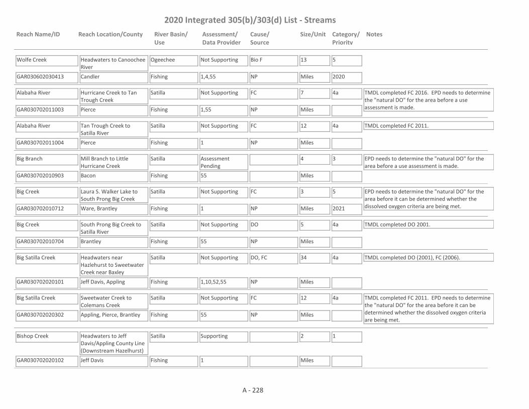
2020 Integrated 305(b)/303(d) List - Streams
Reach Name/ID Reach Location/County River Basin/Use
Assessment/Data Provider
Cause/Source
Size/Unit Category/Priority
Notes
Wolfe Creek
GAR030602030413 1,4,55
Headwaters to Canoochee River
Candler
Ogeechee
Fishing
Not Supporting Bio F 13
Miles
5
2020NP
Alabaha River
GAR030702011003 1,55
Hurricane Creek to Tan Trough Creek
Pierce
Satilla
Fishing
Not Supporting FC 7
Miles
4a TMDL completed FC 2016. EPD needs to determine the "natural DO" for the area before a use assessment is made.NP
Alabaha River
GAR030702011004 1
Tan Trough Creek to Satilla River
Pierce
Satilla
Fishing
Not Supporting FC 12
Miles
4a TMDL completed FC 2011.
NP
Big Branch
GAR030702010903 55
Mill Branch to Little Hurricane Creek
Bacon
Satilla
Fishing
Assessment Pending
4
Miles
3 EPD needs to determine the "natural DO" for the area before a use assessment is made.
Big Creek
GAR030702010712 1
Laura S. Walker Lake to South Prong Big Creek
Ware, Brantley
Satilla
Fishing
Not Supporting FC 3
Miles
5
2021
EPD needs to determine the "natural DO" for the area before it can be determined whether the dissolved oxygen criteria are being met.NP
Big Creek
GAR030702010704 55
South Prong Big Creek to Satilla River
Brantley
Satilla
Fishing
Not Supporting DO 5
Miles
4a TMDL completed DO 2001.
NP
Big Satilla Creek
GAR030702020101 1,10,52,55
Headwaters near Hazlehurst to Sweetwater Creek near Baxley
Jeff Davis, Appling
Satilla
Fishing
Not Supporting DO, FC 34
Miles
4a TMDL completed DO (2001), FC (2006).
NP
Big Satilla Creek
GAR030702020302 55
Sweetwater Creek to Colemans Creek
Appling, Pierce, Brantley
Satilla
Fishing
Not Supporting FC 12
Miles
4a TMDL completed FC 2011. EPD needs to determine the "natural DO" for the area before it can be determined whether the dissolved oxygen criteria are being met.
NP
Bishop Creek
GAR030702020102 1
Headwaters to Jeff Davis/Appling County Line (Downstream Hazelhurst)
Jeff Davis
Satilla
Fishing
Supporting 2
Miles
1
A - 228

2020 Integrated 305(b)/303(d) List - Streams
Reach Name/ID Reach Location/County River Basin/Use
Assessment/Data Provider
Cause/Source
Size/Unit Category/Priority
Notes
Bishop Creek
GAR030702020103 1
Lake Mayers to Big Satilla Creek
Appling
Satilla
Fishing
Assessment Pending
10
Miles
3 EPD needs to determine the "natural DO" for the area before it can be determined whether the dissolved oxygen criteria are being met.
Boggy Creek
GAR030702020405 55
Headwaters to Lake Lindsay Grace
Wayne
Satilla
Fishing
Assessment Pending
10
Miles
3 EPD needs to determine the "natural DO" for the area before a use assessment is made.
Boggy Creek
GAR030702020402 55
Dry Creek to Little Satilla Creek North of Screven
Wayne
Satilla
Fishing
Supporting 1
Miles
1 TMDLs completed DO (2001), FC (2006).
Broxton Creek
GAR030702010401 10
Seven Creek to Seventeen Mile River near Broxton
Coffee
Satilla
Fishing
Not Supporting FC, DO 6
Miles
4a TMDL completed DO (2001), FC (2006).
NP
Buffalo Creek
GAR030702011102 1,55
Little Buffalo Creek to Satilla River
Brantley
Satilla
Fishing
Not Supporting FC, DO 6
Miles
4a TMDLs completed FC (2011), DO (2001).
NP
City Drainage Canal
GAR030702010701 2,55
Tributary to Satilla River, Waycross
Ware
Satilla
Fishing
Not Supporting FC 3
Miles
4a TMDL completed FC (1998 & 2006).
UR
Colemans Creek
GAR030702020301 55
Dry Branch South of Surrency to Big Satilla Creek near Screven
Appling, Wayne
Satilla
Fishing
Not Supporting pH, FC 17
Miles
4a, 5
2026
TMDLs completed DO (2001), FC (2006).
NP
Cox Creek
GAR030702010710 55
Headwaters to the Satilla River
Ware
Satilla
Fishing
Assessment Pending
7
Miles
3 EPD needs to determine the "natural DO" for the area before a use assessment is made.
Dry Creek
GAR030702010606 1,55,59
Headwaters to Hurricane Creek
Coffee
Satilla
Fishing
Not Supporting FC 9
Miles
4a TMDL completed FC 2011.
NP
A - 229
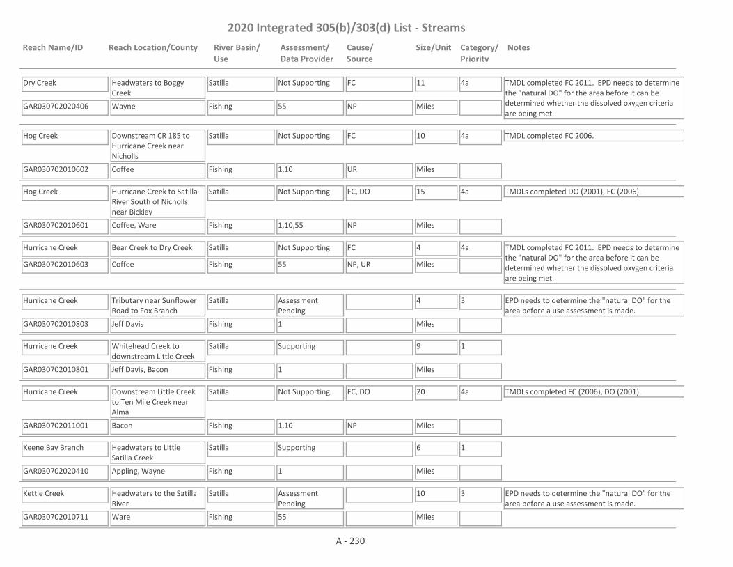
2020 Integrated 305(b)/303(d) List - Streams
Reach Name/ID Reach Location/County River Basin/Use
Assessment/Data Provider
Cause/Source
Size/Unit Category/Priority
Notes
Dry Creek
GAR030702020406 55
Headwaters to Boggy Creek
Wayne
Satilla
Fishing
Not Supporting FC 11
Miles
4a TMDL completed FC 2011. EPD needs to determine the "natural DO" for the area before it can be determined whether the dissolved oxygen criteria are being met.
NP
Hog Creek
GAR030702010602 1,10
Downstream CR 185 to Hurricane Creek near Nicholls
Coffee
Satilla
Fishing
Not Supporting FC 10
Miles
4a TMDL completed FC 2006.
UR
Hog Creek
GAR030702010601 1,10,55
Hurricane Creek to Satilla River South of Nicholls near Bickley
Coffee, Ware
Satilla
Fishing
Not Supporting FC, DO 15
Miles
4a TMDLs completed DO (2001), FC (2006).
NP
Hurricane Creek
GAR030702010603 55
Bear Creek to Dry Creek
Coffee
Satilla
Fishing
Not Supporting FC 4
Miles
4a TMDL completed FC 2011. EPD needs to determine the "natural DO" for the area before it can be determined whether the dissolved oxygen criteria are being met.
NP, UR
Hurricane Creek
GAR030702010803 1
Tributary near Sunflower Road to Fox Branch
Jeff Davis
Satilla
Fishing
Assessment Pending
4
Miles
3 EPD needs to determine the "natural DO" for the area before a use assessment is made.
Hurricane Creek
GAR030702010801 1
Whitehead Creek to downstream Little Creek
Jeff Davis, Bacon
Satilla
Fishing
Supporting 9
Miles
1
Hurricane Creek
GAR030702011001 1,10
Downstream Little Creek to Ten Mile Creek near Alma
Bacon
Satilla
Fishing
Not Supporting FC, DO 20
Miles
4a TMDLs completed FC (2006), DO (2001).
NP
Keene Bay Branch
GAR030702020410 1
Headwaters to Little Satilla Creek
Appling, Wayne
Satilla
Fishing
Supporting 6
Miles
1
Kettle Creek
GAR030702010711 55
Headwaters to the Satilla River
Ware
Satilla
Fishing
Assessment Pending
10
Miles
3 EPD needs to determine the "natural DO" for the area before a use assessment is made.
A - 230
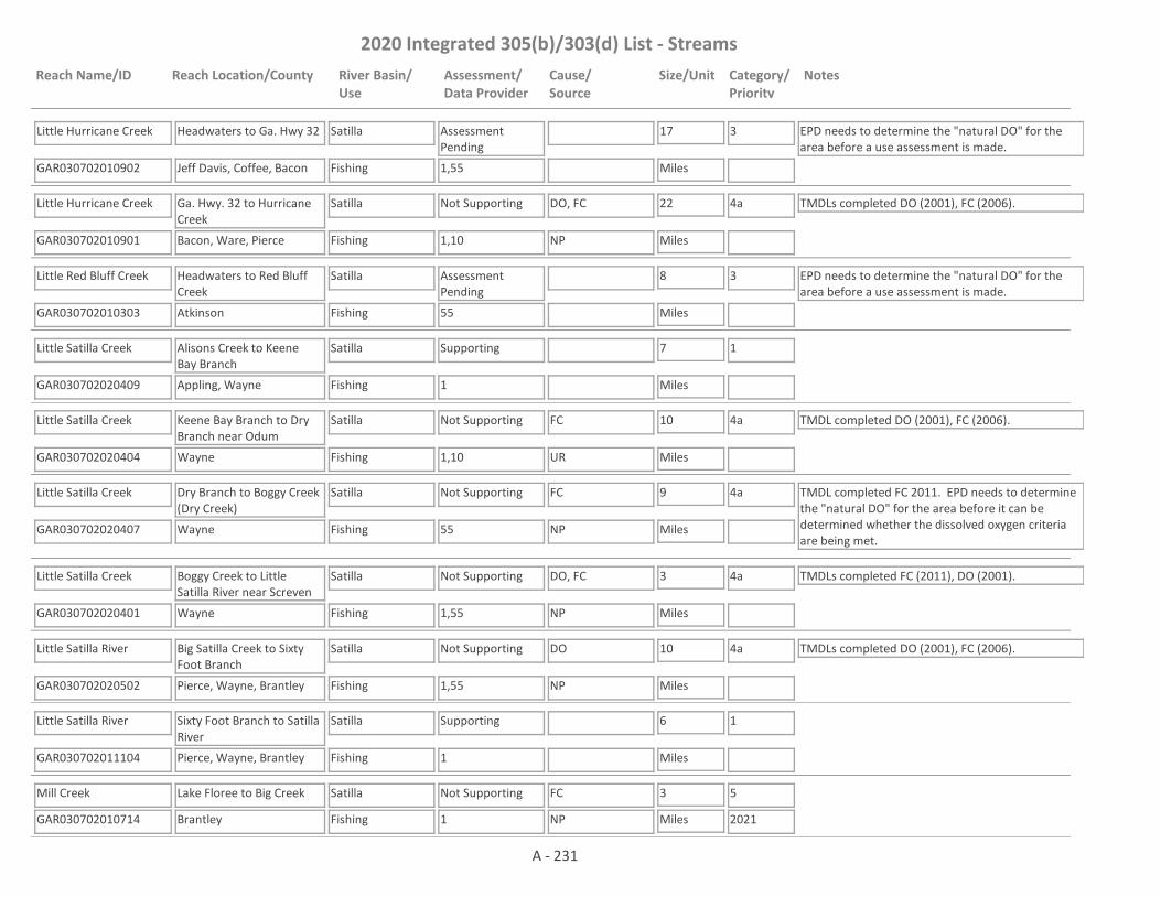
2020 Integrated 305(b)/303(d) List - Streams
Reach Name/ID Reach Location/County River Basin/Use
Assessment/Data Provider
Cause/Source
Size/Unit Category/Priority
Notes
Little Hurricane Creek
GAR030702010902 1,55
Headwaters to Ga. Hwy 32
Jeff Davis, Coffee, Bacon
Satilla
Fishing
Assessment Pending
17
Miles
3 EPD needs to determine the "natural DO" for the area before a use assessment is made.
Little Hurricane Creek
GAR030702010901 1,10
Ga. Hwy. 32 to Hurricane Creek
Bacon, Ware, Pierce
Satilla
Fishing
Not Supporting DO, FC 22
Miles
4a TMDLs completed DO (2001), FC (2006).
NP
Little Red Bluff Creek
GAR030702010303 55
Headwaters to Red Bluff Creek
Atkinson
Satilla
Fishing
Assessment Pending
8
Miles
3 EPD needs to determine the "natural DO" for the area before a use assessment is made.
Little Satilla Creek
GAR030702020409 1
Alisons Creek to Keene Bay Branch
Appling, Wayne
Satilla
Fishing
Supporting 7
Miles
1
Little Satilla Creek
GAR030702020404 1,10
Keene Bay Branch to Dry Branch near Odum
Wayne
Satilla
Fishing
Not Supporting FC 10
Miles
4a TMDL completed DO (2001), FC (2006).
UR
Little Satilla Creek
GAR030702020407 55
Dry Branch to Boggy Creek (Dry Creek)
Wayne
Satilla
Fishing
Not Supporting FC 9
Miles
4a TMDL completed FC 2011. EPD needs to determine the "natural DO" for the area before it can be determined whether the dissolved oxygen criteria are being met.
NP
Little Satilla Creek
GAR030702020401 1,55
Boggy Creek to Little Satilla River near Screven
Wayne
Satilla
Fishing
Not Supporting DO, FC 3
Miles
4a TMDLs completed FC (2011), DO (2001).
NP
Little Satilla River
GAR030702020502 1,55
Big Satilla Creek to Sixty Foot Branch
Pierce, Wayne, Brantley
Satilla
Fishing
Not Supporting DO 10
Miles
4a TMDLs completed DO (2001), FC (2006).
NP
Little Satilla River
GAR030702011104 1
Sixty Foot Branch to Satilla River
Pierce, Wayne, Brantley
Satilla
Fishing
Supporting 6
Miles
1
Mill Creek
GAR030702010714 1
Lake Floree to Big Creek
Brantley
Satilla
Fishing
Not Supporting FC 3
Miles
5
2021NP
A - 231

2020 Integrated 305(b)/303(d) List - Streams
Reach Name/ID Reach Location/County River Basin/Use
Assessment/Data Provider
Cause/Source
Size/Unit Category/Priority
Notes
Otter Creek
GAR030702020503 1
Long Branch to Griffin Branch
Pierce
Satilla
Fishing
Not Supporting FC 2
Miles
4a TMDL completed FC 2016. EPD needs to determine the "natural DO" for the area before it can be determined whether the dissolved oxygen criteria are being met.
NP
Otter Creek
GAR030702010509 1
Tributary 0.3 miles upstream New Forest Hwy to Tiger Creek
Coffee
Satilla
Fishing
Not Supporting FC 4
Miles
5
2021NP
Otter Creek
GAR030702010505 1
Tiger Creek to Seventeen Mile River
Coffee
Satilla
Fishing
Supporting 2
Miles
1
Pudding Creek
GAR030702010201 10
Park Bay to Satilla River N. of Pearson
Atkinson
Satilla
Fishing
Not Supporting DO, FC 9
Miles
4a TMDLs completed DO (2001), FC (2006).
NP
Red Bluff Creek
GAR030702010301 10
Little Red Bluff Creek to Satilla River East of Pearson
Atkinson
Satilla
Fishing
Supporting 7
Miles
1 TMDL completed DO 2001.
Reedy Creek
GAR030702020403 1,55
Headwaters to Little Satilla Creek near Screven (Previously called Headwaters to Big Satilla Creek)
Appling, Wayne
Satilla
Fishing
Not Supporting DO 17
Miles
4a TMDLs completed DO (2001), FC (2006).
NP
Roses Creek
GAR030702010402 10
Upstream Ga. Hwy. 206 to Seventeen Mile River near Broxton
Coffee
Satilla
Fishing
Not Supporting FC 9
Miles
4a TMDLs completed FC (2006), DO (2001).
NP
Satilla Creek
GAR030702010102 10
Hunters Creek East of Ocilla to Satilla River
Irwin, Coffee
Satilla
Fishing
Not Supporting DO 7
Miles
4a TMDLs completed DO (2001), FC (2006).
NP
A - 232
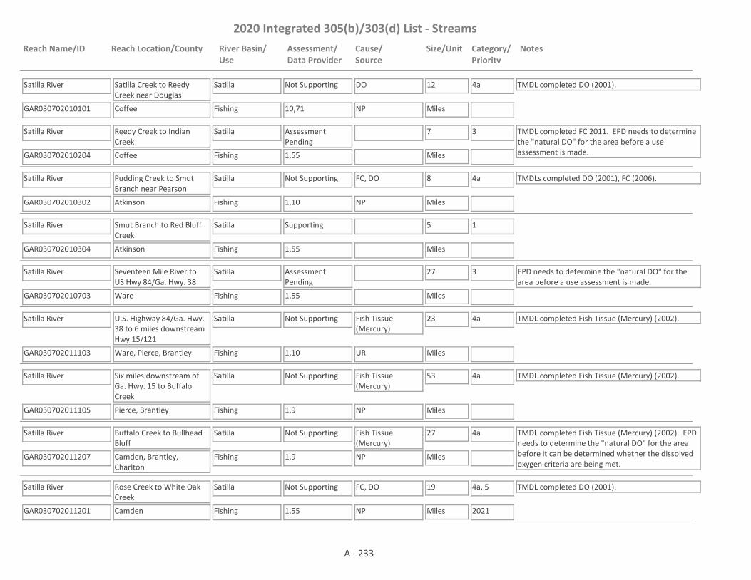
2020 Integrated 305(b)/303(d) List - Streams
Reach Name/ID Reach Location/County River Basin/Use
Assessment/Data Provider
Cause/Source
Size/Unit Category/Priority
Notes
Satilla River
GAR030702010101 10,71
Satilla Creek to Reedy Creek near Douglas
Coffee
Satilla
Fishing
Not Supporting DO 12
Miles
4a TMDL completed DO (2001).
NP
Satilla River
GAR030702010204 1,55
Reedy Creek to Indian Creek
Coffee
Satilla
Fishing
Assessment Pending
7
Miles
3 TMDL completed FC 2011. EPD needs to determine the "natural DO" for the area before a use assessment is made.
Satilla River
GAR030702010302 1,10
Pudding Creek to Smut Branch near Pearson
Atkinson
Satilla
Fishing
Not Supporting FC, DO 8
Miles
4a TMDLs completed DO (2001), FC (2006).
NP
Satilla River
GAR030702010304 1,55
Smut Branch to Red Bluff Creek
Atkinson
Satilla
Fishing
Supporting 5
Miles
1
Satilla River
GAR030702010703 1,55
Seventeen Mile River to US Hwy 84/Ga. Hwy. 38
Ware
Satilla
Fishing
Assessment Pending
27
Miles
3 EPD needs to determine the "natural DO" for the area before a use assessment is made.
Satilla River
GAR030702011103 1,10
U.S. Highway 84/Ga. Hwy. 38 to 6 miles downstream Hwy 15/121
Ware, Pierce, Brantley
Satilla
Fishing
Not Supporting Fish Tissue (Mercury)
23
Miles
4a TMDL completed Fish Tissue (Mercury) (2002).
UR
Satilla River
GAR030702011105 1,9
Six miles downstream of Ga. Hwy. 15 to Buffalo Creek
Pierce, Brantley
Satilla
Fishing
Not Supporting Fish Tissue (Mercury)
53
Miles
4a TMDL completed Fish Tissue (Mercury) (2002).
NP
Satilla River
GAR030702011207 1,9
Buffalo Creek to Bullhead Bluff
Camden, Brantley, Charlton
Satilla
Fishing
Not Supporting Fish Tissue (Mercury)
27
Miles
4a TMDL completed Fish Tissue (Mercury) (2002). EPD needs to determine the "natural DO" for the area before it can be determined whether the dissolved oxygen criteria are being met.
NP
Satilla River
GAR030702011201 1,55
Rose Creek to White Oak Creek
Camden
Satilla
Fishing
Not Supporting FC, DO 19
Miles
4a, 5
2021
TMDL completed DO (2001).
NP
A - 233

2020 Integrated 305(b)/303(d) List - Streams
Reach Name/ID Reach Location/County River Basin/Use
Assessment/Data Provider
Cause/Source
Size/Unit Category/Priority
Notes
Seventeen Mile River
GAR030702010502 1,55
Twenty Mile Creek North of Douglas to Otter Creek downstream General Coffee State Park
Coffee
Satilla
Fishing
Not Supporting DO, FC 7
Miles
4a TMDLs completed DO (2002), FC (2006).
UR
Seventeen Mile River
GAR030702010501 1
Otter Creek (Douglas) to Twentynine Mile Creek
Coffee
Satilla
Fishing
Supporting 8
Miles
1
Seventeen Mile River
GAR030702010503 1,55
Twentynine Mile Creek to Satilla River
Coffee, Atkinson, Ware
Satilla
Fishing
Not Supporting FC, DO 13
Miles
4a TMDLs completed FC (2011), DO (2002).
NP
Sixty Foot Branch
GAR030702020504 1
Headwaters to Otter Creek
Pierce
Satilla
Fishing
Not Supporting FC 10
Miles
5
2021
EPD needs to determine the "natural DO" for the area before a use assessment is made.
NP
South Prong Big Creek
GAR030702010713 1
Headwaters to Big Creek
Brantley
Satilla
Fishing
Assessment Pending
8
Miles
3 EPD needs to determine the "natural DO" for the area before a use assessment is made.
Sweeny Creek
GAR030702011211 1
Headwaters to White Oak Creek
Camden
Satilla
Fishing
Supporting 4
Miles
1
Sweetwater Creek
GAR030702020201 1,10
Black Water Creek to Big Satilla Creek near Baxley
Appling
Satilla
Fishing
Supporting 12
Miles
1 TMDLs completed DO (2001), FC (2006).
Tributary #1 to Sixty-foot Branch
GAR030702020505 1
Headwaters to Sixty-foot Branch
Pierce
Satilla
Fishing
Assessment Pending
2
Miles
3 EPD needs to determine the "natural DO" for the area before it can be determined whether the dissolved oxygen criteria are being met.
Tributary #2 to Sixty-foot Branch
GAR030702020506 1
Headwaters to Sixty Foot Branch
Pierce
Satilla
Fishing
Assessment Pending
5
Miles
3 EPD needs to determine the "natural DO" for the area before it can be determined whether the dissolved oxygen criteria are being met.
A - 234

2020 Integrated 305(b)/303(d) List - Streams
Reach Name/ID Reach Location/County River Basin/Use
Assessment/Data Provider
Cause/Source
Size/Unit Category/Priority
Notes
Tributary to Little Satilla Creek
GAR030702020411 1
Headwaters to Little Satilla Creek
Appling, Wayne
Satilla
Fishing
Assessment Pending
5
Miles
3 EPD needs to determine the "natural DO" for the area before it can be determined whether the dissolved oxygen criteria are being met.
Tributary to Seventeen Mile Creek
GAR030702010506 1
0.3 miles downstream East Baker Hwy to Seventeenmile River
Coffee
Satilla
Fishing
Not Supporting FC, DO, Ammonia Toxicity
4
Miles
5
2021, 2026, 2030
TMDL for FC scheduled to be drafted 2021, DO 2026, ammonia toxicity 2030.
NP, UR, M
Tributary to Seventeen Mile River
GAR030702010507 1
Headwaters to 0.3 miles downstream East Baker Hwy
Coffee
Satilla
Fishing
Not Supporting Ammonia Toxicity 3
Miles
5
2030
EPD needs to determine the "natural DO" for the area before an assessment is made as to whether the DO criteria is being met.
NP
Tributary to Tributary to Seventeen Mile River
GAR030702010508 1
Gaskin Avenue to 0.1 miles downstream US 221
Coffee
Satilla
Fishing
Not Supporting Ammonia Toxicity 1
Miles
5
2030
EPD needs to determine the "natural DO" for the area before an assessment is made as to whether the DO criteria is being met.NP
Tributary to Twenty Mile Creek
GAR030702010403 56
Headwaters to Twenty Mile Creek
Coffee
Satilla
Fishing
Not Supporting Chrysene, Benzo(a)Anthracene
2
Miles
4b Data from EPD's Harzardous Waste Branch. Facility under a corrective action plan.
I2
Tributary to Waverly Creek
GAR030702011210 1
Headwaters to Waverly Creek
Camden
Satilla
Fishing
Assessment Pending
5
Miles
3 EPD needs to determine the "natural DO" for the area before a use assessment is made.
Waverly Creek
GAR030702011209 1
Headwaters to Quarterman Creek
Camden
Satilla
Fishing
Not Supporting FC 9
Miles
5
2021
EPD needs to determine the "natural DO" for the area before it can be determined whether the dissolved oxygen criteria are being met.NP
White Oak Creek
GAR030702011208 1
Headwaters to Waverly Creek
Camden
Satilla
Fishing
Assessment Pending
11
Miles
3 EPD needs to determine the "natural DO" for the area before a use assessment is made.
Armstrong Branch
GAR030601030703 4
Headwaters to Fishing Creek
Wilkes
Savannah
Fishing
Not Supporting Bio F 5
Miles
5
2020NP
A - 235

2020 Integrated 305(b)/303(d) List - Streams
Reach Name/ID Reach Location/County River Basin/Use
Assessment/Data Provider
Cause/Source
Size/Unit Category/Priority
Notes
Bear Creek
GAR030601040105 1
Lavonia
Franklin
Savannah
Fishing
Supporting 1
Miles
1
Bear Creek
GAR030601040101 1,2
0.2 miles downstream West Avenue to SCS Pond (Reservoir 38)
Franklin
Savannah
Fishing
Assessment Pending
2
Miles
3 TMDL completed DO 2000. More data needs to be collected to determine if DO is meeting criteria. The previous DO listing was based on model results of the impact of a WPCP discharge. The WPCP is no longer discharging in the area, so the model results no longer reflect this reach.
Bear Creek
GAR030601040104 1
SCS Pond to Unawatti Creek, Lavonia
Franklin
Savannah
Fishing
Supporting 1
Miles
1
Beaverdam Creek
GAR030601040406 4
Mill Shoal Creek to South Fork Broad River
Oglethorpe, Madison
Savannah
Fishing
Not Supporting Bio F 4
Miles
5
2020NP
Beaverdam Creek
GAR030601040202 1
Downstream Commerce
Jackson
Savannah
Fishing
Not Supporting DO 1
Miles
4a TMDL completed DO 2000.
M
Beaverdam Creek
GAR030601050209 4
Headwaters to Williams Creek
Taliaferro
Savannah
Fishing
Supporting 6
Miles
1
Beaverdam Creek
GAR030601040204 1
Tributary to Grove Creek (Commerce)
Jackson, Banks
Savannah
Fishing
Supporting 5
Miles
1
Beaverdam Creek
GAR030601080402 4
Looks Branch to Little Beaverdam Creek
Burke, Jenkins, Screven
Savannah
Fishing
Supporting 9
Miles
1
Beaverdam Creek
GAR030601080403 10
Big Branch to McDonald Branch
Screven
Savannah
Fishing
Assessment Pending
7
Miles
3 EPD needs to determine the "natural DO" for the area before a use assessment is made.
A - 236

2020 Integrated 305(b)/303(d) List - Streams
Reach Name/ID Reach Location/County River Basin/Use
Assessment/Data Provider
Cause/Source
Size/Unit Category/Priority
Notes
Beaverdam Creek
GAR030601080401 1,4
McDonald Branch to Brier Creek, near Sylvania
Screven
Savannah
Fishing
Supporting 5
Miles
1
Beaverdam Creek
GAR030601030312 59
Pruitt Creek to unnamed tributary approximately 0.3 miles from Hart County Line
Hart, Elbert
Savannah
Fishing
Assessment Pending
4
Miles
3 This site has a narrative rank of fair for macroinvertebrates. Waters with a narrative rank of fair will remain in Category 3 until EPD completes the reevaluation of the metrics used to assess macroinvertebrate data.
Beaverdam Creek
GAR030601030313 10
Confluence of North & South Beaverdam Creeks to Richard B. Russell Lake near Elberton
Elbert
Savannah
Fishing, Drinking Water
Not Supporting FC 8
Miles
4a TMDL completed FC 2005.
NP
Big Toms Creek/Toms Creek
GAR030601040111 4
Ayers Pond/Reservoir 14 to NOrth Fork Broad River
Stephens, Franklin
Savannah
Fishing
Not Supporting Bio F 6
Miles
4a TMDL completed Bio F 2010.
NP
Boggy Gut Creek
GAR030601060613 4
Millers Pond to the Savannah River
Burke
Savannah
Fishing
Supporting 4
Miles
1
Boggy Gut Creek
GAR030601080204 4
McDuffie/Columbia/Richmond County Line to Brier Creek
Richmond
Savannah
Fishing
Supporting 7
Miles
1
Boyds Creek
GAR030601030413 4
Headwaters to Little Coldwater Creek
Hart
Savannah
Fishing
Supporting 6
Miles
1
Brier Creek
GAR030601080207 1
Headstall Creek to Boggy Gut Creek
Jefferson, Burke
Savannah
Fishing
Supporting 6
Miles
1
A - 237

2020 Integrated 305(b)/303(d) List - Streams
Reach Name/ID Reach Location/County River Basin/Use
Assessment/Data Provider
Cause/Source
Size/Unit Category/Priority
Notes
Brier Creek
GAR030601080101 4,10
Whites Creek to Sweetwater Creek near Thomson (formerly Big Brier Creek to Sweetwater Creek)
McDuffie
Savannah
Fishing
Not Supporting FC 3
Miles
4a TMDL completed FC 2005.
NP
Brier Creek
GAR030601080302 1,9,10
Hwy 305 to MacIntosh Creek
Burke
Savannah
Fishing, Drinking Water
Not Supporting Fish Tissue (Mercury)
19
Miles
4a TMDLs completed FC (2005) & Fish Tissue (Mercury) (2005). The water is meeting its Drinking Water Use, but is impaired for the Fishing Use.NP
Brier Creek
GAR030601080502 1,9,10,55
MacIntosh Creek to Savannah River
Burke, Screven
Savannah
Fishing, Drinking Water
Not Supporting Fish Tissue (Mercury)
26
Miles
4a TMDL completed Fish Tissue (Mercury) 2005. The water is meeting its Drinking Water Use, but the Fishing Use is impaired.NP
Broad River
GAR030601040302 10,63
SR 281 to Scull Shoal Creek near Danielsville
Madison
Savannah
Fishing
Not Supporting FC 5
Miles
4a TMDL completed FC 2005.
NP
Broad River
GAR030601040306 1
Scull Shoal Creek to Mill Shoal Creek
Elbert, Madison
Savannah
Fishing
Supporting 2
Miles
1
Broad River
GAR030601040303 10
Deep Creek to South Fork Broad River
Madison, Elbert
Savannah
Fishing
Not Supporting FC 7
Miles
4a TMDL completed FC 2010.
NP
Broad River
GAR030601040601 10
Hwy. 77 to Clarks Hill Lake
Elbert
Savannah
Fishing
Supporting 15
Miles
1 TMDL completed FC 2005.
Brush Creek
GAR030601040407 4
Reservoir U to Bigger Creek
Madison
Savannah
Fishing
Not Supporting Bio F 6
Miles
5
2020NP
Brushy Creek
GAR030601080201 10
SR 80 (Rd. S1571) west Wrens to Brier Creek
Jefferson, Burke
Savannah
Fishing
Not Supporting FC 15
Miles
4a TMDL completed FC 2005.
NP
A - 238

2020 Integrated 305(b)/303(d) List - Streams
Reach Name/ID Reach Location/County River Basin/Use
Assessment/Data Provider
Cause/Source
Size/Unit Category/Priority
Notes
Buck Creek
GAR030601090101 10
Downstream Sylvania WPCP to Savannah River
Screven
Savannah
Fishing
Not Supporting DO 12
Miles
4a TMDLs completed DO 2005 (revised 2007), FC (2005), cyanide (1999), Zn (1999) & Toxicity (2000).
M
Buffalo Creek
GAR030601040505 4
Milner Brook to Long Creek
Oglethorpe
Savannah
Fishing
Not Supporting Bio F 7
Miles
5
2020NP
Bull Creek
GAR030601050207 1,4
Headwaters to Little River
Warren
Savannah
Fishing
Supporting 5
Miles
1
Butler Creek
GAR030601060607 1,4,10,53,59
Boardmans Pond to Phinizy Ditch (formerly Boardmans Pond to SR56)
Richmond
Savannah
Fishing
Assessment Pending
9
Miles
3 TMDL completed FC 2016. This site has a narrative rank of fair for macroinvertebrates. When EPD completes the reevaluation of the metrics used to assess macroinvertebrate data it will be determined if the macroinvertebrate criteria are being met. In Category 3 for pH based on 2013 data from RV_01_88 as there was only 6 months of data available for evaluation.
Butler Creek
GAR030601060601 1,10,53
Phinizy Ditch to Savannah River, Augusta
Richmond
Savannah
Fishing
Not Supporting FC 3
Miles
4a TMDLs completed FC (2000) & DO (2000).
UR
Carlan Creek
GAR030601040213 4
Unnamed tributary 0.4 miles upstream State Route 63 to Crockett Creek
Banks, Franklin
Savannah
Fishing
Supporting 6
Miles
1
Cedar Creek
GAR030601030408 1
Downstream Hartwell WPCP to Little Cedar Creek
Hart
Savannah
Fishing
Supporting 8
Miles
1
Cedar Creek
GAR030601030406 10
Little Cedar Creek to Savannah River near Montevideo
Hart
Savannah
Fishing
Not Supporting FC 4
Miles
4a TMDL completed FC 2005.
NP
A - 239

2020 Integrated 305(b)/303(d) List - Streams
Reach Name/ID Reach Location/County River Basin/Use
Assessment/Data Provider
Cause/Source
Size/Unit Category/Priority
Notes
Chandlers Branch
GAR030601080503 1
Headwaters to pond 0.4 miles downstream Charles Perry Avenue
Burke
Savannah
Fishing
Not Supporting Ammonia Toxicity 1
Miles
5
2030NP
Charlies Creek
GAR030601020113 1
Headwaters to Tallulah River
Towns
Savannah
Fishing
Assessment Pending
4
Miles
3 EPD believes that our pH probes may have been providing falsely low values at times in 2017 and 2018. Waters that would normally be listed as impaired for low pH are being placed in Category 3 while EPD determines if observed low pH is due to issues with the pH probes; whether low pH may be natural due to low alkalinity; or whether the water is actually impaired for low pH.
Chattooga River
GAR030601020205 1,10
Stateline to Lake Tugaloo
Rabun
Savannah
Wild River, Scenic River
Assessment Pending
36
Miles
3 The water is in Category 3 for Fish Tissue (Mercury) because the concentration is 0.3 mg/kg
Chechero Creek
GAR030601020213 1,9
Headwaters to Stekoa Creek
Rabun
Savannah
Fishing
Not Supporting Bio M, FC 3
Miles
4a TMDLs completed Bio M (2001), FC (2000).
NP
Chickasaw CreeK
GAR030601040609 1
Tributary 0.5 miles downstream Norman Rd to the Broad River
Wilkes
Savannah
Fishing
Supporting 4
Miles
1
Chill Creek/ Factory Creek
GAR030601050304 4
Headwaters to Hart Creek
Warren, McDuffie
Savannah
Fishing
Not Supporting Bio F 7
Miles
5
2024NP
Clark Creek
GAR030601040501 10
Greensboro Branch to Long Creek near Tignall
Wilkes
Savannah
Fishing
Not Supporting FC 6
Miles
4a TMDL completed FC (2005).
NP
Clouds Creek
GAR030601040408 1,4
Big Clouds Creek to South Fork Broad River
Oglethorpe
Savannah
Fishing
Supporting 4
Miles
1
A - 240

2020 Integrated 305(b)/303(d) List - Streams
Reach Name/ID Reach Location/County River Basin/Use
Assessment/Data Provider
Cause/Source
Size/Unit Category/Priority
Notes
Coldwater Creek
GAR030601030416 1
Robinson Branch to SR 77
Hart, Elbert
Savannah
Fishing
Supporting 3
Miles
1
Coldwater Creek
GAR030601030407 10
SR 77 to Little Cold Water Creek near Ruckersville
Elbert
Savannah
Fishing
Not Supporting FC 6
Miles
4a TMDL completed FC (2005).
NP
Coleman River
GAR030601020104 1,4,59
Stateline to Tallulah River
Rabun
Savannah
Fishing
Assessment Pending
5
Miles
3 EPD believes that our pH probes may have been providing falsely low values at times in 2017 and 2018. Waters that would normally be listed as impaired for low pH are being placed in Category 3 while EPD determines if observed low pH is due to issues with the pH probes; whether low pH may be natural due to low alkalinity; or whether the water is actually impaired for low pH.
Cowpen Branch
GAR030601090205 55
Headwaters to Runs Branch
Effingham
Savannah
Fishing
Not Supporting FC 7
Miles
4a TMDL completed FC 2010. EPD needs to determine the "natural DO" for the area before it can be determined whether the dissolved oxygen criteria are being met.
NP
Crawford Creek
GAR030601060102 1,2
Downstream Columbia Co. WPCP to Tudor Branch
Columbia
Savannah
Fishing
Assessment Pending
2
Miles
3 TMDL completed Tox 2000. In Category 3 due to a lack of instream data with which to make an assessment.
Crawford Creek
GAR030601020503 9,10
Upstream Lake Hartwell near Lavonia
Franklin
Savannah
Fishing
Not Supporting FC, Bio M 4
Miles
4a TMDLs completed FC (2005) & Bio M (2005).
NP
Davidson Creek
GAR030601020402 1,4,59
Headwaters to Panther Creek near Tallulah Falls
Habersham, Stephens
Savannah
Fishing
Supporting 6
Miles
1
Devils Branch
GAR030601090209 55
Headwaters to Runs Branch
Effingham
Savannah
Fishing
Assessment Pending
8
Miles
3 EPD needs to determine the "natural DO" for the area before a use assessment is made.
A - 241

2020 Integrated 305(b)/303(d) List - Streams
Reach Name/ID Reach Location/County River Basin/Use
Assessment/Data Provider
Cause/Source
Size/Unit Category/Priority
Notes
Dicks Creek
GAR030601040122 56
Tributary 0.3 miles upstream of Ayersville Road to tributary 0.4 miles downstream of Ayersville Road
Stephens
Savannah
Fishing
Not Supporting Tetrachloroethylene, Vinyl Chloride
1
Miles
5
2024I2
Dove Creek
GAR030601040603 4
Headwaters to Little Dove Creek
Elbert
Savannah
Fishing
Not Supporting Bio F 6
Miles
4a TMDL completed Bio F 2010.
NP
Dry Fork Creek
GAR030601040509 4
Headwaters to Beaverdam Creek
Oglethorpe, Wilkes
Savannah
Fishing
Not Supporting Bio F 9
Miles
5
2020NP
Dry Fork Creek
GAR030601040508 1
Cow MireBranch to Centerville Branch
Wilkes, Oglethorpe
Savannah
Fishing
Supporting 5
Miles
1
Eastanollee Creek
GAR030601020501 1,2,3,4,10
Toccoa to Lake Hartwell
Stephens
Savannah
Fishing
Not Supporting FC, Bio F 14
Miles
4a TMDLs completed Bio F (2010), FC (2000), Tox (2005), Zn (2001) & Cu (2000). EPD wants to collect more data for pH before an assessment is made. The pH criteria were met at one station (RV-01_17), but at station RV_01_14 there were a couple of times pH was slightly below the criteria. .
UR
Ebenezer Creek
GAR030601090203 55
Long Bridge to Savannah River near Springfield
Effingham
Savannah
Fishing
Not Supporting DO 6
Miles
4a TMDLs completed DO (2000), pH (2005).
NP
Ebenezer Creek
GAR030601090212 1,10
Turkey Creek to Little Ebenezer Creek
Effingham
Savannah
Fishing
Supporting 8
Miles
1 TMDLs completed DO 2005 (revised 2007), FC 2005.
Falling Creek
GAR030601040602 10
Dry Fork Creek to Broad River near Fortsonia
Elbert
Savannah
Fishing
Not Supporting FC 4
Miles
4a TMDL completed FC (2005).
NP
A - 242

2020 Integrated 305(b)/303(d) List - Streams
Reach Name/ID Reach Location/County River Basin/Use
Assessment/Data Provider
Cause/Source
Size/Unit Category/Priority
Notes
Fitz Branch
GAR030601080301 4
Headwaters to Brier Creek
Burke
Savannah
Fishing
Supporting 5
Miles
1
Flat Rock Branch
GAR030601080206 4
Headwaters to Reedy Creek
Jefferson
Savannah
Fishing
Supporting 3
Miles
1
Florence Creek
GAR030601030702 1
Headwaters to Soap Creek
Wilkes, Lincoln
Savannah
Fishing
Not Supporting Cu 8
Miles
5
2024NP
Fork Creek
GAR030601040309 1
Headwaters to Deep Creek
Elbert
Savannah
Fishing
Supporting 6
Miles
1
Fortson's Creek
GAR030601030310 2,63
Elberton to Beaverdam Creek
Elbert
Savannah
Fishing
Not Supporting FC 4
Miles
4a TMDL completed FC 1998.
UR
Germany Creek
GAR030601050401 4
Little Germany Creek to Clarks Hill Reservoir
McDuffie
Savannah
Fishing
Not Supporting Bio F 4
Miles
5
2024NP
Gin Creek
GAR030601040606 4
Headwaters to Falling Creek
Elbert
Savannah
Fishing
Supporting 6
Miles
1 TMDL completed Bio F 2016.
Goosepond Creek
GAR030601040607 4
Headwaters to the Broad River
Oglethorpe
Savannah
Fishing
Not Supporting Bio F 8
Miles
5
2020NP
Griffin Creek
GAR030601050108 4
Headwaters to North Fork Little River
Greene
Savannah
Fishing
Supporting 3
Miles
1
Grindstone Branch (aka Johnsons Branch, aka Friendship Branch)
GAR030601060306 1,4
Rhodes Pond to Spirit Creek, Hephzibah
Richmond
Savannah
Fishing
Not Supporting Bio F 1
Miles
5
2024NP, UR
A - 243
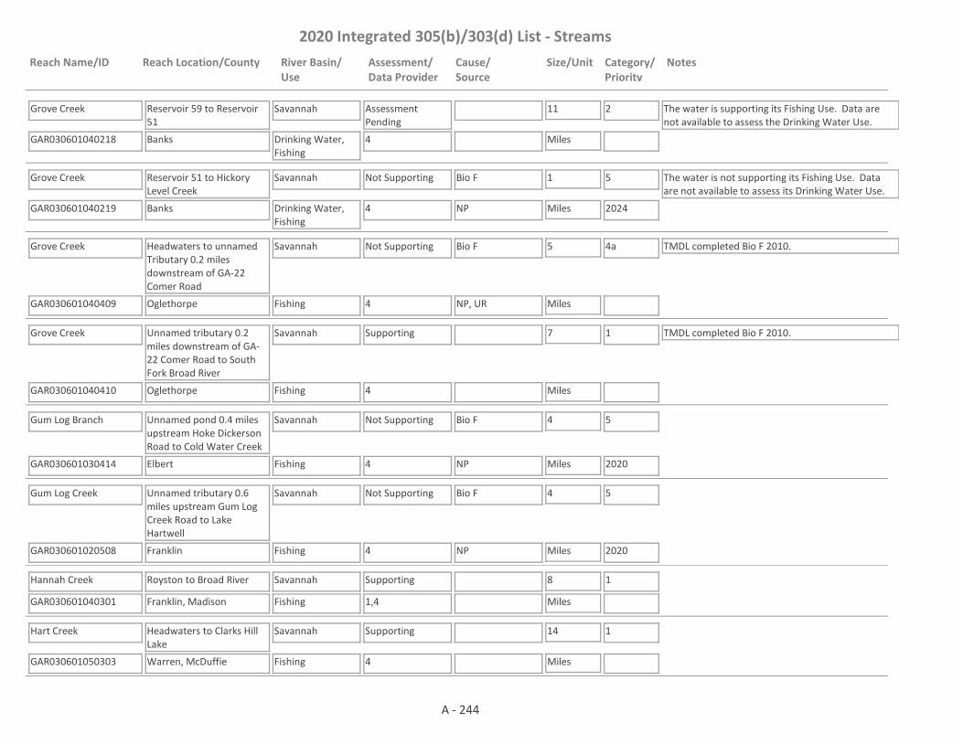
2020 Integrated 305(b)/303(d) List - Streams
Reach Name/ID Reach Location/County River Basin/Use
Assessment/Data Provider
Cause/Source
Size/Unit Category/Priority
Notes
Grove Creek
GAR030601040218 4
Reservoir 59 to Reservoir 51
Banks
Savannah
Drinking Water, Fishing
Assessment Pending
11
Miles
2 The water is supporting its Fishing Use. Data are not available to assess the Drinking Water Use.
Grove Creek
GAR030601040219 4
Reservoir 51 to Hickory Level Creek
Banks
Savannah
Drinking Water, Fishing
Not Supporting Bio F 1
Miles
5
2024
The water is not supporting its Fishing Use. Data are not available to assess its Drinking Water Use.
NP
Grove Creek
GAR030601040409 4
Headwaters to unnamed Tributary 0.2 miles downstream of GA-22 Comer Road
Oglethorpe
Savannah
Fishing
Not Supporting Bio F 5
Miles
4a TMDL completed Bio F 2010.
NP, UR
Grove Creek
GAR030601040410 4
Unnamed tributary 0.2 miles downstream of GA-22 Comer Road to South Fork Broad River
Oglethorpe
Savannah
Fishing
Supporting 7
Miles
1 TMDL completed Bio F 2010.
Gum Log Branch
GAR030601030414 4
Unnamed pond 0.4 miles upstream Hoke Dickerson Road to Cold Water Creek
Elbert
Savannah
Fishing
Not Supporting Bio F 4
Miles
5
2020NP
Gum Log Creek
GAR030601020508 4
Unnamed tributary 0.6 miles upstream Gum Log Creek Road to Lake Hartwell
Franklin
Savannah
Fishing
Not Supporting Bio F 4
Miles
5
2020NP
Hannah Creek
GAR030601040301 1,4
Royston to Broad River
Franklin, Madison
Savannah
Fishing
Supporting 8
Miles
1
Hart Creek
GAR030601050303 4
Headwaters to Clarks Hill Lake
Warren, McDuffie
Savannah
Fishing
Supporting 14
Miles
1
A - 244
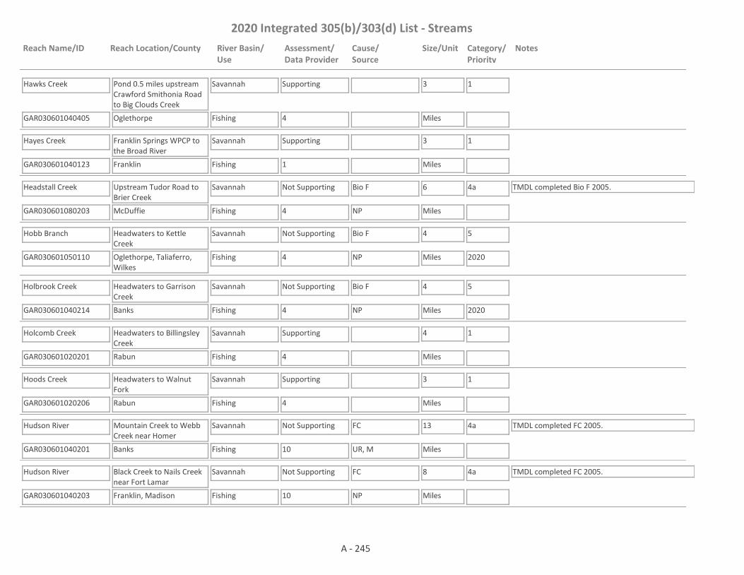
2020 Integrated 305(b)/303(d) List - Streams
Reach Name/ID Reach Location/County River Basin/Use
Assessment/Data Provider
Cause/Source
Size/Unit Category/Priority
Notes
Hawks Creek
GAR030601040405 4
Pond 0.5 miles upstream Crawford Smithonia Road to Big Clouds Creek
Oglethorpe
Savannah
Fishing
Supporting 3
Miles
1
Hayes Creek
GAR030601040123 1
Franklin Springs WPCP to the Broad River
Franklin
Savannah
Fishing
Supporting 3
Miles
1
Headstall Creek
GAR030601080203 4
Upstream Tudor Road to Brier Creek
McDuffie
Savannah
Fishing
Not Supporting Bio F 6
Miles
4a TMDL completed Bio F 2005.
NP
Hobb Branch
GAR030601050110 4
Headwaters to Kettle Creek
Oglethorpe, Taliaferro, Wilkes
Savannah
Fishing
Not Supporting Bio F 4
Miles
5
2020NP
Holbrook Creek
GAR030601040214 4
Headwaters to Garrison Creek
Banks
Savannah
Fishing
Not Supporting Bio F 4
Miles
5
2020NP
Holcomb Creek
GAR030601020201 4
Headwaters to Billingsley Creek
Rabun
Savannah
Fishing
Supporting 4
Miles
1
Hoods Creek
GAR030601020206 4
Headwaters to Walnut Fork
Rabun
Savannah
Fishing
Supporting 3
Miles
1
Hudson River
GAR030601040201 10
Mountain Creek to Webb Creek near Homer
Banks
Savannah
Fishing
Not Supporting FC 13
Miles
4a TMDL completed FC 2005.
UR, M
Hudson River
GAR030601040203 10
Black Creek to Nails Creek near Fort Lamar
Franklin, Madison
Savannah
Fishing
Not Supporting FC 8
Miles
4a TMDL completed FC 2005.
NP
A - 245

2020 Integrated 305(b)/303(d) List - Streams
Reach Name/ID Reach Location/County River Basin/Use
Assessment/Data Provider
Cause/Source
Size/Unit Category/Priority
Notes
Hudson River
GAR030601040208 10
Nails Creek to the Broad River
Franklin, Madison
Savannah
Fishing
Supporting 3
Miles
1
Jacks Branch
GAR030601090208 55
White Deer Branch to Ebenezer Creek
Effingham
Savannah
Fishing
Not Supporting FC 3
Miles
4a TMDL completed FC 2016.
UR
Jones Creek
GAR030601060103 2,69
Tributary to Savannah River near Evans
Columbia
Savannah
Fishing
Not Supporting FC 3
Miles
4a TMDL completed FC 1998.
UR
Kemp Creek
GAR030601050208 1
Headwaters to Clarks Hill Lake
Wilkes
Savannah
Fishing
Supporting 7
Miles
1
Kendrick Creek
GAR030601050211 4
Headwaters to Harden Creek
Taliaferro
Savannah
Fishing
Not Supporting Bio F 6
Miles
5
2024NP
Kettle Creek
GAR030601050112 4
Hatchet Branch to Hobb Branch
Wilkes
Savannah
Fishing
Not Supporting Bio F 2
Miles
5
2020NP
Kettle Creek
GAR030601050106 1
Hobb Branch to Little Kettle Creek
Wilkes
Savannah
Fishing
Not Supporting FC 6
Miles
5
2020
FC TMDL drafted 2020.
NP
Kimbell Creek
GAR030601040118 4
Headwaters to Middle Fork Broad River
Stephens
Savannah
Fishing
Supporting 3
Miles
1
Kiokee Creek
GAR030601060105 1,4
Greenbrier Creek to Savannah River near Evans
Columbia
Savannah
Fishing
Supporting 6
Miles
1
Law Ground Creek
GAR030601020203 9
Headwaters to West Fork Chattooga River
Rabun
Savannah
Fishing
Not Supporting Bio M 2
Miles
4a TMDL completed Bio M 2001.
NP
A - 246

2020 Integrated 305(b)/303(d) List - Streams
Reach Name/ID Reach Location/County River Basin/Use
Assessment/Data Provider
Cause/Source
Size/Unit Category/Priority
Notes
Lick Creek
GAR030601050118 4
Ellington Branch to the Little River
Taliaferro
Savannah
Fishing
Not Supporting Bio F 2
Miles
5
2024NP
Lightwood Log Creek
GAR030601030101 4
Headwaters to Lake Hartwell
Hart
Savannah
Fishing
Supporting 6
Miles
1
Little Bear Creek
GAR030601040106 1
Tributary to Unawatti Creek, Lavonia
Franklin
Savannah
Fishing
Supporting 1
Miles
1
Little Beaverdam Creek
GAR030601030311 4
Headwaters to Reservoir 30
Hart, Elbert
Savannah
Fishing
Not Supporting Bio F 8
Miles
5
2024NP
Little Brier Creek
GAR030601080107 4
Guy Branch to Brier Creek
McDuffie, Warren
Savannah
Fishing
Supporting 2
Miles
1
Little Brushy Creek
GAR030601080211 4
Headwaters to Brushy Creek
Burke
Savannah
Fishing
Not Supporting Bio F 5
Miles
5
2024NP
Little Cedar Creek
GAR030601030411 4
Headwaters to Cedar Creek
Hart
Savannah
Fishing
Not Supporting Bio F 5
Miles
4a TMDL completed Bio F 2010.
NP
Little Coldwater Creek
GAR030601030412 4,59
Headwaters to Boyds Creek
Hart
Savannah
Fishing
Not Supporting Bio F 5
Miles
4a TMDL completed Bio F 2010.
NP
Little Crawford Creek
GAR030601020506 9
Headwaters to Lake Hartwell
Franklin
Savannah
Fishing
Not Supporting Bio M 2
Miles
4a TMDL completed Bio M 2005.
NP
Little Dove Creek
GAR030601040604 4
Headwaters to Dove Creek
Elbert
Savannah
Fishing
Supporting 8
Miles
1
A - 247

2020 Integrated 305(b)/303(d) List - Streams
Reach Name/ID Reach Location/County River Basin/Use
Assessment/Data Provider
Cause/Source
Size/Unit Category/Priority
Notes
Little Ebenezer Creek
GAR030601090210 1
Headwaters to Ebenezer Creek
Effingham
Savannah
Fishing
Assessment Pending
5
Miles
3 EPD needs to determine the "natural DO" for the area before it can be determined whether the dissolved oxygen criteria are being met.
Little Indian Creek
GAR030601040507 4
Headwaters to Indian Creek
Oglethorpe
Savannah
Fishing
Supporting 5
Miles
1
Little Kettle Creek
GAR030601050109 4
Headwaters to Kettle Creek
Wilkes
Savannah
Fishing
Supporting 7
Miles
1
Little Nails Creek
GAR030601040215 4
Headwaters to Mountain Creek
Banks
Savannah
Fishing
Supporting 3
Miles
1
Little Panther Creek
GAR030601020406 4
Headwaters to Big Panther Creek
Habersham
Savannah
Fishing
Supporting 5
Miles
1
Little River
GAR030601050101 10
Confluence of North & South Forks to Kettle Creek near Washington
Taliaferro, Wilkes
Savannah
Fishing
Not Supporting FC 6
Miles
4a TMDL completed FC 2005.
NP
Little River
GAR030601050206 10
Williams Creek to Rocky Creek
McDuffie, Wilkes
Savannah
Fishing
Supporting 10
Miles
1
Little River
GAR030601050202 10,49
Rocky Creek to Clarks Hill Lake
Wilkes
Savannah
Fishing
Not Supporting FC 4
Miles
4a TMDL completed FC 2000.
NP
Little Shoal Creek
GAR030601020505 4,9
Headwaters to Lake Hartwell
Hart
Savannah
Fishing
Not Supporting Bio M, Bio F 6
Miles
4a TMDL completed Bio F (2010), Bio M (2000).
NP
A - 248

2020 Integrated 305(b)/303(d) List - Streams
Reach Name/ID Reach Location/County River Basin/Use
Assessment/Data Provider
Cause/Source
Size/Unit Category/Priority
Notes
Little Spirit Creek
GAR030601060309 4
Headwaters to Spirit Creek
Richmond
Savannah
Fishing
Supporting 10
Miles
1
Little Toccoa Creek
GAR030601020403 4
Headwaters to Toccoa Creek, Toccoa
Stephens
Savannah
Fishing
Supporting 4
Miles
1
Lloyd Creek
GAR030601050403 4
Headwaters to Tributary 0.6 miles downstream Hephzibah Church Road
Wilkes, Lincoln
Savannah
Fishing
Not Supporting Bio F 6
Miles
5
2020NP
Lockner Creek
GAR030601090311 55
Headwaters to the Savannah River
Effingham
Savannah
Fishing
Assessment Pending
9
Miles
3 EPD needs to determine the "natural DO" for the area before a use assessment is made.
Long Branch
GAR030601060108 1
Headwaters to Uchee Creek
Columbia
Savannah
Fishing
Assessment Pending
3
Miles
3 More data is needed before this water is assessed. Data was collected from Station RV_01_136 from January - June 2013 (less than a full year of data).
Long Creek
GAR030601040502 10
Macks Creek to Clark Creek
Wilkes
Savannah
Fishing
Supporting 3
Miles
1 TMDL completed FC 2005.
Long Creek
GAR030601040510 4
Troublesome Creek to Buffalo Creek
Oglethorpe
Savannah
Fishing
Supporting 6
Miles
1
Macks Creek
GAR030601040506 4
Headwaters to Little Macks Creek
Oglethorpe
Savannah
Fishing
Supporting 8
Miles
1
Masons Mill Creek
GAR030601040304 4
Dove Branch to Bluestone Creek
Madison
Savannah
Fishing
Supporting 6
Miles
1
Mattox Creek
GAR030601050302 4
Headwaters to Big Creek
McDuffie
Savannah
Fishing
Not Supporting Bio F 9
Miles
4a TMDL completed Bio F 2010.
NP, UR
A - 249

2020 Integrated 305(b)/303(d) List - Streams
Reach Name/ID Reach Location/County River Basin/Use
Assessment/Data Provider
Cause/Source
Size/Unit Category/Priority
Notes
McBean Creek
GAR030601060611 4
Storys Millpond to Rebecca Walker Creek
Richmond, Burke
Savannah
Fishing
Supporting 2
Miles
1
McBean Creek
GAR030601060608 10,53
Poorly Branch (aka Rebecca Walker Creek) to Savannah River
Richmond, Burke
Savannah
Fishing
Supporting 14
Miles
1 TMDL completed FC 2005.
Mclean Creek
GAR030601080106 4
Headwaters to Reese Lake
Glascock, Warren
Savannah
Fishing
Not Supporting Bio F 4
Miles
5
2024NP
Middle Creek
GAR030601050301 1
Childers Creek to Big Creek (tributary to Clarks Hill Lake), near Wrightsboro
McDuffie
Savannah
Fishing
Supporting 6
Miles
1 TMDL completed DO 2005 (revised 2007).
Middle Fork Broad River
GAR030601040121 4
Tributary 1.8 miles upstream of Sellers Road to Dicks Creek
Habersham, Stephens
Savannah
Fishing
Supporting 3
Miles
1
Middle Fork Broad River
GAR030601040107 1,4,59
Dicks Creek to reservoir No. 44 (u/s of Lake Russell)
Stephens
Savannah
Fishing
Supporting 4
Miles
1
Middle Fork Broad River
GAR030601040102 10
Nancy town Creek to Hunters Creek
Banks, Franklin
Savannah
Fishing
Not Supporting FC 13
Miles
4a TMDL completed FC 2005.
NP
Middle Fork Broad River
GAR030601040119 1
Stephens Creek to North Fork Broad River
Franklin
Savannah
Fishing
Supporting 5
Miles
1
Moccasin Creek
GAR030601020105 4
Headwaters to Lake Burton
Rabun
Savannah
Fishing
Supporting 5
Miles
1
A - 250

2020 Integrated 305(b)/303(d) List - Streams
Reach Name/ID Reach Location/County River Basin/Use
Assessment/Data Provider
Cause/Source
Size/Unit Category/Priority
Notes
Nails Creek
GAR030601040205 4
Headwaters to Ragsdale Creek
Banks, Franklin
Savannah
Fishing
Supporting 3
Miles
1
Nails Creek
GAR030601040210 1
Carlan Creek to the Hudson River
Franklin
Savannah
Fishing
Not Supporting FC 8
Miles
4a TMDL completed FC 2016.
NP
Nancytown Creek
GAR030601040110 4
Headwaters to Nancytown Lake
Habersham
Savannah
Fishing
Not Supporting Bio F 3
Miles
4a TMDL completed Bio F 2010.
NP
Newberry Creek
GAR030601060612 4
Headwaters to Mineral Springs Branch
Burke
Savannah
Fishing
Supporting 4
Miles
1
North Fork Broad River
GAR030601040108 4
Habersham/Stephens Co. Line to Old Rock Quarry Rd. near Toccoa
Stephens
Savannah
Fishing
Supporting 5
Miles
1
North Fork Broad River
GAR030601040103 10
Unawatti Creek to Broad River near Carnesville
Franklin
Savannah
Drinking Water, Fishing
Not Supporting FC 5
Miles
4a TMDL completed FC 2005.
NP
North Fork Little River
GAR030601050104 4
Pond 1.2 miles upstream McWhorter Road to Raiden Creek
Oglethorpe
Savannah
Fishing
Not Supporting Bio F 7
Miles
5
2020NP
Panther Creek (Big Panther Creek)
GAR030601020404 4,10
Upstream Lake Yonah
Habersham, Stephens
Savannah
Fishing
Not Supporting FC, Bio F 9
Miles
4a TMDL completed Bio F (2010), FC (2005).
NP
Payne Creek
GAR030601040117 4
Headwaters to Middle Fork Broad River
Franklin
Savannah
Fishing
Not Supporting Bio F 5
Miles
5
2020NP
A - 251

2020 Integrated 305(b)/303(d) List - Streams
Reach Name/ID Reach Location/County River Basin/Use
Assessment/Data Provider
Cause/Source
Size/Unit Category/Priority
Notes
Phinizy Ditch
GAR030601060602 1
Tributary to Butler Creek (Augusta)
Richmond
Savannah
Fishing
Supporting 2
Miles
1 TMDL completed Pb 2000.
Pickens Creek
GAR030601030415 4
Headwaters to Lake Richard B. Russell
Elbert
Savannah
Fishing
Supporting 6
Miles
1
Pistol Creek
GAR030601030701 1,4
Headwaters to Clarks Hill Lake near Tignall
Wilkes, Lincoln
Savannah
Fishing
Supporting 8
Miles
1
Pool Creek
GAR030601020216 1,9
Headwaters to She Creek (formerly Headwaters to Stekoa Creek)
Rabun
Savannah
Fishing
Not Supporting Bio M 2
Miles
4a TMDL completed Bio M 2001.
NP
Popcorn Creek
GAR030601020114 1
Headwaters to Burton Lake
Rabun
Savannah
Fishing
Assessment Pending
4
Miles
3 The pH probe was not working correctly for part of the year in 2013. More data is needed before making an assessment on pH.
Powder Creek
GAR030601050107 4
Headwaters to Little River
Taliaferro
Savannah
Fishing
Not Supporting Bio F 4
Miles
5
2020NP
Rae's Creek
GAR030601060609 4,59
Headwaters to Cranes Creek
Richmond
Savannah
Fishing
Not Supporting Bio F 4
Miles
4a TMDL completed Bio F 2016.
UR
Ragsdale Creek
GAR030601040206 4
Headwaters to Nails Creek
Banks, Franklin
Savannah
Fishing
Supporting 5
Miles
1
Raiden Creek
GAR030601050105 4
Headwaters to North Fork Little River
Oglethorpe
Savannah
Drinking Water, Fishing
Not Supporting Bio F 7
Miles
5
2020
The water is not supporting its Fishing Use. Data are not available to assess the Drinking Water Use.
NP
A - 252

2020 Integrated 305(b)/303(d) List - Streams
Reach Name/ID Reach Location/County River Basin/Use
Assessment/Data Provider
Cause/Source
Size/Unit Category/Priority
Notes
Rayburn Branch
GAR030601080208 4
Howard Branch to Reedy Creek
Jefferson
Savannah
Fishing
Supporting 1
Miles
1
Reed Creek
GAR030601020504 10
Upstream Lake Hartwell
Hart
Savannah
Fishing
Not Supporting FC 5
Miles
4a TMDL completed FC 2005.
NP
Reed Creek
GAR030601060604 10,69
Rd. S1727 to Bowen Pond near Martinez
Columbia
Savannah
Fishing
Not Supporting FC 8
Miles
4a TMDL completed FC 2005.
UR
Reed Creek
GAR030601060605 2,69
Bowen Pond to Savannah River
Columbia
Savannah
Fishing
Supporting 1
Miles
1 TMDL completed FC 2000.
Reedy Creek
GAR030601080205 4
Headwaters to Warren County Line
Warren
Savannah
Fishing
Not Supporting Bio F 6
Miles
4a TMDL completed Bio F 2016.
NP
Reedy Creek
GAR030601080202 1,4,10
Warren County line to Brier Creek near Wrens
Jefferson
Savannah
Fishing
Not Supporting Bio F, FC 12
Miles
4a, 5
2024
TMDL completed FC 2005.
NP
Roach Mill Creek
GAR030601020217 1,9
Headwaters to Warwoman Creek
Rabun
Savannah
Fishing
Not Supporting Bio M 2
Miles
4a TMDL completed Bio M 2001.
NP
Rocky Creek
GAR030601050201 4,9
Washington to Little River
Wilkes
Savannah
Fishing
Supporting 12
Miles
1 TMDLs completed Cu (2001), Tox (2001), Bio F (2005)
Rocky Creek
GAR030601060610 4,59
Headwaters to SR 56 (formerly Headwaters to Phinizy Ditch)
Richmond
Savannah
Fishing
Not Supporting Bio M, Bio F 6
Miles
4a TMDL completed Bio F & Bio M 2016.
NP, UR
Rocky Creek
GAR030601060603 4,10,59
SR 56 to below New Savannah Road, Augusta
Richmond
Savannah
Fishing
Not Supporting FC, Bio M, Bio F 2
Miles
4a TMDLs completed FC 2000, Bio M 2016 and Bio F 2016.
UR
A - 253

2020 Integrated 305(b)/303(d) List - Streams
Reach Name/ID Reach Location/County River Basin/Use
Assessment/Data Provider
Cause/Source
Size/Unit Category/Priority
Notes
Runs Branch
GAR030601090206 1,55
Sand Pond to Cowpen Branch
Effingham
Savannah
Fishing
Assessment Pending
7
Miles
3 EPD needs to determine the "natural DO" for the area before a use assessment is made.
Runs Branch
GAR030601090211 1,10
Cowpen Creek to Turkey Creek
Effingham
Savannah
Fishing
Not Supporting DO 7
Miles
4a TMDLs completed DO 2005 (revised 2007), FC 2005.
NP
Saddle Gap Creek
GAR030601020212 1,9
Headwaters to Stekoa Creek
Rabun
Savannah
Fishing
Not Supporting Bio M, FC 1
Miles
4a TMDLs completed Bio M (2001) & FC (2000).
NP
Sandy Run Creek
GAR030601080210 4
Rachel Branch to Brier Creek
Richmond, Burke
Savannah
Fishing
Not Supporting Bio F 4
Miles
5
2024NP
Sarahs Creek
GAR030601020207 4
Headwaters to Warwoman Creek
Rabun
Savannah
Fishing
Supporting 5
Miles
1
Satterwhite Branch
GAR030601060106 4
Headwaters to Greenbrier Creek
Columbia
Savannah
Fishing
Supporting 4
Miles
1
Savannah River
GAR030601030409 1
Lake Hartwell to Cedar Creek
Hart
Savannah
Fishing
Supporting 6
Miles
1 TMDL completed DO 2000.
Savannah River
GAR030601060104 10
Clarks Hill Lake to Stevens Creek Dam
Columbia
Savannah
Drinking Water, Fishing
Supporting 9
Miles
1 TMDL completed DO 2000.
Savannah River
GAR030601060616 1
Stevens Creek Dam to Horse Creek (formerly Stevens Creek Dam to US 78/278)
Columbia, Richmond
Savannah
Drinking Water, Fishing
Supporting 9
Miles
1 TMDL completed DO 2000.
A - 254

2020 Integrated 305(b)/303(d) List - Streams
Reach Name/ID Reach Location/County River Basin/Use
Assessment/Data Provider
Cause/Source
Size/Unit Category/Priority
Notes
Savannah River
GAR030601060614 1,10
Horse Creek to Butler Creek
Richmond
Savannah
Fishing
Supporting 10
Miles
1
Savannah River
GAR030601060615 1,10
Butler Creek to McBean Creek
Richmond
Savannah
Fishing
Supporting 21
Miles
1 TMDLs completed Pb (2000) and FC (2000)
Savannah River
GAR030601060903 1,10
McBean Creek to Johnsons Landing
Burke, Screven
Savannah
Fishing
Supporting 40
Miles
1
Savannah River
GAR030601060901 1,9,10
Johnsons Landing to Brier Creek
Screven
Savannah
Fishing, Drinking Water
Supporting 26
Miles
1
Savannah RIver
GAR030601090102 1,9,10
Brier Creek to Ebenezer Creek
Screven, Effingham
Savannah
Fishing, Drinking Water
Not Supporting Fish Tissue (Mercury)
59
Miles
5
2024
TMDLs completed Pb (1999), Zn (1999). The water is supporting its Drinking Water Use, but is impaired for its Fishing Use.NP
Savannah River/Front River
GAR030601090320 10
Ebenezer Creek to SR 25
Effingham, Chatham
Savannah
Drinking Water, Coastal Fishing, Fishing
Assessment Pending
28
Miles
2 FC TMDL drafted 2020. DO is being placed in Category 3. Measured DO was below the daily minimum of 4.0 mg/L 11% of the time. However, the River has a designated use of “Coastal Fishing” where the DO was monitored. The Rules and Regulations acknowledge that waters with a Coastal Fishing use may naturally have DO that does not meet the normal DO criteria. In this case, the DO criteria reverts to “Natural” and up to a 0.1 mg/L deficit from natural is allowed by the Rules. It is not known what the “Natural DO” at this station would have been when DO was recorded below 4.0 mg/L. This section of the River is covered by the 5R dissolved oxygen restoration plan that was put in place for the Savannah Harbor. Implementation of the 5R plan will ensure DO criteria are also met in the River. The water is supporting its Drinking Water Use.
A - 255

2020 Integrated 305(b)/303(d) List - Streams
Reach Name/ID Reach Location/County River Basin/Use
Assessment/Data Provider
Cause/Source
Size/Unit Category/Priority
Notes
Scott Creek
GAR030601020211 1,9
Headwaters to Stekoa Creek
Rabun
Savannah
Fishing
Not Supporting Bio M, FC 4
Miles
4a TMDLs completed Bio M (2001) & FC (2000).
NP
Scull Shoal Creek
GAR030601040308 4
Little Scull Shoal Creek to the Broad River
Madison
Savannah
Fishing
Supporting 1
Miles
1
She Creek
GAR030601020214 1,9
Lake Toccoa to Stekoa Creek
Rabun
Savannah
Fishing
Not Supporting Cu, Bio M, FC 3
Miles
4a, 5
2024
TMDLs completed Bio M(2005) & FC (2005).
NP
Sherrills Creek
GAR030601050116 4
Pond at Corry Circle to South Fork Little River
Greene, Taliaferro
Savannah
Drinking Water, Fishing
Not Supporting Bio F 8
Miles
5
2024
The water is not supporting its Fishing Use. Data are not available to assess the Drinking Water Use.
NP
Shoal Creek
GAR030601020507 9
Headwaters to Pooles Creek
Hart
Savannah
Fishing
Not Supporting Bio M 7
Miles
4a TMDL completed Bio M 2005.
NP
Shoal Creek
GAR030601020502 9,10,59
Pooles Creek to Lake Hartwell, Parkertown
Hart
Savannah
Fishing
Not Supporting FC, Bio M 1
Miles
4a TMDL completed FC (2005), Bio M (2005).
NP
Silver Creek
GAR030601040216 4
Headwaters to the Hudson River
Banks
Savannah
Fishing
Supporting 5
Miles
1
South Creek/Bigger Creek
GAR030601040404 1,9
Headwaters to Brush Creek
Madison
Savannah
Fishing
Not Supporting pH, Bio M 9
Miles
4a, 5
2024
TMDL completed Bio M 2005.
NP
South Fork Broad River
GAR030601040401 10
Brush Creek to Beaverdam Creek near Comer
Madison
Savannah
Fishing
Not Supporting FC 3
Miles
4a TMDL completed FC (2005).
NP
A - 256

2020 Integrated 305(b)/303(d) List - Streams
Reach Name/ID Reach Location/County River Basin/Use
Assessment/Data Provider
Cause/Source
Size/Unit Category/Priority
Notes
South Fork Broad River
GAR030601040402 10
Clouds Creek to Fork Creek near Carlton
Madison, Oglethorpe
Savannah
Fishing
Not Supporting FC 7
Miles
4a TMDL completed FC (2005).
NP
South Fork Little River
GAR030601050102 4
Sherrills Creek to North Fork Little River
Taliaferro
Savannah
Fishing
Not Supporting Bio F 4
Miles
5
2024NP
South Prong Creek
GAR030601060310 4
Ellis Pond to Spirit Creek
Richmond
Savannah
Fishing
Supporting 1
Miles
1
Spirit Creek
GAR030601060307 1,4
Marcum Branch to McDade Pond
Richmond
Savannah
Fishing
Not Supporting Bio F 14
Miles
4a TMDL completed Bio F 2016.
UR
Spirit Creek
GAR030601060308 1,10,53
McDade Pond to Savannah River
Richmond
Savannah
Fishing
Not Supporting FC 7
Miles
4a TMDL completed FC 2005.
NP, UR
St. Augustine Creek
GAR030601090308 1
Walthour Swamp to Front River near Port Wentworth
Effingham, Chatham
Savannah
Fishing
Supporting 7
Miles
1
Stekoa Creek
GAR030601020215 1,9
Cox Lake to Scott Creek
Rabun
Savannah
Fishing
Not Supporting Bio M 3
Miles
4a TMDLs completed Bio M (2001) & FC (2000).
NP
Stekoa Creek
GAR030601020204 1,9,10,59
Clayton to Chattooga River
Rabun
Savannah
Fishing
Not Supporting FC, Bio M 14
Miles
4a TMDLs completed FC (2000) & Bio M (2001). EPD believes that our pH probes may have been providing falsely low values at times in 2017 and 2018. Waters that would normally be listed as impaired for low pH are being placed in Category 3 while EPD determines if observed low pH is due to issues with the pH probes; whether low pH may be natural due to low alkalinity; or whether the water is actually impaired for low pH.
NP, UR
A - 257

2020 Integrated 305(b)/303(d) List - Streams
Reach Name/ID Reach Location/County River Basin/Use
Assessment/Data Provider
Cause/Source
Size/Unit Category/Priority
Notes
Stephens Creek
GAR030601050114 4
Tributary 470 feet upstream of Center Hill School Road NW to South Fork Little River
Taliaferro
Savannah
Fishing
Not Supporting Bio F 3
Miles
5
2020NP
Stephens Creek
GAR030601040115 1
Headwaters to Middle Fork Broad River
Franklin
Savannah
Fishing
Not Supporting FC 10
Miles
4a TMDL completed FC 2016.
NP, M
Sweetwater Creek
GAR030601080103 59
Headwaters to Brier Creek
McDuffie
Savannah
Drinking Water, Fishing
Assessment Pending
8
Miles
3 This site has a narrative rank of fair for macroinvertebrates. Waters with a narrative rank of fair will remain in Category 3 until EPD completes the reevaluation of the metrics used to assess macroinvertebrate data. There are not data available to assess the Drinking Water Use.
Sweigoffer Creek
GAR030601090321 1
Tributary 0.5 miles upstream Old Augusta Road to Mill Creek
Effingham
Savannah
Fishing
Assessment Pending
2
Miles
3 EPD needs to determine the "natural DO" for the area before a use assessment is made.
Syls Fork
GAR030601050113 4
Pond 1 mile downstream Sims Cross Road to North Fork Little River
Oglethorpe
Savannah
Fishing
Supporting 9
Miles
1
Tallulah River
GAR030601020106 1,10,59
Upstream Lake Burton
Rabun
Savannah
Recreation, Fishing
Not Supporting FC 11
Miles
4a TMDL completed FC 2005. pH is being placed in Category 3 based on 2013 data from RV_01_270. The sonde was not working correctly for several months and more data is needed before making an assessment. E. coli is being placed into Category 3 until E. coli data can be collected and assessed.
NP
Tarvers Branch
GAR030601080209 4
Pond upstream Templeton Circle to Brier Creek
Burke
Savannah
Fishing
Supporting 4
Miles
1
A - 258

2020 Integrated 305(b)/303(d) List - Streams
Reach Name/ID Reach Location/County River Basin/Use
Assessment/Data Provider
Cause/Source
Size/Unit Category/Priority
Notes
Tiger Creek
GAR030601020107 4,59
Headwaters to Pole Bridge Creek near Clayton
Rabun
Savannah
Fishing
Assessment Pending
8
Miles
3 This site has a narrative rank of fair for macroinvertebrates. Waters with a narrative rank of fair will remain in Category 3 until EPD completes the reevaluation of the metrics used to assess macroinvertebrate data.
Toccoa Creek
GAR030601020405 1,4
Stephens County
Stephens
Savannah
Fishing
Supporting 5
Miles
1
Toccoa Creek
GAR030601020401 10
Little Toccoa Creek to Lake Hartwell
Stephens
Savannah
Fishing
Not Supporting FC 3
Miles
4a TMDL completed FC (2005).
UR, M
Tributary #1 to Nails Creek
GAR030601040211 4
Headwaters to Nails Creek
Franklin
Savannah
Fishing
Not Supporting Bio F 2
Miles
5
2020NP
Tributary #2 to Nails Creek
GAR030601040212 4
Headwaters to Nails Creek
Franklin
Savannah
Fishing
Supporting 2
Miles
1
Tributary to Broad River
GAR030601040120 1
Headwaters to Broad River
Franklin
Savannah
Fishing
Supporting 3
Miles
1
Tributary to Buck Creek
GAR030601090103 1
Headwaters to Buck Creek
Screven
Savannah
Fishing
Assessment Pending
1
Miles
3 More data is needed before this water is assessed. Data was collected from Station RV_01_16310 from January - April 2016 (less than a full year of data). More data is needed to make an assessment.
Tributary to Buck Creek
GAR030601090104 1
Headwaters to tributary 0.16 miles downstream of SR 21
Screven
Savannah
Fishing
Assessment Pending
2
Miles
3 FC is being placed in Category 3 due to insufficient data. Only two FC samples were taken in the summer months. More data is needed before an assessment is made.
Tributary to Cherokee Creek
GAR030601050405 1
Headwaters to Cherokee Creek
Lincoln
Savannah
Fishing
Supporting 4
Miles
1
A - 259

2020 Integrated 305(b)/303(d) List - Streams
Reach Name/ID Reach Location/County River Basin/Use
Assessment/Data Provider
Cause/Source
Size/Unit Category/Priority
Notes
Tributary to Hanna Creek
GAR030601040305 1
Headwaters to Hanna Creek
Madison
Savannah
Fishing
Supporting 2
Miles
1
Tributary to South Fork Broad River
GAR030601040411 1
0.3 miles upstream Hill Street to the South Fork Broad River
Madison
Savannah
Fishing
Not Supporting Ammonia Toxicity 1
Miles
5
2030
Ammonia toxicity will be addressed through limits in an NPDES permit.
M
Tributary to St. Augustine Creek
GAR030601090319 1
Headwaters to Cut to St. Augustine Creek
Chatham
Savannah
Fishing
Supporting 1
Miles
1
Tributary to Syls Fork
GAR030601050111 4
Headwaters to Syls Fork
Oglethorpe
Savannah
Fishing
Not Supporting Bio F 2
Miles
5
2020NP
Tributary to the Hudson River
GAR030601040217 4
Tributary 0.9 miles upstream Grant Mill Road to the Hudson River
Banks
Savannah
Fishing
Supporting 2
Miles
1
Tributary to Upton Creek
GAR030601050212 4
Headwaters to Upton Creek
Wilkes
Savannah
Fishing
Not Supporting Bio F 3
Miles
5
2024NP
Tributary to Van Creek
GAR030601030410 1,4
Headwaters to Richard B. Russell Lake
Elbert
Savannah
Fishing
Not Supporting Bio F 4
Miles
5
2020
EPD believes that our pH probes may have been providing falsely low values at times in 2017 and 2018. Waters that would normally be listed as impaired for low pH are being placed in Category 3 while EPD determines if observed low pH is due to issues with the pH probes; whether low pH may be natural due to low alkalinity; or whether the water is actually impaired for low pH.
NP
Tributary to Whites Creek
GAR030601080104 56
Headwaters to Whites Creek near Thomson
McDuffie
Savannah
Fishing
Supporting 2
Miles
1
A - 260
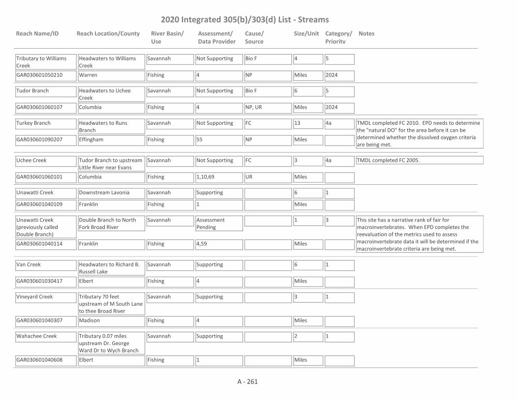
2020 Integrated 305(b)/303(d) List - Streams
Reach Name/ID Reach Location/County River Basin/Use
Assessment/Data Provider
Cause/Source
Size/Unit Category/Priority
Notes
Tributary to Williams Creek
GAR030601050210 4
Headwaters to Williams Creek
Warren
Savannah
Fishing
Not Supporting Bio F 4
Miles
5
2024NP
Tudor Branch
GAR030601060107 4
Headwaters to Uchee Creek
Columbia
Savannah
Fishing
Not Supporting Bio F 6
Miles
5
2024NP, UR
Turkey Branch
GAR030601090207 55
Headwaters to Runs Branch
Effingham
Savannah
Fishing
Not Supporting FC 13
Miles
4a TMDL completed FC 2010. EPD needs to determine the "natural DO" for the area before it can be determined whether the dissolved oxygen criteria are being met.
NP
Uchee Creek
GAR030601060101 1,10,69
Tudor Branch to upstream Little River near Evans
Columbia
Savannah
Fishing
Not Supporting FC 3
Miles
4a TMDL completed FC 2005.
UR
Unawatti Creek
GAR030601040109 1
Downstream Lavonia
Franklin
Savannah
Fishing
Supporting 6
Miles
1
Unawatti Creek (previously called Double Branch)
GAR030601040114 4,59
Double Branch to North Fork Broad River
Franklin
Savannah
Fishing
Assessment Pending
1
Miles
3 This site has a narrative rank of fair for macroinvertebrates. When EPD completes the reevaluation of the metrics used to assess macroinvertebrate data it will be determined if the macroinvertebrate criteria are being met.
Van Creek
GAR030601030417 4
Headwaters to Richard B. Russell Lake
Elbert
Savannah
Fishing
Supporting 6
Miles
1
Vineyard Creek
GAR030601040307 4
Tributary 70 feet upstream of M South Lane to thee Broad River
Madison
Savannah
Fishing
Supporting 3
Miles
1
Wahachee Creek
GAR030601040608 1
Tributary 0.07 miles upstream Dr. George Ward Dr to Wych Branch
Elbert
Savannah
Fishing
Supporting 2
Miles
1
A - 261
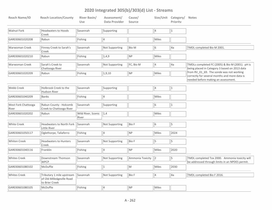
2020 Integrated 305(b)/303(d) List - Streams
Reach Name/ID Reach Location/County River Basin/Use
Assessment/Data Provider
Cause/Source
Size/Unit Category/Priority
Notes
Walnut Fork
GAR030601020208 4
Headwaters to Hoods Creek
Rabun
Savannah
Fishing
Supporting 4
Miles
1
Warwoman Creek
GAR030601020210 1,4,9
Finney Creek to Sarah's Creek
Rabun
Savannah
Fishing
Not Supporting Bio M 6
Miles
4a TMDL completed Bio M 2001.
NP
Warwoman Creek
GAR030601020209 1,9,10
Sarah's Creek to Chattooga River
Rabun
Savannah
Fishing
Not Supporting FC, Bio M 4
Miles
4a TMDLs completed FC (2005) & Bio M (2001). pH is being placed in Category 3 based on 2013 data from RV_01_69. The sonde was not working correctly for several months and more data is needed before making an assessment.
NP
Webb Creek
GAR030601040209 4
Holbrook Creek to the Hudson River
Banks
Savannah
Fishing
Supporting 4
Miles
1
West Fork Chattooga River
GAR030601020202 1,4
Rabun County - Holcomb Creek to Chattooga River
Rabun
Savannah
Wild River, Scenic River
Supporting 6
Miles
1
White Creek
GAR030601050117 4
Headwaters to North Fork Little River
Oglethorpe, Taliaferro
Savannah
Fishing
Not Supporting Bio F 6
Miles
5
2024NP
Whiten Creek
GAR030601040116 4
Headwaters to Hunters Creek
Franklin
Savannah
Fishing
Not Supporting Bio F 5
Miles
5
2020NP
Whites Creek
GAR030601080102 1
Downstream Thomson WPCP
McDuffie
Savannah
Fishing
Not Supporting Ammonia Toxicity 2
Miles
5
2030
TMDL completed Tox 2000. Ammonia toxicity will be addressed through limits in an NPDES permit.
M
Whites Creek
GAR030601080105 4
Tributary 1 mile upstream of Old Milledgeville Road to Brier Creek
McDuffie
Savannah
Fishing
Not Supporting Bio F 4
Miles
4a TMDL completed Bio F 2016.
NP
A - 262

2020 Integrated 305(b)/303(d) List - Streams
Reach Name/ID Reach Location/County River Basin/Use
Assessment/Data Provider
Cause/Source
Size/Unit Category/Priority
Notes
Wildcat Creek
GAR030601020108 4
Headwaters to Lake Burton
Rabun
Savannah
Fishing
Supporting 6
Miles
1
Boone Creek
GAR030702040602 55
Upstream St. Marys River
Charlton
St. Marys
Fishing
Supporting 6
Miles
1 TMDL completed DO 2001.
Clay Branch
GAR030702040305 1
Headwaters to Spanish Creek
Charlton
St. Marys
Fishing
Not Supporting FC 4
Miles
5
2021
EPD needs to determine the "natural DO" for the area before a use assessment is made.
NP, UR
Corn House Creek
GAR030702040701 55
Upstream St. Marys River
Charlton
St. Marys
Fishing
Supporting 7
Miles
1 TMDLs completed DO (2001), FC (2006).
Hatchers Branch
GAR030702040804 1
Headwaters to Spanish Creek
Charlton
St. Marys
Fishing
Assessment Pending
4
Miles
3 EPD needs to determine the "natural DO" for the area before a use assessment is made.
Horsepen Creek (aka Temple Creek)
GAR030702040909 55
Temple Creek to the St. Marys River
Camden
St. Marys
Fishing
Not Supporting DO, FC 1
Miles
4a TMDLs completed DO (2001), FC (2006).
NP
Long Branch
GAR030702040803 1
Headwaters to Spanish Creek
Charlton
St. Marys
Fishing
Not Supporting FC 6
Miles
5
2021
EPD needs to determine the "natural DO" for the area before a use assessment is made as to whether DO is meeting criteria.NP
North Prong St. Marys River
GAR030702040306 1,55
Headwaters to Cedar Creek
Charlton
St. Marys
Fishing
Not Supporting Fish Tissue (Mercury)
19
Miles
4a TMDLs completed DO (2001), Fish Tissue (Mercury) (2002).
NP
North Prong St. Marys River
GAR030702040307 10,55
Cedar Creek to South Prong St. Marys River
Charlton
St. Marys
Fishing
Not Supporting Fish Tissue (Mercury)
9
Miles
4a TMDL completed Fish Tissue (Mercury) (2002).
NP
Spanish Creek
GAR030702040802 55
Little Spanish Creek to Long Branch
Charlton
St. Marys
Fishing
Assessment Pending
6
Miles
3 EPD needs to determine the "natural DO" for the area before a use assessment is made.
A - 263

2020 Integrated 305(b)/303(d) List - Streams
Reach Name/ID Reach Location/County River Basin/Use
Assessment/Data Provider
Cause/Source
Size/Unit Category/Priority
Notes
Spanish Creek
GAR030702040801 1,55
Long Branch to St. Marys River
Charlton
St. Marys
Fishing
Not Supporting DO, FC 4
Miles
4a TMDLs completed DO (2001), FC (2006).
UR
St. Marys River
GAR030702040601 1,9,55
Confluence of North & South Prong of St. Marys River to Cornhouse Creek
Charlton
St. Marys
Fishing
Not Supporting Fish Tissue (Mercury)
34
Miles
4a TMDL completed Fish Tissue (Mercury) 2002.
NP
St. Marys River
GAR030702040905 1,9,55
Cornhouse Creek to St. Marys Cut
Charlton, Camden
St. Marys
Fishing
Not Supporting Fish Tissue (Mercury)
21
Miles
4a EPD needs to determine the "natural DO" for the area before it can be determined whether the dissolved oxygen criteria are being met.NP
St. Marys River
GAR030702040903 10
Upstream Cabbage Bend to Catfish Creek
Camden
St. Marys
Fishing
Not Supporting DO 15
Miles
4a TMDL completed DO 2001.
NP
St. Marys Trib. 5 (aka Cooner Branch)
GAR030702040901 55
Upstream St. Marys River
Charlton
St. Marys
Fishing
Supporting 3
Miles
1 TMDL completed DO 2001.
Tributary #6 to St. Marys River
GAR030702040908 56
Headwaters to St. Marys River
Charlton
St. Marys
Fishing
Not Supporting As 3
Miles
4b Data from EPD's Harzardous Waste Branch. Facility under a corrective action plan.
I2
Alapaha River
GAR031102020301 1,10,62
U.S. Hwy. 280 to Sand Creek
Wilcox, Ben Hill, Turner, Irwin
Suwannee
Fishing
Not Supporting DO 29
Miles
4a TMDL completed DO (2001).
NP
Alapaha River
GAR031102020402 10,62
Sand Creek to U.S. Hwy. 129/Ga. Hwy. 11
Irwin, Tift, Berrien
Suwannee
Fishing
Not Supporting Fish Tissue (Mercury), DO
16
Miles
4a TMDLs completed DO (2001), Fish Tissue (Mercury) (2002).
NP
Alapaha River
GAR031102020404 1,9,55
U.S. Hwy. 129/Ga. Hwy. 11 to Willacoochee River
Berrien
Suwannee
Fishing
Not Supporting Fish Tissue (Mercury)
18
Miles
4a TMDL completed Fish Tissue (Mercury) (2002). EPD needs to determine the "natural DO" for the area before it can be determined whether the dissolved oxygen criteria are being met.
NP
A - 264

2020 Integrated 305(b)/303(d) List - Streams
Reach Name/ID Reach Location/County River Basin/Use
Assessment/Data Provider
Cause/Source
Size/Unit Category/Priority
Notes
Alapaha River
GAR031102021203 1,9,55
Willacoochee River to Stateline
Atkinson, Berrien, Lanier, Lowndes, Echols
Suwannee
Fishing
Not Supporting Fish Tissue (Mercury)
94
Miles
4a TMDL completed Fish Tissue (Mercury) (2002).
NP
Alapahoochee River
GAR031102021101 1,55
Confluence of Mud and Grand Bay Creek to Stateline
Echols
Suwannee
Fishing
Not Supporting FC 11
Miles
4a TMDL completed FC (2011), Fish Tissue (Mercury) (2002).
NP
Bear Creek
GAR031102040402 10
Reedy Creek to Indian Creek near Berlin
Colquitt
Suwannee
Fishing
Supporting 7
Miles
1 TMDL completed DO 2001.
Bear Creek
GAR031102030405 1,3
Upstream Giddons Mill Creek to downstream Ga. Hwy. 37/76, Adel
Cook
Suwannee
Fishing
Assessment Pending
3
Miles
3 EPD needs to determine the "natural DO" for the area before it can be determined whether the dissolved oxygen criteria are being met.
Bear Creek
GAR031102030404 10
City of Adel Lake to Withlacoochee River
Cook
Suwannee
Fishing
Not Supporting FC 4
Miles
4a TMDLs completed FC (2000 & 2006), DO (2001).
M
Beatty Branch
GAR031102030306 1
Headwaters to Cat Creek
Lowndes
Suwannee
Fishing
Assessment Pending
3
Miles
3 EPD needs to determine the "natural DO" for the area before it can be determined whether the dissolved oxygen criteria are being met.
Beaverdam Creek
GAR031102030307 1
Rays Millpond to Cat Creek
Berrien
Suwannee
Fishing
Assessment Pending
2
Miles
3 EPD needs to determine the "natural DO" for the area before a use assessment is made.
Big Branch
GAR031102040405 1
Headwaters to Sumner Lake
Cook
Suwannee
Fishing
Assessment Pending
3
Miles
3 EPD needs to determine the "natural DO" for the area before it can be determined whether the dissolved oxygen criteria are being met.
Big Creek
GAR031102020302 1,10
SR 107 to Alapaha River near Irwinville
Irwin
Suwannee
Fishing
Not Supporting DO 9
Miles
4a TMDL completed DO 2001.
NP
A - 265

2020 Integrated 305(b)/303(d) List - Streams
Reach Name/ID Reach Location/County River Basin/Use
Assessment/Data Provider
Cause/Source
Size/Unit Category/Priority
Notes
Big Creek
GAR031102020804 1
Fivemile Creek to Mill Creek
Lanier
Suwannee
Fishing
Assessment Pending
6
Miles
3 EPD needs to determine the "natural DO" for the area before a use assessment is made.
Big Creek
GAR031102020805 1
Pond 0.3 miles upstream of GA-11 (East Main Street) to the Alapaha River
Lanier
Suwannee
Fishing
Supporting 2
Miles
1
Cane Creek
GAR031102010102 1,10,55
Rooty Branch to Okeefenokee Swamp near Homerville
Clinch
Suwannee
Fishing
Not Supporting DO 6
Miles
4a TMDL completed DO 2001.
NP
Cat Creek
GAR031102030308 1
Batterbee Branch to Beaverdam Creek
Berrien
Suwannee
Fishing
Assessment Pending
0.45
Miles
3 EPD needs to determine the "natural DO" for the area before a use assessment is made.
Cat Creek
GAR031102030305 1,62
Beaverdam Creek downstream SR 37 to Beatty Mill Creek
Berrien, Lowndes
Suwannee
Fishing
Not Supporting DO 4
Miles
4a TMDL completed DO 2001.
NP
Cat Creek
GAR031102030304 10,62
Beatty Mill Creek to Withlacoochee River near Ray City
Lowndes
Suwannee
Fishing
Not Supporting DO 4
Miles
4a TMDL completed DO 2001.
NP
Clyatt Mill Creek
GAR031102030802 59
Headwaters to Withlacoochee River
Lowndes
Suwannee
Fishing
Supporting 6
Miles
1
Cow Creek
GAR031102021202 10
Headwaters to Alapaha River
Clinch, Lanier, Echols
Suwannee
Fishing
Supporting 14
Miles
1 TMDL completed DO 2001.
Daniels Creek
GAR031102040106 1,59
Headwaters to Big Branch
Turner, Worth
Suwannee
Fishing
Not Supporting Bio M 8
Miles
4a TMDL completed Bio M 2017.
NP
A - 266

2020 Integrated 305(b)/303(d) List - Streams
Reach Name/ID Reach Location/County River Basin/Use
Assessment/Data Provider
Cause/Source
Size/Unit Category/Priority
Notes
Deep Creek
GAR031102020206 59
Headwaters to Red Oak Creek
Crisp
Suwannee
Fishing
Assessment Pending
4
Miles
3 This site has a narrative rank of fair for macroinvertebrates. Waters with a narrative rank of fair will remain in Category 3 until EPD completes the reevaluation of the metrics used to assess macroinvertebrate data.
Deep Creek
GAR031102020201 1,10
West Fork Deep Creek to Lake Creek East of Ashburn
Turner
Suwannee
Fishing
Assessment Pending
9
Miles
3 TMDL completed DO 2001. DO is being put in Category 3 based on 2014 data from RV_09_3271. There were no violations, but only a partial year of data was available as the stream was dry July - November. More data is needed before an assessment is made.
Double Run Creek
GAR031102020101 10
Upstream SR 90 to Alapaha River near Rebecca
Turner
Suwannee
Fishing
Supporting 5
Miles
1 TMDLs completed DO (2001), Hg (2002).
Fivemile Creek
GAR031102020801 10
Downstream Gaskins Pond to Big Creek near Nashville
Berrien, Lanier
Suwannee
Fishing
Supporting 10
Miles
1 TMDL completed DO 2001.
Flat Branch
GAR031102040407 1
Headwaters to Doe Branch
Cook
Suwannee
Fishing
Assessment Pending
4
Miles
3 EPD needs to determine the natural DO of the water before a use assessment is made.
Franks Creek
GAR031102040503 10
State Route S1780 to Little River near Hahira
Lowndes
Suwannee
Fishing
Not Supporting FC 9
Miles
4a TMDLs completed FC (2000 & 2006) & DO (2001).
UR
Giddens Mills Creek
GAR031102030406 1,3,62
Upstream U.S. Hwy. 41/SR 7 to Bear Creek, Adel
Cook
Suwannee
Fishing
Not Supporting DO 1
Miles
4a TMDL completed DO 2001.
UR
Grand Bay Creek
GAR031102020908 1
Grand Bay to Alapahoochee River
Lanier, Lowndes
Suwannee
Fishing
Supporting 18
Miles
1
A - 267

2020 Integrated 305(b)/303(d) List - Streams
Reach Name/ID Reach Location/County River Basin/Use
Assessment/Data Provider
Cause/Source
Size/Unit Category/Priority
Notes
Greasy Branch
GAR031102010103 10,71
U.S. Hwy. 84/SR 38 to Okeefenokee Swamp
Ware
Suwannee
Fishing
Supporting 10
Miles
1 TMDL completed DO 2001.
Gum Creek
GAR031102030203 2
Headwaters to New River, Tifton
Tift
Suwannee
Fishing
Supporting 5
Miles
1
Hardy Mill Creek
GAR031102030102 1,10
U.S. Hwy 319, S. of Tifton to Withlacoochee River
Tift, Berrien
Suwannee
Fishing
Supporting 17
Miles
1 TMDL completed DO 2001.
Hat Creek
GAR031102020305 1
Headwaters to Unnamed tributary 980 feet upstream of Bussey Rd
Turner
Suwannee
Fishing
Assessment Pending
3
Miles
3 EPD needs to determine the "natural DO" for the area before a use assessment is made.
Hat Creek
GAR031102020307 1
Unnamed tributary 980 feet upstream Bussey Rd to SR S 1989 S.E. (E. Inaha Rd)
Turner
Suwannee
Fishing
Assessment Pending
6
Miles
3 EPD needs to determine the "natural DO" for the area before a use assessment is made.
Hat Creek
GAR031102020304 1,59
SR S 1989 (E. Inaha Rd) S.E. of Sycamore to Middle Creek
Turner, Tift, Irwin
Suwannee
Fishing
Assessment Pending
13
Miles
3 This site has a narrative rank of fair for macroinvertebrates. When EPD completes the reevaluation of the metrics used to assess macroinvertebrate data it will be determined if the macroinvertebrate criteria are being met.
Heard Creek
GAR031102040103 10
Headwaters to Little River, near Tifton
Tift
Suwannee
Fishing
Supporting 5
Miles
1
Horse Creek
GAR031102040304 10
Headwaters near Sylvester to Warrior Creek
Worth
Suwannee
Fishing
Not Supporting DO 13
Miles
4a TMDL completed DO 2001
NP
Indian Creek
GAR031102040401 10
Upstream Little River near Berlin
Colquitt
Suwannee
Fishing
Not Supporting DO 4
Miles
4a TMDL completed DO 2001.
NP
A - 268

2020 Integrated 305(b)/303(d) List - Streams
Reach Name/ID Reach Location/County River Basin/Use
Assessment/Data Provider
Cause/Source
Size/Unit Category/Priority
Notes
Indian Trail Branch
GAR031102030409 1
Pond 0.75 miles upstream Adel Hwy to Bear Creek
Cook
Suwannee
Fishing
Assessment Pending
1
Miles
3 EPD needs to determine the "natural DO" for the area before a use assessment is made.
Jones Creek (aka Tatum Creek)
GAR031102010203 1,55
Dry Branch to the Suwannee River
Clinch
Suwannee
Fishing
Not Supporting Pb 5
Miles
4a TMDL completed Pb 2018. EPD needs to determine the "natural DO" for the area before it can be determined whether the dissolved oxygen criteria are being met.
NP
Jumping Gully Creek
GAR031102030903 1
Bevel Creek to State Line
Lowndes
Suwannee
Fishing
Not Supporting FC 1
Miles
4a TMDL completed FC 2016.
NP
Lime Sink Creek
GAR031102040107 1,59
Headwaters to Daniels Creek
Turner
Suwannee
Fishing
Not Supporting Bio M 4
Miles
4a TMDL completed Bio M 2017. EPD needs to determine the "natural DO" for the area before it can be determined whether the dissolved oxygen criteria are being met.
NP
Little Brushy Creek
GAR031102020505 1,10,62
Stump Creek to Reedy Creek South of Ocilla
Irwin
Suwannee
Fishing
Not Supporting FC, DO 4
Miles
4a TMDLs completed FC (2000 & 2006), DO (2001).
NP
Little Creek
GAR031102030506 1
Unnamed tributary 1.7 miles upstream Perry Road to Okapilco Creek
Colquitt
Suwannee
Fishing
Not Supporting FC 3
Miles
5
2021NP
Little River
GAR031102040102 10
Newell Branch, downstream Hwy. 32 to Ashburn Branch, West of Sycamore
Turner
Suwannee
Fishing
Not Supporting DO 4
Miles
4a TMDL completed DO 2001.
NP
Little River
GAR031102040104 17
Ashburn Branch West of Sycamore to Big Branch
Turner, Tift
Suwannee
Fishing
Not Supporting DO 17
Miles
4a TMDL completed DO 2001.
NP
Little River
GAR031102040105 1,10
Big Branch to Warrior Creek
Tift, Colquitt, Cook
Suwannee
Fishing
Not Supporting DO 24
Miles
4a TMDL completed DO 2001.
NP
A - 269
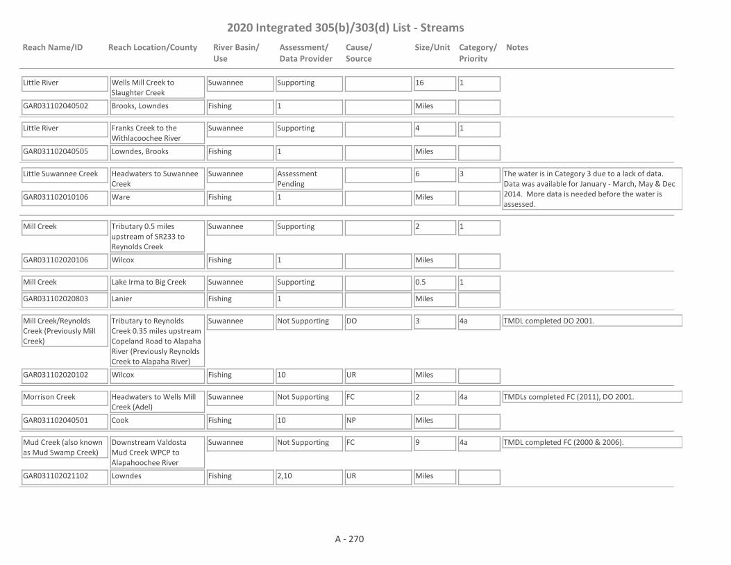
2020 Integrated 305(b)/303(d) List - Streams
Reach Name/ID Reach Location/County River Basin/Use
Assessment/Data Provider
Cause/Source
Size/Unit Category/Priority
Notes
Little River
GAR031102040502 1
Wells Mill Creek to Slaughter Creek
Brooks, Lowndes
Suwannee
Fishing
Supporting 16
Miles
1
Little River
GAR031102040505 1
Franks Creek to the Withlacoochee River
Lowndes, Brooks
Suwannee
Fishing
Supporting 4
Miles
1
Little Suwannee Creek
GAR031102010106 1
Headwaters to Suwannee Creek
Ware
Suwannee
Fishing
Assessment Pending
6
Miles
3 The water is in Category 3 due to a lack of data. Data was available for January - March, May & Dec 2014. More data is needed before the water is assessed.
Mill Creek
GAR031102020106 1
Tributary 0.5 miles upstream of SR233 to Reynolds Creek
Wilcox
Suwannee
Fishing
Supporting 2
Miles
1
Mill Creek
GAR031102020803 1
Lake Irma to Big Creek
Lanier
Suwannee
Fishing
Supporting 0.5
Miles
1
Mill Creek/Reynolds Creek (Previously Mill Creek)
GAR031102020102 10
Tributary to Reynolds Creek 0.35 miles upstream Copeland Road to Alapaha River (Previously Reynolds Creek to Alapaha River)
Wilcox
Suwannee
Fishing
Not Supporting DO 3
Miles
4a TMDL completed DO 2001.
UR
Morrison Creek
GAR031102040501 10
Headwaters to Wells Mill Creek (Adel)
Cook
Suwannee
Fishing
Not Supporting FC 2
Miles
4a TMDLs completed FC (2011), DO 2001.
NP
Mud Creek (also known as Mud Swamp Creek)
GAR031102021102 2,10
Downstream Valdosta Mud Creek WPCP to Alapahoochee River
Lowndes
Suwannee
Fishing
Not Supporting FC 9
Miles
4a TMDL completed FC (2000 & 2006).
UR
A - 270
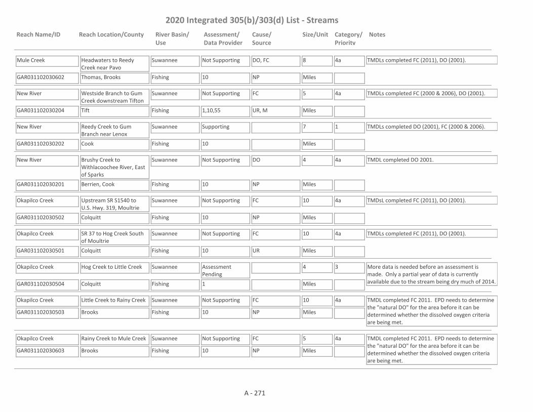
2020 Integrated 305(b)/303(d) List - Streams
Reach Name/ID Reach Location/County River Basin/Use
Assessment/Data Provider
Cause/Source
Size/Unit Category/Priority
Notes
Mule Creek
GAR031102030602 10
Headwaters to Reedy Creek near Pavo
Thomas, Brooks
Suwannee
Fishing
Not Supporting DO, FC 8
Miles
4a TMDLs completed FC (2011), DO (2001).
NP
New River
GAR031102030204 1,10,55
Westside Branch to Gum Creek downstream Tifton
Tift
Suwannee
Fishing
Not Supporting FC 5
Miles
4a TMDLs completed FC (2000 & 2006), DO (2001).
UR, M
New River
GAR031102030202 10
Reedy Creek to Gum Branch near Lenox
Cook
Suwannee
Fishing
Supporting 7
Miles
1 TMDLs completed DO (2001), FC (2000 & 2006).
New River
GAR031102030201 10
Brushy Creek to Withlacoochee River, East of Sparks
Berrien, Cook
Suwannee
Fishing
Not Supporting DO 4
Miles
4a TMDL completed DO 2001.
NP
Okapilco Creek
GAR031102030502 10
Upstream SR S1540 to U.S. Hwy. 319, Moultrie
Colquitt
Suwannee
Fishing
Not Supporting FC 10
Miles
4a TMDsL completed FC (2011), DO (2001).
NP
Okapilco Creek
GAR031102030501 10
SR 37 to Hog Creek South of Moultrie
Colquitt
Suwannee
Fishing
Not Supporting FC 10
Miles
4a TMDLs completed FC (2011), DO (2001).
UR
Okapilco Creek
GAR031102030504 1
Hog Creek to Little Creek
Colquitt
Suwannee
Fishing
Assessment Pending
4
Miles
3 More data is needed before an assessment is made. Only a partial year of data is currently available due to the stream being dry much of 2014.
Okapilco Creek
GAR031102030503 10
Little Creek to Rainy Creek
Brooks
Suwannee
Fishing
Not Supporting FC 10
Miles
4a TMDL completed FC 2011. EPD needs to determine the "natural DO" for the area before it can be determined whether the dissolved oxygen criteria are being met.
NP
Okapilco Creek
GAR031102030603 10
Rainy Creek to Mule Creek
Brooks
Suwannee
Fishing
Not Supporting FC 5
Miles
4a TMDL completed FC 2011. EPD needs to determine the "natural DO" for the area before it can be determined whether the dissolved oxygen criteria are being met.
NP
A - 271

2020 Integrated 305(b)/303(d) List - Streams
Reach Name/ID Reach Location/County River Basin/Use
Assessment/Data Provider
Cause/Source
Size/Unit Category/Priority
Notes
Okapilco Creek
GAR031102030805 10
SR 76, Quitman to Withlacoochee River
Brooks
Suwannee
Fishing
Not Supporting DO 5
Miles
4a TMDLs completed DO (2001) & FC (2006).
NP
Piscola Creek
GAR031102030707 1,10
Downstream Whitlock Branch @ Ozell Road to Dry Lake Creek
Thomas
Suwannee
Fishing
Not Supporting DO, FC 4
Miles
4a TMDLs completed FC (2011), DO (2001).
NP
Piscola Creek
GAR031102030705 1
Headwaters to Tributary 0.3 miles upstream of Pope Road
Thomas
Suwannee
Fishing
Not Supporting FC 3
Miles
5
2021NP
Piscola Creek
GAR031102030706 1
Tributary 0.3 miles upstream of Pope Road to Whitlock Branch
Thomas
Suwannee
Fishing
Not Supporting FC 5
Miles
5
2021
EPD needs to determine the "natural DO" for the area before it can be determined whether the DO criteria is being met.
NP
Piscola Creek
GAR031102030708 1,10
Dry Lake Creek to Allen Branch
Thomas, Brooks
Suwannee
Fishing
Not Supporting DO 9
Miles
4a TMDLs completed FC (2011), DO (2001).
NP
Piscola Creek
GAR031102030704 1,10
Allen Branch to Okapilco Creek near Boston
Brooks
Suwannee
Fishing
Not Supporting FC 13
Miles
4a TMDLs completed FC (2011), DO (2001).
NP
Pride Branch (Formerly Negro Branch)
GAR031102030702 1,10
Headwaters to Piscola Creek, Quitman
Brooks
Suwannee
Fishing
Not Supporting FC, DO 9
Miles
4a TMDL completed DO (2001), FC (1998 & 2006).
NP
Red Oak Creek
GAR031102020207 1,59
Headwaters to Deep Creek
Crisp
Suwannee
Fishing
Not Supporting Bio M 12
Miles
4a TMDL completed Bio M 2017. pH is in Category 3. Only a partial year of data was available to assess as the stream went dry. More data needs to be collected before a decision is made as to whether pH is meeting its criteria.
NP
Redland Creek
GAR031102030803 59
Headwaters to Withlacoochee River
Lowndes
Suwannee
Fishing
Supporting 4
Miles
1
A - 272
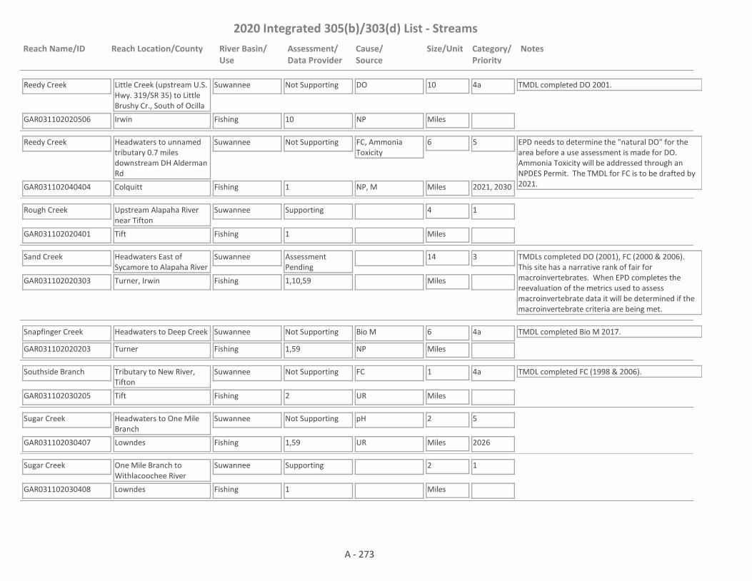
2020 Integrated 305(b)/303(d) List - Streams
Reach Name/ID Reach Location/County River Basin/Use
Assessment/Data Provider
Cause/Source
Size/Unit Category/Priority
Notes
Reedy Creek
GAR031102020506 10
Little Creek (upstream U.S. Hwy. 319/SR 35) to Little Brushy Cr., South of Ocilla
Irwin
Suwannee
Fishing
Not Supporting DO 10
Miles
4a TMDL completed DO 2001.
NP
Reedy Creek
GAR031102040404 1
Headwaters to unnamed tributary 0.7 miles downstream DH Alderman Rd
Colquitt
Suwannee
Fishing
Not Supporting FC, Ammonia Toxicity
6
Miles
5
2021, 2030
EPD needs to determine the "natural DO" for the area before a use assessment is made for DO. Ammonia Toxicity will be addressed through an NPDES Permit. The TMDL for FC is to be drafted by 2021.NP, M
Rough Creek
GAR031102020401 1
Upstream Alapaha River near Tifton
Tift
Suwannee
Fishing
Supporting 4
Miles
1
Sand Creek
GAR031102020303 1,10,59
Headwaters East of Sycamore to Alapaha River
Turner, Irwin
Suwannee
Fishing
Assessment Pending
14
Miles
3 TMDLs completed DO (2001), FC (2000 & 2006). This site has a narrative rank of fair for macroinvertebrates. When EPD completes the reevaluation of the metrics used to assess macroinvertebrate data it will be determined if the macroinvertebrate criteria are being met.
Snapfinger Creek
GAR031102020203 1,59
Headwaters to Deep Creek
Turner
Suwannee
Fishing
Not Supporting Bio M 6
Miles
4a TMDL completed Bio M 2017.
NP
Southside Branch
GAR031102030205 2
Tributary to New River, Tifton
Tift
Suwannee
Fishing
Not Supporting FC 1
Miles
4a TMDL completed FC (1998 & 2006).
UR
Sugar Creek
GAR031102030407 1,59
Headwaters to One Mile Branch
Lowndes
Suwannee
Fishing
Not Supporting pH 2
Miles
5
2026UR
Sugar Creek
GAR031102030408 1
One Mile Branch to Withlacoochee River
Lowndes
Suwannee
Fishing
Supporting 2
Miles
1
A - 273

2020 Integrated 305(b)/303(d) List - Streams
Reach Name/ID Reach Location/County River Basin/Use
Assessment/Data Provider
Cause/Source
Size/Unit Category/Priority
Notes
Suwannee Canal
GAR031102010101 1
Okefenokee Swamp
Charlton, Ware
Suwannee
Fishing
Not Supporting Fish Tissue (Mercury)
27
Miles
4a TMDL completed Fish Tissue (Mercury) 2002.
NP
Suwannee Creek
GAR031102010104 10,71
Headwaters to Little Suwannee Creek near Manor
Clinch, Ware
Suwannee
Fishing
Not Supporting DO 16
Miles
4a TMDL completed DO 2001.
NP
Suwannee Creek
GAR031102010105 55
Little Suwannee Creek to Water Oak Creek
Ware
Suwannee
Fishing
Assessment Pending
10
Miles
3 EPD needs to determine the "natural DO" for the area before a use assessment is made.
Suwannee River
GAR031102010501 1,9,10
Mainstem-Suwannee Canal to Stateline
Charlton, Ware, Clinch, Echols
Suwannee
Fishing
Not Supporting Fish Tissue (Mercury)
40
Miles
4a TMDL completed Fish Tissue (Mercury) 2002.
NP
Suwannoochee Creek
GAR031102010302 1,10
Bear Branch to Lees Bay
Clinch
Suwannee
Fishing
Supporting 30
Miles
1 TMDL completed DO 2001.
Suwannoochee Creek
GAR031102010301 1,10,55
Lees Bay to Suwannee River
Clinch
Suwannee
Fishing
Not Supporting Pb 11
Miles
4a TMDL completed DO (2001), Cd (2000) & Pb (2018).
NP
Tatum Creek
GAR031102010202 55
Dickerson Millpond to Tower Road
Clinch
Suwannee
Fishing
Not Supporting FC 6
Miles
4a TMDL completed FC 2011. EPD needs to determine the "natural DO" for the area before it can be determined whether the dissolved oxygen criteria are being met.
NP
Tatum Creek
GAR031102010201 10
Tower Road to Jones Creek
Clinch
Suwannee
Fishing
Not Supporting DO 11
Miles
4a TMDL completed DO 2001.
NP
Tenmile Creek
GAR031102020802 1,10
Averys Millpond to Big Creek near Nashville
Berrien, Lanier
Suwannee
Fishing
Supporting 9
Miles
1 TMDL completed DO 2001.
A - 274

2020 Integrated 305(b)/303(d) List - Streams
Reach Name/ID Reach Location/County River Basin/Use
Assessment/Data Provider
Cause/Source
Size/Unit Category/Priority
Notes
Toms Creek
GAR031102010502 1,10
Headwaters to Stateline
Echols
Suwannee
Fishing
Supporting 23
Miles
1 TMDL completed DO 2001.
Town Creek
GAR031102040305 10
Headwaters to Warrior Creek near Sylvester
Worth
Suwannee
Fishing
Not Supporting DO 9
Miles
4a TMDL completed DO 2001.
UR
Tributary to Alapaha River #5
GAR031102020103 59
Headwaters to the Alapaha River
Wilcox
Suwannee
Fishing
Assessment Pending
2
Miles
3 This site has a narrative rank of fair for macroinvertebrates. Waters with a narrative rank of fair will remain in Category 3 until EPD completes the reevaluation of the metrics used to assess macroinvertebrate data.
Tributary to Cherry Creek
GAR031102030410 1
Oak Street Subdivision WPCP to unnamed tributary 0.4 miles downstream Lake Laurie Drive
Lowndes
Suwannee
Fishing
Not Supporting DO, Ammonia Toxicity
0.3
Miles
5
2026, 2030
Ammonia toxicity will be addressed through an NPDES Permit. The TMDL for DO is to be drafted by 2026.
NP, M
Tributary to Franks Creek
GAR031102040504 1
Pond 780 feet upstream of Union Road to Franks Creek
Lowndes
Suwannee
Fishing
Not Supporting DO, Ammonia Toxicity
1
Miles
5
2026, 2030
Ammonia toxicity will be addressed through an NPDES Permit. TMDL for DO to be drafted by 2026.
NP, M
Tributary to Hat Creek
GAR031102020306 1
Headwaters to Hat Creek
Turner
Suwannee
Fishing
Assessment Pending
1
Miles
3 EPD needs to determine the "natural DO" for the area before a use assessment is made. In addition, the stream was dry from June - Ocober 2015 and more data is needed.
Tributary to Little Creek
GAR031102030507 1
Headwaters to Little Creek
Colquitt
Suwannee
Fishing
Not Supporting FC 2
Miles
5
2021
EPD needs to determine the "natural DO" for the area before it can be determined whether the dissolved oxygen criteria are being met.NP
Tributary to Little River
GAR031102040108 1
Headwaters to Little River
Turner
Suwannee
Fishing
Supporting 3
Miles
1
A - 275
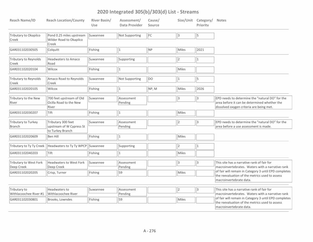
2020 Integrated 305(b)/303(d) List - Streams
Reach Name/ID Reach Location/County River Basin/Use
Assessment/Data Provider
Cause/Source
Size/Unit Category/Priority
Notes
Tributary to Okapilco Creek
GAR031102030505 1
Pond 0.25 miles upstream Wilder Road to Okapilco Creek
Colquitt
Suwannee
Fishing
Not Supporting FC 3
Miles
5
2021NP
Tributary to Reynolds Creek
GAR031102020104 1
Headwaters to Amaco Road
Wilcox
Suwannee
Fishing
Supporting 2
Miles
1
Tributary to Reynolds Creek
GAR031102020105 1
Amaco Road to Reynolds Creek
Wilcox
Suwannee
Fishing
Not Supporting DO 1
Miles
5
2026NP, M
Tributary to the New River
GAR031102030207 1
700 feet upstream of Old Ocilla Road to the New River
Tift
Suwannee
Fishing
Assessment Pending
3
Miles
3 EPD needs to determine the "natural DO" for the area before it can be determined whether the dissolved oxygen criteria are being met.
Tributary to Turkey Branch
GAR031102020609 1
Tributary 300 feet upstream of W Cypress St to Turkey Branch
Ben Hill
Suwannee
Fishing
Assessment Pending
2
Miles
3 EPD needs to determine the "natural DO" for the area before a use assessment is made.
Tributary to Ty Ty Creek
GAR031102040203 1
Headwaters to Ty Ty WPCP
Tift
Suwannee
Fishing
Supporting 2
Miles
1
Tributary to West Fork Deep Creek
GAR031102020205 59
Headwaters to West Fork Deep Creek
Crisp, Turner
Suwannee
Fishing
Assessment Pending
3
Miles
3 This site has a narrative rank of fair for macroinvertebrates. Waters with a narrative rank of fair will remain in Category 3 until EPD completes the reevaluation of the metrics used to assess macroinvertebrate data.
Tributary to Withlacoochee River #1
GAR031102030801 59
Headwaters to Withlacoochee River
Brooks, Lowndes
Suwannee
Fishing
Assessment Pending
2
Miles
3 This site has a narrative rank of fair for macroinvertebrates. Waters with a narrative rank of fair will remain in Category 3 until EPD completes the reevaluation of the metrics used to assess macroinvertebrate data.
A - 276

2020 Integrated 305(b)/303(d) List - Streams
Reach Name/ID Reach Location/County River Basin/Use
Assessment/Data Provider
Cause/Source
Size/Unit Category/Priority
Notes
Tributary to Withlacoochee River #2
GAR031102030804 1,59
Headwaters to Withlacoochee River
Lowndes
Suwannee
Fishing
Not Supporting FC 5
Miles
4a TMDL completed FC 2015. This site has a narrative rank of fair for macroinvertebrates. When EPD completes the reevaluation of the metrics used to assess macroinvertebrate data it will be determined if the macroinvertebrate criteria are being met. EPD needs to determine the "natural DO" for the area before it can be determined whether the dissolved oxygen criteria are being met.
NP
Tributary to Withlacoochee River #3
GAR031102030302 1,71
Upstream Morris Pond, Nashville
Berrien
Suwannee
Fishing
Not Supporting DO 2
Miles
4a TMDL completed DO 2001.
NP
Turkey Branch
GAR031102020605 1,2,10
Headwaters to Willacoochee River downstream Fitzgerald
Ben Hill
Suwannee
Fishing
Not Supporting Algae, DO, FC 8
Miles
4a, 5
2026
TMDLs completed FC (2000 & 2006), DO (2000), Fish Tissue (Mercury) (2002), Cd (2000), Cu (2000), Pb (2000), Zn (2000), Tox (2000).
NP, UR
Two Mile Branch
GAR031102030402 2,62
Headwaters to Sugar Creek, Valdosta
Lowndes
Suwannee
Fishing
Not Supporting FC 2
Miles
4a TMDL completed FC (1998 & 2006).
UR
Ty Ty Creek
GAR031102040202 1,10
Little Creek near Ty Ty to Tucker Creek near Omega
Worth, Tift
Suwannee
Fishing
Not Supporting FC, DO 10
Miles
4a TMDLs completed FC (2000 & 2006), DO (2001).
NP
Ty Ty Creek
GAR031102040201 1,10
Tucker Creek to Warrior Creek near Omega
Colquitt
Suwannee
Fishing
Not Supporting DO 9
Miles
4a TMDL completed DO 2001.
NP
Warrior Creek
GAR031102040306 59
Headwaters to Town creek
Worth
Suwannee
Fishing
Assessment Pending
12
Miles
3 This site has a narrative rank of fair for macroinvertebrates. Waters with a narrative rank of fair will remain in Category 3 until EPD completes the reevaluation of the metrics used to assess macroinvertebrate data.
Warrior Creek
GAR031102040303 10
Briar Creek to Horse Creek
Worth
Suwannee
Fishing
Supporting 3
Miles
1
A - 277

2020 Integrated 305(b)/303(d) List - Streams
Reach Name/ID Reach Location/County River Basin/Use
Assessment/Data Provider
Cause/Source
Size/Unit Category/Priority
Notes
Warrior Creek
GAR031102040302 1,10
Horse Creek to Rock Creek near Norman Park
Worth, Colquitt
Suwannee
Fishing
Not Supporting FC, DO 10
Miles
4a TMDLs completed FC (2011), DO (2001).
NP
Warrior Creek
GAR031102040301 10
Rock Creek to Ty Ty Creek near Norman Park
Colquitt
Suwannee
Fishing
Supporting 8
Miles
1 TMDL completed DO 2001.
West Fork Deep Creek
GAR031102020202 1,10
Downstream SR S1798 to downstream SR 159 North of Ashburn
Turner
Suwannee
Fishing
Not Supporting DO 1
Miles
4a TMDL completed DO 2001.
NP
Westside Branch
GAR031102030206 1,2,62
Tributary to New River, Tifton (Previously Tributary to Little River)
Tift
Suwannee
Fishing
Not Supporting FC 2
Miles
4a TMDL completed FC (1998 & 2006). EPD needs to determine the "natural DO" for the area before it can be determined whether the dissolved oxygen criteria are being met.UR
Willacoochee River
GAR031102020608 1
Courthouse Branch to Turkey Branch
Ben Hill, Irwin
Suwannee
Fishing
Not Supporting FC 5
Miles
5
2021
EPD needs to determine the "natural DO" for the area before it can be determined whether the dissolved oxygen criteria are being met.NP
Willacoochee River
GAR031102020610 1,10
Turkey Branch to tributary 0.4 miles upstream of Frank Road
Irwin
Suwannee
Fishing
Not Supporting FC, DO 3
Miles
4a TMDL completed DO 2001 & FC 2016.
NP
Willacoochee River
GAR031102020611 1,10
Tributary 0.4 miles upstream of Frank Road to SR 90
Irwin
Suwannee
Fishing
Not Supporting FC 11
Miles
4a TMDL completed DO 2001 & FC 2016.
NP
Willacoochee River
GAR031102020606 1,10
SR 158 to Alapaha River
Berrien
Suwannee
Fishing
Not Supporting FC, DO 11
Miles
4a TMDL completed FC (2011), DO (2001).
NP
Withlacoochee River
GAR031102030101 10
Headwaters (Hardy Mill Creek) to New River
Berrien
Suwannee
Fishing
Not Supporting Fish Tissue (Mercury), DO
17
Miles
4a TMDLs completed FC (2011), DO (2001), Fish Tissue (Mercury) (2002)
NP
A - 278
2020 Integrated 305(b)/303(d) List - Streams
Reach Name/ID Reach Location/County River Basin/Use
Assessment/Data Provider
Cause/Source
Size/Unit Category/Priority
Notes
Withlacoochee River
GAR031102030403 1,9
New River to Bay Branch
Cook, Berrien, Lowndes
Suwannee
Fishing
Not Supporting Fish Tissue (Mercury), FC
23
Miles
4a TMDL completed Fish Tissue (Mercury) 2002 & FC 2016. EPD needs to determine the "natural DO" for the area before it can be determined whether the dissolved oxygen criteria are being met.
NP
Withlacoochee River
GAR031102030401 1,9,10
Bay Branch to Little River
Lowndes
Suwannee
Fishing
Not Supporting Fish Tissue (Mercury), FC
9
Miles
4a TMDLs completed FC (2000 & 2006), Fish Tissue (Mercury) (2002).
NP
Withlacoochee River
GAR031102030806 1,10
Little River to Okapilco Creek
Brooks, Lowndes
Suwannee
Fishing
Not Supporting Fish Tissue (Mercury), FC, Pb
15
Miles
4a TMDL completed Fish Tissue (Mercury) 2002, FC 2016 & Pb 2017.
NP
Withlacoochee River
GAR031102030902 10
Okapilco Creek to Stateline
Brooks, Lowndes
Suwannee
Fishing
Not Supporting Fish Tissue (Mercury)
14
Miles
4a TMDL completed Fish Tissue (Mercury) 2002.
NP
Withlacoochee River
GAR031102030904 1
Stateline to Stateline near GA Hwy 31
Lowndes
Suwannee
Fishing
Supporting 3
Miles
1
Wolf Creek
GAR031102020204 1,59
Headwaters to Deep Creek
Turner
Suwannee
Fishing
Assessment Pending
6
Miles
3 This site has a narrative rank of fair for macroinvertebrates. Waters with a narrative rank of fair will remain in Category 3 until EPD completes the reevaluation of the metrics used to assess macroinvertebrate data.
Allen Creek
GAR031501080510 4
Hollingsworth Lake to Little Tallapoosa River
Carroll
Tallapoosa
Fishing
Not Supporting Bio F 4
Miles
5
2023NP
Baxter Creek
GAR031501080102 2
Bremen to Little River
Haralson
Tallapoosa
Fishing
Supporting 2
Miles
1
Beach Creek
GAR031501080202 4
Headwaters to Tallapoosa River
Haralson
Tallapoosa
Fishing, Drinking Water
Assessment Pending
8
Miles
2 The water is supporting its Fishing Use. Data are not available to assess the Drinking Water Use.
A - 279

2020 Integrated 305(b)/303(d) List - Streams
Reach Name/ID Reach Location/County River Basin/Use
Assessment/Data Provider
Cause/Source
Size/Unit Category/Priority
Notes
Big Creek
GAR031501080208 4
Little Creek to Lassetter Creek
Haralson
Tallapoosa
Fishing
Supporting 4
Miles
1
Big Creek
GAR031501080209 4,59
Lassetter Creek to Tallapoosa River
Haralson
Tallapoosa
Fishing
Assessment Pending
1
Miles
3 This site has a narrative rank of fair for macroinvertebrates. When EPD completes the reevaluation of the metrics used to assess macroinvertebrate data it will be determined if the macroinvertebrate criteria are being met.
Blalock Creek
GAR031501080306 4
Headwaters to Walker Creek
Haralson, Carroll
Tallapoosa
Fishing
Supporting 6
Miles
1
Brooks Creek
GAR031501080103 4
Headwaters to Tallapoosa River
Carroll, Haralson
Tallapoosa
Fishing
Supporting 10
Miles
1
Buck Creek
GAR031501080508 4
Cantrell Lake to Little Buck Creek
Carroll
Tallapoosa
Fishing
Supporting 7
Miles
1
Buck Creek
GAR031501080506 4
Little Buck Creek to Bear Creek
Carroll
Tallapoosa
Fishing
Supporting 3
Miles
1
Buck Creek
GAR031501080504 10
Bear Creek to Little Tallapoosa River
Carroll
Tallapoosa
Fishing
Not Supporting FC 3
Miles
4a TMDL completed FC 2009.
NP
Buffalo Creek
GAR031501080602 1,4,10,54
Downstream Southwire Corp.
Carroll
Tallapoosa
Fishing
Not Supporting FC, Bio F 3
Miles
4a TMDLs completed Cu 2004 (revised 2018), Bio F 2009 & FC 2009.
UR, I2
Buffalo Creek
GAR031501080601 10,54
Upstream Little Tallapoosa River
Carroll
Tallapoosa
Fishing
Not Supporting DO, FC, Cu 6
Miles
4a, 5
2023
TMDLs completed FC 2004, Cu 2004 (revised 2018).
UR
A - 280

2020 Integrated 305(b)/303(d) List - Streams
Reach Name/ID Reach Location/County River Basin/Use
Assessment/Data Provider
Cause/Source
Size/Unit Category/Priority
Notes
Cochran Creek
GAR031501080104 1,4,6
Headwaters to the Tallapoosa River
Haralson
Tallapoosa
Fishing
Supporting 6
Miles
1
Flat Wood Creek
GAR031501080210 4
Headwaters to the Tallapoosa River
Haralson
Tallapoosa
Fishing
Supporting 5
Miles
1
Garrett Creek
GAR031501080608 4
Headwaters to the Little Tallapoosa River
Carroll
Tallapoosa
Fishing
Supporting 4
Miles
1
Greene Creek
GAR031501080206 1,4,59
American Legion Lake to Tallapoosa River
Haralson
Tallapoosa
Fishing
Not Supporting Bio M 4
Miles
4a TMDL completed Bio M 2016.
NP
Harris Creek
GAR031501080207 4
Headwaters to Beach Creek
Haralson
Tallapoosa
Fishing
Supporting 4
Miles
1
Holcomb Creek
GAR031501080211 4
Headwaters to Beach Creek
Haralson
Tallapoosa
Fishing
Supporting 4
Miles
1
Indian Creek
GAR031501080605 4
Headwaters to Little Tallapoosa River near Roopville
Carroll
Tallapoosa
Fishing
Supporting 3
Miles
1 TMDL completed Bio F 2009.
Indian Creek
GAR031501080704 4
Headwaters to Turkey Creek
Carroll
Tallapoosa
Fishing
Not Supporting Bio F 7
Miles
4a TMDL completed Bio F 2009.
NP
A - 281
2020 Integrated 305(b)/303(d) List - Streams
Reach Name/ID Reach Location/County River Basin/Use
Assessment/Data Provider
Cause/Source
Size/Unit Category/Priority
Notes
Indian Creek
GAR031501080701 1,10
Downstream Brickyard Road to Little Tallapoosa River near Bowdon
Carroll
Tallapoosa
Fishing
Not Supporting FC 6
Miles
4a TMDL completed FC 2009. EPD believes that our pH probes may have been providing falsely low values at times in 2017 and 2018. Waters that would normally be listed as impaired for low pH are being placed in Category 3 while EPD determines if observed low pH is due to issues with the pH probes; whether low pH may be natural due to low alkalinity; or whether the water is actually impaired for low pH.
NP
Lassetter Creek
GAR031501080203 4
Headwaters to Big Creek (formerly Headwaters to Tallapoosa River)
Haralson
Tallapoosa
Fishing
Supporting 3
Miles
1
Little River
GAR031501080110 10
Baxter Creek to Tallapoosa River
Haralson
Tallapoosa
Fishing
Not Supporting FC 10
Miles
4a TMDL completed FC 2009.
NP
Little Tallapoosa River
GAR031501080502 1,4
Little Tallapoosa Lake to Sharpe Creek
Carroll
Tallapoosa
Fishing
Not Supporting Bio F, FC 7
Miles
4a, 5
2023
TMDL completed Bacteria (FC) 2019.
NP
Little Tallapoosa River
GAR031501080505 1,9,10
Sharpe Creek to Buck Creek
Carroll
Tallapoosa
Drinking Water, Fishing
Not Supporting FC, Bio M 11
Miles
4a TMDL completed Bio M (2004) & FC (2009).
NP
Little Tallapoosa River
GAR031501080606 1,6
Buck Creek to Buffalo Creek
Carroll
Tallapoosa
Fishing
Supporting 11
Miles
1
Little Tallapoosa River
GAR031501080603 1,9,10
Buffalo Creek to Stateline
Carroll
Tallapoosa
Fishing
Not Supporting Bio M, FC 14
Miles
4a TMDLs completed FC (2004) & Bio M (2004).
UR
Little Turkey Creek
GAR031501080703 4
Headwaters to Turkey Creek
Carroll
Tallapoosa
Fishing
Not Supporting Bio F 5
Miles
4a TMDL completed Bio F (2009).
NP, UR
A - 282
2020 Integrated 305(b)/303(d) List - Streams
Reach Name/ID Reach Location/County River Basin/Use
Assessment/Data Provider
Cause/Source
Size/Unit Category/Priority
Notes
Mann Creek
GAR031501080204 4,59
Tributary to the Tallapoosa River
Haralson
Tallapoosa
Fishing
Assessment Pending
6
Miles
3 This site has a narrative rank of fair for macroinvertebrates. When EPD completes the reevaluation of the metrics used to assess macroinvertebrate data it will be determined if the macroinvertebrate criteria are being met.
Mountain Creek
GAR031501080607 59
Headwaters to Little Tallapoosa River
Heard, Carroll
Tallapoosa
Fishing
Assessment Pending
7
Miles
3 This site has a narrative rank of fair for macroinvertebrates. Waters with a narrative rank of fair will remain in Category 3 until EPD completes the reevaluation of the metrics used to assess macroinvertebrate data.
Mud Branch
GAR031501080509 1
Tributary at Villa Rica Tallapoosa West WPCP to Little Tallapoosa River
Carroll
Tallapoosa
Fishing
Not Supporting DO, FC 1
Miles
5
2023
Sources for DO are M and UR. Source for FC is UR.
UR, M
Mud Creek
GAR031501080105 4
Headwaters to Tallapoosa River
Carroll, Paulding
Tallapoosa
Fishing
Not Supporting Bio F 5
Miles
4a TMDL completed Bio F 2009.
NP
Panther Creek
GAR031501080114 4
Headwaters to Brooks Creek
Haralson
Tallapoosa
Fishing
Supporting 3
Miles
1
Pine Tucky Branch
GAR031501080609 4
Headwaters to Boyles Branch
Carroll
Tallapoosa
Fishing
Supporting 2
Miles
1
Swinney Branch
GAR031501080106 1,4,59
Headwaters to Tallapoosa River
Haralson, Polk
Tallapoosa
Fishing
Not Supporting Bio F, Bio M 5
Miles
4a TMDL completed Bio F 2009 & Bio M 2016.
NP
Tallapoosa River
GAR031501080107 4
McClendon Creek to Water Mill Creek
Paulding, Haralson
Tallapoosa
Drinking Water, Fishing
Assessment Pending
7
Miles
2 The water is supporting its Fishing Use. Data are not available to assess the Drinking Water Use.
A - 283
2020 Integrated 305(b)/303(d) List - Streams
Reach Name/ID Reach Location/County River Basin/Use
Assessment/Data Provider
Cause/Source
Size/Unit Category/Priority
Notes
Tallapoosa River
GAR031501080111 1,4,10
Water Mill Creek to Little River
Haralson
Tallapoosa
Fishing
Not Supporting DO 9
Miles
5
2023
TMDL completed FC 2004.
NP
Tallapoosa River
GAR031501080205 10
Little River to Beach Creek
Haralson
Tallapoosa
Fishing
Not Supporting FC 12
Miles
4a TMDL completed FC 2004.
NP
Tallapoosa River
GAR031501080301 1,10
Hwy 100 to Stateline
Haralson
Tallapoosa
Fishing, Drinking Water
Not Supporting FC 10
Miles
4a TMDL completed FC 2004.
NP
Thomasson Creek
GAR031501080108 4
Confluence of Rabbit Branch and Caney Branch to Water Mill Creek
Haralson, Paulding
Tallapoosa
Fishing
Supporting 4
Miles
1
Trestle Creek
GAR031501080503 6
Temple
Carroll
Tallapoosa
Fishing
Supporting 2
Miles
1
Tributary to Baxter Creek
GAR031501080101 2
Bremen
Haralson
Tallapoosa
Fishing
Not Supporting FC 1
Miles
4a TMDL completed FC 1998.
UR
Tributary to Bear Creek
GAR031501080511 4
Headwaters to Bear Creek
Carroll
Tallapoosa
Fishing
Not Supporting Bio F 2
Miles
5
2023NP
Tributary to Buck Creek
GAR031501080507 1,4
1 mile downstream of Headwaters to Buck Creek
Haralson
Tallapoosa
Fishing
Not Supporting FC 4
Miles
5
2023NP, UR
Tributary to Buck Creek
GAR031501080501 2,4
Headwaters to 1 mile downstream of Headwaters in Bremen
Haralson
Tallapoosa
Fishing
Not Supporting FC 1
Miles
4a TMDL completed FC 1998.
UR
A - 284
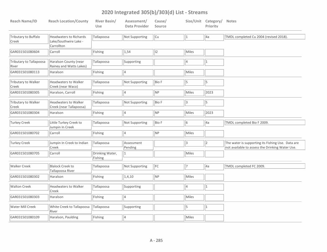
2020 Integrated 305(b)/303(d) List - Streams
Reach Name/ID Reach Location/County River Basin/Use
Assessment/Data Provider
Cause/Source
Size/Unit Category/Priority
Notes
Tributary to Buffalo Creek
GAR031501080604 1,54
Headwaters to Richards Lake/Southwire Lake - Carrollton
Carroll
Tallapoosa
Fishing
Not Supporting Cu 1
Miles
4a TMDL completed Cu 2004 (revised 2018).
I2
Tributary to Tallapoosa River
GAR031501080113 4
Haralson County (near Rainey and Watts Lakes)
Haralson
Tallapoosa
Fishing
Supporting 4
Miles
1
Tributary to Walker Creek
GAR031501080305 4
Headwaters to Walker Creek (near Waco)
Haralson, Carroll
Tallapoosa
Fishing
Not Supporting Bio F 5
Miles
5
2023NP
Tributary to Walker Creek
GAR031501080304 4
Headwaters to Walker Creek (near Tallapoosa)
Haralson
Tallapoosa
Fishing
Not Supporting Bio F 3
Miles
5
2023NP
Turkey Creek
GAR031501080702 4
Little Turkey Creek to Jumpin In Creek
Carroll
Tallapoosa
Fishing
Not Supporting Bio F 6
Miles
4a TMDL completed Bio F 2009.
NP
Turkey Creek
GAR031501080705 1
Jumpin In Creek to Indian Creek
Carroll
Tallapoosa
Drinking Water, Fishing
Assessment Pending
3
Miles
2 The water is supporting its Fishing Use. Data are not available to assess the Drinking Water Use.
Walker Creek
GAR031501080302 1,4,10
Blalock Creek to Tallapoosa River
Haralson
Tallapoosa
Fishing
Not Supporting FC 7
Miles
4a TMDL completed FC 2009.
NP
Walton Creek
GAR031501080303 4
Headwaters to Walker Creek
Haralson
Tallapoosa
Fishing
Supporting 4
Miles
1
Water Mill Creek
GAR031501080109 4
White Creek to Tallapoosa River
Haralson, Paulding
Tallapoosa
Fishing
Supporting 5
Miles
1
A - 285

2020 Integrated 305(b)/303(d) List - Streams
Reach Name/ID Reach Location/County River Basin/Use
Assessment/Data Provider
Cause/Source
Size/Unit Category/Priority
Notes
White Creek
GAR031501080112 4
Headwaters to Water Mill Creek
Paulding
Tallapoosa
Fishing
Supporting 2
Miles
1
Allison Creek
GAR060200011108 4
Headwaters to Lookout Creek
Dade
Tennessee
Fishing
Supporting 2
Miles
1
Anderson Creek
GAR060200020516 4
Headwaters to Coosa Creek
Union
Tennessee
Fishing
Not Supporting Bio F 3
Miles
4a TMDL completed Bio F 2016.
NP
Arkaqua Creek
GAR060200020505 1,4,13
Pine Ridge Road to Nottely River
Union
Tennessee
Fishing
Not Supporting Bio F 4
Miles
4a TMDL completed Bio F 2016.
NP
Back Valley Creek
GAR060200010815 4
Harris Lake Dam to Mill Creek
Walker
Tennessee
Fishing
Supporting 1
Miles
1
Bear Creek
GAR060200011116 1,59
Price Branch to Daniels Creek
Dade
Tennessee
Fishing
Supporting 2
Miles
1
Bearmeat Creek
GAR060200020101 13
Tributary to Hiawassee River (aka Hiwassee River)
Towns
Tennessee
Fishing
Not Supporting Bio F 2
Miles
4a TMDL completed Bio F 2004.
NP
Betty Creek
GAR060102020102 1,4
Barkers Creek to Little Tennessee River
Rabun
Tennessee
Fishing
Supporting 5
Miles
1
Big Creek
GAR060200030101 4,13
Tributary to Toccoa River
Gilmer, Fannin
Tennessee
Fishing
Supporting 9
Miles
1
A - 286

2020 Integrated 305(b)/303(d) List - Streams
Reach Name/ID Reach Location/County River Basin/Use
Assessment/Data Provider
Cause/Source
Size/Unit Category/Priority
Notes
Big Spring Branch (aka Higdon Creek)
GAR060300010201 1,59
Harris Creek to Stateline (Formerly Higdon Creek to Stateline)
Dade
Tennessee
Fishing
Not Supporting Bio M 1
Miles
4a TMDL completed Bio M 2016.
NP
Bitter Creek
GAR060200020303 1,4
Headwaters to Brasstown Creek
Union
Tennessee
Fishing
Not Supporting Bio F 3
Miles
4a TMDL completed Bio F 2016.
NP
Black Branch
GAR060200010925 1,4,59
Van Cleve St., Ft. Oglethorpe to Spring Creek
Catoosa
Tennessee
Fishing
Not Supporting Bio F, Bio M 3
Miles
4a TMDLs completed Bio F 2009 & Bio M 2016.
NP
Brasstown Creek
GAR060200020307 4,10
Little Bald Cove to Yewell Branch
Union, Towns
Tennessee
Fishing
Not Supporting FC, Bio F 4
Miles
4a TMDLs completed FC 1998 & Bio F 2016.
NP
Brasstown Creek
GAR060200020306 1,4,13
Yewell Branch to State Line
Towns
Tennessee
Fishing
Not Supporting FC 7
Miles
4a TMDL completed FC 1998.
NP
Bryan Creek
GAR060200030209 1,59
Headwaters to Hemptown Creek
Fannin
Tennessee
Fishing
Not Supporting pH 3
Miles
5
2028NP
Bryant Creek
GAR060200030102 4
Headwaters to Cooper Creek
Union
Tennessee
Fishing
Supporting 3
Miles
1
Butler Creek
GAR060200020602 1,13
Tributary to Nottely River
Union
Tennessee
Fishing
Supporting 3
Miles
1
Butternut Creek
GAR060200020502 13
Tributary to Nottely Lake - Blairsville
Union
Tennessee
Fishing
Not Supporting Bio F, FC 2
Miles
4a TMDLs completed Bio F 2004, FC 2004.
NP
Canada Creek
GAR060200030103 4,13
Wildhog creek to the Toccoa River
Union
Tennessee
Fishing
Not Supporting Bio F 2
Miles
5
2023NP
A - 287
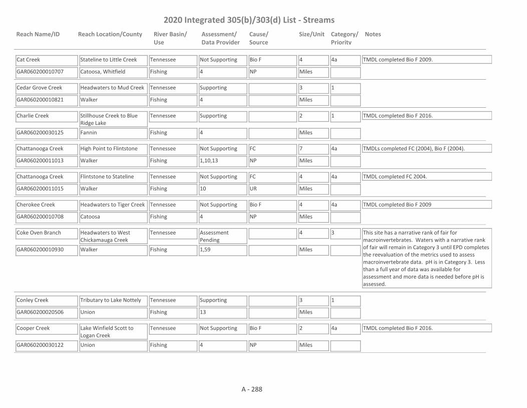
2020 Integrated 305(b)/303(d) List - Streams
Reach Name/ID Reach Location/County River Basin/Use
Assessment/Data Provider
Cause/Source
Size/Unit Category/Priority
Notes
Cat Creek
GAR060200010707 4
Stateline to Little Creek
Catoosa, Whitfield
Tennessee
Fishing
Not Supporting Bio F 4
Miles
4a TMDL completed Bio F 2009.
NP
Cedar Grove Creek
GAR060200010821 4
Headwaters to Mud Creek
Walker
Tennessee
Fishing
Supporting 3
Miles
1
Charlie Creek
GAR060200030125 4
Stillhouse Creek to Blue Ridge Lake
Fannin
Tennessee
Fishing
Supporting 2
Miles
1 TMDL completed Bio F 2016.
Chattanooga Creek
GAR060200011013 1,10,13
High Point to Flintstone
Walker
Tennessee
Fishing
Not Supporting FC 7
Miles
4a TMDLs completed FC (2004), Bio F (2004).
NP
Chattanooga Creek
GAR060200011015 10
Flintstone to Stateline
Walker
Tennessee
Fishing
Not Supporting FC 4
Miles
4a TMDL completed FC 2004.
UR
Cherokee Creek
GAR060200010708 4
Headwaters to Tiger Creek
Catoosa
Tennessee
Fishing
Not Supporting Bio F 4
Miles
4a TMDL completed Bio F 2009
NP
Coke Oven Branch
GAR060200010930 1,59
Headwaters to West Chickamauga Creek
Walker
Tennessee
Fishing
Assessment Pending
4
Miles
3 This site has a narrative rank of fair for macroinvertebrates. Waters with a narrative rank of fair will remain in Category 3 until EPD completes the reevaluation of the metrics used to assess macroinvertebrate data. pH is in Category 3. Less than a full year of data was available for assessment and more data is needed before pH is assessed.
Conley Creek
GAR060200020506 13
Tributary to Lake Nottely
Union
Tennessee
Fishing
Supporting 3
Miles
1
Cooper Creek
GAR060200030122 4
Lake Winfield Scott to Logan Creek
Union
Tennessee
Fishing
Not Supporting Bio F 2
Miles
4a TMDL completed Bio F 2016.
NP
A - 288

2020 Integrated 305(b)/303(d) List - Streams
Reach Name/ID Reach Location/County River Basin/Use
Assessment/Data Provider
Cause/Source
Size/Unit Category/Priority
Notes
Cooper Creek
GAR060200030123 4
Logan Creek to Bryant Creek
Union
Tennessee
Fishing
Not Supporting Bio F 5
Miles
4a TMDL completed Bio F 2016.
NP
Cooper Creek
GAR060200030121 4
Bryant Creek to unnamed tributary approx 0.5 mi d/s Union County Line
Union, Fannin
Tennessee
Fishing
Supporting 5
Miles
1
Cooper Creek
GAR060200030105 1,4,10,13
Tributary to Toccoa River (beginning approx 0.5 mi d/s Union Co. Line)
Fannin
Tennessee
Fishing
Supporting 3
Miles
1 TMDL completed FC 2009.
Coosa Creek
GAR060200020517 4
Headwaters to East Fork Coosa Creek
Union
Tennessee
Fishing
Supporting 4
Miles
1
Coosa Creek
GAR060200020515 1,13
Anderson Creek to Nottely Lake
Union
Tennessee
Fishing
Not Supporting Bio F 1
Miles
4a TMDL completed Bio F 2016.
NP
Corbin Creek
GAR060200020103 4
Headwaters to Hiawassee River (aka Hiwassee River)
Towns
Tennessee
Fishing
Supporting 5
Miles
1
Corn Creek
GAR060200020301 1
Tributary to Brasstown Creek, Young Harris
Towns
Tennessee
Fishing
Not Supporting FC 2
Miles
4a TMDL completed FC 1998.
NP
Coulter Creek
GAR060200010709 4
Headwaters to Little Chickamauga Creek
Catoosa
Tennessee
Fishing
Not Supporting Bio F 4
Miles
4a TMDL completed Bio F 2009.
NP
Cove Branch
GAR060200010710 4
Headwaters to East Chickamauga Creek
Whitfield
Tennessee
Fishing
Not Supporting Bio F 4
Miles
4a TMDL completed Bio F 2009.
NP
A - 289

2020 Integrated 305(b)/303(d) List - Streams
Reach Name/ID Reach Location/County River Basin/Use
Assessment/Data Provider
Cause/Source
Size/Unit Category/Priority
Notes
Crawfish Creek
GAR060200011109 4,13
Tributary to Lookout Creek
Dade
Tennessee
Fishing
Supporting 3
Miles
1
Crawfish Creek
GAR060200010811 4
Headwaters to West Chickamauga Creek
Walker
Tennessee
Fishing
Supporting 7
Miles
1
Crawfish Spring
GAR060200010931 1
Headwaters to Coke Oven Branch
Walker
Tennessee
Drinking Water, Fishing
Supporting 1
Miles
1
Cutcane Creek
GAR060200030216 1
Tarpley Branch to Hemptown Creek
Fannin
Tennessee
Fishing
Supporting 4
Miles
1
Daley Creek
GAR060200030217 1
Headwaters to Hothouse Creek
Fannin
Tennessee
Fishing
Supporting 2
Miles
1
Daniel Creek
GAR060200011117 1,59
Gray Creek to Bear Creek
Dade
Tennessee
Fishing
Supporting 3
Miles
1
Darnell Creek
GAR060102020105 1
Thomas Creek to Little Tennessee River
Rabun
Tennessee
Fishing
Supporting 3
Miles
1
Dooley Creek
GAR060200020603 4,13
Tributary to Nottely River
Union
Tennessee
Fishing
Not Supporting Bio F 6
Miles
4a TMDL completed Bio F 2016.
NP
Dry Branch
GAR060200010711 4
Stateline to Tiger Creek
Whitfield
Tennessee
Fishing
Not Supporting Bio F 3
Miles
4a TMDL completed Bio F 2009.
NP
Dry Creek
GAR060200011110 4,13
Tributary to Lookout Creek
Dade
Tennessee
Fishing
Supporting 3
Miles
1
A - 290
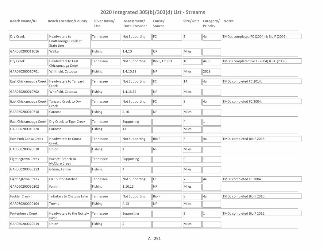
2020 Integrated 305(b)/303(d) List - Streams
Reach Name/ID Reach Location/County River Basin/Use
Assessment/Data Provider
Cause/Source
Size/Unit Category/Priority
Notes
Dry Creek
GAR060200011016 1,4,10
Headwaters to Chattanooga Creek at State Line
Walker
Tennessee
Fishing
Not Supporting FC 5
Miles
4a TMDLs completed FC (2004) & Bio F (2009).
UR
Dry Creek
GAR060200010701 1,4,10,13
Headwaters to East Chickamauga Creek
Whitfield, Catoosa
Tennessee
Fishing
Not Supporting Bio F, FC, DO 10
Miles
4a, 5
2023
TMDLs completed Bio F (2004) & FC (2009).
NP
East Chickamauga Creek
GAR060200010702 1,4,13,59
Headwaters to Tanyard Creek
Whitfield, Catoosa
Tennessee
Fishing
Not Supporting FC 14
Miles
4a TMDL completed FC 2014.
NP
East Chickamauga Creek
GAR060200010718 4,10
Tanyard Creek to Dry Creek
Catoosa
Tennessee
Fishing
Not Supporting FC 3
Miles
4a TMDL completed FC 2004.
NP
East Chickamauga Creek
GAR060200010720 13
Dry Creek to Tiger Creek
Catoosa
Tennessee
Fishing
Supporting 4
Miles
1
East Fork Coosa Creek
GAR060200020518 4
Headwaters to Coosa Creek
Union
Tennessee
Fishing
Not Supporting Bio F 6
Miles
4a TMDL completed Bio F 2016.
NP
Fightingtown Creek
GAR060200030213 4
Burnett Branch to McClure Creek
Gilmer, Fannin
Tennessee
Fishing
Supporting 9
Miles
1
Fightingtown Creek
GAR060200030202 1,10,13
CR 159 to Stateline
Fannin
Tennessee
Fishing
Not Supporting FC 7
Miles
4a TMDL completed FC 2004.
NP
Fodder Creek
GAR060200020104 4,13
Tributary to Chatuge Lake
Towns
Tennessee
Fishing
Not Supporting Bio F 3
Miles
4a TMDL completed Bio F 2016.
NP
Fortenberry Creek
GAR060200020519 4
Headwaters to the Nottely River
Union
Tennessee
Fishing
Supporting 3
Miles
1 TMDL completed Bio F 2016.
A - 291

2020 Integrated 305(b)/303(d) List - Streams
Reach Name/ID Reach Location/County River Basin/Use
Assessment/Data Provider
Cause/Source
Size/Unit Category/Priority
Notes
Gulf Creek
GAR060200011112 4
Headwaters to Lookout Creek
Dade
Tennessee
Fishing
Not Supporting Bio F 6
Miles
4a TMDL completed Bio F 2009.
NP
Gumlog Creek
GAR060200020304 59
West Gumlog Creek to Stateline
Union, Towns
Tennessee
Fishing
Supporting 2
Miles
1
Helton Creek
GAR060200030106 13
Headwaters to Turkey Creek
Union
Tennessee
Fishing
Supporting 1
Miles
1
Helton Creek
GAR060200020520 4
Headwaters to the Nottely River
Union
Tennessee
Fishing
Not Supporting Bio F 4
Miles
4a TMDL completed Bio F 2016.
NP
Hemptown Creek
GAR060200030203 1,4,10,13,59
Mitchell Branch to Young Stone Creek
Fannin
Tennessee
Fishing
Not Supporting FC, Bio M 10
Miles
4a TMDLs completed FC 2004 & Bio M 2016.
NP
Hiawassee River (aka Hiwassee River)
GAR060200020105 1,10,13
Upstream Lake Chatuge
Towns
Tennessee
Recreation, Fishing
Not Supporting E Coli, FC 10
Miles
5
2028
TMDL completed FC 2009. E. coli and FC are both indicators for pathogens. In the future, EPD may use the FC TMDL for the E coli impairment with a translator for FC to E. coli. EPD believes that our pH probes may have been providing falsely low values at times. Waters that would normally be listed as impaired for low pH are being placed in Category 3 while EPD determines if observed low pH is due to issues with the pH probes; whether low pH may be natural due to low alkalinity; or whether the water is actually impaired for low pH.
NP
Hightower Creek
GAR060200020114 4
Shoal Branch (near headwaters) to Little Hightower Creek
Towns
Tennessee
Fishing
Supporting 1
Miles
1
A - 292

2020 Integrated 305(b)/303(d) List - Streams
Reach Name/ID Reach Location/County River Basin/Use
Assessment/Data Provider
Cause/Source
Size/Unit Category/Priority
Notes
Hightower Creek
GAR060200020115 4,59
Little Hightower Creek to Scataway Creek (formerly Shoal Branch to Swallow Creek)
Towns
Tennessee
Fishing
Not Supporting Bio F 2
Miles
4a TMDL completed Bio F 2016. This site has a narrative rank of fair for macroinvertebrates. When EPD completes the reevaluation of the metrics used to assess macroinvertebrate data it will be determined if the macroinvertebrate criteria are being met.
NP
Hightower Creek
GAR060200020116 13
Scataway Creek to Lake Chatuge
Towns
Tennessee
Fishing
Supporting 3
Miles
1
Hog Creek
GAR060200020107 13
Tributary to Chatuge Lake
Towns
Tennessee
Fishing
Supporting 2
Miles
1
Hogjowl Creek
GAR060200010816 4
Headwaters to Mud Creek
Walker
Tennessee
Fishing
Supporting 10
Miles
1
Hopkins Creek
GAR060200010717 4
Headwaters to East Chickamauga Creek
Whitfield
Tennessee
Fishing
Supporting 5
Miles
1
Hothouse Creek
GAR060200030204 1,4,13,59
Tributary to Toccoa River
Fannin
Tennessee
Fishing
Not Supporting pH 8
Miles
5
2028
This site has a narrative rank of fair for macroinvertebrates. When EPD completes the reevaluation of the metrics used to assess macroinvertebrate data it will be determined if the macroinvertebrate criteria are being met.
NP
Hurricane Creek
GAR060200010924 4,13
Headwaters to Peters Branch (formerly Tributary to S. Chickamauga Creek)
Catoosa
Tennessee
Fishing
Supporting 2
Miles
1
Hurricane Creek
GAR060200011120 4
Tributary 1.1 miles upstream Cave Springs Road to Lookout Creek
Dade
Tennessee
Fishing
Supporting 2
Miles
1
A - 293

2020 Integrated 305(b)/303(d) List - Streams
Reach Name/ID Reach Location/County River Basin/Use
Assessment/Data Provider
Cause/Source
Size/Unit Category/Priority
Notes
Ivylog Creek
GAR060200020508 1,4,13,59
Tributary to Lake Nottely
Union
Tennessee
Fishing
Not Supporting Bio M, Bio F, FC 7
Miles
4a TMDLs completed FC 2014, Bio M 2016 & Bio F 2016.
NP
Jones Creek
GAR060200020521 4
Headwaters to Youngcane Creek
Union
Tennessee
Fishing
Not Supporting Bio F 4
Miles
4a TMDL completed Bio F 2016.
NP
Keener Creek
GAR060102020106
Headwaters to Blue Ridge Gap Road
Rabun
Tennessee
Fishing
Assessment Pending
2
Miles
3 Bio F TMDL completed 2016. In Category 3 due to lack of data with which to make an assessment.
Keener Creek
GAR060102020107 4
Blue Ridge Gap Road to the Little Tennessee River
Rabun
Tennessee
Fishing
Not Supporting Bio F 1
Miles
4a TMDL completed Bio F 2016.
NP
Kelly Creek
GAR060102020108 1
0.05 miles downstream Dills Lane to the Little Tennessee River
Rabun
Tennessee
Fishing
Assessment Pending
1
Miles
3 FC is in Category 3 due to insufficient data. Only 4 FC samples were taken in 2018 and this is below our preferred minimum data set.
Kettle Branch
GAR060200010926 4
Headwaters to South Chickamauga Creek
Catoosa
Tennessee
Fishing
Not Supporting Bio F 1
Miles
4a TMDL completed Bio F 2009.
NP
Left Fork Coulter Branch
GAR060200010813 4
Headwaters to Coulter Creek
Walker
Tennessee
Fishing
Supporting 4
Miles
1
Little Chickamauga Creek
GAR060200010703 4
Headwaters to Coulter Creek
Walker, Catoosa
Tennessee
Fishing
Not Supporting Bio F 9
Miles
4a TMDL completed Bio F 2009.
NP
Little Chickamauga Creek
GAR060200010704 1,10,13
Coulter Creek to South Chickamauga Creek
Catoosa
Tennessee
Fishing
Not Supporting FC 11
Miles
4a TMDL completed FC 2009.
NP
A - 294

2020 Integrated 305(b)/303(d) List - Streams
Reach Name/ID Reach Location/County River Basin/Use
Assessment/Data Provider
Cause/Source
Size/Unit Category/Priority
Notes
Little Fightingtown Creek
GAR060200030205 4
Headwaters to Fightingtown Creek
Fannin
Tennessee
Fishing
Supporting 6
Miles
1
Little Hightower Creek (aka Little Shoal Branch)
GAR060200020108 1
Downstream Berrong Lake
Towns
Tennessee
Fishing
Supporting 1
Miles
1
Little Tennessee River
GAR060102020101 1,4,10,13
Dillard to Stateline
Rabun
Tennessee
Fishing
Not Supporting FC 3
Miles
4a TMDL completed FC 2004.
UR
Little Tiger Creek
GAR060200010715 4
Headwaters to Ward Branch
Catoosa
Tennessee
Fishing
Supporting 1
Miles
1 TMDL completed Bio F 2009.
Little Youngcane Creek
GAR060200020522 4
Mason Branch to Youngcane Creek
Union
Tennessee
Fishing
Not Supporting Bio F 2
Miles
4a TMDL completed Bio F 2016.
NP
Lookout Creek
GAR060200011113 1,4,13
Georgia/Alabama State Line to Trenton
Dade
Tennessee
Fishing, Drinking Water
Supporting 21
Miles
1
Lookout Creek
GAR060200011107 1,10,13
Trenton to Stateline
Dade
Tennessee
Fishing, Drinking Water
Not Supporting FC 14
Miles
4a TMDL completed FC 2004.
NP
Lower Youngcane Creek
GAR060200020503 13
Headwaters to Youngcane Creek
Union
Tennessee
Fishing
Not Supporting Bio F 2
Miles
4a TMDL completed Bio F 2004.
NP
McClure Creek
GAR060200030215 4
Headwaters to Fightingtown Creek
Fannin
Tennessee
Fishing
Supporting 6
Miles
1
McCollum Branch
GAR060200011118 4
Headwaters to Lookout Creek
Dade
Tennessee
Fishing
Supporting 1
Miles
1
A - 295

2020 Integrated 305(b)/303(d) List - Streams
Reach Name/ID Reach Location/County River Basin/Use
Assessment/Data Provider
Cause/Source
Size/Unit Category/Priority
Notes
McFarland Branch
GAR060200011012 10
Rossville to Stateline
Walker
Tennessee
Fishing
Not Supporting FC 1
Miles
4a TMDLs completed FC (2004), DO (2004).
UR
Mill Creek
GAR060200020102 10
Pheasant Branch to Hiawassee River (aka Hiwassee River)
Towns
Tennessee
Fishing
Not Supporting FC 2
Miles
4a TMDL completed FC 1998. More data needs to be collected before it can be determined if the pH criteria is being met.
NP
Mill Creek #1
GAR060200010817 4
Headwaters to Mud Creek, tributary to West Chickamauga Creek
Walker
Tennessee
Fishing
Supporting 3
Miles
1
Mill Creek #2
GAR060200010818 4
Coulter Creek to West Chickamauga Creek
Walker
Tennessee
Fishing
Supporting 2
Miles
1
Mineral Springs Creek
GAR060200030218 1
Headwaters to Weaver Creek
Fannin
Tennessee
Fishing
Supporting 2
Miles
1
Moccasin Creek
GAR060200020607 1
Lance Branch to State Line
Union
Tennessee
Fishing
Not Supporting pH 2
Miles
5
2028NP
Mud Creek
GAR060200010819 1,4
Hogjowl Creek to West Chickamauga Creek
Walker
Tennessee
Fishing
Supporting 1
Miles
1
Mud Creek
GAR060102020104 4
Headwaters to the Little Tennessee River
Rabun
Tennessee
Drinking Water, Fishing
Assessment Pending
5
Miles
2 The water is supporting its Fishing Use. Data are not available to assess the Drinking Water Use.
Noontootlah Creek
GAR060200030107 1,4,13
Kirby Creek to the Toccoa River
Fannin
Tennessee
Fishing
Supporting 3
Miles
1
A - 296

2020 Integrated 305(b)/303(d) List - Streams
Reach Name/ID Reach Location/County River Basin/Use
Assessment/Data Provider
Cause/Source
Size/Unit Category/Priority
Notes
Nottely River
GAR060200020504 1,4,10
Right/Left Forks to US Hwy 19
Union
Tennessee
Recreation, Fishing
Not Supporting E Coli, FC 6
Miles
5
2028
TMDL completed FC 2004. E. coli and FC are both indicators for pathogens. In the future, EPD may use the FC TMDL for the E coli impairment with a translator for FC to E. coli.
NP
Nottely RIver
GAR060200020501 1,10,13
US Hwy 19 to Lake Nottely
Union
Tennessee
Drinking Water, Recreation, Fishing
Not Supporting E Coli, FC 8
Miles
4a, 5
2028
TMDL completed FC 2004. The designated use of Drinking Water is not being met for FC. The Designated Use of Recreation not being met for E. coli. E. coli and FC are both indicators for pathogens. In the future, EPD may use the FC TMDL for the E coli impairment with a translator for FC to E. coli. EPD believes that our pH probes may have been providing falsely low values at times. Waters that would normally be listed as impaired for low pH are being placed in Category 3 while EPD determines if observed low pH is due to issues with the pH probes; whether low pH may be natural due to low alkalinity; or whether the water is actually impaired for low pH.
NP
Nottely River
GAR060200020601 1,13
Downstream Lake Nottely
Union
Tennessee
Recreation, Fishing
Not Supporting Bio F 2
Miles
4c TMDL completed DO 2000. Bio F is in Category 4c. The impairment is caused by the dam. TVA has done extensive work to improve water quality below its dams including reoxygenation of hypolimnetic releases and the change in operation of the dam to provide a more stable flow in tailwater reaches. The water is supporting its Recreation Use, but not its Fishing Use.
Dam
Owenby Creek
GAR060200020606 4
Headwaters to Stateline
Fannin
Tennessee
Fishing
Supporting 5
Miles
1 TMDL completed Bio F 2016.
Owl Creek
GAR060200020117 4
Headwaters to the Hiwassee River
Towns
Tennessee
Fishing
Supporting 4
Miles
1 TMDL completed Bio F 2016.
Peavine Creek
GAR060200010927 4
Headwaters to Rock Spring Creek
Walker
Tennessee
Fishing
Not Supporting Bio F 4
Miles
4a TMDL completed Bio F 2009.
NP
A - 297

2020 Integrated 305(b)/303(d) List - Streams
Reach Name/ID Reach Location/County River Basin/Use
Assessment/Data Provider
Cause/Source
Size/Unit Category/Priority
Notes
Peavine Creek
GAR060200010928 4
Rock Spring Creek to Jackson Lake Dam
Walker, Catoosa
Tennessee
Fishing
Not Supporting Bio F 5
Miles
5
2023NP
Peavine Creek
GAR060200010922 1,10,13
Upstream South Chickamauga Creek
Catoosa
Tennessee
Fishing
Not Supporting FC 8
Miles
4a TMDLs completed Bio F (2004), FC (2004).
NP
Pigeon Creek (aka Brawley Branch Creek)
GAR060200030120 4
Headwaters to the Toccoa River
Fannin
Tennessee
Fishing
Supporting 4
Miles
1
Pocket Branch
GAR060200010823 4
Hise Branch to West Chickamauga Creek
Walker
Tennessee
Fishing
Supporting 1
Miles
1
Pope Creek
GAR060200011114 4
Tributary to Lookout Creek
Dade
Tennessee
Fishing
Supporting 3
Miles
1
Reservoir Branch
GAR060200030219 1
Headwaters to Sugar Creek
Fannin
Tennessee
Fishing
Supporting 3
Miles
1
Right Prong Butternut Creek
GAR060200020523 4
Headwaters to Butternut Creek
Union
Tennessee
Fishing
Supporting 3
Miles
1 TMDL completed Bio F 2016.
Ritchie Creek (aka Higdon Creek)
GAR060200030214 4
Patterson Creek to Madola Mill Creek (aka Dunn Mill Creek)
Fannin
Tennessee
Fishing
Supporting 2
Miles
1
Rock Creek
GAR060200030108 1,13
Mill Creek to the Toccoa River
Fannin
Tennessee
Fishing
Supporting 5
Miles
1
Rock Creek
GAR060200011014 1,13,59
Headwaters to Chattanooga Creek
Dade, Walker
Tennessee
Fishing
Supporting 14
Miles
1 TMDL completed Bio F 2004.
A - 298

2020 Integrated 305(b)/303(d) List - Streams
Reach Name/ID Reach Location/County River Basin/Use
Assessment/Data Provider
Cause/Source
Size/Unit Category/Priority
Notes
Scataway Creek
GAR060200020112 4
Headwaters to Hightower Creek
Towns
Tennessee
Fishing
Supporting 4
Miles
1
Shaw Branch
GAR060200010822 4
Headwaters to West Chickamauga Creek
Walker
Tennessee
Fishing
Supporting 4
Miles
1
Skeenah Creek
GAR060200030124 4,13
Headwaters to the Toccoa River (formerly Fannin County)
Fannin
Tennessee
Fishing
Not Supporting Bio F 6
Miles
5
2023NP
South Chickamauga Creek
GAR060200010921 10,13
Ringgold to Stateline
Catoosa
Tennessee
Fishing
Not Supporting FC 15
Miles
4a TMDL completed FC 2004.
NP
South Fork Rapier Mill Creek
GAR060200020605 1,4,59
Stateline to Stateline
Fannin
Tennessee
Fishing
Not Supporting Bio F 2
Miles
4a TMDL completed Bio F 2016.
NP
Spring Creek
GAR060200010929 4
Headwaters to State Line
Catoosa
Tennessee
Fishing
Supporting 2
Miles
1
Squirrel Town Creek
GAR060200011123 4,13
Dry Wash Branch to Lookout Creek
Dade
Tennessee
Fishing
Supporting 3
Miles
1
Stanley Creek
GAR060200030110 4
Headwaters to Toccoa River
Gilmer, Fannin
Tennessee
Fishing
Supporting 4
Miles
1
Star Creek
GAR060200030111 13
Tributary to Blue Ridge Lake
Fannin
Tennessee
Fishing
Supporting 1
Miles
1
A - 299

2020 Integrated 305(b)/303(d) List - Streams
Reach Name/ID Reach Location/County River Basin/Use
Assessment/Data Provider
Cause/Source
Size/Unit Category/Priority
Notes
Stink Creek
GAR060200020524 4,13
Headwaters to the Nottely River (formerly Union County)
Union
Tennessee
Fishing
Not Supporting Bio F 5
Miles
4a TMDL completed Bio F 2016..
NP
Suches Creek
GAR060200030112 4,13
Baker Branch to the Toccoa River (formerly Union County)
Union
Tennessee
Fishing
Supporting 2
Miles
1
Sugar Creek
GAR060200030206 1,4,13,59
Upstream Toccoa River
Fannin
Tennessee
Fishing
Not Supporting pH, Bio M 2
Miles
4a, 5
2028
TMDL completed Bio M 2016.
NP
Sugar Creek
GAR060200010716 1,4,59
State Line to Tiger Creek
Catoosa
Tennessee
Fishing
Not Supporting Bio M 5
Miles
4a TMDL completed Bio M 2016.
NP
Swallow Creek
GAR060200020113 4
Headwaters to Hightower Creek
Towns
Tennessee
Fishing
Not Supporting Bio F 4
Miles
4a TMDL completed Bio F 2016.
NP
Tanyard Creek
GAR060200010705 4
Ga. Hwy. 201 to East Chickamauga Creek (formerly Ga. Hwy. 201 to Chickamauga Creek)
Whitfield, Catoosa
Tennessee
Fishing
Not Supporting Bio F 3
Miles
4a TMDL completed Bio F 2009.
NP
Tiger Creek
GAR060200010706 1,4,10,13
Dry Branch to East Chickamauga Creek
Catoosa, Whitfield
Tennessee
Fishing
Not Supporting FC 8
Miles
4a TMDL completed FC 2004.
NP
Toccoa River
GAR060200030116 4,13
Headwaters to Big Creek
Union, Fannin
Tennessee
Recreation, Fishing
Assessment Pending
22
Miles
2 The water is supporting its Fishing Use. Data are not available to assess the Recreation Use.
Toccoa River
GAR060200030115 10,13
Big Creek to Lake Blue Ridge
Fannin
Tennessee
Recreation, Fishing
Not Supporting FC 10
Miles
4a TMDL completed FC 2009. E. coli is being placed into Category 3 until E. coli data can be collected and assessed.NP
A - 300
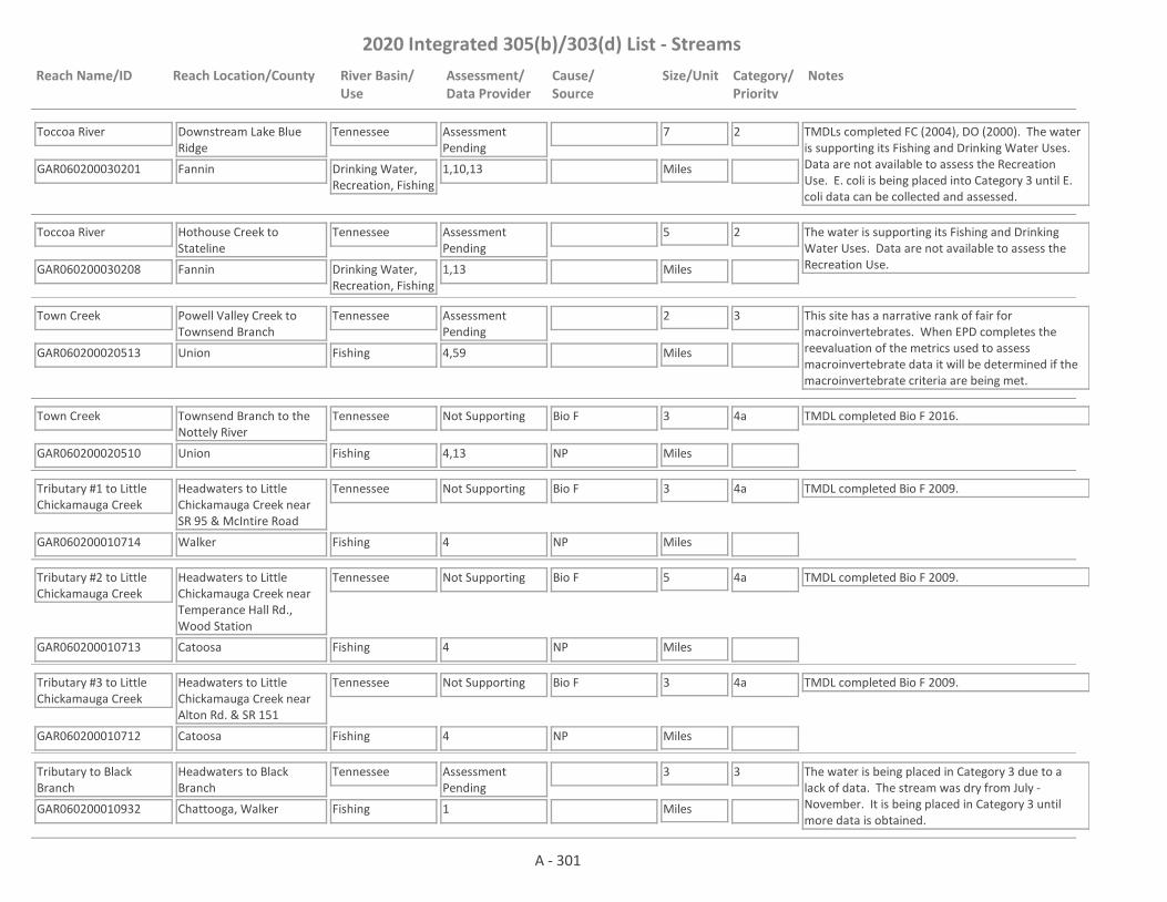
2020 Integrated 305(b)/303(d) List - Streams
Reach Name/ID Reach Location/County River Basin/Use
Assessment/Data Provider
Cause/Source
Size/Unit Category/Priority
Notes
Toccoa River
GAR060200030201 1,10,13
Downstream Lake Blue Ridge
Fannin
Tennessee
Drinking Water, Recreation, Fishing
Assessment Pending
7
Miles
2 TMDLs completed FC (2004), DO (2000). The water is supporting its Fishing and Drinking Water Uses. Data are not available to assess the Recreation Use. E. coli is being placed into Category 3 until E. coli data can be collected and assessed.
Toccoa River
GAR060200030208 1,13
Hothouse Creek to Stateline
Fannin
Tennessee
Drinking Water, Recreation, Fishing
Assessment Pending
5
Miles
2 The water is supporting its Fishing and Drinking Water Uses. Data are not available to assess the Recreation Use.
Town Creek
GAR060200020513 4,59
Powell Valley Creek to Townsend Branch
Union
Tennessee
Fishing
Assessment Pending
2
Miles
3 This site has a narrative rank of fair for macroinvertebrates. When EPD completes the reevaluation of the metrics used to assess macroinvertebrate data it will be determined if the macroinvertebrate criteria are being met.
Town Creek
GAR060200020510 4,13
Townsend Branch to the Nottely River
Union
Tennessee
Fishing
Not Supporting Bio F 3
Miles
4a TMDL completed Bio F 2016.
NP
Tributary #1 to Little Chickamauga Creek
GAR060200010714 4
Headwaters to Little Chickamauga Creek near SR 95 & McIntire Road
Walker
Tennessee
Fishing
Not Supporting Bio F 3
Miles
4a TMDL completed Bio F 2009.
NP
Tributary #2 to Little Chickamauga Creek
GAR060200010713 4
Headwaters to Little Chickamauga Creek near Temperance Hall Rd., Wood Station
Catoosa
Tennessee
Fishing
Not Supporting Bio F 5
Miles
4a TMDL completed Bio F 2009.
NP
Tributary #3 to Little Chickamauga Creek
GAR060200010712 4
Headwaters to Little Chickamauga Creek near Alton Rd. & SR 151
Catoosa
Tennessee
Fishing
Not Supporting Bio F 3
Miles
4a TMDL completed Bio F 2009.
NP
Tributary to Black Branch
GAR060200010932 1
Headwaters to Black Branch
Chattooga, Walker
Tennessee
Fishing
Assessment Pending
3
Miles
3 The water is being placed in Category 3 due to a lack of data. The stream was dry from July - November. It is being placed in Category 3 until more data is obtained.
A - 301

2020 Integrated 305(b)/303(d) List - Streams
Reach Name/ID Reach Location/County River Basin/Use
Assessment/Data Provider
Cause/Source
Size/Unit Category/Priority
Notes
Tributary to Black Creek
GAR060200010933 4
Headwaters to tributary in Gilbert-Stephenson City Park
Walker, Catoosa
Tennessee
Fishing
Not Supporting Bio F 3
Miles
5
2023NP, UR
Tributary to East Chickamauga Creek
GAR060200010721 1
Headwaters to East Chickamauga Creek
Catoosa
Tennessee
Fishing
Supporting 1
Miles
1
Tributary to Lookout Creek
GAR060200011119 4
Headwaters to Lookout Creek
Dade
Tennessee
Fishing
Not Supporting Bio F 2
Miles
5
2023NP
Tributary to Rock Creek
GAR060200011017 4
Tributary at Rock Creek Court to Rock Creek
Walker
Tennessee
Fishing
Not Supporting Bio F 1
Miles
5
2023NP
Tributary to South Fork Rapier Mill Creek
GAR060200020608 1
Stateline to South Fork Rapier Mill Creek
Fannin
Tennessee
Fishing
Not Supporting pH 1
Miles
5
2028NP
Tributary to Squirrel Town Creek
GAR060200011122 4,13
Downstream Brow Road to Squirrel Town Creek
Dade
Tennessee
Fishing
Supporting 3
Miles
1
Tributary to Tiger Creek
GAR060200010719 1,59
Headwaters to Tiger Creek
Catoosa
Tennessee
Fishing
Not Supporting DO, Bio M 3
Miles
4a, 5
2023
TMDL completed Bio M 2016.
NP
Tributary to Town Creek
GAR060200011121 4
Headwaters to Town Creek
Dade
Tennessee
Fishing
Not Supporting Bio F 1
Miles
5
2023NP, UR
Tributary to West Chickamauga Creek
GAR060200010820 4
Headwaters to West Chickamauga Creek, near intersection of SR 136 & 341
Walker
Tennessee
Fishing
Supporting 4
Miles
1
A - 302

2020 Integrated 305(b)/303(d) List - Streams
Reach Name/ID Reach Location/County River Basin/Use
Assessment/Data Provider
Cause/Source
Size/Unit Category/Priority
Notes
Tumbling Creek
GAR060200030211 4
Headwaters to State Line
Fannin
Tennessee
Fishing
Not Supporting Bio F 5
Miles
4a TMDL completed Bio F 2016.
NP
Wauhatchie Branch
GAR060200011115 1,4
State line to Lookout Creek
Dade
Tennessee
Fishing
Supporting 2
Miles
1
Weaver Creek
GAR060200030207 1,4,13
Mineral Springs Creek to the Toccoa River
Fannin
Tennessee
Fishing
Not Supporting Bio F 2
Miles
4a TMDL completed Bio F 2004.
NP
West Chickamauga Creek
GAR060200010812 4
Mud Creek to Mill Creek
Walker
Tennessee
Fishing
Supporting 7
Miles
1
West Chickamauga Creek
GAR060200010814 1,4,10,13
Mill Creek to Crawfish Creek
Walker
Tennessee
Fishing
Supporting 16
Miles
1 TMDL completed FC 2004.
West Chickamauga Creek
GAR060200010923 1,10,13
Hwy 2 to Stateline
Catoosa
Tennessee
Fishing
Not Supporting FC 7
Miles
4a TMDL completed FC 2004.
UR
West Fork Wolf Creek
GAR060200020525 1,59
Headwaters to Wolf Creek (formerly Headwaters to the Nottely River)
Union
Tennessee
Fishing
Not Supporting Bio M 4
Miles
4a TMDL completed Bio M 2016.
NP
Wilscot Creek
GAR060200030114 4,13
Crawford Creek to Blue Ridge Lake (formerly Fannin County)
Fannin
Tennessee
Fishing
Not Supporting Bio F 3
Miles
5
2023NP
Wilscot Creek
GAR060200030119 4
Headwaters to Crawford Creek
Fannin
Tennessee
Fishing
Not Supporting Bio F 4
Miles
4a TMDL completed Bio F 2016.
NP
Winchester Creek
GAR060200020305 4
Headwaters to State Line
Towns
Tennessee
Fishing
Supporting 4
Miles
1 TMDL completed Bio F 2016.
A - 303

2020 Integrated 305(b)/303(d) List - Streams
Reach Name/ID Reach Location/County River Basin/Use
Assessment/Data Provider
Cause/Source
Size/Unit Category/Priority
Notes
Wolf Creek
GAR060200020511 4,13
Lake Trahlyta to the Nottely River
Union
Tennessee
Fishing
Not Supporting Bio F 3
Miles
5
2023NP
Wolf Creek
GAR060200030210 1,4,59
Stateline to Toccoa River
Fannin
Tennessee
Fishing
Assessment Pending
4
Miles
3 This site has a narrative rank of fair for macroinvertebrates. When EPD completes the reevaluation of the metrics used to assess macroinvertebrate data it will be determined if the macroinvertebrate criteria are being met.
Yewell Branch
GAR060200020302 1
Darr Cove to Brasstown Creek
Towns
Tennessee
Fishing
Not Supporting FC 2
Miles
4a TMDL completed FC 1998.
NP
Young Stone Creek
GAR060200030212 4
Headwaters to Hemptown Creek
Fannin
Tennessee
Fishing
Supporting 5
Miles
1
Youngcane Creek
GAR060200020514 4,59
Payne Creek to Little Youngcane Creek
Union
Tennessee
Fishing
Assessment Pending
1
Miles
3 This site has a narrative rank of fair for macroinvertebrates. When EPD completes the reevaluation of the metrics used to assess macroinvertebrate data it will be determined if the macroinvertebrate criteria are being met.
Youngcane Creek
GAR060200020512 1,4,10,13
Little Youngcane Creek to Nottely Lake
Union
Tennessee
Fishing
Not Supporting Bio F, FC 4
Miles
4a TMDL completed FC 2004 & Bio F 2016. pH is being placed in Category 3 based on 2013 data from RV_15_4985. The sonde was not working correctly for several months and more data is needed before making an assessment.
NP
A - 304