2015s2954 cheshire west and chester level 1 strategic
TRANSCRIPT

2015s2954 Cheshire West and Chester Level 1 Strategic Flood Risk Assessment
Final Report
March 2016
Cheshire West and Chester Council
1 Black Friars
Chester
CH1 2NU

2015s2954 CWaC Level 1 SFRA Final Report v1.0.docx i
JBA Project Manager Mike Williamson JBA Consulting Bank Quay House Sankey Street Warrington WA1 1NN
Revision History
Revision Ref / Date Issued Amendments Issued to
Version 0.1 / 4th September 2015
Initial Draft Report Charlotte Aspinall (CWaC) Dawn Hewitt (EA)
Version 0.3 / December 2015
Council comments addressed, additional information received and updated
Charlotte Aspinall (CWaC)
Final Draft v0.1 / 15 Jan 2016 CWaC comments Charlotte Aspinall, Lyndsay Jennings (CWaC)
Final Draft v2.0 / 01 February 2016
Final CWaC comments addressed
Charlotte Aspinall (CWaC) Dawn Hewitt (EA) Emyr Gareth (NRW) Chris Hames (UU) Nick Holt (Welsh Water)
Final v1.0 / March 2016
Comments from stakeholders addressed, EA 2016 climate change guidance included
Charlotte Aspinall (CWaC)
Contract This report describes work commissioned by Kevin Cliffe, on behalf of Cheshire West and Chester Council, by a letter dated 14th July 2015. Cheshire West and Chester Council's representative for the contract was Charlotte Aspinall. Mike Williamson of JBA Consulting carried out this work.
Prepared by .................................................. Mike Williamson BSc MSc EADA FRGS CGeog
Chartered Senior Analyst
Reviewed by ................................................. Howard Keeble MPhil BEng BSc CertBusStud CEng CEnv CSci MICE MCIWEM C.WEM
Principal Engineer

2015s2954 CWaC Level 1 SFRA Final Report v1.0.docx ii
Purpose This document has been prepared as a Final Report for Cheshire West and Chester Council. JBA Consulting accepts no responsibility or liability for any use that is made of this document other than by the Client for the purposes for which it was originally commissioned and prepared.
JBA Consulting has no liability regarding the use of this report except to Cheshire West and Chester Council.
Acknowledgements JBA would like to thank all Council, Environment Agency, Natural Resources Wales, United Utilities, Welsh Water and Canal & River Trust staff for their time and commitment to providing data and discussing the issues identified during the course of this study.
Copyright © Jeremy Benn Associates Limited 2016
Carbon Footprint A printed copy of the main text in this document will result in a carbon footprint of 371g if 100% post-consumer recycled paper is used and 472g if primary-source paper is used. These figures assume the report is printed in black and white on A4 paper and in duplex.
JBA is aiming to reduce its per capita carbon emissions.

2015s2954 CWaC Level 1 SFRA Final Report v1.0.docx iii
Executive Summary This Level 1 Strategic Flood Risk Assessment (SFRA) updates the previous Level 1 assessment published in 2008 using up-to-date flood risk information together with the most current flood risk and planning policy available from the National Planning Policy Framework1 (NPPF) and Flood Risk and Coastal Change Planning Practice Guidance2 (FRCC-PPG). CWaC require this update to initiate the sequential risk-based approach to the allocation of land for development and to identify whether application of the Exception Test is likely to be necessary. This will help to inform and to provide the evidence base for their Local Plan (Part Two) Land Allocations and Detailed Policies.
CWaC provided their latest potential sites data and information. An assessment of flood risk to all sites is provided to assist CWaC in their decision making process for sites to take forward as part of their Local Plan (Part Two).
The aims and objectives of this SFRA update are:
To form part of the evidence base and inform the Sustainability Appraisal (Incorporating the Strategic Environmental Assessment) for the council’s Local Plan (Part Two).
To reflect current national policy documentation including the NPPF and its accompanying Flood Risk and Coastal Change Planning Practice Guidance to enable CWaC to meet its obligations as defined by the NPPF.
To supplement current policy guidelines and to provide a straightforward risk based approach to development management in the area.
To make recommendations on the suitability of potential development sites based on flood risk for CWaC's Local Plan (Part Two).
To understand current flood risk from all sources and any historic and future flood risk information to enable investigation and identification of the extent and severity of flood risk throughout the borough. This assessment will enable CWaC to steer development away from those areas where flood risk is considered greatest, ensuring that areas allocated for development can be developed in a safe, cost effective and sustainable manner.
To provide guidance for developers and planning officers on planning requirements.
To pay particular attention to surface water flood risk, using the Environment Agency’s third generation updated Flood Map for Surface Water (uFMfSW).
To provide a reference document (this report) to which all parties involved in development planning and flood risk can reliably turn to for initial advice and guidance.
To develop a report that forms the basis of an informed development management process that also provides guidance on the potential risk of flooding associated with future planning applications and the basis for site-specific Flood Risk Assessments (FRAs) where necessary.
To provide a suite of interactive GeoPDF flood risk maps illustrating the interaction between flood risk and potential development sites.
To identify land required for current and future flood management that should be safeguarded as set out in the NPPF.
1 http://planningguidance.planningportal.gov.uk/blog/policy/
2 http://planningguidance.planningportal.gov.uk/blog/guidance/flood-risk-and-coastal-change/

2015s2954 CWaC Level 1 SFRA Final Report v1.0.docx iv
A number of potential development sites are shown to be at varying risk from fluvial, tidal, surface water flooding and residual risk. Table 1-1 summarises the number of sites at risk from each flood zone as per the Environment Agency's Flood Map for Planning.
Table 1-1: Number of Potential Development Sites at Risk from Flood Map for Planning Flood Zones
Potential development Sites
Number of Sites Within
Flood Zone 2 Flood Zone 3a Flood Zone 3b
Residential 112 109 33
Employment 20 22 4
Mixed use 34 29 15
Retail 6 5 0
Minerals & waste 4 2 2
Recreation & leisure 6 5 1
Power plant 0 0 0
Other 0 0 0
TOTAL 182 172 55
(Sites provided by the Council from their Housing and Employment Land Availability Assessment - see Section 6.4 for more details).
Recommendations, in Section 6.5 of this report, are made for each site at risk, broadly entailing the following:
Consider withdrawing the site based on level or flood risk;
Exception Test required if site passes Sequential Test;
Consider site layout and design if site passes Sequential Test;
Site-specific FRA required; and
Site permitted on flood risk grounds due to no perceived risk, subject to consultation with the LPA / LLFA.
Out of the 2,165 sites provided for assessment by CWaC, 55 are within or partially within the functional floodplain (Flood Zone 3b), delineated from this SFRA. Out of these 55 sites, 18 are recommended for withdrawal where the level of risk is considered too great for development to proceed. There are a further eight sites that are recommended for withdrawal based on significant surface water flood risk.
Included along with this report as part of the SFRA are:
Detailed interactive GeoPDF maps showing all available flood risk information together with the potential development sites - Appendix A;
Development Site Assessment spreadsheet detailing the risk to each site with recommendations on development - Appendix B; and
A note on the delineation of the functional floodplain following discussion and agreement between CWaC and the Environment Agency - Appendix C.

2015s2954 CWaC Level 1 SFRA Final Report v1.0.docx V
Contents 1 Introduction .......................................................................................................... 1
1.1 Commission ........................................................................................................... 1 1.2 Cheshire West and Chester Level 1 SFRA Update .............................................. 1 1.3 SFRA Future Proofing ........................................................................................... 2
2 Study Area ............................................................................................................ 3
3 Understanding Flood Risk .................................................................................. 4
3.1 Sources of Flooding ............................................................................................... 4 3.2 Likelihood and Consequence ................................................................................ 5 3.3 Risk ........................................................................................................................ 6
4 The Planning Framework and Flood Risk Policy ............................................. 7
4.1 Introduction ............................................................................................................ 7 4.2 Legislation .............................................................................................................. 8 4.3 Planning Policy ...................................................................................................... 10 4.4 Flood Risk Management Policy ............................................................................. 14 4.5 Roles and Responsibilities..................................................................................... 19
5 Flood Risk in Cheshire West and Chester ........................................................ 21
5.1 Flood Risk Datasets ............................................................................................... 21 5.2 Fluvial and Tidal Flooding ...................................................................................... 21 5.3 Surface Water Flooding ......................................................................................... 24 5.4 Groundwater flooding ............................................................................................ 27 5.5 Canal and Reservoir Flood Risk ............................................................................ 28 5.6 Flood Risk Management ........................................................................................ 29
6 Development and Flood Risk ............................................................................. 32
6.1 Introduction ............................................................................................................ 32 6.2 The Sequential Approach ...................................................................................... 32 6.3 Local Plan Sequential & Exception Test ................................................................ 33 6.4 Local Plan (Part Two) Sites Assessment .............................................................. 35 6.5 Potential Development Sites Review ..................................................................... 38 6.6 Key Area Review ................................................................................................... 49 6.7 Development Management Sequential & Exception Test ..................................... 59 6.8 Guidance for Developers ....................................................................................... 62 6.9 Sustainable Drainage Systems (SuDS) ................................................................. 66 6.10 Emergency Planning .............................................................................................. 68
7 Conclusions and Recommendations ................................................................ 72
7.1 Conclusions ........................................................................................................... 72 7.2 Planning Policy and Flood Risk Recommendations .............................................. 72 7.3 Recommendations for Further Work ..................................................................... 74

2015s2954 CWaC Level 1 SFRA Final Report v1.0.docx VI
List of Figures Figure 2-1: Cheshire West and Chester SFRA study area ................................................ 3
Figure 3-1: Flooding from all sources ................................................................................. 4
Figure 3-2: Source-Pathway-Receptor Model .................................................................... 5
Figure 4-1: Key documents and strategic planning links with flood risk ............................. 7
Figure 4-2: EU Floods Directive.......................................................................................... 8
Figure 4-3: CFMP Policy Units ........................................................................................... 16
Figure 5-1: Historic fluvial flooding incidents (CWaC PFRA 2011) .................................... 22
Figure 5-2: Historic surface water flooding incidents (CWaC PFRA 2011) ........................ 26
Figure 6-1: Flood Risk Management hierarchy .................................................................. 32
Figure 6-2: Local Plan sequential approach to site allocation ............................................ 34
Figure 6-3: Development management Sequential Test process ...................................... 61
Figure 6-4: SuDS Management Train Principle .................................................................. 68
List of Tables Table 1-1: Number of Potential Development Sites at Risk from Flood Map for Planning
Flood Zones ...................................................................................................... iv
Table 3-1: NPPF Flood Zones ............................................................................................ 5
Table 4-1: Key LLFA Duties under the FWMA ................................................................... 9
Table 4-2: CFMP Policies ................................................................................................... 16
Table 5-1: Flood source and key datasets ......................................................................... 21
Table 5-2: Canal flooding mechanisms .............................................................................. 28
Table 5-3: Historic canal flood incidents ............................................................................. 28
Table 6-1: Number of potential development sites at risk from Flood Map for Planning flood zones ........................................................................................................ 35
Table 6-2: Potential areas to safeguard for flood storage .................................................. 37
Table 6-3: Sites to consider withdrawing that are within Flood Zone 3b ............................ 39
Table 6-4: Sites where application of the Exception Test would be required ..................... 40
Table 6-5: Sites to consider layout and design to avoid risk areas .................................... 43
Table 6-6: Number of sites at risk from surface water flooding .......................................... 46
Table 6-7: Sites to consider withdrawing based on surface water risk............................... 46
Table 6-8: Proposed indicative ACDs ................................................................................. 48
Table 6-9: Development types and application of Sequential and Exception Tests for developers ......................................................................................................... 63
Table 6-10: Recommended Peak River Flow Allowances for the North West River Basin District ............................................................................................................... 65
Table 6-11: Recommended Peak River Flow Allowances for the Dee River Basin District ............................................................................................................... 65
Table 6-12: Peak Rainfall Intensity Allowance in Small and Urban Catchments for England ............................................................................................................. 65
Table 6-13: Sea Level Allowance for North West England and River Dee RBD ................ 66
Table 6-14: UKCP09 High++ Allowances for Peak River Flow .......................................... 66
2015s2954 CWaC Level 1 SFRA Final Report v1.0.docx VII
Table 6-15: UKCP09 High++ Allowances for Relative Mean Sea Level Rise .................... 66
Table 6-16: Flood warning and evacuation plans ............................................................... 71
Table 7-1: Recommended Further Work ............................................................................ 75

2015s2954 CWaC Level 1 SFRA Final Report v1.0.docx VIII
Abbreviations ABD ................................. Areas Benefitting from Defences
ACD ................................ Area of Critical Drainage
AEP ................................. Annual Exceedance Probability
AIMS ............................... Asset Information Management System
AStGWF .......................... Areas Susceptible to Groundwater Flooding
CC ................................... Climate change
CCA ................................ Civil Contingencies Act
CDA ................................ Critical Drainage Area
CFMP .............................. Catchment Flood Management Plan
CIL .................................. Community Infrastructure Levy
CRF ................................. Cheshire Resilience Forum
CSO ................................ Combined Sewer Overflow
CWaC ............................. Cheshire West and Chester Council
DCLG .............................. Department for Communities and Local Government
DPD ................................ Development Plan Documents
DTM ................................ Digital Terrain Model
EA ................................... Environment Agency
FAA ................................. Flood Alert Area
FCA ................................. Flood Consequence Assessment
FCDPAG ......................... Flood and Coastal Defence Project Appraisal Guidance
FCERM ........................... Flood and Coastal Erosion Risk Management Network
FDGiA ............................. Flood Defence Grant in Aid
FEH ................................. Flood Estimation Handbook
FRA ................................. Flood Risk Assessment
FRCC-PPG ..................... Flood Risk and Coastal Change Planning Practice Guidance
FRM ................................ Flood Risk Management
FRMP .............................. Flood Risk Management Plan
FRMS .............................. Flood Risk Management Strategy
FRR ................................. Flood Risk Regulations
FSA ................................. Flood Storage Area
FWA ................................ Flood Warning Area
FWMA ............................. Flood and Water Management Act
GI .................................... Green Infrastructure
GIS .................................. Geographical Information Systems
HFM ................................ Historic Flood Map
IDB .................................. Internal Drainage Board
LA .................................... Local Authority
LDF ................................. Local Development Framework
LFRMS ............................ Local Flood Risk Management Strategy
LLFA ............................... Lead Local Flood Authority

2015s2954 CWaC Level 1 SFRA Final Report v1.0.docx IX
LPA ................................. Local Planning Authority
LRF ................................. Local Resilience Forum
MAFRP ........................... Multi-Agency Flood Response Plan
NGO ................................ Non-Governmental Organisation
NPPF .............................. National Planning Policy Framework
NRW ............................... Natural Resources Wales
PCPA .............................. Planning and Compulsory Purchase Act
PFRA .............................. Preliminary Flood Risk Assessment
RBD ................................ River Basin District
RBMP .............................. River Basin Management Plan
RFRSM ........................... Risk of Flooding from Rivers and the Sea Map
RMA ................................ Risk Management Authority
RSS ................................. Regional Spatial Strategy
SA ................................... Sustainability Appraisal
SEA ................................. Strategic Environmental Assessment
SFRA .............................. Strategic Flood Risk Assessment
SIRS ................................ Sewerage Incident Register System
SoP ................................. Standard of Protection
SPD ................................. Supplementary Planning Documents
SuDS ............................... Sustainable Drainage Systems
SWMP ............................. Surface Water Management Plan
UDP ................................ Unitary Development Plan
uFMfSW .......................... updated Flood Map for Surface Water
UKCIP02 ......................... UK Climate Projections 2002
UKCP09 .......................... UK Climate Projections 2009
UU ................................... United Utilities
WFD ................................ Water Framework Directive
WIRS ............................... Wastewater Incident Register System
WW ................................. Welsh Water

2015s2954 CWaC Level 1 SFRA Final Report v1.0.docx 1
1 Introduction
1.1 Commission
Cheshire West and Chester Council (CWaC) commissioned JBA Consulting in July 2015 to undertake an update of the existing Level 1 Strategic Flood Risk Assessment (SFRA) completed in 2008. CWaC have adopted their Local Plan (Part One) Strategic Policies3 and are in the process of preparing their Local Plan (Part Two) Land Allocations and Detailed Policies which will take forward the spatial strategy of the Adopted Plan and will include the allocation of sites. As such, the Local Plan (Part Two) will play a direct role in delivering the borough’s regeneration and growth objectives which will be informed by this Level 1 SFRA update.
This update has been carried out in accordance with the Government’s latest development planning guidance including the National Planning Policy Framework (NPPF) and flood risk guidance called the Flood Risk and Coastal Change Planning Practice Guidance (FRCC-PPG). The latest guidance is available online via:
http://planningguidance.planningportal.gov.uk/blog/guidance/flood-risk-and-coastal-change
This updated SFRA makes use of the most up-to-date flood risk datasets to assess the extent of risk, at a strategic level, to potential development allocation sites identified by CWaC.
This SFRA consists of this report together with an appendix containing SFRA maps showing the potential sites overlaid with the latest, readily available, gathered flood risk information; and a site assessment spreadsheet indicating the level of flood risk to each site following a strategic assessment of risk. This information will allow CWaC to identify the strategic development options that may be applicable to each site and to inform on the need for the application of the Sequential Test.
This report begins by outlining the connections between the planning framework and flood risk policy thus discussing legislation, planning policy, flood risk management policy and the roles and responsibilities of key stakeholders. All sources of flood risk within the local authority area are then examined before an assessment of flood risk to the potential development sites. Conclusions and recommendations are cited at the end of the report.
1.2 Cheshire West and Chester Level 1 SFRA Update
As a Lead Local Flood Authority (LLFA) and Local Planning Authority (LPA), CWaC require an SFRA to develop the evidence base for their Local Plan (Part Two) Land Allocations and Detailed Policies and to inform the Sustainability Appraisal (SA). This SFRA update is required to initiate the sequential risk-based approach to the allocation of land for development and to identify whether application of the Exception Test is likely to be necessary.
The aims and objectives of the SFRA are:
To form part of the evidence base and inform the Sustainability Appraisal (Incorporating the Strategic Environmental Assessment) for the council’s Local Plan (Part Two).
To make recommendations on the suitability of potential development sites based on flood risk for CWaC's Local Plan (Part Two).
To understand flood risk from all sources and to investigate and identify the extent and severity of flood risk throughout the borough. This assessment will enable CWaC to steer development away from those areas where flood risk is considered greatest, ensuring that areas allocated for development can be developed in a safe, cost effective and sustainable manner.
To pay particular attention to surface water flood risk, using the Environment Agency’s third generation updated Flood Map for Surface Water (uFMfSW).
To enable CWaC to meet its obligations under the National Planning Policy Framework (NPPF).
To supplement current policy guidelines and to provide a straightforward risk based approach to development management in the area.
3 http://consult.cheshirewestandchester.gov.uk/portal/cwc_ldf/adopted_cwac_lp/lp_1_adopted?tab=files
2015s2954 CWaC Level 1 SFRA Final Report v1.0.docx 2
To provide a reference document (this report) to which all parties involved in development planning and flood risk can reliably turn to for initial advice and guidance.
To develop a report that forms the basis of an informed development management process that also provides guidance on the potential risk of flooding associated with future planning applications and the basis for site-specific Flood Risk Assessments (FRAs) where necessary.
To identify land required for current and future flood management that should be safeguarded as set out in the NPPF.
To advise on the applicability of Sustainable Drainage Systems (SuDS) for managing surface water runoff.
To provide guidance for developers and planning officers dealing with applications as well as for the council to fulfil its role as Lead Local Flood Authority including advice on the application of the council’s role in SuDS approval and adoption.
To assist CWaC in identifying specific locations where further and more detailed flood risk data and assessment work is required as part of a Level 2 SFRA, prior to the allocation of specific developments.
1.3 SFRA Future Proofing
As discussed, this SFRA has been developed using the most up-to-date data and information available at the time of submission. The SFRA has been future proofed as far as possible though the reader should always confirm with the source organisation (CWaC) that the latest information is being used when decisions concerning development and flood risk are being made. The Flood Risk and Coastal Change Planning Practice Guidance (FRCC-PPG), alongside the National Planning Policy Framework (NPPF), is referred to throughout this SFRA, being the current primary development and flood risk guidance information available at the time of the finalisation of this SFRA.
2015s2954 CWaC Level 1 SFRA Final Report v1.0.docx 3
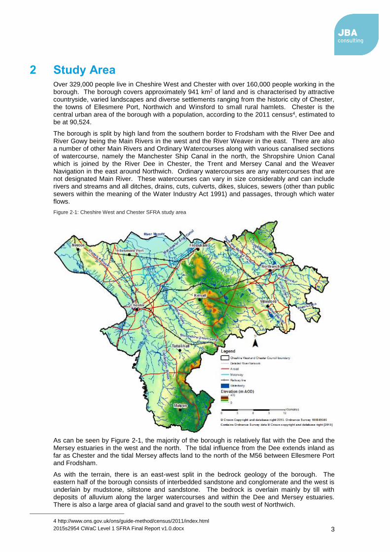
2 Study Area Over 329,000 people live in Cheshire West and Chester with over 160,000 people working in the borough. The borough covers approximately 941 km2 of land and is characterised by attractive countryside, varied landscapes and diverse settlements ranging from the historic city of Chester, the towns of Ellesmere Port, Northwich and Winsford to small rural hamlets. Chester is the central urban area of the borough with a population, according to the 2011 census4, estimated to be at 90,524.
The borough is split by high land from the southern border to Frodsham with the River Dee and River Gowy being the Main Rivers in the west and the River Weaver in the east. There are also a number of other Main Rivers and Ordinary Watercourses along with various canalised sections of watercourse, namely the Manchester Ship Canal in the north, the Shropshire Union Canal which is joined by the River Dee in Chester, the Trent and Mersey Canal and the Weaver Navigation in the east around Northwich. Ordinary watercourses are any watercourses that are not designated Main River. These watercourses can vary in size considerably and can include rivers and streams and all ditches, drains, cuts, culverts, dikes, sluices, sewers (other than public sewers within the meaning of the Water Industry Act 1991) and passages, through which water flows.
Figure 2-1: Cheshire West and Chester SFRA study area
As can be seen by Figure 2-1, the majority of the borough is relatively flat with the Dee and the Mersey estuaries in the west and the north. The tidal influence from the Dee extends inland as far as Chester and the tidal Mersey affects land to the north of the M56 between Ellesmere Port and Frodsham.
As with the terrain, there is an east-west split in the bedrock geology of the borough. The eastern half of the borough consists of interbedded sandstone and conglomerate and the west is underlain by mudstone, siltstone and sandstone. The bedrock is overlain mainly by till with deposits of alluvium along the larger watercourses and within the Dee and Mersey estuaries. There is also a large area of glacial sand and gravel to the south west of Northwich.
4 http://www.ons.gov.uk/ons/guide-method/census/2011/index.html

2015s2954 CWaC Level 1 SFRA Final Report v1.0.docx 4
3 Understanding Flood Risk
3.1 Sources of Flooding
Flooding is a natural process and can happen at any time in a wide variety of locations. It constitutes a temporary covering of land not normally covered by water and presents a risk when people and human or environmental assets are present in the area that floods. Assets at risk from flooding can include housing, transport and public service infrastructure, commercial and industrial enterprises, agricultural land and environmental and cultural heritage. Flooding can occur from many different and combined sources and in many different ways. Major sources of flooding include (also see Figure 3-1):
Fluvial (rivers) - inundation of floodplains from rivers and watercourses; inundation of areas outside the floodplain due to influence of bridges, embankments and other features that artificially raise water levels; overtopping or breaching of defences; blockages of culverts; blockages of flood channels/corridors.
Tidal - sea; estuary; overtopping of defences; breaching of defences; other flows (e.g. fluvial surface water) that could pond due to tide locking; wave action.
Surface water - surface water flooding covers two main sources including direct run-off from adjacent land (pluvial) and surcharging of piped drainage systems (public sewers, highway drains, etc.)
Groundwater - water table rising after prolonged rainfall to emerge above ground level remote from a watercourse; most likely to occur in low-lying areas underlain by permeable rock (aquifers); groundwater recovery after pumping for mining or industry has ceased.
Infrastructure failure - reservoirs; canals; industrial processes; burst water mains; blocked sewers or failed pumping stations.
Different types and forms of flooding present a range of different risks and the flood hazards of speed of inundation, depth and duration of flooding can vary greatly. With climate change, the frequency, pattern and severity of flooding are expected to change and become more damaging.
Figure 3-1: Flooding from all sources

2015s2954 CWaC Level 1 SFRA Final Report v1.0.docx 5
3.2 Likelihood and Consequence
Flood risk is a combination of the likelihood of flooding and the potential consequences arising. It is assessed using the source – pathway – receptor model as shown in Figure 3-2 below. This is a standard environmental risk model common to many hazards and should be the starting point of any assessment of flood risk. However, it should be remembered that flooding could occur from many different sources and pathways, and not simply those shown in the illustration below.
Figure 3-2: Source-Pathway-Receptor Model
The principal sources are rainfall or higher than normal sea levels, the most common pathways are rivers, drains, sewers, overland flow and river and coastal floodplains and their defence assets and the receptors can include people, their property and the environment. All three elements must be present for flood risk to arise. Mitigation measures have little or no effect on sources of flooding but they can block or impede pathways or remove receptors.
The planning process is primarily concerned with the location of receptors, taking appropriate account of potential sources and pathways that might put those receptors at risk. It is therefore important to define the components of flood risk in order to apply this guidance in a consistent manner.
3.2.1 Likelihood
Likelihood of flooding is expressed as the percentage probability based on the average frequency measured or extrapolated from records over a large number of years. A 1% probability indicates the flood level that is expected to be reached on average once in a hundred years, i.e. it has a 1% chance of occurring in any one year, not that it will occur once every hundred years. Table 3-1 provides an example of the flood probabilities used to describe Flood Zones as defined in the NPPF Technical Guide.
Table 3-1: NPPF Flood Zones
Flood Zone
Annual Probability of Flooding
1 This zone comprises land assessed as having a less than 1 in 1,000 annual probability of river or sea flooding in any year (<0.1%).
2 This zone comprises land assessed as having between a 1 in 100 and 1 in 1,000 annual probability of river flooding (1% – 0.1%) or between a 1 in 200 and 1 in 1,000 annual probability of sea flooding (0.5% – 0.1%) in any year.
3a This zone comprises land assessed as having a 1 in 100 or greater annual probability of river flooding (>1%) or a 1 in 200 or greater annual probability of flooding from the sea (>0.5%) in any year.
3b
This zone comprises land where water has to flow or be stored in times of flood. This includes land that would flood with an annual probability of 1 in 20 (5%) or 1 in 25 (4%) or greater in any year, or is designed to flood in an extreme (0.1%) flood. Also referred to as functional floodplain.

2015s2954 CWaC Level 1 SFRA Final Report v1.0.docx 6
Considered over the lifetime of development, such an apparently low frequency or rare flood has a significant probability of occurring. For example:
A 1% flood has a 26% (1 in 4) chance of occurring at least once in a 30-year period - the period of a typical residential mortgage
And a 49% (1 in 2) chance of occurring in a 70-year period - a typical human lifetime
3.2.2 Consequence
The consequences of flooding include fatalities, property damage, disruption to lives and businesses, with severe implications for people (e.g. financial loss, emotional distress, health problems). Consequences of flooding depend on the hazards caused by flooding (depth of water, speed of flow, rate of onset, duration, wave-action effects, water quality) and the vulnerability of receptors (type of development, nature, e.g. age-structure, of the population, presence and reliability of mitigation measures etc). Flood risk is then expressed in terms of the following relationship:
Flood risk = Probability of flooding x Consequences of flooding
3.3 Risk
Flood risk is not static; it cannot be described simply as a fixed water level that will occur if a river overtops its banks or from a high spring tide that coincides with a storm surge. It is therefore important to consider the continuum of risk carefully. Risk varies depending on the severity of the event, the source of the water, the pathways of flooding (such as the condition of flood defences) and the vulnerability of receptors as mentioned above.
3.3.1 Actual Risk
This is the risk 'as is' taking into account any flood defences that are in place for extreme flood events (typically these provide a minimum Standard of Protection (SoP)). Hence, if a settlement lies behind a fluvial flood defence that provides a 1 in 100-year SoP then the actual risk of flooding from the river in a 1 in 100-year event is generally low.
Actual risk describes the primary, or prime, risk from a known and understood source managed to a known SoP. However, it is important to recognise that risk comes from many different sources and that the SoP provided will vary within a river catchment. Hence, the actual risk of flooding from the river may be low to a settlement behind the defence but moderate from surface water, which may pond behind the defence in low spots and is unable to discharge into the river during high water levels.
3.3.2 Residual Risk
Even when flood defences are in place, there is always a likelihood that these could be overtopped in an extreme event or that they could fail or breach. Where there is a consequence to that occurrence, this risk is known as residual risk. Defence failure can lead to rapid inundation of fast flowing and deep floodwaters, with significant consequences to people, property and the local environment behind the defence.
Whilst the actual risk of flooding to a settlement that lies behind a fluvial flood defence that provides a 1 in 100-year SoP may be low, there will always be a residual risk from flooding if these defences overtopped or failed that must be taken into account. Because of this, it is never appropriate to use the term "flood free".

2015s2954 CWaC Level 1 SFRA Final Report v1.0.docx 7
4 The Planning Framework and Flood Risk Policy
4.1 Introduction
The main purpose of this section of the SFRA is to provide an overview of the key planning and flood risk policy documents that have shaped the current planning framework. This section also provides an overview and context of CWaC's responsibilities and duty in respect to managing local flood risk including but not exclusive to the delivery of the requirements of the Flood Risk Regulations (FRR) 2009 and the Flood and Water Management Act (FWMA) 2010.
Figure 4-1 illustrates the links between legislation, national policy, statutory documents and flood risk assessments. The figure shows that whilst the key pieces of legislation and policy are separate, they are closely related and their implementation should aim to provide a comprehensive and planned approach to asset record keeping and improving flood risk management within communities.
It is intended that the non-statutory SWMPs and SFRAs can provide much of the base data required to support the delivery of statutory flood risk management tasks as well supporting Local Authorities in developing capacity, effective working arrangements and informing Local Flood Risk Management Strategies (LFRMS) and Local Plans, which in turn help deliver flood risk management infrastructure and new development at a local level. This SFRA should be used to support CWaC's Local Plan (Part Two) and to help inform planning decisions.
Figure 4-1: Key documents and strategic planning links with flood risk
2015s2954 CWaC Level 1 SFRA Final Report v1.0.docx 8
4.2 Legislation
4.2.1 EU Floods Directive & the Flood Risk Regulations
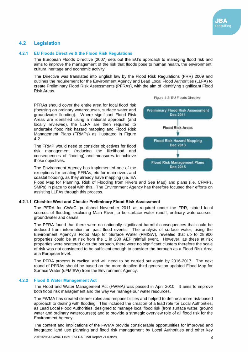
The European Floods Directive (2007) sets out the EU’s approach to managing flood risk and aims to improve the management of the risk that floods pose to human health, the environment, cultural heritage and economic activity.
The Directive was translated into English law by the Flood Risk Regulations (FRR) 2009 and outlines the requirement for the Environment Agency and Lead Local Flood Authorities (LLFA) to create Preliminary Flood Risk Assessments (PFRAs), with the aim of identifying significant Flood Risk Areas.
Figure 4-2: EU Floods Directive
PFRAs should cover the entire area for local flood risk (focusing on ordinary watercourses, surface water and groundwater flooding). Where significant Flood Risk Areas are identified using a national approach (and locally reviewed), the LLFA are then required to undertake flood risk hazard mapping and Flood Risk Management Plans (FRMPs) as illustrated in Figure 4-2.
The FRMP would need to consider objectives for flood risk management (reducing the likelihood and consequences of flooding) and measures to achieve those objectives.
The Environment Agency has implemented one of the exceptions for creating PFRAs, etc for main rivers and coastal flooding, as they already have mapping (i.e. EA Flood Map for Planning, Risk of Flooding from Rivers and Sea Map) and plans (i.e. CFMPs, SMPs) in place to deal with this. The Environment Agency has therefore focused their efforts on assisting LLFAs through this process.
4.2.1.1 Cheshire West and Chester Preliminary Flood Risk Assessment
The PFRA for CWaC, published November 2011 as required under the FRR, stated local sources of flooding, excluding Main River, to be surface water runoff, ordinary watercourses, groundwater and canals.
The PFRA found that there were no nationally significant harmful consequences that could be deduced from information on past flood events. The analysis of surface water, using the Environment Agency's Flood Map for Surface Water (FMfSW), revealed that up to 28,900 properties could be at risk from the 1 in 200 AEP rainfall event. However, as these at risk properties were scattered over the borough, there were no significant clusters therefore the scale of risk was not considered to be sufficient enough to consider the borough as a Flood Risk Area at a European level.
The PFRA process is cyclical and will need to be carried out again by 2016-2017. The next round of PFRAs should be based on the more detailed third generation updated Flood Map for Surface Water (uFMfSW) from the Environment Agency.
4.2.2 Flood & Water Management Act
The Flood and Water Management Act (FWMA) was passed in April 2010. It aims to improve both flood risk management and the way we manage our water resources.
The FWMA has created clearer roles and responsibilities and helped to define a more risk-based approach to dealing with flooding. This included the creation of a lead role for Local Authorities, as Lead Local Flood Authorities, designed to manage local flood risk (from surface water, ground water and ordinary watercourses) and to provide a strategic overview role of all flood risk for the Environment Agency.
The content and implications of the FWMA provide considerable opportunities for improved and integrated land use planning and flood risk management by Local Authorities and other key

2015s2954 CWaC Level 1 SFRA Final Report v1.0.docx 9
partners. The integration and synergy of strategies and plans at national, regional and local scales, is increasingly important to protect vulnerable communities and deliver sustainable regeneration and growth. Table 4-1 provides an overview of the key LLFA responsibilities under the FWMA.
Table 4-1: Key LLFA Duties under the FWMA
FWMA Responsibility
Description of duties and powers CWaC LLFA Status
Local Strategy for Flood Risk Management
A LLFA has a duty to develop, maintain, apply and monitor a local strategy for flood risk management in its area. The local strategies will build on information such as national risk assessments and will use consistent risk based approaches across different Local Authority areas and catchments. The local strategy will not be secondary to the national strategy; rather it will have distinct objectives to manage local flood risks important to local communities.
Consultation closed. Cabinet approval anticipated early 2016
Duty to contribute to sustainable development
The LLFA has a duty to contribute towards the achievement of sustainable development.
Ongoing
Duty to comply with national strategy
The LLFA has a duty to comply with national flood and coastal risk management strategy principles and objectives in respects of its flood risk management functions.
Ongoing
Investigating Flood Incidents
The LLFA, on becoming aware of a flood in its area, has (to the extent it considers necessary and appropriate) to investigate and record details of "locally significant" flood events within their area. This duty includes identifying the relevant risk management authorities and their functions and how they intend to exercise those functions in response to a flood. The responding risk management authority must publish the results of its investigation and notify any other relevant risk management authorities.
Ongoing
Asset Register
A LLFA has a duty to maintain a register of structures or features, which are considered to have an effect on flood risk, including details on ownership and condition as a minimum. The register must be available for inspection and the Secretary of State will be able to make regulations about the content of the register and records.
Ongoing - ownership information required
Duty to co-operate and Powers to Request Information
The LLFA must co-operate with other relevant authorities in the exercise of their flood and coastal erosion management functions.
Ongoing
Ordinary Watercourse Consents
A LLFA has a duty to deal with enquiries and determine watercourse consents where the altering, removing or replacing of certain flood risk management structures or features that affect flow on ordinary watercourses is required. It also has provisions or powers relating to the enforcement of unconsented works.
Ongoing
Works Powers The Act provides a LLFA with powers to undertake works to manage flood risk from surface runoff, groundwater and on ordinary watercourses, consistent with the local flood risk management strategy for the area.
Ongoing
Designation Powers
The Act provides a LLFA with powers to designate structures and features that affect flooding or coastal erosion. The powers are intended to overcome the risk of a person damaging or removing a structure or feature that is on private land and which is relied on for flood or coastal erosion risk management. Once a feature is designated, the owner must seek consent to alter, remove, or replace it.
To be taken forward
Emergency Planning
A LLFA is required to play a lead role in emergency planning and recovery after a flood event.
Multi Agency Flood Response Plan in place
Community Involvement
A LLFA should engage local communities in local flood risk management issues. This could include the training of community volunteers, the development of local flood action groups and the preparation of community flood plans, and general awareness raising around roles and responsibilities plans.
Various ongoing
Planning Requirements for SuDS
Sustainable Drainage Systems (SuDS) are to become a planning requirement for major planning applications of 10 or more residential units or equivalent commercial development schemes with sustainable
Implemented April 2015

2015s2954 CWaC Level 1 SFRA Final Report v1.0.docx 10
FWMA Responsibility
Description of duties and powers CWaC LLFA Status
drainage. The LLFA is now a statutory planning consultee and it will be between the LPA and the LLFA to determine the acceptability of these proposed sustainable drainage schemes subject to exemptions and thresholds. Approval must be given before the developer can commence construction. Planning authorities should use planning conditions or obligations to make sure that arrangements are in place for ongoing maintenance of any SuDS over the lifetime of the development.
Reservoirs Designate high risk reservoirs, with preparation of a flood plan by the owner, including all relevant data.
Ongoing
Latest changes to FWMA legislation.5
4.2.3 Water Framework Directive & Water Environment Regulations
The purpose of the Water Framework Directive (WFD) is to deliver improvements across Europe in the management of water quality and water resources. The Water Environment Regulations (2003) transposed the WFD into law in England and Wales. The first management cycle of the WFD requires all inland and coastal waters to reach “good waterbody status” by 2015 through a catchment-based system of River Basin Management Plans (RBMPs), incorporating a programme of measures to improve the status of all natural water bodies. There is an exception for “heavily modified water bodies”, that are required to achieve “good waterbody potential”. The deadline for achieving good waterbody status can be extended to 2021 or 2027 if required, for technical or economic reasons.
The Environment Agency is responsible for monitoring and reporting on the objectives of the Water Framework Directive (WFD) on behalf of government. They work with Government, Ofwat, local government, non-governmental organisations (NGOs) and a wide range of other stakeholders including local businesses, water companies, industry and farmers to manage water6.
The second management cycle is due to begin at the end of 2015 where the second round of river basin management plans are due to begin.
The CWaC area is covered by two RBMPs, namely the North West River Basin District RBMP, managed by the Environment Agency and the Dee River Basin District RBMP, managed by Natural Resources Wales, each published in December 2009.
The main responsibility for CWaC is to work with the Environment Agency to develop links between river basin management planning and the development of Local Authority plans, policies and assessments. In particular, the programme of actions (measures) within the RBMP highlights the need for:
Water Cycle Studies to promote water efficiency in new development through regional strategies and local development frameworks,
Surface Water Management Plan implementation,
Considering the WFD objectives (achieving good status or potential as appropriate) in the spatial planning process, including LDDs and Sustainable Community Strategies, and
Promoting the wide scale use of Sustainable Drainage Systems (SuDS) in new development.
4.3 Planning Policy
4.3.1 National Planning Policy Framework
The National Planning Policy Framework (NPPF) was published in March 2012, and is based on core principles of sustainability. It forms the national policy framework in England and is accompanied by a number of Planning Practice Guidance notes.
5 http://www.legislation.gov.uk/ukpga/2010/29
6 https://www.gov.uk/government/policies/improving-water-quality/supporting-pages/planning-for-better-water

2015s2954 CWaC Level 1 SFRA Final Report v1.0.docx 11
The NPPF is the national planning policy framework for Local Planning Authorities to help them prepare Local Plans and take development management decisions. Section 10 Paragraph 100 of the NPPF states that Local Plans:
“...should be supported by a Strategic Flood Risk Assessment and develop policies to manage flood risk from all sources, taking account of advice from the Environment Agency and other relevant flood risk management bodies, such as Lead Local Flood Authorities and Internal Drainage Boards. Local Plans should apply a sequential, risk-based approach to the location of development to avoid, where possible, flood risk to people and property and manage any residual risk, taking account of the impacts of climate change, by applying the Sequential Test, if necessary applying the Exception Test, safeguarding land from development that is required for current and future flood management, using opportunities offered by new development to reduce the causes and impacts of flooding and where climate change is expected to increase flood risk so that some existing development may not be sustainable in the long term, seeking opportunities to facilitate the relocation of development including housing to more sustainable locations”.
The Flood Risk and Coastal Change Planning Practice Guidance (FRCC-PPG) sits alongside the NPPF and sets out detailed guidance on how this policy should be implemented.
4.3.2 Flood Risk and Coastal Change Planning Practice Guidance (FRCC-PPG)
On 6 March 2014 the Department for Communities and Local Government (DCLG) launched their planning practice guidance, including guidance for flood risk and coastal change, which replaces the previous Technical Guidance. This new guidance is available as a web-based resource7, which is accessible to all and is regularly updated. Whilst the NPPF concentrates on high level national policy, the FRCC-PPG is more detailed. The practice guidance advises on how planning can take account of the risks associated with flooding and coastal change in plan making and the development management process. This is in respect of local plans, SFRAs, the sequential and exception tests, permitted development, site-specific flood risk, Neighbourhood Planning, Flood Resilience and Resistance and making development safe from flooding, and vulnerability.
4.3.3 Planning and Compulsory Purchase Act, 2004
The Planning and Compulsory Purchase Act (PCPA) sets out provisions in regards to regional functions, local development and development control whilst radically changing the raft of documents required for a Local Plan to be produced and adopted. Previous documents include regional planning guidance, county structure plans, district local plans, unitary development plans, and old-style ‘structure’ plans. These were replaced with Regional Spatial Strategies (RSS) and Local Development Frameworks contained within a series of Development Plan Documents (DPD).
4.3.4 Planning Act, 2008
This act predominantly applies to streamlining the approval of major national infrastructure development. However, this act also allowed for the streamlining of planning appeals for minor developments by allowing appeals to be heard and considered by a panel of local councillors rather than by a planning inspector. The Community Infrastructure Levy (CIL) was also formed from the Planning Act, 2008, whereby a local authority could place a levy on a new development to help finance local infrastructure projects designed to benefit the local area, such as a new school, health centre or park improvements.
7 http://planningguidance.planningportal.gov.uk/blog/guidance/flood-risk-and-coastal-change/
The Sequential Test must be performed when considering the placement of future development and for planning application proposals. The Sequential Test is used to direct all new development (through the site allocation process) to locations at the lowest probability of flooding. It states that development should not be permitted or allocated if there are reasonably available sites appropriate for the proposed development in areas with a lower probability of flooding.

2015s2954 CWaC Level 1 SFRA Final Report v1.0.docx 12
4.3.5 Localism Act
The Localism Act was given Royal Assent in November 2011 with the purpose of shifting power from Central Government back to local councils, communities and individuals. The Government abolished Regional Spatial Strategies, providing the opportunity for councils to re-examine the local evidence base and establish their own local development requirements for employment, housing and other land uses through the plan making process.
Additionally, this act places a duty to cooperate on local authorities, including statutory bodies and other groups, in relation to the planning of sustainable development. This duty to cooperate requires local authorities to:
“...engage constructively, actively and on an ongoing basis in any process by means of which development plan documents are prepared so far as relating to a strategic matter.” (Provision 110).
This act, together with the Neighbourhood Planning (General) Regulations 2012, also provides new rights to allow Parish or Town Councils to deliver additional development through neighbourhood planning (Neighbourhood Plans). This means local people can help decide where new homes and businesses should go and what they should look like. Local planning authorities will be required to provide technical advice and support as neighbourhoods draw up their proposals. Neighbourhood Plans have a number of conditions and requirements, set out in legislation and the NPPF and Planning Practice Guidance.
4.3.6 Local Plan
A Local Plan8 is a statutory document forming the centre of the planning system, designed to promote and deliver sustainable development. Local Plans have to set out a clear vision, be kept up to date and to set out a framework for future development of the local area, addressing needs and opportunities in relation to housing, the economy, community facilities and infrastructure as well as safeguarding the environment and adapting to climate change and securing good design.
Local plans set the context for guiding decisions and development proposals and along with the NPPF, set out a strategic framework for the long-term use of land and buildings, thus providing a framework for local decision making and the reconciliation of competing development and conservation interests. The aim of a Local Plan is to ensure that land use changes proceed coherently, efficiently, and with maximum community benefit. Local plans should indicate clearly how local residents, landowners, and other interested parties might be affected by land use change. They are subject to regular periods of intensive public consultation, public involvement, negotiation and approval.
The NPPF requires that the evidence base for the Local Plan must clearly set out what is intended over the lifetime of the plan, where and when this will occur and how it will be delivered. The NPPF states that local plans should be supported by a SFRA and should take account of advice provided by the Environment Agency and other flood risk management bodies. The SFRA should be used to ensure that when allocating land or determining planning applications, development is located in areas at lowest risk of flooding. Policies to manage, mitigate and design appropriately for flood risk should be written into the Local Plan, informed by both the SFRA and Sustainability Appraisal.
4.3.6.1 Sustainability Appraisal
The Sustainability Appraisal (SA) is a key component of the Local Plan evidence base, ensuring that sustainability issues are addressed during the preparation of local plans. The SA is a technical document which has to meet the requirements of the Strategic Environmental Assessment Directive 2001/42/EC which assesses and reports on a plan’s potential impact on the environment, economy, and society. The SA carries out an assessment of the draft policies at various stages throughout the preparation of the Local Plan, and does this by testing the potential impacts, and consideration of alternatives are tested against the plan's objectives and policies. This ensures that the potential impacts from the plan on the aim of achieving sustainable development are considered, in terms of the impacts, and that adequate mitigation and monitoring mechanisms are implemented.
8 Town and Country Planning, England. The Town and Country Planning (Local Planning) (England) Regulations 2012

2015s2954 CWaC Level 1 SFRA Final Report v1.0.docx 13
The Cheshire West and Chester Council Sustainability Appraisal was completed in July 2013, informed by the 2008 SFRA.
4.3.6.2 Cheshire West and Chester Local Plan (Part One) Strategic Policies
The Cheshire West and Chester Local Plan (Part One) was adopted on the 29th January 2015 and forms the statutory development plan for the borough. The Local Plan (Part One) sets the strategic policies for the borough and provides the overall vision, strategic objectives, spatial strategy and strategic planning policies for the borough up to 2030.
The Plan's strategy is to locate most new development in Chester, Northwich, Ellesmere Port and Winsford with development in the rural area focused in the most sustainable settlements identified as Key Service Centres. The overall extent of the Green Belt will be maintained whilst allowing for the justified and sensitive release of Green Belt to the south of Chester.
The Local Plan (Part One) includes policies that have been informed by a suite of evidence base documents, such as the Sustainability Appraisal, prepared to support the Plan to ensure that the policies reflect locally determined priorities for new homes, jobs, the environment and infrastructure development.
Whilst the Local Plan (Part One) should be read as a whole, Policy ENV1 relates specifically to flood risk and water management.
The Local Plan (Part One) will be the starting point when considering planning applications and will be supported by the Cheshire West and Chester Local Plan (Part Two) Land Allocations and Detailed Policies Plan in due course.
4.3.6.3 Cheshire West and Chester Local Plan (Part Two)
The Cheshire West and Chester Local Plan (Part Two) Land Allocations and Detailed Policies will provide further detailed policies which will support the strategic objectives and policies set out in the Local Plan (Part One) and will include non-strategic allocations.. This Level 1 SFRA update will provide a key evidence base document to inform the preparation of the Local Plan (Part Two).
Policy ENV1 - Flood Risk and Water Management:
"The Local Plan will seek to reduce flood risk, promote water efficiency measures, and protect and enhance water quality through the following mechanisms: All development must follow the sequential approach to determining the suitability of land for development, directing new development to areas at the lowest risk of flooding and where necessary apply the exception test, as outlined in national planning policy. Developers will be required to demonstrate, where necessary, through an appropriate Flood Risk Assessment (FRA) at the planning application stage, that development proposals will not increase flood risk on site or elsewhere, and should seek to reduce the risk of flooding. New development will be required to include or contribute to flood mitigation, compensation and/or protection measures, where necessary, to manage flood risk associated with or caused by the development. Development proposals should comply with the Water Framework Directive by contributing to the North West River Basin Management Plan and Dee River Basin Management Plan objectives, unless it can be demonstrated that this would not be technically feasible. The drainage of new development shall be designed to reduce surface water runoff rates to include the implementation of Sustainable Drainage Systems (SuDS) unless it can be demonstrated that it is not technically feasible or viable. Proposals within areas of infrastructure capacity and/or water supply constraint should demonstrate that there is adequate wastewater infrastructure and water supply capacity to serve the development or adequate provision can be made available".

2015s2954 CWaC Level 1 SFRA Final Report v1.0.docx 14
4.4 Flood Risk Management Policy
4.4.1 West Cheshire SFRA (May 2008)
The 2008 SFRA was commissioned as a joint study by the former councils of West Cheshire, namely Chester City Council (CCC), Vale Royal Borough Council (VRBC) and Ellesmere Port and Neston Borough Council (EPNBC). These councils were abolished in 2009 when the new Cheshire West and Chester unitary authority was formed. The 2008 SFRA therefore contained three separate reports with recommendations specific to each former council area. Many of these recommendations may still be relevant though some may have been superseded by this SFRA update. The key recommendations that are still relevant include the following:
The 2006 breach analysis for the Sealand Basin should be used by the LPA to consider the potential levels of flood risk to people when proposing future development.
Any future development along the Sealand Basin embankments should be set back by at least 300 m. Further information should be provided in a site specific FRA on a case by case basis.
Any proposed future development on land west and immediately to the east of Clifton Drive, and the land in and around Finchett’s Gutter flood storage basin should seriously consider the significant degrees of flood hazard that could occur.
o If development were to take place within any of these areas, extensive flood mitigation measures would be required. No built development should be considered in the Finchett's Gutter flood storage basin.
o Any future development in these areas should assess the flood risk from Sealand Main Drain and Finchett’s Gutter in more detail to see if development can take place on fluvial flood risk grounds.
The potential future allocation at Border House Farm and Sealand Industrial Estate should take into account the proximity to the river Dee and the potential for a significant degree of flood hazard should a breach occur. This location is at a lower risk than the locations described in bullet point three.
The flood defences though Chester should be maintained to the 1 in 200 year standard in the locations where there is existing urban development.
Flood risk from the Manchester Ship Canal and from the Shropshire Union Canal could not be ascertained from the 2008 SFRA therefore Flood Risk Assessments should assess risk from all sources including canals. For potential sites in the vicinity of the canals, it is recommended that one flood risk study is completed to cover all sites. This should cover both the issues of overtopping and breach.
Within the Stanlow area at risk from Flood Zones 2 and 3, flooding would occur regularly with a high hazard potential if there was not a flood alleviation scheme present. This flood alleviation scheme entails the following:
o River Gowy defences - in 2002 flood defences were improved along the lower reaches of the River Gowy at a cost of £1.7 million. The scheme was completed in partnership with the Environment Agency, Cheshire Wildlife Trust and Shell UK.
o Improvements along both banks of the River Gowy were made including the replacement and refurbishment of tidal gates to Gale Brook, Thornton Brook and the River Gowy to prevent tidal flooding; the stabilisation of the riverbank, where there had previously been risk of collapse and watercourse blockage; raised defences along the River Gowy adjacent to Ellesmere Port Waste Water Treatment Plant; and a new channel diversion for Thornton Brook was established whereby Thornton Brook now flows into the River Gowy within the Gowy Meadows. The Gowy Meadows provide essential flood storage capacity to protect the Shell Stanlow oil refinery. As part of the new flood defence scheme, sluices were provided to control water levels at the 170 hectare site, which consists of low-lying grazing marsh, intersected by drainage ditches and old hawthorn hedges. The Cheshire Wildlife Trust manages the land as a nature reserve on a 25 year lease from Shell UK. The sluices are used to produce wetland conditions through winter flooding and a high water table in the summer months.

2015s2954 CWaC Level 1 SFRA Final Report v1.0.docx 15
However, other sources of flooding still pose a risk to the site. The standard of protection should be maintained into the future therefore the area should be acceptable for less vulnerable development types.
Flood extent and frequency in the Ince Marshes area is expected to increase in the future due to climate change. This area is low lying and has a number of drains running through it which would normally flood naturally but are now pumped out to the Mersey. The CFMP policy is to reduce existing flood risk management actions in this area. Development should not take place in this area due to the level of risk from a number of sources, the reduction in FRM actions and the natural tendency of the area to flood.
4.4.2 Catchment Flood Management Plans
Developed by the Environment Agency, a Catchment Flood Management Plan (CFMP) is a key tool within spatial planning. As well as providing a broad overview of flood risk mainly from Main River and tidal sources, they develop complementary policies for long-term management of flood risk within the catchment that take account of the likely impacts of climate change, the effects of land use and land management whilst helping deliver multiple benefits and contributing towards sustainable development. This is critical when areas under development pressure coincide with high flood risk.
Chosen policies and actions highlight areas where development should be avoided when it is deemed inappropriate to reduce current and future flood risk. They also indicate where water should be allowed to flood or where current flood risk measures should be reduced. Development should therefore be focused towards the more 'sustainable' areas in terms of those locations at lower risk of flooding or where flood risk management is considered viable within the short and long-term plans. Therefore if development has been proposed in flood risk areas and the chosen policy is not to take further action to reduce flood risk, then developments will find it difficult to rely on Environment Agency led FRM infrastructure investment and there will be a great reliance on private (developer) funding to reduce risk. In this instance, development may not be viable.
As part of the CFMP process each CFMP area was divided up into broad areas (known as ‘policy units’), which represent areas of similar characteristics, flood mechanisms and flood risks. Each policy unit was then assessed to decide which policy will provide the most appropriate level and direction of flood risk management both now and in the future. Whilst the policy unit simplifies direct action over vast areas of land, in reality, the chosen policy may only focus on a small urban or rural area within that policy unit.
There are three CFMPs which cover the Cheshire West and Chester local authority area, namely the Weaver Gowy CFMP9, which covers the majority of the borough, the River Dee CFMP10 and the Mersey Estuary CFMP11. There are five policy units from the Weaver Gowy CFMP that are within the borough, four from the River Dee CFMP and three from the Mersey Estuary CFMP. The policy options selected for each of the relevant policy units are shown in Table 4-2 and will influence local plan policy. Figure 4-3 shows the areas covered by each CFMP and the policy units within each CFMP.
9
https://www.gov.uk/government/uploads/system/uploads/attachment_data/file/293779/Weaver_Gowy_Catchment_Flood_Management_Plan.pdf
10 https://www.gov.uk/government/uploads/system/uploads/attachment_data/file/357552/LIT_10019_River_Dee_CFMP_gewa0110brko-e-e.pdf
11 https://www.gov.uk/government/uploads/system/uploads/attachment_data/file/293769/Mersey_Estuary_Catchment_Flood_Management_Plan.pdf

2015s2954 CWaC Level 1 SFRA Final Report v1.0.docx 16
Table 4-2: CFMP Policies
CFMP Policy Unit Policy Option
Weaver Gowy
Northwich Policy 5 - take further action to reduce flood risk
Winsford and Middlewich
Policy 3 - continue with existing or alternative actions to manage flood risk at the current level
Frodsham and Runcorn Policy 4 - take further action to sustain the current level of flood risk into the future (responding to the potential increases in risk from urban development, land use change and climate change)
Stanlow
Rural Areas Policy 6 - take action with others to store water or manage runoff in locations that provide overall flood risk reduction or environmental benefits, locally or elsewhere in the catchment
River Dee
Chester
Policy 5 - take further action to reduce flood risk Deeside, Wirral, Flintshire
Middle Dee Policy 2 - reduce existing flood risk management actions
Lower Dee Policy 3 - continue with existing or alternative actions to manage flood risk at the current level
Mersey Estuary
Ince Banks Policy 2 - reduce existing flood risk management actions
Bebington (plus Ellesmere Port)
Policy 3 - continue with existing or alternative actions to manage flood risk at the current level
Greasby (Heswall & Neston)
Policy 6 - take action with others to store water or manage runoff in locations that provide overall flood risk reduction or environmental benefits, locally or elsewhere in the catchment
Figure 4-3: CFMP Policy Units
4.4.3 Area Flood Risk Assessments
Two Area Flood Risk Assessments (AFRA) were produced to inform the Local Plan (Part One); one for Northwich Town Centre in 2009 and one for Winsford Regeneration Area in 2013. AFRAs are usually carried out for large-scale regeneration schemes or multiple development sites and are designed to act as a step between a SFRA and a site-specific Flood Risk Assessment.
Northwich and Winsford were identified, through the 2008 SFRA, as areas at risk of flooding and each part of large-scale regeneration programmes. Each AFRA identified the level of flood risk

2015s2954 CWaC Level 1 SFRA Final Report v1.0.docx 17
to identified development sites together with their vulnerability. The Sequential Test was also applied to each development site and subsequent mitigation measures were recommended for each site.
4.4.4 National and Local Flood Risk Management Strategies
As presented in Figure 4-1, the FWMA establishes how flood risk will be managed within the framework of National Strategies for England and Local Strategies for each LLFA area.
The National Strategy for England has been developed by the Environment Agency with the support and guidance of Defra. It sets out principles for how flood risk should be managed and provides strategic information about different types of flood risk and which organisations are responsible for their effective management. The Act requires risk management authorities (local authorities, internal drainage boards, sewerage companies and highways authorities) to work together and act consistently with the National Strategy in carrying out their flood and coastal erosion risk management functions effectively, efficiently and in collaboration with communities, business and infrastructure operators to deliver more effective flood risk management.
LLFAs have responsibility for developing a Local Flood Risk Management Strategy (LFRMS) for their area covering local sources of flooding (see Table 4-1). The local strategy produced must be consistent with the National Strategy. The strategy should set out the framework for local flood risk management functions and activities and should raise awareness of local organisations with responsibilities for flood risk management in the area. The strategy should also facilitate partnership arrangements to ensure co-ordination between local organisations and an assessment of flood risk and plans and actions for managing risk, as set out under section 9 of the FWMA. CWaC produced a Consultation Draft LFRMS in August 2015.
4.4.4.1 Cheshire West and Chester Council Local Flood Risk Management Strategy
The Consultation Draft LFRMS considers the interactions that flooding from Main Rivers may have with local flood risk attributable to ordinary watercourses, surface water runoff and groundwater, and promotes a partnership working philosophy between all risk management authorities to deliver the effective management of flood risk in the borough, as stipulated by the FWMA.
4.4.5 Surface Water Management Plans
In June 2007, widespread extreme flooding was experienced in the UK. The Government review of the 2007 flooding, chaired by Sir Michael Pitt recommended that…
“…Local Surface Water Management Plans (SWMPs) … coordinated by local authorities, should provide the basis for managing all local flood risk.”
The Government's guidance document12 2011 for SWMPs defines a SWMP as:
A framework through which key local partners with responsibility for surface water and drainage in their area, work together to understand the causes of surface water flooding and agree the most cost-effective way of managing surface water flood risk.
A tool to facilitate sustainable surface water management decisions that are evidence based, risk based, future proofed and inclusive of stakeholder views and preferences.
A plan for the management of urban water quality through the removal of surface water from combined systems and the promotion of SuDS.
As a demonstration of its commitment to SWMPs as a structured way forward in managing local flood risk, Defra announced an initiative to provide funding for the highest flood risk authorities to produce SWMPs. CWaC to date have not produced a SWMP for any location within the borough, however the Council does continue to work with United Utilities and Welsh Water where appropriate. There may be opportunities based on the outcomes of this SFRA or in the second cycle of the PFRAs to review the requirements for a SWMP.
12 Surface Water Management Plan Technical Guidance - https://www.gov.uk/government/publications/surface-water-
management-plan-technical-guidance

2015s2954 CWaC Level 1 SFRA Final Report v1.0.docx 18
4.4.6 Flood Risk Partnerships and Partnership Plans
CWaC have been involved in the development of a number of partnerships designed to provide collaboration between public agencies, businesses and the community. Partnerships and plans that affect the borough include:
Cheshire Resilience Forum (CRF);
Cheshire West and Chester Multi Agency Flood Response Plan;
Cheshire Local Resilience Forum Flood and Extreme Weather Task Group;
Cheshire Risk Assessment Group;
Cheshire Resilience Forum Media Plan;
Cheshire Local Authorities Rest Centre Plan.
4.4.7 Cheshire West and Chester Open Space Assessment
In October 2011, CWaC completed an assessment of open space in the borough in line with Planning Policy Guidance Note 17 (PPG17). As part of the assessment, the Council produced an ArcGIS shapefile of the Borough's open space which has been used for the purposes of this report. The Council is currently preparing an update to the Open Space Study (2016-2030) which will be a key evidence base document for the preparation of the Local Plan (Part Two) Land Allocations and Detailed Policies. The Open Space Study update uses the following typologies to categorise the open space across the borough:
Accessible Natural Green Space
Allotments
Amenity green space
Churchyards and Cemeteries
Education
Green Corridor
Outdoor Sport
Park and Recreation Ground
Play Space
Private Open Space
Open space, or Green Infrastructure, should be designed and managed as a multifunctional resource capable of delivering a wide range of environmental and quality of life benefits for local communities and should be provided as an integral part of all new development, alongside other infrastructure such as utilities and transport networks.
Open space can provide many social, economic and environmental benefits close to where people live and work including:
Places for outdoor relaxation and play;
Space and habitat for wildlife with access to nature for people;
Environmental education;
Local food production - in allotments, gardens and through agriculture;
Improved health and well-being – lowering stress levels and providing opportunities for exercise;
Climate change adaptation - for example flood alleviation and cooling urban heat islands.
The NPPF explains that open space can perform many functions, including flood risk mitigation, and that Local Plans should account for increased flood risk, resulting from climate change, through the planning of Green Infrastructure (GI). GI can have an important role to play in reducing the likelihood of flooding by providing space for flood storage, reducing runoff and increasing infiltration, whilst also providing other benefits as stated above.
Alongside GI should be the implementation of Sustainable Drainage Systems (SuDS), specifically within potential development sites, where possible. The suitability of GI and SuDS can be informed by this SFRA through utilisation of open space for water in the areas of greatest flood risk.

2015s2954 CWaC Level 1 SFRA Final Report v1.0.docx 19
The Town and Country Planning Association together with The Wildlife Trusts produced a guidance document for Green Infrastructure13. The guidance states that local plans should identify funding sources for GI and provision should be made for GI to be adequately funded as part of a development's core infrastructure. For new developments, GI assets can be secured from a landowner's 'land value uplift' and as part of development agreements. The LPA could include capital for the purchase, design, planning and maintenance of GI within its Community Infrastructure Levy (CIL) programme.
There should be an integrated approach to flood risk and open space throughout the borough which would be key in delivering sustainable development. Examples include:
Restoration of the natural character of floodplains;
Keeping and preserving of areas of existing natural floodplain;
Introduction of new areas and enhancing existing areas of greenspace whilst incorporating sustainable drainage within new development;
Reduction of downstream flood risk.
4.5 Roles and Responsibilities
The responsibilities for the Risk Management Authorities (RMA) under the Flood and Water Management Act and the Flood Risk Regulations are summarised below.
4.5.1 Environment Agency as a RMA
The Environment Agency:
Has a strategic overview role for all forms of flooding;
Has the power to request information from any partner in connection with its risk management functions;
Must exercise its flood or coastal erosion risk management functions in a manner consistent with the National Strategy and Local Strategies;
Must be consulted on Local Strategies, if affected by the strategy, by the LLFA;
Must help advise on sustainable development.
4.5.2 Cheshire West and Chester Council LLFA as a RMA
Cheshire West and Chester Council LLFA:
Must develop, maintain, apply and monitor a strategy for local flood risk management. This must be consulted on with all RMAs, the public and all other partners with an interest in local flood risk, and must comply with the national strategy;
Is required to coordinate and share information on local flood risk management between relevant authorities and partners;
Is empowered to request information from others when it is needed in relation to its flood risk management functions;
Must investigate flooding incidents in its area where it considers it necessary or appropriate;
Has a duty to establish and maintain a record of structures within its area that have a significant impact on local flood risk;
Is empowered to designate structures and features that affect flooding;
Has powers to undertake works to manage flood risk from surface runoff, groundwater and ordinary watercourses;
Must exercise its flood and coastal erosion risk management functions in a manner consistent with the National Strategy and the Local Strategy;
Is permitted to agree the transfer of responsibilities for risk management functions (except the production of a Local Strategy) to other RMAs;
Must aim to contribute to sustainable development;
13 Planning for a Healthy Environment - Good Practice Guidance for Green Infrastructure and Biodiversity, Published by
the Town and Country Planning Association and The Wildlife Trusts, July 2012

2015s2954 CWaC Level 1 SFRA Final Report v1.0.docx 20
Should consider flooding issues that require collaboration with neighbouring LLFAs and other RMAs.
4.5.3 United Utilities and Welsh Water as RMAs
The water companies:
Have a duty to act in a manner that is consistent with the National Strategy and have regard to Local Strategies;
Must be consulted on Local Strategies, if affected by the strategy, by the relevant LLFA;
Have a duty to be subject to scrutiny from LLFAs;
Have a duty to cooperate and share information with other RMAs;
Are responsible for managing the risks of flooding from water and foul or combined sewer systems providing drainage from buildings and yards.
4.5.4 Highways (CWaC) as a RMA
CWaC Highway Network Management:
Has a duty to act consistently with the National Strategy and Local Strategies;
Has responsibility for ensuring effective drainage of local roads in so far as ensuring drains and gullies are maintained;
Must be consulted on Local Strategies, if affected by the Strategy, by the relevant LLFA;
Has a duty to be subject to scrutiny from LLFAs.
4.5.5 The Local Community
The local community:
Must be consulted on Local Strategies by the LLFA;
Have a key role in ensuring local strategies are capable of being successfully delivered within the community. They should actively participate in this process and be engaged by the LLFA.
4.5.6 Riparian Owners
A riparian owner is someone who owns land or property alongside a river or other watercourses including a culvert. A watercourse is any natural or artificial channel through which water flows, such as a river including where rivers flow through a culvert, brook, beck, or mill stream.
Riparian owners have statutory responsibilities, including:
Maintaining river beds and banks;
Allowing the flow of water to pass without obstruction;
Controlling invasive alien species
Further guidance for riverside property owners can be found in the Environment Agency’s helpful booklet ‘Living on the Edge'14.
4.5.7 Developers
Have a vital role in ensuring effective local flood risk management by avoiding development in areas at risk of flooding. Local Strategies should form a key element of local planning guidance.
14 http://www.environment-agency.gov.uk/homeandleisure/floods/31626.aspx

2015s2954 CWaC Level 1 SFRA Final Report v1.0.docx 21
5 Flood Risk in Cheshire West and Chester
5.1 Flood Risk Datasets
This section of the SFRA provides a strategic overview of flood risk from all sources within the borough. The information contained is the best available at the time of publication and is intended to provide CWaC with an overview of risk. Where further detail is available, then the source of information is provided. Table 5-1 provides a summary of the key datasets used in this SFRA according to the source of flooding.
Table 5-1: Flood source and key datasets
Flood Source Datasets / Studies
Fluvial and tidal
Environment Agency Flood Map for Planning
Environment Agency Risk of Flooding from Rivers and the Sea Map
Weaver Gowy, River Dee, Mersey Estuary CFMPs
Environment Agency Flood Risk Mapping Studies
Historic evidence – Environment Agency Recorded Flood Outlines and Historic Flood Map
Pluvial (surface water runoff)
Environment Agency updated Flood Map for Surface Water (uFMfSW)
Cheshire West and Chester PFRA
Sewer Welsh Water DG5 data; drainage areas and networks
United Utilities DG5 data; drainage areas and networks
Groundwater Environment Agency Areas Susceptible to Groundwater Flooding (AStGWF)
Canal Canal & River Trust Asset Register
Canal & River Trust historic breach and overtopping incidents
Reservoir Environment Agency Reservoir Flood Maps (available online)
All sources CWaC LFRMS
Flood risk management infrastructure
CWaC Asset Register
Environment Agency flood defence data
Canal & River Trust Asset Database
5.2 Fluvial and Tidal Flooding
Fluvial flooding is associated with the exceedance of channel capacity during higher flows. The process of flooding from watercourses depends on a number of characteristics associated with the catchment including geographical location and variation in rainfall; steepness of the channel and surrounding floodplain; and infiltration and rate of runoff associated with urban and rural catchments.
Judging from the Environment Agency's Flood Map for Planning, the majority of fluvial flood risk comes from the River Dee, the River Gowy, the River Weaver and their tributaries in the west, central and eastern areas of the borough respectively. These areas include rural land and the towns of Chester, Winsford and Northwich. Tidal flooding from the River Dee and the River Mersey is apparent in the low lying tidal floodplain affecting Chester and Ellesmere Port respectively.
The SFRA Maps in Appendix A present the Environment Agency's Flood Map for Planning which shows the fluvial and tidal coverage of flood zones 2 and 3 across the borough. It can be deduced from the GIS analysis that, across the whole borough, 0.7% of existing residential properties have been identified to be at risk from Flood Zone 3. This does not seem a great amount however in absolute terms this equates to 1,011 residential properties that are within Flood Zone 3 and therefore have a 1% chance of flooding in any one year. As discussed in Section 3.2.1, this means over a typical mortgage term of 30 years, these properties have a 26% chance of flooding at least once over that period.
5.2.1 Historical Fluvial and Tidal Flooding
CWaC have limited records regarding any historical flood incidents. This is not to say such incidents have not occurred, but that they have not been fully recorded. As part of their FWMA duties, CWaC is developing a register to keep a record of flood incidents in the borough (CWaC Flood Event Recording System) that is continually updated when flood events occur. At the time

2015s2954 CWaC Level 1 SFRA Final Report v1.0.docx 22
of writing, CWaC have developed a register that will be used to record locally significant flood incidents. CWaC have also developed flood incident, flood investigation and post flood incident review reports to record future flood incidents.
There are records of historic flooding available from Cheshire Archives, though this is not a formal nor comprehensive list of incidents detailing flood source, consequence, etc. The Environment Agency's Historic Flood Map does however indicate past fluvial and tidal flooding in the borough.
The CWaC PFRA contains a map showing 29 historic instances of fluvial flooding from ordinary watercourses and four instances attributable to Main River. This map is shown in Figure 5-1 with the red spots signifying the incidents. The majority occur in the north west of the borough around Ellesmere Port and Neston.
Figure 5-1: Historic fluvial flooding incidents (CWaC PFRA 201115)
5.2.1.1 Environment Agency Historic Flood Map
The Historic Flood Map (HFM) contains outlines of past fluvial, tidal and groundwater flooding. These outlines can be viewed on the accompanying SFRA Maps in Appendix A. It does not contain any information regarding flood source, return period or date of flood. The HFM shows that there has been widespread flooding from the fluvial Dee, affecting Chester and surrounding rural communities. Historic fluvial flooding from the River Gowy affected only rural land though the HFM around the River Weaver covers the centre of Northwich. Historic tidal flooding appears less apparent with small areas around the tidal Dee in Chester.
5.2.2 Environment Agency Flood Map for Planning
The Environment Agency’s Flood Map for Planning is the main dataset used by planners for predicting the location and extent of fluvial and tidal flooding. This is supported by the CFMPs
15 Cheshire West and Chester Preliminary Flood Risk Assessment, Doc Ref: B1115510/04/03/01/D03/Final, November
2011

2015s2954 CWaC Level 1 SFRA Final Report v1.0.docx 23
and a number of detailed hydraulic river modelling reports which provide further detail on flooding mechanisms.
The Flood Map for Planning provides flood extents for the 1 in 100 year fluvial (Flood Zone 3), 1 in 200 year tidal (also Flood Zone 3) and the 1 in 1000 year fluvial and tidal flood events (Flood Zone 2). Flood zones were originally prepared by the Environment Agency using a methodology based on the national digital terrain model (NextMap), derived river flows from the Flood Estimation Handbook (FEH) and two dimensional flood routing. Since their initial release, the Environment Agency has regularly updated their flood zones with detailed hydraulic model outputs as part of their flood risk mapping programme.
The EA Flood Map for Planning is precautionary in that it does not take account of flood defences (which can be breached, overtopped or may not be in existence for the lifetime of the development) and, therefore, represents a worst-case scenario of flooding. The flood zones do not consider sources of flooding other than fluvial and tidal, and do not take account of climate change. For this SFRA, Flood Zone 3 is referred to as Flood Zone 3a. Areas of functional floodplain are referred to as Flood Zone 3b (see Section 5.2.3).
The Environment Agency also provides a ‘Risk of Flooding from Rivers and the Sea Map’. This map shows the Environment Agency’s assessment of the likelihood of flooding from rivers and the sea, at any location, and is based on the presence and effect of all flood defences, predicted flood levels and ground levels. This dataset is further discussed in Section 5.2.5.
This SFRA uses the Environment Agency's Flood Map for Planning version issued in May 2015 to assess fluvial and tidal risk to potential development sites, as per the NPPF and the accompanying Flood Risk and Coastal Change Planning Practice Guidance. See Section 6.5.1 for this assessment.
5.2.3 Functional Floodplain (Flood Zone 3b)
The NPPF and the Flood Risk and Coastal Change Planning Practice Guidance define functional floodplain as Flood Zone 3b which is described as land where water has to flow or be stored in times of flood and includes water conveyance routes and designated flood storage areas. CWaC have agreed the areas defined as functional floodplain in this SFRA with the Environment Agency, taking localised circumstances into account. The FRCC-PPG states that ‘the identification of functional floodplain should take account of local circumstances and not be defined solely on rigid probability parameters.
A technical note is provided in Appendix C which explains the methodology used in creating the functional floodplain outline. The outline is also displayed on the SFRA Maps.
The functional floodplain is usually defined by more frequent flood events, such as the 1 in 20 or 1 in 25 year flood outlines, but does not include currently developed land or areas that benefit from raised flood defences. The Historic Flood Map is included in the functional floodplain outline, though as discussed, flood source, return period and date of occurrence are unknown. However, as it is known that the areas covered by the HFM have flooded in the past, the precautionary approach is to include the HFM areas within the functional floodplain. The inclusion of the HFM means there are certain areas where the functional floodplain may extend further than Flood Zone 3a. The EA Flood Storage Areas (FSA) dataset is also included within the functional floodplain as the FSA includes areas designed to flood.
The following areas are generally not included in an area of functional floodplain:
Land already benefiting from raised flood defences as identified in the Environment Agency’s Areas Benefiting from Defences (ABD) GIS layer;
Currently developed land where no flood alleviation function has been defined;
Major transport infrastructure (e.g. roads and railways).
As part of this SFRA, the Environment Agency provided all of its most recent, readily available hydraulic river model modelled flood outlines for the borough. Where the 1 in 20 year outlines were available, they were used to define the functional floodplain. Where a 1 in 20 year outline had not been produced, the 1 in 25 year outline was used.
Where river models were not available, identified sites are considered to be located in Flood Zone 3a. Flood Zone 3a is defined as the areas of Flood Zone 3 that is not functional floodplain. It is recommended that further analysis is carried out during detailed site-specific FRAs to
2015s2954 CWaC Level 1 SFRA Final Report v1.0.docx 24
improve the understanding and assessment of the actual risk and extent of any functional floodplain for those potential sites within Flood Zone 3a where 20 year or 25 year outlines were not available.
5.2.4 TAN 15 Development Advice Map
One potential development site, the Watersmeet site (reference JBA2949), straddles the English (CWaC) and Welsh (Flintshire) border. The Welsh Government's Development Advice Map (DAM) should therefore be consulted when assessing risk on the area of the site that falls within Flintshire.
The TAN 15 Development Advice Map consists of flood zones where:
Zone A includes areas considered to be at little or no risk of fluvial or coastal / tidal flooding,
Zone B includes areas known to have been flooded in the past, as evidenced by sedimentary deposits,
Zone C1 includes areas of the floodplain, defined by the NRW extreme flood outline >=0.1% AEP outline, which are developed and served by significant infrastructure, including flood defences,
Zone C2 includes areas of the floodplain, defined by the NRW extreme flood outline >=0.1% AEP outline, without significant flood defence infrastructure.
5.2.5 Environment Agency Risk of Flooding from Rivers and the Sea Map
This map shows the likelihood of flooding from rivers and the sea based on the presence and effect of all flood defences, predicted flood levels and ground levels. The map splits the likelihood of flooding into four risk categories:
High – greater than to equal to 1 in 30 (3.3%) chance in any given year
Medium – less than 1 in 30 (3.3%) but greater than or equal to 1 in 100 (1%) chance in any given year
Low – less than 1 in 100 (1%) but greater than or equal to 1 in 1,000 (0.1%) chance in any given year
Very Low – less than 1 in 1,000 (0.1%) chance in any given year
The Risk of Flooding from Rivers and the Sea Map (RFRSM) is included on the SFRA Maps to act as a supplementary piece of information to assist the LPA in the decision making process for site allocation. The Environment Agency's Flood Map for Planning should be used for Sequential testing of site allocations, as per the FRCC-PPG.
5.3 Surface Water Flooding
Surface water flooding, in the context of the CWaC SFRA, includes:
Surface water runoff (also known as pluvial flooding); and
Sewer flooding
Judging from the updated Flood Map for Surface Water (uFMfSW), surface water flooding is prevalent across the borough over the flatter ground where surface water can accumulate. The higher ground in the central area of the borough is much less at risk.
There are certain locations where the probability and consequence of pluvial and sewer flooding are more prominent due to the complex hydraulic interactions in the urban environment. Urban watercourse connectivity, sewer capacity, and the location and condition of highway gullies all have a major role to play in surface water flood risk.
It should be acknowledged that once an area is flooded during a large rainfall event, it is often difficult to identify the route, cause and ultimately the source of flooding without undertaking further site-specific and detailed investigations.
5.3.1 Pluvial Flooding
Pluvial flooding of land from surface water runoff is usually caused by intense rainfall that may only last a few hours. In these instances, the volume of water from rural land can exceed

2015s2954 CWaC Level 1 SFRA Final Report v1.0.docx 25
infiltration rates in a short amount of time, resulting in the flow of water over land. Within urban areas, this intensity is too great for the urban drainage network resulting in excess water flowing along roads, through properties and ponding in natural low spots. Areas at risk can, therefore, lie outside of the fluvial flood zones.
Pluvial flooding within urban areas will typically be associated with events greater than the 1 in 30 year design standard of new sewer systems. Some older sewer and highway drainage networks will have a lower capacity than what is required to mitigate for the 1 in 30 year event. There is also a residual risk associated with these networks due to possible network failures, blockages or collapses.
The updated Flood Map for Surface Water (uFMfSW) is the third generation national surface water flood map, produced by The Environment Agency, aimed at helping to identify areas where localised, flash flooding can cause problems even if the Main Rivers are not overflowing. The uFMfSW, used in this SFRA to assess risk from surface water, has proved extremely useful in supplementing the EA Flood Map for Planning by identifying areas in Flood Zone 1, which may have critical drainage problems.
5.3.2 Locally Agreed Surface Water Information
As part of the PFRA, CWaC considered locally agreed surface water information that best represents local conditions to be the Areas Susceptible to Surface Water Flooding map produced by the Environment Agency. This was the first of three generations of surface water maps produced by the EA. CWaC should now consider the third generation updated Flood Map for Surface Water as their locally agreed surface water flood information.
5.3.3 Updated Flood Map for Surface Water (uFMfSW)
The Environment Agency updated the second generation FMfSW in 2013 to produce a third generation national surface water flood map, the updated Flood Map for Surface Water (uFMfSW). The uFMfSW is much more refined than the second generation map in that:
More detailed hydrological modelling has been carried out using several design rainfall events rather than one for the second generation,
A higher resolution Digital Terrain Model (DTM) has been used – 2 m, compared to 5 m for the second generation,
Manual edits of DTM to improve flow routes at over 91,000 locations compared to 40,000 for the second generation,
DTM edited to better represent road network as a possible flow pathway, this was not done for the second generation,
Manning’s n roughness (used to represent the resistance of a surface to flood flows in channels and floodplains) values varied using MasterMap Topography layer compared to blanket values for urban and rural land use applied in the second generation surface water flood map.
The National Modelling and Mapping Method Statement, May 2013 details the methodology applied. The uFMfSW is displayed on the SFRA Maps.
5.3.4 Sewer Flooding
Combined sewers spread extensively across urban areas serving residential homes, business and highways, conveying waste and surface water to treatment works. Combined Sewer Overflows (CSOs), provide an overflow release from the drainage system into local watercourses or large surface water systems during times of high flows. Some areas may also be served by separate foul and surface water sewers which convey waste water to treatment works and surface water into local watercourses.
Flooding from the sewer network mainly occurs when flow entering the system, such as an urban storm water drainage system, exceeds its available discharge capacity, the system becomes blocked or it cannot discharge due to a high water level in the receiving watercourse. Pinch points and failures within the drainage network may also restrict flows. Water then begins to back up through the sewers and surcharge through manholes, potentially flooding highways and properties. It must be noted that sewer flooding in 'dry weather' resulting from blockage,

2015s2954 CWaC Level 1 SFRA Final Report v1.0.docx 26
collapse or pumping station mechanical failure (for example), is the sole concern of the drainage undertaker.
5.3.5 Historic Surface Water Flooding
The two water companies that serve the administrative area are United Utilities and Welsh Water. The following data was requested from both water companies to aid with cataloguing of historical sewer flooding incidents:
Sewerage Incident Register System (SIRS) - January 1990 to March 2008
Wastewater Incident Register System (WIRS) - April 2008 to present day
DG5 Register – latest dataset
United Utilities and Welsh Water provided their DG5 registers to aid with the understanding of historic flooding. The DG5 Register is used to record flood incidents attributable to Water Company controlled sewer networks, whether that be from foul and / or surface water sewers. Welsh Water have control of the sewer system within the borough generally to the west of the A41, which includes Chester and Neston. United Utilities control the rest of the borough.
The CWaC PFRA summarises past surface water flood events in the borough. 97 surface water flood incidents were identified, as shown by Figure 5-2 which is a map extract from the PFRA. It can be seen from the map that clustering occurs in the north west of the borough around Ellesmere Port and Neston. There are also several recorded incidents in Chester and Northwich. As discussed in Section 5.2.1, CWaC have developed a register to record locally significant flood incidents, including surface water events. CWaC have also developed flood incident, flood investigation and post flood incident review reports to record future flood incidents.
Figure 5-2: Historic surface water flooding incidents (CWaC PFRA 201116)
16 Cheshire West and Chester Preliminary Flood Risk Assessment, Doc Ref: B1115510/04/03/01/D03/Final, November
2011
2015s2954 CWaC Level 1 SFRA Final Report v1.0.docx 27
5.3.6 Indicative Areas of Critical Drainage
The Town and Country Planning (Development Management Procedure) (England) Order 2010 defines Critical Drainage Areas (CDA) as:
“…an area within Flood Zone 1 which has critical drainage problems and which has been notified to the local planning authority by the Environment Agency”.
The Environment Agency has not formally designated any CDAs in Cheshire, therefore this SFRA considers indicative Areas of Critical Drainage (ACD).
For the purposes of this SFRA, an ACD is considered to be an area contributing surface water runoff, either as direct overland flow or from the existing sewer network, which causes flooding at locations within that area, or at an area where development pressure could increase the strain on a system already at capacity. The risk of flooding is thereby confirmed, either by historical evidence, through an assessment of the updated Flood Map for Surface Water or through ‘on the ground’ local evidence provided by council drainage engineers. An ACD therefore has areas within it where surface water flood risk exists (flood prone areas within an ACD) and areas where properties, although not directly at risk, contribute to that flood risk (upstream areas in an ACD directly affect flood prone areas).
One of the requirements of this SFRA is to propose indicative locations for ACDs to help inform development policies and the possible need for detailed SWMPs. For the purpose of this Level 1 SFRA, the ACDs are, at this stage, defined as indicative and are therefore not notified to the LPA by the Environment Agency but identified by the LPA and approved by the Environment Agency as 'Areas of Critical Drainage', based on a high level review of:
The Environment Agency's updated Flood Map for Surface Water (uFMfSW);
Historical surface water flood incidents, where available;
Existing fluvial / tidal risk based on the Flood Map for Planning;
Topographical data - OS OpenData 50 m Panorama Digital Terrain Model (DTM);
Water company sewer networks; and
Water company sewerage drainage catchments.
See Section 6.5.3 for the outcomes of this review.
5.4 Groundwater flooding
Groundwater flooding is caused by the emergence of water from beneath the ground, either at point or diffuse locations. The occurrence of groundwater flooding is usually local and unlike flooding from rivers and the sea, does not generally pose a significant risk to life due to the slow rate at which the water level rises. However, groundwater flooding can cause significant damage to property, especially in urban areas, and can pose further risks to the environment and ground stability.
There are several mechanisms that increase the risk of groundwater flooding including prolonged rainfall, high in-bank river levels, artificial structures, groundwater rebound and mine water rebound. Properties with basements or cellars or properties that are located within areas deemed to be susceptible to groundwater flooding are at particular risk. Development within areas that are susceptible to groundwater flooding will generally not be suited to SuDS; however, this is dependent on detailed site investigation and risk assessment.
5.4.1 Areas Susceptible to Groundwater Flooding (AStGWF)
The Environment Agency’s national dataset, Areas Susceptible to Groundwater Flooding (AStGWF), provides the main dataset used to assess the future risk of groundwater flooding. The AStGWF map uses four susceptibility categories to show the proportion of each 1 km grid square where geological and hydrogeological conditions show that groundwater might emerge. It does not show the likelihood of groundwater flooding occurring. The AStGWF is shown on the SFRA Maps.

2015s2954 CWaC Level 1 SFRA Final Report v1.0.docx 28
5.5 Canal and Reservoir Flood Risk
5.5.1 Canals
There are several canalised watercourses within the borough, namely the Shropshire Union Canal, Trent and Mersey Canal and the Weaver Navigation. The Manchester Ship Canal also runs through the north of the borough. See the SFRA Maps (Appendix A) to view the canal network. The canal network is owned and maintained by the Canal & River Trust, who have provided their asset database (see SFRA Maps) as part of this SFRA, with the exception of the Manchester Ship Canal which is privately owned by Peel Ports.
The risk of flooding along a canal is considered residual and is dependent on a number of factors. As canals are manmade systems that are heavily controlled, it is unlikely they will respond in the same way as a natural watercourse during a storm event. Flooding is more likely to be associated with residual risks, similar to those associated with river defences, such as overtopping of canal banks, breaching of embanked reaches or asset (gate) failure as highlighted in Table 5-2. Canals can also have a significant interaction with other sources, such as watercourses that feed them and minor watercourses or drains that cross underneath.
Table 5-2: Canal flooding mechanisms
Potential Mechanism Significant Factors
Leakage causing erosion and rupture of canal lining leading to breach
Embankments Sidelong ground Culverts Aqueduct approaches
Collapse of structures carrying the canal above natural ground level
Aqueducts Large diameter culverts Structural deterioration or accidental damage
Overtopping of canal banks Low freeboard Waste weirs
Blockage or collapse of conduits Culverts
The risks associated with these events are also dependent on their potential failure location with the consequence of flooding higher where floodwater could cause the greatest harm due to the presence of local highways and adjacent property. The focus should be on areas adjacent to raised embankments. The pound length of the canal also increases the consequence of failure, as flows will only cease due to the natural exhaustion of supply. Stop plank17 (log) arrangements, stop gates and the continued inspection and maintenance of such assets by the Canal & River Trust help to manage the overall risk of a flood event.
5.5.1.1 Historic Canal Flooding
The Canal & River Trust, along with their asset database, also provided records of historic breaches and/or overtopping incidents. There are five recorded breaches and two overtopping events shown in Table 5-3. These incidents are also shown on the SFRA Maps.
Table 5-3: Historic canal flood incidents
Type Canal Location Date Description
Overtop Trent and Mersey
Croxton 25/09/2012 Embankment collapse
Overtop Shropshire Union
Nr. Nixon's Bridge
30/01/2009 Unknown
Breach Trent and Mersey
Dutton Railway culvert
19/01/2005 Culvert failure
Breach Shropshire Union
Stanthorne 1991 Minor breach
Breach Trent and Mersey
Little Leigh 24/01/1989 Pipe failure, leakage
Breach Trent and Mersey
Marbury 21/07/1907 Subsidence caused leakage
17 Wooden boards for dropping into grooves at a narrows; to permit drainage for maintenance work on a canal section or
to isolate a leaking section
2015s2954 CWaC Level 1 SFRA Final Report v1.0.docx 29
Type Canal Location Date Description
Breach Trent and Mersey
Nr. Dutton Hall 1770 Failure during or after construction
5.5.2 Reservoirs
A reservoir can usually be described as an artificial lake where water is stored for use. Some reservoirs supply water for household and industrial use, others serve other purposes, for example, as fishing lakes or leisure facilities. Like canals, the risk of flooding associated with reservoirs is residual and is associated with failure of reservoir outfalls or breaching. This risk is reduced through regular maintenance by the operating authority. Reservoirs in the UK have an extremely good safety record with no incidents resulting in the loss of life since 1925.
The Environment Agency is the enforcement authority for the Reservoirs Act 1975 in England and Wales. All large reservoirs must be regularly inspected and supervised by reservoir panel engineers. Local Authorities are responsible for coordinating emergency plans for reservoir flooding and ensuring communities are well prepared. Local Authorities should work with other members of the Local Resilience Forum (LRF) to develop these plans. See Section 6.10.1 for information on the Cheshire Resilience Forum of which CWaC are a part of.
5.5.3 Reservoir Flood Maps
The Environment Agency has prepared reservoir flood maps for all large reservoirs that they regulated under the Reservoirs Act 1975 (reservoirs that hold over 25,000 cubic meters of water).
The maps show the largest area that might be flooded if a reservoir were to fail and release the water it holds but do not give any information about the depth or speed of the flood waters. CWaC Emergency Planners should have access to this information so they can develop effective Emergency Plans. Due to the sensitivity of the information, any detailed information on reservoirs is not provided within this SFRA.
However, reservoir flood maps can be viewed online only and can be found on the Environment Agency’s website18. The FWMA updated the Reservoirs Act and targeted a reduction in the capacity at which reservoirs should be regulated from 25,000m³ to 10,000m³. This reduction is, at the time of writing, yet to be confirmed meaning the requirements of the Reservoirs Act 1975 should still be adhered to.
5.6 Flood Risk Management
The aim of this section of the SFRA is to identify existing Flood Risk Management (FRM) assets and previous / proposed FRM schemes in the borough. The location, condition and design standard of existing assets will have a significant impact on actual flood risk mechanisms. Whilst future schemes in high flood risk areas carry the possibility of reducing the probability of flood events and reducing the overall level of risk. Both existing assets and future schemes will have a further impact on the type, form and location of new development or regeneration.
5.6.1 Environment Agency Assets
The Environment Agency provided an ArcGIS shapefile of their flood defence dataset which shows that there is a large network of flood defence infrastructure throughout the borough, the majority of which are owned and maintained by private owners, else the Environment Agency. There is one defence at Stretton Mill in the south of the borough, classified as high ground, which is owned and maintained by the Local Authority.
Several flood defence assets are designated as formal raised embankments or walls intended to provide protection against fluvial and/or tidal flooding from Main Rivers such as the River Dee, River Gowy, and River Weaver. Many of these formal defences exist to provide protection for urban areas such as Chester and Ellesmere Port. Information such as the Standard of Protection (SoP) offered by the defence, the crest height or the defence condition has not been made available for this study.
18 http://maps.environment-
agency.gov.uk/wiyby/wiybyController?x=357683.0&y=355134.0&scale=1&layerGroups=default&ep=map&textonly=off&lang=_e&topic=reservoir

2015s2954 CWaC Level 1 SFRA Final Report v1.0.docx 30
As well as the ownership and maintenance of a network of formal defence structures, the Environment Agency carries out a number of other flood risk management activities that help to reduce the probability of flooding, whilst also addressing the consequences of flooding. These include:
Maintaining and improving the existing flood defences, structures and watercourses.
Enforcement and maintenance where riparian owners unknowingly carry out work that may be detrimental to flood risk.
Identifying and promoting new flood alleviation schemes (FAS) where appropriate.
Working with local authorities to influence the location, layout and design of new and redeveloped property and ensuring that only appropriate development is allowed on the floodplain.
Operation of Floodline Warnings Direct and warning services for areas within designated Flood Warning Areas (FWA) or Flood Alert Areas (FAA). EA FWAs are shown on the SFRA Maps in Appendix A.
Promoting awareness of flooding so that organisations, communities and individuals are aware of the risk and are prepared in case they need to take action in time of flood.
Promoting resilience and resistance measures for those properties already in the floodplain.
5.6.2 Water Company Assets
The sewerage infrastructure of Cheshire West and Chester is likely to be based on Victorian sewers from which there is a risk of localised flooding associated with the existing drainage capacity and sewer system. The drainage system may be under capacity and / or subject to blockages resulting in localised flooding of roads and property. United Utilities and Welsh Water are responsible for the management of the urban drainage system. This includes surface water and foul sewerage. There may however be some private surface water sewers in the borough as only those connected to the public sewer network transferred to the water companies under the Private Sewer Transfer in 2011. Surface water sewers discharging to watercourses did not transfer and would therefore not be under the ownership of United Utilities or Welsh Water, unless adopted under a Section 104 adoption agreement.
United Utilities are responsible for the majority of assets in the borough with Welsh Water responsible for any assets to the approximate west of the A41 and through all of Chester. Water company assets include Wastewater Treatment Works, Combined Sewer Overflows, pumping stations, detention tanks, sewer networks and manholes.
5.6.3 CWaC Assets
As a LLFA, CWaC will own and maintain a number of assets throughout the borough including culverts, bridge structures and trash screens. The majority of these assets are likely to lie along ordinary watercourses, especially within urban areas, such as Chester, where they have been culverted or diverted. Other managed assets include highway drains and gullies on major and minor roads. All these assets can have flood risk management functions as well as an effect on flood risk if they become blocked or fail.
As part of their FWMA duties, CWaC has a duty to maintain a register of structures or features, which are considered to have a significant effect on flood risk, including details on ownership and condition as a minimum. CWaC's Asset Register includes feature type, description of principal materials, location, measurements (height, length, width, diameter) and condition grade. The Asset Register should outline how CWaC intend to manage these assets or features including their ongoing maintenance programme. Where assets or features are located in a high risk area or have been assessed to have the potential to effect flood risk, CWaC should prioritise and focus any maintenance or upgrades.
5.6.4 Future Flood Risk Management Work Programmes
Future schemes may be derived from a joint bid by the C&MM group (Cheshire and Mid Mersey Tactical Flood and Coastal Risk Management Partnership), that was undertaken and completed in June 2015. Sections of ordinary watercourse were identified as being at ‘high risk’ and have

2015s2954 CWaC Level 1 SFRA Final Report v1.0.docx 31
been fully surveyed and modelled. As this project was considered to be a success, it is thought that this will be an ongoing theme for this group.
Based on information provided by CWaC and the Environment Agency, there are a number of ongoing and proposed flood risk management work programmes in the borough including:
Northwich Town Centre flood defence scheme - Northwich has a history of flooding, with serious floods in 1946, 2000 and 2012. The Environment Agency and Cheshire West & Chester Council secured funding to construct a sustainable flood risk management scheme in Northwich that will seek to reduce the risk of flooding from the Rivers Dane and Weaver to around 500 local homes and businesses. Half of the money was secured from a special growth fund set up by the government following extensive flooding across the UK in 2012, which was made available for the construction of flood defences that would encourage economic growth. The bid for funding in Northwich was successful because, by reducing the risk of flooding in the town, we will protect existing investment and encourage further development that will generate employment. The scheme will benefit the town centre.
Sealand Basin - the Environment Agency has commissioned modelling on Finchett's Gutter.
Manchester Ship Canal flood modelling - revised modelling is ongoing, at the time of writing, and should be available in 2017.
Mill Brook, Tattenhall Flood Defence Project. Potential Flood Storage Area here.
Dee Lock Flood Defences - along the river frontage along the Cop, Sealand Road and New Crane Street, a defence scheme was constructed in 2008 to a defence height of 7.2 m AOD and a Standard of Protection of 200 years. At Dee Lock, there is a low spot in the defences where the Shropshire Union canal connects to the river Dee.
As levels rise in the river Dee, water overtops the canal gates and fills the Dee Lock basin. As water levels rise in the basin, they can flood properties and premises in the Old Port area and floodwaters can flow to New Crane Street. Up to 95 properties (properties and premises) could be affected. In December 2013, a storm surge on top of a high spring tide caused some flooding to properties in the Old Port.
The location around Dee Lock where the Shropshire Union Canal connects to the river Dee was a development area. In 2008 provision was made for the developer to incorporate a flood defence within their regeneration plans for this location. Unfortunately due to the economic climate the redevelopment of this location has not progressed.
Given the remaining risk to the community and the remaining poor prospect that the area will be redeveloped in the foreseeable future, an interim solution has been progressed by the Environment Agency, Cheshire West & Chester and the Canal & River Trust working in partnership. We have also consulted with the Chester Canal Heritage Trust.
Acceptable to all is a demountable defence solution consisting of stop logs that will fit within the existing canal infrastructure. Coupled with some raised flood walls on the towpath, these boards will be fitted prior to high tides and will raise the defences to the same standard as the adjacent defences. This will prevent the flood route to the Old Port properties and Sealand Road.
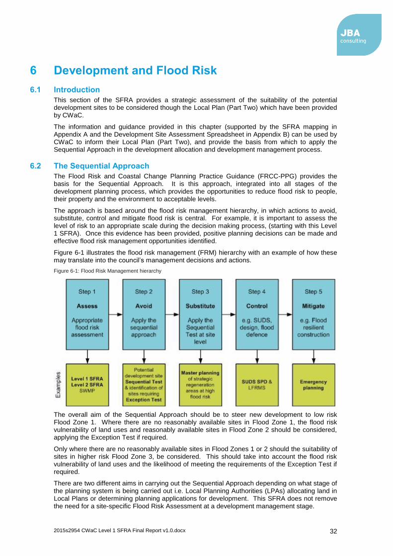
2015s2954 CWaC Level 1 SFRA Final Report v1.0.docx 32
6 Development and Flood Risk
6.1 Introduction
This section of the SFRA provides a strategic assessment of the suitability of the potential development sites to be considered though the Local Plan (Part Two) which have been provided by CWaC.
The information and guidance provided in this chapter (supported by the SFRA mapping in Appendix A and the Development Site Assessment Spreadsheet in Appendix B) can be used by CWaC to inform their Local Plan (Part Two), and provide the basis from which to apply the Sequential Approach in the development allocation and development management process.
6.2 The Sequential Approach
The Flood Risk and Coastal Change Planning Practice Guidance (FRCC-PPG) provides the basis for the Sequential Approach. It is this approach, integrated into all stages of the development planning process, which provides the opportunities to reduce flood risk to people, their property and the environment to acceptable levels.
The approach is based around the flood risk management hierarchy, in which actions to avoid, substitute, control and mitigate flood risk is central. For example, it is important to assess the level of risk to an appropriate scale during the decision making process, (starting with this Level 1 SFRA). Once this evidence has been provided, positive planning decisions can be made and effective flood risk management opportunities identified.
Figure 6-1 illustrates the flood risk management (FRM) hierarchy with an example of how these may translate into the council’s management decisions and actions.
Figure 6-1: Flood Risk Management hierarchy
The overall aim of the Sequential Approach should be to steer new development to low risk Flood Zone 1. Where there are no reasonably available sites in Flood Zone 1, the flood risk vulnerability of land uses and reasonably available sites in Flood Zone 2 should be considered, applying the Exception Test if required.
Only where there are no reasonably available sites in Flood Zones 1 or 2 should the suitability of sites in higher risk Flood Zone 3, be considered. This should take into account the flood risk vulnerability of land uses and the likelihood of meeting the requirements of the Exception Test if required.
There are two different aims in carrying out the Sequential Approach depending on what stage of the planning system is being carried out i.e. Local Planning Authorities (LPAs) allocating land in Local Plans or determining planning applications for development. This SFRA does not remove the need for a site-specific Flood Risk Assessment at a development management stage.

2015s2954 CWaC Level 1 SFRA Final Report v1.0.docx 33
The following sections provide a guided discussion on why and how the Sequential Approach should be applied, including the specific requirements for undertaking Sequential and Exception Testing.
6.3 Local Plan Sequential & Exception Test
CWaC, as the LPA, should seek to avoid inappropriate development in areas at risk of flooding by directing development away from areas at highest risk and ensuring that all development does not increase risk and where possible can help reduce risk from flooding to existing communities and development.
(Guidance on the application of the sequential and exceptions test through the development management process is provided at Section 1.1 of this report)
Figure 6-2 illustrates the Sequential and Exception Tests as a process flow diagram using the information contained in this SFRA to assess potential development sites against the Environment Agency’s Flood Map for Planning flood zones and development vulnerability compatibilities.
This is a stepwise process, but a challenging one, as a number of the criteria used are qualitative and based on experienced judgement. The process must be documented and evidence used to support decisions recorded.
At a strategic level, this should be carried out as part of CWaC's Local Plan (Part Two). This should be done by:
1. Applying the Sequential Test and if the Sequential Test is passed, applying the Exception Test, if required;
2. Safeguarding land from development that is required for current and future flood management;
3. Using opportunities offered by new development to reduce the causes and impacts of flooding and where climate change is expected to increase flood risk so that existing development may not be sustainable in the long term;
4. Seeking opportunities to facilitate the relocation of development including housing to more sustainable locations.

2015s2954 CWaC Level 1 SFRA Final Report v1.0.docx 34
Figure 6-2: Local Plan sequential approach to site allocation
This SFRA provides the main evidence required. This process also enables those sites that have passed the Sequential Test, and may require the Exception Test, to be identified.
For the Exception Test to be passed, the NPPF Paragraph 102 states:
a. It must be demonstrated that the development provides wider sustainability benefits to the community that outweigh flood risk informed by a Strategic Flood Risk Assessment where one has been prepared; and
b. A site-specific Flood Risk Assessment (FRA) must demonstrate that the development will be safe for its lifetime taking account of the vulnerability of its users, without increasing flood risk elsewhere, and, where possible, will reduce flood risk overall.
Both elements of the test will have to be passed for development to be allocated or permitted.
Although actually passing the Exception Test will require the completion of a site-specific FRA, CWaC should be able to assess the likelihood of passing the test at the Local Plan (Part Two) level by using the information contained in this SFRA to answering the following questions:
a. Can development within higher risk areas be avoided through avoidance or substitution?
b. Is flood risk associated with possible development sites considered too high; and will this mean that the criteria for Exception Testing are unachievable?
c. Can risk be sustainably managed through appropriate development techniques (resilience and resistance) and incorporate Sustainable Drainage Systems without compromising the viability of the development?
d. Can the site, and any residual risks to the site, be safely managed to ensure that its occupiers remain safe during times of flood if developed?

2015s2954 CWaC Level 1 SFRA Final Report v1.0.docx 35
Where it is unlikely that the Exception Test can be passed due to few wider sustainability benefits, the risk of flooding being too great, or the viability of the site being compromised by the flood risk management work required, then CWaC should consider avoiding the site all together.
Once the process has been completed CWaC should then be able to allocate appropriate development sites through the Local Plan (Part Two) as well as prepare flood risk policy including the requirement to prepare site-specific FRAs for all allocated sites that remain at risk of flooding.
6.4 Local Plan (Part Two) Sites Assessment
Housing and Economic Land Availability Assessment (HELAA)
The HELAA is an evidence base document that will inform the preparation of the Council’s Local Plan (Part Two) Land Allocations and Detailed Policies. Local Planning Authorities have a requirement under the National Planning Policy Framework (NPPF) to demonstrate a sufficient supply of potential sites suitable for residential development to meet local housing requirements as well as sites for economic development uses. In addition, the NPPF identifies advantages of carrying out land assessments for housing and economic development as part of the same exercise in order that sites may be allocated for the most appropriate use. Planning Practice Guidance (PPG) as revised (March 2014) has been reviewed and updated and the preparation of a joint land availability assessment is now aided by the publication of guidance entitled “Housing and economic land availability assessment”.
Sites have been identified from a broad range of sources as suggested in PPG, and include planning commitments, sites promoted through a “call for sites” exercise, and sites included in the Council’s Strategic Housing Land Availability Assessment and Employment Land Study Update. The identified sites have been used for assessment for the purposes of this SFRA update. 2,165 sites overall have been assessed and subdivided into several proposed uses including:
Residential (1805 sites)
Employment (133 sites)
Mixed use (131 sites), including housing, employment, retail and greenspace
Retail (51 sites)
Minerals and waste (6 sites)
Recreation and leisure (29 sites)
Power plant (1)
Other (9 sites)
In order to inform the first part of the Sequential Approach for allocation of development through the Local Plan (Part Two) (illustrated in Figure 6-2), this SFRA has carried out a high level screening exercise overlaying the sites against Flood Zones 1, 2, 3a and 3b.
Surface water risk to sites has also been assessed through the Environment Agency's updated Flood Map for Surface Water dataset to help identify those sites that may have critical drainage problems. The site assessment Excel spreadsheet, included in Appendix B (2015s2954 – CWaC Development Site Assessment.xls) provides a breakdown of each site and the Area (ha) and percentage coverage of each flood zone and each surface water flood zone.
Zones 3b, 3a and 2 are considered in isolation. Any area of a site within the higher risk Flood Zone 3b that is also within Flood Zone 3a is excluded from Flood Zone 3a and any area within Flood Zone 3a is excluded from Flood Zone 2. This allows the sequential assessment of risk at each site by addressing those sites at higher risk first. Table 6-1 provides a count of the number of sites within each Flood Zone.
Table 6-1: Number of potential development sites at risk from Flood Map for Planning flood zones
Potential development Sites
Number of Sites Within
Flood Zone 2 Flood Zone 3a Flood Zone 3b
Residential 112 109 33
Employment 20 22 4

2015s2954 CWaC Level 1 SFRA Final Report v1.0.docx 36
Potential development Sites
Number of Sites Within
Flood Zone 2 Flood Zone 3a Flood Zone 3b
Mixed use 34 29 15
Retail 6 5 0
Minerals & waste 4 2 2
Recreation & leisure
6 5 1
Power plant 0 0 0
Other 0 0 0
TOTAL 182 172 55
If this is not the case, or where wider strategic objectives require regeneration in areas already at risk of flooding, then CWaC should consider the compatibility of vulnerability classifications and Flood Zones (refer to FRCC-PPG) and whether or not the Exception Test will be required before finalising sites. The decision making process on site suitability should be transparent and information from this SFRA should be used to justify decisions to allocate land in areas at high risk of flooding.
6.4.1 Sustainability Appraisal and Flood Risk
The Sustainability Appraisal should help to ensure that flood risk is taken into account at all stages of the planning process with a view to directing development away from areas at flood risk, now and in the future, by following the sequential approach to site allocation, as shown in Figure 6-2. Using this SFRA, and specifically the sites assessment information included in Section 6.5 and the Development Site Assessment spreadsheet (Appendix B), the Council should be able to make decisions on the sustainability of specific sites, with regards to flood risk.
By avoiding sites identified in this SFRA as being at significant risk, such as those listed in Section 6.5.1.1, or by considering how changes in site layout can avoid those parts of a site at flood risk, such as any site included within Recommendation C (Section 6.5.1.3), the Council would be demonstrating a sustainable approach to development.
In terms of surface water, the same approach should be followed whereby those sites at highest risk should be avoided or site layout should be tailored to ensure sustainable development. This should involve investigation into appropriate SuDS techniques (see Section 6.9). The formal designation of Critical Drainage Areas through Surface Water Management Plans or drainage strategies, following on from the indicative Areas of Critical Drainage proposed through this SFRA (see Section 5.3.6), should also provide sustainability benefits by ensuring that any site within a CDA that is >0.5 ha should be subject to a site-specific FRA and be subject to a larger reduction on existing runoff rates to ensure appropriate mitigation of surface water risk.
Once the Council has decided on a final list of sites following application of the Sequential Test and, where required, the Exception Test following a site-specific FRA, a phased approach to development should be carried out to avoid any cumulative impacts that multiple developments may have on flood risk. For example, for any site where it is required to develop in Flood Zone 3, detailed modelling would be required to ascertain where water displaced by development may flow and to calculate subsequent increases in downstream flood volumes. The modelling should investigate scenarios based on compensatory storage techniques to ensure that downstream or nearby sites are not adversely affected by development on other sites.
Using a phased approach to development, based on modelling results of floodwater storage options, should ensure that any sites at risk of causing flooding to other sites are developed first in order to ensure flood storage measures are in place before other sites are developed, thus ensuring a sustainable approach to site development. Also, it may be possible that flood mitigation measures put in place at sites upstream could alleviate flooding at downstream or nearby sites.
CWaC should use the site assessment spreadsheet in Appendix B to identify which sites should be avoided during the Sequential Test. The spreadsheet can also be used to assess whether or not economic and housing projections can be met by purely allocating sites in areas at low risk of flooding

2015s2954 CWaC Level 1 SFRA Final Report v1.0.docx 37
6.4.2 Safeguarded Land for Flood Storage
Where possible, the Council may look to allocate land designed for flood storage functions. Such land can be explored through the site allocation process whereby an assessment is made, using this SFRA, of the flood risk at potential sites and what benefit could be gained by leaving the site undeveloped. In some instances the storage of flood water can help to alleviate flooding elsewhere, such as downstream developments. Where there is a large area of a site at risk that is considered large enough to hinder development, it may be appropriate to safeguard this land for the storage of flood water.
An assessment has been made of the potential sites within the key areas (Section 1.1) and their applicability for flood storage. The Council's Open Spaces Assessment (Section 4.4.7) information has also been evaluated for potential flood storage areas. Applicable sites include any current Greenfield sites:
That are considered to be large enough (>1 ha) to store flood water to achieve effective mitigation,
With large areas of their footprint at risk from 1 in 30 or 1 in 100 AEP surface water flood events (based on the uFMfSW),
That is within the functional floodplain (Flood Zone 3b),
With large areas of their footprint at risk from Flood Zone 3a, and
That are large enough and within a suitable distance to receive flood water from a nearby development site using appropriate SuDS techniques which may involve pumping, piping or swales / drains.
Brownfield sites could also be considered though this would entail site clearance of existing buildings and conversion to greenspace.
Potential sites covering existing Greenfield land that could be safeguarded for flood storage are listed in Table 6-2. Note that parts of these sites may still be available for development, depending on the percentage area at risk. By using the sequential approach to site layout, the LPA and developers should be able to avoid the areas at risk and leave clear for potential flood storage. See the SFRA Maps in Appendix A for the areas of the sites at risk.
Table 6-2: Potential areas to safeguard for flood storage
Site ID Location Area (ha)
Main source of risk
% area at risk
JBA1242 Land to west of Clifton Drive, rear of 174-300 Sealand Road, Chester
8.9 FZ3b 42
JBA1316 Land to west of Chaser Court, Chester 3.3 FZ3a 100
JBA584 Land to west of Dee Banks Road, adjacent to Butter Bache Bridge, Huntington, Chester
2.2 FZ3b 44
JBA1760 Land at Green Lane / Boundary Lane, Lache 4.4 FZ3b 70
JBA1749 Land south of River Dane, east of Withington Close, Dane Valley, Langley Road, Leftwich
35.5 FZ3b 81
JBA1979 Land to south of Vickers Way Park, west of Carlton Road, Northwich
8.1 FZ3b 59
JBA2486 Kemira, Ince Marshes 42.6 FZ3a 98
JBA259 Acton Bridge 3.0 FZ3a 91
JBA682 Land at Beeston Bridge, south of Shropshire Union Canal, Beeston
2.9 FZ3a 55
Open Space Assessment
Frodsham and Helsby Marshes 892 FZ3a 48
Open Space Assessment
CWT Reserve, Thornton-le-Moors, Stanlow 161 FZ3b 46
Open Space Assessment
The Meadows, Chester 25.6 FZ3b 72
Open Space Assessment
Caldy Nature Park, Chester 10.8 FZ3a 54
Open Space Assessment
River Weaver NSN, Northwich 2.8 FZ3b 68
Open Space Vickers Way AGS 2.9 FZ3a 79

2015s2954 CWaC Level 1 SFRA Final Report v1.0.docx 38
Site ID Location Area (ha)
Main source of risk
% area at risk
Assessment
Open Space Assessment
Frodsham Cricket Club 3.6 FZ3a 98
Open Space Assessment
Marshlands Tree Garden 1.3 FZ3a 69
Open Space Assessment
South Wood, Junction 8, Ellesmere Port 1.7 FZ3a 72
Open Space Assessment
The Cop Amenity Space, Chester 1.3 FZ3a 88
Open Space Assessment
Ashton Cricket Club 1.4 Surface water
36
Open Space Assessment
Stanney Fields Park, Neston 3.8 Surface water
38
Open Space Assessment
Wades Clough, Winsford 2.2 Surface water
25
Open Space Assessment
Monarch Way AGS, Kingsmead, Northwich 1.1 Surface water
19
Open Space Assessment
Marshall's Arm, Hartford 13.8 FZ3b 24
Open Space Assessment
Park Moss, Antrobus 9.9 Surface water
26
Open Space Assessment
Rosslyn Lane, Cartledge Moss, Sandiway 1.1 Surface water
33
6.5 Potential Development Sites Review
This section of the report assesses flood risk to potential sites. Section 6.5.1 provides high level broad-brush recommendations for those sites within the flood zones of the Flood Map for Planning. Section 6.5.2 reviews the surface water risk to the potential sites by way of the updated Flood Map for Surface Water.
It is important to consider that each individual site will require further investigation, as local circumstances may dictate the outcome of the recommendation. Such local circumstances may include the following:
If sites have planning permission but construction has not started, the SFRA will only be able to influence the design of the development e.g. finished floor levels. New, more extensive flood extents (from new models) cannot be used to reject development where planning permission has already been granted
Some sites may be able to develop around the flood risk. Planners are best placed to make this judgement i.e. will the site still be deliverable if part of it needs to be retained to make space for flood water
Surrounding infrastructure may influence scope for layout redesign/removal of site footprints from risk
Current land use. A number of sites included in the assessment are brownfield thus the existing development could be taken into account as further development may not lead to increased flood risk. However, the Environment Agency may have their own views on this in regard to health warnings as new-build properties in risk areas could be built with flood protection in mind
Existing planning permissions may exist on some sites where the Environment Agency may have already passed comment and/or agreed to appropriate remedial works concerning flood risk. Previous flood risk investigations/FRAs may already have been carried out at some sites.

2015s2954 CWaC Level 1 SFRA Final Report v1.0.docx 39
6.5.1 Flood Map for Planning Site Assessment
6.5.1.1 Recommendation A – Consider withdrawal of site
This recommendation DOES NOT take account of local circumstances, only that part of a site area falls within a Flood Zone.
The 10% threshold is not included within any policy, it is merely considered that it would be very difficult for developers to deliver a site where 10% or more of the site area is considered as undevelopable, based on the NPPF. This 10% threshold does not account for local circumstances therefore it may be possible to deliver some of the sites included with Recommendation A.
Table 6-3 lists those sites where Recommendation A should apply based on the 10% threshold of site area within the functional floodplain. This accounts for 18 sites. There are another eight sites where Recommendation A could apply based on the level of significant surface water flood risk on-site and the unlikelihood of mitigation based on limited space. These sites are listed in Table 6-7.
Table 6-3: Sites to consider withdrawing that are within Flood Zone 3b
Site ID Site Name Proposed use
Site Area (ha)
% Area within FZ3b
JBA190 Land to south of Riverholm, 20 Sandy Lane, Boughton, Chester
Residential 0.23 18.51
JBA243 Unknown Employment 2.23 13.32
JBA507 Land adjacent 27 Townfield Lane, Farndon Residential 2.08 14.11
JBA584 Land to west of Dee Banks Road, adjacent to Butter Bache Bridge, Huntington, Chester
Residential 2.20 17.62
JBA1179 Land to south-east of Deva Link, bound by Finchetts Gutter, Chester
Residential 5.95 98.73
JBA1195 Sandy Lane (car park), Chester Residential 0.22 49.14
JBA1242 Land to west of Clifton Drive, rear of 174-300 Sealand Road, Chester
Residential 8.94 41.49
The following recommendations provide only a guide, based on the flood risk information made available for this Level 1 SFRA. Information regarding local, site specific information is beyond the scope of this SFRA. It is CWaC's responsibility to carry out sequential testing of each site using the information provided in this SFRA and more specifically using their local, site specific knowledge and advice from the EA / NRW. These sections should be read alongside the Development Site Spreadsheet in
Appendix B.
Recommendation A applies to any site within the functional floodplain where the following criteria is true:
10% or greater of the site area is within Flood Zone 3b. The FRCC-PPG flood risk vulnerability classification states that only water-compatible uses and essential infrastructure should be permitted in Flood Zone 3b, though any essential infrastructure must pass the Exception Test. Land allocated for housing falls in to the more vulnerable category and sites for employment; retail; recreation and leisure; and mineral and waste are in the less vulnerable category, though waste management sites for hazardous materials fall with the more vulnerable category. It is assumed that none of the waste facility sites are hazardous. Mixed use sites should be placed into the higher of the relevant classes of flood risk sensitivity. Development should not be permitted for sites within the more vulnerable and less vulnerable categories that fall within Flood Zone 3b. If the developer is able to avoid 3b however, then part of the site could still be delivered.
The scale of surface water risk on the site is considered large enough that possible mitigation of the risk on site is deemed unlikely to be achievable.

2015s2954 CWaC Level 1 SFRA Final Report v1.0.docx 40
Site ID Site Name Proposed use
Site Area (ha)
% Area within FZ3b
JBA1252 Land to north-west of Deva Link, bound by Saughall Road, Chester
Residential 31.94 99.23
JBA1271 Caledonian Garage, Parkgate Road, Chester
Residential 1.50 24.21
JBA1315 Land at Sealand Meadows, east of Finchetts Gutter
Residential 4.12 67.07
JBA1318 Land west of Chaser Court, north of Finchetts Gutter, Chester
Residential 6.87 88.78
JBA1504 Allotments and garage off Saughall Road/ Cheyney Road, Chester
Residential 0.92 47.54
JBA1518 BW Tip at Mollington, east of Shropshire Union Canal
Residential 3.41 90.49
JBA1749 Land south of River Dane, east of Withington Close, Dane Valley, Langley Road, Leftwich
Residential 29.94 81.11
JBA1760 Land at Green Lane / Boundary Lane, Lache
Residential 4.40 70.05
JBA1770 Land to rear of 41-47 Peel Crescent, Ashton
Residential 0.19 61.66
JBA1899 Land to east of Hollands Road / London Road, Leftwich, Northwich
Residential 4.80 12.29
JBA1979 Land to south of Vickers Way Park, west of Carlton Road, Northwich
Residential 8.14 59.07
6.5.1.2 Recommendation B – Exception Test
Recommendation B applies to sites where it is likely the Exception Test would be required. This does not include any recommendation on the likelihood of a site passing the Exception Test. These sites would need to be examined as part of a more in-depth Level 2 SFRA. The developer / LPA should attempt to avoid the risk area where possible.
This recommendation DOES NOT take account of local circumstances, only that part of a site area falls within a Flood Zone.
The 10% threshold is not included within any policy, it is merely considered that it would be very difficult for developers to avoid Flood Zone 3a when 10% or more of the site area is within it. This 10% threshold does not account for local circumstances therefore it may be possible to avoid Flood Zone 3a altogether for some of the sites included with Recommendation B.
Table 6-4 lists those sites where Recommendation B should apply based on the 10% threshold of site area within Flood Zone 3a. The Development Site Assessment spreadsheet in Appendix B lists those sites where Recommendation B should apply, encompassing 63 sites.
Table 6-4: Sites where application of the Exception Test would be required
Site ID Site Name Proposed use
Site Area (ha)
% Area within FZ3a
JBA133 Barons Quay, Northwich (cinema, A3 restaurants, A1 retail phases 1 and 2)
Mixed Use 2.66 30.94
JBA237 Unknown Residential 0.19 24.32
JBA239 Land to rear of 15 - 45 Greenlands, Tattenhall
Residential 6.36 11.71
JBA297 Unknown Residential 0.13 51.09
JBA336 Unknown Residential 10.31 26.29
Recommendation B applies to sites where the following criteria is true:
10% or greater of any residential site or essential infrastructure that is within Flood Zone 3a. Only water-compatible and less vulnerable uses of land are appropriate in this zone.
10% or greater of any mixed use site that may entail residential use that is within Flood Zone 3a.
All development proposals in Flood Zone 3a must be accompanied by a flood risk assessment.

2015s2954 CWaC Level 1 SFRA Final Report v1.0.docx 41
Site ID Site Name Proposed use
Site Area (ha)
% Area within FZ3a
JBA342 Land to east of Clifton Drive, rear of 100-174 Sealand Road, Chester
Residential 5.38 100.00
JBA356 Unknown Mixed Use 87.07 14.42
JBA380 Ince Park, Ince Marshes, Near Stanlow Mixed Use 126.79 92.11
JBA405 Honeywell Unit 1, Chester Road, Helsby, WA6
Mixed Use 1.39 11.96
JBA471 Towers Lane Farm, Dunham-on-the-Hill Residential 4.75 47.50
JBA492 Land north of Hooton Road, Hooton Mixed Use 5.73 21.24
JBA535 Brooklea Meadows, Welsh Road, Little Sutton
Residential 3.45 23.78
JBA565 British Waterways site off Bradford Road, Winsford
Mixed Use 1.36 18.54
JBA619 The Boat House, Farndon Residential 0.12 61.63
JBA682 Land at Beeston Bridge, south of Shropshire Union Canal, Beeston
Residential 2.94 55.28
JBA684 Land to rear of 30-84 Castlefields, Tattenhall
Residential 2.27 14.65
JBA806 Northwich Market, Watling Street, Northwich
Residential 0.29 33.90
JBA807 Land to west of Queen Street, Northwich Residential 1.74 73.94
JBA815 Land at Hargreaves Road / Middlewich Road, Northwich
Mixed Use 4.92 15.02
JBA830 Boat House off Lower Park Road, Queens Park, Chester
Residential 0.24 54.80
JBA853 Land off Green Lane, Lache Residential 6.72 21.59
JBA866 Land at Haycroft and Farmers Heath, Great Sutton, Ellesmere Port
Residential 1.05 24.79
JBA868 Rear of 932 to 936 Chester Road, Ellesmere Port
Residential 0.32 11.14
JBA951 Land west of Wrexham Road, Lache Eyes, Chester
Residential 119.37 19.96
JBA993 Land at Irons Lane, Hollowmoor Heath, Great Barrow
Residential 0.06 100.00
JBA1129 Land at Caldy Brook/ Caldy Valley Road, Chester
Residential 0.46 69.25
JBA1169 Car park to rear of The Boat House PH, Grosvenor Park Terrace, Chester
Residential 0.18 34.42
JBA1213 Former Tilston's Builder's Yard, New Crane Street, Chester
Residential 0.12 17.75
JBA1232 Land south of The Brambles, Parkgate Road, Mollington
Residential 1.40 15.04
JBA1248 Mulberry Centre, Sealand Road, Chester Residential 1.36 100.00
JBA1267 Land at Parkgate Road,south-east of Finchetts Gutter, Blacon
Residential 1.98 71.25
JBA1270 Land at Bank Farm, Sealand Road, Chester
Residential 0.87 83.87
JBA1314 Land at Bumpers Lane municipal tip, Chester
Mixed Use 23.88 39.30
JBA1316 Land to west of Chaser Court, Chester Residential 3.27 100.00
JBA1377 Land at Lock Street, Northwich Mixed Use 1.82 42.29
JBA1378 British Waterways Site, Navigation Road, Northwich
Residential 1.26 18.63
JBA1387 Land off London Road, Northwich Residential 0.49 64.54
JBA1415 Land at Arthur Street, Chester Residential 0.56 100.00
JBA1427 Chapelfields, Frodsham Residential 1.26 31.63
JBA1489 Gowy Landfill Site, Wimbolds Trafford Residential 74.82 35.02
JBA1520 Land at Backford Bridge, north of Shropshire Union Canal, Birkenhead Road, Backford
Residential 4.75 14.94
JBA1584 Land off Sandy Lane, Weaverham, Northwich
Residential 1.64 11.67
JBA1589 INEOS Compounds, Chester Road, Helsby Residential 2.03 16.05
JBA1607 Land to the rear of Pool House, Oulton Mill Lane, Cotebrook, Tarporley
Residential 0.51 31.61
JBA1625 Land south of Heath Lane, east of Manor Close, Great Barrow
Residential 0.62 56.83
JBA1722 Land at Sealand Road, Blacon (adjoining Welsh border)
Residential 4.66 100.00

2015s2954 CWaC Level 1 SFRA Final Report v1.0.docx 42
Site ID Site Name Proposed use
Site Area (ha)
% Area within FZ3a
JBA1755 Land at Marsh Lane, Ince, Ellesmere Port Mixed Use 84.83 18.53
JBA1833 Green Lane Farm, Green Lane, Marslton Cum Lache, Chester,
Residential 0.06 100.00
JBA1917 Land adjacent 48 Sealand Road, Chester Residential 1.30 100.00
JBA2003 Land east of Withington Close, Dane Valley, Northwich
Residential 14.52 15.07
JBA2023 Land at Western Avenue / Sealand Road junction, Blacon, Chester
Residential 3.42 97.85
JBA2044 Cheshire Brick and Slate, Kelsall Road, Tarvin
Residential 0.79 59.36
JBA2097 Land to north of Sutton Causeway, south-west of Weaver Navigation, Frodsham
Residential 2.37 100.00
JBA2098 Land south-east of Sutton Causeway, north of Frodsham Bridge, Frodsham
Residential 6.85 100.00
JBA2288 Land at Llewellis Farm, Mill Lane, Kingsley Residential 0.17 100.00
JBA2486 Kemira, Ince Marshes, Ince Mixed Use 42.61 97.70
JBA2656 Chester Road, Helsby Residential 7.69 19.52
JBA2803 Land off Appleyards Lane, Handbridge, Chester
Residential 4.47 12.18
JBA2812 Land off Boundary Lane/Green Lane, Lache, Chester
Residential 0.26 100.00
JBA2957 Land south of dismantled railway/adjacent Neston Sewage Works
Mixed Use 10.93 21.03
JBA2966 Land to the north of A556, Rudheath, Northwich
Residential 9.77 11.69
JBA785 Marina Development Area, London Road / Chester Way, Northwich
Residential 0.47 100.00
JBA3034 Crowton Mill, Ainsworth Lane, Crowton Residential 0.30 81.05
6.5.1.3 Recommendation C – Consider site layout and design
Recommendation C recommends a review of site layout and / or design at the development planning stage in order for development to proceed. A Level 2 SFRA or site-specific FRA would be required to inform on site layout and design.
This recommendation DOES NOT take account of local circumstances, only that part of a site area falls within a Flood Zone.
The 10% threshold is not included within any policy, it is merely considered that it may be possible for developers to avoid Flood Zone 3b and Flood Zone 3a when less than 10% of the site area is at risk. This 10% threshold does not account for local circumstances.
The Development Site Assessment spreadsheet in Appendix B categorises those sites with <10% of their area within Flood Zone 3b where site layout should be examined with a view to removing the site footprint from Flood Zone 3b. Depending on local circumstances, if it is not possible to adjust the site boundary to remove the site footprint from Flood Zone 3b to a lower risk zone then development should not be permitted.
Also listed within the spreadsheet are the residential and mixed use sites with <10% of their area within Flood Zone 3a and where site layout and / or design should be examined with a view to removing the site footprint from Flood Zone 3a or incorporating on-site storage of water into site design. Depending on local circumstances, if it is not possible to adjust the site boundary to remove the site footprint from Flood Zone 3a to a lower risk zone or to incorporate on-site
Recommendation C applies to sites where the following criteria is true:
<10% of the area of any site type is within Flood Zone 3b.
<10% of any residential site is within Flood Zone 3a.
<10% of any mixed use site that may entail residential use is within Flood Zone 3a.
<10% of any essential infrastructure site is within Flood Zone 3a.

2015s2954 CWaC Level 1 SFRA Final Report v1.0.docx 43
storage of water within the site design, then the Exception Test should be undertaken and passed as part of a site-specific FRA.
Overall there are 69 potential sites to which Recommendation C applies, listed in Table 6-5.
Any site layout and design should take account of the 8 m easement buffer along watercourses where development is not permitted. This easement buffer is recommended by the Environment Agency to allow ease of access to watercourses for maintenance works. Any site redesign, where Flood Zone 3a is included within the site footprint, should allow water to flow naturally or be stored in times of flood through application of suitable SuDS.
Table 6-5: Sites to consider layout and design to avoid risk areas
Site ID Site Name Proposed use
Site Area (ha)
JBA84 Land at former BICC Helsby, west of Crossland Drive, Helsby
Recreation & Leisure
3.06
JBA100 Memorial Hall Site, Chester Way/Brockhurst Street, Northwich
Mixed Use 1.93
JBA242 Land North of Leicester Street, Northwich Mixed Use 1.55
JBA252 Land west of Ravensholme, Chester Road, Tattenhall
Residential 3.45
JBA257 Land at Winnington Works, Northwich Mixed Use 58.55
JBA306 Unknown Mixed Use 2.29
JBA315 Land east of Church Street, Tarvin Residential 17.53
JBA324 Unknown Mixed Use 6.40
JBA381 Land off Warrington New Road / Manchester Road. Northwich
Mixed Use 4.37
JBA384 Unknown Residential 46.17
JBA396 Land to the south of A556, Rudheath, Northwich (south west Gadbrook Park)
Mixed Use 66.65
JBA531 Unknown Minerals & Waste
342.96
JBA536 Unknown Mixed Use 53.37
JBA573 Land south of Rilshaw Lane, Winsford (NP site S1)
Mixed Use 59.97
JBA581 Greedy Pig, New Road, Winsford Mixed Use 1.10
JBA583 Regents' Grange - Saighton Camp, Sandy Lane, Huntington, Chester (Area B)
Residential 17.11
JBA627 The Rookery / Chester Road (paddock adjacent), Tattenhall
Residential 3.58
JBA637 Land to rear of Adari, Chester Road, rear of Rookery Drive and south of Keys Brook, Tattenhall
Residential 5.55
JBA704 Ellesmere Port Docks and hinterland Residential 27.49
JBA758 Land to north of Landford Road, Wincham Mixed Use 17.79
JBA773 Land adjacent 7 Old Quay Close, Neston Residential 0.51
JBA786 Watling Street (Council offices), Northwich Residential 0.70
JBA797 Land at Lostock Works House, Works Lane, Northwich
Mixed Use 1.70
JBA816 Middlewich Road, Wade Works (Phase I) Residential 8.27
JBA817 Land adjacent Victoria Bridge, Chester Way, Northwich
Mixed Use 0.29
JBA819 Dane House Chester Way, Northwich Mixed Use 0.11
JBA824 Lapperfield, off Barnwood Drive, Lache Residential 8.11
JBA825 Land adjacent railway line, Green Lane, Lache
Residential 3.83
JBA827 Land adjacent 5 Dingle Bank, Curzon park Residential 0.48
JBA855 40 Curzon Park North, Chester Residential 0.27
JBA875 West Works Winsford Rocksalt Mine, Bradford Road, Winsford
Residential 10.79
JBA888 Land to rear of Red Lion Pub, High Street, Winsford
Residential 0.81
JBA898 Meadow Island, Bradford Road, Winsford Residential 2.44
JBA905 Bradford Road (Overworks stocking area) Residential 8.49
JBA1073 Land to rear of Crane Bank Garage, Chester
Residential 0.19
JBA1130 Land at Orchid Road, Chester Residential 0.25
JBA1181 Southern Tail development (remaining part of allocation), New crane street
Residential 0.69

2015s2954 CWaC Level 1 SFRA Final Report v1.0.docx 44
Site ID Site Name Proposed use
Site Area (ha)
JBA1254 Land at Capenhurst Lane, Capenhurst Residential 31.34
JBA1272 Rough Hill, Marlston cum Lache, Dodleston
Residential 8.88
JBA1312 Land at Greenbank Wood, School Lane, Hartford, Northwich
Residential 31.54
JBA1313 Land at Abbots Mead, east of canal / south of Blacon Avenue, Blacon
Residential 2.09
JBA1321 59 Mill Lane, (land adjacent) Little Sutton, Ellesmere Port
Residential 0.09
JBA1396 Winnington Urban Village, Northwich Residential 45.39
JBA1448 Field Parcels (south of Oaklands and east of Wicker Lane), Guilden Sutton
Residential 101.75
JBA1470 Land to south of Heath Lane, east of Manor Close, Great Barrow
Residential 4.16
JBA1559 Land to east of Griffiths Road, Northwich Residential 132.89
JBA1570 Land east of Weaver Lane, Ship Street, Frodsham
Residential 3.04
JBA1576 Land to rear of Ashton House, Pentre Lane, Ashton Hayes
Residential 0.86
JBA1590 Land north of Well Lane, off Mill Lane, Little Budworth
Residential 2.29
JBA1639 Land at Peckmill Farm, London Road, Davenham, Northwich
Residential 7.13
JBA1773 Land off Runcorn Road, Barnton Residential 18.58
JBA1875 Land at Cow Lane / Stocks Lane, Ways Green, Winsford
Residential 5.54
JBA1937 Land south of Mill Lane, Kingsley Residential 5.88
JBA2059 Mostyn House and land adjacent, The Parade, Parkgate
Residential 2.29
JBA2069 The Chase, Chase Drive, off Chase Way, Sutton, Ellesmere Port
Residential 0.45
JBA2091 Land at Weaver Shipyard, Saxons Lane, Northwich
Residential 3.32
JBA2328 Land to rear of 1-27 Parker Drive, Farndon Residential 0.38
JBA2506 Land at Weaver Navigation / Runcorn Road, Barnton
Mixed Use 0.96
JBA2521 Site of Former Ince A and B Power Stations
Employment 34.83
JBA2590 Griffiths Road, Lostock Gralam, CW9 7NU Minerals & Waste
3.86
JBA2602 Wincham Urban Village, Chapel Street, Wincham
Mixed Use 43.60
JBA2668 Cheshire Warehousing Ltd, New Road, Winsford
Mixed Use 1.19
JBA2738 Site of Former Ince A and B Power Stations
Employment 2.17
JBA2775 Land to West of Cosgrove Bus' Park Employment 0.57
JBA2788 Land to the rear of the Salt Museum, London Road, Northwich
Residential 0.79
JBA2801 Land off Melverly Drive, Blacon Residential 4.38
JBA2905 Site rear of canal site 5, Oil Sites Road, Ellesmere Port
Residential 3.04
JBA2949 "Watersmeet", land adjoining Chester West Employment Park and land to south of River Dee, eastern side of Saltney
Mixed Use 165.22
JBA133 Barons Quay, Northwich (Foodstore and A1 retail phase 1)
Mixed Use 2.28
6.5.1.4 Recommendation D – Development permitted subject to FRA
Recommendation D recommends that development could be permitted, assuming a site-specific FRA shows the site can be safe and it is demonstrated that the site is sequentially preferable. A site within Flood Zone 2 could still be rejected if the conclusions of the FRA decide development is unsafe or inappropriate.
This recommendation DOES NOT take account of local circumstances, only that part of a site area falls within a Flood Zone.
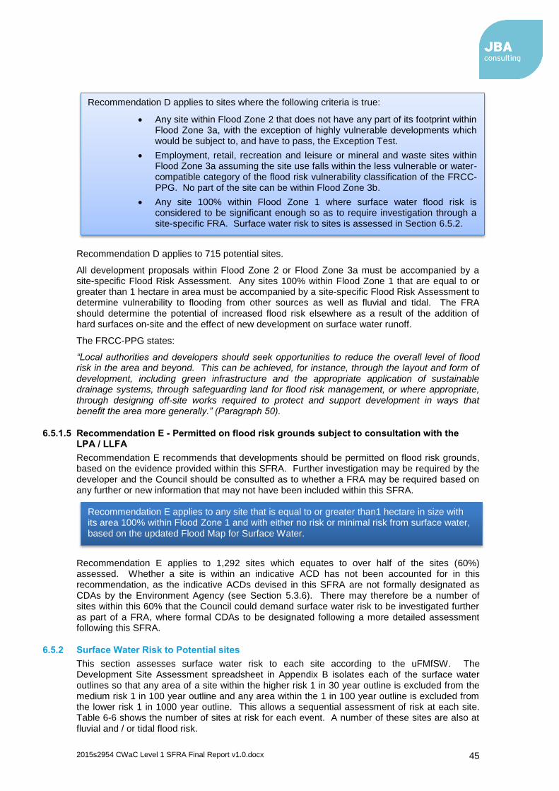
2015s2954 CWaC Level 1 SFRA Final Report v1.0.docx 45
Recommendation D applies to 715 potential sites.
All development proposals within Flood Zone 2 or Flood Zone 3a must be accompanied by a site-specific Flood Risk Assessment. Any sites 100% within Flood Zone 1 that are equal to or greater than 1 hectare in area must be accompanied by a site-specific Flood Risk Assessment to determine vulnerability to flooding from other sources as well as fluvial and tidal. The FRA should determine the potential of increased flood risk elsewhere as a result of the addition of hard surfaces on-site and the effect of new development on surface water runoff.
The FRCC-PPG states:
“Local authorities and developers should seek opportunities to reduce the overall level of flood risk in the area and beyond. This can be achieved, for instance, through the layout and form of development, including green infrastructure and the appropriate application of sustainable drainage systems, through safeguarding land for flood risk management, or where appropriate, through designing off-site works required to protect and support development in ways that benefit the area more generally.” (Paragraph 50).
6.5.1.5 Recommendation E - Permitted on flood risk grounds subject to consultation with the LPA / LLFA
Recommendation E recommends that developments should be permitted on flood risk grounds, based on the evidence provided within this SFRA. Further investigation may be required by the developer and the Council should be consulted as to whether a FRA may be required based on any further or new information that may not have been included within this SFRA.
Recommendation E applies to 1,292 sites which equates to over half of the sites (60%) assessed. Whether a site is within an indicative ACD has not been accounted for in this recommendation, as the indicative ACDs devised in this SFRA are not formally designated as CDAs by the Environment Agency (see Section 5.3.6). There may therefore be a number of sites within this 60% that the Council could demand surface water risk to be investigated further as part of a FRA, where formal CDAs to be designated following a more detailed assessment following this SFRA.
6.5.2 Surface Water Risk to Potential sites
This section assesses surface water risk to each site according to the uFMfSW. The Development Site Assessment spreadsheet in Appendix B isolates each of the surface water outlines so that any area of a site within the higher risk 1 in 30 year outline is excluded from the medium risk 1 in 100 year outline and any area within the 1 in 100 year outline is excluded from the lower risk 1 in 1000 year outline. This allows a sequential assessment of risk at each site. Table 6-6 shows the number of sites at risk for each event. A number of these sites are also at fluvial and / or tidal flood risk.
Recommendation D applies to sites where the following criteria is true:
Any site within Flood Zone 2 that does not have any part of its footprint within Flood Zone 3a, with the exception of highly vulnerable developments which would be subject to, and have to pass, the Exception Test.
Employment, retail, recreation and leisure or mineral and waste sites within Flood Zone 3a assuming the site use falls within the less vulnerable or water-compatible category of the flood risk vulnerability classification of the FRCC-PPG. No part of the site can be within Flood Zone 3b.
Any site 100% within Flood Zone 1 where surface water flood risk is considered to be significant enough so as to require investigation through a site-specific FRA. Surface water risk to sites is assessed in Section 6.5.2.
Recommendation E applies to any site that is equal to or greater than1 hectare in size with its area 100% within Flood Zone 1 and with either no risk or minimal risk from surface water, based on the updated Flood Map for Surface Water.

2015s2954 CWaC Level 1 SFRA Final Report v1.0.docx 46
Table 6-6: Number of sites at risk from surface water flooding
uFMfSW event Number of sites at risk Number of sites with >=10% / >=20% area at risk
1 in 30 year 595 46
1 in 100 year 827 52
1 in 1000 year 1279 152^
*In reality, sites within the 1 in 30 year outline will also be in the 1 in 100 year outline and those within the 1 in 100 year outline will also be in the 1000 year outline. ^Based on 20% percentage threshold
Table 6-6 summarises the number of sites at risk from each surface water flood zone. Of the 595 sites at risk from the higher risk 1 in 30 year event, 8% have 10% or more of their site area at risk. The same can be said with the medium risk 1 in 100 year event with only 7% of sites having 10% or more of their area at risk. For the lower risk 1 in 1000 year extreme event, 12% of sites have 20% or more of their area at risk.
As explained with the fluvial / tidal flood zones, the percentage thresholds are not included within any policy, it is merely considered that where a site has 10% or greater of its area at risk from the 1 in 30 and 1 in 100 year event outlines, or 20% or greater for the 1 in 1000 event, then it could prove difficult to manage this surface water on-site. Therefore a site-specific FRA should be carried out to investigate possible mitigation measures for flood storage or infiltration techniques through appropriate SuDS. The percentage thresholds do not consider local conditions. Table 6-7 lists the sites where surface water flood risk is considered to be significant enough that it may be difficult to develop these sites.
Table 6-7: Sites to consider withdrawing based on surface water risk
Site ID Proposed use Site Area (ha) % Area within 1 in 30 Year Outline (uFMfSW)
JBA1360 Residential 0.05 77.38
JBA259 Residential 3.01 72.69
JBA1535 Residential 0.04 72.11
JBA983 Residential 0.35 67.32
JBA1743 Residential 0.05 66.65
JBA1222 Residential 0.43 66.50
JBA1069 Residential 0.23 65.94
JBA2207 Residential 0.03 54.58
For sites at surface water flood risk the following should be considered:
Possible withdrawal, redesign or relocation of the site, certainly for those sites at higher risk from the 1 in 30 year event and those with a large percentage area at risk. This applies to the sites listed in Table 6-7. These sites are considered to be too small to be able to mitigate the level of surface water risk apparent at each site;
A detailed site-specific Flood Risk Assessment incorporating surface water flood risk management;
Any FRA may want to consider detailed surface water modelling, particularly for the larger sites which may influence sites elsewhere;
The size of development and the possibility of increased surface water flood risk caused by development on current Greenfield land, and cumulative impacts of this within specific areas;
Management and re-use of surface water on-site, assuming the site is large enough to facilitate this and achieve effective mitigation;
NOTE: This assessment of surface water risk to sites DOES NOT take account of local circumstances, only that part of a site area falls within a surface water flood outline of the updated Flood Map for Surface Water.

2015s2954 CWaC Level 1 SFRA Final Report v1.0.docx 47
Larger sites could leave surface water flood prone areas as open greenspace, incorporating social and environmental benefits;
Effective surface water management should ensure risks on and off site are controlled;
SuDS should be used where possible. Appropriate SuDS may offer opportunities to control runoff to Greenfield rates. Restrictions on surface water runoff from new development should be incorporated into the development planning stage. For brownfield sites, where current infrastructure may be staying in place, then runoff should attempt to mimic that of Greenfield rates, unless it can be demonstrated that this is unachievable or hydraulically impractical;
Formal Critical Drainage Area (CDA) designation, following on from the indicative ACDs proposed in this SFRA, for large sites and for areas in the borough where surface water flooding is considered significant. For a CDA to be formally designated and notified to the local authority by the Environment Agency, detailed analysis would be required as part of a, Surface Water Management Plan (SWMP) or drainage strategy. This would entail consultation between United Utilities and Welsh Water with CWaC on the capacity of existing sewer systems in order to identify critical parts of the system. Model outputs could be obtained to confirm the critical parts of the drainage network. Recommendations could then be made for future development i.e. strategic SuDS sites, parts of the drainage system where any new connections should be avoided, and parts of the system that may have any additional capacity and recommended runoff rates.

2015s2954 CWaC Level 1 SFRA Final Report v1.0.docx 48
6.5.3 Indicative Areas of Critical Drainage
Based on the methodology described in Section 5.3.6, 20 indicative Areas of Critical Drainage (ACD) have been proposed. Table 6-8 lists the indicative ACDs and the ACD outlines can be viewed on the SFRA Maps in Appendix A.
Table 6-8: Proposed indicative ACDs
Indicative ACD Risk Potential development Sites Present?
ACD 1 Oscroft High surface water flood risk, historical incidents No
ACD 2 Tarvin Historical incidents Yes
ACD 3 Tarporley Historical incidents Yes
ACD 4 Kelsall High surface water flood risk, historical incidents Yes
ACD 5 Winsford High surface water flood risk, historical incidents Yes
ACD 6 Northwich High surface water flood risk, historical incidents Yes
ACD 7 Moulton High surface water flood risk, historical incidents Yes
ACD 8 Lostock Gralam High surface water flood risk, historical incidents Yes
ACD 9 Higher Wincham High surface water flood risk, historical incidents Yes
ACD 10 Comberbatch High surface water flood risk, historical incidents Yes
ACD 11 Barnton High surface water flood risk, historical incidents Yes
ACD 12 Weaverham High surface water flood risk, historical incidents Yes
ACD 13 Cuddington High surface water flood risk, historical incidents Yes
ACD 14 Mickle Trafford High surface water flood risk, historical incidents Yes
ACD 15 Chester High surface water flood risk, historical incidents Yes
ACD 16 Christleton High surface water flood risk, historical incidents Yes
ACD 17 Ellesmere Port High surface water flood risk, historical incidents Yes
ACD 18 Neston High surface water flood risk, historical incidents Yes
ACD 19 Frodsham High surface water flood risk, historical incidents Yes
ACD 20 Helsby High surface water flood risk, historical incidents Yes

2015s2954 CWaC Level 1 SFRA Final Report v1.0.docx 49
6.6 Key Area Review
The strategy of the Local Plan (Part One) is to direct most development to the four main urban areas of the borough. The following key areas have been assessed in more detail in terms of flood risk:
Chester central, including the Sealand Basin and the Watersmeet site
Ellesmere Port and Stanlow
Northwich Town Centre and Gadbrook
Winsford
The following boxes summarise the risk identified at each key area and the subsequent recommendations in relation to flood risk. Several of these recommendations have been carried over from the 2008 SFRA, where they are still considered to be relevant.

2015s2954 CWaC Level 1 SFRA Final Report v1.0.docx 50
Location Chester Central, Sealand Basin and Watersmeet Site
Catchment River Dee

2015s2954 CWaC Level 1 SFRA Final Report v1.0.docx 51
Location Chester Central, Sealand Basin and Watersmeet Site
Flood Zones
Flood Zone 2 Flood Zone 3a Flood Zone 3b
TAN15 DAM shown only for Wales, outside of the Council boundary
Surface water risk
Indicative ACD
Historic flooding
Defended Walls around Chester Retail Park, on Finchett's Gutter; high ground, several embankments on River Dee; high ground on Caldy Brook around Broughton.
Flood Warning
EA Flood Storage Area
Sealand Basin FSA
Potential flood storage
Based on fluvial, tidal and surface water risk, potential sites could include: - JBA1242 west and east of Clifton Drive, Blacon; - JBA1271 Caledonian Garage, Parkgate Rd, Brownfield; - JBA1222 Bear's Paw, Bache, Brownfield; - JBA584 west of Dee Banks Rd, Huntington; - JBA1760 land at Green Lane, Lache
Flood risk The main source of flooding comes from the tidal and fluvial River Dee and fluvial Finchett's Gutter. There are areas of functional floodplain covering rural land on the Dee west of Great Broughton, on Chester Racecourse and also covering the Sealand Basin FSA.
Recommendations
The 2007 breach analysis for the Sealand Basin19 should be used by the LPA to consider the potential levels of flood risk to people when proposing future development within this area. Any future development along the Sealand Basin embankments should be set back by at least 300 m. Further information should be provided in site-specific FRAs on a case by case basis. Any proposed future development on land west and immediately to the east of Clifton Drive and the land in and around the Sealand Basin FSA should seriously consider the significant degrees of flood hazard that could occur. If development is to take place within the above areas, extensive flood mitigation measures will be required. No built development should be considered within the FSA. The flood defences though Chester should be maintained to the 1 in 200 year standard in the locations where there is existing urban development. The Watersmeet site is located within Zone C1 which corresponds to NRW's extreme flood event outline (0.1% AEP event) therefore TAN15 should be consulted when planning the proposed use and development of this site. For any site at surface water risk, SuDS techniques should be investigated to ascertain the most suitable method for
19 Sealand Basin Breach Modelling, Final Report, October 2007

2015s2954 CWaC Level 1 SFRA Final Report v1.0.docx 52
Location Chester Central, Sealand Basin and Watersmeet Site
mitigating surface water flood risk on site. The areas of potential flood storage, cited above, should be investigated for potential storage volumes and associated benefits, in terms of reducing flood risk, to the local area. The LPA should use this SFRA as its first point of reference when considering potential sites in Chester to be allocated through the Local Plan.

2015s2954 CWaC Level 1 SFRA Final Report v1.0.docx 53
Location Ellesmere Port and Stanlow
Catchment River Mersey

2015s2954 CWaC Level 1 SFRA Final Report v1.0.docx 54
Location Ellesmere Port and Stanlow
Flood Zones Flood Zone 2 Flood Zone 3a Flood Zone 3b
Surface water risk
Indicative ACD (Ellesmere Port)
Historic flooding (minor)
Defended Several embankments along River Gowy and Mill Brook to protect Stanlow; several areas of high ground on Rivacre Brook to protect Ellesmere Port. (As detailed in Section 4.4.1)
Flood Warning
EA Flood Storage Area
FSA south of Stanlow at Thornton-le-Moors
Potential flood storage
Based on fluvial, tidal and surface water risk there do not appear to be any suitable sites available for flood storage
Flood risk The main source of flooding comes from the tidal and fluvial River Mersey and fluvial River Gowy and Thornton Brook. There is an area of functional floodplain covering rural land to the south of Stanlow at Thornton-le-Moors.
Recommendations
Within the Stanlow area at risk from Flood Zones 2 and 3a, flooding would occur regularly with a high hazard potential if there was not a flood alleviation scheme present. However, other sources of flooding still pose a risk to the site. The standard of protection should be maintained into the future therefore the area should be acceptable for less vulnerable development types. Flood extent and frequency in the Ince Marshes area is expected to increase in the future due to climate change. This area is low lying and has a number of drains running through it which would normally flood naturally but are now pumped out to the Mersey. The CFMP policy is to reduce existing flood risk management actions in this area therefore development should not take place here due to the level of risk from a number of sources, the reduction in FRM actions and the natural tendency of the area to flood. For any site at surface water risk, SuDS techniques should be investigated to ascertain the most suitable method for mitigating surface water flood risk on site. Areas of open space should be considered for flood storage where feasible. This may include the use of appropriate SuDS for attenuation. The LPA should use this SFRA as its first point of reference when considering potential sites in Ellesmere Port and Stanlow to be allocated through the Local Plan.

2015s2954 CWaC Level 1 SFRA Final Report v1.0.docx 55
Location Northwich Town Centre and Gadbrook
Catchment River Weaver

2015s2954 CWaC Level 1 SFRA Final Report v1.0.docx 56
Location Northwich Town Centre and Gadbrook
Flood Zones Flood Zone 2 Flood Zone 3a Flood Zone 3b
Surface water risk
Indicative ACD
Historic flooding
Defended One embankment on the Weaver Navigation protecting the Marina; several areas of high ground on the Weaver and Dane. See Section 5.6.4 for information on further flood defence works
Flood Warning
EA Flood Storage Area
None
Potential flood storage
Based on fluvial, tidal and surface water risk, potential sites could include: - JBA1749 Land south of River Dane, east of Withington Close, Dane Valley, Langley Road, Leftwich; - JBA1979 south of Vickers Way Park.
Flood risk The main source of flooding comes from the fluvial River Dane and at the confluence with the Weaver the town centre. There is an area of functional floodplain covering rural land to the south of the railway line on the Dane and on the Weaver around Kingsmead.
Recommendations
A more detailed assessment of the levels of flood risk within the flood zones should be undertaken. This should be used to identify the areas least at risk and in turn inform the major developments that are planned in Northwich and Winnington. In general, higher probabilities of flooding and flood hazards are found in central Northwich and the Winnington area. Less vulnerable development should be located in these areas with more vulnerable development kept further back from the rivers Dane and Weaver. For any site at surface water risk, SuDS techniques should be investigated to ascertain the most suitable method for mitigating surface water flood risk on site. The areas of potential flood storage, cited above, should be investigated for potential storage volumes and associated benefits, in terms of reducing flood risk, to the local area. The LPA should use this SFRA as its first point of reference when considering potential sites in Northwich to be allocated through the Local Plan.

2015s2954 CWaC Level 1 SFRA Final Report v1.0.docx 57
Location Winsford
Catchment River Weaver

2015s2954 CWaC Level 1 SFRA Final Report v1.0.docx 58
Location Winsford
Flood Zones Flood Zone 2 Flood Zone 3a Flood Zone 3b
Surface water risk
Indicative ACD
Historic flooding
Defended Several areas of high ground providing protection to Winsford Town Centre
Flood Warning
EA Flood Storage Area
None
Potential flood storage
Based on fluvial, tidal and surface water risk there do not appear to be any suitable sites available for flood storage
Flood risk The main source of flooding comes from the fluvial River Weaver and the Weaver Navigation. Also from the Bottom Flash waterbody. The functional floodplain follows the course of the River Weaver and Navigation for the majority of its length through Winsford though is mainly confined to the river banks
Recommendations
A more detailed assessment of the levels of flood risk within the flood zones should be undertaken. This should be used to identify the areas least at risk and in turn inform the major developments that are planned in Winsford. In general, the higher levels of flood risk are found in north Winsford, near the extensive potential future housing allocations. Consideration should be given to putting less vulnerable developments closer to the river and residential further back. Mitigation measures or flood defence improvements may be required if the extensive riverside developments are to take place in north Winsford. For any site at surface water risk, SuDS techniques should be investigated to ascertain the most suitable method for mitigating surface water flood risk on site. Areas of open space should be considered for flood storage where feasible. This may include the use of appropriate SuDS for attenuation. The LPA should use this SFRA as its first point of reference when considering potential sites in Winsford to be allocated through the Local Plan.

2015s2954 CWaC Level 1 SFRA Final Report v1.0.docx 59
6.7 Development Management Sequential & Exception Test
This section of the SFRA has been developed to provide a useful tool to inform the development management process about the potential risk of flooding associated with future planning applications and the basis for requiring site-specific FRAs where necessary.
According to the NPPF Paragraph 103:
“When determining planning applications, local planning authorities should ensure flood risk is not increased elsewhere and only consider development appropriate in areas at risk of flooding where, informed by a site-specific flood risk assessment following the Sequential Test, and if required the Exception Test, it can be demonstrated that:
Within the site, the most vulnerable development is located in areas of lowest flood risk unless there are overriding reasons to prefer a different location; and
Development is appropriately flood resilient and resistant, including safe access and escape routes where required, and that any residual risk can be safely managed, including by emergency planning; and it gives priority to the use of sustainable drainage systems.”
Paragraph 011 of the NPPF re-affirms planning law that applications for planning permission…
“…must be determined in accordance with the development plan unless material considerations indicate otherwise”.
Development proposals that are in line with Local Plan policies should be approved. Those that conflict should be refused unless material considerations indicate otherwise.
6.7.1 Demonstrating the Sequential Test for Planning Applications
The Environment Agency's Standing Advice20 recommends the following approach is used by LPAs to apply the Sequential Test to planning applications located in flood zones 2 or 3. Figure 6-3 illustrates this approach. The approach provides an open demonstration of the Sequential Test being applied in line with the NPPF and the FRCC-PPG. Close working between LPA Development Management and Planning Policy departments will be required to implement the Sequential Test effectively. The Environment Agency also works with local authorities to agree locally specific approaches to the application of the Sequential Test and any local information or consultations with the Lead Local Flood Authority should be taken into account.
In accordance with the Environment Agency Standing Advice, the following process should be followed:
First, check the Local Plan for sites that have already been allocated for development and could be suitable for the development you’re proposing,
Also look at sites that haven’t been allocated in the Local Plan, but that have been granted planning permission for a development that’s the same or similar to the development you’re proposing,
Finally, check whether there are any ‘windfall sites’ in your search area. Windfall sites are sites that are not allocated in the Local Plan and don’t have planning permission, but could be available for development. You can look for windfall sites yourself and also reference the Council’s Housing Land Monitor Report and the Housing and Employment Land Availability Assessment.
The Sequential Test does not apply to change of use applications unless it is for change of land use to a caravan, camping or chalet site, or to a mobile home site or park home site. The Sequential Test can also be considered adequately demonstrated if both of the following criteria are met:
The Sequential Test has already been carried out for the site (for the same development type) at the strategic level (Local Plan); and
20 https://www.gov.uk/guidance/flood-risk-assessment-the-sequential-test-for-applicants

2015s2954 CWaC Level 1 SFRA Final Report v1.0.docx 60
The development vulnerability is appropriate to the Flood Zone (see Table 3 of the FRCC-PPG).
If both these criteria are met, reference should be provided for the site allocation of the Local Plan document and the vulnerability of the development should be clearly stated.
When applying the Sequential Test the following should also be considered:
The geographic area in which the Test is to be applied. For CWaC, this would be the whole borough;
The source of reasonable available sites in which the application site will be tested against; and
The evidence and method used to compare flood risk between sites.
Sites should be compared in relation to flood risk; Local Plan status; capacity; and constraints to delivery including availability, policy restrictions, physical problems or limitations, potential impacts of the development, and future environmental conditions that would be experienced by the inhabitants of the development.
The test should conclude if there are any reasonably available sites, in areas with a lower probability of flooding that would be appropriate to the type of development or land use proposed.
The LPA should now be able to assess whether or not the proposed site has passed the Sequential Test. If the Test has been passed then the applicant should apply the Exception Test in the circumstances set out by tables 1 and 3 of the FRCC-PPG.
In all circumstances, where the site is within areas at risk of flooding and where a site-specific FRA has not already been carried out, a site-specific FRA should be completed in line with the NPPF and the FRCC-PPG. Further guidance is provided in Section 6.8.
In addition to the formal Sequential Test, the NPPF sets out the requirement for developers to apply the sequential approach to locating development within the site. As part of their application and masterplanning discussions with applicants, LPAs should seek whether or not:
Flood risk can be avoided by substituting less vulnerable uses or by amending the site layout;
Less vulnerable uses for the site have been considered; or
Density can be varied to reduce the number or the vulnerability of units located in higher risk parts of the site.

2015s2954 CWaC Level 1 SFRA Final Report v1.0.docx 61
Figure 6-3: Development management Sequential Test process

2015s2954 CWaC Level 1 SFRA Final Report v1.0.docx 62
6.8 Guidance for Developers
This SFRA provides the evidence base for developers to assess flood risk at a strategic level and to determine the requirements of an appropriate site-specific FRA.
The aim of this section is to provide guidance for developers on using this SFRA.
When initially considering the development options for a site, developers should use this
SFRA, the NPPF and the Planning Practice Guidance to:
Assess whether the site is
o A windfall development, allocated development, within a regeneration area,
single property or subject to a change of use to identify if the Sequential
and Exception Tests are required.
Check whether the Sequential Test and / or the Exception Test have already
been applied
o Request information from the LPA on whether the Sequential Test, or the
likelihood of the site passing the Exception Test, have been assessed;
o If not, provide evidence to the LPA that the site passes the Sequential Test
and will pass the Exception Test.
Consult with the LPA Development Control, the LLFA and the Environment
Agency / Natural Resources Wales and the wider group of flood risk
consultees, where appropriate, to scope an appropriate FRA if required
o Guidance on FRAs provided in Section 6.8.1 of this SFRA;
o Also refer to the Environment Agency Standing Advice, CIRIA Report C624,
the NPPF and the Planning Practice Guidance;
o Consult LLFA.
Submit FRA to Development Control and the Environment Agency / Natural
Resources Wales for approval, where necessary

2015s2954 CWaC Level 1 SFRA Final Report v1.0.docx 63
Table 6-9 identifies, for developers, when the Sequential and Exception Tests are required for certain types of development and who is responsible for providing the evidence and those who should apply the tests if required.
Table 6-9: Development types and application of Sequential and Exception Tests for developers
Development Sequential Test Required
Who Applies the Sequential Test?
Exception Test Required?
Who Applies the Exception Test?
Allocated Sites No
LPA should have already carried out the test during the allocation of development sites
Dependent on land use vulnerability
LPA to advise on the likelihood of test being passed. The developer must also provide evidence that the test can be passed by providing planning justification and producing a detailed FRA
Windfall Sites Yes
Developer provides evidence, to the LPA that the test can be passed. An area of search should be agreed within the borough
Dependent on land use vulnerability
Developer must provide evidence that the test can be passed by providing planning justification and producing a detailed FRA
Regeneration Sites Identified Within Local Plan
No - Dependent on land use vulnerability
LPA to advise on the likelihood of test being passed. The developer must also provide evidence that the test can be passed by providing planning justification and producing a detailed FRA
Redevelopment of Existing Single Properties
No - Dependent on land use vulnerability
Developer must provide evidence that the test can be passed by providing planning justification and producing a detailed FRA
Changes of Use
Yes for minor development such as caravan / camping, chalet sites
Developer provides evidence, to the LPA that the test can be passed
Dependent on land use vulnerability
Developer must provide evidence that the test can be passed by providing planning justification and producing a detailed FRA
6.8.1 Site-Specific Flood Risk Assessment
According to the FRCC-PPG (Para 030), a site-specific FRA is:
“…carried out by (or on behalf of) a developer to assess the flood risk to and from a development site. Where necessary (see footnote 20 in the National Planning Policy Framework), the assessment should accompany a planning application submitted to the local planning authority. The assessment should demonstrate to the decision-maker how flood risk will be managed now and over the development’s lifetime, taking climate change into account, and with regard to the vulnerability of its users (see Table 2 – Flood Risk Vulnerability of PPG).”

2015s2954 CWaC Level 1 SFRA Final Report v1.0.docx 64
The FRCC-PPG doesn’t contain any further detail on the minimum requirements for site-specific FRAs. It is therefore important that the Environment Agency’s FRA guidance21 is referred to and also the site-specific Flood Risk Assessment Checklist in paragraph 068 of the FRCC-PPG should be consulted. CIRIA’s report 'C624 Development and Flood Risk' also provides useful guidance.
21 https://www.gov.uk/flood-risk-assessment-local-planning-authorities
The objectives of a site-specific FRA are to establish:
Whether a proposed development is likely to be affected by current or future flooding (including effects of climate change) from any source. This should include referencing this SFRA to establish sources of flooding. Further analysis should be performed to improve understanding of flood risk including agreement with the Council on areas of functional floodplain that have not been specified within this SFRA Whether the development will increase flood risk elsewhere Whether the measures proposed to deal with these effects and risks are appropriate; The evidence for the local planning authority to apply (if necessary) the Sequential Test, and; Whether the development will be safe and pass the Exception Test, if applicable.
When is a Site-Specific FRA Required?
According to NPPF footnote 20, a site-specific FRA should be prepared when the application site is:
Situated in Flood Zone 2 and 3; for all proposals for new development (including minor development and change of use)
1 hectare or greater in size and located in Flood Zone 1
Located in Flood Zone 1 where there are critical drainage problems
At risk of flooding from other sources of flooding, such as those identified in this SFRA
Subject to a change of use to a higher vulnerability classification which may be subject to other sources of flooding
The LPA may also like to consider further options for stipulating FRA requirements, such as:
Situated in an area currently benefitting from defences
Situated within 20 m of the bank top of a Main River
Situated over a culverted watercourse or where development will require controlling the flow of any river or stream or the development could potentially change structures known to influence flood flow
These further options should be considered during the preparation and development of the Local Plan (Part Two)

2015s2954 CWaC Level 1 SFRA Final Report v1.0.docx 65
6.8.2 Taking Climate Change into Account
Climate change will increase flood risk over the lifetime of a development. In making an assessment of the impacts of climate change on flooding from the land and rivers as part of a FRA, the sensitivity ranges shown below may provide an appropriate precautionary response to the uncertainty about climate change impacts on rainfall intensities and river flow.
Considering the impacts of climate change within a FRA will have implications for both the type of development that is appropriate according to its vulnerability to flooding and design standards for any SuDS or mitigation schemes proposed. For example through very flat floodplains, using the +35 per cent from 2070 to 2115 allowance for peak river flows, could see an area currently within lower risk zones (Flood Zone 2), in future be re-classified as lying within a higher risk zone (Flood Zone 3a). Therefore residential development may not be appropriate without suitable flood mitigation measures or flood resilient or resistant houses. In well-defined floodplains the same climate change allowance could have significant impacts on flood depths influencing building type and design (e.g. finished floor levels).
The Environment Agency revised the climate change allowances, in February 2016, for use in FRAs and SFRAs and will use these revised allowances when providing advice:
https://www.gov.uk/guidance/flood-risk-assessments-climate-change-allowances
The revised climate change allowances are predictions of anticipated change for:
Peak river flow by River Basin District;
Peak rainfall intensity;
Sea level rise; and
Offshore wind speed and extreme wave height.
Deciding on which of the peak river flow allowances to use is based on the flood zone the development is within and the associated vulnerability classification (see Table 2 of the FRCC-PPG). Table 6-10 and Table 6-11 show the peak river flow allowances for the North West and Dee River Basin Districts respectively.
Table 6-10: Recommended Peak River Flow Allowances for the North West River Basin District
Allowance Category Total Potential Change Anticipated for…
2020s (2015-2039) 2050s (2040-2069) 2080s (2070-2115)
Upper end +20% +35% +70%
Higher central +20% +30% +35%
Central +15% +25% +30%
Table 6-11: Recommended Peak River Flow Allowances for the Dee River Basin District
Allowance Category Total Potential Change Anticipated for…
2020s (2015-2039) 2050s (2040-2069) 2080s (2070-2115)
Upper end +20% +30% +45%
Higher central +15% +20% +25%
Central +10% +15% +20%
The peak rainfall intensity allowance applies to the whole of England. SFRAs and FRAs should assess both the central and upper end allowances to gauge the range of impacts. Table 6-12 shows these allowances.
Table 6-12: Peak Rainfall Intensity Allowance in Small and Urban Catchments for England
Allowance Category Total Potential Change Anticipated for…
2010-2039 2040-2059 2060-2115
Upper end +10% +20% +40%
Central +5% +10% +20%

2015s2954 CWaC Level 1 SFRA Final Report v1.0.docx 66
Allowances for sea level rise are based on different regions of England, including the River Dee River Basin District. The allowances for the North West of England, including the River Dee, are shown in Table 6-13. The number in brackets is the cumulative sea level rise for each year within each range.
Table 6-13: Sea Level Allowance for North West England and River Dee RBD
1990 - 2025 2026 - 2050 2051 - 2080 2081 - 2115 Cumulative Rise 1990 -
2115
2.5 mm (87.5 mm) 7 mm (175 mm) 10 mm (300 mm) 13 mm (455 mm) 1.02 m
The Environment Agency will also require consideration, if appropriate, of the 'high++ allowances' for peak river flows and mean sea level rise where a development is considered to be very sensitive to flood risk and with lifetimes beyond the end of the century. This could include infrastructure projects or developments that significantly change existing settlement patterns. The high++ allowances can be found in the Environment Agency's Adapting to Climate Change: Advice for Flood and Coastal Erosion Risk Management Authorities22, which uses science from UKCP09. This guidance is based on Government’s policy for climate change adaptation, and is specifically intended for projects or strategies seeking Government Flood Defence Grant in Aid (FDGiA) funding. However, RMAs in England may also find it useful in developing plans and making Flood and Coastal Erosion Risk Management (FCERM) investment decisions even if there is no intention of applying for central government funding. This is important for any future large scale infrastructure used to support the delivery of strategic sites such as flood defence schemes.
Although, it is anticipated that increases in river flows will lie somewhere within the range of the central to upper end estimates of the February 2016 allowances, more extreme change cannot be discounted. The high++ allowances can be used to represent more severe climate change impacts and help to identify the options that would be required. The UKCP09 high++ allowances for peak river flows and relative mean sea level rise are presented in Table 6-14 and Table 6-15 respectively.
Table 6-14: UKCP09 High++ Allowances for Peak River Flow
RBD 2020s 2050s 2080s
North West +40% +60% +105%
Dee +30% +45% +70%
Table 6-15: UKCP09 High++ Allowances for Relative Mean Sea Level Rise
Sea Level Rise up to 2025 (mm/yr)
Sea Level Rise up to 2026-2050 (mm/yr)
Sea Level Rise up to 2051-2080 (mm/yr)
Sea Level Rise up to 2081-2115 (mm/yr)
6 12.5 24 33
For any potential development sites crossing over the Welsh border into Flintshire (such as the site at Watersmeet, Chester, Ref: JBA2949), developers should also refer to Defra’s FCDPAG3 Economic Appraisal Supplementary Note to Operating Authorities – Climate Change Impacts (October 2006) based on UK Climate Projections 2002 (UKCIP02) scenarios which the Welsh Government state should be used in assessing climate change in Flood Consequence Assessments (FCA).
6.9 Sustainable Drainage Systems (SuDS)
Development has the potential to cause an increase in impermeable area, an associated increase in surface water runoff rates and volumes, and consequently a potential increase in downstream flood risk due to overloading of sewers, watercourses, culverts and other drainage infrastructure. CWaC is producing a SuDS Guidance Document for developers which should be referred to alongside this SFRA.
22 Environment Agency Adapting to Climate Change: Advice for Flood and Coastal Erosion Risk Management
Authorities

2015s2954 CWaC Level 1 SFRA Final Report v1.0.docx 67
Managing surface water discharges from new development is therefore crucial in managing and reducing flood risk to new and existing development downstream. Carefully planned development can also play a role in reducing the amount of properties that are directly at risk from surface water flooding.
The FWMA, 2010, originally transferred the adoption and maintenance of SuDS to Sustainable Drainage Systems Approval Bodies (SABs) that were to be established by local authorities, or LLFA's, under Schedule 3 of the Act. However, the designation of a SAB has since been removed following lengthy consultation, with the announcement from the Department for Communities and Local Government (DCLG) in December 2014 that local planners will be responsible for delivering SuDS. Changes to planning legislation give provisions for major applications of ten or more residential units or equivalent commercial development to require sustainable drainage within the development proposals in accordance with the interim national standards published in April 2015.
The system proposed by government builds on the existing planning system, which developers and local authorities are already using. Policy changes to the planning system can also be introduced relatively quickly ensuring that flood risk benefits from sustainable drainage systems can be brought forward as part of planning application proposals.
The NPPF continues to reinforce how planning applications that fail to deliver SuDS above conventional drainage techniques could be rejected and sustainable drainage should form part of integrated design secured by detailed planning conditions so that the SuDS to be constructed must be maintained to a minimum level of effectiveness. Maintenance options must clearly identify who will be responsible for SuDS maintenance and funding for maintenance should be fair for householders and premises occupiers; and, set out a minimum standard to which the sustainable drainage systems must be maintained.
The runoff destination should always be the first consideration when considering design criteria for SuDS including the following possible destinations in order of preference:
1. To ground;
2. To surface water body;
3. To surface water sewer;
4. To combined sewer.
Effects on water quality should also be investigated when considering runoff destination in terms of the potential hazards arising from development and the sensitivity of the runoff destination. Developers should also establish that proposed outfalls are hydraulically capable of accepting the runoff from SuDS.
The non-statutory technical standards for sustainable drainage systems23 (March 2015) set out appropriate design criteria based on the following:
1. Flood risk outside the development;
2. Peak flow control;
3. Volume control;
4. Flood risk within the development;
5. Structural integrity;
6. Designing for maintenance considerations;
7. Construction.
In addition, the Local Planning Authority may set local requirements for planning permission that include more rigorous obligations than these non-statutory technical standards. More stringent requirements should be considered where current Greenfield sites lie upstream of high risk areas. This could include improvements on Greenfield runoff rates. CIRIA has also produced a number of guidance documents relating to SuDS that should be consulted by the LPA and developers.
Many different SuDS techniques can be implemented. As a result, there is no one standard correct drainage solution for a site. In most cases, a combination of techniques, using the
23 https://www.gov.uk/government/uploads/system/uploads/attachment_data/file/415773/sustainable-drainage-technical-
standards.pdf

2015s2954 CWaC Level 1 SFRA Final Report v1.0.docx 68
Management Train principle (see Figure 6-4), will be required, where source control is the primary aim.
Figure 6-4: SuDS Management Train Principle24
The effectiveness of a flow management scheme within a single site is heavily limited by land use and site characteristics including (but not limited to) topography; geology and soil (permeability); and available area. Potential ground contamination associated with urban and former industrial sites should be investigated with concern being placed on the depth of the local water table and potential contamination risks that will affect water quality. The design, construction and ongoing maintenance regime of any SuDS scheme must be carefully defined as part of a site-specific FRA. A clear and comprehensive understanding of the catchment hydrological processes (i.e. nature and capacity of the existing drainage system) is essential for successful SuDS implementation.
6.10 Emergency Planning
The provisions for emergency planning for local authorities as Category 1 responders are set out by the Civil Contingencies Act, 2004 and the National Flood Emergency Framework for England, December 201425. This framework is a resource for all involved in emergency planning and response to flooding from the sea, rivers, surface water, groundwater and reservoirs. The Framework sets out the government's strategic approach to:
Ensuring all delivery bodies understand their respective roles and responsibilities when planning for and responding to flood related emergencies
Give all players in an emergency flooding situation a common point of reference which includes key information, guidance and key policies
Establish clear thresholds for emergency response arrangements
Place proper emphasis on the multi-agency approach to managing flooding events
Provide clarity on the means of improving resilience and minimising the impact of flooding events
Provide a basis for individual responders to develop and review their own plans and
Being a long-term asset that will provide the basis for continuous improvement in flood emergency management
Along with the Environment Agency flood warning systems, there are a range of flood plans at a sub-regional and local level, outlining the major risk of flooding and the strategic and tactical response framework for key responders.
24 CIRIA (2008) Sustainable Drainage Systems: promoting good practice – a CIRIA initiative
25 https://www.gov.uk/government/publications/the-national-flood-emergency-framework-for-england

2015s2954 CWaC Level 1 SFRA Final Report v1.0.docx 69
This SFRA contains useful data to allow emergency planning processes to be tailored to the needs of the area and be specific to the flood risks faced. The SFRA Maps in Appendix A and accompanying GIS layers provided should be made available for consultation by emergency planners during an event and throughout the planning process.
6.10.1 Civil Contingencies Act
Under the Civil Contingencies Act (CCA, 2004)26, CWaC is classified as a Category 1 responder and has duties to assess the risk of emergencies occurring, and uses this to inform contingency planning; Put in place emergency plans; Put in place Business continuity management arrangements; Put in place arrangements to make information available to the public about civil protection matters and maintain arrangements to warn, inform and advise the public in the event of an emergency; Share information with other local responders to enhance coordination; Cooperate with other local responders to enhance coordination and efficiency and provide advice and assistance to businesses and voluntary organisations about business continuity management.
During an emergency such as a flood event, the Local Authority must also co-operate with other Category 1 responders (such as the emergency services and the Environment Agency) to provide the core response.
CWaC is part of the Cheshire Resilience Forum (CRF)27. The role of the Resilience Forum is to ensure an appropriate level of preparedness to enable an effective multi-agency response to emergency incidents that may have a significant impact on the communities of Cheshire. The CRF consists of representatives from the Emergency Services, all four Cheshire Local Authorities (CWaC, Cheshire East Council, Warrington BC, and Halton BC), the North West Ambulance Service (part of the NHS Trust), the Environment Agency, The Association of Port Health Authorities and other professional and voluntary agencies.
6.10.1.1 Community Risk Register
As a strategic decision-making organisation, the CRF prepared a Community Risk Register (CRR)28, last updated in April 2014, which considers the likelihood and consequences of the most significant risks the area faces, including tidal fluvial and urban flooding. This SFRA can help to inform this. The CRR is considered as the first step in the emergency planning process and is designed to reassure the local community that measures and plans are in place to respond the potential hazards listed within the CRR.
6.10.2 Multi-Agency Flood Response Plan (MAFRP)
Local Resilience Forums (LRF) are required to have generic multi-agency and site-specific plans in place to respond to all emergencies including the development of a specific flood plan due to the complex and diverse nature of flooding and the consequences that arise. Developing a Multi-Agency Flood Response Plan (MAFRP) allows all responders to collaborate on an agreed coordinated response to a severe flood incident. The Detailed Guidance on Developing a Multi-Agency Flood Plan29 (June 2011) document, written by Defra, provides guidance for LRFs on how to develop a MAFP. The LRF should decide on the type of flood plan needed (depending on local circumstances) as well as deciding if a MAFP is to supersede or complement existing flood plans.
The CWaC Multi-Agency Flood Response Plan is ongoing in its construction. The Council's emergency planning for flooding is detailed on their website - http://www.cheshirewestandchester.gov.uk/your_council/policies_and_performance/council_plans_and_strategies/emergency_planning/flooding_information.aspx
6.10.3 Local Flood Plans
This SFRA provides a number of flood risk data sources that should be used when producing or updating flood plans. CWaC will be unable to write specific flood plans for new developments at
26 https://www.gov.uk/preparation-and-planning-for-emergencies-responsibilities-of-responder-agencies-and-others#the-
civil-contingencies-act
27 http://www.cheshireresilience.org.uk/
28 http://www.cheshireresilience.org.uk/risk-register/
29 Detailed Guidance on Developing a Multi-Agency Flood Plan, June 2011, Defra

2015s2954 CWaC Level 1 SFRA Final Report v1.0.docx 70
flood risk. Developers should write their own. Guidance can be found on the Environment Agency web site30. Generally, owners with individual properties at risk should write their own individual flood plans, however larger developments or regeneration areas, such as retail parks, hotels and leisure complexes, should consider writing one collective plan for the assets within an area.
This SFRA can help to:
Update these flood plans if appropriate;
Inform emergency planners in understanding the possibility, likelihood and spatial distribution of all sources of flooding (emergency planners may however have access to more detailed information, such as for Reservoir Inundation Maps, which have not been made available for this SFRA);
Identify safe evacuation routes and access routes for emergency services;
Identify key strategic locations to be protected in flooding emergencies, and the locations of refuge areas which are capable of remaining operational during flood events;
Provide information on risks in relation to key infrastructure, and any risk management activities, plans or business continuity arrangements;
Raise awareness and engage local communities;
Support emergency responders in planning for and delivering a proportionate, scalable and flexible response to the level of risk;
Provide flood risk evidence for further studies.
6.10.4 Flood Warning and Evacuation Plans
Developments that include areas that are designed to flood (e.g. ground floor car parking and amenity areas) or have a residual risk associated with them, will need to provide appropriate flood warning and instructions so users and residents are safe in a flood. This will include both physical warning signs and written flood warning and evacuation plans. Those using the new development should be made aware of any evacuation plans.
Whilst there is no statutory requirement on the Environment Agency or the emergency services to approve evacuation plans, CWaC is accountable under its Civil Contingencies duties, via planning condition or agreement, to ensure that plans are suitable. This should be done in consultation with Development Management Officers. Given the cross cutting nature of flooding, it is recommended that further discussions are held internally to CWaC between emergency planners and policy planners / development management officers, Lead Local Flood Authorities, drainage engineers and also to external stakeholders such as the emergency services, the Environment Agency, United Utilities, Welsh Water and Canal & River Trust.
It may be useful for both the LLFA and spatial planners to consider whether, as a condition of planning approval, flood evacuation plans should be provided by the developer which aim to safely evacuate people out of flood risk areas, using as few emergency service resources as possible. The application of such a condition is likely to require policy support in the Local Plan (Part Two), and discussions within the Cheshire Resilience Forum are essential to establish the feasibility / effectiveness of such an approach, prior to it being progressed. It may also be useful to consider how key parts of agreed flood evacuation plans could be incorporated within local development documents, including in terms of protecting evacuation routes and assembly areas from inappropriate development.
Once the development goes ahead, it will be the requirement of the plan owner (developer) to make sure the plan is put in place, and to liaise with CWaC regarding maintenance and updating of the plan.
6.10.4.1 What should the Plan Include?
Flood warning and evacuation plans should include the information stated in Table 6-16. Advice and guidance on plans is accessible from the Environment Agency website and there are templates available for businesses and local communities
30 https://www.gov.uk/prepare-for-a-flood/make-a-flood-plan

2015s2954 CWaC Level 1 SFRA Final Report v1.0.docx 71
Table 6-16: Flood warning and evacuation plans
Consideration Purpose
Availability of existing flood warning system
The Environment Agency offers a flood warning service that currently covers designated Flood Warning Areas in England and Wales. In these areas they are able to provide a full Flood Warning Service.
Rate of onset of flooding The rate of onset is how quickly the water arrives and the speed at which it rises which, in turn, will govern the opportunity for people to effectively prepare for and respond to a flood. This is an important factor within Emergency Planning in assessing the response time available to the emergency services.
How flood warning is given and occupants awareness of the likely frequency and duration of flood events
Everyone eligible to receive flood warnings should be signed up to the Environment Agency flood warning service. Where applicable, the display of flood warning signs should be considered. In particular sites that will be visited by members of the public on a daily basis; sports complexes, car parks, retail stores. It is envisaged that the responsibility should fall upon the developers and should be a condition of the planning permission. Information should be provided to new occupants of houses concerning the level of risk and subsequent procedures if a flood occurs.
The availability of staff / occupants / users to respond to a flood warning and the time taken to respond to a flood warning
The plan should identify roles and responsibilities of all responders. The use of community flood wardens should also be considered.
Designing and locating safe access routes, preparing evacuation routes and the identification of safe locations for evacuees
Dry routes will be critical for people to evacuate as well as emergency services entering the site. The extent, depth and flood hazard rating should be considered when identifying these routes.
Vulnerability of occupants Vulnerability classifications associated with development as outlined in the FRCC-PPG. This is closely linked to its occupiers.
How easily damaged items will be relocated and the expected time taken to re-establish normal use following an event
The impact of flooding can be long lasting well after the event has taken place affecting both the property which has been flooded and the lives that have been disrupted. The resilience of the community to get back to normal will be important including time taken to repair / replace damages.
6.10.5 Flood Awareness
Emergency planners may also use the outputs from this SFRA to raise awareness within local communities. This should include raising awareness of flood risks, roles and responsibilities and measures that people can take to make their homes more resilient to flooding from all sources whilst also encouraging all those at fluvial flood risk to sign up to the Environment Agency’s Floodline Warnings Direct service. It is also recommended that Category 1 responders are provided with appropriate flood response training to help prepare them for the possibility of a major flood with an increased number of people living within flood risk areas, to ensure that adequate pre-planning, response and recovery arrangements are in place.

2015s2954 CWaC Level 1 SFRA Final Report v1.0.docx 72
7 Conclusions and Recommendations
7.1 Conclusions
This SFRA provides a single repository planning tool relating to flood risk and development in Cheshire West and Chester. It has consulted key flood risk stakeholders namely the Environment Agency, Natural Resources Wales, United Utilities, Welsh Water and Canal & River Trust to collate all available and relevant flood risk information on all sources into one comprehensive assessment. Together with this report, this SFRA also provides a suite of interactive GeoPDF flood risk maps (Appendix A) and a development site assessment spreadsheet (Appendix B) illustrating the level of risk to sites, with subsequent recommendations. All GIS data used in creating the maps and spreadsheets is included within this SFRA.
The flood risk information, assessment, guidance and recommendations of the SFRA will provide strategic planners with the evidence base required to apply the Sequential and Exception Tests, as required under the NPPF, and demonstrate that a risk based, sequential approach has been applied in the preparation of their development plans and documents. This will allow for a sustainable and robust Local Plan (Part Two).
Whilst the aim of the sequential approach is the avoidance of high flood risk areas, in locations such as Chester and Northwich, where the council strives for continued growth and regeneration, this will not always be possible. This SFRA therefore provides the necessary links between spatial developments, wider flood risk management policies, local strategies / plans and on the ground works by bringing flood risk information into one location. As this is a strategic study, detailed local information on flood risk is not however fully accounted for. For a more detailed assessment of specific areas or sites, a Level 2 SFRA would usually be carried out following the completion of a Level 1 assessment.
7.2 Planning Policy and Flood Risk Recommendations
The following planning policy recommendations relating to flood risk are designed to enable the Council to translate the information provided in this SFRA into meaningful Local Plan policy for flood risk and water management:
Policy Recommendation 1: No development within Flood Zone 3b… …as per the NPPF and FRCC-PPG, unless in exceptional circumstances such as for essential infrastructure or where development is water compatible. Development must not impede the flow of water within Flood Zone 3b nor should it reduce the volume available for storage of flood water. Refer to tables 1 to 3 of the FRCC-PPG

2015s2954 CWaC Level 1 SFRA Final Report v1.0.docx 73
Policy Recommendation 2: Sequential approach to site allocation and site layout… …must be followed by the LPA to ensure sustainable development when either allocating land in Local Plans or determining planning applications for development The overall aim of the Sequential Approach should be to steer new development to low risk Flood Zone 1. Where there are no reasonably available sites in Flood Zone 1, the flood risk vulnerability of land uses and reasonably available sites in Flood Zone 2 should be considered, applying the Exception Test if required Only where there are no reasonably available sites in Flood Zones 1 or 2 should the suitability of sites in higher risk Flood Zone 3, be considered. This should take into account the flood risk vulnerability of land uses and the likelihood of meeting the requirements of the Exception Test if required This SFRA and the NPPF and FRCC-PPG should be consulted throughout this process
Policy Recommendation 3: Requirement for a site-specific Flood Risk Assessment…
…from a developer when a site is:
Within Flood Zone 3a or Flood Zone 2
Within Flood Zone 1 and 1 ha or greater in size
At risk from surface water flooding
Situated in an area currently benefitting from defences
Situated within 20 m of the bank top of a Main River
Situated over a culverted watercourse or where development will be required to control or influence the flow of any watercourse
Before deciding on the scope of the FRA, this SFRA should be consulted along with the LPA, LLFA and EA / NRW. The FRA should be submitted to and approved by the LPA including suitable consultation with the LLFA and the EA / NRW
Policy Recommendation 4: Use of appropriately sourced of SuDS… …required for all major developments of 10 or more residential units or equivalent commercial development. This is in accordance with the interim national standards published in April 2015 SuDS scoping and design, as part of a site-specific FRA, must be included within the early stages of the site design in order to incorporate appropriate SuDS within the development The LPA, LLFA, EA / NRW must be consulted during the design stage and the FRA must be submitted to and approved by the LPA including suitable consultation with the LLFA and the EA / NRW

2015s2954 CWaC Level 1 SFRA Final Report v1.0.docx 74
7.3 Recommendations for Further Work
This SFRA process has however, developed into more than just a planning tool. Sitting alongside the Cheshire West and Chester LFRMS and PFRA, it can be used to provide a much broader and inclusive vehicle for integrated, strategic and local flood risk management and delivery.
There are a number of plans and assessments listed in Table 7-1 that would be of benefit to CWaC in developing their flood risk evidence base to support the delivery of their Local Plan (Part Two) or to help fill critical gaps in flood risk information.
7.3.1 Level 2 SFRA
The Council should review the sites where they expect the main housing numbers and employment sites to be delivered, using Section 6.5 of this report, the SFRA Maps in Appendix A and the Development Site Assessment spreadsheet in Appendix B. A Level 2 SFRA will be required if a large site, or group of sites, are within Flood Zone 3 and have strategic planning objectives, which means they cannot be relocated or avoided. A Level 2 SFRA may also be required if the majority of the sites are within Flood Zone 2 or are at significant risk of surface water flooding. Residual flood risk should also be taken account of when considering options for future work.
Policy Recommendation 5: Phasing of development…
…should be carried out by the LPA to avoid any cumulative impacts of flood risk. Using a phased approach to development, should ensure that any sites at risk of causing flooding to other sites are developed first in order to ensure flood storage measures are in place before other sites are developed, thus ensuring a sustainable approach to site development. It may be possible that flood mitigation measures put in place at sites upstream could alleviate flooding at downstream or nearby sites.
Policy Recommendation 6: Planning permission for at risk sites…
…can only be granted by the LPA where a site-specific Flood Risk Assessment shows that:
The NPPF and FRCC-PPG have been referenced together with appropriate consultation with the LLFA, the EA / NRW and the water companies, where applicable
The effects of climate change have been taken into account
There is no loss in floodplain storage resulting from the development
The development will not increase flood risk elsewhere
There is no adverse effect on the operational functions of any existing flood defence infrastructure
Proposed resistance / resilience measures designed to deal with current and future risks are appropriate
Appropriate SuDS techniques have been considered and are to be incorporated into the design of the site, where applicable
Whether the development will be safe and pass the Exception Test, if applicable
2015s2954 CWaC Level 1 SFRA Final Report v1.0.docx 75
A Level 2 SFRA should build on the source information provided in this Level 1 assessment and should show that a site will not increase risk to others and will be safe, once developed. A Level 2 study may also assess locations and options for the implementation of open space, or Green Infrastructure, to help manage flood risk in key areas.
The LPA will need to provide evidence in their Local Plan (Part Two) to show that the housing numbers (and other sites) can be delivered. The Local Plan (Part Two) may be rejected if a large number of sites require the Exception Test to be passed but with no evidence that this will be possible.
Once all sites within this Level 1 assessment have been reviewed by the LPA then further advice or guidance should be sought to discuss possible next steps.
7.3.2 Indicative Areas of Critical Drainage
Formally designated Critical Drainage Areas (CDAs) are a useful planning tool, giving the LPA the means to reject a planning application or to request further investigation from a developer such as through a site-specific FRA. The formal designation of the indicative Areas of Critical Drainage (ACDs), proposed in this SFRA, should be discussed between the LLFA lead officer and an LPA officer along with the Environment Agency. CWaC may then decide that further work is required to define the indicative ACDs proposed in this SFRA in collaboration with the water companies and the Environment Agency. As these ACDs are indicative at this stage, they are therefore not notified to the LPA by the Environment Agency but rather defined by the LPA and approved by the Environment Agency.
The indicative ACDs can be formally designated as CDAs as part of a Surface Water Management Plan or drainage strategy for the borough or for specific areas or communities where CWaC drainage engineers consider surface water flooding to be a significant issue, based on their local knowledge.
Consultation between CWaC and United Utilities and / or Welsh Water on the capacity of existing sewer systems would be required in order to identify critical parts of the system that may increase risk. Model outputs could be obtained to confirm the critical parts of the drainage network. Recommendations could then be made for future development i.e. strategic SuDS sites, parts of the drainage system where any new connections should be avoided, and parts of the system that may have any additional capacity and recommended runoff rates.
Table 7-1: Recommended Further Work
Type Study Explanation Timeframe
Understanding of local flood risk
EA FRM studies
Various EA modelling studies to be completed e.g. Northwich Town Centre; Lower Dee flood modelling. Updates of Flood Map for Planning upon completion
Medium term
Understanding of local flood risk
Level 2 SFRA Further, more detailed assessment of flood risk to high risk sites, as notified by the Development Site Assessment spreadsheet
Short term
CDA designation
SWMP / drainage strategy / EA Communities at Risk Map
Indicative ACDs from this SFRA could be formally designated using surface water / drainage modelling, EA information combined with local council data. Uncertainty on the capacity of the drainage network in the ACDs.
Short term
Flood storage Community Infrastructure Levy (CIL)
For new developments, GI assets can be secured from a landowner's 'land value uplift' and as part of development agreements. The LPA could include capital for the purchase, design, planning and maintenance of GI within its CIL programme.
Short term
Data Collection Flood Incident Data
CWaC has a duty to investigate and record details of locally significant flood events within their area. General data collected for each incident, should include date, location, weather, flood source (if apparent without an investigation), impacts (properties flooded or number of people affected) and response by any RMA.
Short Term / Ongoing
2015s2954 CWaC Level 1 SFRA Final Report v1.0.docx 76
Type Study Explanation Timeframe
Data collection Asset Register CWaC should continue to update and maintain their register of structures and features, which are considered to have an effect on flood risk.
Ongoing
Risk assessment
Asset Register Risk Assessment
CWaC should carry out a strategic assessment of structures and features on the Asset Register to inform capital programme and prioritise maintenance programme.
Ongoing
Capacity SuDS review / guidance
CWaC should identify internal capacity required to deal with SuDS applications, set local specification and set policy for adoption and maintenance of SuDS.
Short Term, under review
Partnership United Utilities / Welsh Water
CWaC should continue to work with United Utilities and Welsh Water on sewer and surface water projects.
Ongoing
Partnership Environment Agency / Natural Resources Wales
CWaC should continue to work with the EA and NRW on fluvial and tidal flood risk management projects. CWaC should also identify potential opportunities for joint schemes to tackle flooding from all sources.
Ongoing
Partnership Canal & River Trust
CWaC should continue to work with the Canal & River Trust to understand the residual risks associated with canals and asset owners of reservoirs.
Ongoing
Partnership Community Continued involvement with the community through CWaC's existing flood risk partnerships.
Ongoing
2015s2954 CWaC Level 1 SFRA Final Report v1.0.docx I
Appendices
A SFRA Maps
SFRA Interactive GeoPDFs
Open the Index Map in Adobe Acrobat. The index maps contain a set of index squares covering different areas of the borough. Clicking on an index square will open up a more detailed map of that area by way of a hyperlink. Within Adobe Acrobat, use the zoom tools and the hand tool to zoom in/out and pan around the maps. In the legend on the right-hand side of the detailed maps, layers can be switched on and off when required. The potential development site reference labels can also be switched on and off if, for example the smaller sites are obscured by the labels.

2015s2954 CWaC Level 1 SFRA Final Report v1.0.docx II
B Development Site Assessment Spreadsheet Excel spreadsheet containing an assessment of flood risk to potential sites based on the Environment Agency's Flood Map for Planning Flood Zones 2 and 3 and the functional floodplain delineated from this SFRA, and also the updated Flood Map for Surface Water (uFMfSW).

2015s2954 CWaC Level 1 SFRA Final Report v1.0.docx III
C Functional Floodplain Delineation Technical note explaining the methodology behind the delineation of the functional floodplain (Flood Zone 3b) for this SFRA.

Offices at Coleshill
Doncaster
Dublin
Edinburgh
Exeter
Glasgow
Haywards Heath
Isle of Man
Limerick
Newcastle upon Tyne
Newport
Peterborough
Saltaire
Skipton
Tadcaster
Thirsk
Wallingford
Warrington
Registered Office South Barn
Broughton Hall
SKIPTON
North Yorkshire
BD23 3AE
t:+44(0)1756 799919 e:[email protected] Jeremy Benn Associates Ltd Registered in England
3246693
Visit our website
www.jbaconsulting.com