2015 port transportation i lan dettlaff paul ferro sim ogle port of portland 2015 port of portland...
TRANSCRIPT
2015 PORT TRANSPORTATION IMPROVEMENT PLAN
FINAL 2/11/2015

Acknowledgments
Port Transportation Improvement Plan Team
Steve Bloomquist Tom Bouillion Mike Coleman
Sebastian Degens Rick Finn
Lise Glancy
Phil Healy Susie Lahsene Sean Loughran
Kathryn Williams Mark Witsoe
Port GIS Team
Ryan Campbell Chad Dettlaff
Paul Ferro Sim Ogle
Port of Portland 2015 Port of Portland Transportation Improvement Plan
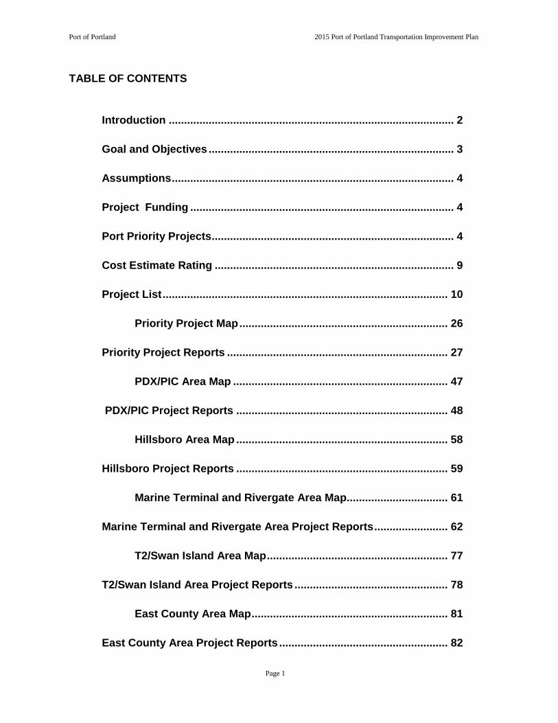
TABLE OF CONTENTS
Introduction ............................................................................................. 2
Goal and Objectives ................................................................................ 3
Assumptions ............................................................................................ 4
Project Funding ...................................................................................... 4
Port Priority Projects ............................................................................... 4
Cost Estimate Rating .............................................................................. 9
Project List ............................................................................................. 10
Priority Project Map .................................................................... 26
Priority Project Reports ........................................................................ 27
PDX/PIC Area Map ...................................................................... 47
PDX/PIC Project Reports ..................................................................... 48
Hillsboro Area Map ..................................................................... 58
Hillsboro Project Reports ..................................................................... 59
Marine Terminal and Rivergate Area Map................................. 61
Marine Terminal and Rivergate Area Project Reports ........................ 62
T2/Swan Island Area Map ........................................................... 77
T2/Swan Island Area Project Reports .................................................. 78
East County Area Map ................................................................ 81
East County Area Project Reports ....................................................... 82
Page 1

Port of Portland 2015 Port of Portland Transportation Improvement Plan
INTRODUCTION
The Port of Portland's mission is to provide competitive cargo and passenger access to regional, national and international markets while enhancing the region's quality of life. For the most part, the Port does not own or control the surrounding transportation system that provides access to its facilities.1 Good access to Port properties and marine and aviation facilities is a competitive advantage for the region’s businesses and residents. The region’s economy depends on efficient movement to and through the marine and aviation gateways. Therefore, improvements to the road, rail, water and transit systems that provide access to Port facilities are of vital interest to the Port and to the region’s and state’s businesses. Freight movement has historically played a large role in the development of the Portland area economy. Due to its location at the confluence of the Willamette and Columbia Rivers with access to the Pacific Ocean, Portland has long served as a major shipment point in the Pacific Northwest. In addition to the navigable waterways, Portland is also served by two Class 1 rail lines, two interstate highways and a network of other major roads. All of these factors contribute to Portland’s development as a major distribution center for freight. Several recent studies have substantiated the importance of investing in the transportation system and linked those investments to the region’s and state’s economic health. The Cost of Congestion to the Economy of the Portland Region (updated 2014), sponsored by a consortium of public agencies and private businesses, confirms the transportation dependency of the region’s economy and affirms that the region’s competitiveness is largely dependent upon its role as a gateway and distribution center. The study determined that improvements in the transportation system produce a 2:1 return for the economy.
The Commodity Flow Forecast Update (2006) produced by DRI/WEFA predicts a doubling of freight volume moving throughout the region in 30 years. This kind of growth will dramatically impact Port facilities and will require significant investments to ensure access to them. The magnitude of regional transportation access investments and their financing are addressed through Metro’s Regional Transportation Plan (RTP),
1 Roads owned and maintained by the Port of Portland include: NE Airport Way (between I-205 and the Airport terminal), 82nd Ave. (north of NE Alderwood Rd.), NE Frontage Rd., NE Mt. Hood Ave. (north of Airport Way), NE AirTrans Way, part of N Time Oil Rd., T-5 access road, T-6 access roads, old Marine Dr. (west of N Portland Rd.), Ramsey St. (west of Rivergate Blvd.) and other misc. access roads.
Page 2

Port of Portland 2015 Port of Portland Transportation Improvement Plan
Metro’s Transportation Improvement Program (MTIP) and the State Transportation Improvement Plan (STIP). Access needs critical to Port facilities are reflected in the Port Transportation Improvement Plan (PTIP).
GOAL AND OBJECTIVES
The Port Transportation Improvement Plan is a multimodal compilation of marine terminal, airport, road, rail, waterway, transit, bicycle, and pedestrian projects, normally identified through transportation and other studies managed by or in coordination with the Port. The plan also identifies a transportation demand management program to be implemented. The plan is designed to organize transportation and transportation-related improvement needs. The goal and objectives of the Port's Transportation Improvement Plan are as follows: Goal:
Maintain the strategic advantage provided by the transportation system in this region by addressing the surface access needs of businesses and passengers trying to reach national and international markets via Port facilities. Objectives:
• Identify 5, 10, and 20-year surface transportation system investments
that provide and maintain access to Port facilities and property developments.
• Develop a long-range vision for the financial implications of
transportation system investments, and integrate this long-range planning with the Port’s 5-year capital program.
• Increase public awareness of Port access needs on the city, state and
private rail carrier systems.
• Facilitate coordination between the Port and appropriate public and private transportation system stakeholders to make improvements and investments that enhance access to national and international markets for the region’s businesses and residents.
Page 3

Port of Portland 2015 Port of Portland Transportation Improvement Plan
ASSUMPTIONS
Contained within this document are projects generally developed from transportation studies based on the region’s assumptions about population and employment growth. These assumptions, developed by Metro in cooperation with all the jurisdictions in the region, are allocated to the land use designations of locally adopted comprehensive plans. As population and employment assumptions are updated, the needs of the transportation system are updated. The Port and other local governments participate in transportation systems studies to determine what parts of the surface transportation system (road/transit/rail/bicycle/pedestrian) are insufficient to meet the regional assumptions about passenger and freight movement. This document represents the Port’s assessment of the transportation system and the infrastructure necessary in order to achieve its mission. The PTIP helps the Port focus its transportation priorities and lets the public and the Port’s partner jurisdictions know which projects will need cooperative efforts.
PROJECT FUNDING
In recent years, the overall demand for transportation improvements at the local, state and federal levels has vastly exceeded available resources. The PTIP defines Port transportation needs over a 20-year time frame. Some of the transportation improvements are on Port properties, and some are on systems that are the legal responsibility of others but serve Port facilities. Funding for projects in the PTIP is expected from a number of sources, including the jurisdictions that have legal responsibility for the system and private interests that may benefit from the improvements. The project detail sheets identify the funding sources anticipated to implement these projects. Funds attributed to specific jurisdictions reflect specific funding commitments. Funds designated as “Committed Port Share” are in the Port’s approved budget. “Forecasted Port Share” indicates funds which the Port will obtain, whether from its own revenues or with funding from other sources. Where funds are listed as ‘Unfunded’, either a funding strategy has not yet been defined for the improvement, or changes in the project scope have impacted the existing funding strategy.
PORT PRIORITY PROJECTS
Port facilities support an array of transportation modes and present a wide range of project needs: marine and aviation terminal, road, rail, waterway, transit, bicycle and pedestrian improvements. The PTIP maps include surface transportation projects that improve or provide access to marine and aviation terminals. However, the ability of the marine and aviation terminals to provide the region’s businesses with access to markets also depends on the transportation system within the terminal facilities themselves.
Page 4

Port of Portland 2015 Port of Portland Transportation Improvement Plan
Many of the Port’s priority transportation projects will involve funding from other agencies and/or the private sector. A significant portion of these projects are off Port property on facilities owned and maintained by other jurisdictions and in areas that are significant transportation bottlenecks for access to national and international markets via Port facilities. Due to size, type and use of the facility, a cooperative funding arrangement among the affected parties will be necessary to adequately fund and implement these projects. A subgroup of high priority projects deemed to be of strategic value for the Port have been identified to warrant focused attention for obtaining cooperative funding this year.
High Priority Projects Involving Other Funding Sources1
Project Cost2
Map ID #
Rivergate Boulevard Overcrossing $14,200,000 25 PDX Northside Redevelopment $5,800,000 3 Cornfoot Road Multimodal Safety Improvements $3,626,000 6 T6 Crane Drives for Cranes 6380 and 6381 $2,000,000 12 Terminal 2 Crane Upgrade $2,300,000 26 Terminal 2 Rail Improvement $2,200,000 28 Terminal 2 Crane Drives for Cranes 2371 and 2372 $2,000,000 31 New Dredge Tender $6,000,000 30 Dredge Oregon Pipe, Scows, and Pontoons $10,200,000 29 Auto Import/Export Expansion $14,000,000 17 PIC Ped/Bike Network $1,163,835 4
Notes: 1. Projects are not listed in order of priority.
2. Refer to Priority Reports for funding break-out For surface transportation projects, the following criteria determine which projects have been considered for cooperative funding:
1. The project improves access to Port terminals or properties and is critical to Port strategic development in either a) the next ten years, or b) the next twenty years, with aspects of the project required to begin within the next ten years.
2. The project also serves other city, regional, state or national transportation and/or economic functions.
3. The project is included or, prior to construction, will be included in the Regional Transportation Plan (RTP).
4. The project meets the eligibility criteria for federal funding.
Page 5
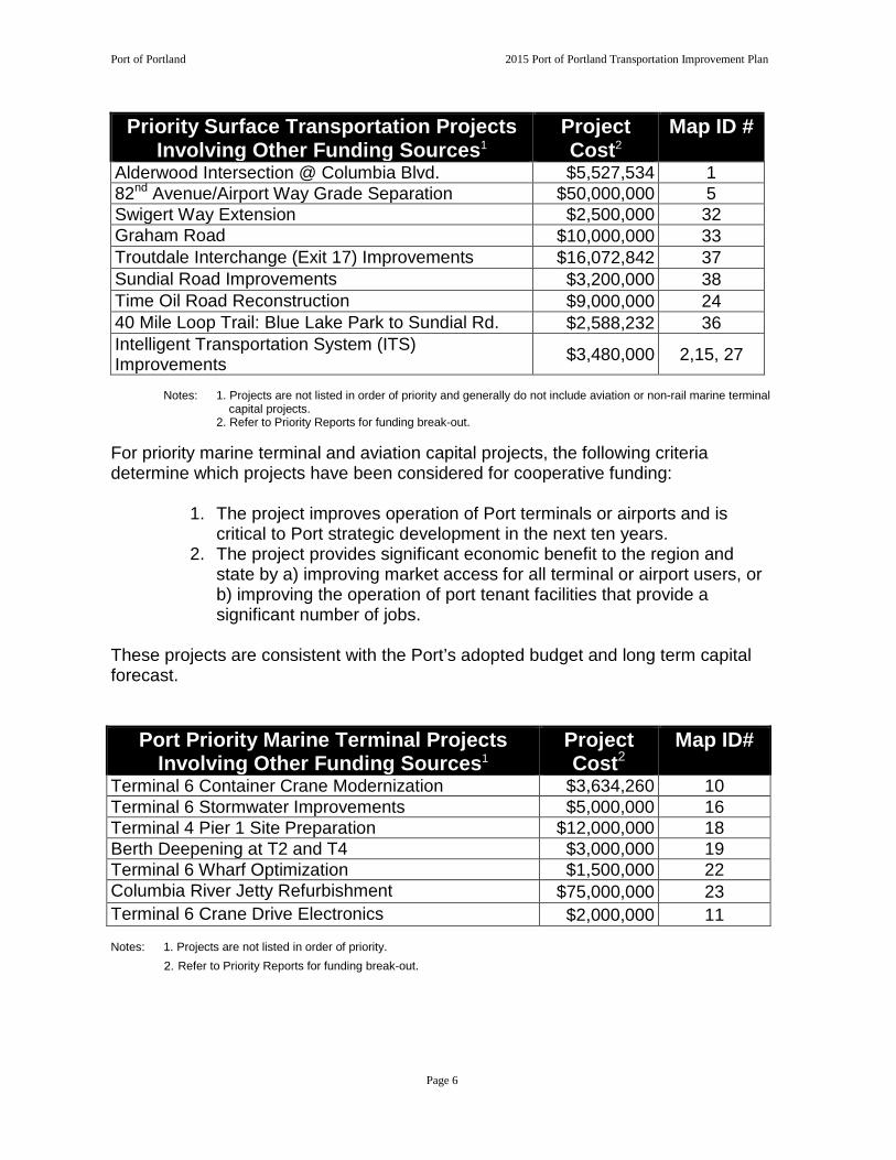
Port of Portland 2015 Port of Portland Transportation Improvement Plan
Priority Surface Transportation Projects Involving Other Funding Sources1
Project Cost2
Map ID #
Alderwood Intersection @ Columbia Blvd. $5,527,534 1 82nd Avenue/Airport Way Grade Separation $50,000,000 5 Swigert Way Extension $2,500,000 32 Graham Road $10,000,000 33 Troutdale Interchange (Exit 17) Improvements $16,072,842 37 Sundial Road Improvements $3,200,000 38 Time Oil Road Reconstruction $9,000,000 24 40 Mile Loop Trail: Blue Lake Park to Sundial Rd. $2,588,232 36 Intelligent Transportation System (ITS) Improvements $3,480,000 2,15, 27
Notes: 1. Projects are not listed in order of priority and generally do not include aviation or non-rail marine terminal capital projects.
2. Refer to Priority Reports for funding break-out.
For priority marine terminal and aviation capital projects, the following criteria determine which projects have been considered for cooperative funding:
1. The project improves operation of Port terminals or airports and iscritical to Port strategic development in the next ten years.
2. The project provides significant economic benefit to the region andstate by a) improving market access for all terminal or airport users, orb) improving the operation of port tenant facilities that provide asignificant number of jobs.
These projects are consistent with the Port’s adopted budget and long term capital forecast.
Port Priority Marine Terminal Projects Involving Other Funding Sources1
Project Cost2
Map ID#
Terminal 6 Container Crane Modernization $3,634,260 10 Terminal 6 Stormwater Improvements $5,000,000 16 Terminal 4 Pier 1 Site Preparation $12,000,000 18 Berth Deepening at T2 and T4 $3,000,000 19 Terminal 6 Wharf Optimization $1,500,000 22 Columbia River Jetty Refurbishment $75,000,000 23 Terminal 6 Crane Drive Electronics $2,000,000 11
Notes: 1. Projects are not listed in order of priority. 2. Refer to Priority Reports for funding break-out.
Page 6

Port of Portland 2015 Port of Portland Transportation Improvement Plan
Priority Aviation Projects Involving Other Funding Sources1
Project Cost2
Map ID#
HIO Relocate Charlie Pattern Landing Site $1,433,100 7 HIO Construct East Access Road $1,886,560 8 HIO Relocate Taxiway AA $4,700,000 9 TTD Reconstruct Runway 7-25 $12,534,000 34 TTD Rehabilitate Taxiway A $5,000,000 35 Notes: 1. Projects are not listed in order of priority. 2. Refer to Priority Reports for funding break-out.
PROJECT REPORTS AND MAPS
The following pages contain a list of all projects, followed by maps of project locations and individual project reports. The first map and group of reports are for priority projects in all locations. Following the priority projects are the other projects by area, along with area maps. It should be noted that the area maps include both priority and non-priority projects. The project reports include such details as a brief description, purpose, funding information, cost estimate rating, time frame, and strategic alignment. Acronym Key:
PIC Portland International Center PDX Portland International Airport WHI West Hayden Island TRIP Troutdale Reynolds Industrial Park TTD Troutdale Airport HIO Hillsboro Airport GVBP Gresham Vista Business Park
Time Frame: Projects identified in the PTIP are shown as occurring in the 5, 10, or 20-year time frames. Projects within the 5-year time frame are expected to occur within the next five years. Projects within the 10-year time frame are expected to occur between five and ten years from the time of PTIP adoption. Similarly, projects within the 20-year time frame are expected to occur between 10 and 20 years from the time of PTIP adoption. The time frames shown are estimates. The listing of a project in a given period does not ensure that it will be constructed in that time frame. Rather, projects will be constructed when transportation/business needs support them and when funding becomes available. For many projects, this need has already been identified. However, others depend on a variety of factors, including development at Port facilities and the changing challenges of the region’s transportation system.
Page 7

Port of Portland 2015 Port of Portland Transportation Improvement Plan
Port Strategic Plan Alignment The mission of the Port is to enhance the region’s economy and quality of life by providing efficient cargo and air passenger access to national and global markets. Critical to the Port’s effectiveness in implementing its mission are the following strategic areas of focus.
• Provide leadership around regional transportation infrastructure • Retain and grow key services (Aviation and Marine) • Be a regional leader in industrial land acquisition and development • Implement a Portwide environmental strategy that supports the Port’s
requirements, generates savings and maintains/builds regional credibility as an environmental steward
• Build a sustainable financial model • Strengthen the Port’s culture as a strategic asset
The project reports identify which of the strategic areas of focus the projects most closely align with. The first four areas of focus identified above are the primary categories of alignment. The following abbreviations of the above strategies are included in the project reports.
• Regional Leadership in Transportation • Retain and Grow Key Services • Regional Leadership in Industrial Lands • Portwide Environmental Strategy
Page 8

Port of Portland 2015 Port of Portland Transportation Improvement Plan
Cost Estimate Rating When applicable, the project reports shown in the PTIP contain cost estimate ratings. The purpose of the rating is to provide those using the estimates with a qualitative measure of its precision for a project. Since the precision of an estimate is a function of the clarity of project scope (scope accuracy) and the level of effort expended to produce the desired estimate (engineering effort), the rating scale is designed to reflect both of these factors. Below are the definitions of each of these categories.
Scope Accuracy Level 1 Project scope is defined. Level 2 Project scope is conceptual. Scope lacks
detail due to potential permit requirements; unknown project conditions; limited knowledge of external impacts.
Level 3 Project scope has limited detail. Engineering Effort Level A Preliminary engineering has been
performed. Technical information is available, engineering calculations have been performed; clear understanding of the materials size and quantity needed to execute the job. Schedule is understood; staff and permitting is fairly clear. Contingency generally ranges between 15% and 20%.
Level B Conceptual engineering has been performed. Technical information is available, rough engineering calculations may have been performed, or similar information from previous similar work is compared and used. Contingency generally ranges between 20% and 30%.
Level C No engineering has been performed. Limited technical information is available and/or limited analysis has been performed. Contingency generally ranges between 40% and 50%.
Note: Projects that are the responsibility of a private entity or are the responsibility of another agency generally are not given cost estimate ratings. The costs listed are for the year the estimate was done. Due to cost escalation and other factors the projected costs will vary over time.
Page 9

PTIP MASTER PROJECT LIST
Map ID
Priority
Area Map
Project Name
Project Description
Purpose
Total Cost
Time Frame (Years)
1 PDX/PICAlderwood and Columbia Blvd. Intersection
Widen and signalize intersection on Columbia Boulevard at Alderwood Rd.
Provide transportation link to the cargo area located within the south airport area and to support Columbia Corridor freight movement.
$5,527,5345
2 PDX/PICPDX ITS - AVI Technology Automated Vehicle Identification Technology
Implement automated vehicle identification system at PDX to improve airport operations, commercial roadway operations and parking shuttle bus management.
$5,116,0005
3 PDX/PICPDX Northside Redevelopment
Construct a new apron for business aviation. Add Remain Overnight Parking.
Provide overnight parking for commercial jets and improve a new apron for business aviation.
$5,800,0005
4 PDX/PICPIC Ped/Bike Network Construct bike and pedestrian facilities as shown in the CS/PIC Plan District.
Improve bike/ped circulation in PIC.
$1,163,83510
5 PDX/PIC82nd Ave./Airport Way Grade Separation
Construct grade-separated overcrossing. Provide efficient movement of traffic to PDX properties.
$50,000,00010
6 PDX/PICCornfoot Road Multimodal Safety Improvements
Provide a separated multi-use path on the north side of NE Cornfoot Road.
Increase safety and provide improved bicycle and pedestrian access along NE Cornfoot Road.
$3,626,0005
Port of Portland 2015 Port Transportation Improvement Plan
Page 10
Map ID
Priority
Area Map
Project Name
Project Description
Purpose
Total Cost
Time Frame (Years)
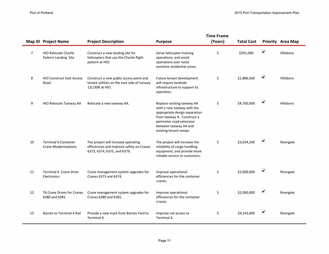
7 HillsboroHIO Relocate Charlie Pattern Landing Site
Construct a new landing site for helicopters that use the Charlie flight pattern at HIO.
Serve helicopter training operations, and avoid operations over noise sensitive residential zones.
$391,0005
8 HillsboroHIO Construct East Access Road
Construct a new public access point and tenant utilities on the east side of runway 12L/30R at HIO.
Future tenant development will require landside infrastructure to support its operation.
$1,886,5605
9 HillsboroHIO Relocate Taxiway AA Relocate a new taxiway AA. Replace existing taxiway AA with a new taxiway with the appropriate design separation from taxiway A. Construct a perimeter road extension between taxiway AA and existing tenant ramps.
$4,700,0005
10 RivergateTerminal 6 Container Crane Modernizations
The project will increase operating efficiencies and improve safety on Cranes 6373, 6374, 6375, and 6379.
The project will increase the reliability of cargo handling equipment, and provide more reliable service to customers.
$3,634,2605
11 RivergateTerminal 6 Crane Drive Electronics
Crane management system upgrades for Cranes 6373 and 6374.
Improve operational efficiencies for the container cranes.
$2,000,0005
12 RivergateT6 Crane Drives for Cranes 6380 and 6381
Crane management system upgrades for Cranes 6380 and 6381.
Improve operational efficiencies for the container cranes.
$2,000,0005
13 RivergateBarnes to Terminal 4 Rail Provide a new track from Barnes Yard to Terminal 4.
Improve rail access to Terminal 4.
$4,543,0005
Port of Portland 2015 Port Transportation Improvement Plan
Page 11

Map ID
Priority
Area Map
Project Name
Project Description
Purpose
Total Cost
Time Frame (Years)
14 RivergateKenton Rail Line Upgrade Upgrade existing track to second main track with new double track from Peninsula Junction to I-205 and increase track speeds between North Portland, Peninsula Junction, to Reynolds on UP's Kenton Line. Part of triangle project with ODOT.
Expand rail capacity and reduce delays for greater efficiency.
$25,382,00010
15 RivergateRivergate ITS Intelligent Transportation System in Rivergate.
Improve traffic efficiency in Rivergate by connecting information about the roadway system to ODOT’s Highway ITC systems.
$480,0005
16 RivergateTerminal 6 Stormwater System
Design and construct a stormwater system. The project will modernize the storm drainage system in the container yard.
$5,000,0005
17 RivergateAuto Import /Export Expansion
The project will construct site improvements to expand the storage and processing capacity for auto imports and exports through Berth 601 at Terminal 6. By increasing the storage and processing capacity, the Berth 601 auto facility can increase throughpu
Increase the storage and processing capacity for auto imports and exports through Berth 601, thereby allowing for an increase of volumes, leading to increased employment.
$14,000,0005
18 RivergateTerminal 4 Pier 1 Site Preparation
Demolish various structures and improve certain infrastructure features in the Pier 1 area of Terminal 4.
This project will facilitate the redevelopment of approximately 30 acres of vital marine industrial property in the Portland Harbor.
$12,000,0005
Port of Portland 2015 Port Transportation Improvement Plan
Page 12
Map ID
Priority
Area Map
Project Name
Project Description
Purpose
Total Cost
Time Frame (Years)
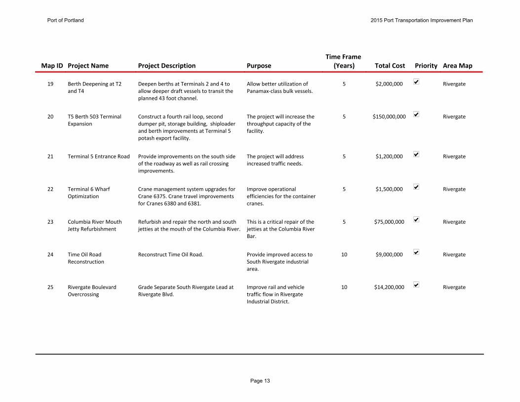
19 RivergateBerth Deepening at T2 and T4
Deepen berths at Terminals 2 and 4 to allow deeper draft vessels to transit the planned 43 foot channel.
Allow better utilization of Panamax-class bulk vessels.
$2,000,0005
20 RivergateT5 Berth 503 Terminal Expansion
Construct a fourth rail loop, second dumper pit, storage building, shiploader and berth improvements at Terminal 5 potash export facility.
The project will increase the throughput capacity of the facility.
$150,000,0005
21 RivergateTerminal 5 Entrance Road Provide improvements on the south side of the roadway as well as rail crossing improvements.
The project will address increased traffic needs.
$1,200,0005
22 RivergateTerminal 6 Wharf Optimization
Crane management system upgrades for Crane 6375. Crane travel improvements for Cranes 6380 and 6381.
Improve operational efficiencies for the container cranes.
$1,500,0005
23 RivergateColumbia River Mouth Jetty Refurbishment
Refurbish and repair the north and south jetties at the mouth of the Columbia River.
This is a critical repair of the jetties at the Columbia River Bar.
$75,000,0005
24 RivergateTime Oil Road Reconstruction
Reconstruct Time Oil Road. Provide improved access to South Rivergate industrial area.
$9,000,00010
25 RivergateRivergate Boulevard Overcrossing
Grade Separate South Rivergate Lead at Rivergate Blvd.
Improve rail and vehicle traffic flow in Rivergate Industrial District.
$14,200,00010
Port of Portland 2015 Port Transportation Improvement Plan
Page 13

Map ID
Priority
Area Map
Project Name
Project Description
Purpose
Total Cost
Time Frame (Years)
26 T2/Swan Island
Terminal 2 Crane Upgrades The project will modify and upgrade Cranes 2371 and 2372, located at Terminal 2. The improvements will increase the suitability and efficiency of the crane to handle bulk cargoes.
The improvements will increase the suitability and efficiency of the cranes to handle bulk cargoes.
$2,300,0005
27 T2/Swan Island
PSU ITS Expansion Expand PSU's existing web based ITS "count sensor" program beyond the freeway to some key arterials throughout the region and create a repository of regional freight data.
To secure truck flow and congestion data.
5
28 T2/Swan Island
Terminal 2 Rail Improvement
Add approximately 600 feet to the inner track (Track 10) and connect it with the outer loop (Track 15). A third track may also be constructed and a rail scaling station added in addition to stormwater improvements to the dock.
Increase rail capacity and operating efficiencies at Terminal 2.
$2,200,0005
29 T2/Swan Island
Dredge Oregon Pipe, Scows and Pontoons
Acquire 2,000 feet of dredge pipe, pontoons, anchor scows and anchors.
Allow Dredge Oregon to make full use of recent repower and pump material 14,000 feet.
$10,200,0005
30 T2/Swan Island
New Dredge Tender Replace the existing vintage tugboat W.L. Williams with a newly constructed modern work-boat vessel.
Improve operational support for Dredge Oregon dredging operations and improve environmental performance
$6,000,0005
31 T2/Swan Island
T2 Crane Drives for Cranes 2371 and 2372
Crane management system upgrades for Cranes 2371 and 2372.
Improve operational efficiencies for the cargo handling cranes.
$2,000,0005
Port of Portland 2015 Port Transportation Improvement Plan
Page 14

Map ID
Priority
Area Map
Project Name
Project Description
Purpose
Total Cost
Time Frame (Years)
32 East CountySwigert Way Extension Extend Swigert Way from it existing terminus to Graham Road.
Improve access to Troutdale Reynolds Industrial Park.
$2,500,0005
33 East CountyGraham Road Reconstruct and/or widen Graham Road along Troutdale Reynolds Industrial Park frontage.
Improve access to Troutdale Reynolds Industrial Park Phase 2.
$10,000,0005
34 East CountyTTD Reconstruct runway 7-25
Reconstruct existing 150' x 5400' runway; narrow to 75' wide, relocated/reconstruct edge lighting, construct required drainage improvements.
Project identified in 2004 TTD Master Plan.
$12,534,0005
35 East CountyTTD Rehabilitate Taxiway A Rehabilitation of full-length parallel taxiway A including lighting and markings.
Project recommended in 2004 Master Plan and verified by Port assessment of pavement condition and expected remaining life.
$10,100,0005
36 East County40 Mile Loop Trail: Blue Lake Park to Sundial Rd.
Construct a mixed use off road trail connecting Blue Lake Park and Sundial Road.
Combined with the Port's Reynolds levee trail it will complete gaps in the 40 Mile Loop Trail.
$3,424,0735
37 East CountyTroutdale Interchange (Exit 17) Improvements
Convert Marine Drive one-way southbound to two-way under I-84 and widen to five lanes. Widen South Frontage Rd. and provide associated improvements.
Ensure adequate long term interchange operation and improve access to north industrial area.
$16,072,8425
38 East CountySundial Road Improvements
Widen Sundial north of Swigert Way . Accommodate Troutdale Reynolds Industrial Park and other traffic.
$3,200,0005
Port of Portland 2015 Port Transportation Improvement Plan
Page 15
Map ID
Priority
Area Map
Project Name
Project Description
Purpose
Total Cost
Time Frame (Years)
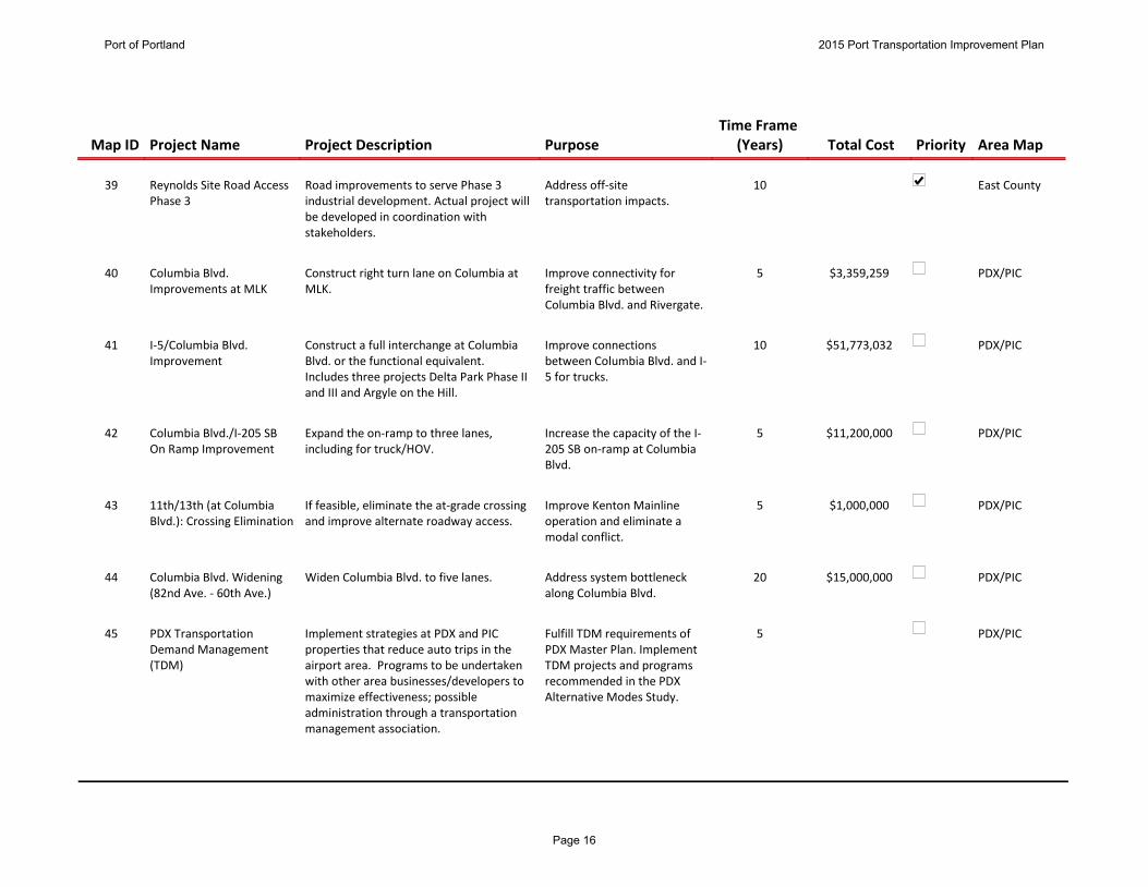
39 East CountyReynolds Site Road Access Phase 3
Road improvements to serve Phase 3 industrial development. Actual project will be developed in coordination with stakeholders.
Address off-site transportation impacts.
10
40 PDX/PICColumbia Blvd. Improvements at MLK
Construct right turn lane on Columbia at MLK.
Improve connectivity for freight traffic between Columbia Blvd. and Rivergate.
$3,359,2595
41 PDX/PICI-5/Columbia Blvd. Improvement
Construct a full interchange at Columbia Blvd. or the functional equivalent. Includes three projects Delta Park Phase II and III and Argyle on the Hill.
Improve connections between Columbia Blvd. and I-5 for trucks.
$51,773,03210
42 PDX/PICColumbia Blvd./I-205 SB On Ramp Improvement
Expand the on-ramp to three lanes, including for truck/HOV.
Increase the capacity of the I-205 SB on-ramp at Columbia Blvd.
$11,200,0005
43 PDX/PIC11th/13th (at Columbia Blvd.): Crossing Elimination
If feasible, eliminate the at-grade crossing and improve alternate roadway access.
Improve Kenton Mainline operation and eliminate a modal conflict.
$1,000,0005
44 PDX/PICColumbia Blvd. Widening (82nd Ave. - 60th Ave.)
Widen Columbia Blvd. to five lanes. Address system bottleneck along Columbia Blvd.
$15,000,00020
45 PDX/PICPDX Transportation Demand Management (TDM)
Implement strategies at PDX and PIC properties that reduce auto trips in the airport area. Programs to be undertaken with other area businesses/developers to maximize effectiveness; possible administration through a transportation management association.
Fulfill TDM requirements of PDX Master Plan. Implement TDM projects and programs recommended in the PDX Alternative Modes Study.
5
Port of Portland 2015 Port Transportation Improvement Plan
Page 16

Map ID
Priority
Area Map
Project Name
Project Description
Purpose
Total Cost
Time Frame (Years)
46 PDX/PICI-205 Auxiliary Lane NB New auxiliary lane from I-84 to I-205 NB before Columbia Blvd.
Provide additional capacity for anticipated growth in area traffic.
$5,775,00020
47 PDX/PICSW Quad Access Provide street access from 33rd Ave. into SW Quad.
Provide efficient movement of traffic to developing PDX properties.
$5,917,50010
48 PDX/PICAirport Way Braided Ramps
Construct braided ramps between the I-205 interchange and Cascade Interchange.
Maintain safety and capacity of Airport Way and interchanges.
$59,000,00020
49 PDX/PICAlternative Fuels Station Construct a PDX alternative fuels station. Provide refueling capabilities for both landside (public) CNG vehicles. Encourage airport businesses to convert fleets to CNG to improve air quality.
$1,000,0005
50 PDX/PICSW Quad Drainage Improvements
Drainage improvements in SW Quad through modifications to the existing drainage channels and increasing the capacity of the Broadmoor Pump Station.
Provide additional capacity for anticipated growth in airport traffic.
$1,250,0005
51 PDX/PICWiden APW Outbound East of 82nd
Add New Lane Provide additional capacity for anticipated growth in passenger traffic.
$3,335,00010
52 PDX/PICDeplaning Curbside Roadway Lanes
Add New Lane Provide additional capacity for anticipated growth in passenger traffic.
$2,976,00020
Port of Portland 2015 Port Transportation Improvement Plan
Page 17
Map ID
Priority
Area Map
Project Name
Project Description
Purpose
Total Cost
Time Frame (Years)
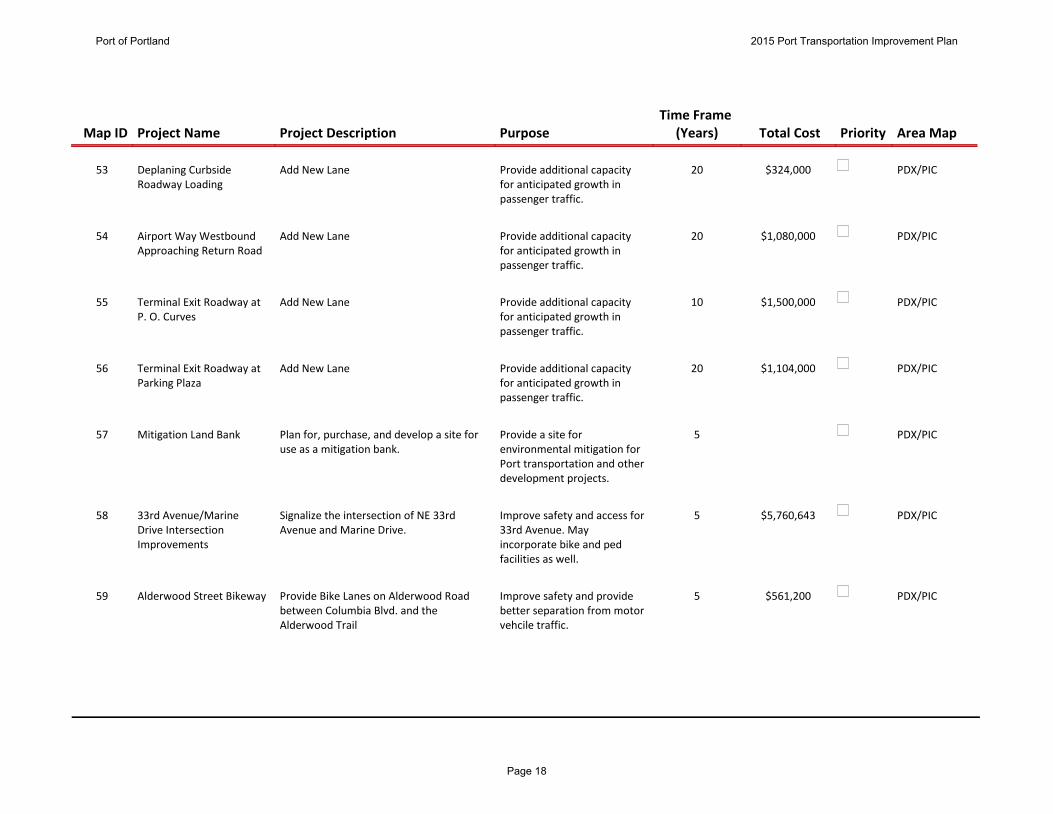
53 PDX/PICDeplaning Curbside Roadway Loading
Add New Lane Provide additional capacity for anticipated growth in passenger traffic.
$324,00020
54 PDX/PICAirport Way Westbound Approaching Return Road
Add New Lane Provide additional capacity for anticipated growth in passenger traffic.
$1,080,00020
55 PDX/PICTerminal Exit Roadway at P. O. Curves
Add New Lane Provide additional capacity for anticipated growth in passenger traffic.
$1,500,00010
56 PDX/PICTerminal Exit Roadway at Parking Plaza
Add New Lane Provide additional capacity for anticipated growth in passenger traffic.
$1,104,00020
57 PDX/PICMitigation Land Bank Plan for, purchase, and develop a site for use as a mitigation bank.
Provide a site for environmental mitigation for Port transportation and other development projects.
5
58 PDX/PIC33rd Avenue/Marine Drive Intersection Improvements
Signalize the intersection of NE 33rd Avenue and Marine Drive.
Improve safety and access for 33rd Avenue. May incorporate bike and ped facilities as well.
$5,760,6435
59 PDX/PICAlderwood Street Bikeway Provide Bike Lanes on Alderwood Road between Columbia Blvd. and the Alderwood Trail
Improve safety and provide better separation from motor vehcile traffic.
$561,2005
Port of Portland 2015 Port Transportation Improvement Plan
Page 18

Map ID
Priority
Area Map
Project Name
Project Description
Purpose
Total Cost
Time Frame (Years)
60 HillsboroBrookwood Parkway/Hwy 26 Interchange Improvements
Construct a new westbound to southbound loop ramp at the interchange to serve Brookwood Parkway. Realign and relocate nearby local roads.
Improve access to HIO and area industry.
$45,000,0005
61 HillsboroHIO Wash Racks Construct new wash racks for tenant and itinerant aircraft washing with pollution control system to keep wash water out of storm system.
Improve environmental performance at the airport.
$620,1005
62 HillsboroHIO Taxiway to NW Corporate Center
Construct a taxiway to serve new tenant leasehold development.
New tenant development in the area behind the HIO ATCT will require airside infrastructure.
$1,050,0005
63 RivergateCathedral Park Quiet Zone Address rail switching noise by improving multiple public rail crossings in the St. Johns Cathedral Park area.
To allow auto import operations to continue to grow in N. Portland and improve neighborhood livability.
$8,200,0005
64 RivergateNorth Portland Junction Upgrade railroad with revised crossovers, centralized traffic control tie-in and increased turning radius.
Accommodate higher rail speeds at the junction which provides greater capacity.
$9,160,00010
65 RivergateI-5 Columbia River Crossing
Increase the number of lanes and add transit capacity across the river.
Increase multi-modal capacity across the Columbia River and relieve congestion.
$2,982,000,00010
66 RivergateN. Hayden Island Drive Reconstruct N. Hayden Island Drive. Provide improved access to West Hayden Island.
$12,000,00010
Port of Portland 2015 Port Transportation Improvement Plan
Page 19

Map ID
Priority
Area Map
Project Name
Project Description
Purpose
Total Cost
Time Frame (Years)
67 RivergateWest Hayden Island Rail Access
Rail access to support West Hayden Island development.
Advance rail-dependent development.
$3,000,00020
68 RivergateWest Hayden Island Rail Yard
Seven track rail yard connected to facility trackage.
Advance rail development on West Hayden Island.
$9,500,00020
69 RivergateWest Hayden Island Interior Access Road
Construct interior roadway including rail overpass and berth access.
Provide roadway for new West Hayden Island terminal.
$13,600,00010
70 RivergateSt. Johns Pedestrian District
Improvements could include restriping, curb extensions and other pedestrian and bicycle amenities on Lombard St. that do not impede truck movement, as well as intersection improvements and signalization.
Maintain truck movement and minimize conflicts with bicycles and pedestrians between Philadelphia Ave. and Lombard St. at Pier Park.
$3,346,0005
71 RivergateBurgard Bridge Replacement
Upgrade structure. Replace the bridge with a slab on grade to eliminate weight restrictions.
$1,445,0005
72 RivergateColumbia Blvd./Portland Rd. Intersection Improvements
Redesign could include realignment of travel lanes, channelization, signalization, signing or new sidewalks and curbs.
Reinforce through truck movements on minor and major truck streets (Portland Rd. and Columbia Blvd. respectively), minimizing neighborhood cut-through traffic.
$1,214,0005
73 RivergateNorth Burgard/Lombard Street Improvements
Widen Burgard to 3 Lanes with bike lanes and sidewalks from UPRR bridge to Columbia.
Improve freight mobility, safety and industrial site access.
$14,588,0005
Port of Portland 2015 Port Transportation Improvement Plan
Page 20

Map ID
Priority
Area Map
Project Name
Project Description
Purpose
Total Cost
Time Frame (Years)
74 RivergateMarine Dr. Improvement Phase 2
Construct rail overcrossing on Marine Dr. Avoid road/rail conflict. $13,644,20020
75 RivergateWillamette River Channel Deepening
Deepen the portions of the Willamette River with deep draft infrastructure to -43' where appropriate.
To allow Willamette River terminals to also benefit from the Columbia River's new controlling depth.
$200,000,00010
76 RivergateTerminal 6 Honda Rail Extension
Extend current rail yard in order to provide more capacity for current tenants.
Capacity improvements for current tenants.
$1,000,00010
77 RivergateColumbia River Anchorage Improvements
Placement of up to seven stern buoys at different anchorages up and down the Columbia River.
Allow for the anchorage of ships in the river rather than at terminals that could otherwise be loading/unloading cargo.
$2,342,0005
78 RivergateTerminal 6 Internal Overcrossing
Construct a rail overcrossing at Terminal 6. Increase efficient movement for rail and Terminal 6 tenants.
$3,649,0845
79 RivergateT6 Second Entrance Construct second entrance and rail overcrossing.
Improve capacity and safety at T6.
$12,000,00020
80 RivergateT6 Suttle Road Entrance Construct access road from terminus of Suttle Road.
To support development of east end of T6.
$3,000,00020
81 RivergateT6 Development Project This program includes Additional Scour Protection, T6 Entrance Overcrossing, Two New PPMX Cranes, Terminal Electrical Upgrades, Yard Gantry Cranes and 6,800’ Arrival and 8,500' Departure Tracks.
This program is needed to upgrade the terminal to expand the capacity of the container terminal to 1 Million TEUs.
$76,000,00010
Port of Portland 2015 Port Transportation Improvement Plan
Page 21

Map ID
Priority
Area Map
Project Name
Project Description
Purpose
Total Cost
Time Frame (Years)
82 RivergateT4 B416 Lay Berth Improvements
This project will design, permit and install electrical equipment upgrades necessary to allow vessels to lay berth at B416
The project is needed to allow vessels to lay berth at B416. This will help the Port retain and grow key services and to be a leader in transportation infrastructure.
$500,0005
83 RivergateT4 Stormwater Improvements
Install stormwater improvements including control equipment such as dust filtering equipment for the warehouses and/or various types of stormwater filtering or treatment mechanisms.
Implement capital projects identified during stormwater master planning process. The improvements will be needed in order to comply with new environmental permits and water quality regulations.
$4,100,0005
84 RivergateTerminal 4 Automobile Yard Expansion
Design and construct six acres of porous pavement parking for the storage of imported automobiles.
The project will provide additional land to meet auto storage capacity needs of Toyota, supporting the Port's automobile import business line.
$3,000,00010
85 RivergateBNSF Fallbridge Double Tracking
Double Track Fallbridge line to Washougal. Increases capacity of the BNSF east-west mainline serving Port of Portland.
$72,000,00010
86 RivergateTerminal 4 Grain Elevator Demolition
Demolish the Terminal 4 grain elevator. Demolition of the elevator will facilitate the redevelopment of approximately 30 acres of vital marine industrial property in the Portland Harbor.
$8,000,00010
Port of Portland 2015 Port Transportation Improvement Plan
Page 22

Map ID
Priority
Area Map
Project Name
Project Description
Purpose
Total Cost
Time Frame (Years)
87 RivergateT4 Berth 410, 411 Rail Yard Improvements
Construct additional rail track in the Berth 410 and 411 Rail Yard.
Improve the efficiency of the rail yard by creating additional rail capacity.
$1,529,0005
88 RivergateT4 Berth 405 and 408 Demolition
Demolish Berth 405 and Berth 408. Remove obsolete berth structures.
$18,747,2225
89 RivergateBonneville Rail Yard Build Out
Construct two interior yard tracks and complete the double track lead from the wye at the east end of the yard to Barnes Yard.
Add rail staging capacity for South Rivergate.
$3,600,00010
90 RivergateRamsey Yard Utilization Connect existing set out track with industrial lead.
Improve unit train staging capabilities at Ramsey Rail Yard.
$1,700,00010
91 RivergateColumbia River Underkeel Clearance Study
Underkeel clearance study for ships moving between the Columbia Bar and Portland.
Understand vessel underclearance in Columbia River to optimize safety and payload.
$1,319,0005
92 T2/Swan Island
North Willamette Greenway Trail
Pedestrian and bicycle trail from Kelly Point Park to the Steel Bridge along the Willamette River. The money associated for this project is for a study only.
Improve pedestrian and bicycle connectivity in North Portland. Coordinate implementation with the City of Portland.
$500,00020
93 T2/Swan Island
Graham Line Connection This project will create a new track connection between the Graham Line, which runs parallel with I-84 through Sullivan's Gulch and the Brooklyn Sub, UP's north-south line through Portland.
This connection will allow UP rail traffic entering Portland from the east to turn south onto the Brooklyn Sub from the Graham Line. This project will eliminate delay and increase system capacity.
$15,000,0005
Port of Portland 2015 Port Transportation Improvement Plan
Page 23
Map ID
Priority
Area Map
Project Name
Project Description
Purpose
Total Cost
Time Frame (Years)
94 T2/Swan Island
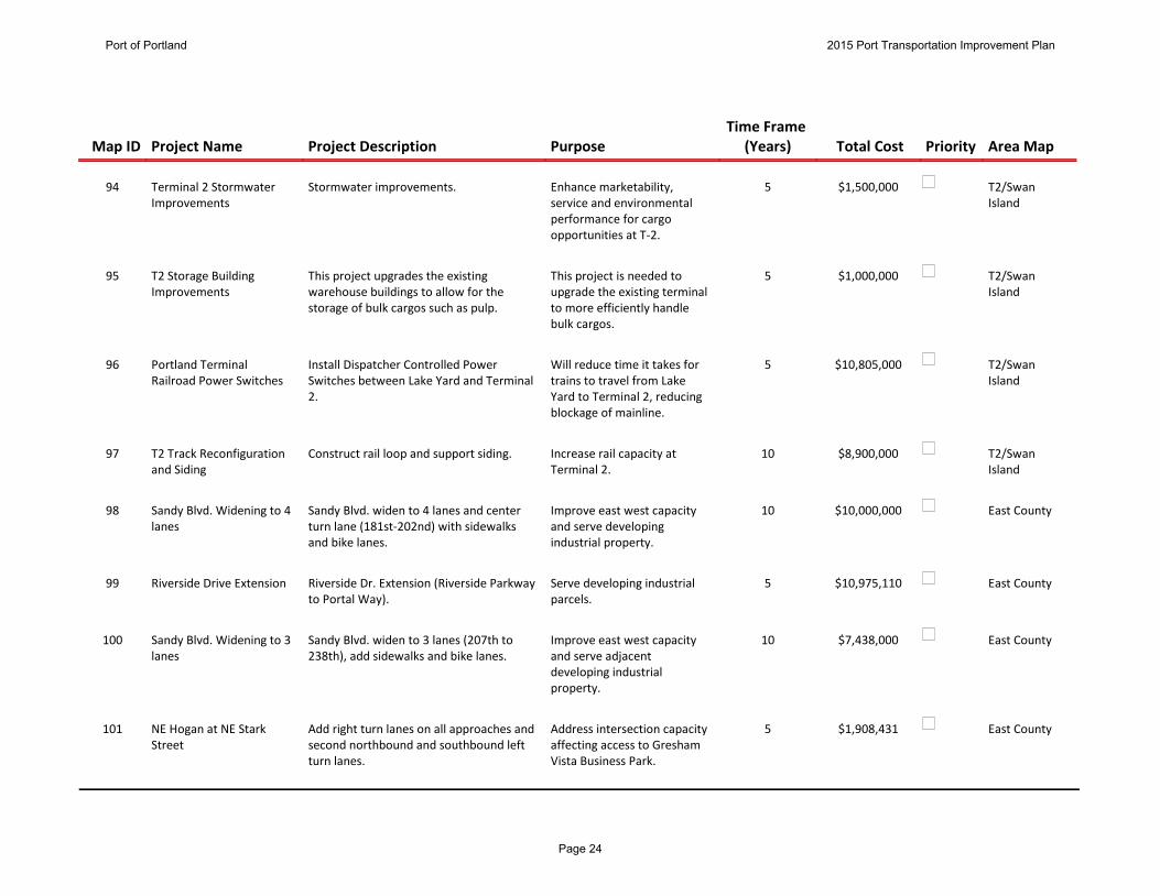
Terminal 2 Stormwater Improvements
Stormwater improvements. Enhance marketability, service and environmental performance for cargo opportunities at T-2.
$1,500,0005
95 T2/Swan Island
T2 Storage Building Improvements
This project upgrades the existing warehouse buildings to allow for the storage of bulk cargos such as pulp.
This project is needed to upgrade the existing terminal to more efficiently handle bulk cargos.
$1,000,0005
96 T2/Swan Island
Portland Terminal Railroad Power Switches
Install Dispatcher Controlled Power Switches between Lake Yard and Terminal 2.
Will reduce time it takes for trains to travel from Lake Yard to Terminal 2, reducing blockage of mainline.
$10,805,0005
97 T2/Swan Island
T2 Track Reconfiguration and Siding
Construct rail loop and support siding. Increase rail capacity at Terminal 2.
$8,900,00010
98 East CountySandy Blvd. Widening to 4 lanes
Sandy Blvd. widen to 4 lanes and center turn lane (181st-202nd) with sidewalks and bike lanes.
Improve east west capacity and serve developing industrial property.
$10,000,00010
99 East CountyRiverside Drive Extension Riverside Dr. Extension (Riverside Parkway to Portal Way).
Serve developing industrial parcels.
$10,975,1105
100 East CountySandy Blvd. Widening to 3 lanes
Sandy Blvd. widen to 3 lanes (207th to 238th), add sidewalks and bike lanes.
Improve east west capacity and serve adjacent developing industrial property.
$7,438,00010
101 East CountyNE Hogan at NE Stark Street
Add right turn lanes on all approaches and second northbound and southbound left turn lanes.
Address intersection capacity affecting access to Gresham Vista Business Park.
$1,908,4315
Port of Portland 2015 Port Transportation Improvement Plan
Page 24

Map ID
Priority
Area Map
Project Name
Project Description
Purpose
Total Cost
Time Frame (Years)
102 East CountyNE 223rd at Stark Add eastbound and northbound right turn lanes and southbound left turn lanes.
Address intersection capacity affecting access to Gresham Vista Business Park.
$1,196,7565
103 East CountyNE 238th Drive: Halsey to Glisan
Construct improvements for freight by modifying road curvature. Also adds improvements for bikes and pedestrians.
Will improve freight access to Gresham Vista Business Park.
$9,769,3405
104 East County223rd Avenue Widening Widen to three lanes between Halsey St and Marine Drive.
Upgrade the facility to major collector urban street standards.
$3,667,0005
Port of Portland 2015 Port Transportation Improvement Plan
Page 25
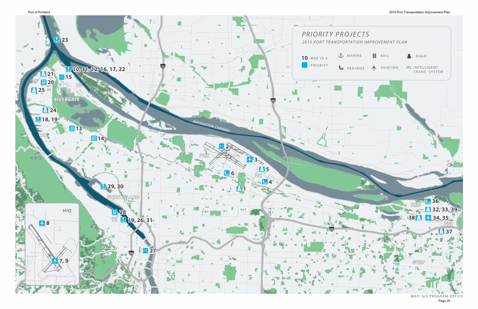
P DXP DX
M A P : G I S P R O G R A M O F F I C E
5
84
405
205
W H IW H I
T R I PT R I P
T T DT T D
R I V E R G AT ER I V E R G AT E
T 4T 4
T 6T 6T 5T 5
T 2T 2
S WA N I S L A N DS WA N I S L A N D
GV B PGV B P
NAVIGATION CHANNEL
P I CP I C
ITS
ITS
ITS
2323
10, 11, 12, 16, 17, 2210, 11, 12, 16, 17, 2215152121
2020
2424
1414
1313
22
33
11
55
3636
3737
34, 3534, 3532, 33, 3932, 33, 39
3838
29, 3029, 30
19, 26, 3119, 26, 31 28 28
2727
2525
6644
18, 1918, 19
P R I O R I T Y
M A P I D #1010ITS
R A I LM A R I N E
P E D / B I K E I N T E L L I G E N TT R A N S . S Y S T E M
P R I O R I T Y P R O J E C T S2 0 1 5 P O R T T R A N S P O R TAT I O N I M P R O V E M E N T P L A N
R O A D
AV I AT I O N
88
H I OH I O
7, 97, 9
Port of Portland 2015 Port Transportation Improvement Plan
Page 26

1
Provide transportation link to the cargo area located within
the south airport area and to support Columbia Corridor
freight movement.
$5,527,534
3c
$4,959,856
$567,678
10336
Airport Futures Transportation Impact Study (2010)
Map ID:
Project Description:
Purpose:
Total Cost:
Estimate Rating:
Federal:
State:
City:
SDC:
Port Share
Committed:
Port Share
Forecasted:
Private:
Other:
Unfunded:
810020JDE NUM:
Conditioned Project
Identified in STIP
RTP Related:
Recent Study:
5Time Frame (Years): years
Project Type: Road
Operation Area PDX/PIC
Alderwood and Columbia Blvd. IntersectionProject Name:
2013
Year of Cost
Estimate:
Widen and signalize intersection on Columbia Boulevard at
Alderwood Rd.
RTP 2040 Constrained
RTP 2040 Illustrative
Port Strategic Area: Retain and Grow Key Services
2
Implement automated vehicle identification system at PDX
to improve airport operations, commercial roadway
operations and parking shuttle bus management.
$5,116,000
2b
$5,116,000
$0
10370
PDX ITS Plan (2001)
Map ID:
Project Description:
Purpose:
Total Cost:
Estimate Rating:
Federal:
State:
City:
SDC:
Port Share
Committed:
Port Share
Forecasted:
Private:
Other:
Unfunded:
100680JDE NUM:
Conditioned Project
Identified in STIP
RTP Related:
Recent Study:
5Time Frame (Years): years
Project Type: ITS
Operation Area PDX/PIC
PDX ITS - AVI TechnologyProject Name:
2010
Year of Cost
Estimate:
Automated Vehicle Identification Technology
RTP 2040 Constrained
RTP 2040 Illustrative
Port Strategic Area: Retain and Grow Key Services
Port of Portland 2015 Port Transportation Improvement Plan
Page 27

3
Provide overnight parking for commercial jets and improve a
new apron for business aviation.
$5,800,000
$5,800,000
11650
Airport Futures
Map ID:
Project Description:
Purpose:
Total Cost:
Estimate Rating:
Federal:
State:
City:
SDC:
Port Share
Committed:
Port Share
Forecasted:
Private:
Other:
Unfunded:
101460JDE NUM:
Conditioned Project
Identified in STIP
RTP Related:
Recent Study:
5Time Frame (Years): years
Project Type: Aviation
Operation Area PDX/PIC
PDX Northside RedevelopmentProject Name:
2013
Year of Cost
Estimate:
Construct a new apron for business aviation. Add Remain
Overnight Parking.
RTP 2040 Constrained
RTP 2040 Illustrative
Port Strategic Area: Retain and Grow Key Services
4
Improve bike/ped circulation in PIC.
$1,163,835
3c
$1,163,835
10368
2014 Airport Bike and Pedestrian Master Plan
Map ID:
Project Description:
Purpose:
Total Cost:
Estimate Rating:
Federal:
State:
City:
SDC:
Port Share
Committed:
Port Share
Forecasted:
Private:
Other:
Unfunded:
JDE NUM:
Conditioned Project
Identified in STIP
RTP Related:
Recent Study:
10Time Frame (Years): years
Project Type: Bike/Ped
Operation Area PDX/PIC
PIC Ped/Bike NetworkProject Name:
2007
Year of Cost
Estimate:
Construct bike and pedestrian facilities as shown in the
CS/PIC Plan District.
RTP 2040 Constrained
RTP 2040 Illustrative
Port Strategic Area: Regional Leadership in Industrial Land
Port of Portland 2015 Port Transportation Improvement Plan
Page 28

5
Provide efficient movement of traffic to PDX properties.
$50,000,000
3c
$40,000,000
$10,000,000
10362
Airport Futures Transportation Impact Study (2010)
Map ID:
Project Description:
Purpose:
Total Cost:
Estimate Rating:
Federal:
State:
City:
SDC:
Port Share
Committed:
Port Share
Forecasted:
Private:
Other:
Unfunded:
101474JDE NUM:
Conditioned Project
Identified in STIP
RTP Related:
Recent Study:
10Time Frame (Years): years
Project Type: Road
Operation Area PDX/PIC
82nd Ave./Airport Way Grade SeparationProject Name:
2007
Year of Cost
Estimate:
Construct grade-separated overcrossing.
RTP 2040 Constrained
RTP 2040 Illustrative
Port Strategic Area: Retain and Grow Key Services
6
Increase safety and provide improved bicycle and
pedestrian access along NE Cornfoot Road.
$3,626,000
$3,626,000
10340
Map ID:
Project Description:
Purpose:
Total Cost:
Estimate Rating:
Federal:
State:
City:
SDC:
Port Share
Committed:
Port Share
Forecasted:
Private:
Other:
Unfunded:
JDE NUM:
Conditioned Project
Identified in STIP
RTP Related:
Recent Study:
5Time Frame (Years): years
Project Type: Bike/Ped
Operation Area PDX/PIC
Cornfoot Road Multimodal Safety ImprovementsProject Name:
2013
Year of Cost
Estimate:
Provide a separated multi-use path on the north side of NE
Cornfoot Road.
RTP 2040 Constrained
RTP 2040 Illustrative
Port Strategic Area: Regional Leadership in Transportation
Port of Portland 2015 Port Transportation Improvement Plan
Page 29

7
Serve helicopter training operations, and avoid operations
over noise sensitive residential zones.
$391,000
$391,000
Map ID:
Project Description:
Purpose:
Total Cost:
Estimate Rating:
Federal:
State:
City:
SDC:
Port Share
Committed:
Port Share
Forecasted:
Private:
Other:
Unfunded:
101032JDE NUM:
Conditioned Project
Identified in STIP
RTP Related:
Recent Study:
5Time Frame (Years): years
Project Type: Aviation
Operation Area Hillsboro
HIO Relocate Charlie Pattern Landing SiteProject Name:
2014
Year of Cost
Estimate:
Construct a new landing site for helicopters that use the
Charlie flight pattern at HIO.
RTP 2040 Constrained
RTP 2040 Illustrative
Port Strategic Area: Retain and Grow Key Services
8
Future tenant development will require landside
infrastructure to support its operation.
$1,886,560
$1,886,560
Map ID:
Project Description:
Purpose:
Total Cost:
Estimate Rating:
Federal:
State:
City:
SDC:
Port Share
Committed:
Port Share
Forecasted:
Private:
Other:
Unfunded:
101235JDE NUM:
Conditioned Project
Identified in STIP
RTP Related:
Recent Study:
5Time Frame (Years): years
Project Type: Aviation
Operation Area Hillsboro
HIO Construct East Access RoadProject Name:
2008
Year of Cost
Estimate:
Construct a new public access point and tenant utilities on
the east side of runway 12L/30R at HIO.
RTP 2040 Constrained
RTP 2040 Illustrative
Port Strategic Area: Retain and Grow Key Services
Port of Portland 2015 Port Transportation Improvement Plan
Page 30

9
Replace existing taxiway AA with a new taxiway with the
appropriate design separation from taxiway A. Construct a
perimeter road extension between taxiway AA and existing
tenant ramps.
$4,700,000
$4,700,000
Map ID:
Project Description:
Purpose:
Total Cost:
Estimate Rating:
Federal:
State:
City:
SDC:
Port Share
Committed:
Port Share
Forecasted:
Private:
Other:
Unfunded:
101030JDE NUM:
Conditioned Project
Identified in STIP
RTP Related:
Recent Study:
5Time Frame (Years): years
Project Type: Aviation
Operation Area Hillsboro
HIO Relocate Taxiway AAProject Name:
2009
Year of Cost
Estimate:
Relocate a new taxiway AA.
RTP 2040 Constrained
RTP 2040 Illustrative
Port Strategic Area: Retain and Grow Key Services
10
The project will increase the reliability of cargo handling
equipment, and provide more reliable service to customers.
$3,634,260
$2,9074,08
$726,852
11207
Map ID:
Project Description:
Purpose:
Total Cost:
Estimate Rating:
Federal:
State:
City:
SDC:
Port Share
Committed:
Port Share
Forecasted:
Private:
Other:
Unfunded:
700111JDE NUM:
Conditioned Project
Identified in STIP
RTP Related:
Recent Study:
5Time Frame (Years): years
Project Type: Marine
Operation Area Rivergate
Terminal 6 Container Crane ModernizationsProject Name:
2012
Year of Cost
Estimate:
The project will increase operating efficiencies and improve
safety on Cranes 6373, 6374, 6375, and 6379.
RTP 2040 Constrained
RTP 2040 Illustrative
Port Strategic Area: Retain and Grow Key Services
Port of Portland 2015 Port Transportation Improvement Plan
Page 31
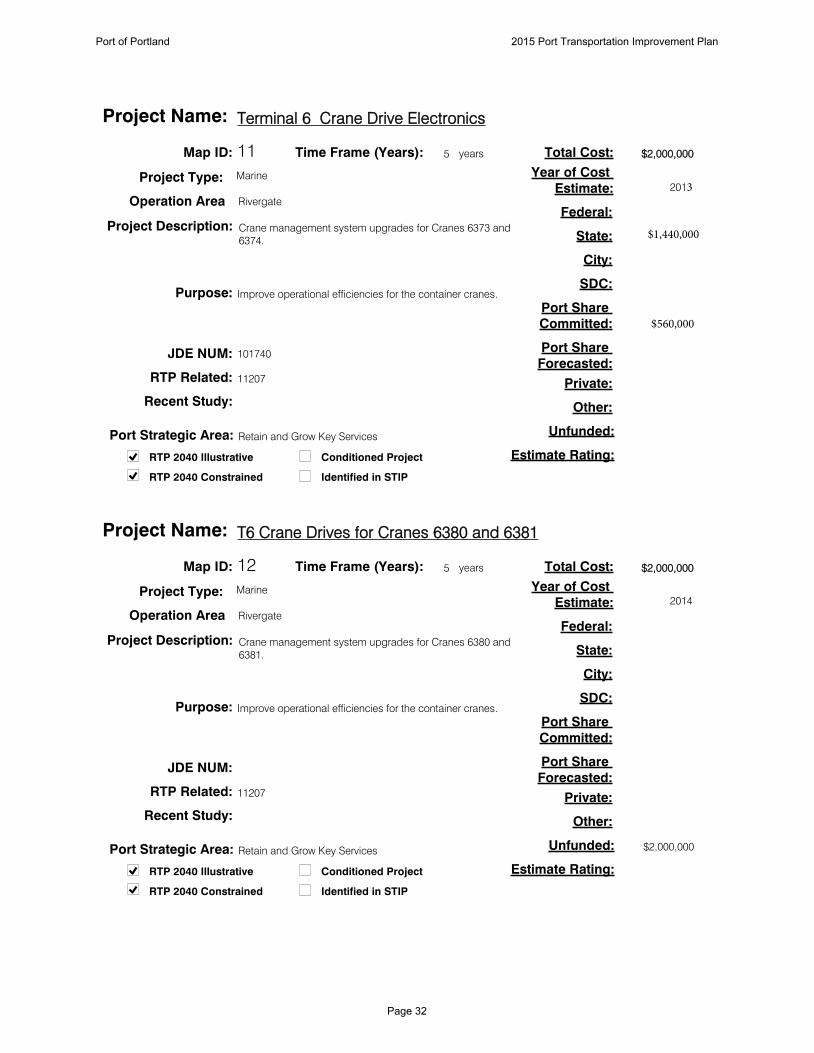
11
Improve operational efficiencies for the container cranes.
$2,000,000
11207
Map ID:
Project Description:
Purpose:
Total Cost:
Estimate Rating:
Federal:
State:
City:
SDC:
Port Share
Committed:
Port Share
Forecasted:
Private:
Other:
Unfunded:
101740JDE NUM:
Conditioned Project
Identified in STIP
RTP Related:
Recent Study:
5Time Frame (Years): years
Project Type: Marine
Operation Area Rivergate
Terminal 6 Crane Drive ElectronicsProject Name:
2013Year of Cost
Estimate:
Crane management system upgrades for Cranes 6373 and
6374.
RTP 2040 Constrained
RTP 2040 Illustrative
Port Strategic Area: Retain and Grow Key Services
12
Improve operational efficiencies for the container cranes.
$2,000,000
$2,000,000
11207
Map ID:
Project Description:
Purpose:
Total Cost:
Estimate Rating:
Federal:
State:
City:
SDC:
Port Share
Committed:
Port Share
Forecasted:
Private:
Other:
Unfunded:
JDE NUM:
Conditioned Project
Identified in STIP
RTP Related:
Recent Study:
5Time Frame (Years): years
Project Type: Marine
Operation Area Rivergate
T6 Crane Drives for Cranes 6380 and 6381Project Name:
2014
Year of Cost
Estimate:
Crane management system upgrades for Cranes 6380 and
6381.
RTP 2040 Constrained
RTP 2040 Illustrative
Port Strategic Area: Retain and Grow Key Services
Port of Portland 2015 Port Transportation Improvement Plan
Page 32
$560,000
$1,440,000

13
Improve rail access to Terminal 4.
$4,543,000
2b
$4,543,000
11355
Marine Terminal Master Plan 2020 (2003)
Map ID:
Project Description:
Purpose:
Total Cost:
Estimate Rating:
Federal:
State:
City:
SDC:
Port Share
Committed:
Port Share
Forecasted:
Private:
Other:
Unfunded:
100658JDE NUM:
Conditioned Project
Identified in STIP
RTP Related:
Recent Study:
5Time Frame (Years): years
Project Type: Rail
Operation Area Rivergate
Barnes to Terminal 4 RailProject Name:
2005
Year of Cost
Estimate:
Provide a new track from Barnes Yard to Terminal 4.
RTP 2040 Constrained
RTP 2040 Illustrative
Port Strategic Area: Regional Leadership in Industrial Lands
14
Expand rail capacity and reduce delays for greater efficiency.
$25,382,000
$25,382,000
11356
I-5 Rail Capacity Study (HDR, 2003)
Map ID:
Project Description:
Purpose:
Total Cost:
Estimate Rating:
Federal:
State:
City:
SDC:
Port Share
Committed:
Port Share
Forecasted:
Private:
Other:
Unfunded:
JDE NUM:
Conditioned Project
Identified in STIP
RTP Related:
Recent Study:
10Time Frame (Years): years
Project Type: Rail
Operation Area Rivergate
Kenton Rail Line UpgradeProject Name:
2003
Year of Cost
Estimate:
Upgrade existing track to second main track with new
double track from Peninsula Junction to I-205 and increase
track speeds between North Portland, Peninsula Junction,
to Reynolds on UP's Kenton Line. Part of triangle project
with ODOT.
RTP 2040 Constrained
RTP 2040 Illustrative
Port Strategic Area: Regional Leadership in Transportation
Port of Portland 2015 Port Transportation Improvement Plan
Page 33

15
Improve traffic efficiency in Rivergate by connecting
information about the roadway system to ODOT’s Highway
ITC systems.
$480,000
3c
$480,000
10373
Map ID:
Project Description:
Purpose:
Total Cost:
Estimate Rating:
Federal:
State:
City:
SDC:
Port Share
Committed:
Port Share
Forecasted:
Private:
Other:
Unfunded:
JDE NUM:
Conditioned Project
Identified in STIP
RTP Related:
Recent Study:
5Time Frame (Years): years
Project Type: ITS
Operation Area Rivergate
Rivergate ITSProject Name:
2007
Year of Cost
Estimate:
Intelligent Transportation System in Rivergate.
RTP 2040 Constrained
RTP 2040 Illustrative
Port Strategic Area: Regional Leadership in Transportation
16
The project will modernize the storm drainage system in the
container yard.
$5,000,000
$5,000,000
Map ID:
Project Description:
Purpose:
Total Cost:
Estimate Rating:
Federal:
State:
City:
SDC:
Port Share
Committed:
Port Share
Forecasted:
Private:
Other:
Unfunded:
101653JDE NUM:
Conditioned Project
Identified in STIP
RTP Related:
Recent Study:
5Time Frame (Years): years
Project Type: Marine
Operation Area Rivergate
Terminal 6 Stormwater SystemProject Name:
2012
Year of Cost
Estimate:
Design and construct a stormwater system.
RTP 2040 Constrained
RTP 2040 Illustrative
Port Strategic Area: Portwide Environmental Strategy
Port of Portland 2015 Port Transportation Improvement Plan
Page 34

17
Increase the storage and processing capacity for auto
imports and exports through Berth 601, thereby allowing for
an increase of volumes, leading to increased employment.
$14,000,000
2b
$14,000,000
Map ID:
Project Description:
Purpose:
Total Cost:
Estimate Rating:
Federal:
State:
City:
SDC:
Port Share
Committed:
Port Share
Forecasted:
Private:
Other:
Unfunded:
101764JDE NUM:
Conditioned Project
Identified in STIP
RTP Related:
Recent Study:
5Time Frame (Years): years
Project Type: Marine
Operation Area Rivergate
Auto Import /Export ExpansionProject Name:
2009
Year of Cost
Estimate:
The project will construct site improvements to expand the
storage and processing capacity for auto imports and
exports through Berth 601 at Terminal 6. By increasing the
storage and processing capacity, the Berth 601 auto facility
can increase throughpu
RTP 2040 Constrained
RTP 2040 Illustrative
Port Strategic Area: Retain and Grow Key Services
18
This project will facilitate the redevelopment of
approximately 30 acres of vital marine industrial property in
the Portland Harbor.
$12,000,000
$12,000,000
11208
Terminal 4 Pier 1 Facility Plan (TEC Inc.)
Map ID:
Project Description:
Purpose:
Total Cost:
Estimate Rating:
Federal:
State:
City:
SDC:
Port Share
Committed:
Port Share
Forecasted:
Private:
Other:
Unfunded:
101739JDE NUM:
Conditioned Project
Identified in STIP
RTP Related:
Recent Study:
5Time Frame (Years): years
Project Type: Marine
Operation Area Rivergate
Terminal 4 Pier 1 Site PreparationProject Name:
2012
Year of Cost
Estimate:
Demolish various structures and improve certain
infrastructure features in the Pier 1 area of Terminal 4.
RTP 2040 Constrained
RTP 2040 Illustrative
Port Strategic Area: Regional Leadership in Industrial Lands
Port of Portland 2015 Port Transportation Improvement Plan
Page 35

19
Allow better utilization of Panamax-class bulk vessels.
$2,000,000
$2,000,000
Map ID:
Project Description:
Purpose:
Total Cost:
Estimate Rating:
Federal:
State:
City:
SDC:
Port Share
Committed:
Port Share
Forecasted:
Private:
Other:
Unfunded:
100863JDE NUM:
Conditioned Project
Identified in STIP
RTP Related:
Recent Study:
5Time Frame (Years): years
Project Type: Marine
Operation Area Rivergate
Berth Deepening at T2 and T4Project Name:
2012
Year of Cost
Estimate:
Deepen berths at Terminals 2 and 4 to allow deeper draft
vessels to transit the planned 43 foot channel.
RTP 2040 Constrained
RTP 2040 Illustrative
Port Strategic Area: Retain and Grow Key Services
20
The project will increase the throughput capacity of the
facility.
$150,000,000
3c
$150,000,000
Map ID:
Project Description:
Purpose:
Total Cost:
Estimate Rating:
Federal:
State:
City:
SDC:
Port Share
Committed:
Port Share
Forecasted:
Private:
Other:
Unfunded:
101763JDE NUM:
Conditioned Project
Identified in STIP
RTP Related:
Recent Study:
5Time Frame (Years): years
Project Type: Rail
Operation Area Rivergate
T5 Berth 503 Terminal ExpansionProject Name:
Year of Cost
Estimate:
Construct a fourth rail loop, second dumper pit, storage
building, shiploader and berth improvements at Terminal 5
potash export facility.
RTP 2040 Constrained
RTP 2040 Illustrative
Port Strategic Area: Retain and Grow Key Services
Port of Portland 2015 Port Transportation Improvement Plan
Page 36
21
The project will address increased traffic needs.
$1,200,000
3c
$1,200,000
Map ID:
Project Description:
Purpose:
Total Cost:
Estimate Rating:
Federal:
State:
City:
SDC:
Port Share
Committed:
Port Share
Forecasted:
Private:
Other:
Unfunded:
101716JDE NUM:
Conditioned Project
Identified in STIP
RTP Related:
Recent Study:
5Time Frame (Years): years
Project Type: Road
Operation Area Rivergate
Terminal 5 Entrance RoadProject Name:
2011
Year of Cost
Estimate:
Provide improvements on the south side of the roadway as
well as rail crossing improvements.
RTP 2040 Constrained
RTP 2040 Illustrative
Port Strategic Area: Retain and Grow Key Services
22
Improve operational efficiencies for the container cranes.
$1,500,000
$300,000
Map ID:
Project Description:
Purpose:
Total Cost:
Estimate Rating:
Federal:
State:
City:
SDC:
Port Share
Committed:
Port Share
Forecasted:
Private:
Other:
Unfunded:
101740JDE NUM:
Conditioned Project
Identified in STIP
RTP Related:
Recent Study:
5Time Frame (Years): years
Project Type: Marine
Operation Area Rivergate
Terminal 6 Wharf OptimizationProject Name:
2011
Year of Cost
Estimate:
Crane management system upgrades for Crane 6375.
Crane travel improvements for Cranes 6380 and 6381.
RTP 2040 Constrained
RTP 2040 Illustrative
Port Strategic Area: Retain and Grow Key Services
Port of Portland 2015 Port Transportation Improvement Plan
Page 37
$1,200,000

23
This is a critical repair of the jetties at the Columbia River Bar.
$75,000,000
$75,000,000
Map ID:
Project Description:
Purpose:
Total Cost:
Estimate Rating:
Federal:
State:
City:
SDC:
Port Share
Committed:
Port Share
Forecasted:
Private:
Other:
Unfunded:
JDE NUM:
Conditioned Project
Identified in STIP
RTP Related:
Recent Study:
5Time Frame (Years): years
Project Type: Marine
Operation Area Rivergate
Columbia River Mouth Jetty RefurbishmentProject Name:
2012
Year of Cost
Estimate:
Refurbish and repair the north and south jetties at the
mouth of the Columbia River.
RTP 2040 Constrained
RTP 2040 Illustrative
Port Strategic Area: Regional Leadership in Transportation
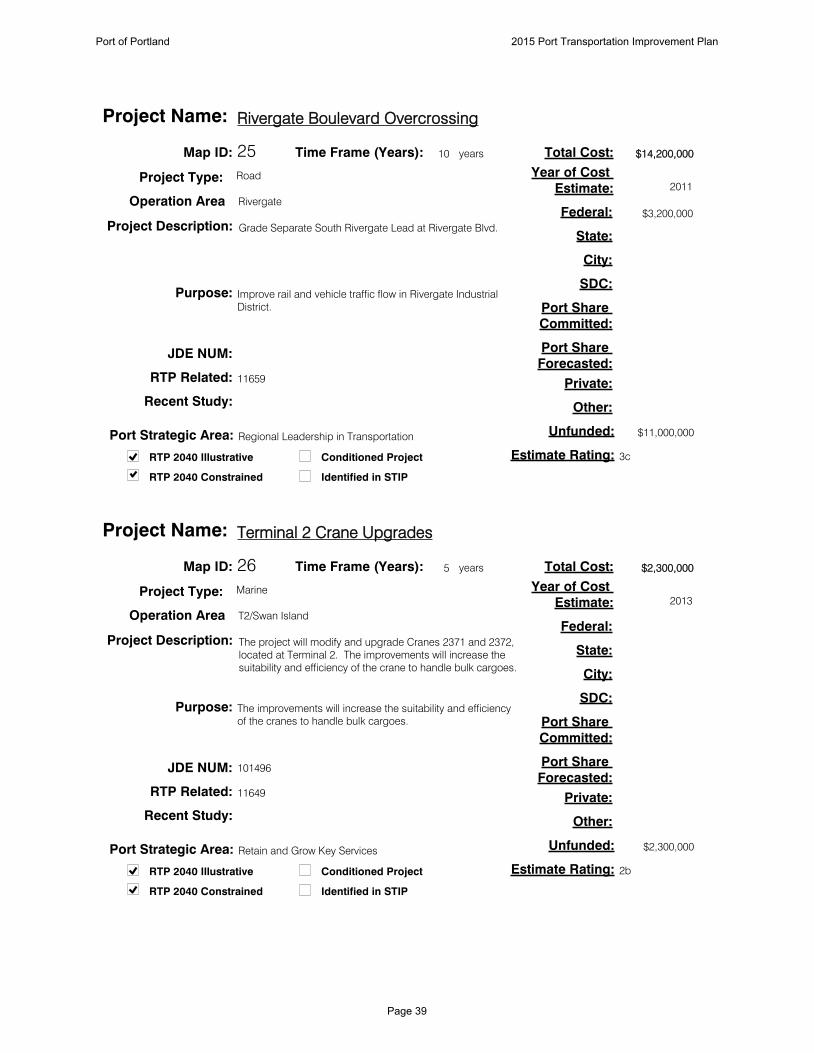
24
Provide improved access to South Rivergate industrial area.
$9,000,000
$9,000,000
11654
Map ID:
Project Description:
Purpose:
Total Cost:
Estimate Rating:
Federal:
State:
City:
SDC:
Port Share
Committed:
Port Share
Forecasted:
Private:
Other:
Unfunded:
JDE NUM:
Conditioned Project
Identified in STIP
RTP Related:
Recent Study:
10Time Frame (Years): years
Project Type: Road
Operation Area Rivergate
Time Oil Road ReconstructionProject Name:
2013
Year of Cost
Estimate:
Reconstruct Time Oil Road.
RTP 2040 Constrained
RTP 2040 Illustrative
Port Strategic Area: Regional Leadership in Transportation
Port of Portland 2015 Port Transportation Improvement Plan
Page 38
25
Improve rail and vehicle traffic flow in Rivergate Industrial
District.
$14,200,000
3c
$3,200,000
$11,000,000
11659
Map ID:
Project Description:
Purpose:
Total Cost:
Estimate Rating:
Federal:
State:
City:
SDC:
Port Share
Committed:
Port Share
Forecasted:
Private:
Other:
Unfunded:
JDE NUM:
Conditioned Project
Identified in STIP
RTP Related:
Recent Study:
10Time Frame (Years): years
Project Type: Road
Operation Area Rivergate
Rivergate Boulevard OvercrossingProject Name:
2011
Year of Cost
Estimate:
Grade Separate South Rivergate Lead at Rivergate Blvd.
RTP 2040 Constrained
RTP 2040 Illustrative
Port Strategic Area: Regional Leadership in Transportation
26
The improvements will increase the suitability and efficiency
of the cranes to handle bulk cargoes.
$2,300,000
2b
$2,300,000
11649
Map ID:
Project Description:
Purpose:
Total Cost:
Estimate Rating:
Federal:
State:
City:
SDC:
Port Share
Committed:
Port Share
Forecasted:
Private:
Other:
Unfunded:
101496JDE NUM:
Conditioned Project
Identified in STIP
RTP Related:
Recent Study:
5Time Frame (Years): years
Project Type: Marine
Operation Area T2/Swan Island
Terminal 2 Crane UpgradesProject Name:
2013
Year of Cost
Estimate:
The project will modify and upgrade Cranes 2371 and 2372,
located at Terminal 2. The improvements will increase the
suitability and efficiency of the crane to handle bulk cargoes.
RTP 2040 Constrained
RTP 2040 Illustrative
Port Strategic Area: Retain and Grow Key Services
Port of Portland 2015 Port Transportation Improvement Plan
Page 39

27
To secure truck flow and congestion data.
10377
Map ID:
Project Description:
Purpose:
Total Cost:
Estimate Rating:
Federal:
State:
City:
SDC:
Port Share
Committed:
Port Share
Forecasted:
Private:
Other:
Unfunded:
JDE NUM:
Conditioned Project
Identified in STIP
RTP Related:
Recent Study:
5Time Frame (Years): years
Project Type: ITS
Operation Area T2/Swan Island
PSU ITS ExpansionProject Name:
Year of Cost
Estimate:
Expand PSU's existing web based ITS "count sensor"
program beyond the freeway to some key arterials
throughout the region and create a repository of regional
freight data.
RTP 2040 Constrained
RTP 2040 Illustrative
Port Strategic Area: Regional Leadership in Transportation
28
Increase rail capacity and operating efficiencies at Terminal
2.
$2,200,000
3c
$2,200,000
11649
Map ID:
Project Description:
Purpose:
Total Cost:
Estimate Rating:
Federal:
State:
City:
SDC:
Port Share
Committed:
Port Share
Forecasted:
Private:
Other:
Unfunded:
101046JDE NUM:
Conditioned Project
Identified in STIP
RTP Related:
Recent Study:
5Time Frame (Years): years
Project Type: Rail
Operation Area T2/Swan Island
Terminal 2 Rail ImprovementProject Name:
2013
Year of Cost
Estimate:
Add approximately 600 feet to the inner track (Track 10) and
connect it with the outer loop (Track 15). A third track may
also be constructed and a rail scaling station added in
addition to stormwater improvements to the dock.
RTP 2040 Constrained
RTP 2040 Illustrative
Port Strategic Area: Retain and Grow Key Services
Port of Portland 2015 Port Transportation Improvement Plan
Page 40

29
Allow Dredge Oregon to make full use of recent repower and
pump material 14,000 feet.
$10,200,000
3c
$10,200,000
Map ID:
Project Description:
Purpose:
Total Cost:
Estimate Rating:
Federal:
State:
City:
SDC:
Port Share
Committed:
Port Share
Forecasted:
Private:
Other:
Unfunded:
102271JDE NUM:
Conditioned Project
Identified in STIP
RTP Related:
Recent Study:
5Time Frame (Years): years
Project Type: Marine
Operation Area T2/Swan Island
Dredge Oregon Pipe, Scows and PontoonsProject Name:
2014
Year of Cost
Estimate:
Acquire 2,000 feet of dredge pipe, pontoons, anchor scows
and anchors.
RTP 2040 Constrained
RTP 2040 Illustrative
Port Strategic Area: Regional Leadership in Transportation
30
Improve operational support for Dredge Oregon dredging
operations and improve environmental performance
$6,000,000
3c
$6,000,000
Map ID:
Project Description:
Purpose:
Total Cost:
Estimate Rating:
Federal:
State:
City:
SDC:
Port Share
Committed:
Port Share
Forecasted:
Private:
Other:
Unfunded:
101349JDE NUM:
Conditioned Project
Identified in STIP
RTP Related:
Recent Study:
5Time Frame (Years): years
Project Type: Marine
Operation Area T2/Swan Island
New Dredge TenderProject Name:
2014
Year of Cost
Estimate:
Replace the existing vintage tugboat W.L. Williams with a
newly constructed modern work-boat vessel.
RTP 2040 Constrained
RTP 2040 Illustrative
Port Strategic Area: Regional Leadership in Transportation
Port of Portland 2015 Port Transportation Improvement Plan
Page 41

31
Improve operational efficiencies for the cargo handling
cranes.
$2,000,000
$2,000,000
Map ID:
Project Description:
Purpose:
Total Cost:
Estimate Rating:
Federal:
State:
City:
SDC:
Port Share
Committed:
Port Share
Forecasted:
Private:
Other:
Unfunded:
JDE NUM:
Conditioned Project
Identified in STIP
RTP Related:
Recent Study:
5Time Frame (Years): years
Project Type: Marine
Operation Area T2/Swan Island
T2 Crane Drives for Cranes 2371 and 2372Project Name:
2014
Year of Cost
Estimate:
Crane management system upgrades for Cranes 2371 and
2372.
RTP 2040 Constrained
RTP 2040 Illustrative
Port Strategic Area: Retain and Grow Key Services
32
Improve access to Troutdale Reynolds Industrial Park.
$2,500,000
1a
$2,220,000
$280,000
11231
Map ID:
Project Description:
Purpose:
Total Cost:
Estimate Rating:
Federal:
State:
City:
SDC:
Port Share
Committed:
Port Share
Forecasted:
Private:
Other:
Unfunded:
101633JDE NUM:
Conditioned Project
Identified in STIP
RTP Related:
Recent Study:
5Time Frame (Years): years
Project Type: Road
Operation Area East County
Swigert Way ExtensionProject Name:
2008
Year of Cost
Estimate:
Extend Swigert Way from it existing terminus to Graham
Road.
RTP 2040 Constrained
RTP 2040 Illustrative
Port Strategic Area: Regional Leadership in Industrial Lands
Port of Portland 2015 Port Transportation Improvement Plan
Page 42

33
Improve access to Troutdale Reynolds Industrial Park Phase
2.
$10,000,000
1a
$8,880,000
$1,120,000
11232, 11130
Map ID:
Project Description:
Purpose:
Total Cost:
Estimate Rating:
Federal:
State:
City:
SDC:
Port Share
Committed:
Port Share
Forecasted:
Private:
Other:
Unfunded:
101633JDE NUM:
Conditioned Project
Identified in STIP
RTP Related:
Recent Study:
5Time Frame (Years): years
Project Type: Road
Operation Area East County
Graham RoadProject Name:
2009
Year of Cost
Estimate:
Reconstruct and/or widen Graham Road along Troutdale
Reynolds Industrial Park frontage.
RTP 2040 Constrained
RTP 2040 Illustrative
Port Strategic Area: Regional Leadership in Industrial Lands
34
Project identified in 2004 TTD Master Plan.
$12,534,000
$12,534,000
Map ID:
Project Description:
Purpose:
Total Cost:
Estimate Rating:
Federal:
State:
City:
SDC:
Port Share
Committed:
Port Share
Forecasted:
Private:
Other:
Unfunded:
101039JDE NUM:
Conditioned Project
Identified in STIP
RTP Related:
Recent Study:
5Time Frame (Years): years
Project Type: Aviation
Operation Area East County
TTD Reconstruct runway 7-25Project Name:
2010
Year of Cost
Estimate:
Reconstruct existing 150' x 5400' runway; narrow to 75' wide,
relocated/reconstruct edge lighting, construct required
drainage improvements.
RTP 2040 Constrained
RTP 2040 Illustrative
Port Strategic Area: Retain and Grow Key Services
Port of Portland 2015 Port Transportation Improvement Plan
Page 43

35
Project recommended in 2004 Master Plan and verified by
Port assessment of pavement condition and expected
remaining life.
$10,100,000
$10,100,000
Map ID:
Project Description:
Purpose:
Total Cost:
Estimate Rating:
Federal:
State:
City:
SDC:
Port Share
Committed:
Port Share
Forecasted:
Private:
Other:
Unfunded:
101038JDE NUM:
Conditioned Project
Identified in STIP
RTP Related:
Recent Study:
5Time Frame (Years): years
Project Type: Aviation
Operation Area East County
TTD Rehabilitate Taxiway AProject Name:
2010
Year of Cost
Estimate:
Rehabilitation of full-length parallel taxiway A including
lighting and markings.
RTP 2040 Constrained
RTP 2040 Illustrative
Port Strategic Area: Retain and Grow Key Services
36
Combined with the Port's Reynolds levee trail it will
complete gaps in the 40 Mile Loop Trail.
$3,424,073
$3,072,421
$88,604
$263,048
10408
Map ID:
Project Description:
Purpose:
Total Cost:
Estimate Rating:
Federal:
State:
City:
SDC:
Port Share
Committed:
Port Share
Forecasted:
Private:
Other:
Unfunded:
102069JDE NUM:
Conditioned Project
Identified in STIP
RTP Related:
Recent Study:
5Time Frame (Years): years
Project Type: Bike/Ped
Operation Area East County
40 Mile Loop Trail: Blue Lake Park to Sundial Rd.Project Name:
2014
Year of Cost
Estimate:
Construct a mixed use off road trail connecting Blue Lake
Park and Sundial Road.
RTP 2040 Constrained
RTP 2040 Illustrative
Port Strategic Area: Regional Leadership in Transportation
Port of Portland 2015 Port Transportation Improvement Plan
Page 44
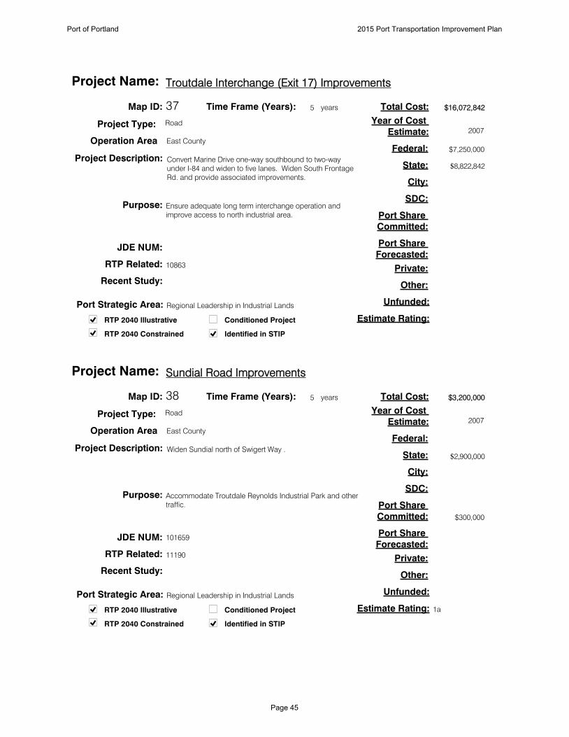
37
Ensure adequate long term interchange operation and
improve access to north industrial area.
$16,072,842
$7,250,000
$8,822,842
10863
Map ID:
Project Description:
Purpose:
Total Cost:
Estimate Rating:
Federal:
State:
City:
SDC:
Port Share
Committed:
Port Share
Forecasted:
Private:
Other:
Unfunded:
JDE NUM:
Conditioned Project
Identified in STIP
RTP Related:
Recent Study:
5Time Frame (Years): years
Project Type: Road
Operation Area East County
Troutdale Interchange (Exit 17) ImprovementsProject Name:
2007
Year of Cost
Estimate:
Convert Marine Drive one-way southbound to two-way
under I-84 and widen to five lanes. Widen South Frontage
Rd. and provide associated improvements.
RTP 2040 Constrained
RTP 2040 Illustrative
Port Strategic Area: Regional Leadership in Industrial Lands
38
Accommodate Troutdale Reynolds Industrial Park and other
traffic.
$3,200,000
1a
$2,900,000
$300,000
11190
Map ID:
Project Description:
Purpose:
Total Cost:
Estimate Rating:
Federal:
State:
City:
SDC:
Port Share
Committed:
Port Share
Forecasted:
Private:
Other:
Unfunded:
101659JDE NUM:
Conditioned Project
Identified in STIP
RTP Related:
Recent Study:
5Time Frame (Years): years
Project Type: Road
Operation Area East County
Sundial Road ImprovementsProject Name:
2007
Year of Cost
Estimate:
Widen Sundial north of Swigert Way .
RTP 2040 Constrained
RTP 2040 Illustrative
Port Strategic Area: Regional Leadership in Industrial Lands
Port of Portland 2015 Port Transportation Improvement Plan
Page 45

39
Address off-site transportation impacts.
11231, 11232
Map ID:
Project Description:
Purpose:
Total Cost:
Estimate Rating:
Federal:
State:
City:
SDC:
Port Share
Committed:
Port Share
Forecasted:
Private:
Other:
Unfunded:
100909JDE NUM:
Conditioned Project
Identified in STIP
RTP Related:
Recent Study:
10Time Frame (Years): years
Project Type: Road
Operation Area East County
Reynolds Site Road Access Phase 3Project Name:
Year of Cost
Estimate:
Road improvements to serve Phase 3 industrial
development. Actual project will be developed in
coordination with stakeholders.
RTP 2040 Constrained
RTP 2040 Illustrative
Port Strategic Area: Regional Leadership in Industrial Lands
Port of Portland 2015 Port Transportation Improvement Plan
Page 46

M A P : G I S P R O G R A M O F F I C E
P O RT L A N D
P DXP DX205
VA N CO U V E R
CO LU M B I A R I V E R N AV I G AT I O N C H A N N E L
N E CO LU M B I A B LV D
N E CO LU M B I A B LV DN E LO M B A R D S T
N E LO M B A R D S T
N E M A R I N E D RN E M A R I N E D R
NE
82N
D A
VE
NE
82N
D A
VE
NE
33R
D A
VE
NE
33R
D A
VE
P I CP I C
5
NE AIRPORT WAY
NE AIRPORT WAY
NE
MLK
BLV
DN
E M
LK B
LVD
ITS
4747
43434040
5050
22
4444
11
42424646
484844
5151
554949
33
45, 5745, 57
52, 5352, 53
5858
54, 55, 5654, 55, 56
5959
66
4141
P R I O R I T Y
N O N - P R I O R I T Y
M A P I D #1010
ITS
R A I LAV I AT I O N
P E D / B I K E I N T E L L I G E N TT R A N S . S Y S T E M
P DX / P I C A R E A P R O J E C T S2 0 1 5 P O R T T R A N S P O R TAT I O N I M P R O V E M E N T P L A N
R O A D
O T H E RO
Port of Portland 2015 Port Transportation Improvement Plan
Page 47

40
Construct right turn lane on Columbia at MLK.
Improve connectivity for freight traffic between Columbia
Blvd. and Rivergate.
$3,359,259
$3,014,263
$230,541
$114,455
10208
Columbia Corridor Transportation Study (1999)
Map ID:
Project Description:
Purpose:
Total Cost:
Estimate Rating:
Federal:
State:
City:
SDC:
Port Share
Committed:
Port Share
Forecasted:
Private:
Other:
Unfunded:
810030JDE NUM:
Conditioned Project
Identified in STIPRTP 2040 Constrained
RTP 2040 Illustrative
RTP Related:
Recent Study:
5Time Frame (Years): years
Project Type: Road
Operation Area PDX/PIC
Columbia Blvd. Improvements at MLKProject Name:
2011
Year of Cost
Estimate:
Port Strategic Area: Regional Leadership in Transportation
41
Construct a full interchange at Columbia Blvd. or the
functional equivalent. Includes three projects Delta Park
Phase II and III and Argyle on the Hill.
Improve connections between Columbia Blvd. and I-5 for
trucks.
$51,773,032
$51,773,032
10219, 10874
I-5 Delta Park Environmental Assessment (2006)
Map ID:
Project Description:
Purpose:
Total Cost:
Estimate Rating:
Federal:
State:
City:
SDC:
Port Share
Committed:
Port Share
Forecasted:
Private:
Other:
Unfunded:
JDE NUM:
Conditioned Project
Identified in STIPRTP 2040 Constrained
RTP 2040 Illustrative
RTP Related:
Recent Study:
10Time Frame (Years): years
Project Type: Road
Operation Area PDX/PIC
I-5/Columbia Blvd. ImprovementProject Name:
2006
Year of Cost
Estimate:
Port Strategic Area: Regional Leadership in Transportation
Port of Portland 2015 Port Transportation Improvement Plan
Page 48

42
Expand the on-ramp to three lanes, including for
truck/HOV.
Increase the capacity of the I-205 SB on-ramp at Columbia
Blvd.
$11,200,000
$11,200,000
11091
Colwood Golf Course Rezone Transportation Impact
Analysis (2013)
Map ID:
Project Description:
Purpose:
Total Cost:
Estimate Rating:
Federal:
State:
City:
SDC:
Port Share
Committed:
Port Share
Forecasted:
Private:
Other:
Unfunded:
JDE NUM:
Conditioned Project
Identified in STIPRTP 2040 Constrained
RTP 2040 Illustrative
RTP Related:
Recent Study:
5Time Frame (Years): years
Project Type: Road
Operation Area PDX/PIC
Columbia Blvd./I-205 SB On Ramp ImprovementProject Name:
2007
Year of Cost
Estimate:
Port Strategic Area: Retain and Grow Key Services
43
If feasible, eliminate the at-grade crossing and improve
alternate roadway access.
Improve Kenton Mainline operation and eliminate a modal
conflict.
$1,000,000
$1,000,000
10334
Map ID:
Project Description:
Purpose:
Total Cost:
Estimate Rating:
Federal:
State:
City:
SDC:
Port Share
Committed:
Port Share
Forecasted:
Private:
Other:
Unfunded:
JDE NUM:
Conditioned Project
Identified in STIPRTP 2040 Constrained
RTP 2040 Illustrative
RTP Related:
Recent Study:
5Time Frame (Years): years
Project Type: Rail
Operation Area PDX/PIC
11th/13th (at Columbia Blvd.): Crossing EliminationProject Name:
2007
Year of Cost
Estimate:
Port Strategic Area: Regional Leadership in Transportation
Port of Portland 2015 Port Transportation Improvement Plan
Page 49

44
Widen Columbia Blvd. to five lanes.
Address system bottleneck along Columbia Blvd.
$15,000,000
$15,000,000
10376
East Columbia-Lombard Connector Study
Transportation Analysis (2000)
Map ID:
Project Description:
Purpose:
Total Cost:
Estimate Rating:
Federal:
State:
City:
SDC:
Port Share
Committed:
Port Share
Forecasted:
Private:
Other:
Unfunded:
JDE NUM:
Conditioned Project
Identified in STIPRTP 2040 Constrained
RTP 2040 Illustrative
RTP Related:
Recent Study:
20Time Frame (Years): years
Project Type: Road
Operation Area PDX/PIC
Columbia Blvd. Widening (82nd Ave. - 60th Ave.)Project Name:
2003
Year of Cost
Estimate:
Port Strategic Area: Regional Leadership in Transportation
45
Implement strategies at PDX and PIC properties that
reduce auto trips in the airport area. Programs to be
undertaken with other area businesses/developers to
maximize effectiveness; possible administration through a
transportation management association.
Fulfill TDM requirements of PDX Master Plan. Implement
TDM projects and programs recommended in the PDX
Alternative Modes Study.
10380
PDX Employee TDM Program Study (2002)
Map ID:
Project Description:
Purpose:
Total Cost:
Estimate Rating:
Federal:
State:
City:
SDC:
Port Share
Committed:
Port Share
Forecasted:
Private:
Other:
Unfunded:
JDE NUM:
Conditioned Project
Identified in STIPRTP 2040 Constrained
RTP 2040 Illustrative
RTP Related:
Recent Study:
5Time Frame (Years): years
Project Type: Other
Operation Area PDX/PIC
PDX Transportation Demand Management (TDM)Project Name:
Year of Cost
Estimate:
Port Strategic Area: Regional Leadership in Transportation
Port of Portland 2015 Port Transportation Improvement Plan
Page 50

46
New auxiliary lane from I-84 to I-205 NB before Columbia
Blvd.
Provide additional capacity for anticipated growth in area
traffic.
$5,775,000
$5,775,000
11398
Airport Area Transp. Study (1998)
Map ID:
Project Description:
Purpose:
Total Cost:
Estimate Rating:
Federal:
State:
City:
SDC:
Port Share
Committed:
Port Share
Forecasted:
Private:
Other:
Unfunded:
810022JDE NUM:
Conditioned Project
Identified in STIPRTP 2040 Constrained
RTP 2040 Illustrative
RTP Related:
Recent Study:
20Time Frame (Years): years
Project Type: Road
Operation Area PDX/PIC
I-205 Auxiliary Lane NBProject Name:
Year of Cost
Estimate:
Port Strategic Area: Regional Leadership in Transportation
47
Provide street access from 33rd Ave. into SW Quad.
Provide efficient movement of traffic to developing PDX
properties.
$5,917,500
3c
$5,917,500
10363
PDX Conditional Use Master Plan (2003)
Map ID:
Project Description:
Purpose:
Total Cost:
Estimate Rating:
Federal:
State:
City:
SDC:
Port Share
Committed:
Port Share
Forecasted:
Private:
Other:
Unfunded:
100757JDE NUM:
Conditioned Project
Identified in STIPRTP 2040 Constrained
RTP 2040 Illustrative
RTP Related:
Recent Study:
10Time Frame (Years): years
Project Type: Road
Operation Area PDX/PIC
SW Quad AccessProject Name:
2007
Year of Cost
Estimate:
Port Strategic Area: Regional Leadership in Industrial Land
Port of Portland 2015 Port Transportation Improvement Plan
Page 51
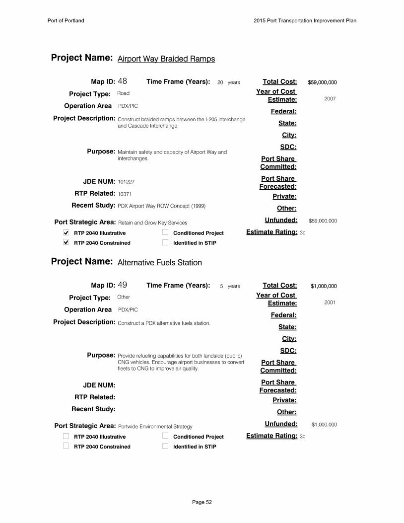
48
Construct braided ramps between the I-205 interchange
and Cascade Interchange.
Maintain safety and capacity of Airport Way and
interchanges.
$59,000,000
3c
$59,000,000
10371
PDX Airport Way ROW Concept (1999)
Map ID:
Project Description:
Purpose:
Total Cost:
Estimate Rating:
Federal:
State:
City:
SDC:
Port Share
Committed:
Port Share
Forecasted:
Private:
Other:
Unfunded:
101227JDE NUM:
Conditioned Project
Identified in STIPRTP 2040 Constrained
RTP 2040 Illustrative
RTP Related:
Recent Study:
20Time Frame (Years): years
Project Type: Road
Operation Area PDX/PIC
Airport Way Braided RampsProject Name:
2007
Year of Cost
Estimate:
Port Strategic Area: Retain and Grow Key Services
49
Construct a PDX alternative fuels station.
Provide refueling capabilities for both landside (public)
CNG vehicles. Encourage airport businesses to convert
fleets to CNG to improve air quality.
$1,000,000
3c
$1,000,000
Map ID:
Project Description:
Purpose:
Total Cost:
Estimate Rating:
Federal:
State:
City:
SDC:
Port Share
Committed:
Port Share
Forecasted:
Private:
Other:
Unfunded:
JDE NUM:
Conditioned Project
Identified in STIPRTP 2040 Constrained
RTP 2040 Illustrative
RTP Related:
Recent Study:
5Time Frame (Years): years
Project Type: Other
Operation Area PDX/PIC
Alternative Fuels StationProject Name:
2001
Year of Cost
Estimate:
Port Strategic Area: Portwide Environmental Strategy
Port of Portland 2015 Port Transportation Improvement Plan
Page 52

50
Drainage improvements in SW Quad through
modifications to the existing drainage channels and
increasing the capacity of the Broadmoor Pump Station.
Provide additional capacity for anticipated growth in
airport traffic.
$1,250,000
3c
$1,250,000
Map ID:
Project Description:
Purpose:
Total Cost:
Estimate Rating:
Federal:
State:
City:
SDC:
Port Share
Committed:
Port Share
Forecasted:
Private:
Other:
Unfunded:
101625JDE NUM:
Conditioned Project
Identified in STIPRTP 2040 Constrained
RTP 2040 Illustrative
RTP Related:
Recent Study:
5Time Frame (Years): years
Project Type: Other
Operation Area PDX/PIC
SW Quad Drainage ImprovementsProject Name:
2008
Year of Cost
Estimate:
Port Strategic Area: Regional Leadership in Industrial Land
51
Add New Lane
Provide additional capacity for anticipated growth in
passenger traffic.
$3,335,000
3c
$3,335,000
PDX Airport Futures 2010 Master Plan
Map ID:
Project Description:
Purpose:
Total Cost:
Estimate Rating:
Federal:
State:
City:
SDC:
Port Share
Committed:
Port Share
Forecasted:
Private:
Other:
Unfunded:
101228JDE NUM:
Conditioned Project
Identified in STIPRTP 2040 Constrained
RTP 2040 Illustrative
RTP Related:
Recent Study:
10Time Frame (Years): years
Project Type: Road
Operation Area PDX/PIC
Widen APW Outbound East of 82ndProject Name:
2010
Year of Cost
Estimate:
Port Strategic Area: Retain and Grow Key Services
Port of Portland 2015 Port Transportation Improvement Plan
Page 53

52
Add New Lane
Provide additional capacity for anticipated growth in
passenger traffic.
$2,976,000
$2,976,000
11657
PDX Airport Futures 2010 Master Plan
Map ID:
Project Description:
Purpose:
Total Cost:
Estimate Rating:
Federal:
State:
City:
SDC:
Port Share
Committed:
Port Share
Forecasted:
Private:
Other:
Unfunded:
101466JDE NUM:
Conditioned Project
Identified in STIPRTP 2040 Constrained
RTP 2040 Illustrative
RTP Related:
Recent Study:
20Time Frame (Years): years
Project Type: Road
Operation Area PDX/PIC
Deplaning Curbside Roadway LanesProject Name:
2010
Year of Cost
Estimate:
Port Strategic Area: Retain and Grow Key Services
53
Add New Lane
Provide additional capacity for anticipated growth in
passenger traffic.
$324,000
$324,000
11657
PDX Airport Futures 2010 Master Plan
Map ID:
Project Description:
Purpose:
Total Cost:
Estimate Rating:
Federal:
State:
City:
SDC:
Port Share
Committed:
Port Share
Forecasted:
Private:
Other:
Unfunded:
101467JDE NUM:
Conditioned Project
Identified in STIPRTP 2040 Constrained
RTP 2040 Illustrative
RTP Related:
Recent Study:
20Time Frame (Years): years
Project Type: Road
Operation Area PDX/PIC
Deplaning Curbside Roadway LoadingProject Name:
2010
Year of Cost
Estimate:
Port Strategic Area: Retain and Grow Key Services
Port of Portland 2015 Port Transportation Improvement Plan
Page 54
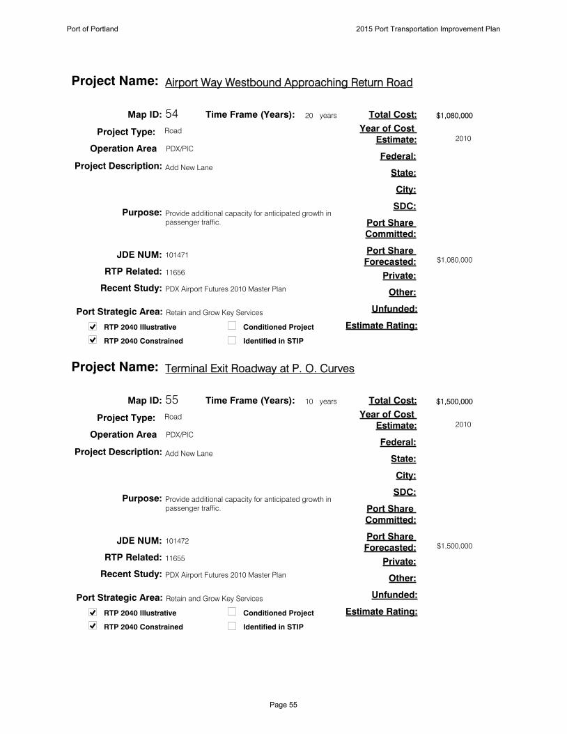
54
Add New Lane
Provide additional capacity for anticipated growth in
passenger traffic.
$1,080,000
$1,080,000
11656
PDX Airport Futures 2010 Master Plan
Map ID:
Project Description:
Purpose:
Total Cost:
Estimate Rating:
Federal:
State:
City:
SDC:
Port Share
Committed:
Port Share
Forecasted:
Private:
Other:
Unfunded:
101471JDE NUM:
Conditioned Project
Identified in STIPRTP 2040 Constrained
RTP 2040 Illustrative
RTP Related:
Recent Study:
20Time Frame (Years): years
Project Type: Road
Operation Area PDX/PIC
Airport Way Westbound Approaching Return RoadProject Name:
2010
Year of Cost
Estimate:
Port Strategic Area: Retain and Grow Key Services
55
Add New Lane
Provide additional capacity for anticipated growth in
passenger traffic.
$1,500,000
$1,500,000
11655
PDX Airport Futures 2010 Master Plan
Map ID:
Project Description:
Purpose:
Total Cost:
Estimate Rating:
Federal:
State:
City:
SDC:
Port Share
Committed:
Port Share
Forecasted:
Private:
Other:
Unfunded:
101472JDE NUM:
Conditioned Project
Identified in STIPRTP 2040 Constrained
RTP 2040 Illustrative
RTP Related:
Recent Study:
10Time Frame (Years): years
Project Type: Road
Operation Area PDX/PIC
Terminal Exit Roadway at P. O. CurvesProject Name:
2010
Year of Cost
Estimate:
Port Strategic Area: Retain and Grow Key Services
Port of Portland 2015 Port Transportation Improvement Plan
Page 55

56
Add New Lane
Provide additional capacity for anticipated growth in
passenger traffic.
$1,104,000
$1,104,000
11655
PDX Airport Futures 2010 Master Plan
Map ID:
Project Description:
Purpose:
Total Cost:
Estimate Rating:
Federal:
State:
City:
SDC:
Port Share
Committed:
Port Share
Forecasted:
Private:
Other:
Unfunded:
101473JDE NUM:
Conditioned Project
Identified in STIPRTP 2040 Constrained
RTP 2040 Illustrative
RTP Related:
Recent Study:
20Time Frame (Years): years
Project Type: Road
Operation Area PDX/PIC
Terminal Exit Roadway at Parking PlazaProject Name:
2010
Year of Cost
Estimate:
Port Strategic Area: Retain and Grow Key Services
57
Plan for, purchase, and develop a site for use as a
mitigation bank.
Provide a site for environmental mitigation for Port
transportation and other development projects.
Map ID:
Project Description:
Purpose:
Total Cost:
Estimate Rating:
Federal:
State:
City:
SDC:
Port Share
Committed:
Port Share
Forecasted:
Private:
Other:
Unfunded:
JDE NUM:
Conditioned Project
Identified in STIPRTP 2040 Constrained
RTP 2040 Illustrative
RTP Related:
Recent Study:
5Time Frame (Years): years
Project Type: Other
Operation Area PDX/PIC
Mitigation Land BankProject Name:
Year of Cost
Estimate:
Port Strategic Area: Portwide Environmental Strategy
Port of Portland 2015 Port Transportation Improvement Plan
Page 56
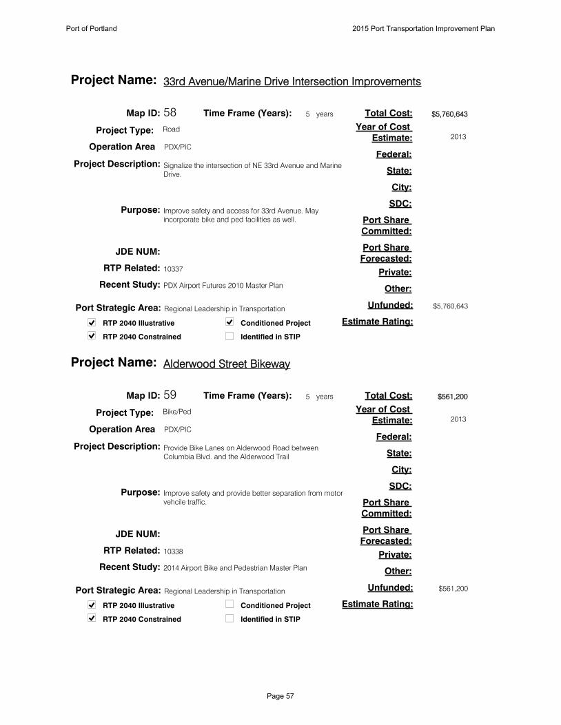
58
Signalize the intersection of NE 33rd Avenue and Marine
Drive.
Improve safety and access for 33rd Avenue. May
incorporate bike and ped facilities as well.
$5,760,643
$5,760,643
10337
PDX Airport Futures 2010 Master Plan
Map ID:
Project Description:
Purpose:
Total Cost:
Estimate Rating:
Federal:
State:
City:
SDC:
Port Share
Committed:
Port Share
Forecasted:
Private:
Other:
Unfunded:
JDE NUM:
Conditioned Project
Identified in STIPRTP 2040 Constrained
RTP 2040 Illustrative
RTP Related:
Recent Study:
5Time Frame (Years): years
Project Type: Road
Operation Area PDX/PIC
33rd Avenue/Marine Drive Intersection ImprovementsProject Name:
2013
Year of Cost
Estimate:
Port Strategic Area: Regional Leadership in Transportation
59
Provide Bike Lanes on Alderwood Road between
Columbia Blvd. and the Alderwood Trail
Improve safety and provide better separation from motor
vehcile traffic.
$561,200
$561,200
10338
2014 Airport Bike and Pedestrian Master Plan
Map ID:
Project Description:
Purpose:
Total Cost:
Estimate Rating:
Federal:
State:
City:
SDC:
Port Share
Committed:
Port Share
Forecasted:
Private:
Other:
Unfunded:
JDE NUM:
Conditioned Project
Identified in STIPRTP 2040 Constrained
RTP 2040 Illustrative
RTP Related:
Recent Study:
5Time Frame (Years): years
Project Type: Bike/Ped
Operation Area PDX/PIC
Alderwood Street BikewayProject Name:
2013
Year of Cost
Estimate:
Port Strategic Area: Regional Leadership in Transportation
Port of Portland 2015 Port Transportation Improvement Plan
Page 57

88
6060
61, 6261, 62
7, 97, 9
H I L L S B O R O
H I OH I O
M A P : G I S P R O G R A M O F F I C E
N W CO R N E L L R DN W CO R N E L L R D
N W E V E R G R E E N PA R K WAYN W E V E R G R E E N PA R K WAY
US 26US 26
P R I O R I T Y
N O N - P R I O R I T Y
M A P I D #1010
H I O A R E A P R O J E C T S2 0 1 5 P O R T T R A N S P O R TAT I O N I M P R O V E M E N T P L A N
R O A D
AV I AT I O N
Port of Portland 2015 Port Transportation Improvement Plan
Page 58
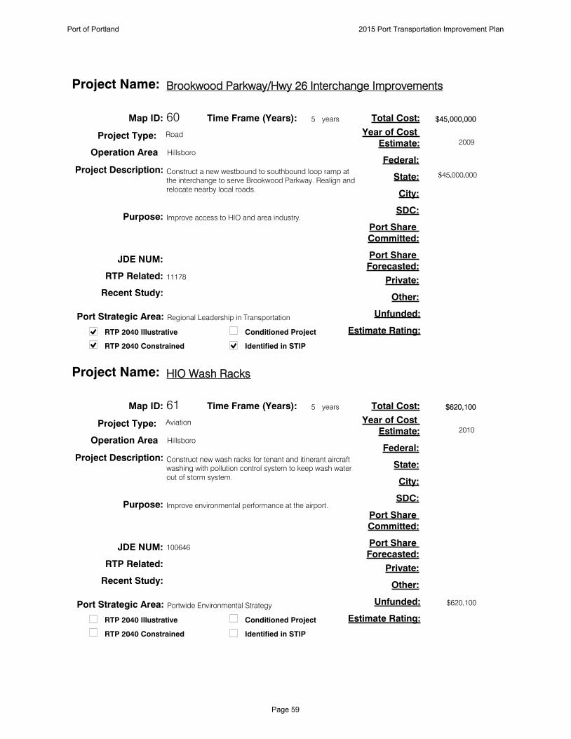
60
Construct a new westbound to southbound loop ramp at
the interchange to serve Brookwood Parkway. Realign and
relocate nearby local roads.
Improve access to HIO and area industry.
$45,000,000
$45,000,000
11178
Map ID:
Project Description:
Purpose:
Total Cost:
Estimate Rating:
Federal:
State:
City:
SDC:
Port Share
Committed:
Port Share
Forecasted:
Private:
Other:
Unfunded:
JDE NUM:
Conditioned Project
Identified in STIPRTP 2040 Constrained
RTP 2040 Illustrative
RTP Related:
Recent Study:
5Time Frame (Years): years
Project Type: Road
Operation Area Hillsboro
Brookwood Parkway/Hwy 26 Interchange ImprovementsProject Name:
2009
Year of Cost
Estimate:
Port Strategic Area: Regional Leadership in Transportation
61
Construct new wash racks for tenant and itinerant aircraft
washing with pollution control system to keep wash water
out of storm system.
Improve environmental performance at the airport.
$620,100
$620,100
Map ID:
Project Description:
Purpose:
Total Cost:
Estimate Rating:
Federal:
State:
City:
SDC:
Port Share
Committed:
Port Share
Forecasted:
Private:
Other:
Unfunded:
100646JDE NUM:
Conditioned Project
Identified in STIPRTP 2040 Constrained
RTP 2040 Illustrative
RTP Related:
Recent Study:
5Time Frame (Years): years
Project Type: Aviation
Operation Area Hillsboro
HIO Wash RacksProject Name:
2010
Year of Cost
Estimate:
Port Strategic Area: Portwide Environmental Strategy
Port of Portland 2015 Port Transportation Improvement Plan
Page 59

62
Construct a taxiway to serve new tenant leasehold
development.
New tenant development in the area behind the HIO ATCT
will require airside infrastructure.
$1,050,000
$1,050,000
Map ID:
Project Description:
Purpose:
Total Cost:
Estimate Rating:
Federal:
State:
City:
SDC:
Port Share
Committed:
Port Share
Forecasted:
Private:
Other:
Unfunded:
100657JDE NUM:
Conditioned Project
Identified in STIPRTP 2040 Constrained
RTP 2040 Illustrative
RTP Related:
Recent Study:
5Time Frame (Years): years
Project Type: Aviation
Operation Area Hillsboro
HIO Taxiway to NW Corporate CenterProject Name:
2009
Year of Cost
Estimate:
Port Strategic Area: Retain and Grow Key Services
Port of Portland 2015 Port Transportation Improvement Plan
Page 60
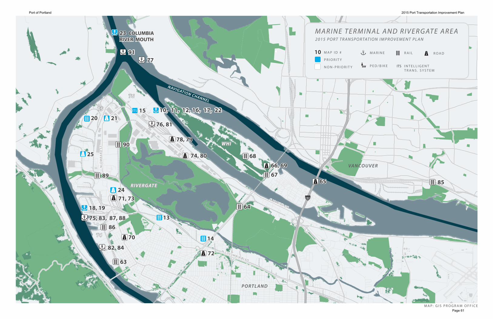
ITS
8585
1515
23 COLUMBIA RIVER MOUTH23 COLUMBIA RIVER MOUTH
91917777
2020
2525
76, 8176, 81
10, 11, 12, 16, 17, 2210, 11, 12, 16, 17, 222121
9090
8989
242471, 7371, 73
868675, 83, 87, 8875, 83, 87, 88
18, 1918, 19
82, 8482, 84
7070
6363
1313
1414
7272
6565
6868
676766, 6966, 69
6464
78, 7978, 79
74, 8074, 80
5
P O RT L A N D
R I V E R G AT ER I V E R G AT E
M A P : G I S P R O G R A M O F F I C E
VA N CO U V E R
W H IW H I
T 6T 6
T 5T 5
T 4T 4
NAVIGATION CHANNEL
N M A R I N E D R
N M A R I N E D R
NLO
MB
AR
D S
TN
LOM
BA
RD
ST
N CO LU M B I A B LV D
N CO LU M B I A B LV D
P R I O R I T Y
N O N - P R I O R I T Y
M A P I D #1010
ITS
R A I LM A R I N E
P E D / B I K E I N T E L L I G E N TT R A N S . S Y S T E M
M A R I N E T E R M I N A L A N D R I V E R G AT E A R E A2 0 1 5 P O R T T R A N S P O R TAT I O N I M P R O V E M E N T P L A N
R O A D
Port of Portland 2015 Port Transportation Improvement Plan
Page 61

63
Address rail switching noise by improving multiple public
rail crossings in the St. Johns Cathedral Park area.
To allow auto import operations to continue to grow in N.
Portland and improve neighborhood livability.
$8,200,000
$8,200,000
10375
Cathedral Park Whistle Free Zone Strategic Options,
Parametrix (2007)
Map ID:
Project Description:
Purpose:
Total Cost:
Estimate Rating:
Federal:
State:
City:
SDC:
Port Share
Committed:
Port Share
Forecasted:
Private:
Other:
Unfunded:
810051JDE NUM:
Conditioned Project
Identified in STIPRTP 2040 Constrained
RTP 2040 Illustrative
RTP Related:
Recent Study:
5Time Frame (Years): years
Project Type: Rail
Operation Area Rivergate
Cathedral Park Quiet ZoneProject Name:
2007
Year of Cost
Estimate:
Port Strategic Area: Retain and Grow Key Services
64
Upgrade railroad with revised crossovers, centralized
traffic control tie-in and increased turning radius.
Accommodate higher rail speeds at the junction which
provides greater capacity.
$9,160,000
$9,160,000
I-5 Rail Capacity Study (HDR, 2003)
Map ID:
Project Description:
Purpose:
Total Cost:
Estimate Rating:
Federal:
State:
City:
SDC:
Port Share
Committed:
Port Share
Forecasted:
Private:
Other:
Unfunded:
JDE NUM:
Conditioned Project
Identified in STIPRTP 2040 Constrained
RTP 2040 Illustrative
RTP Related:
Recent Study:
10Time Frame (Years): years
Project Type: Rail
Operation Area Rivergate
North Portland JunctionProject Name:
2003
Year of Cost
Estimate:
Port Strategic Area: Regional Leadership in Transportation
Port of Portland 2015 Port Transportation Improvement Plan
Page 62
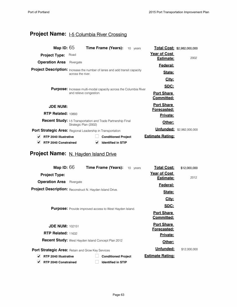
65
Increase the number of lanes and add transit capacity
across the river.
Increase multi-modal capacity across the Columbia River
and relieve congestion.
$2,982,000,000
$2,982,000,000
10893
I-5 Transportation and Trade Partnership Final
Strategic Plan (2002)
Map ID:
Project Description:
Purpose:
Total Cost:
Estimate Rating:
Federal:
State:
City:
SDC:
Port Share
Committed:
Port Share
Forecasted:
Private:
Other:
Unfunded:
JDE NUM:
Conditioned Project
Identified in STIPRTP 2040 Constrained
RTP 2040 Illustrative
RTP Related:
Recent Study:
10Time Frame (Years): years
Project Type: Road
Operation Area Rivergate
I-5 Columbia River CrossingProject Name:
2002
Year of Cost
Estimate:
Port Strategic Area: Regional Leadership in Transportation
66
Reconstruct N. Hayden Island Drive.
Provide improved access to West Hayden Island.
$12,000,000
$12,000,000
11632
West Hayden Island Concept Plan 2012
Map ID:
Project Description:
Purpose:
Total Cost:
Estimate Rating:
Federal:
State:
City:
SDC:
Port Share
Committed:
Port Share
Forecasted:
Private:
Other:
Unfunded:
102151JDE NUM:
Conditioned Project
Identified in STIPRTP 2040 Constrained
RTP 2040 Illustrative
RTP Related:
Recent Study:
10Time Frame (Years): years
Project Type:
Operation Area Rivergate
N. Hayden Island DriveProject Name:
2012
Year of Cost
Estimate:
Port Strategic Area: Retain and Grow Key Services
Port of Portland 2015 Port Transportation Improvement Plan
Page 63

67
Rail access to support West Hayden Island development.
Advance rail-dependent development.
$3,000,000
$3,000,000
11353
West Hayden Island Concept Plan 2012
Map ID:
Project Description:
Purpose:
Total Cost:
Estimate Rating:
Federal:
State:
City:
SDC:
Port Share
Committed:
Port Share
Forecasted:
Private:
Other:
Unfunded:
100348JDE NUM:
Conditioned Project
Identified in STIPRTP 2040 Constrained
RTP 2040 Illustrative
RTP Related:
Recent Study:
20Time Frame (Years): years
Project Type: Rail
Operation Area Rivergate
West Hayden Island Rail AccessProject Name:
Year of Cost
Estimate:
Port Strategic Area: Retain and Grow Key Services
68
Seven track rail yard connected to facility trackage.
Advance rail development on West Hayden Island.
$9,500,000
$9,500,000
11354
West Hayden Island Concept Plan 2012
Map ID:
Project Description:
Purpose:
Total Cost:
Estimate Rating:
Federal:
State:
City:
SDC:
Port Share
Committed:
Port Share
Forecasted:
Private:
Other:
Unfunded:
100348JDE NUM:
Conditioned Project
Identified in STIPRTP 2040 Constrained
RTP 2040 Illustrative
RTP Related:
Recent Study:
20Time Frame (Years): years
Project Type: Rail
Operation Area Rivergate
West Hayden Island Rail YardProject Name:
Year of Cost
Estimate:
Port Strategic Area: Retain and Grow Key Services
Port of Portland 2015 Port Transportation Improvement Plan
Page 64
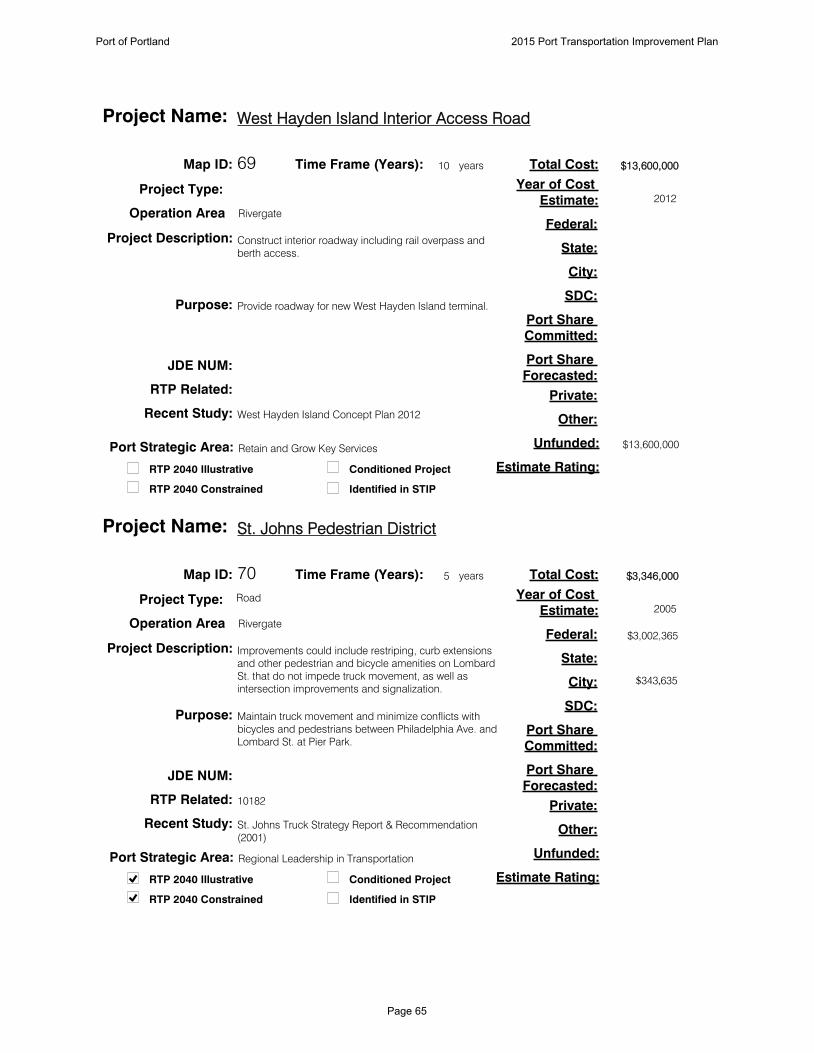
69
Construct interior roadway including rail overpass and
berth access.
Provide roadway for new West Hayden Island terminal.
$13,600,000
$13,600,000
West Hayden Island Concept Plan 2012
Map ID:
Project Description:
Purpose:
Total Cost:
Estimate Rating:
Federal:
State:
City:
SDC:
Port Share
Committed:
Port Share
Forecasted:
Private:
Other:
Unfunded:
JDE NUM:
Conditioned Project
Identified in STIPRTP 2040 Constrained
RTP 2040 Illustrative
RTP Related:
Recent Study:
10Time Frame (Years): years
Project Type:
Operation Area Rivergate
West Hayden Island Interior Access RoadProject Name:
2012
Year of Cost
Estimate:
Port Strategic Area: Retain and Grow Key Services
70
Improvements could include restriping, curb extensions
and other pedestrian and bicycle amenities on Lombard
St. that do not impede truck movement, as well as
intersection improvements and signalization.
Maintain truck movement and minimize conflicts with
bicycles and pedestrians between Philadelphia Ave. and
Lombard St. at Pier Park.
$3,346,000
$3,002,365
$343,635
10182
St. Johns Truck Strategy Report & Recommendation
(2001)
Map ID:
Project Description:
Purpose:
Total Cost:
Estimate Rating:
Federal:
State:
City:
SDC:
Port Share
Committed:
Port Share
Forecasted:
Private:
Other:
Unfunded:
JDE NUM:
Conditioned Project
Identified in STIPRTP 2040 Constrained
RTP 2040 Illustrative
RTP Related:
Recent Study:
5Time Frame (Years): years
Project Type: Road
Operation Area Rivergate
St. Johns Pedestrian DistrictProject Name:
2005
Year of Cost
Estimate:
Port Strategic Area: Regional Leadership in Transportation
Port of Portland 2015 Port Transportation Improvement Plan
Page 65
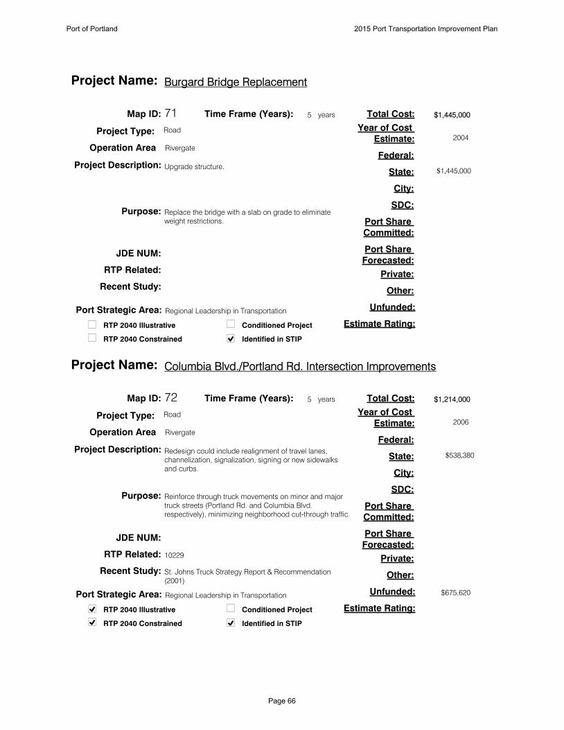
71
Upgrade structure.
Replace the bridge with a slab on grade to eliminate
weight restrictions.
$1,445,000
$1,445,000
Map ID:
Project Description:
Purpose:
Total Cost:
Estimate Rating:
Federal:
State:
City:
SDC:
Port Share
Committed:
Port Share
Forecasted:
Private:
Other:
Unfunded:
JDE NUM:
Conditioned Project
Identified in STIPRTP 2040 Constrained
RTP 2040 Illustrative
RTP Related:
Recent Study:
5Time Frame (Years): years
Project Type: Road
Operation Area Rivergate
Burgard Bridge ReplacementProject Name:
2004
Year of Cost
Estimate:
Port Strategic Area: Regional Leadership in Transportation
72
Redesign could include realignment of travel lanes,
channelization, signalization, signing or new sidewalks
and curbs.
Reinforce through truck movements on minor and major
truck streets (Portland Rd. and Columbia Blvd.
respectively), minimizing neighborhood cut-through traffic.
$1,214,000
$538,380
$675,620
10229
St. Johns Truck Strategy Report & Recommendation
(2001)
Map ID:
Project Description:
Purpose:
Total Cost:
Estimate Rating:
Federal:
State:
City:
SDC:
Port Share
Committed:
Port Share
Forecasted:
Private:
Other:
Unfunded:
JDE NUM:
Conditioned Project
Identified in STIPRTP 2040 Constrained
RTP 2040 Illustrative
RTP Related:
Recent Study:
5Time Frame (Years): years
Project Type: Road
Operation Area Rivergate
Columbia Blvd./Portland Rd. Intersection ImprovementsProject Name:
2006
Year of Cost
Estimate:
Port Strategic Area: Regional Leadership in Transportation
Port of Portland 2015 Port Transportation Improvement Plan
Page 66

73
Widen Burgard to 3 Lanes with bike lanes and sidewalks
from UPRR bridge to Columbia.
Improve freight mobility, safety and industrial site access.
$14,588,000
$14,588,000
10214
Map ID:
Project Description:
Purpose:
Total Cost:
Estimate Rating:
Federal:
State:
City:
SDC:
Port Share
Committed:
Port Share
Forecasted:
Private:
Other:
Unfunded:
JDE NUM:
Conditioned Project
Identified in STIPRTP 2040 Constrained
RTP 2040 Illustrative
RTP Related:
Recent Study:
5Time Frame (Years): years
Project Type: Road
Operation Area Rivergate
North Burgard/Lombard Street ImprovementsProject Name:
2009
Year of Cost
Estimate:
Port Strategic Area: Regional Leadership in Transportation
74
Construct rail overcrossing on Marine Dr.
Avoid road/rail conflict.
$13,644,200
3c
$13,644,200
10379
Map ID:
Project Description:
Purpose:
Total Cost:
Estimate Rating:
Federal:
State:
City:
SDC:
Port Share
Committed:
Port Share
Forecasted:
Private:
Other:
Unfunded:
JDE NUM:
Conditioned Project
Identified in STIPRTP 2040 Constrained
RTP 2040 Illustrative
RTP Related:
Recent Study:
20Time Frame (Years): years
Project Type: Road
Operation Area Rivergate
Marine Dr. Improvement Phase 2Project Name:
2003
Year of Cost
Estimate:
Port Strategic Area: Regional Leadership in Transportation
Port of Portland 2015 Port Transportation Improvement Plan
Page 67

75
Deepen the portions of the Willamette River with deep draft
infrastructure to -43' where appropriate.
To allow Willamette River terminals to also benefit from the
Columbia River's new controlling depth.
$200,000,000
$200,000,000
Map ID:
Project Description:
Purpose:
Total Cost:
Estimate Rating:
Federal:
State:
City:
SDC:
Port Share
Committed:
Port Share
Forecasted:
Private:
Other:
Unfunded:
JDE NUM:
Conditioned Project
Identified in STIPRTP 2040 Constrained
RTP 2040 Illustrative
RTP Related:
Recent Study:
10Time Frame (Years): years
Project Type: Marine
Operation Area Rivergate
Willamette River Channel DeepeningProject Name:
Year of Cost
Estimate:
Port Strategic Area: Regional Leadership in Transportation
76
Extend current rail yard in order to provide more capacity
for current tenants.
Capacity improvements for current tenants.
$1,000,000
3c
$1,000,000
Map ID:
Project Description:
Purpose:
Total Cost:
Estimate Rating:
Federal:
State:
City:
SDC:
Port Share
Committed:
Port Share
Forecasted:
Private:
Other:
Unfunded:
100323JDE NUM:
Conditioned Project
Identified in STIPRTP 2040 Constrained
RTP 2040 Illustrative
RTP Related:
Recent Study:
10Time Frame (Years): years
Project Type: Marine
Operation Area Rivergate
Terminal 6 Honda Rail ExtensionProject Name:
2009
Year of Cost
Estimate:
Port Strategic Area: Retain and Grow Key Services
Port of Portland 2015 Port Transportation Improvement Plan
Page 68

77
Placement of up to seven stern buoys at different
anchorages up and down the Columbia River.
Allow for the anchorage of ships in the river rather than at
terminals that could otherwise be loading/unloading cargo.
$2,342,000
3c
$1,728,500
$153,400
$460,100Feasibility Study
Map ID:
Project Description:
Purpose:
Total Cost:
Estimate Rating:
Federal:
State:
City:
SDC:
Port Share
Committed:
Port Share
Forecasted:
Private:
Other:
Unfunded:
JDE NUM:
Conditioned Project
Identified in STIPRTP 2040 Constrained
RTP 2040 Illustrative
RTP Related:
Recent Study:
5Time Frame (Years): years
Project Type: Marine
Operation Area Rivergate
Columbia River Anchorage ImprovementsProject Name:
2009
Year of Cost
Estimate:
Port Strategic Area: Regional Leadership in Transportation
78
Construct a rail overcrossing at Terminal 6.
Increase efficient movement for rail and Terminal 6 tenants.
$3,649,084
2b
$3,649,084
10378
Marine Terminal Master Plan 2020 (2003)
Map ID:
Project Description:
Purpose:
Total Cost:
Estimate Rating:
Federal:
State:
City:
SDC:
Port Share
Committed:
Port Share
Forecasted:
Private:
Other:
Unfunded:
100324JDE NUM:
Conditioned Project
Identified in STIPRTP 2040 Constrained
RTP 2040 Illustrative
RTP Related:
Recent Study:
5Time Frame (Years): years
Project Type: Road
Operation Area Rivergate
Terminal 6 Internal OvercrossingProject Name:
2006
Year of Cost
Estimate:
Port Strategic Area: Retain and Grow Key Services
Port of Portland 2015 Port Transportation Improvement Plan
Page 69

79
Construct second entrance and rail overcrossing.
Improve capacity and safety at T6.
$12,000,000
3c
$12,000,000
11306
Terminal 6 Access Improvement Alternatives (2008)
Map ID:
Project Description:
Purpose:
Total Cost:
Estimate Rating:
Federal:
State:
City:
SDC:
Port Share
Committed:
Port Share
Forecasted:
Private:
Other:
Unfunded:
102056JDE NUM:
Conditioned Project
Identified in STIPRTP 2040 Constrained
RTP 2040 Illustrative
RTP Related:
Recent Study:
20Time Frame (Years): years
Project Type: Road
Operation Area Rivergate
T6 Second EntranceProject Name:
2008
Year of Cost
Estimate:
Port Strategic Area: Retain and Grow Key Services
80
Construct access road from terminus of Suttle Road.
To support development of east end of T6.
$3,000,000
3c
$3,000,000
11307
Suttle Road Improvement Options (2008)
Map ID:
Project Description:
Purpose:
Total Cost:
Estimate Rating:
Federal:
State:
City:
SDC:
Port Share
Committed:
Port Share
Forecasted:
Private:
Other:
Unfunded:
JDE NUM:
Conditioned Project
Identified in STIPRTP 2040 Constrained
RTP 2040 Illustrative
RTP Related:
Recent Study:
20Time Frame (Years): years
Project Type: Road
Operation Area Rivergate
T6 Suttle Road EntranceProject Name:
2008
Year of Cost
Estimate:
Port Strategic Area: Retain and Grow Key Services
Port of Portland 2015 Port Transportation Improvement Plan
Page 70
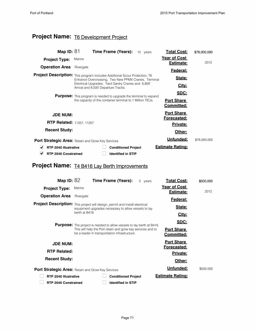
81
This program includes Additional Scour Protection, T6
Entrance Overcrossing, Two New PPMX Cranes, Terminal
Electrical Upgrades, Yard Gantry Cranes and 6,800’
Arrival and 8,500' Departure Tracks.
This program is needed to upgrade the terminal to expand
the capacity of the container terminal to 1 Million TEUs.
$76,000,000
$76,000,000
11357, 11207
Map ID:
Project Description:
Purpose:
Total Cost:
Estimate Rating:
Federal:
State:
City:
SDC:
Port Share
Committed:
Port Share
Forecasted:
Private:
Other:
Unfunded:
JDE NUM:
Conditioned Project
Identified in STIPRTP 2040 Constrained
RTP 2040 Illustrative
RTP Related:
Recent Study:
10Time Frame (Years): years
Project Type: Marine
Operation Area Rivergate
T6 Development ProjectProject Name:
2012
Year of Cost
Estimate:
Port Strategic Area: Retain and Grow Key Services
82
This project will design, permit and install electrical
equipment upgrades necessary to allow vessels to lay
berth at B416
The project is needed to allow vessels to lay berth at B416.
This will help the Port retain and grow key services and to
be a leader in transportation infrastructure.
$500,000
$500,000
Map ID:
Project Description:
Purpose:
Total Cost:
Estimate Rating:
Federal:
State:
City:
SDC:
Port Share
Committed:
Port Share
Forecasted:
Private:
Other:
Unfunded:
JDE NUM:
Conditioned Project
Identified in STIPRTP 2040 Constrained
RTP 2040 Illustrative
RTP Related:
Recent Study:
5Time Frame (Years): years
Project Type: Marine
Operation Area Rivergate
T4 B416 Lay Berth ImprovementsProject Name:
2012
Year of Cost
Estimate:
Port Strategic Area: Retain and Grow Key Services
Port of Portland 2015 Port Transportation Improvement Plan
Page 71

83
Install stormwater improvements including control
equipment such as dust filtering equipment for the
warehouses and/or various types of stormwater filtering or
treatment mechanisms.
Implement capital projects identified during stormwater
master planning process. The improvements will be
needed in order to comply with new environmental permits
and water quality regulations.
$4,100,000
$4,100,000
Map ID:
Project Description:
Purpose:
Total Cost:
Estimate Rating:
Federal:
State:
City:
SDC:
Port Share
Committed:
Port Share
Forecasted:
Private:
Other:
Unfunded:
101668JDE NUM:
Conditioned Project
Identified in STIPRTP 2040 Constrained
RTP 2040 Illustrative
RTP Related:
Recent Study:
5Time Frame (Years): years
Project Type: Marine
Operation Area Rivergate
T4 Stormwater ImprovementsProject Name:
2012
Year of Cost
Estimate:
Port Strategic Area: Portwide Environmental Strategy
84
Design and construct six acres of porous pavement
parking for the storage of imported automobiles.
The project will provide additional land to meet auto
storage capacity needs of Toyota, supporting the Port's
automobile import business line.
$3,000,000
$3,000,000
Map ID:
Project Description:
Purpose:
Total Cost:
Estimate Rating:
Federal:
State:
City:
SDC:
Port Share
Committed:
Port Share
Forecasted:
Private:
Other:
Unfunded:
100769JDE NUM:
Conditioned Project
Identified in STIPRTP 2040 Constrained
RTP 2040 Illustrative
RTP Related:
Recent Study:
10Time Frame (Years): years
Project Type: Marine
Operation Area Rivergate
Terminal 4 Automobile Yard ExpansionProject Name:
Year of Cost
Estimate:
Port Strategic Area: Regional Leadership in Industrial Lands
Port of Portland 2015 Port Transportation Improvement Plan
Page 72

85
Double Track Fallbridge line to Washougal.
Increases capacity of the BNSF east-west mainline serving
Port of Portland.
$72,000,000
$72,000,000
Port Rail Plan
Map ID:
Project Description:
Purpose:
Total Cost:
Estimate Rating:
Federal:
State:
City:
SDC:
Port Share
Committed:
Port Share
Forecasted:
Private:
Other:
Unfunded:
JDE NUM:
Conditioned Project
Identified in STIPRTP 2040 Constrained
RTP 2040 Illustrative
RTP Related:
Recent Study:
10Time Frame (Years): years
Project Type: Rail
Operation Area Rivergate
BNSF Fallbridge Double TrackingProject Name:
Year of Cost
Estimate:
Port Strategic Area: Regional Leadership in Transportation
86
Demolish the Terminal 4 grain elevator.
Demolition of the elevator will facilitate the redevelopment
of approximately 30 acres of vital marine industrial
property in the Portland Harbor.
$8,000,000
3c
$8,000,000
11208
Terminal 4 Pier 1 Facility Plan (TEC Inc.)
Map ID:
Project Description:
Purpose:
Total Cost:
Estimate Rating:
Federal:
State:
City:
SDC:
Port Share
Committed:
Port Share
Forecasted:
Private:
Other:
Unfunded:
810049JDE NUM:
Conditioned Project
Identified in STIPRTP 2040 Constrained
RTP 2040 Illustrative
RTP Related:
Recent Study:
10Time Frame (Years): years
Project Type: Marine
Operation Area Rivergate
Terminal 4 Grain Elevator DemolitionProject Name:
2012
Year of Cost
Estimate:
Port Strategic Area: Regional Leadership in Industrial Lands
Port of Portland 2015 Port Transportation Improvement Plan
Page 73

87
Construct additional rail track in the Berth 410 and 411 Rail
Yard.
Improve the efficiency of the rail yard by creating
additional rail capacity.
$1,529,000
3c
$1,529,000
Map ID:
Project Description:
Purpose:
Total Cost:
Estimate Rating:
Federal:
State:
City:
SDC:
Port Share
Committed:
Port Share
Forecasted:
Private:
Other:
Unfunded:
102052JDE NUM:
Conditioned Project
Identified in STIPRTP 2040 Constrained
RTP 2040 Illustrative
RTP Related:
Recent Study:
5Time Frame (Years): years
Project Type: Rail
Operation Area Rivergate
T4 Berth 410, 411 Rail Yard ImprovementsProject Name:
2012
Year of Cost
Estimate:
Port Strategic Area: Retain and Grow Key Services
88
Demolish Berth 405 and Berth 408.
Remove obsolete berth structures.
$18,747,222
$18,747,222
Map ID:
Project Description:
Purpose:
Total Cost:
Estimate Rating:
Federal:
State:
City:
SDC:
Port Share
Committed:
Port Share
Forecasted:
Private:
Other:
Unfunded:
810048JDE NUM:
Conditioned Project
Identified in STIPRTP 2040 Constrained
RTP 2040 Illustrative
RTP Related:
Recent Study:
5Time Frame (Years): years
Project Type: Marine
Operation Area Rivergate
T4 Berth 405 and 408 DemolitionProject Name:
2013
Year of Cost
Estimate:
Port Strategic Area: Retain and Grow Key Services
Port of Portland 2015 Port Transportation Improvement Plan
Page 74

89
Construct two interior yard tracks and complete the double
track lead from the wye at the east end of the yard to
Barnes Yard.
Add rail staging capacity for South Rivergate.
$3,600,000
3c
$3,600,000
11652
Port Rail Plan
Map ID:
Project Description:
Purpose:
Total Cost:
Estimate Rating:
Federal:
State:
City:
SDC:
Port Share
Committed:
Port Share
Forecasted:
Private:
Other:
Unfunded:
JDE NUM:
Conditioned Project
Identified in STIPRTP 2040 Constrained
RTP 2040 Illustrative
RTP Related:
Recent Study:
10Time Frame (Years): years
Project Type: Rail
Operation Area Rivergate
Bonneville Rail Yard Build OutProject Name:
2013
Year of Cost
Estimate:
Port Strategic Area: Regional Leadership in Transportation
90
Connect existing set out track with industrial lead.
Improve unit train staging capabilities at Ramsey Rail Yard.
$1,700,000
3c
$1,700,000
11653
Port Rail Plan
Map ID:
Project Description:
Purpose:
Total Cost:
Estimate Rating:
Federal:
State:
City:
SDC:
Port Share
Committed:
Port Share
Forecasted:
Private:
Other:
Unfunded:
JDE NUM:
Conditioned Project
Identified in STIPRTP 2040 Constrained
RTP 2040 Illustrative
RTP Related:
Recent Study:
10Time Frame (Years): years
Project Type: Rail
Operation Area Rivergate
Ramsey Yard UtilizationProject Name:
2013
Year of Cost
Estimate:
Port Strategic Area: Regional Leadership in Transportation
Port of Portland 2015 Port Transportation Improvement Plan
Page 75

91
Underkeel clearance study for ships moving between the
Columbia Bar and Portland.
Understand vessel underclearance in Columbia River to
optimize safety and payload.
$1,319,000
$949,608
$65,000
$304,392
Map ID:
Project Description:
Purpose:
Total Cost:
Estimate Rating:
Federal:
State:
City:
SDC:
Port Share
Committed:
Port Share
Forecasted:
Private:
Other:
Unfunded:
JDE NUM:
Conditioned Project
Identified in STIPRTP 2040 Constrained
RTP 2040 Illustrative
RTP Related:
Recent Study:
5Time Frame (Years): years
Project Type: Marine
Operation Area Rivergate
Columbia River Underkeel Clearance StudyProject Name:
2013
Year of Cost
Estimate:
Port Strategic Area: Regional Leadership in Transportation
Port of Portland 2015 Port Transportation Improvement Plan
Page 76
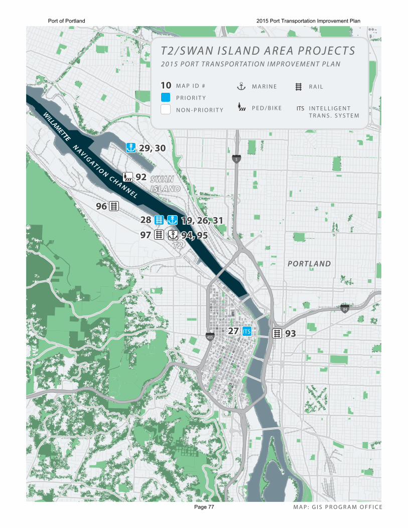
ITS 93932727
28289797
969619, 26, 3119, 26, 3194, 9594, 95
29, 3029, 30
9292
P R I O R I T Y
N O N - P R I O R I T Y
M A P I D #1010
ITS
R A I LM A R I N E
P E D / B I K E I N T E L L I G E N TT R A N S . S Y S T E M
5
84
405
P O RT L A N D
S WA NI S L A N DS WA NI S L A N D
T 2T 2
WILLAMETTE
N AV I G AT I O N C H A N N E L
T 2 / S WA N I S L A N D A R E A P R O J E C T S2 0 1 5 P O R T T R A N S P O R TAT I O N I M P R O V E M E N T P L A N
M A P : G I S P R O G R A M O F F I C E
Port of Portland 2015 Port Transportation Improvement Plan
Page 77

92
Pedestrian and bicycle trail from Kelly Point Park to the
Steel Bridge along the Willamette River. The money
associated for this project is for a study only.
Improve pedestrian and bicycle connectivity in North
Portland. Coordinate implementation with the City of
Portland.
$500,000
$500,000
10355
Map ID:
Project Description:
Purpose:
Total Cost:
Estimate Rating:
Federal:
State:
City:
SDC:
Port Share
Committed:
Port Share
Forecasted:
Private:
Other:
Unfunded:
JDE NUM:
Conditioned Project
Identified in STIPRTP 2040 Constrained
RTP 2040 Illustrative
RTP Related:
Recent Study:
20Time Frame (Years): years
Project Type: Bike/Ped
Operation Area T2/Swan Island
North Willamette Greenway TrailProject Name:
2007
Year of Cost
Estimate:
Port Strategic Area: Regional Leadership in Transportation
93
This project will create a new track connection between the
Graham Line, which runs parallel with I-84 through
Sullivan's Gulch and the Brooklyn Sub, UP's north-south
line through Portland.
This connection will allow UP rail traffic entering Portland
from the east to turn south onto the Brooklyn Sub from the
Graham Line. This project will eliminate delay and increase
system capacity.
$15,000,000
$15,000,000
I-5 Rail Capacity Study (HDR, 2003)
Map ID:
Project Description:
Purpose:
Total Cost:
Estimate Rating:
Federal:
State:
City:
SDC:
Port Share
Committed:
Port Share
Forecasted:
Private:
Other:
Unfunded:
JDE NUM:
Conditioned Project
Identified in STIPRTP 2040 Constrained
RTP 2040 Illustrative
RTP Related:
Recent Study:
5Time Frame (Years): years
Project Type: Rail
Operation Area T2/Swan Island
Graham Line ConnectionProject Name:
2006
Year of Cost
Estimate:
Port Strategic Area: Regional Leadership in Transportation
Port of Portland 2015 Port Transportation Improvement Plan
Page 78

94
Stormwater improvements.
Enhance marketability, service and environmental
performance for cargo opportunities at T-2.
$1,500,000
$1,500,000
Map ID:
Project Description:
Purpose:
Total Cost:
Estimate Rating:
Federal:
State:
City:
SDC:
Port Share
Committed:
Port Share
Forecasted:
Private:
Other:
Unfunded:
101667JDE NUM:
Conditioned Project
Identified in STIPRTP 2040 Constrained
RTP 2040 Illustrative
RTP Related:
Recent Study:
5Time Frame (Years): years
Project Type: Marine
Operation Area T2/Swan Island
Terminal 2 Stormwater ImprovementsProject Name:
2011
Year of Cost
Estimate:
Port Strategic Area: Retain and Grow Key Services
95
This project upgrades the existing warehouse buildings to
allow for the storage of bulk cargos such as pulp.
This project is needed to upgrade the existing terminal to
more efficiently handle bulk cargos.
$1,000,000
$1,000,000
Map ID:
Project Description:
Purpose:
Total Cost:
Estimate Rating:
Federal:
State:
City:
SDC:
Port Share
Committed:
Port Share
Forecasted:
Private:
Other:
Unfunded:
JDE NUM:
Conditioned Project
Identified in STIPRTP 2040 Constrained
RTP 2040 Illustrative
RTP Related:
Recent Study:
5Time Frame (Years): years
Project Type: Marine
Operation Area T2/Swan Island
T2 Storage Building Improvements Project Name:
2012
Year of Cost
Estimate:
Port Strategic Area: Retain and Grow Key Services
Port of Portland 2015 Port Transportation Improvement Plan
Page 79

96
Install Dispatcher Controlled Power Switches between
Lake Yard and Terminal 2.
Will reduce time it takes for trains to travel from Lake Yard
to Terminal 2, reducing blockage of mainline.
$10,805,000
3c
$10,805,000
Port Rail Plan
Map ID:
Project Description:
Purpose:
Total Cost:
Estimate Rating:
Federal:
State:
City:
SDC:
Port Share
Committed:
Port Share
Forecasted:
Private:
Other:
Unfunded:
JDE NUM:
Conditioned Project
Identified in STIPRTP 2040 Constrained
RTP 2040 Illustrative
RTP Related:
Recent Study:
5Time Frame (Years): years
Project Type: Rail
Operation Area T2/Swan Island
Portland Terminal Railroad Power SwitchesProject Name:
Year of Cost
Estimate:
Port Strategic Area: Regional Leadership in Transportation
97
Construct rail loop and support siding.
Increase rail capacity at Terminal 2.
$8,900,000
3c
$8,900,000
11651
Port Rail Plan
Map ID:
Project Description:
Purpose:
Total Cost:
Estimate Rating:
Federal:
State:
City:
SDC:
Port Share
Committed:
Port Share
Forecasted:
Private:
Other:
Unfunded:
JDE NUM:
Conditioned Project
Identified in STIPRTP 2040 Constrained
RTP 2040 Illustrative
RTP Related:
Recent Study:
10Time Frame (Years): years
Project Type: Rail
Operation Area T2/Swan Island
T2 Track Reconfiguration and SidingProject Name:
2013
Year of Cost
Estimate:
Port Strategic Area: Retain and Grow Key Services
Port of Portland 2015 Port Transportation Improvement Plan
Page 80

P R I O R I T Y
N O N - P R I O R I T Y
M A P I D #1010
P E D / B I K E
E A S T CO U N T Y P R O J E C T A R E A S2 0 1 5 P O R T T R A N S P O R TAT I O N I M P R O V E M E N T P L A N
R O A D AV I AT I O N
M A P : G I S P R O G R A M O F F I C E
100100
3636
104104
3838
9999
3939
34, 3534, 35
32, 3332, 33
3737
102102 101101
9898
103103
84
T R O U T DA L E
T R I PT R I P
G R E S H A M
FA I R V I E W V I L L AG EW O O D
T T DT T D
COLUMBIA RIVER NAVIGATION CHANNEL
N E H A L S E Y S TN E H A L S E Y S T
N E S A N DY B LV DN E S A N DY B LV D
SW 2
57TH
AV
ESW
257
TH A
VE
N E M A R I N E D R
N E M A R I N E D R
GV B PGV B P
Port of Portland 2015 Port Transportation Improvement Plan
Page 81

98
Sandy Blvd. widen to 4 lanes and center turn lane (181st-
202nd) with sidewalks and bike lanes.
Improve east west capacity and serve developing
industrial property.
$10,000,000
$10,000,000
10443
Map ID:
Project Description:
Purpose:
Total Cost:
Estimate Rating:
Federal:
State:
City:
SDC:
Port Share
Committed:
Port Share
Forecasted:
Private:
Other:
Unfunded:
JDE NUM:
Conditioned Project
Identified in STIPRTP 2040 Constrained
RTP 2040 Illustrative
RTP Related:
Recent Study:
10Time Frame (Years): years
Project Type: Road
Operation Area East County
Sandy Blvd. Widening to 4 lanesProject Name:
Year of Cost
Estimate:
Port Strategic Area: Regional Leadership in Transportation
99
Riverside Dr. Extension (Riverside Parkway to Portal Way).
Serve developing industrial parcels.
$10,975,110
$10,975,110
10515
Map ID:
Project Description:
Purpose:
Total Cost:
Estimate Rating:
Federal:
State:
City:
SDC:
Port Share
Committed:
Port Share
Forecasted:
Private:
Other:
Unfunded:
JDE NUM:
Conditioned Project
Identified in STIPRTP 2040 Constrained
RTP 2040 Illustrative
RTP Related:
Recent Study:
5Time Frame (Years): years
Project Type: Road
Operation Area East County
Riverside Drive ExtensionProject Name:
Year of Cost
Estimate:
Port Strategic Area: Regional Leadership in Transportation
Port of Portland 2015 Port Transportation Improvement Plan
Page 82

100
Sandy Blvd. widen to 3 lanes (207th to 238th), add
sidewalks and bike lanes.
Improve east west capacity and serve adjacent developing
industrial property.
$7,438,000
$7,438,000
10399
Map ID:
Project Description:
Purpose:
Total Cost:
Estimate Rating:
Federal:
State:
City:
SDC:
Port Share
Committed:
Port Share
Forecasted:
Private:
Other:
Unfunded:
JDE NUM:
Conditioned Project
Identified in STIPRTP 2040 Constrained
RTP 2040 Illustrative
RTP Related:
Recent Study:
10Time Frame (Years): years
Project Type: Road
Operation Area East County
Sandy Blvd. Widening to 3 lanesProject Name:
Year of Cost
Estimate:
Port Strategic Area: Regional Leadership in Transportation
101
Add right turn lanes on all approaches and second
northbound and southbound left turn lanes.
Address intersection capacity affecting access to
Gresham Vista Business Park.
$1,908,431
$1,908,431
10511
East Metro Connections Plan
Map ID:
Project Description:
Purpose:
Total Cost:
Estimate Rating:
Federal:
State:
City:
SDC:
Port Share
Committed:
Port Share
Forecasted:
Private:
Other:
Unfunded:
JDE NUM:
Conditioned Project
Identified in STIPRTP 2040 Constrained
RTP 2040 Illustrative
RTP Related:
Recent Study:
5Time Frame (Years): years
Project Type: Road
Operation Area East County
NE Hogan at NE Stark StreetProject Name:
2007
Year of Cost
Estimate:
Port Strategic Area: Regional Leadership in Transportation
Port of Portland 2015 Port Transportation Improvement Plan
Page 83

102
Add eastbound and northbound right turn lanes and
southbound left turn lanes.
Address intersection capacity affecting access to
Gresham Vista Business Park.
$1,196,756
$1,196,756
10473
East Metro Connections Plan
Map ID:
Project Description:
Purpose:
Total Cost:
Estimate Rating:
Federal:
State:
City:
SDC:
Port Share
Committed:
Port Share
Forecasted:
Private:
Other:
Unfunded:
JDE NUM:
Conditioned Project
Identified in STIPRTP 2040 Constrained
RTP 2040 Illustrative
RTP Related:
Recent Study:
5Time Frame (Years): years
Project Type: Road
Operation Area East County
NE 223rd at StarkProject Name:
2007
Year of Cost
Estimate:
Port Strategic Area: Regional Leadership in Transportation
103
Construct improvements for freight by modifying road
curvature. Also adds improvements for bikes and
pedestrians.
Will improve freight access to Gresham Vista Business
Park.
$9,769,340
$9,769,340
East Metro Connections Plan
Map ID:
Project Description:
Purpose:
Total Cost:
Estimate Rating:
Federal:
State:
City:
SDC:
Port Share
Committed:
Port Share
Forecasted:
Private:
Other:
Unfunded:
JDE NUM:
Conditioned Project
Identified in STIPRTP 2040 Constrained
RTP 2040 Illustrative
RTP Related:
Recent Study:
5Time Frame (Years): years
Project Type: Road
Operation Area East County
NE 238th Drive: Halsey to GlisanProject Name:
2012
Year of Cost
Estimate:
Port Strategic Area: Regional Leadership in Transportation
Port of Portland 2015 Port Transportation Improvement Plan
Page 84

104
Widen to three lanes between Halsey St and Marine Drive.
Upgrade the facility to major collector urban street
standards.
$3,667,000
N/A
$3,667,000
10388, 10389
Map ID:
Project Description:
Purpose:
Total Cost:
Estimate Rating:
Federal:
State:
City:
SDC:
Port Share
Committed:
Port Share
Forecasted:
Private:
Other:
Unfunded:
JDE NUM:
Conditioned Project
Identified in STIPRTP 2040 Constrained
RTP 2040 Illustrative
RTP Related:
Recent Study:
5Time Frame (Years): years
Project Type: Road
Operation Area East County
223rd Avenue WideningProject Name:
Year of Cost
Estimate:
Port Strategic Area: Regional Leadership in Transportation
Port of Portland 2015 Port Transportation Improvement Plan
Page 85