2015 old settlers gazette - page 30oldstagecoachstop.org/webgeezer/gazette15/pages 30-43...
TRANSCRIPT
Many of us who grew up in Pulas-ki and adjoining counties count cave explorations as part of the experience. The abundance of caves in the north-ern Ozarks brought this year’s annual gathering of the National Speleological Society to Waynesville. In this feature, John Bradbury, Assistant Director of the State Historical Society of Missouri Research Center-Rolla, explores our cavernous heritage.
Introduction
A popular fascination with caves flourished in the Ozarks in the late nineteenth and early twentieth cen-turies, when residents and visitors alike shared in the preoccupation with natural openings in the earth. It led them for many reasons to gather at caves, take up torches and explore the sometimes wet and muddy confines of what might otherwise be just holes in the ground. In this area, the phenom-enon was greatest following the Civil War through 1904, when specimens of Phelps and Pulaski County cave forma-tions were part of the Missouri min-erals exhibit at the World’s Fair in St. Louis. By then, many of the caves in the area, all private properties, had become virtual public venues open to visitors. As late as the 1930s, the tourist maps of Phelps and Pulaski counties published by the Federal Emergency Relief Ad-ministration marked a score of caves as “scenes of outstanding interest.” This area is a good locale for a person interested in caves. Along with springs and sinkholes (collapsed caverns),
caves are characteristic of a landscape type known as karst topography. Much of the Ozarks is karst in nature. It is not necessary to delve into the geological processes that created the distinctive terrain except to say that its features are the product of irregu-lar uplift of limestone (the variety in this area is called dolomite), fracture along joints and bedding planes and eons of shaping by water. In this part of the northern Ozarks, the bluffs of the upper Meramec and Gasconade rivers and their principal tributaries are dotted with caverns great and small. Some run for miles through passages of various size that frequently contain stalactites, stalagmites, flowstone, and other cave formations known variously as columns, draperies, curtains, corals, pearls, and straws. They are the product of acidic ground water having dissolved limestone and re-deposited minerals in solution elsewhere, resulting in a fine-grained, translucent stone of variegated color called onyx. The subterranean forms are some-times spectacular sights that have led to the development of many caverns in the Ozarks as commercial attractions. The first in our area may have been the cav-ern at Cave Lodge on the Gasconade, featured in the resort’s advertising and accessible to guests via a long stairway descending from the lodge to the river. During the early automobile age, Pike’s Peak Cave (earlier Kraft Cave) on the Roubidoux was a commercial attrac-tion not for its formations, but for two chambers featuring a dance hall and
“Musicians Balcony.” Growth of auto-mobile tourism following World War Two, led to commercial development of Maxey Cave near Laquey and Onyx Cave at Boiling Spring. They were of a type known as “show” caves, to which visitors paid a fee to be guided through the wonders underground. In common with other show caves, the Pulaski County caves acquired new names (Maxey became Inca and Onyx became Onyx Mountain) along with electric lighting, pathways and associated gift shops. A unique additional attraction at Inca was E. D. Tarbell’s planetarium. Both are closed now, but two fine exam-ples of show caves along the Meramec River—Onondaga Cave and Meramec Caverns—may be visited today. Phelps and Pulaski counties have an abundance of caves, notably along the Gasconade River and its tributaries. As of 2014, the Missouri Geological Survey had on record 359 caves in Pulaski and another 155 caves in Phelps, making this one of the most cavernous areas of the state. Most are small or obscure enough to be known only by local resi-dents and cave specialists, but a few be-came local destinations in the late nine-teenth and early twentieth centuries. Combinations of scenic beauty above and below ground, relatively large and dry entrances, central location, easy access, and resources to be exploited made some caves more attractive than others. Among those meeting some or all of those requirements were Friede’s Cave (now known as Saltpeter Cave) and Tick Creek Cave, northwest of Rol-la. Both are along Tick Creek (formerly Cave Spring Creek), a tributary of the Gasconade. Poole Hollow Cave near Newburg and Gourd Creek Cave near Vida also had an appeal. Both are locat-ed in the valley of Little Piney Creek, also a Gasconade tributary. In Pulaski County, Miller Cave on the Big Piney River was an important spot for thousands of years in prehis-tory. It has generated antiquarian and archaeological interest ever since. Onyx Cave on the Gasconade, known earlier as Boiling Spring and Schultz Cave, also had a long period of prehistoric use, and in modern times, may have been frequented more than any other Pulaski County cavern. It has one of the largest entrances of any Gasconade River caverns and in historic times has had social, recreational, educational,
and industrial usages. Easily reached after 1870 by railroad to Arlington and five-mile wagon ride to the cave, it was a frequent destination for student geologists and miners from the Mis-souri School of Mines (MSM), picnic groups and day-trippers from Rolla and Newburg. During the early twentieth century heyday of the Gasconade River resorts at Arlington and Jerome, guests boated upriver to Boiling Springs or rode overland on horseback to explore the cave. In recent times many others visited it as Onyx Mountain Caverns, a commercial attraction operated by Har-ry Thiltgen and his family in the 1990s.The last and best preserved of Pulaski County’s show caves, Onyx Cave is list-ed on the National Register of Historic Places. Most of the larger, drier caves show evidence of extensive prehistoric occu-pation. After nearly a century of archae-ological investigation, in many cases we know more about the human use of caves thousands of years ago than we do about the past couple of hundred. Yet in modern times, some of these caves have attracted visitors enough to leave a documentary record of sorts. The cultural and social history of a few caves can be glimpsed in the accounts of soldiers, newspaper editors, country correspondents and St. Louis reporters, and early archaeologists.
2015 Old Settlers Gazette - Page 30
“Musicians Balcony.” Growth of automobile tourism following World War Two, led to commercial development of Maxey Cave near Laquey and Onyx Cave at Boiling Spring. They were of a type known as “show” caves, to which visitors paid a fee to be guided through the wonders underground. In common with other show caves, the Pulaski County caves acquired new names
Onyx Mountain) along with electric lighting, pathways and associated gift shops. A unique additional attraction at Inca was E. D. Tarbell’s planetarium. Both are closed now, but two fine examples of show caves along the Meramec
Cave PicnicsThere is “oodles” of fun to be had at private pic-nics, especially when the pic-nic is held in a cave. All you have to do is lug three baskets of provi-sions, four torches, a box of candles, an old pair of shoes and a water-proof down two flights of hills, water and feed your horses, make a fool of your-self generally, make lemonade and a fire for coffee, prepare for dinner, eat enough to do you for a month, take your best girl all through the cave at the expense of your best “panties,” burn your fingers with the torches, get a bug down your back, carry up three pails of water, eat a little supper, hitch up your horses, carry the same baskets with your girl hanging on to your coat-tails up the same flight of hills, make an occasional dive for a tick bite, and strike out for home. Oh, there’s loads of fun in it, ain’t there boys?—Rolla Herald, July10, 1879
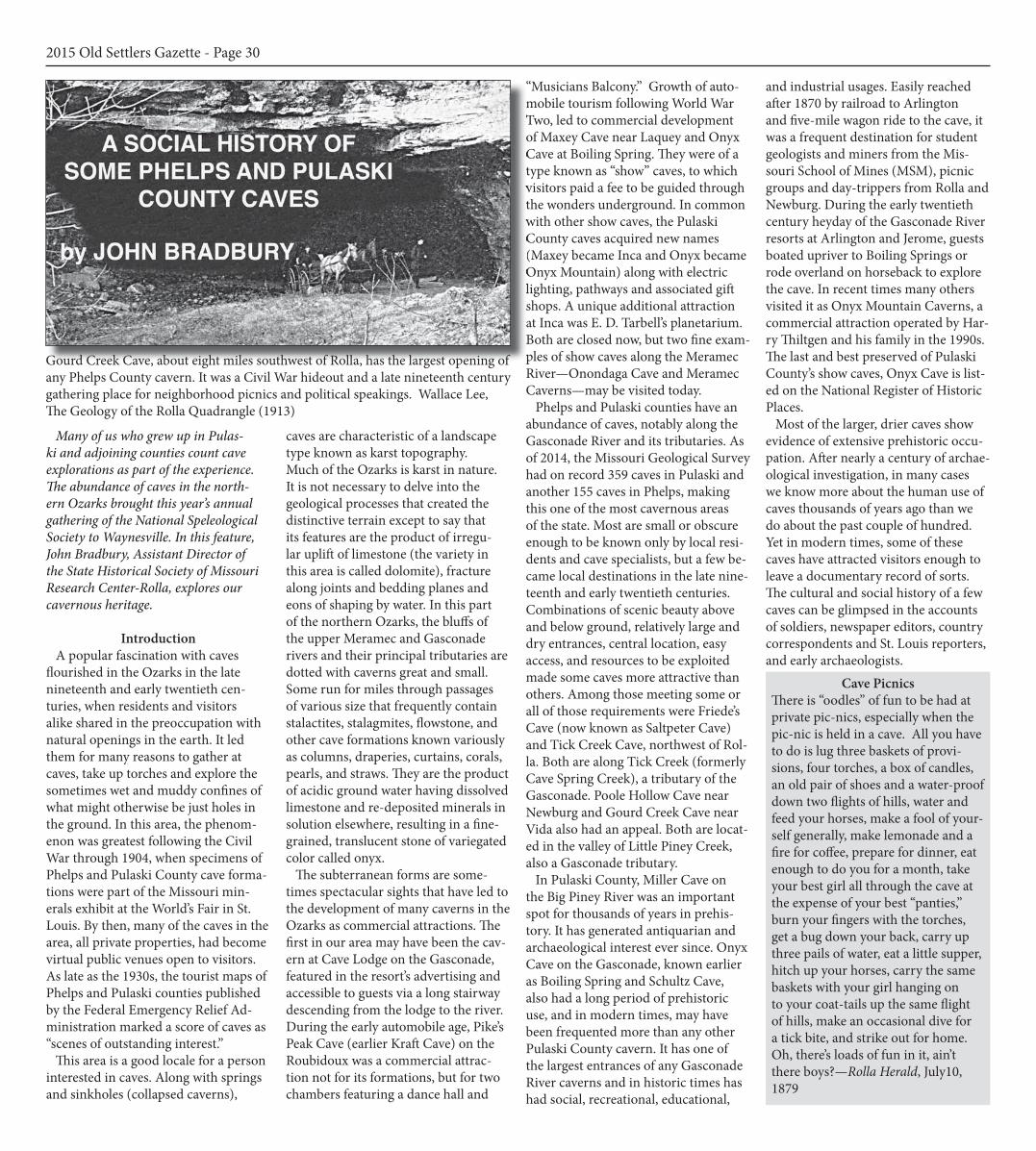
Gourd Creek Cave, about eight miles southwest of Rolla, has the largest opening of any Phelps County cavern. It was a Civil War hideout and a late nineteenth century gathering place for neighborhood picnics and political speakings. Wallace Lee, The Geology of the Rolla Quadrangle (1913)

The largest caverns (in terms of the entrances) likely were known to trappers, hunters and mineral pros-pectors before Missouri became United States territory in 1804. One item of interest would have been the presence of nitre (potassium nitrate) in cave earth. A critical component of gunpowder, nitre was more often called saltpeter (spelled “saltpetre” in older usages). It was present in cave earth in the form of bat manure, known locally as guano, although the term correct-ly applies only to the manure of seabirds. Saltpeter was extracted by leaching guano-impregnated cave soil with water; evaporating the liquid produced crystals of nitre. Saltpeter was a valuable com-modity on the frontier and was being produced at caves along the Gasconade River before the War of 1812. Daniel Boone led a party of nitre miners to the Gasconade about 1810 to dig at what was described as the first large cave below the mouth of the Big Piney—a description that fits Onyx Cave. Another party connected with the Boone crowd brought a critical batch of Gasconade saltpeter by raft and pack horses to the settlement at St. Charles when it was under threat of attack during the war. South of Phelps County, Col. William H. Ashley and his men produced saltpeter in Texas County at Ashley Cave near pres-ent-day Montauk, 1812-1814. Good-speed’s 1889 history of Pulaski County notes early Gasconade settlers Johnson, Dulle and Cullen and their families engaged in gunpowder manufacture in 1816, probably a reference to occa-sional production of saltpeter as part of making a living on the frontier. There is no specific record of saltpeter being produced in Phelps County during this period, but it seems likely that hunters and frontiersmen would have known about the possibilities of Phelps Coun-ty caves. The lumbermen who sawed the first trees along the Pineys in 1816 had keen eyes for exploitable natu-ral resources too, so it would not be surprising if nitre from Phelps County caves occasionally floated on lumber rafts to the downstream settlements. By the 1820s, store-bought gunpowder was readily available via St. Louis merchants and digging for nitre ceased. Today, the caverns in Phelps and Pulaski counties
named “Saltpeter’ reflect the use of cave earth as agricultural fertilizer rather than in gunpowder. Some of the earliest records of cave explorations in this region’s historic period occur in letters and diaries from the Civil War. Several groups of soldiers from the 36th Illinois Infantry (“Fox River Regiment”) visited an unnamed cave a few miles from Rolla. The de-scription is nonspecific enough to make identification tenuous, but wherever it was, Private Wallace P. Benson de-scribed it in a diary entry November 16, 1861 as: “one of the most splendid scenes I ever saw.” Indeed, Illinois soldiers saw wonders the likes of which they had never seen in the Prairie State. The “Special Correspondent” of the Woodstock, Illinois Sentinel described a visit to what may have been Poole Hollow Cave near Newburg in Novem-ber 19, 1861: The entrance facing the south at the foot of a large hill is highly picturesque and beautiful….The entrance is more than thirty feet in width, and about fif-teen feet high. As we proceeded the cave became narrower, till it was a winding path, five or six feet high, and about the same width, opening at intervals into low chambers, around which we could
creep on hands and knees, but could not discern their boundaries in the dim distance. We went on, now walking erect, now stooping, until we reached a beau-tiful basin, which received the waters of a small stream issuing from source still farther within, thus forming a pretty waterfall about four feet in height. We drank of the gurgling waters, which sounded so strangely and mysteriously, echoing in the caverns, and then retraced our steps. Everywhere the ceiling was hung with stalactites, looking like icicles, and the concave point of which was glittering with its pearly drop of water. A few specimens were brought away which at home would be regarded as valuable curiosities. Flatland soldiers from Illinois were not the only visitors to bring back cu-riosities from local caves. As the Union army prepared to leave winter camp near Rolla for the march to Springfield, artillery officer Henry Voelkner wrote his family in January 30, 1862, advising them that he was sending to his home in St. Louis a box of souvenirs includ-ing “stones from the largest stalactite cavern near Rolla.” In November 1862, soldiers from the 22nd Iowa Infantry explored Bell Cave across Roubidoux Creek from Waynes-
ville. It provided novel entertain-ment and a brief respite from escorting army wagons between Rolla and Waynesville. Described in a letter to the Iowa City Republi-can, the soldiers found the mostly deserted Pulaski County seat situated in a picturesque “moun-tain gorge” dominated by a rocky, nearly perpendicular bluff three hundred feet high: Arriving at the foot of the bluff af-ter crossing Rudubee [Roubidoux], a small stream flowing near the base, we scrambled with difficulty about half distance to the top, and here the solid rock commenced. By the rough unhewn steps we ascended still higher and found ourselves at the entrance of several spacious caves. These were entered and [we] saw the wonderful exhibitions of nature therein. One we followed some dis-tance into the rock, and the aperture
grew smaller and smaller, and then we went on our hands and knees, and finally crawled about 60 yards into the dark enclosure, guided by the light of a lantern, and here we entered a fine grotto about the size of a small tent. It was the terminus of the cave, and here the sight was magnificent. The light reflected back and gave to view the stalactites, crystals and geological curiosities that laid abun-dantly around. The surface was encircled with a cornice resembling icicles from a dwelling. The dazzling light gave a peculiar lustre to their ashy appearance. With the aid of a few stones, we secured many rich specimens, which I hope will someday find their way on to the shelves of the Iowa State Historical Society. This scene amply repaid us for all our toil and labor. After engraving our names on the solid rock, we left the haunts never tread by human foot before, impressed by the idea that the country had some redeem-ing feature about it, sublime in nature.” Wartime activities involving caves were not always sublime or pacific. If we can believe George Clinton Arthur’s windy tale about Bill Wilson, Phelps County’s notorious bushwhacker, the desperado’s favorite hideouts were Gourd Creek Cave near Vida and Renaud Cave near Edgar Springs. He also frequented Hoffman Cave and Moak (also seen as “Moke”) Cave along Corn Creek, a tributary of the Little Piney south of Yancy Mill, and an unnamed cave on Beaver Creek.
2015 Old Settlers Gazette - Page 31
Saltpeter Cave is due north of Newburg and Poole Hollow Cave is northeast. Onyx Cave is in Pulaski County, just across the county boundary from Slaughter and Conical sinks. All are part of the same karst complex. Seven other caves are nearby. Gourd Creek Cave (not shown in this map section) is southwest of Newburg. Tourist Map of Phelps County, 1935.
The bushwhacker is said to have found lead ore in Moak Cave Hollow that he smelted for bullets. Arthur claimed that trees around Gourd Creek Cave were perfectly ringed with balls from the outlaw’s pistol practice, so Wilson must have needed all the lead he could get. Arthur’s Bushwhacker is a colorful account with few verifiable specifics, but we can believe that caves served as temporary places of refuge. However, they generally have only one way in and one way out, thus making them poten-tial traps. There were Union militiamen (such as the Samples crowd from north-ern Texas County) and other soldiers with enough local knowledge to have scouted such hideouts, especially one as large and well known as Gourd Creek Cave. Smaller, more obscure caverns might have made better sanctuaries, but even Hoffman Cave was ferreted out by Union soldiers who found “Old man Deem” hiding there and killed him. Another suspected rebel, Shelby Kester, is believed to have met the same fate in a cave on the Dry Fork. There was probably more temporary use of caves during the war than will ever be documented, but they were likely not the safe havens described by Clint Arthur. For all the supposed war-time activity, there is no “Bushwhacker” Cave in Phelps County. The local cave bearing that name, really no more than a large rock overhang, overlooks the Gasconade River from a bluff opposite the mouth of the Big Piney in Pulaski
County. It is said to contain the ashes of many campfires. Bill Wilson is known to have run with guerrillas robbing stage coaches and civilian wagons on the Springfield Road during the war, so perhaps this was the real hideout and talk of Phelps County caves was just another of Bill’s clever tricks to put the authorities off his trail! After the Civil War, visitation of the region’s caves greatly increased once a person could venture into the countryside without losing a horse to bushwhackers. The local population in-creased thanks to employment oppor-tunities in railroad construction, iron mining at the Beaver Creek mines, and iron smelting at the Ozark (later Knot-well) furnace in the 1870s and 1880s. The Frisco railway created the town of Newburg from scratch in 1882-1883 to serve as the railroad’s division point on the St. Louis to Springfield line. It soon counted five hundred souls. In Pulaski County, railroad construction shifted the population northward to the new towns of Dixon, Crocker and Richland. The railroad’s close proximity to the Gasconade made the long stretch of river from Hazelgreen to Arlington accessible to hunters, anglers, explorers and tourists. Similarly, rail and wagon connections at Arlington made the Big Piney River accessible to adventurous sportsmen. There were more people in the area than ever and they were getting out and around, seeking out the region’s scenic attractions, curiosities and natu-
ral resources.
Friede’s Cave (now Saltpeter Cave), Phelps County
Friede’s Cave in Phelps County is the first we can positively identify in any known record. It is on Tick Creek (for-merly Cave Spring Creek), close to its confluence with the Gasconade River. It was named originally for Myer Friede, who acquired the cave in a 320 acre parcel in 1858. Little else is known of Friede (his widow seems to have been living in St. Louis in 1890), but he and local guide R. H. Prewitt explored the underground property in the summer of 1860. Prewitt, who lived nearby, had earlier explored a mile and a half of the cave’s passages and discovered the stalactites and columnar formations that delighted so many future visitors. On August 11, 1860 the Jefferson City Examiner reported Friede and Prewitt’s explorations in a story entitled “Mam-moth Cave in Missouri.” The account’s author is not named, but may have been Friede himself. By 1870 the cave had acquired Friede’s name. Only eleven miles northwest of Rolla, Friede’s Cave could be visited in a day over roads passable enough for buggies and wagons. It became a destination for picnic parties, courting couples and other mixed groups of young people, and geology students from the School of Mines at Rolla. Those venturing underground found multiple chambers some twenty or thirty feet high, filled
with subterranean formations “pass-ing description”—stalactites, columns, spires, pedestals, arches, and drapery. The editor of the Rolla Herald described in glowing terms similar sights during his June 1870 visit to Friede’s Cave, but noted: “In some of the chambers much damage has been done by parties, who, from pure love of mischief, have broken many specimens from the walls, and we hope efforts will be made to prevent such vandalism in the future.” It is clear that the cave was among the earliest scenic attractions in Phelps County. It is also evident that it had suffered from the attention. Newspaper items indicate the popu-larity of Friede’s Cave. Parties of a half dozen people or so commonly took two or three wagons or buggies; young women occasionally outnumbered their older chaperones. Prof. George D. Emerson at MSM led many of the ex-peditions from Rolla, most often taking his students to examine the geology of the cave. Emerson could be counted on for an illuminating experience, as one explorer related in September 1881: “The many scenes which met the eyes of the visitors well paid them, for they were truly beyond description. When a calcium light was cast upon the innu-merable crystal and almost transpar-ent pillars, the effect was dazzling. No spectacular play produced upon the stage could in anyway compare with it.” Prof. Emerson also employed artificial light inside the cave to make what were
2015 Old Settlers Gazette - Page 32
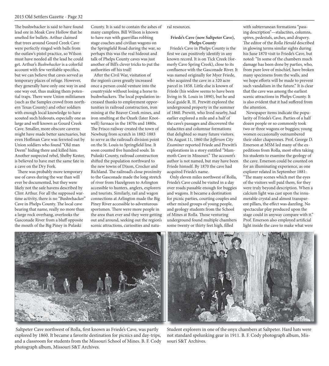
Saltpeter Cave northwest of Rolla, first known as Friede’s Cave, was partly explored by 1860. It became a favorite destination for picnics and day-trips, and a classroom for students from the Missouri School of Mines. B. F. Cody photograph album, Missouri S&T Archives.
Student explorers in one of the onyx chambers at Saltpeter. Hard hats were not standard spelunking gear in 1911. B. F. Cody photograph album, Mis-souri S&T Archives.

probably the first photographs ever made of the cavern and perhaps the first of any of the Gasconade Valley caverns. The views were available to the public at Dr. W. C. Guild’s photograph gallery on Pine Street, but no examples are now known to exist. In 1877, two MSM chemists pub-lished an analysis of the earth at Friede’s Cave. As reported in the Rolla Herald, their tests showed high levels of potassi-um and lime, making cave earth worth $21.50 per ton as agricultural fertilizer. Thereafter, newspaper items referred to “Friede’s Saltpetre Cave” or simply “Saltpetre Cave.” It bears the latter name today although the modern rendering is “Saltpeter.” Cave earth’s value as fertil-izer led farmers to begin digging and hauling guano out of many Gasconade caverns for spreading on their fields. The Frisco Fertilizer Company tried to make a commercial proposition of gua-no mined at Bat Cave near Crocker, but it was not profitable or perhaps quickly exhausted. The company was inactive by the mid-1880s.
The extraction of cave earth did not put off visitors to the favored spots, Attendees of Frisco Fertilizer’s “Grand Picnic” at Bat Cave in August 1885 heard Judge Bland and attorney Lumin F. Parker of Rolla, the featured orators at the event. Advertisements noted that spirituous liquors were absolutely pro-hibited, but that all other kinds of liquid refreshment would be available. At Salt-peter Cave, visitation continued apace despite guano mining. Sometimes the explorers were students from the min-ing school, but as often the parties were young couples from Rolla, Newburg and the Pea Ridge neighborhood. On August 19, 1882, the Rolla Herald not-ed: “A gay crowd of 13 ladies went out to the saltpeter cave Tuesday to pass the day.” The young women were of Rolla’s merchant and professional families, chaperoned by adults. “The ‘male men’ loaned their presence at the dinner ta-ble and stood guard while these gentle human zephyrs gyromanced the hours away…” On a similar excursion to the “famous” cave in October 1886, one of
the party reported: “The exploration of the cave was accompanied with the usual results—muddy shoes and skirts, fear from the horrid bats, a request from one of the ladies to carry out a stalactite that would weigh a ton, etc.” A broken singletree on their wagon was the only mishap of the day. It was a group of Grand Army of the Republic members who stood guard on a visit to Saltpeter Cave in November 1893. After some exploring, the vet-erans tended the campfire while their wives tended to the commissary depart-ment. In October 1895 the Rolla Cycle Club rode to the cave, measuring the distance by cyclometer at exactly 11¼ miles, which the wheelmen covered in one hour and twenty minutes. Mem-bers of the William Jennings Bryan political club of Phelps County made an excursion in September 1896, leaving Newburg in a three-seat buggy and a gravel wagon loaned by Mayor John Scanlan. Their baggage included “Bryan caps” and a “little brown jug” that they swore was cream for midnight coffee.
Whatever the conveyance or compo-sition of the parties, examination of the cave’s formations was generally the first item of business. Once explorers emerged “wet to the fetlock,” campfires, late suppers on the picnic ground and moonlight rides home concluded a day’s entertainment.
Gathering Places: Gourd Creek Cave, Poole Hollow Cave, Campground Cave
Gourd Creek Cave is on a tributary of the Little Piney about eight miles south-west of Rolla, not far from the former general store and post office at Vida. It has the largest opening of any cave in Phelps County, about 125 feet wide and 30 feet high, large enough for wagons to be turned around inside the mouth. It was easily reached by wagon road down Gourd Creek or by fording the Little Piney from the west. The cave’s Civil War association with Bill Wilson has already been noted, and it appears to have been well-known and widely-vis-ited by the late 1870s. It was a favored summer gathering place for folks in the
2015 Old Settlers Gazette - Page 33
Wilderness Ridge ResortOn the Big Piney River
Canoeing·Rafting·Camping·Cabins
Nancy Warrick33850 Windsor Lane
Duke, MO 65461(573) 435-6767
www.wildernessridgeresort.com
Ozark natural beauty and charmon the middle Big Piney
a pictorial history of Pulaski County * More than 280 vintage images * 154 pages * Indexed
Rivers beckoned lum-bermen and settlersRailroads created new townsRoads brought tour-ismRecreation destination for more than century
Available at: The Pulaski County Tour-ism Bureau, Lone Oak Printing, Talbot House, Lost in the Woods Antiques, Se-da’s Gift Shoppe, and the Old Stagecoach Stop, or by mail from: Terry Primas 10925 Western Road Duke, MO 65461
$24.99postage included
Duke, MO 65461
south part of the county. The setting is scenic, the cave spacious and it is always a dozen degrees cooler on a hot day. It does not contain the wonderful formations of other caverns, but explo-ration of the interior is not challenging for amateurs. For many folks in Phelps County, Gourd Creek was the first cave they ever visited. Newspaper items concerning the cave began appearing in the 1870s when that part of the country started filling up as a consequence of the development of iron mines along Beaver Creek. Not merely a spot for picnics and outings by the young folks, Gourd Creek Cave was a natural community gathering place on social and political occasions such as July 4th. At least part of the attrac-tion was a wooden floor built inside the cave that served as a speaker’s podium and a dance platform. It was in place by August 29, 1878 when the Rolla Herald noted:: “A fiddler at the Gourd Creek picnic, where they had a dance, failed to get the two dollars he claimed and in consequence swore that, if they danced, they would dance over him--; they did, as he got drunk and crawled under the floor, they danced over him to the music of his beautiful snore.” In 1879, local resident D. F. Silvey tuned up the dance floor for the July 4th celebration, for which the neighborhood “Com-mittee of Arrangements” awarded him the exclusive concession to sell candy, lemonade and soda pop. Independence Day festivities and widely-advertised political speakings drew hundreds of people to Gourd Creek in 1878-1880. It was close enough to Rolla for county officials and political leaders to visit country constit-uents and was a place where candidates put themselves in front of voters. Ora-tors and raconteurs also found a venue at Gourd Creek, including on one occasion an extempore address by Rol-la’s self-appointed street philosopher, “Prof.” Erastus Darro: “Barefooted, head and beard unkempt, clothes rather the worse for wear, [Darro] looked like a modern blending of Diogenes and Demosthenes” as he delivered one of his crackpot but erudite orations and received an enthusiastic response from the crowd. Dr. C. H. Storts of Rolla offered to talk about his Mexican War experiences if time permitted after his regular address at Gourd Creek on July 4th, 1878, but
we can suppose that it was the Civil War that still struck sparks in the heart of Bushwhacker Bill Wilson’s coun-try. There were enough Republicans, renegade Democrats and Greenbackers around to make election campaigns lively, but a person had to be careful. At Yancy Mill, only a few miles from Gourd Creek Cave, William C. Kelly and Ed Seay, Democrat and Republican candidates for Phelps County prosecut-ing attorney in 1884 and Confederate and Union veterans, respectively, nearly came to blows over an allusion to the killings of former Phelps County judge Lewis Wright and four of his sons in August 1865. Meetings at Gourd Creek apparently stayed civil, even if fiddling
and dancing did break out afterwards. The cave was popular with Greenback Party candidates for about as long as that party lasted. New Era editor W. J. Powell, a Greenbacker himself, pro-moted their appearances during the campaigns of 1878 and 1880. To start the festivities in July 1880, Greenback-ers drilled three holes into solid rock above the cave’s mouth, tamped them with black powder, and fired them like mortars. Powell described their pic-nics and speakings at the cave as well attended and well-received, but the Herald’s editor, a Democrat, claimed that the Gourd Creek Greenbackers got “well chawed.” Greenbacker candidates also favored
Poole Hollow Cave, three miles east of the future site of Newburg. The cave is much smaller and wetter than Gourd Creek, but was centrally located to attract people from the Beaver Creek community and those living near William James’s defunct ironworks at Ozark. The local Greenback stan-dard bearer in 1880, B. W. Hudgens addressed a “goodly crowd” at Poole Hollow in September, but one that was about two-thirds Democrat. According the Herald, Hudgens came forth “and with a great deal of eloquence said a little about something and a great deal about nothing.” After several speakers, “the floor was given to the young peo-ple and dancing was kept up till late at night.” The editor went on to disparage Hudgens and his party generally: Greenbackers, so far as our observa-tions have extended, are great talkers, and great talkers are generally great nuisances. They force upon you the impression that that they know every-thing and you know nothing, and that they conceive it to be their mission to tell you all they know before they leave you. So they talk on with a rushing, gushing, whirling, twirling tide of words, which engulf, swamp and drown you. So it seems the mud was not the only thing that might get deep around caves about election time. Larger gatherings at Poole Hollow Cave ended after George Bohannon murdered a fiddler, William Light, during a neighborhood picnic at the cave in August 1881. There had been dancing and there was to have been a shooting match, but it was called off after the killing. Bohannon claimed the incident started as a beef over a debt, but Phelps County authorities signaled their ideas on the root of the matter a week later when they arrested Jonathan Rice, “a peculiar gospel preacher,” for selling wine without a license at Poole Hollow. After 1883, Newburg had com-mercial buildings, churches and lodge halls as venues for public gatherings, and Poole Hollow Cave largely disap-pears thereafter from the public record. In modern times the cave was utilized for commercial mushroom-growing, but the enterprise was not successful and was so ephemeral that nothing much is known about it. A similar ex-periment occurred at Muench Cave in the western part of Phelps County. So far as we know, caves in Pulaski
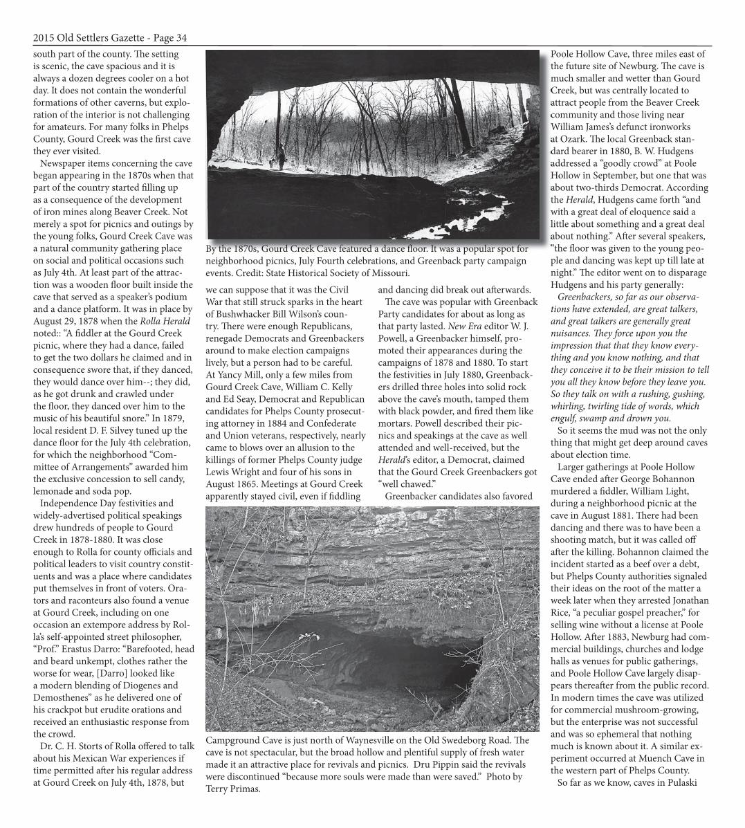
2015 Old Settlers Gazette - Page 34Poole Hollow Cave, three miles east of the future site of Newburg. The cave is much smaller and wetter than Gourd Creek, but was centrally located to attract people from the Beaver Creek community and those living near William James’s defunct ironworks at Ozark. The local Greenback standard bearer in 1880, B. W. Hudgens addressed a “goodly crowd” at Poole Hollow in September, but one that was about two-thirds Democrat. According the with a great deal of eloquence said a little about something and a great deal about nothing.” After several speakers, “the floor was given to the young peoBy the 1870s, Gourd Creek Cave featured a dance floor. It was a popular spot for
neighborhood picnics, July Fourth celebrations, and Greenback party campaign events. Credit: State Historical Society of Missouri.
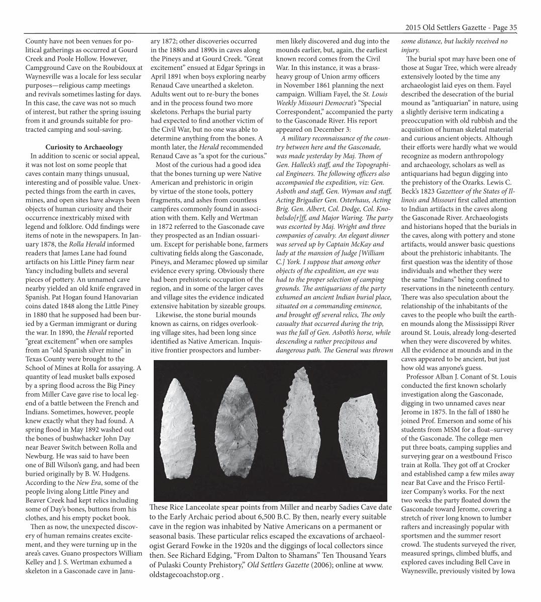
Campground Cave is just north of Waynesville on the Old Swedeborg Road. The cave is not spectacular, but the broad hollow and plentiful supply of fresh water made it an attractive place for revivals and picnics. Dru Pippin said the revivals were discontinued “because more souls were made than were saved.” Photo by Terry Primas.
County have not been venues for po-litical gatherings as occurred at Gourd Creek and Poole Hollow. However, Campground Cave on the Roubidoux at Waynesville was a locale for less secular purposes—religious camp meetings and revivals sometimes lasting for days. In this case, the cave was not so much of interest, but rather the spring issuing from it and grounds suitable for pro-tracted camping and soul-saving.
Curiosity to Archaeology In addition to scenic or social appeal, it was not lost on some people that caves contain many things unusual, interesting and of possible value. Unex-pected things from the earth in caves, mines, and open sites have always been objects of human curiosity and their occurrence inextricably mixed with legend and folklore. Odd findings were items of note in the newspapers. In Jan-uary 1878, the Rolla Herald informed readers that James Lane had found artifacts on his Little Piney farm near Yancy including bullets and several pieces of pottery. An unnamed cave nearby yielded an old knife engraved in Spanish. Pat Hogan found Hanovarian coins dated 1848 along the Little Piney in 1880 that he supposed had been bur-ied by a German immigrant or during the war. In 1890, the Herald reported “great excitement” when ore samples from an “old Spanish silver mine” in Texas County were brought to the School of Mines at Rolla for assaying. A quantity of lead musket balls exposed by a spring flood across the Big Piney from Miller Cave gave rise to local leg-end of a battle between the French and Indians. Sometimes, however, people knew exactly what they had found. A spring flood in May 1892 washed out the bones of bushwhacker John Day near Beaver Switch between Rolla and Newburg. He was said to have been one of Bill Wilson’s gang, and had been buried originally by B. W. Hudgens. According to the New Era, some of the people living along Little Piney and Beaver Creek had kept relics including some of Day’s bones, buttons from his clothes, and his empty pocket book. Then as now, the unexpected discov-ery of human remains creates excite-ment, and they were turning up in the area’s caves. Guano prospectors William Kelley and J. S. Wertman exhumed a skeleton in a Gasconade cave in Janu-
ary 1872; other discoveries occurred in the 1880s and 1890s in caves along the Pineys and at Gourd Creek. “Great excitement” ensued at Edgar Springs in April 1891 when boys exploring nearby Renaud Cave unearthed a skeleton. Adults went out to re-bury the bones and in the process found two more skeletons. Perhaps the burial party had expected to find another victim of the Civil War, but no one was able to determine anything from the bones. A month later, the Herald recommended Renaud Cave as “a spot for the curious.” Most of the curious had a good idea that the bones turning up were Native American and prehistoric in origin by virtue of the stone tools, pottery fragments, and ashes from countless campfires commonly found in associ-ation with them. Kelly and Wertman in 1872 referred to the Gasconade cave they prospected as an Indian ossuari-um. Except for perishable bone, farmers cultivating fields along the Gasconade, Pineys, and Meramec plowed up similar evidence every spring. Obviously there had been prehistoric occupation of the region, and in some of the larger caves and village sites the evidence indicated extensive habitation by sizeable groups. Likewise, the stone burial mounds known as cairns, on ridges overlook-ing village sites, had been long since identified as Native American. Inquis-itive frontier prospectors and lumber-
men likely discovered and dug into the mounds earlier, but, again, the earliest known record comes from the Civil War. In this instance, it was a brass-heavy group of Union army officers in November 1861 planning the next campaign. William Fayel, the St. Louis Weekly Missouri Democrat’s “Special Correspondent,” accompanied the party to the Gasconade River. His report appeared on December 3: A military reconnaissance of the coun-try between here and the Gasconade, was made yesterday by Maj. Thom of Gen. Halleck’s staff, and the Topographi-cal Engineers. The following officers also accompanied the expedition, viz: Gen. Asboth and staff, Gen. Wyman and staff, Acting Brigadier Gen. Osterhaus, Acting Brig. Gen. Albert, Col. Dodge, Col. Kno-belsdo[r]ff, and Major Waring. The party was escorted by Maj. Wright and three companies of cavalry. An elegant dinner was served up by Captain McKay and lady at the mansion of Judge [William C.] York. I suppose that among other objects of the expedition, an eye was had to the proper selection of camping grounds. The antiquarians of the party exhumed an ancient Indian burial place, situated on a commanding eminence, and brought off several relics, The only casualty that occurred during the trip, was the fall of Gen. Asboth’s horse, while descending a rather precipitous and dangerous path. The General was thrown
some distance, but luckily received no injury. The burial spot may have been one of those at Sugar Tree, which were already extensively looted by the time any archaeologist laid eyes on them. Fayel described the desecration of the burial mound as “antiquarian” in nature, using a slightly derisive term indicating a preoccupation with old rubbish and the acquisition of human skeletal material and curious ancient objects. Although their efforts were hardly what we would recognize as modern anthropology and archaeology, scholars as well as antiquarians had begun digging into the prehistory of the Ozarks. Lewis C. Beck’s 1823 Gazetteer of the States of Il-linois and Missouri first called attention to Indian artifacts in the caves along the Gasconade River. Archaeologists and historians hoped that the burials in the caves, along with pottery and stone artifacts, would answer basic questions about the prehistoric inhabitants. The first question was the identity of those individuals and whether they were the same “Indians” being confined to reservations in the nineteenth century. There was also speculation about the relationship of the inhabitants of the caves to the people who built the earth-en mounds along the Mississippi River around St. Louis, already long-deserted when they were discovered by whites. All the evidence at mounds and in the caves appeared to be ancient, but just how old was anyone’s guess. Professor Alban J. Conant of St. Louis conducted the first known scholarly investigation along the Gasconade, digging in two unnamed caves near Jerome in 1875. In the fall of 1880 he joined Prof. Emerson and some of his students from MSM for a float–survey of the Gasconade. The college men put three boats, camping supplies and surveying gear on a westbound Frisco train at Rolla. They got off at Crocker and established camp a few miles away near Bat Cave and the Frisco Fertil-izer Company’s works. For the next two weeks the party floated down the Gasconade toward Jerome, covering a stretch of river long known to lumber rafters and increasingly popular with sportsmen and the summer resort crowd. The students surveyed the river, measured springs, climbed bluffs, and explored caves including Bell Cave in Waynesville, previously visited by Iowa
2015 Old Settlers Gazette - Page 35
These Rice Lanceolate spear points from Miller and nearby Sadies Cave date to the Early Archaic period about 6,500 B.C. By then, nearly every suitable cave in the region was inhabited by Native Americans on a permanent or seasonal basis. These particular relics escaped the excavations of archaeol-ogist Gerard Fowke in the 1920s and the diggings of local collectors since then. See Richard Edging, “From Dalton to Shamans” Ten Thousand Years of Pulaski County Prehistory,” Old Settlers Gazette (2006); online at www.oldstagecoachstop.org .
soldiers. Dr. W. C. Guild, Rolla’s com-mercial photographer, accompanied the party at least part of the way. He and Prof. Emerson attempted photographs by magnesium light of cave interi-ors, but met with indifferent success. Downstream the expedition explored Boiling Spring and Onyx Cave. The final camp was near Jerome, where the party entered caves in the long bluff above the village. While some went in search of cave formations, Prof. Conant and others opened an excavation in a cave reported to contain many Indian artifacts. They also found several skulls and many human bones, particulars unknown, that presumably informed Conant’s essay on archaeology in Wil-liam F. Switzler’s Illustrated History of Missouri, published in St. Louis in 1881. Rev. A. L. Love, superintendent of the Congregational City Missionary Society, and William J. Seever, secretary of the Missouri Historical Society, both of St. Louis, made a similar reconnais-sance of caves along the Gasconade in Pulaski County in 1894. They entered
twenty-four caves and dug in fifteen of them, looking for evidence relevant to the big question in anthropology of the day—whether ancient man could be pre-glacial in age. Love said he had found some “flint lance heads” that might be that old, but believed the evi-dence too slim to postulate an age older than 1,500 years for the prehistoric occupation of the Ozarks. In an exten-sive interview for the St. Louis Republic, reprinted in the Rolla New Era, Love explained: “The evidences of a crude civilization anterior to the appearance of the red man exists in numerous specimens of a higher order of ceramic art than found in the mounds, and in the immense collection of implements and flint weapons used in war and the chase…there can be no dispute upon the assertion that they fared sumptu-ously, although to the modern taste the raccoon is an unknown dish.” He did not believe the cave inhabitants were kin to contemporary Indians, but rather to the earlier Aztecs of Mexico. The Rolla editor appended Love’s interview
with the comment: “It is hoped that the all-important undertaking begun under such favorable auspices by Messrs. Love and Seever will not be allowed to end here, and that persistent endeavor in the rich fields discovered by these gen-tlemen will result in settling the vexed question as to the ancient inhabitants of the region once and for all.” St. Louis archaeologist Gerard Fowke took up the “vexed question” for the Smithsonian Institution in a series of excavations before and after World War One. Fowke worked in many of the caves in Pulaski and Phelps Counties visited earlier by Conant, Seever and Love, and extended his investigations to cairns, village sites and house mounds on open sites. He was the first archae-ologist to dig at Gourd Creek Cave, drawn by its large size and local reports of burials discovered within it. He also excavated three of six burial mounds nearby on Lost Hill. In Pulaski County, Fowke worked extensively at Sell’s Cave on the Rou-bidoux near Waynesville and at Miller
Cave on the Big Piney. At Sell’s he had to break up roof fall with sledge ham-mer and dynamite to reach the cultural deposit; it took two men five weeks to clear the rocky rubble. However, his greatest effort was at Miller Cave, which he identified as the focal point of an intensively-occupied prehistoric locale. There was evidence of extensive vil-lage sites in fields across the Big Piney from the cave and just upriver at Miller Spring. Three burials mounds above the cave and a remarkable collection of petroglyphs nearby were more signs that the place had been intensively in-habited by prehistoric people. Deposits in the cave were 4-6 feet deep in places and in terms of the sheer number of human remains and artifacts he recov-ered, it was a rich site. Fowke sent to the Smithsonian collections 12 skulls and fragments of another 8, 10 partial skeletons, 711 worked flint objects; 413 objects of wrought bone and stag horn; 10 axes; 74 items of shell; 2 clay pipes, and miscellaneous other items. He estimated that several wagonloads of
2015 Old Settlers Gazette - Page 36
SATISFACTION GUARANTEED
1002 Historic Route 66West Waynesville, MO 65583
573-336-1392573-433-0590
www.JNLCarpetCleaning.com
• Residential and Commercial• Truck Mounts• Steam Extraction• Emergency Water Damage Restoration• Grout Cleaning• Full Moveout Cleanings• Construction Clean-up• Bonded & Insured• Free Estimates
Club of Pulaski County R TARY
The Rotary Club of Pulaski County is a non-profit service organization that:• funds scholarships for graduating seniors• helps provide free dictionaries to 3rd graders throughout the county• serves free soup after the Christmas parade• provides free photos with the “Cat in the Hat” and the “Grinch” during Christmas on the Square • teaches the Choices Program, which encourages students to make good decisions, to Pulaski County middle school students• judges middle school science fairs throughout the county• sponsors the Interact Clubs at Waynesville Middle and High Schools• recognizes the WMDS Student of the Month• helped build the skate park in St. Robert• sponsors and sends high school students in Pulaski County to leadership training• volunteers monthly at the USO on Fort Leonard Wood
For more information, please contact Club President Jim Standfast at 573-201-7091.
RotaRians obseRve a moRal code foR peRsonal and business Re
lation
sh
ips k
no
wn a
s the 4-w
ay tes
t, wh
ich a
sk
s the
se q
ue
stio
ns: ..is it th
e tRuth ? is it faiR to all conceRned? will it build Goodwi l
l a
nd b
ett
eR
fR
ien
ds
hip
s?
wil
l it
be b
en
efi
cia
l to
all
co
nc
eR
ne
d?
Rotary Motto:
SERVICE Above
Self

rough stone, broken animal bones, and pottery fragments remained. The Smithsonian published Fowke’s findings in 1922 as Cave Explorations in the Ozark Region of Central Missouri, a bulletin of its Bureau of American Ethnology. While it presented more detail than had even been written about archaeological investigation of these parts, the report was badly written, hard to follow, and disappointing to professionals and lay people alike. As had others before him, Fowke recog-nized that the artifact assemblages from the caves were generally the same as commonly found in open sites. How-ever, he did not recognize much by way of stylistic differences in the artifacts from his cave excavations, some of which reached several feet in depth. He believed the deposit represented a considerable span of time, but admitted that there was no reliable way to date his discoveries. Much like his antiquarian forebears, Fowke was preoccupied with the recovery of human remains, unusual
objects, and the acquisition of wrought bone and stone artifacts. He was un-impressed by the utilitarian nature of artifacts in the caves and disappointed to have found only one complete pot-tery vessel in all his diggings. Display-ing the prejudices of his era, Fowke believed that the crude material objects indicated a lower order of culture. He speculated that the prehistoric inhabi-tants dined so well off the land that they never progressed beyond a primitive state of “savagery.” Although his report had illustrations of three individual symbols, he devoted only a short para-graph to the petroglyphs at Miller Cave (see page 38). Although they were ap-parently singular among his discoveries in the Gasconade region, they did not raise his estimate of the culture above primitive. However, he did find human bones wherever he dug. Fowke never clear-ly stated exactly how many whole or partial skeletons and bones he removed, but they represented several dozen prehistoric individuals. In burned or
broken fragments of human bone, seemingly discarded with household debris and kitchen refuse, Fowke be-lieved he found “presumptive evidence that dwellers here sometimes devoured the flesh of human beings.” He found no plausible reason except cannibalism for the bones. He only other explana-tion was, he concluded: “the equally repulsive hypothesis that the inmates of the cave were brutally indifferent to the bodies or skeletal remains of their fel-lows.” This from a man who had dug up dozens of prehistoric burials, shipping them in crates to an uncertain eternity in storage. No archaeologist since has raised the specter of cannibalism by Ozark cave dwellers, so perhaps Fowke had been in the caves too long. Although Fowke was over-concerned with prehistoric human remains and burials, he made a contribution by his sketches of the internal structures of two burial mounds near Gourd Creek—the first publication to show these features of cairns in the Ozarks. He noted that nearly all of the mounds
he encountered had been previously pitted and their stones scattered “by hunters as well as by credulous individ-uals who are firmly fixed in the belief that all such ‘rock piles’ contain gold hidden by Indians.” Fowke’s mention of the local folklore of caves and cairns is as valuable as his archaeological record. Tales of Indian and Spanish treasure are commonplace in the Ozarks and exist to the present; frequently they are associated with caves. The New Era published a good example of the type on March 9, 1878, reprinted from the Salem Monitor. It was a report of an old tradition that Indians buried a barrel of silver dollars in southeastern Dent or northern Shannon counties in a cave on the Current River marked by a bear’s head engraved on a bluff. Indians were reported to have looked unsuccessfully for the cache in the past century, but the cave since been found and work was said to be in progress preparatory to digging for the barrel. Similar tales existed throughout the region, initiat-ing an era of treasure digging. William
2015 Old Settlers Gazette - Page 37
Darrell ThomasCommercial Applicator
Toll Free: 866-628-PESTPhone: 417-458-4111www.shomepest.comEmail: [email protected]
255 Eastlawn Ave, Ste. 1P.O. Box 1148 St. Robert, MO 65584Phone573-336-3759Onlinewww.bestfriendsah.comEmailhospital@bestfriendsah.com
Michael V. HeadrickAssociate Circuit Judge
Probate Division
Wishes You an Enjoyable Settlers Day Weekend
I am Honored to continueserving as your judge.
ELBOW INNOver 75 Years in Devil’s Elbow
•Famous for Hickory Smoked
Ribs and Bar-B-QueFull Menu Beer Garden Karaoke
Open at 11:00 a.m.Open Sunday Noon • Closed Mon. & Tues.
573 336-5375

Seever reported finding Warnell Cave on the Gasconade completely churned by treasure hunters as early as 1894. Fowke noted similar disturbance at McWilliams Cave, but the locals told him that it was due to a search for possible murder victims, brought about when a hog rooted out bones. When Fowke arrived at Gourd Creek, he found owner Valentine Allen, the half-brother of Bushwhacker Bill Wil-son, storing hay and farm equipment in the cave. He observed that the interior surface was quite irregular, attributing it to cave earth having been hauled out as fertilizer by the owner. Allen’s digging had unearthed several burials and he showed Fowke a skull that appeared to be “the well preserved skull of a white woman.” Fowke also heard from Allen or some of the other locals a legend of Indian treasure at Gourd Creek: “There is a firm belief in the community that somewhere in the cave is concealed $10,000 in gold, seven ‘pony loads’ in all, which were put here by an old squaw, sole survivor of a massacre by which her tribe was exterminated. Much of the irregularity of the surface noted in the deposits is due to the ef-forts of persons trying to find the mon-ey.” Historian Dwight Weaver reports the same legend, right down to the
mystical number seven, associated with a cave in Miller County. Cave special-ist J Harlen Bretz noted the legend in connection with a “prospect hole” that has been cut into the floor of Gourd Creek Cave and speculated that it may have been associated with treasure dig-ging. Whatever the purpose, someone expended time and effort carving the shallow basin into solid rock. It was not just unsophisticated rural whites who bought into the legends. The Rolla Herald published a story in November 1897 headlined “A Strange Visit by a Strange Woman.” The piece involved another treasure legend, this one associated with a Gasconade cave in Maries County. The tale was cur-rent enough to have brought an aged Indian woman from Texas who said she had learned the details from a man on his deathbed. She enlisted two Spring Creek men to help her locate the cave and the gold and silver coins buried in it. The woman’s directions were precise enough to locate the cavern, but when they entered it they found other dig-gers had gotten there first—they found only a large hole that bore the imprint of the vessel that had held the treasure. The Spring Creek guides delivered the crestfallen Indian woman to Rolla to begin her return to Texas. Clearly, gua-
no diggers, antiquarians, and archae-ologists have not been the only people to root around in the caves in modern times. And lest we think that the golden legends are a quaint thing of the past, a person can hear an outlaw variation of the theme yet today on every tour past Jesse James’s Loot Rock at Meramec Caverns. It would be several decades before more scientific studies began to provide reliable data, provided by the excava-tions of archaeologists more interested in the evidence of prehistoric ways of life than burial practices. A Federal Road and Research Survey under the direction of Prof. J. C. Harrington of Chicago visited Phelps County in July 1935 for an archaeological tour of caves near Rolla. Missourians on the survey included anthropologist J. B. Berry and historian Jesse Wrench from the Uni-versity of Missouri, MSM professors H. B. Butler, J. W. Hartley, and S. H. Lloyd, historian Gerard Schultz of Iberia Junior College, archaeologist Carl H. Chapman of Steelville, and various oth-er road engineers and field men. Before leaving for the caves, Prof. Harrington favored the Rolla Lions Club with an address on archaeology, speaking to a packed house at the Sinclair Pennant Tavern. Although the survey team conduct-ed no field work, it may be counted a success if it introduced Carl Chapman to Phelps County’s caves. A native of Crawford County, Chapman was to become the eminent figure of Missouri archaeology for the next fifty years. Drawing on the results of excavations
at Maramec Spring and Verkamp shelter on the Dry Fork, he and other archaeologists had begun to establish a cultural and chronological framework for prehistory of the Ozarks. There were still gaps in the record, howev-er, and the caves were problematic. In the early 1960s, Chapman sent his graduate research assistant, R. Bruce McMillan, to conduct the first investi-gation of Gasconade River caves since Gerard Fowke’s excavations. McMillan’s “Gasconade Prehistory,” published in Missouri Archaeologist in 1965, was the first exposition of modern archaeology to be conducted in the caves of Phelps and Pulaski Counties. It was augment-ed by that of amateur archaeologists Ralph Roberts and Jack Scrivner of Rolla, whose excavation of Tick Creek Cave, three miles south of Saltpeter Cave, helped to fill in the prehistoric sequence for this region. Their stylistic analysis of stone tools at Tick Creek and a separate analysis of animal remains by Illinois paleontologist Paul Parmalee also appeared in Missouri Archaeologist in 1965. In recent decades, archaeologists at Fort Leonard Wood have studied pre-historic sites within the military reser-vation on the Big Piney and Roubidoux. They include some of the caves visited by Gerard Fowke, most notably Miller Cave. The ethics of archaeology in caves are different now, due to protest by Native Americans concerning the treat-ment of prehistoric human remains and resulting legislation. Human remains are protected now, and much archae-ological work in caves now on the
2015 Old Settlers Gazette - Page 38
Human activity at Miller Cave on the Fort Leonard Wood military reservation goes back at least ten thousand years. Archaeologist Gerard Fowke excavated Miller Cave after World War One and shipped hundreds of artifacts to the Smith-sonian Institution. Miller Cave was the focus of an extensive prehistoric locale that featured cave and open campsites, burial mounds and rock art. The remarkable petroglyphs outside Miller Cave are shown (above right) in 1965, highlighted with chalk and gridded for scale. Robert L. Elgin collection, State Historical Society of Missouri.
military reservation has been remedial, salvaging the mess left by other dig-gers and stabilizing what is left. In that process on Fort Leonard Wood sites, archaeologists have acquired a series of radiocarbon dates that have replaced former speculations about the prehis-toric chronology. The results supply reliable dates applicable to many other sites in Phelps and Pulaski counties. And the answers to those vexing old questions? Native American occupa-tion of this region began at least ten thousand years before the present. But evidence for pre-glacial man in the Americas is once again a lively topic in anthropological circles, so who knows what future discoveries will prove. Evidence for prehistoric occupation of caves in the northern Ozarks during the earliest (pre-Paleo and Paleo) periods is nonexistent to sparse, perhaps because the caves were too wet to be habitable. Beginning about 9,000 B.C., Native Americans began using the larger, drier caves as occasional or semi-perma-nent bases, and continued to do so for
thousands of years. The stone burial mounds, on the other hand, are much younger—only a thousand years or so. They are associated with the last and most intensive prehistoric occupation of the caves that lasted until about 1450 A.D. when the northern Ozarks region was mysteriously abandoned. As for the Ozark cave dwellers being kin to the Aztecs, the jury will be out a while yet on that matter.
Onyx Mining Digging in the region’s caves for other reasons commenced in 1890 with an episode of mining onyx for commercial remanufacture and sale. The onyx-min-ing era (if something that only lasted for so short a time can be called an era) was as chimerical as treasure-digging. It was based on an even more widespread belief: that the Ozarks would become the nation’s most famous mineral district and that fortunes waited to be mined. In this case, the object was onyx, a beautiful translucent stone of calcite with banded color ranging
from cream to dark reds and greens. It saws and carves easily and takes a high polish. Quarries in various parts of the world had supplied onyx slabs for wainscoting and sills for the high-end architectural market and a smaller trade in manufactured decorative items including lamp bases, clock pedestals, parasol and cane handles, drawer-pulls, and knick-knacks such as paperweights. Mines in Mexico supplied the market when other sources played out in the mid 1860s, but the deposits there were believed to be approaching exhaustion as well. Geologists and lapidaries had known for years of onyx deposits in the northern Ozarks (there was an Onyx Post Office in Pulaski County, 1836-1841), referring to the stone variously as “alabaster,” “oriental marble,” and “cave marble.” Technically, the stone here is not true onyx (being a carbonate of lime rather than a silicate stone), but it is similar in appearance, color, and qualities. Henry Cobb of St. Louis is said to have brought a great quantity of it to St. Louis about 1860 for use as
wainscoting in the Equitable building but the innovation was not pursued. Interest in Missouri’s onyx was re-awakened in 1890 as a response to changes in federal tariff law by virtue of what was known as the McKinley bill. It reclassified imported onyx slabs as marble, raising the duties and making domestic production potentially com-petitive. It seemed to J. F. Leighton and H. E. Rood in St. Louis that they might corner the world’s onyx market. By De-cember 1890 they owned onyx deposits in two caves and a quarry near Bour-bon in Crawford County, and a cave and quarries in Pulaski County near Frank’s Switch and Dixon. They inter-ested stone finisher Guy H. Reynolds of Rutland, Vermont in the prospect, and took him, along with other potential investors and newspaper reporters, on a guided tour of their properties during which “Wide attention was called to the subject and enormous demands which would surely result from placing on the market a material or exquisite beau-ty, and at figures which must render
2015 Old Settlers Gazette - Page 39
Terri MitchellPulaski
County Collector
Thank You forallowing me to provide
the service you deserve...
Enjoy Old Settlers Day
Taco Tuesday—soft & hard shelled tacos for $1Thursday—Margaritas on the Rocks & Mojitos for $1
Happy Hour: 5:00—8:00 pm Sun thru WedWeekly Specials • Military 10% DiscountHouse Specialty - Don Jose Guacamole
573-336-4373560 OLD ROUTE 66, ST. ROBERT, MO VOTED BEST KENNEL
Rocky Top PetsFull Line of fish, pets & supplies
Premium pet foodProfessional All Breed Dog Grooming
573-774-4002Townfield Plaza
www.rockytoppets.com
Rocky Top KennelPet Boarding
Large Climate Controlled Indoor/Outdoor RunsDecorated Luxury Suites with T.Vs.Private Cattery with “Kitty Condos”
Huge PlaygroundsState Licensed Boarding: 573-774-2900
KEVIN HILLMANPROSECUTING ATTORNEYPULASKI COUNTY, MISSOURI
Enjoy Old Settlers Day
and
Thank you for the opportunity to serve thepeople of Pulaski County as ProsecutingAttorney.
SeegerToyota / Scionof St. Robert
169 St. Robert Blvd.St. Robert, MO 65584
573-336-7111800-844-6026
www.seegertoyota.netwww.seegerscion.net
www.oldstagecoachstop.org
GOODRICH GAS, INC.Now Serving You In Four Locations
CROCKER736-2212 DIXON759-6400ST. ROBERT336-4045 RICHLAND 765-5544YOUR SUPPLIER OF WHIRLPOOL APPLIANCES
* Gas and Electric Ranges * Refrigerators* Freezers *Washers / Dryers * Window A/C Units
* Parts Department * Heating & CoolingInstallation and Service
* Service Department 24 hrs a day / 7 days a week“PROUDLY SERVING PULASKICOUNTY
FOR 56 YEARS”

foreign competition of no avail.” The result was the Ozark Onyx Company, a Missouri corporation organized in March 1891, capitalized at $300,000. Reynolds moved his Vermont finishing plant to a former cotton compress on Chouteau Avenue in St Louis. With Rood and Leighton, Reynolds became a principal stockholder of Ozark Onyx. He retained management of the finish-ing plant. St. Louis newspapers published stories of great underground wealth with head-lines such as “Millions In Onyx.” They quoted Reynolds that the deposits were “inexhaustible” and that $20,000,000 in onyx was already “in sight.” Work began at the spring of 1891 at the quarries in Crawford County and those in Pulaski near Franks, where the company em-ployed forty men. The firm’s unnamed cave has not been identified, but may have been Kempton or Jim Jones on the western edge of Phelps County not far from Onyx Cave. Harlen Bretz saw mined onyx blocks at Kempton Cave when he visited it in the 1950s; Jim Jones still shows the spot where onyx blocks were removed. Kempton is only four miles south of Franks, but getting onyx blocks from the cave to the rail-road loading dock at Franks would have entailed crossing the Gasconade River. If blocks from Kempton were hauled to the tracks at Arlington, the Gasconade crossing was avoided. Whatever the origin, the St. Louis Globe-Democrat reported that two carloads of Pulaski County onyx had arrived at the fin-ishing plant. Sawed into slabs, Pulaski County onyx probably made up part of the glittering stone paneling of the newspaper’s new counting room. The local press joined in promoting the natural resource. “Description of Onyx in Pulaski County, Missouri,” published by the Dixon Echo and re-printed in the Rolla New Era on August 27, 1892, described “virtually untapped’ onyx deposits east and west of Dixon and not far from the railroad line. The local scribe’s enthusiasm rivaled that of urban reporters: “Any one wishing to buy onyx property will do well to come to Dixon and see the great onyx caves and then they will say like the queen of Sheba, ‘The half has not been told.’ There is enough onyx stone in Pulaski County to build a building like Solo-mon’s house and not miss it. There will be millions of dollars made out of this
valuable stone by them that work it, for it is rapidly coming into use.” The Ozark Onyx Company claimed to have examined and purchased all the best deposits in Crawford and Pulaski counties, but they did not own the great cave at Boiling Spring on the Gascon-ade River above Arlington and Jerome. It featured a passage nearly filled with flowstone, but, a thousand feet from the cave’s entrance, the difficulty in getting it out may have put off the company. The Murphy brothers of Crocker and Dixon also may have blocked Ozark Onyx. Judge W. H. Murphy owned 800 acres in Pulaski County contain-ing fourteen onyx prospects and was reported to have turned down sizeable options tendered by New York and Bos-ton capitalists. His brother and mercan-tile partner, T. A. Murphy, was referred to in one account as one of the propri-etors of Boiling Spring Cave, soon to be renamed Onyx Cave. The Murphys may have been local representatives of the Imperial Onyx Company, a Wisconsin corporation organized at Milwaukee in June 1892, but they were not stockhold-ers. Whatever the Murphy connection with the company may have been, Imperial Onyx purchased Onyx Cave from William E. Bell in Pulaski County on June 2, 1892. The Imperial Onyx Company’s corpo-rate records are not known to exist, but its operations can be summarized from newspaper items, a mining engineering
thesis, and evidence still remaining on the property. The Rolla New Era re-ported that onyx was being readied for rail shipment at Arlington on July 30, 1892, so Imperial Onyx must have had an arrangement to send its stone to the Ozark Onyx finishing plant in St. Louis, the only factory in Missouri capable of processing it. Mining occurred sporad-ically through 1893. Onyx Cave was “in blast once again” according to New Era on November 25, but shut down by December 14. The newspaper’s editor opined in February 1894 that “there is no prospect of our onyx mines busi-ness starting up again…in these good old democratic times,” but on March 13 reported that mining had resumed. It must have been short-lived. A note clipped from the Pulaski County Dem-ocrat and published by the New Era on December 1, 1894 reported that mining would soon resume “prosecuted upon more extended lines, $25,000 additional having been subscribed for that pur-pose.” If the sum was actually expend-ed, it was money down a hole. One of the most unique features left by the mining of Onyx Cave is a shaft, about eight feet by ten feet, cut ver-tically through solid rock above the cave into the onyx chamber 100 feet below. The shaft was said to have been necessitated by the unreasonable price asked for a road easement to the cave’s natural entrance. Foreman Charles M. McAfferty, who led crews of miners
at Onyx in 1893, probably supervised sinking the shaft. Underground in the main onyx chamber, miners drilled and blasted loose blocks of onyx four feet wide, four feet thick and six feet long. Skidded to the bottom of the shaft with ropes and pulleys, the blocks were hoisted to the surface. Many blocks of onyx still remain in the cave and around the top of the shaft. There seems only to have been a single carload of carload of Onyx Cave blocks actually shipped to the finishing plant in St. Louis. Unfortunately for promot-ers of the much-ballyhooed stone, cave onyx had minute fissures and fractures that often caused it to shatter when put to the saws and grinders at the finishing plant. The same held true for much of the cave onyx in the region, making it unsuitable for the high-end market in slabs. Without a marketable product, the Ozark Onyx Company entered receivership in 1893. The company’s properties in Pulaski and Crawford counties, as well as the St. Louis fin-ishing plant, sold for debt and brought only four cents on the dollar. In 1894 the St. Louis Trust Company brought suit against the stockholders, charging fraud in the manner by which the promoters had exchanged 445 acres of overpriced wild land for shares of stock. Without a processing plant, blocks previously cut at Onyx Cave stayed where they were; they remain there still. In June 1895, the Pulaski County Democrat advertised a constable’s sale of the property of the Imperial Onyx Company to satisfy a judgment of $250 against it. The sum represented the back wages of “Pink” Case, overseer of the works “for the past few years.” Albert Keenan of Arlington got a real bargain, winning $9,000 of machinery at Onyx Cave on a $100 bid. The company’s col-lapse had legal ramifications that lasted until at least March 1945, when Josef Fabra brought suit in Pulaski County Circuit Court to clear title to 140 acres formerly owned by the Imperial Onyx Company. MSM students Ignatius J. Stauber and Fred R. Hoeberlin studied Onyx Cave for their 1901 thesis in mining engi-neering, “Report on the Onyx Deposits of Boiling Spring Cave.” They visited the cave while the mining failure was still fresh and left the only technical account of the work. The engineers concluded that improper use of explosives caused
2015 Old Settlers Gazette - Page 40
Large blocks of decomposing onyx remain above Onyx Cave near the 125-foot vertical shaft through which they were hoisted to the surface. Drill marks are visible on the nearest block. The onyx was destined for the railroad at Arlington and shipment to a finishing plant in St. Louis. The onyx business collapsed and the Imperial Onyx Company went bankrupt before these blocks could be shipped. Photo by Terry Primas.
much of the problem with the stone and believed it might be remedied by more careful blasting technique. However, they also noted that continuing exper-iments by Imperial Onyx miners to remove undamaged blocks had failed, leading the company to abandon the cave “in disgust,” leaving the remaining blocks in place. In a cost analysis with an eye toward reopening the mine, the engineers calculated that it would be a marginal business at best, even if their estimates of the remaining onyx (ad-mittedly speculative without test drill-ing) were accurate. Other geologists, including Missouri Geological Survey chief Henry A. Buehler, believed the local stone was inherently unsuitable for large scale exploitation. What is sure is that the onyx mining phase in these parts was over by 1895. Production was so insignificant that it was not reported in state reports of “surplus products” exported from Pulaski County. Beyond mining, Onyx Cave was another spot for the curious. In Feb-ruary 1880, the Rolla New Era carried an item regarding three Big Piney tie rafters who indulged their curiosity. They hired a young local lad as guide. He waited outside while the rafters explored the cave, and when they did not reappear at dark, the boy assumed they were lost inside and raised an alarm. A search party found the rafters sleeping peacefully in the cave at the point where their torch had given out. The country correspondent of the Rolla
Herald noted a less-alarming occasion in August 1889 when “A Joyous Brid-al Picnic” explored the entire karst complex of Onyx Cave, Boiling Spring, and Slaughter’s and Conical sinks. The reporter advised: “All who have not saw it ought to,” but cautioned that the party encountered and killed a large rattlesnake at Slaughter’s Sink. About 1900 the cave became a destination for guests of the resorts at Jerome and Arlington who motored upstream in the gasoline-powered “launches” beginning to ply the Gasconade. In the 1920s the cave was talked of as a site for a tuberculosis sanitarium and was part of the apparently short-lived Onyx Cave Park of the 1930s. Along with other caves in the Ozarks, it was considered in the 1950s as a site of a jet propulsion laboratory. More recently, it was closed to the public until Harry and Agnes Thiltgen opened it as a tourist attrac-tion called Onyx Mountain Caverns in the 1990s. The cave is the best remain-ing example of the onyx mining period in Missouri history. Today it is a U. S. Forest Service property and is managed by that agency. Historian Dwight Weaver observes that it is fortunate that mining ended so quickly at Onyx Cave. Work continued fitfully in some caves into the 1920s, much to their detriment. In one noto-rious example, Big Onyx Cave on the Meramec River in Crawford County, the use of explosives left it wrecked, unsightly, and unstable. The same
might have happened at Saltpeter Cave in Phelps County had mining been profitable. In November 1890, geologist James L. Buskett of Rolla called atten-tion to onyx deposits in Phelps County. He believed the whole country was full of valuable minerals, awaiting only “the expenditure of a small amount of capi-tal to make the region famous as a min-ing district. If St. Louis capitalists would spend a small part of what they send to the Rocky Mountains right here in their own state, they would accomplish more for themselves and for Missouri.” Someone certainly expended a little capital and no small amount of labor at Saltpeter Cave. A unique feature of Saltpeter is an artificial opening, about five feet by ten feet, cut laterally into the side of the cave. Smaller but drier than the natural entrance, the artificial open-ing penetrates the main chamber of onyx formations only a short distance away. While nothing like the shaft at Onyx, cutting a hole through solid rock at Saltpeter was no mean feat. But who cut the artificial opening is an unan-swered question. The Ozark Onyx and Imperial Onyx companies are the obvi-ous candidates. Imperial Onyx Com-pany seems more likely as it had tools and experienced miners not far away at Onyx Cave. Imperial operated during the period of the Columbian Exposition (World’s Fair) at Chicago in 1893, by which time the Ozark Onyx Company was in receivership. It is said locally that specimens from Saltpeter Cave were exhibited at Chicago, although no evi-dence is known to support that claim. The 1895 report of the Missouri Board of Agriculture listed onyx from Craw-ford and Pulaski counties as part of the state’s exhibit at Chicago, but showed nothing from Phelps. Onyx from Saltpeter Cave did go to St. Louis World’s Fair in 1904, making up part of the Missouri minerals exhibit superintended by MSM’s director, Dr. George E. Ladd. On March 31, 1904, the Rolla Herald reported that MSM groundskeeper Robert Dickerson had shipped to St. Louis two tons of Phelps County ore samples, rock crushing and slicing machinery, and onyx specimens from Saltpeter Cave. However, if Ladd, Dickerson or MSM students had any hand in cutting the artificial opening into the side of Saltpeter Cave, the evi-dence has not been found in newspaper accounts, college yearbooks, or photo-
graph albums. When MSM student B. F. Cody photographed Saltpeter about 1910, the artificial entrance already looked old. The intent of the artificial entrance was obviously to facilitate access into the cave’s main onyx chamber. Photog-rapher A. B. Duncan no doubt lugged his camera gear through the artificial entrance to make a series of views of the onyx chambers. A local boy, Dun-can began his photographic career at Arlington and went on to become the Frisco railroad’s official photographer, tasked with making views of scenic spots and destinations along the line for the advertising department. The railroad fitted him out with a Palace Photo Car combining a darkroom and living accommodations that became a frequent sight on Frisco tracks. The Herald reported in September 1897 that Duncan would embark on an extensive project taking photographs along the Meramec and Gasconade for Frisco tourist publications, and that “Phelps County will predominate in furnishing views of scenery equal to any in the world.” As proof, three Duncan pho-tographs of Saltpeter Cave appeared in the Herald in July 1898; the Columbia Herald published a Duncan photo of the main onyx chamber at Saltpeter in November. Duncan displayed photo-graphs of scenes along the Gasconade, Pineys and White River, presumably including his work at Saltpeter, in his exhibit at the Pan American Exposition at Buffalo, New York in 1901 He oper-ated the Studio Royale at Rolla through 1903, then moved to Springfield. Although some of Duncan’s work in Phelps and Pulaski counties is known from Frisco publications, whatever else he might have recorded was lost when his studio burned in the great Spring-field fire of January 1909.
Monument Man The last newspaper item we have for a picnic at Saltpeter is in the Rolla Herald on May 7, 1914, when a “jolly crowd” spent the day. There must have been other social occasions thereafter, but if the newspapers are any indica-tion, the vogue of cave visitation may have diminished by then. Students and professionals from MSM continued to visit and study cave geology and the formations at Saltpeter and must have seen the places where specimens had
2015 Old Settlers Gazette - Page 41
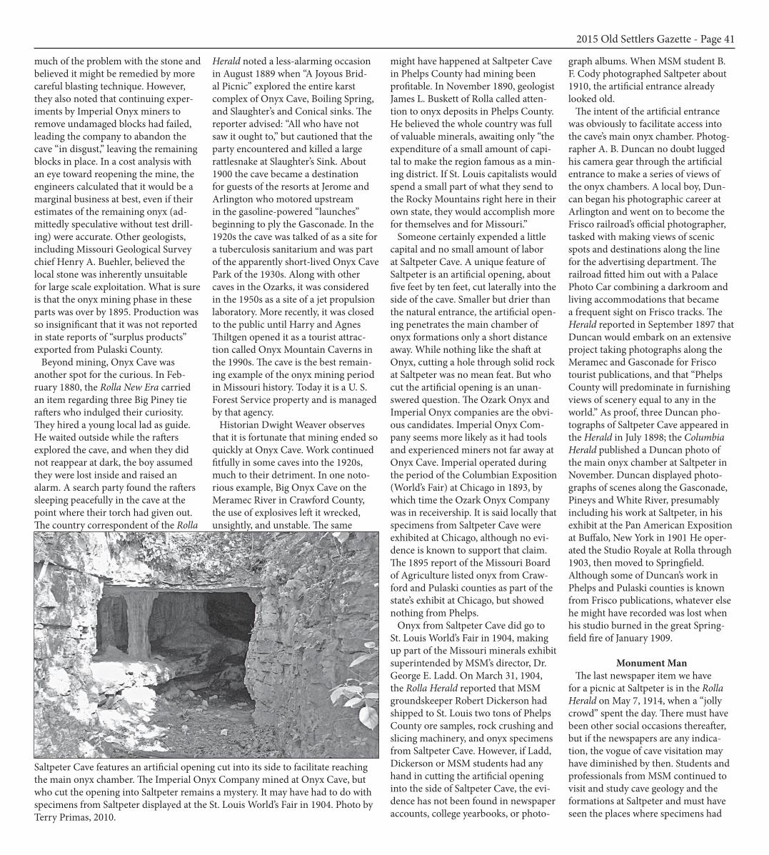
Saltpeter Cave features an artificial opening cut into its side to facilitate reaching the main onyx chamber. The Imperial Onyx Company mined at Onyx Cave, but who cut the opening into Saltpeter remains a mystery. It may have had to do with specimens from Saltpeter displayed at the St. Louis World’s Fair in 1904. Photo by Terry Primas, 2010.
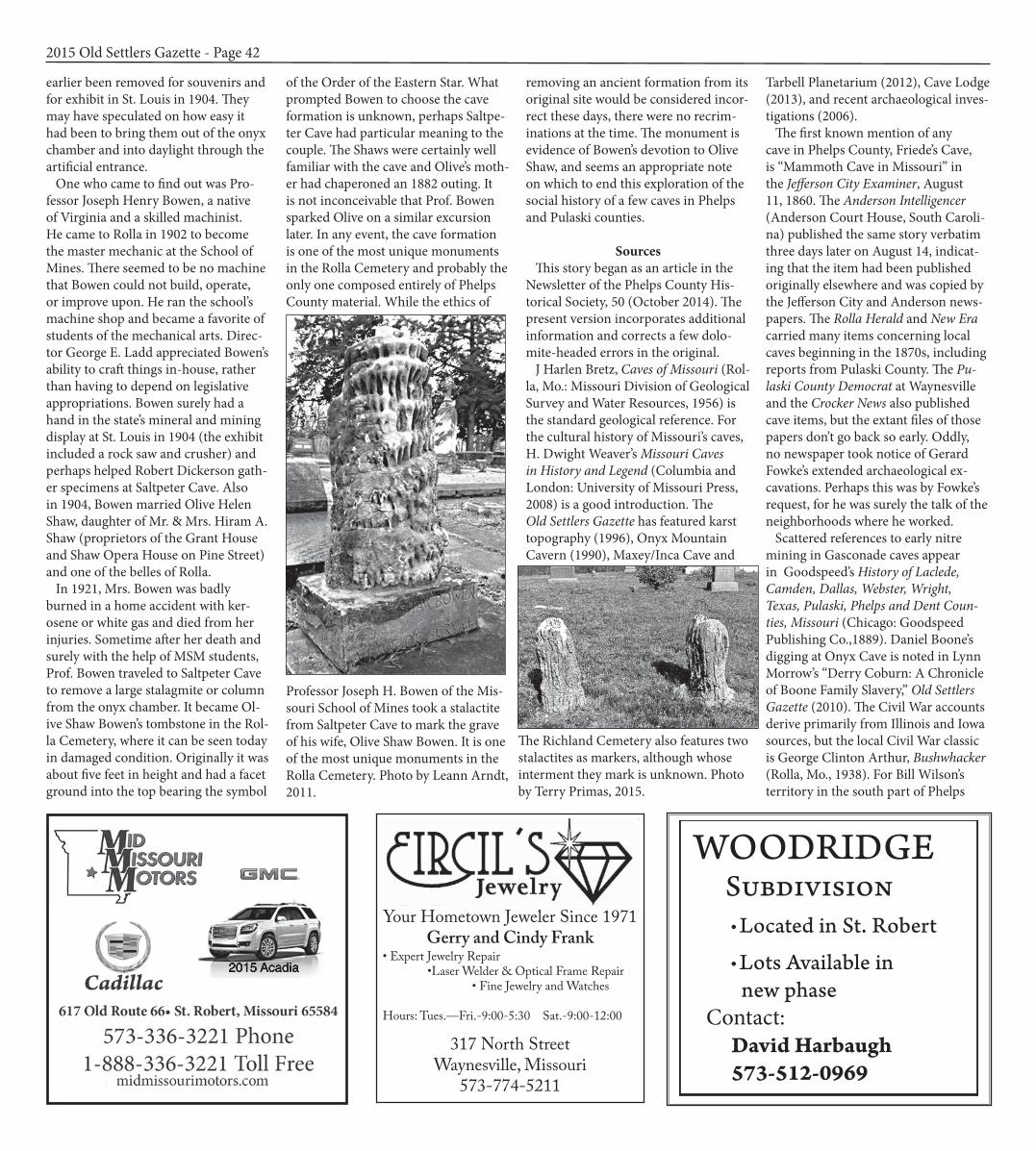
earlier been removed for souvenirs and for exhibit in St. Louis in 1904. They may have speculated on how easy it had been to bring them out of the onyx chamber and into daylight through the artificial entrance. One who came to find out was Pro-fessor Joseph Henry Bowen, a native of Virginia and a skilled machinist. He came to Rolla in 1902 to become the master mechanic at the School of Mines. There seemed to be no machine that Bowen could not build, operate, or improve upon. He ran the school’s machine shop and became a favorite of students of the mechanical arts. Direc-tor George E. Ladd appreciated Bowen’s ability to craft things in-house, rather than having to depend on legislative appropriations. Bowen surely had a hand in the state’s mineral and mining display at St. Louis in 1904 (the exhibit included a rock saw and crusher) and perhaps helped Robert Dickerson gath-er specimens at Saltpeter Cave. Also in 1904, Bowen married Olive Helen Shaw, daughter of Mr. & Mrs. Hiram A. Shaw (proprietors of the Grant House and Shaw Opera House on Pine Street) and one of the belles of Rolla. In 1921, Mrs. Bowen was badly burned in a home accident with ker-osene or white gas and died from her injuries. Sometime after her death and surely with the help of MSM students, Prof. Bowen traveled to Saltpeter Cave to remove a large stalagmite or column from the onyx chamber. It became Ol-ive Shaw Bowen’s tombstone in the Rol-la Cemetery, where it can be seen today in damaged condition. Originally it was about five feet in height and had a facet ground into the top bearing the symbol
of the Order of the Eastern Star. What prompted Bowen to choose the cave formation is unknown, perhaps Saltpe-ter Cave had particular meaning to the couple. The Shaws were certainly well familiar with the cave and Olive’s moth-er had chaperoned an 1882 outing. It is not inconceivable that Prof. Bowen sparked Olive on a similar excursion later. In any event, the cave formation is one of the most unique monuments in the Rolla Cemetery and probably the only one composed entirely of Phelps County material. While the ethics of
removing an ancient formation from its original site would be considered incor-rect these days, there were no recrim-inations at the time. The monument is evidence of Bowen’s devotion to Olive Shaw, and seems an appropriate note on which to end this exploration of the social history of a few caves in Phelps and Pulaski counties.
Sources This story began as an article in the Newsletter of the Phelps County His-torical Society, 50 (October 2014). The present version incorporates additional information and corrects a few dolo-mite-headed errors in the original. J Harlen Bretz, Caves of Missouri (Rol-la, Mo.: Missouri Division of Geological Survey and Water Resources, 1956) is the standard geological reference. For the cultural history of Missouri’s caves, H. Dwight Weaver’s Missouri Caves in History and Legend (Columbia and London: University of Missouri Press, 2008) is a good introduction. The Old Settlers Gazette has featured karst topography (1996), Onyx Mountain Cavern (1990), Maxey/Inca Cave and
Tarbell Planetarium (2012), Cave Lodge (2013), and recent archaeological inves-tigations (2006). The first known mention of any cave in Phelps County, Friede’s Cave, is “Mammoth Cave in Missouri” in the Jefferson City Examiner, August 11, 1860. The Anderson Intelligencer (Anderson Court House, South Caroli-na) published the same story verbatim three days later on August 14, indicat-ing that the item had been published originally elsewhere and was copied by the Jefferson City and Anderson news-papers. The Rolla Herald and New Era carried many items concerning local caves beginning in the 1870s, including reports from Pulaski County. The Pu-laski County Democrat at Waynesville and the Crocker News also published cave items, but the extant files of those papers don’t go back so early. Oddly, no newspaper took notice of Gerard Fowke’s extended archaeological ex-cavations. Perhaps this was by Fowke’s request, for he was surely the talk of the neighborhoods where he worked. Scattered references to early nitre mining in Gasconade caves appear in Goodspeed’s History of Laclede, Camden, Dallas, Webster, Wright, Texas, Pulaski, Phelps and Dent Coun-ties, Missouri (Chicago: Goodspeed Publishing Co.,1889). Daniel Boone’s digging at Onyx Cave is noted in Lynn Morrow’s “Derry Coburn: A Chronicle of Boone Family Slavery,” Old Settlers Gazette (2010). The Civil War accounts derive primarily from Illinois and Iowa sources, but the local Civil War classic is George Clinton Arthur, Bushwhacker (Rolla, Mo., 1938). For Bill Wilson’s territory in the south part of Phelps
2015 Old Settlers Gazette - Page 42
Professor Joseph H. Bowen of the Mis-souri School of Mines took a stalactite from Saltpeter Cave to mark the grave of his wife, Olive Shaw Bowen. It is one of the most unique monuments in the Rolla Cemetery. Photo by Leann Arndt, 2011.
The Richland Cemetery also features two stalactites as markers, although whose interment they mark is unknown. Photo by Terry Primas, 2015.
2015 Acadia
Your Hometown Jeweler Since 1971Gerry and Cindy Frank
• Expert Jewelry Repair•Laser Welder & Optical Frame Repair
• Fine Jewelry and Watches
Hours: Tues.—Fri.-9:00-5:30 Sat.-9:00-12:00
317 North Street Waynesville, Missouri
573-774-5211
WOODRIDGE Subdivision l Located in St. Robert
l Lots Available in new phase Contact: David Harbaugh 573-512-0969

County, see also Cecil King’s History of Yancy Mills (1996) and Garrett Gabel, Days of Yore (Rolla, Mo.: 2014). Prof. A. J. Conant’s archaeological in-vestigations were reported by the Rolla New Era, November 20, 1875, and Rolla Herald, November 11, 1880. William J. Seever’s memorandum of his 1894 reconnaissance of the Gasconade River caves is at the State Historical Society of Missouri. The St. Louis Republic published an extensive interview with Seever’s colleague, Rev. A. L. Love, on August 19, 1894 (reprinted in the Rolla Herald on August 30). Gerard Fowke’s investigations in Phelps and Pulaski counties were reported in “Cave Explo-rations in the Ozark Region of Central Missouri,” Smithsonian Institution Bu-reau of American Ethnology Bulletin 76 (Washington, DC: Government Print-ing Office, 1922). For modern archaeology, see Ralph G. Roberts, “Tick Creek Cave: An Archaic Site in the Gasconade River Valley of Missouri,” Missouri Archaeologist 27, No. 2 (April 1965); R. Bruce McMillan, “Gasconade Prehistory: A Survey and Evaluation of the Archaeological Re-sources,” Missouri Archaeologist 27, No. 3-4 (July-October 1965); and Richard Edging, “From Daltons to Shamans: Ten Thousand Years of Pulaski County Prehistory,” Old Settler’s Gazette (2006). The best modern study, based on more than a decade of research at Fort Leon-ard Wood, is Steven R. Ahler, Paul P. Kreisa and Richard Edging, Marginality and Continuity: the Archaeology of the Northern Ozarks (Springfield, Mo.: Mis-souri Archaeological Society, 2010). For onyx mining, see H. Dwight Weaver’s Missouri Caves in History
and Legend and his “Report on Cave Onyx Mining in Missouri,” National Speleological Society News 17, No. 4 (June 1959): 81-83. Mining at Onyx Cave is described in Ignatius J. Staub-er and Fred R. Hoeberlin, “Report on the Onyx Deposits of Boiling Springs Cave,” Bachelor of Science Thesis, Mine Engineering, Missouri School of Mines, May 1901. See also Milan Harrison Detweiler and Frank Edgar Townsend, “Mine Map and Geology of Saltpeter Cave,” Bachelor of Science Thesis, Min-ing Engineering, Missouri School of Mines, 1911. The thesis is exactly as the title suggests, but, in connection with the cave’s name, the authors reported local folklore that Confederate soldiers secured mined guano at Saltpeter.
The photograph albums of MSM students B. F. Cody (Class of 1911), Harmon Minor (Class of 1910), and Dr. Charles L. Dake are in the Archives at Missouri S&T. All three albums contain photos of Saltpeter Cave. Prof. Dake’s photos date to about 1920.
Acknowledgements For keeping me from straying too far beyond the natural light, thanks to Leann Arndt, Susan Dunn, Beth Lane, Melody Lloyd, Terry Primas, Book-er Rucker, Mike Siemens, Erika Van Vranken, Jerry Vineyard, and Dwight Weaver.
2015 Old Settlers Gazette - Page 43
Pike’s Peak Cave (also known as Kraft, Roubidoux, Indian, and Swanson Cave) has been the site of considerable activity including prehistoric occupation, saltpeter mining, and commercial use as a saloon and dance hall. B. F. Scott built tourist accommodations at the cave in the 1920s. During World War Two, it was a recre-ational center for army officers and their guests. Courtesy of Jan and Terry Primas.
3 GI’s Found After 30 Hrs. in Indian Cave
Three Fort Leonard Wood soldiers lost in what is known as “Indian Cave” or “ Swanson Cave” three miles north of Waynesville on Highway 17 were found Monday evening around eight o’clock by a group of spelunkers from the University of Missouri at Rolla. The seven-man team was headed by Dr. James Maxwell of the UMR faculty. Dr. Maxwell said the three men, identified by Army authorities as Pfc. David H. Box, 19, DeLeon, Tex., Pfc Steven D. Lasky, 20, Ilion, N. Y. and Spc 4 Alber Perswill, 21, of Houston, Tex., signed out of the post at 3 p.m. Sunday. They said they were going to explore the former commercial cave, known both as Roubidoux Cave and Indian Cave. When they failed to report for duty Monday morning, the search was started. Their car was found near the cavern and clothing was found inside the mouth of the cave. Col. Willard Harrison, chief of staff at Fort Leonard Wood, directed the search, with the Missouri Highwya Patrol, the Pulaski County sheriff ’s office, detachment from the provost marshal’s office at the fort, and the Rolla “spelunkers,” under his com-mand. The three men were found about 8:15 p.m. and were taken from the scene to Fort Leonard Wood Hospital for observation. Reports from the cave said the three appeared in “good con-dition.”—Pulaski County Democrat, April 4, 1968
Shipping: 400 Marshall Drive, Ste. 3St. Robert , MO 65584
Phone: 573-336-7255
“Guaranteed Not To Be Undersold”0$ Down - 12 Months Same as Cash
PPAAUULL ’’SS FFuurrnn ii ttuu rreeOOuutt ll ee tt
• Ashley • Frigidaire• Maytag • Flexsteel• La-Z-Boy
114 Town Center Blvd.St. Robert, MO 65584
Phone 573-336-2888 Fax 573-336-2884
Phone573-674-1382
9 a.m. - 5 p.m.Monday - Saturday
• Buy• Sell
•Trade
Highway 32 East, Licking, Mo.Across from Licking Livestock