2015 hobart airport master plan - hobart international airport · 2015 hobart international airport...
TRANSCRIPT

2015 Hobart Airport
Master Plan


This Master Plan has been prepared by
Hobart International Airport Pty Ltd (HIAPL)
(ABN 27080 919 717).
This Master Plan, and the assessments, forecasts,
assumptions and strategies contained in this
Master Plan, have been prepared as part of Hobart
Airport’s internal strategic planning processes and
is in accordance with Part 5 of the Airports Act
1996, and should not be relied upon by any other
person for any other purpose.
While all care has been taken in development of
this Master Plan it is based on certain forecasts and
assumptions and is subject to change. As a result
the proposed development details are indicative
only, there is no commitment that they will occur.
© Hobart International Airport Pty Ltd

2015 Hobart International Airport Master Plan | i
Foreword
ForewordWe are pleased to present Hobart Airport’s 2015
Master Plan. The 2015 Plan outlines and reflects Hobart
Airport’s vision for growth and the delivery of strategic
infrastructure to meet demand and to better connect
Tasmania with the rest of Australia and the world.
In 2016 Hobart Airport will celebrate 60 years of
operations. As the Hobart and Tasmanian community
continue to grow, so will the demand for air transport
for both passengers and freight. Since its privatisation
in 1998 Hobart Airport has grown from 856,000 to 2.1
million passengers per year. By 2020 we are expecting to
welcome an additional half a million passengers per year
and more than four and a half million per year by 2035.
To be able to support the growth of the Tasmanian
economy and meet the expectations of our passengers
and partners, Hobart Airport will undertake two
transformative projects over the next five year period.
These projects will significantly redefine the airport and
provide new economic opportunities for the State.
The construction of a 500m runway extension will
enable direct flights from Tasmania to South-East Asia
for passenger and freight opportunities and allow
for expansion of current Antarctic operations. The
redevelopment of the airport’s passenger terminal will
offer an improved experience for airport visitors and
cater for projected growth and enable international
passenger processing.
These projects will enable operation of direct flights to
Asia for tourism, the export of time sensitive products
(including key produce exports) and will enable increased
logistic opportunities for Antarctic operations for both
Australia and other Nations operating research programs
in East Antarctica.
The Master Plan also provides plans for the continued
development of the airport’s non-aviation activities,
which underpin the long term economic viability of
Hobart Airport and complement its key aviation role, and
for the protection of areas of environmental significance
on the airport site.
In addition, the 2015 Master Plan addresses key matters
facing the airport including how it interacts with
important road networks such as Tasman Highway and
the need to be vigilant in ensuring the unhindered long
term operation at Hobart Airport.
Importantly, the plans provided in the 2015 Master Plan
will allow Hobart Airport to build upon the foundations
it has developed over the past 60 years and reinforce
the role of the airport as a critical piece of State
infrastructure and an essential part of the Tasmanian
community.
Hobart Airport’s vision for the next 20 years is to
be Tasmania’s premier airport providing a boutique
experience for our visitors and an economic hub that
delivers opportunity and growth for the Tasmanian
Community. With the support of our stakeholders and
partners we will continue to grow and operate Hobart
Airport in a responsible manner.
Every five years the airport develops a Master Plan;
this plan is the way we clearly communicate our plans
with the community and key stakeholders. We value
the opportunity to seek your feedback on our plans and
welcome your comments.
Rod Parry
CEO Hobart Airport
2015 Hobart International Airport Master Plan | ii
Con
tent
s Contents1 Introduction ..............................................................1
1.1 Overview ................................................................2
1.2 Vision for Hobart Airport ..................................
1.2.1 Development Objectives ................4
1.3 History of Hobart Airport ...............................5
1.4 Hobart Airport Today .......................................6
1.5 Airlines and Tenants .........................................8
1.6 Developments since 2009 .............................9
1.7 Previous Master Plans .................................. 10
2 Economic Benefit ................................................... 11
2.1 Introduction ....................................................... 12
2.2 Hobart Airport’s economic
contribution ...................................................... 12
2.3 Social Impacts .................................................. 14
2.4 Capital Investment ........................................ 15
3 National Policy and Regulatory Framework .... 17
3.1 Introduction ...................................................... 18
3.3 Airport Regulation 1997 .............................. 23
3.4 Airport (Environment Protection)
Regulations 1997 ............................................ 24
3.5 Environment Protection and
Biodiversity Conservation Act 1999 ........ 24
3.6 National Airports Safeguarding
Framework ........................................................ 25
3.7 State and Local Regulations ....................... 26
3.7.1 State Coastal Policy 1996 ............ 28
3.7.2 Southern Tasmania Regional Land
Use Strategy 2010-2035 .............. 28
3.7.3 Southern Tasmania Industrial
Land Strategy 2013 ........................ 29
3.7.4 Clarence Planning Scheme ......... 30
3.7.5 Sorrell Draft Interim Planning
Scheme 2014 ................................... 31
3.7.6 Recent Planning Decisions ......... 32
4 Land Use and Precinct Development ................. 33
4.1 Overview and Objectives.............................. 34
4.2 Master Plan Precincts ................... 35
4.2.1 Runway Precinct .............................. 38
4.2.2 Terminal Precinct ............................. 38
4.2.3 Aviation Precincts ........................... 40
4.2.4 Local Business Precinct ................................. 41
4.2.5 Tourism/Mixed Use Precinct ...................... 42
4.2.6 Environment Precinct .................................... 43
4.2.7 Light Industrial Precinct .............................. 43
5 Air Traffic Forecasts ................................................ 47
5.1 Introduction to Growth Forecasts ........... 48
5.1.2 Future Passenger Growth ............ 49
5.2 Forecasting for Design (Annual Busy
Day and Busy Hour Demand) .................... 50
5.2.1 Busy Hour Forecasts ...................... 51
5.2.2 International ..................................... 52
6 Passenger Terminal Planning .............................. 53
6.1 Planning Approach ......................................... 54
6.1.1 Existing Situation ............................ 54
6.1.2 2020 Terminal Design .................... 56
6.2 Planning Considerations .............................. 58
6.2.1 Passenger Terminal Plan .............. 59
7 Airfield Development ................................................... 61
7.1 Introduction ....................................................... 62
7.2 Existing Runway ............................................... 62
7.3 Existing Taxiway System ............................... 64
7.4 Existing Aprons ................................................ 64
7.4.1 Passenger Aircraft Apron .............. 64
7.4.2 Freight and GA Apron ................... 65
7.4.3 Existing Freight Operation ........... 65
7.4.4 Existing GA Operation ................... 65
7.6 Proposed Runway Extension ....................... 65
7.6.1 Introduction ....................................... 65
7.6.2 Runway Extension Description . 67
7.7 Future Taxiway System ................................. 68
7.7.1 Parallel Taxiway ................................ 68
7.7.2 New Link Taxiways .......................... 68
7.8 Future Aprons ................................................... 68
7.8.1 Passenger Aprons ........................... 68
7.8.2 Multiple Use Aprons ..................... 69
7.8.3 Freight Apron .................................... 69
7.8.4 Future General Aviation
Development ..................................... 69
7.9 Planning considerations ............................... 69
2015 Hobart International Airport Master Plan | iii
8 Landside Transport ......................................................... 71
8.1 Introduction ....................................................... 72
8.2 About the Ground Transport Plan ............ 72
8.2.1 Ground Transport Aims ................ 72
8.2.2 Objectives of the Ground
Transport Plan .................................. 73
8.2.3 Consultation ...................................... 73
8.2.4 Plans and Strategies Considered 73
8.3 Existing Ground Transport System .......... 74
8.3.1 Internal Roads .................................. 75
8.3.2 External Roads ................................. 75
8.3.3 Parking ................................................ 78
8.3.4 Public Transport .............................. 78
8.3.5 Rental Car ........................................... 79
8.3.6 Active Transport Network ............ 79
8.3.7 Freight and Logistics ...................... 80
8.4 Ground Transport Demand ......................... 80
8.4.1 Existing transport demand by
mode ..................................................... 80
8.4.2 Current Daily Vehicle Demand . 80
8.4.3 Future Daily Vehicle Demand .... 80
8.5 Proposed Ground Transport
8.5.1 External Roads ................................. 82
8.5.2 Internal Roads .................................. 82
8.5.3 Parking ................................................. 84
8.5.4 Taxi and Rentals ............................... 84
8.5.5 Active Transport ............................... 84
8.5.6 Public Transport ............................... 84
9 Other Aviation Uses ............................................... 89
9.1 Air Services Australia .................................... 90
9.1.2 Aviation Rescue and Fire Fight
Services (ARFFS) ............................... 91
9.2 Airport Operational Services ..................... 92
9.2.1 Navigational and Land Aids ....... 92
9.2.2 Ground Based Augmentation
System (GBAS) ................................. 92
9.3 Airport Lighting ................................................ 92
9.3.1 Future Development ..................... 92
9.4 Airside Signage ................................................ 93
9.5 Airline Support Facilities ............................. 93
9.5.1 Airline Catering ............................... 93
9.5.2 Aircraft Refuelling ........................... 93
9.5.3 Ground Service Support .............. 93
10 Utilities and Services Infrastructure .................. 95
10.1 Existing Services and Future Planning .. 96
10.2 Future Development ...................................... 97
11 Airspace Protection ................................................ 99
11.1 OLS and PANS-OPS ........................................100
11.2 Proposed changes to OLS and
PANS-OPS ..........................................................100
12 Aircraft Noise ....................................................... 105
12.1 Introduction ....................................................106
12.2 Background .....................................................106
12.3 Noise Forecasting .........................................106
12.4 ANEF / ANEC ....................................................107
12.4.1 Limitations of ANEF ......................107
12.4.2 Preferred approach to planning
decisions and noise exposure ..107
12.4.3 N70 / N60 108
12.4.4 Scenarios109
12.5 Noise Modelling Methodology ...............109
12.6 Noise Modelling Results ............................114
12.6.1 Ultimate ANEF ...............................114
12.6.2 ANECS and N60 / N70 ................114
12.6.3 Comparison between 2009
and 2015 ANEF ..............................114
12.7 Approach to managing aircraft noise
intrusion ...........................................................114
13 Environment ......................................................... 119
13.1 Environmental Management ...................120
13.2 Environment Strategy ................................126
13.2.1 Resource Use ...................................126
13.2.2 Land ....................................................127
13.2.3 Surface Water and
Groundwater ..................................129
13.2.4 Biodiversity ......................................130
13.2.5 Cultural Heritage ..........................132
13.2.6 Air Quality ........................................133
13.2.7 Ground-Based noise ....................134
13.2.8 Hazardous Materials ...................135
14 Consultation Program ........................................ 137
14.1 Informal Consultation .................................139
14.2 Formal pre-release consultation ............139
14.3 Formal public comment period
consultation.....................................................140
14.4 Submission to the Minister.......................140
14.5 Publication of Final Master Plan .............140
15 Implementation.................................................... 141
15.1 Phasing of the Development ....................142
16 References ......................................................... 147 Appendix ......................................................... 148
Public Consultation Period – Submissions and
Responses
Contents

2015 Hobart International Airport Master Plan | iv
Figu
res Figures
Figure 1.a Hobart Airport and surrounds ............................. 3Figure 1.b Located 17km from Hobart city Hobart
Airport occupies approximately 565 ha of land. ............................................................ 6
Figure 1.c Current Airport Layout ............................................ 7Figure 2.b Hobart Airport economic contribution .........13Figure 3.a Extract from Southern Tasmania Industrial
Land Strategy – recommended sites in Clarence (p.30) ...........................................................29
Figure 3.b Clarence Planning Scheme 2007 Airport buffer overlay (sheets 13 and 14) ......................30
Figure 3.c Excerpt from Clarence Draft Interim Planning Scheme 2014 map showing the airport land unzoned, with the exception of the two freehold properties that are zoned Light Industrial (pink) ..........................................................31
Figure 4.a 2009 Hobart Airport Master Plan ....................36Figure 4.b 2015 Land Use Precinct Plan .............................37Figure 4.c Photograph of Runway, Terminal and
Aviation Precincts .....................................................39Figure 5.a Total Domestic Passenger Movements at
Hobart Airport January 1996 to 2014 ...........48Figure 5.b Busy Hour and Stand Demand
Methodology .............................................................50Figure 6.a Current Hobart Airport passenger
terminal layout ..........................................................55Figure 6.b 2020 terminal design for Hobart Airport’s
passenger terminal. ...............................................57Figure 6.c Planning Considerations .......................................58Figure 6.d Ultimate (2035) Terminal Master Plan ...........60Figure 7.b Runway Overlay Work ............................................62Figure 7.a Existing Airfield Layout at Hobart
Airport .........................................................................63Figure 7.c Illustration indicating aircraft parking options
on the passenger apron at Hobart Airport. Larger aircraft is indicative of a B777-200 aircraft. .........................................................................64
Figure 7.d Future Airfield Developments ............................66Figure 7.e Range Curves for existing and future
scenarios for a B787 with a viable payload .........................................................................67
Figure 8.a Existing kerbside facilities at Hobart Airport .........................................................................74
Figure 8.b Existing internal road network and parking areas ..............................................................76
Figure 8.c Existing external road network .........................77Figure 8.d Bus routes in the vicinity of Hobart
Airport .........................................................................78Figure 8.e Proposed Clarence Cycle Network
(Bicycle Network Tasmania) .................................79Figure 8.f Total project daily vehicle trips (2015 – 2035) b .........................................................81Figure 8.g Future Transport Network (0-5 years) ............82Figure 8.h Future Transport Network (5-20 years) ...........83Figure 8.i 0-5 year terminal precinct
implementation plan ..............................................85Figure 8.j 5-20 year terminal precinct
implementation plan .............................................87Figure 9.a Air Traffic Control Tower and Llanherne
House .........................................................................90Figure 11.a Splay angles .............................................................100 Figure 11.b OLS for Hobart Airport. ......................................102Figure 11.c ANS-OPS changes 2009 and 2015 ................102Figure 11.d Revised PANS-OPS for Hobart Airport ..........103Figure 11.e Hobart Airport PANS-OPS ..................................103Figure 12.a Example Noise Levels
(Source: www.aircraftnoise.com.au, Airservices Australia and Australian Airports Association) ....................108
Table 12.a Modelled future noise scenarios ....................109Figure 12.c Flight tracks – departures .................................110Figure 12.b Flight tracks – arrivals .........................................110Figure 12.e Circuit tracks ............................................................111Figure 12.d Helicopter tracks ....................................................111Figure 12.f Draft ultimate capacity ANEF ..........................112Figure 12.g Ultimate Practical Capacity ANEF –
flight movement schedule and AS2012 Table 2.1 .....................................................................113
Figure 12.i 2035 (with extended runway) ANEC contour ......................................................................115
Figure 12.h 2014 (current runway) ANEC contour ........115Figure 12.k 2035 (extended runway) N
70 contour
for the 12day time period (07:00am – 7:00pm) ......................................................................116
Figure 12.j 2014 (current runway) N70
contour for the day time period (07:00am – 7:00pm) .....................................................................116
Figure 12.m 2014 (current runway) N60
contour for the night time period (7:00pm to 7:00am) .....................................................................117
Figure 12.l 2035 with Runway Extension N60
Contour - night time period (7:00pm - 7:00am) ......................................................................117
Figure 12.o 2035 with Runway Extension N60
Contour - night time period (7:00pm - 7:00am) ......................................................................118
Figure 12.n 2014 (current runway) N60
contour for the night time period (7:00pm to 7:00am) .....................................................................118
Figure 13.a Hobart Airport’s Safety, Security and Environment Policy ......................................121
Figure 13.b Hobart Airport ESAs and Llanherne House ......................................................................124
Figure 13.c Vegetation significance within ESA areas ...125Figure 13.d Llanherne House ....................................................132Figure 15.a Hobart Airport implementation program
(mapped activities) ................................................143Figure
Appendix.a Greuber Avenue alignment
options 1 and 2. ....................................................155

1 Introduction
2015 Hobart International Airport Master Plan | 2
1 Introduction
1.1 Overview
Operated by Hobart International Airport Pty Ltd
(HIAPL), Hobart Airport is the ninth busiest airport in
Australia and the busiest airport in Tasmania. It is the
principal aviation gateway to the city of Hobart and the
southern Tasmanian region and a critical piece of State
infrastructure.
The airport (as shown in Figure 1.a) has operated on the
same site for nearly 60 years and is strategically located
to serve many of the fastest growing residential areas in
Tasmania and the greater Hobart area.
The airport is a key economic hub for Tasmania and a site
of employment for more than 731 full time staff. During
the past five years Hobart Airport has experienced one of
the highest growth rates by any airport not supporting
mining operations and in 2014 the Airport delivered a
direct and indirect economic contribution to the State
of Tasmania of $142.5M. It is forecast that by 2035 this
contribution will increase to more than 1,000 full time
jobs and an economic contribution to the State in excess
of $220 million. The proposals detailed in the 2015
Master Plan will allow Hobart Airport to build upon this
foundation and continue to be a strong contributor to
opportunity and growth for the Tasmanian community.
Hobart is also Australia’s Antarctic ‘Gateway’ and a global
Gateway to the East Antarctic. Hobart is the location of
the world’s largest single concentration of Antarctic and
Southern Ocean research, as well as co-located logistics
operations. Hobart Airport is the base for the Australian
Antarctic Division’s aviation operations. The development
of Hobart Airport’s infrastructure to support future
Antarctic operations of Australian and other Antarctic
programs is essential for the growth of this important
economic and nationally strategic sector.
The 2015 Master Plan reflects Hobart Airport’s vision
for growth and the delivery of strategic infrastructure to
better connect Tasmania with the rest of Australia and
the world. The forecast passenger projections presented
in this Master Plan, forecast an average annual growth
rate of five percent during the next 20 years to 2035.
The development of facilities required to accommodate
this growth, with a focus on the developments required
during the next five years, are set out in this Master Plan.
During the next five years, Hobart Airport plans to
undertake two transformative projects that will
significantly redefine and improve the operations of the
airport:
• The construction of a 500m runway extension to
enable direct flights from Tasmania to South-East
Asia for passenger and freight opportunities and
allow for improved operational flexibility and the
further development of Antarctic aviation programs;
and
• Changes to the layout and size of the passenger
terminal, which will offer an improved experience
for airport visitors and is designed meet capacity
demands through to 2023.
The Master Plan is the key planning document for the
Airport under the Airports Act 1996 (Cth) (Airports Act)
and is used to guide the development of both aviation
and non-aviation uses at the airport, the assessment
of environmental effects of airport developments and
operation, and for the provision of information to the
Hobart community and airport stakeholders. This
Master Plan is proposed to apply for a planning period
of 20 years.
A key component of the 2015 Master Plan is the land use
strategy for the airport site. Hobart Airport’s land use
strategy reflects the fact that Hobart Airport will need
to grow and develop to meet demand as Tasmania, and
in particular southern Tasmania, continues to grow. It
sets out the framework to guide the airport’s growth
to enable it to meet increased demand for aviation,
tourism and freight services. It also seeks to strike a
balance between the airport’s focus on and the growth in
aviation related activities and the need for non-aviation
development and uses to support the airport.
1
In
trod
uct
ion

2015 Hobart International Airport Master Plan | 3
1 Introduction
Hob
art
Airp
ort
Mid
way
Poin
t
Sore
ll
Lew
isha
m Car
lton
Cam
brid
geAi
rpor
tBar
illa
Bay
Fred
eric
kH
enry
Bay
Tasm
anH
wy
Tasm
ania
Gol
f Cou
rse
Llan
hern
eG
olf C
ours
e
Seve
nM
ile B
each
Pittw
ater
Rd
Hollyman
Ave
Tasm
anHwy
Arthur Hwy
Sou
rce:
Esr
i, D
igita
lGlo
be, G
eoE
ye, i
-cub
ed, U
SD
A, U
SG
S, A
EX
, Get
map
ping
, Aer
ogrid
, IG
N, I
GP,
swis
stop
o, a
nd th
e G
IS U
ser C
omm
unity
Hob
art
East
Coa
st
060
01,
200
1,80
02,
400
Met
res
[
Figu
re N
o
1.a
Coo
rdin
ate
Sys
tem
GD
A 19
94 M
GA
Zone
55
Scal
e at
A4
1:60
,000
Dra
win
g Ti
tle
Hob
art A
irpor
t and
sur
roun
ds
Figu
re 1
.a H
obar
t A
irpo
rt a
nd s
urro
unds
2015 Hobart International Airport Master Plan | 4
In addition to its core aviation business and development,
non-aviation development is essential to the long term
economic viability of Hobart Airport and compliments its
key aviation role. Non-aviation development at Hobart
Airport has occurred successfully since privatisation in
1998 and Hobart Airport currently has approximately
36 tenants that directly support aviation business and
approximately 27 tenants that are not directly related
to aviation. Development of non-aviation uses are led by
market demand.
Another important component of the 2015 Master
Plan is the environment strategy, which applies for five
years. In developing its environment strategy, HIAPL has
considered the importance of environmental values
present at the airport and the value of the environment to
the State of Tasmania. The airport site includes areas that
are environmentally significant at both Commonwealth
and State levels. The Master Plan, land use plan and
environment strategy strives to achieve a sustainable
balance between airport operations, environmentally
sensitive areas and planning for the growth of Hobart
Airport.
For that reason the land use plan incorporates a number
of environmental precincts that consist of areas of
remnant natural vegetation, designated areas of cultural
significance or areas prone to flooding. Any allowable work
in these areas will support the protection, enhancement
and appreciation of the natural environment and the
cultural values of the site.
Hobart Airport has been recognised for its importance
to the State, as a port for movements of passengers and
time sensitive products (such as key produce exports).
In particular, it has been recognised that any negative
economic impact to Hobart Airport by potential constraints
to its future operations may pose a risk to the economic
development of the region and the State.
Due to its location away from higher density residential
areas, Hobart Airport has been fortunate to avoid conflict
with surrounding land use and development, with
the consequence that its curfew-free status has been
maintained. However increasing residential development
pressure in those areas adjacent to the airport highlights
the need for local and state government to continue having
regard to best practice and guidelines to assist in the
assessment and approvals for land use and development
on and around airports.
1.2 Vision for Hobart Airport
HIAPL’s vision for Hobart Airport is to be Tasmania’s premier
airport providing a boutique airport experience for our
visitors and an economic hub that delivers opportunity and
growth for the Tasmanian community.
Since the 2009 Master Plan over 11.7 million passengers
have travelled through Hobart Airport. In 2009 1.8
million passengers moved through the airport growing
to 2.1 million in 2014, an annual average growth of 2.6
percent. Looking forward Hobart Airport, working with
key partners is forecasting an annual growth rate of 4.2
percent. This growth has supported employment and
economic growth in the community and has been a key
component of the State’s strongly performing tourism
sector.
Over the next five years, Hobart Airport will deliver
strategic infrastructure that will provide new social and
economic opportunities for Tasmania to connect and do
business with the world.
By working with the community and developing our
business in a sustainable and responsible manner, Hobart
Airport will continue to grow as a key economic hub. It will
continue grow as a place of employment and provide the
essential social connectivity for our island state.
1.2.1 DevelopmentObjectives
To achieve this vision Hobart Airport has the following
development objectives:
• Ensure that Hobart Airport is operated and developed in a manner that is safe, secure, customer focused and sustainable, with a culture focused on excellence for quality and customer service;
• Provide a business environment with associated infrastructure that enables Hobart Airport and its partners to reach their potential;
• Enable the future growth of both the airport and the Tasmanian economy by planning and delivering infrastructure to meet demand;
• Develop Hobart Airport as a port to service international and domestic passengers travelling for tourism, business and personal reasons and in doing so improve Tasmania’s connectivity and economic success;
1
In
trod
uct
ion
2015 Hobart International Airport Master Plan | 5
• Develop Hobart Airport as an important freight port to service both international and domestic import and export requirements with a particular focus on the high value perishable market;
• Maximise the growth of Hobart Airport and in so doing support growth for the Tasmanian and Hobart economies;
• Develop Hobart Airport as a key Antarctic aviation hub for Australia and other nations;
• Achieve business diversification through the development of non-aeronautical land and businesses in order to provide fiscal support to future aeronautical infrastructure requirements and provide stability to the overall business;
• Continue to protect and conserve the important cultural and environmental heritage found at Hobart Airport; and
• Be an engaged and responsive member of the local
community.
1.3 History of Hobart Airport
The Hobart region was served initially by nearby
Cambridge Aerodrome until 1956, when Hobart Airport,
at Llanherne, was commissioned as the primary Regular
Passenger Transport (RPT) airport.
Hobart Airport’s original domestic terminal building
and runway were commissioned in 1956 and were
re-developed in 1976. An international terminal was
commissioned in 1983 to provide facilities for the
then trans-Tasman B727 service. The airport was
further upgraded in 1985 to cater for B767 aircraft,
with capability for handling weight restricted B747
operations. At the same time the international terminal
building was extended, additional apron and car park
facilities were constructed and the runway was extended
to its current length of 2,251 metres.
The Federal Airports Corporation assumed ownership
and control of both Hobart Airport and Cambridge
Aerodrome in January 1988, but sold Cambridge Airport
in March 1993. Under the terms of sale, Cambridge
Aerodrome must have been operated as an aerodrome
until June 2004. This requirement has now expired though
Cambridge Aerodrome, located to the north west of
Hobart Airport, remains as a General Aviation (GA) facility.
Hobart Airport was privatised in June 1998, with
HIAPL entering into a 99-year land lease with the
Commonwealth Government (50 years plus a 49 year
option). HIAPL bought the improvements and the
business at that time.
The Hobart Airport has been operated by HIAPL since
1998, originally with a mix of international and local
owners, but under full State ownership from 2004 as
component part of Tasmanian Ports Corporation Pty Ltd
(Tasports). In 2007, the State Government of Tasmania
took the decision to sell HIAPL to its current owners.
Since January 2008, HIAPL has been owned by the
Tasmanian Gateway Consortium - this consortium
comprises Macquarie Global Infrastructure Fund III, a
Macquarie-managed unlisted infrastructure fund with a
50.1 percent interest in Tasmanian Gateway Consortium,
and Retirement Benefits Fund Board, a Tasmanian
superannuation fund with a 49.9 percent interest in
Tasmanian Gateway Consortium.
Under the terms of the land lease, HIAPL is mandated
to operate the airport, to effect capital improvements
in accordance with the Airport Master Plan, protect the
environment and maintain the airport in good repair.
1 Introduction

2015 Hobart International Airport Master Plan | 6
1.4 Hobart Airport Today
Enjoying one of Australia’s most scenic approaches,
Hobart Airport is located 17 kilometres east of Hobart,
in the City of Clarence and occupies approximately 565
hectares of land (see Figure 1.b). The airport is served by
arterial roads linking it to the centre of Hobart and, via the
regional highway network, to other locations in the State.
The airport’s location, between the waterways of Barilla
Bay and Frederick Henry Bay, has served to minimise
adverse community noise impacts due to water bodies at
both ends, open space to the east and it is situated away
from higher density residential areas.
The airport is served by Australia’s four main passenger
airlines: Qantas and Qantas Link, Jetstar, Virgin Australia
and Tiger Airways. These airlines carried 2.1 million
passengers in 2014 calendar year to and from Hobart
Airport. Qantas Freight and Toll operate dedicated freight
operations from Hobart Airport. It also serves as a port
for the Royal Flying Doctor Service with more than 365
flights a year operating from Hobart Airport.
HIAPL’s airport operations include the provision of
aeronautical services and facilities, including the
following core airport infrastructure:
• A single runway system, Runway 12/30 that is
2,251m long, served by two taxiways;
• Taxiways linking the runway to aprons to the east
and south of the terminal - this taxiway and apron
infrastructure can cater for aircraft up to the size of a
747 aircraft, with weight restrictions applied;
• Ground handling facilities including fuel storage;
• An integrated domestic and international terminal
facility, with the two buildings connected by a central
check in hall, a baggage hall and a checked baggage
x-ray screening system;
• The Qantas Freight and Toll Air freight facilities;
• General Aviation facilities primarily to service rotary
wing (helicopter), Royal Flying Doctor Service and
private Jet aircraft;
• The Air Cargo freight facility leased by HIAPL to Sky
Trek Pty Ltd;
• Airservices Australia facilities and infrastructure
- navigation aids, aviation rescue and firefighting
services, air traffic control tower; and
• Road, parking, sewerage, drainage, electrical and
telecommunications reticulation.
The current airport layout is shown in Figure 1.c. The
Hobart Airport site contains both land that is leased
from the Commonwealth and freehold land. While the
freehold land is not covered by the Airports Act, for
completeness, this Master Plan identifies the proposed
land uses for both the freehold land adjacent to the
airport site as well as for the leasehold land subject to
the Airports Act.
1
In
trod
uct
ion
Figure 1.b Located 17km from Hobart city Hobart Airport occupies approximately
565 ha of land.

2015 Hobart International Airport Master Plan | 7
1 Introduction
Figu
re 1
.c C
urre
nt A
irpo
rt L
ayou
t
1415
1617
18
1
23
45
67
810
911
1213
Airp
ort A
rea
(leas
ehol
d la
nd)
Free
hold
Lan
d
Free
hold
Lan
d5
9
Sou
rce:
Esr
i, D
igita
lGlo
be, G
eoE
ye, i
-cub
ed, U
SD
A, U
SG
S, A
EX
, Get
map
ping
, Aer
ogrid
, IG
N, I
GP,
sw
isst
opo,
and
the
GIS
Use
r Com
mun
ity
020
040
060
080
0
Met
res
[
Figu
re N
o
1.c
Coo
rdin
ate
Sys
tem
GD
A 19
94 M
GA
Zone
55
Scal
e at
A4
1:20
,000
Dra
win
g Ti
tle
Cur
rent
Airp
ort L
ayou
t

2015 Hobart International Airport Master Plan | 8
1
In
trod
uct
ion 1.5 AirlinesandTenants
As at June 2015, the airport is served by four key
passenger airlines: Qantas, Jetstar, Virgin Australia and
Tiger Airways, with direct destinations shown in Table
1.a.
Table 1.a Hobart Airport Airline Destinations
Airline Domestic Destinations
Qantas Link and Qantas Melbourne, Sydney
Jetstar Melbourne, Sydney,
Brisbane
Virgin Australia Melbourne, Sydney,
Brisbane
Tiger Airways Melbourne
In developing the airfield development parameters as set
out in Chapter 7: Airfield Development, HIAPL considered
the future needs of all civil aviation users at the airport.
In particular, HIAPL focused on their requirements for an
efficient, safe and reliable set of infrastructure services
– services we intend to provide through upgrades to the
terminal and the roadways, aprons and taxiways.
Hobart Airport is also the base for the Australian
Antarctic Program with international flights to Wilkins
Aerodrome each summer. A key component of this
Master Plan is the extension of the Hobart Airport
runway, which will enable larger aircraft to service East
Antarctica, opening up economic possibilities for Hobart
and of strategic importance to Australia.
Other facilities and services provided by HIAPL and
its tenants include car rental, freight forwarding and
logistics, air traffic control, emergency, meteorological,
customs, immigration, retail, helicopter operations and
training, ground transport services and quarantine
services. Tenants are described further in Chapter 4: Land
Use and Precinct Development.
2015 Hobart International Airport Master Plan | 9
1 Introduction
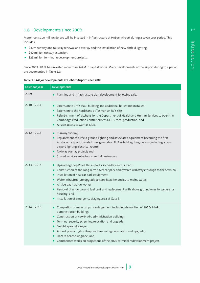
1.6 Developments since 2009
More than $100 million dollars will be invested in infrastructure at Hobart Airport during a seven year period. This
includes:
• $40m runway and taxiway renewal and overlay and the installation of new airfield lighting.
• $40 million runway extension.
• $25 million terminal redevelopment projects.
Since 2009 HIAPL has invested more than $47M in capital works. Major developments at the airport during this period
are documented in Table 1.b.
Table 1.b Major developments at Hobart Airport since 2009
Calendar year Developments
2009 • Planning and infrastructure plan development following sale.
2010 – 2011 • Extension to Britz Maui building and additional hardstand installed;
• Extension to the hardstand at Tasmanian RV’s site;
• Refurbishment of kitchens for the Department of Health and Human Services to open the
Cambridge Production Centre services DHHS meal production; and
• Airside access to Qantas Club.
2012 – 2013 • Runway overlay;
• Replacement of airfield ground lighting and associated equipment becoming the first
Australian airport to install new generation LED airfield lighting system(including a new
airport lighting electrical room);
• Taxiway overlay project; and
• Shared service centre for car rental businesses.
2013 – 2014 • Upgrading Loop Road, the airport’s secondary access road;
• Construction of the Long Term Saver car park and covered walkways through to the terminal;
• Installation of new car park equipment;
• Water infrastructure upgrade to Loop Road tenancies to mains water;
• Airside bay 4 apron works;
• Removal of underground fuel tank and replacement with above ground ones for generator
housing; and
• Installation of emergency staging area at Gate 5.
2014 – 2015 • Completion of main car park enlargement including demolition of 1950s HIAPL
administration building;
• Construction of new HIAPL administration building;
• Terminal security screening relocation and upgrade;
• Freight apron drainage;
• Airport power high voltage and low voltage relocation and upgrade;
• Hazard beacon upgrade; and
• Commenced works on project one of the 2020 terminal redevelopment project.

2015 Hobart International Airport Master Plan | 10
1
In
trod
uct
ion 1.7 Previous Master Plans
The 2015 Master Plan is based on more than 20 years
of prior planning and reflects the growth and evolution
of the airport since the first Master Plan for the airport,
developed by the Federal Airports Corporation in 1991.
This initial plan was revised and updated in 1995 and
1997.
Following privatisation of Hobart Airport in June 1998,
HIAPL progressed the 1999 Airport Master Plan and this
was approved by the then Minister for Transport and
Regional Services. This plan was the first implemented
pursuant to the Airports Act 1996 and was in turn
updated by HIAPL in 2004. The 2009 Master Plan aligned
with and updated the 2004 plan, reflecting revised
forecast growth in passenger, freight and general
aviation.
Key differences between the 2009 Master Plan and
this 2015 Master Plan are as a result of changes to the
legislative requirements of the Airports Act in relation
to the requirements for an Airport Master Plan, notably
inclusion of the environment plan and ground transport
plan in the Master Plan. Other changes relate to the
proposed runway extension, changes to the long term
terminal design, and small modifications to the land
use plan. These are be discussed in detail in Chapter 4:
Land Use and Precinct Development, Chapter 8: Landside
Transport and Chapter 13: Environment.

2 Economic Benefit
2015 Hobart International Airport Master Plan | 12
2
E
con
omic
Ben
efit 2 Economic Benefit
2.1 Introduction
Hobart is the capital city and the largest population
centre in the State of Tasmania. The Greater Hobart
region is home to more than 216,000 persons (ABS 2012)
with the airport catchment area being approximately
300,000 people. Hobart is the base for government
and corporate businesses, health services and tertiary
education in Tasmania. It is the State’s main arrival point.
Hobart and the southern area of Tasmania have a diverse
economic base including significant aquaculture and
agriculture businesses, a strong base of professional
scientific institutions including CSIRO, Australian
Antarctic program, the Institute for Marine and Antarctic
Studies (IMAS) and the Menzies institute, home to the
University of Tasmania, public administration, health
care, manufacturing and a strong and vibrant tourism
and arts sectors.
Airports play an important and essential economic and
social role in a community, particularly for an island
community such as Tasmania. Strong connectivity and
access is essential for Hobart and Tasmania in developing
the attractiveness of Hobart as a place to live, conduct
business and build industry.
The operation of a major airport involves complex
relationships between the airport operator and various
entities, including airlines, freight companies, private
contractors and government agencies. Hobart Airport
contributes to the Tasmanian economy directly through
its core operations as an airport operator (direct
contribution) and through housing further industries in
the wider airport precinct (indirect contribution).
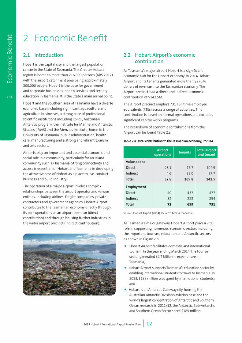
2.2 Hobart Airport’s economic contribution
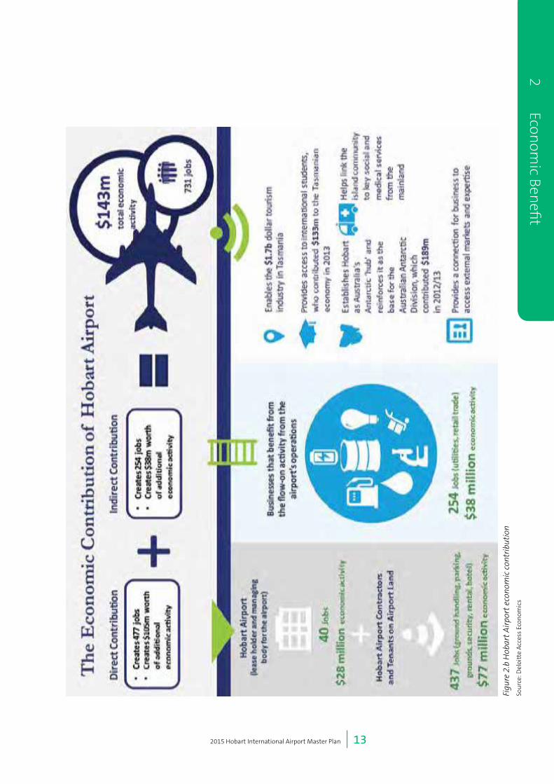
As Tasmania’s major airport Hobart is a significant
economic hub for the Hobart economy. In 2014 Hobart
Airport and its tenants generated more than $270M
dollars of revenue into the Tasmanian economy. The
Airport precinct had a direct and indirect economic
contribution of $142.5M.
The Airport precinct employs 731 Full time employee
equivalents (FTEs) across a range of activities. This
contribution is based on normal operations and excludes
significant capital works programs.
The breakdown of economic contributions from the
Airport can be found Table 2.a.
Table 2.a: Total contribution to the Tasmanian economy, FY2014
Airport operations
TenantsTotal airport and tenant
Value added
Direct
Indirect
Total
28.1
4.6
32.8
76.7
33.0
109.8
104.9
37.7
142.5
Employment
Direct
Indirect
Total
40
32
72
437
222
659
477
254
731
Source: Hobart Airport (2014), Deloitte Access Economics
As Tasmania’s major gateway, Hobart Airport plays a vital
role in supporting numerous economic sectors including
the important tourism, education and Antarctic sectors
as shown in Figure 2.b.
• Hobart Airport facilitates domestic and international
tourism. In the year ending March 2014, the tourism
sector generated $1.7 billion in expenditure in
Tasmania;
• Hobart Airport supports Tasmania’s education sector by
enabling international students to travel to Tasmania. In
2013, $133 million was spent by international students;
and
• Hobart is an Antarctic Gateway city, housing the
Australian Antarctic Division’s aviation base and the
world’s largest concentration of Antarctic and Southern
Ocean research. In 2011/12, the Antarctic, Sub-Antarctic
and Southern Ocean Sector spent $189 million.
2015 Hobart International Airport Master Plan | 13
2 Econom
ic Benefi
t
Figu
re 2
.b H
obar
t A
irpo
rt e
cono
mic
con
trib
utio
n
Sou
rce:
Del
oitt
e A
cces
s Ec
onom
ics

2015 Hobart International Airport Master Plan | 14
2
E
con
omic
Ben
efit During the next 20 years Hobart Airport will deliver an
important economic and social contribution driven by
developments and growth outlined in this 2015 Master
Plan. During this 20 year period and the life of this
Master Plan, Hobart Airport will generate more than $1.6
billion of revenue into the Tasmanian economy.
This contribution will be enhanced by outcomes
delivered by this 2015 Master Plan, so that by 2020:
• The direct and indirect economic contribution into
the Tasmanian economy in terms of Value Add will
increase to $164 million from $143 million today (an
increase of 15%);
• Direct FTEs will increase to 536 from 477 today (an
increase of 12%); and
• Total jobs (direct and indirect) will increase to 849
from 731 today (an increase of 16%).
Further, by 2035;
• The direct and indirect economic contribution into
the Tasmanian economy in terms of Value Add from
Hobart Airport will increase to $227 million from
$143 million today (an increase of 60 percent);
• Direct FTEs (full time employees) will increase to 663
from 477 today (an increase of 39 percent); and
• Total jobs both direct and indirect will increase to
1,031 from 731 today (an increase of 41 percent).
2.3 Social Impacts
Hobart Airport enhances the attractiveness of the region
for residents by providing easy connectivity to other
destinations for family, social, educational, medical and
other purposes as well as providing employment and
business opportunities in the region.
The creation of additional jobs as a result of the
developments proposed in this Master Plan, in addition
to the direct economic benefit, will also provide a social
benefit to the region, where these opportunities will
assist in reducing unemployment in the region and
provide locally based jobs for the people of south east
Tasmania.
As Tasmania’s major gateway, Hobart Airport plays a vital
role in supporting numerous economic sectors including
the important tourism, education and Antarctic sectors.
The increase in capacity and affordability of flights to and
from Hobart has enhanced the ease in which Tasmanians
can travel to and from the State. Regular, timely and
cost effective access combined with remote working
technologies enables a range of working arrangements
and employment opportunities for Tasmanians
allowing them to stay in, or return to, Hobart to live
while undertaking work interstate. This connectivity is
essential in attracting new residents to Hobart and plays
an important part in population growth for the State.
Hobart Airport plays an active role in the community
including its support of the Parkside Foundation. The
Foundation provides a wide range of flexible leisure
and recreational services for people with intellectual
disabilities in the greater Hobart area. Activities such
as horse riding, computer skills and art and craft are
provided in a variety of settings. One of these sites is
Llanherne Cottage located at Hobart Airport. Llanherne
Cottage provides an ideal venue for people to develop a
range of practical life skills and pre-vocational skills such
as preparation of meals, personal hygiene, grooming,
laundering, gardening and cleaning. Llanherne Cottage
is made available to The Parkside Foundation by Hobart
Airport as part of a community partnership with the
assistance of Kangaroo Bay Rotary Club.
Hobart Airport is also strongly engaged with the local
community through both the master planning process
and regular engagement via the Community Aviation
Consultation Group meetings held regularly. Hobart
Airport also contributes to the State economy indirectly
via its active participation in meetings of the Tasmanian
Tourism Industry Council, the Tasmanian Airports
Association, the Freight Logistics Network, the Tasmanian
Polar Network and the State Government Tasmanian
Access Group.
2015 Hobart International Airport Master Plan | 15
2 Econom
ic Benefi
t
There are also social impacts associated with the
operations of the airport and the development of the
proposals in this Master Plan, in particular the extension
of the runway and development of the passenger
terminal. HIAPL accepts that as Hobart Airport continues
to grow there will be an increase in the frequency of
flights, resulting in increased aircraft noise. HIAPL is
working to minimise the impacts of aircraft noise on
the region by working with the Clarence City Council to
ensure that only appropriate development occurs within
the vicinity of the airport.
Continued growth at the airport is also expected to
increase the demands on the roads network around
the airport. These issues, and the strategies HIAPL
has developed to mitigate and minimise any negative
impacts, are detailed in Chapter 8: Landside Transport
of this Master Plan.
2.4 Capital Investment
Hobart Airport will invest $100 million in a seven year
period to transform the State’s busiest gateway. During
the past three years, $40 million has been invested in
key infrastructure projects including the overlay of the
airport’s runway and taxiways, the renewal of the airfield
lighting to a leading LED solution, the renewal of the
airport’s secondary access road Loop Rd, the development
of a new saver car park, enlargement of the main car park
and the construction of a new administration building.
During the coming four year period, a further $65 million
will be invested in Hobart Airport. This includes a $40
million runway extension, enabled by funding assistance
of $38 million from the Australian Government, and an
additional $2 million from HIAPL. This project is part of
the Australian Government’s economic growth plan for
Tasmania and provides opportunities for direct flights for
passengers and cargo to South-East Asia an important
market for Tasmania’s primary producers and tourism
industry. The project will also provide opportunity for
Australia’s and other countries Antarctic programs to use
larger heavier lift aircraft from Hobart to the Antarctic
and significantly enhances Hobart’s competitiveness as
the leading Gateway for the East Antarctic.
A further $25 million will be invested in the
redevelopment of the airport’s passenger terminal, which
will include a larger departure lounge, centralised areas
for arrivals, international passenger processing areas
and a range of exciting new retail and dining spaces.
The first project for the terminal redevelopment is the
transformation of the arrivals hall, featuring designs
inspired by Tasmania’s environment, an indoor/outdoor
dining experience, the relocation of car rental desks
and an external forecourt area, all due for completion
in mid-2016. The redevelopment and expansion
of the departure lounge will follow. The terminal
redevelopment will showcase some of Tasmania’s best
food and tourism experiences. New dining options will
feature Tasmanian produce and producers.
These key projects, in addition to other minor
infrastructure projects, will ensure the airport continues
to grow and provide relevant and essential infrastructure
that provides opportunities to better service new
markets and provide social, economic growth for
Tasmania.

2015 Hobart International Airport Master Plan | 16
2
E
con
omic
Ben
efit
3 National Policy and Regulatory Framework
2015 Hobart International Airport Master Plan | 18
3
Nat
ion
al P
olic
y an
d Re
gula
tory
Fra
mew
ork 3 National Policy
and Regulatory Framework
3.1 Introduction
The 2015 Master Plan is an important document for
Hobart Airport, its community and for Local and State
Governments.
Each federally leased airport (including Hobart), must
have a final master plan. The purposes of a final master
plan are:
• To establish the strategic direction for efficient and
economic development at the airport during the
planning period of the plan;
• To provide for the development of additional uses of
the airport site;
• To indicate to the public the intended uses of the
airport site;
• To reduce potential conflicts between uses of the
airport site, and to ensure that uses of the airport
site are compatible with the areas surrounding the
airport;
• To ensure that all operations at the airport
are undertaken in accordance with relevant
environmental legislation and standards;
• To establish a framework for assessing compliance at
the airport with relevant environmental legislation
and standards; and
• To promote the continual improvement of
environmental management at the airport.
3.2 The Airports Act
Hobart Airport is subject to Commonwealth legislation to
regulate its own operations and those of other businesses
located on the airport. The Airports Act 1996 (Airports Act)
is the primary legislative instrument and governs planning,
operation and development on the Airport. The Airports
Act outlines the requirements for core regulated or joint
user airports.
Under the Airports Act, Hobart International Airport Pty
Ltd (HIAPL) is required to prepare and publish an Airport
Master Plan every five years. Permission was granted to
delay the publication of the Master Plan until 2015 to allow
it to better align with the Major Development Plan (MDP)
for the proposed runway extension.
In accordance with requirements of the Airports Act,
this 2015 Master Plan establishes long term planning
objectives for Hobart Airport and provides a framework
to guide appropriate aeronautical and non-aeronautical
development.
The plan defines a physical layout for the airport for the
next 20 years (2015 to 2035), allocating future airport land
usage based on an assessment of present and forecast
aviation activities, the environment, other demands and
wider community expectations.
In accordance with the Airports Act, the 2015 Master
Plan provides the framework for airport development for
a period of 20 years up to 2035 - the forecast planning
period. In this plan, reference is also made to the initial
forecast period. This is a reference to the five year period
from 2015 to 2020, when the plan is again due for review.
The Airport Environment Strategy (Chapter 13) relates to a
period of five years.
On the particular matter of aircraft noise exposure, this
Master Plan goes beyond the forecast planning period,
recognising that development or activity outside the
airport legitimately has an outlook considerably longer
than twenty years.
In order to meet the requirements of the Airports Act
and associated Airports Regulations, the Master Plan
must specify a number of items. Table 3.a outlines
the requirements of the Airports Act and Regulations
and notes where each requirement is addressed in this
Master Plan.

2015 Hobart International Airport Master Plan | 19
3 Nation
al Policy and Regu
latory Framew
ork
Table 3.a Requirements of Airports Act and associated Regulations and location in this document
Section Requirements Locationinthis
document
Airports Act 1996 (Cth)
71(2)(a) State its development objectives for the Airport Sections 1.2.1, 4.1
and 8.2.2
71(2)(b) Assess the future needs of civil aviation and other users of the Airport, for
services and facilities relating to the Airport
Sections 1.5 and 4.1,
Chapters 6, 7 and 8
71(2)(c) Set out its intentions for land use and related development of the Airport
site, where the proposals embrace airside, landside, surface access and land
planning/zoning aspects
Chapters 4,6,7 and 8
71(2)(d) Present an Australian Noise Exposure Forecast for the areas surrounding the
Airport
Section 12.5
71(2)(da) Identify flight paths at the Airport Section 12.8
71(2)(e) Present plans, developed following consultation with airlines that use the
airport and local government bodies in the vicinity of the Airport, for managing
noise intrusion in areas forecast to be subject to exposure above the significant
ANEF levels
Chapters 12 and 14
71(2)(f) Assessment of environmental issues that might reasonably be expected to be
associated with the implementation of the plan
Chapter 13
71(2)(g) Set out plans for dealing with such environmental issues and plans for
ameliorating or preventing environmental impacts
Chapter 13
71(2)(ga) In relation to the first 5 years of the Master Plan – set out a plan for a ground
transport system on the landside of the airport that details:
(i) A road network plan; and
(ii) The facilities for moving people (employees, passengers and other airport
users) and freight at the airport; and
(iii) The linkages between those facilities, the road network and public
transport system at the airport and the road network and public transport
system outside the airport; and
(iv) The arrangements for working with the State or local authorities or other
bodies responsible for the road network and the public transport system;
and
(v) The capacity of the ground transport system at the airport to support
operations and other activities at the airport; and
(vi) The likely effect of the proposed developments in the master plan on the
ground transport system and traffic flows at, and surrounding, the airport.
Chapter 8
71(2)(gb) In relation to the first 5 years of the master plan – provide detailed information
on the proposed developments in the master plan that are to be used for:
(i) Commercial, community, office or retail purposes; or
(ii) For any other purpose that is not related to airport services.
Section 4.2.2
Section 4.2.4
Section 4.2.5
Section 4.2.6
Section 15.1
71(2)(gc) In relation to the first 5 years of the master plan – assess the likely effect of the
proposed developments in the master plan on:
(i) Employment levels at the airport; and
(ii) The local and regional economy and community, including an analysis
of how the proposed developments fit within the planning schemes for
commercial and retail development in the area that is adjacent to the airport
Chapters 2 and 3

2015 Hobart International Airport Master Plan | 20
3
Nat
ion
al P
olic
y an
d Re
gula
tory
Fra
mew
ork 71(2)(h) Provide an environment strategy that details:
(i) The airport-lessee company’s objectives for the environmental
management of the airport; and
(ii) The areas (if any) within the airport site which the airport-lessee company,
in consultation with State and Federal conservation bodies, identifies as
environmentally significant; and
(iii) The sources of environmental impact associated with airport operations;
and
(iv) The studies, reviews and monitoring to be carried out by the airport-lessee
company in connection with the environmental impact associated with
airport operations; and
(v) The time frames for completion of those studies and reviews and for
reporting on that monitoring; and
(vi) The specific measures to be carried out by the airport-lessee company for
the purposes of preventing, controlling or reducing the environmental
impact associated with airport operations; and
(vii) The time frames for completion of those specific measures; and
(viii) Details of the consultations undertaken in preparing the strategy
(including the outcome of the consultations); and
(ix) Any other matters that are prescribed in the regulations.
Chapter 13
Section 13.1
Sections 13.1 and
S13.2.4
Section 13.2
Sections 13.1 and
S13.2
Sections 13.1 and
S13.2
Sections 13.1 and
S13.2
Sections 13.1 and
S13.2
Chapter 14
Chapters 13 and 11
71(6) In specifying a particular objective or proposal covered by section 71(2)(a), (c),
(ga), (gb) or (gc), a draft or final master plan must address:
(a) the extent (if any) of consistency with planning schemes in force under a
law of the State in which the airport is located; and
(b) if the draft or final master plan is not consistent with those planning
schemes—the justification for the inconsistencies.
Chapters 4, 6, 7 and 8
71(8) In developing plans referred to in paragraph (2)(e), an airport-lessee company
must have regard to Australian Standard AS 2021—2000 (“Acoustics—Aircraft
noise intrusion—Building siting and construction”) as in force or existing at that
time.
Chapter 12
71A(1) A draft or final master plan must identify any proposed sensitive development in
the plan.
Section 3.2
72(1)-(2) The planning period must be for 20 years, however the environment strategy
must relate to a period of 5 years
Chapters 3 and 13
Airports Regulations 1997
5.02(1) For paragraph 71 (2) ( j) of the Act, the following matters are specified:
(a) any change to the OLS or PANS-OPS surfaces for the airport concerned that
is likely to result if development proceeds in accordance with the master
plan;
(b) for an area of an airport where a change of use of a kind described in
subregulation 6.07 (2) of the Airports (Environment Protection) Regulations
1997 is proposed:
(i) the contents of the report of any examination of the area carried out
under regulation 6.09 of those Regulations; and
(ii) the airport-lessee company’s plans for dealing with any soil pollution
referred to in the report.
Chapter 11

2015 Hobart International Airport Master Plan | 21
3 Nation
al Policy and Regu
latory Framew
ork
5.02(2) An airport master plan must, in relation to the landside part of the airport,
where possible, describe proposals for land use and related planning, zoning or
development in an amount of detail equivalent to that required by, and using
terminology (including definitions) consistent with that applying in, land use
planning, zoning and development legislation in force in the State or Territory in
which the airport is located
Section 4.2
5.02(3) For subsection 71 (5) of the Act, a draft or final master plan must:
(a) address any obligation that has passed to the relevant airport-lessee
company under subsection 22 (2) of the Act or subsection 26 (2) of the
Transitional Act; and
(b) address any interest to which the relevant airport lease is subject under
subsection 22 (3) of the Act, or subsection 26 (3) of the Transitional Act.
Section 3.3
5.02A(2) The environment strategy must specify any areas within the airport site to
which the strategy applies that the airport-lessee company for the airport has
identified as being a site of indigenous significance, following consultation with:
(a) any relevant indigenous communities and organisations; and
(b) any relevant Commonwealth or State body.
Section 13.2.5
5.02A(3) The environment strategy must specify the airport-lessee company’s strategy
for environmental management of areas of the airport site that are, or could be,
used for a purpose that is not connected with airport operations.
Section 13.2
5.02A(4) The environment strategy must specify:
(a) the training necessary for appropriate environment management by
persons, or classes of persons, employed on the airport site by the airport-
lessee company or by other major employers; and
(b) the training programs, of which the airport-lessee company is aware,
that it considers would meet the training needs of a person mentioned in
paragraph (a).
Section 13.1
5.02B(2) In specifying its objectives for the airport under subparagraph 71 (2) (h) (i) of the
Act, an airport-lessee company must address its policies and targets for:
(a) continuous improvement in the environmental consequences of activities
at the airport; and
(b) progressive reduction in extant pollution at the airport; and
(c) development and adoption of a comprehensive environmental
management system for the airport that maintains consistency with
relevant Australian and international standards; and
(d) identification, and conservation, by the airport-lessee company and other
operators of undertakings at the airport, of objects and matters at the
airport that have natural, indigenous or heritage value; and
(e) involvement of the local community and airport users in development of
any future strategy; and
(f) dissemination of the strategy to sub-lessees, licensees, other airport users
and the local community.
Sections 13.1 and
13.2
2015 Hobart International Airport Master Plan | 22
3
Nat
ion
al P
olic
y an
d Re
gula
tory
Fra
mew
ork 5.02B(3) In specifying under subparagraph 71 (2) (h) (ii) of the Act, the areas within
the airport site it identifies as environmentally significant, an airport-lessee
company must address:
(a) any relevant recommendation of the Australian Heritage Council; and
(b) any relevant recommendation of the Department of Environment
regarding biota, habitat, heritage or similar matters; and
(c) any relevant recommendation of a body established in the State in which
the airport is located, having responsibilities in relation to conservation of
biota, habitat, heritage or similar matters.
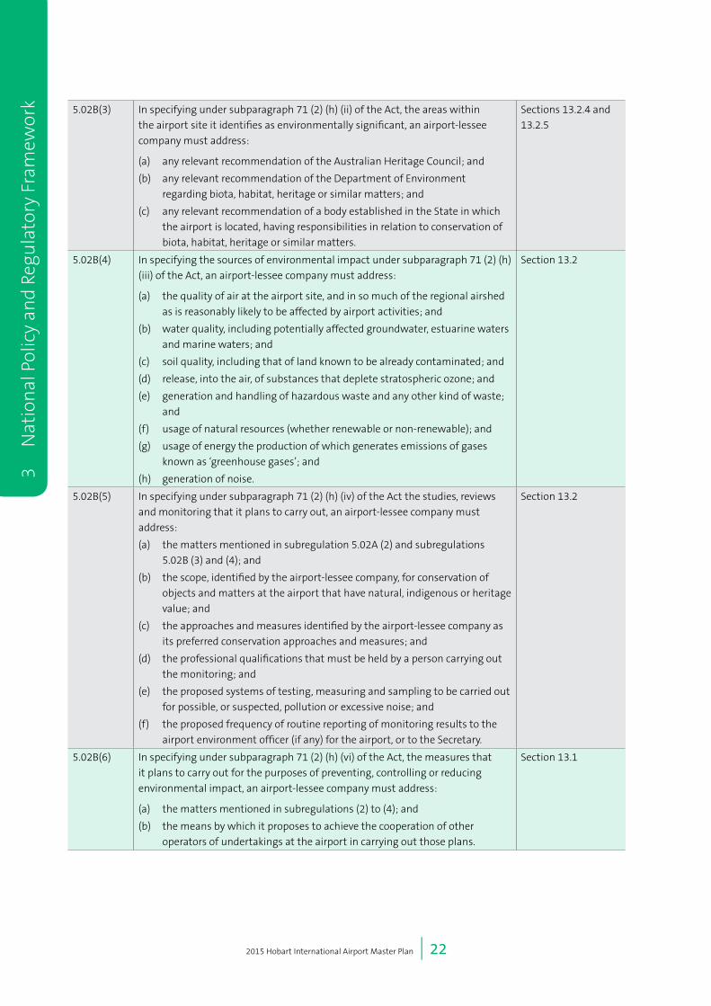
Sections 13.2.4 and
13.2.5
5.02B(4) In specifying the sources of environmental impact under subparagraph 71 (2) (h)
(iii) of the Act, an airport-lessee company must address:
(a) the quality of air at the airport site, and in so much of the regional airshed
as is reasonably likely to be affected by airport activities; and
(b) water quality, including potentially affected groundwater, estuarine waters
and marine waters; and
(c) soil quality, including that of land known to be already contaminated; and
(d) release, into the air, of substances that deplete stratospheric ozone; and
(e) generation and handling of hazardous waste and any other kind of waste;
and
(f) usage of natural resources (whether renewable or non-renewable); and
(g) usage of energy the production of which generates emissions of gases
known as ‘greenhouse gases’; and
(h) generation of noise.
Section 13.2
5.02B(5) In specifying under subparagraph 71 (2) (h) (iv) of the Act the studies, reviews
and monitoring that it plans to carry out, an airport-lessee company must
address:
(a) the matters mentioned in subregulation 5.02A (2) and subregulations
5.02B (3) and (4); and
(b) the scope, identified by the airport-lessee company, for conservation of
objects and matters at the airport that have natural, indigenous or heritage
value; and
(c) the approaches and measures identified by the airport-lessee company as
its preferred conservation approaches and measures; and
(d) the professional qualifications that must be held by a person carrying out
the monitoring; and
(e) the proposed systems of testing, measuring and sampling to be carried out
for possible, or suspected, pollution or excessive noise; and
(f) the proposed frequency of routine reporting of monitoring results to the
airport environment officer (if any) for the airport, or to the Secretary.
Section 13.2
5.02B(6) In specifying under subparagraph 71 (2) (h) (vi) of the Act, the measures that
it plans to carry out for the purposes of preventing, controlling or reducing
environmental impact, an airport-lessee company must address:
(a) the matters mentioned in subregulations (2) to (4); and
(b) the means by which it proposes to achieve the cooperation of other
operators of undertakings at the airport in carrying out those plans.
Section 13.1

2015 Hobart International Airport Master Plan | 23
3 Nation
al Policy and Regu
latory Framew
ork
Two key factors which impact on development under
the Act are defined ‘major development’ and ‘sensitive
development’.
Section 71A of the Act specifies that ‘sensitive
development’ in a Master Plan must be identified. The
term ‘sensitive development’ is defined as development
that increases capacity, of the following:
• Residential dwelling;
• Community care facility;
• Pre-school;
• Primary, secondary, tertiary or other educational
institution; or
• Hospital.
But excludes:
• An aviation education facility;
• Accommodation for students studying at an aviation
education facility at the airport;
• A facility with the primary purpose of providing
emergency medical treatment and which does not
have in-patient facilities; or
• A facility with the primary purpose of providing in-
house training to staff of an organisation conducting
operations at the airport.
‘Sensitive development’ is prohibited except in
exceptional circumstances, but can be approved by the
Minister under the Major Development Plan process.
There are pre-existing ‘sensitive uses’ (as defined by
the Airports Act or National Aviation White Paper and
resulting changes to the Airports Act) currently on the
Hobart Airport site; the waste treatment plant and
childcare facility. It is not intended to add to these
through this Master Plan or to undertake any additional
‘sensitive developments’ during the planning period.
3.2.1 2010 – 2015 Hobart Airport Environment Strategy
Hobart Airport has an Airport Environment Strategy that
provides a long-term strategic vision for Hobart Airport
and its interaction with the environment.
The key objectives of the Airport Environment
Strategy are to summarise the airport’s environmental
approach to management of environmental values.
The environmental values outlined within the Airport
Environment Strategy are:
• Heritage – Aboriginal and Historic;
• Biodiversity – Vegetation communities and
Threatened Species;
• Air Quality;
• Water Quality – Surface and Groundwater;
• Soil Quality – Contamination;
• Energy and Natural Resources – including Climate
Change and Greenhouse gas emissions;
• Waste Management; and
• Noise – Ground based emissions.
The current Environment Strategy was approved July
2013. The Airport Environment Strategy has been
incorporated into the 2015 Master Plan as is now
required by the Airports Act.
3.3 Airport Regulation 1997
To meet the requirements of the Airports Regulations
1997 (Airports Regulations), made under the Airports Act
in relation to the preparation of the Master Plan, HIAPL is
required to:
• Address any obligations passed to HIAPL by the
Commonwealth in relation to leases on the airport in
existence before 11 June 1998; and
• Address any interests in airport land that were in
existence before 11 June 1998.
The leases on the airport in existence prior to 11 June
1998 and still current are:
• Airservices Australia facilities - Control tower, fire
station and car park, radio/electrical maintenance
workshop, gym/SAR store, fire training ground,
DVOR/DME, localiser, glidepath, SGS, course bars and
markers; and
• Bureau of Meteorology - Main building, instrument
site (west), instrument site (east – anemometer).
Since the last Master Plan, HIAPL has negotiated the
lease of the Qantas Domestic Terminal Lease (DTL) and
aircraft waste facility. HIAPL now operate these facilities.
The Master Plan fully recognises the operation of these
leases, and is to no detriment to the operation of the
leases.
HIAPL has agreed with the Bureau of Meteorology
that development that might affect the operation of
instruments in the west site (i.e. in Precinct 9) will be
preceded by adequate time for new instruments to
be established at the east site and a sufficient overlap
of operation of the two sites to confirm continuity of
climatic records.

2015 Hobart International Airport Master Plan | 24
3
Nat
ion
al P
olic
y an
d Re
gula
tory
Fra
mew
ork The 2015 Master Plan creates no effect on the Airservices
Australia facilities or the Bureau of Meteorology building.
To the best of HIAPL’s knowledge only the following may
represent interests for the purposes of the Regulations:
• Surf Road easement;
• A pipeline easement along the Tasman Highway
boundary; and
• Existence of the following trunk and other services:
– Telstra East Coast and Seven Mile Beach optic
fibres;
– Telstra incoming optic fibre to Customs Kennel;
– Aurora optic fibre along Holyman Avenue;
– Qantas Diversity optic fibre;
– Water re-use inbound and outbound lines along
– Holyman Avenue;
– Airservices Australia – numerous
communications;
– Incoming high voltage at airport metering point
(Aurora);
– Incoming high voltage along Pittwater Road; and
– Numerous Aurora poles and associated assets.
The Master Plan fully recognises the existence of these
interests and is no detriment to continuation of the
level of accommodation provided for these interests
prior to 11 June 1998, with the exception of Surf Road.
A benefitting easement exists on Surf Road. A future
runway extension is expected to impact access over
this easement and will be the subject of an MDP and
is discussed further in Chapter 8: Landside Transport.
Sinclair Creek flows across the airport. The TasWater
Wastewater Treatment Plant relies on Sinclair Creek
for acceptance of treated wastewater in certain
circumstances under the Environment Protection Notice
governing its operation. No other interests associated
with this water course have been identified by title or any
other searching.
Proclamation under Section 9A and 52A of the State
Roads and Jetties Act 1935, registered 24th June 1997
has the following effects:
• Section 9A provides that the Governor may, by
proclamation, declare – (a) the intended new line of a
State highway or subsidiary road; or (b) the intended
line of a new State highway or subsidiary road; and
• Section 52A provides that the Governor may,
by proclamation, declare any State highway or
subsidiary road, or part thereof to be a “limited
access road”. A proclamation under this section may
be combined with a proclamation under section 9A.
HIAPL recognises that any such declarations would
modify any affected provisions of the Master Plan.
Public consultation, title and other searching in
preparation of the Master Plan identified no other
interests and so there are no other interests to the best
of HIAPL’s knowledge.
3.4 Airport (Environment Protection) Regulations 1997
The Airport (Environment Protection) Regulations 1997
provide the overarching environmental legislation for
airports in Australia. The objectives of the Regulations
are:
• To establish a Commonwealth system of regulation
and accountability for activities at airports,
particularly where those activities have the potential
to generate pollution or excessive noise; and
• To encourage continual improvement in
environmental management practices for activities
undertaken at airport sites.
The Regulations are supported and encouraged by the
Commonwealth appointed Airport Environment Officer
(AEO) for individual airports.
3.5 Environment Protection and Biodiversity Conservation Act 1999
Hobart Airport must comply with the Environment
Protection and Biodiversity Conservation Act 1999 (EPBC
Act). This legislation is particularly relevant to airport
Master Plans due to its requirements for managing
significant flora and fauna species.
2015 Hobart International Airport Master Plan | 25
3 Nation
al Policy and Regu
latory Framew
ork
3.6 National Airports Safeguarding Framework
Airports are of significant social and economic
importance to local and State economies especially so for
an island state such as Tasmania. Conflict with off
airport activities is a growing issue for many Australian
airports.
The Australian Government recognises that responsibility
for land use planning rests primarily with State, Territory
and Local Governments, but that a National approach
can assist in improving planning outcomes on and near
airports and under flight paths.
Accordingly a National Airports Safeguarding Framework
(NASF) has been developed to provide guidance on
planning requirements for development that affects
aviation operations. This includes building activity
around airports that might penetrate operational
airspace and/or affect navigational procedures for
aircraft (Commonwealth Department of Infrastructure
and Regional Development (DIRD), October 2014).
NASF was developed by the National Airports
Safeguarding Advisory Group, which includes
representatives from Commonwealth Infrastructure and
Defence departments and aviation agencies; State and
Territory planning and transport departments, and the
Australian Local Government Association. The Tasmanian
Government is a signatory to and has officially endorsed
NASF and associated guidelines.
NASF was implemented in recognition of airports
importance and contribution to Australia’s economy,
stating the following as the context behind the
Guidelines:
• Australian airports are significant contributors to
jobs, economic development, national productivity
and social connectivity.
• Airports are important national infrastructure
assets. They are essential transport hubs and
contribute significantly to the national economy,
as well as to the economies of the cities, regions,
States and Territories where they are located.
• Airports support trade and tourism and help to
drive growth across the economy. They support the
jobs of around 50,000 people directly employed
in the air transport sector and many more in the
retail, hospitality and service industries on airport
sites.
• All sectors of the Australian economy rely directly
or indirectly on the efficient movement of people
and freight through airports. Over 120 million
passengers pass through Australian airports
annually. Domestic air travel has more than
trebled over the last 20 years, with over 50 million
passenger movements in 2008-09 through more
than 180 domestic airports.
• Australia’s annual international freight task
comprises over $100 billion worth of air freight,
over 20 per cent of the total value of Australia’s
international cargo trade.”
NASF consists of:
• Principles for National Airports Safeguarding
Framework;
• Guideline A: Managing Aircraft Noise;
• Guideline B: Managing Building-Generated Windshear;
• Guideline C: Managing Wildlife Strike Risk;
• Guideline D: Managing Wind Turbine Risk to Aircraft;
• Guideline E: Managing Pilot Lighting Distraction; and
• Guideline F: Managing Protected Airspace Intrusion.
The aim of NASF is to:
• Enhance the current and future safety, viability and
growth of aviation operations at Australian airports;
• Support and enable the implementation of best
practice in relation to land use assessment and
decision making in the vicinity of airports to support
the safe and efficient operation of airports;
• Improve safety outcomes by ensuring aviation safety
requirements are recognised in land use planning
decisions;
• Improve community amenity by minimising noise
sensitive developments near airports, including
through the use of additional noise metrics; and
• Improve aircraft noise-disclosure mechanisms.
Out of these stated purposes, the relevant Federal,
State (including Tasmania) and Territory Governments
developed the following NASF Principles to be adopted in
each relevant jurisdiction:
• The safety, efficiency and operational integrity of
airports should be protected by all governments,
recognising their economic, defence and social
significance;
• Airports, governments and local communities should
share responsibility to ensure that airport planning is
integrated with local and regional planning;
• Governments at all levels should align land use
planning and building requirements in the vicinity of
airports;

2015 Hobart International Airport Master Plan | 26
3
Nat
ion
al P
olic
y an
d Re
gula
tory
Fra
mew
ork • Land use planning processes should balance and
protect both airport/aviation operations and
community safety and amenity expectations;
• Governments will protect operational airspace
around airports in the interests of both aviation and
community safety; and
• Strategic and statutory planning frameworks should
address aircraft noise by applying a comprehensive
suite of noise measures.
NASF and the above principles are intended to be applied
and incorporated into relevant planning schemes over
time and provide guidance to state, local and territory
governments which can in turn be used to guide
assessment and approvals for land use and development
on and around identified airports.
Hobart Airport has been fortunate to have avoided
conflict with surrounding land use and development,
with the consequence that its curfew-free status has
been maintained. However increasing residential
development pressure in the City of Clarence and Sorell
municipality highlights the need for Local and State
Government to continue having regard to NASF.
3.7 State and Local Regulations
Hobart Airport’s land is owned by the Australian
Commonwealth Government. Therefore, pursuant to
S.112 of the Airports Act, new developments are not
subject to the statutory State and Local Government
planning and environmental approval process.
Any developments at the airport are controlled through
the detailed requirements of the Airports Act, including
specific and stringent environmental and building
controls, and compliance with the Master Plan and its
integrated Airport Environment Strategy.
At the same time under, S.71(6) of the Airports Act,
the Master Plan is required to describe the extent of
consistency of the plan with state and local government
planning regimes in force where the airport is located.
Therefore these regimes have been considered when
developing the 2015 Master Plan. Table 3.b summarises
the statutory and regulatory framework for development
of both Commonwealth owned land and that owned
by HIAPL, with the Master Plan clearly central to both
regimes.
Hobart Airport must also comply with State legislation in
the context of:
• Effects on State and Local Government land use
planning and development policies;
• Environmental considerations (including aircraft
noise, flora, fauna, cultural, heritage, drainage and
wastewater issues);
• Airport access;
• The provision of telecommunications, water and
electricity services; and
• Land acquisition.
The State and Local planning context forms the basis of
the Hobart Airport Master Plan’s direction and concepts
have been consulted in developing the 2015 Master Plan,
including the policies, schemes and plans addressed in
this chapter.
Consistency of the objectives and proposals set out in
this 2015 Master Plan and, where any inconsistency
is identified, justification for that inconsistency, are
addressed in a number of sections of this Master Plan
including Chapter 4: Land Use and Precinct Development,
Chapter 6: Passenger Terminal Planning, Chapter 7:
Airfield Development and Chapter 8: Landside Transport
(in relation to aviation and non-aviation development).

2015 Hobart International Airport Master Plan | 27
3 Nation
al Policy and Regu
latory Framew
ork
Table 3.b Statutory Regulatory Framework Overview
CommonwealthLeasedLand HobartInternationalAirportFreeholdLand
KeyLegislation Airports Act 1996
Airport Reguslations 1997
Airport (control of on-Airport
Activities) Regulations 1997
Airports (Building Control)
Regulations 1996
Land Use Planning and Approvals Act 1993
Airport (Environment
Protection) Regulations 1997
Environmental Management and Pollution Control Act 1994
OtherPotentially
RelevantLegislation
Environment Protection and
Biodiversity Conservation Act
1999
Building
Local Government (Building and Miscellaneous Provisions)
Act 1993
State Policies and Projects Act 1993
Historic Cultural Heritage Act 1995
Aboriginal Relics Act 1975
Threatened Species Protection Act 1995
Nature Conservation Act 2002
Weed Management Act 1999
Forest Practices Act 1985
AirportPolicy
FrameworkNational Airports Safeguarding Framework
StrategicPlanning Hobart Airport Land Use Strategy 20142015 Hobart Airport Master Plan
STATE
Southern Tasmania Regional
Land Use Strategy 2010-2035
Southern Tasmania Regional
Economic Development Plan
2012
Southern Tasmania Industrial
Land Strategy 2013
COUNCIL
Clarence Strategic Plan 2010-
2015
Policy STATE
State Coastal Policy 1996
National Environment
Protection Measures
LocalLandUse
Planning
Major Development Plan
approvals process in
accordance with the Airports
Act 1996
STATE
State Planning Directives
COUNCIL
Clarence Planning Scheme
2007; to be replaced in 2015
by
Clarence Planning Scheme
2015

2015 Hobart International Airport Master Plan | 28
3
Nat
ion
al P
olic
y an
d Re
gula
tory
Fra
mew
ork 3.7.1 StateCoastalPolicy1996
The State Coastal Policy 1996 (State Coastal Policy)
applies the sustainable development objectives of the
Resource Management Planning System to Tasmania’s
coast, and is guided by three main principles:
• Natural and cultural values of the coast shall be
protected;
• The coast shall be used and developed in a
sustainable manner; and
• Integrated management and protection of the coastal
zone is a shared responsibility.
The area to which the policy is applied is the ‘Coastal
Zone’ which is defined under the policy as:
… State waters and to all land to a distance of one
kilometre inland from the high-water mark.
The airport land is entirely within the Coastal Zone, as is
the area surrounding it.
A number of principles and objectives apply to the
airport and the surrounding land that reinforce the
strategic importance of the airport, or raise matters that
are recognised as being of importance within the coastal
zone, notably:
Principles
The coast shall be used and developed in a sustainable
manner.
This principle recognises:
the economic and social values of sea ports
and airports, mineral and forest resources,
agriculture, marine farming and fisheries to
Tasmania, and the legitimate aspirations of
individuals and communities for allocation of
space and resources in the coastal zone for these
activities; (emphasis added)
Outcomes
2. Sustainable Development of Coastal Areas and
Resources
2.1. COASTAL USES AND DEVELOPMENT
2.1.1. The coastal zone shall be used and
developed in a sustainable manner
subject to the objectives, principles and
outcomes of this Policy. It is acknowledged
that there are conservation reserves and
other areas within the coastal zone which
will not be available for development
(emphasis added)
2.1.6. In determining decisions on use and
development in the coastal zone, priority
will be given to those which are dependent
on a coastal location for spatial, social,
economic, cultural or environmental reasons
2.3. TOURISM
2.3.1. Tourism use and development in the coastal
zone, including visitor accommodation and
other facilities, will be directed to suitable
locations based on the objectives, principles
and outcomes of this Policy and subject to
planning controls. (Emphasis added)
2.5. TRANSPORT
2.5.5. The multiple use of port areas will be
encouraged but priority will be given
to efficient port operations and safety
requirements subject to cultural,
natural and aesthetic values not being
compromised (emphasis added)
2.6. PUBLIC ACCESS AND SAFETY
2.6.1. The public’s common right of access to and
along the coast, from both land and water,
will be maintained and enhanced where
it does not conflict with the protection of
natural and cultural coastal values, health
and safety and security requirements.
The 2015 Master Plan is consistent with the State Coastal
Policy, and recognises the need to balance the strategic
economic and social significance of the airport with
the public access and safety outcomes of the policy. In
planning for future developments including the runway
extension, provision will be made for public access along
the coast from both land and water, together with the
protection of natural and cultural coastal values, health
and safety and security requirements.
3.7.2 SouthernTasmaniaRegionalLandUseStrategy2010-2035
The Southern Tasmania Regional Land Use Strategy
2010-2035 is a broad policy document that will facilitate
and manage change, growth, and development within
Southern Tasmania over the next 25 years. The strategy
document contains a vision, strategies and policy
statements to implement those strategies. The strategy
is given statutory status under Division 1A of the Land
Use Planning Approvals Act 1993. The strategy is intended
to be implemented through planning schemes, and
scheme amendments are required to be consistent with
the strategy. The proposals in the 2015 Master Plan are
consistent with this strategy.

2015 Hobart International Airport Master Plan | 29
3 Nation
al Policy and Regu
latory Framew
ork
The strategy document notes the importance of Hobart
Airport to the State, noting in relation to “Strategic
Direction 4 - Improving our Economic Infrastructure”
that:
“Southern Tasmania is highly dependent upon the
State’s three northern ports for exports and imports
and Hobart airport for movements of passengers and
time sensitive products. Maintaining a strong strategic
approach to industrial land with efficient and cost
effective intrastate road and rail linkages to and from
the sea and airports are vitally important, particularly
in this modern era of 24 hour 7 days a week freight
logistics.”
There are no statements in the strategy document
regarding protection of the operational environment of
Hobart Airport. Notwithstanding this, there is a strong
strategic and policy context that controls the location
and density of future residential and commercial
development affecting the areas around the airport.
The strategy prescribes both a settlement strategy and
an urban growth boundary for the southern Tasmanian
region. No lands to the east of the airport within the
Seven Mile Beach Peninsula are currently identified
for future settlement/ residential development. The
Tasmanian Planning Commission has confirmed the
exclusion of residential settlement development in this
area in its decision in Draft Amendment A - 2013/1 to
the Clarence Planning Scheme 2007. The area west of
the airport in the Acton corridor, has been identified
for a mix of future commercial, industrial or residential
development.
3.7.3 SouthernTasmaniaIndustrialLandStrategy2013
The Southern Tasmania Industrial Land Strategy 2013
provides a review of the southern region’s industrial
profile, land supply and demand projections and
recommends preferred sites to meet projected demand
for the next 30 years.
The City of Clarence was identified in the strategy as
currently having the most extensive supply of vacant
industrial land at 105ha. The industrial strategy
recognises the following parts of Hobart Airport as
being strategically placed for new industrial uses: and
• The HIAPL owned titles at 158 Surf Road and 525
Pittwater Road for aeronautical related uses; and
• Hobart Airport Precincts 3 and 9 (4ha) are identified
as regionally significant land and well suited to
accommodate export-orientated industries within
the next 15 years.
Southern Tasmania Industrial Land Strategy 30
F I G UR E 5 C L A R EN C E
* Specialty industrial use: Commonwealth land, which is beyond the jurisdiction of State and local planning controls.
Figure 3.a Extract from Southern Tasmania Industrial Land Strategy – recommended sites in Clarence (p.30)
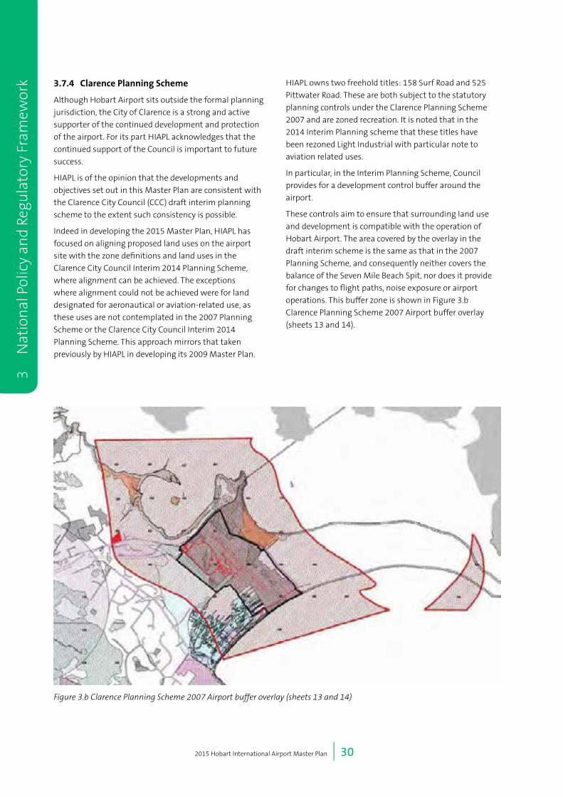
2015 Hobart International Airport Master Plan | 30
3
Nat
ion
al P
olic
y an
d Re
gula
tory
Fra
mew
ork 3.7.4 ClarencePlanningScheme
Although Hobart Airport sits outside the formal planning
jurisdiction, the City of Clarence is a strong and active
supporter of the continued development and protection
of the airport. For its part HIAPL acknowledges that the
continued support of the Council is important to future
success.
HIAPL is of the opinion that the developments and
objectives set out in this Master Plan are consistent with
the Clarence City Council (CCC) draft interim planning
scheme to the extent such consistency is possible.
Indeed in developing the 2015 Master Plan, HIAPL has
focused on aligning proposed land uses on the airport
site with the zone definitions and land uses in the
Clarence City Council Interim 2014 Planning Scheme,
where alignment can be achieved. The exceptions
where alignment could not be achieved were for land
designated for aeronautical or aviation-related use, as
these uses are not contemplated in the 2007 Planning
Scheme or the Clarence City Council Interim 2014
Planning Scheme. This approach mirrors that taken
previously by HIAPL in developing its 2009 Master Plan.
HIAPL owns two freehold titles: 158 Surf Road and 525
Pittwater Road. These are both subject to the statutory
planning controls under the Clarence Planning Scheme
2007 and are zoned recreation. It is noted that in the
2014 Interim Planning scheme that these titles have
been rezoned Light Industrial with particular note to
aviation related uses.
In particular, in the Interim Planning Scheme, Council
provides for a development control buffer around the
airport.
These controls aim to ensure that surrounding land use
and development is compatible with the operation of
Hobart Airport. The area covered by the overlay in the
draft interim scheme is the same as that in the 2007
Planning Scheme, and consequently neither covers the
balance of the Seven Mile Beach Spit, nor does it provide
for changes to flight paths, noise exposure or airport
operations. This buffer zone is shown in Figure 3.b
Clarence Planning Scheme 2007 Airport buffer overlay
(sheets 13 and 14).
Figure 3.b Clarence Planning Scheme 2007 Airport buffer overlay (sheets 13 and 14)
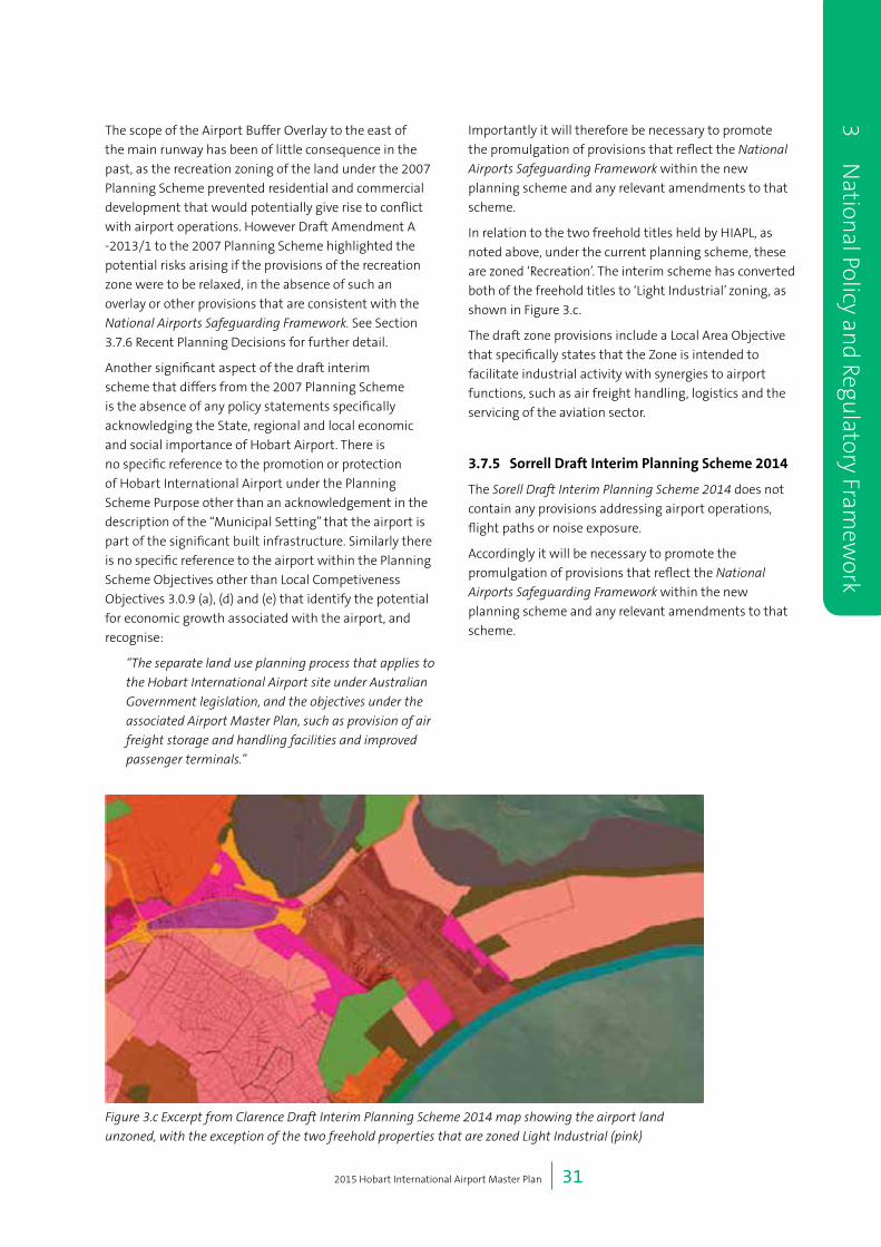
2015 Hobart International Airport Master Plan | 31
3 Nation
al Policy and Regu
latory Framew
ork
The scope of the Airport Buffer Overlay to the east of
the main runway has been of little consequence in the
past, as the recreation zoning of the land under the 2007
Planning Scheme prevented residential and commercial
development that would potentially give rise to conflict
with airport operations. However Draft Amendment A
-2013/1 to the 2007 Planning Scheme highlighted the
potential risks arising if the provisions of the recreation
zone were to be relaxed, in the absence of such an
overlay or other provisions that are consistent with the
National Airports Safeguarding Framework. See Section
3.7.6 Recent Planning Decisions for further detail.
Another significant aspect of the draft interim
scheme that differs from the 2007 Planning Scheme
is the absence of any policy statements specifically
acknowledging the State, regional and local economic
and social importance of Hobart Airport. There is
no specific reference to the promotion or protection
of Hobart International Airport under the Planning
Scheme Purpose other than an acknowledgement in the
description of the “Municipal Setting” that the airport is
part of the significant built infrastructure. Similarly there
is no specific reference to the airport within the Planning
Scheme Objectives other than Local Competiveness
Objectives 3.0.9 (a), (d) and (e) that identify the potential
for economic growth associated with the airport, and
recognise:
“The separate land use planning process that applies to
the Hobart International Airport site under Australian
Government legislation, and the objectives under the
associated Airport Master Plan, such as provision of air
freight storage and handling facilities and improved
passenger terminals.”
Importantly it will therefore be necessary to promote
the promulgation of provisions that reflect the National
Airports Safeguarding Framework within the new
planning scheme and any relevant amendments to that
scheme.
In relation to the two freehold titles held by HIAPL, as
noted above, under the current planning scheme, these
are zoned ‘Recreation’. The interim scheme has converted
both of the freehold titles to ‘Light Industrial’ zoning, as
shown in Figure 3.c.
The draft zone provisions include a Local Area Objective
that specifically states that the Zone is intended to
facilitate industrial activity with synergies to airport
functions, such as air freight handling, logistics and the
servicing of the aviation sector.
3.7.5 SorrellDraftInterimPlanningScheme2014
The Sorell Draft Interim Planning Scheme 2014 does not
contain any provisions addressing airport operations,
flight paths or noise exposure.
Accordingly it will be necessary to promote the
promulgation of provisions that reflect the National
Airports Safeguarding Framework within the new
planning scheme and any relevant amendments to that
scheme.
Figure 3.c Excerpt from Clarence Draft Interim Planning Scheme 2014 map showing the airport land
unzoned, with the exception of the two freehold properties that are zoned Light Industrial (pink)

2015 Hobart International Airport Master Plan | 32
3
Nat
ion
al P
olic
y an
d Re
gula
tory
Fra
mew
ork 3.7.6 RecentPlanningDecisions
Decision in relation to Amendment A-2013/1 - Clarence
Planning Scheme
During 2014 the Tasmanian Planning Commission,
which is responsible for the assessment and approval
of amendments to the Clarence Planning Scheme,
rejected draft amendment A-2013/1 to the scheme, for
reasons which included concerns about the effect of the
proposed amendment on Hobart Airport.
The amendment provided for a portion of the land at
300 Pittwater Road, Seven Mile Beach to be used and
developed for two 18 hole golf courses, a children’s
golf course, conference and retail facilities, tourist
accommodation, restaurants and up to 216 dwelling
units. Prior to the decision by the Commission, the
Clarence City Council determined, after a period of
public consultation, that it did not support the draft
amendment.
HIAPL provided submissions to the Council during
the public consultation period and participated in the
hearing by the Commission.
In rejecting the draft amendment, the Tasmanian
Planning Commission Delegates accepted that:
“…Hobart Airport is of such regional and State
significance that surrounding use and development
must pose a very low risk to the operations of the
airport. The Delegates consider that increasing
residential pressure close to the airport may give rise
to future complaints and any increase in the number
of complaints poses an unacceptable risk to the future
operations of the airport.”
The Commission noted that:
“The current absence of a curfew is acknowledged as
an important advantage that the Hobart Airport has
over several other capital city airports.”
and that
“…any negative economic impact to the Hobart Airport
by potential constraints to its future operations poses
a risk to the economic development of the region and
the State.”
The Commission also specifically acknowledged
the relevance of the National Airports Safeguarding
Framework, notably Guideline A, page 2, para 13, which
makes the following statement about land use and
development planning on land surrounding airports:
“… where there is no major existing or approved
development, there is scope to plan ahead to take
account of potential noise disturbance and in
particular to minimise the zoning of noise exposed
land for residential development”.
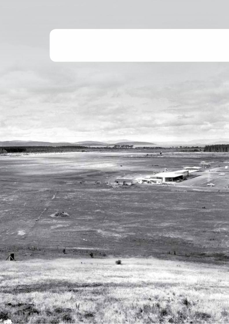
4 Land Use and Precinct Development
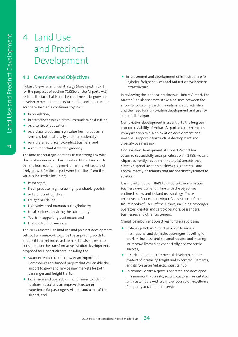
2015 Hobart International Airport Master Plan | 34
4
L
and
Use
an
d Pr
ecin
ct D
evel
opm
ent 4 Land Use
and Precinct Development
4.1 Overview and Objectives
Hobart Airport’s land use strategy (developed in part
for the purposes of section 71(2)(c) of the Airports Act)
reflects the fact that Hobart Airport needs to grow and
develop to meet demand as Tasmania, and in particular
southern Tasmania continues to grow:
• In population;
• In attractiveness as a premium tourism destination;
• As a centre of education;
• As a place producing high value fresh produce in
demand both nationally and internationally;
• As a preferred place to conduct business; and
• As an important Antarctic gateway
The land use strategy identifies that a strong link with
the local economy will best position Hobart Airport to
benefit from economic growth. The market sectors of
likely growth for the airport were identified from the
various industries including:
• Passengers;
• Fresh produce (high value high perishable goods);
• Antarctic and logistics;
• Freight handeling;
• Light/advanced manufacturing/industry;
• Local business servicing the community;
• Tourism supporting businesses; and
• Flight related businesses.
The 2015 Master Plan land use and precinct development
sets out a framework to guide the airport’s growth to
enable it to meet increased demand. It also takes into
consideration the transformative aviation developments
proposed for Hobart Airport, including the:
• 500m extension to the runway, an important
Commonwealth-funded project that will enable the
airport to grow and service new markets for both
passenger and freight traffic;
• Expansion and upgrade of the terminal to deliver
facilities, space and an improved customer
experience for passengers, visitors and users of the
airport; and
• Improvement and development of infrastructure for
logistics, freight services and Antarctic development
infrastructure.
In reviewing the land use precincts at Hobart Airport, the
Master Plan also seeks to strike a balance between the
airport’s focus on growth in aviation related activities
and the need for non-aviation development and uses to
support the airport.
Non-aviation development is essential to the long term
economic viability of Hobart Airport and compliments
its key aviation role. Non-aviation development and
revenues support infrastructure development and
diversify business risk.
Non-aviation development at Hobart Airport has
occurred successfully since privatisation in 1998. Hobart
Airport currently has approximately 36 tenants that
directly support aviation business e.g. car rental, and
approximately 27 tenants that are not directly related to
aviation.
It is the intention of HIAPL to undertake non-aviation
business development in line with the objectives
outlined below and its land use strategy. These
objectives reflect Hobart Airport’s assesment of the
future needs of users of the Airport, including passenger
operators, charter and cargo operators, passengers,
businesses and other customers.
Overall development objectives for the airport are:
• To develop Hobart Airport as a port to service
international and domestic passengers travelling for
tourism, business and personal reasons and in doing
so improve Tasmania’s connectivity and economic
success;
• To seek appropriate commercial development in the
context of increasing freight and export requirements,
and its role as an Antarctic logistics hub;
• To ensure Hobart Airport is operated and developed
in a manner that is safe, secure, customer-orientated
and sustainable with a culture focused on excellence
for quality and customer service;
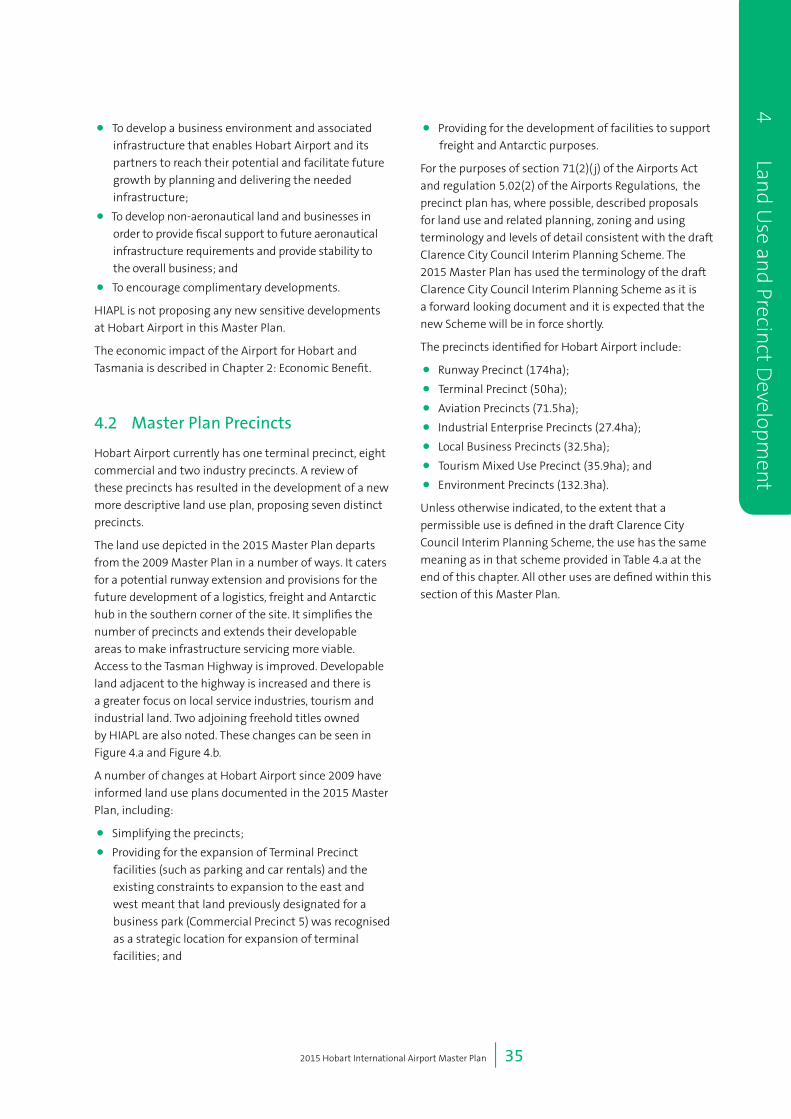
2015 Hobart International Airport Master Plan | 35
4 Land U
se and Precin
ct Developm
ent
• To develop a business environment and associated
infrastructure that enables Hobart Airport and its
partners to reach their potential and facilitate future
growth by planning and delivering the needed
infrastructure;
• To develop non-aeronautical land and businesses in
order to provide fiscal support to future aeronautical
infrastructure requirements and provide stability to
the overall business; and
• To encourage complimentary developments.
HIAPL is not proposing any new sensitive developments
at Hobart Airport in this Master Plan.
The economic impact of the Airport for Hobart and
Tasmania is described in Chapter 2: Economic Benefit.
4.2 Master Plan Precincts
Hobart Airport currently has one terminal precinct, eight
commercial and two industry precincts. A review of
these precincts has resulted in the development of a new
more descriptive land use plan, proposing seven distinct
precincts.
The land use depicted in the 2015 Master Plan departs
from the 2009 Master Plan in a number of ways. It caters
for a potential runway extension and provisions for the
future development of a logistics, freight and Antarctic
hub in the southern corner of the site. It simplifies the
number of precincts and extends their developable
areas to make infrastructure servicing more viable.
Access to the Tasman Highway is improved. Developable
land adjacent to the highway is increased and there is
a greater focus on local service industries, tourism and
industrial land. Two adjoining freehold titles owned
by HIAPL are also noted. These changes can be seen in
Figure 4.a and Figure 4.b.
A number of changes at Hobart Airport since 2009 have
informed land use plans documented in the 2015 Master
Plan, including:
• Simplifying the precincts;
• Providing for the expansion of Terminal Precinct
facilities (such as parking and car rentals) and the
existing constraints to expansion to the east and
west meant that land previously designated for a
business park (Commercial Precinct 5) was recognised
as a strategic location for expansion of terminal
facilities; and
• Providing for the development of facilities to support
freight and Antarctic purposes.
For the purposes of section 71(2)( j) of the Airports Act
and regulation 5.02(2) of the Airports Regulations, the
precinct plan has, where possible, described proposals
for land use and related planning, zoning and using
terminology and levels of detail consistent with the draft
Clarence City Council Interim Planning Scheme. The
2015 Master Plan has used the terminology of the draft
Clarence City Council Interim Planning Scheme as it is
a forward looking document and it is expected that the
new Scheme will be in force shortly.
The precincts identified for Hobart Airport include:
• Runway Precinct (174ha);
• Terminal Precinct (50ha);
• Aviation Precincts (71.5ha);
• Industrial Enterprise Precincts (27.4ha);
• Local Business Precincts (32.5ha);
• Tourism Mixed Use Precinct (35.9ha); and
• Environment Precincts (132.3ha).
Unless otherwise indicated, to the extent that a
permissible use is defined in the draft Clarence City
Council Interim Planning Scheme, the use has the same
meaning as in that scheme provided in Table 4.a at the
end of this chapter. All other uses are defined within this
section of this Master Plan.
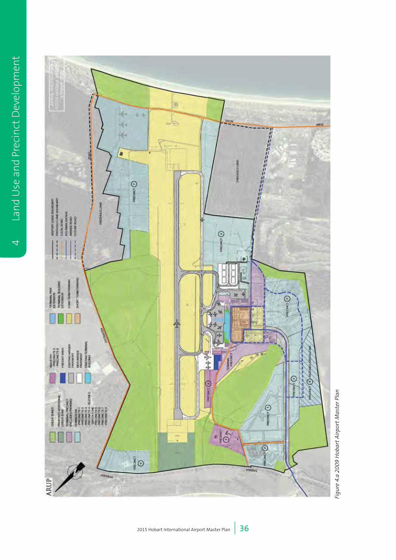
2015 Hobart International Airport Master Plan | 36
4
L
and
Use
an
d Pr
ecin
ct D
evel
opm
ent
Figu
re 4
.a 2
009
Hob
art
Air
port
Mas
ter P
lan

2015 Hobart International Airport Master Plan | 37
4 Land U
se and Precin
ct Developm
ent
Ligh
tIn
dust
ryPr
ecin
ct 1
Ligh
tIn
dust
ryPr
ecin
ct 2
Run
way
Pre
cinc
t
Term
inal
Prec
inct
Envi
ronm
ent
Prec
inct
3
Avia
tion
Prec
inct
1
Avia
tion
Prec
inct
2
Tour
ism
/Mix
ed U
sePr
ecin
ct 1
Envi
ronm
ent
Prec
inct
1
Envi
ronm
ent
Prec
inct
2
Loca
l Bus
ines
sPr
ecin
ct 2
Envi
ronm
ent
Prec
inct
4
Loca
l Bus
ines
sPr
ecin
ct 1
Envi
ronm
ent
Prec
inct
5
Sou
rce:
Esr
i, D
igita
lGlo
be, G
eoE
ye, i
-cub
ed, U
SD
A, U
SG
S, A
EX
, Get
map
ping
, Aer
ogrid
, IG
N, I
GP,
sw
isst
opo,
and
the
GIS
Use
r Com
mun
ity
020
040
060
080
0
Met
res
[
Figu
re N
o
4.b
Coo
rdin
ate
Sys
tem
GD
A 1
994
MG
A Z
one
55
Scal
e at
A4
1:16
,221
Dra
win
g Ti
tle
2015
Lan
d U
se P
reci
nct P
lan
Land
use
pre
cinc
ts:
Loca
l Bus
ines
sAv
iatio
nTe
rmin
alTo
uris
m/M
ixed
Use
Run
way
Envi
ronm
ent
Ligh
t Ind
ustry
Figu
re 4
.b 2
015
Land
Use
Pre
cinc
t Pl
an
2015 Hobart International Airport Master Plan | 38
4.2.1 RunwayPrecinct
This precinct primarily caters for the runway, taxiways
and the apron. The key development objectives for the
runway precinct are:
• Allowing for safe aircraft landing, take off and taxiing
operations;
• Providing sufficient and for current and future core
aviation functions;
• Facilitating regulatory compliance;
• Catering for aircraft navigation aids, communications
equipment, aviation rescue and firefighting;
• Allowing for other facilities to ensure safe operation
of aircraft; and
• Enabling growth of existing and new markets.
Development in this precinct needs to comply with all
relevant National and International aviation standards
and regulations.
The control tower and operational areas of Tower Hill
have been removed from the Runway Precinct and
placed in the Terminal Precinct to better define airside
land and limit the functions of the runway precinct to
aircraft movement. Fire training has been placed into
the Aviation Precinct. The Runway Precinct has widened
to the north-west to cater for future parallel taxiway
developments.
There is no equivalent zoning under the draft Clarence
City Council Interim Planning Scheme as only one use
(Transport Depot and Distribution) is envisaged for this
precinct.
While the land use envisaged for this precinct is not
consistent with the draft Clarence Interim Planning
Scheme, this is justified on the basis that the draft
scheme does not provide for aviation uses, and such uses
are integral to the operation of the airport.
It is intended that the Runway Precinct will be developed
as follows during the Master Plan period:
• Extension of the runway by 500m (150m to the
northern end and 350m to the southern end);
• Development of a new large aircraft apron to the
northern end of the existing passenger apron;
• Alteration and relocation navigational equipment (in
conjunction with Airservices Australia); and
• The closure of Surf Road to vehicular traffic and
constructionof a new road Grueber Avenue.
The above projects are subject to a Major Development
Plan and will occur in the first three years of this Master
Plan.
Developments that may occur within five years include
taxiway and apron to a possible logistic/Antarctic hub on
the southern edge of this precinct and the development
of freight support facilities for the new northern apron.
Both these developments are dependent on demand.
Long term developments in this precinct include the
development of parallel taxiways the full length of the
runway towards the end of this Master Plan’s 20 year
planning period.
4.2.2 TerminalPrecinct
The key development objectives for the Terminal Precinct
are to:
• Accommodate facilities for the safe, efficient and
economic handling of aircraft, passengers and freight,
and related services and support activities;
• Provide sufficient capacity for terminal facilities
and related infrastructure development for airline
services;
• Cater for the airport’s role as a key tourist and
business gateway to the region;
• Provide efficient, diverse and responsive ground
transportation facilities (including car parking, hire
cars, taxis, coaches); and
• Provide for aircraft navigation aids, radar and
communications equipment, air traffic control, and
meteorological services.
All buildings should be of a high architectural standard
and be highly functional, designed in a way that will
allow for future expansion, adoption of new technologies
and changes in operations. The design of buildings in the
precinct should take into consideration the limitation
imposed by the obstacle limitation surface (OLS), wind
shear considerations and glare. Landscaping species
should be chosen not to attract birds.
During the coming three years the airport terminal will
be redeveloped, this redevelopment is outlined fully in
Chapter 6: Passenger Terminal Planning.
There is no equivalent zoning under the draft Clarence
City Council Interim Planning Scheme. Again, this is
justified on the basis that the draft Clarence Interim
Panning Scheme does not provide for aviation uses
proposed for the Terminal Precinct are more specialised
than any of the available zone types within the planning
scheme.
4
L
and
Use
an
d Pr
ecin
ct D
evel
opm
ent

2015 Hobart International Airport Master Plan | 39
The uses for this precinct are set out below or defined
when possible in the Clarence City Council Interim
planning scheme definitions found in Table 4.a or as
follows:
• Passenger Services (where the primary purpose is
to facilitate the safe travel of passengers and other
visitors, providing facilities that support the core
aviation operations of Hobart Airport);
• Freight Terminal (the use of land to facilitate
processing and storage of freight, where goods are
loaded and unloaded from aircraft);
• Administration facilities;
• Business and professional services;
• Domestic animal boarding;
• Emergency services;
• Food services;
• Service industry;
• Tourism operation;
• Transport depot and distribution;
• Utilities;
• Vehicle fuel sales and service;
• Vehicle parking; and
• Visitor accommodation.
It is intended that the Terminal Precinct will be
developed as follows during the Master Plan period.
These developments are in the five year plan outlined in
Chapter 6: Passenger Terminal Planning.
The major development occurring within this precinct
is intended to be the redevelopment of the existing
terminal as further described in Chapter 6: Passenger
Terminal Planning. There will also be minor but effective
road realignments and parking reconfigurations. Future
car park expansion and car rental facilities will occur
in this precinct as need demands. See Figure 4.c for a
photograph of the current Terminal Precinct.
The terminal 2020 redevelopment, road realignments
and car parking reconfiguration are expected to be
undertaken within the first five years of this Master Plan
(completed in 2017). Other developments consistent
with the land uses may be undertaken on a case by case
basis during the period of this Master Plan.
Future developments in this area may include additional
transport associated facilities, freight facilities, tourism
related facilities (e.g. visitor facilities), additional /
upgraded roads and intersections, accommodation
airside hotel/ hospitality facilities. Current interests in
this area relate primarily to transport associated facilities,
including car rental and the terminal building.
4 Land U
se and Precin
ct Developm
ent
Figure 4.c Photograph of Runway, Terminal and Aviation Precincts

2015 Hobart International Airport Master Plan | 40
4.2.3 AviationPrecincts
Two Aviation Precincts have been identified at the
southern end of the runway. The precincts accommodate
aircraft hangars and maintenance facilities, ancillary
aviation support activities including avionics, equipment
maintenance, aviation related services, fire training areas,
and commercial/light industrial and associated land uses.
The key development objectives for the Aviation Precincts
are to:
• Accommodate aviation and related service and
support activities;
• Provide for and maintain general aviation uses at the
airport;
• Develop freight facilities;
• Provide for Antarctic aviation services;
• Provide for tourist related aviation;
• Provide for flight training schools – rotary wing, jet;
• Provide for aviation related administrative and
commercial facilities;
• Provide facilities for the safe, efficient and economic
handling of aircraft, passengers; freight and related
services and support facilities;
• Support the development and opportunities for a
range of aviation support services;
• Aviation rescue and firefighting; and
• Contribute to the commercial viability of the airport
as an enterprise.
Buildings should generally be limited to a maximum
of 20m in height, except in the case of particular
aviation related purpose with special need for increased
clearance, but in any event should not penetrate the
airport’s OLS.
There is an existing TasWater sewerage treatment plant
within this precinct that services the wider community
as well as the airport. The mid to long term future of this
facility is under review by TasWater.
The Aviation Precincts house a rotor terminal and
maintenance facilities, as well as general aviation (GA)
hangars. GA is not a focus for Hobart Airport, Cambridge
Aerodrome located approximately 2km from Hobart
Airport is the designated GA facility for Hobart. Rotor
operations at Hobart Airport are expected to grow at a
slow rate and facilities will be developed to meet this
demand.
There is no equivalent zoning under the Clarence City
Council draft Interim Scheme as the uses in the precinct
are more specialised than any of the available zone types.
The uses are set out below as defined in the Clarence City
Council Interim planning scheme definitions found in
Table 4.a or as defined below.
• Aviation activity (the use of land for the arrival,
departure, movement operation of aircraft, including
general aviation, helipads, runways, taxiways and
aprons etc.);
• Aviation support facility (use of land for aircraft
maintenance, consisting of ground-based activities
necessary for the efficient operation of aviation
activities;
• Freight terminal (use of land to facilitate processing
and storage of freight, where goods are loaded and
unloaded from aircraft);
• Export related facilities (facilities to process goods
for export purposes including but not limited to
quarantine, inspection and bond store purposes.)
• Liquid fuel depot and distribution facility;
• Natural and cultural values management;
• Research and development;
• Transport depot and distribution;
• Navigational aids (any aircraft surveillance
equipment, including control towers, radars, visual
and non-visual aids for navigation);
• Utilities; and
• Storage.
It is intended that the Aviation Precincts will be
developed as follows during the Master Plan period. This
proposed development includes both:
• Developments to enhance and enlarge current freight
facilities in the immediate term to cater for potential
demand;
• Future developments to support current Antarctic
operations;
• Future developments include a possible logistic/
Antarctic hub on the southern edge of this precinct,
dependant on demand; and
• Small scale alterations/developments to the GA
hangar area to better facilitate demand and user
requirements.
Future developments in this area include additional
freight handling and storage facilities, particularly to
facilitate high value, perishable freight at larger volumes.
The development of Grueber Avenue will accommodate
any increase in associated vehicle movements to the
proposed logistic hub.
Subject to demand, it is hoped to undertake the
development of freight and export facilities within
the first five years of this master plan. The scale and
location of these facilities will be driven by demand and
operational practicality.
4
L
and
Use
an
d Pr
ecin
ct D
evel
opm
ent

2015 Hobart International Airport Master Plan | 41
4.2.4 LocalBusinessPrecinct
The Local Business Precinct provides for business,
professional and retail services which meet the
convenience needs of both Hobart Airport and the
Cambridge/Acton Park area.
The key development objectives for the Local Business
Precinct are to:
• Allocate parcels to accommodate local business
development which takes advantage of the location
adjacent to the airport and/or assisted by visibility
from and easy access to the Tasman Highway; and
• Ensure the commercial viability of the airport as an
enterprise.
Buildings or structures should not exceed 20 metres in
height or the airport’s OLS, whichever is the lesser. Strict
security fencing and access control measures must be
incorporated within the precinct so as to control public
access to airside sections of the airport.
Local Business Precinct 1 will be targeted for
development in the first instance to make efficient use of
existing infrastructure and consolidate the existing uses
and developments in this area.
The Local Business Precinct aligns with the general
business zone under the draft Clarence City Council
Interim Planning Scheme. Uses are set out below as
defined in the Clarence City Council Interim planning
scheme definitions found in Table 4.a or as defined
below.
• Business and professional service;
• Bulky goods;
• Domestic animal boarding and training;
• Community meeting and entertainment;
• Food services;
• General retail and hire;
• Equipment, machinery sales and hire;
• Transport depot and distribution;
• Emergency services support;
• Utilities;
• Vehicle fuel sales and service;
• Vehicle parking;
• Research and development;
• Service industry; and
• Storage.
The following uses are considered to be sensitive in
nature and are not deemed appropriate for Hobart
Airport:
• Custodial Facility;
• Education and Occasional Care (excluding current
operations on site);
• Hospital Services; and
• Residential.
While there are no specific development proposals
currently contemplated for this precinct, HIAPL will
consider potential development consistent with land
uses on a case by case basis and subject to demand.
Former environmental areas have been allocated for
local business development. Any removal of vegetation
in this area will be subject to approvals by the Tasmanian
Government as per the Nature Conservation Act 2002
and outlined in chapter 13: Environment.
4 Land U
se and Precin
ct Developm
ent

2015 Hobart International Airport Master Plan | 42
4.2.5 Tourism/MixedUsePrecinct
This precinct is at the entrance to Hobart Airport is
approximately 35.9ha in size, of which 8.4ha is currently
developed.
The precinct provides for both businesses with either
a tourism focus or of likely interest to tourists and
retail services which meet the convenience needs of
the Cambridge/Acton Park area. The Holyman Avenue
frontage which is largely undeveloped is a great
opportunity to link the design of future buildings to the
tourism market of Hobart.
Current key tenants in the Tourism/Mixed Use Precinct
include Travelodge Hotel, service station, campervan
rental, caravan/tourism park and a child care centre.
The key development objectives for the Tourism/Mixed
Use Precinct are to:
• Provide for continuation of the existing tourism
accommodation facilities and allow for possible
expansion of such facilities;
• Allocate parcels to accommodate an increased
concentration of tourism related business
development which utilise the frontage onto
Holyman Avenue;
• Allocate parcels for retail and commercial
development to assist with the commercial viability
of the airport as an enterprise;
• Provide for possible office space and / or call centre
facilities in the longer term;
• Provide for potential industrial and warehouse uses in
the longer term; and
• Enable a high quality architectural frontage along
Holyman Avenue.
Buildings or structures should not exceed 20m in height
or the airport’s OLS whichever is the lesser. Buildings
should be setback to a mandatory distance of 15m
from Holyman Avenue to create a consistent wall along
the avenue. Facades to Holyman Avenue should be of
significant design merit and should promote a high
degree of visual interest.
The Tourism/Mixed Use Precinct aligns with the
commercial zone in the draft Clarence City Council
Interim Planning Scheme. Uses are set out below as
defined in the Clarence City Council Interim planning
scheme definitions found in Table 4.a or as defined
below.
• Natural and cultural values and management;
• Utilities;
• Bulky good sales;
• Food services;
• General retail and hire including Direct Factory Outlet
type development;
• Passive recreation;
• Emergency services
• Business and professional services;
• Community meeting and entertainment;
• Educational and occasional care – only short term
child care purposes and respite care as is current
operation;
• Equipment and machinery sales and hire;
• General retail and hire;
• Service industry;
• Sports and recreation;
• Tourism operation;
• Vehicle fuel sales and service; and
• Vehicle Parking.
This precinct includes the area previously identified and
approved for a mixed use retail development. Hobart
Airport is currently investigating the use of this site to
undertake a retail, commercial, supermarket, discount
department store or outlet redevelopment of up to
60,000m2 and other retail uses to support key objectives.
It is intended that the precinct will be developed during
the coming 3-10 years as the Hobart market strengthens
and to meet demand.
4
L
and
Use
an
d Pr
ecin
ct D
evel
opm
ent
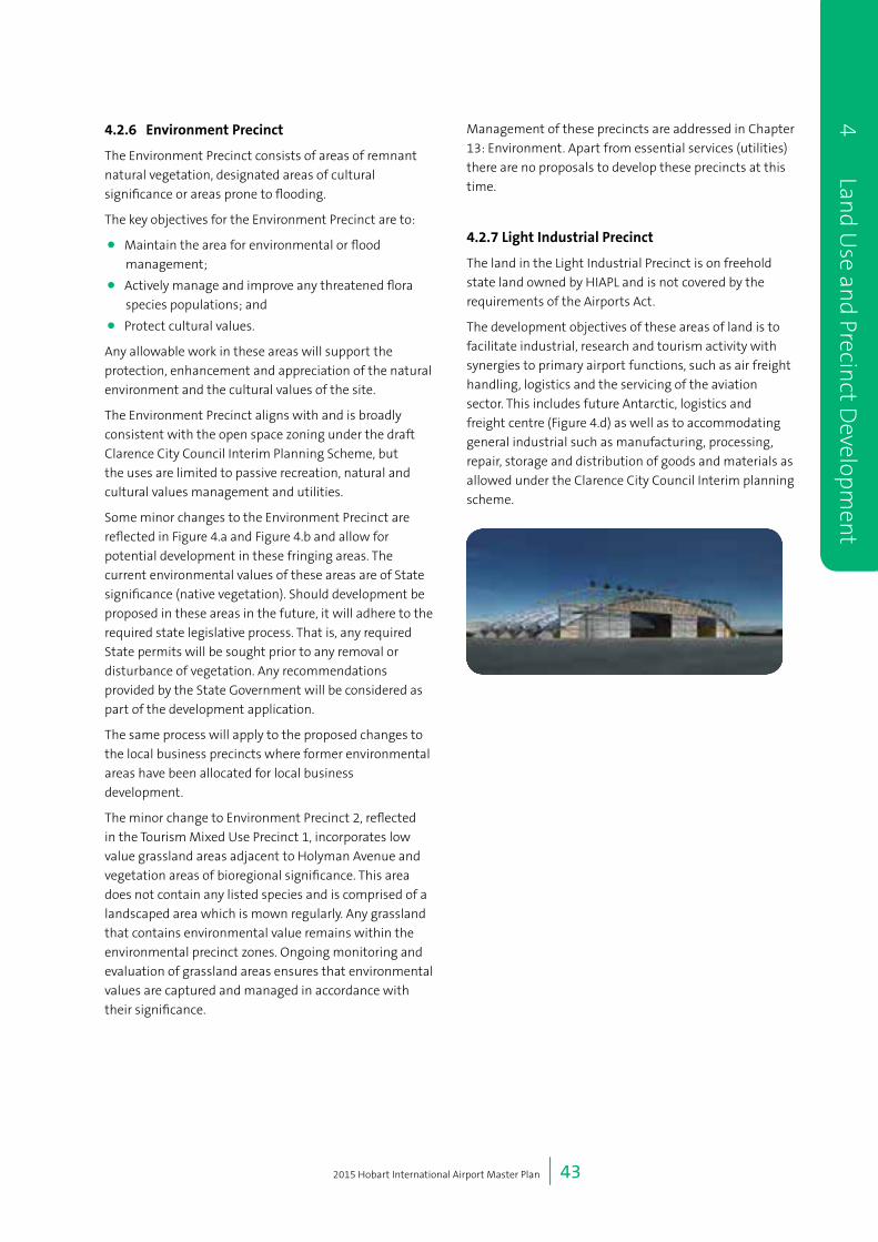
2015 Hobart International Airport Master Plan | 43
4.2.6 EnvironmentPrecinct
The Environment Precinct consists of areas of remnant
natural vegetation, designated areas of cultural
significance or areas prone to flooding.
The key objectives for the Environment Precinct are to:
• Maintain the area for environmental or flood
management;
• Actively manage and improve any threatened flora
species populations; and
• Protect cultural values.
Any allowable work in these areas will support the
protection, enhancement and appreciation of the natural
environment and the cultural values of the site.
The Environment Precinct aligns with and is broadly
consistent with the open space zoning under the draft
Clarence City Council Interim Planning Scheme, but
the uses are limited to passive recreation, natural and
cultural values management and utilities.
Some minor changes to the Environment Precinct are
reflected in Figure 4.a and Figure 4.b and allow for
potential development in these fringing areas. The
current environmental values of these areas are of State
significance (native vegetation). Should development be
proposed in these areas in the future, it will adhere to the
required state legislative process. That is, any required
State permits will be sought prior to any removal or
disturbance of vegetation. Any recommendations
provided by the State Government will be considered as
part of the development application.
The same process will apply to the proposed changes to
the local business precincts where former environmental
areas have been allocated for local business
development.
The minor change to Environment Precinct 2, reflected
in the Tourism Mixed Use Precinct 1, incorporates low
value grassland areas adjacent to Holyman Avenue and
vegetation areas of bioregional significance. This area
does not contain any listed species and is comprised of a
landscaped area which is mown regularly. Any grassland
that contains environmental value remains within the
environmental precinct zones. Ongoing monitoring and
evaluation of grassland areas ensures that environmental
values are captured and managed in accordance with
their significance.
Management of these precincts are addressed in Chapter
13: Environment. Apart from essential services (utilities)
there are no proposals to develop these precincts at this
time.
4.2.7LightIndustrialPrecinct
The land in the Light Industrial Precinct is on freehold
state land owned by HIAPL and is not covered by the
requirements of the Airports Act.
The development objectives of these areas of land is to
facilitate industrial, research and tourism activity with
synergies to primary airport functions, such as air freight
handling, logistics and the servicing of the aviation
sector. This includes future Antarctic, logistics and
freight centre (Figure 4.d) as well as to accommodating
general industrial such as manufacturing, processing,
repair, storage and distribution of goods and materials as
allowed under the Clarence City Council Interim planning
scheme.
4 Land U
se and Precin
ct Developm
ent

2015 Hobart International Airport Master Plan | 44
Table 4.a Definitions
Use DefinitionasperClarenceInterimPlanningScheme QualificationforHobartAirport
Businessand
professionalservices
Use of land for administration, clerical, technical,
professional or similar activities. Examples include
a bank, call centre, consulting room, funeral parlour,
medical centre, office, post office, real estate agency,
travel agency and veterinary centre.
Excluding funeral parlour.
Domesticanimal
boardingandtraining
Use of land for breeding, boarding or training
domestic animals. Examples include an animal pound,
cattery and kennel.
For the use of on airport providers,
for example quarantine.
Emergencyservices Use of land for police, fire, ambulance and other
emergency services including storage and deployment
of emergency vehicles and equipment. Examples
include ambulance station, fire station and police
station.
Foodservices Use of land for preparing or selling food or drink for
consumption on or off the premises. Examples include
a cafe, restaurant and take-away food premises.
Generalretailandhire Use of land for selling goods or services, or hiring
goods. Examples include an adult sex product shop,
amusement parlour, beauty salon, betting agency,
commercial art gallery, department store, hairdresser,
market, primary produce sales, shop, shop front dry
cleaner, supermarket and video shop
Excluding adult activities
Including Direct Factory Outlet
type development.
Visitoraccommodation Use of land for providing short or medium term
accommodation for persons away from their normal
place of residence. Examples include a backpackers
hostel, bed and breakfast establishment, camping
and caravan park, holiday cabin, holiday unit, motel,
overnight camping area, residential hotel and serviced
apartment.
Naturalandcultural
valuesmanagement
Use of land to protect, conserve or manage ecological
systems, habitat, species, cultural sites or landscapes.
All environmental management is
addressed in detail in Chapter 13:
Environment.
ServiceIndustry Use of land for cleaning, washing, servicing or
repairing articles, machinery, household appliances
or vehicles. Examples include a car wash, commercial
laundry, electrical repairs, motor repairs and panel
beating.
Notably car rental and taxi service
related activities.
Transportdepotand
distribution
Use of land for distributing goods or passengers,
or to park or garage vehicles associated with those
activities, other than Port and shipping. Examples
include an airport, bus terminal, council depot,
heliport, mail centre, railway station, road or rail
freight terminal and taxi depot.
4
L
and
Use
an
d Pr
ecin
ct D
evel
opm
ent
2015 Hobart International Airport Master Plan | 45
Use DefinitionasperClarenceInterimPlanningScheme QualificationforHobartAirport
Utilities Use of land for utilities and infrastructure including:
(a) telecommunications;
(b) electricity generation;
(c) transmitting or distributing gas, oil, or power;
(d) transport networks;
(e) collecting, treating, transmitting, storing or
distributing water; or
(f) collecting, treating, or disposing of storm or
floodwater, sewage, or sullage.
Examples include an electrical sub-station or powerline,
gas, water or sewerage main, optic fibre main or
distribution hub, pumping station, railway line,
retarding basin, road, sewage treatment plant, storm or
flood water drain, water storage dam and weir.
Vehicleparking Use of land for the parking of motor vehicles.
Examples include single and multi-storey car parks.
Communitymeeting
andentertainment
Use of land for social, religious and cultural activities,
entertainment and meetings. Examples include an art
and craft centre, church, cinema, civic centre, function
centre, library, museum, public art gallery, public hall
and theatre.
Tourismoperation Use of land specifically to attract tourists, other than
for accommodation. Examples include a theme park,
visitors centre, wildlife park and zoo.
Excluding wildlife park and zoos.
Researchand
development
Use of land for electronic technology, biotechnology,
or any other research and development purposes,
other than as part of an educational use.
Bulky goods sales Use of land for the sale of heavy or bulky goods
which require a large area for handling, storage and
display. Examples include garden and landscape
suppliers, rural suppliers, timber yards, trade suppliers,
showrooms for furniture, electrical goods and floor
coverings, and motor vehicle, boat or caravan sales.
Equipment hire and
machinery sales
Use of land for displaying, selling, hiring or leasing
plant, equipment or machinery, associated with, but
not limited to, cargo-handling, construction, earth-
moving, farming, industry and mining.
Hotel industry Use of land to sell liquor for consumption on or off
the premises. If the land is so used, the use may
include accommodation, food for consumption on
the premises, entertainment, dancing, amusement
machines and gambling. Examples include a hotel,
bar, bottle shop,
4 Land U
se and Precin
ct Developm
ent

2015 Hobart International Airport Master Plan | 46
Use DefinitionasperClarenceInterimPlanningScheme QualificationforHobartAirport
Storage Use of land for storage or wholesale of goods, and
may incorporate distribution. Examples include boat
and caravan storage, contractors yard, freezing and
cool storage, liquid fuel depot, solid fuel depot, vehicle
storage, warehouse and wood yard.
Vehicle fuel sales and
service
Use of land primarily for the sale of motor vehicle
fuel and lubricants, and if the land is so used, the use
may include the routine maintenance of vehicles. An
example is a service station.
Including aviation fuel sales.
Educational and
occasional care
Use of land for educational or short-term care
purposes. Examples include a childcare centre,
day respite facility, employment training centre,
kindergarten, primary school, secondary school and
tertiary institution.
Only as currently used – child care
and day respite and educational
facility for Park Side.
Sports and recreation Use of land for organised or competitive recreation or
sporting purposes including associated clubrooms.
Examples include a bowling alley, fitness centre,
firing range, golf course or driving range, gymnasium,
outdoor recreation facility, public swimming pool, race
course and sports ground.
Manufacturing and
processing
use of land for manufacturing, assembling or
processing products other than Resource processing.
Examples include boat building, brick making, cement
works, furniture making, glass manufacturing, metal
and wood fabrication, mineral processing and textile
manufacturing.
4
L
and
Use
an
d Pr
ecin
ct D
evel
opm
ent

5 Air Traffic Forecasts
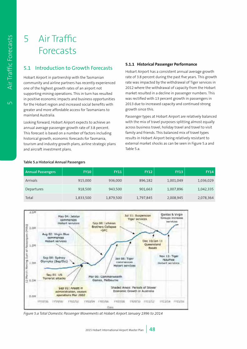
2015 Hobart International Airport Master Plan | 48
9
O
ther
Avi
atio
n U
ses 5 Air Traffic
Forecasts
5.1 Introduction to Growth Forecasts
Hobart Airport in partnership with the Tasmanian
community and airline partners has recently experienced
one of the highest growth rates of an airport not
supporting mining operations. This in turn has resulted
in positive economic impacts and business opportunities
for the Hobart region and increased social benefits with
greater and more affordable access for Tasmanians to
mainland Australia.
Looking forward, Hobart Airport expects to achieve an
annual average passenger growth rate of 3.8 percent.
This forecast is based on a number of factors including
historical growth, economic forecasts for Tasmania,
tourism and industry growth plans, airline strategic plans
and aircraft investment plans.
5.1.1 HistoricalPassengerPerformance
Hobart Airport has a consistent annual average growth
rate of 3.8 percent during the past five years. This growth
rate was impacted by the withdrawal of Tiger services in
2012 where the withdrawal of capacity from the Hobart
market resulted in a decline in passenger numbers. This
was rectified with 13 percent growth in passengers in
2013 due to increased capacity and continued strong
growth since this.
Passenger types at Hobart Airport are relatively balanced
with the mix of travel purposes splitting almost equally
across business travel, holiday travel and travel to visit
family and friends. This balanced mix of travel types
results in Hobart Airport being relatively resistant to
external market shocks as can be seen in Figure 5.a and
Table 5.a.
5
A
ir T
raffi
c Fo
reca
sts
Table 5.a Historical Annual Passengers
Annual Passengers FY10 FY11 FY12 FY13 FY14
Arrivals 915,000 936,000 896,182 1,001,049 1,036,029
Departures 918,500 943,500 901,663 1,007,896 1,042,335
Total 1,833,500 1,879,500 1,797,845 2,008,945 2,078,364
Figure 5.a Total Domestic Passenger Movements at Hobart Airport January 1996 to 2014
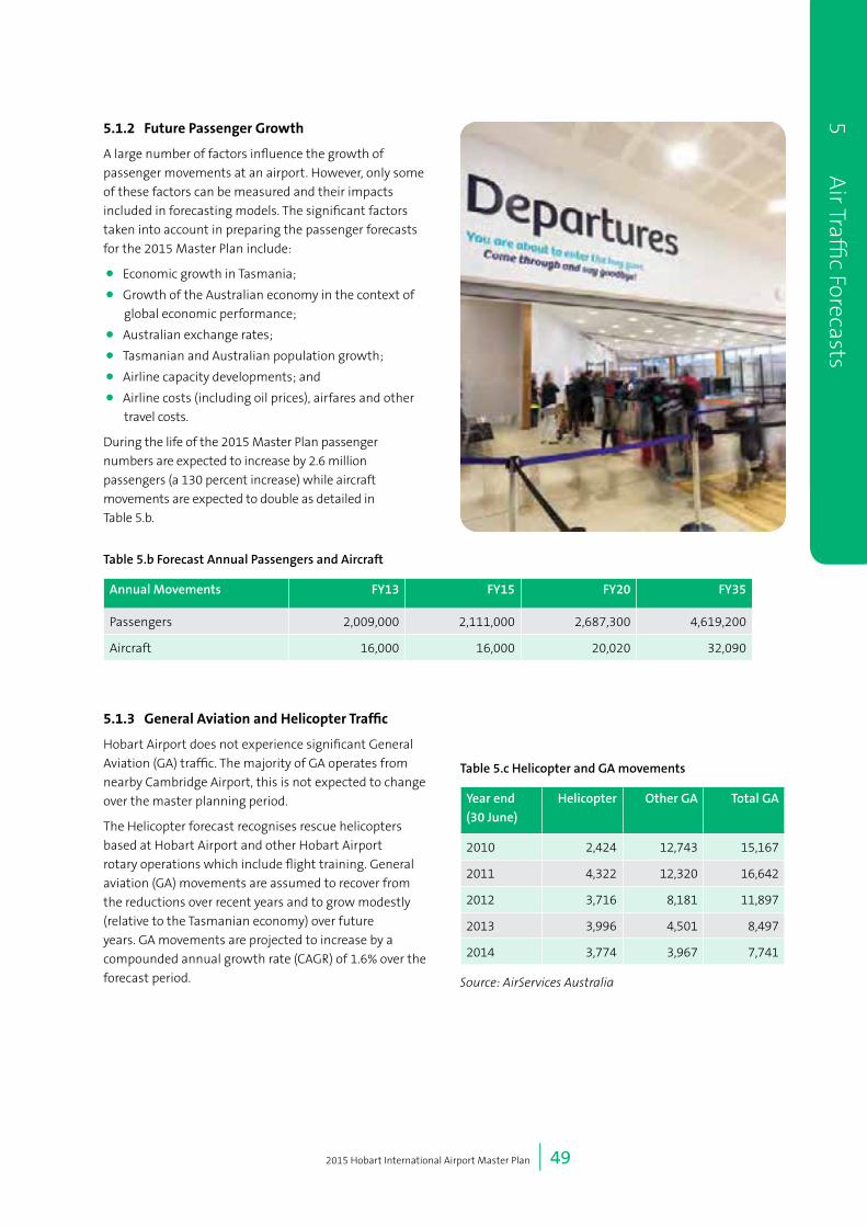
2015 Hobart International Airport Master Plan | 49
9O
therA
viationU
ses
5.1.2 FuturePassengerGrowth
A large number of factors influence the growth of
passenger movements at an airport. However, only some
of these factors can be measured and their impacts
included in forecasting models. The significant factors
taken into account in preparing the passenger forecasts
for the 2015 Master Plan include:
• Economic growth in Tasmania;
• Growth of the Australian economy in the context of
global economic performance;
• Australian exchange rates;
• Tasmanian and Australian population growth;
• Airline capacity developments; and
• Airline costs (including oil prices), airfares and other
travel costs.
During the life of the 2015 Master Plan passenger
numbers are expected to increase by 2.6 million
passengers (a 130 percent increase) while aircraft
movements are expected to double as detailed in
Table 5.b.
5.1.3 GeneralAviationandHelicopterTraffic
Hobart Airport does not experience significant General
Aviation (GA) traffic. The majority of GA operates from
nearby Cambridge Airport, this is not expected to change
over the master planning period.
The Helicopter forecast recognises rescue helicopters
based at Hobart Airport and other Hobart Airport
rotary operations which include flight training. General
aviation (GA) movements are assumed to recover from
the reductions over recent years and to grow modestly
(relative to the Tasmanian economy) over future
years. GA movements are projected to increase by a
compounded annual growth rate (CAGR) of 1.6% over the
forecast period.
5 Air Traffi
c Forecasts
Table 5.b Forecast Annual Passengers and Aircraft
Annual Movements FY13 FY15 FY20 FY35
Passengers 2,009,000 2,111,000 2,687,300 4,619,200
Aircraft 16,000 16,000 20,020 32,090
Table 5.c Helicopter and GA movements
Year end
(30 June)
Helicopter Other GA Total GA
2010 2,424 12,743 15,167
2011 4,322 12,320 16,642
2012 3,716 8,181 11,897
2013 3,996 4,501 8,497
2014 3,774 3,967 7,741
Source: AirServices Australia

2015 Hobart International Airport Master Plan | 50
9
O
ther
Avi
atio
n U
ses 5.1.4 FreightForecasts
The production of high value, high perishable produce in
Tasmania is expected to double in key sectors (seafood
and stone fruits) over the coming five years, as a result of
expended irrigation schemes and demand for Tasmanian
produce.
This is expected to result in an increased demand for
airfreight from Hobart Airport. Much of this will be
delivered through increased cargo being carried on
passenger aircraft. It is forecast that an additional
freighter aircraft will operate from Hobart Airport
three times a week from 2016/17 in order to service
non-Melbourne centric markets. These movements
are incorporated in the total Aircraft Movements from
Hobart Airport shown below.
5
A
ir T
raffi
c Fo
reca
sts
Figure 5.b Busy Hour and Stand Demand Methodology
Table 5.d Freight Forecasts

2015 Hobart International Airport Master Plan | 51
9O
therA
viationU
ses5 A
ir Traffic Forecasts
5.2 Forecasting for Design (Annual Busy Day and Busy Hour Demand)
Infrastructure development at an airport needs to meet anticipated demand during the busiest periods or the ‘busy
hour’. Forecasts of busy hour passengers are required in order to inform a number of planning functions within
the context of an Airport Master Plan. These forecasts are a prediction of the number of arriving and/or departing
passengers expected during a typically busy hour (the ‘busy hour’) within a given year. These hourly passenger forecasts
generally represent a volume of hourly passengers that is below the peak number of hourly passengers expected within
a particular planning year. These are used to size areas, determine numbers of facilities required (i.e. security screening
units, check-in desks/kiosks) amongst a variety of other planning uses within the Master Planning process.
Busy hour forecasts for this Master Plan have been derived through an assessment of existing hourly passenger volumes,
factors likely to influence demand during the planning period and through an application of a peaking factor to the
annual forecasts. Forecasts have been provided for the following design years:
• Domestic arrivals busy hour forecast FY15, FY20 and FY35;
• Domestic departures busy hour forecast FY15, FY20 and FY35; and
• Aircraft stand demand FY15, FY20 and FY35.
In line with the annual forecasts a scenario whereby one large or Code E International flight arrives and departs in the
busy hour has also been included.
The methodology followed to determine the busy hour passenger and stand demand forecasts is illustrated in Figure 5.b.
5.2.1 BusyHourForecasts
The forecast busy hour and annual passengers are identified in Table 5.c.
Table 5.c
Sector FY15 FY20 FY25 FY35
Annual Passengers Domestic
Passengers
2,111,000 2,683,000 3,287,000 4,599,000
International
Passengers
0 4,300 7,900 20,200
Annual Aircraft (AC)
Movements*
Domestic AC
Movements
16,000 20,000 24,000 32,000
International
Passenger
AC Movements
0 20 36 90
Busy Hour
Passengers
Domestic
Passengers
Arrival 780 990 1,210 1,700
Departure 720 920 1,130 1,580
International Arrival 0 220 220 280
Departure 0 220 220 280
Domestic +
International
Passengers
Arrival 780 1,210 1,430 1,920
Departure 720 1,140 1,350 1,800
The forecast for the number and type of aircraft parking or stand demand is provided in Table 5.d. The key assumptions
used to determine the stand demand forecasts are as follows:
• The international scenario assumes that Code E (i.e. B787 aircraft) international operations begin in the period post
FY18 or at the completion of the Runway Extension.

2015 Hobart International Airport Master Plan | 52
9
O
ther
Avi
atio
n U
ses
5
A
ir T
raffi
c Fo
reca
sts • Domestic services are expected to continue to be
serviced by Code C (i.e. 737 or A320) type aircraft.
• Contingency positions have been provided,
maintained at the FY13 ratio. These stands will allow
for schedule flexibility and for unscheduled aircraft
maintenance.
Table 5.d Aircraft Stand Demand Forecasts
Code FY15 FY20 FY35
E 0 1 1
C 5 6 9
Total 5 7 10
Contingency Positions C 1 1 1
E 1 1
5.2.2 InternationalThe extension of the Hobart Airport runway will enable
direct flight to South-East Asia, and for larger aircraft to
service East Antarctica opening up economic possibilities
for Hobart and Tasmania.
The forecast shows international passenger flights
between Hobart and South-Asia commencing from
2019 after the completion of the runway extension. The
forecast is conservative, showing steady growth for this
market, with initial forecasting showing flights during
the summer months. The likely aircraft used for these
services would be a Code E A330-200 or B787 aircraft.
The developments proposed in this Master Plan
incorporate infrastructure requirements to facilitate
international passenger, freight and Antarctic operations
including the development of a northern apron area
for large or Code E aircraft parking and international
processing facilities in the 2020 and 2035 terminal
redevelopments.

6 Passenger Terminal Planning

2015 Hobart International Airport Master Plan | 54
6 Passenger Terminal Planning
6.1 Planning Approach
During the next five years, Hobart Airport will undertake
two transformative projects that will significantly
redefine and improve the operations of the airport:
• The construction of a 500m runway extension will
enable direct flights from Tasmania to South-East
Asia for passenger and freight opportunities and
allow for improved operational flexibility and the
further development of Antarctic aviation programs;
and
• Changes to the layout and size of the passenger
terminal will offer an improved experience for airport
visitors. The phased redevelopment of the terminal
will see works completed around 2017, 2025 and
2035 as required to meet passenger and airline
demand.
As identified in Chapter 5, passenger growth at Hobart
Airport is forecast to continue at an average annual
growth rate of 3.8 percent. These projects will allow
Hobart Airport to meet that increased demand and cater
appropriatley for the needs of its customers, civil aviation
and other users of the airport.
Given this, the following criteria were used as the basis
for terminal planning:
• 2035 design horizon;
• 2035 forecast domestic and international busy hour
passenger demand;
• 2035 forecast aircraft stand demand;
• 2035 apron planning; and
• Next five year terminal development.
6.1.1 ExistingSituation
The existing passenger terminal building is a single
level building. Check-in is located centrally with
domestic security and domestic departures to the east.
International processing facilities are located to the north
of check-in facilities. The most southerly extent of the
building provides an arrivals area that is currently used
by Jetstar and Qantas. The most northerly extent of the
building provides a second arrivals area that is currently
used by Tiger and Virgin. Both arrivals areas have
baggage reclaim facilities with associated back of house
areas. Airline office space, border agency facilities and
baggage make up facilities are housed directly behind
check-in. See Figure 6.a for a plan of the current Hobart
Airport passenger terminal layout.
6
P
asse
nge
r Ter
min
al P
lan
nin
g
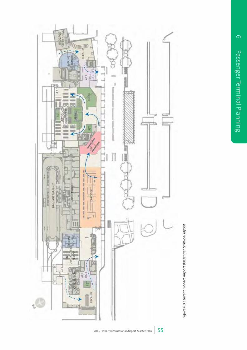
2015 Hobart International Airport Master Plan | 55
6 Passenger Term
inal Plan
nin
g
Figu
re 6
.a C
urre
nt H
obar
t A
irpo
rt p
asse
nger
ter
min
al la
yout

2015 Hobart International Airport Master Plan | 56
6.1.2 2020TerminalDesign
Work on what is referred to as the 2020 terminal design
commenced in 2015 and is expected to be complete in
mid-2017. This redevelopment is called 2020 terminal
design as this equates to the five year Master Plan planning
period. It is forecast to provide sufficient capacity until
2023/2024. At the time of writing, HIAPL has commenced
the redevelopment Project 1 at Hobart Airport.
Consisting of four separate projects, the 2020 terminal
redevelopment is a $25 million dollar investment in
Hobart Airport. The project will provide improved
and larger facilities to visitors and customers. Hobart
Airport will engage with airport stakeholders, including
Airservices Australia, during the planning and delivery of
the upgraded terminal.
The separate terminal development projects include:
• Project 1 – Security screening relocation
This project was completed in March 2015. The
relocation of the screening throat has greatly
improved the efficiency of passenger screening at
Hobart Airport.
• Project 2 – New arrivals hall
The arrivals hall project has commenced and is due
for completion mid-2016. The new arrivals hall will be
used by all arriving passengers and includes a swing
gate area for international and Antarctic passenger
processing.
An international ‘swing gate’ is a removable partition
that can be closed as required to provide areas for
international passengers to pass through immigration
and customs. When the area is not required the swing
gate folds out of the way and is used as part of the
overall domestic arrivals area.
During international arrivals and the operation of the
swing gate, there will be minor impact on the baggage
reclaim availability for domestic passengers. However,
in this initial phase of development, this is forecast to
occur on minimal occasions (with only 20 international
movements forecast per annum) which will have a
limited impact that will be appropriately managed.
The project will also relocate car rental desks to inside
the arrivals hall, deliver new sanitation facilities, a
new local food and convenience outlet, and improved
waiting area for customers.
• Project 3 – Front of house road system
To facilitate changes inside the terminal, the front
of house road system will be upgraded to improve
traffic flow and create a larger external plaza area for
pedestrians. It is due for completion in mid-2016.
Car rental holding bays will move to the area north
of the main car park to be closer to the arrivals hall
and car rental desks. The taxi rank holding area will be
relocated with a smaller immediate holding bay area
being retained outside arrivals to facilitate the flow of
taxis to the rank.
• Project 4 - Redevelopment of the departures hall
The development will involve expanding the
departures lounge to incorporate the old Qantas arrival
area, add additional boarding gates, establish new
food and beverage and retail outlets and provision for
the construction of two future new and larger Airline
lounges.
The purpose of this development is to improve the
passenger experience at Hobart Airport through the
addition of more seating space and improved facilities,
to provide five boarding gates to service the five current
parking bays and provision for additional boarding
gates to meet future parking bay requirements. It will
also enable Hobart Airport to respond to requests from
airlines for new or upgraded lounge facilities.
There will be the requirement for a segregated
international departures lounge and gate for some
international flights. The layout allows for a swing
gate t facilitate international departures. There are
approximately 20 international flights forecast in
2020, which will have minimal impact on the domestic
operations.
Passengers will continue to be provided with direct
access from the terminal to current and future aircraft
via pedestrian pathways across the apron. Covered
walkways on the apron side of the terminal building
will be constructed as part of this project to improve
passengers’ experience as they walk to and from
aircraft.
Aerobridges are not envisaged within this Master
Plan horizon due to the current and forecast
passenger numbers not being great enough to warant
aerobridges, their significant cost along with the
associated development of an upper level mezzanine
floor and vertical circulation to enable access for
passengers to/from the future aerobridges. New
developments within the Master Plan will consider the
ability to introduce aerobridges is protected for the
long term future.
See Figure 6.b for a plan of the 2020 terminal design
for Hobart Airport’s passenger terminal.
6
P
asse
nge
r Ter
min
al P
lan
nin
g

2015 Hobart International Airport Master Plan | 57
6 Passenger Term
inal Plan
nin
g
Figu
re 6
.b 2
020
term
inal
des
ign
for H
obar
t A
irpo
rt’s
pass
enge
r te
rmin
al.

2015 Hobart International Airport Master Plan | 58
6.2 Planning Considerations
To identify an appropriate future terminal design,
planning HIAPL has considered the following (see Figure
6.c for locations):
• Existing location of terminal facilities such as check-
in, departures lounge, international passenger
facilities, security, baggage handling etc.;
• The future uptake of fast travel initiatives such as
internet/mobile check-in, check-in kiosks, bag drops
etc.;
• The types of airlines and aircraft types expected to
service Hobart Airport and passenger types travelling
to and from Hobart in the future;
• Buildability of the design and high level cost
implications;
• Apron, aircraft parking and taxiway system
development;
• Aviation Rescue Fire Fighting Services (ARFFS)
requirements;
• Royal hospital kitchen – lease expires 2024;
• Toll building – lease expires 2036; and
• Freight apron and hangars.
The ARFF will not be impacted by planned terminal
expansions. Regular dialogue will continue to occur with
ARFF around these developments.
HIAPL considers that the redevelopment of the terminal
is consistent with State and Local Planning Schemes.
In particular, HIAPL considers that the expansion and
redevelopment of the terminal is an essential part of
achieving the development objectives of the Clarence
Interim Planning Scheme, which is noted in Chapter
3: National Policy and Regulatory Framework, include
achieving increased product and commodity export and
increased tourism visitation through Hobart Airport. 6
P
asse
nge
r Ter
min
al P
lan
nin
g
Figure 6.c Planning Considerations
2015 Hobart International Airport Master Plan | 59
6.2.1 PassengerTerminalPlan
Hobart Airport operates a single level terminal. Hobart
has domestic quarantine requirements which impact the
terminal layout and design as all inbound passengers
are screen by quarantine. The terminal at Hobart will
accommodate passenger growth by design, expansion
and technical innovation.
Key terminal facilities required at the 2035 design
horizon are identified in Table 6.a. The 2035 terminal plan
(see Figure 6.d) achieves these requirements and provides
an integrated and stageable development solution from
the existing design.
Table 6.a Terminal Design Requirements
DesignYear 2035
Departures
Check-In
Conventional counters 5
Kiosks 17
Bag drops 14
Area (m2) 1,440
Security
Security x-ray units 4
Area (m2) 660
Arrivals
Baggage Reclaim
Reclaim units 3 x 60m
Area (m2) 2,380
Other facilities
Baggage Handling
Bag make-up 48 positions
Area (m2) 2,870
Bag breakdown (m2) 1,070
Lounges / Retail
Airside
Departure Lounge (m2) 1,820
Retail (m2) 2,130
Landside
Arrivals Lounge (m2) 1,700
Retail (m2) 540
Airline Lounge
Lounge (m2) 850
To meet the 2035 forecast the following departures
related developments are planned:
• Check-in – Check-in would be retained in its existing
location with new facilities provided in an expanded
footprint. The development of the check-in hall
provides for an increasing share of fast travel
initiatives such as self-service kiosks and internet/
mobile check-in uptake amongst travellers.
• Security – Security would expand landside toward
the carpark to provide space for additional screening facilities and to allow greater queue space to limit the impact on the check-in hall where queues form.
• Baggage make-up – The existing position of the baggage make-up facility is problematic. It currently occupies the centre of the passenger terminal building behind check-in. The relocation of the baggage make-up facility to the northern end of the building would remove conflicts between passengers and ground service equipment (GSE - such as stairs, tugs, baggage equipment), allowing for future growth of the facility and opening the central passenger terminal area for passenger use.
• Departures lounge – With the relocation of the baggage make-up facility growth of the departures lounge would generally be contained within the existing terminal footprint apart from a small area of expansion on the eastern edge of the building.
International facilities
An international departures facility would be located
in its existing position at the southern end of the
departures lounge.
Airline loungeAn area for airline lounge expansion has been identified in the 0-5 year period, located at the southern end of the
building.
To meet the 2035 forecast the following arrivals related
developments are planned:
• International and domestic arrivals flow – To minimise GSE and passenger conflicts and allow for the future expansion of baggage facilities both domestic and international arrivals facilities would be relocated closer to the centre of the building and apron. International arriving passengers would be processed through a central immigration facility, into a swing reclaim facility and out through customs and quarantine.
• Baggage reclaim – The position of the reclaim hall and back of house area optimises back of house facilities, minimises impact of landside roads, enables compact passenger terminal area and keeps arriving passengers and GSE flows separate. A third baggage reclaim belt is proposed to be added to optimise this process.
• Aerobridges – The existing terminal building is not designed to accommodate aerobridge operations. Aerobridges are not envisaged within this Master Plan horizon due to their significant cost along with the associated development of an upper level mezzanine floor and vertical circulation to enable access for passengers to/from the future aerobridges. New developments within the Master Plan will however consider the ability to introduce aerobridges is protected for the long term future.
6 Passenger Term
inal Plan
nin
g

2015 Hobart International Airport Master Plan | 60
6
P
asse
nge
r Ter
min
al P
lan
nin
g
Figu
re 6
.d U
ltim
ate
(203
5) T
erm
inal
Mas
ter P
lan

7 Airfield Development

2015 Hobart International Airport Master Plan | 62
7 Airfield Development
7.1 Introduction
During the next 20 years, key airfield developments
will enable Hobart Airport to meet its development
objectives. These developments will provide new
opportunities for the Tasmanian economy namely the
runway extension project and enable the continued
growth the airport by providing core aviation
infrastructure. This section of the 2015 Master Plan
outlines the key airfield developments planned for
Hobart Airport in the forecast planning period.
7.2 Existing Runway
Hobart Airport’s existing runway has a paved length of
2,251m and a width of 45m. Known as Runway 12/30
(as shown in Figure 7.a) it is aligned in a north-west
to south-east direction. The runway is a high strength,
flexible pavement constructed with a grooved asphaltic
concrete surface and has a Pavement Classification
Number (PCN) of 63.
Currently the runway caters for unrestricted operations
for narrow bodied aircraft, such as Code C aircraft
(B737/A320) and Code D aircraft (B767). Larger aircraft,
such as the Boeing B787, A330 or B777 (Code E aircraft)
can operate with a weight restriction.
In assessing the future needs of civil aviation and other
users at the Airport, Hobart Airport considers that
Code E aircraft are the largest aircraft likely to fly future
international passenger and freight operations to or from
Hobart. At this time, there are no plans for the A380 (and
other Code F aircraft) for Hobart Airport.
During 2012 $20 million was invested in renewing the
airport’s runway. This project removed and replaced
the runway surface, strengthened areas of the runway
substrate and maintained its shape and integrity (see
Figure 7.b). Further major interventional maintenance is
not expected to be necessary on the runway and taxiway
system until approximately 2027.
7
A
irfi
eld
Dev
elop
men
t
Figure 7.b Runway Overlay Work

2015 Hobart International Airport Master Plan | 63
7 Airfi
eld Developm
ent
Figu
re 7
.a E
xist
ing
Air
fiel
d La
yout
at
Hob
art
Air
port
Run
way
12/
30
Taxi
way
sPa
ssen
ger
Apro
ns
Term
inal
Free
hold
Lan
d
Free
hold
Lan
d
Airp
ort A
rea
(leas
ehol
d la
nd)
Frei
ght
Term
inal
& A
pron
Frei
ght T
erm
inal
& A
pron
Hel
icop
ter
Ope
ratio
nsH
elic
opte
rO
pera
tions
Gen
eral
avi
atio
n ta
xiw
ay a
nd a
pron
Sou
rce:
Esr
i, D
igita
lGlo
be, G
eoE
ye, i
-cub
ed, U
SD
A, U
SG
S, A
EX
, Get
map
ping
, Aer
ogrid
, IG
N, I
GP,
sw
isst
opo,
and
the
GIS
Use
r Com
mun
ity
020
040
060
080
0
Met
res
[
Figu
re N
o
7.a
Coo
rdin
ate
Sys
tem
GD
A 19
94 M
GA
Zone
55
Scal
e at
A4
1:17
,982
Dra
win
g Ti
tle
Exis
ting
Airf
ield
Lay
out a
t Hob
art
Run
way
cen
trelin
eE
xist
ing
airs
ide
layo
ut
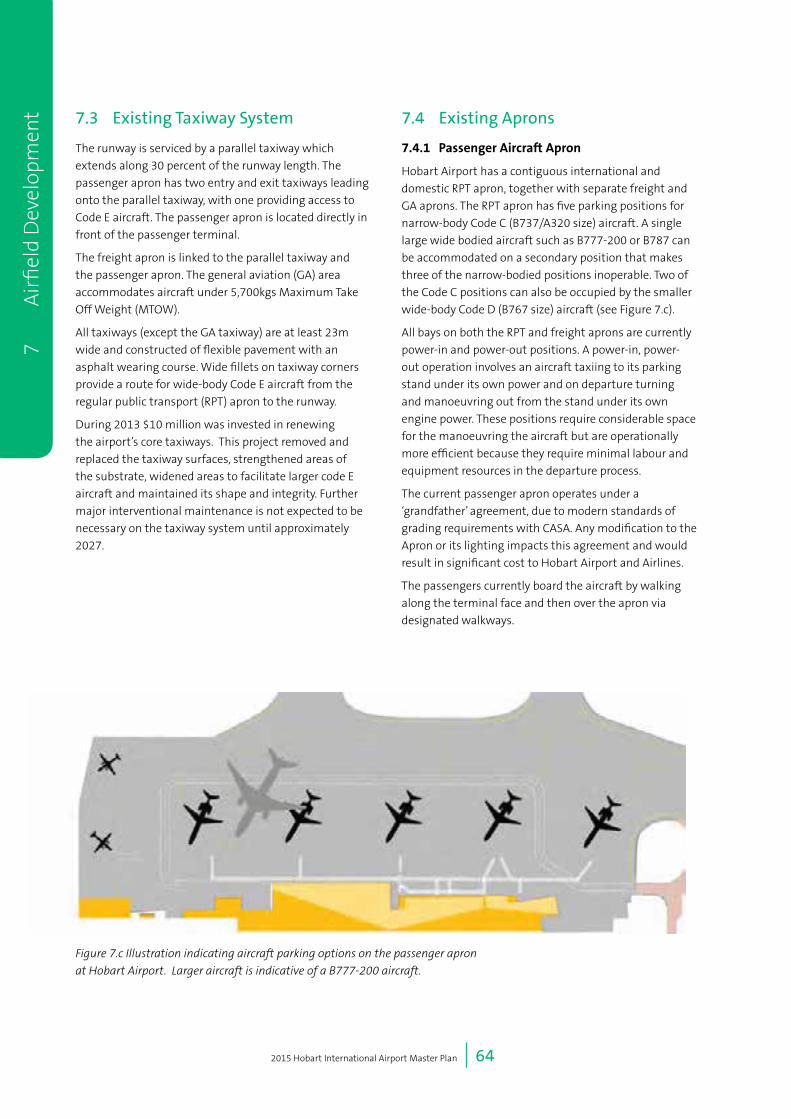
2015 Hobart International Airport Master Plan | 64
7.3 Existing Taxiway System
The runway is serviced by a parallel taxiway which
extends along 30 percent of the runway length. The
passenger apron has two entry and exit taxiways leading
onto the parallel taxiway, with one providing access to
Code E aircraft. The passenger apron is located directly in
front of the passenger terminal.
The freight apron is linked to the parallel taxiway and
the passenger apron. The general aviation (GA) area
accommodates aircraft under 5,700kgs Maximum Take
Off Weight (MTOW).
All taxiways (except the GA taxiway) are at least 23m
wide and constructed of flexible pavement with an
asphalt wearing course. Wide fillets on taxiway corners
provide a route for wide-body Code E aircraft from the
regular public transport (RPT) apron to the runway.
During 2013 $10 million was invested in renewing
the airport’s core taxiways. This project removed and
replaced the taxiway surfaces, strengthened areas of
the substrate, widened areas to facilitate larger code E
aircraft and maintained its shape and integrity. Further
major interventional maintenance is not expected to be
necessary on the taxiway system until approximately
2027.
7.4 Existing Aprons
7.4.1 PassengerAircraftApron
Hobart Airport has a contiguous international and
domestic RPT apron, together with separate freight and
GA aprons. The RPT apron has five parking positions for
narrow-body Code C (B737/A320 size) aircraft. A single
large wide bodied aircraft such as B777-200 or B787 can
be accommodated on a secondary position that makes
three of the narrow-bodied positions inoperable. Two of
the Code C positions can also be occupied by the smaller
wide-body Code D (B767 size) aircraft (see Figure 7.c).
All bays on both the RPT and freight aprons are currently
power-in and power-out positions. A power-in, power-
out operation involves an aircraft taxiing to its parking
stand under its own power and on departure turning
and manoeuvring out from the stand under its own
engine power. These positions require considerable space
for the manoeuvring the aircraft but are operationally
more efficient because they require minimal labour and
equipment resources in the departure process.
The current passenger apron operates under a
‘grandfather’ agreement, due to modern standards of
grading requirements with CASA. Any modification to the
Apron or its lighting impacts this agreement and would
result in significant cost to Hobart Airport and Airlines.
The passengers currently board the aircraft by walking
along the terminal face and then over the apron via
designated walkways.
7
A
irfi
eld
Dev
elop
men
t
Figure 7.c Illustration indicating aircraft parking options on the passenger apron
at Hobart Airport. Larger aircraft is indicative of a B777-200 aircraft.

2015 Hobart International Airport Master Plan | 65
7.4.2 FreightandGAApron
Hobart Airport is an important air freight centre, with
the major commodities handled including seafood, fruit
and vegetables, flowers, ‘just in time’ manufactured
goods, newspapers and livestock. Further horticulture
upgrades such as irrigation schemes and increase in
high-value, high-perishable freight is expected to expand
the demand for air freight. As such, Hobart Airport is
committed to the development of infrastructure to meet
demand for freight operations.
Various GA aircraft parking areas have space for up 20
fixed and rotary wing aircraft. In-ground tie down points
are provided on two sectors of these areas.
7.4.3 ExistingFreightOperation
Hobart Airport has two freight terminal and apron areas.
A larger facility to the south caters for Code C aircraft,
and a smaller facility to the north caters for smaller
aircraft. The Qantas Freight and Toll Air Express facilities
are located respectively to the south and north.
Freight carried on passenger aircraft is loaded and
unloaded on the domestic apron and transported on
trolleys to and from the freight area.
7.4.4 ExistingGAOperation
The principal users of GA facilities at Hobart Airport
include:
• Rotor-Lift Pty Ltd (both landside and airside rotary
operations);
• Royal Flying Doctor Service;
• Small freight operators;
• Business jets; and
• Charter operators.
Nearly all recreational GA activity in the Hobart region is
off airport, at either the adjacent Cambridge Airport, or
at privately owned strips.
The Air Traffic Control tower controls air traffic for both
Hobart Airport and Cambridge Aerodrome, and priority is
given to RPT traffic. Development at Hobart Airport also
prioritises RPT operations.
7.5 Future Airfield Development
During the life of the 2015 Master Plan, a number of
airfield developments are planned including runway,
taxiway and apron developments. These are described in
the following sections and illustrated in Figure 7.d.
7.6 Proposed Runway Extension
7.6.1 Introduction
A key component of the 2015 Master Plan is the
proposed runway extension and terminal expansion
to cater for forecast passenger growth, facilitate direct
flights from South-East Asia for passengers and freight
and to service the Antarctic Sector.
An aircraft’s take-off length is typically longer than
landing length for runway operations, and is therefore
more relevant in determining the capability of Hobart
Airport to service a destination using a particular aircraft.
Analysis shows that the current Hobart Airport runway
length of 2,251m is adequate for take-off on direct flights
to:
• The furthest domestic sectors of Darwin, Cairns and
Perth by Boeing 737-800 and Airbus A320 operated
by the current operators to and from Hobart; and
• International sectors such as New Zealand.
For larger Code E aircraft, such as the Boeing 787 and
777 aircraft, to operate from the existing runway, airlines
have to substantially reduce their payload or fuel or make
a refuelling stop, limiting the destinations that can be
reached. These restrictions make the operation of flights
to Hobart impractical and economically unviable.
Hobart is the hub of Australia’s Antarctic Program and
an important Gateway to East Antarctica. To enhance the
city’s competitiveness in relation to Antarctic operations,
Hobart Airport needs to be able to accommodate
operations of heavier lift logistic type aircraft like a
Boeing C-17 Globemaster III. The C-17 aircraft requires a
runway length of 2,360m for day operations and 2,316m
for night operations.
7 Airfi
eld Developm
ent

2015 Hobart International Airport Master Plan | 66
7
A
irfi
eld
Dev
elop
men
t
Logi
stic
s,
Frei
ght
and
Ant
arct
ic
Hub
Exte
nded
Apr
on
Exte
nded
Run
way
Exte
nded
Term
inal
Gru
eber
Ave
Sou
rce:
Esr
i, D
igita
lGlo
be, G
eoE
ye, i
-cub
ed, U
SD
A, U
SG
S, A
EX
, Get
map
ping
, Aer
ogrid
, IG
N, I
GP,
sw
isst
opo,
and
the
GIS
Use
r Com
mun
ity
020
040
060
080
0
Met
res
[
Figu
re N
o
7.d
Coo
rdin
ate
Sys
tem
GD
A 19
94 M
GA
Zone
55
Scal
e at
A4
1:17
,500
Dra
win
g Ti
tle
Futu
re A
irfie
ld D
evel
opm
ents
Run
way
cen
trelin
eEx
istin
g ai
rsid
e la
yout
Figu
re 7
.d F
utur
e A
irfi
eld
Dev
elop
men
ts
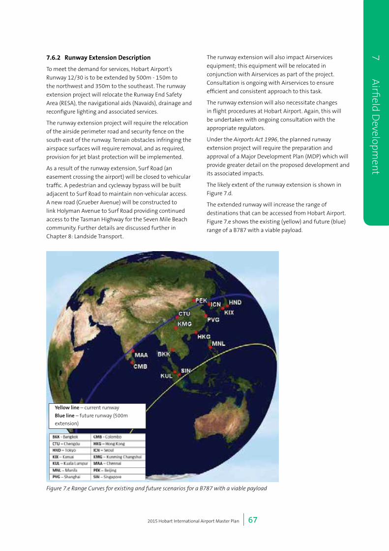
2015 Hobart International Airport Master Plan | 67
7.6.2 RunwayExtensionDescription
To meet the demand for services, Hobart Airport’s
Runway 12/30 is to be extended by 500m - 150m to
the northwest and 350m to the southeast. The runway
extension project will relocate the Runway End Safety
Area (RESA), the navigational aids (Navaids), drainage and
reconfigure lighting and associated services.
The runway extension project will require the relocation
of the airside perimeter road and security fence on the
south-east of the runway. Terrain obstacles infringing the
airspace surfaces will require removal, and as required,
provision for jet blast protection will be implemented.
As a result of the runway extension, Surf Road (an
easement crossing the airport) will be closed to vehicular
traffic. A pedestrian and cycleway bypass will be built
adjacent to Surf Road to maintain non-vehicular access.
A new road (Grueber Avenue) will be constructed to
link Holyman Avenue to Surf Road providing continued
access to the Tasman Highway for the Seven Mile Beach
community. Further details are discussed further in
Chapter 8: Landside Transport.
The runway extension will also impact Airservices
equipment; this equipment will be relocated in
conjunction with Airservices as part of the project.
Consultation is ongoing with Airservices to ensure
efficient and consistent approach to this task.
The runway extension will also necessitate changes
in flight procedures at Hobart Airport. Again, this will
be undertaken with ongoing consultation with the
appropriate regulators.
Under the Airports Act 1996, the planned runway
extension project will require the preparation and
approval of a Major Development Plan (MDP) which will
provide greater detail on the proposed development and
its associated impacts.
The likely extent of the runway extension is shown in
Figure 7.d.
The extended runway will increase the range of
destinations that can be accessed from Hobart Airport.
Figure 7.e shows the existing (yellow) and future (blue)
range of a B787 with a viable payload.
7 Airfi
eld Developm
ent
Figure 7.e Range Curves for existing and future scenarios for a B787 with a viable payload
Yellow line – current runway
Blue line – future runway (500m
extension)

2015 Hobart International Airport Master Plan | 68
7.7 Future Taxiway System
7.7.1 ParallelTaxiway
At present arriving aircraft on Runway 12/30 land and
turn 180 degrees on the runway and backtrack along the
runway until they can exit the runway via the mid-field
link Taxiways C and D. This turning and backtracking
impacts capacity as Runway 12/30 cannot be used
for any other runway operations whilst an aircraft
is occupying the runway for this manoeuvre (which
typically takes around three minutes).
The future provision of extended parallel taxiways at the
end of the runway will allow arriving aircraft on Runway
12 to proceed to the runway end and then exit via the
parallel taxiway. The extended parallel taxiway would be
required in approximately in 2032 to maintain airport
capacity and meet demand.
7.7.2 NewLinkTaxiways
The new northern apron and the future freight and
Antarctic aprons will require taxiways to allow aircraft
access the runway.
These new taxiways will need to accommodate Code
E aircraft and will be 23m wide with large fillets to
accommodate the larger turning circles of these aircraft.
These link taxiways will be delivered with the aprons
- the northern apron as part of the runway extension
project and the southern logistic, freight and Antarctic
area as demand requires.
7.8 Future Aprons
7.8.1 PassengerAprons
To cater for forecast aircraft movements, the current
passenger apron will need to accommodate up to 10 Code
C (narrow body) aircraft by 2035. To increase the capacity
of the passenger apron, operations will need to move from
the current power in power out operation which requires
significant area for aircraft manoeuvring to power in push
back operations. Power in push back has the same arrival
procedure but, on departure, the aircraft is pushed-back by
a tug or similar motorised vehicle.
The change in operations better utilises space of the
apron and enables a shorter terminal length and a better
passenger experience to be achieved.
Push back operations will commence depending on
demand. The cost of changing to a power in push
back operation is considerable due to the ‘grandfather’
conditions that exist and will only occur when
economically feasible for all parties.
The way that passengers embark and disembark aircraft
is not expected to change significantly during the life of
the 2015 Master Plan. The current single level terminal
design, power in power out operations, forecast passenger
numbers (which is below five million passengers - the
typical level passengers normally required justify
introduction of aerobridges) means that the installation
of aerobridges at Hobart Airport is not practicable or
economically feasible at this stage. To improve passenger
amenity covered walk ways will be installed as part of the
2020 terminal redevelopment project.
7
A
irfi
eld
Dev
elop
men
t

2015 Hobart International Airport Master Plan | 69
7.8.2 MultipleUseAprons
To accommodate the large 75m length, 65m wingspan
and weight of a Code E aircraft used for international
and Antarctic operations, a new and separate apron will
be designed and purpose-built on the northern side of
the existing RPT apron to accommodate these Code E
aircraft (see Figure 7.d). It is anticipated this apron will
facilitate any code E freight and Antarctic operations in
the immediate future. This new northern apron will be
supported by a new entry / exit taxiway from the parallel
taxiway. These planned operational and infrastructure
changes will enhance the efficiency of the aircraft
movements on the new northern apron and existing
apron.
The staging of changes and development of aprons
will be aligned to changes to the passenger terminal to
ensure efficient and safe operations. This is expected to
occur within the next five years. Further details of the
northern apron will be provided as part of the runway
extension MDP.
7.8.3 FreightApron
The current freight aprons are anticipated to continue
operating in the next five years. Changes in operation will
be as a result of operational necessity driven by demand.
The new northern apron freight facility is planned for
development in the short-term to accommodate the
parking of the two Code C aircraft or a single Code E
aircraft for both the Antarctic flights and international
operations. The concept design of the apron has
taken the existing freight facility into account and it
is anticipated that both facilities can co-exist for the
medium-term.
To meet future demand for airfreight it is proposed that
modern freight facilities be established at the southern
end of the airport where land area and topography
permit the development of aprons and hangars for the
storage and handling of freight and aircraft.
The future freight facilities planned for Aviation Precinct
1 allow for the development of warehouses and
cool stores and the expansion of both domestic and
international airfreight facilities.
This area is also identified for Antarctic aviation
operations as this precinct provides the space to develop
separate handling and operational facilities for wide
bodied aircraft to have direct access to apron areas,
taxiways and the runway. The apron has also been
positioned to facilitate high tailed military aircraft.
Aviation Precinct 1’s buildings and aprons will be served
by a proposed new a landside road (Grueber Avenue) and
taxiways linking to freight aprons from the runway and
facilities. The freight hangars can been located so that
the control tower view of the extended approach onto
Runway 30 is not obscured.
These facilities are reflected in the 2035 airport layout in
Figure 7.d. Demand will determine the development for
the future freight and Antarctic area,
7.8.4 FutureGeneralAviationDevelopment
GA refers to non-jet, non-regular passenger aircraft,
mostly smaller lighter aircraft. Hobart Airport does not
foresee significant future GA development. Most GA
activity occurs at Cambridge Aerodrome. GA activity at
Hobart Airport will remain in its current location with
scope for limited development as required.
To meet the forecast demand, provision for helicopter
operations and parking is expected to be expanded in the
short-term (by 2020). This increase in demand has been
factored into the noise modelling.
7.9 Planning considerations
HIAPL considers that the developments proposed in this
Chapter are consistent with State and local planning
schemes including the Southern Tasmania Regional Land
Use Strategy 2010-2035 and the draft Clarence Interim
Planning Scheme
In particular, HIAPL considers that these developments
are essential to maintaining Hobart Airport’s status
as a transport hub in Tasmania to allow for increased
movements of passengers and time sensitive products.
Further, as noted in Chapter 3, HIAPL is planning for the
runway extension and other airfield developments to
ensure continuation of existing public access rights along
the coast from both land and water, together with the
protection of natural and cultural coastal values, health
and safety and security requirements, consistent with
the principles of the State Coastal Policy.
7 Airfi
eld Developm
ent

2015 Hobart International Airport Master Plan | 70
7
A
irfi
eld
Dev
elop
men
t

8 Landside Transport
2015 Hobart International Airport Master Plan | 72
8 Landside Transport
8.1 Introduction
Efficient ground transport within, to and from Hobart
Airport is essential for its economic development. In
the coming 20 years, the airport is expected to play a
significant role in the economic prosperity and growth of
both Hobart and Tasmania.
Forecast growth and development demands will have
a significant impact on transport access to Hobart
Airport. Passenger demands are expected grow by 150
percent during the next twenty years, which in turn
drives employment and development in the terminal
precinct. Land use planning has identified an ambitious
development program that will drive commercial and
logistic growth within the airport boundary. The demand
for movement and goods is also expected to rise, with
Hobart Airport providing a hub particularly for high-value
high perishable goods.
In addition, traffic levels around the airport are also
increasing driven by growth in nearby Cambridge Park
and the growing eastern townships of Sorell and Midway
Point. This growth outside the airport itself will impact
on the effectiveness of the Tasman Highway to be able to
cater for both airport and non-airport growth.
To ensure Hobart Airport is prepared for projected
growth, and to meet the requirements of the Airports
Act in relation to ground transport, this chapter provides
details of the Ground Transport Plan for Hobart Airport,
including:
• An overview of the existing transport infrastructure
provision at Hobart Airport, including a review of the
main travel modes at Hobart Airport (roads, bus, taxi
and freight);
• A summary of the existing and projected transport
demand. Projected transport demand estimates
will inform the requirements for the future ground
transport network;
• The aims for ground transport access to Hobart
Airport setting out the aspiration to provide an
efficient, reliable and sustainable ground transport
network for all users; and
• The future ground transport network to serve the
projected transport demand. This includes provisions
for the improvement of all travel modes expected at
Hobart Airport including roads, bus, taxi and freight.
The Ground Transport Plan identifies the opportunities
for improved transport access to Hobart Airport to cater
for changes at the airport and the projected transport
demand.
8.2 About the Ground Transport Plan
The following sections outline the aims, objectives, issues
addressed, time periods, consultation and plans and
strategies considered in the preparation of the Ground
Transport Plan.
8.2.1 GroundTransportAims
HIAPL’s aims in relation to ground transport are as
follows:
Road: The broader road transport system will facilitate a
variety of transport functions with more reliable access
to the terminal forecourt and facilitate access to new
development precincts.
Parking: Parking supply will be increased to
accommodate new parking products and anticipated
parking demands.
Bus: Bus access will be increased to provide frequent,
safe and affordable services with comparable travel
times to private vehicles. It will provide a more equitable
transport choice for all airport users.
Taxi: The capability of the taxi system to reliably carry
high number of passengers will be improved through a
larger holding area and improved queuing and control
facilities.
Active transport: The walking and cycling network will be
connected, continuous, safe and comfortable with high
amenity.
8
Lan
dsid
e Tr
ansp
ort

2015 Hobart International Airport Master Plan | 73
Freight: The transport network will provide efficient
access for high productivity freight vehicles.
Demand management: Technology and communications
will be used to improve the utilisation of the existing
transport network.
In order to achieve these aims, collaboration between
Hobart Airport, Federal, State and Local government as
well as the private sector is required to plan and deliver
transport infrastructure.
8.2.2 ObjectivesoftheGroundTransportPlan
Hobart Airport has identified four objectives for the 2015
Hobart Airport Ground Transport Plan:
• Incorporate State and Local Government transport
planning in the development of the Ground Transport
Plan to ensure a holistic approach to this area;
• Provide an integrated plan to improve transport
access to Hobart Airport. The Ground Transport Plan
integrates with land use to provide airside, landside,
business and industry precincts with an efficient,
reliable and sustainable ground transport network;
• Improve ground transport access for all modes of
travel for passengers, staff and commercial users.
Provision of a choice of travel modes is a key outcome
to provide equitable travel for users of Hobart
Airport; and
• Provision of a future transport network capacity that
is capable of meeting projected transport demand
over the next 20 year period.
8.2.3 Consultation
To prepare the Ground Transport Plan, HIAPL consulted
with a range of stakeholders including:
• Clarence City Council - responsible for local road
network planning and transport provisions in the City
of Clarence. Council provided input on the adjacent
road network, bus planning and cycling routes; and
• Department of State Growth (DSG) - responsible
for the planning and development of the freeway
and arterial road network (including the Tasman
Highway) in Tasmania and regulator of the taxi and
hire vehicle industry in Tasmania. DSG provided input
on external road development, public transport,
cycling and shared path infrastructure and demand
management measures.
Additional information about consultation activities can
be found in Chapter 14: Consultation Program.
HIAPL has a strong relationship with the State and local
authorities responsible for the road network and public
transport system and has both formal and informal
processes to engage and consult with key stakeholders in
relation to these issues.
Transport, road and public transport issues can be and
are regularly discussed at Hobart Airport’s:
• Planning Coordination Forum, which meets four
times per year and is attended by, amongst others,
the State and local authorities responsible for the
road network and public transport system; and
• bi-annual meeting with the Secretary for the
Department of State Growth and relevant Ministers.
8.2.4 PlansandStrategiesConsidered
There are a number of plans and strategies that were
considered during the preparation of the Ground
Transport Plan. These plans and strategies include:
State Government
• Southern Tasmania Transport Plan 2010;
• Tasman/East Derwent Highway Upgrade;
• Variable Speed Limit System; and
• Approved Higher Mass Limit Route Network.
Local Government
• Clarence Bicycle Strategy and Action Plan 2013;
• Clarence Planning Scheme 2014;
• Clarence Activity Centre Strategy 2013; and
• Clarence City Council Strategic Plan 2010-2015.
Hobart Airport
• Hobart Airport Master Plan 2009;
• Hobart Airport Environment Strategy 2010-2015; and
• Hobart Runway Extension.
8 Landside Tran
sport
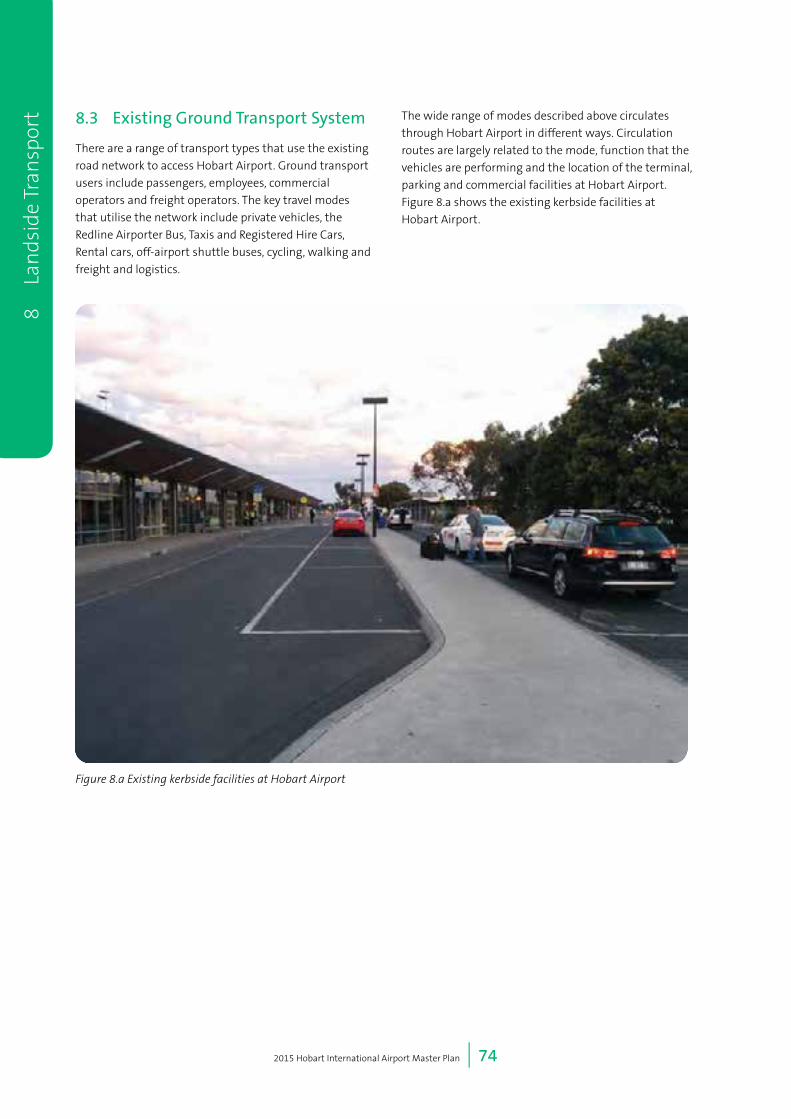
2015 Hobart International Airport Master Plan | 74
8.3 Existing Ground Transport System
There are a range of transport types that use the existing
road network to access Hobart Airport. Ground transport
users include passengers, employees, commercial
operators and freight operators. The key travel modes
that utilise the network include private vehicles, the
Redline Airporter Bus, Taxis and Registered Hire Cars,
Rental cars, off-airport shuttle buses, cycling, walking and
freight and logistics.
The wide range of modes described above circulates
through Hobart Airport in different ways. Circulation
routes are largely related to the mode, function that the
vehicles are performing and the location of the terminal,
parking and commercial facilities at Hobart Airport.
Figure 8.a shows the existing kerbside facilities at
Hobart Airport.
8
Lan
dsid
e Tr
ansp
ort
Figure 8.a Existing kerbside facilities at Hobart Airport
2015 Hobart International Airport Master Plan | 75
8.3.1 InternalRoads
This section details the internal roads currently within Hobart Airport, both within and connecting the terminal,
business and industry precincts (shown in Figure 8.b). Key internal roads are listed below in Table 8.a.
Table 8.a Internal road network descriptions
RoadName Operation KeyUse(s) Layout
Holyman Avenue NW-SE road from Tasman
Highway sweeping NE to the
terminal building
Access to the airport precinct
from Tasman Highway
2 lanes, two-way
Addison Drive Loop road from Holyman Avenue
to front of terminal, around to
Long Street
Access to drop-off and pick-up
area adjacent to terminal
1 lane, one way
Gatty Street NW-SE road from Holyman
Avenue to Long Street
Access to hire car drop off, saver
car park, freight terminal, ARFF
and heli operations
2 lane, two-way
Loop Road Generally north-south road from
Addison Drive to Back Road
Alternative access to Tasman
Highway
2 lane, two-way
(narrow pavement)
Back Road NW-SE road from Tasman
Highway to Loop Road
Alternative access to Tasman
Highway
2 lane, two-way
Tower Road North-south road from Loop Road
to airport control tower
Access to airport control tower 2 lane, two-way
Surf Road NE-SW road from Pittwater Road
to Seven Mile Beach Road
Local access. Partially situated on
easement within airport site
2 lane, two-way
Unnamed Road NE-SW road from Holyman
Avenue to Back Road/Loop Road
Access to the hotel and caravan
park
2 lane, two-way
8.3.2 ExternalRoads
The road network external to Hobart Airport consists of major roads that provide connectivity to the broader transport
network (shown in Figure 8.c). The key connections between these roads and the internal road network are also detailed
in Table 8.b.
Table 8.b External road network descriptions
RoadName Declared Access Layout Management
Tasman Highway Declared Arterial (A3) CBD, Sorell, Tasman
Peninsula, East Coast
and circulatory east
coast to Launceston
4 lane, two-way
2 lane two-way in vicinity
of Hobart Airport
State
Pittwater Road No Tasman Highway to
Surf Road
2 lane, two-way Council
Surf Road No Pittwater Road, Seven
Mile Beach Road.
Partially managed by
HIAPL
2 lane, two-way Council
Seven Mile Beach
Road
No Surf Road, Acton Road 2 lane, two-way Council
Estate Drive No Seven Mile Beach
Road, Acton Road
2 lane, two-way Council
Acton Road Declared Arterial
(C330)
Tasman Highway,
Acton
2 lane, two-way Council
8 Landside Tran
sport

2015 Hobart International Airport Master Plan | 76
8
Lan
dsid
e Tr
ansp
ort
Figu
re 8
.b E
xist
ing
inte
rnal
road
net
wor
k an
d pa
rkin
g ar
eas
Add
ison
Driv
e
Gat
ty S
tree
t
Loop
Roa
d
Holyman
Avenue
Sou
rce:
Esr
i, D
igita
lGlo
be, G
eoE
ye, i
-cub
ed, U
SD
A, U
SG
S, A
EX
, Get
map
ping
, Aer
ogrid
, IG
N, I
GP,
sw
isst
opo,
and
the
GIS
Use
r Com
mun
ity
040
8012
016
0
Met
res
[
Car
Par
king
Ren
tal P
arki
ngTa
xi H
oldi
ng A
rea
Term
inal
sEx
istin
g R
oads
Figu
re N
o
8.b
Coo
rdin
ate
Sys
tem
GD
A 19
94 M
GA
Zone
55
Scal
e at
A4
1:3,
448
Dra
win
g Ti
tle
Exis
ting
inte
rnal
road
net
wor
kan
d pa
rkin
g ar
ea
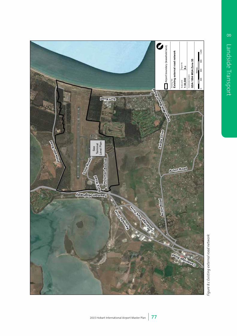
2015 Hobart International Airport Master Plan | 77
8 Landside Tran
sport
Figu
re 8
.c E
xist
ing
exte
rnal
road
net
wor
k
Surf Road
Pittw
ater
Roa
d
Tasman Highway Back
Roa
d
Loop
Roa
d
Hol
yman
Ave
nue
Kenn
edy D
rive
Cambr
idge P
ark D
rive
Cambridge Road
Act
on R
oad
Esta
te D
rive
Acton RoadSe
ven
Mile
Bea
ch R
oad
See
Term
inal
Le
vel P
lan
Sou
rce:
Esr
i, D
igita
lGlo
be, G
eoE
ye, i
-cub
ed, U
SD
A, U
SG
S, A
EX
, Get
map
ping
, Aer
ogrid
, IG
N, I
GP,
sw
isst
opo,
and
the
GIS
Use
r Com
mun
ity
030
060
090
01,
200
Met
res
[
Airp
ort b
ound
ary
(leas
ehol
d la
nd)
Figu
re N
o
8.c
Coo
rdin
ate
Sys
tem
GD
A 19
94 M
GA
Zone
55
Scal
e at
A4
1:30
,000
Dra
win
g Ti
tle
Exis
ting
exte
rnal
roa
d ne
twor
k

2015 Hobart International Airport Master Plan | 78
8.3.3 Parking
There are approximately 1,750 car spaces at Hobart Airport for passenger parking, rental, employee and other uses. An additional 150 car spaces, predominantly for long-term passenger parking, will be made available in 2015 from the demolition of the old Hobart Airport administration building and the development of new parking adjacent to Loop Road. These additional spaces are incorporated into the passenger parking area shown in Figure 8.b.
On-site car parking is generally provided for short and long-term parking and include areas of varying price ranges. Limited staff and designated car parking is provided for employee and commercial use. Off-site private car parks are also located in Kennedy Drive (off Tasman Highway/Holyman Avenue intersection).
8.3.4 PublicTransport
8.3.4.1 Bus and Shuttle
Bus travel provides equitable access to the airport for those who cannot access a private vehicle. Bus services additionally provide a more sustainable mode of access than multiple private vehicles given the number of passengers each bus can accommodate.
Existing bus services (shown in Figure 8.d) that provide direct access to Hobart Airport include:
• Redline Airporter Shuttle bus which facilitates movements between Hobart CBD and Hobart Airport. The shuttle picks up and drops off passengers within Hobart CBD at the Hobart Transit Centre (230 Liverpool Street) and at various hotels, on a booking basis.
• Shuttle (off-airport car park) bus which provides access from off-site car parks for airport users who wish to access Hobart Airport. The operations of these shuttle services are dependent on passenger demand.
The terminal forecourt provides parking areas for a variety of individual shuttles and vehicles.
The regional bus services between Hobart and the East Coast run along the Tasman Highway but do not currently provide direct access to Hobart Airport.
8.3.4.2 Taxis
The key points of the taxi system are as follows:
• Taxi drop-off typically occurs in the terminal forecourt and is co-located with the passenger drop-off areas in the terminal forecourt;
• Recirculation involves taxis circulating through the terminal forecourt and accessing a partially
8
Lan
dsid
e Tr
ansp
ort
Figure 8.d Bus routes in the vicinity of Hobart Airport
Tasm
an H
ighw
ay
Holyman Avenue
Cam
brid
ge R
oad
Acton Road Estate Drive
Acton R
oad
Seven Mile Beach Road
Source: Esri, DigitalGlobe, GeoEye, i-cubed, USDA, USGS, AEX, Getmapping, Aerogrid, IGN, IGP, swisstopo,and the GIS User Community
0 250 500 750 1,000
Metres
[
Figure No
8.dCoordinate System
GDA 1994 MGA Zone 55
Scale at A4
1:24,000
Drawing Title
Bus routes around Hobart Airport
AirporterRegional Coach PublicLocal Bus Routes

2015 Hobart International Airport Master Plan | 79
controlled holding area around positioned off Addison Drive. Taxis will queue in the holding area and then access a secondary controlled queue for access to the forecourt; and
• A taxi pick-up rank is located in the terminal forecourt for passenger access.
8.3.5 RentalCar
Rental car is a popular mode of ground transport access from Hobart Airport. A number of rental car companies are permanently located at Hobart Airport, each at separate locations within the terminal precinct.
Rental vehicles generally access the terminal precinct via Holyman Avenue and Gatty Street. Passengers are able to book a vehicle through a range of companies at a rental facility located adjacent to the terminal forecourt.
Rental car companies generally have their own cleaning and parking facilities, which minimises vehicle shuttling between parking areas and the number of trips through the terminal precinct.
8.3.6 ActiveTransportNetwork
Active transport is a mode of access that involves
physical activity, and typically focuses on walking and
cycling networks. In terms of Hobart Airport, the active
transport network includes existing bicycle links to the
airport, and the pedestrian environment to and within
the airport boundary.
Where structures practical walkways will be covered. It is
intended that carparks will be linked to the terminal via
covered pedestrian access.
8.3.6.1 Cycling
Cycling access depends primarily on the provision of safe
and convenient bicycle routes and access to quality end
of trip facilities (which include showers, change facilities,
and secure bicycle parking).
In 2013, the Clarence City Council released the Clarence
Bicycle Strategy. The bicycle strategy provides a network
of existing and proposed on-street and off-street bicycle
networks.
The Tasman Highway has been designated as a principal
bicycle route as part of the Council’s strategy. A shared
use path is located along the Tasman Bridge between
Sorrell and Cambridge. There are no dedicated on- or
off-road bicycle facilities within Hobart Airport or on
adjacent roadways. Figure 8.e outlines the cycle routes
close to the airport.
8 Landside Tran
sport
Acton Road Estate Drive
Acton R
oad
Source: Esri, DigitalGlobe, GeoEye, i-cubed, USDA, USGS, AEX, Getmapping, Aerogrid, IGN, IGP, swisstopo,and the GIS User Community
0 200 400 600 800
Metres
[
Figure No
001Coordinate System
GDA 1994 MGA Zone 55
Scale at A4
1:22,782
Drawing Title
Proposed Clarence Cycle Network (Bicycle Network Tasmania)
Bicycle Priority RouteAirport boundary
Figure 8.e Proposed Clarence Cycle Network (Bicycle Network Tasmania)

2015 Hobart International Airport Master Plan | 80
8.3.6.2 Walking
The pedestrian environment at Hobart Airport is a
critical component of interchange between modes.
Consideration of the pedestrian journey is critical as both
employees and passengers are pedestrians for at least
part of their complete trip length from origin to terminal
processing and airline gate access.
Due to the size and location of the airport precinct and
the presence of major roads and airside operations,
walking to the airport from surrounding suburbs is
considered difficult. As a result, the major concern of the
pedestrian realm is facilitating appropriate movements
within the airport site.
Significant pedestrian circulation occurs at the terminal
frontage. This area is a major source of vehicle activity on
Addison Drive with multiple pedestrian zebra crossings
connecting the terminal to the forecourt and parking areas.
8.3.7 FreightandLogistics
Both airside and landside freight form a key component of
the ground transport network, both in terms of existing
operations and future planning.
Freight vehicles require high quality road infrastructure
to safely transport cargo. The freight operation requires
clear routes to major arterial roads such as the Tasman
Highway.
Air freight is generally managed from the freight terminal.
Current operations service 5,000 tonnes of air freight per
annum.
8.4 Ground Transport Demand
This section considers existing (2014) and future (2020
and 2035) passenger, employment, commercial and
freight demand. The information for use in the analysis
has been taken from the following data sources:
• Passenger forecasts provided from HIAPL;
• Transactional data (ground transport) from HIAPL; and
• Traffic surveys undertaken in October 2014.
8.4.1 Existingtransportdemandbymode
Passenger demand currently comprises the majority of
the traffic demand at Hobart Airport as follows:
• Passenger demand – 85 percent;
• Employee demand – 11 percent; and
• Commercial / freight and logistics demand
– 4 percent.
Existing passenger vehicle mode share (2014) is estimated
to be comprised of:
• Private vehicle (kerbside) – 55 percent;
• Private vehicle (parking) – 27 percent;
• Taxi – 8 percent; and
• Rental – 10 percent.
The vehicle mode share above does not detail bus and
shuttle modes such as the Redline Airporter and off-
airport shuttle services. Bus and shuttle movements are
incorporated into the kerbside vehicle mode share.
8.4.2 CurrentDailyVehicleDemand
Based on existing data, Hobart Airport currently attracts
approximately two million passengers per year. Current
vehicle demand at Hobart Airport for all vehicle types is
estimated at an average of approximately 8,400 vehicles
trips per day in 2014. Of these, the majority (7,100 daily
vehicle trips) are attributed to travelling passengers, 950
daily vehicle trips are attributed to airport employees and
there are around 330 vehicle trips each day related to
freight and logistics.
8.4.3 FutureDailyVehicleDemand
Growth in passenger, employee, commercial and freight
and logistics trips are projected to increase daily vehicle
trips to and from Hobart Airport to around 27,300 per
day in 2035. Projected increases in total trip volumes are
shown in Figure 8.f.
In 2035 it is projected that 16,100 daily vehicle trips will
be related to passengers, 2,900 daily vehicle trips will be
related to airport employees, 7,800 daily vehicle trips will be
related to commercial development on the airport and 530
daily vehicle trips would be related to freight and logistics.
8
Lan
dsid
e Tr
ansp
ort
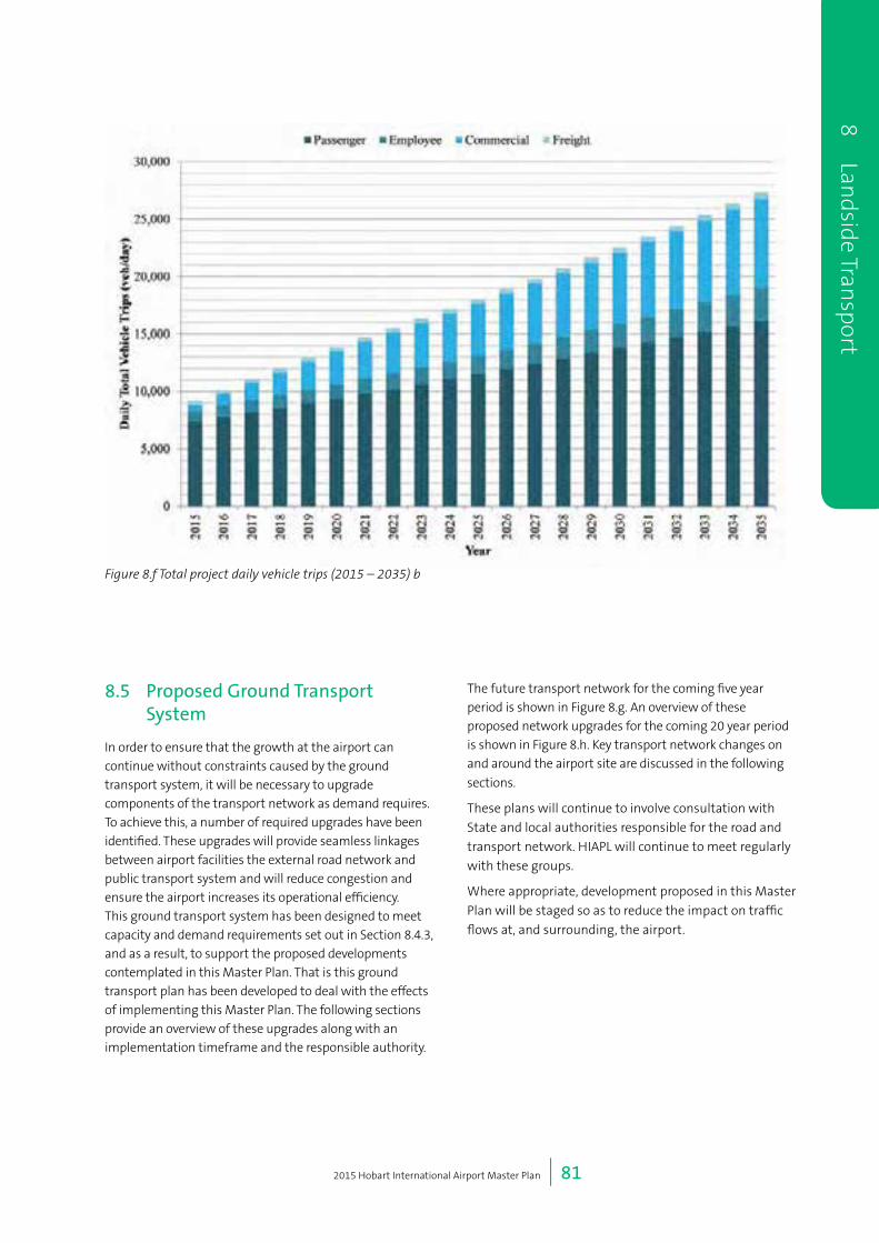
2015 Hobart International Airport Master Plan | 81
8.5 Proposed Ground Transport System
In order to ensure that the growth at the airport can continue without constraints caused by the ground transport system, it will be necessary to upgrade components of the transport network as demand requires. To achieve this, a number of required upgrades have been identified. These upgrades will provide seamless linkages between airport facilities the external road network and public transport system and will reduce congestion and ensure the airport increases its operational efficiency. This ground transport system has been designed to meet capacity and demand requirements set out in Section 8.4.3, and as a result, to support the proposed developments contemplated in this Master Plan. That is this ground transport plan has been developed to deal with the effects of implementing this Master Plan. The following sections provide an overview of these upgrades along with an implementation timeframe and the responsible authority.
The future transport network for the coming five year period is shown in Figure 8.g. An overview of these proposed network upgrades for the coming 20 year period is shown in Figure 8.h. Key transport network changes on and around the airport site are discussed in the following
sections.
These plans will continue to involve consultation with
State and local authorities responsible for the road and
transport network. HIAPL will continue to meet regularly
with these groups.
Where appropriate, development proposed in this Master
Plan will be staged so as to reduce the impact on traffic
flows at, and surrounding, the airport.
8 Landside Tran
sport
Figure 8.f Total project daily vehicle trips (2015 – 2035) b

2015 Hobart International Airport Master Plan | 82
8
Lan
dsid
e Tr
ansp
ort
Surf
Roa
d
Pittwater Road
Tasm
an H
ighw
ay
Holyman Avenue
Estate Drive
Acton R
oad
Seven Mile Beach Road
Grueber Avenue
Source: Esri, DigitalGlobe, GeoEye, i-cubed, USDA, USGS, AEX, Getmapping, Aerogrid, IGN, IGP, swisstopo,and the GIS User Community
0 200 400 600 800
Metres
[
Figure No
8.gCoordinate System
GDA 1994 MGA Zone 55
Scale at A4
1:16,467
Drawing Title
Future Transport Network (0-5 years)
Intersection UpgradesNew / Upgraded RoadsNew Cycling RoutesNew Footpath
Figure 8.g Future Transport Network (0-5 years)
8.5.1 ExternalRoads
The external road network includes a number of key
upgrades to cater for the anticipated growth in traffic
demand to Hobart Airport. These upgrades are generally
concerned with providing additional capacity for airport
related access.
• Upgrade the Tasman Hwy and Holyman Avenue
intersection:
The Tasman Highway, running along the northern
edge of the airport, provides the only link into the
airport from Hobart and is one of the primary routes
out of Hobart to the north east coast of the State.
The intersection of Holyman Avenue and Tasman
Highway will need to be upgraded to provide road
network capacity from the forecast airport related
traffic demand and through traffic.
• Tasman / East Derwent Highway upgrade: DSG is currently undertaking a major upgrade to
the intersection of the Tasman Highway and East
Derwent Highway which will ensure that traffic
coming from the East Derwent Highway will be able
to access the Tasman highway through a dedicated
lane, improving access to Hobart Airport.
Capacity improvements on the Tasman Highway could
include, but are not limited to the following measures:
• Duplicate the Tasman Highway adjacent to Hobart
Airport;
• Signalisation of the Tasman Highway and Holyman
Avenue intersection; and
• Intersection upgrades at Tasman Highway.
HIAPL will engage with DSG as the responsible authority
for these roads.
8.5.2 InternalRoads
Connections to the terminal precinct will be
strengthened with additional capacity provided as well
as new connections to the planned commercial precincts.
Upgrades to the terminal precinct will include a revised
forecourt to match the terminal development and new
the commercial areas listed below.
• Service access road(s) to the Local Business 2 and
Industrial Enterprise 1 precincts off Pittwater Road;
• Service access road(s) to the General Aviation 1 and
Industrial Enterprise 2 precincts off Pittwater Road;
• Service access road(s) to the General Aviation 1
precinct off Greuber Avenue; and
• Service access road(s) to the Local Business 1 and
Tourism Mixed Use precincts from Holyman Avenue.

2015 Hobart International Airport Master Plan | 83
Major internal road upgrades are discussed below:
Closure of Surf Road
Surf Road is an easement on Airport land at the southern end of the runway. The extension of the runway will
bring aircraft closer to Surf Road as they land and take
off. A vehicle travelling on Surf Road would breach the
required regulated separation distance between an
aircraft and an obstacle; as such the section of Surf Road
along the southern end of the runway will need to close.
The southern end of Surf Road adjacent to the runway
will be permanently closed to vehicles. This section of
roadway – which currently lies between two gates – is
part of Hobart Airport.
No other part of Surf Road will be affected. Pittwater
Road will also be unaffected. Pedestrian, cyclist and
non-vehicle access will be maintained through the
construction of a new sealed path along the airport’s
southern boundary.
Existing traffic from Seven Mile Beach using Surf Road
to access Pittwater Road and the Tasman Highway will
be able to use Grueber Avenue to gain access via the
Tasman Highway round-about. This is not a significant
traffic movement and the additional traffic at the
Tasman Highway round-about intersection will be
accommodated in identified future upgrades.
There will also be additional aviation related
development on the new section of Grueber Avenue. It
is anticipated that traffic volumes associated with the
aviation development will predominantly access the site
from the Tasman Highway and should have negligible
impact on Surf Road.
Grueber Avenue
Grueber Avenue is a new road that will be constructed
to run from Surf Road through to the Tasman Highway
along the western side of the Airport. Grueber Avenue
will provide Seven Mile Beach with continued access
to the Tasman Highway. Its exact alignment will be
established in consultation with Clarence City Council.
It will also provide access to the proposed Clarence
City recreational grounds when developed, reducing
additional traffic going through the Seven Mile Beach
community.
8 Landside Tran
sport
Figure 8.h Future Transport Network (5-20 years)
Surf
Roa
d
Pittwater Road
Tasm
an H
ighw
ay
Holyman Avenue
Acton Road Estate Drive
Acton R
oad
Seven Mile Beach Road
Grueber Avenue
Source: Esri, DigitalGlobe, GeoEye, i-cubed, USDA, USGS, AEX, Getmapping, Aerogrid, IGN, IGP, swisstopo,and the GIS User Community
0 200 400 600 800
Metres
[
Figure No
8.hCoordinate System
GDA 1994 MGA Zone 55
Scale at A4
1:19,154
Drawing Title
Future Transport Network (5-20 years)
New / Upgraded RoadsNew Cycling RoutesNew FootpathIntersection Upgrades

2015 Hobart International Airport Master Plan | 84
8.5.3 Parking
The future of vehicle parking at Hobart Airport considers
the provision of appropriate capacity and facilities to
meet the demand of passenger, employees and visitors.
Parking supply at Hobart Airport is expected to increase
to accommodate the future passenger demand.
Additional car parking to be provided in the near term
to accommodate an additional 300 car spaces will be
completed part of the 2020 terminal redevelopment.
Consideration will be given in the medium and long
term to the provision of additional long-term and staff
parking requirements as well as upgrades to parking
management and parking products available.
8.5.4TaxiandRentals
Taxi infrastructure is planned to be improved to provide
passengers with a reliable access to taxis through
improved queuing and control management. A new taxi
holding area is to be provided allowing for additional
storage capacity. The need of the taxi driver is also
considered through the provision of driver facilities in the
taxi holding areas.
Rentals will continue to provide a flexible choice to
customers with a variety of rental options accommodated
within Hobart Airport. Passengers will be able to book
and retrieve vehicles within the terminal and access their
rental vehicle from consolidated parking areas.
8.5.5ActiveTransport
Active transport is considered an important mode of
travel particularly for short and medium length trips. In
order to encourage a greater uptake in cycling usage and
a safe pedestrian environment, suitable facilities, both on
and off road will be provided.
In the short term, upgrades to end-of-trip facilities for
cycling and the incorporation of a shared use path along
Grueber Avenue will promote cycling within the airport
precinct. Provision of clear pedestrian connections
through the terminal and parking areas with appropriate
wayfinding will improve amenity for pedestrians.
8.5.6 PublicTransport
The provision of an improved bus service is considered
the future of public transport at Hobart Airport. The
implementation of a regularly scheduled direct and
local bus services would improve equitable access and
mode shift to more sustainable modes of travel. A
dedicated bus waiting area will minimise bus parking in
the forecourt area and provide more capacity for other
modes.
8.6 Five Year Plan
The five year plan identifies transport upgrades and
initiatives that are planned for implementation within
five years (see Table 8.c) to ensure that that the strategic
growth objectives of the airport can be met. Figure 8.i
highlights the implementation plan within the terminal
precinct.
8
Lan
dsid
e Tr
ansp
ort

2015 Hobart International Airport Master Plan | 85
8 Landside Tran
sport
11
75
2
7
3
48
6 101
9
Sou
rce:
Esr
i, D
igita
lGlo
be, G
eoE
ye, i
-cub
ed, U
SD
A, U
SG
S, A
EX
, Get
map
ping
, Aer
ogrid
, IG
N, I
GP,
sw
isst
opo,
and
the
GIS
Use
r Com
mun
ity
© A
rup
040
8012
016
0
Met
res
[
Car
Par
king
Ren
tal P
arki
ng
Bus
Hol
ding
Are
a
Term
inal
s
Taxi
Hol
ding
Are
a
New
/ U
pgra
ded
Roa
ds
New
Act
ive
Tran
spor
t
Figu
re N
o
8.i
Coo
rdin
ate
Sys
tem
GD
A 19
94 M
GA
Zone
55
Scal
e at
A4
1:3,
556
Dra
win
g Ti
tle
0-5
year
Ter
min
al P
reci
nct
Impl
emen
tatio
n Pl
an
Figu
re 8
.i 0-
5 ye
ar t
erm
inal
pre
cinc
t im
plem
enta
tion
pla
n

2015 Hobart International Airport Master Plan | 86
Table 8.c Projects for 0-5 Year Implementation
Recommendation Responsibility Figure8.i
Reference
(where
relevant)
External Road
Commence discussions on the Tasman Hwy and Holyman Ave intersection
improvements.
HIAPL / CCC/
DSG
Complete the Tasman / East Derwent Highway upgrade DSG
Internal Road
Close Surf Road easement and construct Grueber Avenue/Hinkler Rd HIAPL 1
Construct new forecourt as part of 2020 terminal development HIAPL 2
Possible upgrade of the intersection of Holyman Avenue and Gatty Street HIAPL 3
Plan and construct new terminal precinct road infrastructure HIAPL
Parking
Provide additional parking spaces within the terminal precinct HIAPL 4
Taxi
Upgrade operational and queuing arrangements for taxi pick-up HIAPL 5
Relocate taxi holding area HIAPL / DSG 6
Rental
Car rental parking bays and holding areas HIAPL 7
Active Transport
Develop pedestrian connections to new parking areas HIAPL 8
Upgrade wayfinding infrastructure to parking and rental areas HIAPL
Provide cycling facilities HIAPL / DSG 9
Provide shared use path adjacent to Grueber / Hinkler and Surf Rd HIAPL 10
Public Transport
Provide bus holding area HIAPL / DSG 11
8.7 20 Year Plan
The 20 year plan identifies transport projects and initiatives that should be implemented within 20 years (see Table 8.d)
to ensure that that the strategic growth objectives of the airport can be met. Figure 8.j highlights the implementation
plan within the terminal precinct.
8
Lan
dsid
e Tr
ansp
ort

2015 Hobart International Airport Master Plan | 87
8 Landside Tran
sport
Figu
re 8
.j 5-
20 y
ear
term
inal
pre
cinc
t im
plem
enta
tion
pla
n
2
4
5
3
6
1
Sou
rce:
Esr
i, D
igita
lGlo
be, G
eoE
ye, i
-cub
ed, U
SD
A, U
SG
S, A
EX
, Get
map
ping
, Aer
ogrid
, IG
N, I
GP,
sw
isst
opo,
and
the
GIS
Use
r Com
mun
ity
[
040
8012
016
0
Met
res
Ren
tal P
arki
ngC
ar P
arki
ngB
us H
oldi
ng A
rea
Taxi
Hol
ding
Are
aTe
rmin
als
New
Act
ive
Tran
spor
tN
ew /
Upg
rade
d R
oads
Figu
re N
o
8.j
Coo
rdin
ate
Sys
tem
GD
A 19
94 M
GA
Zone
55
Scal
e at
A4
1:3,
932
Dra
win
g Ti
tle
5-20
yea
r Ter
min
al P
reci
nct
Impl
emen
tatio
n Pl
an
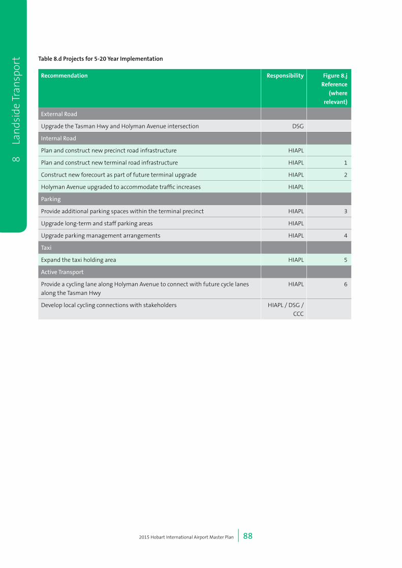
2015 Hobart International Airport Master Plan | 88
8
Lan
dsid
e Tr
ansp
ort Table 8.d Projects for 5-20 Year Implementation
Recommendation Responsibility Figure8.j
Reference
(where
relevant)
External Road
Upgrade the Tasman Hwy and Holyman Avenue intersection DSG
Internal Road
Plan and construct new precinct road infrastructure HIAPL
Plan and construct new terminal road infrastructure HIAPL 1
Construct new forecourt as part of future terminal upgrade HIAPL 2
Holyman Avenue upgraded to accommodate traffic increases HIAPL
Parking
Provide additional parking spaces within the terminal precinct HIAPL 3
Upgrade long-term and staff parking areas HIAPL
Upgrade parking management arrangements HIAPL 4
Taxi
Expand the taxi holding area HIAPL 5
Active Transport
Provide a cycling lane along Holyman Avenue to connect with future cycle lanes
along the Tasman Hwy
HIAPL 6
Develop local cycling connections with stakeholders HIAPL / DSG /
CCC
9 Other Aviation Uses

2015 Hobart International Airport Master Plan | 90
9
O
ther
Avi
atio
n U
ses 9 Other Aviation
Uses
9.1 Air Services Australia
9.1.1 AirTrafficControl
A number of other aviation related activities take place
at Hobart Airport. These relate to air traffic control,
navigation aids, fire and rescue services, aviation related
signage, runway and apron lighting and airline support
facilities. This section of the 2015 Master Plan describes
these services and outlines development plans for these
uses.
Figure 9.a Air Traffic Control Tower and Llanherne House
Existing Situation
The airport’s control tower is operated by Airservices
Australia on land leased from HIAPL. The tower is 12.5m
high and was constructed in 1953 on the peak of the hill
to the west of the terminal as shown in Figure 9.a. The
elevated location and extra height of the control tower
provide the tower with an excellent view of the whole
airfield, the aprons and particularly the approaches to the
runway. The air traffic controllers within the tower are
responsible for directing all aircraft landings, take-offs,
and all movements on the runway and taxiways at the
airport, as well as activity at Cambridge Aerodrome. The
two airfields are managed together as a runway system
for aircraft operations. Cambridge Aerodrome has seen
significant growth in recent years as a result of increased
tourism operations and flight training.
Airservices Australia manages the air traffic in the Hobart
region in a manner that maximises capacity and optimises
the utility of the airport facilities during the tower’s
opening hours within the requirements of legislation
including the Air Services Act 1995.
Future Development
It is anticipated that during the forecast planning
period, the control tower instruments may need to be
replaced with modern facilities. Airservices Australia has
commissioned a site study under the National Towers
Program which concluded that the current tower was
situated in the best location. The study concluded that
if a new tower were to be provided, it would be best
situated adjacent to the existing tower in the same
position or as-close-as-possible adjacent location on
top of the hill. Alternatively, the current tower could be
replaced or refurbished to allow for new technology and/
or additional air traffic control management, training
and extended equipment room accommodation within a
secure compound. It is not envisaged that this will occur
in the next five years.
The development plans for the terminal, regular public
transport (RPT) apron expansion, runway extensions
and taxiway alterations have considered the sight lines
of the tower in the positioning of the development.
HIAPL recognises that further development, including
that of the freight area and Antarctic apron and facility,
must consider lines of sight from the tower. Airservices
Australia will be consulted during the design phase of
the airport development.

2015 Hobart International Airport Master Plan | 91
9O
therA
viationU
ses9
Oth
er Aviation
Uses
9.1.2 AviationRescueandFireFightServices(ARFFS)
Existing Situation
The Aviation Rescue and Fire Fighting Service (ARFFS)
operated by Airservices Australia has the primary
responsibility of firefighting and rescue operations
associated with the airside runway and aircraft
movement areas. Where relevant, the ARFFS would be
assisted by the Tasmanian Fire Service in firefighting
operations that involve airport emergencies.
The Tasmanian Fire Service is the responsible authority
for landside, non-aircraft related firefighting services and
is assisted by ARFFS as relevant to respond to calls for
assistance.
Opened in 1956, the ARFFS fire station is located to
the south of the terminal building and is one of the
oldest airport fire stations in Australia. Due to its central
location with good access to the aprons, taxiways and
runway system, it is ideally suited to respond quickly to
potential airside emergencies. The ARFFS station is also
well positioned to respond to fires and rescue on the
landside areas of the airport.
Future Development
In planning the development of aviation-related facilities
including apron and terminal expansion, the impact
on the existing fire station has been considered and
avoided. The current siting of the station complies with
ARFFS response times which are usually determined
on an optimised location with respect to the runway
or runways. Airservices Australia has set operational
objectives of:
• A two minute response time to the end of each
runway; and
• A response time not exceeding three minutes to any
part of the movement area.
The extension of the runway does not impact compliance
with these objectives.
The category of ARFFS required at an airport is dependent
on the largest design aircraft using that airport and
the frequency that aircraft uses the airport. As current
operations are Code C, primarily B737-800s and A320s,
the ARFFS provision is Category 7 cover.
The largest critical design aircraft at Hobart in 2035 will
be Code E aircraft such as the B787 and A330. These
aircraft require Category 9 cover but as movements are
forecast to be below 700 in the busiest three months of
the year, airport lessees are permitted to reduce the scale
ARFFS vehicles
2015 Hobart International Airport Master Plan | 92
9
O
ther
Avi
atio
n U
ses of ARFFS facilities to one category below. Accordingly,
at the onset of regular Code E passenger services in the
future there is a requirement to upgrade from the current
Category 7 to Category 8.
The upgrade from Category 7 to Category 8 requires an
extra 40 percent on the mandatory discharge rate of
foam extinguishing agents and 100 percent increase of
the complimentary agent (a dry chemical powder) due
to the increased width and length of aircraft potential
involved in an incident. During the period of the
2015 Master Plan, the ARFFS may need to increase its
availability of fire tenders and crews to adhere with these
requirements when the operations of the larger Code E
aircraft becomes a regular occurrence.
9.2 Airport Operational Services
9.2.1 NavigationalandLandAids
Existing Situation
The following ground based navigational and landing
aids are provided at Hobart Airport:
• VOR - VHF omni-directional radio range, providing
radial tracks to the beacon through 360° of the
magnetic compass;
• DME - distance measuring equipment, which provides
the air distance between the aircraft and ground
installation;
• ILS - an instrument landing system, which provides
track (via the localiser) and approach slope guidance
(via the glidepath) for landings on Runway 12;
• PAPI - precision approach slope indicator systems,
providing visual slope guidance for approaches to
runways 12 and 30; and
• High-intensity approach lighting for a category 1
precision approach for Runway 12.
Future Development
Airservices Australia will identify the need for the
introduction or relocation of navigation aids. Planning
for this will be developed in collaboration with
Airservices Australia. All future navigational and land aid
development would occur within the runway precinct.
9.2.2 GroundBasedAugmentationSystem(GBAS)
Ground Based Augmentation Systems (GBAS) provide
guidance for aircraft during the landing phase of flight
and have been used at some Australian Airport for up to
ten years. GBAS offers advantages in terms of improved
airport capacity and flexibility of location.
HIAPL acknowledges this emerging technology and its
potential for improved operational accuracy at Hobart
Airport and favours its implementation upon further
consultations with Airservices Australia.
9.3 Airport Lighting
Existing Situation
Hobart Airport upgraded its lighting system in 2012 as
part of the runway and 2013 taxiway overlay projects. The
airfield ground lighting (AGL) comprises:
• Runway, taxiway and apron directional lighting;
• Apron flood lighting; and
• Obstacle lighting.
Specifically, the airport runway lighting system
consists of:
• Both a high intensity and low intensity runway edge
lighting;
• Runway 12 and Runway 30 PAPI Systems; and
• Runway 12 High Intensity Approach Lighting System.
The runway, taxiway and apron directional light is
sourced through and controlled by equipment in the
Airfield Lighting Equipment Room (ALER) which was also
recently upgraded. Sufficient capacity exists within this
upgraded ALER for the runway extension works. HIAPL
maintains an onsite emergency power supply to maintain
essential lighting in the event of a power outage.
9.3.1 FutureDevelopment
The next lighting facility that is scheduled for maintenance
is the masts for the approach lighting on Runway 12. The
maintenance is a result of corrosion from salt in the sea
water and the northern runway extension. Additional
masts will be installed as part of the runway extension
project. The installation of these masts will be subject to
the runway extension Major Development Plan and an
EPBC referral as part of the Runway Extension project.
Within the next five years, the runway approach lighting,
remaining taxiway lighting and apron floodlighting will
be augmented, upgraded and relocated for the various
runway and taxiway extensions and existing apron
upgrade provisions proposed in the Master Plan.
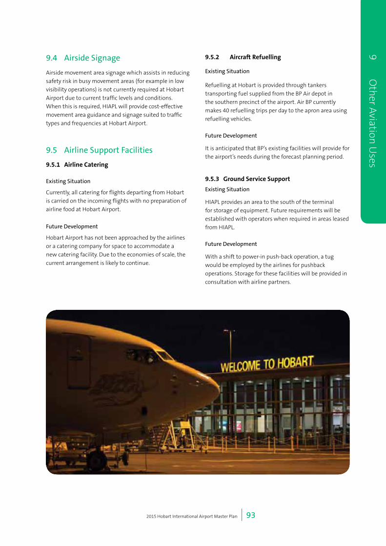
2015 Hobart International Airport Master Plan | 93
9O
therA
viationU
ses
9.4 Airside Signage
Airside movement area signage which assists in reducing
safety risk in busy movement areas (for example in low
visibility operations) is not currently required at Hobart
Airport due to current traffic levels and conditions.
When this is required, HIAPL will provide cost-effective
movement area guidance and signage suited to traffic
types and frequencies at Hobart Airport.
9.5 Airline Support Facilities
9.5.1 AirlineCatering
Existing Situation
Currently, all catering for flights departing from Hobart
is carried on the incoming flights with no preparation of
airline food at Hobart Airport.
Future Development
Hobart Airport has not been approached by the airlines
or a catering company for space to accommodate a
new catering facility. Due to the economies of scale, the
current arrangement is likely to continue.
9.5.2 AircraftRefuelling
Existing Situation
Refuelling at Hobart is provided through tankers
transporting fuel supplied from the BP Air depot in
the southern precinct of the airport. Air BP currently
makes 40 refuelling trips per day to the apron area using
refuelling vehicles.
Future Development
It is anticipated that BP’s existing facilities will provide for
the airport’s needs during the forecast planning period.
9.5.3 GroundServiceSupport
Existing Situation
HIAPL provides an area to the south of the terminal
for storage of equipment. Future requirements will be
established with operators when required in areas leased
from HIAPL.
Future Development
With a shift to power-in push-back operation, a tug
would be employed by the airlines for pushback
operations. Storage for these facilities will be provided in
consultation with airline partners.

2015 Hobart International Airport Master Plan | 94
9
O
ther
Avi
atio
n U
ses
10 Utilities and Services Infrastructure
2015 Hobart International Airport Master Plan | 96
10 Utilities and Services Infrastructure
10.1 Existing Services and Future Planning
The objectives of the utilities and services infrastructure section is to provide information on existing services, highlight
future developments and identify any deficiencies. These are shown in Table 10.a.
Development of individual precincts in line with Chapter 4: Land Use, will drive the timing of proposed infrastructure
upgrades.
Table 10.a Existing and future services at Hobart Airport
Services Existing Future
Electricity Airport supplied by TasNetworks infrastructure
as dual 11 kV.
11 kV ring main feeds via a mix of overhead
line and underground cable via Holyman Drive,
to the terminal precinct and around the Loop
Road.
The primary substation for the terminal
precinct is located adjacent the administration
building. This substation comprises a single
2MVA transformer, and as such provides no
redundancy. It is less than 50 percent loaded,
and so there is spare capacity for significant
expansion of the terminal facility.
The high voltage ring main provides capacity
and flexibility for future development of key
areas across the site with upgraded or new
substations.
New power supplies could be taken direct
from Cambridge Road and Pittwater and
remain separate from the existing HV ring
main.
Telecommunications Optical fibre services installed by Telstra run
through the site, north to south, and connect
to the main distribution frame room at the
administration block.
More recently, TasNetworks has installed
optical fibre into the site, via Holyman Drive,
which currently services only the RHH Kitchen.
It is likely that new telecommunications
infrastructure will be required to provide NBN
or other services to any future substantial
development, outside the terminal precinct.
Water Supply A bulk water main connects into reticulated
water supply within the Tasman Highway and
runs along Holyman Avenue.
Secondary connection on Back Road to the
bulk water supply within the Tasman Highway
however this is currently turned off.
Water for fire suppression currently comes
from the same mains as the domestic supply.
Storage tanks for firefighting are located on
Tower Hill. TasWater has adopted a policy that
water supply for domestic and fire-fighting
purposes are to be separate rather than
combined.
Providing future developments with their own
separate fire and domestic water from the
existing Holyman Avenue main is seen as the
preferred approach to development.
10
U
tilit
ies
and
Serv
ices
Infr
astr
uct
ure

2015 Hobart International Airport Master Plan | 97
Services Existing Future
Sewerage The site is currently serviced with a rising main
that runs from the Tasman Highway, along
Holyman Avenue and connects to an existing
TasWater sewerage treatment plant on the
site.
The freehold titles are not serviced at present.
TasWater has a policy of allowing a maximum
of one connection per lot to sewer mains, this
means future developments would need to
connect to the existing connections.
TasWater’s standard policy requires that any
new pump stations be contained within their
own lot and transferred to their ownership.
This is impossible on the Commonwealth
lease area, so suitable agreements would have
to be negotiated if TasWater are to take over
any pump stations on the Commonwealth
lease area. Alternatively any new pump station
and mains may remain as private assets
maintained by HIAPL.
10.2 Future Development
Hobart Airport does not foresee major significant utility requirements during the coming five year period. On airport
utilities and services infrastructure will be expanded and renewed as required through demand or lifecycle.
10 Utilities an
d Services Infrastru
cture

2015 Hobart International Airport Master Plan | 98
10
U
tilit
ies
and
Serv
ices
Infr
astr
uct
ure

11 Airspace Protection

2015 Hobart International Airport Master Plan | 100
11 Airspace Protection
11.1 OLS and PANS-OPS
Obstacles in the vicinity of an airport can have safety
implications for the operation of aircraft in flight.
Airspace at leased Commonwealth airports is therefore
protected under Part 12 of the Airports Act 1996,
together with the Airports (Protection of Airspace)
Regulations (APAR). Protection is provided in the form
of Obstacle Limitation Surfaces (OLS), used for flying by
sight, and Procedures for Air Navigation Services Airport
Operations (PANS-OPS) surfaces, used when flying by
instrument without external visual reference to the
ground.
These surfaces are used to make sure aircraft arriving
or departing from an airport are not adversely affected
by high terrain, natural obstacles such as trees, or
the building of structures or other land use activities.
New structures should be designed, or other activities
controlled, to ensure that they do not intrude into the
present and future prescribed airspace surfaces.
To protect these surfaces off the airport site, the OLS
and PANSOPS are reflected in the Clarence City Council
2007 Planning Scheme and current draft Clarence
City Council Interim Planning Scheme. The planning
schemes recognise that the airport flight paths should
be protected from ‘inappropriate development’ to
allow ‘safe air navigation for aircraft approaching and
departing the airfield’.
The OLS and PANS-OPS are created in accordance with
regulations contained within Civil Aviation Safety
Regulations Parts 139 and 173, respectively. As the
intent of the regulations is to protect aircraft operations
in the vicinity of aerodromes, the physical layout of the
aerodrome and, in particular, its runways determines the
associated airspace volumes.
As described in Chapter 7: Airfield Development, a
runway extension is planned within the forecast
planning period. Changes airport’s OLS and
PANS-OPS due to the runway extension are described
in the following section.
The 500m pavement extension provides Runway 30
with an operational length of 2,751m and Runway 12
an operational length of 2,680m. The turning area at the
north-west runway end utilises a section of pavement,
resulting in the slightly shorter operational length on
Runway 12.
HIAPL will undertake a separate approval process, under
the Airports (Protection of Airspace) Regulations, to
formally declare its future airspace as a result of the
proposed runway extension.
11.2 Proposed changes to OLS and PANS-OPS
Proposed changes to Hobart Airport involve lengthening
the runway infrastructure and the consequent re-
positioning of the runway threshold. The Runway 30
threshold position moves 350m to the south-east, while
the Runway 12 threshold extends 79m to the north-west.
The position of the Departure End of Runway (DER) for
Runway 30 is unaffected as the north-west extension
uses an area already set aside for departures. The DER
for Runway 12 will extend 350m to the south-east in line
with the approach threshold. There is no re-definition
of the Aerodrome position via the Aerodrome Reference
Point (ARP), Reference Elevation Datum (RED) or the
runway alignment.
Because the protection surfaces move relative to the
runway threshold or DER, splays which widen as they
move away from the current threshold/DER will narrow
compared to the original. This is due to base widths
being set at threshold/DER and thence angular splay
boundaries are generated. A narrower splay implies the
maximum difference between the splays and does not
mean a change to base width (see Figure 11.a).
Figure 11.a Splay angles
11
Air
spac
e Pr
otec
tion

2015 Hobart International Airport Master Plan | 101
The Obstacle Limitation Surfaces Outer Horizontal is
based on the ARP, hence is unaffected. All other surfaces
are dependent on the runway position, and will extend
by the amount of the threshold displacement or DER
location. No lateral change to the OLS occurs.
The departure OLS to the north-west remains unchanged
while the approach OLS at this end moves 79m. In
comparison to the existing OLS, the approach splay is
narrower by 23.7m, but lower by 1.58m. To the south-
east the 350m displacement makes the approach
narrower by 105m but lower by 7m compared to the
existing, and the departure narrower by 87.5m and lower
by 7m.
The PANS-OPS procedures provide guidance to a runway
threshold for all approaches except those to radio
navigation aids, and from a DER for departures. The
navigation aids at Hobart Airport are, for all intents and
purposes, aligned with the runway centreline. Thus, the
protected flight paths associated with those navaids
do not change laterally, or in any step altitudes. This
includes the VOR procedures to Runway 12 and Ruwnay
30 and the NDB on Runway 30.
The Visual Segment Surface (VSS) for non-precision
approaches moves with the approach thresholds.
Compared to the existing the VSS for the north-west end
is narrower by 23.7m but lower by 2.6m. For the south
east end the VSS is narrower by 105m and lower by
11.5m. Note that VSS for both ends at Hobart Airport are
wholly contained within the approach OLS.
For all Instrument Flight Approach Procedures using
position fixes to a runway (ILS, RNAV (GNSS) and RNAV
(RNP)) position fixes need not change and hence the
longitudinal position, and the consequent protection
splay boundary, does not change. The vertical path will
change and be at a lower level to ensure that aircraft
touch down consistent with the new runway thresholds.
For the Runway 12 ILS, compared to existing, the splay
boundary will be slightly narrower along the flight path,
but slightly wider at the 300m above airport level. The
protection height will be 2.25m lower along its length.
The two RNAV (GNSS) procedures protection boundaries
need not change at all with such a small change in
runway position and only the nominal flight altitude will.
For RNAV (RNP), the protection boundaries are not
affected by the change and only the height of the surface
will change. For Runway 12 (north-west) there is a height
change is 3.95m while runway 30 (south east) difference
is 17.5m lower.
Departures include an assumption that aircraft cross
the DER at a height of 5m and then protection surfaces
climb at a grade 0.8 percent less than the aircraft
climb gradient. The standard protection gradient is 2.5
percent. As the DER at the north western end does not
change, there is no change to the protection surfaces
for departures in this direction. For departures to the
south east, the displacement makes the protection area
laterally narrower than the existing by up to 105m and
vertically 8.75m lower.
The revised OLS and PANS-OPS for Hobart Airport
have been developed taking the extended runway into
consideration. HIAPL updated the OLS for Hobart Airport
in 2013 (see Figure 11.c). This revised OLS update has
been included in the draft Clarence City Council Interim
Planning Scheme. The updated OLS addressed the
runway extension at that time and remains current. See
Figure 11.b for a comparison between the 2009 and new
OLS.
Changes between the 2009 PANS-OPS and the 2015
PANS-OPS are shown in Figure 11.e. The 2015 PANS-OPS
are shown in Figure 11.f.
11 Airspace Protection

2015 Hobart International Airport Master Plan | 102
11
Air
spac
e Pr
otec
tion
Figure 11.b OLS for Hobart Airport.
Figure 11.c PANS-OPS changes 2009 and 2015

2015 Hobart International Airport Master Plan | 103
11 Airspace Protection
Figure 11.d Revised PANS-OPS for Hobart Airport
Figure 11.e Hobart Airport PANS-OPS

2015 Hobart International Airport Master Plan | 104
11
Air
spac
e Pr
otec
tion
12 Aircraft Noise

2015 Hobart International Airport Master Plan | 106
12 Aircraft Noise
12.1 Introduction
This section of the 2015 Master Plan provides an
overview of the issues relating to aircraft noise at Hobart
Airport. It provides a discussion of the noise modelling
undertaken based on the current Master Plan, compares
the existing noise environment against the potential
noise impact of the runway extension and presents the
forecast ultimate capacity Australian Noise Exposure
Forecast (ANEF) contours for the airport.
As required under the Airports Act 1996, the ANEF was
endorsed for technical accuracy by Airservices Australia
(AsA) in the approved manner on [to be endorsed AsA].
12.2 Background
According to the International Civil Aviation Organization
(ICAO), and as noted in the National Airports
Safeguarding Framework (NASF):
“…aircraft noise is the most significant cause of adverse
community reaction to the operation and growth
of airports. Noise can impact adversely on residents,
workers and visitors in the vicinity of airports.”
Aircraft noise complaints can cause significant
limitations on the operations, and potential for
development, of airports, including leading to calls for
curfews to be imposed.
Hobart Airport, has to date, been fortunate in that
the operation of aircraft has caused little conflict with
the local community. This is aided by the geographical
location of Hobart Airport – with bodies of water at each
end of the airport’s runway and a large tract of vacant
Crown recreational land to the east under the airport’s
key approach path.
One of the objectives of this Master Plan is to ensure as
much as possible that the airport’s operations continue
to have minimal impact on the surrounding community.
To help achieve this, the 2015 Master Plan uses
additional noise forecasting tools to demonstrate future
noise impacts to inform local planning authorities and
the wider community.
Hobart Airport does not have a curfew, it can operate 24
hours a day 7 days a week. Maintaining this is critical for
the wider Hobart economy and the airport itself and is a
key priority for HIAPL. The Meehan Range to the west of
the airfield necessitates that all passenger aircraft flight
paths be to the east of the airfield.
HIAPL is responsible for working with the community in
planning for potential noise impacts from the airport’s
operation, particularly from flight operations. However
HIAPL is not responsible for, and does not have ultimate
control over, aircraft operation or airspace management,
since these are the responsibility of the aircraft operators
and Airservices Australia.
Noise from aircraft operations impacting noise sensitive
receivers is recognised as a critical future issue for the
operation of Hobart Airport.
It should be noted that Cambridge Aerodrome is not part
of Hobart Airport and thus the noise modelling in this
Hobart Airport Master Plan does not include Cambridge
Aerodrome operations. Cambridge Aerodrome is an
important asset for southern Tasmania catering for
recreational aircraft, smaller passenger aircraft for
tourism operations and is the home to a growing flight
training school. Hobart Airport encourages planning in
the local area to cater for the current and future growth
of Cambridge Aerodrome.
12.3 Noise Forecasting
The Australian Noise Exposure Forecast (ANEF) is the
primary noise metric used in Australia for land use
planning around airports. The Airports Act requires the
calculation of ANEF contours for use in assessing future
noise exposure patterns around Australian airports.
The use of ANEF contours for reporting of noise impacts
to non-noise experts and in community consultation has
come under scrutiny since the 1995 Senate Enquiry into
the third runway expansion at Sydney Airport.
Additional, secondary noise metrics, were proposed by
the Commonwealth Government to assist non-experts
in understanding the extent of potential noise impacts
from aircraft operations in simpler terms. In particular,
the use of the N70
and N60
metrics are proposed.
12
Air
craf
t N
oise
2015 Hobart International Airport Master Plan | 107
12.4 ANEF / ANEC
The ANEF contours represent an annual ‘average day’
noise exposure at locations near an airport. They are a
cumulative noise descriptor of a full year, meaning that
seasonal impacts and weather are considered. An ANEF
contour shows a 12 month period divided by 365 days to
give an average day.
A description of the ANEF system and associated
compatible land uses can be found in the Australian
Standard AS2021-2000 Acoustics – Aircraft Noise
Intrusion – Building Siting and Construction.
Two types of Australian Noise Exposure calculations have
been used in this master plan:
• ANEF (Australian Noise Exposure Forecast) based on
forecast or predicted flight volumes and tracks and is
endorsed by Airservices Australia
• ANEC (Australian Noise Exposure Concept) which is
calculated using an identical methodology as the
ANEF
The ANEF is for an Ultimate Capacity scenario, which
considers the maximum practical capacity of the airport.
The proposed runway extension has been included.
ANEC contours are generally used for benchmarking or
informational purposes. The ultimate capacity for Hobart
Airport is not expected to be reached within 40 years,
and probably would not be achieved until past 50 years.
12.4.1LimitationsofANEF
The ANEF system has been incorporated into AS2021 as
a way for determining the acceptability developments
in noise affected areas. However, the fact that a
development undertaken in area outside of an ANEF
contour does not mean that that development will
not be affected by noise or that any new development
outside the ANEF contour should be approved.
In this regard it needs to be remembered that:
• AS2021 was not developed solely as a land use
planning tool - it was developed as a way to assess
the insulation required in a house where a decision
had already been made to build in an area affected
by noise;
• AS2021 and the ANEF do not adequately to take into
account greenfield development where there is little
other ambient noise to hide or obscure the aircraft
noise; and
• The ANEF contours are averages, based on a complex
formula. ANEF contours do not provide an indication
of the level or frequency of aircraft noise at particular
times of day or year, the frequency of occasional
loud noise events or the full impact arising from the
frequency or volume of night-time or early morning
noise.
It is also noted that Stage Governments that endorsed
the National Aviation Safeguarding Framework
(NASF),including Tasmania, have agreed to approach
Standards Australia to undertake a review of AS2021-
2000 to update the standard to more accurately reflect
community expectations. In particular, it is proposed
to update the standard to reflect alternative noise
measurement metrics such as those covering the
frequency of noise events above certain specified decibel
levels.
12.4.2Preferredapproachtoplanningdecisionsandnoiseexposure
Hobart Airport is currently in a fortunate position when
compared to some other major metropolitan airports, in
respect of its proximity to residential developments and
the risk of being exposed to complaints about aircraft
noise.
For this reason, the airport considers it extremely
important that planners take appropriate care to:
• Consider the potential for noise disturbance at any
new potential residential site; and
• Where possible, protect the well planned position
of Hobart Airport with respect to residential
development.
NASF Guideline A recommends with respect to future
development that:
“There is a need to treat future development and
existing development differently. Where there is no
major existing or approved development, there is
scope to plan ahead to take account of potential noise
disturbance and in particular to minimise the zoning
of noise‐exposed land for residential development.”
12 Aircraft N
oise
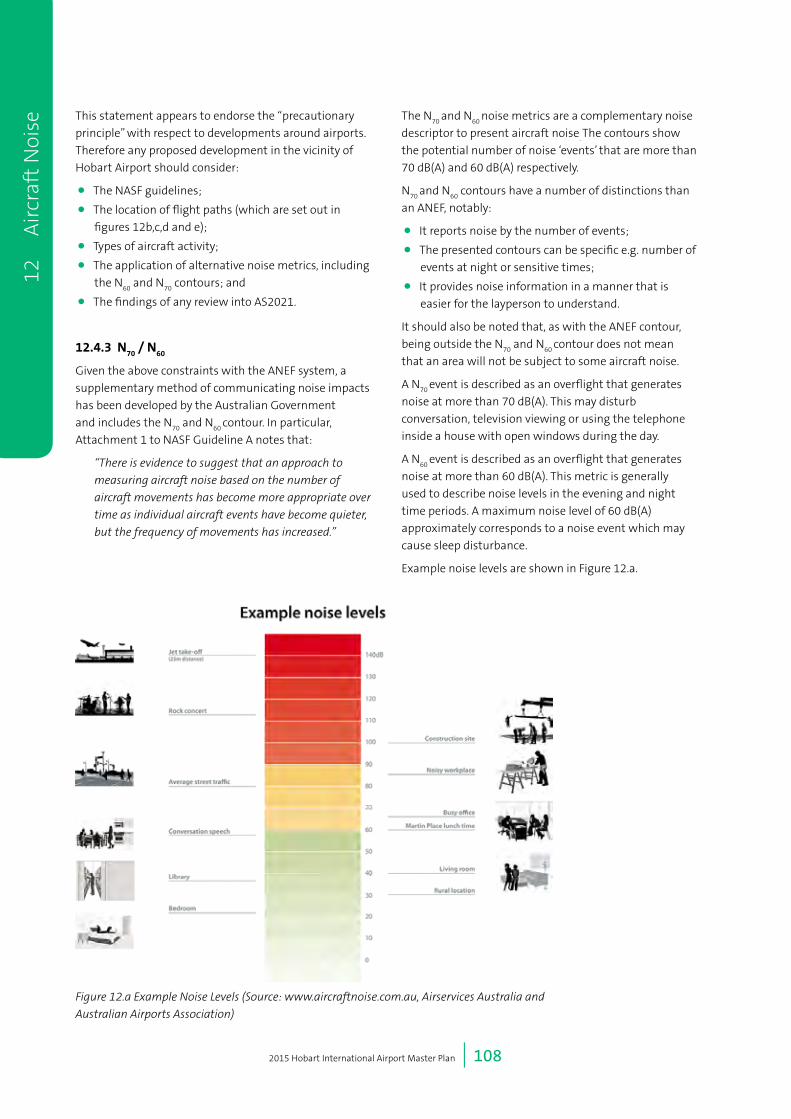
2015 Hobart International Airport Master Plan | 108
This statement appears to endorse the “precautionary
principle” with respect to developments around airports.
Therefore any proposed development in the vicinity of
Hobart Airport should consider:
• The NASF guidelines;
• The location of flight paths (which are set out in
figures 12b,c,d and e);
• Types of aircraft activity;
• The application of alternative noise metrics, including
the N60
and N70
contours; and
• The findings of any review into AS2021.
12.4.3N70
/N60
Given the above constraints with the ANEF system, a
supplementary method of communicating noise impacts
has been developed by the Australian Government
and includes the N70
and N60
contour. In particular,
Attachment 1 to NASF Guideline A notes that:
“There is evidence to suggest that an approach to
measuring aircraft noise based on the number of
aircraft movements has become more appropriate over
time as individual aircraft events have become quieter,
but the frequency of movements has increased.”
The N70
and N60
noise metrics are a complementary noise
descriptor to present aircraft noise. The contours show
the potential number of noise ‘events’ that are more than
70 dB(A) and 60 dB(A) respectively.
N70
and N60
contours have a number of distinctions than
an ANEF, notably:
• It reports noise by the number of events;
• The presented contours can be specific e.g. number of
events at night or sensitive times;
• It provides noise information in a manner that is
easier for the layperson to understand.
It should also be noted that, as with the ANEF contour,
being outside the N70
and N60
contour does not mean
that an area will not be subject to some aircraft noise.
A N70
event is described as an overflight that generates
noise at more than 70 dB(A). This may disturb
conversation, television viewing or using the telephone
inside a house with open windows during the day.
A N60
event is described as an overflight that generates
noise at more than 60 dB(A). This metric is generally
used to describe noise levels in the evening and night
time periods. A maximum noise level of 60 dB(A)
approximately corresponds to a noise event which may
cause sleep disturbance.
Example noise levels are shown in Figure 12.a.
12
Air
craf
t N
oise
Figure 12.a Example Noise Levels (Source: www.aircraftnoise.com.au, Airservices Australia and
Australian Airports Association)

2015 Hobart International Airport Master Plan | 109
For the Hobart Airport forecast, N70
has been determined
for the day time period (7:00am – 7:00pm) and the N60
has been determined for both the day time period and
the night time period (7:00pm– 7:00am).
In this respect, it is noted that, N60
rather than N70
is
ordinarily used for measuring noise at night in highly
developed urban settings, to account for the typically
higher sensitivity to aircraft noise during the evening
and night time period. However, given the relatively
low levels of urban development around Hobart
Airport, it is expected that a similarly higher level of
sensitivity to aircraft noise would be expected in these
areas. Therefore, this Master Plan sets out N60
has been
determined for both the day time period and the night
time period.
12.4.4Scenarios
Noise modelling has been undertaken for the following
scenarios:
ANEF:
• Ultimate Capacity.
ANEC, N70
, N60
:
• Existing 2014; and
• 2035 with runway extension.
To inform noise modelling four future schedules were
produced which are summarised in Table 12.a.
To provide the community and local planners with the
long term noise impact of operations at Hobart Airport
an ultimate capacity forecast was developed for the
ANEF. This provides the number of aircraft movements
when the airport is at capacity.
12.5 Noise Modelling Methodology
The modelling has taken into consideration the following
aspects:
• Flight tracks for both existing runway and proposed
runway extension;
• Approximate altitude of aircraft operating on flight
tracks;
• Type of aircraft;
• Number or aircraft per average day and per average
evening;
• Number of aircraft per peak day (estimated worst
case);
• Number of aircraft per peak evening (estimated worst
case); and
• Typical weather conditions (retrieved from long term
averaged Bureau of Meteorology data).
Existing flight tracks were identified and agreed with
local air traffic control based on historical radar tracks,
the standard departure and arrival procedures and
discussions with the air traffic controller.
The new flight tracks based on the extended runway
were created by adjusting the existing tracks to consider
both the new runway ends and associated navigation
thresholds (such as altitude thresholds and electronic
navigational aids).
The noise modelling software considers aircraft altitude
when aircraft movements are allocated to tracks.
The existing flight tracks are generally similar to the
flight tracks included in the 2009 noise model for areas
near to the airport that influence the ANEF contour.
The 2014 flight tracks were developed to a greater level
of detail than the flight tracks used in 2009 because
additional details were required for the creation of N70
/
N60
contours.
The modelled aircraft types and forecast schedules were
based forecasts provided in Chapter 5: Aircraft Forecasts.
The flight tracks adopted for the noise model are shown
in Figure 12.b, Figure 12.c, Figure 12.d and Figure 12.e and
include circuit and helicopter tracks.
12 Aircraft N
oise
Table 12.a Modelled future noise scenarios
ScenarioTotalPeakDayAircraft
Movements
TotalAverageDayAircraft
Movements
2014 Peak Day and Average Day Schedules 82 65
2035 Peak Day and Average Day Schedules 156 123
Ultimate Capacity Average Day Schedule - 293

2015 Hobart International Airport Master Plan | 110
12
Air
craf
t N
oise
! (
! (
! (
! (" )
" )
" )
" )" )
" )
" )" )
" )
" )
" )
" )
" )
R30
E V
OR
R30
E R
NAV
R30
E V
FR
R12
E C
LAR
K
R12
E V
FR
R12
W R
NAV
R30
W R
NAV
R30
W V
OR
R30
EW
CK
VFR
(R30
EW
CK
VFR
)
R30
W L
TR
30 W
LIF
FY
R12
W C
LAR
K
R12
SW
VFR R30
SW
VFR
LIFFY
IRONS
ST HELENS
BRO
AD
KAREN
LAUNCESTON
CLARK
25DME
10DME
010
Nau
tical
Mile
s[
Lege
nd
" )R
NAV
Mar
kers
!(N
on-D
irect
iona
l Bea
cons
Way
poin
ts0
10K
ilom
eter
s
! (
! (
R30 GA S1
R30
GA
W
R30 K
AREN
R30 LT
R12 LIFFY_T, R12 LIFFY_W
R30 LIFFY
R30 IRONS
R12
GA
W
R12 GA S
R12
GA
SE
R30
GA
SE
R30
STH
R12 IRONS
R12
KA
RE
N_W
R12
KA
RE
N_T
R12
STH
_T
R12
IRO
NS
_W, R
12 L
IFFY
_WR
12 IR
ON
S_T
, R12
LIF
FY_T
R12
LT_
TR
12 L
T_W
LIFFY
IRONS
ST HELENS
BRO
AD
KAREN
LAUNCESTON
CLARK
YM
HB
VO
R/D
ME
TEA
TRE
E (T
TR)
05
Nau
tical
Mile
s[
Lege
nd
!(N
on-D
irect
iona
l Bea
cons
Way
poin
ts0
5K
ilom
eter
s
R12 STH_W
Figu
re 1
2.b
Flig
ht t
rack
s –
arri
vals
Fi
gure
12.
c Fl
ight
tra
cks
– de
part
ures

2015 Hobart International Airport Master Plan | 111
12 Aircraft N
oise
Cam
brid
ge A
erod
rom
e
304
301
302
303
124
305
121
122
123
302
301
125
305 30
4
303
121
122
123
125
124
03
Nau
tical
Mile
s[
03
Kilo
met
ers
Lege
nd
121
Arriv
als
Trac
k
121
Dep
artu
res
Trac
k
E
W
03
Nau
tical
Mile
s[
03
Kilo
met
ers
Lege
nd Circ
uit T
rack
Figu
re 1
2.d
Hel
icop
ter
trac
ks
Figu
re 1
2.e
Cir
cuit
tra
cks

2015 Hobart International Airport Master Plan | 112
12
Air
craf
t N
oise
20
25
30
35
40
Scale at A3: 1:100,000
Hobart AirportMaster Plan 2015 Ultimate Practical Capacity ANEF
Date:By:Appd:
JKS
KAB
2/07/2015
GDA 1994 MGA Zone 55
[
Revision: 1
Coordinate System:
Qualifications:Factors taken into consideration in the ANEF are the following:Aircraft flight tracksDistribution of flights during day and nightDistribution of aircraft over flight tracksStage length of flights (distance to destination)Ultimate Capacity forecast for operationsMeteorological dataTerrain topograpy was used when calculating the ANEF contoursWhere figures have been provided there may be somedifferences between 'totals' and the sum of component items dueto rounding
0 1 20.5Nautical Miles
0 2 41Kilometers
Cambridge Aerodrome
Building Type ANEC Zone of Site
Acceptable Conditionally Acceptable Unacceptable
House, home unit, flat, caravan park Less than 20 ANEF (Note 1) 20 to 25 ANEF (Note 2) Greater than 25 ANEF
Hotel, motel, hostel Less than 25 ANEF 25 to 30 ANEF Greater than 30 ANEF
School, university Less than 20 ANEF (Note 1) 20 to 25 ANEF (Note 2) Greater than 25 ANEF
Hospital, nursing home Less than 20 ANEF (Note 1) 20 to 25 ANEF Greater than 25 ANEF
Public building Less than 20 ANEF (Note 1) 20 to 30 ANEF Greater than 30 ANEF
Commercial building Less than 25 ANEF 25 to 35 ANEF Greater than 35 ANEF
Light industrial Less than 30 ANEF 30 to 40 ANEF Greater than 40 ANEF
Other industrial Acceptable in all ANEF zones
Source: Table 2.1, AS2021:2015 Acoustics – Aircraft noise intrusion – Building siting and construction
NOTES: 1. The actual location of the 20 ANEF contour is difficult to define accurately, mainly because of variation in aircraft flight paths. Because of this, the
procedure of AS2021 Clause 2.3.2 may be followed for building sites outside but near to the 20 ANEF contour. 2. Within 20 ANEF to 25 ANEF, some people may find that the land is not compatible with residential or educational uses. Land use authorities may
consider that the incorporation of noise control features in the construction of residences or schools is appropriate (see also AS2021 Figure A1 of Appendix A).
3. There will be cases where a building of a particular type will contain spaces used for activities which would generally be found in a different type of building (e.g. an office in an industrial building). In these cases AS2021 Table 2.1 should be used to determine site acceptability, but internal design noise levels within the specific spaces should be determined by AS2021 Table 3.3.
4. This Standard does not recommend development in unacceptable areas. However, where the relevant planning authority determines that any development may be necessary within existing built-up areas designated as unacceptable, it is recommended that such development should achieve the required ANR determined according to AS2021 Clause 3.2. For residences, schools, etc., the effect of aircraft noise on outdoor areas associated with the buildings should be considered.
5. In no case should new development take place in greenfield sites deemed unacceptable because such development may impact airport operations.
Runway 12
Day Night Total Day Night Total Day Night TotalRPT Embraer E-190 0.82 0.96 1.78 0.91 1.07 1.98 3.75
Boeing 737-800 16.41 2.27 18.68 18.23 2.52 20.75 39.43Airbus A320 9.22 3.86 13.07 10.24 4.28 14.53 27.60Airbus A321 3.84 0.44 4.28 4.26 0.49 4.75 9.03Boeing 787-8 12.66 3.09 15.75 14.07 3.43 17.50 33.25
GA Beechcraft Super King Air 200 1.55 1.08 2.63 2.43 1.68 4.11 6.74Cessna 172 Skyhawk 0.39 0.02 0.41 0.60 0.03 0.63 0.82 0.82 1.86Beechcraft Model 50 Twin Bonanza 0.47 0.11 0.58 0.73 0.17 0.90 1.48Boeing 737-300 0.07 0.35 0.42 0.11 0.55 0.66 1.08BAe 146-300 0.05 0.31 0.36 0.08 0.49 0.57 0.93Cessna Citation 0.15 0.01 0.16 0.24 0.02 0.26 0.42Canadair CL-610 0.10 0.03 0.13 0.16 0.04 0.20 0.33Gulfstream GV 0.05 0.01 0.06 0.07 0.02 0.09 0.15BAe 125-800 0.04 0.01 0.05 0.07 0.01 0.08 0.14Boeing 767-300 0.04 0.04 0.07 0.07 0.11Bombardier DASH-8 0.03 0.00 0.03 0.05 0.00 0.05 0.08
Antarctic Airbus A319 0.04 0.03 0.07 0.06 0.05 0.11 0.18Boeing C-17 0.02 0.01 0.03 0.03 0.01 0.03 0.06Lockheed C-130E 0.03 0.02 0.04 0.03 0.02 0.05 0.09
Runway 30
Day Night Total Day Night Total Day Night TotalRPT Embraer E-190 1.00 1.18 2.17 0.91 1.07 1.98 4.15
Boeing 737-800 20.05 2.77 22.83 18.23 2.52 20.75 43.58Airbus A320 11.26 4.71 15.98 10.24 4.28 14.53 30.50Airbus A321 4.69 0.54 5.23 4.26 0.49 4.75 9.98Boeing 787-8 15.47 3.78 19.25 14.07 3.43 17.50 36.75
GA Beechcraft Super King Air 200 3.30 2.29 5.59 2.43 1.68 4.11 9.69Cessna 172 Skyhawk 0.82 0.04 0.86 0.60 0.03 0.63 0.82 0.82 2.32Beechcraft Model 50 Twin Bonanza 0.99 0.24 1.23 0.73 0.17 0.90 2.13Boeing 737-300 0.14 0.75 0.90 0.11 0.55 0.66 1.55BAe 146-300 0.11 0.66 0.77 0.08 0.49 0.57 1.34Cessna Citation 0.32 0.03 0.35 0.24 0.02 0.26 0.60Canadair CL-610 0.21 0.06 0.27 0.16 0.04 0.20 0.47Gulfstream GV 0.10 0.03 0.13 0.07 0.02 0.09 0.22BAe 125-800 0.09 0.02 0.11 0.07 0.01 0.08 0.19Boeing 767-300 0.09 0.09 0.07 0.07 0.16Bombardier DASH-8 0.06 0.00 0.07 0.05 0.00 0.05 0.11
Antarctic Airbus A319 0.08 0.06 0.14 0.06 0.05 0.11 0.25Boeing C-17 0.03 0.01 0.04 0.03 0.01 0.03 0.07Lockheed C-130E 0.03 0.02 0.05 0.03 0.02 0.05 0.09
Helipad
Day Night Total Day Night TotalSikorsky S-76 Spirit 2.49 0.94 3.43 2.49 0.94 3.43 6.86Euro 355A Twin Squirrel 3.08 0.56 3.64 3.08 0.56 3.64 7.28Bell 206L Long Ranger 3.25 0.65 3.90 3.25 0.65 3.90 7.80
Arrival Departure
Helicopter
Total Movements
Total Movements
Aircraft
Aircraft
Aircraft
Arrival Departure Touch & Go
Arrival Departure Touch & Go
Total Movements
ENDORSEMENT FOR TECHNICAL ACCURACY
ULTIMATE PRACTICAL CAPACITY ANEF
……………………………………… Date: ……../……… /………………
Executive General Manager Safety,
Environment & Assurance Airservices Australia. Canberra
The aircraft noise contours on this chart have been calculated using an appropriate modelling process. Airservices Australia has, in accordance with the approved manner of endorsement, considered the physical ultimate capacity of the existing or proposed runway/s in its endorsement process. The data input and assumptions made in that process are derived in part from external sources. Airservices Australia makes no warranty in respect of that information and excludes all liability for any loss arising from reliance on that information.
Figure 12.f Draft ultimate capacity ANEF

2015 Hobart International Airport Master Plan | 113
12 Aircraft N
oise
20
25
30
35
40
Scale at A3: 1:100,000
Hobart AirportMaster Plan 2015 Ultimate Practical Capacity ANEF
Date:By:Appd:
JKS
KAB
2/07/2015
GDA 1994 MGA Zone 55
[
Revision: 1
Coordinate System:
Qualifications:Factors taken into consideration in the ANEF are the following:Aircraft flight tracksDistribution of flights during day and nightDistribution of aircraft over flight tracksStage length of flights (distance to destination)Ultimate Capacity forecast for operationsMeteorological dataTerrain topograpy was used when calculating the ANEF contoursWhere figures have been provided there may be somedifferences between 'totals' and the sum of component items dueto rounding
0 1 20.5Nautical Miles
0 2 41Kilometers
Cambridge Aerodrome
Building Type ANEC Zone of Site
Acceptable Conditionally Acceptable Unacceptable
House, home unit, flat, caravan park Less than 20 ANEF (Note 1) 20 to 25 ANEF (Note 2) Greater than 25 ANEF
Hotel, motel, hostel Less than 25 ANEF 25 to 30 ANEF Greater than 30 ANEF
School, university Less than 20 ANEF (Note 1) 20 to 25 ANEF (Note 2) Greater than 25 ANEF
Hospital, nursing home Less than 20 ANEF (Note 1) 20 to 25 ANEF Greater than 25 ANEF
Public building Less than 20 ANEF (Note 1) 20 to 30 ANEF Greater than 30 ANEF
Commercial building Less than 25 ANEF 25 to 35 ANEF Greater than 35 ANEF
Light industrial Less than 30 ANEF 30 to 40 ANEF Greater than 40 ANEF
Other industrial Acceptable in all ANEF zones
Source: Table 2.1, AS2021:2015 Acoustics – Aircraft noise intrusion – Building siting and construction
NOTES: 1. The actual location of the 20 ANEF contour is difficult to define accurately, mainly because of variation in aircraft flight paths. Because of this, the
procedure of AS2021 Clause 2.3.2 may be followed for building sites outside but near to the 20 ANEF contour. 2. Within 20 ANEF to 25 ANEF, some people may find that the land is not compatible with residential or educational uses. Land use authorities may
consider that the incorporation of noise control features in the construction of residences or schools is appropriate (see also AS2021 Figure A1 of Appendix A).
3. There will be cases where a building of a particular type will contain spaces used for activities which would generally be found in a different type of building (e.g. an office in an industrial building). In these cases AS2021 Table 2.1 should be used to determine site acceptability, but internal design noise levels within the specific spaces should be determined by AS2021 Table 3.3.
4. This Standard does not recommend development in unacceptable areas. However, where the relevant planning authority determines that any development may be necessary within existing built-up areas designated as unacceptable, it is recommended that such development should achieve the required ANR determined according to AS2021 Clause 3.2. For residences, schools, etc., the effect of aircraft noise on outdoor areas associated with the buildings should be considered.
5. In no case should new development take place in greenfield sites deemed unacceptable because such development may impact airport operations.
Runway 12
Day Night Total Day Night Total Day Night TotalRPT Embraer E-190 0.82 0.96 1.78 0.91 1.07 1.98 3.75
Boeing 737-800 16.41 2.27 18.68 18.23 2.52 20.75 39.43Airbus A320 9.22 3.86 13.07 10.24 4.28 14.53 27.60Airbus A321 3.84 0.44 4.28 4.26 0.49 4.75 9.03Boeing 787-8 12.66 3.09 15.75 14.07 3.43 17.50 33.25
GA Beechcraft Super King Air 200 1.55 1.08 2.63 2.43 1.68 4.11 6.74Cessna 172 Skyhawk 0.39 0.02 0.41 0.60 0.03 0.63 0.82 0.82 1.86Beechcraft Model 50 Twin Bonanza 0.47 0.11 0.58 0.73 0.17 0.90 1.48Boeing 737-300 0.07 0.35 0.42 0.11 0.55 0.66 1.08BAe 146-300 0.05 0.31 0.36 0.08 0.49 0.57 0.93Cessna Citation 0.15 0.01 0.16 0.24 0.02 0.26 0.42Canadair CL-610 0.10 0.03 0.13 0.16 0.04 0.20 0.33Gulfstream GV 0.05 0.01 0.06 0.07 0.02 0.09 0.15BAe 125-800 0.04 0.01 0.05 0.07 0.01 0.08 0.14Boeing 767-300 0.04 0.04 0.07 0.07 0.11Bombardier DASH-8 0.03 0.00 0.03 0.05 0.00 0.05 0.08
Antarctic Airbus A319 0.04 0.03 0.07 0.06 0.05 0.11 0.18Boeing C-17 0.02 0.01 0.03 0.03 0.01 0.03 0.06Lockheed C-130E 0.03 0.02 0.04 0.03 0.02 0.05 0.09
Runway 30
Day Night Total Day Night Total Day Night TotalRPT Embraer E-190 1.00 1.18 2.17 0.91 1.07 1.98 4.15
Boeing 737-800 20.05 2.77 22.83 18.23 2.52 20.75 43.58Airbus A320 11.26 4.71 15.98 10.24 4.28 14.53 30.50Airbus A321 4.69 0.54 5.23 4.26 0.49 4.75 9.98Boeing 787-8 15.47 3.78 19.25 14.07 3.43 17.50 36.75
GA Beechcraft Super King Air 200 3.30 2.29 5.59 2.43 1.68 4.11 9.69Cessna 172 Skyhawk 0.82 0.04 0.86 0.60 0.03 0.63 0.82 0.82 2.32Beechcraft Model 50 Twin Bonanza 0.99 0.24 1.23 0.73 0.17 0.90 2.13Boeing 737-300 0.14 0.75 0.90 0.11 0.55 0.66 1.55BAe 146-300 0.11 0.66 0.77 0.08 0.49 0.57 1.34Cessna Citation 0.32 0.03 0.35 0.24 0.02 0.26 0.60Canadair CL-610 0.21 0.06 0.27 0.16 0.04 0.20 0.47Gulfstream GV 0.10 0.03 0.13 0.07 0.02 0.09 0.22BAe 125-800 0.09 0.02 0.11 0.07 0.01 0.08 0.19Boeing 767-300 0.09 0.09 0.07 0.07 0.16Bombardier DASH-8 0.06 0.00 0.07 0.05 0.00 0.05 0.11
Antarctic Airbus A319 0.08 0.06 0.14 0.06 0.05 0.11 0.25Boeing C-17 0.03 0.01 0.04 0.03 0.01 0.03 0.07Lockheed C-130E 0.03 0.02 0.05 0.03 0.02 0.05 0.09
Helipad
Day Night Total Day Night TotalSikorsky S-76 Spirit 2.49 0.94 3.43 2.49 0.94 3.43 6.86Euro 355A Twin Squirrel 3.08 0.56 3.64 3.08 0.56 3.64 7.28Bell 206L Long Ranger 3.25 0.65 3.90 3.25 0.65 3.90 7.80
Arrival Departure
Helicopter
Total Movements
Total Movements
Aircraft
Aircraft
Aircraft
Arrival Departure Touch & Go
Arrival Departure Touch & Go
Total Movements
ENDORSEMENT FOR TECHNICAL ACCURACY
ULTIMATE PRACTICAL CAPACITY ANEF
……………………………………… Date: ……../……… /………………
Executive General Manager Safety,
Environment & Assurance Airservices Australia. Canberra
The aircraft noise contours on this chart have been calculated using an appropriate modelling process. Airservices Australia has, in accordance with the approved manner of endorsement, considered the physical ultimate capacity of the existing or proposed runway/s in its endorsement process. The data input and assumptions made in that process are derived in part from external sources. Airservices Australia makes no warranty in respect of that information and excludes all liability for any loss arising from reliance on that information.
Figure 12.g Ultimate Practical Capacity ANEF – flight movement schedule and AS2012 Table 2.1

2015 Hobart International Airport Master Plan | 114
12
Air
craf
t N
oise
12.6 Noise Modelling Results
12.6.1UltimateANEF
The ultimate capacity ANEF contours for Hobart Airport
are shown in Figure 12.f. The ANEF was endorsed for
technical accuracy by AsA in the approved manner on
[to be endorsed].
The ultimate capacity ANEF does not represent current
aircraft noise exposure around the airport but it
provides appropriate guidance for long-term planning
considerations.
12.6.2ANECSandN60
/N70
The ANEC, N70
and N60
contours used to investigate the
impact of the runway extension are provided in Figure
12.g, Figure 12.h, Figure 12.i, Figure 12.j, Figure 12.k and
Figure 12.l. They will also appear in the runway extension
MDP. It should be noted that noise from aircraft and
airport operations can be experienced outside of these
contours.
12.6.3Comparisonbetween2009and2015ANEF
The 2009 and 2015 are not directly comparable as the
2009 ANEF was produced as a projected Long Range
2038 ANEF opposed to the 2015 Ultimate Capacity ANEF.
However, noting this difference, the overall footprint of
the two ANEF contours are broadly similar in size and
location. The variations between the noise contours
are generally due to a different forecast methodology
and improved flight track identification and the runway
extension. The aircraft model mix is generally consistent.
The most significant difference in contours are the ‘spurs’
located north-east of the contour. The 2015 arrival and
departure tracks generally have a longer initial departure
and final approach straight than the 2009 model,
shifting the noise impact to Pitt Water or Frederick Henry
Bay. The spike south of the spit is mostly due to updated
tracks for aircraft approaching from the north-west.
12.7 Approach to managing aircraft noise intrusion
As noted above, Hobart Airport has to date been
fortunate in that the operation of aircraft has caused
little conflict with the local community. This is aided by
the geographical nature of Hobart Airport – with bodies
of water at each end of the airport’s runway and a large
tract of vacant recreational land to the east under the
Airport’s key approach path, and with good planning
from Clarence City Council.
As such, there are no sensitive use areas forecast to be
subject to exposure above the significant ANEF levels
and Hobart Airport has not been required to develop any
plans for the management of aircraft noise intrusion
over existing residences. If any such plans were required
HIAPL would have regard to AS2021, the view of airlines
and relevant government bodies.
However, notwithstanding the above, Hobart Airport is
mindful of the potential impacts of aircraft noise and
therefore continues to work with planning authorities
and community in relation to potential noise impacts
from the airport’s operation, to ensure as much as
possible that the airport’s operations continue to have
minimal impact on the surrounding community.

2015 Hobart International Airport Master Plan | 115
12 Aircraft N
oise
Figu
re 1
2.h
2014
(cur
rent
runw
ay) A
NEC
con
tour
Fi
gure
12.
i 203
5 (w
ith
exte
nded
runw
ay) A
NEC
con
tour
20
25
3035
40
01
Nau
tical
Mile
s[
AN
EC20 25 30 35 40
01
Kilo
met
ers
20
25
30
35
40
01
Nau
tical
Mile
s[
AN
EC20 25 30 35 40
01
Kilo
met
ers
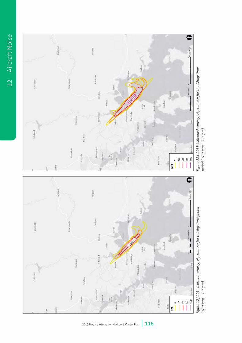
2015 Hobart International Airport Master Plan | 116
12
Air
craf
t N
oise
Figu
re 1
2.j 2
014
(cur
rent
runw
ay) N
70 c
onto
ur fo
r th
e da
y ti
me
peri
od
(07:
00am
– 7
:00p
m)
Figu
re 1
2.k
2035
(ext
ende
d ru
nway
) N70
con
tour
for
the
12da
y ti
me
peri
od (0
7:00
am –
7:0
0pm
)
05
Nau
tical
Mile
s[
05
Kilo
met
ers
N70
5 10 20 50 100
05
Nau
tical
Mile
s[
05
Kilo
met
ers
N70
5 10 20 50 100
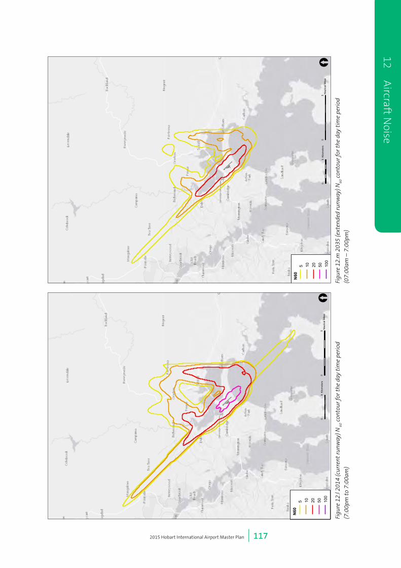
2015 Hobart International Airport Master Plan | 117
12 Aircraft N
oise
Figu
re 1
2.m
203
5 (e
xten
ded
runw
ay) N
60 c
onto
ur fo
r th
e da
y ti
me
peri
od
(07:
00am
– 7
:00p
m)
05
Nau
tical
Mile
s[
05
Kilo
met
ers
N60
5 10 20 50 100
05
Nau
tical
Mile
s[
05
Kilo
met
ers
N60
5 10 20 50 100
Figu
re 1
2.l 2
014
(cur
rent
runw
ay) N
60 c
onto
ur fo
r th
e da
y ti
me
peri
od
(7:0
0pm
to
7:00
am)

2015 Hobart International Airport Master Plan | 118
12
Air
craf
t N
oise
Figu
re 1
2.o
2035
wit
h Ru
nway
Ext
ensi
on N
60 C
onto
ur -
nigh
t ti
me
peri
od
(7:0
0pm
- 7:
00am
)
05
Nau
tical
Mile
s[
05
Kilo
met
ers
N60
5 10 20 50 100
05
Nau
tical
Mile
s[
05
Kilo
met
ers
N60
5 10 20 50 100
Figu
re 1
2.n
2014
(cur
rent
runw
ay) N
60 c
onto
ur fo
r th
e ni
ght
tim
e pe
riod
(7:0
0pm
to
7:00
am)

13 Environment
2015 Hobart International Airport Master Plan | 120
13 Environment
HIAPL recognises the importance of environmental
values present at the airport and strives to achieve
a sustainable balance between airport operations,
environmentally sensitive areas and planning for the
growth of Hobart Airport.
The airport site includes areas that are environmentally
significant at both Commonwealth and State levels. The
legislative mechanisms for managing the environment at
Hobart Airport is largely influenced by Commonwealth
legislation, primarily the Airports (Environment
Protection) Regulations 1997, however State legislation
also plays a role in areas where Commonwealth
legislation does not apply.
A part time Airport Environment Officer (AEO) is
employed by the Department of Infrastructure and
Regional Development (DIRD) to assist with the
administration of the Regulations at Hobart Airport. The
AEO has a number of specific statutory functions under
the Airports Act and Regulations. HIAPL works with the
AEO to ensure best practice environmental management
at Hobart Airport.
Under the Airports Act (Division 3 Section 70 (2)) in
relation to environmental management, an Airport
Master Plan details the airport lessee’s plans to:
• Ensure all operations at the airport are undertaken in
accordance with relevant environmental legislation
and standards;
• Establish a framework for assessing legislative
compliance in relation to environmental matters; and
• Promote the continual improvement of
environmental management at the airport.
This chapter has considers:
• The potential environmental issues resulting from the
implementation of the airport development plan for
a 5 and 20 year period and HIAPL’s plans for dealing
with these environmental issues during this period;
and
• Environmental impacts associated with airport
operations and the environment strategy to address
them.
In the past Hobart Airport has produced a standalone
Airport Environment Strategy (AES) to address these
matters. Due to a change in the Airports Act in recent
years, the Airport Environment Strategy has now
been incorporated into the 2015 Master Plan to more
closely align environmental management actions with
the airport’s development plan. This chapter updates
and replaces the previous AES. This chapter of the
2015 Master Plan meets the requirements set out
in the Airports Act in relation to the provision of an
environment strategy for the master plan period.
13.1 Environmental Management
HIAPL’s overall objectives for environmental management
is to promote continuous improvement in environmental
management and minimise potential adverse
environment impacts as a result of airport activities.
Integrated Management System
HIAPL is currently implementing an Integrated
Management System (IMS) which incorporates the
management of quality, environment, aerodrome safety,
security and health and safety. Key environmental
objectives and targets have been developed for the
airport, and combined with defined approaches, are
key features of the IMS that facilitate the ongoing
improvement of environmental management practices
at the airport. HIAPL’s IMS has been developed and is
reviewed to ensure it maintains consistency with all
relevant Australian and international standards.
Supporting the environmental aspects of the IMS are
the HIAPL Site Management Procedures (SMPs). SMPs
are an additional tool in which HIAPL approaches the
management of environmental aspects and are addressed
within the AES. The SMPs are embedded within the IMS
and are reported on and reviewed on an annual basis in
order to capture changes and lessons learnt. This ensures
continual improvement in managing the environment.
HIAPL has implemented an electronic management
system (SERA) through which the majority requirements
of the IMS can be undertaken. The system can be
accessed online and is an effective tool in which to log
and monitor incidents and audits via a reporting system
and identifies opportunities for improvement and risk
management across all levels of the organisation. Key
environmental achievements from the previous five years
are detailed in Table 13.a.
13
En
viro
nm
ent
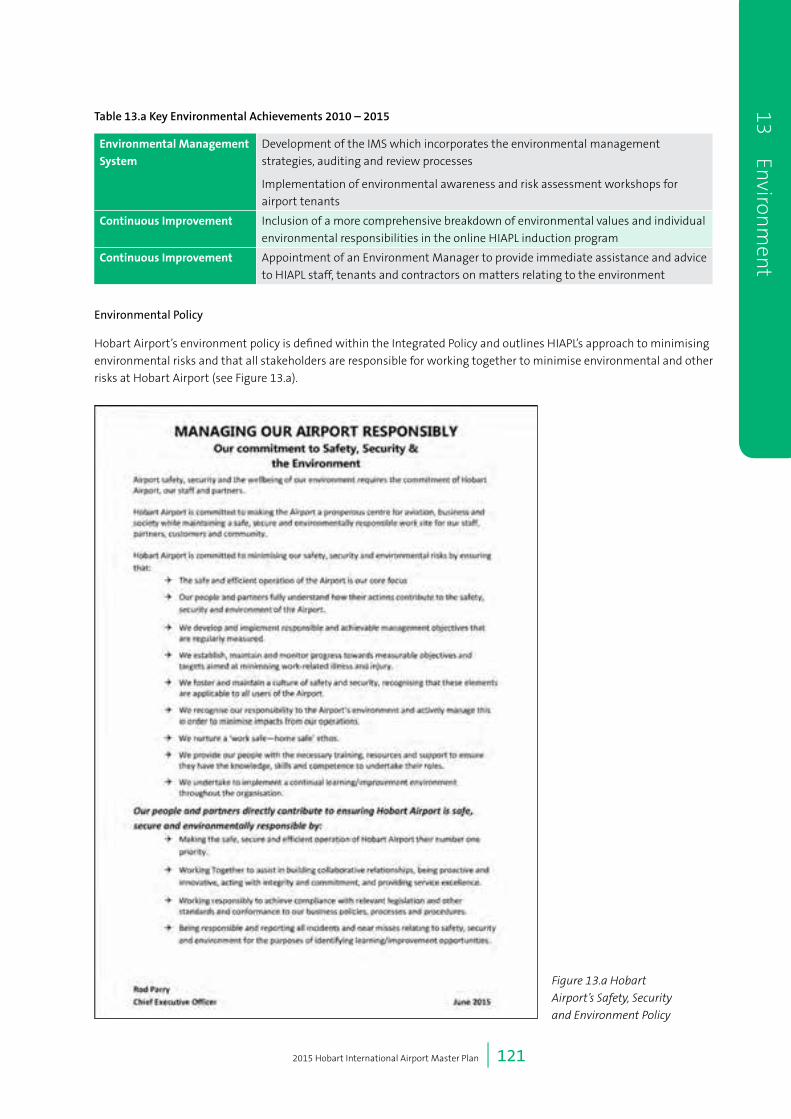
2015 Hobart International Airport Master Plan | 121
Table 13.a Key Environmental Achievements 2010 – 2015
EnvironmentalManagement
System
Development of the IMS which incorporates the environmental management
strategies, auditing and review processes
Implementation of environmental awareness and risk assessment workshops for
airport tenants
ContinuousImprovement Inclusion of a more comprehensive breakdown of environmental values and individual
environmental responsibilities in the online HIAPL induction program
ContinuousImprovement Appointment of an Environment Manager to provide immediate assistance and advice
to HIAPL staff, tenants and contractors on matters relating to the environment
Environmental Policy
Hobart Airport’s environment policy is defined within the Integrated Policy and outlines HIAPL’s approach to minimising
environmental risks and that all stakeholders are responsible for working together to minimise environmental and other
risks at Hobart Airport (see Figure 13.a).
13 Environ
ment
Figure 13.a Hobart
Airport’s Safety, Security
and Environment Policy

2015 Hobart International Airport Master Plan | 122
Monitoring and Research
Ongoing environmental monitoring and reporting
occurs at the airport on issues relating to environmental
values. As a result the airport has a comprehensive
understanding of existing values and potential impacts
associated with airport operations and resulting from
the proposed developments in this Master Plan. All
environmental values are considered for proposed
projects with the appropriate investigations undertaken
as required, specific to the site and the nature of
the proposed development. Any mitigation and
environmental management measures are prescribed
following site specific investigations. A number of
environmental assessments have been undertaken
for large projects such as the runway extension and
surrounding road networks. The findings of these reports
will be provided as part of the Major Development Plan
process.
Routine environmental monitoring is undertaken at
Hobart Airport for a number of reasons, including:
• Meeting the requirements of legislation and
demonstrate compliance;
• Identifying trends;
• Detecting anomalies that may cause environmental
harm and require changes in management; and
• Fostering an awareness and understanding of
the immediate environment in which the airport
operates.
Hobart Airport’s regular monitoring and reporting
programs are summarised in Table 13.b and take into
account results from the strategies outlined in section
13.2 of this Master Plan. The timeframes for monitoring
and frequency of reporting are influenced by regulatory
requirements and/or the environmental aspects that
are being studied. As such, the frequency of monitoring
is subject to change in response to environmental
conditions or results. All monitoring results are
interpreted by HIAPL and submitted to and AEO and
(where relevant) DIRD in reports.
Table 13.b Hobart Airport monitoring program
EnvironmentalAspect Frequency
Tenant Audits Annually
Water usage Quarterly
Electricity usage Quarterly
Soil contamination As required on specific
projects
Interceptor traps Bi-annual or quarterly
– responsibility of the
operator
Surface water Monthly – 1 site
Quarterly – all other sites
Groundwater Annually
Threatened flora species
populations
Annually
Weeds Annually
Noise As required
Air quality As required
All HIAPL staff and/or consultants who undertake
environmental monitoring or research have the relevant
professional and/or scientific qualifications required.
Where monitoring includes the collection of samples
requiring analysis, these are submitted to a National
Association of Testing Authorities (NATA) accredited
laboratory for analysis. Interpretation of results is
undertaken by qualified environmental staff.
Should a non-conformance occur or there is evidence of
adverse trends from analytical results, corrective actions
are implemented with the aim to improve the existing
environmental condition and to achieve improvements in
environmental performance. All testing, measuring and
sampling is undertaken in accordance with the AEPR and
National sampling protocols and standards.
Further detail regarding studies, reviews and monitoring
is set out in section 13.2.
13
En
viro
nm
ent

2015 Hobart International Airport Master Plan | 123
Training
HIAPL ensures that personnel who interact with the
airport environment have the required training that
facilitates awareness of the potential environmental
impacts that activities may cause. This includes
information and/or training for general environmental
awareness, training for appropriate responses to
environmental issues such as accidental spills and
an awareness of individual responsibilities from a
regulatory/legislative perspective.
HIAPL have internal procedures in place to ensure project
managers address environmental risks on projects and
implement the appropriate mitigation measures to
reduce and/or eliminate the potential environmental
impact. Permission to undertake work or activities at the
airport cannot proceed until this information is provided.
Tenants and Contractors
HIAPL requires tenants and contractors to be legally
responsible for their activities and to minimise
potential impacts to the receiving environment. In
addition tenants and are not permitted to discharge
to the environment without appropriate management
procedures in place and notifying HIAPL of the intended
discharge. HIAPL undertakes annual environmental
audits on tenants where airport environmental values
are reiterated and information provided on how to
identify potential risks as a result of activities. HIAPL may
update and communicate environmental requirements
to maintain compliance or as part of internal review
processes, which the tenant or contractor will also be
subject to.
In addition to tenants’ annual environmental auditing,
spot checks on contractors and tenants are undertaken
on a monthly basis. The outcomes of each spot check are
documented and recorded, with any required action to be
undertaken by the responsible party. Contractors are also
required to undertake the HIAPL online induction course
which provides background information on the general
environmental values at Hobart Airport and contractor
responsibilities.
Where construction activities interact with the
environment, tenants and/or contractors will be required
to prepare a Construction Environmental Management
Plan (CEMP) prior to any works commencing. The CEMP
must highlight potential environmental risks from
activities and mitigation measures to ameliorate those
risks. All CEMPs will be reviewed by the Airport to ensure
that known environmental values are not impacted on
as a result of the activity. Routine environmental spot
checks will be undertaken on projects to ensure CEMPs
are being implemented effectively. Specific requirements
for CEMPs and further details for each environmental
aspect are provided in the targets and timeframes tables
within this chapter.
Cultural Heritage Sites
A key site of historic heritage significance identified
on the airport site is Llanherne House. The site is used
for office based tenant activities. A Cultural Heritage
Management Plan (CHMP) was prepared for Llanherne
House in 2013 by HIAPL, in consultation with Heritage
Tasmania, and outlines the maintenance requirements
for the building for annual, long term and reactive
timeframes.
Environmentally Significant Areas (ESAs)
The airport’s environmentally significant areas (ESAs),
which have been identified by HIAPL in consultation with
relevant Tasmanian and Federal conservation bodies,
have remained largely unchanged since the development
of the previous environment strategy, with the exception
of the EPBC listed grasslands. As a precautionary action,
HIAPL increased areas of environmental significance in
the 2009 Airport Master Plan to cover areas that may
have contained the critically endangered Tasmanian
Lowland Native Grasslands. In 2011 a comprehensive
survey of these areas was undertaken by ecologists
to qualify these areas. The survey confirmed areas of
grassland that qualified for EPBC listing and areas that
did not meet the qualification criteria.
HIAPL notes that there have been no relevant
recommendations from the Commonwealth Department
of Environment or State bodies regarding biodata,
habitat, heritage or similar matters in relation to the
ESAs within the airport site.
The ESAs and Llanherne House are shown in Figure 13.b.
A more detailed map of the significance of the vegetation
areas within the ESA’s is illustrated in Figure 13.c.
The vegetation is defined by vegetation of national,
bioregional and state significance. The EPBC listed grass
land vegetation community comprises the areas of
national significance.
13 Environ
ment

2015 Hobart International Airport Master Plan | 124
13
En
viro
nm
ent
Sou
rce:
Esr
i, D
igita
lGlo
be, G
eoE
ye, i
-cub
ed, U
SD
A, U
SG
S, A
EX
, Get
map
ping
, Aer
ogrid
, IG
N, I
GP,
sw
isst
opo,
and
the
GIS
Use
r Com
mun
ity
015
030
045
060
0
Met
res
[
Figu
re N
o
13.b
Coo
rdin
ate
Sys
tem
GD
A 1
994
MG
A Z
one
55
Scal
e at
A4
1:15
,119
Dra
win
g Ti
tle
ESA
s an
d Ll
anhe
rne
Hou
se
Llan
hern
e H
ouse
Env
ironm
enta
lly S
igni
fican
t Are
as
Figu
re 1
3.b
Hob
art
Air
port
ESA
s an
d Ll
anhe
rne
Hou
se

2015 Hobart International Airport Master Plan | 125
13 Environ
ment
Sou
rce:
Esr
i, D
igita
lGlo
be, G
eoE
ye, i
-cub
ed, U
SD
A, U
SG
S, A
EX
, Get
map
ping
, Aer
ogrid
, IG
N, I
GP,
sw
isst
opo,
and
the
GIS
Use
r Com
mun
ity
015
030
045
060
0
Met
res
[
Figu
re N
o
13.c
Coo
rdin
ate
Sys
tem
GD
A 1
994
MG
A Z
one
55
Scal
e at
A4
1:14
,940
Dra
win
g Ti
tle
Vege
tatio
n Si
gnifi
canc
e w
ithin
ESA
s
Nat
iona
l Sig
nific
ance
Bior
egio
nal S
igni
fican
ceSt
atew
ide
sign
ifica
nce
Figu
re 1
3.c
Veg
etat
ion
sign
ifica
nce
wit
hin
ESA
are
as

2015 Hobart International Airport Master Plan | 126
13.2 Environment Strategy
HIAPL’s strategic approach to environmental management is outlined in the following sections. This includes the context,
prior achievements, HIAPL’s preferred environmental management approach and targets for 2015-2020.
The environment strategy that has been developed and that is referred to in this chapter also applies to, and will be
implemented in, areas of the airport site that are, or could be, used for a purpose that is not connected with airport
operations.
HIAPL will continue to develop its environment strategy through ongoing consultations with the community and airport
users (including via the Community Aviation Consultation Group) and will make the strategy available (as part of this
Master Plan) on its website once finalised.
HIAPL also intends to provide briefings to relevant industry participants on the plans in the environment strategy in order
to attempt to ensure they are aware of the strategy and how it applies to their operations and to achieve their cooperation
with respect to the plans. Further, as noted in section 13.1, HIAPL requires in its leases and contracts that tenants and
contractors to be responsible for their activities and to minimise potential impacts to the receiving environment.
13.2.1ResourceUse
HIAPL’s environmental objective in relation to resource use is to:
• Seek ways in which to reduce resource use and the generation of waste and ‘greenhouse gases’ as a result of
activities and operations at Hobart Airport.
The effective management and minimisation of resource use and the production of ‘greenhouse gases’ is a key objective
for Hobart Airport. Activities at the airport (including those activities arising from the implementation of this Master
Plan) that use natural resources include:
• General airport operations including activities within buildings;
• Tenant activities;
• Vehicle and ground based aircraft activities;
• Operation of plant and equipment;
• Grounds maintenance and landscaping; and
• Construction activities relating to specific projects.
Achievements in relation to resource use at Hobart Airport in the past five years are identified in Table 13.c.
Table 13.c Resource use achievements 2010-2015
EnergyandFuel • Use of LED lighting on projects and replacement programs e.g. taxi way approach lights,
emergency and exit lighting
• Installation of energy efficient hand dryers in terminal facilities
• Use of solar powered generated Obstacle Beacon Lights
• Incorporation of energy efficient measures on new developments
• Review of electricity use in the Annual Environment Reports (AER)
Water • Development of a Shared Service Centre for car rental agencies
• Adoption of the new Australian Fire Service Maintenance Standard AS1851:2012
• Improving water use efficiency with replacement of water supply fixtures
• Review of water use in the AER
Waste • Introduction of designated recycling bins for beverage containers within the terminal building
• Recycling of material where practical for other construction projects e.g. reuse of crushed
bitumen for Loop Road emergency vehicle muster area
• Introduction of recycling for HIAPL Administration
• Review and update of the HIAPL Waste Management Procedure (SMP04)
• Contractors are required to identify waste management measures/strategies within project
specific Construction Environmental Management Plans (CEMPs)
13
En
viro
nm
ent

2015 Hobart International Airport Master Plan | 127
Targets – Resource Use
The following targets (Table 13.d) have been set in relation to resource use for the period 2015 – 2020. These will be
integrated into the IMS and used for assessment and reporting targets in order to deal with the possible environmental
impacts associated with the operation of the airport and the implementation of the Master Plan.
Table 13.d Resource use targets and timeframes
Target Timeframe
Development and implementation of energy efficient strategies using information
provided from reputable sources and adopt recommended actions where applicable
As required
Incorporate energy efficient measures for new developments As required
Continue to identify opportunities to improve natural resource use during annual tenant
audits and review HIAPL resource use for the AER
2015-2020
Continue to investigate and promote recycling initiatives for tenants 2015-2020
Ensure Contractor CEMPs include measures to reduce generation of waste 2015-2020
Promote water reuse from the WWTP when water quality is suitable for reuse 2015-2020
13.2.2Land
HIAPL’s environmental objective in relation to land is to:
• To minimise adverse impacts to land and soil as a result of Hobart Airport activities and to manage and rehabilitate
sites of known contamination in accordance with relevant standards and regulations.
The Hobart Airport site is a key asset that needs to be carefully managed to ensure environmental risks do not
impact the health of lands both on and off the airport. Airport activities (including those activities arising from the
implementation of this Master Plan) that may impact land include:
• Storage, handling, use and disposal of fuels, oils, chemicals and hazardous substances;
• Above ground and underground storage systems for these items;
• Inappropriate disposal of waste generated from activities and construction projects;
• Vehicle and aircraft maintenance and washing;
• Car parking and potential for contaminated runoff from hardstand areas;
• Firefighting training;
• Disturbance of acid sulfate soils or contaminated soils from excavation activities;
• Disturbance of former waste disposal sites and asbestos materials;
• Importation of fill; and
• Landscaping and vegetation removal that may cause erosion.
In addition to the Commonwealth land area, the HIAPL manages two areas of freehold land. Any proposed development
in these areas is subject to state legislative requirements such as the Threatened Species Protection Act 1995 and the
Nature Conservation Act 2002. The HIAPL is committed to following the required state approval processes under state
legislation for any proposed project on freehold land. The HIPAL has prepared Forest Practices Plans for both freehold
land titles which addresses any environmental values and mitigation measures required.
Both Freehold titles have historical land use relating to pine plantation. Forest Practices Plans have been developed for
each site where any environmental values are defined. Each site will be surveyed prior to any proposed development for
emerging environmental values and managed according to state legislative requirements.
13 Environ
ment

2015 Hobart International Airport Master Plan | 128
Achievements in relation to the land at Hobart Airport in the past five years are identified in Table 13.e.
Table 13.e Land achievements 2010-2015
UPSS • Removal of three underground Petroleum Storage Systems (UPSS) from eastern boundary of
the Budget Rent a Car site, including soil analysis and validation assessment
• Removal of UPSS from Approach Lights Power House, including soil analysis and validation
assessment
• Removal of UPSS from HIAPL compound, including soil analysis and validation assessment
Contaminated
Sites• Development of a contaminated sites register
• Documentation of potential contaminants captured in annual tenant audits
• Remediation of former HIAPL vehicle wash down area (airside) including soil analytical testing
prior to disposal
• Preparation of work plan for the remediation of the disused landfill site (airside)
• Soil contamination investigation for land associated with the Taxiway Alpha extension project
• Soil contamination investigation of the former TasAir hangar site and design of an interceptor
trap for the site
• A soil contamination investigation and risk assessment on soil that was excavated for the
redeveloped Tas Campers site
• A soil contamination investigation and interceptor efficiency assessment for Clarks
Maintenance shed and operations
• Provision of an Emergency Spill Response trailer to use airside
Waste • Stockpiles of soil, asphalt and some concrete stored onsite for reuse on projects requiring fill or material in non-environmentally sensitive areas
• Introduction of designated recycling bins for beverage containers within the terminal building
and HIAPL administration building
Any new development that has the potential to impact on the airport’s environmental values during construction
or operation will be assessed for each proposed project in accordance with any Commonwealth or state approval
requirements.
Targets – Land
The following targets (Table 13.f) have been set in relation to land for the period 2015 – 2020. These will be integrated
into the IMS and used for assessment and reporting targets in order to deal with the possible environmental impacts
associated with the operation of the airport and the implementation of the Master Plan.
Table 13.f Land targets and timeframes
Target Timeframe
Continued investigations into PFOS and PFOA and remediation measures and liaison with
Airservices
Ongoing
Annual review and update of contaminated sites and UPSS register Annual
Investigations into the remediation of disused landfill site (airside) 2016
Incorporation of mitigation measures to land in CEMPs As required
Site investigations of potential contaminated sites prior to disturbance or development
projects, including analytical testing
As required
Incorporation of the Air Services Australia Managing PFC Contamination at Airports
Interim Contamination Management Strategy and Decision Framework in the
management of PFC impacted soil and water
As required
Assessment and clearance of sites where UPSS are removed by a qualified consultant As required
Appropriate mitigation measures in place where the potential for disturbance of acid
sulfate soils exist
As required
13
En
viro
nm
ent

2015 Hobart International Airport Master Plan | 129
13.2.3 Surface Water and Groundwater
HIAPL’s environmental objective in relation to water is to:
• To minimise adverse environmental impacts to surface water and groundwater as a result of airport activities.
The airport has an extensive internal network of piped and open lined and unlined drains which provide for the majority of stormwater drainage throughout the site. Sinclair Creek receives a substantial amount of this drainage, discharging offsite into Frederick Henry Bay.
Airport related activities (including those activities arising from the implementation of this Master Plan) that have the potential to impact surface and/or ground water quality include:
• Above ground storage tanks generally for fuel and oil;
• Underground storage tanks (a decommissioning and removal program is in place, where applicable);
• Known contaminated sites;
• Disturbance of Potential Acid Sulfate Soils (PASS);
• Car parking and operational areas;
• Vehicle workshops and wash down bays;
• Disused landfill sites;
• Wastewater treatment plant discharges;
• Refuelling activities;
• Firefighting training;
• General litter; and
• Construction related activities.
Achievements in relation to surface and ground water at Hobart Airport in the past five years are identified in Table 13.g.
Table 13.g Surface water and groundwater achievements 2010 -2015
HIAPL • Routine monthly and quarterly surface water quality monitoring and reporting to the AEO
• Routine annual groundwater quality monitoring and reporting to the AEO
• Preparation of a 6 monthly trend analysis on water quality results for the AEO
• Ongoing liaison with TasWater regarding discharge results and annual reporting
• Improvement of drainage network function and efficiency through the development of a routine
maintenance program e.g. removal of Cumbungi and sedimentation, erosion improvement measures
• Additional surface water quality testing of open stormwater drains to determine contaminant
extent and distribution
• Installation of a dedicated Shared Service Centre for car rental companies to clean and detail car
fleets
• Routine inspection and servicing of oil/water separators and interceptor traps
• Review of CEMPs on projects to ensure that potential risks to stormwater, surface water and
groundwater are addressed and mitigation measures identified
Airservices • Development and implementation of a stormwater monitoring program for the fire station building
• Routine annual groundwater quality monitoring and reporting to the AEO
• Continued investigation at a National level into PFOS/PFOA contamination of groundwater at the
firefighting training ground and Airservices building and effective remediation/disposal techniques
TasWater • Investigation into options to improve discharge water quality and meet existing
Environmental Protection Notice (EPN) conditions issued by the State Government
Tenants • Independent assessment of water quality discharge from SALCO Seafoods to ensure minimal
adverse impacts to the water quality within swale drains
• Routine servicing and maintenance of oil/water separators and triple interceptor traps
• Routine stormwater quality testing and groundwater monitoring by Air BP at the bulk fuel storage and refuelling area
• Routine groundwater monitoring by BP Service station and tank integrity testing
13 Environ
ment
2015 Hobart International Airport Master Plan | 130
Targets – Surface Water and Groundwater
The following targets (Table 13.h) have been set in relation to water for the period 2015 – 2020. These will be integrated
into the IMS and used for assessment and reporting targets in order to deal with the possible environmental impacts
associated with the operation of the airport and the implementation of the Master Plan.
Table 13.h Surface water and groundwater targets and timeframes
Target Timeframe
Continuation of surface water quality monitoring and annual groundwater monitoring Ongoing
Water quality monitoring reports to be provided to AEO and review program periodically
based on results
Ongoing
Communication with TasWater regarding wastewater discharges and potential impacts or
complaints
Ongoing
Communication with tenants on stormwater control devices (servicing and maintenance)
and effectiveness of mitigation measures
Annual
Annual review of SMPs relevant to water quality, update as required and include within the
IMS
Annual
Review and update of SMPs 05 and 06 2014 - 2015
Ensure all CEMPs on projects identify environmental risks to water quality and the
appropriate mitigation measures are in place to prevent/minimise environmental harm
As required
13.2.4Biodiversity
HIAPL’s environmental objective in relation to biodiversity is to:
• To identify, understand and conserve biodiversity values at the Hobart Airport while considering the operational
aspects of wildlife management.
Hobart Airport has a number of biodiversity values that require careful management. Airport related activities (including
those activities arising from the implementation of this Master Plan) that have the potential to impact biodiversity
include:
• Mowing and landscaping which may result in habitat loss or destruction and reduce biodiversity and increase
opportunities for weed invasion;
• Pest and weed control which may impact on non-target species;
• Tree removal which may impact on habitat or species values;
• Planned burning of vegetation;
• Land clearance for construction projects e.g. roads, car parks, new developments;
• Construction activities that have the potential to generate dust, noise and changes to surface water and
groundwater conditions; and
• Construction and operational activities that have the potential to impact on adjacent Ramsar listed wetland values.
Achievements in relation to biodiversity at Hobart Airport in the past five years are identified in Table 13.i.
13
En
viro
nm
ent

2015 Hobart International Airport Master Plan | 131
Table 13.i Biodiversity achievements 2010 – 2015
Biodiversity • Review and update of Wildlife Hazard Management Plan and integration of monitoring and management recommendations
• Assessment and mapping of native grasslands that qualify for EPBC Commonwealth listing as Tasmanian Lowland Native Grasslands (Critically Endangered)
• Development of recommendations to improve areas of native grassland to EPBC qualification condition
• Protection measures installed and communicated to preserve population of Carex tasmanica (Curly sedge) in the Loop Road swale drain
• Mapping of threatened flora species populations, vegetation communities and weed species throughout the site
• Site specific investigation for listed flora species on the taxiway extension project
• Site specific investigation for the removal of trees to improve safety for helicopter approach
• Desktop assessment of potential fauna values for the airport
• Targeted terrestrial assessment to verify fauna habitat and values throughout the site
• Demarcation of and communication to contractors regarding airside conservation areas
• Assessment of biodiversity values on individual project sites prior to work commencing
• Review of contractor CEMPs to determine whether mitigation measures are appropriate
• Review and removal of the Vegetation Management Agreement (VMA) following consultation with the state and commonwealth governments, due to changes in proposed developments
Weeds • Annual weed mapping of significant weed species
• Development of a supporting material for contractors to manage and monitor weed infestations
• Annual review of weed monitoring and management actions to determine effectiveness of control measures over time
• Removal of pine trees from within the grassland conservation areas
Targets – Biodiversity
The following targets (Table 13.j) have been set in relation to biodiversity for the period 2015 – 2020. These will be
integrated into the IMS and used for assessment and reporting targets in order to deal with the possible environmental
impacts associated with the operation of the airport and the implementation of the Master Plan.
Table 13.j Biodiversity targets and timeframes
Target Timeframe
Continued liaison with relevant departments at the state and Commonwealth level regarding biodiversity issues as they arise
As required
Continue to ensure that all CEMPs incorporate measures to minimise potential adverse impacts to biodiversity values
As required
Annual review of site management procedures relevant to biodiversity, update as required and include within the IMS
Annual
Annual assessment of targeted threatened species populations during optimal flowering periods and updated mapping
Annual
Continue to raise awareness of airport biodiversity values through annual tenant auditing Annual
Continued monitoring and management of pest and weeds throughout the site Annual
Development and implementation of management actions to improve selected areas of grassland to EPBC qualification level and monitoring of success
2015-2020
Undertake targeted fauna survey for the Tussock skink in grassland areas 2015
Ensure construction activities incorporate mitigation measures to minimise impacts to adjacent wetlands e.g. silt traps, detention facilities, run-off control
As required
Review operational activities and procedures to ensure potential impacts to adjacent Ramsar listed wetlands are minimised
Annual
13 Environ
ment

2015 Hobart International Airport Master Plan | 132
13.2.5CulturalHeritage
HIAPL’s environmental objective in relation to cultural heritage is to:
• To understand, preserve and manage sites of cultural heritage value (historic and Aboriginal) in accordance with
legislative requirements and in consultation with the relevant departments, community groups and organisations.
Airport related activities (including those activities arising from the implementation of this Master Plan) that have the
potential to impact cultural heritage include:
• Accidental damage to heritage buildings;
• Wear and tear and deterioration of heritage buildings; and
• Land disturbance resulting from development, maintenance or remediation works including landscaping activities
impacting Aboriginal heritage.
Achievements in relation to cultural heritage at Hobart Airport in the past five years are identified in Table 13.k.
Table 13.k Cultural heritage achievements 2010 – 2015
LlanherneHouse • Development of a CHMP for the immediate, long term and reactive maintenance of Llanherne House in accordance with Heritage Tasmania recommendations
• Development of the Llanherne House Site Management Procedure (SMP14)
• Development of the Llanherne House Five Year Maintenance Plan
Aboriginal
Heritage• Consultation with Aboriginal Heritage Tasmania (AHT) , which coordinates the consultation
process with indigenous communities, and approval of the delisting of two TASI sites located
on airport land
• Review and update of the HIAPL Aboriginal sites register
• Review of contractor CEMPs to determine whether mitigation measures are appropriate and/
or relevant to Aboriginal heritage sites at the airport
• Increased awareness of Aboriginal heritage sites and values on airport land with tenants
during annual environmental auditing
Aboriginal Heritage
There are 13 recognised Aboriginal heritage sites located at Hobart Airport which are largely comprised of isolated stone
artefacts and artefact scatters, with one having an association of midden shell.
This location of Aboriginal heritage values is not available for general viewing due to cultural sensitivities and it has been
formally requested by the State government that this information remain confidential.
Historic Heritage
Llanherne House (Figure 13.d) is a heritage listed property located at the airport. The house is a small stone cottage
currently used as office space by Airservices, While Llanherne House is not currently listed on the Australian Heritage
database, it is permanently listed on the Tasmanian Heritage Register (THR).
Figure 13.d Llanherne House
HIAPL notes that there have been no relevant recommendations from the Australian Heritage Council, Department of
Environment or State body regarding heritage or similar matters.
13
En
viro
nm
ent

2015 Hobart International Airport Master Plan | 133
Targets – Cultural Heritage
The following targets (Table 13.l) have been set in relation to cultural heritage for the period 2015 – 2020. These will be
integrated into the IMS and used for assessment and reporting targets in order to deal with the possible environmental
impacts associated with the operation of the airport and the implementation of the Master Plan that are outlined above.
Table 13.l Cultural heritage targets and timeframes
Target Timeframe
Continued liaison with relevant departments at the state and Commonwealth level and
community organisations regarding heritage issues as they arise
As required
Continue to ensure that all contractor CEMPs incorporate measures to minimise potential
adverse impacts to heritage values
As required
Implementation of the CHMP and recommendations Annual
Annual review of site management procedures relevant to heritage values, update as
required and include within IMS
Annual
Continue to raise awareness of airport heritage values through annual tenant auditing Annual
13.2.6AirQuality
HIAPL’s environmental objective in relation to air quality is to:
• To minimise impacts to air quality as a result of activities at the airport and to strive for continual improvement in
the management of ozone depleting substances by reducing, substituting or eliminating their use.
Airport related activities (including those activities arising from the implementation of this Master Plan) that have the
potential to impact air quality in those areas of the regional airshed as is reasonably likely to be affected by airport
activities including:
• Vehicle emissions from airport operators, passengers and visitors to the airport contributing to airborne pollution;
• Dark smoke emissions from the firefighting training ground and use of firefighting extinguishers during training
exercises;
• Cambridge Wastewater Treatment Plant which can generate offensive odours;
• Refuelling activities;
• Construction and development activities which can lead to dust generation and reduced visibility for aircraft;
• Removal or damage to asbestos containing material resulting in the release of asbestos fibres;
• The use of air conditioners and refrigerators that use ozone depleting substances; and
• Vegetation burn offs resulting in a public nuisance.
13 Environ
ment
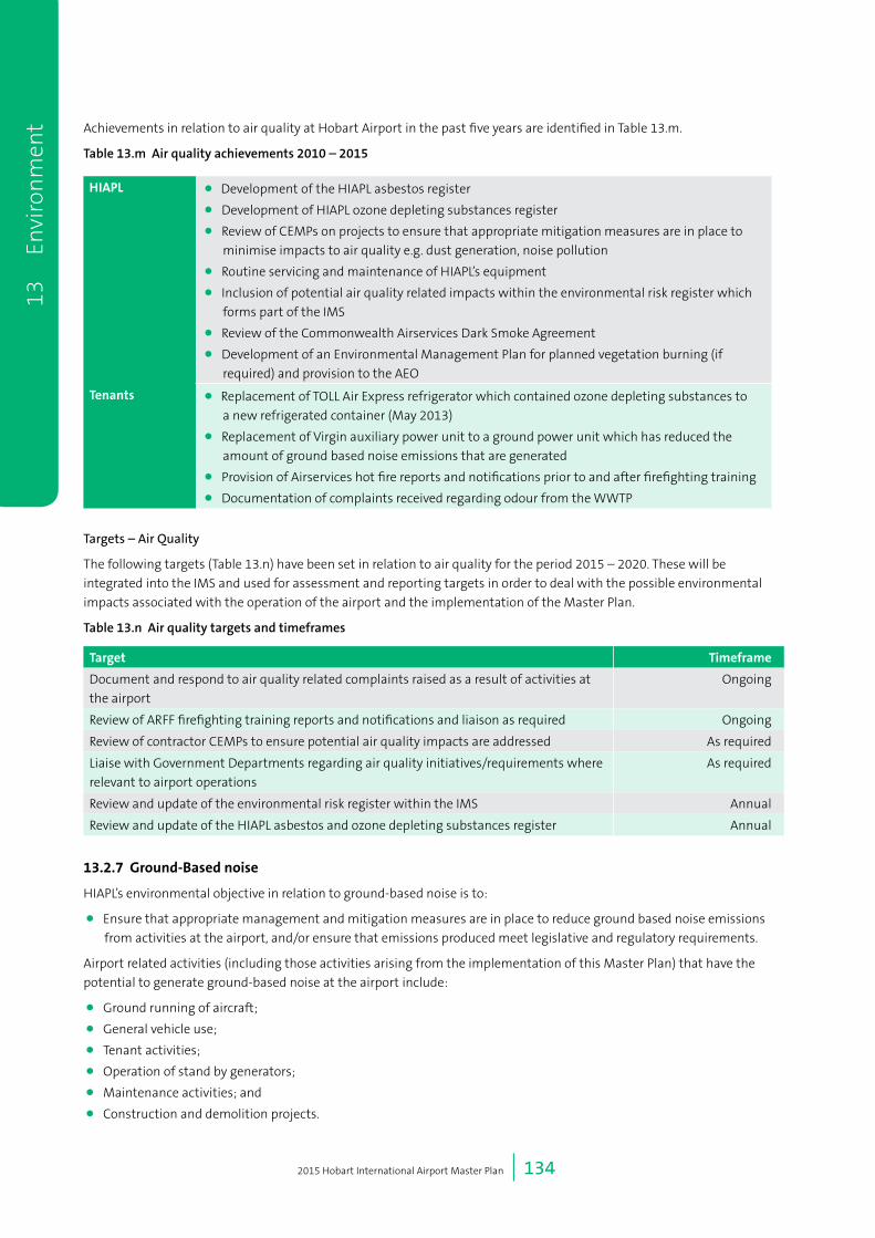
2015 Hobart International Airport Master Plan | 134
Achievements in relation to air quality at Hobart Airport in the past five years are identified in Table 13.m.
Table 13.m Air quality achievements 2010 – 2015
HIAPL • Development of the HIAPL asbestos register
• Development of HIAPL ozone depleting substances register
• Review of CEMPs on projects to ensure that appropriate mitigation measures are in place to
minimise impacts to air quality e.g. dust generation, noise pollution
• Routine servicing and maintenance of HIAPL’s equipment
• Inclusion of potential air quality related impacts within the environmental risk register which
forms part of the IMS
• Review of the Commonwealth Airservices Dark Smoke Agreement
• Development of an Environmental Management Plan for planned vegetation burning (if
required) and provision to the AEO
Tenants • Replacement of TOLL Air Express refrigerator which contained ozone depleting substances to
a new refrigerated container (May 2013)
• Replacement of Virgin auxiliary power unit to a ground power unit which has reduced the
amount of ground based noise emissions that are generated
• Provision of Airservices hot fire reports and notifications prior to and after firefighting training
• Documentation of complaints received regarding odour from the WWTP
Targets – Air Quality
The following targets (Table 13.n) have been set in relation to air quality for the period 2015 – 2020. These will be
integrated into the IMS and used for assessment and reporting targets in order to deal with the possible environmental
impacts associated with the operation of the airport and the implementation of the Master Plan.
Table 13.n Air quality targets and timeframes
Target Timeframe
Document and respond to air quality related complaints raised as a result of activities at
the airport
Ongoing
Review of ARFF firefighting training reports and notifications and liaison as required Ongoing
Review of contractor CEMPs to ensure potential air quality impacts are addressed As required
Liaise with Government Departments regarding air quality initiatives/requirements where
relevant to airport operations
As required
Review and update of the environmental risk register within the IMS Annual
Review and update of the HIAPL asbestos and ozone depleting substances register Annual
13.2.7Ground-Basednoise
HIAPL’s environmental objective in relation to ground-based noise is to:
• Ensure that appropriate management and mitigation measures are in place to reduce ground based noise emissions
from activities at the airport, and/or ensure that emissions produced meet legislative and regulatory requirements.
Airport related activities (including those activities arising from the implementation of this Master Plan) that have the
potential to generate ground-based noise at the airport include:
• Ground running of aircraft;
• General vehicle use;
• Tenant activities;
• Operation of stand by generators;
• Maintenance activities; and
• Construction and demolition projects.
13
En
viro
nm
ent

2015 Hobart International Airport Master Plan | 135
Achievements in relation to ground-based noise at Hobart Airport in the past five years are identified in Table 13.o.
Table 13.o Ground-based noise achievements 2010 – 2015
Noise • Documentation of any noise related complaints received from stakeholders or the general
public
• Review of contractor CEMPs to ensure that ground based emissions meet legislative and
regulatory compliance
• Inclusion of activities with potential ground based noise emissions within the environmental
risk register which forms part of the IMS
• Discussion of potential noise related issues on quarterly basis with CACG
• Review of mitigation measures implemented by tenants and effectiveness for ground based
noise during annual audits
Targets – Ground-Based Noise
The following targets (Table 13.p) have been set in relation to ground-based noise for the period 2015 – 2020. These
will be integrated into the IMS and used for assessment and reporting targets in order to deal with the possible
environmental impacts associated with the operation of the airport and the implementation of the Master Plan.
Table 13.p Ground-based noise targets and timeframe
Target Timeframe
Continuation of discussions with CACG on potential noise related issues Quarterly
Review and update ground based noise management procedures and implement
accordingly
Bi-annually
Continue to liaise with tenants on mitigation measures for ground based noise Annual
Review of contractor CEMPs to ensure potential ground based noise impacts are addressed As required
Update complaints register regarding ground based noise issues As required
Undertake noise quality assessments where impacts persist and remain unresolved As required
Participate in Government programs or initiatives on noise mitigation schemes As required
13.2.8HazardousMaterials
HIAPL’s environmental objective in relation to hazardous materials is:
• To ensure hazardous materials are stored, handled and used in accordance with applicable requirements and
managed to reduce potential adverse environmental impacts as a result of activities.
Hazardous materials that are currently produced, collected, stored or used at the airport (and which are expected to
continue to be produced, collected, stored or used at the airport following the implementation of this Master Plan)
include:
• Pesticides and herbicides;
• Cleaning agents;
• Aviation and automotive fuel;
• Sludge from sumps, triple interceptors and wastewater treatment (biosolids);
• Removed asbestos;
• Paints and solvents;
• Batteries;
• Fire extinguishing and de-icing chemicals;
• Quarantine waste; and
• Potentially contaminated water from firefighting activities.
Achievements in relation to hazardous waste at Hobart Airport in the past five years are identified in Table 13.q.
13 Environ
ment

2015 Hobart International Airport Master Plan | 136
Table 13.q Hazardous waste achievements 2010 – 2015
HazardousWaste • Review and update of SMP01 and SMP04
• Development of Spill Response Procedure – Information Sheet (July 2013)
• Review of contractor CEMPs to ensure that storage and use of hazardous substances meet
legislative and regulatory compliance
• Review of mitigation measures implemented by tenants for storage and use of hazardous
substances during annual audits, including MSDS information
• Annual review and update of asbestos register
• Documentation of safety incidents using SERA program and implementation of response/
action required
• Development of a work plan for the remediation of former landfill site east of the runway
• Testing and analysis of potentially contaminated soil stockpiles prior to disposal to ensure
classification level, in accordance with the EPA Bulletin 105 - Classification and Management of
Contaminated Soil for Disposal
• Refer to achievements under “Land” Section for specific projects that addressed hazardous
waste issues
Targets – Hazardous Materials
The following targets (Table 13.r) have been set in relation to hazardous materials for the period 2015 – 2020. These
will be integrated into the IMS and used for assessment and reporting targets in order to deal with the possible
environmental impacts associated with the operation of the airport and the implementation of the Master Plan.
Table 13.r Hazardous materials targets and timeframes
Target Timeframe
Review of legislative changes in waste management and implement any changes as
required, including internal SMPs e.g. disposal of controlled waste and update IMS
accordingly
Annual
Continue to liaise with tenants on mitigation measures for the handling and storage of
contaminating substances during annual audits
Annual
Ensure all potentially hazardous waste is classified and disposed of by a licensed contractor
to an appropriate receiving facility
As required
Review of contractor CEMPs to ensure the storage and handling of contaminating
substances are addressed appropriately
As required
13
En
viro
nm
ent

14 Consultation Program

2015 Hobart International Airport Master Plan | 138
14 Consultation Program During the past 12 months, HIAPL has worked with a range of stakeholders to develop the 2015 Master Plan (including
the Environment Strategy). As outlined in section 4.7, the Airports Act sets out a number of requirements in relation
to stakeholder and community consultation in relation to a Master Plan. The consultation program for the Master Plan
aimed to:
• Provide information about the 2015 Master Plan to relevant stakeholders and community members during the
preparation of the document;
• Provide opportunities for HIAPL to consult with people and groups to better understand the real and perceived
impacts and benefits of the development plans;
• Provide opportunities for interested people and groups to learn about the Master Plan as they progress so they can
make informed comments during the public comment period; and
• Address the consultation requirement of the Airports Act 1996 for the Master Plan.
Table 14.a outlines HIAPL’s approach to meet the legislated consultation requirements, and the additional consultation
actions undertaken, during the preparation of this Master Plan and Environment Strategy.
Table 14.a Legislated and non-legislation engagement activities
Informalconsultation
(Mid2014–April2015)
Formalpre-release
consultation
(April-May2015)
Formalpubliccomment
periodconsultation
(LateJune–midSept2015)
Legislated consultation
requirements – Master Plan• Informal discussions
with airlines, local
government authorities
and State Government
representatives to
discuss planned airport
development.
• Consultation with the
State government, an
authority of a State, a
local government body,
an airline or other user
of the airport concerned
or any other person.
• Airlines and local
government bodies
in the vicinity of the
airport regarding noise
• Letter to State
Minister and authority
responsible for Town
Planning and relevant
local government
authorities advising
the release of the
Master Plan for public
comment
• Advertisement in
relevant newspapers
• Information on HIAPL
website
• Copies of the master
Plan available in hard
and soft copy for review
Additional consultation
activities undertaken /
planned
• Informal discussions
with stakeholders on
a range of Master Plan
related topics to inform
the content of the
document.
• Business as usual
briefings with airport
stakeholders that
address the Master Plan
process.
• Additional stakeholder
meetings
• Business as usual
briefings with airport
stakeholders that
address the Master Plan
process.
• Additional stakeholder
meetings
• Community briefing
• Business as usual
briefings with airport
stakeholders that
address the Master Plan
process.
14
Con
sult
atio
n P
rogr
am
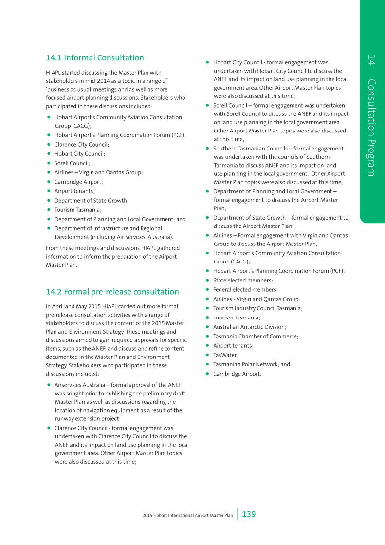
2015 Hobart International Airport Master Plan | 139
14.1 Informal Consultation
HIAPL started discussing the Master Plan with
stakeholders in mid-2014 as a topic in a range of
‘business as usual’ meetings and as well as more
focused airport planning discussions. Stakeholders who
participated in these discussions included:
• Hobart Airport’s Community Aviation Consultation
Group (CACG);
• Hobart Airport’s Planning Coordination Forum (PCF);
• Clarence City Council;
• Hobart City Council;
• Sorell Council;
• Airlines – Virgin and Qantas Group;
• Cambridge Airport;
• Airport tenants;
• Department of State Growth;
• Tourism Tasmania;
• Department of Planning and Local Government; and
• Department of Infrastructure and Regional
Development (including Air Services, Australia).
From these meetings and discussions HIAPL gathered
information to inform the preparation of the Airport
Master Plan.
14.2 Formal pre-release consultation
In April and May 2015 HIAPL carried out more formal
pre-release consultation activities with a range of
stakeholders to discuss the content of the 2015 Master
Plan and Environment Strategy. These meetings and
discussions aimed to gain required approvals for specific
items, such as the ANEF, and discuss and refine content
documented in the Master Plan and Environment
Strategy. Stakeholders who participated in these
discussions included:
• Airservices Australia – formal approval of the ANEF
was sought prior to publishing the preliminary draft
Master Plan as well as discussions regarding the
location of navigation equipment as a result of the
runway extension project;
• Clarence City Council - formal engagement was
undertaken with Clarence City Council to discuss the
ANEF and its impact on land use planning in the local
government area. Other Airport Master Plan topics
were also discussed at this time;
• Hobart City Council - formal engagement was
undertaken with Hobart City Council to discuss the
ANEF and its impact on land use planning in the local
government area. Other Airport Master Plan topics
were also discussed at this time;
• Sorell Council – formal engagement was undertaken
with Sorell Council to discuss the ANEF and its impact
on land use planning in the local government area.
Other Airport Master Plan topics were also discussed
at this time;
• Southern Tasmanian Councils – formal engagement
was undertaken with the councils of Southern
Tasmania to discuss ANEF and its impact on land
use planning in the local government. Other Airport
Master Plan topics were also discussed at this time;
• Department of Planning and Local Government –
formal engagement to discuss the Airport Master
Plan;
• Department of State Growth – formal engagement to
discuss the Airport Master Plan;
• Airlines – Formal engagement with Virgin and Qantas
Group to discuss the Airport Master Plan;
• Hobart Airport’s Community Aviation Consultation
Group (CACG);
• Hobart Airport’s Planning Coordination Forum (PCF);
• State elected members;
• Federal elected members;
• Airlines - Virgin and Qantas Group;
• Tourism Industry Council Tasmania;
• Tourism Tasmania;
• Australian Antarctic Division;
• Tasmania Chamber of Commerce;
• Airport tenants;
• TasWater;
• Tasmanian Polar Network; and
• Cambridge Airport.
14 C
onsu
ltation Program

2015 Hobart International Airport Master Plan | 140
14.3 Formal public comment period consultation
To meet the requirements of the Airports Act in relation
to consultation HIAPL has undertaken the following
actions:
• Peter Gutwein, Treasurer and Minister for Planning
and Local Government, has been advised in writing
that the Hobart Airport Master Plan has been
released for public comment;
• Officers from the Department of State Growth have
been advised in writing that the Hobart Airport
Master Plan has been released for public comment;
• Clarence City Council has been advised in writing that
the Hobart Airport Master Plan has been released for
public comment;
• Sorell City Council has been advised in writing that
the Hobart Airport Master Plan has been released for
public comment;
• Hobart City Council has been advised in writing that
the Hobart Airport Master Plan has been released for
public comment;
• An advertisement has been placed in The Mercury
advising that the Hobart Airport Master Plan has
been released for public comment;
• HIAPL’s website has been updated to provide
information about the release of the Airport Master
Plan for public comment. This includes links to an
electronic (soft) copy of the Airport Master Plan;
• Printed copies of the Airport Master Plan have been
made available for viewing at required locations
including Sorell, Clarence and Hobart City council
offices and other locations as outlined under the
requirements of the Act.
Hobart Airport will continue to use a range of
communication channels including its website, media
releases, community meeting opportunities, other
stakeholder forums to provide timely information about
the airport operations and plans.
14.4 Submission to the Minister
After the completion of the consultation process and
HIAPL’s review and consideration of the comments
received, the preliminary draft Master Plan will be
amended and submitted to the Commonwealth Minister
for Infrastructure and Regional Development for approval
under the Airports Act.
The draft submitted will be accompanied by additional
documentation including copies of all comments
received during a consultation process, a list of the
names of all people who submitted comments and a
summary of those comments.
14.5 Publication of Final Master Plan
On approval by the Minister, the draft Master Plan
becomes a final Master Plan, and will come into force at
the time of the approval.
Upon approval, HIAPL will:
• Place an advertisement in The Mercury advising that
the Hobart Airport Master Plan has been approved;
• Updated HIAPL’s website to include a links to an
electronic (soft) copy of the final approved Airport
Master Plan; and
• Make printed copies of the Airport Master Plan
available for inspection and purchase at those
locations as outlined in the advertisement.
14
Con
sult
atio
n P
rogr
am

15 Implementation

2015 Hobart International Airport Master Plan | 142
15 Implementation
15.1 Phasing of the Development
HIAPL is committed to the aeronautical and commercial
development of land at the airport in a planned and
sensibly managed manner, in accordance with the
development guidelines prepared for each of the
precincts and the Airport Environment Strategy. When
appropriate, HIAPL will facilitate the establishment and
growth of other businesses on the airport, by providing
land, support and assistance in a manner that maximises
the opportunity for those businesses to operate in a
sustainable and profitable manner.
The timing of infrastructure development is subject
to demand which is driven by actual traffic (passenger
and aircraft) growth and/or commercial imperatives
depending on the nature of the demand. HIAPL will
actively pursue growth opportunities although these
are subject to a range of fluctuating market and
external conditions. Close monitoring of actual growth
is therefore necessary to assess current trends and the
potential need to adjust implementation plans and
programs.
The following sections represent development
expectations, in a series of stages, based on the
forecasting in Chapter 5: Air Traffic Forecasts. The
staged development endeavours to provide the airport
infrastructure in a timeframe consistent with demand
and proposed operations, and to suit available funding.
During the initial planning period, it is anticipated that
development of land at Hobart Airport will primarily
occur on the western side of the runway. When
appropriate, development will be staged to allow for
the orderly provision of new infrastructure to meet
demand for services in a financially and environmentally
responsible manner.
The on airport aspects of the implementation program
are mapped in Figure 15.a. The indicative implementation
program for development of the Hobart Airport property
is shown in Table 15.a and Table 15.b.
HIAPL appreciates that in implementing the 2015 Master
Plan potential effects on the environment will need to
be considered. Many of these matters are dealt with in
Chapter 13: Environment. However in implementing
the plan HIAPL has also assessed the following
environmental matters and requirements as needing
particular attention;
• Impacts on surrounding water bodies;
• Impacts on surrounding wetlands;
• The need to take into account protected species;
• An overall need to mitigate environment damage;
and
• A need to monitor ground water and air quality.
15
Im
plem
enta
tion

2015 Hobart International Airport Master Plan | 143
15 Implem
entation
1415
1617
18
1
23
45
67
810
911
1213
Airp
ort A
rea
(leas
ehol
d la
nd)
Free
hold
Lan
d
Free
hold
Lan
d
19
5
920
21
Sou
rce:
Esr
i, D
igita
lGlo
be, G
eoE
ye, i
-cub
ed, U
SD
A, U
SG
S, A
EX
, Get
map
ping
, Aer
ogrid
, IG
N, I
GP,
sw
isst
opo,
and
the
GIS
Use
r Com
mun
ity
[
020
040
060
080
0
Met
res
[
Figu
re N
o
15.a
Coo
rdin
ate
Sys
tem
GD
A 1
994
MG
A Z
one
55
Scal
e at
A4
1:20
,000
Dra
win
g Ti
tle
Airp
ort F
eatu
res
Figu
re 1
5.a
Hob
art
Air
port
impl
emen
tati
on p
rogr
am (m
appe
d ac
tivi
ties
)
Cat
erin
g B
uild
ing
Frei
ght a
nd R
otar
Fac
ilitie
s
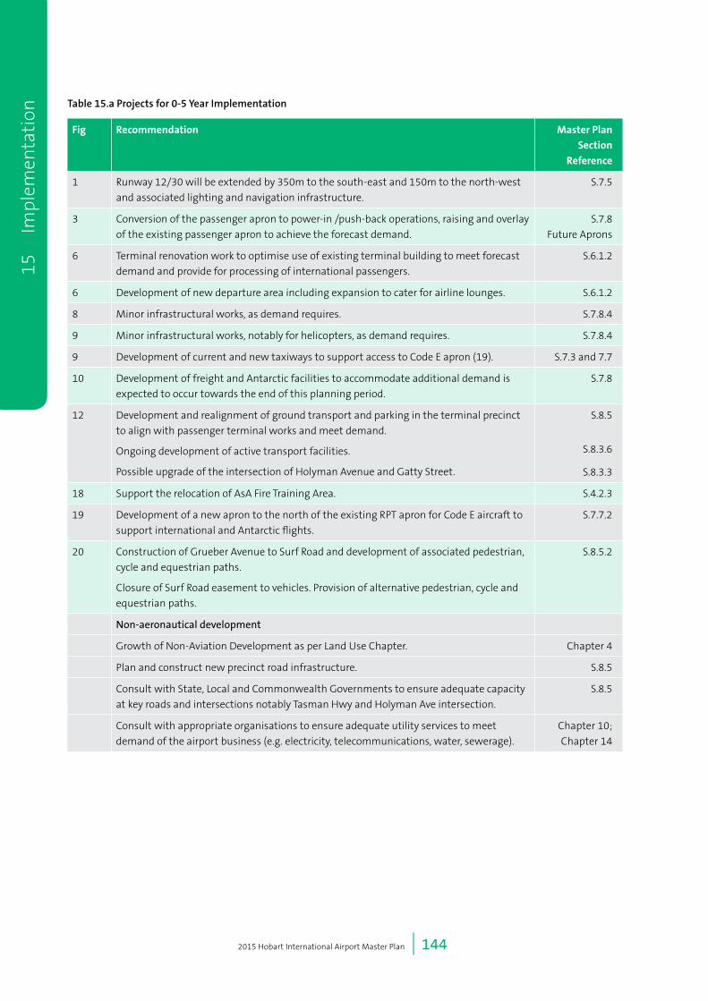
2015 Hobart International Airport Master Plan | 144
Table 15.a Projects for 0-5 Year Implementation
Fig Recommendation MasterPlan
Section
Reference
1 Runway 12/30 will be extended by 350m to the south-east and 150m to the north-west
and associated lighting and navigation infrastructure.
S.7.5
3 Conversion of the passenger apron to power-in /push-back operations, raising and overlay
of the existing passenger apron to achieve the forecast demand.
S.7.8
Future Aprons
6 Terminal renovation work to optimise use of existing terminal building to meet forecast
demand and provide for processing of international passengers.
S.6.1.2
6 Development of new departure area including expansion to cater for airline lounges. S.6.1.2
8 Minor infrastructural works, as demand requires. S.7.8.4
9 Minor infrastructural works, notably for helicopters, as demand requires. S.7.8.4
9 Development of current and new taxiways to support access to Code E apron (19). S.7.3 and 7.7
10 Development of freight and Antarctic facilities to accommodate additional demand is
expected to occur towards the end of this planning period.
S.7.8
12 Development and realignment of ground transport and parking in the terminal precinct
to align with passenger terminal works and meet demand.
Ongoing development of active transport facilities.
Possible upgrade of the intersection of Holyman Avenue and Gatty Street.
S.8.5
S.8.3.6
S.8.3.3
18 Support the relocation of AsA Fire Training Area. S.4.2.3
19 Development of a new apron to the north of the existing RPT apron for Code E aircraft to
support international and Antarctic flights.
S.7.7.2
20 Construction of Grueber Avenue to Surf Road and development of associated pedestrian,
cycle and equestrian paths.
Closure of Surf Road easement to vehicles. Provision of alternative pedestrian, cycle and
equestrian paths.
S.8.5.2
Non-aeronautical development
Growth of Non-Aviation Development as per Land Use Chapter. Chapter 4
Plan and construct new precinct road infrastructure. S.8.5
Consult with State, Local and Commonwealth Governments to ensure adequate capacity
at key roads and intersections notably Tasman Hwy and Holyman Ave intersection.
S.8.5
Consult with appropriate organisations to ensure adequate utility services to meet
demand of the airport business (e.g. electricity, telecommunications, water, sewerage).
Chapter 10;
Chapter 14
15
Im
plem
enta
tion

2015 Hobart International Airport Master Plan | 145
Table 15.b Projects for 5-20 Year Implementation
ID Recommendation MasterPlan
Section
Reference
2 Widening of existing taxiways, extended parallel taxiway to meet demand. S.7.6
3 Possible further apron extension towards end of planning period to meet demand. S.7.7.1
5 Development of this area as airport usage and customer and freight demand requires. S.7.8
6 Terminal expansion to meet demand. S.6.2.1
7 Development of ARFFS capability to meet requirements for aircraft type and passenger
demand.
S.9.1.2
8 Development to be undertaken as demand requires. S.7.7
9 Development to be undertaken as demand requires. S.7.7
10 Continued development of Antarctic and freight facilities as demand requires. S.7.7.8
11 Waste treatment facility operated by TasWater may be relocated off-site during this time
period.
S.4.2.3
12 Development of new road infrastructure to meet demand and terminal development
program.
Development of parking and other transportation facilities to meet demand.
Development of active transport both within and accessing the airport.
S.8.5
13 Support Airservices Australia requirements to accommodate future operations. S.9.1
Non-aeronautical development
Growth of Non-Aviation Development as per Land Use Chapter. S.4
Consult with State, Local and Commonwealth Governments to ensure adequate capacity at
key roads and intersections notably Tasman Hwy and Holyman Ave intersection.
S.8.5;
Chapter 14
Develop precinct terminal and major internal road infrastructure to meet demand. S.8.5
Consult with appropriate organisations to ensure adequate utility services to meet demand
of the Airport business (e.g. electricity. telecommunications, water, sewerage).
Chapter 10
Chapter 14
14 Parallel taxiway development to meet capacity demand. S.7.6.1
21 Development of logistic, freight and Antarctic Hub. 7.6.1
7.6.1
15 Implem
entation

2015 Hobart International Airport Master Plan | 146
15
Im
plem
enta
tion
15 Implem
entation

16 References

2015 Hobart International Airport Master Plan | 148
Reference list Air Services Act 1995.
Airports (Environment Protection) Regulations 1997(Cth) (Australia).
Airports (Protection of Airspace) Regulations (Cth) (Australia).
Airports Act 1996 (Cth) (Australia).
Airports Regulations 1997 (Cth) (Australia).
Australian Bureau of Statistics (2011) Census of Population and Housing, Australia: Australian Bureau of Statistics.
Civil Aviation Safety Authority (1998) Manual of Standards, Canberra: Civil Aviation Safety Authority.
Clarence City Council (2007) Clarence Planning Scheme 2007, Tasmania: Clarence City Council.
Clarence City Council (2010) Strategic Plan 2010-2015, Tasmania: Clarence City Council.
Clarence City Council (2013) Activity Centre Strategy 2013, Tasmania: Clarence City Council.
Clarence City Council (2013) Clarence Bicycle Strategy and Action Plan 2013, Tasmania: Clarence City Council.
Clarence City Council (2014) Clarence City Council Interim 2014 Planning Scheme, Tasmania: Clarence City Council.
Environment Protection and Biodiversity Conservation Act 1999 (Cth) (Australia).
Hobart International Airport Pty Ltd (2009) Hobart Airport Master Plan 2009, Tasmania: Hobart
International Airport Pty Ltd.
Hobart International Airport Pty Ltd (2013) Cultural Heritage Management Plan - Llanherne House, Tasmania: Hobart
International Airport Pty Ltd.
National Airports Safeguarding Advisory Group (2012) National Airports Safeguarding Framework, Australia: Department
of Infrastructure and Regional Development.
Nature Conservation Act 2002 (Tas) (Tasmania).
SGS Planning (2011) Southern Tasmania Industrial Land Strategy 2013, Tasmania: Southern Tasmanian Councils Authority.
Sorell Council (2014) Sorrell Draft Interim Planning Scheme 2014, Tasmania: Sorell Council.
Southern Tasmanian Councils Authority (2010) Southern Integrated Transport Plan 2010, Tasmania: Southern Tasmanian
Councils Authority.
Standards Australia (2015) Acoustics – Aircraft Noise Intrusion – Building Siting and Construction (AS AS2021-2015).
State Coastal Policy 1996 (Tas) (Tasmania).
Threatened Species Protection Act 1995 (Tas) (Tasmania).
16
Ref
eren
ces

2015 Hobart International Airport Master Plan | 149
Appen
dixPublic Consultation Period – Submissions and Responses
Date Received From Key Topic Consideration Raised HIAPL Response Location in
Master Plan
26/06/2015 Roger Isaac Taxiway Will there be a full length
taxiway at the end of the
runway extension?
Section 7.7 of the Preliminary Draft Master
Plan outlines the plans for the future parallel
taxiway system. Based on the current traffic
forecasts, a parallel taxiway would be required in
approximately 2032. The parallel taxiway is not
part of the runway extension project.
Section 7.7
Aerobridges Aerobridges are vital. In Section 6.2, the Preliminary Draft Master
Plan outlines the terminal planning
considerations. Section 6.2.1 specifically notes
that the current terminal building, being a
single storey structure, is not readily able
to accommodate aerobridges without the
associated development of an upper level. Due
to the nature and age of the current structure,
this would effectively involve the construction
of a new terminal building. This would be
cost-prohibitive when looked at in association
with total passenger numbers for the Master
Planning period. Covered walkways between
the aircraft and terminal are being developed in
the current terminal project.
Section 6.2
Section 6.2.1
13/07/2015 Andrew
Wilkie MP,
Member for
Denison
Aerobridges A number of constituents
have raised concerns re
inclusion of an aerobridge
In Section 6.2, the Preliminary Draft Master Plan
outlines the terminal planning considerations.
Section 6.2.1 specifically notes that the current
terminal building being a single storey structure,
is not readily able to accommodate aerobridges
without the associated development of an
upper level. Due to the nature and age of the
current structure, this would effectively involve
the construction of a new terminal building.
This would be cost-prohibitive when looked at
in association with total passenger numbers for
the Master Planning period. Covered walkways
between the aircraft and terminal are being
developed in the current terminal project.
Section 6.2
Section 6.2.1
15/07/2015 Roger Isaac Taxiway Full parallel taxiway appears
not to be included in
current $38M extension
plans - if this is correct then
there will be even more
inefficiencies than currently
occur.
Section 7.7 of the Preliminary Draft Master Plan
outlines the plans for the future parallel taxiway
system. Based on the current traffic forecasts,
a full parallel taxiway would be required in
approximately 2032. The parallel taxiway is not
part of the runway extension project.
Section 7.7

2015 Hobart International Airport Master Plan | 150
App
endi
x15/07/2015 Helma
Stevenson
General
conditions
Not happy with conditions
at Hobart – it is too dark,
there are tunnels of ropes,
the departures and arrivals
board is illegible, there are
too few staff, security too
slow. Hobart should copy
Rockhampton Airport.
Hobart bring back the upper
level, and have aerobridges.
In Section 6.2, the Preliminary Draft Master Plan
outlines the terminal planning considerations.
Section 6.2.1 specifically notes that the current
terminal building being a single storey structure,
is not readily able to accommodate aerobridges
without the associated development of an
upper level. Due to the nature and age of the
current structure, this would effectively involve
the construction of a new terminal building.
This would be cost-prohibitive when looked at
in association with total passenger numbers for
the Master Planning period. Covered walkways
between the aircraft and terminal are being
developed in the current terminal project.
Section 6.2.1 also notes that security would
expand landside to provide space for additional
screening facilities. This is in addition to recent
improvements customer security operations at
Hobart Airport.
Section 6.2
15/07/2015 Albert Ogilvie Aerobridges Feels an aerobridge is
essential in terminal
upgrade and suggests
redoing the whole design
to include an upper floor if
necessary.
In Section 6.2, the Preliminary Draft Master Plan
outlines the terminal planning considerations.
Section 6.2.1 specifically notes that the current
terminal building being a single storey structure,
is not readily able to accommodate aerobridges
without the associated development of an
upper level. Due to the nature and age of the
current structure, this would effectively involve
the construction of a new terminal building.
This would be cost-prohibitive when looked at
in association with total passenger numbers for
the Master Planning period. Covered walkways
between the aircraft and terminal are being
developed in the current terminal project.
Section 6.2
27/07/2015 Jenny Turner Aerobridges Hobart will soon be the
busiest airport in Australia
without aerobridges.
If there are not to be
aerobridges, then walking
distances should be
minimised. Departure and
arrival access should be
aligned with aircraft. The
departure gate should
be as close as possible to
plane. Common ingress /
egress point to the building
reduces walking distance
but also leaves an easy
upgrade path for future
installations.
In Section 6.2, the Preliminary Draft Master Plan
outlines the terminal planning considerations.
Section 6.2.1 specifically notes that the current
terminal building being a single storey structure,
is not readily able to accommodate aerobridges
without the associated development of an
upper level. Due to the nature and age of the
current structure, this would effectively involve
the construction of a new terminal building.
This would be cost-prohibitive when looked at
in association with total passenger numbers for
the Master Planning period. Covered walkways
between the aircraft and terminal are being
developed in the current terminal project.
The recent changes to security screening (as
shown in this master plan) at Hobart airport
has resulted in a highly efficient service for
customers.
Section 6.2

2015 Hobart International Airport Master Plan | 151
15/07/2015 Helma
Stevenson
General
conditions
Not happy with conditions
at Hobart – it is too dark,
there are tunnels of ropes,
the departures and arrivals
board is illegible, there are
too few staff, security too
slow. Hobart should copy
Rockhampton Airport.
Hobart bring back the upper
level, and have aerobridges.
In Section 6.2, the Preliminary Draft Master Plan
outlines the terminal planning considerations.
Section 6.2.1 specifically notes that the current
terminal building being a single storey structure,
is not readily able to accommodate aerobridges
without the associated development of an
upper level. Due to the nature and age of the
current structure, this would effectively involve
the construction of a new terminal building.
This would be cost-prohibitive when looked at
in association with total passenger numbers for
the Master Planning period. Covered walkways
between the aircraft and terminal are being
developed in the current terminal project.
Section 6.2.1 also notes that security would
expand landside to provide space for additional
screening facilities. This is in addition to recent
improvements customer security operations at
Hobart Airport.
Section 6.2
15/07/2015 Albert Ogilvie Aerobridges Feels an aerobridge is
essential in terminal
upgrade and suggests
redoing the whole design
to include an upper floor if
necessary.
In Section 6.2, the Preliminary Draft Master Plan
outlines the terminal planning considerations.
Section 6.2.1 specifically notes that the current
terminal building being a single storey structure,
is not readily able to accommodate aerobridges
without the associated development of an
upper level. Due to the nature and age of the
current structure, this would effectively involve
the construction of a new terminal building.
This would be cost-prohibitive when looked at
in association with total passenger numbers for
the Master Planning period. Covered walkways
between the aircraft and terminal are being
developed in the current terminal project.
Section 6.2
27/07/2015 Jenny Turner Aerobridges Hobart will soon be the
busiest airport in Australia
without aerobridges.
If there are not to be
aerobridges, then walking
distances should be
minimised. Departure and
arrival access should be
aligned with aircraft. The
departure gate should
be as close as possible to
plane. Common ingress /
egress point to the building
reduces walking distance
but also leaves an easy
upgrade path for future
installations.
In Section 6.2, the Preliminary Draft Master Plan
outlines the terminal planning considerations.
Section 6.2.1 specifically notes that the current
terminal building being a single storey structure,
is not readily able to accommodate aerobridges
without the associated development of an
upper level. Due to the nature and age of the
current structure, this would effectively involve
the construction of a new terminal building.
This would be cost-prohibitive when looked at
in association with total passenger numbers for
the Master Planning period. Covered walkways
between the aircraft and terminal are being
developed in the current terminal project.
The recent changes to security screening (as
shown in this master plan) at Hobart airport
has resulted in a highly efficient service for
customers.
Section 6.2
Appen
dix9/08/2015 Robert Moore Taxiway The redevelopment plan
does not indicate taxiway
extension to either end of
runway.
Section 7.7 of the Preliminary Draft Master
Plan outlines the plans for the future parallel
taxiway system. Based on the current traffic
forecasts, a parallel taxiway would be required in
approximately 2032. The parallel taxiway is not
part of the runway extension project.
Section 7.7
25/08/2015 Ben
McCulloch
Virgin Lounge The lack of a Virgin Lounge
is likely to be contributing to
inflating the cost of Qantas
airfares.
The development of a lounge is a commercial
decision for the airlines rather than the Airport.
Hobart Airport will continue to work with our
Airline partners to develop customer facilities.
The future layouts depicted in Section 6.2
accommodate potential lounge expansion areas.
Section 6.2
25/08/2015 Andrew
Wilkie MP,
Member for
Denison
Future plans Hopes that a sealed cycle
/ walkway will be provided
along the closed Surf Road,
notably for triathletes.
Closing Surf Road cuts
off eastern access to
change and toilet facilities,
recommend building a new
one at Pittwater / Surf Road
junction.
Non-vehicle access (such as pedestrians and
cyclist) will be maintained along Surf Road
through the provision of a new sealed path
along the southern boundary of the airport.
Events, such as the triathlon, that currently use
this portion of Surf Road as part of their course
will need to utilise the new sealed pathway.
The public toilets located in Lewis Park at Seven
Mile Beach will still be accessible via the sealed
pathway.
27/08/2015 Andrew
Sparrow –
Airservices
Australia
Approval of
document
and request
for early
consultation
The PANSOPS are
considered fit for purpose.
Noted
Please consult with AsA
early to discuss:
Runway 12 ILS glidepath
relocation before the
amended procedures can be
published for the ILS;
Wide Area Multilateration
(WAM) Reference Units
(RU) 1,3&4 which will be
affected by proposal
Relocation of anemometer
and DVOR
Potential impacts on the
ARFF station and future
capacity.
Consideration of plant and
crane operations etc.
Noted
Require line of sight
diagrams to determine the
extent of any impacts with
the construction of freight
hangers in Aviation Precinct
1 between ATC tower and
Rwy 30 approach.
The construction of future freight facilities
in Aviation Precinct 1 will be undertaken in
consultation with Air services Australia to
address any line of sight issues that may arise.

2015 Hobart International Airport Master Plan | 152
App
endi
x7/09/2015 Jessica
Browne
Virgin Lounge Providing strong support
for the upgrade. Would like
a Virgin lounge included as
the lack of these facilities
means she is less likely to fly
to Hobart for business.
The development of a lounge is a commercial
decision for the airlines rather than the Airport.
Hobart Airport will continue to work with our
Airline partners to develop customer facilities.
The future layouts depicted in Section 6.2
accommodate potential lounge expansion areas.
Section 6.2
7/09/2015 Julie Collins,
Federal Labor
Member for
Franklin
Surf Road A number of constituents
have raised concerns
regarding the closure of
Surf Road, and the impact
on local events.
Non-vehicle access (such as pedestrians and
cyclist) will be maintained along Surf Road
through the provision of a new sealed path
along the southern boundary of the airport.
Events, such as the triathlon, that currently use
this portion of Surf Road as part of their course
will need to utilise the new sealed pathway.
14/09/2015 Shane Lord –
Virgin
Support Writing to express that he
is generally supportive of
the development concept,
airfield plan and ground
transport plan, although
notes that the works are
driven by international &
Antarctic services rather
than domestic RPT. As
such, any future recovery
costs should be directed
appropriately.
Would also like to ensure
that HIAPL adopts a least
cost approach to ground
transport, with costs
recovered from users and
beneficiaries (not just
airlines).
Hobart Airport acknowledges the ongoing
support from Virgin Australia.
The Airport also recognises that charges for
future development, as with all developments
on Airport, will be negotiated with and allocated
to relevant users.
29/09/2015 Gillian Geeves Aerobridge Request reconsideration of
not including aerobridges.
Understands that building
a mezzanine floor would
involve considerable
expense, however the
ingenuity and experience
of Australian engineers
should be able to find a
solution with a standalone
construction which could
be used to access aircraft
in a more dignified and
comfortable manner.
In Section 6.2, the Preliminary Draft Master Plan
outlines the terminal planning considerations.
Section 6.2.1 specifically notes that the current
terminal building being a single storey structure,
is not readily able to accommodate aerobridges
without the associated development of an
upper level. Due to the nature and age of the
current structure, this would effectively involve
the construction of a new terminal building.
This would be cost-prohibitive when looked at
in association with total passenger numbers for
the Master Planning period. Covered walkways
between the aircraft and terminal are being
developed in the current terminal project.
Section 7.7
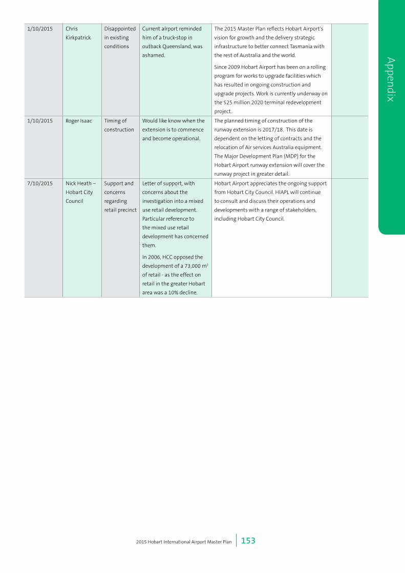
2015 Hobart International Airport Master Plan | 153
7/09/2015 Jessica
Browne
Virgin Lounge Providing strong support
for the upgrade. Would like
a Virgin lounge included as
the lack of these facilities
means she is less likely to fly
to Hobart for business.
The development of a lounge is a commercial
decision for the airlines rather than the Airport.
Hobart Airport will continue to work with our
Airline partners to develop customer facilities.
The future layouts depicted in Section 6.2
accommodate potential lounge expansion areas.
Section 6.2
7/09/2015 Julie Collins,
Federal Labor
Member for
Franklin
Surf Road A number of constituents
have raised concerns
regarding the closure of
Surf Road, and the impact
on local events.
Non-vehicle access (such as pedestrians and
cyclist) will be maintained along Surf Road
through the provision of a new sealed path
along the southern boundary of the airport.
Events, such as the triathlon, that currently use
this portion of Surf Road as part of their course
will need to utilise the new sealed pathway.
14/09/2015 Shane Lord –
Virgin
Support Writing to express that he
is generally supportive of
the development concept,
airfield plan and ground
transport plan, although
notes that the works are
driven by international &
Antarctic services rather
than domestic RPT. As
such, any future recovery
costs should be directed
appropriately.
Would also like to ensure
that HIAPL adopts a least
cost approach to ground
transport, with costs
recovered from users and
beneficiaries (not just
airlines).
Hobart Airport acknowledges the ongoing
support from Virgin Australia.
The Airport also recognises that charges for
future development, as with all developments
on Airport, will be negotiated with and allocated
to relevant users.
29/09/2015 Gillian Geeves Aerobridge Request reconsideration of
not including aerobridges.
Understands that building
a mezzanine floor would
involve considerable
expense, however the
ingenuity and experience
of Australian engineers
should be able to find a
solution with a standalone
construction which could
be used to access aircraft
in a more dignified and
comfortable manner.
In Section 6.2, the Preliminary Draft Master Plan
outlines the terminal planning considerations.
Section 6.2.1 specifically notes that the current
terminal building being a single storey structure,
is not readily able to accommodate aerobridges
without the associated development of an
upper level. Due to the nature and age of the
current structure, this would effectively involve
the construction of a new terminal building.
This would be cost-prohibitive when looked at
in association with total passenger numbers for
the Master Planning period. Covered walkways
between the aircraft and terminal are being
developed in the current terminal project.
Section 7.7
1/10/2015 Chris
Kirkpatrick
Disappointed
in existing
conditions
Current airport reminded
him of a truck-stop in
outback Queensland, was
ashamed.
The 2015 Master Plan reflects Hobart Airport’s
vision for growth and the delivery strategic
infrastructure to better connect Tasmania with
the rest of Australia and the world.
Since 2009 Hobart Airport has been on a rolling
program for works to upgrade facilities which
has resulted in ongoing construction and
upgrade projects. Work is currently underway on
the $25 million 2020 terminal redevelopment
project.
1/10/2015 Roger Isaac Timing of
construction
Would like know when the
extension is to commence
and become operational.
The planned timing of construction of the
runway extension is 2017/18. This date is
dependent on the letting of contracts and the
relocation of Air services Australia equipment.
The Major Development Plan (MDP) for the
Hobart Airport runway extension will cover the
runway project in greater detail.
7/10/2015 Nick Heath –
Hobart City
Council
Support and
concerns
regarding
retail precinct
Letter of support, with
concerns about the
investigation into a mixed
use retail development.
Particular reference to
the mixed use retail
development has concerned
them.
In 2006, HCC opposed the
development of a 73,000 m2
of retail - as the effect on
retail in the greater Hobart
area was a 10% decline.
Hobart Airport appreciates the ongoing support
from Hobart City Council. HIAPL will continue
to consult and discuss their operations and
developments with a range of stakeholders,
including Hobart City Council.
Appen
dix

2015 Hobart International Airport Master Plan | 154
7/10/2015 Andrew Paul
– Clarence
City Council
Support and
requests for
consultation
Supportive of the runway
extension, ongoing
development, Grueber
Avenue etc. Requests
ongoing engagement with
Council and landowners
to discuss Grueber Avenue
alignment, management
and opportunities to
improve access to future
developments.
Hobart Airport appreciates the ongoing support
from Clarence City Council. Consultation
between Hobart Airport and Council and the
landowners has resulted in a refinement of
the alignment of Grueber Avenue as it crosses
Airport land. This is shown in this appendix and
will be presented in full as part of the Major
Development Plan for the Runway Extension
project which includes Grueber Avenue. The
alignment proposed offers a more direct route
to Surf Road and is considered superior from a
road safety perspective. Consultation with the
effected landowners is ongoing.
Request inclusion of a
future road connection
between Holyman Ave and
the Cranston Pde specific
area (Light Industrial Zone).
This is not considered as part of the current
Master Plan Ground Use Plan, as it is not
required for the Airport’s operations. Hobart
Airport will continue to consult with Council on
all roadway maters.
Council considers
stormwater management,
planning and retention
infrastructure to be an issue
of importance.
Noted.
Request a minor
correction of page 75 of
draft Masterplan which
states Acton Rd is under
management of State,
rather than CCC
Thank you, updated.
The draft MP notes HIAPL
support for Clarence
Interim Planning Scheme
Airport Buffer Code
(Overlay). However the
current Airport buffer does
not equate to the ANEF
shown in the plan. In due
course, this inconsistency
needs to be addressed to
update the mapping and
ensure development / use
controls are consistent with
implications of ANEF.
Hobart Airport acknowledges the need for
ongoing discussions relating to noise. Hobart
Airport notes it has made a separate submission
to the CCC planning scheme to expand the
buffer overlay to better align with Airport noise
impacts as per the ANEF and Noise contours (n
countours).
Chapter 12
Regarding road transport
matters generally, the
integrated approach
incorporating State and
Local Government transport
planning is essential,
particularly regarding the
upgrade of the Tasman
Highway / Holyman
Drive roundabout and
establishment of improved
bus services.
Hobart Airport, through the Planning Co-
ordination Forum and other means, will work
with Local and State Governments to facilitate
timely planning for the Tasman Highway
roundabout.
App
endi
x

2015 Hobart International Airport Master Plan | 155
9/10/2015 Sarah Tink –
Department
of
Infrastructure
and Regional
Development
Aircraft
numbers,
freight
forecasts
and car park
terminals.
Please include the
breakdown of RPT / GA /
Rotary aircraft?
Section 5.13 has been added to address these
comments.
Section 5.13
Please include details of
freight forecasts over the
planning period.
Section 5.13 has been added to address these
comments.
Section 5.13
Would like to know details
of the linkages between car
parks and terminals.
Covered walkways on the apron side of the
terminal building will be constructed as part of
this project to improve passengers’ experience
as they walk to and from aircraft. There is also
a covered walkway between the long term
car park and the terminal building. Additional
covered walkways will be constructed where
appropriate in high traffic areas.
Grueber Avenue Option1 and Option 2
Surf Road closure
New Cycleway / Footpath
Source: Esri, DigitalGlobe, GeoEye, Earthstar Geographics, CNES/Airbus DS, USDA, USGS, AEX,Getmapping, Aerogrid, IGN, IGP, swisstopo, and the GIS User Community
0 200 400 600 800
Metres
[Figure No
A1Coordinate System
GDA 1994 MGA Zone 55
Scale at A4
1:20,000
Drawing Title
Grueber Avenue Alignment Options
Airport boundary (leasehold land)Freehold landGrueber Avenue Option 1Grueber Avenue Option 2
.
Figure Appendix a. Greuber Avenue alignment options 1 and 2.
Appen
dix


15 Implem
entation
