2015 06-15 relief line presentation
TRANSCRIPT

Relief Line Project Assessment
Coordinated Transit Consultation Program Public Information Centre
June 13-25, 2015

Overview of Presentation
2
1. Coordination of Rapid Transit Studies
2. Overview of Key Studies• GO RER/SmartTrack Background
• SmartTrack Eglinton West Feasibility Study
• Scarborough Subway Extension Project Assessment
3. Relief Line Project Assessment
Why are we here?
3
• We are seeking your opinions and comments on the work currently underway.
• What we hear will be used to inform our work going forward.
• Sharing your thoughts is very important in order for the needs of the community to be reflected in the final review.
• The best results will come by more people participating in and contributing to the conversation. We need your input.

4
Coordination of Rapid Transit
Studies
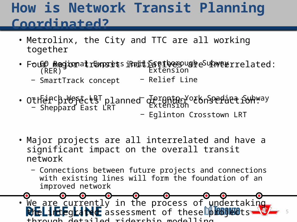
How is Network Transit Planning Coordinated?
5
• Metrolinx, the City and TTC are all working together
• Four major transit initiatives are interrelated:
• Other projects planned or under construction:
• Major projects are all interrelated and have a significant impact on the overall transit network
‒ Connections between future projects and connections with existing lines will form the foundation of an improved network
• We are currently in the process of undertaking the integrated assessment of these projects through detailed ridership modelling
‒ Work on each project will inform the other analysis
‒ GO Regional Express Rail (RER)‒ SmartTrack concept
‒ Scarborough Subway Extension‒ Relief Line
‒ Finch West LRT‒ Sheppard East LRT
‒ Toronto-York Spadina Subway Extension‒ Eglinton Crosstown LRT
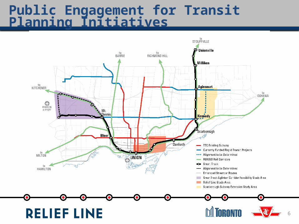
Public Engagement for Transit Planning Initiatives
6
7
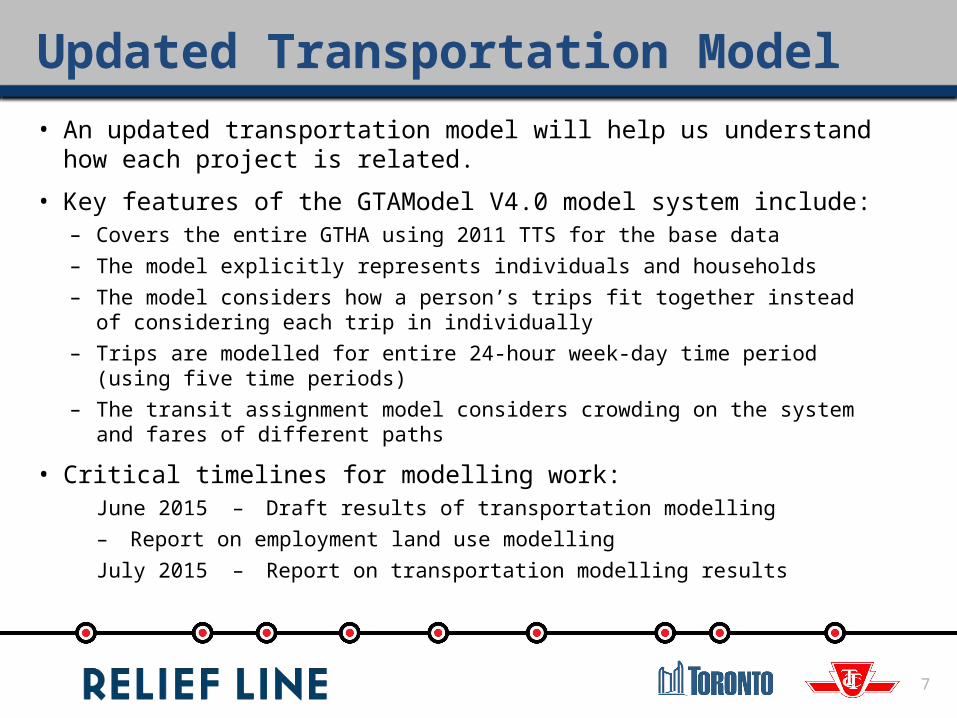
Updated Transportation Model• An updated transportation model will help us understand how each
project is related.
• Key features of the GTAModel V4.0 model system include:– Covers the entire GTHA using 2011 TTS for the base data– The model explicitly represents individuals and households– The model considers how a person’s trips fit together instead of considering each
trip in individually– Trips are modelled for entire 24-hour week-day time period (using five time
periods)– The transit assignment model considers crowding on the system and fares of
different paths
• Critical timelines for modelling work:June 2015 – Draft results of transportation modelling
– Report on employment land use modellingJuly 2015 – Report on transportation modelling results

8
Timing
Current • Public consultation in June, 2015 on all projects
Mid/late Summer
• Further analysis and assessment of options for each project• Public consultation on project recommendations in
September, 2015
Fall • Report to Council October/November, 2015 on results and public consultations and recommendations for next steps on each project
Future Work
• Issue Notice of Commencement for Final Project Review in 2016
Overview of Key Studies GO RER/SmartTrack SmartTrack Eglinton West Feasibility Study Scarborough Subway Extension Project Assessment
10
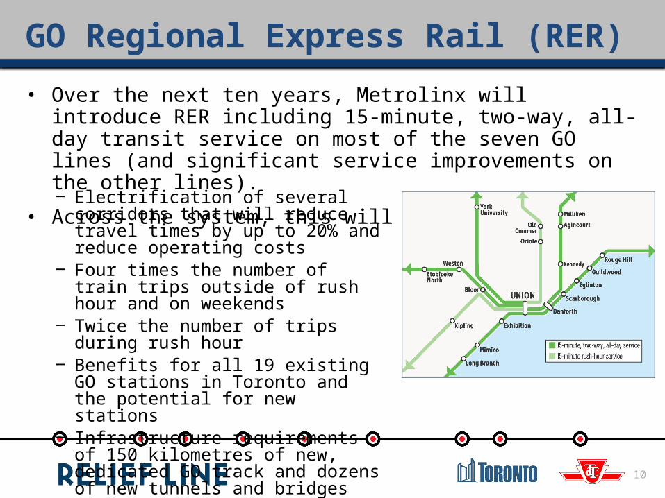
GO Regional Express Rail (RER)
• Over the next ten years, Metrolinx will introduce RER including 15-minute, two-way, all-day transit service on most of the seven GO lines (and significant service improvements on the other lines).
• Across the system, this will mean:‒ Electrification of several corridors that will
reduce travel times by up to 20% and reduce operating costs
‒ Four times the number of train trips outside of rush hour and on weekends
‒ Twice the number of trips during rush hour ‒ Benefits for all 19 existing GO stations in
Toronto and the potential for new stations‒ Infrastructure requirements of 150
kilometres of new, dedicated GO track and dozens of new tunnels and bridges

11
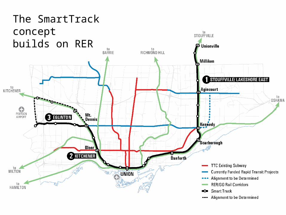
RER and SmartTrack
• SmartTrack builds on RER and the existing GO network– Proposes enhanced service on three existing corridors – Stouffville, Lakeshore
East, Kitchener– Proposes a heavy rail corridor connecting Mount Dennis to the Mississauga
Airport Corporate Centre
• SmartTrack concept features– Service frequency of 15 minutes or better– All stop service in both directions– TTC fare option– Additional stations along the three existing GO corridors– Electrified trains
• City Council has directed staff to further evaluate the SmartTrack concept and report back– This includes the Eglinton West SmartTrack Feasibility Review
12
The SmartTrack concept builds on RER

13
SmartTrack Eglinton West Corridor – Objectives• In February, 2015, City Council
directed staff to review the feasibility of SmartTrack options between Mt. Dennis Station and the Mississauga Airport Corporate Centre
• The first step is a high-level feasibility review of various options to connect Mount Dennis station to the Mississauga Airport Corporate Centre.
SmartTrack Eglinton West Corridor – Potential Corridors and Conceptual Alignments
14
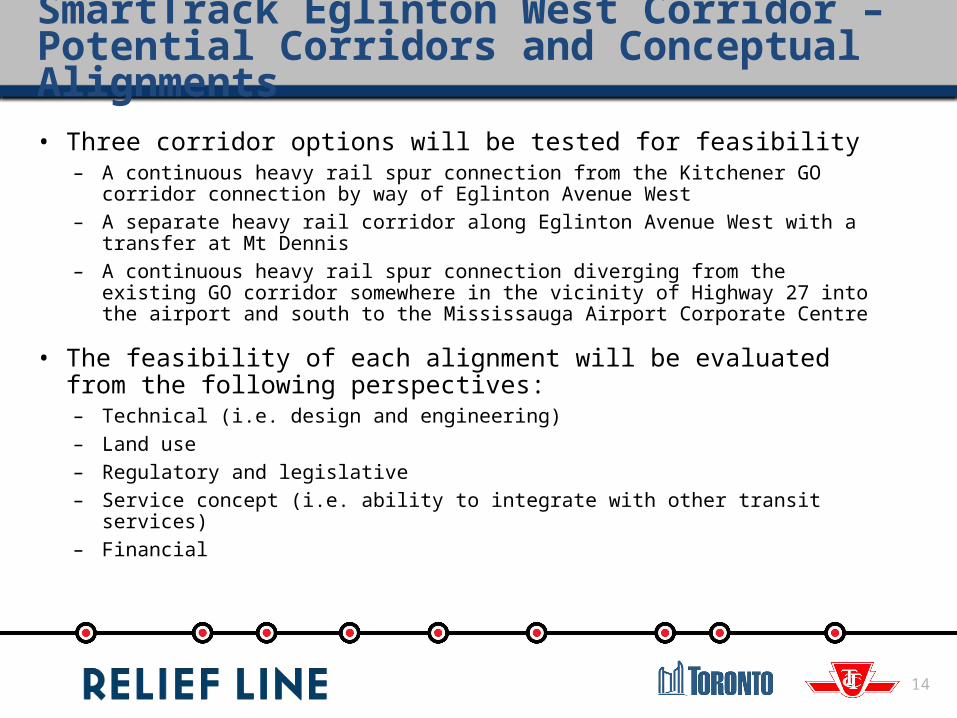
• Three corridor options will be tested for feasibility – A continuous heavy rail spur connection from the Kitchener GO corridor
connection by way of Eglinton Avenue West– A separate heavy rail corridor along Eglinton Avenue West with a transfer at
Mt Dennis– A continuous heavy rail spur connection diverging from the existing GO
corridor somewhere in the vicinity of Highway 27 into the airport and south to the Mississauga Airport Corporate Centre
• The feasibility of each alignment will be evaluated from the following perspectives:– Technical (i.e. design and engineering)– Land use– Regulatory and legislative– Service concept (i.e. ability to integrate with other transit services)– Financial
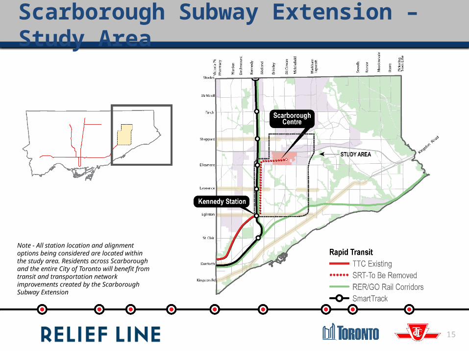
Note - All station location and alignment options being considered are located within the study area. Residents across Scarborough and the entire City of Toronto will benefit from transit and transportation network improvements created by the Scarborough Subway Extension
Scarborough Subway Extension – Study Area
15

16
• Nine potential corridors have been assessed– Preliminary evaluation has
identified three best performing
• Consultation to-date:– Two public meetings– Stakeholder Advisory Group– Interactive workshop– Online consultation
• Looking for public feedback on:– Existing conditions– Short listed corridors– Preliminary evaluation of
corridors– Potential alignments and station
locations
Scarborough Subway Extension – Current Work
Relief Line Project Assessment

18
Study Status• In 2014, Relief Line Project Assessment launched to determine preferred
alignment and station locations
• In March 2015, public and stakeholder consultation was held to review the long list of potential station options and draft evaluation criteria
WE ARE HERE
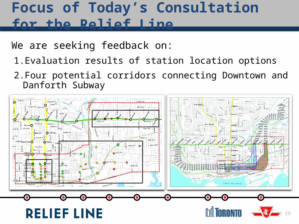
Focus of Today’s Consultation for the Relief Line
19
We are seeking feedback on:1. Evaluation results of station location options
2. Four potential corridors connecting Downtown and Danforth Subway
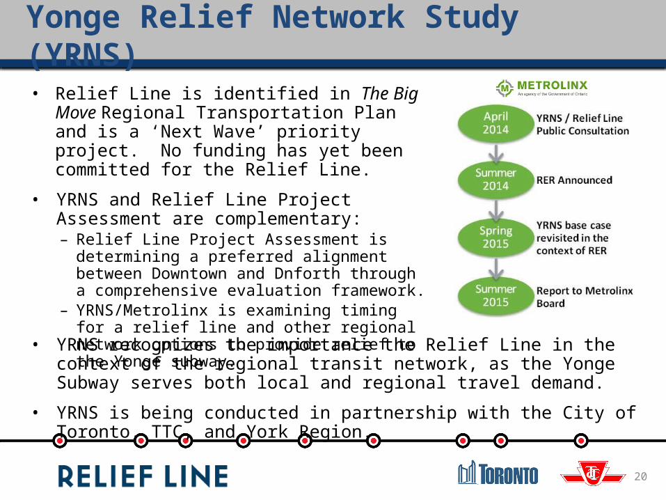
• Relief Line is identified in The Big Move Regional Transportation Plan and is a ‘Next Wave’ priority project. No funding has yet been committed for the Relief Line.
• YRNS and Relief Line Project Assessment are complementary:– Relief Line Project Assessment is determining a
preferred alignment between Downtown and Dnforth through a comprehensive evaluation framework.
– YRNS/Metrolinx is examining timing for a relief line and other regional network options to provide relief to the Yonge subway.
Yonge Relief Network Study (YRNS)
20
• YRNS recognizes the importance the Relief Line in the context of the regional transit network, as the Yonge Subway serves both local and regional travel demand.
• YRNS is being conducted in partnership with the City of Toronto, TTC, and York Region.

21
Study Area
Note - All station location and alignment options being considered are located within the study area. Residents from across the entire City of Toronto will benefit from transit and transportation network improvements created by the Relief Line.
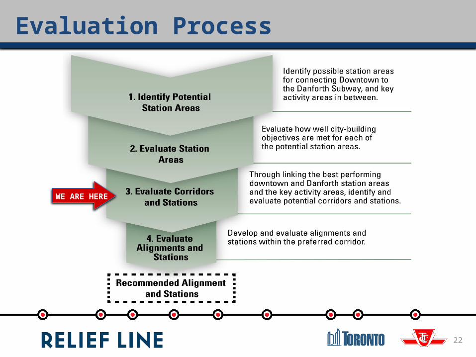
Evaluation Process
22
WE ARE HERE
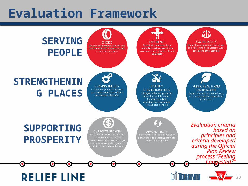
SERVING PEOPLE
STRENGTHENING PLACES
SUPPORTING PROSPERITY
Evaluation criteria based on principles
and criteria developed during the Official Plan
Review process “Feeling Congested?”
Evaluation Framework
23
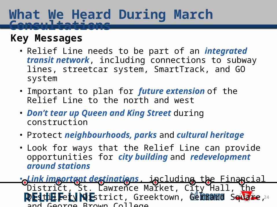
What We Heard During March Consultations
Key Messages• Relief Line needs to be part of an integrated transit network,
including connections to subway lines, streetcar system, SmartTrack, and GO system
• Important to plan for future extension of the Relief Line to the north and west
• Don’t tear up Queen and King Street during construction• Protect neighbourhoods, parks and cultural heritage • Look for ways that the Relief Line can provide opportunities for city
building and redevelopment around stations• Link important destinations, including the Financial District, St.
Lawrence Market, City Hall, the Distillery District, Greektown, Gerrard Square, and George Brown College
24
25
Results of Potential Station Areas Evaluation
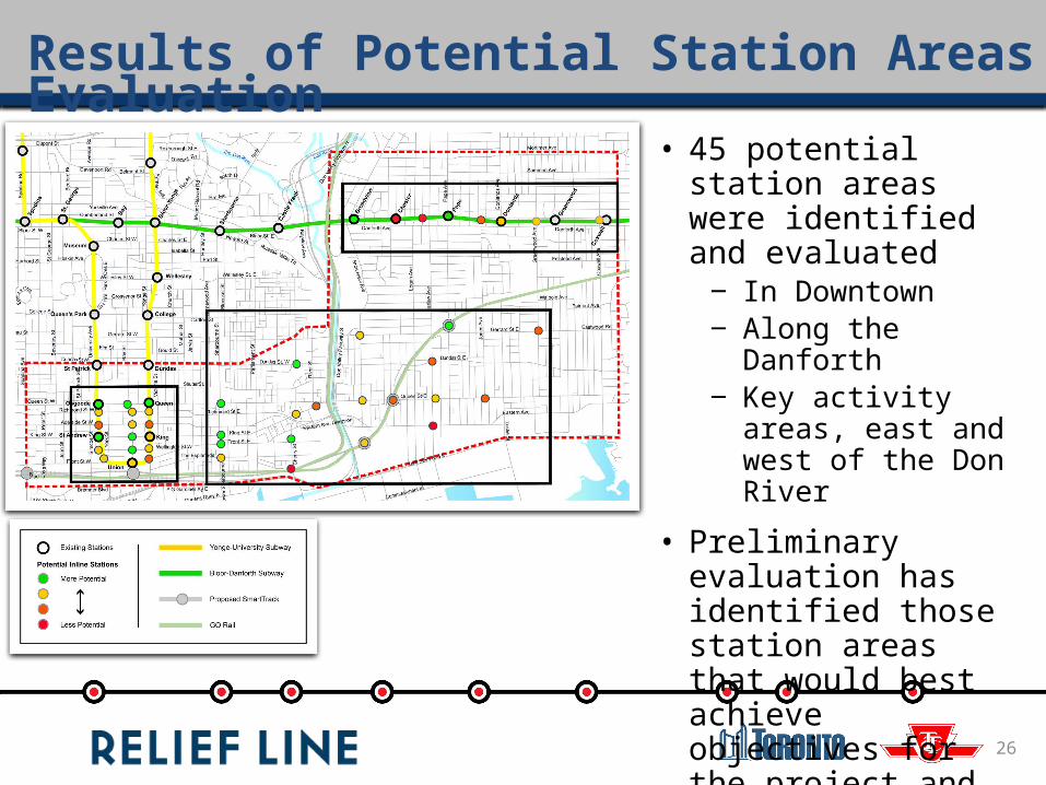
Results of Potential Station Areas Evaluation
• 45 potential station areas were identified and evaluated
‒ In Downtown‒ Along the Danforth‒ Key activity areas, east
and west of the Don River
• Preliminary evaluation has identified those station areas that would best achieve objectives for the project and the communities
26

27
Key Station Evaluation Findings:• Bay Street – close to area of high
employment density• King / Wellington corridor stands out:
‒ Proximity to highest employment density
‒ Ability to extend west along existing public right-of-way
• Queen Street serves key destinations such as the Eaton Centre, St. Michael’s Hospital and City Hall• Front Street / Union Station has high
existing pedestrian volumes• Adelaide and Richmond are more
challenging to extend to the west
Downtown Stations

Downtown Stations
28
What We Heard During March Consultations• Many respondents commented that Union Station is already congested
and that a different station should be considered for a Downtown terminus
• Respondents noted that a Relief Line corridor on streets such as Wellington, Richmond or Adelaide Streets would not disrupt streetcar services
• Key destinations noted by respondents include the Financial District, Eaton Centre, Ryerson University, City Hall, St. Michael’s Hospital
29
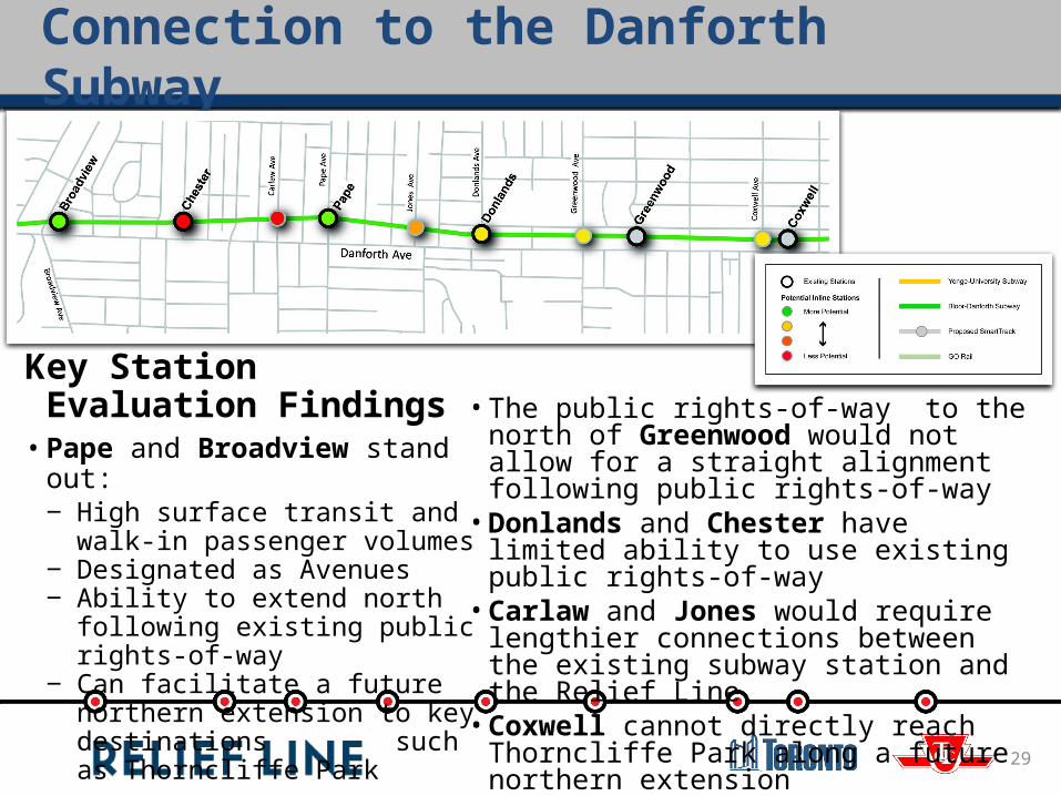
• The public rights-of-way to the north of Greenwood would not allow for a straight alignment following public rights-of-way• Donlands and Chester have limited ability to
use existing public rights-of-way• Carlaw and Jones would require lengthier
connections between the existing subway station and the Relief Line• Coxwell cannot directly reach Thorncliffe Park
along a future northern extension
Key Station Evaluation Findings• Pape and Broadview stand out:
‒ High surface transit and walk-in passenger volumes
‒ Designated as Avenues‒ Ability to extend north following
existing public rights-of-way‒ Can facilitate a future northern
extension to key destinations such as Thorncliffe Park
Connection to the Danforth Subway
Connection to the Danforth Subway
30
What We Heard During March Consultations• Pape Station received the vast majority of comments in support of a
connection to the Danforth Subway. Pape station has many key transit connections and provides an amble opportunity for a northern extension.
• There were many comments in support of Broadview Station as that there is key surface transit connections and the potential to investigate a future connection to the nearby Richmond Hill GO line.
• Respondents commented that redevelopment opportunities may exist at Greenwood and Coxwell stations.
• Key destinations documented by respondents including Greektown, Centennial College and Withrow Park.
31
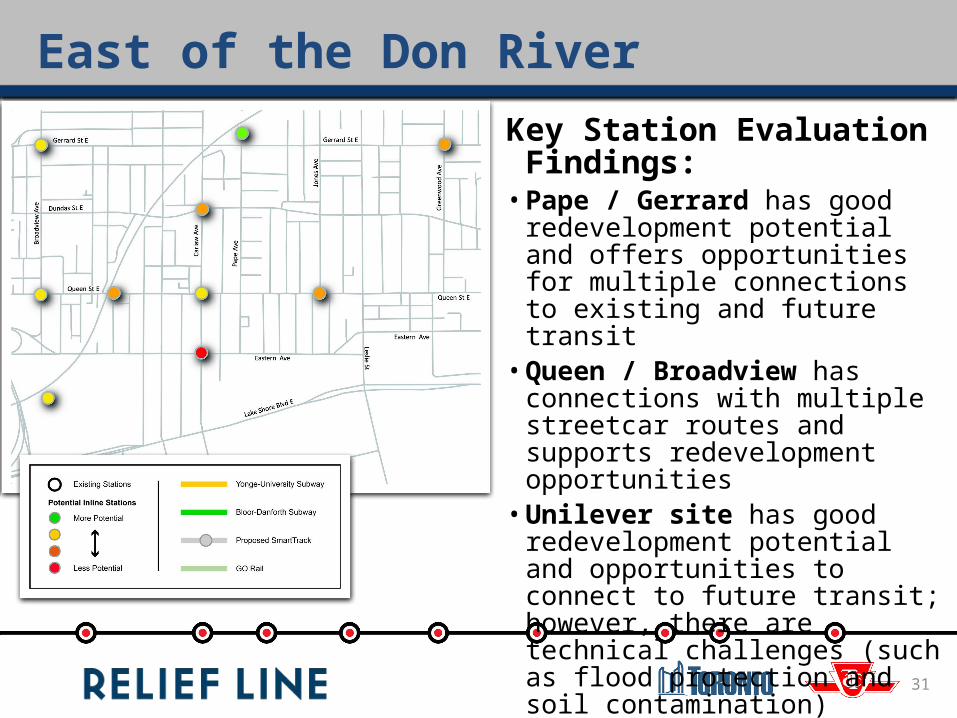
Key Station Evaluation Findings:• Pape / Gerrard has good
redevelopment potential and offers opportunities for multiple connections to existing and future transit• Queen / Broadview has connections
with multiple streetcar routes and supports redevelopment opportunities• Unilever site has good redevelopment
potential and opportunities to connect to future transit; however, there are technical challenges (such as flood protection and soil contamination)• Queen / Degrassi and Queen / Jones
are physically constrained
East of the Don River

32
Key Station Evaluation Findings:• Stations along Sherbourne have more
potential because of higher population and employment densities• A station at Regent Park addresses social
equity and could support redevelopment• Front / Cherry serves areas of new
development and can provide surface transit connections to the Portlands• King / Cherry is physically constrained
with less redevelopment potential• Lakeshore / Cherry and River / Queen
would be challenging to construct and would have flooding risks
West of the Don River

What We Heard During March ConsultationsEast of the Don River• The project team received broad support for stations at Gerrard Square and
the Unilever site• There was strong support to not have a station at Queen/Degrassi due to
community concerns about impacts to nearby park space. This station scored low on the technical evaluation and will not be carried forward
• Key destinations documented by respondents including Leslieville, Chinatown, Bridgepoint Health and Gerrard Square
West of the Don River• Respondents noted that the Relief Line could provide opportunities for city
building and redevelopment particularly in areas such as the West Donlands• Important destinations noted by respondents include St. Lawrence Market
and George Brown College
East and West of the Don River
33
34
Potential Corridors

Development of Potential Corridor Options
35
• Consider results of technical evaluation and public input on potential station areas
• Determine best connecting stations in Downtown and to Danforth Subway
• Identify best opportunities for future expansion to the west and north
• Link key activity areas with highest potential, based on city-building criteria
• Utilize public rights-of-way as much as possible to minimize impacts to private property
• Consider technical requirements of subway operations (e.g. curves, grades, trackwork)
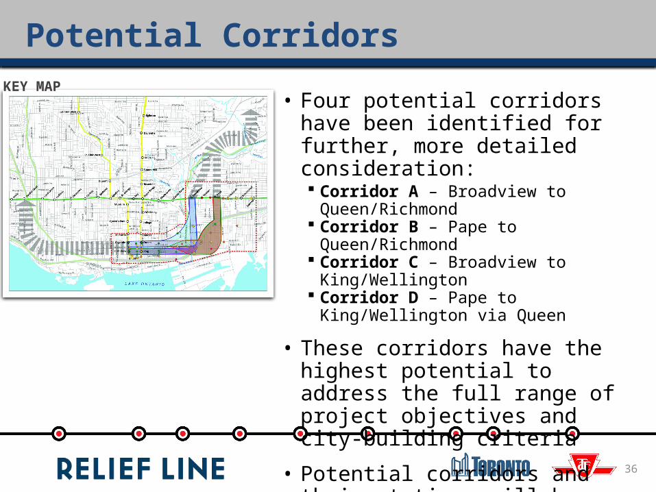
Potential Corridors
36
• Four potential corridors have been identified for further, more detailed consideration: Corridor A – Broadview to Queen/Richmond Corridor B – Pape to Queen/Richmond Corridor C – Broadview to King/Wellington Corridor D – Pape to King/Wellington via Queen
• These corridors have the highest potential to address the full range of project objectives and city-building criteria
• Potential corridors and their stations will be further evaluated to identify a preferred corridor
KEY MAP
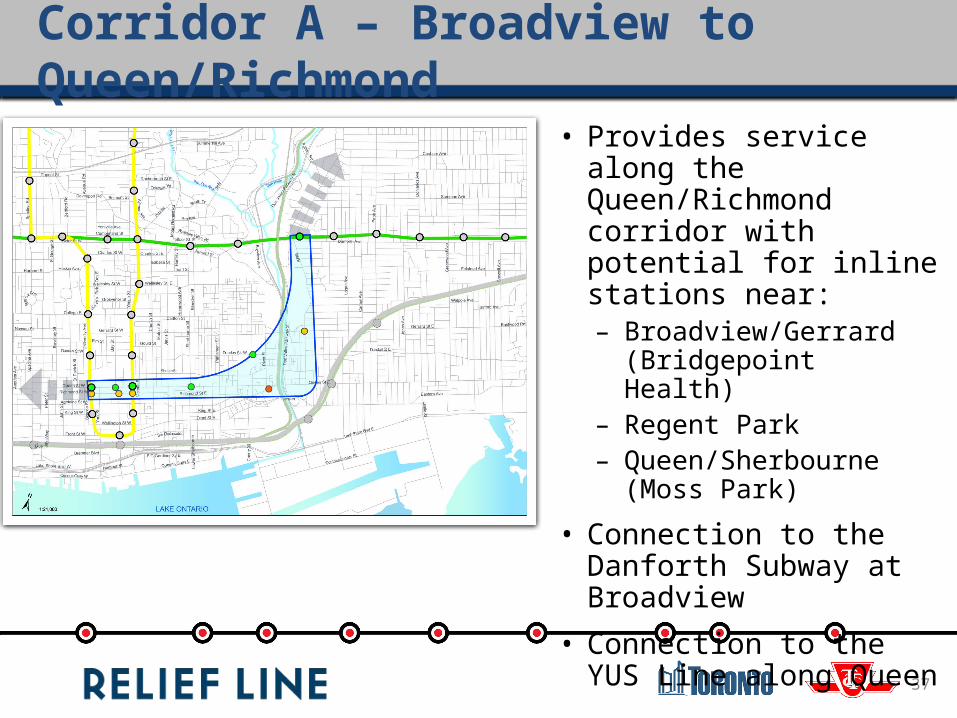
Corridor A – Broadview to Queen/Richmond
37
• Provides service along the Queen/Richmond corridor with potential for inline stations near: – Broadview/Gerrard
(Bridgepoint Health)– Regent Park– Queen/Sherbourne (Moss
Park)
• Connection to the Danforth Subway at Broadview
• Connection to the YUS Line along Queen

• Provides service along the Queen/Richmond corridor with potential for inline stations near: – Gerrard Square (potential
connection to SmartTrack)– Queen/Broadview Area– Unilever Lands– Queen/Sumach– Queen/Sherbourne (Moss
Park)
• Connection to the Danforth Subway at Pape
• Connection to the YUS Line along Queen
Corridor B – Pape to Queen/Richmond
38
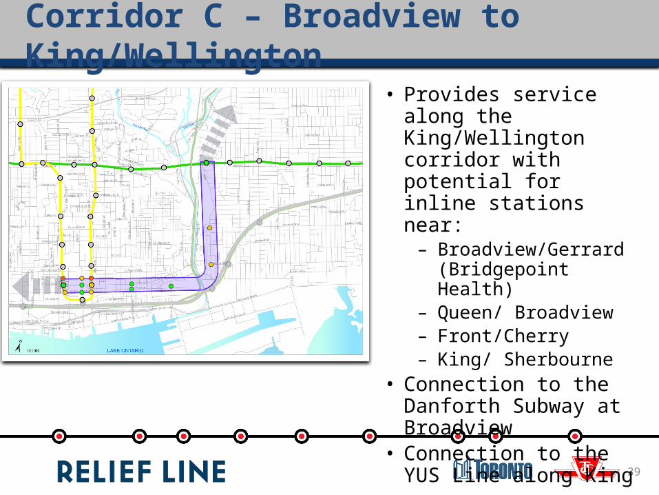
Corridor C – Broadview to King/Wellington
39
• Provides service along the King/Wellington corridor with potential for inline stations near: – Broadview/Gerrard
(Bridgepoint Health)– Queen/ Broadview– Front/Cherry– King/ Sherbourne
• Connection to the Danforth Subway at Broadview
• Connection to the YUS Line along King
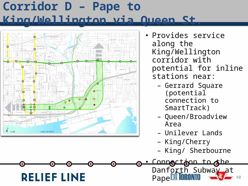
Corridor D – Pape to King/Wellington via Queen St.
40
• Provides service along the King/Wellington corridor with potential for inline stations near: – Gerrard Square (potential
connection to SmartTrack)– Queen/Broadview Area– Unilever Lands– King/Cherry– King/ Sherbourne
• Connection to the Danforth Subway at Pape
• Connection to the YUS Line along King
Next Steps
41
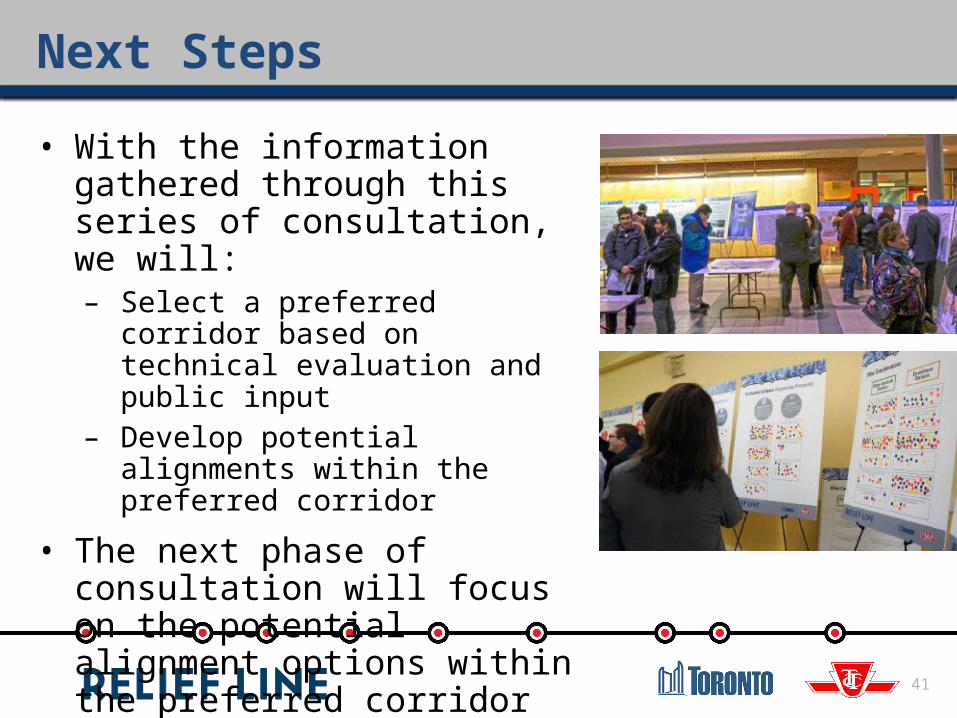
• With the information gathered through this series of consultation, we will:– Select a preferred corridor based on
technical evaluation and public input– Develop potential alignments within
the preferred corridor
• The next phase of consultation will focus on the potential alignment options within the preferred corridor
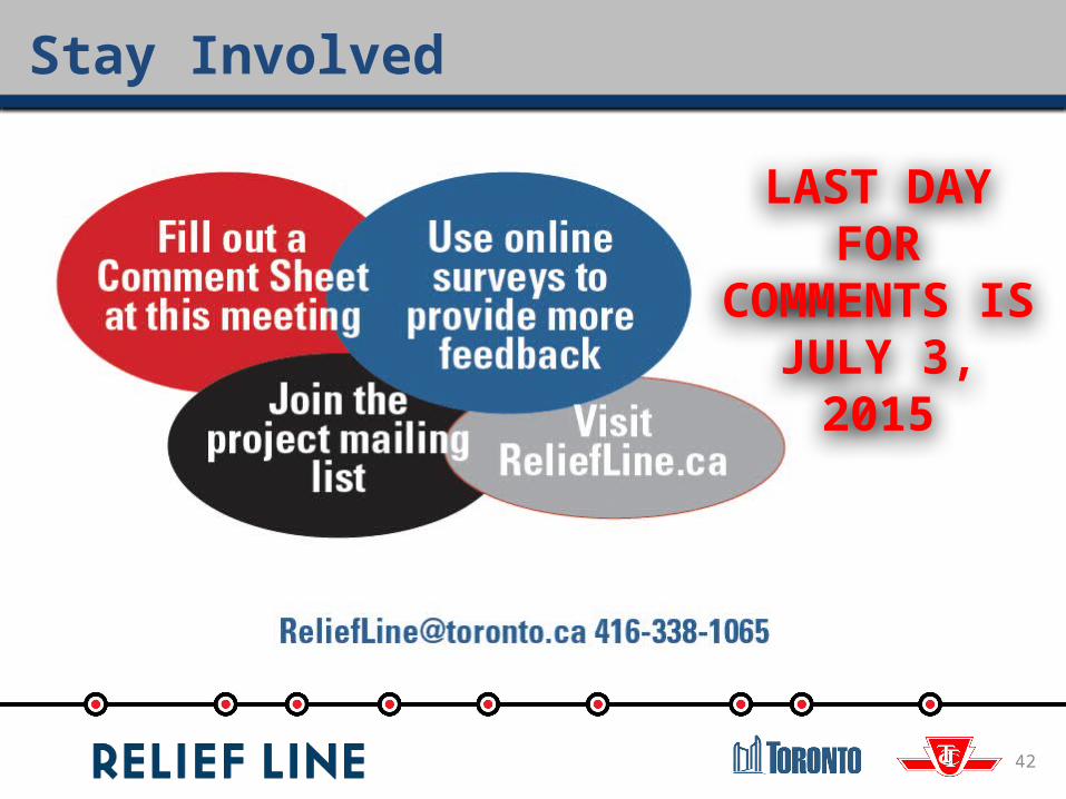
Stay Involved
42
LAST DAY FOR COMMENTS IS
JULY 3, 2015
Questions?