2014 sb1069 grant application fillable - oregon€¦ · · 2014-05-15grant application...
TRANSCRIPT

Grant Program Funding Application Form – March 2014
2014 WATER CONSERVATON, REUSE AND STORAGE
GRANT APPLICATION
APPLICATION INSTRUCTIONS
1. Complete Sections I through VII in the spaces provided.
2. An application must be submitted on a form provided by the Department. An explanation must accompany the application if any of the information required cannot be provided [OAR 690-600-0020(6)].
3. If in hard copy - use 8 ½” x 11” single sided, unstapled pages. Provide any attachments to application also on 8 ½” x 11” single-sided, unstapled pages. Avoid color and detail that will not photocopy clearly.
4. Contact Nancy Pustis 503.986.0919 or [email protected] if you have any questions.
Application Deadline: April 11, 2014 5:00 PM, (Application must be received by this date and time)
OREGON WATER RESOURCES DEPARTMENT Attention: Nancy Pustis
725 Summer Street NE, Suite A Salem, OR 97301
Phone: 503-986-0919
Grant Program Funding Application Form – August 2013
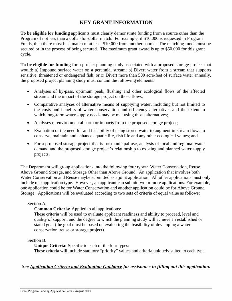
KEY GRANT INFORMATION To be eligible for funding applicants must clearly demonstrate funding from a source other than the Program of not less than a dollar-for-dollar match. For example, if $10,000 is requested in Program Funds, then there must be a match of at least $10,000 from another source. The matching funds must be secured or in the process of being secured. The maximum grant award is up to $50,000 for this grant cycle. To be eligible for funding for a project planning study associated with a proposed storage project that would: a) Impound surface water on a perennial stream; b) Divert water from a stream that supports sensitive, threatened or endangered fish; or c) Divert more than 500 acre-feet of surface water annually, the proposed project planning study must contain the following elements:
Analyses of by-pass, optimum peak, flushing and other ecological flows of the affected
stream and the impact of the storage project on those flows;
Comparative analyses of alternative means of supplying water, including but not limited to the costs and benefits of water conservation and efficiency alternatives and the extent to which long-term water supply needs may be met using those alternatives;
Analyses of environmental harm or impacts from the proposed storage project;
Evaluation of the need for and feasibility of using stored water to augment in-stream flows to conserve, maintain and enhance aquatic life, fish life and any other ecological values; and
For a proposed storage project that is for municipal use, analysis of local and regional water demand and the proposed storage project’s relationship to existing and planned water supply projects.
The Department will group applications into the following four types: Water Conservation, Reuse, Above Ground Storage, and Storage Other than Above Ground. An application that involves both Water Conservation and Reuse maybe submitted as a joint application. All other applications must only include one application type. However, an applicant can submit two or more applications. For example, one application could be for Water Conservation and another application could be for Above Ground Storage. Applications will be evaluated according to two sets of criteria of equal value as follows: Section A.
Common Criteria: Applied to all applications: These criteria will be used to evaluate applicant readiness and ability to proceed, level and quality of support, and the degree to which the planning study will achieve an established or stated goal (the goal must be based on evaluating the feasibility of developing a water conservation, reuse or storage project).
Section B. Unique Criteria: Specific to each of the four types: These criteria will include statutory “priority” values and criteria uniquely suited to each type.
See Application Criteria and Evaluation Guidance for assistance in filling out this application.

Grant Program Funding Application Form – March 2014
Page 2
IV. Grant Specifics Section A. Common Criteria Instructions: Answer all questions in this section by typing the answer below the question. It is anticipated that completed applications will result in additional pages.
1. Describe your goal (which must be based on evaluating the feasibility of developing a water conservation, reuse or storage project) and how this study helps to achieve the goal.
The goal of this project is to obtain sufficient information for the City of Astoria to identify the most comprehensive yet ecologically and fiscally responsible strategy for remediating Bear Creek Dam, thereby securing the City’s primary source of potable water and the safety of persons and property downstream of the reservoir. At this time, the City and the City’s consulting engineers lack enough data to determine the full extent of the risk to the dam during a seismic event and thus are unable to select the strategy that best balances safety with environmental and economic concerns.
Previous studies prepared for the City of Astoria in 1993 by Harza Northwest Inc. indicate that the current condition of the dam may not be stable during a seismic event and that a costly remediation measure which included a rock buttress was necessary to achieve the required factor of safety. The analysis performed included conservative assumptions and a conservative approach to determining the dam strength. The City hired Cornforth Consultants to prepare a Geotechnical Investigation (Phase 1) which was completed in March 2014. This study included a more thorough site investigation resulting in better data that will allow a more detailed analysis without the need for conservative assumptions. The results of the study were favorable indicating that the dam may be more stable than previously thought.
The assessment proposed for this OWRD project will provide a risk analysis upon which the City may base its decision on which remediation strategy represents a reasonable response to the level of seismic risk identified. Once the most feasible remediation strategy is selected, the City may enter the next phase—that of determining full costs, potential environmental impacts, and a realistic timeframe for completing remediation once funds are secured.
Bear Creek Dam has received a hazard rating of HIGH due to the danger of loss of life if the dam were to fail. It is imperative that the City move quickly to obtain the information needed to determine the most feasible remediation strategy. 2. Describe the water supply need(s) that the project associated with the planning study is intended to meet. Applicant
should reference supporting documentation that would be available upon request. This project addresses an important source of drinking water available for the City of Astoria. The Bear Creek reservoir provides essential water for the community of approximately 10,000 residents in addition to approximately 5,000 people in multiple outlying water districts. As the preliminary examinations have concluded, the Bear Creek Dam may be susceptible to structural damage or complete failure during a seismic event. The results of this seismic vulnerability study will have enormous impact on the City’s water supply. It is unknown at this time if it is feasible to remediate the dam structures. It is possible that the study may recommend costly modifications to the dam, but it is also possible that the detailed analysis and use of the most modern analysis methods may conclude that the dam will be stable during a large seismic event. This seismic vulnerability study will help the City determine the most cost-effective approach to maintaining the City’s drinking water supply while ensuring the safety of downstream residents during a seismic event. The study may reveal that the dam can be remediated to acceptable levels with only minor modifications, which would save millions of dollars while exerting the least possible environmental impact.

Grant Program Funding Application Form – March 2014
Page 3
3. Explain how the project associated with the planning study will meet the water supply need(s), and indicate what percentage of that need will be met. (For example: If your water supply need is 20,000 acre-feet of additional water and the project will supply 10,000 additional acre-feet, 50% of your need will be met).
The City of Astoria obtains its drinking water from multiple sources within the Bear Creek Watershed. The Bear Creek Reservoir (the subject of the proposed study) stores approximately 200 million gallons of pre-treated water. Between April and October the City diverts water from Bear Creek and Cedar Creek. Starting in July the creek diversions do not provide adequate supply so water is drawn from the Bear Creek Reservoir to augment the supply. At the later part of that period the supply from the reservoir is critical. Between November and January water is supplied by Middle Lake. During February and March water is also drawn from Bear Creek Reservoir due to water quality issues that develop in Middle Lake. Therefore, at times, the Bear Creek Reservoir is the primary source of drinking water and at times augments creek diversions.
4. Describe the technical aspects of the planning study and why your approaches are appropriate for accomplishing the goal of the planning study.
The proposed planning study is a phased program designed to reach an objective conclusion regarding the seismic stability of Bear Creek Dam and to develop concepts to improve the stability, if needed. The phases of the planning study involve; 1) developing a more accurate model of the stability problem, 2) developing analysis techniques that model site conditions more accurately than previous studies, and 3) developing strategies to improve the stability, if necessary. The planning study was developed because using conventional analysis methods could lead the City to expend funds mitigating a stability problem that may or may not exist. As previous investigators have noted, the unique geometry and geology of Bear Creek Dam are not amenable to conventional analysis methods. The proposed study would quantify the stabilizing forces that previous analyses have ignored for computational expedience.
Phase I of the planning study has been completed and involved performing additional geologic mapping, subsurface explorations, and installing instruments to monitor seepage pressures in the foundation. One factor that previous stability evaluations have ignored is the stability provided by the rock in the abutments of the dam. Geologic mapping was completed to identify the strike and dip of the predominant joint sets in the bedrock that makes up the right and left abutments. This information will be used in Phase II to quantify the stabilizing force that previous analyses have neglected. The geologic mapping was also performed to help locate the lateral and vertical limits of the basalt in the abutments. The location of the contact between basalt and weaker, marine sediments will have a large influence on the results of stability analyses performed in Phase II (subject of this grant application). Another important factor influencing the stability of the dam is the shear strength at the concrete/rock contact. High quality samples retrieved during Phase I identified three distinct concrete mixes in the dam. The mixes in the cutoff/shear key and the lower portion of the gravity section are the key materials that will influence the Phase II stability analyses. Existing standpipe piezometers at the dam have deteriorated and do not yield specific data required for the Phase II stability evaluation. Vibrating wire piezometers were installed during Phase I of the planning study to measure seepage pressure at discrete positions in the foundation.
Phase II of the planning study is set to begin once funding is procured. The earliest start date will be July 1, 2014 when the new fiscal year budget is available. The first step in Phase II is to incorporate all the data gathered in Phase I into a comprehensive geologic model. The geometry of the dam is an important element in determining the amount of passive resistance available in the abutments. The City archives contain hand-drawn cross sections developed by the resident engineer during construction of the dam. The sections will be used to determine how far the dam was keyed into rock. The model will also include the influence of bedrock joints because passive resistance will be limited by the dominant joint sets in the bedrock. The geologic model would establish the interpreted limits of the basalt/marine sediment contact. This is important because potential failure surfaces could develop within or beneath the basalt foundation. The last piece of the geologic model is the seepage pressure acting beneath the dam. Data from piezometers as well as observations made during drilling will be used to establish where seepage paths appear to be concentrated.

Grant Program Funding Application Form – March 2014
Page 4
High-quality HQ3 cores of the three concrete mixes in the dam were collected during Phase I. Point load index tests were performed on selected cores to establish the range of shear strength offered by the concrete. In Phase II, additional laboratory testing will be completed to establish the shear strength and stiffness of the two concrete mixes used near the base of the dam. Results from the laboratory testing will help determine the shear strength of the concrete/basalt interface.
The final portion of Phase II will involve calculating the stability of Bear Creek Dam for ground motions expected to occur during a Cascadia Subduction Zone earthquake. The goals of the analysis are to quantify the influence of stabilizing factors neglected by previous analyses and to use ground motions that reflect the current state of knowledge about the activity of the Cascadia Subduction Zone. One key factor that previous analyses have ignored is the fact that the dam would act as a monolith due to its low length to height ratio. Limit-equilibrium stability analyses would be conducted at targeted locations along the dam to determine a composite factor-of-safety. The analyses would be completed on potential shear surfaces located at the base of the dam, at the base of the cutoff, and at the contact between basalt and marine sediments. Load transfer across cracks in the monolith would also be accounted for in the analyses. The yield acceleration for each section would be determined in order to estimate displacements using Newmark-type analyses.
Earthquake engineers would complete a probabilistic seismic hazard evaluation to develop earthquake time histories for the site. The evaluation would quantify the contribution of multiple earthquake sources and would utilize the most up-to-date attenuation relationships developed following recent subduction earthquakes in Chile and Japan. Ground motion time histories would be input at the base of the stability model. Displacements would be calculated whenever the response of the dam exceeds the yield acceleration.
At the conclusion of Phase II, it will be determined if the dam meets currently-accepted stability standards for gravity dams. If stability margin is deficient or if displacements calculated using the Newmark analyses are unacceptable, Phase III of the planning study will be initiated.
Phase III of the planning study, if needed, would focus on developing conceptual mitigation measures to increase the stability of the existing structure. Mitigation measures would be evaluated using the stability model developed in Phase II. Stability improvement offered by different mitigation concepts would be quantified for comparison purposes using the calculated factor-of-safety as well as the calculated displacements during a Cascadia Subduction Zone earthquake. Advantages and disadvantages of each mitigation option would be tabulated along with comparative construction cost estimates. Construction considerations for each alternative would be discussed to aid the City in choosing the most cost-effective mitigation strategy. 5. Describe how the planning study will be performed. Include:
a. General summary statement that describes the study progression. b. When the planning study could begin. c. Listing of Key Tasks to be accomplished with each task having:
i. Title ii. Timeline for completion
iii. Description of the activities to be performed in this key task Example: Seepage Loss Measurements: June to July – Measurements will be taken to determine… (Key Tasks listed here are to be placed in Section VI. Project Planning Study Schedule for a quick reference “graphical” representation of the schedule.)
5.a. Planning Study Schedule/Timeline
Phase I of the Planning Study was initiated in August 2013 and was completed in February 2014. Data collected during subsurface explorations and geologic mapping have been summarized and are ready to be incorporated into a geologic model of the dam. Phase II of the Planning Study is set to begin once funding is obtained. Phase II will involve developing the geologic model of the dam and the abutments as well as completing stability analyses and displacement calculations. It is anticipated that Phase II of the Planning Study would be completed within 6 months of receiving notice-to-proceed. Phase III of the study would involve evaluating mitigation options if Phase II concludes that the structure is seismically-

Grant Program Funding Application Form – March 2014
Page 5
deficient. It is anticipated that, if necessary, Phase III of the Planning Study could be started immediately following Phase II. The Phase III portion of the Planning Study could be completed in approximately 4 to 6 months depending on the mitigation options the City elects to evaluate.
5.b. Planning Study Start Date
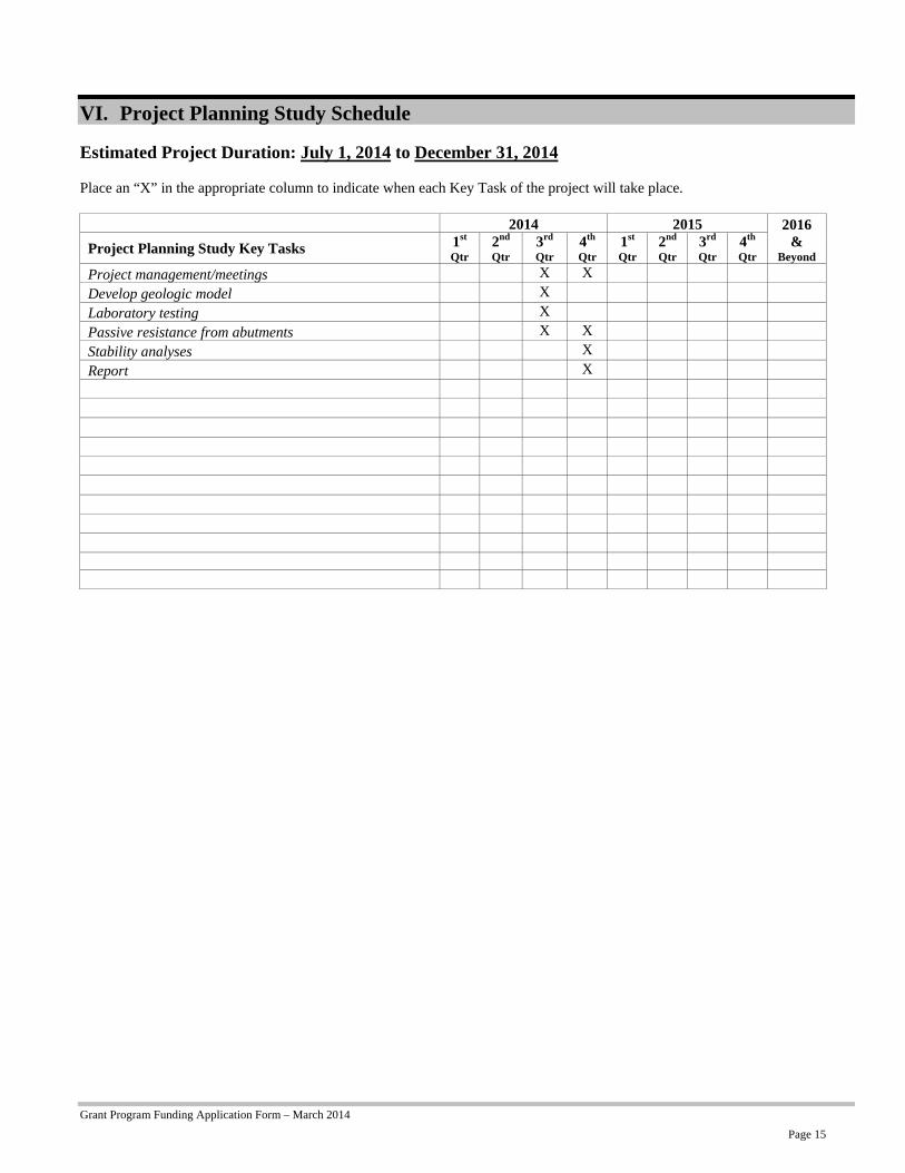
Phase I of the Planning Study has been completed. Phase II of the study would begin July 1, 2014.
5.c. Key Tasks
Project management/meetings: (July – December) - Track expenditures and budget, coordinate staffing and resources, and participate in checkpoint meetings with the City regarding results of the analysis.
Develop geologic model: (July – Mid-August) - Incorporate all the data gathered in Phase I into a comprehensive geologic model showing the dam, key geologic units, dominant joint orientations, and seepage conditions.
Laboratory testing: (Mid-August – End of August) - Complete unconfined compression testing on two concrete mixes of concern to develop strength parameters for concrete/rock interface.
Passive resistance from abutments: (September – Mid-October) - Complete limit-equilibrium analyses to quantify the available passive resistance on embedded portions of the dam. These analyses will include the influence of the jointing in the bedrock on the available resistance.
Stability analyses: (Mid-October – Mid-December) - Complete limit-equilibrium stability analyses on the dam assuming it acts as a monolith. Include the resisting force of embedment at the rock abutments. Evaluate three potential shear surfaces at each representative cross section, and use the critical surface to determine the contribution of the section to the stability of the monolith.
Report: (Mid-December – End of December) - Summarize analysis approach and results in a brief technical report.
6. Provide data and information on the associated project and the project’s sources of water supply:
a. The location of the associated project. (Include the basin, county, township, range and section.)
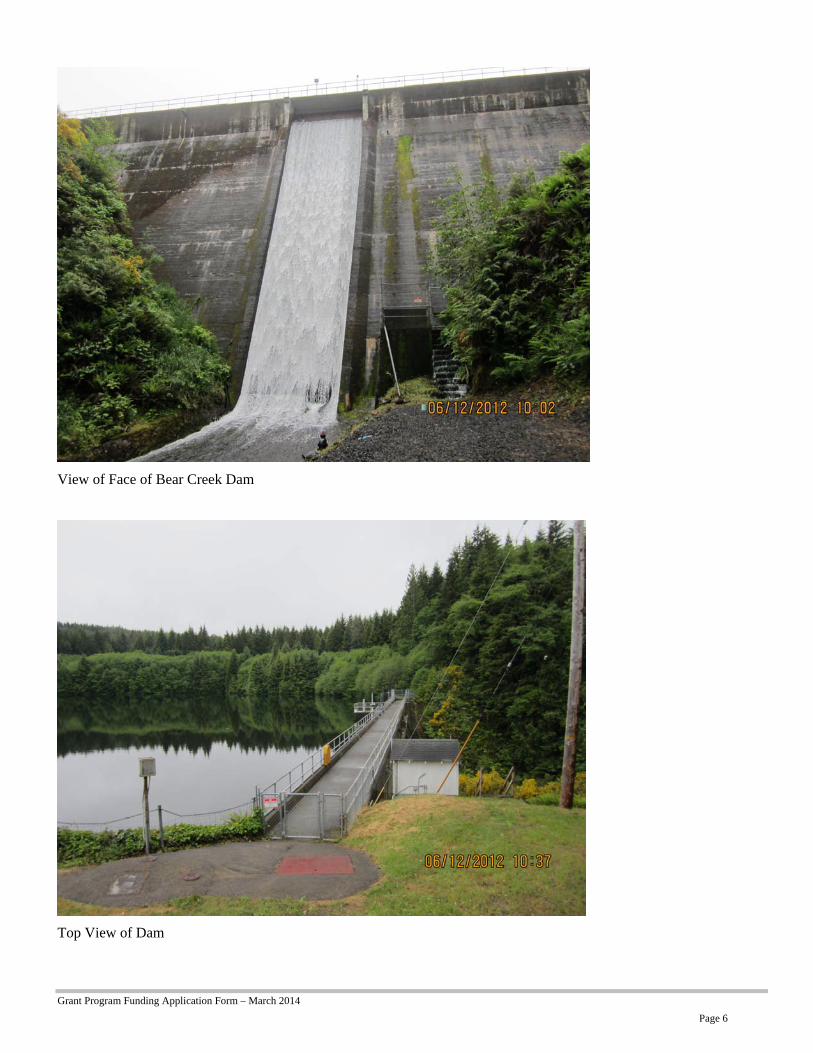
The project is located in the Bear Creek Watershed, Clatsop County, OR. The reservoir extends across Township 7N, Range 8W, Section 2 and Section 11. The dam is located within Township 7N, Range 8W, Section 2. A map of the project area is included with this application package showing the watershed boundary, the City reservoirs and tributary streams.
Grant Program Funding Application Form – March 2014
Page 6
View of Face of Bear Creek Dam
Top View of Dam

Grant Program Funding Application Form – March 2014
Page 7
Location of Various Water Storage Reservoirs
b. The name(s) and river mile(s) of the source water and what they are tributary to, if applicable.
Bear Creek is the source water for the reservoir impounded by Bear Creek Dam. Bear Creek is a tributary to the Columbia River. The City holds a point of diversion water right for Bear Creek with a point of diversion located 3,150 feet north and 300 feet west from the SE corner of Section 13, Township 7N, Range 9W and 360 feet North and 700 feet East from the SE corner of Section 18, Township 7N, Range 8W.
d. Whether the project will be off-channel or on-channel.
The project is located on-channel.
e. Water availability to meet project storage. (Typically, the Department evaluates new storage projects using a 50 percent water availability analysis.)
The proposed feasibility study does not affect a new storage project. Sufficient water exists to meet the current facilities’ storage needs. The total authorized storage volume of the reservoir impounded by the Bear Creek Dam is 615 acre-feet and is used for municipal use under Certificate 19542 and Permit S13424.

Grant Program Funding Application Form – March 2014
Page 8
f. Proposed purposes and uses of stored water.
The stored water forms an important source of potable water for the City of Astoria and multiple outlying water districts. Water is also used for fire suppression, commercial and industrial use.
g. Environmental flow needs and water quality requirements of supply source water bodies.
The proposed feasibility study deals directly with the current water needs and does not propose changes that would impact environmental flow needs or water quality requirements of supply source water bodies.
7. What local, state or federal project permitting requirements/issues/approvals do you anticipate in order for the planning study to be conducted? If approvals are required, indicate whether you have obtained them. If you have not obtained the necessary permits/governmental approval, describe the steps you have taken to obtain them.
No permits are required for feasibility study activities for which OWRD funds are being requested.
8. Describe the level of involvement, interest and/or commitment of different entities associated with the planning study (attach letters of support). Describe how these entities will benefit or be impacted by the planning study.
While the proposed feasibility study itself is not likely to involve or affect different entities, many stakeholders will clearly be affected by the results of this study and whatever remediation strategy the City of Astoria decides to pursue (or if there is no remediation and a catastrophic failure occurs). Stakeholders include, Clatsop County Emergency Management, the Knappa Fire District, Oregon State Police, Oregon Department of Transportation, Clatsop County residents in the area and all commerce and visitor to the area that depend on U.S. Route 30 for transportation. Furthermore, multiple state agencies are interested in seeing this study executed, because what is learned can be applied to other Oregon communities in the future.
Letters of support are included from the following entities:
• Clatsop County Emergency Management (Tiffany Brown)
• Knappa Fire District (Paul Olheiser)
• Oregon State Police (Andrew Merila)
• Oregon Department of Transportation (Bill Jablonski)
• Astoria-Warrenton Chamber of Commerce (Skip Hauke)
9. Identify when matching funds will be secured and the term of matching funds availability.
The total estimated cost of the Seismic Vulnerability Study is $145,000. The City will fund $95,000 from our Public Works Improvement Fund. The match has been budgeted in the City’s 2014/2015 fiscal year budget and will be available July 1, 2014.
Grant Program Funding Application Form – March 2014
Page 9
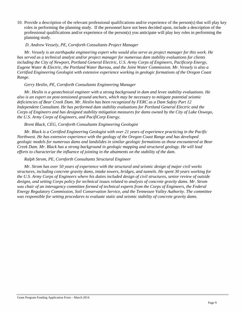
10. Provide a description of the relevant professional qualifications and/or experience of the person(s) that will play key roles in performing the planning study. If the personnel have not been decided upon, include a description of the professional qualifications and/or experience of the person(s) you anticipate will play key roles in performing the planning study.
D. Andrew Vessely, PE, Cornforth Consultants Project Manager
Mr. Vessely is an earthquake engineering expert who would also serve as project manager for this work. He has served as a technical analyst and/or project manager for numerous dam stability evaluations for clients including the City of Newport, Portland General Electric, U.S. Army Corps of Engineers, Pacificorp Energy, Eugene Water & Electric, the Portland Water Bureau, and the Joint Water Commission. Mr. Vessely is also a Certified Engineering Geologist with extensive experience working in geologic formations of the Oregon Coast Range.
Gerry Heslin, PE, Cornforth Consultants Engineering Manager
Mr. Heslin is a geotechnical engineer with a strong background in dam and levee stability evaluations. He also is an expert on post-tensioned ground anchors, which may be necessary to mitigate potential seismic deficiencies of Bear Creek Dam. Mr. Heslin has been recognized by FERC as a Dam Safety Part 12 Independent Consultant. He has performed dam stability evaluations for Portland General Electric and the Corps of Engineers and has designed stability mitigation measures for dams owned by the City of Lake Oswego, the U.S. Army Corps of Engineers, and PacifiCorp Energy.
Brent Black, CEG, Cornforth Consultants Engineering Geologist
Mr. Black is a Certified Engineering Geologist with over 21 years of experience practicing in the Pacific Northwest. He has extensive experience with the geology of the Oregon Coast Range and has developed geologic models for numerous dams and landslides in similar geologic formations as those encountered at Bear Creek Dam. Mr. Black has a strong background in geologic mapping and structural geology. He will lead efforts to characterize the influence of jointing in the abutments on the stability of the dam.
Ralph Strom, PE, Cornforth Consultants Structural Engineer
Mr. Strom has over 50 years of experience with the structural and seismic design of major civil works structures, including concrete gravity dams, intake towers, bridges, and tunnels. He spent 30 years working for the U.S. Army Corps of Engineers where his duties included design of civil structures, senior review of outside designs, and setting Corps policy for technical issues related to analysis of concrete gravity dams. Mr. Strom was chair of an interagency committee formed of technical experts from the Corps of Engineers, the Federal Energy Regulatory Commission, Soil Conservation Service, and the Tennessee Valley Authority. The committee was responsible for setting procedures to evaluate static and seismic stability of concrete gravity dams.
Grant Program Funding Application Form – March 2014
Page 10
Section B. Unique Criteria Instructions: Answer the set of questions below that applies to the type of planning study that this grant will fund.
Water Conservation or Reuse
1. Water Conservation or Reuse projects that may result from this planning study are requested to be included in the Water Resources Department’s “Inventory of Potential Conservation Opportunities”. Though you may have already submitted this information earlier in the year through a separate survey, we ask that all applicants complete the information on the form provided at the end of this application.
I have filled out the application or I have not filled out the application.
2. Explain how the associated project will mitigate the need to develop new water supplies and/or use water more efficiently. Reference documentation and/or examples of the success of similar or comparable water conservation/reuse projects that would be available upon request.

Grant Program Funding Application Form – March 2014
Page 11
Above-Ground Storage Please answer the following three questions BEFORE proceeding:
Will the project divert greater than 500 acre-feet of surface water annually? Yes No
Will the project impound surface water on a perennial stream? Yes No
Will the project divert water from a stream that supports sensitive, threatened or endangered species? Yes No
If you answered “Yes” to any one of these questions, by signature on this application, you are committing to include the following required elements in your planning study.
Describe how you intend to address the required elements in your planning study:
a) Analyses of by-pass, optimum peak, flushing and other ecological flows of the affected stream and the impact of the storage project on those flows.
N/A
b) Comparative analyses of alternative means of supplying water, including but not limited to the costs and benefits of water conservation and efficiency alternatives and the extent to which long-term water supply needs may be met using those alternatives.
N/A
c) Analyses of environmental harm or impacts from the proposed storage project.
N/A
d) Evaluation of the need for and feasibility of using stored water to augment in-stream flows to conserve, maintain and enhance aquatic life, fish life and any other ecological values.
N/A
Is the proposed storage project for municipal use?
Yes No
If you answered “Yes,” then describe how you intend to address the following required element in your planning study:
e) For a proposed storage project that is for municipal use, analysis of local and regional water demand and the proposed storage project’s relationship to existing and planned water supply projects.
The City of Astoria has a Water Supply Study (1996) that indicates that the existing supply and treatment facilities are adequately sized. The study indicates that water conservation may be required to meet the 50 year projected water needs and suggest monitoring use to verify that the projected growth is realistic. Current water demands indicate that the projected growth is not being realized and storage capacity should remain adequate.
Proceed in answering the following questions:
1. Describe when and to what extent the project associated with the planning study includes provisions for using stored water to augment instream flows to conserve, maintain and enhance aquatic life, fish life or other ecological values.
The purpose of the study is to determine if the Bear Creek Dam is seismically stable under its existing conditions and if not what mitigation measures will be required to make the dam seismically stable. The mitigation measures that may be recommended for the dam should not have any impact on the use of the stored water and will definitely not result in additional storage of water.
2. Present convincing argument that there are no other reasonably achievable alternatives that would be able to meet the water supply need(s). Applicant may reference supporting documentation that would be available upon request.

Grant Program Funding Application Form – March 2014
Page 12
The proposed study will not be developing alternatives to the City’s water supply. The proposed study will specifically be looking at the seismic stability of the dam and determining whether structural mitigation is necessary to increase the dam’s stability during a Cascadia Subduction Zone earthquake. There are no other known alternatives to provide the necessary water storage needed by the City to augment the in-stream diverted water during the dry season. Phase 1- Geotechnical Data Report prepared for the City indicates that the dam has been located at the most appropriate location where basalt rock formation exists. The intention of the study is to provide much needed information regarding the possible risk of dam failure during a seismic event and to indicate the possibility of mitigation measures that could help avoid catastrophic dam failure and potential loss of life and property as a result.
Grant Program Funding Application Form – March 2014
Page 13
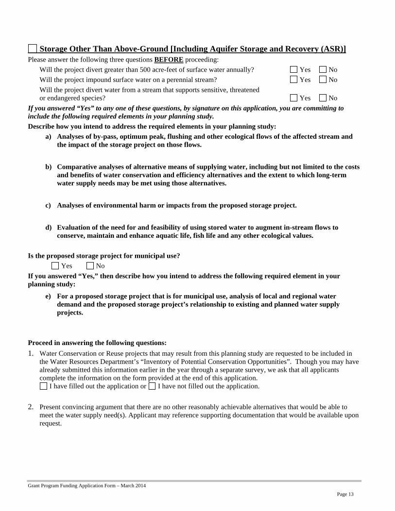
Storage Other Than Above-Ground [Including Aquifer Storage and Recovery (ASR)] Please answer the following three questions BEFORE proceeding:
Will the project divert greater than 500 acre-feet of surface water annually? Yes No
Will the project impound surface water on a perennial stream? Yes No
Will the project divert water from a stream that supports sensitive, threatened or endangered species? Yes No
If you answered “Yes” to any one of these questions, by signature on this application, you are committing to include the following required elements in your planning study.
Describe how you intend to address the required elements in your planning study:
a) Analyses of by-pass, optimum peak, flushing and other ecological flows of the affected stream and the impact of the storage project on those flows.
b) Comparative analyses of alternative means of supplying water, including but not limited to the costs and benefits of water conservation and efficiency alternatives and the extent to which long-term water supply needs may be met using those alternatives.
c) Analyses of environmental harm or impacts from the proposed storage project.
d) Evaluation of the need for and feasibility of using stored water to augment in-stream flows to conserve, maintain and enhance aquatic life, fish life and any other ecological values.
Is the proposed storage project for municipal use?
Yes No
If you answered “Yes,” then describe how you intend to address the following required element in your planning study:
e) For a proposed storage project that is for municipal use, analysis of local and regional water demand and the proposed storage project’s relationship to existing and planned water supply projects.
Proceed in answering the following questions:
1. Water Conservation or Reuse projects that may result from this planning study are requested to be included in the Water Resources Department’s “Inventory of Potential Conservation Opportunities”. Though you may have already submitted this information earlier in the year through a separate survey, we ask that all applicants complete the information on the form provided at the end of this application.
I have filled out the application or I have not filled out the application.
2. Present convincing argument that there are no other reasonably achievable alternatives that would be able to meet the water supply need(s). Applicant may reference supporting documentation that would be available upon request.

Grant Program Funding Application Form – March 2014
Page 14
V. Match Funding Information
Applicants must demonstrate a minimum dollar-for-dollar match based on the total funding request. The match may include a) secured resources, b) previously expended resources, and/or c) pending resources. For secured funding, you must attach a letter of support from the match funding source that specially mentions the dollar amount shown in the “Amount/Dollar Value” column. For pending resources, documentation showing a request for the matching funds must accompany the application. For resources that have been previously expended, the expenditure must have occurred on or after July 1, 2013. Resources expended prior to July 1, 2013 are not eligible for match purposes.
The Type of matching funds may include: The Status of matching funds may include:
The value of in-kind labor, equipment rental and materials essential to the planning study provided by the applicant or partner*.
Secured funding commitments from other sources.
Cash is direct expenditures made in support of the planning study by the applicant.
Associated and documented expenditures for the planning study from non-program sources incurred on or after July 1, 2013.
Pending commitments of funding from other sources. In such instances, Department funding will not be released prior to securing a commitment of the funds from other sources. Pending commitments of the funding must be secured within 12 months from the date of the award.
*”Partner” means a non-governmental or governmental person or entity that has committed funding, expertise, materials, labor, or other assistance to a proposed planning study. OAR 690-600-0010.
Match Funding Source
(if in-kind, briefly describe the nature of the contribution) Type
( One) Status
( One) Amount/ Dollar
Value Date Match Funds Available
(Month/Year)
Cash from Public Works Improvement Fund cash in kind
secured expended pending
$95,000 July 1, 2014
cash in kind
secured expended pending
cash in kind
secured expended pending
cash in kind
secured expended pending
cash in kind
secured expended pending
cash in kind
secured expended pending
cash in kind
secured expended pending
cash in kind
secured expended pending
cash in kind
secured expended pending
cash in kind
secured expended pending
Grant Program Funding Application Form – March 2014
Page 15
VI. Project Planning Study Schedule
Estimated Project Duration: July 1, 2014 to December 31, 2014 Place an “X” in the appropriate column to indicate when each Key Task of the project will take place.
2014 2015 2016
& Beyond
Project Planning Study Key Tasks 1st Qtr
2nd Qtr
3rd Qtr
4th Qtr
1st Qtr
2nd Qtr
3rd Qtr
4th Qtr
Project management/meetings X X
Develop geologic model X
Laboratory testing X
Passive resistance from abutments X X
Stability analyses X
Report X
Grant Program Funding Application Form – March 2014
Page 16
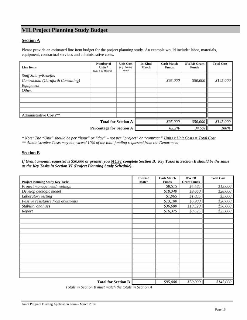
VII. Project Planning Study Budget Section A Please provide an estimated line item budget for the project planning study. An example would include: labor, materials, equipment, contractual services and administrative costs. Line Items
Number of Units*
(e.g. # of Hours)
Unit Cost (e.g. hourly
rate)
In-Kind Match
Cash Match Funds
OWRD Grant Funds
Total Cost
Staff Salary/Benefits Contractual (Cornforth Consulting) $95,000 $50,000 $145,000Equipment Other: Administrative Costs**
Total for Section A $95,000 $50,000 $145,000
Percentage for Section A 65.5% 34.5% 100% * Note: The “Unit” should be per “hour” or “day” – not per “project” or “contract.” Units x Unit Costs = Total Cost ** Administrative Costs may not exceed 10% of the total funding requested from the Department Section B
If Grant amount requested is $50,000 or greater, you MUST complete Section B. Key Tasks in Section B should be the same as the Key Tasks in Section VI (Project Planning Study Schedule).
Project Planning Study Key Tasks
In-Kind Match
Cash Match Funds
OWRD Grant Funds
Total Cost
Project management/meetings $8,515 $4,485 $13,000Develop geologic model $18,340 $9,660 $28,000Laboratory testing $1,965 $1,035 $3,000Passive resistance from abutments $13,100 $6,900 $20,000Stability analyses $36,680 $19,320 $56,000Report $16,375 $8,625 $25,000
Total for Section B $95,000 $50,000 $145,000Totals in Section B must match the totals in Section A
Grant Program Funding Application Form – March 2014
Page 17
APPLICATION CHECKLIST Instructions: Use this form as an important cross-check to ensure that your application is complete. An incomplete application will jeopardize your application’s review. This form does not need to be included in your application packet. General If submitting electronically the preferred format is either a Microsoft word or Adobe pdf
Only one application is included with the packet (other applications must be sent separately). Paper submissions only
The application and attachments are on 8 ½” x 11” paper. The application and attachments are single sided. The application and attachments are not stapled or bound.
Section I – Grant Information
All questions in this section have been answered. The Grant Dollars Requested and the Total Project Cost mirror the totals shown in Section VII.
Section II – Applicant Information
All contact information – for the applicant(s) and fiscal officer – is complete and current. The certification is signed by an authorized signer.
Section III – Planning Study Summary
A brief summary, of no more than 150 words, is complete. Section IV – Grant Specifics
All questions in Section A have been answered. If the type of planning study is Water Conservation, Reuse or Storage Other Than Above-Ground, a Request to be added to the Oregon Water Resources Department’s Inventory of Potential Conservation Opportunities has been completed. (Form is located at the end of this document.)
All applicable questions for the type of grant requested have been answered. Section V – Match Funding Information
Applicant has identified that at least 50% match has been sought, secured or expended. Letters of support are included for “secured” match funding sources. Documentation is included for “expended” match funds. Documentation is included for “pending” match funds.
Section VI – Project Planning Study Schedule
Estimated project duration dates have been supplied. All Key Tasks of the project are listed.
Section VII – Project Planning Study Budget
Section A is complete. Administration costs do not exceed 10% of the requested OWRD Grant Funds. If grant amount requested is $50,000 or greater, Section B has been completed. All Key Tasks listed in Section B mirror the Key Tasks listed in Section VI.
Grant Program Funding Application Form – March 2014
Page 18
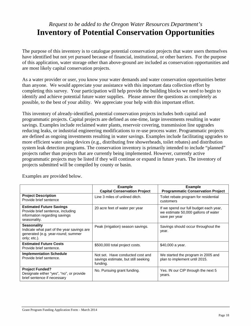
Request to be added to the Oregon Water Resources Department’s
Inventory of Potential Conservation Opportunities The purpose of this inventory is to catalogue potential conservation projects that water users themselves have identified but not yet pursued because of financial, institutional, or other barriers. For the purpose of this application, water storage other than above-ground are included as conservation opportunities and are most likely capital conservation projects. As a water provider or user, you know your water demands and water conservation opportunities better than anyone. We would appreciate your assistance with this important data collection effort by completing this survey. Your participation will help provide the building blocks we need to begin to identify and achieve potential future water supplies. Please answer the questions as completely as possible, to the best of your ability. We appreciate your help with this important effort. This inventory of already-identified, potential conservation projects includes both capital and programmatic projects. Capital projects are defined as one-time, large investments resulting in water savings. Examples include reclaimed water plants, reservoir covering, transmission line upgrades reducing leaks, or industrial engineering modifications to re-use process water. Programmatic projects are defined as ongoing investments resulting in water savings. Examples include facilitating upgrades to more efficient water using devices (e.g., distributing free showerheads, toilet rebates) and distribution system leak detection programs. The conservation inventory is primarily intended to include “planned” projects rather than projects that are currently being implemented. However, currently active programmatic projects may be listed if they will continue or expand in future years. The inventory of projects submitted will be compiled by county or basin. Examples are provided below. Example
Capital Conservation Project Example
Programmatic Conservation Project Project Description Provide brief sentence
Line 3 miles of unlined ditch. Toilet rebate program for residential customers
Estimated Future Savings Provide brief sentence, including information regarding savings seasonality.
20 acre feet of water per year If we spend our full budget each year, we estimate 50,000 gallons of water save per year
Seasonality Indicate what part of the year savings are generated (e.g. year-round; summer only; etc.).
Peak (irrigation) season savings. Savings should occur throughout the year.
Estimated Future Costs Provide brief sentence.
$500,000 total project costs. $40,000 a year.
Implementation Schedule Provide brief sentence.
Not set. Have conducted cost and savings estimate, but still seeking funding.
We started the program in 2005 and plan to implement until 2015.
Project Funded? Designate either “yes”, “no”, or provide brief sentence if necessary
No. Pursuing grant funding. Yes. IN our CIP through the next 5 years.

Grant Program Funding Application Form – March 2014
Page 19
To add a project to the inventory of potential conservation opportunities, please provide the following information for each conservation project. This is a Capital Conservation Project Programmatic Conservation Project
Project #/Name
Project Description
Estimated Future Savings
Seasonality
Estimated Future Costs
Implementation Schedule
What are the barriers to implementation, e.g. funding?
This is a Capital Conservation Project Programmatic Conservation Project
Project #/Name
Project Description
Estimated Future Savings
Seasonality
Estimated Future Costs
Implementation Schedule
What are the barriers to implementation, e.g. funding?
- Include this form with your application -

KLASKANINE X OVER
BEAR CREEK
Cedar Creek
FAT BUCK CREEK
CEDAR CREEK
CUB CREEK
Cedar Creek
BEAR CREEK
BEAR CREEK
BEAR CREEK
FAT BUCK CREEK
CEDAR CREEK
N L
INE
SPUR
12
A LINE
SPUR 13
SP
UR
21
SPUR 12
12B
B1
Spur B
SP
UR
12
A
Spu
r A
-1
14B
D1
12C
Spur
19
SPUR 13B
SP
UR
13
A
A LINE RD
SPUR 12A
SPUR 1-A
KLASKANINE X OVER
SPUR 17
Spur 13-C
Wickiup Lookout R
oad
11B-1
11A
-1
M L
INE
SPU
R 18
SPUR 11A-3
SPUR 11-A
SP
UR
20
SPUR 1
SP
UR
13D
SP
UR
14
SP
UR
1C
SPUR 1B
SPUR11B-2
SP
UR
1E
SPUR A3
SPUR A2
SP
UR
1
SP
UR
12
A LI
NE
Spu
r B
SPUR 12
SPUR 11-A
SP
UR
12A
SPUR 11-A
SP
UR
21
A LINE
SPUR 12A
SP
UR
12
CEDAR CREEK DAM
BEAR CRK DIV DAM 2
BEAR CRK DIV DAM 1
-