2013-038-chugach access plan reso-finaldraft … 2014-101_5-chugach...2010 chugach access plan as a...
TRANSCRIPT

MUNICIPALITY OF ANCHORAGE
PLANNING AND ZONING COMMISSION RESOLUTION 2013-038 A RESOLUTION SUPPORTING THE APPROVAL AND ADOPTION OF THE CHUGACH ACCESS PLAN. (Case 2012-104) WHEREAS, the State of Alaska, Division of Parks and Outdoor Recreation, undertook a five-year planning process with the intent of inventorying existing public access, analyzing potential future sites, and identifying long-term goals and locations for new access to Chugach State Park; and WHEREAS, this planning effort culminated with a Draft Chugach Access Plan; and WHEREAS, the purpose of the Chugach Access Plan is twofold: to provide a long-term vision for the establishment of frequent, secured public access points, along with guidelines and methods for securing future access sites to the Park; and
WHEREAS, numerous elements of the Anchorage Comprehensive Plan include policies stating the significance of Chugach State Park as an important natural resource to the community; and
WHEREAS, the Chugach Access Plan functions as an implementation strategy for these
Comprehensive Plan policies and in order for the Chugach Access Plan to serve that function, the Municipal Attorney recommended it be adopted as an element of the Comprehensive Plan; and
WHEREAS, the Community Development Department released the State of Alaska’s
2010 Chugach Access Plan as a public hearing draft, and the Planning and Zoning Commission held a public hearing on this draft on September 17, 2012, after which the Commission requested changes to the Plan maps and notification of landowners impacted by the Plan; and
WHEREAS, following these map upgrades, additional text amendments, and the
landowner notification, the Planning and Zoning Commission held a second public hearing on April 1, 2013; and
WHEREAS, the Commission convened follow-up work sessions with staff, which lead to
a suite of plan amendments and new maps that responded to public concerns and Commission recommendations.
NOW, THEREFORE, BE IT RESOLVED by the Anchorage Planning and Zoning
Commission that:
A. The Commission makes the following findings of fact:
Exhibit B
Planning and Zoning Commission Resolution No. 2013-038 Page 2
1. The Chugach Access Plan as a Functional Plan recommended for approval by the Anchorage Planning and Zoning Commission will serve as the basis for securing future public access to Chugach State Park and will move other Comprehensive Plan elements towards implementation.
2. The January 2010 Public Hearing Draft Chugach Access Plan,
with Commission recommendations and staff amendments presented in the final staff packet of October 7, 2013, meets the standards for functional plans as an element of the Comprehensive Plan.
3. The Plan provides a valuable tool for the Division of Parks and
Outdoor Recreation and the Municipality of Anchorage’s Platting Board. It highlights areas of opportunity for securing public access via platting, acquisitions, or donations. As development occurs along the edge of the Park, State Parks, Municipal Planning staff, and the Platting Board through its public processes will determine how to properly locate and develop future access locations with minimal impacts.
4. Because 53% of Alaskans live within 30 miles of Chugach State
Park, having this Plan for expanding public access to this important resource is a long-term benefit.
5. With the Commission’s input, the Plan and adopted amendments
balance future public access with locations and methods that are meant to address and minimize impacts on property owners and neighborhoods. The PZC is concerned with the lack of information and/or planning in regards to internal circulation within the Park. Better internal circulation would serve to mitigate the impact to properties outside of the Park. The PZC encourages the Division of Parks and Outdoor Recreation to work on correcting this critical omission prior to the next annual report and/or Plan review.
6. The Planning and Zoning Commission delayed the Plan’s approval
to allow for public and landowner notification. Although the Commission did not delve into the details of each access site, it had reservations about property impacts and required necessary discussion about access points that might be removed in the future.

Attachment A PZC Resolution No. 2013‐038
PZC Amendments to the Chugach Access Plan October 7, 2013
The following is a summary list of final Planning and Zoning Commission amendments with page insertion points. [All changes/additions are underlined; deletions are strikethrough] 1. Change Title Page and all Footers
Change Plan Title to: CHUGACH STATE PARK ACCESS PLAN 2. Global change:
All references in the Plan document to the military, the Air Force, or the Army shall be changed to JBER.
3. Page 2, INTRODUCTION, Objectives, revise #1:
Disperse park use throughout the Municipality/Park interface by indentifying and securing various types of public access. approximately every ¼ mile.
4. Page 2, INTRODUCTION, modify Objective #4 to:
Ensure that the need for reserved access and trail connectivity to Chugach State Park is addressed through state and municipal planning processes, budgeting, municipal staff analysis of zoning and platting requests, and periodic training for state and municipal staff and board and commission members who have the opportunity to identify or procure access and connectivity to Chugach State Park.
5. Page 5, PLANNING EFFORT AND PROCESS, insert:
The State will use the CAP as a tool to guide access acquisition and development on lands owned or managed by the park. Like the MOA District Plans, the Chugach State Park Management Plan is the basis for management and development within the park. The Chugach State Park Trail Management Plan provides management objectives and specific guidelines for the future use, design, development & maintenance of trails within the park. The park management plan and trail plan are closely linked documents that inter-relate to each other. The CAP is a stand-alone document that is related to the main park plans but is specific in its intent

Attachment A
PZC Resolution No. 2013‐038 PZC Amendments to the Chugach Access Plan
October 7, 2013 2
to provide guidance for securing access to the park. Both the park management plan and trail plan defer to the CAP for access-related decision making.
With adoption of this Plan, the Municipality plans to use the Plan’s identified access points and related recommendations for dedications, future planning activities, and relevant opportunistic land use actions only in the areas within the Municipality covered by this Plan. These areas are almost exclusively where private and municipal lands interface with the Chugach State Park boundary. This Plan will serve as the basis for platting requirements to reserve public access to CSP through dedications only at sites identified in the Plan and only for public access to the state park.
These points will also serve to modify or otherwise guide public access in other municipal functional plans. This Plan is a comprehensive plan element that allows for dedications for trails, roads, and access to CSP. The Plan provides the basis for access dedications directly tied to the new section of Title 21, 21.08.040 D. Specific Park access points and future public improvements recommended in this Plan serve to augment and in some cases replace specific public access sites presented in other Municipal plans, including the Hillside District Plan. This Plan also serves as the essential access reference for all State Park interface areas of the Municipality and for all relevant current or future district plans and functional plans.
The access areas identified in this Plan are based on considerable analysis of terrain and other conditions. These represent the most detailed findings and specific recommendations about access to the Park. Where appropriate, access locations in this Plan amend those of previous municipal functional or district plans. In the event that the identified sites have changed or are deemed infeasible in the future or that new sites are identified or locations not shown in this Plan are presented in a new planning document, that new plan could amend this document.
The Municipality’s Anchorage 2020: Anchorage Bowl Comprehensive Plan (Anchorage 2020) and the 2006 Anchorage Bowl Park, Natural Resource, and Recreation Facility Plan (Parks Plan) stress the values and importance of maintaining existing and establishing new pedestrian/public connections to Chugach State Park across the MOA-Park interface.
The following polices and elements from these highlight the MOA’s approach to coordinating CSP access, Chugach State Park access and management issues and relationships with the Municipality are otherwise described and referenced in other Comprehensive Plan elements including

Attachment A
PZC Resolution No. 2013‐038 PZC Amendments to the Chugach Access Plan
October 7, 2013 3
the Potter Valley Land Use Analysis, the Turnagain Arm Comprehensive Plan, and the Chugiak-Eagle River Comprehensive Plan.
ANCHORAGE 2020 & PARKS PLAN
Anchorage 2020 Chapter 5, Policy #65, and Parks Plan Chapter 6, Park Strategy 7:
Promote and encourage the identification and conservation of open
spaces, including access to greenbelts, Chugach State Park, Anchorage Coastal Refuge and Far North Bicentennial Park.
HILLSIDE DISTRICT PLAN (HDP)
In addition, the municipal HDP provides significant reference to Chugach State Park access with the following:
HDP Policy 10-A Identify proposed trails and trailheads to improve the system of
trails with the Hillside District and access to Chugach State Park.
HDP Policy 10-B
Provide a range of trailheads and parking areas to Chugach State Park, including neighborhood and auto-access trailheads.
The HDP further identifies several elements that should be considered when improving access to Chugach State Park.
Improved Access Points: Identify, reserve, and improve multiple
pedestrian and small trailhead parking access points to Chugach State Park to diffuse and spread uses and to reduce crowding at any one location.
Alpine Access Priority Trailhead Improvements: Provide one or
more, larger-capacity trailheads at points that can handle crowds and more traffic without adverse effects on adjoining neighborhoods; this may require new land acquisitions and/or Heritage Land Bank land trades.
Improved Funding and Management: Develop significantly
improved new ways to pay for capital improvements and operations and maintenance. This must include law enforcement, collection of park access fees, and trail (and road) maintenance.
Attachment A
PZC Resolution No. 2013‐038 PZC Amendments to the Chugach Access Plan
October 7, 2013 4
The Adopted Title 21 Revision and subsequent proposed amendments codified this relationship between the Municipality and Chugach State Park access with references in the code section governing Dedications. The final language in Title 21 for (original) section 21.08.040 – Dedications, is still under consideration at the time of this publication. Regardless of final code changes, a reference to the CAP in the forthcoming new Title 21 revision establishes the authority of the Municipality to dedicate access in new subdivisions. The new code will reflects the Municipality’s intent to evaluate, require, and locate future public access points only at sites identified in the CAP.
6. Page 5, insert as further amendment to Item #5 above, after the third sentence in the
first paragraph:
The access locations and details outlined in the Chugach State Park Access Plan are in part based on proposed future development nodes within the park boundary. Refer to Figure 6.11, the Chugach State Park Management Plan Facility Recommendations map, included in the Access-Specific Recommendations section of the Plan.
7. Page 17, Area-Wide Recommendations, include a reference to the items below in
order to put this Plan in context with specific recommended changes to Title 21:
a. The updated or new standards of Title 21; b. Relevant policies and implementation actions from municipal plans
(Hillside District Plan; Anchorage Bowl Park, Natural Resource, and Recreational Facility Plan; and others) that provide guidance in securing access to Chugach State Park; and
c. Specific items listed as additional tools that are used to implement
and guide this plan.
8. Page 17, Area-Wide Recommendations, add the following new paragraph after the first introductory paragraph to provide more details on applicability of this Plan and how final new access sites will be determined:
First and foremost, this Plan serves as an organized inventory of potentially suitable and strategically located access possibilities. The Plan seeks to identify and activate tools, mechanisms, and funding sources to secure this access. In the absence of these, and given the realities and conditions across the planning area, not each site represents a certain new access location. The Plan has flexibility and feasibility written into it, as
Attachment A
PZC Resolution No. 2013‐038 PZC Amendments to the Chugach Access Plan
October 7, 2013 5
exemplified in the recommendations column in the tables. Given the extent of parameters and site specific conditions at each of the access locations listed in this Plan, realities are such that not all of these sites will become future public access to the Park. If future site analysis provides compelling data that a site isn’t appropriate for access, and there is no option for a modification that provides comparable access, then the platting board has justification not to require access at that site.
9. Page 17, Rights-of-Way and Easements, first paragraph, add as last sentence:
Flexibility should be applied to widths of new access requirements in new subdivisions to provide for safe trails that are wide enough to buffer neighboring residences; where practical, new trail rights-of-way, pedestrian easement, conservation easement or tracts should be a minimum 20’ wide.
10. Page 18, Education and Etiquette, add as new last sentence:
The State should explore and evaluate other access options to address crowding and offer amenities for visitors and expand trailhead trash cans and service.
11. Page 19, Acquisitions, amend first sentence:
Acquisitions of interests in land will be considered on a case by case basis in order to enhance or protect public access, viewsheds, forest communities, wildlife corridors, stream corridors and drainageways, and secure holdings.
12. Page 19, Acquisitions, add the following new sentence:
State and municipal planning staff shall continue to consult with ADF&G with future acquisition and park access developments relative to potential wildlife issues and conflicts.
13. Page 19, Acquisitions, add as new second to last sentence:
While access to the Park is a significant public benefit and highlighted in municipal plans, private land owners will not be required to provide land for parking and other trailhead facilities without fair payment. Most future trailhead and parking areas are to be located within the Park boundary or municipal land.

Attachment A
PZC Resolution No. 2013‐038 PZC Amendments to the Chugach Access Plan
October 7, 2013 6
14. Page 19, Acquisitions, add the following new sentence at the end:
The use of eminent domain for acquiring access to the Park will not be used.
15. Page 19, Trailhead Design, Management and Maintenance, add as a new last
sentence in the Section:
Where appropriate, the ADNR and the MOA will consult with ADOT/PF on relevant design and maintenance issues.
16. Pages 20-74, global changes to Area–Specific Recommendations Tables:
Where applicable, access locations will be prioritized. Site descriptions will include more detail, as needed, and location
information, level and types of public uses will be further detailed. Locations identified in the Draft Plan as “problematic” will have
enhanced descriptions to clarify why the label was applied.
17. Pages 20-74, changes to specific sites in Area–Specific Recommendations Tables:
Add the following unimproved, secured access sites:
1. The Eklutna Canyon site off Eklutna Lake Road; 2. An alternative access to Ram Valley from approximately Mile 11.5
of the Eagle River Road; 3. A winter access on Hesterberg Road leading to the Eagle River
Campground; 4. A pedestrian trail off Yosemite Drive in Eagle River; 5. The platted walkways off Yellowstone Circle in the Eagle Pointe
Subdivision and Wolf Drive in the Hundred Hills Subdivision in Eagle River; and
6. The platted easements in the Parkview Terrace East Subdivision,
the Eagle Crossing Subdivision, the River View Estates Subdivision, the Mountain Valley Estates Subdivision in Eagle River.

Attachment A
PZC Resolution No. 2013‐038 PZC Amendments to the Chugach Access Plan
October 7, 2013 7
Include the following unimproved, unsecured access to the Eagle River Greenbelt:
Spring Street off West Lake Drive, Harmony Ranch Road, McIntyre Road, and from Stonehill Drive.
Remove the following Access Entry:
The access depicted at Midden Way (H5) in the Hillside Units will be removed in the final plan
Modify the following Access Entries
1. The Goat Creek (E&) access (page 23) and the Upper Canyon
Drive (ER15) access (page 37) will be relocated; 2. The type recommendation for the Mile Hi (ER14) access (page 37)
and Ship Creek (S3a) access (page 51) will change to a medium vehicular access;
3. The type recommendation for the Threebowls Alternative (ER51)
access (page 47) and the Tulugak Circle (H4) access (page 55) will be modified to pedestrian.
18. Maps
All the final maps will reflect the most current land status. Additional feature names will be added to better orient users.
The final maps will include the following new and/or modified legend
annotations in Bold:
o USE OF ROUTES OR TRAILS OUTSIDE OF CHUGACH STATE PARK WHERE ON PRIVATE LAND MAY BE TRESPASS.
o Not all access represented on this map is reserved
public access; many routes depicted herein are on private land.
o Note, access onto or through JBER requires a permit
and use of the automated access system for authorization. Some of these areas include live fire training.

Attachment A
PZC Resolution No. 2013‐038 PZC Amendments to the Chugach Access Plan
October 7, 2013 8
A new Map # 6.0 will be inserted as a new first map in the map section of the Plan.
A new Map #6.11, Chugach State Park Management Plan Facility
Recommendations, will be inserted at the end of the maps section of the Plan.
19. Page 48, Current Condition and Justification/Actions, add the following to the
columns for ER54:
The trail depicted near ER54 crossed this parcel years ago before it was posted No Trespassing, at which time the main trail was rerouted to its current location on state land. Some residents may gain permission from the landowner to traverse the property in order to reach the Park. This private parcel includes a conservation easement with certain preservation mandates.
Any future access plans and locations for this area must be consistent with terms and conditions of the conservation easement for this homestead. Vehicular access plans may not be feasible given the conservation easement.
20. Page 53, Current Conditions, replace the last sentence in the column for site H1a
with:
Access to the Park at H1a crosses JBER land—trail users must secure a JBER use permit due to proximity to training areas.
21. Pages 61 and 63, Justification/Actions, modify the first sentence in the column for
sites H18 and H21a to:
Work to implement the MOA’s Areawide Trails Plan and the Hillside District Plan’s recommendations for the…
22. Page 95, Implementation, add as new paragraphs to follow the introductory
paragraph (deletions are included to show changes made to amendments):
Municipal adoption of the Chugach State Park Access Plan as a Comprehensive Plan element in no way obligates, or is intended to obligate the Municipality to acquire private land for Chugach State Park. The State Park boundary is established by the state legislature and cannot be altered without action by that body. The Plan is to be used by the Municipality as an aid and foundation for reserving public access to Chugach State Park in new subdivision actions as identified in this Plan.

Attachment A
PZC Resolution No. 2013‐038 PZC Amendments to the Chugach Access Plan
October 7, 2013 9
Where appropriate, applicable, and feasible, these access sites may involve roads, trails, or other easements. The Plan may also be used opportunistically by the Municipality or the State for future acquisitions, trail extensions, or related Park access actions. This Plan identifies potential new access points that may be located on State Park, federal, municipal land and/or potentially on private land, through subdivision dedications. Each access location identified in the Plan may not be exact, and may require some latitude in actual placement and further consideration for applicability, feasibility, and safety with each proposed subdivision. The municipal authorities for Plan implementation and the future dedication of access to CSP are outlined in the rewrite of Anchorage Municipal Code, Title 21, Chapter 8 subdivision standards. New Section 21.08.040D. addresses dedications. Under subsection D, the platting authority shall require the dedication of access for areas designated on adopted municipal plans and for connectivity with a trail or access point identified in the most current Chugach State Park Access Plan. For pedestrian access, a right-of-way dedication is the preferred method of providing access. However, in lieu of right-of-way, the platting authority may consider and approve a public use easement dedication or an access tract dedication to establish a public access corridor. The platting authority shall also require the dedication of a public right-of-way for vehicular access for public access to trails, parks, and other public lands as defined in AMC 21.08.040D.1. that are identified in an adopted municipal plan or the Chugach State Park Access Plan. Acceptable rights-of-way for vehicular access shall be public streets in accordance with relevant Title 21 provisions. Where access locations are not within a recognized municipal road service area, the access would be from a section of privately maintained, but public roadway. Where a vehicular access required to the park also provides access to new subdivision lots in addition to the park,[ and/or the road is necessary for another public purpose,] the developer will be required to construct the public improvements to front the subdivision lots with a regulation turnaround, as applicable. If the vehicular access to the park does not provide access to new subdivision lots, the developer will not be required to construct the access corridor. It is presumed that in the latter cases, the State will construct the vehicular access improvements when it initiates development of a new park access or trailhead at that location. The municipal pre-application, platting, and subdivision agreement processes will serve to clarify these requirements.

Attachment A
PZC Resolution No. 2013‐038 PZC Amendments to the Chugach Access Plan
October 7, 2013 10
The authority outlined in municipal code provides for dedication for pedestrian access and vehicular rights-of-way for public access to trails in Chugach State Park. In some cases, the vehicular ROW may both be used for a road and parking. The R-6 and R-10 zoning districts of the municipal code do not allow parking lots as principal uses. New roads in the park interface area of the Municipality require 50- to 60-foot dedications. [When the access road is required to be constructed, the Platting Authority may require the developer to provide parking spaces in the new right-of-way at the park interface, only if the Plan calls for vehicular access and the site is suitable. ]
Flexibility with parking requirements is paramount and must include consideration of specific site conditions, engineering design, neighborhood context, and costs. A parking requirement in the right-of-way may be applied to new access sites described as pullouts or small vehicular types in this Plan. It is presumed that the State and the Municipality will also monitor the use of these parking areas. The State and the Municipality both have a long-term goal of providing parking inside the Park’s boundary at those sites specifically identified for that use. The Plan does not require, nor is there provision for parking lots for the state park to be required of private landowners in new subdivisions. Where the Plan calls for new formal parking lots, these are to be located within the park boundary and constructed with state funds, or on other public land.
23. Page 95, Implementation, add the following as new, additional second and third
sentences in the second paragraph of item #22 above, which modified the Introductory section:
Given the complexities of platting and the sometimes unrelated timelines between subdivision actions on adjoining properties, and with concerns about private property, there may be occasions when other means of obtaining public access to the Park are faster and more appropriate than dedications. In these instances, and in general, the Plan recommends that the Municipality and the State consider or attempt to acquire public access via mutual agreements with landowners ahead of some future potential platting action. It is possible that internal trail and road circulation within the Park boundary may replace the need for some of the Plan’s future access points. The State will include long-term consideration of using internal Park circulation in their management plan to alleviate or supersede the need for reservations of new access points on or near private parcels.

Attachment A
PZC Resolution No. 2013‐038 PZC Amendments to the Chugach Access Plan
October 7, 2013 11
24. Page 95, replace the entire paragraph for the Priorities and Phasing Section of the Implementation Chapter with:
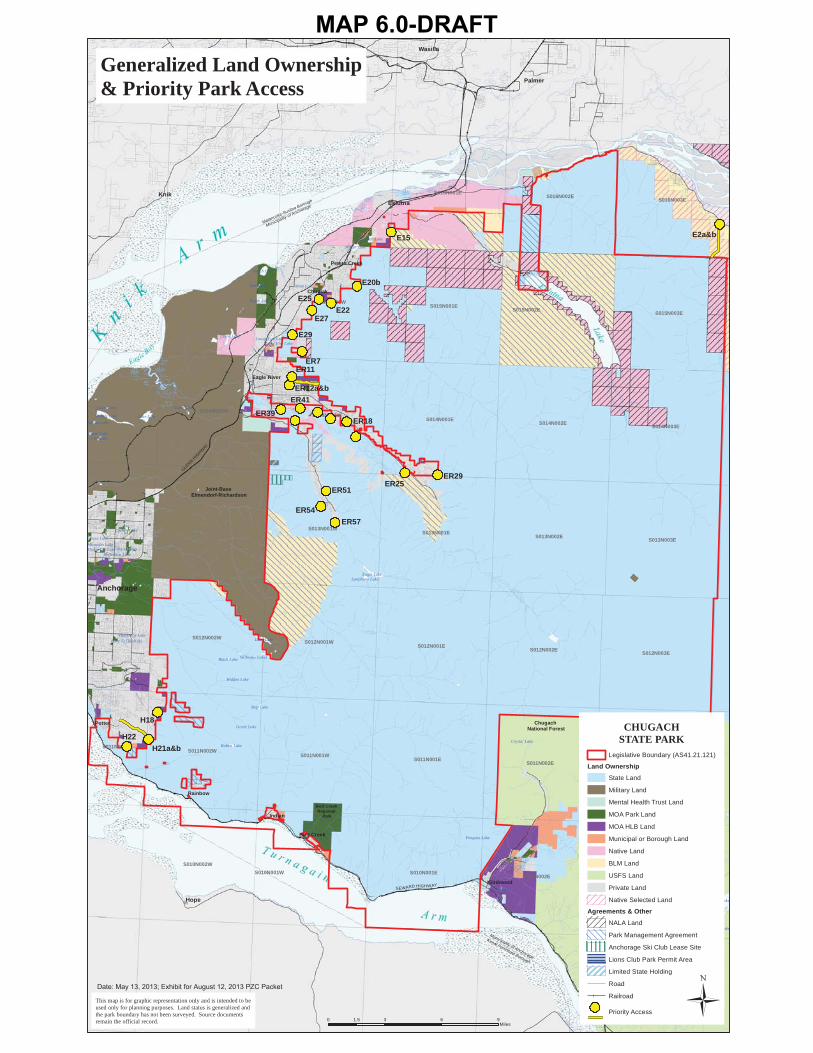
Priorities[ and Phasing]
Generally, this Plan places priority on acquiring access at specific locations before a window of opportunity closes due to development or other land status changes. Throughout the planning process for this document however, a subset of access areas across the CSP boundary were clearly identified as priorities by the public and also identified in Municipal planning documents. These priorities are summarized on Map 6.0 of this Plan and are located mainly in Thunder Bird Creek drainage and along Peters Creek and its tributaries in the Eklutna-Peters Creek Unit, Ram Valley and Harp Mountain in the Eagle River Unit and McHugh Peak within the Hillside Unit. These sites provide ideal future access based on topography, site conditions, road access, and proximity to populated areas or growing neighborhoods and to highly sought after destinations within the Park. Many of the priorities are also included in previous Municipal plans, which further accentuate their significance.
Since opportunities for acquiring or securing public access to the Park can arise quickly, the State and Municipality must remain open to dealing with access on a case-by-case and time-sensitive basis. The nature of access acquisition and the public’s evolving interest towards certain areas of the Park require an opportunistic approach to securing new sites rather than focusing exclusively on the priority list presented in the Plan. The following list comprises the most important future access sites for CSP. As of the date of this publication, these represent the long-term priorities to secure new or enhanced public access to the Park. Eklutna-Peters Creek Unit Most of the priorities in this unit are focused in the underserved Peters Creek Area. Development is not imminent but the area is experiencing a steady increase in use, especially from nearby residents of Chugiak-Eagle River. E2a & E2b E15 E20b E22 E25 E27 E29

Attachment A
PZC Resolution No. 2013‐038 PZC Amendments to the Chugach Access Plan
October 7, 2013 12
Eagle River Unit Priorities The population of Eagle River has grown significantly in recent years increasing the demand for access to popular park destinations. Access to the park is poor in this region compared to other areas and opportunities have been lost or are limited due to terrain, avalanche concern and increased development. The Eagle River Greenbelt is seeing renewed project interest and like other greenbelt trails, access for adjacent neighborhoods and connectivity with other trails will be a primary focus. ER7 ER11 ER12a & ER12b ER18 Spring Street Harmony Ranch Road McIntyre Road Stonehill Drive ER25 ER29 ER39 ER41 ER51 ER54 ER57 Ship Creek Unit Priorities There are no specific priorities for access in this unit because all of the access areas are on military lands. The military mission precludes this plan from securing access sites beyond making recommendations for State and JBER collaboration. Hillside Unit Priorities Most of the focus for this unit involves increasing pedestrian options for neighborhoods to disperse use across the Park boundary and to reduce vehicle trips to existing trailheads. The unit has the highest visitation currently and much of the access recommendations are being made to alleviate overcrowding and unacceptable park resource impacts. The southern end of this unit will remain a primary focus even though development presently remains far from the boundary of the park despite high traditional recreational use. H18 H21a & H21b H22

Attachment A
PZC Resolution No. 2013‐038 PZC Amendments to the Chugach Access Plan
October 7, 2013 13
Turnagain Arm Unit Priorities Most of the identified access in this area is secured so there are no priorities listed.
25. Page 96, modify the third sentence and add the following new sentences in the first paragraph with the following:
The Alaska Division of Parks and Outdoor Recreation and the MOA will coordinate periodic reviews of this Plan to make Plan modifications and to determine if access areas need to be added or removed. These reviews should occur every five years and would include a public process. The State will submit annual reports to the Planning and Zoning Commission detailing CAP updates including changes in status or elimination of access points, additions of new sites, and development of CSP access. If the Alaska Division of Parks and Outdoor Recreation fails to reach a written agreement with a landowner identified in this Plan involving unsubdividable land within 5 years, without any further action by the landowner the property in question shall be deleted from consideration for an access point.
26. Add the following definition to Appendix A:
JBER. Joint Base Elmendorf-Richardson.
27. Rework Appendix B to include the following:
Regulations for Recreation on Joint Base Elmendorf-Richardson (JBER) Lands Recreation is allowed on JBER lands. Three requirements must be met before entering the JBER training lands:
1. All persons entering JBER training lands that do not already have access to the base (non-DoD cardholders) must first visit either the Richardson or the Boniface Main Gate Visitor Center and obtain an AF Form 75 for the day.
2. All persons must then obtain a JBER iSportsman Recreation
Access Permit. Permits are free of charge and available online at www.jber.isportsman.net/registration or at the self-service kiosks located in both of the JBER Visitor Centers. Permits are good through the end of the calendar year and are renewable online.
3. After obtaining the iSportsman Recreation Access Permit, you
must check-into the iSportsman automated access system. This

Attachment A
PZC Resolution No. 2013‐038 PZC Amendments to the Chugach Access Plan
October 7, 2013 14
system has been designed to increase public safety and minimize conflict between military training and recreation. It is intended to inform recreation users of areas open or closed to access and recreational activities per a given time period.
To use the access system, you must either:
To Sign in, call 855-703-9176 or go to www.jber.isportsman.net/sign-in-sign-out
Enter your Recreation Access Permit Number and PIN If you see the area you want to recreate, it is open for sign in To Sign out, call 855-703-9176 or go to
www.jber.isportsman.net/sign-in-sign-out Answer remaining questions about activity and location.
A link to 673D Air Base Wing Instruction 32-7001, can be found at: http://jber.isportsman.net/docs/reference/673abwi32-7001.pdf?sfvrsn=2
Attachments: Map 6.0, Generalized Land Ownership & Priority Park Access
Map 6.11, Chugach State Park Management Plan Facility Recommendations
SEWARD HIGHWAY
GLENN H
IGHW
AY
S011N002ES011N001E
S011N003E
S013N001ES013N002E S013N003E
S010N001ES010N002E
S014N001ES014N002E S014N003E
S015N001ES015N002E S015N003E
S012N001ES012N002E S012N003E
S016N001ES016N002E S016N003E
S011N002WS011N001W
S013N001W
S010N002WS010N001W
S014N002WS014N001W
S015N001W
S012N002WS012N001W
S011N003W
Twenty Mile Lake
Otter Lake
Eagle Lake
Clune Lake
Sixmile Lake
Beach Lake
Long Lake
Mirror Lake
Rabbit Lake
Ship Lake
Lower Fire Lake
Edmonds Lake
Symphony Lake
Psalm Lake
Cheney Lake
University Lake
Upper Fire Lake
Crystal Lake
Black Lake
Goose Lake
Tuomi Lake
Gwen Lake
Spring Lake
Penguin Lake
Williwaw Lakes
Lake Beebe
Dee Lake
Green Lake
Hideaway Lake
Reflection Lake
Mink Lake
Lake 'O The Hills
Fish Lake
Hidden Lake
Virgin Lake
Baxter BogMosquito Lake
Carmen Lake
Potter
Indian
Rainbow
Chugiak
Girdwood
Bird Creek
Eagle River
Peters Creek
Hope
Knik
Palmer
Eklutna
Wasilla
Big Lake
CHUGACHSTATE PARK
Legislative Boundary (AS41.21.121)
Land Ownership
State Land
Military Land
Mental Health Trust Land
MOA Park Land
MOA HLB Land
Municipal or Borough Land
Native Land
BLM Land
USFS Land
Private Land
Native Selected Land
Agreements & Other
NALA Land
Park Management Agreement
Anchorage Ski Club Lease Site
Lions Club Park Permit Area
Limited State Holding
Road
Railroad
Generalized Land Ownership& Priority Park Access
Anchorage
0 3 6 91.5Miles
Chugach National Forest
Joint-Base Elmendorf-Richardson
Municipality of Anchorage
Matanuska-Susitna Borough
This map is for graphic representation only and is intended to beused only for planning purposes. Land status is generalized andthe park boundary has not been surveyed. Source documentsremain the official record.
Municipality of Anchorage
Kenai Peninsula Borough
Bird Creek Regional
Park
E2a&bE15
E20b
E22E27
ER7
E25
E29
ER29
ER57ER54
ER51ER25
H18
H21a&bH22
ER41ER39
ER11
ER12a&b
ER18
Priority Access Ü
MAP 6.0-DRAFT

(39
(98(97
(94
(92(91
(34
(71
(70
(68(66(64
(60
(27
(23
(20
(14
(10
(13
(99
(96(95
(93
(90
(87
(82(81
(88
(86
(85
(84
(35
(45
(43
(36
(69
(67
(65
(63
(62
(61
(50
(51
(44
(38
(42
(41
(39
(39
(39
(39
(39
(34
(32
(31
(30
(22
(29
(22
(37
(33
(28
(26
(89
(25
(21
(21
(18
(15
(16 (19
(12
(40
(24
(21
(17(11
(102(103
(105
(107
(106
(104
(101
(100
Tokle Creek
Quartz Creek
West F
ork
Bird Creek
BirdC
re
ek
RavenC
reek
Eklutna River
Icicle Creek
Pa rks Creek
Bold Creek
Indi
anC
ree k
SouthF
orkC
ampbell C
reek
Clear Creek
Littl
e Pet
ers
Cre
ek
Fa l
ling
Wat
erC
re
ek
Thunder Bird Creek
S ix MileCree
k
Pen guin C reek
Wall Str eet Cre
ek
So uth Fork C hester Creek
Ship
Creek
Sou thF
orkE
agleR
iver
Hid
den
Creek
North Fork Campbell Creek
South Fork Bird Creek
Middle Fork Campbell Creek
Snow H
awk C
reek
Eagle River
Peters Creek
Rainbow Creek
Four Mile Creek
S hip Creek
Penguin Creek
Penguin
Cre
ek
EagleR
iver
R
abbit Creek
Ship Creek
Glaci
erC
reek
Meadow Creek
McHugh Creek
FireCre
ek
Gunnery Cree k
Little Rabbit Creek
Peters Creek
Craig Creek
Potter Creek
Crow
Cree k
Little Cam
pbell Cre ek
SouthF
o rkE
agleR
ive r
Eklutn a River
Virgin Creek
South ForkCampbell Creek
SouthFork
Che
ster Creek
Mink Cre
ek
North Fork Campbell Creek
Elmore Creek
AlyeskaC
reek
Mirror Creek
Little Survival Creek
Califo
r nia
C
reek
Edmonds Creek
Parks
C
reek
Carol Creek
Stuckagain Creek
Eagle River Loop Creek
Middle Fork Chester Creek
WinnerCreek
Hidden C
reek
Otter Lake
Eagle Lake
Clune Lake
Sixmile Lake
Beach Lake
Long Lake
Twenty Mile Lake
Mirror Lake
Rabbit Lake
Ship Lake
Lower Fire Lake
Edmonds Lake
Symphony Lake
Psalm Lake
Cheney Lake
Goose Lake
University Lake
Upper Fire Lake
Crystal Lake
Black Lake
Tuomi Lake
Gwen Lake
Spring Lake
Penguin Lake
Williwaw Lakes
Lake Beebe
Dee Lake
Green Lake
Reflection Lake
Mink Lake
Lake 'O The Hills
Fish Lake
Hidden Lake
Virgin Lake
Triangle Lake
Baxter Bog
Mosquito Lake
Lake Kiowa
Fish Lake
Indian
Rainbow
Chugiak
Girdwood
Bird Creek
Eagle River
Peters Creek
Hope
Knik
Eklutna
Anchorage
The Ramp
The Wedge
The Mitre
Crow Pass
Bold Peak
Bird Peak
Near Point
Eagle Peak
McHugh Peak
Benign Peak
Tanaina Peak
Pioneer Peak
Cantata Peak
Bradley Peak
Baumann Bump
Bashful Peak
Baleful Peak
Suicide Peaks
O'Malley Peak
Harp Mountain
Goat Mountain
Mount Eklutna
Mount Alyeska
Wolverine Peak
Mount Williwaw
West Twin Peak
Ptarmigan Peak
Powerline Pass
Organ Mountain
Jewel Mountain
East Twin Peak
Blueberry Hill
Temptation Peak
Summit Mountain
Rendezvous Peak
Bird Creek Pass
Barnes Mountain
Peeking Mountain
Flattop Mountain
Thunder Bird Peak
Mount Magnificent
Indian Creek Pass
Highland Mountain
Mount Gordon Lyon
Calliope Mountain
Raggedtop Mountain
Hurdygurdy Mountain
Indianhouse Mountain
This map is for graphic representation only and is intended to be used only for planning purposes. Land statusis generalized and the park boundary has not been surveyed. Source documents remain the official record. Revised 9.18.2013
Proposed Trailhead
Upgrade & Enlarge Existing Trailhead & Scenic Overlook &Improve Visitor Use
(106
Proposed Scenic Overlook
& Trailhead
Redesign Existing Trailhead
Proposed Campground, Group Use Area & Public Use Cabin
Redesign & Enlarge Existing Campground & Improve Group Use
Redesign Existing Trailhead
RedesignExisting
Trailhead
Proposed Scenic Overlook
& Trailhead
UpgradeExisting
Site
UpgradeExisting
Trailhead
Redesign &Enlarge ExistingScenic Overlook
Proposed Trailhead
Upgrade & Enlarge Existing Trailhead
Proposed Group Recreation Site
Redesign & Upgrade ExistingScenic Overlook
Relocate, Redesign& Enlarge Existing
Scenic Overlook& Trailhead
Proposed Maintenance Site
Upgrade Existing Trailhead & Improve Group Use
Proposed Trailhead
Proposed Scenic Overlook
Proposed Trailhead
(80Proposed Visitor Contact Center & Ranger Station
Convert Existing Site to Museum &Upgrade Existing Maintenance Yard
Proposed Trailhead & Scenic Overlook
Proposed Trailhead
Upgrade & RedesignExisting Trailhead
Upgrade Existing Trailhead
Enlarge Existing Trailhead & Improve
Group Use
Enlarge & UpgradeExisiting Trailhead
Upgrade Existing Road
Redesign & Enlarge Existing Trailhead & Improve Group Use
Proposed Access Road,
Associated Trailheads & MaintenanceCompound
Improve Group Use
Proposed Trailhead
Enhance Recreation Site
ImproveVisitor Use
Proposed TrailheadProposed Trailhead
Proposed Trailhead
Proposed Trailhead
Proposed Trailheads
Proposed Trailheads
Relocate, Redesign & EnlargeExisting Trailhead & Visitor
Contact Center
UpgradeExisting
Campsites
Proposed Scenic Overlook
Upgrade Existing Trailhead &
Improve Group Use
Proposed Trailhead
Upgrade Existing Trailhead & Improve Group Use
Upgrade Existing Campground& Improve Group Use
Enlarge & Redesign Existing Trailhead
Proposed Trailhead
Proposed Trailhead
Upgrade Existing Trailhead & Improve
Group Use
Relocate & Upgrade Trailhead
ProposedPublic Use Cabin
Proposed Trailhead
Proposed TrailheadMount
POW/MIA
Upgrade Existing Group Recreation Site
Relocate & UpgradeVisitor Contact Center,
Ranger Office & Volunteer Housing
Upgrade Existing Trailheads, Boat Access, Picnic Area, Group Area & Campground
Proposed Campsite
Proposed Public Use
Cabins & Campsites
Upgrade Existing Campgrounds
Proposed Public Use
Cabin
Upgrade ExistingCampground
Upgrade ReservationSystem for
Existing Public Use Hut
Chugach State Park Management Plan Facility RecommendationsFIGURE 6.11
Trailway
Planning UnitsEklutna-Peters Creek Unit
Eagle River Unit
Ship Creek Unit
Hillside Unit
Turnagain Arm Unit
Potter
Indian
Rainbow
Potter to Indian Pathway Extension Sites & Facilities
(83
Ü
Knik
Arm
Turnagain Arm
Lake
Eklutna
DRAFT To view an area in detail, refer to the digital version of the map at http://www________________________. PZC October 7, 2013