2012 and 2013-15 changes to the rapid refresh and hrrr ... · the rapid refresh and hrrr weather...
TRANSCRIPT

2012 and 2013-15 changes to the Rapid Refresh and HRRR
weather forecast models 31 October 2012
Stan Benjamin Steve Weygandt Curtis Alexander NOAA Earth System Research Laboratory
Boulder, CO FPAW - 2012 31 October 2012 HRRR/RAP Model Status 1

13km Rapid Refresh (RAP) (mesoscale)
13km RUC (mesoscale)
3km HRRR (storm-scale)
High-Resolution Rapid Refresh Experimental 3km nest inside RAP, hourly 15-h fcst
Replaced RUC at NCEP 05/01/12 WRF, GSI, RUC features
Hourly Updated NOAA Weather Models
FPAW - 2012 31 October 2012 HRRR/RAP Model Status 2

RAP: Data assimilation engine for HRRR
3
RAP
Data Assimilation cycle
Observations
Hourly cycling model
HRRR

HRRR Forecast Behavior
2012 Targets
(1) Lower peak bias in
convection over eastern US
(2) Fewer false alarms
(3) Improved timing of
convective initiation
(4) More success maintaining
mesoscale convective systems
(5) More realistic reflectivity
RAP/HRRR Model Development and Evaluation
GSD Program Review 13 March 2012 High-Resolution Rapid Refresh 4 FPAW - 2012 31 October 2012 HRRR/RAP Model Status 4

RAP and HRRR Changes 20112012 Model Data Assimilation
RAP-ESRL (13 km)
WRFv3.3.1+ Physics changes (convection, microphysics, land-surface, PBL) Numerics changes (w-damp upper bound conditions, 5th-order vertical advection) MODIS land use, fractional 3010 min shortwave radiation New reflectivity diagnostic
Soil adjustment Temp-dep radar- hydrometeor building PW assim mods Cloud assim mods Tower/nacelle/sodar observations GLD360 lightning GSI merge with trunk Radial wind assim
HRRR (3 km)
WRFv3.3.1+ Physics changes (microphysics, land-surface, PBL) Numerics changes (w-damp upper bound conditions, 5th-order vertical advection) MODIS land use, fractional 3005 min shortwave radiation New reflectivity diagnostic
3 km/15 min reflect assim 3 km radial wind assim 3 km cloud cycling 3 km land-surface cycling
GSD Program Review 13 March 2012 High-Resolution Rapid Refresh 5 FPAW - 2012 31 October 2012 HRRR/RAP Model Status 5

RAPv2 (2012 HRRR) more accurate than RAPv1 (2011 HRRR, NCEP) for
6
Wind Temperature
6h forecast RMS errors vs. radiosonde observations (weather balloons) - July – September 2012
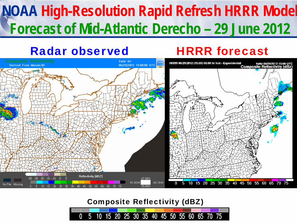
NOAA High-Resolution Rapid Refresh HRRR Model Forecast of Mid-Atlantic Derecho – 29 June 2012
Composite Reflectivity (dBZ)
Radar observed HRRR forecast
Derecho loop

Radar observed HRRR 12-h forecast
Composite Reflectivity (dBZ)
NOAA Next-Generation RAP / HRRR System Forecast of Mid-Atlantic Derecho – 29 June 2012
Valid 11PM EDT Real-time HRRR forecast
HRRR Experiment with 2011 RAP

2013 – add 3-km 15-min radar assimilation for HRRR
Now: radar data assimilation only in 13km RAP By Jan 2013: continued radar assimilation in RAP (13 km) + 1h radar assimilation in HRRR (at 3 km) before HRRR forecast begins Future: cycling with all obs (including radar) on HRRR (3-km) grid 3DVar and reflectivity-based temperature tendency, hybrid / ensemble assimilation and forecasting
RAP 13 km fcst
obs
radar data
fcst
HRRR 3 km fcst
t0−2 h t0−1 h t0 interpolation
radar data
radar data
radar data
radar data
3DVar + cloud analysis … …
HRRR reflectivity DA • same formulation of
reflectivity-based temperature tendency as in RAP
• no digital filter

HRRR Storm Skill: 20 dBZ radar reflectivity threshold
3-day retrospective period June 2011, forecasts every 2 hours composite reflectivity
verification over eastern half of US (widespread convective storms)
Critical Success Index (CSI) Bias
upscaled to 40-km grid native 3-km grid
2013 - with 3-km radar DA without 3-km radar DA
2013 - with 3-km radar DA without 3-km radar DA
Bias = 1.0

Composite Reflectivity
2200 UTC 11 June 2011
0-h fcst with 3-km radar DA
observations
0-h fcst without 3-km
radar DA
explicit precipitation from RAP
1000 km

Composite Reflectivity
2200 UTC 11 June 2011
0-h fcst with 3-km radar DA
0-h fcst without 3-km
radar DA
storms developed during HRRR cycling; locations were forced partly by reflectivity-
based heating
observations
1000 km

Composite Reflectivity
2300 UTC 11 June 2011
1-h fcst with 3-km radar DA
1-h fcst without 3-km
radar DA
mature convective systems benefit particularly from
subhourly radar DA
observations
1000 km

Composite Reflectivity
0100 UTC 12 June 2011
3-h fcst with 3-km radar DA
observations
3-h fcst without 3-km
radar DA
convective systems maturing;
errors apparent
1000 km

Composite Reflectivity
0100 UTC 12 June 2011
3-h fcst with 3-km radar DA
observations
3-h fcst without 3-km
radar DA
better representation of convective
character and location
1000 km

Composite Reflectivity
0400 UTC 12 June 2011
6-h fcst with 3-km radar DA
observations
6-h fcst without 3-km
radar DA
differences persist (cumulative effects
following from radar and/or other DA)
1000 km
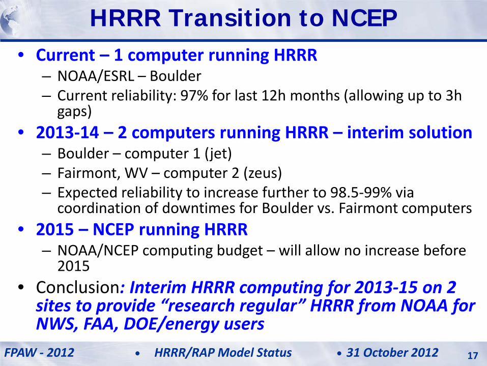
• Current – 1 computer running HRRR – NOAA/ESRL – Boulder – Current reliability: 97% for last 12h months (allowing up to 3h
gaps) • 2013-14 – 2 computers running HRRR – interim solution
– Boulder – computer 1 (jet) – Fairmont, WV – computer 2 (zeus) – Expected reliability to increase further to 98.5-99% via
coordination of downtimes for Boulder vs. Fairmont computers • 2015 – NCEP running HRRR
– NOAA/NCEP computing budget – will allow no increase before 2015
• Conclusion: Interim HRRR computing for 2013-15 on 2 sites to provide “research regular” HRRR from NOAA for NWS, FAA, DOE/energy users
HRRR Transition to NCEP
FPAW - 2012 31 October 2012 HRRR/RAP Model Status 17

HRRR 12 hr fcst availability Includes all missed/incomplete runs
Jet (HRRR feeding CoSPA) Zeus (HRRR backup) FPAW - 2012 31 October 2012 HRRR/RAP Model Status 18
Increasing reliability from HRRR running on zeus (Fairmont, WV computer)– for 2013

13km Rapid Refresh and 3km HRRR hourly updated weather models
ESRL – experimental version • RAPv1 – used in 2011
– Initialized 2011 HRRR – effective but too many storms
• RAPv2 – used in 2012 – Initialized 2012 HRRR – Better use of surface obs / radar,
storm bias eliminated • HRRR – 2012
– Major improvement over 2011 HRRR, storm coverage/accuracy
• HRRR – 2013 – 3km/15min radar assimilation – Initialized from RAP-2013 – Available 45 min earlier, much more
accurate 0-15h storm forecasts, more reliable 2-computer
NWS-NCEP - operational
• Implemented 1 May 2012 • RAPv2 - Scheduled to be
implemented in June 2013
• HRRR – estimated 2015
19

NOAA Next-Generation Global Model Development
FIM
iHYCOM
atmosphere
ocean iHYCOM – Icosahedral Hybrid Coordinate Ocean Model
- Matched grid design to FIM for coupled ocean- atmosphere prediction system
- Experimental testing at ESRL, Navy development
FIM – Flow-following finite volume Icosahedral Model
– “soccer-ball” grid design for uniform grid spacing
– New 14-day forecast twice daily – Real-time experimental at ESRL

Hurricane Isaac 7-day forecast track by FIM9 (15km) from Friday 24 Aug 18z run
Observed track for Isaac
Initial Position of Isaac – 18z 24 Aug

Eyjafjallajökull 2010: Comparison of FIM-Chem volcanic ash forecasts with London VAAC at 1800Z, April 17 and 0000Z, April 18

Why NOAA Weather Modeling Matters
Innovation to meet crucial societal needs: – Protecting lives and property
– Improving quality of life Aviation / Severe weather / Energy tornadoes hurricanes wind events floods winter storms air quality
What makes it possible - Improved model formulation
- Improved data assimilation - Increased computer power
HRRR
FIM