2011 annual work plan for master agreement for timber
TRANSCRIPT

v. 2.0 (5/2/2011)
1
2011 Annual Work Plan for Master Agreement for Timber Operations and
Road Management Waste Discharge Requirements
Pursuant to the Master Agreement for Timber Operations (MATO) (1600-2010-0114-R1) issued by the Department of Fish and Game (DFG) on May 18, 2010 and Road Management Waste Discharge Requirements (RMDR) (R1-2010-0044) issued by the North Coast Water Quality Control Board (NCWQCB) issued on June 10, 2010 an Annual Work Plan (AWP) is required to be submitted by Green Diamond Resource Co (GDRCo) describing all planned activities for 2011 for enrollment under these permits. The activities proposed under this AWP for sites not related to Timber Harvest Plans include watercourse crossing upgrading in the Hunter Creek, Terwer Creek, Mynot Creek, and Mad River drainages. These projects are being initiated per the Routine Road Maintenance standards under AHCP 6.2.3.9. The detailed site descriptions for all watercourse crossing sites can be found under the Road Work Order on pages 5 through 18 (Mad River) and on pages 87 through 171 (Klamath area). There is a significant amount of upgrading and decommissioning in this Annual Work Plan related to THPs. The sites included are within approved THPs, only. It is anticipated that additional sites will be amended to this Annual Work Plan as “New Site Revisions” as THPs are approved through the season. The detailed descriptions for the operating area south of Bald Hills Road can be found on pages 19 through 86 and the operating area north of Bald Hills Road can be found on pages 172 through 200. Water drafting activities are located in proximity to harvesting activities scheduled for 2011 on the property, specifically Little River, Maple Creek, North Fork Mad River, Ah-Pah Creek, Surpur Creek, Wilson Creek, Dominie Creek, and Rowdy Creek drainages. The notifications for these sites are the same notifications provided in the 2010 Annual Work Plan. Any site not previously included in a valid 1600-permit or the previous Annual Work Plan will be amended to this plan as “New Site Revisions”. The detailed descriptions for all water drafting sites can be found on pages 201 through 209. A monthly water drafting report will be submitted to DFG no later than 30 days after water drafting activities are reviewed and commence on the sites disclosed under this Plan. There are no in-stream restoration projects proposed. Maps and culvert calculations, where applicable, are located prior to the Road Work Orders for each distinct project area or THP. For sites associated with THPs the individual THP maps are included for each referenced plan. The review requirements for wildlife, plants, archaeology and non-fish aquatic vertebrates (refer to Section B and Attachments 1 through 3 of the MATO) are on-going.

v. 2.0 (5/2/2011)
2
To date, wildlife issues have been identified, specifically related to the northern spotted owl, willow fly catcher and marbled murrelet for non-THP projects. No operations will be conducted prior to official notification from GDRCo wildlife staff that seasonal restrictions can be lifted. Please refer to the Road Work Orders for specific species-related restrictions. Botantical surveys are on-going for non-THP projects. There have been no sensitive plant species identified to date. If specific operational restrictions are required for specific sites, then a Site Revision will be sent to DFG prior to the start of operations and CNDDB records submitted for qualifying plant species. No operations will be conducted prior to official notification from the GDRCo botanical staff that all surveys are complete and any mitigation measures are revised for any affected site. Requests for archaeological information related to Non-THP projects were sent to tribal organizations. To date GDRCo has not received any information indicating that Non-THP related projects would potentially affect any archaeological resources. Initial non-fish aquatic vertebrate surveys were completed on all sites included in this AWP. Staff herpetologists are currently reviewing the identified sites. Any mitigation measures performed at identified sites and results will be discussed in the 2011 Annual Work Report to be submitted on March 31, 2011. All sites included in this AWP for THP-related notifications shall follow all wildlife, botanical and archaeological restrictions set forth in the respective THPs. An Annual Report has been submitted to both agencies on March 31, 2011 summarizing the work completed in 2010. As a result of field review of this AWP revisions have been made to the first version submitted on March 1, 2011. A summary of these revisions are included below:
1. Site H400-03: DFG recommended that the proposed culvert size be increased to 48” diameter. The recommendation is included in the revised treatment for this site.
2. Site R32-01: DFG and NCWQCB recommended the option of cleaning the culvert with mitigation measures included to prevent significant sediment delivery from flushing of culvert be included in the proposed treatment. Additionally, NCWQCB recommended the site description be revised to reflect the current culvert diameter of 24”. These recommendations are included in the revised treatment for this site.
3. Site R32-03: DFG recommended that the site description be revised to state the current culvert is 60” in diameter. The recommendation is included in the site description for this site.
4. Site R32-04: DFG recommended that the proposed culvert size be increased to 36” diameter and to install a single-post trash rack. The recommendation is included in the revised treatment for this site.
5. Site T250-01: DFG recommended the outlet of the new culvert be armored. NCWQCB recommended that a Professional Geologist be on-site during installation of new crossing to direct the placement of the outlet. These recommendations are included in the revised treatment for this site.

v. 2.0 (5/2/2011)
3
6. Site T250-02: NCWQCB recommended the adjacent (left) in-board ditchline be rock armored if disturbed during crossing installation. The recommendation is included in the revised treatment for this site.
7. Site U10-26: DFG and NCWQCB recommended that a new site be included in the AWP (U-10-26.1) to install a culvert at the diverted watercourse located adjacent (left) to Site U10-26. This site is included in the New Site Revision submitted on May 2, 2011.
8. Site U430-01: DFG recommended that the proposed new culvert size be increased to 24” diameter. The recommendation is included in the revised treatment for this site.
9. Site U10-21: DFG recommended that excavation of the sediment wedge be limited to the area below the confluence of the main watercourse and a secondary watercourse which enters to the left. Additionally, the headcut will be armored, and extended to the inlet. Any trees removed during sediment wedge excavation will be placed stream-side outside the area of armor. The recommendation is included in the revised treatment for this site.
10. Non-THP Sites (all): All culvert sizes were recalculated for all Non-THP sites as a result of concerns related to passage of bedload and woody debris. Many proposed sizes were increased to account for this concern. No proposed sizes were decreased as a result of the calculations. Please refer to the culvert calculation reports included for each project which are located preceding the Road Work Orders.
Table 1. Fee summary.
Project Type Cost Per Project Total Number of
Projects Total Fee Annual Work Plan $1120.50 1 $1120.50
Class II/III $65.00 135 $8,775.00 Total $9,895.50
All fees have been paid. All correspondence should be directed to the following designated contact person for GDRCo: Jeremy Wright, RPF 2794 AHCP Roads Supervisor P.O Box 68 Korbel, California 95550 Email: [email protected] Office phone: (707) 668-4471 Mobile phone: (707) 498-9852

v. 2.0 (5/2/2011)
4
TABLE OF CONTENTS GDRCo # Date of Inclusion Page Number 4200/4100 Roads (Non-THP) 3/1/2011 5 THP #14-1001 3/1/2011 19 THP #14-1002 3/1/2011 35 THP #24-1002 3/1/2011 38 THP #40-1002 3/1/2011 40 THP #42-1004 3/1/2011 57 THP #45-1010 3/1/2011 71 THP #47-1012 3/1/2011 75 THP #47-1016 3/1/2011 83 H400/H410 Roads (Non-THP) 3/1/2011 87 H500/T900 Roads (Non-THP) 3/1/2011 102 T250/R32/Relim Right Spur Roads (Non-THP) 3/1/2011 115 U10/U430 Roads (Non-THP) 3/1/2011 137 T100 Road (Non-THP) 3/1/2011 152 THP #56-1001 3/1/2011 172 THP #56-1002 3/1/2011 175 THP #71-1001 3/1/2011 182 Water Drafting Sites 3/1/2011 201

DOG
DRY
MAD
SITE
CREEK
BLACK
CREEK
WATEK
CREEK
RIVER
VINCENT
SULLIVAN
LOW
4580
4540
5700
FLAT4250
5620
5750 57
10
4500
4530
4007
4008
40104020
4025
4030
4110
5600
4200 41284120
4200
4000
4040
4125
41454140
4100
4151
4150
4237
4230
4235
4200
5400
5000
XING421
03070
4100
4107
4190
4105
4000
3070
31203100
5850
5800
4200
4090
5600
5000
4230
4100
4100
4120
4200
4100
4100
5000
SWEET!>!>
!>!>
!>
!>
!>
!>!>
!>
!>!>
4100-05
4100-04
4100-02
4200-01
4200-02
4200-03
4200-04
4200-054200-09 4200-10
4200-07
4200-06
417000
417000
417500
417500
418000
418000
418500
418500
419000
419000
419500
419500
420000
420000
4519
500
4519
500
4520
000
4520
000
4520
500
4520
500
4521
000
4521
000
4521
500
4521
500
4522
000
4522
000
4522
500
4522
500
4523
000
4523
000
4523
500
4523
500
g2011 Annual Work Plan:
Road Work Required
Seasonal Road, Native SurfacePermanent Road, Rocked SurfaceClass I WatercourseClass II WatercourseClass III Watercourse
!> Project Site
¯RF 1:18,000
1 inch = 1,500 feetUTM Zone 10, NAD 1983
March 1, 2011
5
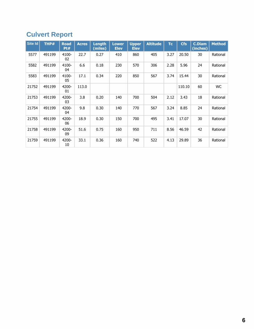
Site Id THP# Road Pt#
Acres Length(miles)
Lower Elev
Upper Elev
Altitude Tc Cfs C.Diam(inches)
Method
5577 491199 4100-02
22.7 0.27 410 860 405 3.27 20.50 30 Rational
5582 491199 4100-04
6.6 0.18 230 570 306 2.28 5.96 24 Rational
5583 491199 4100-05
17.1 0.34 220 850 567 3.74 15.44 30 Rational
21752 491199 4200-01
113.0 110.10 60 WC
21753 491199 4200-03
3.8 0.20 140 700 504 2.12 3.43 18 Rational
21754 491199 4200-04
9.8 0.30 140 770 567 3.24 8.85 24 Rational
21755 491199 4200-06
18.9 0.30 150 700 495 3.41 17.07 30 Rational
21758 491199 4200-09
51.6 0.75 160 950 711 8.56 46.59 42 Rational
21759 491199 4200-10
33.1 0.36 160 740 522 4.13 29.89 36 Rational
Culvert Report
6

CURRENT CONDITION : Class III watercourse crossing. Plastic pipe has become separated, water flows under culvert, outlet shotgunned, high plug potential, undersized, with diversion potential and a connected downcutting ditchline.
TREATMENT : Excavate xing from TOP to BOT install new 36" CMP to AHCP standards. Install 18"DRC 75ft to left
Excavated Volume 4124
Delivery Volume 2728
Disturbed Surface Area 4000
Erosion Potential
AHCP Priority High
Excavated materials Soil,Gravel,Rock and Wood
GDRCo#
State THP#
Road Point
Road Name
Road Class
UTM
Hydrologic Planning Area
Project Type
PreConsultation Completed?
Fees Payed From Previous AWP NO
NO
II/III
North Fork Mad River
RMA
N : 419359
Rock
4100
4100-02
E : 4522599
Powers CreekCalwater Watershed
Legal Description 05.0N 02.0E 04
N/A
2011
No Operations Prior to Wildlife Clearance
Willow Fly Catcher
Permanent Road Restrictions
NO
True
True
1600 Timing
Annual Plan Year
Work Timing
Wildlife Restrictions
Road Use Restrictions
Aquatic Habitat Survey Req?
ECP Req ?
1600 Req ?
Work Type
1109.100104
GDRCo Name AWP 2011
Annual Work Plan : Road Work Order Korbel
7
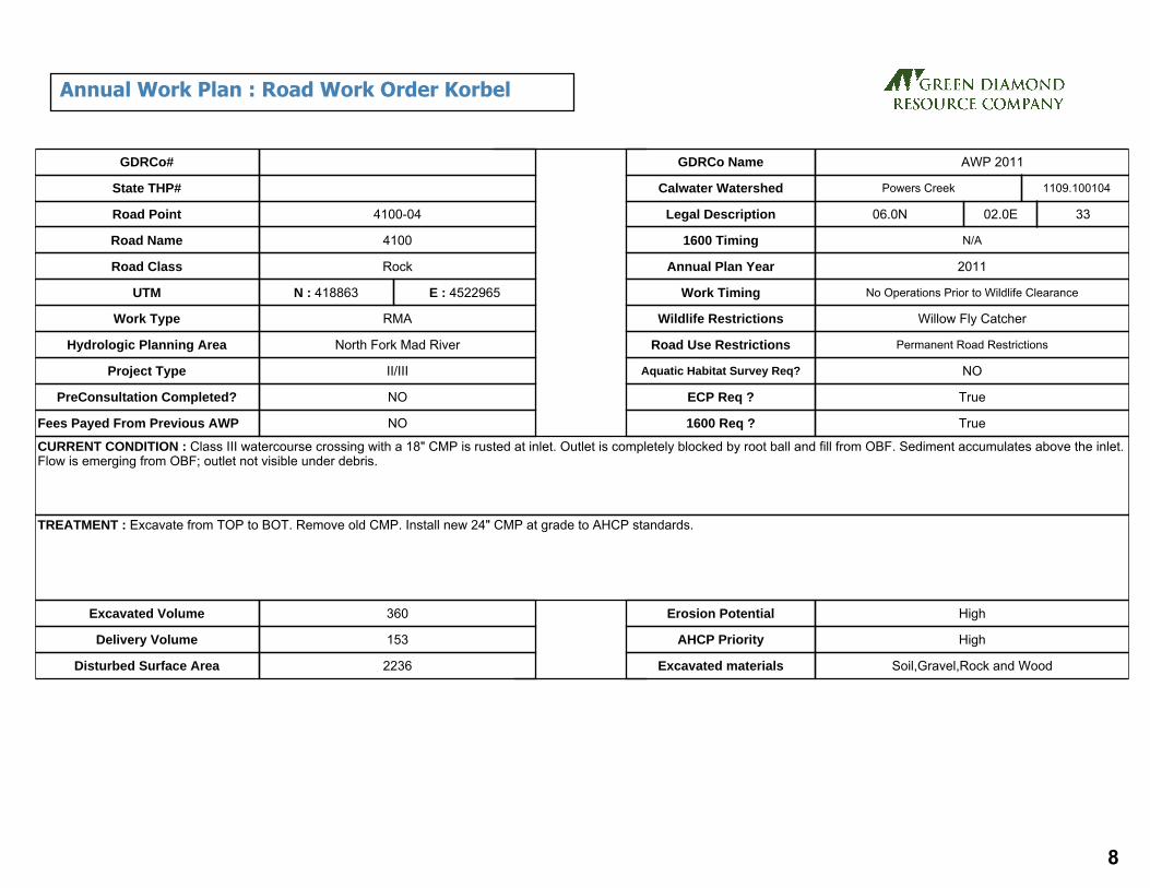
CURRENT CONDITION : Class III watercourse crossing with a 18" CMP is rusted at inlet. Outlet is completely blocked by root ball and fill from OBF. Sediment accumulates above the inlet. Flow is emerging from OBF; outlet not visible under debris.
TREATMENT : Excavate from TOP to BOT. Remove old CMP. Install new 24" CMP at grade to AHCP standards.
Excavated Volume 360
Delivery Volume 153
Disturbed Surface Area 2236
Erosion Potential High
AHCP Priority High
Excavated materials Soil,Gravel,Rock and Wood
GDRCo#
State THP#
Road Point
Road Name
Road Class
UTM
Hydrologic Planning Area
Project Type
PreConsultation Completed?
Fees Payed From Previous AWP NO
NO
II/III
North Fork Mad River
RMA
N : 418863
Rock
4100
4100-04
E : 4522965
Powers CreekCalwater Watershed
Legal Description 06.0N 02.0E 33
N/A
2011
No Operations Prior to Wildlife Clearance
Willow Fly Catcher
Permanent Road Restrictions
NO
True
True
1600 Timing
Annual Plan Year
Work Timing
Wildlife Restrictions
Road Use Restrictions
Aquatic Habitat Survey Req?
ECP Req ?
1600 Req ?
Work Type
1109.100104
GDRCo Name AWP 2011
Annual Work Plan : Road Work Order Korbel
8

CURRENT CONDITION : Class II stream crossing with 50% plugged CMP inlet. Shotgun outlet is rusting out with holes.
TREATMENT : Excavate crossing from TOP to BOT. Replace with 36" CMP to AHCP standards.
Excavated Volume 727
Delivery Volume 459
Disturbed Surface Area 1200
Erosion Potential
AHCP Priority High
Excavated materials Soil,Gravel,Rock and Wood
GDRCo#
State THP#
Road Point
Road Name
Road Class
UTM
Hydrologic Planning Area
Project Type
PreConsultation Completed?
Fees Payed From Previous AWP NO
NO
II/III
North Fork Mad River
RMA
N : 418833
Rock
4100
4100-05
E : 4523009
Powers CreekCalwater Watershed
Legal Description 06.0N 02.0E 33
N/A
2011
No Operations Prior to Wildlife Clearance
Willow Fly Catcher
Permanent Road Restrictions
NO
True
True
1600 Timing
Annual Plan Year
Work Timing
Wildlife Restrictions
Road Use Restrictions
Aquatic Habitat Survey Req?
ECP Req ?
1600 Req ?
Work Type
1109.100104
GDRCo Name AWP 2011
Annual Work Plan : Road Work Order Korbel
9

CURRENT CONDITION : Class2 xing with a 48" concrete pipe, pipe is seperating at last 4ft section. Outlet is shotgunned and causing OBF erosion.
TREATMENT : Excavate from TOP to BOT, remove old concrete pipe. Install new 60" CMP @ grade to AHCP standards. Install critical dip, rock armor OBF, IBF and side slopes below outlet.
Excavated Volume 355
Delivery Volume 286
Disturbed Surface Area 1297
Erosion Potential Medium
AHCP Priority High
Excavated materials Soil,Gravel,Rock and Wood
GDRCo#
State THP#
Road Point
Road Name
Road Class
UTM
Hydrologic Planning Area
Project Type
PreConsultation Completed?
Fees Payed From Previous AWP NO
NO
II/III
Mad River
RMA
N : 417436
Rock
4200
4200-01
E : 4522009
Powers CreekCalwater Watershed
Legal Description 05.0N 02.0E 05
N/A
2011
No Operations Prior to Wildlife Clearance
Willow Fly Catcher
Permanent Road Restrictions
NO
True
True
1600 Timing
Annual Plan Year
Work Timing
Wildlife Restrictions
Road Use Restrictions
Aquatic Habitat Survey Req?
ECP Req ?
1600 Req ?
Work Type
1109.100104
GDRCo Name AWP 2011
Annual Work Plan : Road Work Order Korbel
10

CURRENT CONDITION : Ditchline blocked/ change in topography causes water to run through road. This has caused a large sink hole in the road.
TREATMENT : Install a 18" CMP DRC at current sinkhole location. Rebuild road prism using rock. Place rock below outlet.
Excavated Volume
Delivery Volume
Disturbed Surface Area
Erosion Potential
AHCP Priority High
Excavated materials
GDRCo#
State THP#
Road Point
Road Name
Road Class
UTM
Hydrologic Planning Area
Project Type
PreConsultation Completed?
Fees Payed From Previous AWP NO
NO
II/III
Mad River
RMA
N : 417447
Rock
4200
4200-02
E : 4521944
Lower Cannon CreekCalwater Watershed
Legal Description 05.0N 02.0E 05
N/A
2011
No Operations Prior to Wildlife Clearance
Willow Fly Catcher
Permanent Road Restrictions
NO
True
1600 Timing
Annual Plan Year
Work Timing
Wildlife Restrictions
Road Use Restrictions
Aquatic Habitat Survey Req?
ECP Req ?
1600 Req ?
Work Type
1109.300602
GDRCo Name AWP 2011
Annual Work Plan : Road Work Order Korbel
11

CURRENT CONDITION : Class III watercourse crossing has an 18" CMP that is partially plugged at inlet.
TREATMENT : Excavate from TOP to BOT. Remove old CMP. Install new 30" CMP at grade to AHCP standards. Excavate material from ditch and rock ditch.
Excavated Volume 62
Delivery Volume 44
Disturbed Surface Area 200
Erosion Potential High
AHCP Priority Medium
Excavated materials Soil,Gravel,Rock and Wood
GDRCo#
State THP#
Road Point
Road Name
Road Class
UTM
Hydrologic Planning Area
Project Type
PreConsultation Completed?
Fees Payed From Previous AWP NO
NO
II/III
Mad River
RMA
N : 417596
Rock
4200
4200-03
E : 4521389
Lower Cannon CreekCalwater Watershed
Legal Description 05.0N 02.0E 05
N/A
2011
No Operations Prior to Wildlife Clearance
Willow Fly Catcher
Permanent Road Restrictions
NO
True
True
1600 Timing
Annual Plan Year
Work Timing
Wildlife Restrictions
Road Use Restrictions
Aquatic Habitat Survey Req?
ECP Req ?
1600 Req ?
Work Type
1109.300602
GDRCo Name AWP 2011
Annual Work Plan : Road Work Order Korbel
12

CURRENT CONDITION : Class III watercourse with an 18" CMP. Inlet has been buried in the past and was re-opened with the top torn out to allow more water passage. Outlet is shotgunned with flow at outlet fallling approximately 20' down to the floodplain of Mad River.
TREATMENT : Excavate from TOP to BOT install new 24" CMP to AHCP standards.
Excavated Volume 158
Delivery Volume 115
Disturbed Surface Area 300
Erosion Potential High
AHCP Priority
Excavated materials Soil,Gravel,Rock and Wood
GDRCo#
State THP#
Road Point
Road Name
Road Class
UTM
Hydrologic Planning Area
Project Type
PreConsultation Completed?
Fees Payed From Previous AWP NO
NO
II/III
Mad River
RMA
N : 417606
Rock
4200
4200-04
E : 4521287
Lower Cannon CreekCalwater Watershed
Legal Description 05.0N 02.0E 08
N/A
2011
No Operations Prior to Wildlife Clearance
Willow Fly Catcher
Permanent Road Restrictions
NO
True
True
1600 Timing
Annual Plan Year
Work Timing
Wildlife Restrictions
Road Use Restrictions
Aquatic Habitat Survey Req?
ECP Req ?
1600 Req ?
Work Type
1109.300602
GDRCo Name AWP 2011
Annual Work Plan : Road Work Order Korbel
13

CURRENT CONDITION : Water from ditch line is flowing through road. Water enters through a 6" hole in IBF. No outlet was visible.
TREATMENT : Install 18" DRC to AHCP standards rock armor below outlet.
Excavated Volume
Delivery Volume
Disturbed Surface Area
Erosion Potential
AHCP Priority
Excavated materials
GDRCo#
State THP#
Road Point
Road Name
Road Class
UTM
Hydrologic Planning Area
Project Type
PreConsultation Completed?
Fees Payed From Previous AWP NO
NO
II/III
Mad River
RMA
N : 417666
Rock
4200
4200-05
E : 4521057
Lower Cannon CreekCalwater Watershed
Legal Description 05.0N 02.0E 08
N/A
2011
No Operations Prior to Wildlife Clearance
Willow Fly Catcher
Permanent Road Restrictions
NO
True
1600 Timing
Annual Plan Year
Work Timing
Wildlife Restrictions
Road Use Restrictions
Aquatic Habitat Survey Req?
ECP Req ?
1600 Req ?
Work Type
1109.300602
GDRCo Name AWP 2011
Annual Work Plan : Road Work Order Korbel
14

CURRENT CONDITION : Class III watercourse hits ditchline and diverts approximately 120' to an 18" aluminum culvert that has become separated with a sink hole developing in the outboard edge if the road.It should also be noted that below the road within the natural channel are a series of unstable features which make evident the need to continue to divert the watercourse rather than re-place it in its natural channel.
TREATMENT : Excavate from TOP to BOT instal new 36" CMP to AHCP standards. Recut and rockline ditch from natural channel down to CMP inlet.
Excavated Volume 103
Delivery Volume 77
Disturbed Surface Area 853
Erosion Potential Medium
AHCP Priority
Excavated materials Soil,Gravel,Rock and Wood
GDRCo#
State THP#
Road Point
Road Name
Road Class
UTM
Hydrologic Planning Area
Project Type
PreConsultation Completed?
Fees Payed From Previous AWP NO
NO
II/III
Mad River
RMA
N : 418567
Rock
4200
4200-06
E : 4520760
Lower Cannon CreekCalwater Watershed
Legal Description 05.0N 02.0E 09
N/A
2011
No Operations Prior to Wildlife Clearance
Willow Fly Catcher
Permanent Road Restrictions
NO
True
True
1600 Timing
Annual Plan Year
Work Timing
Wildlife Restrictions
Road Use Restrictions
Aquatic Habitat Survey Req?
ECP Req ?
1600 Req ?
Work Type
1109.300602
GDRCo Name AWP 2011
Annual Work Plan : Road Work Order Korbel
15

CURRENT CONDITION : A DRC, buried at inlet, with long left road ditch. Flow gullies on outboard fill.
TREATMENT : Install 24" DRC to AHCP standards, dig out inlet basin.
Excavated Volume
Delivery Volume
Disturbed Surface Area
Erosion Potential
AHCP Priority High
Excavated materials
GDRCo#
State THP#
Road Point
Road Name
Road Class
UTM
Hydrologic Planning Area
Project Type
PreConsultation Completed?
Fees Payed From Previous AWP NO
NO
II/III
Mad River
RMA
N : 418593
Rock
4200
4200-07
E : 4520779
Lower Cannon CreekCalwater Watershed
Legal Description 05.0N 02.0E 09
N/A
2011
No Operations Prior to Wildlife Clearance
Willow Fly Catcher
Permanent Road Restrictions
NO
True
False
1600 Timing
Annual Plan Year
Work Timing
Wildlife Restrictions
Road Use Restrictions
Aquatic Habitat Survey Req?
ECP Req ?
1600 Req ?
Work Type
1109.300602
GDRCo Name AWP 2011
Annual Work Plan : Road Work Order Korbel
16

CURRENT CONDITION : 24" CMP on Class II watercourse with springs beside inlet providing year round flow. Inlet has high plug potential due to the heavy debris load brought down by a past debris torrent in the channel.A second smaller CMP inlet is burried, and shotgunned outlet is visible stickoug out of the outboard fill at a 45 degree angle from the natural channel alignment. Functioning 24" CMP also has a shotgunned outlet with a past erosional void and evidence of flow under culvert.
TREATMENT : Excavate from TOP to BOT install new 42" CMP @ grade to AHCP standards
Excavated Volume 146
Delivery Volume 86
Disturbed Surface Area 440
Erosion Potential Medium
AHCP Priority High
Excavated materials Soil,Gravel,Rock and Wood
GDRCo#
State THP#
Road Point
Road Name
Road Class
UTM
Hydrologic Planning Area
Project Type
PreConsultation Completed?
Fees Payed From Previous AWP NO
NO
II/III
Mad River
RMA
N : 419294
Rock
4200
4200-09
E : 4520924
Lower Cannon CreekCalwater Watershed
Legal Description 05.0N 02.0E 09
N/A
2011
No Operations Prior to Wildlife Clearance
Willow Fly Catcher
Permanent Road Restrictions
NO
True
True
1600 Timing
Annual Plan Year
Work Timing
Wildlife Restrictions
Road Use Restrictions
Aquatic Habitat Survey Req?
ECP Req ?
1600 Req ?
Work Type
1109.300602
GDRCo Name AWP 2011
Annual Work Plan : Road Work Order Korbel
17

CURRENT CONDITION : 24" CMP on a Class II watercourse atop a Humboldt crossing. Sediment wedge above inlet, channel agraded above top flag. Inlet of culvert is 80% plugged with sediment and a small hole (approximately 6" wide, 12" deep, and a couple of feet deep) is visible to the left of the inlet. On the outboard edge of the road, in-line with the small hole near the inlet, is a larger sink hole (approximately 3' wide, 4' long and 4' deep). The outlet of the pipe is shotgunned with an approximate 12' drop and no energy dissipaters.
TREATMENT : Excavate from TOP to BOT remove old CMP and wood install new 42" CMP @ grade to AHCP standards.
Excavated Volume 718
Delivery Volume 548
Disturbed Surface Area 2845
Erosion Potential High
AHCP Priority High
Excavated materials Soil,Gravel,Rock and Wood
GDRCo#
State THP#
Road Point
Road Name
Road Class
UTM
Hydrologic Planning Area
Project Type
PreConsultation Completed?
Fees Payed From Previous AWP NO
NO
II/III
Mad River
RMA
N : 419529
Rock
4200
4200-10
E : 4520912
Lower Cannon CreekCalwater Watershed
Legal Description 05.0N 02.0E 09
N/A
2011
No Operations Prior to Wildlife Clearance
Willow Fly Catcher
Permanent Road Restrictions
NO
True
True
1600 Timing
Annual Plan Year
Work Timing
Wildlife Restrictions
Road Use Restrictions
Aquatic Habitat Survey Req?
ECP Req ?
1600 Req ?
Work Type
1109.300602
GDRCo Name AWP 2011
Annual Work Plan : Road Work Order Korbel
18

19

Site Id THP# Road Pt#
Acres Length(miles)
Lower Elev
Upper Elev
Altitude Tc Cfs C.Diam(inches)
Method
12383 141001 01 9.2 0.24 300 630 297 3.21 10.24 24 Rational
12393 141001 08 9.1 0.30 610 810 180 5.04 10.13 24 Rational
Culvert Report
20

CURRENT CONDITION : Class III watercourse crossing with erosional void and flow under culvert.
TREATMENT : Install new 24 inch culvert crossing to THP and FPR standards. Road approach surfaces on the following shall be treated with either: rock, slash, seed and straw mulch, seed and stabilized straw, or seed and slash: (i) all seasonal roads used for hauling in the current year (ii) all seasonal roads used from October 16* to May 14* for purposes other than hauling
Excavated Volume 612
Delivery Volume 439
Disturbed Surface Area 1200
Erosion Potential High
AHCP Priority Medium
Excavated materials Soil,Gravel,Rock and Wood
GDRCo#
State THP#
Road Point
Road Name
Road Class
UTM
Hydrologic Planning Area
Project Type
PreConsultation Completed?
Fees Payed From Previous AWP NO
NO
II/III
Humboldt Bay
THP
N : 401274
Native
S1000
01
1-10-113
141001
E : 4501687
Middle Salmon CreekCalwater Watershed
Legal Description 03.0N 01.0W 10
N/A
2011
N/A
NONE
Seasonal Road Restrictions
NO
True
True
1600 Timing
Annual Plan Year
Work Timing
Wildlife Restrictions
Road Use Restrictions
Aquatic Habitat Survey Req?
ECP Req ?
1600 Req ?
Work Type
1110.000604
GDRCo Name S2100 '11
Annual Work Plan : Road Work Order Korbel
21

CURRENT CONDITION : Previously pulled Class III watercourse crossing (1-02-149H). Fill was not pulled to grade and has a sink hole in the bottom of the channel.
TREATMENT : Prior to operations, a temporary watercourse crossing shall be installed. If water is present at time of operations, a temporary pipe of adequate size to transmit flows present shall be installed in the crossing The existing crossing shall be abandoned to THP and FRP standards.
Excavated Volume
Delivery Volume
Disturbed Surface Area 1800
Erosion Potential
AHCP Priority
Excavated materials Soil,Gravel,Rock and Wood
GDRCo#
State THP#
Road Point
Road Name
Road Class
UTM
Hydrologic Planning Area
Project Type
PreConsultation Completed?
Fees Payed From Previous AWP NO
NO
II/III
Humboldt Bay
THP
N : 401545
Native
S1000spur1
02
1-10-113
141001
E : 4501866
Middle Salmon CreekCalwater Watershed
Legal Description 03.0N 01.0W 10
N/A
2011
N/A
NONE
Seasonal Road Restrictions
NO
True
True
1600 Timing
Annual Plan Year
Work Timing
Wildlife Restrictions
Road Use Restrictions
Aquatic Habitat Survey Req?
ECP Req ?
1600 Req ?
Work Type
1110.000604
GDRCo Name S2100 '11
Annual Work Plan : Road Work Order Korbel
22

CURRENT CONDITION : Humboldt crossing on a Class II watercourse has failed. Some deliverable road fill and debris remain.
TREATMENT : Prior to operations temporary crossing shall be constructed for operational use. If water is present at time of operations, a temporary pipe of adequate size to transmit flows present shall be installed in the crossing The existing crossing shall be abandoned to THP and FPR standards.
Excavated Volume 410
Delivery Volume 362
Disturbed Surface Area 2200
Erosion Potential Medium
AHCP Priority Medium
Excavated materials Soil,Gravel,Rock and Wood
GDRCo#
State THP#
Road Point
Road Name
Road Class
UTM
Hydrologic Planning Area
Project Type
PreConsultation Completed?
Fees Payed From Previous AWP NO
NO
II/III
Humboldt Bay
THP
N : 401586
Native
S1000spur1
03
1-10-113
141001
E : 4501903
Middle Salmon CreekCalwater Watershed
Legal Description 03.0N 01.0W 10
N/A
2011
N/A
NONE
Seasonal Road Restrictions
NO
True
True
1600 Timing
Annual Plan Year
Work Timing
Wildlife Restrictions
Road Use Restrictions
Aquatic Habitat Survey Req?
ECP Req ?
1600 Req ?
Work Type
1110.000604
GDRCo Name S2100 '11
Annual Work Plan : Road Work Order Korbel
23

CURRENT CONDITION : Existing Humboldt crossing on a Class III watercourse with sink holes throughout.
TREATMENT : Prior to operations, a temporary watercourse crossing shall be installed. If water is present at time of operations, a temporary pipe of adequate size to transmit flows present shall be installed in the crossing. Existing crossing shall be abandoned to THP and FPR standards.
Excavated Volume 733
Delivery Volume 621
Disturbed Surface Area 1800
Erosion Potential Medium
AHCP Priority Medium
Excavated materials Soil,Gravel,Rock and Wood
GDRCo#
State THP#
Road Point
Road Name
Road Class
UTM
Hydrologic Planning Area
Project Type
PreConsultation Completed?
Fees Payed From Previous AWP NO
NO
II/III
Humboldt Bay
THP
N : 401695
Native
S1000spur1
07
1-10-113
141001
E : 4502158
Middle Salmon CreekCalwater Watershed
Legal Description 03.0N 01.0W 10
N/A
2011
N/A
NONE
Seasonal Road Restrictions
NO
True
True
1600 Timing
Annual Plan Year
Work Timing
Wildlife Restrictions
Road Use Restrictions
Aquatic Habitat Survey Req?
ECP Req ?
1600 Req ?
Work Type
1110.000604
GDRCo Name S2100 '11
Annual Work Plan : Road Work Order Korbel
24

CURRENT CONDITION : Failing Humboldt crossing on Class III watercourse.
TREATMENT : Abandon crossing to THP and FPR standards.
Excavated Volume
Delivery Volume
Disturbed Surface Area 1000
Erosion Potential
AHCP Priority
Excavated materials Soil,Gravel,Rock and Wood
GDRCo#
State THP#
Road Point
Road Name
Road Class
UTM
Hydrologic Planning Area
Project Type
PreConsultation Completed?
Fees Payed From Previous AWP NO
NO
II/III
Humboldt Bay
THP
N : 401693
Native
S1000spur1
07.1
1-10-113
141001
E : 4502251
Middle Salmon CreekCalwater Watershed
Legal Description 03.0N 01.0W 03
N/A
2011
N/A
NONE
Seasonal Road Restrictions
NO
True
True
1600 Timing
Annual Plan Year
Work Timing
Wildlife Restrictions
Road Use Restrictions
Aquatic Habitat Survey Req?
ECP Req ?
1600 Req ?
Work Type
1110.000604
GDRCo Name S2100 '11
Annual Work Plan : Road Work Order Korbel
25

CURRENT CONDITION : Class III watercourse crossing with a 24 inch CMP and downspout. The culvert is rusted through greater than 25% of the length of the culvert with erosional void under outlet.
TREATMENT : Install new crossing with a 24 inch culvert to THP and FPR standards. Road approach surfaces on the following shall be treated with either: rock, slash, seed and straw mulch, seed and stabilized straw, or seed and slash: (i) all seasonal roads used for hauling in the current year (ii) all seasonal roads used from October 16* to May 14* for purposes other than hauling
Excavated Volume 621
Delivery Volume 494
Disturbed Surface Area
Erosion Potential Medium
AHCP Priority Medium
Excavated materials
GDRCo#
State THP#
Road Point
Road Name
Road Class
UTM
Hydrologic Planning Area
Project Type
PreConsultation Completed?
Fees Payed From Previous AWP NO
NO
II/III
Humboldt Bay
THP
N : 401382
Native
S2100
08
1-10-113
141001
E : 4502368
Middle Salmon CreekCalwater Watershed
Legal Description 03.0N 01.0W 03
N/A
2011
N/A
NONE
Seasonal Road Restrictions
NO
True
True
1600 Timing
Annual Plan Year
Work Timing
Wildlife Restrictions
Road Use Restrictions
Aquatic Habitat Survey Req?
ECP Req ?
1600 Req ?
Work Type
1110.000604
GDRCo Name S2100 '11
Annual Work Plan : Road Work Order Korbel
26

CURRENT CONDITION : Class III watercourse crossing with a 36 inch CMP and half-round downspout. Windfall has smashed the downspout and is obstructing the outlet of the culvert.
TREATMENT : The trees shall be removed and the downspout shall either be repaired or replaced with energy dissipater. Road approach surfaces on the following shall be treated with either: rock, slash, seed and straw mulch, seed and stabilized straw, or seed and slash: (i) all seasonal roads used for hauling in the current year (ii) all seasonal roads used from October 16* to May 14* for purposes other than hauling
Excavated Volume
Delivery Volume
Disturbed Surface Area
Erosion Potential
AHCP Priority NAP
Excavated materials
GDRCo#
State THP#
Road Point
Road Name
Road Class
UTM
Hydrologic Planning Area
Project Type
PreConsultation Completed?
Fees Payed From Previous AWP NO
NO
II/III
Humboldt Bay
THP
N : 401199
Native
S2100
09
1-10-113
141001
E : 4502691
Middle Salmon CreekCalwater Watershed
Legal Description 03.0N 01.0W 03
N/A
2011
N/A
NONE
Seasonal Road Restrictions
NO
True
1600 Timing
Annual Plan Year
Work Timing
Wildlife Restrictions
Road Use Restrictions
Aquatic Habitat Survey Req?
ECP Req ?
1600 Req ?
Work Type
1110.000604
GDRCo Name S2100 '11
Annual Work Plan : Road Work Order Korbel
27

CURRENT CONDITION : Class III watercourse crossing with a 24 inch plastic culvert. The inlet is buried.
TREATMENT : Clean inlet area. Road approach surfaces on the following shall be treated with either: rock, slash, seed and straw mulch, seed and stabilized straw, or seed and slash: (i) all seasonal roads used for hauling in the current year (ii) all seasonal roads used from October 16* to May 14* for purposes other than hauling
Excavated Volume
Delivery Volume
Disturbed Surface Area
Erosion Potential
AHCP Priority NAP
Excavated materials
GDRCo#
State THP#
Road Point
Road Name
Road Class
UTM
Hydrologic Planning Area
Project Type
PreConsultation Completed?
Fees Payed From Previous AWP NO
NO
II/III
Humboldt Bay
THP
N : 400419
Native
S2100
10
1-10-113
141001
E : 4502506
Middle Salmon CreekCalwater Watershed
Legal Description 03.0N 01.0W 03
N/A
2011
N/A
NONE
Seasonal Road Restrictions
NO
True
1600 Timing
Annual Plan Year
Work Timing
Wildlife Restrictions
Road Use Restrictions
Aquatic Habitat Survey Req?
ECP Req ?
1600 Req ?
Work Type
1110.000604
GDRCo Name S2100 '11
Annual Work Plan : Road Work Order Korbel
28

CURRENT CONDITION : Old Humboldt crossing on a legacy road with a 12 inch plastic pipe. The inlet of the pipe is currently obstructed. Most water likely flows under the pipe.
TREATMENT : The existing crossing is to be used as is for operations. The existing crossing shall be abandoned to THP and FPR standards.
Excavated Volume 887
Delivery Volume 710
Disturbed Surface Area 1800
Erosion Potential Medium
AHCP Priority Medium
Excavated materials Soil,Gravel,Rock and Wood
GDRCo#
State THP#
Road Point
Road Name
Road Class
UTM
Hydrologic Planning Area
Project Type
PreConsultation Completed?
Fees Payed From Previous AWP NO
NO
II/III
Humboldt Bay
THP
N : 400022
Native
S2170
13
1-10-113
141001
E : 4502592
Fields LandingCalwater Watershed
Legal Description 03.0N 01.0W 04
N/A
2011
N/A
NONE
Seasonal Road Restrictions
NO
True
True
1600 Timing
Annual Plan Year
Work Timing
Wildlife Restrictions
Road Use Restrictions
Aquatic Habitat Survey Req?
ECP Req ?
1600 Req ?
Work Type
1110.000603
GDRCo Name S2100 '11
Annual Work Plan : Road Work Order Korbel
29

CURRENT CONDITION : Fill crossing on a Class III watercourse.
TREATMENT : Prior to operations, a temporary watercourse crossing shall be installed. If water is present at time of operations, a temporary pipe of adequate size to transmit flows present shall be installed in the crossing. Temporary crossing shall be removed prior to the Winter Period.
Excavated Volume 290
Delivery Volume 210
Disturbed Surface Area 1600
Erosion Potential Medium
AHCP Priority Medium
Excavated materials Soil,Gravel,Rock and Wood
GDRCo#
State THP#
Road Point
Road Name
Road Class
UTM
Hydrologic Planning Area
Project Type
PreConsultation Completed?
Fees Payed From Previous AWP NO
NO
II/III
Humboldt Bay
THP
N : 399899
Native
S2170
14
1-10-113
141001
E : 4502501
Fields LandingCalwater Watershed
Legal Description 03.0N 01.0W 04
N/A
2011
N/A
NONE
Seasonal Road Restrictions
NO
True
True
1600 Timing
Annual Plan Year
Work Timing
Wildlife Restrictions
Road Use Restrictions
Aquatic Habitat Survey Req?
ECP Req ?
1600 Req ?
Work Type
1110.000603
GDRCo Name S2100 '11
Annual Work Plan : Road Work Order Korbel
30

CURRENT CONDITION : Existing fill crossing on a Class III watercourse.
TREATMENT : A temporary crossing shall be installed prior to operations. If water is present at time of operations, a temporary drain pipe of adequate size to transmit flows present shall be installed. Prior to the Winter Period, the crossing shall be abandoned to THP and FPR standards.
Excavated Volume 311
Delivery Volume 203
Disturbed Surface Area 1300
Erosion Potential Medium
AHCP Priority Medium
Excavated materials Soil,Gravel,Rock and Wood
GDRCo#
State THP#
Road Point
Road Name
Road Class
UTM
Hydrologic Planning Area
Project Type
PreConsultation Completed?
Fees Payed From Previous AWP NO
NO
II/III
Humboldt Bay
THP
N : 399865
Native
S2170
15
1-10-113
141001
E : 4502474
Fields LandingCalwater Watershed
Legal Description 03.0N 01.0W 04
N/A
2011
N/A
NONE
Seasonal Road Restrictions
NO
True
True
1600 Timing
Annual Plan Year
Work Timing
Wildlife Restrictions
Road Use Restrictions
Aquatic Habitat Survey Req?
ECP Req ?
1600 Req ?
Work Type
1110.000603
GDRCo Name S2100 '11
Annual Work Plan : Road Work Order Korbel
31

CURRENT CONDITION : Existing fill crossing on a Class III watercourse.
TREATMENT : A temporary crossing shall be installed prior to operations. If water is present at time of operations, a temporary drain pipe of adequate size to transmit flows present shall be installed. Prior to the Winter Period, the crossing shall be abandoned to THP and FPR standards.
Excavated Volume 189
Delivery Volume 99
Disturbed Surface Area
Erosion Potential Medium
AHCP Priority Medium
Excavated materials
GDRCo#
State THP#
Road Point
Road Name
Road Class
UTM
Hydrologic Planning Area
Project Type
PreConsultation Completed?
Fees Payed From Previous AWP NO
NO
II/III
Humboldt Bay
THP
N : 399795
Native
S2170
16
1-10-113
141001
E : 4502459
Fields LandingCalwater Watershed
Legal Description 03.0N 01.0W 04
N/A
2011
N/A
NONE
Seasonal Road Restrictions
NO
True
True
1600 Timing
Annual Plan Year
Work Timing
Wildlife Restrictions
Road Use Restrictions
Aquatic Habitat Survey Req?
ECP Req ?
1600 Req ?
Work Type
1110.000603
GDRCo Name S2100 '11
Annual Work Plan : Road Work Order Korbel
32

CURRENT CONDITION : Proposed temporary crossing on a Class III watercourse.
TREATMENT : Prior to operations, a temporary watercourse crossing shall be installed. If water is present at time of operations, a temporary pipe of adequate size to transmit flows present shall be installed in the crossing. Temporary crossing shall be removed prior to the Winter Period.
Excavated Volume
Delivery Volume
Disturbed Surface Area 200
Erosion Potential
AHCP Priority
Excavated materials Soil,Gravel,Rock and Wood
GDRCo#
State THP#
Road Point
Road Name
Road Class
UTM
Hydrologic Planning Area
Project Type
PreConsultation Completed?
Fees Payed From Previous AWP NO
NO
II/III
Humboldt Bay
THP
N : 399777
Native
S2170
17
1-10-113
141001
E : 4502482
Fields LandingCalwater Watershed
Legal Description 03.0N 01.0W 04
N/A
2011
N/A
NONE
Seasonal Road Restrictions
NO
False
True
1600 Timing
Annual Plan Year
Work Timing
Wildlife Restrictions
Road Use Restrictions
Aquatic Habitat Survey Req?
ECP Req ?
1600 Req ?
Work Type
1110.000603
GDRCo Name S2100 '11
Annual Work Plan : Road Work Order Korbel
33

CURRENT CONDITION : Failing fill crossing on a Class III watercourse.
TREATMENT : Prior to operations, a temporary crossing shall be installed. If water is present at time of operations, a temporary pipe of adequate size to transmit flows present shall be installed in the crossing. The crossing shall be abandoned prior to the Winter Period.
Excavated Volume 740
Delivery Volume 511
Disturbed Surface Area 1800
Erosion Potential Medium
AHCP Priority Medium
Excavated materials Soil,Gravel,Rock and Wood
GDRCo#
State THP#
Road Point
Road Name
Road Class
UTM
Hydrologic Planning Area
Project Type
PreConsultation Completed?
Fees Payed From Previous AWP NO
NO
II/III
Humboldt Bay
THP
N : 399641
Native
S2170
18
1-10-113
141001
E : 4502430
Fields LandingCalwater Watershed
Legal Description 03.0N 01.0W 04
N/A
2011
N/A
NONE
Seasonal Road Restrictions
NO
True
True
1600 Timing
Annual Plan Year
Work Timing
Wildlife Restrictions
Road Use Restrictions
Aquatic Habitat Survey Req?
ECP Req ?
1600 Req ?
Work Type
1110.000603
GDRCo Name S2100 '11
Annual Work Plan : Road Work Order Korbel
34

35

Site Id THP# Road Pt#
Acres Length(miles)
Lower Elev
Upper Elev
Altitude Tc Cfs C.Diam(inches)
Method
8531 141002 058 8.7 0.24 920 1320 360 2.98 9.68 24 Rational
Culvert Report
36

CURRENT CONDITION : Ephemeral Class III watercourse was diverted from original channel during past logging activities. Currently, the water flows down an existing skid trail and crosses the existing road. This Watercourse flows subsurface and flows on the surface only during large storm events.
TREATMENT : Install a 24 inch culvert crossing to THP and FPR standards. The TOP of excavation shall be approximately 20 feet above the road and approximately 5 feet deep to capture the flow and to prevent future diversion. The BOT shall extend approximately 60 feet below the road to the existing channel. These TOP and BOT locations shall be flagged in the field prior to operations.
Excavated Volume 83
Delivery Volume 30
Disturbed Surface Area 1000
Erosion Potential Low
AHCP Priority Medium
Excavated materials Soil,Gravel,Rock and Wood
GDRCo#
State THP#
Road Point
Road Name
Road Class
UTM
Hydrologic Planning Area
Project Type
PreConsultation Completed?
Fees Payed From Previous AWP NO
NO
II/III
Humboldt Bay
THP
N : 406472
Native
S2541
058
1-10-107
141002
E : 4501368
Lower S. Fork Elk RiverCalwater Watershed
Legal Description 03.0N 01.0E 07
N/A
2011
N/A
NONE
Seasonal Road Restrictions
NO
True
1600 Timing
Annual Plan Year
Work Timing
Wildlife Restrictions
Road Use Restrictions
Aquatic Habitat Survey Req?
ECP Req ?
1600 Req ?
Work Type
1110.000302
GDRCo Name McCloud Creek #4
Annual Work Plan : Road Work Order Korbel
37

38

CURRENT CONDITION : Temporary crossing on a Class II watercourse.
TREATMENT : If water is flowing at the time of operations install a spittler or other temporary crossing of sufficient size to conduct flows present to allow equipment and truck passage. Decommission to FPR and THP standards prior to October 16th of the year of use.
Excavated Volume
Delivery Volume
Disturbed Surface Area 1500
Erosion Potential
AHCP Priority
Excavated materials Soil,Gravel,Rock and Wood
GDRCo#
State THP#
Road Point
Road Name
Road Class
UTM
Hydrologic Planning Area
Project Type
PreConsultation Completed?
Fees Payed From Previous AWP NO
NO
II/III
Mad River
THP
N : 427158
Native
241002TB1
01
1-10-096
241002
E : 4520243
Upper Cannon CreekCalwater Watershed
Legal Description 05.0N 03.0E 08
N/A
2011
N/A
NONE
Seasonal Road Restrictions
NO
True
1600 Timing
Annual Plan Year
Work Timing
Wildlife Restrictions
Road Use Restrictions
Aquatic Habitat Survey Req?
ECP Req ?
1600 Req ?
Work Type
1109.300603
GDRCo Name Ward RD 4 Pack
Annual Work Plan : Road Work Order Korbel
39

40

Culvert Report THP# Road Pt# Acres Length (miles)
Lower Elev
Upper Elev
Altitude Tc Cfs C.Diam (inches)
Method
401002 1 36 0.5 690 5 33 36 Rational 401002 2 23 0.5 690 5 21 30 Rational 401002 3 92 0.6 810 7 92 60 Rational 401002 4 9 0.6 930 6 8 24 Rational 401002 5 17 0.6 770 6 15 30401002 6 14 0.4 510 4 13 24 Rational 401002 7 6 0.2 350 3 5 24 Rational 401002 8 41 0.6 890 6 37 42 Rational 401002 9 17 0.4 520 5 15 30 Rational
41

CURRENT CONDITION : A Class II watercourse with a 12" CMP has a sediment wedge and an inlet that is completely buried by accumulated sediment. The watercourse has overtopped the road and gullied through the outboard fill, and there has been some past failure of the over steepened fill face as a result. The culvert is short and set high in the fill. There is some water emerging from the base of the fill, where old Humboldt logs emerge.
TREATMENT : Excavate from the flagged bottom to the flagged top, including the sediment wedge at the top and any buried logs. Install a 36" culvert that meets the standards of the FPRs and this THP on grade with drainage disconnect structures on both approaches to hydrologically disconnect the watercourse from the road .
Excavated Volume 1041
Delivery Volume 895
Disturbed Surface Area 3713
Erosion Potential High
AHCP Priority High
Excavated materials Soil,Gravel,Rock and Wood
GDRCo#
State THP#
Road Point
Road Name
Road Class
UTM
Hydrologic Planning Area
Project Type
PreConsultation Completed?
Fees Payed From Previous AWP NO
NO
II/III
North Fork Mad River
THP
N : 421667
Native
NF1100
01
1-10-094
401002
E : 4528280
Pollock CreekCalwater Watershed
Legal Description 06.0N 02.0E 15
N/A
2011
N/A
NONE
Seasonal Road Restrictions
NO
True
True
1600 Timing
Annual Plan Year
Work Timing
Wildlife Restrictions
Road Use Restrictions
Aquatic Habitat Survey Req?
ECP Req ?
1600 Req ?
Work Type
1109.200003
GDRCo Name NF1200 ‘11
Annual Work Plan : Road Work Order Korbel
42

CURRENT CONDITION : A Class II watercourse with a 30" CMP is mostly bypassed through the fill by flow around old Humboldt logs buried below the culvert. The culvert is set high in the fill and shotguns onto the toe of the fillslope when there is enough discharge to actually make it through the culvert. The watercourse makes a sharp angled turn at the inlet.
TREATMENT : Excavate from the flagged bottom to the flagged top, including any sediment accumulated at the top and any buried logs. Install a 30" culvert that meets the standards of the FPRs and this THP on the natural channel grade; OR excavate and remove the existing culvert and install a single 60" culvert for Points 2 & 3 that meets the standards of the FPRs and this THP on the natural channel grade
Excavated Volume 172
Delivery Volume 155
Disturbed Surface Area 986
Erosion Potential High
AHCP Priority High
Excavated materials Soil,Gravel,Rock and Wood
GDRCo#
State THP#
Road Point
Road Name
Road Class
UTM
Hydrologic Planning Area
Project Type
PreConsultation Completed?
Fees Payed From Previous AWP NO
NO
II/III
North Fork Mad River
THP
N : 421584
Native
NF1100
02
1-10-094
401002
E : 4528375
Pollock CreekCalwater Watershed
Legal Description 06.0N 02.0E 15
N/A
2011
N/A
NONE
Seasonal Road Restrictions
NO
True
True
1600 Timing
Annual Plan Year
Work Timing
Wildlife Restrictions
Road Use Restrictions
Aquatic Habitat Survey Req?
ECP Req ?
1600 Req ?
Work Type
1109.200003
GDRCo Name NF1200 ‘11
Annual Work Plan : Road Work Order Korbel
43

CURRENT CONDITION : A partially washed out Humboldt crossing on a Class II watercourse is not passable to vehicles. The channel has not yet cut completely down to grade and the sides remain over steepened.
TREATMENT : Excavate from the flagged bottom to the flagged top, including any sediment accumulated at the top and any buried logs. Install a 60" culvert that meets the standards of the FPRs and this THP on the natural channel grade. This installation may be combined with Point 2 as a single crossing. Install a drainage disconnect structure on the right approach to hydrologically disconnect the watercourse from the road.
Excavated Volume 1003
Delivery Volume 403
Disturbed Surface Area 3000
Erosion Potential High
AHCP Priority High
Excavated materials Soil,Gravel,Rock and Wood
GDRCo#
State THP#
Road Point
Road Name
Road Class
UTM
Hydrologic Planning Area
Project Type
PreConsultation Completed?
Fees Payed From Previous AWP NO
NO
II/III
North Fork Mad River
THP
N : 421573
Native
NF1100
03
1-10-094
401002
E : 4528375
Pollock CreekCalwater Watershed
Legal Description 06.0N 02.0E 15
N/A
2011
N/A
NONE
Seasonal Road Restrictions
NO
True
True
1600 Timing
Annual Plan Year
Work Timing
Wildlife Restrictions
Road Use Restrictions
Aquatic Habitat Survey Req?
ECP Req ?
1600 Req ?
Work Type
1109.200003
GDRCo Name NF1200 ‘11
Annual Work Plan : Road Work Order Korbel
44

CURRENT CONDITION : A crossing on a Class III watercourse lacks a drainage structure. Some water runs down the road to an adjacent area of instability approximately 75’ down the road to the left, and some overtops the road and erodes the outboard fill.
TREATMENT : Excavate from flagged bottom to flagged top and install a 24" culvert to that meets the standards of the FPRs and this THP on grade with a critical dip over the left hinge-line of the excavation and armor at the transition point near the inlet to minimize headcutting above. Or: Install a rocked ford that is armored past the transition in grade on the outboard edge of the road. Install a drainage disconnect structure on the right approach to hydrologically disconnect the watercourse from the road.
Excavated Volume 21
Delivery Volume 10
Disturbed Surface Area 299
Erosion Potential High
AHCP Priority High
Excavated materials Soil,Gravel,Rock and Wood
GDRCo#
State THP#
Road Point
Road Name
Road Class
UTM
Hydrologic Planning Area
Project Type
PreConsultation Completed?
Fees Payed From Previous AWP NO
NO
II/III
North Fork Mad River
THP
N : 421566
Native
NF1100
04
1-10-094
401002
E : 4528329
Pollock CreekCalwater Watershed
Legal Description 06.0N 02.0E 15
N/A
2011
N/A
NONE
Seasonal Road Restrictions
NO
True
True
1600 Timing
Annual Plan Year
Work Timing
Wildlife Restrictions
Road Use Restrictions
Aquatic Habitat Survey Req?
ECP Req ?
1600 Req ?
Work Type
1109.200003
GDRCo Name NF1200 ‘11
Annual Work Plan : Road Work Order Korbel
45
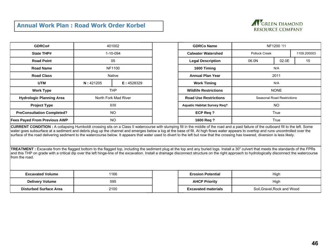
CURRENT CONDITION : A collapsing Humboldt crossing sits on a Class II watercourse with slumping fill in the middle of the road and a past failure of the outboard fill to the left. Some water goes subsurface at a sediment and debris plug up the channel and emerges below a log at the base of fill. At high flows water appears to overtop and runs uncontrolled over the surface of the road delivering sediment to the watercourse below. It appears that water used to divert to the left but now that the crossing has lowered, diversion is less likely.
TREATMENT : Excavate from the flagged bottom to the flagged top, including the sediment plug at the top and any buried logs. Install a 30" culvert that meets the standards of the FPRs and this THP on grade with a critical dip over the left hinge-line of the excavation. Install a drainage disconnect structure on the right approach to hydrologically disconnect the watercourse from the road.
Excavated Volume 1166
Delivery Volume 595
Disturbed Surface Area 2100
Erosion Potential High
AHCP Priority High
Excavated materials Soil,Gravel,Rock and Wood
GDRCo#
State THP#
Road Point
Road Name
Road Class
UTM
Hydrologic Planning Area
Project Type
PreConsultation Completed?
Fees Payed From Previous AWP NO
NO
II/III
North Fork Mad River
THP
N : 421205
Native
NF1100
05
1-10-094
401002
E : 4528329
Pollock CreekCalwater Watershed
Legal Description 06.0N 02.0E 15
N/A
2011
N/A
NONE
Seasonal Road Restrictions
NO
True
True
1600 Timing
Annual Plan Year
Work Timing
Wildlife Restrictions
Road Use Restrictions
Aquatic Habitat Survey Req?
ECP Req ?
1600 Req ?
Work Type
1109.200003
GDRCo Name NF1200 ‘11
Annual Work Plan : Road Work Order Korbel
46

CURRENT CONDITION : A 24" CMP on a Class II watercourse crossing has some rust holes and a separation at the joint which causes water to bypass the downspout below the outlet with some erosion underneath, but only a small erosional void so far. There are suspected Humboldt logs protruding from the base of the fill. Sediment has built up above the inlet due to the shallow culvert gradient.
TREATMENT : Excavate from the flagged bottom to the flagged top, including the sediment built up at the top and any buried logs. Install a 24" culvert that meets the standards of the FPRs and this THP on grade with a critical dip over the left hinge-line of the excavation.
Excavated Volume 277
Delivery Volume 188
Disturbed Surface Area 1300
Erosion Potential High
AHCP Priority High
Excavated materials Soil,Gravel,Rock and Wood
GDRCo#
State THP#
Road Point
Road Name
Road Class
UTM
Hydrologic Planning Area
Project Type
PreConsultation Completed?
Fees Payed From Previous AWP NO
NO
II/III
North Fork Mad River
THP
N : 422293
Native
NF1200
06
1-10-094
401002
E : 4528766
Pollock CreekCalwater Watershed
Legal Description 06.0N 02.0E 14
N/A
2011
N/A
NONE
Seasonal Road Restrictions
NO
True
True
1600 Timing
Annual Plan Year
Work Timing
Wildlife Restrictions
Road Use Restrictions
Aquatic Habitat Survey Req?
ECP Req ?
1600 Req ?
Work Type
1109.200003
GDRCo Name NF1200 ‘11
Annual Work Plan : Road Work Order Korbel
47
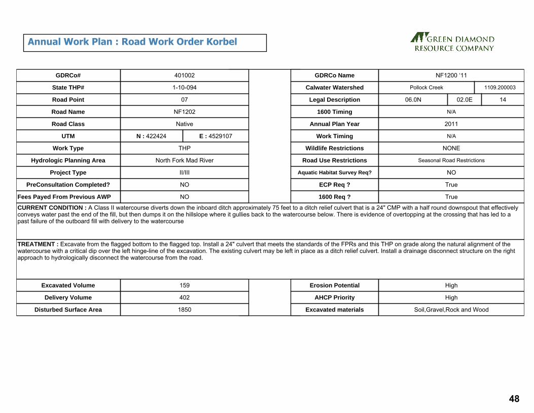
CURRENT CONDITION : A Class II watercourse diverts down the inboard ditch approximately 75 feet to a ditch relief culvert that is a 24" CMP with a half round downspout that effectively conveys water past the end of the fill, but then dumps it on the hillslope where it gullies back to the watercourse below. There is evidence of overtopping at the crossing that has led to a past failure of the outboard fill with delivery to the watercourse
TREATMENT : Excavate from the flagged bottom to the flagged top. Install a 24" culvert that meets the standards of the FPRs and this THP on grade along the natural alignment of the watercourse with a critical dip over the left hinge-line of the excavation. The existing culvert may be left in place as a ditch relief culvert. Install a drainage disconnect structure on the right approach to hydrologically disconnect the watercourse from the road.
Excavated Volume 159
Delivery Volume 402
Disturbed Surface Area 1850
Erosion Potential High
AHCP Priority High
Excavated materials Soil,Gravel,Rock and Wood
GDRCo#
State THP#
Road Point
Road Name
Road Class
UTM
Hydrologic Planning Area
Project Type
PreConsultation Completed?
Fees Payed From Previous AWP NO
NO
II/III
North Fork Mad River
THP
N : 422424
Native
NF1202
07
1-10-094
401002
E : 4529107
Pollock CreekCalwater Watershed
Legal Description 06.0N 02.0E 14
N/A
2011
N/A
NONE
Seasonal Road Restrictions
NO
True
True
1600 Timing
Annual Plan Year
Work Timing
Wildlife Restrictions
Road Use Restrictions
Aquatic Habitat Survey Req?
ECP Req ?
1600 Req ?
Work Type
1109.200003
GDRCo Name NF1200 ‘11
Annual Work Plan : Road Work Order Korbel
48

CURRENT CONDITION : A Class II watercourse has a 24" CMP with an extensive sediment wedge accumulated upstream of an inlet that is partially crushed. The culvert appears to be separated at an interior joint and water flows out underneath the culvert, bypassing the half round downspout. There are voids forming in the fill where the culvert has been bypassed and there is additional water emerging from the bottom of the fill, indicating that there may be old Humboldt logs buried below.
TREATMENT : Excavate from the flagged bottom to the flagged top, including the sediment wedge at the top and any buried logs. Install a 42" culvert that meets the standards of the FPRs and this THP on the natural watercourse grade. Install a drainage disconnect structure on the right approach to hydrologically disconnect the watercourse from the road.
Excavated Volume 1625
Delivery Volume 632
Disturbed Surface Area 2200
Erosion Potential High
AHCP Priority High
Excavated materials Soil,Gravel,Rock and Wood
GDRCo#
State THP#
Road Point
Road Name
Road Class
UTM
Hydrologic Planning Area
Project Type
PreConsultation Completed?
Fees Payed From Previous AWP NO
NO
II/III
North Fork Mad River
THP
N : 422404
Native
NF1202
08
1-10-094
401002
E : 4529268
Denman CreekCalwater Watershed
Legal Description 06.0N 02.0E 14
N/A
2011
N/A
NONE
Seasonal Road Restrictions
NO
True
True
1600 Timing
Annual Plan Year
Work Timing
Wildlife Restrictions
Road Use Restrictions
Aquatic Habitat Survey Req?
ECP Req ?
1600 Req ?
Work Type
1109.200001
GDRCo Name NF1200 ‘11
Annual Work Plan : Road Work Order Korbel
49

CURRENT CONDITION : A Class II watercourse with an 18" CMP has a sediment wedge and an inlet that is completely buried by accumulated sediment. The watercourse is diverted approximately 120’ to the right via the inboard ditch before it gullies across the road and outboard fill. The watercourse has also overtopped the road at the crossing site and there has been some past failure of the over steepened fill face as a result. The culvert is separated and is visible through a collapse hole in the center of the road. It is also short, set high in the fill and has a long half round downspout that is filled with debris from an old failure adjacent to the left. There is water emerging from the bottom of the fill, indicating that there may be old Humboldt logs buried below. TREATMENT : Excavate from the flagged bottom to the flagged top, including the sediment wedge at the top and any buried logs. Install a 30" culvert that meets the standards of the FPRs and this THP on grade with a critical dip over the right hinge-line of the excavation. Install a drainage disconnect structure on the left approach to hydrologically disconnect the watercourse from the road.
Excavated Volume 337
Delivery Volume 188
Disturbed Surface Area 1700
Erosion Potential High
AHCP Priority High
Excavated materials Soil,Gravel,Rock and Wood
GDRCo#
State THP#
Road Point
Road Name
Road Class
UTM
Hydrologic Planning Area
Project Type
PreConsultation Completed?
Fees Payed From Previous AWP NO
NO
II/III
North Fork Mad River
THP
N : 422241
Native
NF1200
09
1-10-094
401002
E : 4529159
Denman CreekCalwater Watershed
Legal Description 06.0N 02.0E 14
N/A
2011
N/A
NONE
Seasonal Road Restrictions
NO
True
True
1600 Timing
Annual Plan Year
Work Timing
Wildlife Restrictions
Road Use Restrictions
Aquatic Habitat Survey Req?
ECP Req ?
1600 Req ?
Work Type
1109.200001
GDRCo Name NF1200 ‘11
Annual Work Plan : Road Work Order Korbel
50

CURRENT CONDITION : A fill crossing on a Class II watercourse has overtopped. Water flows uncontrolled over the surface of the road and gullies through the outboard fill to the channel below.
TREATMENT : If water is flowing at the time of operations install a spittler or other temporary crossing of sufficient size to conduct flows present to allow equipment and truck passage. Excavate from the flagged bottom to the flagged top, including any sediment accumulated at the top and any buried logs. Abandon the crossing to the standards of the FPRs and this THP. Install a drainage disconnect structure on the right approach to hydrologically disconnect the watercourse from the road.
Excavated Volume 125
Delivery Volume 53
Disturbed Surface Area 1375
Erosion Potential High
AHCP Priority High
Excavated materials Soil,Gravel,Rock and Wood
GDRCo#
State THP#
Road Point
Road Name
Road Class
UTM
Hydrologic Planning Area
Project Type
PreConsultation Completed?
Fees Payed From Previous AWP NO
NO
II/III
North Fork Mad River
THP
N : 421532
Native
NF1410 spur
13
1-10-094
401002
E : 4528803
Pollock CreekCalwater Watershed
Legal Description 06.0N 02.0E 15
N/A
2011
N/A
NONE
Seasonal Road Restrictions
NO
True
True
1600 Timing
Annual Plan Year
Work Timing
Wildlife Restrictions
Road Use Restrictions
Aquatic Habitat Survey Req?
ECP Req ?
1600 Req ?
Work Type
1109.200003
GDRCo Name NF1200 ‘11
Annual Work Plan : Road Work Order Korbel
51
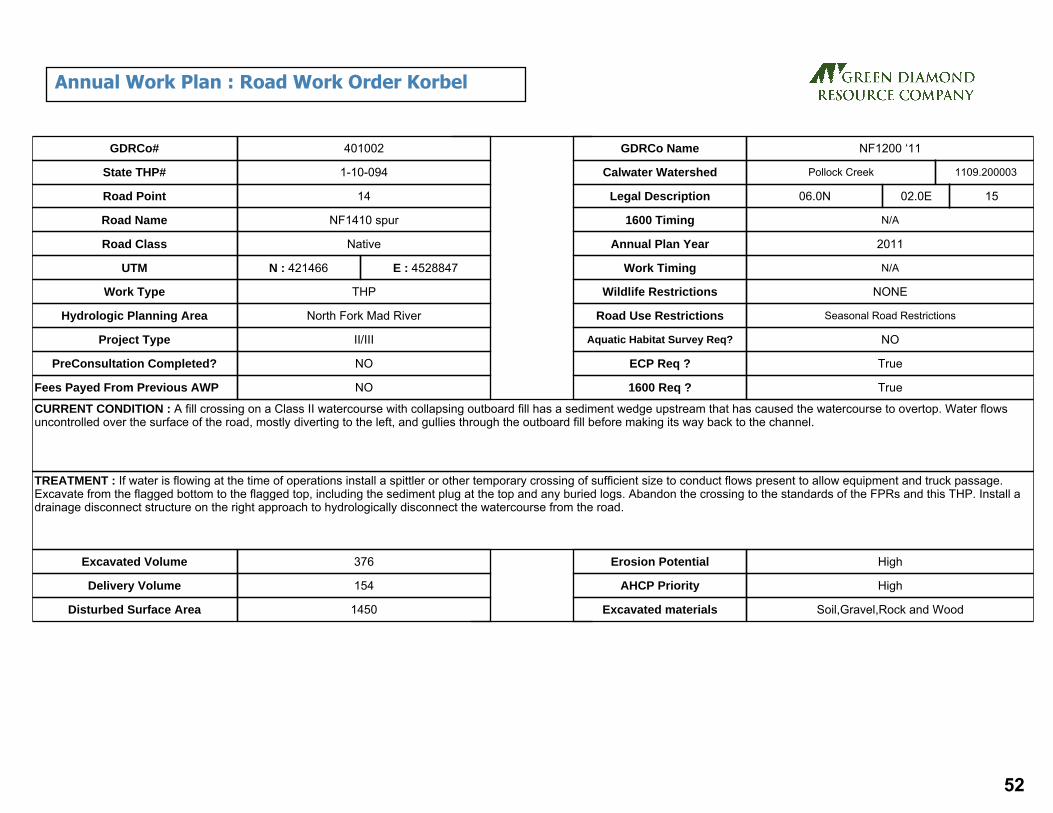
CURRENT CONDITION : A fill crossing on a Class II watercourse with collapsing outboard fill has a sediment wedge upstream that has caused the watercourse to overtop. Water flows uncontrolled over the surface of the road, mostly diverting to the left, and gullies through the outboard fill before making its way back to the channel.
TREATMENT : If water is flowing at the time of operations install a spittler or other temporary crossing of sufficient size to conduct flows present to allow equipment and truck passage. Excavate from the flagged bottom to the flagged top, including the sediment plug at the top and any buried logs. Abandon the crossing to the standards of the FPRs and this THP. Install a drainage disconnect structure on the right approach to hydrologically disconnect the watercourse from the road.
Excavated Volume 376
Delivery Volume 154
Disturbed Surface Area 1450
Erosion Potential High
AHCP Priority High
Excavated materials Soil,Gravel,Rock and Wood
GDRCo#
State THP#
Road Point
Road Name
Road Class
UTM
Hydrologic Planning Area
Project Type
PreConsultation Completed?
Fees Payed From Previous AWP NO
NO
II/III
North Fork Mad River
THP
N : 421466
Native
NF1410 spur
14
1-10-094
401002
E : 4528847
Pollock CreekCalwater Watershed
Legal Description 06.0N 02.0E 15
N/A
2011
N/A
NONE
Seasonal Road Restrictions
NO
True
True
1600 Timing
Annual Plan Year
Work Timing
Wildlife Restrictions
Road Use Restrictions
Aquatic Habitat Survey Req?
ECP Req ?
1600 Req ?
Work Type
1109.200003
GDRCo Name NF1200 ‘11
Annual Work Plan : Road Work Order Korbel
52

CURRENT CONDITION : A partially washed out Humboldt crossing on a Class II watercourse is not passable to vehicles. The channel has not yet cut completely down to grade and the sides remain over steepened.
TREATMENT : Abandon the remaining crossing to the standards of the FPRs and this THP as feasible.
Excavated Volume 308
Delivery Volume 108
Disturbed Surface Area 1600
Erosion Potential High
AHCP Priority High
Excavated materials Soil,Gravel,Rock and Wood
GDRCo#
State THP#
Road Point
Road Name
Road Class
UTM
Hydrologic Planning Area
Project Type
PreConsultation Completed?
Fees Payed From Previous AWP NO
NO
II/III
North Fork Mad River
THP
N : 421394
Native
NF1410 spur
16
1-10-094
401002
E : 4528914
Pollock CreekCalwater Watershed
Legal Description 06.0N 02.0E 15
N/A
2011
N/A
NONE
Seasonal Road Restrictions
NO
True
True
1600 Timing
Annual Plan Year
Work Timing
Wildlife Restrictions
Road Use Restrictions
Aquatic Habitat Survey Req?
ECP Req ?
1600 Req ?
Work Type
1109.200003
GDRCo Name NF1200 ‘11
Annual Work Plan : Road Work Order Korbel
53

CURRENT CONDITION : A collapsing Humboldt crossing sits on a Class II watercourse with sinkholes and slumping fill in the road and outboard fill. Some water goes subsurface at a sediment wedge and emerges below a log at the base of fill. There is direct delivery of sediment to the watercourse below. This site is currently impassable to vehicles.
TREATMENT : If water is flowing at the time of operations install a spittler or other temporary crossing of sufficient size to conduct flows present to allow equipment and truck passage. Excavate from the flagged bottom to the flagged top and abandon the crossing to the standards of the FPRs and this THP. Install drainage disconnect structures on both approaches to hydrologically disconnect the watercourse from the road.
Excavated Volume 427
Delivery Volume 172
Disturbed Surface Area 850
Erosion Potential High
AHCP Priority High
Excavated materials Soil,Gravel,Rock and Wood
GDRCo#
State THP#
Road Point
Road Name
Road Class
UTM
Hydrologic Planning Area
Project Type
PreConsultation Completed?
Fees Payed From Previous AWP NO
NO
II/III
North Fork Mad River
THP
N : 421582
Native
NF1415
17
1-10-094
401002
E : 4528857
Pollock CreekCalwater Watershed
Legal Description 06.0N 02.0E 15
N/A
2011
N/A
NONE
Seasonal Road Restrictions
NO
True
True
1600 Timing
Annual Plan Year
Work Timing
Wildlife Restrictions
Road Use Restrictions
Aquatic Habitat Survey Req?
ECP Req ?
1600 Req ?
Work Type
1109.200003
GDRCo Name NF1200 ‘11
Annual Work Plan : Road Work Order Korbel
54

CURRENT CONDITION : A fill crossing on a Class II watercourse has a sediment wedge and has caused the watercourse to overtop. Water flows uncontrolled over the surface of the road, mostly diverting to the right, and gullies through the outboard fill before making its way back to the channel. The channel is crossed by a legacy skid road approximately 75' downstream which also has diversion potential.
TREATMENT : If water is flowing at the time of operations install a spittler or other temporary crossing of sufficient size to conduct flows present to allow equipment and truck passage. Excavate from the flagged bottom to the flagged top and abandon the crossing to the standards of the FPRs and this THP.
Excavated Volume 150
Delivery Volume 47
Disturbed Surface Area 799
Erosion Potential High
AHCP Priority High
Excavated materials Soil,Gravel,Rock and Wood
GDRCo#
State THP#
Road Point
Road Name
Road Class
UTM
Hydrologic Planning Area
Project Type
PreConsultation Completed?
Fees Payed From Previous AWP NO
NO
II/III
North Fork Mad River
THP
N : 421496
Native
NF1415
18
1-10-094
401002
E : 4528879
Pollock CreekCalwater Watershed
Legal Description 06.0N 02.0E 15
N/A
2011
N/A
NONE
Seasonal Road Restrictions
NO
True
True
1600 Timing
Annual Plan Year
Work Timing
Wildlife Restrictions
Road Use Restrictions
Aquatic Habitat Survey Req?
ECP Req ?
1600 Req ?
Work Type
1109.200003
GDRCo Name NF1200 ‘11
Annual Work Plan : Road Work Order Korbel
55

CURRENT CONDITION : A partially washed out Humboldt crossing on a Class II watercourse is not passable to vehicles. The channel has not yet cut completely down to grade and the sides remain over steepened.
TREATMENT : Abandon the remaining crossing to the standards of the FPRs and this THP as feasible. Install a drainage disconnect structure on the right approach to hydrologically disconnect the watercourse from the road.
Excavated Volume 451
Delivery Volume 149
Disturbed Surface Area 1750
Erosion Potential High
AHCP Priority High
Excavated materials Soil,Gravel,Rock and Wood
GDRCo#
State THP#
Road Point
Road Name
Road Class
UTM
Hydrologic Planning Area
Project Type
PreConsultation Completed?
Fees Payed From Previous AWP NO
NO
II/III
North Fork Mad River
THP
N : 421371
Native
NF1415
19
1-10-094
401002
E : 4528937
Pollock CreekCalwater Watershed
Legal Description 06.0N 02.0E 15
N/A
2011
N/A
NONE
Seasonal Road Restrictions
NO
True
True
1600 Timing
Annual Plan Year
Work Timing
Wildlife Restrictions
Road Use Restrictions
Aquatic Habitat Survey Req?
ECP Req ?
1600 Req ?
Work Type
1109.200003
GDRCo Name NF1200 ‘11
Annual Work Plan : Road Work Order Korbel
56

57

58

Site Id THP# Road Pt#
Acres Length(miles)
Lower Elev
Upper Elev
Altitude Tc Cfs C.Diam(inches)
Method
4867 421004 08 16.0 0.45 1372 1975 542.7 5.26 14.45 30 Rational
4868 421004 09 21.0 0.39 1371 1973 541.8 4.46 18.96 30 Rational
4873 421004 12 15.0 0.41 1400 1959 503.1 4.87 13.55 30 Rational
4875 421004 14 12.0 0.40 1392 1946 498.6 4.75 10.84 24 Rational
4877 421004 15 24.0 0.55 1398 2185 708.3 5.99 21.67 36 Rational
4878 421004 16 23.0 0.51 1384 2184 720 5.45 20.77 30 Rational
Culvert Report
59

CURRENT CONDITION : Site is a fill crossing on a Class III watercourse. The road prism shows signs of slumping at the crossing. No diversion potential exists.
TREATMENT : Excavate the remaining fill from the top to bottom flagging, including large woody debris. Decommission the crossing to THP and FPR standards. Install a waterbar on the right approach to disconnect the surface drainage.
Excavated Volume 223
Delivery Volume 223
Disturbed Surface Area 1400
Erosion Potential Medium
AHCP Priority High
Excavated materials Soil,Gravel,Rock and Wood
GDRCo#
State THP#
Road Point
Road Name
Road Class
UTM
Hydrologic Planning Area
Project Type
PreConsultation Completed?
Fees Payed From Previous AWP NO
NO
II/III
North Fork Mad River
THP
N : 419745
Native
K&K601
01
1-10-105
421004
E : 4535672
Canyon CreekCalwater Watershed
Legal Description 07.0N 02.0E 28
N/A
2011
N/A
NONE
Seasonal Road Restrictions
NO
True
True
1600 Timing
Annual Plan Year
Work Timing
Wildlife Restrictions
Road Use Restrictions
Aquatic Habitat Survey Req?
ECP Req ?
1600 Req ?
Work Type
1109.200005
GDRCo Name K&K 601/605
Annual Work Plan : Road Work Order Korbel
60

CURRENT CONDITION : Installation of a new roaded ford across a small Class II watercourse.
TREATMENT : Install a permanent rocked ford at the crossing. Use rock of sufficient size to allow for the passage of water. Minimize channel disturbance to the greatest degree feasible. After use the RPF or designee shall evaluate the need for seasonal removal of ford prior to the winter period.
Excavated Volume
Delivery Volume
Disturbed Surface Area 400
Erosion Potential
AHCP Priority
Excavated materials Soil
GDRCo#
State THP#
Road Point
Road Name
Road Class
UTM
Hydrologic Planning Area
Project Type
PreConsultation Completed?
Fees Payed From Previous AWP NO
NO
II/III
North Fork Mad River
THP
N : 420273
Native
K&K604
05
1-10-105
421004
E : 4537216
Canyon CreekCalwater Watershed
Legal Description 07.0N 02.0E 21
N/A
2011
N/A
NONE
Seasonal Road Restrictions
NO
False
True
1600 Timing
Annual Plan Year
Work Timing
Wildlife Restrictions
Road Use Restrictions
Aquatic Habitat Survey Req?
ECP Req ?
1600 Req ?
Work Type
1109.200005
GDRCo Name K&K 601/605
Annual Work Plan : Road Work Order Korbel
61

CURRENT CONDITION : Site is a decommissioned crossing on a Class II stream. Perched channel banks above the inlet near the large stump show potential to deliver sediment. The steepened bank to the bottom left also shows signs of erosion.
TREATMENT : Install a 30" CMP on channel grade to THP and FPR standards. Pull back the steep banks at the top and bottom of the crossing and apply stabilizing rock armor. Install a hydrologic disconnect on the left approach. Note: The excavation of this site will tie in together with the adjacent crossing (Site 9). The installation of culverts at both sites will require their outlets aligned with the single channel below.
Excavated Volume 0
Delivery Volume 0
Disturbed Surface Area 2100
Erosion Potential Low
AHCP Priority Low
Excavated materials Soil,Gravel,Rock and Wood
GDRCo#
State THP#
Road Point
Road Name
Road Class
UTM
Hydrologic Planning Area
Project Type
PreConsultation Completed?
Fees Payed From Previous AWP NO
NO
II/III
North Fork Mad River
THP
N : 420709
Native
K&K605
08
1-10-105
421004
E : 4537638
Canyon CreekCalwater Watershed
Legal Description 07.0N 02.0E 15
N/A
2011
N/A
NONE
Seasonal Road Restrictions
NO
True
True
1600 Timing
Annual Plan Year
Work Timing
Wildlife Restrictions
Road Use Restrictions
Aquatic Habitat Survey Req?
ECP Req ?
1600 Req ?
Work Type
1109.200005
GDRCo Name K&K 601/605
Annual Work Plan : Road Work Order Korbel
62

CURRENT CONDITION : Site is a fill crossing on a Class III watercourse. Two channels merge above the top flagging at a bedrock outcrop. The fillslope has failed, exposing large rock and possible Humboldt logs. A swale 120’ to right (Site 10) contributes road surface flow to the outboard road edge of this site.
TREATMENT : Excavate from top to bottom flagging, removing all Humboldt logs and woody debris. Install a 30" CMP on grade to THP and FPR standards. Install a hydrologic disconnect on the right approach and apply energy dissipating rock below the outlet. Apply rock armor where necessary to stabilize the stream banks and fill slope. Note: The excavation of this site will tie in together with the adjacent crossing (Site 8). The installation of culverts at both sites will require their outlets aligned with the single channel below.
Excavated Volume 311
Delivery Volume 126
Disturbed Surface Area 800
Erosion Potential Medium
AHCP Priority High
Excavated materials Soil,Gravel,Rock and Wood
GDRCo#
State THP#
Road Point
Road Name
Road Class
UTM
Hydrologic Planning Area
Project Type
PreConsultation Completed?
Fees Payed From Previous AWP NO
NO
II/III
North Fork Mad River
THP
N : 420715
Native
K&K605
09
1-10-105
421004
E : 4537650
Canyon CreekCalwater Watershed
Legal Description 07.0N 02.0E 15
N/A
2011
N/A
NONE
Seasonal Road Restrictions
NO
True
True
1600 Timing
Annual Plan Year
Work Timing
Wildlife Restrictions
Road Use Restrictions
Aquatic Habitat Survey Req?
ECP Req ?
1600 Req ?
Work Type
1109.200005
GDRCo Name K&K 601/605
Annual Work Plan : Road Work Order Korbel
63

CURRENT CONDITION : Site is a fill crossing on a Class III watercourse. Sink holes have formed at the inboard road edge with flow crossing the road surface and gullying the fill slope. Additional flow emerges from under Humboldt logs at the bottom flagging. Intermittent cracks exist in the road prism for 100’ to the left approach. No diversion potential exists.
TREATMENT : Excavate from top to bottom flagging, removing large woody debris. Install a 30” CMP on grade to THP and FPR standards. Repair the road prism to the left approach and install a hydrologic disconnect on both the left and right approaches. Apply rip-rap at head cut and culvert outlet if needed for grade control.
Excavated Volume 666
Delivery Volume 434
Disturbed Surface Area 3200
Erosion Potential High
AHCP Priority High
Excavated materials Soil,Gravel,Rock and Wood
GDRCo#
State THP#
Road Point
Road Name
Road Class
UTM
Hydrologic Planning Area
Project Type
PreConsultation Completed?
Fees Payed From Previous AWP NO
NO
II/III
North Fork Mad River
THP
N : 420626
Native
K&K605
12
1-10-105
421004
E : 4537886
Canyon CreekCalwater Watershed
Legal Description 07.0N 02.0E 15
N/A
2011
N/A
NONE
Seasonal Road Restrictions
NO
True
True
1600 Timing
Annual Plan Year
Work Timing
Wildlife Restrictions
Road Use Restrictions
Aquatic Habitat Survey Req?
ECP Req ?
1600 Req ?
Work Type
1109.200005
GDRCo Name K&K 601/605
Annual Work Plan : Road Work Order Korbel
64

CURRENT CONDITION : Site is a fill crossing on a Class III watercourse. Heavy tractor activity in the past has fractured the watercourse into multiple channels upslope. The channel at right is well defined upslope and cuts askew across the road. A cutbank seep 150’ to the right approach runs down the road surface, combining with the right channel in a gully down the fillslope. The center channel is swale-like and not well defined upslope. Surface runoff from two skid trails 100’ to the left combine with the center channel, forming large sink holes in the road prism. The combined flow enters a second fillslope gully on the left hinge line.
TREATMENT : Excavate the entire crossing between both top flags down to the bottom flagging, removing all large woody debris. Install a 24” CMP on grade to THP and FPR standards. Apply rip-rap at head cut and at culvert outlet if needed for grade control. Install a hydrologic disconnect on the left approach as feasible with new spur road. Install outsloped rocked dip or ditch at the right approach within 100-150 feet to disconnect runoff from seep and entrenched skid trail.
Excavated Volume 648
Delivery Volume 384
Disturbed Surface Area 3800
Erosion Potential High
AHCP Priority High
Excavated materials Soil,Gravel,Rock and Wood
GDRCo#
State THP#
Road Point
Road Name
Road Class
UTM
Hydrologic Planning Area
Project Type
PreConsultation Completed?
Fees Payed From Previous AWP NO
NO
II/III
North Fork Mad River
THP
N : 420666
Native
K&K605
14
1-10-105
421004
E : 4537991
Canyon CreekCalwater Watershed
Legal Description 07.0N 02.0E 15
N/A
2011
N/A
NONE
Seasonal Road Restrictions
NO
True
True
1600 Timing
Annual Plan Year
Work Timing
Wildlife Restrictions
Road Use Restrictions
Aquatic Habitat Survey Req?
ECP Req ?
1600 Req ?
Work Type
1109.200005
GDRCo Name K&K 601/605
Annual Work Plan : Road Work Order Korbel
65

CURRENT CONDITION : Site is a Humboldt crossing on a Class II watercourse. The crossing is 90% failed with the inboard road edge remaining intact. Woody debris and sediment fill the upper channel leading to a Humboldt skid crossing at the top flagging.
TREATMENT : Excavate from the top to bottom flagging,also removing the Humboldt skid crossing upslope and any remaining fill and woody debris plugging the channel. Install a 36” CMP on grade to THP and FPR standards. Apply rip-rap at head cut and at culvert outlet if needed for grade control. Install a hydrologic disconnect on the left approach.
Excavated Volume 1406
Delivery Volume 658
Disturbed Surface Area 4600
Erosion Potential High
AHCP Priority High
Excavated materials Soil,Gravel,Rock and Wood
GDRCo#
State THP#
Road Point
Road Name
Road Class
UTM
Hydrologic Planning Area
Project Type
PreConsultation Completed?
Fees Payed From Previous AWP NO
NO
II/III
North Fork Mad River
THP
N : 420715
Native
K&K605
15
1-10-105
421004
E : 4538102
Canyon CreekCalwater Watershed
Legal Description 07.0N 02.0E 15
N/A
2011
N/A
NONE
Seasonal Road Restrictions
NO
True
True
1600 Timing
Annual Plan Year
Work Timing
Wildlife Restrictions
Road Use Restrictions
Aquatic Habitat Survey Req?
ECP Req ?
1600 Req ?
Work Type
1109.200005
GDRCo Name K&K 601/605
Annual Work Plan : Road Work Order Korbel
66

CURRENT CONDITION : Site is a Humboldt crossing on a Class III watercourse. The upper channel is filled in and has collapsed holes to the top flag, where the channel is clearly defined. Hillslope runoff collects on the left approach and combines with the watercourse, gullying across the road and down the fillslope. Flow emerges from Humboldt logs at the bottom flagging.
TREATMENT : Excavate from top to bottom flagging, removing the large woody debris. Install a 30” CMP on grade to THP and FPR standards. Apply rip-rap to head cut and to culvert outlet if needed for grade control. Install a critical dip on the right hinge and a hydrologic disconnect on the left approach.
Excavated Volume 931
Delivery Volume 931
Disturbed Surface Area 3200
Erosion Potential High
AHCP Priority High
Excavated materials Soil,Gravel,Rock and Wood
GDRCo#
State THP#
Road Point
Road Name
Road Class
UTM
Hydrologic Planning Area
Project Type
PreConsultation Completed?
Fees Payed From Previous AWP NO
NO
II/III
North Fork Mad River
THP
N : 420723
Native
K&K605
16
1-10-105
421004
E : 4538170
Canyon CreekCalwater Watershed
Legal Description 07.0N 02.0E 15
N/A
2011
N/A
NONE
Seasonal Road Restrictions
NO
True
True
1600 Timing
Annual Plan Year
Work Timing
Wildlife Restrictions
Road Use Restrictions
Aquatic Habitat Survey Req?
ECP Req ?
1600 Req ?
Work Type
1109.200005
GDRCo Name K&K 601/605
Annual Work Plan : Road Work Order Korbel
67

CURRENT CONDITION : Site is a failed Humboldt crossing on a Class II perennial stream. The remaining banks are steep with perched fill likely to fail. Large woody debris chokes the channel.
TREATMENT : Excavate the remaining fill from the top to bottom flagging, including large woody debris. Decommission the crossing to THP and FPR standards. If feasible, install a waterbar on the right approach to disconnect the surface drainage.
Excavated Volume 421
Delivery Volume 288
Disturbed Surface Area 3200
Erosion Potential High
AHCP Priority High
Excavated materials Soil,Gravel,Rock and Wood
GDRCo#
State THP#
Road Point
Road Name
Road Class
UTM
Hydrologic Planning Area
Project Type
PreConsultation Completed?
Fees Payed From Previous AWP NO
NO
II/III
North Fork Mad River
THP
N : 420730
Native
K&K605
17
1-10-105
421004
E : 4538212
Canyon CreekCalwater Watershed
Legal Description 07.0N 02.0E 15
N/A
2011
N/A
NONE
Seasonal Road Restrictions
NO
True
True
1600 Timing
Annual Plan Year
Work Timing
Wildlife Restrictions
Road Use Restrictions
Aquatic Habitat Survey Req?
ECP Req ?
1600 Req ?
Work Type
1109.200005
GDRCo Name K&K 601/605
Annual Work Plan : Road Work Order Korbel
68

CURRENT CONDITION : Class II perennial watercourse with a 24” plastic pipe set high in the fill. The outlet is short in the fill with a half-round shotgun downspout, perched 15’ high on a Humboldt log. An erosional void under the downspout is beginning to undermine the culvert. A swale 140’ to the right contributes ditchline flow to the watercourse.
TREATMENT : Remove plastic downspout from outlet of culvert. Remove imbedded logs and woody chunks in fill at the culvert outlet. Excavate the existing fill slope below the pipe to a stable grade. Rebuild the fill slope using heavy rock from the culvert outlet to the bottom of the fill slope. Position rock armoring to act as dissipater for outlet. Place additional rock in plunge pool at bottom of fill slope. Install an 18” DRC with a full-round downspout at the swale 140’ up the right approach to function as a hydrologic disconnect to Class II. watercourse.
Excavated Volume 410
Delivery Volume 270
Disturbed Surface Area 350
Erosion Potential Medium
AHCP Priority High
Excavated materials Soil,Gravel,Rock and Wood
GDRCo#
State THP#
Road Point
Road Name
Road Class
UTM
Hydrologic Planning Area
Project Type
PreConsultation Completed?
Fees Payed From Previous AWP NO
NO
II/III
North Fork Mad River
THP
N : 421070
Admin.Rock
CR3000
19
1-10-105
421004
E : 4538029
Canyon CreekCalwater Watershed
Legal Description 07.0N 02.0E 15
N/A
2011
N/A
NONE
Permanent Road Restrictions
NO
True
True
1600 Timing
Annual Plan Year
Work Timing
Wildlife Restrictions
Road Use Restrictions
Aquatic Habitat Survey Req?
ECP Req ?
1600 Req ?
Work Type
1109.200005
GDRCo Name K&K 601/605
Annual Work Plan : Road Work Order Korbel
69

CURRENT CONDITION : Site of an abandoned crossing on a Class III watercourse. The site receives flow from a crossing on the CR3000, 130’ up channel.
TREATMENT : Install a 24" CMP on grade to THP and FPR standards. Install a hydrologic disconnect on the right ditch line.
Excavated Volume 0
Delivery Volume
Disturbed Surface Area 1400
Erosion Potential
AHCP Priority Low
Excavated materials Soil
GDRCo#
State THP#
Road Point
Road Name
Road Class
UTM
Hydrologic Planning Area
Project Type
PreConsultation Completed?
Fees Payed From Previous AWP NO
NO
II/III
North Fork Mad River
THP
N : 421025
Native
K&K CR3000 tie
21
1-10-105
421004
E : 4537948
Canyon CreekCalwater Watershed
Legal Description 07.0N 02.0E 15
N/A
2011
N/A
NONE
Seasonal Road Restrictions
NO
False
True
1600 Timing
Annual Plan Year
Work Timing
Wildlife Restrictions
Road Use Restrictions
Aquatic Habitat Survey Req?
ECP Req ?
1600 Req ?
Work Type
1109.200005
GDRCo Name K&K 601/605
Annual Work Plan : Road Work Order Korbel
70

71

Site Id THP# Road Pt#
Acres Length(miles)
Lower Elev
Upper Elev
Altitude Tc Cfs C.Diam(inches)
Method
6865 451010 01 23.4 0.47 1800 2310 459 5.90 20.64 30 Rational
Culvert Report
72

CURRENT CONDITION : Previously pulled crossing on a Class II watercourse.
TREATMENT : Install new 30 inch culvert crossing to THP and FPR standards. Culvert shall be set at the natural stream grade
Excavated Volume
Delivery Volume
Disturbed Surface Area 200
Erosion Potential
AHCP Priority
Excavated materials Soil,Gravel,Rock and Wood
GDRCo#
State THP#
Road Point
Road Name
Road Class
UTM
Hydrologic Planning Area
Project Type
PreConsultation Completed?
Fees Payed From Previous AWP NO
NO
II/III
Coastal Lagoons
THP
N : 417737
Native
CR2810
01
1-10-100
451010
E : 4549513
Maple CreekCalwater Watershed
Legal Description 08.0N 02.0E 08
N/A
2011
N/A
NONE
Seasonal Road Restrictions
NO
True
True
1600 Timing
Annual Plan Year
Work Timing
Wildlife Restrictions
Road Use Restrictions
Aquatic Habitat Survey Req?
ECP Req ?
1600 Req ?
Work Type
1108.100003
GDRCo Name CR2800 Rock Pit
Annual Work Plan : Road Work Order Korbel
73

CURRENT CONDITION : Temporary road crosses Class II watercourse and needs crossing at this point.
TREATMENT : Install a temporary crossing sufficient to conduct flows at the time of operations. Abandon the crossing as per the standards of the FPRs and this THP.
Excavated Volume
Delivery Volume
Disturbed Surface Area 500
Erosion Potential
AHCP Priority NAP
Excavated materials Soil,Gravel,Rock and Wood
GDRCo#
State THP#
Road Point
Road Name
Road Class
UTM
Hydrologic Planning Area
Project Type
PreConsultation Completed?
Fees Payed From Previous AWP NO
NO
II/III
Coastal Lagoons
THP
N : 417768
Native
CR2811TempA
05
1-10-100
451010
E : 4549145
Maple CreekCalwater Watershed
Legal Description 08.0N 02.0E 08
N/A
2011
N/A
NONE
Seasonal Road Restrictions
NO
True
1600 Timing
Annual Plan Year
Work Timing
Wildlife Restrictions
Road Use Restrictions
Aquatic Habitat Survey Req?
ECP Req ?
1600 Req ?
Work Type
1108.100003
GDRCo Name CR2800 Rock Pit
Annual Work Plan : Road Work Order Korbel
74

75

CURRENT CONDITION : A previously pulled Class III watercourse crossing.
TREATMENT : Install temporary crossing. If water is present during operations, a Spittler-type crossing may be installed or a temporary pipe of adequate size to transmit flows shall be installed (minimum 6-inch diameter). Abandon crossing as per the timing stated above. See item 18 for soil stabilization specifications.
Excavated Volume
Delivery Volume
Disturbed Surface Area
Erosion Potential
AHCP Priority NAP
Excavated materials
GDRCo#
State THP#
Road Point
Road Name
Road Class
UTM
Hydrologic Planning Area
Project Type
PreConsultation Completed?
Fees Payed From Previous AWP NO
NO
II/III
Coastal Lagoons
THP
N : 409439
Native
BL2411
01
1-10-098
471012
E : 4554811
Pitcher CreekCalwater Watershed
Legal Description 09.0N 01.0E 28
N/A
2011
N/A
NONE
Seasonal Road Restrictions
NO
True
1600 Timing
Annual Plan Year
Work Timing
Wildlife Restrictions
Road Use Restrictions
Aquatic Habitat Survey Req?
ECP Req ?
1600 Req ?
Work Type
1108.100001
GDRCo Name BL2210 '12
Annual Work Plan : Road Work Order Korbel
76

CURRENT CONDITION : A previously pulled Class II watercourse crossing.
TREATMENT : Install temporary crossing. If water is present during operations, a Spittler-type crossing may be installed or a temporary pipe of adequate size to transmit flows shall be installed (minimum 18-inch diameter). Abandon crossing as per the timing stated above. See item 18 for soil stabilization specifications.
Excavated Volume
Delivery Volume
Disturbed Surface Area
Erosion Potential
AHCP Priority NAP
Excavated materials
GDRCo#
State THP#
Road Point
Road Name
Road Class
UTM
Hydrologic Planning Area
Project Type
PreConsultation Completed?
Fees Payed From Previous AWP NO
NO
II/III
Coastal Lagoons
THP
N : 409155
Native
BL2205
02
1-10-098
471012
E : 4553630
Pitcher CreekCalwater Watershed
Legal Description 09.0N 01.0E 32
N/A
2011
N/A
NONE
Seasonal Road Restrictions
NO
True
1600 Timing
Annual Plan Year
Work Timing
Wildlife Restrictions
Road Use Restrictions
Aquatic Habitat Survey Req?
ECP Req ?
1600 Req ?
Work Type
1108.100001
GDRCo Name BL2210 '12
Annual Work Plan : Road Work Order Korbel
77

CURRENT CONDITION : A previously pulled Class II watercourse crossing.
TREATMENT : Install temporary crossing. If water is present during operations, a Spittler-type crossing may be installed or a temporary pipe of adequate size to transmit flows shall be installed (minimum 6-inch diameter). Abandon crossing as per the timing stated above. See item 18 for soil stabilization specifications.
Excavated Volume
Delivery Volume
Disturbed Surface Area
Erosion Potential
AHCP Priority NAP
Excavated materials
GDRCo#
State THP#
Road Point
Road Name
Road Class
UTM
Hydrologic Planning Area
Project Type
PreConsultation Completed?
Fees Payed From Previous AWP NO
NO
II/III
Coastal Lagoons
THP
N : 409171
Native
BL2205
03
1-10-098
471012
E : 4553619
Pitcher CreekCalwater Watershed
Legal Description 09.0N 01.0E 32
N/A
2011
N/A
NONE
Seasonal Road Restrictions
NO
True
1600 Timing
Annual Plan Year
Work Timing
Wildlife Restrictions
Road Use Restrictions
Aquatic Habitat Survey Req?
ECP Req ?
1600 Req ?
Work Type
1108.100001
GDRCo Name BL2210 '12
Annual Work Plan : Road Work Order Korbel
78

CURRENT CONDITION : A previously pulled Class II watercourse crossing.
TREATMENT : Install temporary crossing. If water is present during operations, a Spittler-type crossing may be installed or a temporary pipe of adequate size to transmit flows shall be installed (minimum 6-inch diameter). Abandon crossing as per the timing stated above. See item 18 for soil stabilization specifications.
Excavated Volume
Delivery Volume
Disturbed Surface Area
Erosion Potential
AHCP Priority NAP
Excavated materials
GDRCo#
State THP#
Road Point
Road Name
Road Class
UTM
Hydrologic Planning Area
Project Type
PreConsultation Completed?
Fees Payed From Previous AWP NO
NO
II/III
Coastal Lagoons
THP
N : 409355
Native
BL2205
04
1-10-098
471012
E : 4553632
Pitcher CreekCalwater Watershed
Legal Description 09.0N 01.0E 32
N/A
2011
N/A
NONE
Seasonal Road Restrictions
NO
True
1600 Timing
Annual Plan Year
Work Timing
Wildlife Restrictions
Road Use Restrictions
Aquatic Habitat Survey Req?
ECP Req ?
1600 Req ?
Work Type
1108.100001
GDRCo Name BL2210 '12
Annual Work Plan : Road Work Order Korbel
79

CURRENT CONDITION : A previously pulled Class II watercourse crossing.
TREATMENT : Install temporary crossing. If water is present during operations, a Spittler-type crossing may be installed or a temporary pipe of adequate size to transmit flows shall be installed (minimum 6-inch diameter). Abandon crossing as per the timing stated above. See item 18 for soil stabilization specifications.
Excavated Volume
Delivery Volume
Disturbed Surface Area
Erosion Potential
AHCP Priority NAP
Excavated materials
GDRCo#
State THP#
Road Point
Road Name
Road Class
UTM
Hydrologic Planning Area
Project Type
PreConsultation Completed?
Fees Payed From Previous AWP NO
NO
II/III
Coastal Lagoons
THP
N : 409404
Native
BL2205
05
1-10-098
471012
E : 4553618
Pitcher CreekCalwater Watershed
Legal Description 09.0N 01.0E 33
N/A
2011
N/A
NONE
Seasonal Road Restrictions
NO
True
1600 Timing
Annual Plan Year
Work Timing
Wildlife Restrictions
Road Use Restrictions
Aquatic Habitat Survey Req?
ECP Req ?
1600 Req ?
Work Type
1108.100001
GDRCo Name BL2210 '12
Annual Work Plan : Road Work Order Korbel
80

CURRENT CONDITION : A previously pulled Class II watercourse crossing.
TREATMENT : Install temporary crossing. If water is present during operations, a Spittler-type crossing may be installed or a temporary pipe of adequate size to transmit flows shall be installed (minimum 6-inch diameter). Abandon crossing as per the timing stated above. See item 18 for soil stabilization specifications.
Excavated Volume
Delivery Volume
Disturbed Surface Area
Erosion Potential
AHCP Priority NAP
Excavated materials
GDRCo#
State THP#
Road Point
Road Name
Road Class
UTM
Hydrologic Planning Area
Project Type
PreConsultation Completed?
Fees Payed From Previous AWP NO
NO
II/III
Coastal Lagoons
THP
N : 409486
Native
BL2205
06
1-10-098
471012
E : 4553609
Pitcher CreekCalwater Watershed
Legal Description 09.0N 01.0E 33
N/A
2011
N/A
NONE
Seasonal Road Restrictions
NO
True
1600 Timing
Annual Plan Year
Work Timing
Wildlife Restrictions
Road Use Restrictions
Aquatic Habitat Survey Req?
ECP Req ?
1600 Req ?
Work Type
1108.100001
GDRCo Name BL2210 '12
Annual Work Plan : Road Work Order Korbel
81

CURRENT CONDITION : A previously pulled Class II watercourse crossing.
TREATMENT : Install temporary crossing. If water is present during operations, a Spittler-type crossing may be installed or a temporary pipe of adequate size to transmit flows shall be installed (minimum 6-inch diameter). Abandon crossing as per the timing stated above. See item 18 for soil stabilization specifications.
Excavated Volume
Delivery Volume
Disturbed Surface Area
Erosion Potential
AHCP Priority NAP
Excavated materials
GDRCo#
State THP#
Road Point
Road Name
Road Class
UTM
Hydrologic Planning Area
Project Type
PreConsultation Completed?
Fees Payed From Previous AWP NO
NO
II/III
Coastal Lagoons
THP
N : 409597
Native
BL2205
09
1-10-098
471012
E : 4553238
Pitcher CreekCalwater Watershed
Legal Description 09.0N 01.0E 33
N/A
2011
N/A
NONE
Seasonal Road Restrictions
NO
True
1600 Timing
Annual Plan Year
Work Timing
Wildlife Restrictions
Road Use Restrictions
Aquatic Habitat Survey Req?
ECP Req ?
1600 Req ?
Work Type
1108.100001
GDRCo Name BL2210 '12
Annual Work Plan : Road Work Order Korbel
82

83

Site Id THP# Road Pt#
Acres Length(miles)
Lower Elev
Upper Elev
Altitude Tc Cfs C.Diam(inches)
Method
38172 471016 02 7.0 0.20 1710 1980 243 2.81 6.17 24 Rational
38174 471016 03 13.0 0.30 1720 2090 333 3.98 11.47 24 Rational
Culvert Report
84

CURRENT CONDITION : Class II watercourse with Humboldt crossing on old legacy road.
TREATMENT : Install 24 inch culvert crossing to THP and FPR standards.rock armor will be installed at the head of the watercourse channel following channel excavation.
Excavated Volume 373
Delivery Volume 52
Disturbed Surface Area 1700
Erosion Potential Medium
AHCP Priority Medium
Excavated materials Soil,Gravel,Rock and Wood
GDRCo#
State THP#
Road Point
Road Name
Road Class
UTM
Hydrologic Planning Area
Project Type
PreConsultation Completed?
Fees Payed From Previous AWP NO
NO
II/III
Coastal Lagoons
THP
N : 414902
Native
BL2900spur
02
1-10-111
471016
E : 4553303
Pitcher CreekCalwater Watershed
Legal Description 09.0N 01.0E 36
N/A
2011
N/A
NONE
Seasonal Road Restrictions
NO
True
True
1600 Timing
Annual Plan Year
Work Timing
Wildlife Restrictions
Road Use Restrictions
Aquatic Habitat Survey Req?
ECP Req ?
1600 Req ?
Work Type
1108.100001
GDRCo Name BL2900 '12
Annual Work Plan : Road Work Order Korbel
85

CURRENT CONDITION : A Class III watercourse diverts down legacy road at a fill crossing to the adjacent crossing site to the right.
TREATMENT : Install 24 inch culvert crossing to THP and FPR standards.
Excavated Volume 66
Delivery Volume 21
Disturbed Surface Area 800
Erosion Potential Medium
AHCP Priority Medium
Excavated materials Soil,Gravel,Rock and Wood
GDRCo#
State THP#
Road Point
Road Name
Road Class
UTM
Hydrologic Planning Area
Project Type
PreConsultation Completed?
Fees Payed From Previous AWP NO
NO
II/III
Coastal Lagoons
THP
N : 414939
Native
BL2900spur
03
1-10-111
471016
E : 4553308
Pitcher CreekCalwater Watershed
Legal Description 09.0N 01.0E 36
N/A
2011
N/A
NONE
Seasonal Road Restrictions
NO
True
True
1600 Timing
Annual Plan Year
Work Timing
Wildlife Restrictions
Road Use Restrictions
Aquatic Habitat Survey Req?
ECP Req ?
1600 Req ?
Work Type
1108.100001
GDRCo Name BL2900 '12
Annual Work Plan : Road Work Order Korbel
86

CREEK
HUNTER
H400
H510
H305
H160
H161
H400
H310
H310
H300
H300
H300
H300
H330H330
H200
H200
H210
H220
H200H255
W100
H260
W300
H410
H500
H510
H510H400
H400
H480
H400
H420 H410
H400
H300
H340
H289
H200E
!>!>!> !>!> !>!>
!>
!>!>!>
!>!>
H400-05
H400-04H410-02
H410-01
H400-02
H400-03H400-01
H400-05.1
H400-04.1
H400-03.2
H400-02.1
H400-03.1
H400-01.1
412000
412000
412500
412500
413000
413000
413500
413500
414000
414000
414500
414500
415000
415000
4607
500
4607
500
4608
000
4608
000
4608
500
4608
500
4609
000
4609
000
4609
500
4609
500
4610
000
4610
000
4610
500
4610
500
4611
000
4611
000
4611
500
4611
500
g2011 Annual Work Plan:
Road Work Required
Seasonal Road, Native SurfacePermanent Road, Rocked SurfaceClass I WatercourseClass II WatercourseClass III Watercourse
!> Project Site
¯RF 1:18,000
1 inch = 1,500 feetUTM Zone 10, NAD 1983
March 1, 2011
87

Site Id THP# Road Pt#
Acres Length(miles)
Lower Elev
Upper Elev
Altitude Tc Cfs C.Diam(inches)
Method
21770 991199 H400-01
43.0 0.60 830 1620 711 6.61 50.57 48 Rational
38445 991199 H400-01.1
20.0 0.57 830 1630 720 6.20 23.52 36 Rational
21768 991199 H400-02
43.0 0.75 860 1760 810 8.14 50.57 48 Rational
38446 991199 H400-02.1
45.0 0.75 862 1773 819.9 8.10 52.92 48 Rational
21533 991199 H400-03
33.0 0.64 950 1760 729 7.06 38.81 42 Rational
38447 991199 H400-03.1
152.0 183.12 84 WC
38481 991199 H400-03.2
11.0 0.26 1170 1530 324 3.41 12.94 30 Rational
21532 991199 H400-04
26.5 0.58 1190 1710 468 7.47 31.16 36 Rational
38483 991199 H400-04.1
4.8 0.19 1210 1460 225 2.73 5.64 24 Rational
38448 991199 H400-05
88.0 113.82 60 WC
38484 991199 H400-05.1
1.6 0.14 1240 1440 180 2.09 1.94 18 Rational
21678 991199 H410-01
44.0 0.77 830 1760 837 8.28 51.74 48 Rational
21679 991199 H410-02
41.0 0.85 800 1760 864 9.17 48.22 48 Rational
Culvert Report
88

CURRENT CONDITION : Class II watercourse with a 36” CMP high in fill. The inlet is set to left of the channel center profile, adjacent to a 24" CMP on a smaller Class II watercourse (site 01.1). Both watercourses combine at the BOT flagging. The 36" CMP is separated 10’ from outlet and is rusted though <25%.
TREATMENT : Excavate from both TOP flags (left and right) to the shared BOT flag. Install a 48” CMP on right watercourse and a 36” CMP on the left watercourse, both on grade and to AHCP specs. Align the culverts inlet with their channel center profile and direct the outlets toward the BOT. Armor inboard and outboard fill slopes and install a critical dip. Install an 18” DRC 75’ up the left approach and add energy dissipating rock or downspout as necessary. Right approach low gradient and short distance and has no need for a DRC.
Excavated Volume 399
Delivery Volume 318
Disturbed Surface Area 1681
Erosion Potential High
AHCP Priority High
Excavated materials Soil,Gravel,Rock and Wood
GDRCo#
State THP#
Road Point
Road Name
Road Class
UTM
Hydrologic Planning Area
Project Type
PreConsultation Completed?
Fees Payed From Previous AWP NO
NO
II/III
Coastal Klamath
RMA
N : 413736
Rock
H400
H400-01
E : 4609731
Upper West Fork Hunter CreekCalwater Watershed
Legal Description 14.0N 01.0E 02
N/A
2011
No Operations Prior to Wildlife & Botany Clearance
NSO
Permanent Road Restrictions
NO
True
True
1600 Timing
Annual Plan Year
Work Timing
Wildlife Restrictions
Road Use Restrictions
Aquatic Habitat Survey Req?
ECP Req ?
1600 Req ?
Work Type
1105.110802
GDRCo Name AWP 2011
Annual Work Plan : Road Work Order Klamath
89

CURRENT CONDITION : Class II watercourse with a 24” CMP completely rusted through and slightly crushed. This culvert is adjacent to a 36" CMP set askew for a larger Class II watercourse right (site 01). Both watercourses combine at the BOT flagging.
TREATMENT : Excavate from both TOP flags (left and right) to the shared BOT flag. Install a 36” CMP on the left watercourse and a 48” CMP on right watercourse, both on grade and to AHCP specs. Align the culvert inlets with their channel center profiles and direct the outlets toward the BOT. Place energy diffusing rock below the outlets. Armor inboard and outboard fill slopes and install a critical dip. Install an 18” DRC 75’ up the left approach and add energy dissipating rock or downspout as necessary. Right approach low gradient and short distance and has no need for a DRC
Excavated Volume 182
Delivery Volume 173
Disturbed Surface Area 1158
Erosion Potential High
AHCP Priority High
Excavated materials Soil,Gravel,Rock and Wood
GDRCo#
State THP#
Road Point
Road Name
Road Class
UTM
Hydrologic Planning Area
Project Type
PreConsultation Completed?
Fees Payed From Previous AWP NO
NO
II/III
Coastal Klamath
RMA
N : 413723
Rock
H400
H400-01.1
E : 4609734
Upper West Fork Hunter CreekCalwater Watershed
Legal Description 14.0N 01.0E 02
N/A
2011
No Operations Prior to Wildlife & Botany Clearance
NSO
Permanent Road Restrictions
NO
True
True
1600 Timing
Annual Plan Year
Work Timing
Wildlife Restrictions
Road Use Restrictions
Aquatic Habitat Survey Req?
ECP Req ?
1600 Req ?
Work Type
1105.110802
GDRCo Name AWP 2011
Annual Work Plan : Road Work Order Klamath
90

CURRENT CONDITION : 30” CMP on a Class II watercourse. Flow currently diverted by a skid road ~100’ above (site 02.1) going subsurface and passing under the H400 and H410, emerging again at the BOT of Site H410-01. At peak flow, the water course re-enters the natural channel via a gullied channel at left. The CMP is rusted through >25% and disconnected at the OBR. The OBF has failed completely with LWD throughout the failed fill. BOT flag for this site is the TOP flag for site H410-01.
TREATMENT : Excavate from TOP to BOT flagging, removing all LWD. Install a 48” CMP on grade to AHCP specs. Re-build the road prism with a critical dip on the right hingeline. Armor the fillslopes and place energy diffusing rock below the outlet. Install DRC’s on the left and right approaches. Install a second DRC on the H310 to break the ditchline.
Excavated Volume 1271
Delivery Volume 1081
Disturbed Surface Area 3572
Erosion Potential High
AHCP Priority High
Excavated materials Soil,Gravel,Rock and Wood
GDRCo#
State THP#
Road Point
Road Name
Road Class
UTM
Hydrologic Planning Area
Project Type
PreConsultation Completed?
Fees Payed From Previous AWP NO
NO
II/III
Coastal Klamath
RMA
N : 413647
Rock
H400
H400-02
E : 4609795
Upper West Fork Hunter CreekCalwater Watershed
Legal Description 14.0N 01.0E 02
N/A
2011
No Operations Prior to Wildlife & Botany Clearance
NSO
Permanent Road Restrictions
NO
True
True
1600 Timing
Annual Plan Year
Work Timing
Wildlife Restrictions
Road Use Restrictions
Aquatic Habitat Survey Req?
ECP Req ?
1600 Req ?
Work Type
1105.110802
GDRCo Name AWP 2011
Annual Work Plan : Road Work Order Klamath
91

CURRENT CONDITION : Fill/ Humboldt crossing on a Class II watercourse located on an old skid road ~100’ above site H400-02. The watercourse diverts down the left approach at an elbow in the road having no headwall. At time of visit, flow enters a sink hole 40’ down the left approach and goes sub-surface, passing under the H400 and H410 then emerging at the BOT of Site H410-01.Note: BOT flag is the TOP flag for site H400-02.
TREATMENT : Pull crossing to AHCP specs. Excavate from TOP to BOT flagging with a 4’ wide channel bed. Pull back channel banks to stable gradient. Install cross drains on the right approach to the hydrologic divide. Armor the channel banks and headcut where necessary to stabilize.
Excavated Volume 451
Delivery Volume 141
Disturbed Surface Area 4107
Erosion Potential High
AHCP Priority High
Excavated materials Soil,Gravel,Rock and Wood
GDRCo#
State THP#
Road Point
Road Name
Road Class
UTM
Hydrologic Planning Area
Project Type
PreConsultation Completed?
Fees Payed From Previous AWP NO
NO
II/III
Coastal Klamath
RMA
N : 413622
Rock
H400
H400-02.1
E : 4609762
Upper West Fork Hunter CreekCalwater Watershed
Legal Description 14.0N 01.0E 02
N/A
2011
No Operations Prior to Wildlife & Botany Clearance
NSO
Permanent Road Restrictions
NO
True
True
1600 Timing
Annual Plan Year
Work Timing
Wildlife Restrictions
Road Use Restrictions
Aquatic Habitat Survey Req?
ECP Req ?
1600 Req ?
Work Type
1105.110802
GDRCo Name AWP 2011
Annual Work Plan : Road Work Order Klamath
92

CURRENT CONDITION : Class II watercourse with a 30” CMP not to grade. Outlet is rusted through and separating causing erosion of OBF. Large Humboldt logs placed throughout fill. Part of the left bank above the inlet has slumped off with a large stump; potential to cause blockage of inlet in future.
TREATMENT : Excavate from TOP to BOT including slump on left bank above the inlet and large logs in fill. Install a new 48” CMP to AHCP specs on grade. Armor IBF, OBF, inlet, and below outlet. Install critical dip on the right hinge line.Install an 18” CRC 75’ to left of crossing as a hydro disconnect. Install single-post trash rack 48" on center from the inlet of the culvert.
Excavated Volume 1484
Delivery Volume 1213
Disturbed Surface Area 4036
Erosion Potential High
AHCP Priority High
Excavated materials Soil,Gravel,Rock and Wood
GDRCo#
State THP#
Road Point
Road Name
Road Class
UTM
Hydrologic Planning Area
Project Type
PreConsultation Completed?
Fees Payed From Previous AWP NO
NO
II/III
Coastal Klamath
RMA
N : 413433
Rock
H400
H400-03
E : 4609789
Upper West Fork Hunter CreekCalwater Watershed
Legal Description 14.0N 01.0E 02
N/A
2011
No Operations Prior to Wildlife & Botany Clearance
NSO
Permanent Road Restrictions
NO
True
True
1600 Timing
Annual Plan Year
Work Timing
Wildlife Restrictions
Road Use Restrictions
Aquatic Habitat Survey Req?
ECP Req ?
1600 Req ?
Work Type
1105.110802
GDRCo Name AWP 2011
Annual Work Plan : Road Work Order Klamath
93

CURRENT CONDITION : A large class II crossing with a 48” CMP. Pipe is separated and 80%plugged 10’ from inlet. Outlet is rusted through and partially separated. Pipe is installed at grade.
TREATMENT : Excavate from TOP to BOT. Remove old pipe and any wood. Install a new 84” CMP (~80 length) on grade (~10%) to AHCP specs. Install and 18” DRC 75’ to right of crossing as hydro disconnect. Road is out sloped to left of crossing but a ditch and 18” DRC may need to be installed 45’ to the left of the crossing to capture runoff from rock pit. Install a critical dip.
Excavated Volume 1286
Delivery Volume 1092
Disturbed Surface Area 2991
Erosion Potential Medium
AHCP Priority High
Excavated materials Soil,Gravel,Rock and Wood
GDRCo#
State THP#
Road Point
Road Name
Road Class
UTM
Hydrologic Planning Area
Project Type
PreConsultation Completed?
Fees Payed From Previous AWP NO
NO
II/III
Coastal Klamath
RMA
N : 413166
Rock
H400
H400-03.1
E : 4609752
Upper West Fork Hunter CreekCalwater Watershed
Legal Description 14.0N 01.0E 03
N/A
2011
No Operations Prior to Wildlife & Botany Clearance
NSO
Permanent Road Restrictions
NO
True
True
1600 Timing
Annual Plan Year
Work Timing
Wildlife Restrictions
Road Use Restrictions
Aquatic Habitat Survey Req?
ECP Req ?
1600 Req ?
Work Type
1105.110802
GDRCo Name AWP 2011
Annual Work Plan : Road Work Order Klamath
94

CURRENT CONDITION : Class III water course crossing with an 18"CMP pipe is rusted through at inlet and outlet is ripped. Water diverts underground through old Humboldt above inlet, water reenters channel approx. 100' downstream. Large sediment wedge above inlet, pipe acts as overflow for Humboldt. Through cut to left of crossing no place to install DRC.
TREATMENT : Excavate from TOP to BOT removing sediment wedge and old skid road Humboldt crossing above inlet. Install new 24"CMP to AHCP standards. Rock line channel from top to inlet, install critical dip.
Excavated Volume 398
Delivery Volume 344
Disturbed Surface Area 2205
Erosion Potential Medium
AHCP Priority High
Excavated materials Soil,Gravel,Rock and Wood
GDRCo#
State THP#
Road Point
Road Name
Road Class
UTM
Hydrologic Planning Area
Project Type
PreConsultation Completed?
Fees Payed From Previous AWP NO
NO
II/III
Coastal Klamath
RMA
N : 412934
Rock
H400
H400-03.2
E : 4609904
Upper West Fork Hunter CreekCalwater Watershed
Legal Description 14.0N 01.0E 03
N/A
2011
No Operations Prior to Wildlife & Botany Clearance
NSO
Permanent Road Restrictions
NO
True
True
1600 Timing
Annual Plan Year
Work Timing
Wildlife Restrictions
Road Use Restrictions
Aquatic Habitat Survey Req?
ECP Req ?
1600 Req ?
Work Type
1105.110802
GDRCo Name AWP 2011
Annual Work Plan : Road Work Order Klamath
95

CURRENT CONDITION : Class II watercourse crossing with a rusted through 24” CMP sitting on top of a Humboldt crossing. Large sediment wedge above inlet. Flow goes through sink hole 20’ above inlet. Outlet is rusted through and has eroded base of OBF.
TREATMENT : Excavate from TOP to BOT, removing sediment wedge, CMP, and Humboldt logs. Install a new 42” CMP at grade to AHCP specs (~80' at 14%). Armor the IBF, OBF, and channel from TOP to inlet. Lower road height over crossing to reduce fill volume and create a critical dip. Install an 18” DRC to left of crossing as hydro disconnect.
Excavated Volume 1586
Delivery Volume 1362
Disturbed Surface Area 4261
Erosion Potential High
AHCP Priority High
Excavated materials Soil,Gravel,Rock and Wood
GDRCo#
State THP#
Road Point
Road Name
Road Class
UTM
Hydrologic Planning Area
Project Type
PreConsultation Completed?
Fees Payed From Previous AWP NO
NO
II/III
Coastal Klamath
RMA
N : 412820
Rock
H400
H400-04
E : 4610086
Upper West Fork Hunter CreekCalwater Watershed
Legal Description 14.0N 01.0E 03
N/A
2011
No Operations Prior to Wildlife & Botany Clearance
NSO
Permanent Road Restrictions
NO
True
True
1600 Timing
Annual Plan Year
Work Timing
Wildlife Restrictions
Road Use Restrictions
Aquatic Habitat Survey Req?
ECP Req ?
1600 Req ?
Work Type
1105.110802
GDRCo Name AWP 2011
Annual Work Plan : Road Work Order Klamath
96

CURRENT CONDITION : Class III water course with a rusted through 18"CMP. Inlet is sitting 6" above ponded water from large seep. Water is flowing through road during normal flows. OBF has sink holes and evidence of past diversion. Outlet is high in fill and eroding OBF.
TREATMENT : Excavate from TOP to BOT removing old CMP and wood, install new 24” CMP @grade to AHCP standards. Install 18” DRC 75’ to left of crossing.
Excavated Volume 190
Delivery Volume 125
Disturbed Surface Area 1109
Erosion Potential Medium
AHCP Priority High
Excavated materials Soil,Gravel,Rock and Wood
GDRCo#
State THP#
Road Point
Road Name
Road Class
UTM
Hydrologic Planning Area
Project Type
PreConsultation Completed?
Fees Payed From Previous AWP NO
NO
II/III
Coastal Klamath
RMA
N : 412800
Rock
H400
H400-04.1
E : 4610133
Upper West Fork Hunter CreekCalwater Watershed
Legal Description 14.0N 01.0E 03
N/A
2011
No Operations Prior to Wildlife & Botany Clearance
NSO
Permanent Road Restrictions
NO
True
True
1600 Timing
Annual Plan Year
Work Timing
Wildlife Restrictions
Road Use Restrictions
Aquatic Habitat Survey Req?
ECP Req ?
1600 Req ?
Work Type
1105.110802
GDRCo Name AWP 2011
Annual Work Plan : Road Work Order Klamath
97

CURRENT CONDITION : Class II watercourse crossing with a completely buried inlet. The inboard fill has failed and plugged the inlet 100%. Flow goes subsurface and re-emerges 100’ below the outlet. The 36” CMP looks to be separated in the center of the fill.
TREATMENT : Excavate from TOP to BOT, removing logs, fill and old CMP. Install a new 60” CMP on grade to AHCP specs (~130' at 16%). Armor the IBF, OBF, and transition from TOP to inlet. Lower road height to create a dip over the crossing and reduce the fill volume. No DRC’s needed; short ditch line.
Excavated Volume 3528
Delivery Volume 3137
Disturbed Surface Area 6204
Erosion Potential High
AHCP Priority High
Excavated materials Soil,Gravel,Rock and Wood
GDRCo#
State THP#
Road Point
Road Name
Road Class
UTM
Hydrologic Planning Area
Project Type
PreConsultation Completed?
Fees Payed From Previous AWP NO
NO
II/III
Coastal Klamath
RMA
N : 412650
Rock
H400
H400-05
E : 4610280
Upper West Fork Hunter CreekCalwater Watershed
Legal Description 15.0N 01.0E 34
N/A
2011
No Operations Prior to Wildlife & Botany Clearance
NSO
Permanent Road Restrictions
YES
True
True
1600 Timing
Annual Plan Year
Work Timing
Wildlife Restrictions
Road Use Restrictions
Aquatic Habitat Survey Req?
ECP Req ?
1600 Req ?
Work Type
1105.110802
GDRCo Name AWP 2011
Annual Work Plan : Road Work Order Klamath
98

CURRENT CONDITION : Class III water course crossing with an 18"CMP rusted out partially crushed inlet. Water is ponding above inlet with evidence of past diversion. Pipe is set to right of natural channel 3 ft.
TREATMENT : Excavate from TOP to BOT removing old CMP and wood, install new 24”CMP @grade to AHCP standards. Armor head cut and Inlet basin. Install critical dip, armor ditch for 10' to left to catch seeps.
Excavated Volume 227
Delivery Volume 156
Disturbed Surface Area 1500
Erosion Potential Medium
AHCP Priority High
Excavated materials Soil,Gravel,Rock and Wood
GDRCo#
State THP#
Road Point
Road Name
Road Class
UTM
Hydrologic Planning Area
Project Type
PreConsultation Completed?
Fees Payed From Previous AWP NO
NO
II/III
Coastal Klamath
RMA
N : 412640
Rock
H400
H400-05.1
E : 4610325
Upper West Fork Hunter CreekCalwater Watershed
Legal Description 15.0N 01.0E 34
N/A
2011
No Operations Prior to Wildlife & Botany Clearance
NSO
Permanent Road Restrictions
YES
True
True
1600 Timing
Annual Plan Year
Work Timing
Wildlife Restrictions
Road Use Restrictions
Aquatic Habitat Survey Req?
ECP Req ?
1600 Req ?
Work Type
1105.110802
GDRCo Name AWP 2011
Annual Work Plan : Road Work Order Klamath
99

CURRENT CONDITION : Class II watercourse with a 24” CMP completely rusted through. Flow goes sub-surface ~200’ above at Site H400-02.1 and emerges at the toe of the OBF below.The last 20’ section of pipe is completely separated and on its back in the remnants of failed outboard fill. The outlet of an older 24” CMP was found 50’ below at the toe of the failed fill.The failed fill material is benched behind a cluster of Alders with potential to deliver. The remnants of a failed Humboldt skid crossing exist just below at the BOT flagging.
TREATMENT : Excavate from TOP to BOT flagging, removing old CMP’s, woody debris, failed fill, and remnant Humboldt skid crossing at BOT flag. Access BOT from skid road right. Potentially spoil the failed fill by grading into old skid road if possible. Re-establish the upper channel from the inlet to the bottom of Site H400-02 above and armor the left channel bank where necessary to reduce diversion potential. Install a 48” CMP (~80’ length) on grade to AHCP specs. Armor the fill slopes and place energy diffusing rock below the outlet. Install an 18” DRC ~75’ to the right approach and add energy dissipating rock or downspout as needed. . Install critical dip on the left hingeline.
Excavated Volume 1030
Delivery Volume 804
Disturbed Surface Area 3565
Erosion Potential High
AHCP Priority High
Excavated materials Soil,Gravel,Rock and Wood
GDRCo#
State THP#
Road Point
Road Name
Road Class
UTM
Hydrologic Planning Area
Project Type
PreConsultation Completed?
Fees Payed From Previous AWP NO
NO
II/III
Coastal Klamath
RMA
N : 413673
Native
h410
H410-01
E : 4609819
Upper West Fork Hunter CreekCalwater Watershed
Legal Description 14.0N 01.0E 02
N/A
2011
No Operations Prior to Wildlife & Botany Clearance
NSO
Permanent Road Restrictions
NO
True
True
1600 Timing
Annual Plan Year
Work Timing
Wildlife Restrictions
Road Use Restrictions
Aquatic Habitat Survey Req?
ECP Req ?
1600 Req ?
Work Type
1105.110802
GDRCo Name AWP 2011
Annual Work Plan : Road Work Order Klamath
100

CURRENT CONDITION : Humboldt crossing on a Class II watercourse. IBF is steep and unstable. A 30” CMP set high in the fill (12’ above channel) serves as an over flow. At time of visit, flow enters a hole at the base of IBF and exists from under Humboldt logs near the toe of the OBF. Many logs extending out of the fill and lower channel choked with woody debris.
TREATMENT : Excavate from TOP to BOT flagging, removing all LWD. Install a 48” CMP (~70’ length) on grade to AHCP specs. Re-build the road prism with a lower fill depth and armor the fill slopes. Install 18” DRC’s on the left and right approach and add energy dissipating rock or downspout as needed.
Excavated Volume 1295
Delivery Volume 1072
Disturbed Surface Area 3377
Erosion Potential High
AHCP Priority High
Excavated materials Soil,Gravel,Rock and Wood
GDRCo#
State THP#
Road Point
Road Name
Road Class
UTM
Hydrologic Planning Area
Project Type
PreConsultation Completed?
Fees Payed From Previous AWP NO
NO
II/III
Coastal Klamath
RMA
N : 413651
Native
H410
H410-02
E : 4610012
Upper West Fork Hunter CreekCalwater Watershed
Legal Description 14.0N 01.0E 02
N/A
2011
No Operations Prior to Wildlife & Botany Clearance
NSO
Permanent Road Restrictions
NO
True
True
1600 Timing
Annual Plan Year
Work Timing
Wildlife Restrictions
Road Use Restrictions
Aquatic Habitat Survey Req?
ECP Req ?
1600 Req ?
Work Type
1105.110802
GDRCo Name AWP 2011
Annual Work Plan : Road Work Order Klamath
101

CREEK
TERWER
TERWER
T10
H571
H570
H570
H570
H585
H580
H560
H500
H500
H500H550
H540
T-700
T-932
T-900
!>
!>
!>
!>!>!>!>!>
!>!>
!> 0908
0710
1112
13
14
10.3
10.210.1
417000
417000
417500
417500
418000
418000
418500
418500
419000
419000
419500
419500
420000
420000 4606
000
4606
500
4606
500
4607
000
4607
000
4607
500
4607
500
4608
000
4608
000
4608
500
4608
500
4609
000
4609
000
4609
500
4609
500
4610
000
4610
000
4610
500
4610
500
g2011 Annual Work Plan:
Road Work Required
Seasonal Road, Native SurfacePermanent Road, Rocked SurfaceClass I WatercourseClass II WatercourseClass III Watercourse
!> Project Site
¯RF 1:18,000
1 inch = 1,500 feetUTM Zone 10, NAD 1983
March 1, 2011
102

Site Id THP# Road Pt#
Acres Length(miles)
Lower Elev
Upper Elev
Altitude Tc Cfs C.Diam(inches)
Method
20313 991199 07 26.0 0.46 1400 2250 765 4.73 30.58 36 Rational
20494 991199 08 17.0 0.42 1390 2130 666 4.49 19.99 30 Rational
22480 991199 09 13.0 0.37 1460 2080 558 4.15 15.29 30 Rational
22482 991199 10 6.0 0.30 1610 2210 540 3.30 7.06 24 Rational
38216 991199 10.1 5.0 0.20 1650 2180 477 2.17 5.88 24 Rational
38217 991199 10.2 7.0 0.23 1620 2180 504 2.49 8.23 24 Rational
38218 991199 10.3 6.0 0.30 1610 2210 540 3.30 7.06 24 Rational
22483 991199 11 6.0 0.27 1660 2210 495 3.02 7.06 24 Rational
20413 991199 12 9.0 0.32 1960 2310 315 4.38 10.58 24 Rational
20568 991199 13 21.0 0.28 2130 2780 585 2.96 24.70 36 Rational
20567 991199 14 17.0 0.31 2100 2790 621 3.25 19.99 30 Rational
Culvert Report
103

CURRENT CONDITION : Class II watercourse is diverting to left about 100' down ditchline. Flows exceeded ditch capacity and crossed the road causing a slump in outboard fill. Install a 36" CMP place at bot of fill
TREATMENT : Install AHCP crossing with a 36" culvert.
Excavated Volume 448
Delivery Volume 388
Disturbed Surface Area 1200
Erosion Potential High
AHCP Priority High
Excavated materials Soil,Gravel,Rock and Wood
GDRCo#
State THP#
Road Point
Road Name
Road Class
UTM
Hydrologic Planning Area
Project Type
PreConsultation Completed?
Fees Payed From Previous AWP YES
YES
II/III
Coastal Klamath
RMA
N : 417383
Rock
H500
07
N/A
N/A
E : 4610043
Upper Turwar CreekCalwater Watershed
Legal Description 14.0N 02.0E 06
N/A
2011
N/A
NONE
Permanent Road Restrictions
NO
True
True
1600 Timing
Annual Plan Year
Work Timing
Wildlife Restrictions
Road Use Restrictions
Aquatic Habitat Survey Req?
ECP Req ?
1600 Req ?
Work Type
1105.110808
GDRCo Name AWP 2011
2011 Annual Work Plan : Road Work Order
104

CURRENT CONDITION : A Class II stream has an 18" CMP that is misaligned. The culvert and downspout are rusted out with on-going erosion under the culvert.
TREATMENT : Excavate from flagged bottom to flagged top, including any buried logs. Install a 24" culvert to AHCP standards.
Excavated Volume 105
Delivery Volume 105
Disturbed Surface Area 775
Erosion Potential High
AHCP Priority High
Excavated materials Soil,Gravel,Rock and Wood
GDRCo#
State THP#
Road Point
Road Name
Road Class
UTM
Hydrologic Planning Area
Project Type
PreConsultation Completed?
Fees Payed From Previous AWP YES
YES
II/III
Coastal Klamath
RMA
N : 417935
Rock
H500
08
N/A
N/A
E : 4610110
Upper Turwar CreekCalwater Watershed
Legal Description 14.0N 02.0E 06
N/A
2011
N/A
NONE
Permanent Road Restrictions
NO
True
True
1600 Timing
Annual Plan Year
Work Timing
Wildlife Restrictions
Road Use Restrictions
Aquatic Habitat Survey Req?
ECP Req ?
1600 Req ?
Work Type
1105.110808
GDRCo Name AWP 2011
2011 Annual Work Plan : Road Work Order
105

CURRENT CONDITION : A 24" CMP on a Class II watercourse is rusted out more than 25% of total length and eroding the outboard fill, causing outboard fill failure. There is diversion potential to right.
TREATMENT : Excavate from flagged bottom to flagged top. Install a 30" culvert to AHCP standards with a critical dip over the right hinge-line of the excavation.
Excavated Volume 81
Delivery Volume 58
Disturbed Surface Area 700
Erosion Potential High
AHCP Priority High
Excavated materials Soil,Gravel,Rock and Wood
GDRCo#
State THP#
Road Point
Road Name
Road Class
UTM
Hydrologic Planning Area
Project Type
PreConsultation Completed?
Fees Payed From Previous AWP YES
YES
II/III
Coastal Klamath
RMA
N : 418188
Rock
H500
09
N/A
N/A
E : 4610183
Upper Turwar CreekCalwater Watershed
Legal Description 14.0N 02.0E 06
N/A
2011
N/A
NONE
Permanent Road Restrictions
NO
True
True
1600 Timing
Annual Plan Year
Work Timing
Wildlife Restrictions
Road Use Restrictions
Aquatic Habitat Survey Req?
ECP Req ?
1600 Req ?
Work Type
1105.110808
GDRCo Name AWP 2011
2011 Annual Work Plan : Road Work Order
106

CURRENT CONDITION : A near origin Class III watercourse crossing has a 24" CMP. The inlet is set 10' to the left of the center line of profile. The pipe is rusting out. The outlet is set high in the fill with a gully under the downspout.
TREATMENT : Install new 24" culvert to AHCP standards.
Excavated Volume 346
Delivery Volume 307
Disturbed Surface Area 1390
Erosion Potential Medium
AHCP Priority High
Excavated materials Soil,Gravel,Rock and Wood
GDRCo#
State THP#
Road Point
Road Name
Road Class
UTM
Hydrologic Planning Area
Project Type
PreConsultation Completed?
Fees Payed From Previous AWP YES
YES
II/III
Coastal Klamath
RMA
N : 418045
Rock
H500
10
N/A
N/A
E : 4609893
Upper Turwar CreekCalwater Watershed
Legal Description 14.0N 02.0E 06
N/A
2011
N/A
NONE
Permanent Road Restrictions
NO
True
True
1600 Timing
Annual Plan Year
Work Timing
Wildlife Restrictions
Road Use Restrictions
Aquatic Habitat Survey Req?
ECP Req ?
1600 Req ?
Work Type
1105.110808
GDRCo Name AWP 2011
2011 Annual Work Plan : Road Work Order
107

CURRENT CONDITION : Fill crossing on Class III watercourse diverts right down inboard ditch to the adjacent crossing.
TREATMENT : Install 24 inch culvert crossing to AHCP standards.
Excavated Volume 89
Delivery Volume 42
Disturbed Surface Area 1000
Erosion Potential Medium
AHCP Priority Medium
Excavated materials Soil,Gravel,Rock and Wood
GDRCo#
State THP#
Road Point
Road Name
Road Class
UTM
Hydrologic Planning Area
Project Type
PreConsultation Completed?
Fees Payed From Previous AWP NO
NO
II/III
Coastal Klamath
RMA
N : 417985
Rock
H500
10.1
N/A
N/A
E : 4609805
Upper Turwar CreekCalwater Watershed
Legal Description 14.0N 02.0E 06
N/A
2011
N/A
NONE
Permanent Road Restrictions
NO
True
True
1600 Timing
Annual Plan Year
Work Timing
Wildlife Restrictions
Road Use Restrictions
Aquatic Habitat Survey Req?
ECP Req ?
1600 Req ?
Work Type
1105.110808
GDRCo Name AWP 2011
2011 Annual Work Plan : Road Work Order
108

CURRENT CONDITION : Class III watercourse crossing lack a drainage stucture.
TREATMENT : Install 24 inch culvert crossing to AHCP standards.
Excavated Volume 115
Delivery Volume 73
Disturbed Surface Area 1000
Erosion Potential Medium
AHCP Priority Medium
Excavated materials Soil,Gravel,Rock and Wood
GDRCo#
State THP#
Road Point
Road Name
Road Class
UTM
Hydrologic Planning Area
Project Type
PreConsultation Completed?
Fees Payed From Previous AWP NO
NO
II/III
Coastal Klamath
RMA
N : 417984
Rock
H500
10.2
N/A
N/A
E : 4609840
Upper Turwar CreekCalwater Watershed
Legal Description 14.0N 02.0E 06
N/A
2011
N/A
NONE
Permanent Road Restrictions
NO
True
True
1600 Timing
Annual Plan Year
Work Timing
Wildlife Restrictions
Road Use Restrictions
Aquatic Habitat Survey Req?
ECP Req ?
1600 Req ?
Work Type
1105.110808
GDRCo Name AWP 2011
2011 Annual Work Plan : Road Work Order
109

CURRENT CONDITION : Class III watercourse and seeps from past slide lack a drainage structure
TREATMENT : Install 24 inch culvert crossing to AHCP standards.
Excavated Volume 95
Delivery Volume 65
Disturbed Surface Area 1000
Erosion Potential Medium
AHCP Priority Medium
Excavated materials Soil,Gravel,Rock and Wood
GDRCo#
State THP#
Road Point
Road Name
Road Class
UTM
Hydrologic Planning Area
Project Type
PreConsultation Completed?
Fees Payed From Previous AWP NO
NO
II/III
Coastal Klamath
RMA
N : 418023
Rock
H500
10.3
N/A
N/A
E : 4609869
Upper Turwar CreekCalwater Watershed
Legal Description 14.0N 02.0E 06
N/A
2011
N/A
NONE
Permanent Road Restrictions
NO
True
True
1600 Timing
Annual Plan Year
Work Timing
Wildlife Restrictions
Road Use Restrictions
Aquatic Habitat Survey Req?
ECP Req ?
1600 Req ?
Work Type
1105.110808
GDRCo Name AWP 2011
2011 Annual Work Plan : Road Work Order
110

CURRENT CONDITION : Class II with an 18" CMP, damaged inlet, more than 25% rusted through the total length, potential blockage of culvert and evidence of past diversion. This culvert appears to be undersized. Watercourse carries heavy bedload during high flow. Flow under culvert with a recent debris torrent below outlet running down and onto the lower road causing failure of that crossing. Site also has an outboard berm.
TREATMENT : Replace existing crossing with a 24" culvert to AHCP standards.
Excavated Volume 156
Delivery Volume 118
Disturbed Surface Area 780
Erosion Potential High
AHCP Priority High
Excavated materials Soil,Gravel,Rock and Wood
GDRCo#
State THP#
Road Point
Road Name
Road Class
UTM
Hydrologic Planning Area
Project Type
PreConsultation Completed?
Fees Payed From Previous AWP YES
YES
II/III
Coastal Klamath
RMA
N : 418036
Rock
H500
11
N/A
N/A
E : 4609836
Upper Turwar CreekCalwater Watershed
Legal Description 14.0N 02.0E 06
N/A
2011
N/A
NONE
Permanent Road Restrictions
NO
True
True
1600 Timing
Annual Plan Year
Work Timing
Wildlife Restrictions
Road Use Restrictions
Aquatic Habitat Survey Req?
ECP Req ?
1600 Req ?
Work Type
1105.110808
GDRCo Name AWP 2011
2011 Annual Work Plan : Road Work Order
111

CURRENT CONDITION : Class III watercourse crossing has a 24" CMP installed. The inlet has a wooden trash rack with sediment backed up to the top of the inlet. There is a 3' drop to the inlet from the trash rack. Boards from trash rack are beginning to weaken and could plug the pipe. The inlet has advanced rust. The outlet is set near the base of fill. Sediment at trash rack qualifies as debris within one culvert diameter of inlet that could cause blockage. A rust line that is >50% at the outlet indicates that the culvert is undersized. The channel is head-cutting at low gradient just below the outlet.
TREATMENT : Excavate from top to bottom flags and install 36" culvert to AHCP standards.
Excavated Volume 389
Delivery Volume 222
Disturbed Surface Area 12500
Erosion Potential Medium
AHCP Priority NAP
Excavated materials Soil,Gravel,Rock and Wood
GDRCo#
State THP#
Road Point
Road Name
Road Class
UTM
Hydrologic Planning Area
Project Type
PreConsultation Completed?
Fees Payed From Previous AWP YES
YES
II/III
Coastal Klamath
RMA
N : 418414
Rock
H500
12
N/A
N/A
E : 4609630
Upper Turwar CreekCalwater Watershed
Legal Description 14.0N 02.0E 05
N/A
2011
N/A
NONE
Permanent Road Restrictions
NO
True
True
1600 Timing
Annual Plan Year
Work Timing
Wildlife Restrictions
Road Use Restrictions
Aquatic Habitat Survey Req?
ECP Req ?
1600 Req ?
Work Type
1105.110808
GDRCo Name AWP 2011
2011 Annual Work Plan : Road Work Order
112

CURRENT CONDITION : A 24" CMP with a rusty bottom, drains a Class II spring and probable headwall swale. There is potential unique amphibian habitat above. The outlet was 90% plugged, partly cleared by hand, but large rocks remain in interior. Culvert gradient not steep enough.
TREATMENT : Replace crosing with a 36" culvert to AHCP standards.
Excavated Volume 915
Delivery Volume 633
Disturbed Surface Area 1500
Erosion Potential High
AHCP Priority Medium
Excavated materials Soil,Gravel,Rock and Wood
GDRCo#
State THP#
Road Point
Road Name
Road Class
UTM
Hydrologic Planning Area
Project Type
PreConsultation Completed?
Fees Payed From Previous AWP YES
YES
II/III
Coastal Klamath
RMA
N : 419699
Rock
T900
13
N/A
N/A
E : 4607698
Upper Turwar CreekCalwater Watershed
Legal Description 14.0N 02.0E 08
N/A
2011
N/A
NONE
Permanent Road Restrictions
NO
True
1600 Timing
Annual Plan Year
Work Timing
Wildlife Restrictions
Road Use Restrictions
Aquatic Habitat Survey Req?
ECP Req ?
1600 Req ?
Work Type
1105.110808
GDRCo Name AWP 2011
2011 Annual Work Plan : Road Work Order
113

CURRENT CONDITION : A Class III watercourse has a recently failed crossing of unknown size and type. Stream flow is diverted and will continue to divert down the road a few hundred feet to two other culverts and over the outboard edge of the road at various locations.
TREATMENT : Excavated exisiting crossing and install a 36" culvert to AHCP standards.
Excavated Volume 346
Delivery Volume 346
Disturbed Surface Area 825
Erosion Potential High
AHCP Priority High
Excavated materials Soil,Gravel,Rock and Wood
GDRCo#
State THP#
Road Point
Road Name
Road Class
UTM
Hydrologic Planning Area
Project Type
PreConsultation Completed?
Fees Payed From Previous AWP YES
YES
II/III
Coastal Klamath
RMA
N : 419840
Rock
T900
14
N/A
N/A
E : 4607615
Upper Turwar CreekCalwater Watershed
Legal Description 14.0N 02.0E 08
N/A
2011
N/A
NONE
Permanent Road Restrictions
NO
True
True
1600 Timing
Annual Plan Year
Work Timing
Wildlife Restrictions
Road Use Restrictions
Aquatic Habitat Survey Req?
ECP Req ?
1600 Req ?
Work Type
1105.110808
GDRCo Name AWP 2011
2011 Annual Work Plan : Road Work Order
114

CREEK
MYNOT
CREEK
HUNTER
T10
R-32
H112
!>!>
!>
!> !>
!>
!>!>
!>!>
!>
!>
!>!>
!>
!>!>
!>
34
33
2930
R32-06
R32-05R32-01
R32-04R32-02
R32-03
T250-08
T250-07T250-09
T250-06T250-05T250-04
T250-10
T250-03
T250-02
T250-01
414000
414000
414500
414500
415000
415000
415500
415500
416000
416000
416500
416500
417000
4170004600
500
4600
500
4601
000
4601
000
4601
500
4601
500
4602
000
4602
000
4602
500
4602
500
4603
000
4603
000
4603
500
4603
500
4604
000
4604
000
4604
500
4604
500
4605
000
4605
000
g2011 Annual Work Plan:
Road Work Required
Seasonal Road, Native SurfacePermanent Road, Rocked SurfaceClass I WatercourseClass II WatercourseClass III Watercourse
!> Project Site
¯RF 1:18,000
1 inch = 1,500 feetUTM Zone 10, NAD 1983
March 1, 2011
115

Site Id THP# Road Pt#
Acres Length(miles)
Lower Elev
Upper Elev
Altitude Tc Cfs C.Diam(inches)
Method
21581 991199 T250-01
5.1 0.26 1010 1610 540 2.80 6.00 24 Rational
37921 991199 T250-02
7.8 0.20 990 1610 558 2.04 9.17 24 Rational
22683 991199 T250-03
15.6 0.20 910 1470 504 2.12 18.35 30 Rational
21584 991199 T250-06
9.1 0.20 860 1410 495 2.14 10.70 24 Rational
37918 991199 T250-07
5.5 0.10 850 1240 351 1.10 6.47 24 Rational
22681 991199 T250-08
7.5 0.10 750 1180 387 1.06 8.82 24 Rational
37920 991199 T250-09
9.5 0.10 850 1340 441 1.00 11.17 24 Rational
Culvert Report
116

CURRENT CONDITION : Fill crossing of Class II watercourse with catastrophic failure between Sept 2008 and Jan 2009. Fill is saturated due to lack of drainage structure.
TREATMENT : Prior to the start of operations a Professional Geologist will flag the location of the proposed outlet. Excavate unstable slide debris from TOP to excavation BOT. Install 24" culvert to AHCP standards along natural watercourse at left margin of fill failure and armor the outlet. Regrade road along left and right approaches to drain IBD runoff into drainage structure. Install 18" DRC 75ft to left of crossing. Install 18"DRC 100ft to right in center of failure.
Excavated Volume 470
Delivery Volume 333
Disturbed Surface Area 2209
Erosion Potential High
AHCP Priority High
Excavated materials Soil,Gravel,Rock and Wood
GDRCo#
State THP#
Road Point
Road Name
Road Class
UTM
Hydrologic Planning Area
Project Type
PreConsultation Completed?
Fees Payed From Previous AWP NO
NO
II/III
Coastal Klamath
RMA
N : 414634
Native
Relim Right Teepo Ridge Connector
T250-01
E : 4603339
Lower West Fork Hunter CreekCalwater Watershed
Legal Description 14.0N 01.0E 26
N/A
2011
N/A
NONE
Permanent Road Restrictions
NO
True
True
1600 Timing
Annual Plan Year
Work Timing
Wildlife Restrictions
Road Use Restrictions
Aquatic Habitat Survey Req?
ECP Req ?
1600 Req ?
Work Type
1105.110803
GDRCo Name AWP 2011
Annual Work Plan : Road Work Order Klamath
117
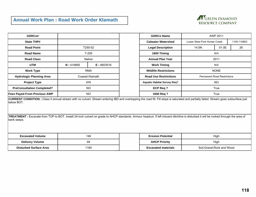
CURRENT CONDITION : Class II annual stream with no culvert. Stream entering IBD and overtopping the road fill. Fill slope is saturated and partially failed. Stream goes subsurface just below BOT.
TREATMENT : Excavate from TOP to BOT. Install 24-inch culvert on grade to AHCP standards. Armour headcut. If left inboard ditchline is disturbed it will be rocked through the area of bank seeps.
Excavated Volume 146
Delivery Volume 94
Disturbed Surface Area 1160
Erosion Potential High
AHCP Priority High
Excavated materials Soil,Gravel,Rock and Wood
GDRCo#
State THP#
Road Point
Road Name
Road Class
UTM
Hydrologic Planning Area
Project Type
PreConsultation Completed?
Fees Payed From Previous AWP NO
NO
II/III
Coastal Klamath
RMA
N : 414669
Native
T-250
T250-02
E : 4603516
Lower West Fork Hunter CreekCalwater Watershed
Legal Description 14.0N 01.0E 26
N/A
2011
N/A
NONE
Permanent Road Restrictions
NO
True
True
1600 Timing
Annual Plan Year
Work Timing
Wildlife Restrictions
Road Use Restrictions
Aquatic Habitat Survey Req?
ECP Req ?
1600 Req ?
Work Type
1105.110803
GDRCo Name AWP 2011
Annual Work Plan : Road Work Order Klamath
118

CURRENT CONDITION : Class II stream without culvert or adequate drainage relief. Flow currently entering inboard ditch and diverting over road prism. Outboard fill is slumping and slowly eroding away to outboard road edge.
TREATMENT : Excavate from TOP to BOT, removing large woody debris. Install 42" culvert on natural stream grade (41% ) to AHCP standards. Armor/buttress headcut and armor fill slope. Install 18" DRC with downspout 80' up left approach.
Excavated Volume 557
Delivery Volume 397
Disturbed Surface Area 2366
Erosion Potential High
AHCP Priority High
Excavated materials Soil,Gravel,Rock and Wood
GDRCo#
State THP#
Road Point
Road Name
Road Class
UTM
Hydrologic Planning Area
Project Type
PreConsultation Completed?
Fees Payed From Previous AWP NO
NO
II/III
Coastal Klamath
RMA
N : 414605
Native
Relim Right Teepo Ridge Connector
T250-03
E : 4603841
Lower West Fork Hunter CreekCalwater Watershed
Legal Description 14.0N 01.0E 26
N/A
2011
N/A
NONE
Permanent Road Restrictions
NO
True
True
1600 Timing
Annual Plan Year
Work Timing
Wildlife Restrictions
Road Use Restrictions
Aquatic Habitat Survey Req?
ECP Req ?
1600 Req ?
Work Type
1105.110803
GDRCo Name AWP 2011
Annual Work Plan : Road Work Order Klamath
119

CURRENT CONDITION : Potentially ephemeral seep/spring with flow emerging from vertical bedrock outcrop and from cutbank slope ~40' left lacks drainage structure. Seep/spring drains to IBD and flows right ~150' to Site ID# 21584. Steep fillslope (42%) has backtilted/ j-shaped trees and evidence of surface erosion likely related to emergent groundwater thru fill prism.
TREATMENT : Install 24" DRC to AHCP standards. Install 18" DRC 100ft to left.
Excavated Volume 50
Delivery Volume 40
Disturbed Surface Area
Erosion Potential
AHCP Priority
Excavated materials
GDRCo#
State THP#
Road Point
Road Name
Road Class
UTM
Hydrologic Planning Area
Project Type
PreConsultation Completed?
Fees Payed From Previous AWP NO
NO
II/III
Coastal Klamath
RMA
N : 414541
Native
T-250
T250-05
E : 4604118
Lower West Fork Hunter CreekCalwater Watershed
Legal Description 14.0N 01.0E 23
N/A
2011
N/A
NONE
Permanent Road Restrictions
YES
True
1600 Timing
Annual Plan Year
Work Timing
Wildlife Restrictions
Road Use Restrictions
Aquatic Habitat Survey Req?
ECP Req ?
1600 Req ?
Work Type
1105.110803
GDRCo Name AWP 2011
Annual Work Plan : Road Work Order Klamath
120

CURRENT CONDITION : Class II stream crossing with 24” CMP has a buried inlet. Pipe is disconnected due to recent catastrophic fill slope failure. Disconnected segment of pipe is located in the slide toe. Active fill failure scarp narrows road to 6’ wide.
TREATMENT : Excavate unstable material from excavation BOT to TOP install new 24" CMP to AHCP Standards. Install DRC ~150’ left of stream crossing.
Excavated Volume 490
Delivery Volume 473
Disturbed Surface Area 1200
Erosion Potential High
AHCP Priority High
Excavated materials Soil,Gravel,Rock and Wood
GDRCo#
State THP#
Road Point
Road Name
Road Class
UTM
Hydrologic Planning Area
Project Type
PreConsultation Completed?
Fees Payed From Previous AWP NO
NO
II/III
Coastal Klamath
RMA
N : 414521
Native
Relim Right Teepo Ridge Connector
T250-06
E : 4604179
Lower West Fork Hunter CreekCalwater Watershed
Legal Description 14.0N 01.0E 23
N/A
2011
N/A
NONE
Permanent Road Restrictions
YES
True
True
1600 Timing
Annual Plan Year
Work Timing
Wildlife Restrictions
Road Use Restrictions
Aquatic Habitat Survey Req?
ECP Req ?
1600 Req ?
Work Type
1105.110803
GDRCo Name AWP 2011
Annual Work Plan : Road Work Order Klamath
121

CURRENT CONDITION : Class III water course with no culvert is over topping road fill. Ditch water combines with stream water at IBR. OBF is eroding away the OBR edge. Large diameter logs extend at an angle out of the fill downstream, possibly Humboldt logs. DRC 100ft to right is ruted through.
TREATMENT : Excavate TOP to BOT install new 24” CMP at grade to AHCP standards. Install new 18” DRC 100ft to right at existing DRC.
Excavated Volume 241
Delivery Volume 184
Disturbed Surface Area 1497
Erosion Potential Medium
AHCP Priority High
Excavated materials Soil,Gravel,Rock and Wood
GDRCo#
State THP#
Road Point
Road Name
Road Class
UTM
Hydrologic Planning Area
Project Type
PreConsultation Completed?
Fees Payed From Previous AWP NO
NO
II/III
Coastal Klamath
RMA
N : 414563
Native
T-250
T250-07
E : 4604392
Lower West Fork Hunter CreekCalwater Watershed
Legal Description 14.0N 01.0E 23
N/A
2011
N/A
NONE
Permanent Road Restrictions
NO
True
True
1600 Timing
Annual Plan Year
Work Timing
Wildlife Restrictions
Road Use Restrictions
Aquatic Habitat Survey Req?
ECP Req ?
1600 Req ?
Work Type
1105.110803
GDRCo Name AWP 2011
Annual Work Plan : Road Work Order Klamath
122

CURRENT CONDITION : 24" CMP on a Class II stream crossing has sediment wedge (25’x25’x3’) with buried inlet. Road has been overtopped by sediment and water. Channel flow goes subsurface thru sediment wedge and fill prism then emerges below pipe and Humboldt logs. Seep 100ft to right crosses road surface causing recent fill slope failure.
TREATMENT : Excavate Humboldt logs and unstable fill material from excavation BOT to TOP install new 24" CMP to AHCP standards. Clean IBD along left approach. Install 18" DRC for seep ~100’ right of stream crossing and rebuild road prism.
Excavated Volume 745
Delivery Volume 843
Disturbed Surface Area 2000
Erosion Potential High
AHCP Priority High
Excavated materials Soil,Gravel,Rock and Wood
GDRCo#
State THP#
Road Point
Road Name
Road Class
UTM
Hydrologic Planning Area
Project Type
PreConsultation Completed?
Fees Payed From Previous AWP NO
NO
II/III
Coastal Klamath
RMA
N : 414534
Native
Relim Right Teepo Ridge Connector
T250-08
E : 4604736
Lower West Fork Hunter CreekCalwater Watershed
Legal Description 14.0N 01.0E 23
N/A
2011
N/A
NONE
Permanent Road Restrictions
NO
True
True
1600 Timing
Annual Plan Year
Work Timing
Wildlife Restrictions
Road Use Restrictions
Aquatic Habitat Survey Req?
ECP Req ?
1600 Req ?
Work Type
1105.110803
GDRCo Name AWP 2011
Annual Work Plan : Road Work Order Klamath
123

CURRENT CONDITION : Class III water course with no culvert is actively over-topping road. No apparent erosion of fill but fill is heavily saturated. Seep located 80’ up road to left.
TREATMENT : Excavate TOP to BOT install new 24”CMP at grade to AHCP standards. Install 18” DRC 75ft to left.
Excavated Volume 113
Delivery Volume 112
Disturbed Surface Area 1994
Erosion Potential Medium
AHCP Priority High
Excavated materials Soil,Gravel,Rock and Wood
GDRCo#
State THP#
Road Point
Road Name
Road Class
UTM
Hydrologic Planning Area
Project Type
PreConsultation Completed?
Fees Payed From Previous AWP NO
NO
II/III
Coastal Klamath
RMA
N : 414576
Native
T-250
T250-09
E : 4604350
Lower West Fork Hunter CreekCalwater Watershed
Legal Description 14.0N 01.0E 23
N/A
2011
N/A
NONE
Permanent Road Restrictions
NO
True
True
1600 Timing
Annual Plan Year
Work Timing
Wildlife Restrictions
Road Use Restrictions
Aquatic Habitat Survey Req?
ECP Req ?
1600 Req ?
Work Type
1105.110803
GDRCo Name AWP 2011
Annual Work Plan : Road Work Order Klamath
124

Site Id THP# Road Pt#
Acres Length(miles)
Lower Elev
Upper Elev
Altitude Tc Cfs C.Diam(inches)
Method
37896 991199 29 18.0 0.20 1120 1660 486 2.15 21.17 36 Rational
21537 991199 30 9.0 0.23 1080 1700 558 2.40 10.58 24 Rational
37877 991199 33 71.0 0.30 980 1790 729 2.94 83.50 54 Rational
37876 991199 34 5.0 0.17 1030 1670 576 1.67 5.88 24 Rational
Culvert Report
125

CURRENT CONDITION : An 18" CMP on a Class III watercourse also drains a perennial seep below a swale 120' to the left. The inlet is 50% plugged with sediment and the outlet has a broken downspout. The culvert is separated at a joint approximately 8’ up from the inlet and water flows out under the end. This watercourse flows into an adjacent Class II watercourse approximately 550’ downstream.
TREATMENT : Excavate from flagged bottom to flagged top. Install a 30" culvert to AHCP standards as close to the natural gradient as feasible, with a critical dip along the right hinge-line of the excavation. Install DRC approx. 100' at cutbank seep uproad (left).
Excavated Volume 414
Delivery Volume 316
Disturbed Surface Area 1690
Erosion Potential High
AHCP Priority High
Excavated materials Soil,Gravel,Rock and Wood
GDRCo#
State THP#
Road Point
Road Name
Road Class
UTM
Hydrologic Planning Area
Project Type
PreConsultation Completed?
Fees Payed From Previous AWP YES
YES
II/III
Coastal Klamath
RMA
N : 416030
Native
Rellim Right Spur #2
29
E : 4602894
Lower West Fork Hunter CreekCalwater Watershed
Legal Description 14.0N 01.0E 25
N/A
2011
No Operations Prior to September 15th
MAMU Restrictions
Seasonal Road Restrictions
NO
True
True
1600 Timing
Annual Plan Year
Work Timing
Wildlife Restrictions
Road Use Restrictions
Aquatic Habitat Survey Req?
ECP Req ?
1600 Req ?
Work Type
1105.110803
GDRCo Name AWP 2011
2011 Annual Work Plan : Road Work Order
126

CURRENT CONDITION : A Class II watercourse crossing has an 18" CMP and a twisted and crushed half round downspout. Sediment has built up at the inlet forming a sediment wedge that plugs the inlet approximately 80%. There is a sinkhole in the inboard fill face. The culvert is separated and has advanced rust and holes at the outlet. There is a diversion of flow to the right via the inboard ditch that delivers to adjacent watercourse crossing.
TREATMENT : Excavate site from bottom to top, including any buried logs and the sediment wedge. Install a 24" culvert to AHCP standards on grade with a critical dip over the right hinge-line of the excavation. Install an 18" ditch relief culvert up-road to the left.
Excavated Volume 286
Delivery Volume 239
Disturbed Surface Area 1200
Erosion Potential High
AHCP Priority High
Excavated materials Soil,Gravel,Rock and Wood
GDRCo#
State THP#
Road Point
Road Name
Road Class
UTM
Hydrologic Planning Area
Project Type
PreConsultation Completed?
Fees Payed From Previous AWP YES
YES
II/III
Coastal Klamath
RMA
N : 416129
Native
Rellim Right Spur #2
30
E : 4602876
Lower West Fork Hunter CreekCalwater Watershed
Legal Description 14.0N 01.0E 25
N/A
2011
No Operations Prior to September 15th
MAMU Restrictions
Seasonal Road Restrictions
NO
True
True
1600 Timing
Annual Plan Year
Work Timing
Wildlife Restrictions
Road Use Restrictions
Aquatic Habitat Survey Req?
ECP Req ?
1600 Req ?
Work Type
1105.110803
GDRCo Name AWP 2011
2011 Annual Work Plan : Road Work Order
127

CURRENT CONDITION : A Class II watercourse with a 36" CMP plugged by large woody debris has overtopped and mostly washed out. There is a sediment wedge above the inlet.
TREATMENT : Excavate the remaining fill from flagged bottom to flagged top. Install a 54" culvert to AHCP standards with a critical dip over the right hinge-line of the excavation.
Excavated Volume 609
Delivery Volume 539
Disturbed Surface Area 5228
Erosion Potential High
AHCP Priority High
Excavated materials Soil,Gravel,Rock and Wood
GDRCo#
State THP#
Road Point
Road Name
Road Class
UTM
Hydrologic Planning Area
Project Type
PreConsultation Completed?
Fees Payed From Previous AWP YES
YES
II/III
Coastal Klamath
RMA
N : 416584
Native
Rellim Right Spur #2
33
E : 4603153
Lower West Fork Hunter CreekCalwater Watershed
Legal Description 14.0N 02.0E 30
N/A
2011
No Operations Prior to September 15th
MAMU Restrictions
Seasonal Road Restrictions
NO
True
True
1600 Timing
Annual Plan Year
Work Timing
Wildlife Restrictions
Road Use Restrictions
Aquatic Habitat Survey Req?
ECP Req ?
1600 Req ?
Work Type
1105.110803
GDRCo Name AWP 2011
2011 Annual Work Plan : Road Work Order
128

CURRENT CONDITION : The road crosses a swale at the head of a Class III watercourse. The 18" CMP is installed as a DRC. The culvert is rusted through less than 25% of its length and is separated at a joint approximately 5' before the outlet. Flow emerges from a small void below the outlet.
TREATMENT : Excavate from flagged bottom to flagged top. Install a 24" culvert to AHCP standards with a critical dip over the right hinge-line of the excavation.
Excavated Volume 90
Delivery Volume 71
Disturbed Surface Area 557
Erosion Potential High
AHCP Priority High
Excavated materials Soil
GDRCo#
State THP#
Road Point
Road Name
Road Class
UTM
Hydrologic Planning Area
Project Type
PreConsultation Completed?
Fees Payed From Previous AWP YES
YES
II/III
Coastal Klamath
RMA
N : 416503
Native
Rellim Right Spur #2
34
E : 4603233
Lower West Fork Hunter CreekCalwater Watershed
Legal Description 14.0N 02.0E 30
N/A
2011
No Operations Prior to September 15th
MAMU Restrictions
Seasonal Road Restrictions
NO
True
1600 Timing
Annual Plan Year
Work Timing
Wildlife Restrictions
Road Use Restrictions
Aquatic Habitat Survey Req?
ECP Req ?
1600 Req ?
Work Type
1105.110803
GDRCo Name AWP 2011
2011 Annual Work Plan : Road Work Order
129
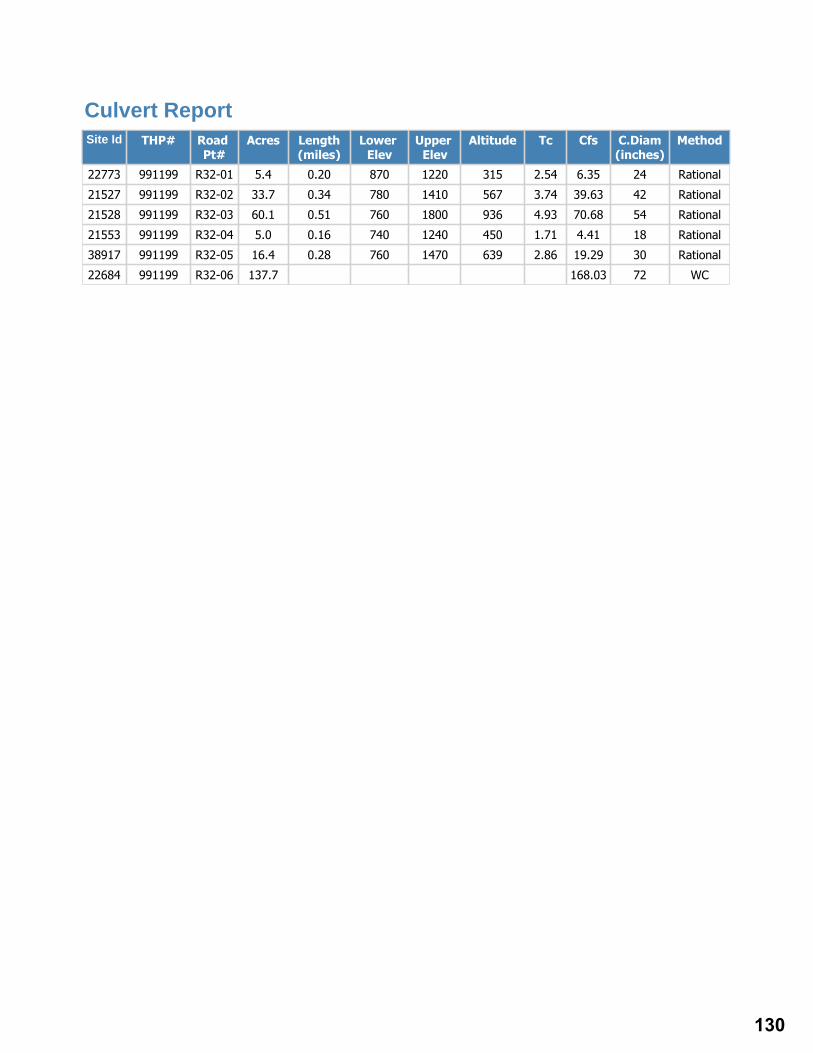
Site Id THP# Road Pt#
Acres Length(miles)
Lower Elev
Upper Elev
Altitude Tc Cfs C.Diam(inches)
Method
22773 991199 R32-01 5.4 0.20 870 1220 315 2.54 6.35 24 Rational
21527 991199 R32-02 33.7 0.34 780 1410 567 3.74 39.63 42 Rational
21528 991199 R32-03 60.1 0.51 760 1800 936 4.93 70.68 54 Rational
21553 991199 R32-04 5.0 0.16 740 1240 450 1.71 4.41 18 Rational
38917 991199 R32-05 16.4 0.28 760 1470 639 2.86 19.29 30 Rational
22684 991199 R32-06 137.7 168.03 72 WC
Culvert Report
130

CURRENT CONDITION : 24" CMP on Class II stream with past debris torrent. Sediment and woody debris have deposited into channel and buried the culvert inlet, creating a 36'W x 20'L pond behind fill crossing. Sediment plug in culvert 10' from outlet.
TREATMENT : Either clean inlet and flush culvert ensuring appropriate measures are in place to minimize downstream sediment delivery (i.e. silt fence, catch basin, etc) --OR-- Excavate from TOP to BOT removing large woody debris and sediment wedge. Armor headcut and left stream bank below TOP flag.Install new 24" CMP to AHCP standards. Install 18" DRC 75ft to left.
Excavated Volume 3525
Delivery Volume 3376
Disturbed Surface Area 9119
Erosion Potential
AHCP Priority High
Excavated materials Soil,Gravel,Rock and Wood
GDRCo#
State THP#
Road Point
Road Name
Road Class
UTM
Hydrologic Planning Area
Project Type
PreConsultation Completed?
Fees Payed From Previous AWP NO
NO
II/III
Coastal Klamath
RMA
N : 414638
Rock
R32
R32-01
E : 4601513
Lower West Fork Hunter CreekCalwater Watershed
Legal Description 14.0N 01.0E 35
N/A
2011
No Operations Prior to September 15th
MAMU Restrictions
Permanent Road Restrictions
NO
True
True
1600 Timing
Annual Plan Year
Work Timing
Wildlife Restrictions
Road Use Restrictions
Aquatic Habitat Survey Req?
ECP Req ?
1600 Req ?
Work Type
1105.110803
GDRCo Name AWP 2011
Annual Work Plan : Road Work Order Klamath
131

CURRENT CONDITION : Class III watercourse has sediment wedge (42’x48’x3’) and pond (31’x29’x8’) above potential fill crossing. Inlet and outlet are not visible. If crossing has a pipe it may be undersized. Sediment evidence suggests water level was about 6” from overtopping the road.
TREATMENT : Excavate stream crossing from BOT to TOP. Remove sediment wedge above crossing. Install 42" pipe on grade to AHCP standards. Install 18" DRC 75ft to left.
Excavated Volume 4814
Delivery Volume 4738
Disturbed Surface Area 10164
Erosion Potential Medium
AHCP Priority High
Excavated materials Soil,Gravel,Rock and Wood
GDRCo#
State THP#
Road Point
Road Name
Road Class
UTM
Hydrologic Planning Area
Project Type
PreConsultation Completed?
Fees Payed From Previous AWP NO
NO
II/III
Coastal Klamath
RMA
N : 414934
Native
R32
R32-02
E : 4601154
Lower West Fork Hunter CreekCalwater Watershed
Legal Description 14.0N 01.0E 36
N/A
2011
N/A
NONE
Permanent Road Restrictions
NO
True
True
1600 Timing
Annual Plan Year
Work Timing
Wildlife Restrictions
Road Use Restrictions
Aquatic Habitat Survey Req?
ECP Req ?
1600 Req ?
Work Type
1105.110803
GDRCo Name AWP 2011
Annual Work Plan : Road Work Order Klamath
132

CURRENT CONDITION : 60" CMP on Class II stream. Outlet shotgun for 6', suspended 8', and rusted through mid-way, permitting flow to undercut road fill. Culvert miss-aligned with stream centerline profile.
TREATMENT : Excavate from TOP to BOT, removing large woody debris. Install new 60"culvert to AHCP standards on stream grade (26%) and align (horizontally) with natural stream center line. Install 18" DRC 75ft to left.
Excavated Volume 972
Delivery Volume 986
Disturbed Surface Area 3789
Erosion Potential High
AHCP Priority High
Excavated materials Soil,Gravel,Rock and Wood
GDRCo#
State THP#
Road Point
Road Name
Road Class
UTM
Hydrologic Planning Area
Project Type
PreConsultation Completed?
Fees Payed From Previous AWP NO
NO
II/III
Coastal Klamath
RMA
N : 415162
Native
R32
R32-03
E : 4601134
Lower West Fork Hunter CreekCalwater Watershed
Legal Description 14.0N 01.0E 36
N/A
2011
N/A
NONE
Permanent Road Restrictions
NO
True
True
1600 Timing
Annual Plan Year
Work Timing
Wildlife Restrictions
Road Use Restrictions
Aquatic Habitat Survey Req?
ECP Req ?
1600 Req ?
Work Type
1105.110803
GDRCo Name AWP 2011
Annual Work Plan : Road Work Order Klamath
133

CURRENT CONDITION : Class III water course crossing, inlet of 18" CMP is buried under sediment wedge. Outlet is clear but has no water flowing through. Pipe is installed close to natural gradient.
TREATMENT : Excavate around inlet and attempt to clear material from inlet. Or excavate TOP to BOT remove old CMP and install new 36” CMP @ grade to AHCP standards. Either way excavate sediment wedge between TOP flag and inlet. Install single-post trash rack 36" on center from the inlet of the culvert.
Excavated Volume 2215
Delivery Volume 2122
Disturbed Surface Area 6126
Erosion Potential
AHCP Priority High
Excavated materials Soil,Gravel,Rock and Wood
GDRCo#
State THP#
Road Point
Road Name
Road Class
UTM
Hydrologic Planning Area
Project Type
PreConsultation Completed?
Fees Payed From Previous AWP NO
NO
II/III
Coastal Klamath
RMA
N : 415213
Rock
R32
R32-04
E : 4601299
Lower West Fork Hunter CreekCalwater Watershed
Legal Description 14.0N 01.0E 36
N/A
2011
N/A
NONE
Permanent Road Restrictions
NO
True
True
1600 Timing
Annual Plan Year
Work Timing
Wildlife Restrictions
Road Use Restrictions
Aquatic Habitat Survey Req?
ECP Req ?
1600 Req ?
Work Type
1105.110803
GDRCo Name AWP 2011
Annual Work Plan : Road Work Order Klamath
134

CURRENT CONDITION : Class II water course crossing with a rusted through 30” CMP. Water is flowing through rust holes before outlet and eroding the outboard fill.
TREATMENT : Excavate TOP to BOT remove old CMP install new 30”CMP at grade to AHCP standards. Remove wood and sediment above inlet, layback right bank 2:1 and rock armor. Lower fill height over center of crossing to reduce fill volume and create critical dip.
Excavated Volume 4888
Delivery Volume 4546
Disturbed Surface Area 7343
Erosion Potential
AHCP Priority High
Excavated materials Soil,Gravel,Rock and Wood
GDRCo#
State THP#
Road Point
Road Name
Road Class
UTM
Hydrologic Planning Area
Project Type
PreConsultation Completed?
Fees Payed From Previous AWP NO
NO
II/III
Coastal Klamath
RMA
N : 415196
Rock
R32
R32-05
E : 4601544
Lower West Fork Hunter CreekCalwater Watershed
Legal Description 14.0N 01.0E 36
N/A
2011
No Operations Prior to September 15th
MAMU Restrictions
Permanent Road Restrictions
NO
True
True
1600 Timing
Annual Plan Year
Work Timing
Wildlife Restrictions
Road Use Restrictions
Aquatic Habitat Survey Req?
ECP Req ?
1600 Req ?
Work Type
1105.110803
GDRCo Name AWP 2011
Annual Work Plan : Road Work Order Klamath
135

CURRENT CONDITION : Steep (26%) class II flows over bedrock and has deposited a thick sediment wedge (54'x81') that buries a 60" CMP completely. Pipe is disconnected about 20' from the outlet causing fill saturation, erosional voids, and gullying of the fillslope. Low gradient half round downspout with sediment accumulation in pipe. Outfall is suspended ~8' over natural channel.
TREATMENT : Excavate from TOP to BOT, including slide debris along right bank where the natural watercourse and diverted slide flow intersect near BOT. Lay slope back and amour right bank (toe of slide). Remove sediment wedge at inlet. Replace pipe with 72", 120' long culvert and install on grade (-26%). Install critical dip at road/stream xing and energy dissipater rock at outlet. Excavate slide debris to toe of the slide (confluence w/ stream). Rebuild road prism including IBD between stream and slide. Armor road fill slope and cutbank for stabilization. Install 18" DRC 75ft to left, re cut ditchline for 150ft at cutbank failures.
Excavated Volume 4154
Delivery Volume 3121
Disturbed Surface Area 8892
Erosion Potential High
AHCP Priority High
Excavated materials Soil,Gravel,Rock and Wood
GDRCo#
State THP#
Road Point
Road Name
Road Class
UTM
Hydrologic Planning Area
Project Type
PreConsultation Completed?
Fees Payed From Previous AWP NO
NO
II/III
Coastal Klamath
RMA
N : 415381
Native Rock
R32
R32-06
E : 4601933
Lower West Fork Hunter CreekCalwater Watershed
Legal Description 14.0N 01.0E 36
N/A
2011
No Operations Prior to September 15th
MAMU Restrictions
Permanent Road Restrictions
NO
True
True
1600 Timing
Annual Plan Year
Work Timing
Wildlife Restrictions
Road Use Restrictions
Aquatic Habitat Survey Req?
ECP Req ?
1600 Req ?
Work Type
1105.110803
GDRCo Name AWP 2011
Annual Work Plan : Road Work Order Klamath
136

CREEK
DANDY
U10
U10
U10
U10
U10U10
A200
A250
A240
A230U100
U600
U500
U470
U460
U420
U900
U900
U700
U700
U700
U1320
U1310U1300
U1500
U1400
U1000
U1100
U1000
!>
!>!>!>
!>!>
!>
!>
!>
!>
!>!>
!>!>
!>
U10-15U10-16
U10-17 U10-13
U10-11U10-19
U10-20
U10-21
U10-22 U10-23U10-25
U10-26 U430-01
U10-14
420000
420000
420500
420500
421000
421000
421500
421500
422000
422000
422500
422500
4598
500
4598
500
4599
000
4599
000
4599
500
4599
500
4600
000
4600
000
4600
500
4600
500
4601
000
4601
000
4601
500
4601
500
4602
000
4602
000
4602
500
4602
500
g2011 Annual Work Plan:
Road Work Required
Seasonal Road, Native SurfacePermanent Road, Rocked SurfaceClass I WatercourseClass II WatercourseClass III Watercourse
!> Project Site
¯RF 1:18,000
1 inch = 1,500 feetUTM Zone 10, NAD 1983
March 1, 2011
137

Site Id THP# Road Pt#
Acres Length(miles)
Lower Elev
Upper Elev
Altitude Tc Cfs C.Diam(inches)
Method
21338 991199 U10-11 2.0 0.19 900 1270 333 2.35 2.35 18 Rational
21335 991199 U10-13 2.8 0.19 950 1270 288 2.48 3.32 18 Rational
21334 991199 U10-14 34.0 0.60 970 1810 756 6.46 39.98 42 Rational
21005 991199 U10-15 65.0 0.72 1010 1810 720 8.12 76.44 54 Rational
21303 991199 U10-16 54.0 0.60 1080 1810 657 6.82 63.50 48 Rational
21302 991199 U10-17 7.0 0.29 1100 1480 342 3.79 8.23 24 Rational
21297 991199 U10-19 16.0 0.47 1210 1800 531 5.58 18.82 30 Rational
21295 991199 U10-20 27.0 0.43 1240 1780 486 5.21 31.75 36 Rational
21294 991199 U10-21 67.2 0.60 1290 2010 648 6.85 79.03 54 Rational
21293 991199 U10-22 16.4 0.53 1370 1980 549 6.33 19.29 30 Rational
21292 991199 U10-23 16.0 0.51 1410 1980 513 6.22 18.82 30 Rational
21290 991199 U10-25 2.8 0.10 1610 1810 180 1.42 3.29 18 Rational
21289 991199 U10-26 4.4 0.10 1620 1810 171 1.45 5.17 18 Rational
Culvert Report
138

CURRENT CONDITION : Class III water course crossing with no drainage strucutre present. Fill failure 13ft wide from OBR towards IBR 25ft long aprox 6ft deep at inside edge of failure. There is also a sink hole at the IBR where water is flowing from the ditch through the failure.
TREATMENT : Re-establish road prism and properly drain this seep with a 24"CMP to AHCP standards and rock line ditch to transport seep flows from spring 50ft to left.
Excavated Volume 341
Delivery Volume 275
Disturbed Surface Area 2500
Erosion Potential
AHCP Priority High
Excavated materials Soil,Gravel,Rock and Wood
GDRCo#
State THP#
Road Point
Road Name
Road Class
UTM
Hydrologic Planning Area
Project Type
PreConsultation Completed?
Fees Payed From Previous AWP NO
NO
II/III
Coastal Klamath
RMA
N : 421083
Native
U10
U10-11
E : 4601535
Upper Turwar CreekCalwater Watershed
Legal Description 14.0N 02.0E 33
N/A
2011
No Operations Prior to Wildlife & Botany Clearance
NSO
Permanent Road Restrictions
NO
True
True
1600 Timing
Annual Plan Year
Work Timing
Wildlife Restrictions
Road Use Restrictions
Aquatic Habitat Survey Req?
ECP Req ?
1600 Req ?
Work Type
1105.110808
GDRCo Name AWP 2011
Annual Work Plan : Road Work Order Klamath
139

CURRENT CONDITION : Class II watercourse with fill crossing diverts down ditch line to site U10-12. Ditch line is being filled with gravels.
TREATMENT : Install 30”CMP to AHCP standards. No DRC IS NEEDED
Excavated Volume 666
Delivery Volume 460
Disturbed Surface Area 1800
Erosion Potential High
AHCP Priority High
Excavated materials Soil,Gravel,Rock and Wood
GDRCo#
State THP#
Road Point
Road Name
Road Class
UTM
Hydrologic Planning Area
Project Type
PreConsultation Completed?
Fees Payed From Previous AWP NO
NO
II/III
Coastal Klamath
RMA
N : 420919
U10
U10-13
E : 4601632
Upper Turwar CreekCalwater Watershed
Legal Description 14.0N 02.0E 33
N/A
2011
No Operations Prior to Wildlife & Botany Clearance
NSO
Permanent Road Restrictions
YES
True
True
1600 Timing
Annual Plan Year
Work Timing
Wildlife Restrictions
Road Use Restrictions
Aquatic Habitat Survey Req?
ECP Req ?
1600 Req ?
Work Type
1105.110808
GDRCo Name AWP 2011
Annual Work Plan : Road Work Order Klamath
140

CURRENT CONDITION : Class II watercourse crossing with two 24" CMPs on top of each other with large sediment wedge above inlet almost as high as top of inlet. Inlet is clear at this time but has a high potential for plugging.
TREATMENT : Excavate sediment wedge above inlet. Excavate down to grade and remove both CMPs. Install new 48” CMP at grade to AHCP standards. Install 18" DRC 100ft to left.
Excavated Volume 1318
Delivery Volume 735
Disturbed Surface Area 1500
Erosion Potential
AHCP Priority High
Excavated materials Soil,Gravel,Rock and Wood
GDRCo#
State THP#
Road Point
Road Name
Road Class
UTM
Hydrologic Planning Area
Project Type
PreConsultation Completed?
Fees Payed From Previous AWP NO
NO
II/III
Coastal Klamath
RMA
N : 420813
U10
U10-14
E : 4601670
Upper Turwar CreekCalwater Watershed
Legal Description 14.0N 02.0E 33
N/A
2011
No Operations Prior to Wildlife & Botany Clearance
NSO
Permanent Road Restrictions
NO
True
True
1600 Timing
Annual Plan Year
Work Timing
Wildlife Restrictions
Road Use Restrictions
Aquatic Habitat Survey Req?
ECP Req ?
1600 Req ?
Work Type
1105.110808
GDRCo Name AWP 2011
Annual Work Plan : Road Work Order Klamath
141

CURRENT CONDITION : 24" CMP on a Class II watercourse. Currently flow goes subsurface well before inlet of culvert and water flows heavily out from below outlet through an old Humboldt. This crossing is 30' wide with a large sediment wedge above inlet. Outboard fill shows signs of slumping with active erosion occurring where water exits Humboldt.
TREATMENT : Install 60”CMP to AHCP standards narrow road width and lower fill height to reduce fill volume and create critical dip. Rock line channel from TOP flag down to inlet. Install 18" DRC 150ft to left due to road through cut.
Excavated Volume 6302
Delivery Volume 5830
Disturbed Surface Area 5250
Erosion Potential
AHCP Priority High
Excavated materials Soil,Gravel,Rock and Wood
GDRCo#
State THP#
Road Point
Road Name
Road Class
UTM
Hydrologic Planning Area
Project Type
PreConsultation Completed?
Fees Payed From Previous AWP NO
NO
II/III
Coastal Klamath
RMA
N : 420715
U10
U10-15
E : 4601834
Upper Turwar CreekCalwater Watershed
Legal Description 14.0N 02.0E 33
N/A
2011
No Operations Prior to Wildlife & Botany Clearance
NSO
Permanent Road Restrictions
NO
True
True
1600 Timing
Annual Plan Year
Work Timing
Wildlife Restrictions
Road Use Restrictions
Aquatic Habitat Survey Req?
ECP Req ?
1600 Req ?
Work Type
1105.110808
GDRCo Name AWP 2011
Annual Work Plan : Road Work Order Klamath
142

CURRENT CONDITION : Class II water course crossing. Inlet of 18" CMP completely buried by sediment wedge. Inlet is 100% plugged water is filtering through sediment wedge and flowing through culvert to outlet.
TREATMENT : Replace with 48” CMP at grade to AHCP standards. Install 18" DRC 75ft to right
Excavated Volume 3458
Delivery Volume 1811
Disturbed Surface Area 2500
Erosion Potential
AHCP Priority High
Excavated materials Soil,Gravel,Rock and Wood
GDRCo#
State THP#
Road Point
Road Name
Road Class
UTM
Hydrologic Planning Area
Project Type
PreConsultation Completed?
Fees Payed From Previous AWP NO
NO
II/III
Coastal Klamath
RMA
N : 420531
U10
U10-16
E : 4601796
Upper Turwar CreekCalwater Watershed
Legal Description 14.0N 02.0E 33
N/A
2011
No Operations Prior to Wildlife & Botany Clearance
NSO
Permanent Road Restrictions
NO
True
True
1600 Timing
Annual Plan Year
Work Timing
Wildlife Restrictions
Road Use Restrictions
Aquatic Habitat Survey Req?
ECP Req ?
1600 Req ?
Work Type
1105.110808
GDRCo Name AWP 2011
Annual Work Plan : Road Work Order Klamath
143

CURRENT CONDITION : Class II watercourse crossing with a separated 24" CMP. Pipe is separated 20ft from and inlet and 10ft from outlet.
TREATMENT : Replace with 36”CMP to AHCP standards. Install 18" DRC 75ft to right.
Excavated Volume 2363
Delivery Volume 1392
Disturbed Surface Area 1500
Erosion Potential
AHCP Priority High
Excavated materials Soil,Gravel,Rock and Wood
GDRCo#
State THP#
Road Point
Road Name
Road Class
UTM
Hydrologic Planning Area
Project Type
PreConsultation Completed?
Fees Payed From Previous AWP NO
NO
II/III
Coastal Klamath
RMA
N : 420590
U10
U10-17
E : 4601736
Upper Turwar CreekCalwater Watershed
Legal Description 14.0N 02.0E 33
N/A
2011
No Operations Prior to Wildlife & Botany Clearance
NSO
Permanent Road Restrictions
NO
True
True
1600 Timing
Annual Plan Year
Work Timing
Wildlife Restrictions
Road Use Restrictions
Aquatic Habitat Survey Req?
ECP Req ?
1600 Req ?
Work Type
1105.110808
GDRCo Name AWP 2011
Annual Work Plan : Road Work Order Klamath
144

CURRENT CONDITION : Class III watercourse with an 18" culvert and Humboldt. Outboard fill cracking and past erosional voids with gully below
TREATMENT : Remove CMP and Humboldt replace with 36” CMP to AHCP standards. Install 18" DRC 75ft to right.
Excavated Volume 503
Delivery Volume 303
Disturbed Surface Area 500
Erosion Potential
AHCP Priority High
Excavated materials Soil,Gravel,Rock and Wood
GDRCo#
State THP#
Road Point
Road Name
Road Class
UTM
Hydrologic Planning Area
Project Type
PreConsultation Completed?
Fees Payed From Previous AWP NO
NO
II/III
Coastal Klamath
RMA
N : 420865
U10
U10-19
E : 4601333
Upper Turwar CreekCalwater Watershed
Legal Description 14.0N 02.0E 33
N/A
2011
No Operations Prior to Wildlife & Botany Clearance
NSO
Permanent Road Restrictions
NO
True
True
1600 Timing
Annual Plan Year
Work Timing
Wildlife Restrictions
Road Use Restrictions
Aquatic Habitat Survey Req?
ECP Req ?
1600 Req ?
Work Type
1105.110808
GDRCo Name AWP 2011
Annual Work Plan : Road Work Order Klamath
145
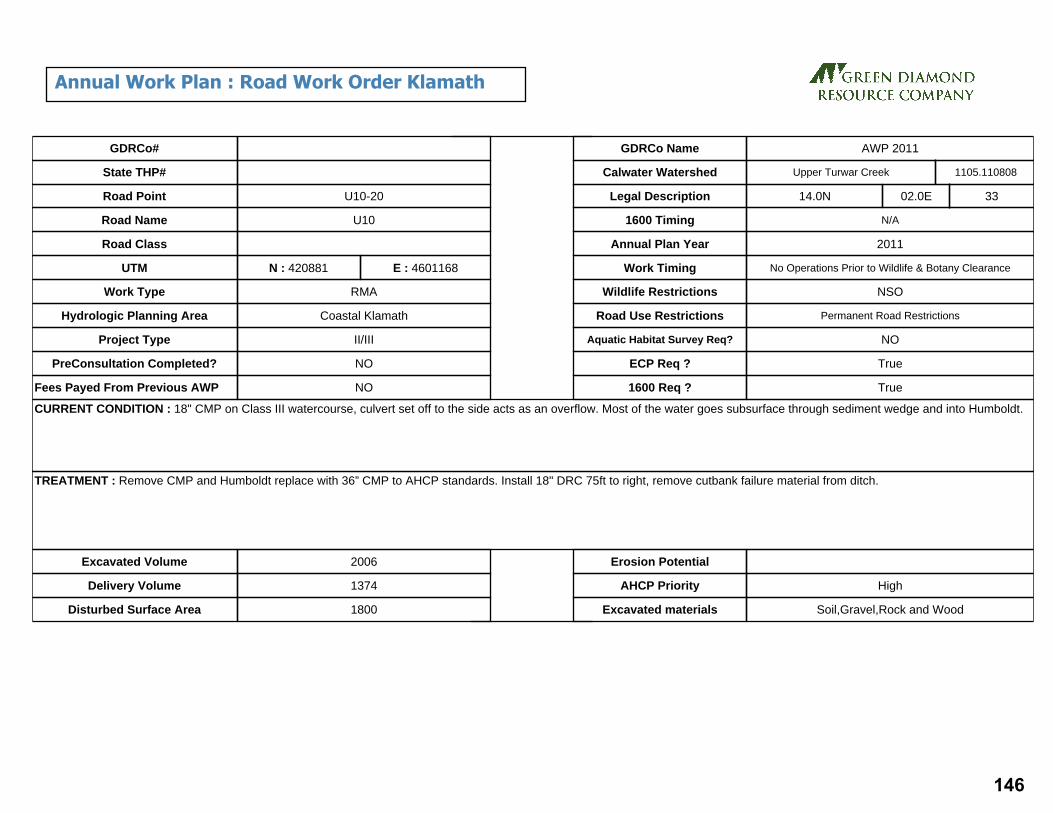
CURRENT CONDITION : 18" CMP on Class III watercourse, culvert set off to the side acts as an overflow. Most of the water goes subsurface through sediment wedge and into Humboldt.
TREATMENT : Remove CMP and Humboldt replace with 36” CMP to AHCP standards. Install 18" DRC 75ft to right, remove cutbank failure material from ditch.
Excavated Volume 2006
Delivery Volume 1374
Disturbed Surface Area 1800
Erosion Potential
AHCP Priority High
Excavated materials Soil,Gravel,Rock and Wood
GDRCo#
State THP#
Road Point
Road Name
Road Class
UTM
Hydrologic Planning Area
Project Type
PreConsultation Completed?
Fees Payed From Previous AWP NO
NO
II/III
Coastal Klamath
RMA
N : 420881
U10
U10-20
E : 4601168
Upper Turwar CreekCalwater Watershed
Legal Description 14.0N 02.0E 33
N/A
2011
No Operations Prior to Wildlife & Botany Clearance
NSO
Permanent Road Restrictions
NO
True
True
1600 Timing
Annual Plan Year
Work Timing
Wildlife Restrictions
Road Use Restrictions
Aquatic Habitat Survey Req?
ECP Req ?
1600 Req ?
Work Type
1105.110808
GDRCo Name AWP 2011
Annual Work Plan : Road Work Order Klamath
146

CURRENT CONDITION : Class II watercourse with an 18" CMP that is undersized and high in fill.
TREATMENT : Excavate sediment wedge from the inlet of the culvert to the confluence of the two streams above. The headcut will be armored and extend to the inlet of the new culvert. Any alders removed during sediment wedge excavation will be placed on the slopes above the armoring to the extent feasible. Install new 54” CMP to AHCP standards. Install 18" DRC 75ft to left.
Excavated Volume 2779
Delivery Volume 1892
Disturbed Surface Area 2000
Erosion Potential
AHCP Priority High
Excavated materials Soil,Gravel,Rock and Wood
GDRCo#
State THP#
Road Point
Road Name
Road Class
UTM
Hydrologic Planning Area
Project Type
PreConsultation Completed?
Fees Payed From Previous AWP NO
NO
II/III
Coastal Klamath
RMA
N : 420875
U10
U10-21
E : 4600963
Upper Turwar CreekCalwater Watershed
Legal Description 14.0N 02.0E 33
N/A
2011
No Operations Prior to Wildlife & Botany Clearance
NSO
Permanent Road Restrictions
YES
True
True
1600 Timing
Annual Plan Year
Work Timing
Wildlife Restrictions
Road Use Restrictions
Aquatic Habitat Survey Req?
ECP Req ?
1600 Req ?
Work Type
1105.110808
GDRCo Name AWP 2011
Annual Work Plan : Road Work Order Klamath
147

CURRENT CONDITION : 12" CMP drains Class II and IBD. Sinkhole developed below inlet. Inlet is perched 12" above bottom of channel/ditch. Water may be passing through fill (no flow at this time).
TREATMENT : Excavate TOP to BOT install new 36" CMP at grade to AHCP standards. Install 18" DRC 75 ft to right.
Excavated Volume 232
Delivery Volume 130
Disturbed Surface Area 2000
Erosion Potential Medium
AHCP Priority Medium
Excavated materials Soil,Gravel,Rock and Wood
GDRCo#
State THP#
Road Point
Road Name
Road Class
UTM
Hydrologic Planning Area
Project Type
PreConsultation Completed?
Fees Payed From Previous AWP NO
NO
II/III
Coastal Klamath
RMA
N : 421141
Rock
U10
U10-22
E : 4600713
Upper Turwar CreekCalwater Watershed
Legal Description 14.0N 02.0E 33
N/A
2011
No Operations Prior to Wildlife & Botany Clearance
NSO
Permanent Road Restrictions
NO
True
True
1600 Timing
Annual Plan Year
Work Timing
Wildlife Restrictions
Road Use Restrictions
Aquatic Habitat Survey Req?
ECP Req ?
1600 Req ?
Work Type
1105.110808
GDRCo Name AWP 2011
Annual Work Plan : Road Work Order Klamath
148

CURRENT CONDITION : Class III watercourse crossing with a buried 12” CMP.
TREATMENT : Install 36” CMP to AHCP standards.Install 18" DRC 75ft to left.
Excavated Volume 383
Delivery Volume 238
Disturbed Surface Area 500
Erosion Potential Medium
AHCP Priority Medium
Excavated materials Soil,Gravel,Rock and Wood
GDRCo#
State THP#
Road Point
Road Name
Road Class
UTM
Hydrologic Planning Area
Project Type
PreConsultation Completed?
Fees Payed From Previous AWP NO
NO
II/III
Coastal Klamath
RMA
N : 421119
U10
U10-23
E : 4600689
Upper Turwar CreekCalwater Watershed
Legal Description 14.0N 02.0E 33
N/A
2011
No Operations Prior to Wildlife & Botany Clearance
NSO
Permanent Road Restrictions
NO
True
True
1600 Timing
Annual Plan Year
Work Timing
Wildlife Restrictions
Road Use Restrictions
Aquatic Habitat Survey Req?
ECP Req ?
1600 Req ?
Work Type
1105.110808
GDRCo Name AWP 2011
Annual Work Plan : Road Work Order Klamath
149

CURRENT CONDITION : Class III watercourse with a 12" rusted out CMP
TREATMENT : Remove old CMP and Humboldt replace with 24”CMP to AHCP standards.
Excavated Volume 411
Delivery Volume 239
Disturbed Surface Area 600
Erosion Potential Medium
AHCP Priority Medium
Excavated materials Soil,Gravel,Rock and Wood
GDRCo#
State THP#
Road Point
Road Name
Road Class
UTM
Hydrologic Planning Area
Project Type
PreConsultation Completed?
Fees Payed From Previous AWP NO
NO
II/III
Coastal Klamath
RMA
N : 420786
U10
U10-25
E : 4600576
Upper Turwar CreekCalwater Watershed
Legal Description 14.0N 02.0E 33
N/A
2011
No Operations Prior to Wildlife & Botany Clearance
NSO
Permanent Road Restrictions
NO
True
True
1600 Timing
Annual Plan Year
Work Timing
Wildlife Restrictions
Road Use Restrictions
Aquatic Habitat Survey Req?
ECP Req ?
1600 Req ?
Work Type
1105.110808
GDRCo Name AWP 2011
Annual Work Plan : Road Work Order Klamath
150
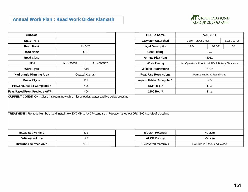
CURRENT CONDITION : Class II stream, no visible inlet or outlet. Water audible below crossing.
TREATMENT : Remove Humboldt and install new 30”CMP to AHCP standards. Replace rusted out DRC 100ft to left of crossing.
Excavated Volume 306
Delivery Volume 173
Disturbed Surface Area 900
Erosion Potential Medium
AHCP Priority Medium
Excavated materials Soil,Gravel,Rock and Wood
GDRCo#
State THP#
Road Point
Road Name
Road Class
UTM
Hydrologic Planning Area
Project Type
PreConsultation Completed?
Fees Payed From Previous AWP NO
NO
II/III
Coastal Klamath
RMA
N : 420737
U10
U10-26
E : 4600552
Upper Turwar CreekCalwater Watershed
Legal Description 13.0N 02.0E 04
N/A
2011
No Operations Prior to Wildlife & Botany Clearance
NSO
Permanent Road Restrictions
NO
True
True
1600 Timing
Annual Plan Year
Work Timing
Wildlife Restrictions
Road Use Restrictions
Aquatic Habitat Survey Req?
ECP Req ?
1600 Req ?
Work Type
1105.110808
GDRCo Name AWP 2011
Annual Work Plan : Road Work Order Klamath
151

TECT
AH
ROAD
J110J100
T105
T500T510
J500
T510
T520
T500 T110
T100
T120
T121T123
T122
T120
T130 T145
T140
T135
T100
T100
T150
JOHNSON
HANCORNE
!>
!>!>
!>
!>
!>!>
!>
!>
!>
!>
!>
!>
!>
!>
!>!>
!>T100-21
T100-17T100-16
T100-15
T100-14T100-13
T100-12
T100-11
T100-10T100-09
T100-08
T100-07
T100-06
T100-04T100-03
T100-01
T100-02
T100-06.5
419000
419000
419500
419500
420000
420000
420500
420500
421000
421000
421500
421500
422000
422000
4564
500
4564
500
4565
000
4565
000
4565
500
4565
500
4566
000
4566
000
4566
500
4566
500
4567
000
4567
000
4567
500
4567
500
4568
000
4568
000
4568
500
4568
500
g2011 Annual Work Plan:
Road Work Required
Seasonal Road, Native SurfacePermanent Road, Rocked SurfaceClass I WatercourseClass II WatercourseClass III Watercourse
!> Project Site
¯RF 1:18,000
1 inch = 1,500 feetUTM Zone 10, NAD 1983
March 1, 2011
152

Site Id THP# Road Pt#
Acres Length(miles)
Lower Elev
Upper Elev
Altitude Tc Cfs C.Diam(inches)
Method
38915 991199 T100-01
8.3 0.19 2300 2580 252 2.61 9.76 24 Rational
17668 991199 T100-02
6.7 0.14 2320 2550 207 1.98 7.88 24 Rational
17671 991199 T100-03
7.5 0.24 2270 2530 234 3.52 8.82 24 Rational
17673 991199 T100-04
18.2 0.36 2210 2560 315 5.02 21.40 36 Rational
22915 991199 T100-06
17.0 0.35 2160 2560 360 4.61 14.99 30 Rational
21590 991199 T100-06.5
17.4 0.37 2080 2560 432 4.58 20.46 30 Rational
17422 991199 T100-07
14.5 0.35 2060 2540 432 4.30 17.05 30 Rational
17222 991199 T100-08
17.4 0.26 1980 2440 414 3.10 20.46 30 Rational
17224 991199 T100-09
18.4 0.28 1930 2320 351 3.60 21.64 36 Rational
38916 991199 T100-10
12.3 0.27 1880 2190 279 3.77 14.46 30 Rational
17229 991199 T100-11
10.3 0.24 1830 2070 216 3.63 12.11 24 Rational
17232 991199 T100-12
17.4 0.28 1760 2030 243 4.15 20.46 30 Rational
17233 991199 T100-13
7.6 0.23 1740 1970 207 3.51 8.94 24 Rational
17234 991199 T100-14
16.4 0.25 1710 1970 234 3.69 19.29 30 Rational
17236 991199 T100-15
16.4 0.28 1640 1940 270 3.98 19.29 30 Rational
17238 991199 T100-16
11.5 0.33 1550 1910 324 4.49 13.52 30 Rational
17239 991199 T100-17
14.6 0.28 1530 1880 315 3.75 17.17 30 Rational
Culvert Report
153

CURRENT CONDITION : Class II water course diverts down ditch for 700ft to 18" DRC. No drainage structure present at road crossing. Large sediment wedge above road.
TREATMENT : Excavate TOP to BOT, rock line transition channel from TOP to inlet. Install new 24" CMP @ grade (19%) to AHCP standards. Install 18" DRC 75ft to the right of crossing.
Excavated Volume 858
Delivery Volume 705
Disturbed Surface Area 3222
Erosion Potential
AHCP Priority High
Excavated materials Soil,Gravel,Rock and Wood
GDRCo#
State THP#
Road Point
Road Name
Road Class
UTM
Hydrologic Planning Area
Project Type
PreConsultation Completed?
Fees Payed From Previous AWP NO
NO
II/III
Coastal Klamath
RMA
N : 419852
Rock
T100
T100-01
E : 4564729
Upper Tectah CreekCalwater Watershed
Legal Description 10.0N 02.0E 28
N/A
2011
N/A
NONE
Permanent Road Restrictions
NO
True
True
1600 Timing
Annual Plan Year
Work Timing
Wildlife Restrictions
Road Use Restrictions
Aquatic Habitat Survey Req?
ECP Req ?
1600 Req ?
Work Type
1105.110405
GDRCo Name AWP 2011
Annual Work Plan : Road Work Order Klamath
154

CURRENT CONDITION : Swale, no culvert, not a watercourse, likely collects water during the winter. IBD flows into swale.
TREATMENT : Install 24” CMP on grade to AHCP standards, install critical dip on left hinge.
Excavated Volume 2766
Delivery Volume 2112
Disturbed Surface Area 2500
Erosion Potential Medium
AHCP Priority High
Excavated materials Soil,Gravel,Rock and Wood
GDRCo#
State THP#
Road Point
Road Name
Road Class
UTM
Hydrologic Planning Area
Project Type
PreConsultation Completed?
Fees Payed From Previous AWP NO
NO
II/III
Coastal Klamath
RMA
N : 419758
Rock
T100
T100-02
E : 4564621
Upper Tectah CreekCalwater Watershed
Legal Description 10.0N 02.0E 28
N/A
2011
N/A
NONE
Permanent Road Restrictions
NO
True
1600 Timing
Annual Plan Year
Work Timing
Wildlife Restrictions
Road Use Restrictions
Aquatic Habitat Survey Req?
ECP Req ?
1600 Req ?
Work Type
1105.110405
GDRCo Name AWP 2011
Annual Work Plan : Road Work Order Klamath
155

CURRENT CONDITION : 24"CMP filled 90% at inlet and 100% at outlet. Class II watercourse
TREATMENT : Install new 24”CMP grade to AHCP standards, install critical dip on left hinge. Install 18” DRC 75ft to right.
Excavated Volume 290
Delivery Volume 246
Disturbed Surface Area 500
Erosion Potential Medium
AHCP Priority High
Excavated materials Soil,Gravel,Rock and Wood
GDRCo#
State THP#
Road Point
Road Name
Road Class
UTM
Hydrologic Planning Area
Project Type
PreConsultation Completed?
Fees Payed From Previous AWP NO
NO
II/III
Coastal Klamath
RMA
N : 419977
Rock
T100
T100-03
E : 4564773
Upper Tectah CreekCalwater Watershed
Legal Description 10.0N 02.0E 28
N/A
2011
N/A
NONE
Permanent Road Restrictions
YES
True
True
1600 Timing
Annual Plan Year
Work Timing
Wildlife Restrictions
Road Use Restrictions
Aquatic Habitat Survey Req?
ECP Req ?
1600 Req ?
Work Type
1105.110405
GDRCo Name AWP 2011
Annual Work Plan : Road Work Order Klamath
156

CURRENT CONDITION : Class III crossing with a 24" CMP. Pipe is rusted out from the outlet toward the center line of road, at least 15'. Water is down cutting a gully below pipe and causing sink holes and cracks in the OBF.
TREATMENT : Install a new 36"CMP at grade to AHCP standards. Armor the inlet area. Install 18" DRC 75ft to the right of crossing.
Excavated Volume 645
Delivery Volume 434
Disturbed Surface Area 600
Erosion Potential Medium
AHCP Priority High
Excavated materials Soil,Gravel,Rock and Wood
GDRCo#
State THP#
Road Point
Road Name
Road Class
UTM
Hydrologic Planning Area
Project Type
PreConsultation Completed?
Fees Payed From Previous AWP NO
NO
II/III
Coastal Klamath
RMA
N : 420238
Rock
T100
T100-04
E : 4564856
Upper Tectah CreekCalwater Watershed
Legal Description 10.0N 02.0E 28
N/A
2011
N/A
NONE
Permanent Road Restrictions
YES
True
True
1600 Timing
Annual Plan Year
Work Timing
Wildlife Restrictions
Road Use Restrictions
Aquatic Habitat Survey Req?
ECP Req ?
1600 Req ?
Work Type
1105.110405
GDRCo Name AWP 2011
Annual Work Plan : Road Work Order Klamath
157

CURRENT CONDITION : Class III watercourse diverts down ditch line 35ft to 18” CMP. Culvert is rusted through completely at inlet causing water to pond above inlet. Full round downspout is separated with water leaking through rust holes onto outboard fill. Outlet is set high in fill.
TREATMENT : Remove existing CMP and rebuild road prism at its current location. Excavate TOP to BOT install new 30” at correct channel alignment to AHCP standards. Install 18” DRC 75ft to right.
Excavated Volume 742
Delivery Volume 607
Disturbed Surface Area 2490
Erosion Potential Medium
AHCP Priority High
Excavated materials Soil,Gravel,Rock and Wood
GDRCo#
State THP#
Road Point
Road Name
Road Class
UTM
Hydrologic Planning Area
Project Type
PreConsultation Completed?
Fees Payed From Previous AWP NO
NO
II/III
Coastal Klamath
RMA
N : 420315
Rock
T100
T100-06
E : 4565130
Upper Tectah CreekCalwater Watershed
Legal Description 10.0N 02.0E 28
N/A
2011
N/A
NONE
Permanent Road Restrictions
NO
True
True
1600 Timing
Annual Plan Year
Work Timing
Wildlife Restrictions
Road Use Restrictions
Aquatic Habitat Survey Req?
ECP Req ?
1600 Req ?
Work Type
1105.110405
GDRCo Name AWP 2011
Annual Work Plan : Road Work Order Klamath
158

CURRENT CONDITION : Sediment wedge is diverting flow from Class III water course down to site T100-07. 18" CMP is rusted through at inlet and at outlet. Pipe is currently functioning as DRC.
TREATMENT : Excavate TOP to BOT remove old CMP install new 30”CMP at grade to AHCP standards. Install 18” DRC 75ft to right.
Excavated Volume 989
Delivery Volume 451
Disturbed Surface Area 1231
Erosion Potential Medium
AHCP Priority High
Excavated materials Soil,Gravel,Rock and Wood
GDRCo#
State THP#
Road Point
Road Name
Road Class
UTM
Hydrologic Planning Area
Project Type
PreConsultation Completed?
Fees Payed From Previous AWP NO
NO
II/III
Coastal Klamath
RMA
N : 420280
Rock
T100
T100-06.5
E : 4565494
Upper Tectah CreekCalwater Watershed
Legal Description 10.0N 02.0E 21
N/A
2011
N/A
NONE
Permanent Road Restrictions
NO
True
True
1600 Timing
Annual Plan Year
Work Timing
Wildlife Restrictions
Road Use Restrictions
Aquatic Habitat Survey Req?
ECP Req ?
1600 Req ?
Work Type
1105.110405
GDRCo Name AWP 2011
Annual Work Plan : Road Work Order Klamath
159
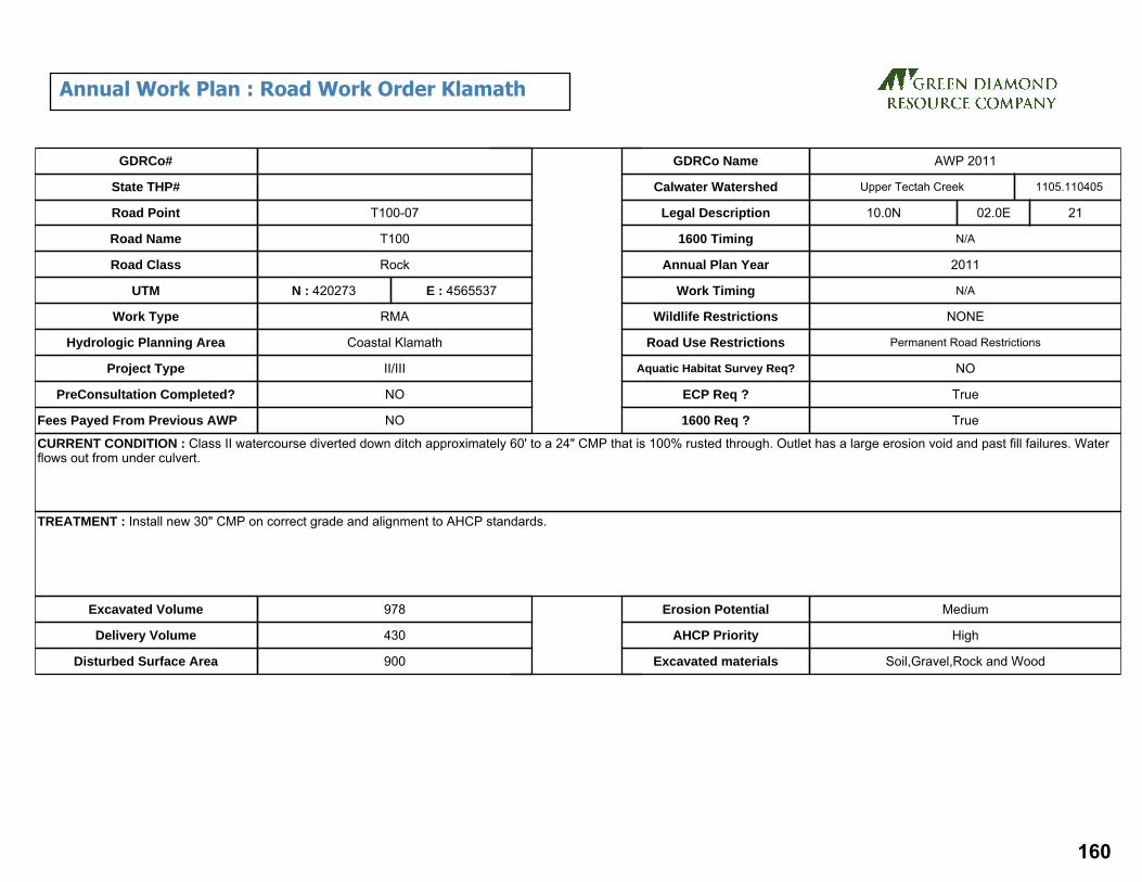
CURRENT CONDITION : Class II watercourse diverted down ditch approximately 60' to a 24" CMP that is 100% rusted through. Outlet has a large erosion void and past fill failures. Water flows out from under culvert.
TREATMENT : Install new 30" CMP on correct grade and alignment to AHCP standards.
Excavated Volume 978
Delivery Volume 430
Disturbed Surface Area 900
Erosion Potential Medium
AHCP Priority High
Excavated materials Soil,Gravel,Rock and Wood
GDRCo#
State THP#
Road Point
Road Name
Road Class
UTM
Hydrologic Planning Area
Project Type
PreConsultation Completed?
Fees Payed From Previous AWP NO
NO
II/III
Coastal Klamath
RMA
N : 420273
Rock
T100
T100-07
E : 4565537
Upper Tectah CreekCalwater Watershed
Legal Description 10.0N 02.0E 21
N/A
2011
N/A
NONE
Permanent Road Restrictions
NO
True
True
1600 Timing
Annual Plan Year
Work Timing
Wildlife Restrictions
Road Use Restrictions
Aquatic Habitat Survey Req?
ECP Req ?
1600 Req ?
Work Type
1105.110405
GDRCo Name AWP 2011
Annual Work Plan : Road Work Order Klamath
160

CURRENT CONDITION : Class III watercourse crossing with a rusted out 12" CMP. Pipe is currently plugged near center of road.
TREATMENT : Install new 36" CMP on propper grade and allignment to AHCP standards, install critical dip, install 18" DRC to 75' to right.
Excavated Volume 1079
Delivery Volume 840
Disturbed Surface Area 1500
Erosion Potential Medium
AHCP Priority High
Excavated materials Soil,Gravel,Rock and Wood
GDRCo#
State THP#
Road Point
Road Name
Road Class
UTM
Hydrologic Planning Area
Project Type
PreConsultation Completed?
Fees Payed From Previous AWP NO
NO
II/III
Coastal Klamath
RMA
N : 420005
Rock
T100
T100-08
E : 4565848
Upper Tectah CreekCalwater Watershed
Legal Description 10.0N 02.0E 21
N/A
2011
N/A
NONE
Permanent Road Restrictions
NO
True
True
1600 Timing
Annual Plan Year
Work Timing
Wildlife Restrictions
Road Use Restrictions
Aquatic Habitat Survey Req?
ECP Req ?
1600 Req ?
Work Type
1105.110405
GDRCo Name AWP 2011
Annual Work Plan : Road Work Order Klamath
161

CURRENT CONDITION : Class II watercourse crossing with an 18" CMP that isrusted through. Flow is going under culvert and coming out in fill under outlet.
TREATMENT : Install new 30" CMP on proper grade and alignment to AHCP standards, install critical dip. Install an 18" DRC 75ft to the right of crossing.
Excavated Volume 1069
Delivery Volume 831
Disturbed Surface Area 1500
Erosion Potential Medium
AHCP Priority High
Excavated materials Soil,Gravel,Rock and Wood
GDRCo#
State THP#
Road Point
Road Name
Road Class
UTM
Hydrologic Planning Area
Project Type
PreConsultation Completed?
Fees Payed From Previous AWP NO
NO
II/III
Coastal Klamath
RMA
N : 419872
Rock
T100
T100-09
E : 4566053
Upper Tectah CreekCalwater Watershed
Legal Description 10.0N 02.0E 21
N/A
2011
N/A
NONE
Permanent Road Restrictions
NO
True
True
1600 Timing
Annual Plan Year
Work Timing
Wildlife Restrictions
Road Use Restrictions
Aquatic Habitat Survey Req?
ECP Req ?
1600 Req ?
Work Type
1105.110405
GDRCo Name AWP 2011
Annual Work Plan : Road Work Order Klamath
162

CURRENT CONDITION : Class III watercourse crossing with a 18” CMP. Culvert is rusted through completely at inlet causing water to pond above inlet. Full round downspout is separated with water leaking through rust holes onto outboard fill.
TREATMENT : Excavate TOP to BOT remove old CMP install new 24”CMP at grade to AHCP standards. Install 18” DRC 75ft to right.
Excavated Volume 172
Delivery Volume 136
Disturbed Surface Area 975
Erosion Potential Medium
AHCP Priority High
Excavated materials Soil,Gravel,Rock and Wood
GDRCo#
State THP#
Road Point
Road Name
Road Class
UTM
Hydrologic Planning Area
Project Type
PreConsultation Completed?
Fees Payed From Previous AWP NO
NO
II/III
Coastal Klamath
RMA
N : 419895
Rock
T100
T100-10
E : 4566264
Upper Tectah CreekCalwater Watershed
Legal Description 10.0N 02.0E 21
N/A
2011
N/A
NONE
Permanent Road Restrictions
NO
True
True
1600 Timing
Annual Plan Year
Work Timing
Wildlife Restrictions
Road Use Restrictions
Aquatic Habitat Survey Req?
ECP Req ?
1600 Req ?
Work Type
1105.110405
GDRCo Name AWP 2011
Annual Work Plan : Road Work Order Klamath
163

CURRENT CONDITION : Class III watercourse crossing combined with IBD flow with an 18" CMP rusted through at outlet.
TREATMENT : Excavate from TOP to BOT. Remove old pipe. Replace with 30" CMP. Install to AHCP standards. Install 18" DRC 75 ft to right.
Excavated Volume 254
Delivery Volume 191
Disturbed Surface Area 600
Erosion Potential High
AHCP Priority High
Excavated materials Soil,Gravel,Rock and Wood
GDRCo#
State THP#
Road Point
Road Name
Road Class
UTM
Hydrologic Planning Area
Project Type
PreConsultation Completed?
Fees Payed From Previous AWP NO
NO
II/III
Coastal Klamath
RMA
N : 419757
Rock
T100
T100-11
E : 4566513
Upper Tectah CreekCalwater Watershed
Legal Description 10.0N 02.0E 21
N/A
2011
N/A
NONE
Permanent Road Restrictions
NO
True
True
1600 Timing
Annual Plan Year
Work Timing
Wildlife Restrictions
Road Use Restrictions
Aquatic Habitat Survey Req?
ECP Req ?
1600 Req ?
Work Type
1105.110405
GDRCo Name AWP 2011
Annual Work Plan : Road Work Order Klamath
164

CURRENT CONDITION : Class II watercourse with Humboldt crossing and an undersized CMP with trash rack. Inlet and outlet are 100% rusted through, water tunnels under pipe. Outboard fill failure has covered outlet.
TREATMENT : Excavate TOP to BOT install a 30" CMP placed in the bottom of the fill and swale to AHCP standards.
Excavated Volume 1432
Delivery Volume 1009
Disturbed Surface Area 1500
Erosion Potential Medium
AHCP Priority High
Excavated materials Soil,Gravel,Rock and Wood
GDRCo#
State THP#
Road Point
Road Name
Road Class
UTM
Hydrologic Planning Area
Project Type
PreConsultation Completed?
Fees Payed From Previous AWP NO
NO
II/III
Coastal Klamath
RMA
N : 419627
Rock
T100
T100-12
E : 4566822
Upper Tectah CreekCalwater Watershed
Legal Description 10.0N 02.0E 21
N/A
2011
N/A
NONE
Permanent Road Restrictions
NO
True
True
1600 Timing
Annual Plan Year
Work Timing
Wildlife Restrictions
Road Use Restrictions
Aquatic Habitat Survey Req?
ECP Req ?
1600 Req ?
Work Type
1105.110405
GDRCo Name AWP 2011
Annual Work Plan : Road Work Order Klamath
165

CURRENT CONDITION : Class II watercourse with CMP offset approximately 40' down the road. Humboldt crossing at the natural swale. Past outboard fill failure. Current culvert is more than 25% rusted out with an erosion void at inlet and outlet. Sediment wedge has built up above Humboldt.
TREATMENT : Excavate from TOP to BOT removing old Humboldt crossing. Install new 24"CMP @ grade to AHCP standards. Remove old pipe down road and rebuild prism Instal 18" DRC if needed.
Excavated Volume 935
Delivery Volume 736
Disturbed Surface Area 1000
Erosion Potential High
AHCP Priority High
Excavated materials Soil,Gravel,Rock and Wood
GDRCo#
State THP#
Road Point
Road Name
Road Class
UTM
Hydrologic Planning Area
Project Type
PreConsultation Completed?
Fees Payed From Previous AWP NO
NO
II/III
Coastal Klamath
RMA
N : 419686
Rock
T100
T100-13
E : 4566957
Upper Tectah CreekCalwater Watershed
Legal Description 10.0N 02.0E 21
N/A
2011
N/A
NONE
Permanent Road Restrictions
NO
True
True
1600 Timing
Annual Plan Year
Work Timing
Wildlife Restrictions
Road Use Restrictions
Aquatic Habitat Survey Req?
ECP Req ?
1600 Req ?
Work Type
1105.110405
GDRCo Name AWP 2011
Annual Work Plan : Road Work Order Klamath
166
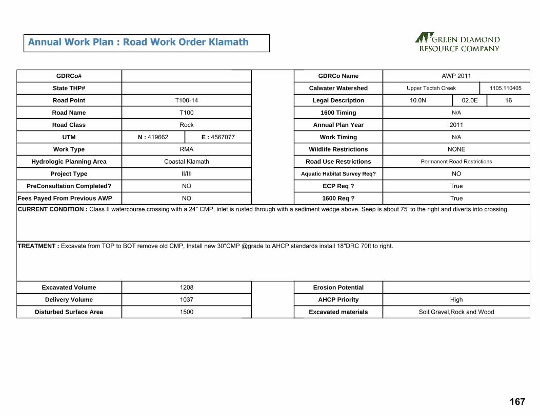
CURRENT CONDITION : Class II watercourse crossing with a 24" CMP, inlet is rusted through with a sediment wedge above. Seep is about 75' to the right and diverts into crossing.
TREATMENT : Excavate from TOP to BOT remove old CMP, Install new 30"CMP @grade to AHCP standards install 18"DRC 70ft to right.
Excavated Volume 1208
Delivery Volume 1037
Disturbed Surface Area 1500
Erosion Potential
AHCP Priority High
Excavated materials Soil,Gravel,Rock and Wood
GDRCo#
State THP#
Road Point
Road Name
Road Class
UTM
Hydrologic Planning Area
Project Type
PreConsultation Completed?
Fees Payed From Previous AWP NO
NO
II/III
Coastal Klamath
RMA
N : 419662
Rock
T100
T100-14
E : 4567077
Upper Tectah CreekCalwater Watershed
Legal Description 10.0N 02.0E 16
N/A
2011
N/A
NONE
Permanent Road Restrictions
NO
True
True
1600 Timing
Annual Plan Year
Work Timing
Wildlife Restrictions
Road Use Restrictions
Aquatic Habitat Survey Req?
ECP Req ?
1600 Req ?
Work Type
1105.110405
GDRCo Name AWP 2011
Annual Work Plan : Road Work Order Klamath
167

CURRENT CONDITION : Class II watercourse crossing with a 24" CMP rusted through more than 25% of length. Outboard fill erosion with a shot gunned outlet undermining the fill and flow under culvert. Possible Humboldt crossing under culvert and a sediment wedge above the inlet..
TREATMENT : Excavate from TOP to BOT removing old Humboldt crossing. Install new 30"CMP @ grade to AHCP standards.. Install 18” DRC 75ft to right.
Excavated Volume 2219
Delivery Volume 1986
Disturbed Surface Area 1500
Erosion Potential Medium
AHCP Priority High
Excavated materials Soil,Gravel,Rock and Wood
GDRCo#
State THP#
Road Point
Road Name
Road Class
UTM
Hydrologic Planning Area
Project Type
PreConsultation Completed?
Fees Payed From Previous AWP NO
NO
II/III
Coastal Klamath
RMA
N : 419619
Rock
T100
T100-15
E : 4567380
Upper Tectah CreekCalwater Watershed
Legal Description 10.0N 02.0E 16
N/A
2011
N/A
NONE
Permanent Road Restrictions
NO
True
True
1600 Timing
Annual Plan Year
Work Timing
Wildlife Restrictions
Road Use Restrictions
Aquatic Habitat Survey Req?
ECP Req ?
1600 Req ?
Work Type
1105.110405
GDRCo Name AWP 2011
Annual Work Plan : Road Work Order Klamath
168

CURRENT CONDITION : 18" CMP on a Class III watercourse crossing with a rusted through inlet. Water flows out from under culvert, outlet is shot gunned with a 15' drop and a resulting erosion void.
TREATMENT : Excavate from TOP to BOT removing old Humboldt crossing. Install new 30"CMP @ grade to AHCP standards. . Install 18” DRC 75ft to right.
Excavated Volume 991
Delivery Volume 843
Disturbed Surface Area 1000
Erosion Potential Medium
AHCP Priority High
Excavated materials Soil,Gravel,Rock and Wood
GDRCo#
State THP#
Road Point
Road Name
Road Class
UTM
Hydrologic Planning Area
Project Type
PreConsultation Completed?
Fees Payed From Previous AWP NO
NO
II/III
Coastal Klamath
RMA
N : 419413
Rock
T100
T100-16
E : 4567763
Upper Tectah CreekCalwater Watershed
Legal Description 10.0N 02.0E 16
N/A
2011
N/A
NONE
Permanent Road Restrictions
NO
True
True
1600 Timing
Annual Plan Year
Work Timing
Wildlife Restrictions
Road Use Restrictions
Aquatic Habitat Survey Req?
ECP Req ?
1600 Req ?
Work Type
1105.110405
GDRCo Name AWP 2011
Annual Work Plan : Road Work Order Klamath
169

CURRENT CONDITION : Class III watercourse crossing, 18" CMP is rusted through for most of pipe length. Flow is down cutting under pipe at inlet and appears fairly stable. Large sediment wedge above inlet could cause plugging and diversion. Active erosion and head cutting are occurring at the outlet where water is flowing through rust holes onto fill before outlet.
TREATMENT : Excavate from TOP to BOT removing old Humboldt crossing. Install new 30"CMP @ grade to AHCP standards.. Install 18” DRC 75ft to right.
Excavated Volume 1403
Delivery Volume 1244
Disturbed Surface Area 1000
Erosion Potential Medium
AHCP Priority High
Excavated materials Soil,Gravel,Rock and Wood
GDRCo#
State THP#
Road Point
Road Name
Road Class
UTM
Hydrologic Planning Area
Project Type
PreConsultation Completed?
Fees Payed From Previous AWP NO
NO
II/III
Coastal Klamath
RMA
N : 419347
Rock
T100
T100-17
E : 4567786
Upper Tectah CreekCalwater Watershed
Legal Description 10.0N 02.0E 16
N/A
2011
N/A
NONE
Permanent Road Restrictions
NO
True
True
1600 Timing
Annual Plan Year
Work Timing
Wildlife Restrictions
Road Use Restrictions
Aquatic Habitat Survey Req?
ECP Req ?
1600 Req ?
Work Type
1105.110405
GDRCo Name AWP 2011
Annual Work Plan : Road Work Order Klamath
170

CURRENT CONDITION : An 18 in. ditch relief culvert delivers sediment via a gully to stream below. Gully is well established. DRC has rust holes throughout. Outlet is set high in fill.
TREATMENT : Replace with 24"CMP and include a downspout. Add 18"DRC to 175 to left.
Excavated Volume 320
Delivery Volume 314
Disturbed Surface Area 1500
Erosion Potential Medium
AHCP Priority High
Excavated materials Soil,Gravel,Rock and Wood
GDRCo#
State THP#
Road Point
Road Name
Road Class
UTM
Hydrologic Planning Area
Project Type
PreConsultation Completed?
Fees Payed From Previous AWP NO
NO
II/III
Coastal Klamath
RMA
N : 418995
Rock
T100
T100-21
E : 4568200
Upper Tectah CreekCalwater Watershed
Legal Description 10.0N 02.0E 17
N/A
2011
N/A
NONE
Permanent Road Restrictions
NO
True
False
1600 Timing
Annual Plan Year
Work Timing
Wildlife Restrictions
Road Use Restrictions
Aquatic Habitat Survey Req?
ECP Req ?
1600 Req ?
Work Type
1105.110405
GDRCo Name AWP 2011
Annual Work Plan : Road Work Order Klamath
171

172

Site Id THP# Road Pt#
Acres Length(miles)
Lower Elev
Upper Elev
Altitude Tc Cfs C.Diam(inches)
Method
37987 561001 2 46.0 0.63 1110 1920 729 6.93 54.10 48 Rational
Culvert Report
173

CURRENT CONDITION : A segment of road with no recent usage has a partially washed out Humboldt crossing on a Class II watercourse. The side slopes are over steepened and over 1000 cubic yards of materials remain in the channel, including the remains of the old sediment wedge.
TREATMENT : The work at this location shall be conducted under the supervision of the Green Diamond Resource Company Staff Professional Geologist. Excavate the site from the flagged bottom to the flagged top including any buried logs. Install a 48” culvert to FPR and THP standards on the natural channel grade with a critical dip. Armor the top of the excavation to minimize head-cutting if necessary. Install a drainage structure on the left approach to hydrologically disconnect the watercourse from the road.
Excavated Volume 1363
Delivery Volume 1012
Disturbed Surface Area 5290
Erosion Potential High
AHCP Priority High
Excavated materials Soil,Gravel,Rock and Wood
GDRCo#
State THP#
Road Point
Road Name
Road Class
UTM
Hydrologic Planning Area
Project Type
PreConsultation Completed?
Fees Payed From Previous AWP NO
NO
II/III
Coastal Klamath
THP
N : 420046
Native
CL1065
2
1-10-130
561001
E : 4581973
Ah Pah CreekCalwater Watershed
Legal Description 12.0N 02.0E 33
N/A
2011
N/A
NONE
Seasonal Road Restrictions
NO
True
True
1600 Timing
Annual Plan Year
Work Timing
Wildlife Restrictions
Road Use Restrictions
Aquatic Habitat Survey Req?
ECP Req ?
1600 Req ?
Work Type
1105.110702
GDRCo Name 584
Annual Work Plan : Road Work Order Klamath
174

175

Site Id THP# Road Pt#
Acres Length(miles)
Lower Elev
Upper Elev
Altitude Tc Cfs C.Diam(inches)
Method
38084 561002 04 6.0 0.13 1590 1850 234 1.73 7.06 24 Rational
38100 561002 06 7.0 0.15 1640 1910 243 2.02 8.23 24 Rational
Culvert Report
176

CURRENT CONDITION : A Class II watercourse has an incompletely decommissioned crossing. Water flows into a sinkhole at the unexcavated top, and flows out of the right flank near the bottom by way of unexcavated Humboldt logs.
TREATMENT : Excavate from bottom to top including any buried logs and install a 30” CMP at the natural channel grade with a critical dip. The excavated channel at both the inlet and outlet shall be lined with rock.
Excavated Volume 77
Delivery Volume 42
Disturbed Surface Area 762
Erosion Potential High
AHCP Priority High
Excavated materials Soil,Gravel,Rock and Wood
GDRCo#
State THP#
Road Point
Road Name
Road Class
UTM
Hydrologic Planning Area
Project Type
PreConsultation Completed?
Fees Payed From Previous AWP NO
NO
II/III
Coastal Klamath
THP
N : 418586
Native
CL1035
04
1-10-112
561002
E : 4581814
Ah Pah CreekCalwater Watershed
Legal Description 12.0N 02.0E 32
N/A
2011
N/A
NONE
Seasonal Road Restrictions
NO
True
True
1600 Timing
Annual Plan Year
Work Timing
Wildlife Restrictions
Road Use Restrictions
Aquatic Habitat Survey Req?
ECP Req ?
1600 Req ?
Work Type
1105.110702
GDRCo Name 585
Annual Work Plan : Road Work Order Klamath
177
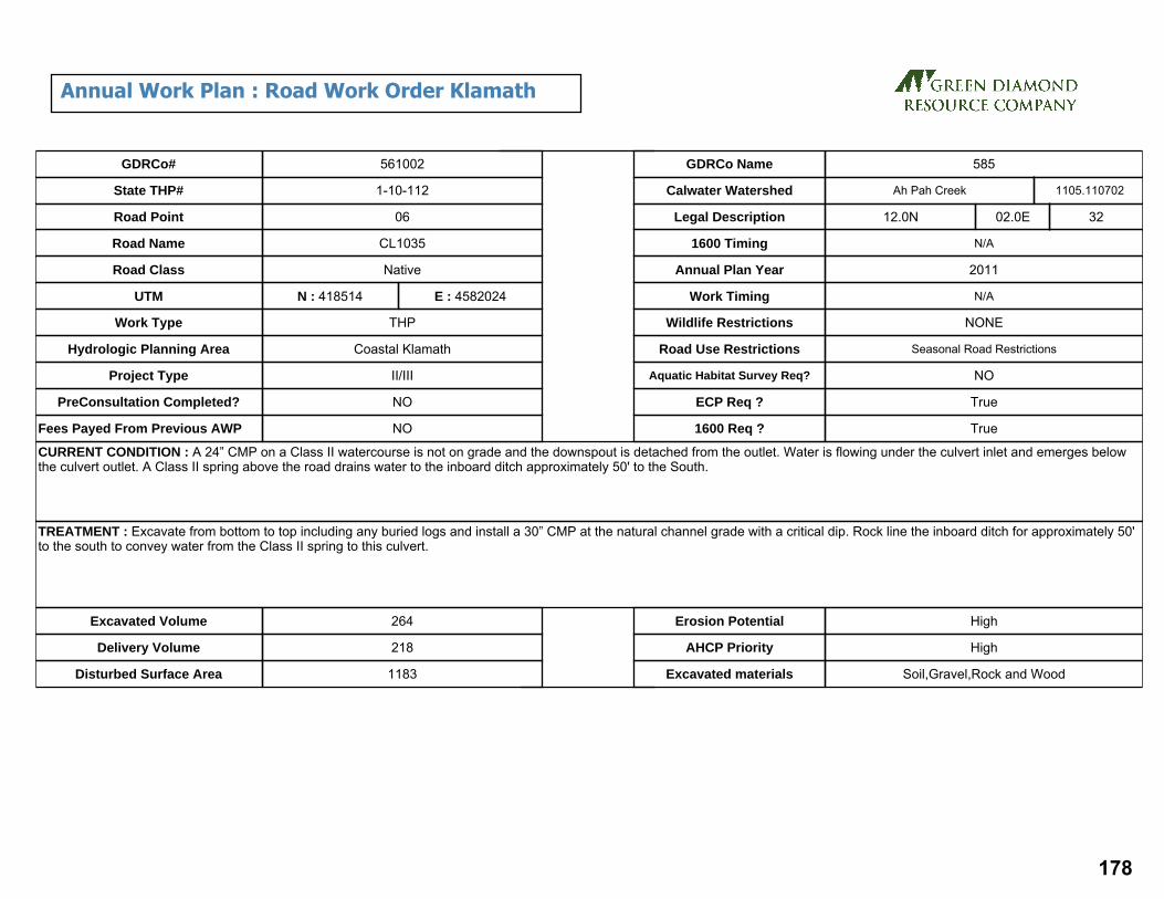
CURRENT CONDITION : A 24” CMP on a Class II watercourse is not on grade and the downspout is detached from the outlet. Water is flowing under the culvert inlet and emerges below the culvert outlet. A Class II spring above the road drains water to the inboard ditch approximately 50' to the South.
TREATMENT : Excavate from bottom to top including any buried logs and install a 30” CMP at the natural channel grade with a critical dip. Rock line the inboard ditch for approximately 50' to the south to convey water from the Class II spring to this culvert.
Excavated Volume 264
Delivery Volume 218
Disturbed Surface Area 1183
Erosion Potential High
AHCP Priority High
Excavated materials Soil,Gravel,Rock and Wood
GDRCo#
State THP#
Road Point
Road Name
Road Class
UTM
Hydrologic Planning Area
Project Type
PreConsultation Completed?
Fees Payed From Previous AWP NO
NO
II/III
Coastal Klamath
THP
N : 418514
Native
CL1035
06
1-10-112
561002
E : 4582024
Ah Pah CreekCalwater Watershed
Legal Description 12.0N 02.0E 32
N/A
2011
N/A
NONE
Seasonal Road Restrictions
NO
True
True
1600 Timing
Annual Plan Year
Work Timing
Wildlife Restrictions
Road Use Restrictions
Aquatic Habitat Survey Req?
ECP Req ?
1600 Req ?
Work Type
1105.110702
GDRCo Name 585
Annual Work Plan : Road Work Order Klamath
178

CURRENT CONDITION : A Class II spring is drained by a 24” CMP with an attached downspout. Minor cut-bank failures associated with the spring have caused debris to collect at the inlet.
TREATMENT : Clean debris from inlet of 24” CMP. Place rock buttressing on cut bank above the inlet to prevent future failures.
Excavated Volume 10
Delivery Volume
Disturbed Surface Area 100
Erosion Potential
AHCP Priority Medium
Excavated materials Soil,Gravel,Rock and Wood
GDRCo#
State THP#
Road Point
Road Name
Road Class
UTM
Hydrologic Planning Area
Project Type
PreConsultation Completed?
Fees Payed From Previous AWP NO
NO
II/III
Coastal Klamath
THP
N : 419385
Rock
CL700
11
1-10-112
561002
E : 4580009
Surpur CreekCalwater Watershed
Legal Description 11.0N 02.0E 05
N/A
2011
N/A
NONE
Permanent Road Restrictions
NO
True
1600 Timing
Annual Plan Year
Work Timing
Wildlife Restrictions
Road Use Restrictions
Aquatic Habitat Survey Req?
ECP Req ?
1600 Req ?
Work Type
1105.110704
GDRCo Name 585
Annual Work Plan : Road Work Order Klamath
179

CURRENT CONDITION : A Class II spring emerges from the cutbank and is drained by an 18” CMP. Minor cut-bank failures associated with the spring have caused debris to collect at the inlet. The failing cut bank has undermined the root system of an approximately 24" Douglas-fir tree just above this road point. The tree is leaning and has most of its limb weight towards the road creating a potential hazard.
TREATMENT : Remove the hazardous Douglas-fir tree. Excavate the debris accumulated at the culvert inlet. Buttress the cutbank with rip-rap to protect the culvert and minimize the potential for future cutbank failures.
Excavated Volume
Delivery Volume
Disturbed Surface Area 100
Erosion Potential
AHCP Priority High
Excavated materials Soil,Gravel,Rock and Wood
GDRCo#
State THP#
Road Point
Road Name
Road Class
UTM
Hydrologic Planning Area
Project Type
PreConsultation Completed?
Fees Payed From Previous AWP NO
NO
II/III
Coastal Klamath
THP
N : 419569
Rock
CL700
12
1-10-112
561002
E : 4580084
Surpur CreekCalwater Watershed
Legal Description 11.0N 02.0E 05
N/A
2011
N/A
NONE
Permanent Road Restrictions
NO
True
1600 Timing
Annual Plan Year
Work Timing
Wildlife Restrictions
Road Use Restrictions
Aquatic Habitat Survey Req?
ECP Req ?
1600 Req ?
Work Type
1105.110704
GDRCo Name 585
Annual Work Plan : Road Work Order Klamath
180

CURRENT CONDITION : The inlet of an 18” corrugated plastic pipe conducting a Class II watercourse across the road has become buried by a cut bank failure above. There is an approximately 4’ drop at the outlet of the downspout.
TREATMENT : Excavate material blocking the inlet. Place rock buttressing at the base of the cut bank excavation to prevent future failures. Install energy dissipating rock at the outfall of the downspout.
Excavated Volume 10
Delivery Volume
Disturbed Surface Area 150
Erosion Potential
AHCP Priority NAP
Excavated materials Soil,Gravel,Rock and Wood
GDRCo#
State THP#
Road Point
Road Name
Road Class
UTM
Hydrologic Planning Area
Project Type
PreConsultation Completed?
Fees Payed From Previous AWP NO
NO
II/III
Coastal Klamath
THP
N : 419932
Rock
CL South
15
1-10-112
561002
E : 4579081
Surpur CreekCalwater Watershed
Legal Description 11.0N 02.0E 09
N/A
2011
N/A
NONE
Permanent Road Restrictions
NO
True
1600 Timing
Annual Plan Year
Work Timing
Wildlife Restrictions
Road Use Restrictions
Aquatic Habitat Survey Req?
ECP Req ?
1600 Req ?
Work Type
1105.110704
GDRCo Name 585
Annual Work Plan : Road Work Order Klamath
181

182
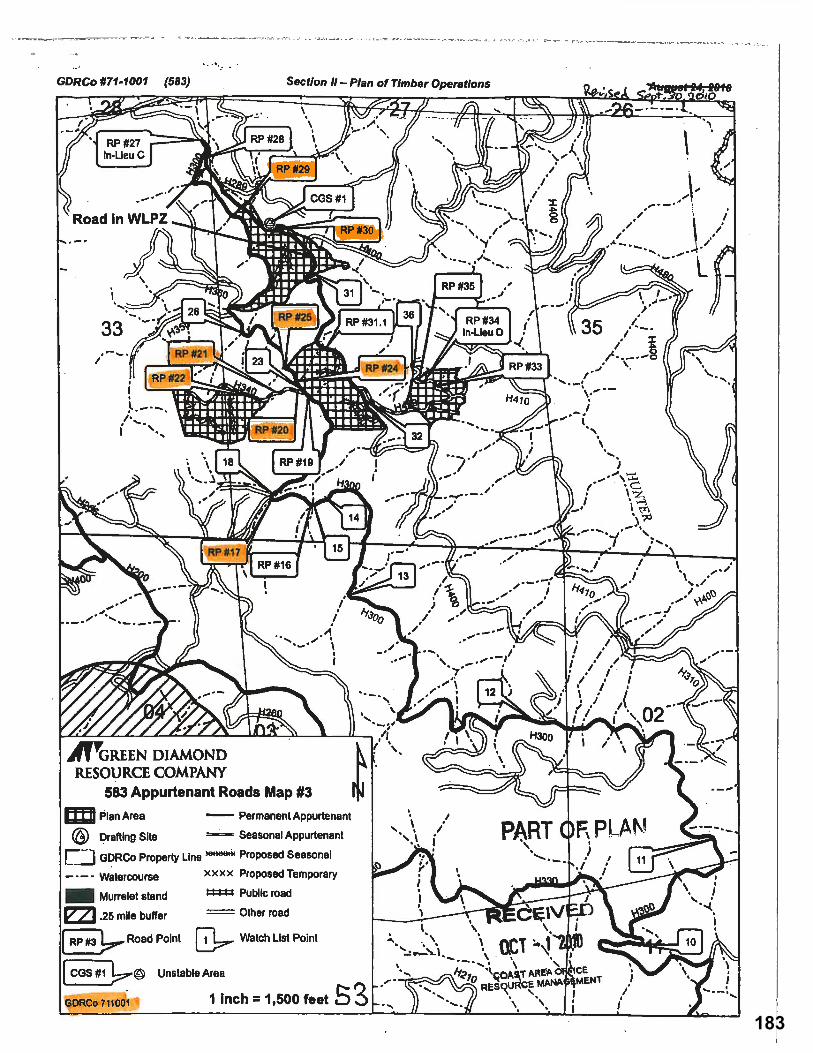
183

184

Site Id THP# Road Pt#
Acres Length(miles)
Lower Elev
Upper Elev
Altitude Tc Cfs C.Diam(inches)
Method
38924 711001 0 17.0 0.41 1060 1700 576 4.62 19.99 30 Rational
8670 711001 02 10.0 0.36 1020 1500 432 4.44 11.76 24 Rational
8666 711001 03 8.0 0.22 1030 1290 234 3.18 9.41 24 Rational
8665 711001 04 39.0 0.53 1020 1540 468 6.73 45.86 42 Rational
8669 711001 06 16.0 0.34 1170 1540 333 4.60 18.82 30 Rational
35461 711001 07 33.0 0.55 380 1520 1026 5.19 38.81 42 Rational
21771 711001 17 51.0 0.44 1390 1720 297 6.47 59.98 48 Rational
37983 711001 20 5.0 0.26 1390 1670 252 3.75 5.88 24 Rational
37870 711001 21 7.0 0.25 1080 1340 234 3.69 8.23 24 Rational
37868 711001 22 8.0 0.23 1490 1720 207 3.51 9.41 24 Rational
37789 711001 24 10.0 0.32 1350 1680 297 4.48 11.76 24 Rational
21531 711001 25 12.0 0.36 1360 1720 324 4.96 14.11 30 Rational
21529 711001 29 9.0 0.34 1200 1580 342 4.55 10.58 24 Rational
21530 711001 30 21.0 0.44 1180 1580 360 6.01 24.70 36 Rational
Culvert Report
185

CURRENT CONDITION : A seasonal spring overwhelmed the inside ditch during a large rain event saturating the fill slope of an approximately 125' section of road, causing it to slip vertically 6 to 8 inches. The movement of the road surface caused a 24" CMP on a Class II watercourse to shear in half. Approximately 1 yd3 of material from the road surface collapsed into the pipe partially plugging the outlet.
TREATMENT : Replace the sheared CMP with a 24” culvert installed to AHCP standards on grade with a critical dip. Install an additional 24” culvert to conduct the seasonal spring across the road. The remainder of this road segment shall be reshaped with a grader to facilitate log hauling.
Excavated Volume 206
Delivery Volume 111
Disturbed Surface Area 1500
Erosion Potential
AHCP Priority High
Excavated materials Soil,Gravel,Rock and Wood
GDRCo#
State THP#
Road Point
Road Name
Road Class
UTM
Hydrologic Planning Area
Project Type
PreConsultation Completed?
Fees Payed From Previous AWP NO
NO
II/III
Smith River
THP
N : 410821
Rock
H200
0
1-10-083
711001
E : 4610539
North of Teds RidgeCalwater Watershed
Legal Description 15.0N 01.0E 33
N/A
2011
N/A
NONE
Permanent Road Restrictions
NO
True
True
1600 Timing
Annual Plan Year
Work Timing
Wildlife Restrictions
Road Use Restrictions
Aquatic Habitat Survey Req?
ECP Req ?
1600 Req ?
Work Type
1103.500001
GDRCo Name 583
Annual Work Plan : Road Work Order Klamath
186

CURRENT CONDITION : A Class II watercourse with a 12" CMP has a sediment wedge and a very rusty inlet that is almost completely blocked by built up sediment. There has been some past failure of the over steepened fill face. The culvert is short, set high in the fill and has eroded fill below the outfall. Most of the flow goes subsurface below the shotgun outlet and reemerges at the base of fill.
TREATMENT : Excavate from flagged bottom to flagged top, including the sediment wedge at the top and any buried logs. Install a 24" culvert to AHCP standards on grade with a critical dip.
Excavated Volume 162
Delivery Volume 77
Disturbed Surface Area 975
Erosion Potential High
AHCP Priority High
Excavated materials Soil,Gravel,Rock and Wood
GDRCo#
State THP#
Road Point
Road Name
Road Class
UTM
Hydrologic Planning Area
Project Type
PreConsultation Completed?
Fees Payed From Previous AWP NO
NO
II/III
Smith River
THP
N : 410045
Rock
H200
02
1-10-083
711001
E : 4613043
North of Teds RidgeCalwater Watershed
Legal Description 15.0N 01.0E 29
N/A
2011
N/A
NONE
Permanent Road Restrictions
NO
True
True
1600 Timing
Annual Plan Year
Work Timing
Wildlife Restrictions
Road Use Restrictions
Aquatic Habitat Survey Req?
ECP Req ?
1600 Req ?
Work Type
1103.500001
GDRCo Name 583
Annual Work Plan : Road Work Order Klamath
187

CURRENT CONDITION : A 12" rusty CMP on a Class II watercourse is misaligned causing a gully where it discharges on to fill. The outlet is nearly buried by fill face failures and there are multiple holes in the outboard fill face. Stream flow goes subsurface before the culvert inlet at the sediment wedge and emerges at the base of the outboard fill. The existing culvert may be separated at an interior joint.
TREATMENT : Excavate from flagged bottom to flagged top, including the sediment wedge at the top and any buried logs. Install a 24" culvert to AHCP standards on grade with a critical dip.
Excavated Volume 716
Delivery Volume 508
Disturbed Surface Area 1200
Erosion Potential High
AHCP Priority High
Excavated materials Soil,Gravel,Rock and Wood
GDRCo#
State THP#
Road Point
Road Name
Road Class
UTM
Hydrologic Planning Area
Project Type
PreConsultation Completed?
Fees Payed From Previous AWP NO
NO
II/III
Smith River
THP
N : 410077
Admin.Rock
H200
03
1-10-083
711001
E : 4613067
North of Teds RidgeCalwater Watershed
Legal Description 15.0N 01.0E 28
N/A
2011
N/A
NONE
Permanent Road Restrictions
NO
True
True
1600 Timing
Annual Plan Year
Work Timing
Wildlife Restrictions
Road Use Restrictions
Aquatic Habitat Survey Req?
ECP Req ?
1600 Req ?
Work Type
1103.500001
GDRCo Name 583
Annual Work Plan : Road Work Order Klamath
188
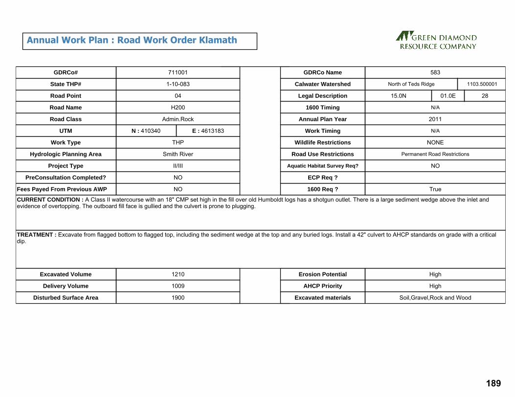
CURRENT CONDITION : A Class II watercourse with an 18" CMP set high in the fill over old Humboldt logs has a shotgun outlet. There is a large sediment wedge above the inlet and evidence of overtopping. The outboard fill face is gullied and the culvert is prone to plugging.
TREATMENT : Excavate from flagged bottom to flagged top, including the sediment wedge at the top and any buried logs. Install a 42" culvert to AHCP standards on grade with a critical dip.
Excavated Volume 1210
Delivery Volume 1009
Disturbed Surface Area 1900
Erosion Potential High
AHCP Priority High
Excavated materials Soil,Gravel,Rock and Wood
GDRCo#
State THP#
Road Point
Road Name
Road Class
UTM
Hydrologic Planning Area
Project Type
PreConsultation Completed?
Fees Payed From Previous AWP NO
NO
II/III
Smith River
THP
N : 410340
Admin.Rock
H200
04
1-10-083
711001
E : 4613183
North of Teds RidgeCalwater Watershed
Legal Description 15.0N 01.0E 28
N/A
2011
N/A
NONE
Permanent Road Restrictions
NO
True
1600 Timing
Annual Plan Year
Work Timing
Wildlife Restrictions
Road Use Restrictions
Aquatic Habitat Survey Req?
ECP Req ?
1600 Req ?
Work Type
1103.500001
GDRCo Name 583
Annual Work Plan : Road Work Order Klamath
189

CURRENT CONDITION : A Humboldt crossing on a Class II watercourse has a sediment wedge built up above the road. The channel above is disrupted by a legacy skid road approximately 75' above the top and there are legacy tractor impacts to the channel itself. There is some erosion of the fill slope where water appears to have overtopped the road at high flows, but most water flows subsurface through the site.
TREATMENT : Excavate from flagged bottom to flagged top, including the sediment wedge at the top and any buried logs. Install a 30" culvert to AHCP standards on grade with a critical dip. The transition point on the sediment wedge may require buttressing with riprap to minimize future headcutting.
Excavated Volume 214
Delivery Volume 223
Disturbed Surface Area 1446
Erosion Potential High
AHCP Priority High
Excavated materials Soil,Gravel,Rock and Wood
GDRCo#
State THP#
Road Point
Road Name
Road Class
UTM
Hydrologic Planning Area
Project Type
PreConsultation Completed?
Fees Payed From Previous AWP NO
NO
II/III
Smith River
THP
N : 410353
Native
H279 (named)
06
1-10-083
711001
E : 4612908
North of Teds RidgeCalwater Watershed
Legal Description 15.0N 01.0E 28
N/A
2011
N/A
NONE
Seasonal Road Restrictions
NO
True
True
1600 Timing
Annual Plan Year
Work Timing
Wildlife Restrictions
Road Use Restrictions
Aquatic Habitat Survey Req?
ECP Req ?
1600 Req ?
Work Type
1103.500001
GDRCo Name 583
Annual Work Plan : Road Work Order Klamath
190

CURRENT CONDITION : A Class II watercourse crossing has an extensive sediment wedge behind it that has buried the original culverts. A 36” diversion culvert was recently installed to channel water to an adjacent gully, but a sinkhole has since opened up at the inlet of an old culvert along the original alignment causing the watercourse to incise through the sediment wedge leaving the diversion high and dry. Water currently makes its way through cavities in the fill and through one of 4 old rusted out CMPs protruding from the fill along the original alignment set at various depths.
TREATMENT : Excavate from the flagged bottom to the flagged top on the sediment wedge and install a 42" culvert to AHCP standards. The transition point on the sediment wedge may require buttressing with riprap to minimize future headcutting. The diversion culvert can be left in place as overflow protection, or install a critical dip.
Excavated Volume 1542
Delivery Volume 1182
Disturbed Surface Area 4727
Erosion Potential High
AHCP Priority High
Excavated materials Soil,Gravel,Rock and Wood
GDRCo#
State THP#
Road Point
Road Name
Road Class
UTM
Hydrologic Planning Area
Project Type
PreConsultation Completed?
Fees Payed From Previous AWP NO
NO
II/III
Coastal Klamath
THP
N : 413621
Rock
H300
07
1-10-083
711001
E : 4607846
Upper West Fork Hunter CreekCalwater Watershed
Legal Description 14.0N 01.0E 11
N/A
2011
N/A
NONE
Permanent Road Restrictions
NO
True
True
1600 Timing
Annual Plan Year
Work Timing
Wildlife Restrictions
Road Use Restrictions
Aquatic Habitat Survey Req?
ECP Req ?
1600 Req ?
Work Type
1105.110802
GDRCo Name 583
Annual Work Plan : Road Work Order Klamath
191

CURRENT CONDITION : A 30" CMP on a low gradient Class II watercourse is rusted through for most of its length.
TREATMENT : Excavate from the flagged bottom to the flagged top and install a 48" culvert to AHCP standards, with a critical dip. Install an 18” ditch relief culvert approximately 80’ up-road to disconnect the inboard ditch from the watercourse.
Excavated Volume 69
Delivery Volume 37
Disturbed Surface Area 562
Erosion Potential Medium
AHCP Priority Medium
Excavated materials Soil,Gravel,Rock and Wood
GDRCo#
State THP#
Road Point
Road Name
Road Class
UTM
Hydrologic Planning Area
Project Type
PreConsultation Completed?
Fees Payed From Previous AWP NO
NO
II/III
Coastal Klamath
THP
N : 411924
Native
H300
17
1-10-083
711001
E : 4610459
Upper West Fork Hunter CreekCalwater Watershed
Legal Description 15.0N 01.0E 34
N/A
2011
N/A
NONE
Seasonal Road Restrictions
NO
False
True
1600 Timing
Annual Plan Year
Work Timing
Wildlife Restrictions
Road Use Restrictions
Aquatic Habitat Survey Req?
ECP Req ?
1600 Req ?
Work Type
1105.110802
GDRCo Name 583
Annual Work Plan : Road Work Order Klamath
192

CURRENT CONDITION : An ephemeral Class III watercourse crossing on a seasonal road lacks a drainage structure.
TREATMENT : Either: Install a 24" culvert to AHCP standards on grade with a critical dip. Or: Install a rocked ford that is armored to the base in fill on the outboard edge of the road.
Excavated Volume 10
Delivery Volume 15
Disturbed Surface Area 262
Erosion Potential High
AHCP Priority High
Excavated materials Soil,Gravel,Rock and Wood
GDRCo#
State THP#
Road Point
Road Name
Road Class
UTM
Hydrologic Planning Area
Project Type
PreConsultation Completed?
Fees Payed From Previous AWP NO
NO
II/III
Coastal Klamath
THP
N : 412054
Native
H340
20
1-10-083
711001
E : 4611005
Upper West Fork Hunter CreekCalwater Watershed
Legal Description 15.0N 01.0E 34
N/A
2011
N/A
NONE
Seasonal Road Restrictions
NO
True
1600 Timing
Annual Plan Year
Work Timing
Wildlife Restrictions
Road Use Restrictions
Aquatic Habitat Survey Req?
ECP Req ?
1600 Req ?
Work Type
1105.110802
GDRCo Name 583
Annual Work Plan : Road Work Order Klamath
193

CURRENT CONDITION : An unclassified ephemeral watercourse crossing lacks a drainage structure. Stream flow is captured by the road and forms a surface gully that is hydrologically connected to another watercourse approximately 250 feet down the road.
TREATMENT : Either: Install a 24" culvert to AHCP standards on grade with a critical dip. Or: Install a rocked ford that breaches the outboard berm and is armored past the transition in grade on the outboard edge of the road.
Excavated Volume 54
Delivery Volume 33
Disturbed Surface Area 655
Erosion Potential High
AHCP Priority High
Excavated materials Soil,Gravel,Rock and Wood
GDRCo#
State THP#
Road Point
Road Name
Road Class
UTM
Hydrologic Planning Area
Project Type
PreConsultation Completed?
Fees Payed From Previous AWP NO
NO
II/III
Coastal Klamath
THP
N : 411960
Native
H340
21
1-10-083
711001
E : 4610994
Upper West Fork Hunter CreekCalwater Watershed
Legal Description 15.0N 01.0E 34
N/A
2011
N/A
NONE
Seasonal Road Restrictions
NO
True
True
1600 Timing
Annual Plan Year
Work Timing
Wildlife Restrictions
Road Use Restrictions
Aquatic Habitat Survey Req?
ECP Req ?
1600 Req ?
Work Type
1105.110802
GDRCo Name 583
Annual Work Plan : Road Work Order Klamath
194

CURRENT CONDITION : A Class III watercourse crossing lacks a drainage structure. Stream flow overtops the road and erodes the outboard fill.
TREATMENT : Either: Install a 24" culvert to AHCP standards on grade with a critical dip. Or: Install a rocked ford that breaches the outboard berm and is armored past the transition in grade on the outboard edge of the road.
Excavated Volume 27
Delivery Volume 13
Disturbed Surface Area 512
Erosion Potential Medium
AHCP Priority High
Excavated materials Soil,Gravel,Rock and Wood
GDRCo#
State THP#
Road Point
Road Name
Road Class
UTM
Hydrologic Planning Area
Project Type
PreConsultation Completed?
Fees Payed From Previous AWP NO
NO
II/III
Coastal Klamath
THP
N : 411857
Native
H340
22
1-10-083
711001
E : 4610964
Upper West Fork Hunter CreekCalwater Watershed
Legal Description 15.0N 01.0E 34
N/A
2011
N/A
NONE
Seasonal Road Restrictions
NO
True
True
1600 Timing
Annual Plan Year
Work Timing
Wildlife Restrictions
Road Use Restrictions
Aquatic Habitat Survey Req?
ECP Req ?
1600 Req ?
Work Type
1105.110802
GDRCo Name 583
Annual Work Plan : Road Work Order Klamath
195

CURRENT CONDITION : A Class II watercourse crossing is drained by Humboldt logs. There is a sediment wedge built up above the road, and legacy impacts associated with past tractor operations at this site. There is a small gully in the fill slope where water may have overtopped the road in the past. There is a high potential for diversion and some past diversion from this site appears to have contributed to the fill failure associated with the right approach to Road Point 19. This site is downstream of Road Point 15 and may receive somewhat higher flows after the road work is completed at that site.
TREATMENT : Treat prior to the Winter Period (Oct.16), unless "Unseasonably Dry Fall" conditions are in effect (Oct.16 - Nov.15) of the year Road Point 15 is upgraded. Excavate from flagged bottom to flagged top, including the sediment wedge at the top and any buried logs. Install a 24" culvert to AHCP standards on grade with a critical dip.
Excavated Volume 319
Delivery Volume 286
Disturbed Surface Area 1637
Erosion Potential High
AHCP Priority High
Excavated materials Soil,Gravel,Rock and Wood
GDRCo#
State THP#
Road Point
Road Name
Road Class
UTM
Hydrologic Planning Area
Project Type
PreConsultation Completed?
Fees Payed From Previous AWP NO
NO
II/III
Coastal Klamath
THP
N : 412050
Native
H300
24
1-10-083
711001
E : 4611053
Upper West Fork Hunter CreekCalwater Watershed
Legal Description 15.0N 01.0E 34
N/A
2011
N/A
NONE
Seasonal Road Restrictions
NO
True
1600 Timing
Annual Plan Year
Work Timing
Wildlife Restrictions
Road Use Restrictions
Aquatic Habitat Survey Req?
ECP Req ?
1600 Req ?
Work Type
1105.110802
GDRCo Name 583
Annual Work Plan : Road Work Order Klamath
196

CURRENT CONDITION : A Class II watercourse crossing with a 12" CMP has a sediment wedge above the inlet. The culvert inlet has collapsed and the fill adjacent the culvert is eroded undercutting the road to the approximate centerline. Humboldt logs are visible protruding from the base of fill. There is an old shallow fill failure along right margin of the outboard fill and the toe slope is undercut by a gully channel from the shotgun culvert outfall. The fill failure appears to be the result of a drainage diversion from another site up the road that was conveyed to this site by the inboard ditch. Water goes subsurface at the sediment wedge approx 20' from the culvert inlet and reemerges near the bottom.
TREATMENT : Excavate from the flagged bottom to the flagged top, and install a 30" culvert to AHCP standards, with a critical dip. Install an 18” ditch relief culvert approximately 80’ up-road to disconnect the inboard ditch from the watercourse.
Excavated Volume 155
Delivery Volume 126
Disturbed Surface Area 887
Erosion Potential Medium
AHCP Priority High
Excavated materials Soil,Gravel,Rock and Wood
GDRCo#
State THP#
Road Point
Road Name
Road Class
UTM
Hydrologic Planning Area
Project Type
PreConsultation Completed?
Fees Payed From Previous AWP NO
NO
II/III
Coastal Klamath
THP
N : 411992
Native
H300
25
1-10-083
711001
E : 4611127
Upper West Fork Hunter CreekCalwater Watershed
Legal Description 15.0N 01.0E 34
N/A
2011
N/A
NONE
Seasonal Road Restrictions
NO
True
True
1600 Timing
Annual Plan Year
Work Timing
Wildlife Restrictions
Road Use Restrictions
Aquatic Habitat Survey Req?
ECP Req ?
1600 Req ?
Work Type
1105.110802
GDRCo Name 583
Annual Work Plan : Road Work Order Klamath
197

CURRENT CONDITION : A 12” culvert fed by cutbank seeps and the Class II unit boundary watercourse is rusted out and eroding the outboard edge of the road. The road is undercut and may be unsafe to haul on prior to road work. There is a Class II watercourse immediately below with direct delivery to a Class I watercourse 80 feet downstream. The existing culvert is accumulating sediment at the inlet and is approximately 25% plugged.
TREATMENT : Rock line the inboard ditch for approximately 75' from the boundary watercourse to the culvert and replace the existing 12” ditch relief culvert with a 24” culvert placed on a steeper gradient to reduce plug potential. Install a critical dip and rock armor at the culvert outlet.
Excavated Volume 17
Delivery Volume 12
Disturbed Surface Area 183
Erosion Potential High
AHCP Priority High
Excavated materials Soil,Gravel,Rock and Wood
GDRCo#
State THP#
Road Point
Road Name
Road Class
UTM
Hydrologic Planning Area
Project Type
PreConsultation Completed?
Fees Payed From Previous AWP NO
NO
II/III
Coastal Klamath
THP
N : 411792
Native
H280
29
1-10-083
711001
E : 4611913
Upper West Fork Hunter CreekCalwater Watershed
Legal Description 15.0N 01.0E 34
N/A
2011
N/A
NONE
Seasonal Road Restrictions
NO
True
True
1600 Timing
Annual Plan Year
Work Timing
Wildlife Restrictions
Road Use Restrictions
Aquatic Habitat Survey Req?
ECP Req ?
1600 Req ?
Work Type
1105.110802
GDRCo Name 583
Annual Work Plan : Road Work Order Klamath
198

CURRENT CONDITION : A Class II watercourse crossing has an 18" CMP placed off the natural alignment and grade and a sediment wedge above the inlet. The inboard ditch delivers directly to the culvert inlet. The culvert is rusted through for more than 25% of its length and approximately 25% of flow bypasses the culvert underneath. The road is severely undercut and the outboard fill face is badly eroded where the outlet used to shotgun onto the fill.
TREATMENT : Excavate from flagged bottom to flagged top, including the sediment wedge at the top and any buried logs. Install a 36" culvert with an inlet cut at an angle to AHCP standards, with a critical dip. Install an 18” ditch relief culvert approximately 75’ up-road to disconnect the inboard ditch from the watercourse and inslope or crown the road for at least 50’ leading down to the ditch relief culvert.
Excavated Volume 310
Delivery Volume 228
Disturbed Surface Area 1682
Erosion Potential High
AHCP Priority High
Excavated materials Soil,Gravel,Rock and Wood
GDRCo#
State THP#
Road Point
Road Name
Road Class
UTM
Hydrologic Planning Area
Project Type
PreConsultation Completed?
Fees Payed From Previous AWP NO
NO
II/III
Coastal Klamath
THP
N : 411940
Native
H280
30
1-10-083
711001
E : 4611806
Upper West Fork Hunter CreekCalwater Watershed
Legal Description 15.0N 01.0E 34
N/A
2011
N/A
NONE
Seasonal Road Restrictions
NO
True
True
1600 Timing
Annual Plan Year
Work Timing
Wildlife Restrictions
Road Use Restrictions
Aquatic Habitat Survey Req?
ECP Req ?
1600 Req ?
Work Type
1105.110802
GDRCo Name 583
Annual Work Plan : Road Work Order Klamath
199

CURRENT CONDITION : There is approximately 70' of cracked fill along the outboard edge of the road. The cracks are approximately 6"-8" wide and extend up to 6’ from the outboard edge of the road. This site is within the WLPZ, approximately 60' from the toe of fill to the Class II watercourse below. The estimated approximate dimensions are w:70' x l:10' x d: 3'
TREATMENT : Excavate the unstable fill material between the flagged margins. The road’s running surface can be moved toward the cutbank. The road is wide and the cutbank probably does not need excavation.
Excavated Volume 1050
Delivery Volume 315
Disturbed Surface Area
Erosion Potential Medium
AHCP Priority Medium
Excavated materials
GDRCo#
State THP#
Road Point
Road Name
Road Class
UTM
Hydrologic Planning Area
Project Type
PreConsultation Completed?
Fees Payed From Previous AWP NO
NO
II/III
Coastal Klamath
THP
N : 412681
Native
H420
34
1-10-083
711001
E : 4611054
Upper West Fork Hunter CreekCalwater Watershed
Legal Description 15.0N 01.0E 34
N/A
2011
N/A
NONE
Seasonal Road Restrictions
NO
1600 Timing
Annual Plan Year
Work Timing
Wildlife Restrictions
Road Use Restrictions
Aquatic Habitat Survey Req?
ECP Req ?
1600 Req ?
Work Type
1105.110802
GDRCo Name 583
Annual Work Plan : Road Work Order Klamath
200

201

202

203

204
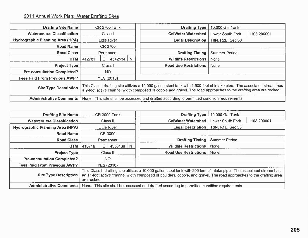
205

206

207

208

209

210

211

212

213