2010 comprehensive plan for the town of berlin, …
TRANSCRIPT

2010 COMPREHENSIVE PLAN
FOR THE TOWN OF BERLIN, MARYLAND
PREPARED BY: TIM BOURCIER; DAVIS, BOWEN AND FRIEDEL, INC.
THE TOWN OF BERLIN PLANNING COMMISSION


2010 Comprehensive Plan Town of Berlin, Maryland
Elected Officials William G. Williams III, Mayor
Elroy Brittingham, Vice-President of Council Paula Lynch Dean Burrell
Lisa Hall Troy Purnell
Planning Commissioners Newt Chandler, Chair
Chris Denny, Vice-Chairman Pete Cosby John Barrett
Phyllis Purnell Bernell Bowen
Ron Cascio Barb Stack
Town Staff Anthony J. Carson, Jr., Town Administrator
Chuck Ward, Planning Director
Consultants Timothy M. Bourcier, AICP, JD
Alix Maubrey Davis, Bowen & Friedel, Inc.
Additional technical assistance provided by: Worcester County Department of Development, Review and Permitting

TABLE OF CONTENTS
INTRODUCTION…….………………………………………………………………………………………….1
HISTORY AND VISION.……………………………………………………………………………………..6
SOCIAL, ECONOMIC AND HOUSING CHARACTERISTICS……………………………………11
COMMUNITY FACILITIES……………………………………………………………………….………..20
LAND USE………………………………………………………………………………………………………26
MUNICIPAL GROWTH…………………………………………………………………………………….30
WATER RESOURCES……………………………………………………………………………………….44
TRANSPORTATION…………………………………………………………………………………………52
HOUSING……………………………………………………………………………………………………….59
SENSITIVE AREAS……………………………………………………………………………………………63
MINERAL RESOURCES…………………………………………………………………………………….70
PLAN IMPLEMENTATION……………………………………………………………….………………..72
MAPS…………………………………………………………………………………………………………….77
COMMUNITY SURVEY…………………………………………………………………………………87

TOWN OF BERLIN, MARYLAND – 2010 COMPREHENSIVE PLAN 1
INTRODUCTION
Introduction Berlin’s Comprehensive Plan analyzes potential growth and the associated impacts through the year 2030. Infrastructure, housing, growth and other issues are discussed in this plan. The purpose of this plan is to properly prepare for growth and related issues the Town will likely encounter over the next twenty years.
Acknowledgements The Town of Berlin would like to thank the planning and engineering staff with Davis, Bowen & Friedel, Inc., for providing technical assistance with this Plan. The Town would also like to thank Chuck Ward, Planning Director, and the members of the Planning Commission for their efforts in this planning process. The Town also thanks the residents and business owners for participating in the various workshops and providing input. The creation of this Comprehensive Plan would not have been possible without the support of the community.
Legal Basis for Planning in Maryland Article 66B of the Annotated Code of Maryland requires municipalities that maintain zoning authority over the jurisdiction to develop a Comprehensive Plan. This article also requires municipalities to address specific issues within their growth plans. 2006 House Bill 1141 requires municipalities to address the impact projected growth will have on infrastructure, water resources, schools, libraries and public safety. Berlin’s Comprehensive Growth Plan meets the necessary requirements under Article 66B and House Bill 1141. The Berlin Plan also addresses workforce housing which qualifies Berlin to participate in the Workforce Housing Grant Program developed under House Bill 1160. The information below further discusses Maryland’s visions and requirements for growth as related to the Town of Berlin.
The State’s “Twelve Visions” for Guiding Future Growth The following twelve “Vision Statements”, based on the original 1992 Planning Act and subsequent amendments thereto, are incorporated into this Comprehensive Plan as fundamental goals which will be achieved through a variety of objectives, policies, principles, recommendations and implementation techniques.
1

2
1. QUALITY OF LIFE AND SUSTAINABILITY: A high quality of life is achieved through universal stewardship of the land, water and air resulting in sustainable communities and protection of the environment;;
2. PUBLIC PARTICIPATION: Citizens are active partners in the planning and
implementation of community initiatives and are sensitive to their responsibilities in achieving community goals;
3. GROWTH AREAS: Growth is concentrated in existing population and business centers,
growth areas adjacent to these centers, or strategically selected new centers;
4. COMMUNITY DESIGN: Compact, mixed-use, walkable design consistent with existing community character and located near available or planned transit options is encouraged to ensure efficient use of land and transportation resources and preservation and enhancement of natural systems, open spaces, recreational areas, and historical, cultural and archeological resources;
5. INFRASTRUCTURE: Growth areas have the water resources and infrastructure to
accommodate population and business expansion in an orderly, efficient, and environmentally sustainable manner;
6. TRANSPORTATION: A well-maintained, multimodal transportation system facilitates the
safe, convenient, affordable, and efficient movement of people, goods and services within and between population and business centers;
7. HOUSING: A range of housing densities, types, and sizes provides residential options
for citizens of all ages and incomes;
8. ECONOMIC DEVELOPMENT: Economic development and natural resource-based businesses that promote employment opportunities for all income levels within the capacity of the State’s natural resources, public services, and public facilities are encouraged;
9. ENVIRONMENTAL PROTECTION: Land and water resources, including the
Chesapeake and Coastal Bays, are carefully managed to restore and maintain healthy air and water, natural systems, and living resources;
10. RESOURCE CONSERVATION: Waterways, forests, agricultural areas, open space,
natural systems, and scenic areas are conserved;
11. STEWARDSHIP: Government, business entities, and residents are responsible for the creation of sustainable communities by collaborating to balance efficient growth with resource protection; and,
12. IMPLEMENTATION: Strategies, policies programs, and funding for growth and
development, resource conservation, infrastructure, and transportation are integrated across the local, regional, state, and interstate levels to achieve these visions.

TOWN OF BERLIN, MARYLAND – 2010 COMPREHENSIVE PLAN 3
1997 Priority Funding Areas Act The 1997 Priority Funding Areas Act capitalizes on the influence of State expenditures on economic growth and development. This legislation directs State spending to Priority Funding Areas (PFA). PFAs are existing communities and places where local governments want State investment to support future growth. Growth-related projects covered by the legislation include highways, sewer and water construction, economic development assistance and State leases or construction of new office facilities. The PFA legislation builds on the foundation created by the Visions that were adopted as State policy in the 1992 Economic Growth, Resource Protection and Planning Act and are articulated above as fundamental goals for the Town of Berlin. In 1998 the State of Maryland directed funding for projects that support growth to PFAs. Funding for projects within municipalities, certain existing communities, industrial areas and designated growth areas receive priority for State funding. PFAs are priorities for State and local government spending to encourage and support economic development.
The Smart Growth Initiative In addition to the Priority Funding Areas Act, the 1997 General Assembly passed four other pieces of legislation and budget initiatives: Brownfields, Live Near Your Work, Job Creation Tax Credits, and Rural Legacy. These four initiatives are known collectively as “Smart Growth”. Smart Growth targets programs and funding to established communities and locally designated growth areas and to protect rural areas. The Priority Funding Areas Act provides a geographic focus for the State’s investment in growth-related infrastructure. The Act focuses State resources to conserve lands outside of PFAs, to encourage growth within PFAs and to ensure that existing communities continue to provide a high quality of life for their residents. Maryland has adopted the following principles of Smart Growth, which provide guidance for new development, infill development, and redevelopment:
- Encourage mixed land uses; - Incorporate compact building design; - Create housing opportunities and choices; - Create walkable communities; - Foster distinctive, attractive communities with a strong sense of place; - Preserve open space, farmland, natural beauty, and critical environmental areas; - Provide a variety of transportation options; - Strengthen and direct development to existing communities; - Make development decisions predictable, fair and cost effective; and - Encourage community and stakeholder collaboration in development decisions.
The 1997 Smart Growth initiative was significant in the State’s refusal to encourage or fund sprawl development.

4
House Bill 1141 During the 2006 Maryland Legislative Session, House Bill 1141 was enacted. This law has a direct effect on procedures for annexations and requires new planning elements within Berlin’s Comprehensive Plan.
Annexation Procedures Two significant changes resulting from HB 1141 are a change to the “five-year rule” regarding zoning and a change regarding “Annexation Plans”. The Five Year Rule Two changes to the five-year rule were incorporated in HB1141. First, the rule would be applied solely based upon zoning. In the past, the five-year rule could be applied when a proposed new zoning classification was substantially different from the use envisioned “in the current and duly adopted Master Plan”. The reference to the Master Plan is now gone. The zoning classification is now required to be reviewed based on the degree of change from current County zoning to the proposed municipal zoning. When the zoning change is proposed to be from one residential zone to another, “substantially different” is now defined by the amount of density change. The five-year rule does not apply in the case of a density change unless the proposed zoning is 50% denser. For example, if the current zoning permits 1 unit per acre, the new zoning can be subject to the five year rule if it permits anything more than 1.5 units per acre. As before, a municipality may obtain a waiver from the County to avoid the five-year wait. This change took effect on October 1, 2006. Annexation Plans An Annexation Plan is required that identifies the extension of services and public facilities prior to the public hearing for an annexation proposal. This section contains no additional language for the content of the Annexation Plan to be adopted, but does require it to be consistent with the municipal growth element for any annexations after October 1, 2009. The Plan must be provided to the County and State (Maryland Department of Planning) at least 30 days prior to the hearing. This requirement took effect on October 1, 2006. The requirement for consistency with the Municipal Growth Element of the Comprehensive Plan takes effect no later than October 1, 2009 with provisions for two six-month extensions.
New Planning Elements The new legislation mentioned above requires two new elements, or chapters, to be included in local Comprehensive Plans. The first element, Water Resources, must be included in County and municipal Plans. The second element, Municipal Growth, is required in municipal Comprehensive Plans only. Both elements are required to be incorporated into the Town’s Comprehensive Plan no later than October 1, 2009 with a provision for two six-month extensions.

TOWN OF BERLIN, MARYLAND – 2010 COMPREHENSIVE PLAN 5
The Water Resources Element This element addresses the relationship of planned growth to water resources for both waste disposal and safe drinking water. It is required of all County and municipal governments in the State. The element must identify drinking water and other water resources adequate for the needs of existing and future development proposed in the land use element of the Comprehensive Plan. It must also identify suitable receiving waters for both wastewater and stormwater management to address the development proposed in the Land Use Element of the Comprehensive Plan. The Maryland Department of Natural Resources will provide available data to identify these resources. Resource issues expected to be addressed in these elements include water protection areas, groundwater resources, water quality standards and Total Maximum Daily Loads (TMDLs). The Municipal Growth Element This element requires a municipality to identify areas for growth consistent with a long-range vision for its future. The Growth Element will be developed based on consideration of a comprehensive list of factors including population projections, land capacity assessment and infrastructure assessment. Completion of this element will guide future annexation proposals and plans. Consultation with Worcester County is required, and a joint agreement with the County is encouraged. 2009 Planning Legislation – Smart, Green and Growing Initiative The 2009 legislative session saw several bills adopted that were introduced by Governor Martin O’Malley’s administration. The Smart, Green and Growing initiative was evidenced by three key planning bills adopted. Beginning in 2010 municipalities will be required to track the progress of their Comprehensive Plan and development based on certain measures and markers. Planning Commissioners and members of local Boards of Appeals will also be required to complete a training session on the rules and responsibilities of their position. Below is a brief summary of the three planning bills of the 2009 legislative session.
• Smart and Sustainable Growth Act of 2009 – A bill addressing the Terrapin Run decision and implementing a new standard of “consistency” governments must have between their Comprehensive Plans and development decisions.
• Smart Growth Measures and Markers – Allows the State to create “Smart Growth” standards to measure local government’s Smart Growth process.
• Planning Visions – Creates several new State planning visions to help guide Comprehensive Planning and growth in Maryland.
The Town of Berlin should continue to work closely with the Maryland Department of Planning and the Berlin Planning Commission to monitor the progress of these new laws and their affect on the Town. .

6
BERLIN’S HISTORY AND FUTURE VISION Location Berlin, located in northern Worcester County, is located only seven miles away from popular destinations such as Ocean City and Assateague Island. It also lies approximately 20 miles away from Salisbury, the largest city on Maryland’s Eastern Shore. The Town can be accessed through a variety of roads including State Routes 374 and 376, and U.S. Routes 50 and 113.
Figure 2.1 Location Map
2
TOWN OF BERLIN, MARYLAND – 2010 COMPREHENSIVE PLAN 7
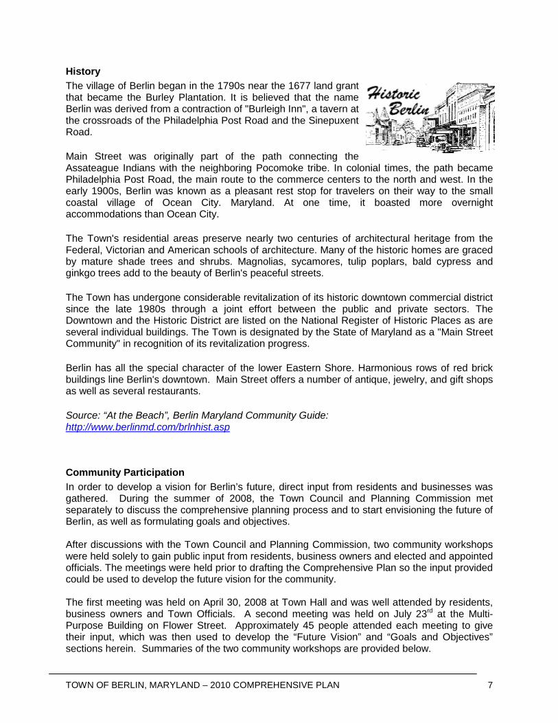
History The village of Berlin began in the 1790s near the 1677 land grant that became the Burley Plantation. It is believed that the name Berlin was derived from a contraction of "Burleigh Inn", a tavern at the crossroads of the Philadelphia Post Road and the Sinepuxent Road.
Main Street was originally part of the path connecting the Assateague Indians with the neighboring Pocomoke tribe. In colonial times, the path became Philadelphia Post Road, the main route to the commerce centers to the north and west. In the early 1900s, Berlin was known as a pleasant rest stop for travelers on their way to the small coastal village of Ocean City. Maryland. At one time, it boasted more overnight accommodations than Ocean City.
The Town's residential areas preserve nearly two centuries of architectural heritage from the Federal, Victorian and American schools of architecture. Many of the historic homes are graced by mature shade trees and shrubs. Magnolias, sycamores, tulip poplars, bald cypress and ginkgo trees add to the beauty of Berlin's peaceful streets.
The Town has undergone considerable revitalization of its historic downtown commercial district since the late 1980s through a joint effort between the public and private sectors. The Downtown and the Historic District are listed on the National Register of Historic Places as are several individual buildings. The Town is designated by the State of Maryland as a "Main Street Community" in recognition of its revitalization progress.
Berlin has all the special character of the lower Eastern Shore. Harmonious rows of red brick buildings line Berlin's downtown. Main Street offers a number of antique, jewelry, and gift shops as well as several restaurants.
Source: “At the Beach”, Berlin Maryland Community Guide: http://www.berlinmd.com/brlnhist.asp
Community Participation In order to develop a vision for Berlin’s future, direct input from residents and businesses was gathered. During the summer of 2008, the Town Council and Planning Commission met separately to discuss the comprehensive planning process and to start envisioning the future of Berlin, as well as formulating goals and objectives. After discussions with the Town Council and Planning Commission, two community workshops were held solely to gain public input from residents, business owners and elected and appointed officials. The meetings were held prior to drafting the Comprehensive Plan so the input provided could be used to develop the future vision for the community. The first meeting was held on April 30, 2008 at Town Hall and was well attended by residents, business owners and Town Officials. A second meeting was held on July 23rd at the Multi-Purpose Building on Flower Street. Approximately 45 people attended each meeting to give their input, which was then used to develop the “Future Vision” and “Goals and Objectives” sections herein. Summaries of the two community workshops are provided below.

8
First Public Workshop At the first meeting, residents suggested that employment opportunities should be encouraged close to Town. A majority also felt that while encouraging growth downtown, it was important for the Town to enact architectural design standards to avoid building new residential development that takes away from the architectural character of the Town. In discussions concerning the Historic District, it was agreed upon that residential uses should be promoted above existing commercial uses downtown, creating a mixed use community. However, points of view diverged over the expansion of the Historic District boundaries. A majority of residents were cautious or disapproving of any expansion, especially property owners whose houses were within the expansion area. Concerns included the relevance of certain classified “historical” structures, disagreement regarding the proposed expansion of the Historic District and the lack of clarity concerning the Historic District Commission’s role and applicable regulations.
Second Public Workshop During the second meeting, different issues were discussed. Lack of affordable housing was a major concern to the attendees, as many felt that the cost of living was prohibitive to many working-class families. Discussion followed regarding educating the community about funding, grants and housing options. The need to add municipal parking lots in the downtown area was also expressed in light of the expected increase in mixed residential and retail uses. Lack of non-automobile modes of transportation including public transportation, sidewalks and bikeways concerned many individuals. Those residing east of Route 113 expressed concern regarding safe access to the commercial businesses on the west side of Rt. 113. A discussion followed regarding the rich cultural and historical character of Berlin’s easterly neighborhoods and how that character could be promoted and preserved.
Resident Survey Results Berlin residents received a paper survey in the mail in November 2008. The survey was also offered on-line with a link from the Town’s website. The survey asked residents to respond to a number of questions, including their satisfaction with the Town’s facilities and their feelings about expanding Town boundaries to coordinate growth. A complete summary of the survey results is provided in Appendix A. Approximately 420 surveys were submitted. Assuming one survey was completed per household, the overall response rate was approximately 25%. Below are some of the highlights of the survey that were used to help develop a vision for the future of Berlin.
• Most of the residents that responded were full-time residents. Respondents were evenly split between residents who recently moved to Berlin (past 2 to 10 years) and long-time residents of Berlin (over 10 years).
• The top three projects respondents stated they would give the most support to included the minimization of sprawl, creating additional sidewalks/walking paths and preserving open space/farmland.

TOWN OF BERLIN, MARYLAND – 2010 COMPREHENSIVE PLAN 9
• In separate questions, respondents suggested residential development needs to be greatly decreased but commercial uses and other services should be expanded and encouraged.
• Historic preservation was indicated to be important to the respondents. • 53% of the respondents felt expanding the Town’s existing boundaries through
annexation was inappropriate at this time; • A majority of the respondents suggested that the development of 25 new homes or less
per year is a reasonable rate of growth. The development of 0 to 10 new homes a year was considered a reasonable rate of growth by 36% of the respondents.
Future Vision Berlin, a historic Eastern Shore rural community, benefits from a vibrant downtown business district and a wealth of natural resources. While residential and commercial development has altered the composition of the community, elected officials, community leaders and citizens have strived to maintain a specific identity and to improve on an already high quality of life. Residents of Berlin have established close-knit relationships and a sense of pride in their community. Results of the community survey conducted in 2009 indicate that a majority of the residents would like elected officials to prioritize projects that take into account recent and ongoing development in Berlin and refocus the community to its traditional roots. In a sense, the survey suggests the Town should go back to its traditional roots. New development and the downtown should be connected via sidewalks and walking paths. The architecture in downtown Berlin should be preserved and enhanced but not in a manner that would take away from Berlin’s uniqueness. Berlin is already moving toward “greening” the community. Several non-profit organizations joined forces to create the “Grow Berlin Green” initiative in 2008. This group is charged with involving citizens and businesses of the Town in creating a more environmentally friendly and energy efficient community. This is an important focus for Berlin as it continues to reduce the costs of managing its electrical facility. A focus on parks and recreational facilities is also important for Berlin. Residents have asked for additional park facilities and interconnection between those facilities. The Town has recognized the need for improvements to the parks system and recently completed a Parks Master Plan, which focuses on improving existing facilities and integrating the park system into the character of the community.

10
Goals and Objectives
1. Reestablish Berlin’s traditional Town Center through encouraging mixed-use development downtown;
2. Preservation and expansion of the Historic District, including development and implementation of architectural design standards for historically significant areas;
3. Direct future growth into the downtown community or within the existing Town boundaries, either as infill growth or where vacancies exist in committed development;
4. Create a plan to manage future annexations, especially to control sprawling residential growth;
5. Repair, maintain and develop park facilities to provide a wealth of recreational activities for the community;
6. Continue to seek environmentally friendly solutions to issues throughout the community; 7. Create viable, alternative modes of transportation by seeking out bike paths and creating
a system of interconnected sidewalks; 8. Create an overall “smart growth” vision and approach to regulating development in the
community; 9. Prohibit potentially harmful development that will affect sensitive areas, including the
Coastal Bays, Chesapeake Bay and the surrounding waterways; 10. Focus on preserving ecologically significant land surrounding the community, especially
existing forested lands and wetland areas; 11. Ensure a variety of housing alternatives for all residents of Berlin; 12. Provide a future growth pattern that has the least impact on water resources and other
community facilities; 13. Implement the policies and recommendations of this plan, through amending the Town
Code and enforcing existing regulations; 14. Develop a funding mechanism to assist in the implementation of this plan.
Conclusions Berlin is a community with a wealth of resources that is very focused on improving the way of life in a manner that is sustainable for generations to come. The community also recognizes its attraction and understands why tourism is important and new residents will continue to flock to the area. However, the community is also very aware of the need to sustain the quality of life in the community in order to maintain its character. The Town and its residents are working together on several projects focusing on sustainability. This plan should act as one of several items helping focus the future vision of Berlin over the next 20 years to maintain the high quality of life in Berlin.
TOWN OF BERLIN, MARYLAND – 2010 COMPREHENSIVE PLAN 11
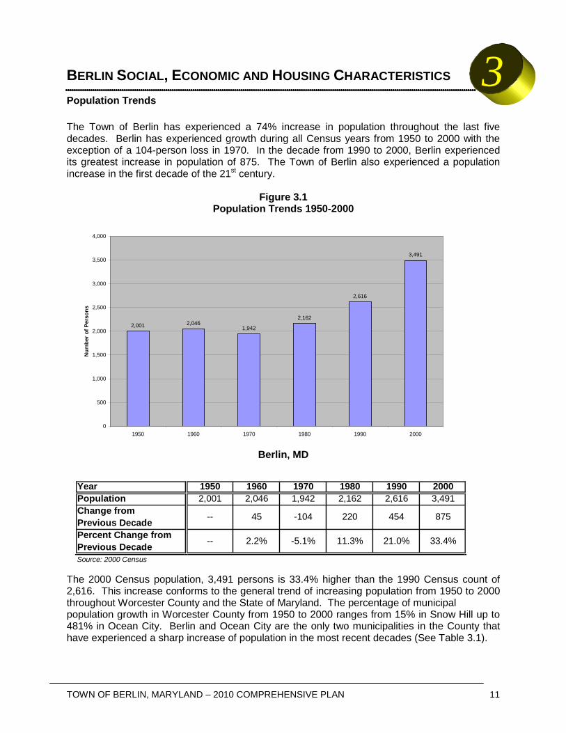
BERLIN SOCIAL, ECONOMIC AND HOUSING CHARACTERISTICS Population Trends The Town of Berlin has experienced a 74% increase in population throughout the last five decades. Berlin has experienced growth during all Census years from 1950 to 2000 with the exception of a 104-person loss in 1970. In the decade from 1990 to 2000, Berlin experienced its greatest increase in population of 875. The Town of Berlin also experienced a population increase in the first decade of the 21st century.
Figure 3.1 Population Trends 1950-2000
Berlin, MD
The 2000 Census population, 3,491 persons is 33.4% higher than the 1990 Census count of 2,616. This increase conforms to the general trend of increasing population from 1950 to 2000 throughout Worcester County and the State of Maryland. The percentage of municipal population growth in Worcester County from 1950 to 2000 ranges from 15% in Snow Hill up to 481% in Ocean City. Berlin and Ocean City are the only two municipalities in the County that have experienced a sharp increase of population in the most recent decades (See Table 3.1).
2,001 2,0461,942
2,162
2,616
3,491
0
500
1,000
1,500
2,000
2,500
3,000
3,500
4,000
1950 1960 1970 1980 1990 2000
Num
ber o
f Per
sons
Year 1950 1960 1970 1980 1990 2000Population 2,001 2,046 1,942 2,162 2,616 3,491Change fromPrevious DecadePercent Change fromPrevious Decade
45
--
Source: 2000 Census
--
33.4%
875
21.0%
454
11.3%
220
-5.1%
-104
2.2%
3

12
Since 1950, Berlin has maintained its population as the second smallest municipality in the County. In 1970, Berlin accounted for 8% of the county total. In 1980 it decreased to 7%, in 1990 it increased to 7.5% and in 2000 it maintained 7.5% of the County’s total population.
Age Composition The age structure and total population trends are important components of future land use designations for Berlin’s future needs. Policy makers for community facilities such as schools, services, and transportation rely on age composition data. In addition, key indicators of relative well being, such as employment and housing, are also dependent upon the age structure of the population. In comparison to the State, County, and other municipalities in Worcester County, Berlin possesses an above average proportion of children less than 17 years of age. The mean proportions of children under 5 and children 5-17 among municipalities in Worcester County are 5.3% and 16.9%, respectively. Berlin has a lower proportion (10%) of population from 18 to 24 than the mean of all municipalities in Worcester County. This statistic is skewed by Ocean City’s abundance of population (15%) within this age group. Persons 18 to 24 years old are generally the most mobile population group. A lower proportion of the 18 to 24 year old group would most likely reflective of those individuals leaving Berlin after completing high school to enter the civilian labor force, attend college or join the military (Figure 3.2).
City/Town 1950 1960 1970 1980 1990 2000Berlin 2,001 2,046 1,942 2,162 2,616 3,491
Ocean City 1,234 983 1,493 4,946 5,146 7,173Pocomoke City - 3,329 3,573 3,558 3,922 4,098
Snow Hill 2,091 2,311 2,201 2,192 2,217 2,409Worcester County 23,148 23,733 24,442 30,889 35,028 46,543State of Maryland 2.3 M 3.1 M 3.92 M 4.22 M 4.78 M 5.29 M
Source: MD Office of Planning, Planning Data Services & 2000 Census
Total Population 1950-2000Worcester County, Cities and Towns
Table 3.1

TOWN OF BERLIN, MARYLAND – 2010 COMPREHENSIVE PLAN 13
Figure 3.2 Population Change by Age Group 1990-2000
Berlin, Maryland
The ratio of Berlin residents in the 25-44 age group, the primary labor force and household forming group, is 26.2%. This is slightly lower than Worcester County’s 26.4% and lower than the State of Maryland’s ratio of 31.4%.
The 45-64 age group comprises almost 20% of the total population in Berlin. Other municipalities in the County range from 19% to 28% for this age group. Statewide this group comprises 23% of the total population.
0
100
200
300
400
500
600
700
800
Num
bers
of P
erso
ns
1990 Population 188 448 189 345 376 248 218 463 141
2000 Population 233 677 258 404 511 391 304 498 215
< 5 5 - 17 18 - 24 25 - 34 35 - 44 45 - 54 55 - 64 65 - 84 85+
City/Town <5 5-17 18-24 25-44 45-64 65+ Median AgeBerlin 6.7% 19.4% 7.4% 26.2% 19.9% 20.4% 38.3
Ocean City 3.0% 8.3% 15.6% 28.2% 28.0% 25.2% 47.2Pocomoke City 6.9% 23.6% 7.8% 26.7% 19.1% 16.0% 35.5
Snow Hill 4.7% 16.3% 9.3% 29.6% 20.5% 19.5% 38.8Worcester County 4.9% 15.7% 6.2% 26.4% 26.9% 20.1% 43.0
State of Maryland (5,296,486) 6.7% 18.9% 8.5% 31.4% 23.1% 11.3% 36.0
Percent of Population by Age Cohort by Municipality 2000Table 3.2
Source: 2000 Census
Worcester County, Maryland

14
Persons over 65 years comprise approximately 20% of Berlin’s population, compared to 11% statewide. In other municipalities, this age group ranges from 16.0% in Pocomoke City to 25.2% in Ocean City. Combined with the 45-64 age group, persons 45 years and older account for 40% of Berlin’s population. In Worcester County, the over-45 age group accounts for 47% of the total population. Statewide this ratio is 34%. In other County municipalities the range is from 35% in Pocomoke City to 53% in Ocean City (See Table 3.2). The 18-24 age group has increased by 2% since the 1990 Census (see Figure 3.2). Berlin had the lowest proportion of young adults in the County with only 7%, well below the Worcester municipalities’ mean of 10%. The median age in Berlin is the second lowest out of the municipalities in Worcester County. The Town’s median age is also lower than that of Worcester County yet higher than the State of Maryland. In 2000, the average median age in Worcester County municipalities was 40 years, while the median age of the residents of Berlin was 38. The municipal average is influenced by Ocean City’s relatively high median age of 47 (See Table 3.2).
Sex and Racial Composition
Figure 3.3 Population Ratio by Sex – Year 2000
Berlin, Maryland In the 2000 Census, Berlin’s population was 44.8% male and 55.2% female. This statistic is more female dominant than the County’s and the State’s (See Figure 3.3). Berlin exists as a majority white community with 63.7% of its population being white. Berlin closely resembles the ethnic diversity that exists in Worcester County and the State of Maryland (See Figure 3.4).
0.0%
10.0%
20.0%
30.0%
40.0%
50.0%
60.0%
Per
cen
t o
f P
op
ula
tio
n
Berlin 44.8% 55.2%Worcester 48.8% 51.2%Maryland 48.3% 51.7%
Male Female

TOWN OF BERLIN, MARYLAND – 2010 COMPREHENSIVE PLAN 15
Figure 3.4 Racial Composition – Year 2000
Berlin, Maryland
Education The proportion of school-age children, older than 3, enrolled in nursery school and preschool is nearly twice that of the County and State. The statistics for kindergarten, elementary, and high school enrollment are similar to the State and County. The proportion of persons enrolled in college and graduate school are considerably lower than that of Wicomico County and Maryland. 21% of persons 25 years and older in Berlin do not have a high school diploma or GED compared to 18% in Wicomico and 16% statewide. Berlin does have a higher proportion of high school graduates, but a lower portion of higher education degrees than the County and State (See Table 3.3).
0%
10%
20%
30%
40%
50%
60%
70%
80%
90%
100%Pe
rcen
tage
of P
opul
atio
n
White 63.7% 81.2% 64.0%
Black or African American 32.0% 16.7% 27.9%
American Indian and AlaskaNative
0.2% 0.2% 0.3%
Asian 1.5% 0.6% 4.0%
Native Hawaiian/PacificIslander
0.0% 0.0% 0.0%
Some Other Race 1.0% 0.4% 1.8%
Two or More Races 1.5% 1.0% 2.0%
Berlin Worcester Maryland

16
Employment and Labor Force Characteristics In 2000, Berlin had a civilian labor force of 2,731 persons over the age of 16. Approximately 132 members of its labor force were unemployed creating a 5% unemployment rate, slightly more than Worcester County’s 4% unemployment rate (See Table 3.4). A larger proportion of Berlin’s labor force was employed in the retail, arts, education and health sectors. Of the Town’s 1,505 workers, 73% were employed in the private wage and salary worker class (See Table 3.5).
Worcester MarylandSCHOOL ENROLLMENTPopulation 3 years and over enrolled in school 955 100% 9,832 1,475,484Nursery school, preschool 116 12.1% 6.5% 6.5%Kindergarten 42 4.4% 5.4% 5.1%Elementary school (grades 1-8) 452 47.3% 45.4% 43.5%High school (grades 9-12) 217 22.7% 25.6% 20.9%College or graduate school 128 13.4% 17.1% 24.0%EDUCATIONAL ATTAINMENTPopulation 25 years and over 2,359 100% 34,092 3,495,595Less than 9th grade 162 6.9% 5.1% 5.1%9th to 12th grade, no diploma 335 14.2% 13.2% 11.1%High school graduate (includes equivalency) 962 40.8% 34.1% 26.7%Some college, no degree 490 20.8% 20.6% 20.3%Associate degree 31 1.3% 5.2% 5.3%Bachelor's degree 294 12.5% 14.6% 18.0%Graduate or professional degree 85 3.6% 7.1% 13.4%
Educational Statistics 2000Berlin, Maryland
Table 3.3
Berlin
Source: 2000 Census

TOWN OF BERLIN, MARYLAND – 2010 COMPREHENSIVE PLAN 17
Table 3.4 Industry & Employment Characteristics 2000
Berlin, Maryland
Berlin Percent Worcester Maryland
Employment Status: Population 16+ years old 2,731 -- 38,103 4,085,942
Employed Persons 1,505 55.1% 56.5% 63.8% Unemployed Persons 132 4.8% 4.1% 3.2%
Not in labor force 1,085 39.7% 39.3% 32.2% Armed Forces 9 0.3% 0.1% 0.8%
Industry: Agriculture, forestry, fisheries, mining 27 1.8% 2.2% 0.6%
Construction 133 8.8% 9.1% 6.9% Manufacturing 126 8.4% 6.8% 7.3%
Wholesale trade 28 1.9% 3.4% 2.8% Retail trade 215 14.3% 13.4% 10.5%
Transportation, warehousing, utilities 79 5.2% 3.0% 4.9% Information 40 2.7% 2.5% 4.0%
Finance, insurance, real estate 98 6.5% 7.9% 7.1% Professional, scientific, management, administrative, waste management 96 6.4% 5.9% 12.4% Educational, health, social services 252 16.7% 17.2% 20.6%
Arts, entertainment, recreation 232 15.4% 17.7% 6.8% Other services 92 6.1% 4.6% 5.6%
Public administration 87 5.8% 6.3% 10.5% Source: 2000 Census
Employed population 1,505 100% 21,510Private wage & salary workers 1,104 73.36% 74.6%
Government workers 269 17.87% 16.2%Self-employed workers 120 7.97% 8.9%Unpaid family workers 12 0.80% 0.3%
Berlin Worcester PercentPercent
Source: 2000 Census
Berlin, MarylandClass of Worker 2000
Table 3.5

18
Commuting to Work The majority of workers in Berlin used a car, truck or van as their means of transportation to work in 2000. Compared with Worcester County, Berlin’s residents carpooled and walked more, but they also used public transportation less and fewer worked from home. The mean travel time to work was 20 minutes for Berlin workers, 2 minutes shorter than that of Worcester County workers (see Table 3.6).
Income and Poverty Median household income for Berlin was $7,212 lower than Worcester County in 2000. The median family income was $10,640 less and the per capita income was $3,202 less than Worcester County (See Tables 3.7 & 3.8). Berlin’s rate of families below the poverty line was approximately 13%, compared to 7%, county-wide. In 2000, the poverty threshold was $8,959 for unrelated individuals and $11,869 for a family of three.
Drove Alone 1,135 76.3% 79.6%Carpooled 229 15.4% 10.3%
Public Transportation 18 1.2% 1.4%Walked 46 3.1% 2.5%
Other Means 8 0.5% 1.3%Worked At Home 51 3.4% 4.9%
Mean Travel Time to Work 20.6 -- 23.3Source: 2000 Census
Berlin Percent Worcester Percent
Table 3.6Commuting to Work Statistics 2000
Berlin, Maryland
Households 1,369 100% 19,706Less than $10,000 162 11.8% 8.1%$10,000 to $14,999 125 9.1% 6.5%$15,000 to $24,999 237 17.3% 13.7%$25,000 to $34,999 198 14.5% 14.1%$35,000 to $49,999 251 18.3% 19.3%$50,000 to $74,999 217 15.9% 19.9%$75,000 to $99,999 107 7.8% 9.7%
$100,000 to $149,999 27 2.0% 5.4%$150,000 to $199,999 15 1.1% 1.5%
$200,000 or more 30 2.2% 1.9%Median household income $33,438 -- $40,650
Source: 2000 Census
WorcesterPercentBerlin
Table 3.7Household Income Characteristics 2000
Berlin, Maryland

TOWN OF BERLIN, MARYLAND – 2010 COMPREHENSIVE PLAN 19
Household Type Berlin had 1,347 households in 2000. This is 377 households more than the 970 households reported in 1990. Of the 1,347 households, 881 are family households. Family households experienced a 33% increase since 1990, while non-family households increased 50% from 310 in 1990 to 466 in 2000. The percent change and the proportions of household types are similar to the County’s statistics. Family households increased 35% in Worcester County from 1990 to 2000. The number of non-family households increased 47% from 1990 to 2000. Household density for Berlin was 2.46 persons in 2000, just slightly higher than the County’s density.
Table 3.9 Household Characteristics 1990-2000
Berlin, Maryland
Berlin Worcester
1990 2000 % Change 1990 2000 % Change Family Households 660 881 33.5% 9,797 13,278 35.5%
Non-Family Households 310 466 50.3% 4,345 6,416 47.7% Persons Per Household 2.51 2.46 -2.0% 2.44 2.33 -4.5%
Total Households 970 1,347 38.9% 14,142 19,694 39.3% Source: 2000 Census
Families 917 100% 13,404Less than $10,000 56 6.1% 4.5%$10,000 to $14,999 81 8.8% 4.5%$15,000 to $24,999 159 17.3% 11.1%$25,000 to $34,999 142 15.5% 12.8%$35,000 to $49,999 183 20.0% 20.3%$50,000 to $74,999 162 17.7% 24.2%$75,000 to $99,999 87 9.5% 11.9%
$100,000 to $149,999 22 2.4% 6.6%$150,000 to $199,999 9 1.0% 2.0%
$200,000 or more 16 1.7% 2.2%Median family income $36,653 -- $47,293
Per capita income $19,303 -- $22,505Source: 2000 Census
Table 3.8Family Income Characteristics 2000
Berlin, Maryland
WorcesterPercentBerlin

20
COMMUNITY FACILITIES ELEMENT Introduction Community facilities are vitally important to maintaining and increasing the public health, safety and welfare of the residents and visitors of Berlin. Community facilities are defined in Article 66B as parks and recreation areas, schools and other educational and cultural facilities, libraries, churches, hospitals, social welfare and medical facilities, institutions, fire stations, police stations, jails, or other public or administrative facilities. Infrastructure such as water supply and sewer systems are also considered community facilities. As Berlin continues to grow, recognizing existing community facilities and their importance to the Town will help the municipality effectively serve an increasing number of citizens and businesses moving in. Ensuring that existing and future residents have adequate recreational opportunities, safe drinking water and that the community is adequately served by public safety officials is essential to maintaining good living standards. A proper inventory of community facilities will also help Berlin monitor and sustain its development in an environmentally responsible way. This section will provide an inventory of various community facilities throughout Berlin and the adequacy and capacity of those facilities. Map 1 is provided indicating the location of community facilities discussed herein. This section will also detail the state of existing community facilities and document any current deficiencies or areas where improvement is appropriate. This section will not focus on future growth or growth impacts on facilities as those issues are more appropriately discussed in Chapter 6 – Municipal Growth Element and Chapter 7 – Water Resources Element. Water Supply All of the potable water supply used for industrial, commercial and residential purposes within Berlin is secured from the Pocomoke Aquifer within the Yorktown formation. The Town is totally dependent upon this source of water for its continuing development and prosperity. The water system consists of a 51-mile distribution system of cast iron, ductile iron and polyvinylchloride (PVC) pipes varying in diameter from two inches to ten inches. This system also includes three wells that are approximately 130 feet in depth, two elevated water towers, over 200 fire hydrants and almost 1,800 metered services. The sole source of water for the Town of Berlin is supplied through three groundwater wells. A review of the metered well production from May 2001 through September 2004 was conducted to identify average and peak system demands. The existing system delivers an average daily production of 405,000 gallons per day (GPD). The Town’s average daily flow increases to 471,500 GPD when factoring in development that has been approved or is currently under construction. Berlin currently uses three wells, summarized in Table 4-1 below, which are operated in a lead/lag configuration. Well #2 and #3 are manually alternated weekly as the lead well. Well #1 always operates as the lag pump and only comes on when tank levels drop below a predefined level which is only reached when the lead pump cannot maintain the current demand.
4

TOWN OF BERLIN, MARYLAND – 2010 COMPREHENSIVE PLAN 21
Table 4-1
Well Pump Summary
Well Location
Horsepower Design Flow Actual Flow(1)
No. (HP) (gpm) (gpm)
1 Powellton Avenue(2) 60 1,100 630
2 Franklin Avenue 20 300 230
3 Branch Street 40 500 415 (1)Actual flow per Town's Water Department (2) Equipped with emergency backup power
At each well site, the water is treated with Sodium Hypochlorite for disinfection and Soda Ash for pH control before traveling through the distribution system. The Town owns two elevated storage tanks. A 200,000 gallon elevated storage tank is located on Franklin Avenue and a 250,000 gallon elevated storage tank is located on Route 346. Finished water storage is provided in a water system to equalize supply and demand over periods of high consumption and to furnish water for such emergencies as fire fighting and unplanned failures. Wastewater Berlin operates and maintains a local sanitary sewage collection and treatment system. Despite the fact that this system was constructed prior to 1940, most of the vitrified clay pipe is still in good condition. There are over 50 miles of 6-inch to 15-inch vitrified clay and PVC gravity sewer mains. There are over 10 miles of 2-inch to ten-inch PVC, ductile iron and cast iron force mains. The remaining wastewater system consists of over 475 manholes, 11 pumping stations and a wastewater treatment plant. Construction of an Enhanced Nutrient Removal (ENR) treatment facility began in June 2009. The new plant will have the ability to treat 0.75 MGD of wastewater per day and has been designed to allow for an additional 0.25 MGD per day with minor retro-fitting. The Town’s Surface Water Discharge Permit will be eliminated on December 8, 2012. After that date all of Berlin’s discharge will be spray irrigated. The Town is in the process of acquiring 350 acres of land on Five Mile Brach Road for a new spray irrigation site in 2009. The site is located approximately 9 miles from the Wastewater Treatment plant. The Worcester County Commissioners approved the incorporation of that site into the County Water and Sewer Plan in 2010. The engineering firm of URS has been contracted to design the new spray site facility with construction expected to begin as soon as January 2011. Once constructed, the Town will operate the largest spray irrigation system for effluent in the State of Maryland. Electric The Town of Berlin owns and operates an electric utility that serves the Town and some of the surrounding areas. The Town’s 2008 – 2017 “Ten Year Plan”, submitted to the Maryland Public Service Commission, states that the Town provides electric utilities to 2,352 residential,

22
commercial and industrial customers. The plant sold a total of 40.2 gigawatt hours in 2007. Per the “Ten Year Plan”, the Town is expecting approximately 1.5% growth a year over the next 20 years, which is in line with growth numbers discussed in the Municipal Growth Element of this Plan. Residents expressed concern through the community survey that electric costs were expensive and that the Town should be addressing this issue. It was further stated in several Town meetings that the Town should look to find “green”, renewable energy sources to invest in that will help bring down energy costs. However, the “Ten Year Plan” currently states that the Town has no plans to seek out renewable resources at this time. Parks and Recreation The following is a summary of Parks and Recreational facilities in Berlin:
Table 4-2
Parks and Recreational Facilities
Recreational Facility Address Area (in Acres)
Worcester County Park Buckingham Lane 76.34
Stephen Decatur Park Rt. 113 and Tripoli Street 18.38
Dr. William Henry Park Flower Street 3.15
Multi-purpose Center Flower and Maple Street 3.15
John Howard Burbage Park 309 William Street 0.28
Total Area: 101.3 Worcester County owns and operates a large park with baseball fields and other recreational facilities along Buckingham Lane on the south side of Berlin. The park draws people regionally and locally. Stephen Decatur Park and Dr. William Henry Park are general use parks that are within walking distance of residential neighborhoods. Within these parks are picnic, playground and sport facilities. Tennis, racquetball and basketball courts are distributed between the two. Both have served as gathering places for specific functions. Certain functions such as the African-American Heritage Festival, the former Berlin Fall Festival and the National Night Out sponsored by the Berlin Police Department have become annual events. A pavilion in each park is available for use with a permit issued by the Town. The playground facilities include multi-function play units for the over-5 age group and a tot-lot for the 2-5 age group. These facilities were renovated and expanded in 2005 through the Community Parks and Playground program. Additional new equipment was installed in late 2009. Burbage Park, a small pocket park in front of the Berlin Power Plant on William Street, consists mainly of landscaping and a covered bench. The Northern Worcester County Senior Center is located near the intersection of Routes 113 and 346. The Multi-Purpose Building, located on Flower Street, also serves the local community as a gathering place for special events. Based on Maryland Program Open Space standards, 30 acres of parks and recreational facilities should be provided for every 1,000 people. Based on the 2009 estimated population for Berlin, 135.7 acres of park space are needed for the existing residents. The Town currently has a deficit of 34.4 acres of park and recreational space to serve its residents. To help reduce

TOWN OF BERLIN, MARYLAND – 2010 COMPREHENSIVE PLAN 23
this deficit, the Town has been requiring developers of recent subdivisions to set aside clustered open space within the development for use by its residents. The Town recently completed a Parks Master Plan which provides an analysis of current parks, recommendations for improvements to Berlin’s three parks and potential new parks and recreational facilities. Educational Berlin residents are served by four Public Schools. Children attend Buckingham Elementary School for grades pre-K through 4, Berlin Intermediate School for grades 4 through 6, Stephen Decatur Middle School for grades 7 and 8, and Stephen Decatur High School for grades 9 through 12. Both the elementary school and the intermediate school are located near the center of Berlin, while Stephen Decatur Middle and High Schools are located on the eastern edge of Town. The Worcester Preparatory School, established in 1970, is an independent school serving students from pre-school age through grade 12. It is located on Main Street at the southerly end of the Town. In 2003, the Worcester County Board of Education released the Bridge to Excellence Master Plan, updated in 2007, that discusses current enrollment and capacity numbers, as well as the potential impacts of future growth on the school system. Consequently, three out of four schools are currently “over-capacity”. The Master Plan can be found online at: http://www.worcester.k12.md.us/district/master_plan. htm. The Municipal Growth Element further discusses how growth will impact the school district and ways Berlin can help mitigate future impacts. Libraries Berlin has one library, offering a selection of books and other resources. In 2007, a Capital Improvement Plan was submitted for the construction of a new library branch in Berlin, and is further explained in the Municipal Growth Element chapter. The location for the new library still has to be determined and should be done in cooperation with the Town. Public Transportation Shore Transit, Maryland’s Eastern Shore bus service, provides public transportation for residents located within Wicomico, Somerset and Worcester Counties. Currently, two bus routes pass through and pick up commuters at ten locations within Berlin. Each bus route is scheduled to come by ten times per day and serves destinations such as Salisbury, Pocomoke City and Ocean City. The average cost of a trip is two dollars. In September 2007, the Maryland Transportation Authority, Shore Transit and its consultant published the Lower Eastern Shore Coordinated Public Transit-Human Services Transportation Plan. The Plan details the various needs Shore Transit has and provides a plan to address those issues. The plan can be found at http://kfhgroup.com/Lower%20Shore%20Final%20Plan-9-19-07.pdf. The need for more reliable public transportation has been expressed by the Berlin community, particularly for those located east of U.S. Route 113. Services are located on the west side of U.S. Route 113 and are inaccessible to residents east of Berlin without an automobile. These

24
issues should be discussed with Shore Transit and a request should be made to address these issues in any updates to the Plan discussed above. If feasible, Berlin should provide resources and guidance to Shore Transit. Public Health Services Berlin residents have access to a county-owned Public Health Department and to Atlantic General Hospital (AGH); AGH has provided health care services to the residents of Worcester, Wicomico, Somerset and Sussex Counties since 1993. They are located adjacent to each other on Healthway Drive. Additional services such as oncology and hematology can be found at various medical facilities located at along Ocean City Boulevard. Even though Berlin has substantial coverage in terms of public health facilities for a community the size of Berlin, the hospital has reached its maximum capacity while the Health Department is experiencing overload. Furthermore, parking space is inadequate and it should be considered by the Health Department and AGH as Berlin continues to increase in population. Police Protection The Berlin Police Department is a twenty-four hour full service agency that is staffed by thirteen full-time sworn personnel. Providing additional support are five full-time and four part-time civilian personnel. The Berlin Police Department serves a residential population of approximately 4,000 and approximately 4,000 students attending schools within the Town limits. The schools, Atlantic General Hospital and other medical facilities combine to elevate Berlin’s daytime population close to 10,000 persons. The Berlin Police Department is currently staffed with a sworn force of eight patrol officers, one school resource officer, one detective assigned to the Worcester County Bureau of Investigation, one specially assigned community based officer and one administrative officer under the direction of the Chief of Police. The agency has recently vacated two positions because of a reduction in budget.
The Berlin Police Department will need an increase in sworn personnel as the residential and daytime populations continue to grow. The Berlin Police Department will also need a larger facility to conduct its daily functions as the staff increases. Fire Protection Berlin is served by a privately-owned, volunteer Fire Company. Currently, the Company consists of four paid paramedics, four paid Emergency Medical Technicians (EMT), and over sixty volunteer firemen. At all times, there is one paramedic and one EMT on service in Berlin. The Mayor and Council allocate funding annually to support the Fire Company. Public Offices and Administrative Facilities The Town’s governing body consists of an elected Mayor and five Council members, representing the four Town voting districts and one at-large Council seat. The Mayor and Council meet bi-monthly, on the second and fourth Mondays in the Council Chambers at Town Hall. The Town’s administrative offices and police department are located at the corner of Bay and William Street. The administrative staff consists of ten employees in four different departments: Administration, Finance, Public Works and Planning and Zoning.

TOWN OF BERLIN, MARYLAND – 2010 COMPREHENSIVE PLAN 25
Churches and Institutions Berlin has a total of ten churches within the Town limits, including two Methodist churches, one Episcopal church, one Presbyterian church, one Church of Christ, three Baptist churches, one A.M.E. church and a Kingdom Hall of Jehovah’s Witnesses. A non-denominational congregation meets regularly at the Jolley Memorial Chapel. A Masonic Lodge is located in the Downtown. Two American Legion Posts, one located on Showell Street and one on Old Ocean City Boulevard, have active memberships.
Policies and Recommendations Water and Sewerage Systems
• Continue to review water usage, wastewater capacity and infrastructure to ensure services are being provided to residents and businesses of the Town;
• Continue to repair I&I problem areas to reduce unnecessary wastewater treatment of stormwater;
• Monitor flows throughout the City and continue to pursue development of an additional elevated water storage tower as necessary;
Electric Utilities
• The Town should work to reduce electric costs for residents and business; • The Town should seek out renewable energy resources to help lower costs and lessen
the plant’s environmental impact; • The Town should create an “energy code” that focuses on the development and use of
renewable resources, promoting efficiency and reducing costs. Parks and Recreation
• Based on the deficit in parks and recreational space in the Town, Berlin should pursue ways to increase park space for the existing residents and also keep in mind the impacts on facilities for future growth. The Municipal Growth Element details a plan to help increase parks and other recreational facilities throughout the Town;
County Services
• Public transportation services, public health services and schools are all controlled by other entities than the Town of Berlin. The Town has participated in the development of various regional plans and should continue to do so. The Town should also provide the various County departments with the information provided in the Municipal Growth Element to assist the agencies in addressing future growth impacts.

26
LAND USE ELEMENT Introduction Berlin is a small, active community with a variety of different land uses scattered throughout the Town. Its distinct character that has attracted filmmakers can be directly attributed to Berlin’s land use practices and historic growth patterns. The historic Downtown area includes a mix of residential, commercial, municipal and institutional uses. Various commercial uses exist throughout the Town, but mostly along U.S. Route 113, the Downtown area and within the Maryland Route 346 Corridor. Light industrial uses are primarily concentrated along the railroad tracks. A large mix of housing options also exist within the Town, including large estate-style homes, modest single-family homes, townhouses and small apartment buildings. This section of the plan details the various land uses existing within the current Town boundaries. Proper land use practices will allow Berlin to maintain its small-town character while properly managing growth. This plan will focus on maintaining the diversity and balance between residential, commercial and industrial uses while accommodating future growth. Land use category definitions are included in Appendix B.
Goals, Objectives and Policies 1) Preserve the character of the community by:
a) Encourage residential and commercial mixed uses downtown while maintaining its historic character;
b) Promoting proper transitions from light industrial uses to residential uses; c) Allowing new residential growth only as necessary to accommodate an increased
workforce, focusing on developing jobs in the community as the main priority; d) Developing “Smart Growth” standards to guide future growth and to incorporate
future developments into the existing Town boundaries; e) Supporting small business in the Downtown area and avoid “Big Box”
development;
2) Make economic impacts a primary consideration for development and redevelopment proposals;
3) Promote business and job opportunities in the Maryland Route 346 Corridor;
4) Maintain existing parks and recreational facilities and provide increased recreational
opportunities and facilities for the growing community;
5) Review and refine the zoning code and other development regulations in order to promote the Comprehensive Plan and the future vision of the citizens of Berlin;
6) Identify areas for future growth that do not create environmental impacts, as discussed in the following sections (and the accompanying maps):
a) Sensitive Areas Element; b) Floodplain Maps; c) Critical Area Maps.
5

TOWN OF BERLIN, MARYLAND – 2010 COMPREHENSIVE PLAN 27
Existing Land Uses The following chart indicates the proportion of each land use as of November 2008. The location of existing land uses can be found on Map 2, located in the rear of this plan.
Table 5-1 Existing Land Use Acreages and Proportions of Total Land Uses
Land Use Area (in acres) Percentage
Single-Family Residential 616 30.70% Agricultural/Undeveloped 412.3 20.50% Commercial 203.2 10.10% Roads and Rights-of-Way 181.7 9.00% Multi-Family Residential 147.1 7.30% Institutional 142.9 7.10% Parks and Recreation 101.3 5.00% Light Industrial 63.4 3.20% Municipal 56.4 2.80% Vacant 49.8 2.50% Open Space 34 1.70%
Total 2008.1 100.00%
Single-Family Residential One-third of the Town’s land uses consist of single-family residential development. The majority of single-family homes in Berlin are clustered into neighborhoods throughout the Town. Agricultural/Undeveloped Agricultural land uses and undeveloped land areas comprise 20% of the Town’s area. “Agricultural/undeveloped” land uses consist of parcels that are currently being used for agriculture, farming, forested lands and other similar uses or parcels that are undeveloped where development is possible. The development capacity analysis and map provided as part of the Municipal Growth Element further detail potential residential development on undeveloped and underdeveloped parcels.
Commercial Approximately 203 acres within the Town contain commercial land uses. Berlin’s commercial land uses are very diverse. Small retail activities, professional business, highway commercial strips and public or private medical offices co-exist throughout the Town. The Downtown area consists of primarily small retail and professional businesses. Along U.S. Route 113, “highway commercial” land uses such as a retail shopping plazas, pharmacies and convenience stores line the roadway. Part of Maryland Route 346 consists mainly of medical-related businesses

28
such as the Atlantic General Hospital (AGH), a number of private medical practices and medical specialist offices. For purposes of the Existing Land Use discussion, any mixed use residential/commercial is shown as residential.
Roads and Right-of-Ways Roads and other rights-of-way are estimated based on subtracting the area of all land uses from the total area of the Town. Approximately 181 acres of land within Berlin contain streets and rights-of-way (ROWs).
Multi-Family Residential Approximately 7% of the existing land uses in Berlin contain of “multi-family residential” development. Multi-family residential uses consist of properties of two or more attached units, such as duplexes, townhouses, and apartment complexes. The proportion of multi-family uses has recently increased due to several new residential communities developing multifamily units. Recent development trends suggest multifamily units will continue to be developed as part of the housing mix for new residential developments.
Institutional “Institutional” land uses include properties where churches, social clubs, schools and other similar developments exist. Berlin’s institutional land uses include a variety of different institutions as discussed in the Community Facilities section and further indicated on the Community Facilities Map (Map 1). Approximately 7% of the existing land uses in Berlin are considered to be institutional.
Parks and Recreation Five percent of Berlin’s land uses are considered parks and recreational facilities. These facilities include Stephen Decatur Park located on Tripoli Street, Dr. William Henry Park located on Flower Street and John Howard Burbage Park located in front of the electric facility. There has been a demand for an indoor/outdoor privately-owned recreational facility, such as a YMCA, to provide various organized recreational activities to the public at an affordable price.
Light Industrial Light industrial uses account for 3% of the total land area of Berlin. Located along the railroad tracks, at the northwest corner of U.S. Route 50 and North Main Street, and along Railroad Avenue, the Town’s industrial land uses are primarily occupied by warehousing, agri-business and heavy equipment storage.
Municipal “Municipal” land uses are defined as those properties being used for municipal and/or government operations; such as Town Hall, the Town’s wastewater treatment plant, the U.S. Post Office, the Volunteer Fire Company and other similar uses.
Dr. William Henry Park

TOWN OF BERLIN, MARYLAND – 2010 COMPREHENSIVE PLAN 29
Vacant “Vacant” land uses are defined as those properties where development has been approved, but the property either has not been developed or the property is developed, but is currently unoccupied.
Table 5-2
Approved Vacant Lots by Project/Ownership
Location/Subdivision Vacant Units
Purnell Crossing Phases II & III 250* Decatur Farms 116 Cannery Village 41 Purnell Crossing – Phase I 24 Walnut Hill 19 Henry’s Mill 8 Austin Acres 7 Buttercup Court 6
Total: 471
* Based on submitted Planned Unit Development plans.
Open Space “Open space” land uses are defined as areas within approved subdivisions that will not be developed and will remain as passive open space. Approximately 34 acres of open space have been set aside in subdivisions throughout the Town. The Town should continue to require developers to set aside open space for use by the residents of the subdivision and the general public.

30
MUNICIPAL GROWTH ELEMENT Introduction The Municipal Growth Element, which projects the dynamics of growth within the existing community and surrounding areas, is a required element in Comprehensive Plans pursuant to the 2006 House Bill 1141. The Municipal Growth Element discussed herein is the first time many of these issues have been addressed by the Town.
Historic Growth Patterns Until recently, Berlin has been a fairly compact community with traditional growth patterns. The Town historically began with growth north and south along the Main Street commercial district. Many historic homes in the community also lie directly east and west of the “downtown” area. During the 1940s and 1950s, between U.S. Route 113 and Main Street, additional residential uses developed, including a mix of small commercial and industrial establishments. The area to the east of U.S. Route 113 and south of MD Route 346 is a historic neighborhood with many families that have resided there for several generations, although the architecture is not as historically significant as architectural designs downtown. With the increase of commercial activities in the downtown area, the development of industrial businesses and the railroad becoming less used, the neighborhood is in transition. Several improvements have been made within the community, including the addition of sidewalks throughout the area and new facilities added to Dr. William Henry Park. Over the past ten years, Berlin has experienced residential growth along Maryland Route 374 (Broad Street) and large-scale residential subdivision development in Decatur Farms. Further expansion is progressing at Purnell Crossing between Old Ocean City Boulevard and Broad Street at the Windy Way Farm site, where several townhouses are already occupied. New growth has also occurred in the commercial and industrial sectors. Atlantic General Hospital has become an important part of the Town and has ignited redevelopment along U.S. Route 113 and Old Ocean City Boulevard (Route 346). The site north of U.S. Route 50 along North Main Street is being considered for the development of an age-restricted residential community. It has been suggested that this plan will lead to an increase of more than a hundred new jobs for local residents and the surrounding communities.
Development Capacity Analysis The Town of Berlin and its consultants performed the development capacity analysis discussed below. This involved collecting, integrating and interpreting data to make it “fit” the Maryland Department of Planning’s (MDP) growth simulation model. The analysis uses the MDP growth model with default assumptions and current zoning to obtain preliminary results. Maryland’s local governments committed to perform the Development Capacity Analysis as part of their comprehensive plan updates. The Development Capacity Analysis Local Government MOU, signed by the Maryland Municipal League and Maryland Association of Counties in August 2004, and the Development Capacity Analysis Executive Order, signed by Governor Ehrlich in August 2004 confirmed this commitment.
6

TOWN OF BERLIN, MARYLAND – 2010 COMPREHENSIVE PLAN 31
These agreements were commitments to implement the recommendations made by the Development Capacity Task Force, which are outlined in their July 2004 report (the full report is available at: http://www.mdp.state.md.us/develop_cap.htm). See the report mentioned above for a full description of the analysis’ methodology and its caveats. This analysis was endorsed by Maryland’s Development Capacity Task Force and many local governments. This analysis estimates the maximum number of dwelling units on a parcel of land based on existing zoning, land use, parcel data, sewer service, and information about un-buildable lands. This analysis does not account for school, road, or sewer capacity. The estimates are focused on the capacity of the land to accommodate future growth. Background and Trend Data The 2000 U.S. Census shows Berlin’s population at 3,491, with an average household size of 2.46 people. In order to predict future growth it is important to review the number of new building permits issued by the Town since 2000. Table 6-1 below indicates the number of new residential building permits approved since 2000.
* Information for 2004 is estimated due to a lack of records for this year. ** 34 building permits were voided in 2008 that were issued in 2007. Several of the residences that were built on building permits issued between 2005 and 2007 remain vacant. 34 permits for multifamily development in the Decatur Farms subdivision expired due to inactivity. In summer 2008, MDP released draft population estimates for Worcester County and its municipalities. According to these estimates, MDP predicted Berlin’s population in 2005 at 3,707. Residential development that occurred between 2000 and 2004 equaled 146 new households. Assuming all of those properties were occupied, the Berlin population in 2005 is better estimated at 3,850. MDP has also estimated that Berlin’s population in 2010 is estimated to be 3,956, only 106 residents greater than their existing 2005 population. Estimating that only 256 residential building permits were issued between 2005 and 2008 have become occupied or were actually built, the Town’s existing population is estimated at 4,586; more than 600 people greater than MDP’s 2010 estimated population. Although new residential development has slowed through 2008 and might decline in the future due to a precarious economy, the Town continues to see steady infill growth in currently vacant households and development at Decatur Farms.
Table 6-1 New Residential Building Permits
Approved Since 2000 Year Number of Approved Building Permits 2000 32 2001 32 2002 40 2003 43 2004 76* 2005 108 2006 101 2007 27** 2008 20 Total 479

32
Population Projections Based on comparing the MDP population estimates with the building permit information discussed above, it is estimated that growth in Berlin is approximately 13% greater than MDP’s estimates. With MDP using shift share analysis to make their population projections, it can be assumed that the same increment of growth within the State and Worcester County will be directed to the Berlin area. Thus, MDP is estimating Berlin’s population in 2030 at 4,857 residents. It can be assumed, based on the information discussed above, that the 2030 population in Berlin will be closer to 5,522 people. It is important to consider the impact on population of the proposed development of the Davis Farm on Rt. 818 north of Rt. 50. The development plan has not yet been approved by the Planning Commission, however 508 age-restricted residential units are being proposed at this time. When the age-restricted use was approved by the Town, the U.S. Census’ estimates do not take into account housing for specific age groups. It is important to take into account that these population estimates only account for the proportion of growth for this age group and are not indicative of a large-scale development targeting the older community. The number of persons per household in the proposed retirement community will likely be less than the 2.46 average used for the rest of the Town. Using 1.75 persons per household as an estimate for the age-restricted development, the Town could see an unanticipated growth of 875 persons. When discussing parks and recreational facilities and other services impacted by growth, an estimated population of 6,100 people for the year 2030 will be used. When looking at schools and infill development, the 5,522 population estimate will be used to consider growth other than senior housing. Estimating an increase of 950 people (with the exclusion of those moving to the aforementioned age-restricted community), approximately 381 new households will be needed for future residents of Berlin. Capacity Analysis Per the analysis discussed above, the Town has ample capacity within its existing limits to accommodate future growth. With 402 units of approved and committed development in the Town, expected growth can currently be served within those approved and committed subdivisions. However, unutilized and underutilized residentially zoned property in the Town can be used more efficiently, and additional subdivisions are possible under current zoning. Table 6-2 below shows the number of dwellings that could be developed for each zoning district, including the R-1 District portion of the Davis-Taylor Farm.
Table 6-2 Development Capacity Analysis
Zoning District Allowed Density
(units per acre) Realized Density (allowed density
at 75%)
Acres
Capacity (# of Potential
Units) R1 Residence 4.36 3.27 164.5 538 R2 Residence 5.45 4.08 110.5 451 R3 Apartment 7.26 5.45 37.6 205 R4 Residence 8.71 6.53 0.3 2
Totals: 312.9 1196 Source: Davis, Bowen & Friedel, Inc

TOWN OF BERLIN, MARYLAND – 2010 COMPREHENSIVE PLAN 33
Map 3 indicates the location of those residentially zoned parcels with potential available residential capacity. The development capacity analysis model does not take into consideration undeveloped or underdeveloped parcels that may not be developed for various reasons, including the land owner’s unwillingness to develop, lack of access to the property and changes in future land use. Future growth areas below consider the possibility that all future residential growth may not be directed within existing Town limits since undeveloped or underdeveloped parcels in residential zoning districts may not be developed to provide for future growth. This plan considers development and redevelopment to meet other goals of the Town, including the creation of a “greenbelt” and redevelopment of industrial sites and other areas in Town. Although the Town should only allow future residential annexations with caution, additional growth should be concentrated within the designated growth areas. Developer contributions to increase public facilities open space should be negotiated. Acreage Demand for Future Development If future populations are directed into existing developable areas, no additional acreage for development will be necessary for 20 years. If the estimated 2030 population develops within underutilized parcels, approximately 65 to 130 acres of residential space will be needed to accommodate this residential growth. The Town’s designated growth areas, combined with efficient utilization of developable parcels within the current Town boundaries, will provide the 502 acres needed to accommodate 2,600 additional residential units at total build-out.
Future Land Use Future land uses are developed to assist the Town in shaping the future of the community to meet its needs and to plan future growth patterns. Future land uses for the areas within the existing Town boundaries and growth areas are shown on Map 4. More specific information on the location of growth areas are shown on Map 5 and discussed further herein. The Town’s future land use map indicates the vision of the residents of the community to promote infill growth, create a mixed-use residential/office community along Main Street and increase service-based business for convenience and job growth.
Current Town Boundaries Future land use designations provide for the logical extension of existing uses, fostering business development along U.S. Route 346 and creating an Urban Growth Boundary around the Town. Below are specific land use designations. Downtown Berlin Berlin has a traditional 19th century downtown district that is both aesthetically pleasing and commercially viable. The Town should consider the affect development throughout the Town will have in this area. Commercial uses that detrimentally affect downtown business should be limited or prohibited in other commercial districts. New residential development should be designed to create easy walking and biking access to the downtown area. Berlin’s “traditional” downtown should foster and maintain its traditional roots and encourage mixed uses.

34
Corridor Plans Berlin has several “corridors” that are significant in attracting people into downtown that should be emphasized. The following corridors should have strict guidelines for architectural development, and for providing safe walking paths:
• Maryland Route 818 – North and South Main Street • Maryland Route 346 – Old Ocean City Boulevard • Maryland Route 376 – Broad Street • Maryland Route 374 – Broad Street/Libertytown Road
The Town should work to create special guidelines for these corridors that provide for consistent growth patterns, uses and architectural standards. Also, since all of the roadways are under State jurisdiction, Berlin should work with the Maryland State Highway Administration (SHA) to ensure all State guidelines are being met with new design standards.
Growth Areas The annexation areas shown on the future land use map and described herein are based on areas most likely to request annexation and are in locations that best benefit the future of Berlin. The “planning area” indicates areas that the Town may consider annexing to address its future growth needs. Growth Area 1 Growth Area 1 (GA1) is located to the east of the Town boundaries Flower Street and Maryland Route 346 as indicated on Map 5. Sparse residential development currently exists in this area along Flower Street. Along Maryland Route 346 a mix of vacant properties, commercial enterprises and warehouses exist. Five specific components existing within Growth Area 1 (GA1) are: (1) Commercial properties on Maryland Route 346, (2) Residential properties along Flower Street Extended, (3) Forested/wetland areas throughout GA1, (4) Vacant farmland to the east of Seahawk Road, and (5) Vacant farmland to the west of the Stephen Decatur Middle and High Schools. Properties along Maryland Route 346 should be considered as priority for annexation to continue the trend of specialized medical facilities and for providing services to residents. Bicycle and pedestrian access should be considered in any development plan. The existing residential development along Flower Street Extended could be annexed to create continuity and to provide necessary infrastructure and services to these residents. In order to protect forested land in GA1, the Town could implement a TDR program as discussed later in this chapter and create a TDR sending overlay district. The vacant farmland to the west of the Stephen Decatur schools should be prioritized for recreation and park land. The vacant farmland to the east of Seahawk Road should be considered for mixed-use development, to include a residential component as well as commercial and retail uses.

TOWN OF BERLIN, MARYLAND – 2010 COMPREHENSIVE PLAN 35
Growth Area 2 Growth Area 2 (GA2) is located north of GA1, between U.S. Route 50 and Maryland Route 346. This is another area the Town should seek to annex to foster spin-off business from Atlantic General Hospital (AGH) and other businesses. The forested areas located to the east of GA2 could remain forested as a natural buffer for future development. Growth Area 3 Growth Area 3 (GA3) is the largest of the four growth areas and is recommended for residential development. The area is also recommended as a TDR sending area per the guidelines discussed herein. Architectural and design guidelines should be adopted in this area. GA3 will have a significant impact on the continued vitality of Downtown, therefore commercial businesses in this area should be limited. Sidewalks should be incorporated with appropriate signage and crosswalks, leading future residents to the downtown area. New houses along Main Street should be designed to preserve the character of the existing Historic District and the corridor should be landscaped to create a scenic gateway into the Town. Growth Area 4 Growth Area 4 (GA4) is mainly mostly comprised of lands adjacent to US Route 113 and along Buckingham Lane. Areas east and west of US Route 113 will remain consistent with current County zoning. Highway Commercial uses should be allowed on the east side of US Route 113 and a mix of residential and institutional uses could exist west of US 113 adjacent to the park. West of the County Park along Buckingham Road are properties currently utilized for industrial uses that the Town could consider annexing.
Urban Growth Boundary An Urban Growth Boundary (UGB) is a development boundary where more intense urban development outside of an existing municipal boundary is highly discouraged. This “smart” growth” principle further requires new growth to occur within the existing municipal boundaries through better utilization of land and increased residential densities. Per discussions with the County, standard practice for developing a UGB is to locate the boundary based on a 50 to 100 year growth horizon. Based on growth between 2000 and 2008, approximately 50 new houses were built in Berlin (including infill and new development) each year. When removing outliers for years where residential development was abnormally high (2005 – 2007), approximately 30 new houses were developed in Berlin each year. When examining both the 30 units per year and the 50 units per year scenarios, residentially zoned lands within the Town and residentially planned growth areas, lands within the UGB as shown on the growth areas map can accommodate approximately 50 to 85 years worth of new growth. Berlin, by implementing a UGB, would expand its boundaries to include Growth Areas 1 through 4 as discussed above and preserve areas surrounding those boundaries to prevent future sprawl. The Town has worked with the Maryland Coastal Bays Program, Worcester County, the Lower Shore Land Trust and Grow Berlin Green in prioritizing the preservation of lands surrounding Berlin. The Urban Growth Boundary is further discussed below and indicated on Map 5.

36
Prioritization of Preservation Areas Areas within the UGB should be preserved in the current state as best as possible. This includes maintaining forested areas and maintaining the type of uses in developed areas. However, if resources are limited for preservation opportunities, forested areas should be the focus of preservation efforts, especially for areas west of the existing Town limits. Establishing a Greenbelt Within the Urban Growth Boundary, the Town should consider incorporating a Greenbelt area to define the ultimate boundaries of the Town. Individual parcel sizes east of Town are generally smaller and already developed, making the easterly side of Town a more difficult location in which to establish a Greenbelt. This should not limit the Town’s attempts to incorporate such a worthwhile feature, however. Parcels to the west and south of the Town are generally large parcels, where annexation requests will likely occur in the future. During annexation requests, the Town should attempt to negotiate a perpetually protected area between 200 and 1,000 feet wide along the outer areas of the property to be annexed. This Greenbelt area should include existing forested areas or areas to be planted in forest. A successful Greenbelt will include forests, walking and bicycling trails and wildlife habitat. Partnerships with local and State conservation groups should be formed to allow for optimal design and location of the Greenbelt. The process of creating a Greenbelt is recommended as part of a 20-50 year plan. Connectivity of the individual segments of the Greenbelt should be considered as each annexation and/or development request is submitted. The Greenbelt’s potential location is provided on Map12. It should be noted, however, that a Greenbelt segment could be considered anywhere within the Urban Growth Boundary. The Town should work closely with Worcester County to determine if any areas immediately outside of Town limits could be utilized for a segment of the Greenbelt.
Making the UGB Work The UGB cannot be successful without coordination of several groups, but most importantly, Worcester County and the Town of Berlin will need to work together to bring this project to fruition. Listed below are several steps that must be implemented to make this important project work:
• Worcester County recently revised its County’s zoning ordinance. The Town submitted a draft of its Comprehensive Plan and future growth plans to the County to consider as part of their process. Berlin should work with the County to resolve any inconsistencies in future Comprehensive Plan review processes;
• Berlin should not annex property in the UGB unless the property is being brought into the Town to ensure a Greenbelt is incorporated in the proposal. Annexations beyond the UGB should be restricted;
• The Town should work closely with cooperating agencies to preserve lands within UGB; • The Town should develop a funding mechanism to purchase development rights on
lands located within the Priority Preservation Areas; • Berlin should work to create methods of preserving lands, such as a Transferable
Development Rights program as discussed below.

TOWN OF BERLIN, MARYLAND – 2010 COMPREHENSIVE PLAN 37
Transferable Development Rights Transferable Development Rights (TDRs) ordinances could assist the Town to move forward with this UGB concept and provide financial incentives for landowners to participate. The Maryland Department of Planning issued Models and Guidelines #9: Transferrable Development Rights to help communities develop TDR programs. The Town should review this guide and seek further assistance to implement a TDR program into its zoning and subdivision codes. Consistency with the County’s Comprehensive Plan Berlin has worked with Worcester County to create this 20-year plan for the community. A major goal of the County’s plan is to direct future populations toward the County’s municipal population centers in order to control sprawl. Per the County’s Comprehensive Plan, the County is directing 2,910 potential new housing units to Berlin through the year 2025, with the assumption that more dwelling units will follow. Per the vision of this plan, the 2,910 Residential Unit Targets (RUT) discussed in the County’s Plan is the maximum number of residential units Berlin is interested in bringing to its community. A goal of the plan is to keep Berlin a unique community. The establishment of an Urban Growth Boundary is consistent with the goals of the community in keeping Berlin’s sense of place intact. Continuous growth will lead to the eroding of Berlin as its own unique community. Based on future residential growth areas, committed and approved development, and potential units that could be developed within the Town, approximately 2,600 units could be developed. Additional residential units could be placed in non-forested areas west of Berlin within the UGB, where clustering opportunities could be available. The proposed UGB will prevent more development than the County is expecting Berlin to accommodate after 2025, but is well within the County’s 2025 growth plan. It is suggested that the Town and County work together to implement the UGB in order to prevent growth beyond what the Town is willing to accommodate. In order to maintain its unique character and to efficiently serve its residents, it is important that the Town cooperate with the County to review development proposals and zoning changes within the Town’s proposed UGB and growth areas. The County and Town should consult to concur on development beyond Berlin’s designated growth area where “leapfrogging” may occur. The County’s growth areas for Berlin and the recently approved Worcester County rezoning do not necessarily, in all aspects, concur with the recommendations in this Comprehensive Plan. The Town will continue to work closely with the County in future Comprehensive Plan revisions to amend land use recommendations. Per the House Bill 1141 requirements, the Town submitted a draft of this chapter to the County for review and comment. The County provided no written comments within the sixty-day review period.
Growth Area Summary The following Table 6-3 summarizes the current land use for each of the growth areas, the acreage of the growth areas and the future use. For residentially designated growth areas, as indicated on the future land use map, the number of units that could be developed based on MDP’s development capacity analysis model are indicated.

38
Table 6-3 Growth Area Summary
Future Growth Area Estimated Acreage
Number of Units* Current Use Future Use Residential Growth Areas
1 250 100 Single-Family/Agricultural Mixed Residential/Commercial
3 500 1200 Agricultural/Undeveloped Mixed Residential
4 50 50 Single-Family/Institutional Single-
Family/Recreational/Commercial Totals: 800 1350
Commercial/Light Industrial Growth Areas 2 40 Agricultural/Undeveloped Commercial/Institutional 4 120 Light Industrial Light Industrial
Totals: 160 Total Acreage for all
Growth Areas: 372
Growth Demands Increased residential and commercial growth will place additional demands on existing facilities. Since some of the services and facilities available to the Town’s residents are owned and controlled by the County, the Town has given the various County agencies in charge of the specific facilities discussed below the opportunity to comment on the Town’s growth plans. For those facilities controlled by the Town, each section discusses how future impacts will need to be mitigated. In the Policies and Recommendations below, further guidance is given concerning the best methods for ensuring that the developers’ proportionate share of growth impacts are mitigated. Parks and Recreation The State of Maryland and the Program Open Space goal is to provide 30 acres of park space for every 1,000 residents. As the Town receives Program Open Space funds for its parks, it is important for the Town review its goals to maintain consistency with the program. According to Program Open Space standards, the Town currently has a shortage of park facilities. 135 acres of park space is needed to meet Program Open Space standards, while 101 acres currently exist. If passive open space set aside within subdivisions is included, an additional 27 acres is still needed. Future population projections suggest an additional 55 acres of parks and recreational facilities will be needed to meet Program Open Space goals. While new subdivision development may fill this deficit, residents’ proximity and access to parks needs to be considered. The proposed age-restricted community north of U.S. Route 50 does not have adequate access to current park facilities. With the potential increase of 900 persons in this area, this development alone would require the Town to develop 27 acres of park space. The Town should consider working

TOWN OF BERLIN, MARYLAND – 2010 COMPREHENSIVE PLAN 39
with the developer create park space within the proposed community. Such a park could also serve potential development in the residential zoning district west of this site (Taylor Farm). Parks and recreational facilities within a subdivision are not always possible or in the best interest of the Town. In these cases, a fee-in-lieu could be considered for park development. The Comprehensive Parks and Recreation plan should detail the Town’s needs and detail a process to bring those needs to fruition. Public recreational and green space in Berlin could be redeveloped within existing facilities to optimize park usage. While the parks have playground, sports and picnic facilities, much of the park space is left underdeveloped. In 2008, the Town received proposals for the creation of a Comprehensive Parks and Recreation Plan to guide the development and improve the conditions of Town parks. The goal is to optimize these spaces through improved design and to create links between them in order to generate a sense of place, identity and connectivity. Based on the County’s 2,910 RUT figure, approximately 215 additional acres of parks and recreational space will be needed to serve all residents upon ultimate build-out of the Town. Public Schools Berlin residents are served by four public schools, including one elementary, one intermediate, one middle school and one high school. According to the Worcester County Board of Education (WCBE), Worcester County schools have one of the best attendance records and highest graduation rates of any Maryland school system (2007 Maryland School Assessment) and offer an excellent schooling system. Worcester Preparatory School, a private school, also is located in Berlin and it serves Worcester County students from kindergarten through 12th grade. Stephen Decatur High School was modernized in 2002 however the other public schools are currently experiencing over-capacity levels, using portable classrooms to alleviate over-crowding of existing facilities. WCBE has developed a comprehensive five-year plan for its public schools to analyze the school system’s needs, create objectives and establish strategies for realizing the objectives. Two challenges, aging facilities and population growth, are highlighted by the fact that a number of County school buildings constructed in the 1970’s are in need of renovation and expansion. Worcester is one of the fastest growing counties on the Eastern Shore with a projected increase of 9,200 new residents by 2020. In their updated Master Plan, the WCBE notes that ongoing restoration and modernization will be required in order to accommodate future demand. A list of renovation projects for County school facilities includes two that serve the Town of Berlin. The Stephen Decatur Middle School project aims at eliminating the school’s nine portable classrooms by 2014, while the Berlin Intermediate School renovation project is scheduled for completion by 2017. A new school located south of Berlin, Worcester Technical High School, opened in 2008 with an estimated capacity of 600 students. If future growth occurs north of Rt. 50, Showell Elementary School capacity may be affected as well. The Homebuilder’s Association’s standard for predicting the number of school-aged children is used by the WCBE to plan for future growth. Table 6-4 shows the possible affect Berlin’s growth could have on the school system.

40
Table 6-4 Potential Future Enrollment Increases for School Serving Berlin
Student Type
Estimated Students per Household*
381 Households
Elementary (Ages 5 - 10) 0.27 103 Middle (ages 11 - 13) 0.135 51 High (ages 14 - 17) 0.206 80
Total Students: 234 Source: Davis, Bowen & Friedel, Inc.
*Estimated Students per Household provided by the Homebuilder’s Association Based on the County’s 2,910 RUT figure, an additional 4,374 students will exist upon build-out of the Town. 1,933 additional elementary students, 966 middle-school students and 1,475 high-school students are estimated. The WCBE cooperates with the County and State to meet its goal of offering the best educational opportunities for the County’s children. The availability of funds will determine how quickly improvements can be completed. Libraries Berlin residents benefit from a conveniently located Public Library. In 2006, a Capital Improvement Plan indicated the intent to construct a new library in Berlin. The new library was proposed to double the size of the present library to house a larger collection of books and library materials. The design incorporated current and emerging technologies to be more user-friendly than the present library. Public Transportation The need for more efficient public transportation services has been raised by residents and by public health service personnel. Clients at the Hospital or Health Departments occasionally experience extended waits for public transportation services. The Health Department has developed an assistance program for clients covered under Medicaid to be transported home following treatment. More strategies should be explored as the current system is primarily designed to transport citizens to and from their work. Lack of appropriate public transportation linking neighborhoods east of Route 113 to the rest of the Town is a concern for residents who may lack transportation to safely travel to a grocery store or other services. Providing reliable public transportation to and from those services should be considered. Public Health The Health Department and Atlantic General Hospital have experienced overload levels in recent years. With the recent opening of a new public health facility in Snow Hill, a number of staff members were relocated from Berlin to Snow Hill. In addition, rooms at the Health
TOWN OF BERLIN, MARYLAND – 2010 COMPREHENSIVE PLAN 41
Department that were initially designed for one person are now sometimes filled with three or four people. Additional parking space is also needed. Plans to add new public health facilities have not been submitted however the County is in the process of converting the former Senior Center on William Street into a Dental Clinic. The scale of future improvements depends on funding as appropriated by the State and County governments. Future plans for expansion of public health facilities should incorporate parking considerations and accessibility to public transportation. Public Safety and Emergency Services Berlin’s Police Department currently responds to police and emergency calls with adequate resources. The potential increase in population for the entire Town, including the development of the age-restricted residential community north of U.S. Route 50 could require the recruitment of additional officers as well as additional space to accommodate the new employees. Residents have suggested foot and bike patrols throughout the Town. The Department should monitor future growth impacts by expanding infrastructure and mobilizing resources to answer the expected demand for public safety. The Town’s Fire Company has adequate resources and staffing to serve Berlin currently and through the 2030 growth period. The Fire Company will continue to evaluate its needs periodically to ensure response times and services do not decline.
Policies and Recommendations In order to meet the future growth needs of the Town and the goals, objectives and visions of the Town, the following policies should be considered to accommodate future growth: Intergovernmental Coordination
• Request Worcester County to recognize the Town’s growth areas and amend the Water and Sewer Master Plan, as necessary to accommodate future growth;
• Request that Worcester County recognizes the Town’s TDR and UGB plans and make zoning changes as necessary;
• Work with Maryland Department of Planning to have growth areas placed into Priority Funding Areas;
• Based on ultimate build-out scenarios discussed in the County’s 2006 Comprehensive Plan, additional resources, facilities and services will be needed to accommodate approximately 7,200 residents – of which approximately 4,400 will consist of school aged children and 900 senior citizens. The Town will need to work closely with various agencies and stakeholders to ensure growth impacts are properly mitigated;
• Review growth over a six-year period and update the Comprehensive Plan as necessary.
Parks and Recreational Facilities
• Implement the Comprehensive Parks and Recreation Master Plan, which should be available for use in 2010;

42
• Require developers to set aside open space as discussed herein to help reduce parks and recreational deficits;
• Require a mix of passive and active recreational spaces; • Begin looking for land to develop a regional park for the use of Berlin residents and the
greater community. Public Safety
• The Town should plan for an increase in officers and the necessary equipment and space;
• To answer the demand from Town residents, the Police Department should determine the potential to provide increased foot and bike patrols;
• The Town should work with the Volunteer Fire Company to ensure adequate resources are available and that the Company is aware of potential future growth in the Town.
Public School Policies
• Review the facilities improvement plan for schools as it becomes available; • Provide growth statistics to WCBE; • Work with WCBE to ensure the proper impact fees are being collected.
Library
• Work with the local library board to retain a downtown library. • Where possible, have developers contribute toward keeping the library downtown.
Land Use and Zoning
• Separate commercial uses allowed along U.S. Route 346 from those uses allowed downtown;
• Revise the Planned Unit Development overlay district; • Implement a TDR overlay district, with sending and receiving areas, as determined on
Map 4 and Map 5; • Protect forested areas and begin developing a UGB on the outer edge of the Town; • Implement the historic area discussion and recommendations in the Sensitive Areas
chapter; • Implement the Historic District recommendations as suggested by the Maryland
Department of Planning. Corridor Plans
• Recognize the corridors discussed herein as special to the vitality of the Town; • Perform an architectural study in order to create a set of standards for each corridor to
be added into the zoning ordinance; • Implement the U.S. Route 346 Corridor Plan as discussed in the Transportation section.
Urban Growth Boundary
• Work to preserve forested and sensitive areas within the UGB;

TOWN OF BERLIN, MARYLAND – 2010 COMPREHENSIVE PLAN 43
• Development proposals within the Urban Growth Area should be required to include preservation areas to allow future connections to other preserved areas. These preserved areas should be planned so as to create a Greenbelt around the Town;
• The Town should work with the County to revise zoning in areas within the UGB to help prevent sprawl and uncharacteristic redevelopment in the UGB;
• The Town should encourage the County to promote the UGB as an area for off-site Forest Conservation mitigation;
• The Town should develop a funding mechanism such as an impact fee or fee-in-lieu program discussed herein, to purchase development rights on lands located with the UGB;
• Berlin should work to create methods of preserving lands, including development of a Transferable Development Rights ordinance discussed herein.
Greenbelt
• A Greenbelt should be established within the Urban Growth Boundary to allow for a clear delineation between the future Town and County boundaries;
• A Greenbelt should be no less than 250 feet in width, while the expected maximum width will be 1,000 feet;
• Within the Greenbelt, a network of pedestrian and cycling trails should be considered, allowing for well-planned access from developed areas;
• Existing forested areas within the Urban Growth Boundary should be given priority consideration for inclusion in the Greenbelt;
• Areas preserved in the County, outside of the Urban Growth Boundary, should be encouraged when the opportunity exists.

44
WATER RESOURCES ELEMENT
Introduction
In 2006, the Maryland Legislature required all counties and municipalities to examine their water resources when predicting future growth. The Water Resources Element requires municipalities to analyze current water supplies, wastewater treatment plant capacity and point source and non-point source loadings. When looking at future growth needs, the Town must address any shortcomings of water resources and either change future land use scenarios to eliminate problem areas or provide options to address any limitations. The following section examines Berlin’s existing water resources in conjunction with the Town’s current development and projected future growth. Where necessary, improvements and alternatives to solve any water resource problems are discussed. Groundwater Sources The Town of Berlin’s sole source of potable water is groundwater from the Pocomoke Aquifer within the Yorktown formation. The Pocomoke aquifer is the shallowest aquifer within the Chesapeake group. Due to its depth, the aquifer is frequently used throughout Worcester County as a source of water for private and public wells alike. Due to the depth and location, the Pocomoke has the potential for salt water intrusion. The Town should monitor the aquifer as usage increases. In 2009, the Town used three different wells to supply 405,000 gallons per day (GPD) of water to the public water distribution system. These wells are located at strategic locations within the distribution system. The three wells yield high quality water, with the exception of alkalinity. When the Town published the “Annual Drinking Water Quality Report” for 2007, the report stated there were no violations of Environmental Protection Agency’s (EPA) Maximum Contaminant Levels (MCL). The Town of Berlin contracted a consultant to provide services associated with the development of a Wellhead Protection Plan in 2002. The Town should periodically review the Wellhead Protection Plan to ensure potential source water contamination causes are being avoided as well as monitoring water quality in the supply wells as necessary. However, there are no water quality issues at this time. Well Production Based on the Town’s well production data from January through December 2008, the Town Average Daily Flow (ADF) was approximately 405,000 gallons of water production per day. The flow during the Month of Maximum Use in 2008 was approximately 469,000 GPD. The usage during the Month of Maximum Use was significantly lower in 2008 than in previous years such as 549,000 GPD in 2006 or 575,000 GPD in 2007. For planning purposes, the Month of Maximum Use for 2007 would be used to be conservative. The Town of Berlin currently requires that one (1) Equivalent Dwelling Unit (EDU), 250 GPD, be reserved for all platted, unimproved and/or unmetered lots. According to the March 2008 Capacity Management Report there are 168 infill lots located within the corporate boundary and 120 EDU’s reserved for commercial/industrial use. Chapter 6 of this report indicates an additional 402 vacant residential lots. Accounting for infill, vacant residential lots and non-residential development, the Town is reserving approximately 203,000 GPD of water usage. Based on a projected future increase of
7

TOWN OF BERLIN, MARYLAND – 2010 COMPREHENSIVE PLAN 45
759 EDU’s, the Town can expect an increase of 203,000 GPD, for a future average day flow during the Month of Maximum use of 764,750 GPD in 2030. Water Appropriations & Use Permit The Town’s Water Appropriation and Use Permit (WAUP) allows for withdrawal of 500,000 gallons on an average day on an annual basis. Up to 750,000 GPD can be withdrawn from the aquifer during the Month of Maximum Use. Based upon the withdrawal limits listed above, an increase in the allowable appropriations permitted by the current WAUP would be needed in order for the Town to meet future growth needs. The Town should continue to monitor water usage and once the Town has reached 80% of the existing appropriations permit, the Town should begin the process of increasing the WAUP. The Water and Sewer Plan has been amended to allow for 750,000 GPD withdrawal. Water Treatment At each well site, the raw water from the wells is treated before entering into the distribution system. The water treatment process includes Sodium Hypochlorite disinfection and soda ash for pH adjustment. The pH adjustment is performed to bring the pH to approximately 7.0-7.5. An annual Consumer Confidence Report is published which contains information about the Town’s water supply. The report is available on the Town’s web site and indicates no water quality issues. Storage Water is stored in elevated storage tanks. Combined with the production from wells with a back-up power source, storage for Berlin’s water distribution system is provided by two elevated storage tanks. One 250,000 gallon pedestal water tower is located in the northeast portion of Town, along Route 346. The second water tower is a 200,000 gallon leg tank in the center of Town, on Franklin Avenue. These storage tanks are supplemented by storage within the Pocomoke aquifer. The Town currently operates three wells with a combined capacity of 1,730 GPM. The Maryland Department of the Environment requires that the wells within the system provide adequate flow with the largest producing well out of service. The largest well is located on Powellton Avenue.
Water Distribution System The Town is served by a single distribution system consisting of over 51 miles of cast iron, ductile iron and polyvinylchloride (PVC) water mains varying in size from 2-inch to 12-inch diameter with isolations valves, fire hydrants and metered services. Significant distribution system upgrades have been made in the last 10 years. Many of the older 2-inch and 4-inch lines have been replaced. Some undersized mains may still inhibit fire flows and pressures and do not meet the minimum 6” main diameter for fire protection systems, per “Ten States Standards”.
Water Summary The Town currently has sufficient water supply capabilities to accommodate the current population and projected future growth with the three existing wells currently being used, if back-up power is provided at all well sites. The Town will need to closely monitor water usage

46
to determine when an amendment to the WAUP is needed in order to accommodate the Town’s future growth. Wastewater Flows In 2008, the average daily flow was estimated to be approximately 413,000 GPD. The average daily flow may return to near 2004 and 2005 levels once the average yearly rainfall within the Town returns to average. For the purpose of Water Resource Element, the average daily flow from 2004 and 2005 will be used for analysis. The Town of Berlin currently requires that one Equivalent Dwelling Unit (EDU), 250 GPD, be reserved for all platted, unimproved and/or unmetered lots within the incorporated Town Limits. The Town is reserving approximately 402 EDU’s for infill lots and has 283 EDU’s available for distribution. Wastewater Treatment The Town of Berlin owns and operates a wastewater treatment facility located off Bottle Branch Road on the east side of Berlin's corporate limits. The Town is currently constructing an upgrade to the existing wastewater treatment facility to Enhanced Nutrient Removal (ENR) levels. The facility will be designed to allow construction in phases. The first phase would be capable of treating 750,000 GPD, with the overall WWTP capable of treating a flow of 1.4 MGD once the plant is fully constructed. When the plant is complete, the treated effluent will contain less than 4 milligrams of nitrogen per liter and less than 0.3 milligrams of phosphorus per liter. It will utilize UV radiation for disinfection and contain a septage receiving station for septage disposal from septic tanks throughout the county. Nutrient Loads The Federal Clean Water Act requires that TMDL limits be developed for bodies of water that are identified by the State to be impaired. The Newport Bay Tributary System has separate TMDL limitations for winter (1058 lbs/day of Nitrogen), summer (147 lbs/day of Nitrogen), and spring (564 lbs/day of Nitrogen). Berlin’s current discharge permit allows the Town to discharge no more than 8,395 lbs/year of Ammonia Nitrogen and 912.5 lbs/year of Total Phosphorous. The ENR upgrades will allow the WWTP to discharge TN at 3.3 mg/L for a total of 7,538 lbs/year after the construction of the first phase (750,000 GPD) of the WWTP upgrades. Treatment of phosphorous will lead to a total discharge of 685 lbs/year after the 750,000 GPD plant is constructed. The Town’s NPDES Discharge Permit requires all surface discharge to be eliminated by December 2012. There will not be any nitrogen or phosphorus discharged from Berlin’s Wastewater Treatment Plant into local water bodies.

TOWN OF BERLIN, MARYLAND – 2010 COMPREHENSIVE PLAN 47
A 39.1 million gallon lagoon currently allows the facility to maximize the use of the groundwater discharge permit. During 2007 and 2008, all of the wastewater effluent was discharged on approximately 213 acres of the Town’s available spray fields. With ongoing treatment plant capacity upgrades and MDE and Worcester County restricting stream discharge, the Town negotiated for the purchase of a new spray irrigation site in 2009. In March 2010, the Worcester County Commissioners granted approval to utilize the newly-acquired property on Five Mile Brach Road as a spray irrigation site for Berlin’s treated effluent. The Town has made great strides to prevent any stream discharge to the Coastal Bay watersheds and continues to explore new ways to maintain their commitment to the environment. Inflow and Infiltration The Town of Berlin currently has a sewer inspection and repair program in place to reduce I&I problems throughout the wastewater collection system. The repairs to the collection system would ultimately reduce the overall flow to the wastewater treatment facility. This section does not take into consideration any further reductions in average daily flows based on I&I repairs besides those reductions which have already taken place. It should be further noted that reductions in average daily flows are expected as the system undergoes future repairs. Septic Systems There are properties within the Town corporate limits, where there is no sewer service, which currently operate on septic systems. The properties that do not have public sewer access are Merial Select property, the Gillis-Gilkerson Professional Building and several homes on the Davis-Taylor property and a few residences on Bottle Branch Road. The Town is currently attempting to convert private septic systems within the Town to the centralized wastewater system. Wastewater Summary Based on this review, the Town will have the necessary capacity in the WWTP to accommodate future growth. Additional infrastructure improvements will be necessary to provide public sewer service to the designated growth areas. The Town should also monitor growth toward the end of this planning period to ensure that the existing discharge permit is not violated.
Hypothetical Build-Out Scenario The following build-out discussion takes into consideration the water and wastewater capacity needs the Town will have if all four growth areas are fully developed, as well as all properties with development capacity within the existing corporate limits. Please keep in mind that this scenario is not expected to occur within the 2030 planning period. According to Worcester County projections, approximately 3,258 EDU’s could be added within the Town of Berlin. The additional residential units are comprised of annexations into the Town and the sub-division of the 218 projected infill lots. Approximately 814,500 GPD of capacity is required for residential growth within the Town’s designated water and sewer areas growth. Including the additional 180,000 GPD being set aside for future commercial and light industrial growth, an increase of 1.4MGD would be necessary to accommodate all future growth within the Town at full build-out. It is not anticipated that full build-out would occur within the projected planning period.

48
County Water and Sewer Master Plan Worcester County is in the process of updating its Water and Sewer Master Plan. Currently, the draft Water and Sewer Master Plan indicates potential water and sewer service in the growth area based on the County’s 2005 Comprehensive Plan. The County is committed to amending the Water and Sewer Master Plan upon acceptance from the County Commissioners and adoption of the plan by the Town.
Stormwater Loading Berlin plans to increase the Town corporate limits in order to accommodate future residential growth and to provide areas for commercial and industrial growth. Future non-point source loads are based on the increase of residential areas by 187 acres and the potential for 47 acres of commercial property. This development may result in the increase of stormwater runoff and non-point nutrient loading. Land Use Scenarios Berlin has existing development beyond the Town boundaries but within the planned growth areas. The Town assumes considerable obligation to supply certain services to these developments outside the Town boundaries. The existing Town boundary created partial enclaves of unincorporated lands by extending the Town boundaries to remote areas. The future growth areas will double the size of the Town at build-out. It is necessary that the Town boundary be made more inclusive to ensure that enclaves are eliminated. Unincorporated lands to which the Town is already providing services should be incorporated. It is also suggested to control the type of development, to direct growth into the designated areas and to allow for developer contributions for adequate public facilities. The Town has minimal ability to create multiple land use scenarios to test which one has the least impact on the environment. The Town should exercise extra care when dealing with regions located near sensitive areas, Critical Areas, streams and forested areas in order to protect the environment. Two land use scenarios were performed to determine non-point source loading. The first scenario looks at the affect planned development will have on increasing or decreasing non-point source runoff. The second scenario looks at ultimate build out in the mapped growth area. Watersheds Berlin is somewhat unique in that it is located in both the Chesapeake Bay and the Maryland Coastal Bays watersheds. Land uses within the Town’s existing boundaries and in the designated growth areas are mostly within the Maryland Coastal Bays Watershed. The non-point analysis discussed below looks at the affect the development within the Town will affect the Maryland Coastal Bays. Expansion and development of Berlin west of the existing Town boundaries will affect nutrient loading into the Upper Pocomoke River. Development in the Urban Growth Boundary (UGB) as described in Chapter 6 will consist of low-density residential development replacing existing agricultural land uses. Per the MDE spreadsheet to calculate nutrient runoff from non-point sources, residential development on agricultural lands will reduce nitrogen and phosphorous runoff. With plans to preserve forested areas, reduce agricultural uses and provide centralized sewer service, nutrient loading from the UGB into the Upper Pocomoke River sub-watershed will decrease.

TOWN OF BERLIN, MARYLAND – 2010 COMPREHENSIVE PLAN 49
Non-Point Source Loading Scenario 1 – Existing Town Boundaries Based on the non-point source (NPS) worksheet provided by the Maryland Department of the Environment, it is estimated that the Town is currently generating 19,553 pounds of nitrogen per year. Potential new growth is estimated to decrease discharge levels to 16,432 pounds of nitrogen per year generated by stormwater runoff; a decrease of 3,121 pounds per year. Phosphorous levels are currently being discharged at an estimated 1,953 pounds per year. Projected future growth is estimated to decrease phosphorous discharge to 1,952 pounds per year. All estimates are based on projected future growth occurring inside and outside of the existing Town limits. Any new development annexed into the Town will be required to address nutrient loading. Scenario 2 – Future Growth Areas Based on the non-point source (NPS) worksheet provided by the Maryland Department of the Environment, it is estimated that nutrient runoff within the Town’s growth areas is generating 4,249 pounds of nitrogen per year. Potential new growth is estimated to decrease discharge levels to 2,831 pounds of nitrogen per year generated by stormwater runoff; a decrease of 1,418 pounds per year. Phosphorous levels are currently being discharged at an estimated 315 pounds per year. Projected future growth is estimated to decrease phosphorous discharge to 324 pounds per year; an increase of 8 pounds per year. All estimates are based on projected future growth occurring inside and outside of the existing Town limits. Any new development annexed into the Town will be required to address nutrient loading. MDE nitrogen, phosphorous loading and impervious surface estimates are based on land use assumptions. The land uses discussed in the Land Use Chapter of this plan do not match MDE’s land use categories. Berlin will work with MDE and Worcester County to simplify and coordinate non-point source loading estimates and to reduce the Town’s stormwater load reduction efforts.
Comprehensive Conservation Management Plan for Maryland’s Coastal Bays The Maryland Coastal Bays Program works to promote the environmental quality of the Maryland Coastal Bays, as well as its recreational and economic benefit. The Maryland Coastal Bays Program worked with a coalition of stakeholders to develop the Comprehensive Conservation Management Plan for Maryland’s Coastal Bays (CCMP). Four “action plans” are included concerning different topical areas to help Berlin and other communities in their efforts to protect the Coastal Bays. The Town should consult with the Maryland Coastal Bays Program and the CCMP prior to annexing and developing properties within the Coastal Bays Watershed. The CCMP can be found online at: http://www.mdcoastalbays.org/files/pdfs_pdf/CCMP_05-24-05.pdf
Total Maximum Daily Loads (TMDLs) Newport Bay and Isle of Wight Bay are both listed as impaired waterways. The Newport Bay TMDL recognizes WWTP discharge and urban runoff into Kitts Branch and Trappe Creek, both affected by Berlin’s built environment and future development. The Lower Pocomoke River is also has a TMDL for fecal coliform mostly due to municipal WWTP discharge however Berlin

50
does not drain directly into the Lower Pocomoke River. The City does contribute urban runoff to the river which can contribute to future nutrient impairments. The suitability of the Pocomoke River and the Coastal Bays as receiving waters is difficult to assess. Berlin is a small contributor to the two large watersheds. The purpose of a TMDL is to reduce water impairments. This suggests these waterways are no longer suitable for WWTP discharge, stormwater, point source discharge or urban runoff. Regardless of a TMDL, unfettered discharge could impair this waterway, thus making it “unsuitable” for discharge. However, the location of Berlin and its infrastructure prior to development of a TMDL limit the Town’s ability to reduce its impacts. Berlin is taking great strides to reduce its impact. This includes the upgrade of its WWTP, land application of all discharge, and establishing an Urban Growth Boundary to limit the impact of future development. The Town will continue to address its environmental impacts to make the local waterways more suitable for non-point source discharge. As shown in this analysis, the Town’s plans for growth will decrease nutrient loads into the watersheds. The specific TMDL implementation plan for these impaired water bodies may have a greater affect on Berlin in the future. The Town should work closely with the County and MDE in implementing plans to reduce impairments.
Tier II Waterways The Federal Clean Water Act requires the State of Maryland to identify water bodies that are high in quality (Tier II water bodies). There are three Tier II designated water bodies in Worcester County. However, none of them are affected directly by point source or non-point source nutrients generated in Berlin. The Town should monitor designations of Tier II waterways affected by urban runoff in Berlin and should take measures to protect these high quality natural resources.
Environmentally-Friendly Practices Berlin recognizes the importance of implementing practices to reduce the impact of development on the community. The Town is interested in exploring innovative infrastructure and architectural techniques to reduce environmental impacts. Reductions in impervious surfaces, elimination of point source and reduction of non-point source nutrient discharge, and re-use of rainwater and “gray water” are just a few of the techniques the Town is exploring. The “Grow Berlin Green” organization has already begun to implement some of these practices within the Town.
Policies and Recommendations • Potable Water
o Monitor well production to ensure water supply remains below WAUP thresholds; o Encourage incentives to reduce water consumption; o Annex territory to extend municipal water service to the properties adjacent to the
Town that have failing water systems; o The Town should monitor water usage and request an increase to the permitted
thresholds once 80% of the WAUP has been met; o The Town should create an education and outreach program to provide residents
and businesses with information concerning water conservation techniques in order to decrease water usage;

TOWN OF BERLIN, MARYLAND – 2010 COMPREHENSIVE PLAN 51
o Water meters should be periodically inspected to ensure proper water usage is being documented;
o Monitor available flow within the system to determine where distribution system upgrades may be needed to produce adequate fire flows;
o The Town should monitor well production and prepare a well maintenance program to ensure wells operate efficiently;
o The Town should consider placing generators at all well sites to ensure adequate storage and to accommodate future growth;
o The Town should periodically review the Wellhead Protection Plan to ensure potential water source contaminates or causes are being avoided as well as monitoring Water Quality in supply wells.
• Wastewater Treatment
o Maintain and monitor point source nutrient discharge to ensure allowable levels are being met until new plant is on-line in January 2011;
o Annex territory to extend municipal sewerage service to the properties adjacent to the Town that have failing wastewater systems;
o Explore the option of expanding the sewerage system to connect all properties within the Corporate limits into the centralized wastewater system;
o Explore the opportunity to obtain additional properties to increase the amount of wastewater effluent discharged through the spray irrigation system;
o Use Town’s Capacity Management Plan in order to allocate EDUs for infill development and possible future annexations;
o Continue to repair inflow and infiltration problems o
• Stormwater Loading o Work with MDE and the County to review Tier II and TMDL designations and TMDL
implementation plans; o Review actual development plans in the Town and assess their non-point source
impact; o Encourage the use of pervious materials where possible to reduce increased
impervious space; o Preserve forested lands to help decrease runoff.
• Promote Environmentally-Friendly Practices
o Study the feasibility for the following items, which will help reduce the impact of development on the environment and water resources: Onsite “gray water”/rain collection; Development of plumbing codes to allow for “gray water” reuse; Other reuses for “gray water”, such as lawn watering and commercial site
irrigation; Encourage “green roofs” and other techniques to reduce stormwater runoff.
o Consult with the Maryland Coastal Bays Program and the Comprehensive Conservation Management Plan when reviewing development and annexation proposals within the Maryland Coastal Bays Watershed.

52
TRANSPORTATION Introduction The movement of people and goods is an important aspect of all growth plans. The Transportation Element examines the existing transportation infrastructure and any deficiencies that may exist. Beyond streets and roads, this element also examines the pedestrian, bicycle and public transportation aspects of the entire transportation system. Next, the relationship between land use, future growth and necessary improvements to the transportation system will be examined. If necessary, improvements to the transportation system will be recommended and funding sources will be discussed. Berlin hopes to realize its future vision for transportation needs in the Town – safe streets to walk, bike and drive.
Goals and Objectives 1. Connect future land uses with transportation development. 2. Encourage the development and use of alternative transportation methods.
• Provide alternative transportation by improving pedestrian and bicycle facilities; • Encourage the use of public transportation; • Continue developing sidewalks to reduce Vehicle Miles Traveled (VMTs).
3. Program funding for expected roadway improvements. • Find funding for building and maintaining roadways; • Monitor the State Highway Needs Inventory/County plans for road construction;
4. Protect sensitive areas. • Implement access management strategies and discourage street access for new
development along Main Street; • Limit impervious surfaces where possible.
Roadway System The Town of Berlin can be accessed by two major roadways: U.S. Route 50 (Ocean Gateway) and U.S. Route 113 (Worcester Highway). Maryland Routes 818, 374 and 376 also bisect the Town and provide access to Berlin’s Downtown. The classification of roadways discussed below better details the various roadways throughout the Town and their intended use. The future intensity of development for land uses discussed in this plan should be based on the functional classification of streets in Berlin. Berlin also prides itself of being a pedestrian and bicycle friendly community. The Planning Commission actively works with developers to set aside areas for paths, sidewalks and bike paths, where applicable. This trend should continue.
Functional Classification of Streets The initial step in developing a transportation plan is to classify the function of streets for the service they were designed to provide. Berlin’s roadway system consists of a combination of “arterials”, “collectors” and local streets. Future land uses should be planned in coordination with the classification system with more intense development and land uses concentrated along higher functioning streets. The various functional classifications are defined below.
8

TOWN OF BERLIN, MARYLAND – 2010 COMPREHENSIVE PLAN 53
Table 8-1 Functional Classification of Streets
Functional Classification Street Name Major Arterials U.S. Route 50
U.S. Route 113 bypass Major Collectors Old Ocean City Boulevard
(Maryland Route 346 – east of North Main Street) Broad Street/Libertytown Road (Maryland Route 374) Bay Street/Assateague Road (Maryland Route 376) William Street (Maryland Route 377)
Minor Collectors Main Street (Maryland Route 818) Neighborhood Collectors Buckingham Lane
Flower Street Franklin Street West Street
* Remaining Town streets not listed above are considered “local streets”, “cul-de-sacs” or “alleys” under the functional classification system.
Major Arterials: For traffic movement with limited access to fronting properties. U.S. Route 50 is the main roadway to enter Berlin and access Main Street. U.S. Route 113 is the major roadway for reaching Berlin from Snow Hill, Pocomoke City and other points south, as well as from Delaware and other points north. U.S. Route 113 is considered a bypass and ingress and egress to commercial properties should be considered more favorably than ingress and egress to individual properties along U.S. Route 50. Major Collectors: Connect residential streets and minor collectors through or adjacent to more than one neighborhood and have continuity to arterials. Major collectors connect neighborhoods via neighborhood collectors throughout the Town and provide access to the various arterials. Bay, Broad and William Streets are residential in character and are important access corridors into the Town. These corridors are important to lead vehicles and pedestrians into downtown. Architectural design guidelines and other features should be implemented to attract residents down these corridors. Since these roadways are under SHA jurisdiction, the Town should work with SHA to adopt plans and implementation practices for these corridors. Moreover, Maryland Routes 374 and 376 adjacent to the Town (within Worcester County jurisdiction) provide an important transition from rural to urban areas as one approaches Berlin. The roads should not be altered in these areas and to maintain the rural-transitional character of the area. Old Ocean City Boulevard connects to U.S. Route 50 on the east and west side of the Town. Old Ocean City is also a very important corridor for maintaining the character of the Town and providing for future economic development. West of Main Street, Old Ocean City Boulevard is very rural in character, with some new development in the Purnell Crossing project. From an aesthetic standpoint, the corridor is ripe for improvement to provide an eastern gateway into

54
downtown Berlin. The Town should cooperate with SHA to develop an easement along the western section of Old Ocean City Boulevard and create a landscaped scenic corridor. There are two additional sections of Old Ocean City Boulevard east of North Main Street: the section from North Main Street to U.S. Route 113 and from U.S. Route 113 to U.S. 50 eastbound. The section from North Main Street to U.S. Route 113 has a mix of small businesses, residentially-friendly office plazas and single-family homes. Near the northeast intersection of North Main Street and Old Ocean City Boulevard is the former Tyson processing plant. Due to the proposed development scenarios, ingress and egress to the site should be developed along Old Ocean City Boulevard and not North Main Street. Also, land uses abutting Old Ocean City Boulevard should be architecturally compatible with Old Ocean City Boulevard and Main Street leading downtown in order to maintain the character and importance of this entry corridor. The final section of Old Ocean City Boulevard is the revitalized commercial corridor. A draft Corridor Plan was sent to the State Highway Administration (SHA) on behalf of the Town and new developers in the area have been asked to set aside a section of their property fronting U.S. 113 for the installation of sidewalks. However, there has been much confusion to the exact plan Berlin has for this area and how they would like to see it grow. Berlin should work closely with SHA and follow their When Main Street is a State Highway Guide which provides principles for transportation planning and improvements in similar communities. More information about this guide is discussed later in this chapter. Minor Collectors: Allow traffic from major collectors to have access to neighborhoods and local streets. The only minor collector in the Town of Berlin is possibly its most important corridor – Main Street. Main Street has many characteristics of a major connector – including access to both arterials and major collectors. However, due to the historic nature and significance of Main Street, increased traffic flows could be detrimental to this area. Traffic passing through Berlin is better suited to follow the higher functioning roadways, leaving Main Street mostly in its current state as a safe place for pedestrians and low-volume automobile traffic. North Main Street remains mostly undeveloped along the approach downtown from Route 50. The Town should work with SHA to maintain the character of Main Street by maintaining the existing road width, limiting access along undeveloped portions of Main Street and creating a scenic corridor. The Town will need to work with the County and SHA to maintain the architectural character of Main Street as new development occurs in this area. Neighborhood Collectors: Connect residential and local streets within a neighborhood to collector streets and to the arterial street network. Berlin has several neighborhood collectors leading residents to the various residential communities around Berlin. Truck traffic should be very limited on the roadways within this classification in order to protect the integrity of the roads and active pedestrians in Berlin’s residential neighborhoods. Local Streets, Cul-de-Sacs and Alleys: Provide access to residences within a neighborhood, abutting properties, and the rear property line of abutting properties, respectively. The Town has an adequate system of arterials, collectors and local streets. If the need arises to create additional roads and access to new development, it is important to create roadways in a

TOWN OF BERLIN, MARYLAND – 2010 COMPREHENSIVE PLAN 55
manner that channel future traffic within the Town to the appropriate arterials and collectors. New ingress and egress points along Main Street should be avoided unless other means of access to the property cannot be utilized.
Levels of Service Standards The ability for a roadway system to carry traffic can be measured quantitatively using Levels-of-Service (LOS) analysis. LOS reflects the analysis of a number of factors affecting the free flow of traffic, including: the degree of congestion, speed and travel time, traffic interruption, freedom to maneuver, safety, driving comfort and convenience. LOS calculations are generally accepted standards and are used in traffic impact analyses to determine the affects new developments have on roadways. LOS standards and future traffic impacts are directly related to land use. The proposed future use of land directly affects the LOS of adjacent roadways and intersections. Traffic impact studies are recommended for future development to ensure that the LOS does not fall below an acceptable level. SHA’s “When Main Street is a State Highway” Guide SHA has developed a guide for “Main Street” Communities to develop corridor and street improvement plans. Berlin has four State highways in the Town that are important corridors that provide significance in defining Berlin’s character. The Town should work closely with SHA to implement the scenic corridors and improvements described therein. The guide can be viewed at http://www.sha.state.md.us/businessWithSHA/projects/ohd/Mainstreet/MainStreet.pdf
Highway Needs Inventory The 2006 Highway Needs Inventory (HNI) for Worcester County shows a portion of Maryland Route 376 from U.S. Route 113 to Trappe Road was due for “two lane reconstruction”. The portion of Assateague Road leading into Berlin is a significant corridor for the Town. Berlin should work with SHA and the County to ensure the road is not being reconstructed to allow more intense land uses in this area. No other areas in Berlin are discussed in the State’s most recent Highway Needs Inventory for Worcester County.
Alternative Transportation Pedestrian and Bicycle Paths Sidewalks, located throughout the Town, assist with local travel. The specific location of sidewalks can be found on Map 11 – Bus Stops and Sidewalks. All residential neighborhoods should have sidewalks in front of homes to provide pedestrian circulation within the neighborhoods. The sidewalk system should provide pedestrians with safe passage to downtown and provide children a safe way to commute to and from school. All sidewalks should eventually lead pedestrians to the downtown area. If necessary, street lighting should also be installed to provide safe travel during hours of darkness. In order to reduce impervious space within the Town, a system of trails through parks and other public areas should be considered. The Town should consider the National Safe Routes to School Program as a possible program and funding opportunity. More information can be found about this program at: http://www.saferoutesinfo.org.

56
Residents residing on the east side of U.S. Route 113 discussed the lack of safe pedestrian access to stores on the west side of U.S. Route 113 and Berlin’s downtown as a pedestrian. Currently no designated crosswalks exist to allow safe travel for pedestrians across U.S. Route 113 along Bay Street. There is a traffic signal at this intersection and this would be an ideal place for a signaled and marked crosswalk. The Town should work with SHA to implement a crosswalk in this area for pedestrians. Sidewalks along the west side of U.S. Route 113 should be considered to allow for safe pedestrian movement to and from the several businesses in this area. If sidewalks are desired, implementing them along U.S. Route 113 should be discussed with SHA immediately. No bicycle paths exist within the Town at this time. There may be the possibility to install bike paths as part of the Maryland Route 346 Corridor Plan or other possible plans developed between SHA and the Town. Additional safe alternatives to driving can help decrease pollution and promote healthy lifestyles. Public Transportation Detailed information concerning public transportation serving Berlin can be found in the Community Facilities chapter. The Town should work closely with Shore Transit to provide more efficient bus stops and routes. Improvements Plan - Short Range Flower Street was recently improved by new sidewalks, curbs and gutters. The Town recently repaired streets and/or sidewalks on and Grice, Vine, Church, Pitts, Jefferson, Washington, West and Baker Streets as well as Graham and Harrison Avenues. The Town should continue to identify needed improvements for local streets over the next ten years to ensure availability of funding for impending repairs. Berlin should develop a Street Master Plan as part of its transportation improvement efforts. This plan should address dead-ends, cul-de-sacs and interconnectivity by extending the Town’s grid system into new subdivisions and growth areas. Standards for lessening the impact on existing streets and reducing noise levels should also be explored.
Improvements Plan - Intermediate Range More improvements will be required within the Town over the next 5 to 15 years. While many of the local streets will likely maintain their integrity, collectors and arterials in the Town may need more extensive repairs. The Town should monitor the integrity of the collector systems to ensure any necessary repairs are taken care of proactively. All development in designated growth areas should provide traffic impact statements for new development, indicating the impacts created. Any roadways which fall below the required LOS standards should be upgraded at the developer’s expense. All transportation improvements should be discussed with the land owner as part of the annexation process and should be explicitly written into the annexation agreement. The Town could review the need for a collector road from Old Ocean City Boulevard to Broad Street and points south. Although the potential development of such a collector road could occur in the intermediate time frame, the feasibility of such a roadway should be explored as

TOWN OF BERLIN, MARYLAND – 2010 COMPREHENSIVE PLAN 57
part of the Street Master Plan. Traffic needs, impacts, and financial concerns should be considered.
Improvements Plan - Long Range Over the next 30 years, the Town should continue to monitor the HNI. Capital improvement programs should focus on future maintenance
State and Local Responsibilities With the exception of state roadways, existing and future roadways within the corporate limits are the responsibility of the Town of Berlin to inspect and maintain. The Town should work closely with the State to discuss any future improvements along roads under SHA jurisdiction. The Town should also discuss with the State any future development that will affect the LOS standards of roadways under state jurisdiction.
Financial Impact and Funding Mechanisms The Town should minimize financial impact by passing the financial burden of creating new infrastructure onto developers. The Town can creatively allow for upgrading existing streets and the development of new streets and infrastructure through properly executed public works agreements. The Town should forecast the budget to anticipate repairs for existing streets and sidewalks.
Policies and Recommendations The following policies and recommendations are being suggested to allow the Town to meet its transportation needs:
• Using SHA’s guide, work to create scenic gateways, streetscapes and other improvements along SHA roadways within the Town limits;
o Protect the character of Main Street. Highly discourage new points of ingress and egress along North Main Street;
o Request a scenic easement for property owners along the portion of Old Ocean City Boulevard west of the Town of Berlin. Create a landscaped gateway into the community;
o Finalize and submit plans to SHA requiring developers to install sidewalks and a bike path along Old Ocean City Boulevard between U.S. Route 113 and U.S. Route 50.
• Create sidewalks and signalized crosswalks for pedestrians residing east of U.S. Route 113 to safely access commercial services on the western edge of Worcester Highway;
• Require traffic impact analyses for residential subdivision/development of four lots or greater and for all new commercial development;
• Create provisions within developers’ agreements that require developers to pay for necessary street and sidewalk improvements, but to also seek reimbursement for the proportionate share of future development;
• Determine the likeliness repairs will be necessary and forecast the budget far enough in advance to make said repairs;
• Seek out grant money where applicable;

58
• Periodically review the most recent Highway Needs Inventory for the County to see if repairs are forecasted within Berlin;
o If necessary, communicate repair needs along roadways under SHA control to be placed on the HNI report.
• Develop a “streets master plan”, which will examine the feasibility of the following: o Extending the Town’s traditional grid system into newer development areas
and future growth areas; o Reducing traffic noise; o Lessening the impacts on existing streets; o Develop standards for the removal of cul-de-sacs, dead-end streets, traffic
calming devices (i.e. narrower streets, lower speed limits, roundabouts, etc.) o Review and adoption of widely accepted standards; o Development of a west-side collector street.
• Implement alternative transportation options for existing residents o Place bike racks throughout Town to encourage increased bicycle usage; o Examine the feasibility of developing a trail along portions of existing and
former railroad areas on the east side of Berlin, as well as near the downtown areas.

TOWN OF BERLIN, MARYLAND – 2010 COMPREHENSIVE PLAN 59
HOUSING Introduction Maryland House Bill 1160 of 2006 established the Workforce Housing Grant Program (WHGP) through the department of Housing and Community Development. The WHGP was set up to create and preserve workforce housing units in local jurisdictions. In order for Berlin to qualify for funds available through WHGP, the Town must have adopted a Comprehensive Plan with a Workforce Housing Element that assesses workforce housing needs. The plan must also contain goals, objectives and policies to preserve or develop workforce housing. This element assesses the need for creating or preserving workforce housing and affordable housing for the lower income segments of the population in Berlin and offer possible solutions to any affordable housing problems. Although it is possible that Berlin may be able to solve any affordable housing issues without participating in the WHGP, the Town is seeking eligibility for program funds should the need exist.
Goals and Objectives Recent studies have shown that focusing affordable housing programs around median income levels can cause a further shortage of housing for very low and extremely low-income households. Berlin has adopted the following goals and objectives to address affordable housing:
• Create new affordable housing units and preserve existing affordable housing units; • Continue to promote redevelopment of existing housing units and residential infill
development; • Address foreclosures and housing abandonment; • Recognize the need for policies to develop affordable housing for new residential
subdivisions and future subdivisions in the Town’s growth areas; • Promote commercial development within Town to provide residents with nearby jobs and
services to minimize residents’ travel expenses; • Create a funding source in order to have matching grant funds in the WHGP; • Address lower income households below 50% of the medium household without creating
neighborhoods or pockets of poverty within the Town; • Develop an education program to help new homeowners and renters plan realistic
housing budgets; • Provide outreach programs with citizens in order to address NIMBY (“not-in-my-
backyard”) issues and with housing developers to address income/profit feasibility issues.
2006 House Bill 1160 House Bill 1160 has several definitions that must be discussed in order to determine workforce housing needs in the Town.
1. “Affordable” housing is housing that does not exceed 30% of a household’s income; 2. For rental housing, “workforce housing” is housing that is “affordable” for households
between 50% and 100% of the area median income”; 3. For homeownership housing, “workforce housing” is housing that is affordable for
households between 60% and 120% of the area “median income”;
9

60
4. “Area median income” is defined as the median household income for the area adjusted for household size as published and updated annually by the U.S. Department of Housing and Urban Development (HUD).
Workforce Housing Assessment The following table shows median household incomes for household sizes between one and eight members in 2008, as published by HUD. The table also indicates the WHGP income standards for workforce rental and homeownership housing for each group.
Table 9-1 WHGP Income Standards
Persons per household
Rental Housing Homeownership Housing Percentage of median income
50% 100% 60% 120% 1 Person $23,150 $46,300 $27,780 $55,560 2 Person $26,500 $53,000 $31,800 $63,600 3 Person $29,800 $59,600 $35,760 $71,520 4 Person $33,100 $66,200 $39,720 $79,440 5 Person $35,750 $71,500 $42,900 $85,800 6 Person $38,400 $76,800 $46,080 $92,160 7 Person $41,050 $82,100 $49,260 $98,520 8 Person $43,700 $87,400 $52,440 $104,880
Source: U.S. Department of Housing and Urban Development (2008)
Figure 9 - 1Affordable Rental Housing Unit Range
$0.00
$500.00
$1,000.00
$1,500.00
$2,000.00
$2,500.00
Number of Persons per Household
Mon
thly
Ren
t
50% of Median Income100% of Median Income
50% of Median Income $578.75 $662.50 $745.00 $827.50 $893.75 $960.00 $1,026.25 $1,092.50
100% of Median Income $1,157.50 $1,325.00 $1,490.00 $1,655.00 $1,787.50 $1,920.00 $2,052.50 $2,185.00
1 2 3 4 5 6 7 8

TOWN OF BERLIN, MARYLAND – 2010 COMPREHENSIVE PLAN 61
Rental Housing Figure 9-1 shows the range of WHGP eligible monthly rental payments based on the affordability definition discussed in House Bill 1160. In order for a rental unit to be eligible for WHGP funds, it must fall within the ranges shown on Figure 9.1. Homeownership Housing The following chart shows the range of WHGP eligible monthly payments based on the affordability definition discussed in House Bill 1160. Monthly payments must include mortgage payments, insurance and property tax in order to be a homeownership unit. Homeownership units that will be developed as part of the WHGP program should consider the cost of insurance and property tax when defining the cost of the unit itself.
Figure 9 - 2Amount Available for Homeownership Unit Payments
$0.00
$500.00
$1,000.00
$1,500.00
$2,000.00
$2,500.00
$3,000.00
Number of Persons per Household
Mont
hly P
ayme
nt(In
clude
s Mor
tgag
e, In
sura
nce a
nd P
rope
rty T
ax )
60% of Median Income120% of Median Income
60% of Median Income $694.50 $795.00 $894.00 $993.00 $1,072.50 $1,152.00 $1,231.50 $1,311.00
120% of Median Income $1,389.00 $1,590.00 $1,788.00 $1,986.00 $2,145.00 $2,304.00 $2,463.00 $2,622.00
1 2 3 4 5 6 7 8
Berlin Workforce and Affordable Housing Needs According the Census and HUD statistics, the following is a summary of workforce and affordable housing needs in the Town of Berlin:
• 16% of the Town’s population was below the poverty line in 1999. • Creating and preserving affordable rental units is the best method of addressing lower-
income households housing needs. Of the 862 occupied housing units, 40% of those units were rental units.
• Only 3% of the rental units were vacant and available for rent in 2000. • Affordable and diverse housing options are needed for those with substandard credit
ratings or low-incomes.

62
Policies and Implementation Berlin should address workforce housing needs. The following policies should be implemented in order to create and maintain a mix of affordable rental and homeownership units for WHGP eligible households and lower-income households:
• Continue to promote redevelopment of the current housing stock and infill development; • Provide education and outreach to local citizens and developers concerning the need to
address housing affordability and how the Town will address the concerns of the citizens;
• Provide workforce housing nearest to job centers or near public transportation stops within the Town;
• Examine the affect and feasibility of allowing accessory living quarters such as garage apartments, “granny-flats” and “mother-in-law units”;
• Develop an energy code that will reduce energy costs for residents in energy efficient dwellings.

TOWN OF BERLIN, MARYLAND – 2010 COMPREHENSIVE PLAN 63
SENSITIVE AREAS ELEMENT
Introduction Berlin is located in the heart of Worcester County at the intersection of U.S. Route 113 and U.S. Route 50. Currently, there are no areas within the current town boundaries that fall within the Chesapeake Bay or Coastal Bays Critical Area. By adopting the Chesapeake Bay Critical Area Law (Natural Resources Article 8-1801 through 8-1816) the Maryland General Assembly found that there is a substantial State interest in fostering more sensitive development activity along the shorelines of the Chesapeake Bay and Maryland Coastal Bays to minimize damage to water quality and wildlife habitats. Concern for the protection of the sensitive natural features of the Town transcends arbitrary boundaries (i.e., the 1,000 foot Critical Area). Issues such as the loss of forested areas and trees, sedimentation of streams and the loss of wildlife habitat are now of concern to the Town. Many realize that managing growth and development in the Town must be balanced with consideration for the positive contributions that the natural setting of Berlin brings to the quality of community life. As mentioned in Chapter I, the Maryland Economic Growth, Resource Protection and Planning Act of 1992 added the requirement to Article 66B that the Comprehensive Plan for Berlin contain a Sensitive Areas Element which describes how the jurisdiction will protect the following sensitive areas:
• Streams, wetlands and their buffers; • 100-year floodplain; • Habitats of rare, threatened and endangered species; • Steep slopes and; • Agricultural and forest lands intended for resource protection or conservation.
In addition to environmentally sensitive areas, the Town is concerned about conserving its historical and cultural resources. Like the natural features, these resources help define the essence of Berlin.
Goals and Objectives
The following goals and objectives are meant to preserve the natural, cultural and historic resources and features of Berlin and the surrounding environments to ensure a balance between development and the need to protect natural resources or features:
1. Identify streams and wetlands in the area and create vegetated buffers to lower non-point-source runoff;
2. Protect existing forested areas; 3. Identify and regulate development in wellhead protection areas and recharge areas; 4. Evaluate places of historic and/or cultural importance; 5. Develop policies to protect important natural, cultural and historic resources.
10

64
Environmentally Sensitive Areas
Critical Areas The Chesapeake Bay Critical Area Program and the Coastal Bays Critical Area Program are a legislatively mandated approach to minimize the adverse impacts of development on water quality within the Chesapeake Bay and its tributaries, and to conserve fish, wildlife and plant habitat. The “Critical Area” is defined as all waters of and lands under the Chesapeake Bay and Coastal Bays and their tributaries to the head of tide, and the first 1,000 feet inland from the boundaries of tidal waters, state wetlands and private tidal wetlands. The Critical Area boundary is shown on the Critical Areas Map. Nearly all jurisdictions with lands in the Critical Area have adopted local Critical Area programs. In 2008, House Bill 1253 was made a law in Maryland which increased regulation in Critical Areas and strengthened enforcement. A summary of the new Critical Area rules are provided in Appendix C. There is no identified Critical Area within the Town of Berlin, however southeast of Town are Resource Conservation Areas (RCA) and Limited Development Areas (LDA). While this area is not within the Town’s growth area, if lands containing Critical Area are annexed into Berlin, the Town will be required to adopt a Critical Area Ordinance and abide by the rules and regulations of the Maryland Coastal Bays Critical Area Program. The Town can assist in mitigating development impacts on water quality and habitats by regulating activities within the Town Limits. The recommended 25 foot forested or naturally vegetated buffer along streams will help reduce stormwater runoff and nutrient loading leading into Maryland Coastal Bays and the Chesapeake Bay. Streams, Wetlands and Their Buffers
There are several networks of ditches and streams throughout Berlin and its Planning Area. These streams drain into the Newport and Isle of Wight Coastal Bays as well as into the Pocomoke River, which leads into the Chesapeake Bay. Streams and ditches within the existing Town boundaries do not require any buffering; however, since the majority of the streams in and around Berlin drain into Maryland Coastal Bays waters it is recommended that the Town implement a 25 foot naturally vegetated buffer along its streams to help reduce non-point source runoff. This buffer would assist in preventing any adverse affects to the Critical Areas outside of Berlin’s Town limits. Palustrine wetlands exist within the Town limits. Estuarine and palustrine wetlands exist in the surrounding areas. State law requires a 25 foot vegetated buffer around non-tidal wetlands and a 100 foot buffer surrounding wetlands of Special State Concern. Map 8 indicates Sensitive Species Project Review areas, which include areas of Special State Concern. Town Code should be modified to require the necessary buffer for development in areas of Special State Concern.
Endangered Species Habitat A Sensitive Species Project Review Area (SSPRA) has been designated by the Maryland Department of Natural Resources near U.S. Route 50 and Route 818 (North Main Street) that may contain rare, threatened or endangered species. Development within the SSPRA should be discouraged by the Town. To promote the protection of endangered species within the

TOWN OF BERLIN, MARYLAND – 2010 COMPREHENSIVE PLAN 65
Town’s jurisdiction, zoning and subdivision ordinances should include the following protective measures:
1. Require proposed development activities near the designated SSPRA address protection of state and federally designated endangered species. The developer must determine and justify whether proposed activities will occur within or adjacent to identified endangered species habitats and whether the activities will affect the area;
2. If an activity is to occur within or adjacent to an endangered species habitat, the Town
should require that the developer provides protection measures in the project design. A written environmental assessment including site design plans and a description of measures to be taken to protect the endangered species should be submitted to the Town as part of the development review process. The developer must work with DNR in establishing species/site-specific protection measures. Protection measures may include:
o Designation of protection areas around the essential habitat of the designated species. Development activities or other disturbances will be prohibited in the protection area, unless it can be shown that these activities or disturbances will not have or cause adverse impact on the habitat. The protection area designation will be made with input from DNR.
o Implementation of design strategies that work to protect the species and essential habitat. These strategies should include, but are not limited to, restrictions on location of structures, use of cluster design, establishment of undisturbed open space areas, restrictive covenants, and restrictions on noise levels and timing of construction activities.
A major way to maintain species habitat is through requiring continued compliance with the State’s Forest Conservation Act, which has been adopted by reference in Worcester County and Berlin. More information concerning the State’s Forest Conservation Act, the full law can be found at: http://www.dnr.state.md.us/forests/programapps/newFCA.asp Floodplains The Town of Berlin adopted a Floodplain Ordinance in April of 1992 in order to provide a comprehensive approach to floodplain management. The ordinance addresses Federal and State programs regarding floodplain management. Map 7 indicates floodplain areas as depicted by the Federal Emergency Management Agency (FEMA) and defines the various flood plain areas. Steep Slopes Although no steep lands were indentified in Berlin, development is regulated on steep slopes wherever they occur in the Critical Area. This same type of land management practice should also be applied outside of the Critical Area. If a change in condition causes a steep slope to exist, the Town shall address it at that time.
Historical and Cultural Areas Berlin identifies itself as being a historically significant community. Historic preservation involves the inventorying, research, restoration, and ongoing protection of sites and structures

66
having significant local, state or national historic character. Continued historic and cultural resource preservation and enhancement through sensitive land use planning and other administrative means would provide Berlin with a number of benefits including:
• Promotion of a strong sense of community pride for Town residents; • Community revitalization through the renovation or adaptive reuse of older structures; • Increased property values and tax revenues as a result of renovation and restoration; • Increased revenues generated from tourism.
There are a number of structures and sites within the Town that are of historic, cultural, or architectural significance. These structures, given proper concern and recognition, have tremendous potential to serve as physical reminders of the history and heritage of the Town’s past. Berlin’s Historic District currently occupies a large portion of the Town spanning an area along Main Street from Stevenson Street south to Rt. 113. The establishment of this active historic and architectural preservation program his been a key component of maintaining the character of Berlin. There has also been recent interest in expanding the existing Historic District to encompass more key historic sites. Information regarding the existing Historic District and its expansion can be obtained from the Town Planning and Zoning Department.The following strategies are designed to facilitate achieving this Plan’s goal of preserving the Town’s history and cultural heritage. Inventory The Town should first develop criteria for identifying significant historic structures and sites. Once criteria are created and sites are identified, the Town can take actions to ensure that these cultural resources are preserved for future generations. Currently there are 175 sites within Berlin, including the Berlin Commercial Historic District, that are registered with the Maryland Historical Trust. Protection and Preservation Programs Programs exist that provide assistance in protection or preservation, offer tax benefits and provide professional historical and architectural consulting. More detailed information on programs including the National Historic Landmark, National Register of Historic Places, Conservation and Preservation Easements and Historic Overlay Districts can be found from various historic preservation organizations such as the Maryland Historical Trust, Maryland Association of Historic District Commissions and Preservation Maryland. National Register of Historic Places In 1966, the Historic Preservation Act established the National Register of Historic Places as the Federal Government’s official list of properties, including districts significant in American history and culture. In Maryland, the Register is administered by the Maryland Historical Trust. Some benefits resulting from a listing in the National Register include the following:
• National recognition of the value of historic properties to the Nation; • Eligibility for Federal tax incentives and other preservation assistance; • Eligibility for a Maryland income tax benefit for the approved rehabilitation of owner-
occupied residential buildings; • Consideration in the planning for federally and state assisted projects.

TOWN OF BERLIN, MARYLAND – 2010 COMPREHENSIVE PLAN 67
Listing does not interfere with a private property owner’s rights to alter, manage or dispose of property. The Maryland Historical Trust (MHT) is an agency of the Maryland Department of Planning and the State Historic Preservation Office. The MHT surveys historic buildings, structures and archaeological sites to determine eligibility of being listed on the State register. Listing does not limit or regulate the property owner on what can or cannot be done with the property. In order to be considered for listing on the National Register or having an easement accepted by the MHT, the site usually must first be listed on the Maryland Historical Trust Register. The MHT administers the following three programs related to research, survey and registration:
• Maryland Inventory of Historic Properties – a broad-based catalog of historic resources throughout the state. The inventory consists of written, photographic, cartographic and other graphic documentation of over 140,000 historic districts, buildings, structures and sites that serve as a physical record of Maryland history. The inventory is constantly expanding through contributions from the Trust’s Statewide Architectural Survey Program, which works with county and local governments and other institutions to identify and document historic resources. Listing in the inventory does not limit or regulate the property owner in what can or cannot be done with the property.
• Maryland Register of Historic Places – consists of those Maryland resources listed in the
National Register and those that the MHT Director determines are significant to the prehistory or history, upland and underwater archeology, architecture, engineering or culture of Maryland and therefore are eligible for listing in the National Register.
• National Register of Historic Places – recognizes districts, buildings, structures, objects
and sites for the significance in American history, archeology, architecture, engineering, or culture, and identifies them as worthy of preservation. Listing in the National Register honors the property by recognizing its importance to its community, State, or to the Nation and confers a measure of protection from harm by Federal activities. Federal agencies whose projects affect a property listed in or determined eligible for the National Register must give the Advisory Council on Historic Preservation an opportunity to comment on the project and its effects on the property. Listing or eligibility for listing in the National Register is a prerequisite for receiving MHT capital grants, easement donation and eligibility for commercial and residential tax credits at the state and federal level.
The MHT administers Maryland state income tax credits for rehabilitation projects on both commercial and residential properties. The MHT also administers Federal rehabilitation tax credits for commercial properties in coordination with the National Park Service. In addition, the MHT offers non-capital grants that can be used for survey and inventory projects, design guidelines and technical assistance for creating and administering a local historic district. There are currently over 175 properties registered with the Maryland Historical Trust. A list of those properties is shown in Appendix D. Current Historic Preservation Efforts in Berlin The Town currently has an adopted Historic District and regulations to help recognize and preserve important historic structures in the Town. In 2008, the Town requested the Maryland

68
Historical Trust come for a site visit and an observation of the Town’s Historic District Commission. The goal was to have MHT provide some advice and best practices to managing the historic wealth of the community. MHT’s Local Preservation Program Administrator offered the following advice to the Town:
• Improve the Historic Commission’s procedures to coincide with widely accepted legal procedural rules;
• Afford the community the ability to comment on the various applications; • Create architectural design guidelines/standards for the Historic District; • Expand the Historic District to include additional properties that have historical
significance as determined by the Town; • Request training from MHT as needed.
The Town should implement the MHT suggestions discussed in their September 4, 2008 letter in order to strengthen and protect its historical significance. Other Potential State Programs Maryland Historic Preservation Easement - A state-held historic preservation easement monitored by the MHT is an excellent means of perpetually preserving a historical structure and property for future generations. Such easements run with the land and transfer to future owners. The benefits for a property owner to donate his land to MHT may include income, estate, inheritance, gift and property tax benefits. In exchange, the owner gives the MHT the right to review and approve proposed alterations on the property. The MHT will only accept easements on properties it determines to be eligible for listing in the National Register. Adaptive Re-Use - The Town should adopt zoning provisions that promote the adaptive reuse of historic structures for public and private uses including, but not limited to, bed and breakfast establishments, craft/gift shops, museums, studio space for artisans and other similar uses, when such uses minimize exterior structural alterations. Support Owners - The Town should encourage through the use of various incentives the preservation of historic structures. Include tax incentives for major structural or exterior renovation or the donation of protective historic easements. Development Proposal Review - The Zoning Ordinance for the Town should be amended to require developers to identify cemeteries/burial grounds/archeological sites/historical structures on a property prior to any disturbance of the site and support archaeological and historical research through preservation of significant sites.
Policies and Recommendations
• Implement policies to promote natural resource conservation: o Require a 25 foot buffer along streams to reduce the adverse affects of runoff
into the Maryland Coastal Bays and the Chesapeake Bay; o Require a 25 foot buffer around non-tidal wetlands and 100 foot buffer around
wetlands of Special State Concern; o Require all development to investigate areas that may contain sensitive, rare,
threatened or endangered species prior to building;

TOWN OF BERLIN, MARYLAND – 2010 COMPREHENSIVE PLAN 69
o Adopt a Critical Areas ordinance in the event that the Town annexes lands containing Critical Areas
• Provide mechanisms for recognizing and maintaining historical properties: o Encourage mixed use in the Downtown area to increase pedestrian activity and
promote the restoration and uses of historic buildings; o Create criteria to identify historic properties of significant importance within the
Town, inside and outside of the historic district; o Expand the district as necessary to protect historic structures; o Review MHT’s report concerning the Historic District Commission’s procedures
and modify the district rules and Board’s procedures as necessary; o Regulate development and redevelopment within the historic district; o Search for grant funding and incentives to maintain historic sites; o Promote educational and cultural opportunities to residents of the Town.

70
MINERAL RESOURCES ELEMENT Introduction The Mineral Resource Element identifies land that should be kept in its undeveloped state until the land can be used to provide a continuous supply of minerals. If mining activities occur, the Town must balance mining activities with existing uses and create a plan for incorporating the property into the fabric of the community after mining activity has ceased. This chapter discusses the mineral resources available in Berlin and the feasibility of mining those areas.
Goals and Objectives
• Maintain the character of the Town; • Protect groundwater resources; • Require existing land uses and proposed mining activities to be compatible; • Allow surface mining activities, where possible and if necessary; • Review updated reports concerning the mining of construction sand and gravel to ensure
mineral resources are not scarce; • Ensure parks and recreational facilities will not be affected by surface mining activities.
Mineral Resources The United States Geological Survey and the Maryland Geological Survey’s Lithogeographical Map of Near-Surface Rock types developed in 2001 indicates the Eastern Shore of Maryland consists of “unconsolidated sediments and soils of high porosity”. In Worcester County and the Berlin area, the Lithogeographical Map indicates the minerals consist of “quartz, silt, sand and gravel; weathered residuum from which iron and carbonate have been removed”. However, the Lithogeographical Map indicates some high-carbon soils exist to the west of Berlin along the Pocomoke River. High-carbon soils have the potential to be used as construction sand and gravel, which is the major mining industry on the Eastern Shore. Construction sand and gravel sediments and mining sites are currently in plentiful supply throughout Maryland and the Eastern Shore.
Mining Industry in Worcester County The Maryland Department of the Environment, in coordination with the United States Geological Survey, developed a report titled “The Mineral Industry of Maryland” in 2004. Worcester County, as well as the rest of the Eastern Shore, was identified as a major producing area of construction sand and gravel. Between 2002 and 2004, construction sand and gravel was mined at a consistent rate (between 11,800 and 12,700 metric tons). At the time of the report, the State had no plans of granting any new surface mining permits to the Eastern Shore. The conclusion can be drawn that the surface mining industry in Maryland and on the Eastern Shore are in adequate supply and no further mining sites are being sought at this time.
Chesapeake Bay and Atlantic Coastal Bays The Town of Berlin is partially in both the Chesapeake Bay and Maryland Coastal Bays Watershed. Mining activities could adversely affect the Chesapeake Bay, Isle of Wight Bay and/or Newport Bay. The Maryland Coastal Bays Program protects the land and waters of Assawoman, Isle of Wight, Sinepuxent, Newport, and Chincoteague Bays. There are no areas
11

TOWN OF BERLIN, MARYLAND – 2010 COMPREHENSIVE PLAN 71
designated as Coastal Bays Critical Area or Chesapeake Bay Critical Area within the Town’s corporate limits. The Coastal Bays Program follows the same guidelines provided by the Chesapeake Bay Critical Area Commission. Surface mining is allowed within the Critical Area and is subject to Critical Area regulations. However, borrow pits are highly discouraged by both programs and groundwater management guidelines suggest surface mining, or the removal of existing soils, may cause groundwater pollution and increase harmful nutrient runoff. Surface mining should be restricted or prohibited in order to protect Trappe Creek and the Coastal Bays from increased groundwater pollution caused by soil removal and water runoff.
Existing and Committed Development High-carbon soils, which are the most feasible for surface mining of construction sand and gravel, exist far west of Berlin along the Pocomoke River. Within the Town’s corporate boundaries, there is no soils exist that are appropriate for surface mining. Undeveloped parcels in Berlin are generally surrounded by residential land uses where any kind of mining activity would most likely become a nuisance to existing residences.
Conclusions Construction sand and gravel mining has not increased according to State reports and construction sand and gravel is in plentiful supply throughout Maryland and the Eastern Shore. Berlin has very few, if any, areas where desirable minerals exist that could be used for construction sand and gravel. Even if suitable minerals existed that could be feasibly mined for construction purposes, many environmental and nuisance issues exist that would make it difficult or impossible to allow surface mining in the Town.
Policies and Recommendations The Town’s zoning ordinance should be amended to allow mining activities as a conditional use in non-residential districts and, at a minimum, require the following conditions if mining activities are approved:
• Show that mining activities are necessary due to a lack of available construction sand and gravel;
• Indicate the location and types of projects construction sand will be used for; • A study to ensure the Chesapeake Bay or Coastal Bays are not adversely impacted by
mining activities; • Mining activities should be compatible with surrounding land uses; • Extensive setbacks, landscaping and buffering must be provided where necessary; • A timeline indicating when mineral supplies will be exhausted; • Plans for cleanup and site conversion into a compatible land use to create an
aesthetically pleasing site after mineral resources are exhausted.

72
PLAN IMPLEMENTATION The following is a summary of policies and recommendations discussed throughout this document. The Town will need to undertake a comprehensive rezoning in order to implement many of these items. Community Facilities Policies and Recommendations
Water and Sewerage Systems
• Continue to review water usage, wastewater capacity and infrastructure to ensure services are being provided to residents and businesses of the Town.
• Continue to repair inflow and infiltration problem areas to reduce unnecessary wastewater treatment of stormwater.
• Monitor flows throughout the City and continue to pursue development of an additional elevated water storage tower as necessary.
Electric Utilities
• The Town should work to reduce electric costs for residents and business. • The Town should seek out renewable energy resources to help lower costs and lessen
the plant’s environmental impact.
Parks and Recreation
• Based on the deficit in parks and recreational space in the Town, Berlin should pursue ways to increase park space for the existing residents and also keep in mind the impacts on facilities for future growth. The Municipal Growth Element details a plan to help increase parks and other recreational facilities throughout the Town.
County Services
• Public transportation services, public health services and schools are all controlled by
other entities than the Town of Berlin. The Town has participated in the development of various regional plans and should continue to do so. The Town should also provide the various County departments with the information provided in the Municipal Growth Element to assist the agencies in addressing future growth impacts.
Municipal Growth Element Policies and Recommendations
Intergovernmental Coordination
• Request Worcester County to recognize the Town’s growth areas and amend the Water and Sewer Master Plan, as necessary to accommodate future growth.
• Request that Worcester County recognize the Town’s UGB and Greenbelt development plans and make zoning changes in County controlled areas as necessary to help the Town implement this Plan.
• Work with Maryland Department of Planning to have growth areas placed into Priority Funding Areas.
12

TOWN OF BERLIN, MARYLAND – 2010 COMPREHENSIVE PLAN 73
• Based on ultimate build-out scenarios discussed in the County’s 2006 Comprehensive Plan, additional resources, facilities and services will be needed to accommodate approximately 7,200 residents – of which approximately 4,400 will consist of school aged children and 900 senior citizens. The Town will need to work closely with various agencies and stakeholders to ensure growth impacts are properly mitigated.
• Review growth over a six-year period and update the Comprehensive Plan as necessary.
Parks and Recreational Facilities
• Implement the Comprehensive Parks and Recreation Master Plan. • Require developers to set aside open space as discussed herein to help reduce parks
and recreational deficits. • Require a mix of passive and active recreational spaces. • Begin looking for land to develop a large, regional park for the use of Berlin residents
and the greater community.
Public Safety
• The Town should plan for the need for an increase in officers and the necessary equipment and space.
• As an answer to requests from Town residents, the Police Department and the Town should determine the potential to provide increased foot and bike patrols.
• The Town should work with the Volunteer Fire Company to ensure adequate resources are available and that the Company is aware of potential future growth in the Town.
Public School Policies
• Review the facilities improvement plan for schools as it becomes available. • Provide growth statistics to WCBE. • Work with WCBE to ensure the proper impact fees are being collected.
Library
• Cooperate with the Library Board during any discussion of relocation to ensure that a
proposed site is accessible to downtown and is easily accessed by pedestrians and bicyclists.
• Where possible, have developers contribute to keeping the library downtown.
Land Use and Zoning
• Separate commercial uses allowed along U.S. Route 346 from those uses allowed downtown.
• Revise the Planned Unit Development overlay district. • Protect forested areas and begin developing a “greenbelt” urban growth boundary
around the entire Town. • Implement the historic area discussion and recommendations in the Sensitive Areas
chapter. • Implement the Historic District Commission recommendations as suggested by the
Maryland Department of Planning.

74
Corridor Plans
• Recognize the corridors discussed herein as special to the vitality of the Town. • Perform an architectural study in order to create a set of standards for each corridor to
be added into the zoning ordinance. • Implement the U.S. Route 346 Corridor Plan as discussed in the Transportation section.
Urban Growth Boundary
• Work to preserve forested and sensitive areas within the UGB; • Development proposals within the Urban Growth Area should be required to include
preservation areas to allow future connections to other preserved areas. These preserved areas should be planned so as to create a Greenbelt around the Town;
• The Town should work with the County to revise zoning in areas within the UGB to help prevent sprawl and uncharacteristic redevelopment in the UGB;
• The Town should encourage the County to promote the UGB as an area for off-site Forest Conservation mitigation;
• The Town should develop a funding mechanism such as an impact fee or fee-in-lieu program discussed herein, to purchase development rights on lands located with the UGB;
• Berlin should work to create methods of preserving lands, including development of a Transferable Development Rights ordinance discussed herein.
Greenbelt
• A Greenbelt should be established within the Urban Growth Boundary to allow for a clear delineation between the future Town and County boundaries;
• A Greenbelt should be no less than 250 feet in width, while the expected maximum width will be 1,000 feet;
• Within the Greenbelt, a network of pedestrian and cycling trails should be considered, allowing for well-planned access from developed areas;
• Existing forested areas within the Urban Growth Boundary should be given priority consideration for inclusion in the Greenbelt;
• Areas preserved in the County, outside of the Urban Growth Boundary, should be encouraged when the opportunity exists.
Water, Wastewater and Stormwater Policies and Recommendations
Potable Water • Monitor well production to ensure water supply remains below WAUP thresholds. • Annex territory to extend municipal water service to the properties adjacent to the
Town that have failing water systems. • The Town should monitor water usage and request an increase to the permitted
thresholds once 80% of the WAUP has been met. • Prepare a Capacity Management Plan in order to allocate EDUs for infill
development and possible future annexations. • The Town should create an education and outreach program to provide residents
and businesses with information concerning water conservation techniques in order to decrease water usage.

TOWN OF BERLIN, MARYLAND – 2010 COMPREHENSIVE PLAN 75
• Water meters should be periodically inspected to ensure proper water usage is being documented.
• Monitor available flow within the system to determine where distribution system upgrades may be needed to produce adequate fire flows.
• The Town should monitor well production and prepare a well maintenance program to ensure wells operate efficiently.
• The Town should consider placing generators at all well sites to ensure adequate storage in order to accommodate future growth.
Wastewater Treatment
• Maintain and monitor point source nutrient discharge to ensure allowable levels are being met.
• Annex territory to extend municipal sewerage service to the properties adjacent to the Town that have failing septic disposal systems.
• The Town should explore the option of expanding the sewerage system to connect all properties within the Corporate limits into the centralized wastewater system.
• Prepare a Capacity Management Plan in order to allocate EDUs for infill development and possible future annexations.
• Continue to repair inflow and infiltration problems. Stormwater Loading
• Work with MDE and the County to review Tier II and TMDL designations and TMDL implementation plans.
• Review development plans in the Town and assess their non-point source impact.
• Encourage the use of pervious materials where possible to reduce increased impervious space.
• Preserve forested lands to help decrease runoff. Transportation Policies and Recommendations
• Using SHA’s guide, work to create scenic gateways, streetscapes and other improvements along SHA roadways within the Town limits.
• Protect the character of Main Street. Highly discourage new points of ingress and egress along North Main Street.
• Request a scenic easement for property owners along the portion of Old Ocean City Boulevard west of the Town of Berlin. Create a landscaped gateway into the community.
• Finalize and submit plans to SHA requiring developers to install sidewalks and a bike path along Old Ocean City Boulevard between U.S. Route 113 and U.S. Route 50.
• Create sidewalks and signalized crosswalks for pedestrians residing east of U.S. Route 113 to safely access commercial services to the west of Worcester Highway.
• Require traffic impact analyses for residential subdivision/development of four lots or greater and for all new commercial development.
• Create provisions within developers’ agreements that require developers to pay for necessary street and sidewalk improvements, but to also seek reimbursement for the proportionate share of future development.

76
• Determine the likeliness repairs will be necessary and forecast the budget far enough in advance to make said repairs.
• Seek out grant money where applicable. • Periodically review the most recent Highway Needs Inventory for the County to see if
repairs are forecasted within Berlin. • If necessary, communicate repair needs along roadways under SHA control to be
placed on the HNI report. Workforce and Affordable Housing Policies and Recommendations
• Continue to promote redevelopment of the current housing stock and infill development. • Continue to provide support to developments providing workforce housing. • Provide education and outreach to local citizens and developers concerning the need to
address housing affordability and how the Town will address the concerns of the citizens.
Sensitive Areas Policies and Recommendations
• Implement policies to promote natural resource conservation. • Require a 25 foot buffer along streams to reduce the adverse affects of runoff into the
Maryland Coastal Bays and the Chesapeake Bay. • Require a 25 foot buffer around non-tidal wetlands and a 100 foot buffer around
wetlands of Special State Concern. • Require all development to investigate areas that may contain sensitive, rare, threatened
or endangered species prior to final review. • Adopt a Critical Areas ordinance in the event that the Town annexes lands containing
Critical Areas. • Provide mechanisms for recognizing and maintaining historical properties. • Encourage mixed use in the Downtown area to increase pedestrian activity and promote
the restoration and uses of historic buildings. • Create criteria to identify historic properties of significant importance within the Town. • Expand the district as necessary to protect historic structures. • Review MHT’s report concerning the Historic District Commission’s procedures and
modify the district rules and Board’s procedures as necessary. • Regulate development and redevelopment within the historic district. • Search for grant funding and incentives to maintain historic sites. • Promote educational and cultural opportunities to residents of the Town.
Mineral Resources Policies and Recommendations
• Show that mining activities are necessary due to a lack of available construction sand and gravel.
• Indicate the location and types of projects for which construction sand will be used. • Prepare a study to ensure the Chesapeake Bay or Coastal Bays are not adversely
impacted by mining activities. • Mining activities should be compatible with surrounding land uses. • Extensive setbacks, landscaping and buffering must be provided where necessary. • A timeline indicating when mineral supplies will be exhausted. • Plans for cleanup and site conversion into a compatible land use and to create an
aesthetically pleasing site after mineral resources are exhausted.
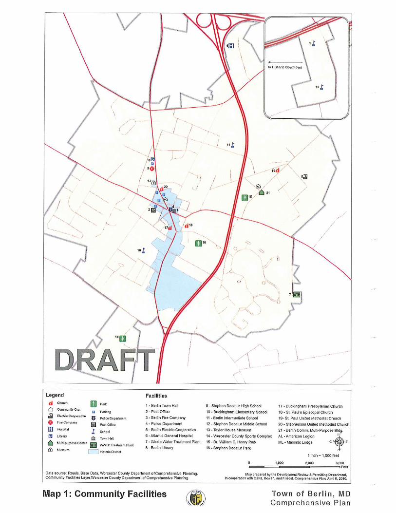


-
Ocean Gtwy
Wor
cest
er H
wy
Flower St
Seah
awk
Rd
Griffin Rd
Old Ocean City Blvd
Mai
n St
Evans
Rd
Harris
on R
d
Mary Rd
Bay St
Assateague Rd
Wes
t St
Dinges Rd
Friendship Rd
Libertytown Rd
S M
ain St
Trappe Rd
Georgetown Rd
Willi
ams
St
N M
ain St
Broad St
Branch St
Germantow
n Rd
Deer Park Dr
Franklin Ave
Grays Corner R
d
Sinepuxent Rd
Beth
el R
d
Tripoli St
Burley St
Ann
Dr
Dec
atur
St
Tall T
imber Rd
Doe
Dr
Cat
hell
RdCash Rd
Buckingham Ln
Henry RdM
aple Ave
Pom
pano Ln
Pitts St
Cedar Ave
Henry
s M
ill Dr
Washington St
Esha
m A
ve
Ann Ct
Gander Ln
Redwood
Bottl
e Br
anch
Rd
Popl
ar R
d
Healthw
ay Dr
Kitts B
ranch
Rd
Huntin
g H
ound
Rd
Ball Park Rd
Thre
e Pe
nny
Ln
Oak Ct
Cedar Lane Rd
Brittany Ln
Greenbriar Dr
Cam elia Ln
Upshur Ln
Millh aven Rd
Deuling Way
Baker St
Meadow St
Schoolfield St
Maple Ct
Gric
e St
Wal
sh S
t
Peach Ln
Nel
son
St
Barrett RdBowen Cir
Ocean Gtwy
Wor
cest
er H
wy
SALISBURY, MARYLANDMILFORD, DELAWAREEASTON, MARYLAND
(410) 543-9091(302) 424-1441(410) 770-4744
www.dbfinc.com
Berlin Town Boundary
Town Center
Mixed Use
Conservation
Multi-Family Residential
Single-Family Residential
Recreational
Commercial
Highway Commercial
Neighborhood Commercial
Institutional
Municipal
Light Industrial
0 2,500 5,0001,250Feet Map 4
Town of Berlin, MarylandFuture Land Use
Draft

-
Ocean Gtwy
Wor
cest
er H
wy
Evans
Rd
Harrison Rd
Flower St
Griffin Rd
Seah
awk
Rd
Old Ocean City Blvd
Mai
n St
Mary Rd
Bay St
Assateague Rd
Libertytown Rd
Wes
t St
Dinges Rd
S M
ain St
Friendship Rd
Trappe Rd
Georgetown Rd
Willi
ams
St
N M
ain St
Broad St
Branch St
Wild Goose Ln
Germantow
n Rd
Grays Corner Rd
Deer Park Dr
Franklin Ave
Sinepuxent Rd
Beth
el R
d
Tripoli St
Burley St
Ann
Dr
Dec
atur
St
Tall T
imber Rd
Doe
Dr
Hayes Landing Rd
Buckingha m Ln
Henry Rd
Cedar Lane Rd
Maple Ave
Pom
pano Ln
Pitts St
Cedar Ave
Henry
s M
ill Dr
Caleb Rd
Washington St
Esha
m A
ve
Ironshire Station Rd
Gander Ln
Redwood
Bot
tle B
ranc
h R
d
Popl
ar R
d
Healthw
ay Dr
Kitts B
ranch
Rd
Hunt
ing
Hou
nd R
d
Ball Park Rd
Oak Ct
Greenbriar Dr
Camelia Ln
Upshur Ln
Thre
e P
enny
Ln
Millhaven Rd
Deuling Way
Meadow St
Schoolfield St
Maple Ct
Gric
e St
Wal
sh S
t
Peach Ln
Nel
son
St
Barrett Rd
Bowen Cir
Ocean Gtwy
LegendPotential Development Area
Growth Area 1
Growth Area 2
Growth Area 3
Growth Area 4
In Town
Permanent Boundary District
Future Land Use
Map 5Town of Berlin, Maryland
Growth and Urban Growth Boundary AreasDraft
SALISBURY, MARYLANDMILFORD, DELAWAREEASTON, MARYLAND
(410) 543-9091(302) 424-1441(410) 770-4744
www.dbfinc.com
0 2,600 5,2001,300Feet
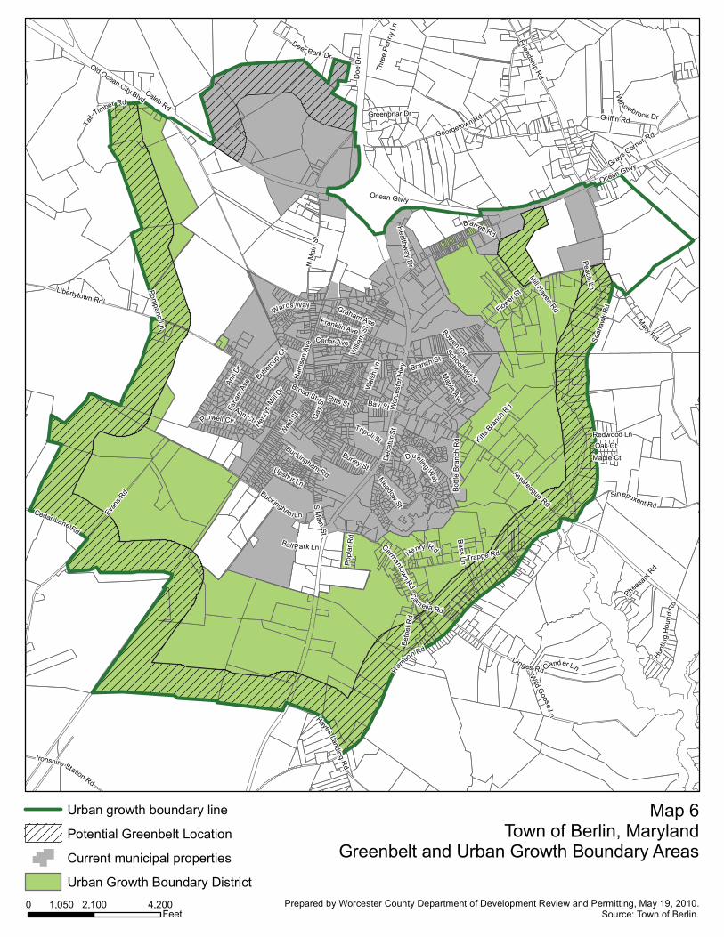
Ocean Gtwy
Wor
cest
er H
wy
H
arriso
n Rd
N M
ain
St
Evan
s Rd
Flower St
Griffin Rd
Seah
awk
Rd
Old Ocean City Blvd
Mary Rd
Bay St
Assateague Rd
Wes
t St
Dinges Rd
Libertytown Rd
S Main St
Broad St
Friendship Rd
Willi
am S
t
Trappe Rd
Georgetown Rd
Branch St
Germantown Rd
Grays Corner R
d
Deer Park Dr
Franklin Ave
Sinepuxent Rd
Beth
el R
d
Tripoli St
Burley St
Ann
Dr
Hayes Landing Rd
Dec
atur
St
Tall T
imber Rd
Doe
Dr
Esha
m A
ve
Buckingham Ln
Henry RdM
aple Ave
Graham Ave
Pompano Ln
Cedar Lane Rd
Pitts St
Cedar Ave
Henry
s Mill
Dr
Ironshire Station Rd
Har
rison
Ave
Caleb Rd
Ann Ct
Gander Ln
Wild G
oose Ln
Bottl
e Br
anch
Rd
Popl
ar R
d
Healthw
ay Dr
Kitts B
ranch
Rd
Hunt
ing
Ho u
nd R
d
Ball Park Ln
Wards Way
Dueling Way
Oak CtRedwood Ln
Greenbriar Dr
Thre
e Pe
nny
Ln
Cam elia Rd
Upshur Ln
Pheasant
Rd
Meadow St
Powell Cir
Mill Haven Rd
Schoolfield St
Gay
St
Wi l lowbrook Dr
Maple Ct
Bass LnButt
ercup
Ct
Peach Ln
Buckingham Rd
Wal
sh L
n
Barrett Rd
Bowen Cir
Ocean Gtwy
Urban growth boundary line
Potential Greenbelt Location
Current municipal properties
Urban Growth Boundary District
Map 6Town of Berlin, Maryland
Greenbelt and Urban Growth Boundary Areas
0 2,100 4,2001,050Feet
Prepared by Worcester County Department of Development Review and Permitting, May 19, 2010.Source: Town of Berlin.


