2009 transportation safety report - cape cod commission · 2009 transportation safety report...
TRANSCRIPT

2009 Transportation Safety Report
Eastham: Eastham Rotary Truro: Truro Central School Zone Provincetown: Route 6 / Shank Painter Road
May 2010

Prepared by CAPE COD COMMISSION Transportation Staff on behalf of the CAPE COD METROPOLITAN PLANNING ORGANIZATION: Massachusetts Department of Transportation Cape Cod Regional Transit Authority • Cape Cod Commission Barnstable County • Town of Barnstable Towns of Bourne, Sandwich, Falmouth & Mashpee Towns of Yarmouth, Dennis, Harwich, Brewster & Chatham Towns of Orleans, Eastham, Wellfleet, Truro & Provincetown
This report was funded in part through grants from the Federal Highway Administration and Federal Transit Administration, United States Department of Transportation (USDOT). The views and opinions of the Cape Cod Metropolitan Planning Organization expressed herein do not necessarily state or reflect those of the USDOT.

2009 Transportation Safety Report May 2010
Cape Cod Metropolitan Planning Organization Page i
Table of Contents
1. Introduction ......................................................................................................1 2. Eastham: Eastham Rotary ............................................................................... 3
2.1. Problem Identification.............................................................................. 3 2.1.1. Location and Geometrics................................................................... 3 2.1.2. Crash History......................................................................................5 2.1.3. Traffic Operations.............................................................................. 8 2.1.4. Inventory of Cautionary Signage...................................................... 11
2.2. Development and Analysis of Alternatives..............................................12 2.2.1. Alternative 1: Signalization ..............................................................13 2.2.2. Alternative 2: Grade Separation.......................................................14 2.2.3. Alternative 3: Modern Roundabout .................................................14 2.2.4. Alternative 4: Redesign with Modern Roundabout Features.......... 15
2.3. Recommendations and Next Steps.......................................................... 17 3. Truro: Truro Central School Zone ................................................................. 20
3.1. Problem Identification............................................................................ 20 3.1.1. Location and Geometrics................................................................. 20 3.1.2. Crash History................................................................................... 22 3.1.3. Warrants for School Zones.............................................................. 22 3.1.4. Traffic Operations............................................................................ 23 3.1.5. Speed Study Results .........................................................................27
3.2. Recommendations and Next Steps......................................................... 28 4. Provincetown: Route 6 / Shank Painter Road............................................... 29
4.1. Problem Identification............................................................................ 29 4.1.1. Location and Geometrics................................................................. 29 4.1.2. Crash History....................................................................................31 4.1.3. Traffic Operations............................................................................ 33
4.2. Development and Analysis of Alternatives............................................. 35 4.2.1. Alternative 1: Modern Roundabout ................................................ 35 4.2.2. Alternative 2: Traffic Signalization ................................................. 36
4.3. Shank Painter Road Corridor ................................................................. 38 4.3.1. Crash History................................................................................... 38 4.3.2. Impacts of Stop and Shop ............................................................... 38 4.3.3. Corridor Sidewalk Inventory........................................................... 38 4.3.4. Intersection with Jerome Smith Road ............................................ 39
4.4. Recommendations and Next Steps......................................................... 42 5. Conclusion ...................................................................................................... 43
5.1. Summary of Recommendations ............................................................. 43

2009 Transportation Safety Report May 2010
Page ii Cape Cod Metropolitan Planning Organization
List of Figures Figure 1 – Study Areas............................................................................................. 2 Figure 2 – Eastham: Eastham Rotary ..................................................................... 4 Figure 3 – Crash Diagram: Eastham Rotary, 2006-2009 .......................................7 Figure 4 – Summer Weekday Average Daily Traffic: Eastham Rotary .................. 8 Figure 5 – Summer Weekday P.M. Origin / Destination (Volume): Eastham
Rotary ............................................................................................................... 9 Figure 6 – Summer Weekday P.M. Origin / Destination (%): Eastham Rotary ...10 Figure 7 – Eastham Rotary Signage ....................................................................... 11 Figure 8 – Massachusetts Department of Environmental Protection Identified
Wetlands..........................................................................................................12 Figure 9 – Eastham Rotary, Signalized Alternative...............................................13 Figure 10 – Eastham Rotary, Grade Separation Alternative .................................14 Figure 11 – Eastham Rotary, Modern Roundabout Alternative ............................ 15 Figure 12 – Potential Smith Lane Approach to Rotary..........................................18 Figure 13 – Eastham Rotary Pedestrian Connections ...........................................19 Figure 14 – Truro: Truro Central School Zone ......................................................21 Figure 15 – Traffic Volumes – Summer Weekday Average Daily Traffic: Truro.. 24 Figure 16 – Summer Weekday A.M. (8:00-9:00) Turning Movements: Truro ... 25 Figure 17 – Summer Weekday P.M. (2:00-3:00) Turning Movements: Truro.... 26 Figure 18 – Concept Pedestrian Refuge Island..................................................... 28 Figure 19 – Provincetown: Route 6 / Shank Painter Rd....................................... 30 Figure 20 – Crash Diagram: Route 6 and Shank Painter Road............................ 32 Figure 21 – Summer Weekday Traffic Volumes: Provincetown........................... 33 Figure 22 – Summer Weekday P.M. Turning Movements: Provincetown........... 34 Figure 23 – Route 6 / Shank Painter Rd, Modern Roundabout Alternative........ 35 Figure 24 – Route 6 / Shank Painter Rd, Signalized Alternative ......................... 36 Figure 25 – Shank Painter Road: Sidewalk Inventory.......................................... 40 Figure 26 – Shank Painter Road: Crosswalk Examples.........................................41
List of Tables Table 1 – Crash History: Eastham Rotary, 2006-2009 .......................................... 6 Table 2 – Traffic Delay for Alternatives: Eastham Rotary.....................................16 Table 3 – Summary of Alternatives: Eastham Rotary ...........................................16 Table 4 – School Zone Warrants: Truro Central School....................................... 22 Table 5 – Speed Study Data: Truro ........................................................................27 Table 6 – Crash History: Route 6 / Shank Painter Road.......................................31 Table 7 – Traffic Delay for Alternatives: Shank Painter Road...............................37 Table 8 – Summary of Alternatives: Shank Painter Road .....................................37
2009 Transportation Safety Report May 2010
Cape Cod Metropolitan Planning Organization Page 1
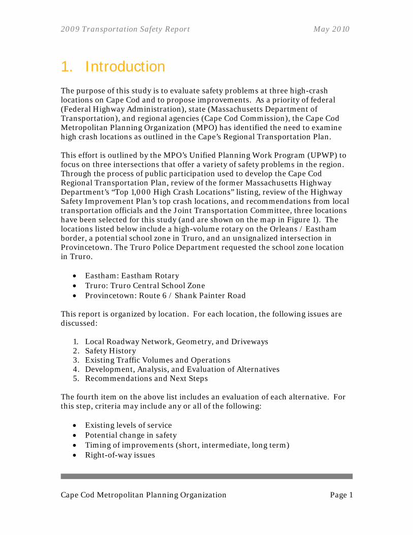
1. Introduction The purpose of this study is to evaluate safety problems at three high-crash locations on Cape Cod and to propose improvements. As a priority of federal (Federal Highway Administration), state (Massachusetts Department of Transportation), and regional agencies (Cape Cod Commission), the Cape Cod Metropolitan Planning Organization (MPO) has identified the need to examine high crash locations as outlined in the Cape’s Regional Transportation Plan. This effort is outlined by the MPO’s Unified Planning Work Program (UPWP) to focus on three intersections that offer a variety of safety problems in the region. Through the process of public participation used to develop the Cape Cod Regional Transportation Plan, review of the former Massachusetts Highway Department’s “Top 1,000 High Crash Locations” listing, review of the Highway Safety Improvement Plan’s top crash locations, and recommendations from local transportation officials and the Joint Transportation Committee, three locations have been selected for this study (and are shown on the map in Figure 1). The locations listed below include a high-volume rotary on the Orleans / Eastham border, a potential school zone in Truro, and an unsignalized intersection in Provincetown. The Truro Police Department requested the school zone location in Truro.
Eastham: Eastham Rotary Truro: Truro Central School Zone Provincetown: Route 6 / Shank Painter Road
This report is organized by location. For each location, the following issues are discussed:
1. Local Roadway Network, Geometry, and Driveways 2. Safety History 3. Existing Traffic Volumes and Operations 4. Development, Analysis, and Evaluation of Alternatives 5. Recommendations and Next Steps
The fourth item on the above list includes an evaluation of each alternative. For this step, criteria may include any or all of the following:
Existing levels of service Potential change in safety Timing of improvements (short, intermediate, long term) Right-of-way issues
2009 Transportation Safety Report May 2010
Page 2 Cape Cod Metropolitan Planning Organization
Cost Responsible party(ies) Possible funding sources for design and construction (where necessary)
The fifth item above, “Recommendations,” will be organized as appropriate for the timing of each improvement (short, intermediate, long term). When completed, this report will be a source of identified improvements for inclusion in the Cape Cod Regional Transportation Plan, Cape Cod Transportation Improvement Program, and implementation by the Massachusetts Department of Transportation (MassDOT) and other responsible entities.
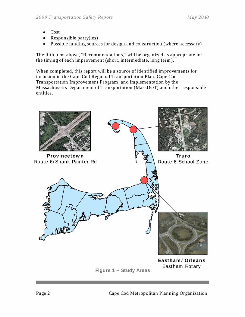
Figure 1 – Study Areas
Truro Route 6 School Zone
Eastham/Orleans Eastham Rotary
Provincetown Route 6/Shank Painter Rd

2009 Transportation Safety Report May 2010
Cape Cod Metropolitan Planning Organization Page 3
2. Eastham: Eastham Rotary The Eastham Rotary is a major intersection on Cape Cod, located on the border of Orleans and Eastham. Essentially all of Route 6 traffic to or from the Outer Cape will pass through this rotary. Route 6A, a fairly commercial stretch of Orleans, meets the rotary on the southern approach. Smith Lane is the northern leg of the rotary, which offers access to local roads in Orleans and Eastham. Smith Lane becomes Rock Harbor Road when crossing the Orleans town line. The Barnstable 2nd District Courthouse is located on Rock Harbor Road.
2.1. PROBLEM IDENTIFICATION The Eastham Rotary, located in both Eastham and Orleans, is a heavily traveled roadway with a history of high-frequency crashes. The summer months bring a substantial increase in population to the Outer Cape, which leads to many more vehicles using the rotary. This location has been a concern for the towns of Eastham and Orleans for a number of years. The approaches to the rotary align on a tangent, allowing entering and exiting motorists to maintain a high rate of speed. This condition is especially of concern for vehicles exiting the rotary on the southern leg. The northern intersection of Route 6A/28 and Canal Road is very close to the southern approach of the Eastham Rotary. The sight distance from Canal Road is very limited, especially during the growing season when bushes have all their leaves, making left turns difficult with the fast approaching vehicles exiting the rotary.
2.1.1. LOCATION AND GEOMETRICS Route 6 west of the rotary, in Orleans, is a two-lane, bi-directional, limited-access highway. As Route 6 continues northeast of the rotary, it becomes a two-lane eastbound, one lane westbound, urban extension of a principal arterial. The rotary has no sidewalks for safe passage by pedestrians.

2009 Transportation Safety Report May 2010
Page 4 Cape Cod Metropolitan Planning Organization
Figure 2 – Eastham: Eastham Rotary
ORLEANS
EASTHAM
2009 Transportation Safety Report May 2010
Cape Cod Metropolitan Planning Organization Page 5
2.1.2. CRASH HISTORY From January 1, 2006 to September 11, 2009, 53 crashes occurred at the Eastham Rotary. With a total of 17 injuries, this nearly four-year period has an Equivalent Property Damage Only (EPDO) rating of 121 ([17x5]+[36x1]). For a list of crashes, see Table 1. The high number of crashes easily qualifies the intersection as a high crash location (high crash locations are determined as three or more crashes per year over a three-year period). The majority of accidents, 42 of 53, were rear-ending incidents (see Figure 3). All but two of those rear-ending crashes occurred at an on-ramp to the rotary. In most scenarios, the at-fault driver admitted to a lack of attention before hitting the rear of the car ahead of them. The crashes occurred at two of the on-ramps more than the other two. Route 6A/28 northbound and Route 6 westbound from Eastham had 16 rear-ending accidents each during this time period. Route 6 eastbound and Smith Lane southbound had a total of eight rear-ending incidents. During this time period, the free-standing post located in the island east of the rotary that flashes a yellow, blinking light was hit at least twice.
2009 Transportation Safety Report May 2010
Page 6 Cape Cod Metropolitan Planning Organization
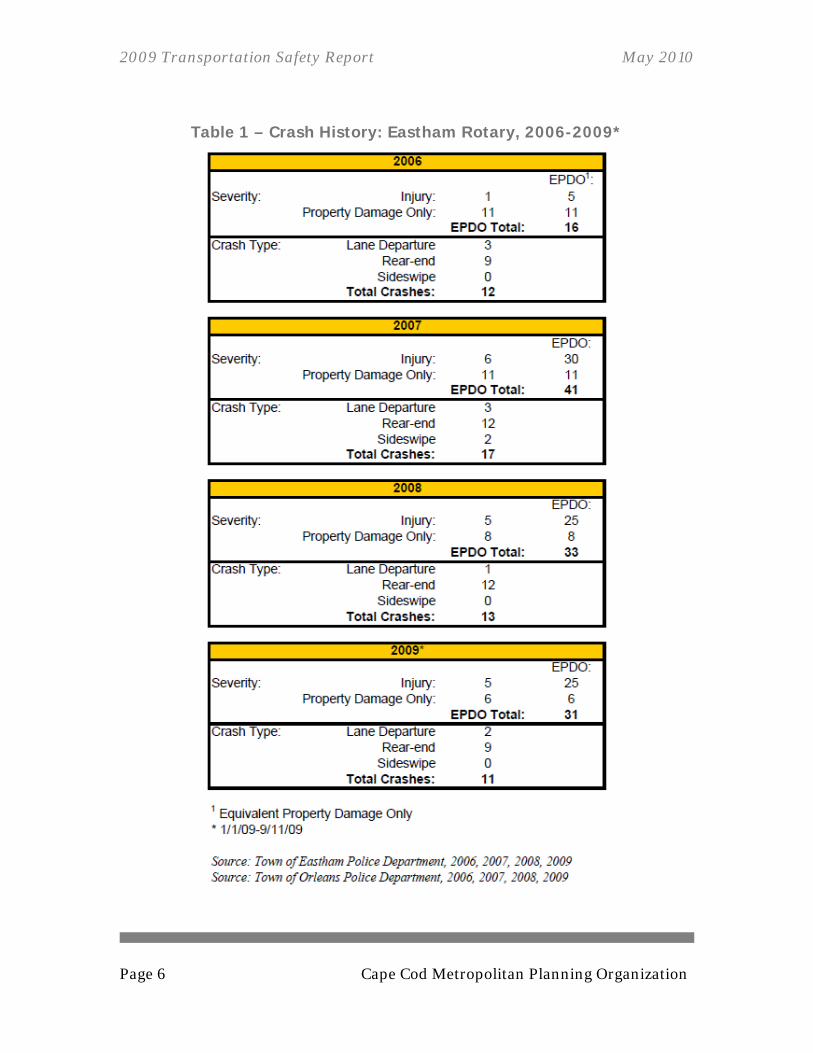
Table 1 – Crash History: Eastham Rotary, 2006-2009*

2009 Transportation Safety Report May 2010
Cape Cod Metropolitan Planning Organization Page 7
Figure 3 – Crash Diagram: Eastham Rotary, 2006-2009 Source: Town of Eastham Police Department, 2006, 2007, 2008, 2009 Source: Town of Orleans Police Department, 2006, 2007, 2008, 2009
2009 Transportation Safety Report May 2010
Page 8 Cape Cod Metropolitan Planning Organization
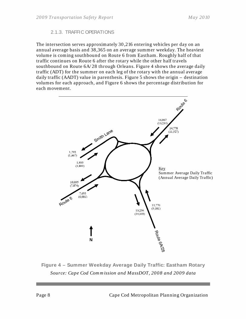
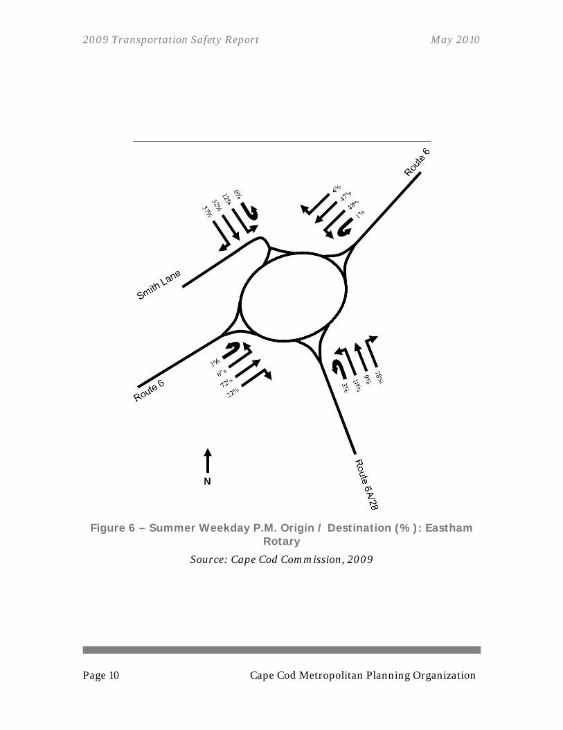
2.1.3. TRAFFIC OPERATIONS The intersection serves approximately 30,216 entering vehicles per day on an annual average basis and 38,365 on an average summer weekday. The heaviest volume is coming southbound on Route 6 from Eastham. Roughly half of that traffic continues on Route 6 after the rotary while the other half travels southbound on Route 6A/28 through Orleans. Figure 4 shows the average daily traffic (ADT) for the summer on each leg of the rotary with the annual average daily traffic (AADT) value in parenthesis. Figure 5 shows the origin – destination volumes for each approach, and Figure 6 shows the percentage distribution for each movement.
Figure 4 – Summer Weekday Average Daily Traffic: Eastham Rotary
Source: Cape Cod Commission and MassDOT, 2008 and 2009 data
Key Summer Average Daily Traffic (Annual Average Daily Traffic)

2009 Transportation Safety Report May 2010
Cape Cod Metropolitan Planning Organization Page 9
Figure 5 – Summer Weekday P.M. Origin / Destination (Volume): Eastham Rotary
Source: Cape Cod Commission, 2009
2009 Transportation Safety Report May 2010
Page 10 Cape Cod Metropolitan Planning Organization
Figure 6 – Summer Weekday P.M. Origin / Destination (%): Eastham Rotary
Source: Cape Cod Commission, 2009

2009 Transportation Safety Report May 2010
Cape Cod Metropolitan Planning Organization Page 11
2.1.4. INVENTORY OF CAUTIONARY SIGNAGE As seen in the crash diagram (Figure 3), rear-end crashes of vehicles entering the rotary are more prevalent at the Route 6A/28 and Route 6 from Eastham approaches. As part of the investigation as to why Route 6 from Orleans eastbound has fewer crashes, this report identifies the type of signage used to warn motorists of the approaching rotary and their location. As is expected for a road with higher speeds, warning signs for Route 6 eastbound begin more than half a mile prior to the rotary (as opposed to 0.18 miles for Route 6A/28 and 0.19 miles for Route 6 from Eastham). Route 6 eastbound has three signs cautioning of the rotary, starting with a sign indicating a reduction in the speed limit to 25 miles per hour, then two consecutive signs with a diagram labeled as “traffic circle.” Route 6A/28 also has three signs, while Route 6 westbound has two, and Smith Lane has none. For sign locations, see Figure 7.
Figure 7 – Eastham Rotary Signage

2009 Transportation Safety Report May 2010
Page 12 Cape Cod Metropolitan Planning Organization
2.2. DEVELOPMENT AND ANALYSIS OF ALTERNATIVES This section includes discussion, analyses, and evaluation of several alternatives. The amount of detailed analysis varies for each alternative, determined by the availability of information. Most alternatives for consideration at this location are hindered by the existence of wetlands identified by the Massachusetts Department of Environmental Protection (Mass DEP). The wetlands are located within the rotary’s island and elsewhere in the vicinity (see following figure).
Figure 8 – Massachusetts Department of Environmental Protection Identified Wetlands

2009 Transportation Safety Report May 2010
Cape Cod Metropolitan Planning Organization Page 13
2.2.1. ALTERNATIVE 1: SIGNALIZATION Although appropriately timed signalization can be an effective way of distributing traffic, to signalize this location significant issues would need to be overcome. Within the inner boundaries of the existing rotary there is a Massachusetts Department of Environmental Protection-identified wetland. The buildable right-of-way appears too narrow to attempt to circumvent the wetland.
Figure 9 – Eastham Rotary, Signalized Alternative

2009 Transportation Safety Report May 2010
Page 14 Cape Cod Metropolitan Planning Organization
2.2.2. ALTERNATIVE 2: GRADE SEPARATION Grade separation is an alternative that may reduce the number of conflicts in the intersection, as through-traffic would have the ability to remain on a direct route. Again, at this time the grade-separation alternative would be unlikely to move forward due to the location of the wetland within the existing rotary.
Figure 10 – Eastham Rotary, Grade Separation Alternative
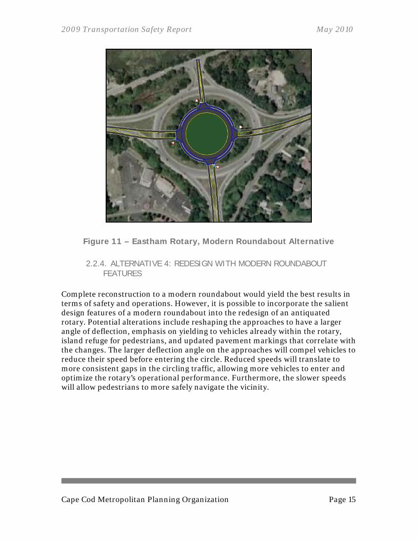
2.2.3. ALTERNATIVE 3: MODERN ROUNDABOUT The modern roundabout can be an effective configuration that slows traffic to create a safer, more efficient flow of traffic. The roundabout typically has a smaller diameter than a conventional rotary or traffic circle, and the approaches meet the roundabout at a larger angle of deflection. Traffic operations are improved as the roundabout focuses on the right of way of drivers within the rotation, rather than on the entering vehicles. Due to the high volumes that enter the existing Eastham Rotary, the modern roundabout alternative has been modeled as a two-lane roundabout. To obtain the projected level of service (following table), the east, west, and south approaches must include an additional approach lane.
2009 Transportation Safety Report May 2010
Cape Cod Metropolitan Planning Organization Page 15
Figure 11 – Eastham Rotary, Modern Roundabout Alternative
2.2.4. ALTERNATIVE 4: REDESIGN WITH MODERN ROUNDABOUT FEATURES
Complete reconstruction to a modern roundabout would yield the best results in terms of safety and operations. However, it is possible to incorporate the salient design features of a modern roundabout into the redesign of an antiquated rotary. Potential alterations include reshaping the approaches to have a larger angle of deflection, emphasis on yielding to vehicles already within the rotary, island refuge for pedestrians, and updated pavement markings that correlate with the changes. The larger deflection angle on the approaches will compel vehicles to reduce their speed before entering the circle. Reduced speeds will translate to more consistent gaps in the circling traffic, allowing more vehicles to enter and optimize the rotary’s operational performance. Furthermore, the slower speeds will allow pedestrians to more safely navigate the vicinity.

2009 Transportation Safety Report May 2010
Page 16 Cape Cod Metropolitan Planning Organization
The previous alternatives have been analyzed in peak summer conditions as shown in Table 2.
Table 2 – Traffic Delay for Alternatives: Eastham Rotary
Measures of Effectiveness1
Alternative Level of Service
Delay/Vehicle (sec)
Existing Conditions F 617.4 Signalization C 124.4 Grade Separation C 494.3 Modern Roundabout C2 15.12 Redesign with Roundabout Features n/a n/a 1 Modeled with Synchro 7 traffic analysis software 2 Modeled with ‘Roundabout Analysis Tool’ from Georgia Department of Transportation The following table presents a summary of the effects of the various alternatives. Each alternative is rated for the relative cost, relief of traffic congestion, improvement of safety, and potential environmental and right-of-way (ROW) impacts.
Table 3 – Summary of Alternatives: Eastham Rotary
Alternative Relative Cost
Congestion Relief
Safety Improvement
Environmental/ ROW Impacts
Signalization Medium None None High
Grade Separation
Very High
Minimal Medium High
Modern Roundabout
High Moderate High High
Rotary Redesign
Medium Moderate Medium/High Low
2009 Transportation Safety Report May 2010
Cape Cod Metropolitan Planning Organization Page 17
2.3. RECOMMENDATIONS AND NEXT STEPS The Cape Cod Commission Transportation Staff has both short-term and long-term recommendations for the Eastham Rotary. Short-term recommendations include looking at signage and ideas for safe pedestrian connections. Long-term recommendations include redesigning the rotary to incorporate elements of a modern roundabout. The first recommendation of this study is for the towns of Eastham and Orleans evaluate the types of signage used to caution motorists of the upcoming rotary and the placement of those signs. There is a large disparity between the accidents on two of the approaches as compared to the other two, and driver awareness is likely related. It is recommended that the ‘Rotary’ signs currently placed on the rotary’s island be moved leftwards. Each approach has this sign facing it from the island, but the sign is not visible until you are within two car lengths of the merge. Shifting the signs left would allow them to be visible from a farther distance. On both the Route 6A/28 and Route 6 from Eastham approaches, where rear-ending crashes were most prevalent, most drivers cited their lack of attention as the contributing factor to the crash. This study recommends that the towns of Eastham and Orleans investigate the potential use of grooved pavement as a means of alerting drivers to the upcoming rotary. Driving over grooved pavement creates a sound that can be disturbing to residents and nearby businesses, so appropriate siting is essential. Route 6 has two travel lanes from Eastham towards the rotary until there is a lane-drop about a half mile before the rotary. Town officials have shown concern that the sign indicating the lane-drop may be presented to drivers too late. This study recommends an evaluation of signage regarding the reduction from two lanes to one. As another short-term improvement, this study recommends the towns of Eastham and Orleans explore options to include sidewalks and crosswalks to accommodate pedestrians. Currently, no sidewalk connects around and through the rotary. There is also no understood method of traversing the intersection on foot; therefore the actions of pedestrians are unpredictable to the motorists. Another recommendation is to conduct an analysis of the relationship and issues concerning the rotary, Route 6A/28, and Route 6A/28’s northern intersection with Canal Road. This intersection is already a safety concern to town officials, and its risk to motorists may be exacerbated by additional development along Canal Road.
2009 Transportation Safety Report May 2010
Page 18 Cape Cod Metropolitan Planning Organization
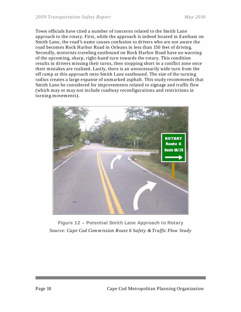
Town officials have cited a number of concerns related to the Smith Lane approach to the rotary. First, while the approach is indeed located in Eastham on Smith Lane, the road’s name causes confusion to drivers who are not aware the road becomes Rock Harbor Road in Orleans in less than 150 feet of driving. Secondly, motorists traveling eastbound on Rock Harbor Road have no warning of the upcoming, sharp, right-hand turn towards the rotary. This condition results in drivers missing their turns, then stopping short in a conflict zone once their mistakes are realized. Lastly, there is an unnecessarily wide turn from the off ramp at this approach onto Smith Lane eastbound. The size of the turning radius creates a large expanse of unmarked asphalt. This study recommends that Smith Lane be considered for improvements related to signage and traffic flow (which may or may not include roadway reconfigurations and restrictions in turning movements).
Figure 12 – Potential Smith Lane Approach to Rotary
Source: Cape Cod Commission Route 6 Safety & Traffic Flow Study

2009 Transportation Safety Report May 2010
Cape Cod Metropolitan Planning Organization Page 19
This study’s long-term recommendation includes redesigning the rotary to integrate elements of a modern roundabout. Potential alterations include reshaping the approaches to have a larger angle of deflection, emphasis on yielding to vehicles already within the rotary, island refuge for pedestrians, and updated pavement markings that correlate with the changes. The Commission Staff believe this would help foster a more pedestrian-friendly environment (in addition to the operational benefits). The following conceptual graphic (Figure 13) depicts a potential pedestrian network around the Eastham Rotary that could be integrating into the redesign. In addition to the connections presented in the graphic, pedestrians will be encouraged to take the Canal Road sidewalk to its intersection with the Cape Cod Rail Trail. From there, users can use the bike trail to cross Route 6 and safely access Rock Harbor Road.
Figure 13 – Eastham Rotary Pedestrian Connections
A next step for this location would be to hold a public meeting to discuss the alternatives outlined in this report. If pursued, this meeting should include area residents and business representatives, local agencies, state and local officials, and other interested stakeholders. The objective of this meeting would be to build consensus for the optimal safety improvement at the Eastham Rotary.
2009 Transportation Safety Report May 2010
Page 20 Cape Cod Metropolitan Planning Organization
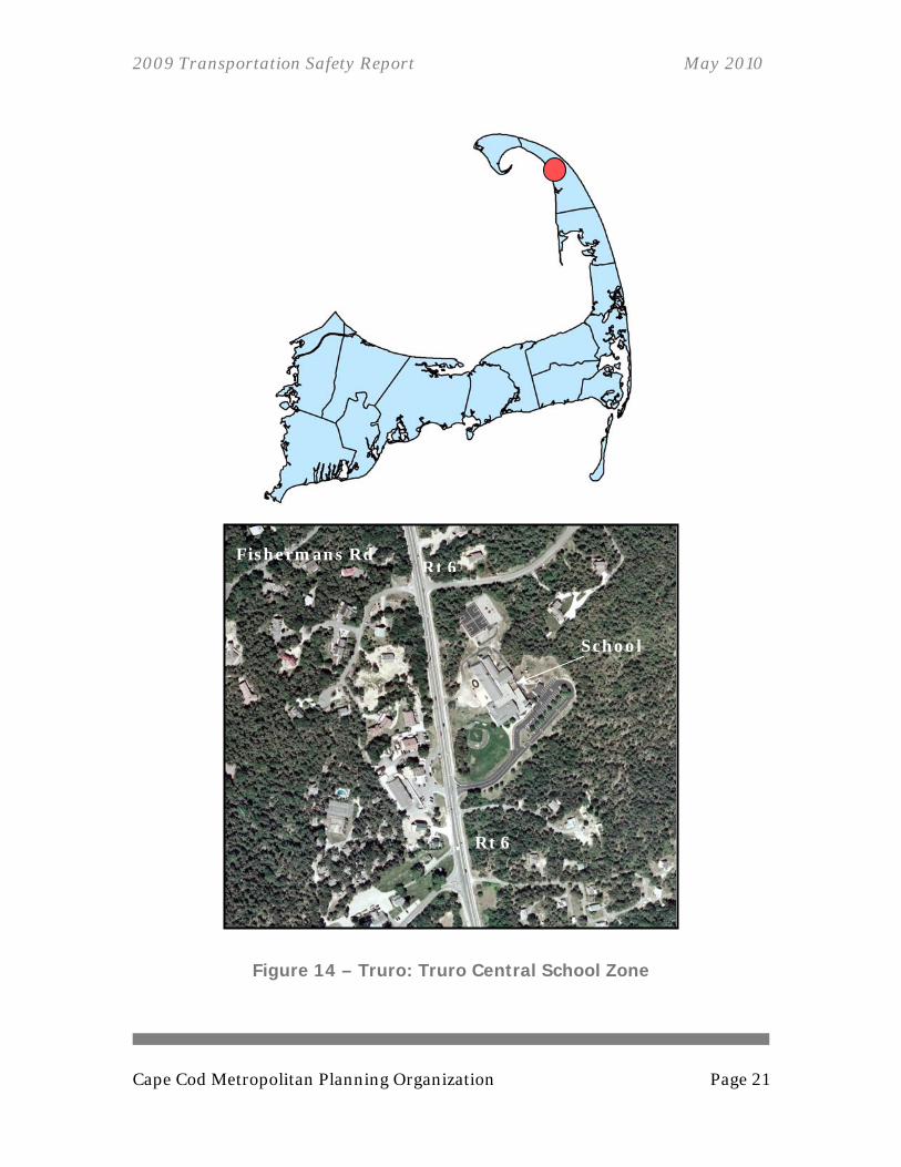
3. Truro: Truro Central School Zone The Truro Central School, serving children from kindergarten to sixth grade, is located at 317 Route 6 in Truro. Route 6 is a heavily traveled road with users traveling at high speeds. All motorists destined for North Truro or Provincetown will use this portion of Route 6, adding to local traffic volumes. A busy restaurant is located across Route 6 from the school.
3.1. PROBLEM IDENTIFICATION The high speeds and large volume of vehicles pose a threat to the students of Truro Central School. The posted speed limit is 45 miles per hour, yet that limit is often exceeded. The lack of safe crosswalks necessitate a police officer (when available) to facilitate road crossings during the morning and afternoon peak periods (7:45-8:30 a.m. and 2:45-3:15 p.m.). Directing vehicles to slow and stop from high speeds to facilitate entering and exiting the school can be dangerous for police personnel, especially in reduced visibility and poor weather. Phase One of a three-phase “Safe Route to School” project was completed in 2008 providing a sidewalk from the Truro Central School to the Public Safety Facility on Route 6. Unfortunately, this sidewalk is on the opposite side of Route 6 from the school, which requires crossing Route 6 to use it.
3.1.1. LOCATION AND GEOMETRICS This stretch of Route 6 in Truro is two-lane and bi-directional with a wide shoulder on both sides. There is a gradual rising incline in the road heading northbound from the intersection with Great Hollow Road, as well as a rising incline leading southbound away from the study area. The Truro Central School driveway intersects Route 6 on the southern portion of the study area. There is a restaurant across Route 6 from the school that also generates traffic making a number of turning movements.
2009 Transportation Safety Report May 2010
Cape Cod Metropolitan Planning Organization Page 21
Figure 14 – Truro: Truro Central School Zone
Rt 6
Rt 6
Fishermans Rd
School
2009 Transportation Safety Report May 2010
Page 22 Cape Cod Metropolitan Planning Organization
3.1.2. CRASH HISTORY Crash records summarized by the Truro Police Department are available beginning in 1992. For the relevant road corridor, from addresses #300 Route 6 to #335 Route 6, 60 major crashes and 29 minor crashes have occurred during the past 16 years. The addresses with the highest number of major crashes are 300 Route 6 (Hillside Farm Stand) and 317 Route 6 (Truro Central School). The crash record summary is included in the appendix.
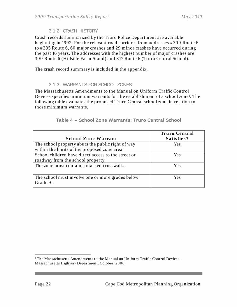
3.1.3. WARRANTS FOR SCHOOL ZONES The Massachusetts Amendments to the Manual on Uniform Traffic Control Devices specifies minimum warrants for the establishment of a school zone1. The following table evaluates the proposed Truro Central school zone in relation to those minimum warrants.
Table 4 – School Zone Warrants: Truro Central School
School Zone Warrant Truro Central
Satisfies? The school property abuts the public right of way within the limits of the proposed zone area.
Yes
School children have direct access to the street or roadway from the school property.
Yes
The zone must contain a marked crosswalk. Yes
The school must involve one or more grades below Grade 9.
Yes
1 The Massachusetts Amendments to the Manual on Uniform Traffic Control Devices. Massachusetts Highway Department. October, 2006.
2009 Transportation Safety Report May 2010
Cape Cod Metropolitan Planning Organization Page 23
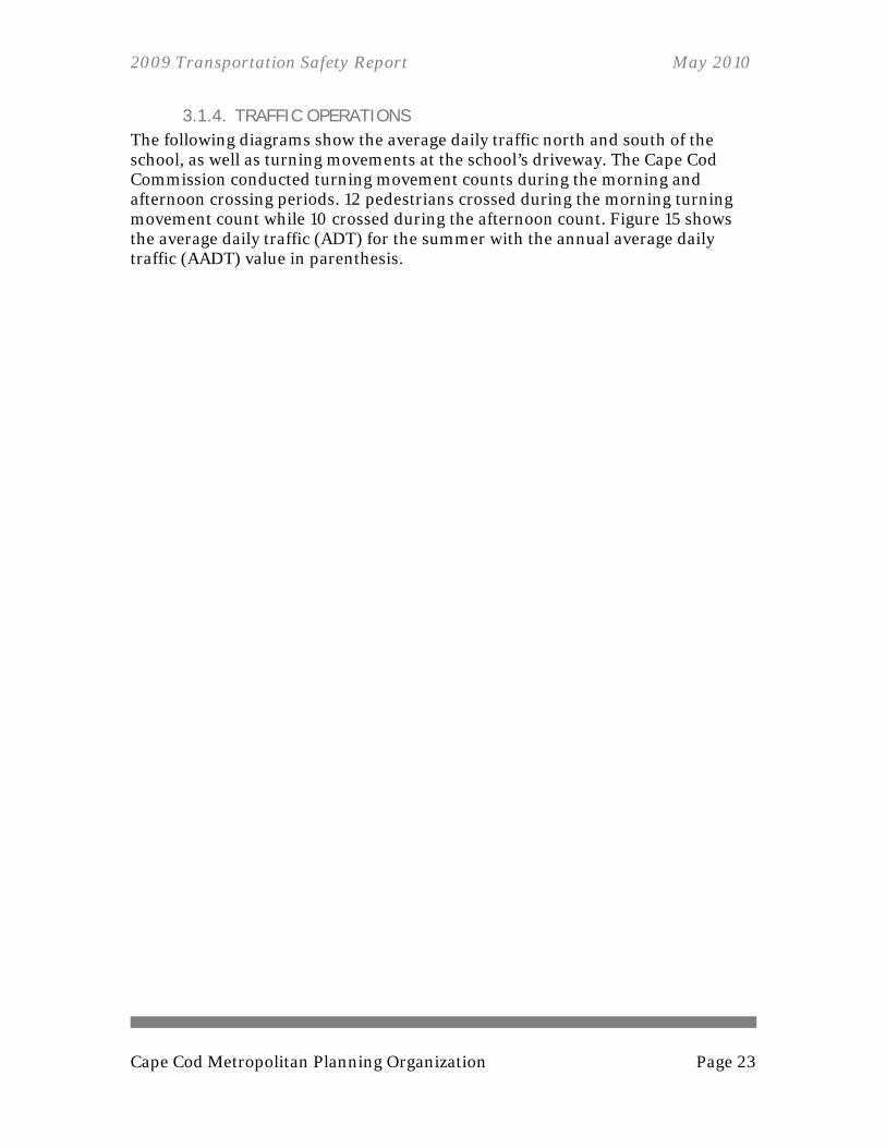
3.1.4. TRAFFIC OPERATIONS The following diagrams show the average daily traffic north and south of the school, as well as turning movements at the school’s driveway. The Cape Cod Commission conducted turning movement counts during the morning and afternoon crossing periods. 12 pedestrians crossed during the morning turning movement count while 10 crossed during the afternoon count. Figure 15 shows the average daily traffic (ADT) for the summer with the annual average daily traffic (AADT) value in parenthesis.
2009 Transportation Safety Report May 2010
Page 24 Cape Cod Metropolitan Planning Organization
Figure 15 – Traffic Volumes – Summer Weekday Average Daily Traffic: Truro
Route 6 North and South of Truro Central School
Source: Cape Cod Commission, 2009
Key Summer Average Daily Traffic (Annual Average Daily Traffic)

2009 Transportation Safety Report May 2010
Cape Cod Metropolitan Planning Organization Page 25
Figure 16 – Summer Weekday A.M. (8:00-9:00) Turning Movements: Truro
Route 6 at Truro Central School
Source: Cape Cod Commission, 2009
2009 Transportation Safety Report May 2010
Page 26 Cape Cod Metropolitan Planning Organization
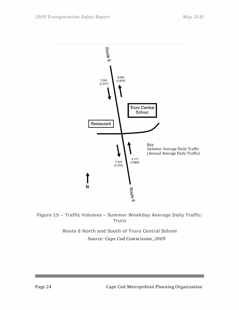
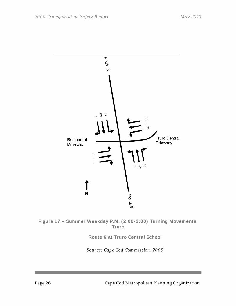
Figure 17 – Summer Weekday P.M. (2:00-3:00) Turning Movements: Truro
Route 6 at Truro Central School
Source: Cape Cod Commission, 2009
2009 Transportation Safety Report May 2010
Cape Cod Metropolitan Planning Organization Page 27
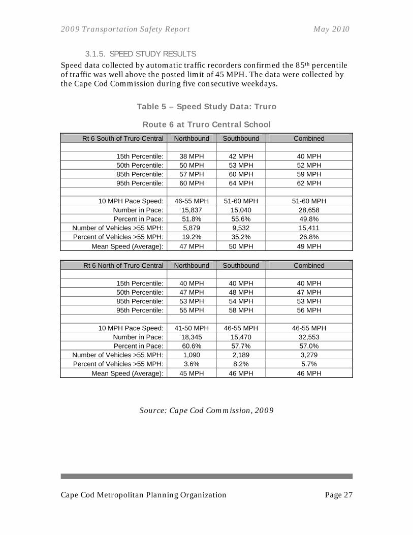
3.1.5. SPEED STUDY RESULTS Speed data collected by automatic traffic recorders confirmed the 85th percentile of traffic was well above the posted limit of 45 MPH. The data were collected by the Cape Cod Commission during five consecutive weekdays.
Table 5 – Speed Study Data: Truro
Route 6 at Truro Central School
Rt 6 South of Truro Central Northbound Southbound Combined
15th Percentile: 38 MPH 42 MPH 40 MPH 50th Percentile: 50 MPH 53 MPH 52 MPH 85th Percentile: 57 MPH 60 MPH 59 MPH 95th Percentile: 60 MPH 64 MPH 62 MPH
10 MPH Pace Speed: 46-55 MPH 51-60 MPH 51-60 MPH
Number in Pace: 15,837 15,040 28,658 Percent in Pace: 51.8% 55.6% 49.8%
Number of Vehicles >55 MPH: 5,879 9,532 15,411 Percent of Vehicles >55 MPH: 19.2% 35.2% 26.8%
Mean Speed (Average): 47 MPH 50 MPH 49 MPH
Rt 6 North of Truro Central Northbound Southbound Combined
15th Percentile: 40 MPH 40 MPH 40 MPH 50th Percentile: 47 MPH 48 MPH 47 MPH 85th Percentile: 53 MPH 54 MPH 53 MPH 95th Percentile: 55 MPH 58 MPH 56 MPH
10 MPH Pace Speed: 41-50 MPH 46-55 MPH 46-55 MPH
Number in Pace: 18,345 15,470 32,553 Percent in Pace: 60.6% 57.7% 57.0%
Number of Vehicles >55 MPH: 1,090 2,189 3,279 Percent of Vehicles >55 MPH: 3.6% 8.2% 5.7%
Mean Speed (Average): 45 MPH 46 MPH 46 MPH
Source: Cape Cod Commission, 2009

2009 Transportation Safety Report May 2010
Page 28 Cape Cod Metropolitan Planning Organization
3.2. RECOMMENDATIONS AND NEXT STEPS A private consultant has been commissioned by the Cape Cod Commission with funds from the Unified Planning Work Program (UPWP) to develop a plan for the Truro Central School’s installation of a school zone speed limit sign. The draft plan is included in this report’s appendix. With the created plan, a meeting with the Massachusetts Department of Transportation Highway Division District 5 will be conducted to bring the project to completion. Beyond the installation of a school zone, the town may consider a year-round pedestrian signal if conflicts between pedestrians and vehicles are present during the summer months. Beside Truro Central School, there is a youth baseball field that is used throughout the summer and school year. Furthermore, there is a restaurant serving pizza and ice cream on the opposite side of Route 6. Safe crossing between these two destinations should be a priority to the town, especially during the summer season, when traffic volumes increase substantially. Future plans may include a pedestrian refuge in the median of Route 6 to facilitate safe crossing. The following figure is a basic concept of how a refuge island could look on Route 6 south of the Truro Central School.
Figure 18 – Concept Pedestrian Refuge Island
2009 Transportation Safety Report May 2010
Cape Cod Metropolitan Planning Organization Page 29
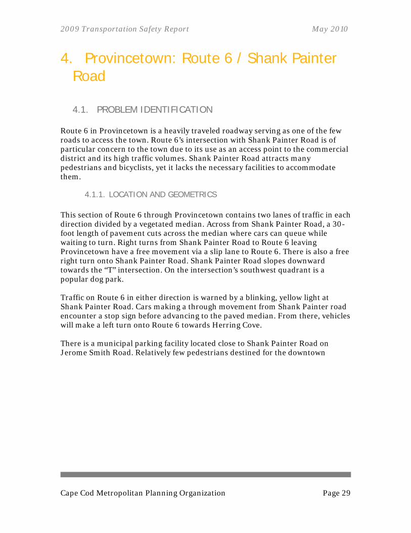
4. Provincetown: Route 6 / Shank Painter Road
4.1. PROBLEM IDENTIFICATION Route 6 in Provincetown is a heavily traveled roadway serving as one of the few roads to access the town. Route 6’s intersection with Shank Painter Road is of particular concern to the town due to its use as an access point to the commercial district and its high traffic volumes. Shank Painter Road attracts many pedestrians and bicyclists, yet it lacks the necessary facilities to accommodate them.
4.1.1. LOCATION AND GEOMETRICS This section of Route 6 through Provincetown contains two lanes of traffic in each direction divided by a vegetated median. Across from Shank Painter Road, a 30-foot length of pavement cuts across the median where cars can queue while waiting to turn. Right turns from Shank Painter Road to Route 6 leaving Provincetown have a free movement via a slip lane to Route 6. There is also a free right turn onto Shank Painter Road. Shank Painter Road slopes downward towards the “T” intersection. On the intersection’s southwest quadrant is a popular dog park. Traffic on Route 6 in either direction is warned by a blinking, yellow light at Shank Painter Road. Cars making a through movement from Shank Painter road encounter a stop sign before advancing to the paved median. From there, vehicles will make a left turn onto Route 6 towards Herring Cove. There is a municipal parking facility located close to Shank Painter Road on Jerome Smith Road. Relatively few pedestrians destined for the downtown
2009 Transportation Safety Report May 2010
Page 30 Cape Cod Metropolitan Planning Organization
Figure 19 – Provincetown: Route 6 / Shank Painter Rd

2009 Transportation Safety Report May 2010
Cape Cod Metropolitan Planning Organization Page 31
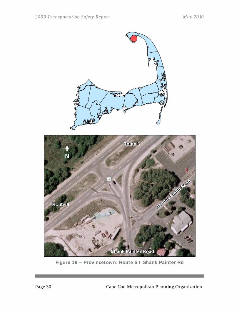
4.1.2. CRASH HISTORY In the time period from July 2006 through July 2009, three crashes occurred at the intersection of Route 6 and Shank Painter Road. Of these three crashes, one reported an injury as a result of the event. One of the crashes was the result of an impact at an angle, and one was a rear-ending incident. The intersection does not currently meet the threshold of three crashes per year over a three-year period to be classified as a high crash location.
Table 6 – Crash History: Route 6 / Shank Painter Road
Date Manner #
Vehicles Severity EPDO1
07/31/2006 Rear-end 2 Property damage only or unknown 1
07/05/2008 Angle 2 Injury 5
08/13/2008 N/A N/A N/A 1*
7 1Equivalent Property Damage Only * Crash record was not recovered for use in this report. An EDPO of 1 is the minimum possible. The crash is not located on the crash diagram.
Source: Town of Provincetown Police Department 2006, 2007, 2008, 2009
2009 Transportation Safety Report May 2010
Page 32 Cape Cod Metropolitan Planning Organization
Figure 20 – Crash Diagram: Route 6 and Shank Painter Road Source: Town of Provincetown Police Department, 2006, 2007, 2008, 2009

2009 Transportation Safety Report May 2010
Cape Cod Metropolitan Planning Organization Page 33
4.1.3. TRAFFIC OPERATIONS Approximately 8,021 vehicles enter the intersection per day on an annual average basis and 10,507 do so on an average summer weekday. The summer average daily traffic (ADT) is displayed on the diagram in the following figure, with the annual average daily traffic (AADT) in parenthesis. Figure 22 shows the results of a turning movement count that was conducted during a summer weekday from 4:00 p.m. – 5:00 p.m.
Figure 21 – Summer Weekday Traffic Volumes: Provincetown
Route 6 / Shank Painter Road
Source: Cape Cod Commission, 2009
Key Summer Average Daily Traffic (Annual Average Daily Traffic)

2009 Transportation Safety Report May 2010
Page 34 Cape Cod Metropolitan Planning Organization
Figure 22 – Summer Weekday P.M. Turning Movements: Provincetown
Route 6 / Shank Painter Road
Source: Cape Cod Commission, 2009

2009 Transportation Safety Report May 2010
Cape Cod Metropolitan Planning Organization Page 35
4.2. DEVELOPMENT AND ANALYSIS OF ALTERNATIVES This section includes discussion, analyses, and evaluation of several alternatives. The amount of detailed analysis varies for each alternative, determined by the availability of information.
4.2.1. ALTERNATIVE 1: MODERN ROUNDABOUT Converting the existing unsignalized intersection into a modern roundabout would results in a significant cost at this location. If this were a high crash location (at least three crashes per year for three years), it might be a good idea to consider a roundabout. Due to the relatively few crashes and the high cost of changing the infrastructure, a roundabout is not recommended at this time.
Figure 23 – Route 6 / Shank Painter Rd, Modern Roundabout Alternative
2009 Transportation Safety Report May 2010
Page 36 Cape Cod Metropolitan Planning Organization
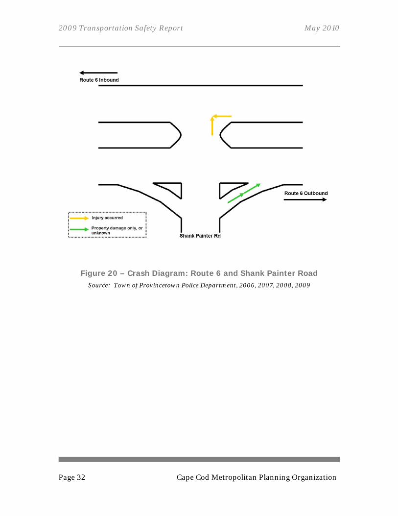
4.2.2. ALTERNATIVE 2: TRAFFIC SIGNALIZATION Traffic signals can be very effective in controlling traffic flow, yet there are minimum thresholds that must be met to warrant a light. It is unlikely a traffic signal is warranted at this location at this time, as it does not meet those thresholds.
Figure 24 – Route 6 / Shank Painter Rd, Signalized Alternative
2009 Transportation Safety Report May 2010
Cape Cod Metropolitan Planning Organization Page 37
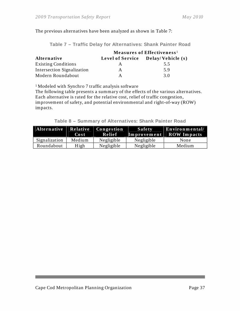
The previous alternatives have been analyzed as shown in Table 7:
Table 7 – Traffic Delay for Alternatives: Shank Painter Road
Measures of Effectiveness1 Alternative Level of Service Delay/Vehicle (s) Existing Conditions A 5.5 Intersection Signalization A 5.9 Modern Roundabout A 3.0
1 Modeled with Synchro 7 traffic analysis software The following table presents a summary of the effects of the various alternatives. Each alternative is rated for the relative cost, relief of traffic congestion, improvement of safety, and potential environmental and right-of-way (ROW) impacts.
Table 8 – Summary of Alternatives: Shank Painter Road
Alternative Relative Cost
Congestion Relief
Safety Improvement
Environmental/ ROW Impacts
Signalization Medium Negligible Negligible None Roundabout High Negligible Negligible Medium

2009 Transportation Safety Report May 2010
Page 38 Cape Cod Metropolitan Planning Organization
4.3. SHANK PAINTER ROAD CORRIDOR Not only is Shank Painter Road a major vehicular thoroughfare from Route 6 to the commercial center, it is also heavily traveled by bicyclists and pedestrians. The street’s sidewalk connections are limited, often forcing pedestrians into the street. Driveways and other curb cuts are plentiful. Several curb cuts are so wide as to make it difficult to distinguish between sidewalks and parking spaces. Narrow right-of-ways and infringement upon the existing right-of-way are obstacles to creating space for new sidewalks, wider sidewalks, and bicycle lanes.
4.3.1. CRASH HISTORY From January 1, 2006, to the end of 2008, 10 reported vehicle crashes occurred relevant to Shank Painter Road in Provincetown. This number reflects reported crashes, not all incidents that may have occurred. Drivers are not required to report crashes with damages under $1,000 (assuming there is no injury involved). Of the 10 crashes, three took place at the intersection of Route 6 and Shank Painter Road (see section 4.1.2.). Four crashes took place at the intersection of Shank Painter Road and Court Street. Court Street is an often-used connection for pedestrians and vehicles accessing the Stop and Shop Supermarket from Bradford Street. Two of the crashes during this three-year period took place at the intersection of Shank Painter Road and Bradford Street (Route 6A), and one occurred at 25 Shank Painter Road.
4.3.2. IMPACTS OF STOP AND SHOP The Stop and Shop Supermarket has been very successful in attracting customers in Provincetown. The town’s dense development facilitates the heavy pedestrian traffic that flows to this supermarket. Narrow shoulders and lack of complete sidewalk connections are forcing many pedestrians into the road.
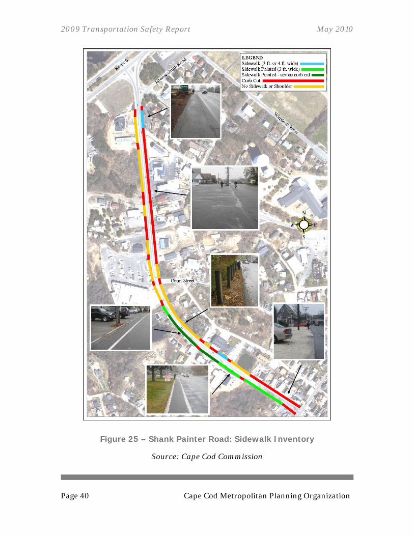
4.3.3. CORRIDOR SIDEWALK INVENTORY A survey conducted by the Cape Cod Commission of Shank Painter Road’s bicycle and pedestrian facilities shows inadequate connectivity on the corridor. The road’s east side has about 180 feet of sidewalk separated from the road, compared to 1,420 feet of curb cuts (most of which are vast unrestricted segments of
2009 Transportation Safety Report May 2010
Cape Cod Metropolitan Planning Organization Page 39
pavement providing continuous access to properties) and 960 feet of edging lacking a sidewalk or any shoulder. The vast expanses of curb cuts and lack of sidewalk facilities force pedestrians to share awkward, undefined swaths of pavement with vehicular traffic. Shank Painter Road’s west side has considerably more sidewalk, although it may only be a sidewalk in name. Almost 1,000 feet of paved shoulder is designated as a sidewalk by a stripe of white paint. Almost half of this painted sidewalk is stretched across curb cuts with no separation from legal vehicle paths. There is no sidewalk or shoulder north of the end of the painted path (at the south boundary of the Stop and Shop Supermarket property). Five crosswalks on Shank Painter Road are of varying degrees of quality. A few of the crosswalks should be considered for re-striping, as the paint has faded (see Figure 26). The crosswalk between TD Bank and Cumberland Farms should be reviewed for issues regarding handicap accessibility. The path from the crosswalk to the Cumberland Farms lot requires traveling over an off-road path and going over a curb.
4.3.4. INTERSECTION WITH JEROME SMITH ROAD Poor sight distances at the intersection of Jerome Smith Road and Shank Painter Road increase the likelihood of conflicts between motorists, pedestrians, and bicyclists. No clear, safe route exists for bicyclists turning left onto Shank Painter Road from Jerome Smith Road. Due to the intersection’s “Y”-style geometry, left-turning bicyclists will often ride against traffic and put them in potential conflict with oncoming traffic.
2009 Transportation Safety Report May 2010
Page 40 Cape Cod Metropolitan Planning Organization
Figure 25 – Shank Painter Road: Sidewalk Inventory
Source: Cape Cod Commission

2009 Transportation Safety Report May 2010
Cape Cod Metropolitan Planning Organization Page 41
Figure 26 – Shank Painter Road: Crosswalk Examples
Source: Cape Cod Commission, 11/25/2009

2009 Transportation Safety Report May 2010
Page 42 Cape Cod Metropolitan Planning Organization
4.4. RECOMMENDATIONS AND NEXT STEPS This report makes no recommendations for changes regarding the intersection of Route 6 and Shank Painter Road. Traffic flows relatively freely, and the frequency of crashes is not high enough to indicate a problem. The length of Shank Painter Road is in need of significant improvements. The amount and size of curb cuts on both sides of the street makes safe pedestrian travel difficult. Town officials and local property owners should work together to create a plan to consolidate the breaks in the curbing and make room for pedestrian facilities. As this road is an important bicycle and pedestrian thoroughfare in Provincetown, accommodations for these modes should be made along its entire length. The paved shoulder stretches across many wide curb cuts, including many areas where cars are parking at right angles to the shoulder. Also, crosswalks need to be restriped, as they have become faded. This study recommends that a sidewalk plan be created for Shank Painter Road, to create an organized, well-connected pedestrian path and bicycle route. The town may consider pursuing enhancement funds from the Transportation Improvement Program (TIP).
2009 Transportation Safety Report May 2010
Cape Cod Metropolitan Planning Organization Page 43
5. Conclusion This review of traffic safety issues at these locations has resulted in a comprehensive package of improvements. Some improvements are identified for short-term implementation and other, more complex improvements are listed for longer-term implementation.
5.1. SUMMARY OF RECOMMENDATIONS The following list is a summary of recommendations from the previous sections. Please refer to the individual sections for details. Eastham Rotary: Eastham, MA
Short-term: Schedule a meeting with local and state officials, business leaders, and residents to discuss improvements at this location
Short-term: Evaluate signage surrounding the rotary Short-term: Explore options for pedestrian connectivity Short-term: Investigate relationship between the rotary and the
intersection of Canal Road with Route 6A/28 in regards to safety Short-term: Make safety improvements at Smith Lane Long-term: Redesign rotary to include features of a modern roundabout
Truro Central School: Truro, MA Short-term: Commission a private consultant to develop a plan for the
Truro Central School’s installation of a school zone speed limit sign Short-term: Install school zone speed limit sign Long-term: Consider year-round pedestrian signal Long-term: Consider pedestrian refuge on Route 6
Route 6 / Shank Painter Road: Provincetown, MA
Short-term: Coordinate with town officials and property owners regarding the consolidation of curb cuts along the corridor
Short-term: Begin curb cut consolidation Short-term: Create a sidewalk plan for the creation of a well-connected
pedestrian path and bicycle route Short-term: Implement sidewalk plan through construction
