2006 infrared d r h e l ±219 ac - images2.loopnet.com€¦ · bab lab wab bab apb goa ra ¯ map...
TRANSCRIPT

Map Updated: Monday, October 29, 2018. This information submitted is not guaranteed. Although obtained from reliable sources, all information should beconfirmed prior to use or reliance upon the information. This document may not be reproduced in whole or in part without the express written consent of NAI Avant.
219 ± Acres1490 Highway 1 N, Cassatt, SC 29032
2006 Infrared
Highway 1 N
Ellio
tt Hu
nter
Rd
Drakeford Rd£¤1
¯
FOR SALE
±219 ACCamden, SC
Horse Country with Pasture Land
Mike Johnson+1 803 744 9829
Exclusively Offered By:
Site
807 Gervais Street, Suite 301 • Columbia, South Carolina 29201 • +1 803.254.0100 • www.naicolumbia.com
Sale Price:$547,500
*Ideal for Hunting and Equestrian Use*

Map Updated: Tuesday, August 14, 2018. This information submitted is not guaranteed. Although obtained from reliable sources, all information should be confirmed
prior to use or reliance upon the information. This document may not be reproduced in whole or in part without the express written consent of NAI Avant.
219 ± Acres
1490 Highway 1 N, Cassatt, SC 29032
Location
Site
CamdenWhite Pines Golf Club
WoodwardField Airport
Kersh
aw H
wy
Broad St
Highway 1 N
£¤521UV97
Jeffer
son D
avis
Hwy
¯
Map Updated: Tuesday, August 14, 2018. This information submitted is not guaranteed. Although obtained from reliable sources, all information should be confirmed
prior to use or reliance upon the information. This document may not be reproduced in whole or in part without the express written consent of NAI Avant.
219 ± Acres
1490 Highway 1 N, Cassatt, SC 29032
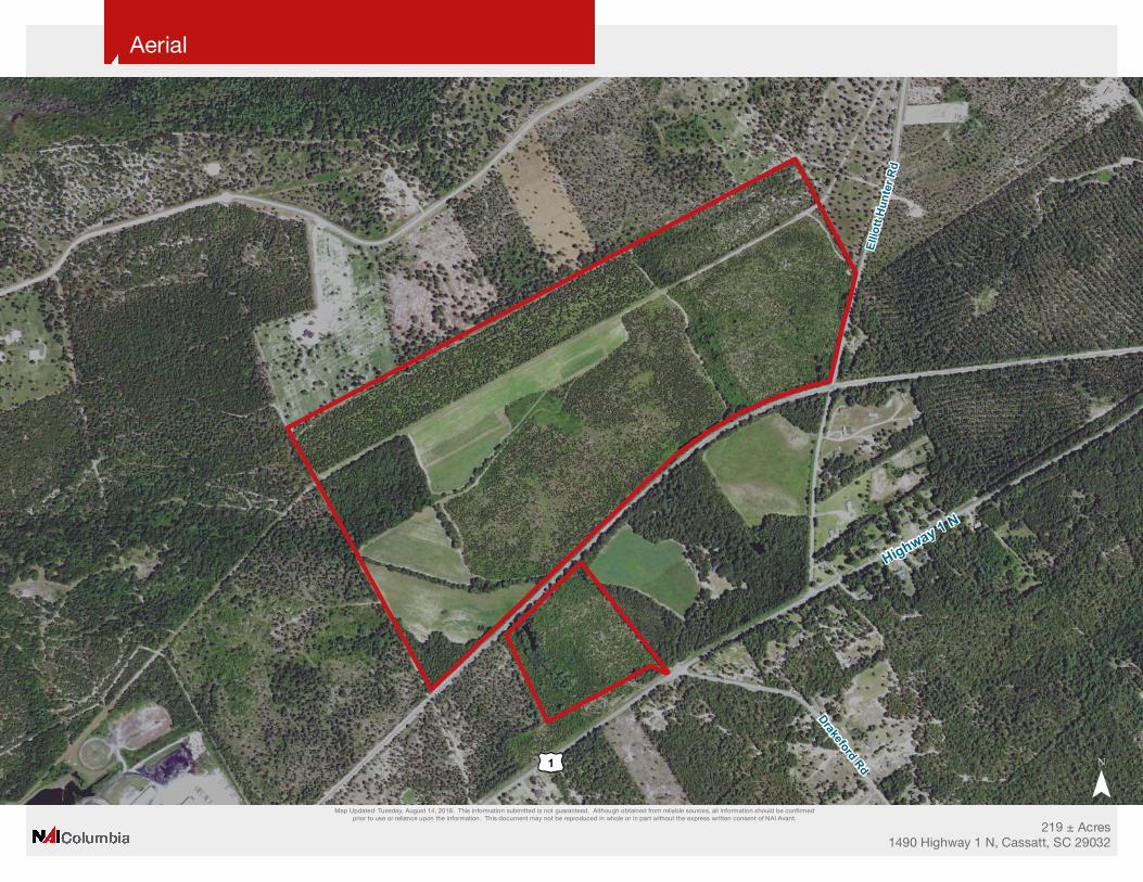
Aerial
Highway 1 N
Elliot
t Hun
ter R
d
Drakeford Rd£¤1
¯

Map Updated: Tuesday, August 14, 2018. This information submitted is not guaranteed. Although obtained from reliable sources, all information should be confirmed
prior to use or reliance upon the information. This document may not be reproduced in whole or in part without the express written consent of NAI Avant.
219 ± Acres
1490 Highway 1 N, Cassatt, SC 29032
2006 Infrared
Highway 1 N
Elliot
t Hun
ter R
d
Drakeford Rd£¤1
¯

Map Updated: Tuesday, August 14, 2018. This information submitted is not guaranteed. Although obtained from reliable sources, all information should be confirmed
prior to use or reliance upon the information. This document may not be reproduced in whole or in part without the express written consent of NAI Avant.
219 ± Acres
1490 Highway 1 N, Cassatt, SC 29032
Topographical Map
Highway 1 N
Elliot
t Hun
ter R
d
Drakeford Rd£¤1
¯

Map Updated: Tuesday, August 14, 2018. This information submitted is not guaranteed. Although obtained from reliable sources, all information should be confirmed
prior to use or reliance upon the information. This document may not be reproduced in whole or in part without the express written consent of NAI Avant.
219 ± Acres
1490 Highway 1 N, Cassatt, SC 29032
FEMA National Flood Hazard Layer
Highway 1 N
Elliot
t Hun
ter R
d
Drakeford Rd£¤1
¯

Map Updated: Tuesday, August 14, 2018. This information submitted is not guaranteed. Although obtained from reliable sources, all information should be confirmed
prior to use or reliance upon the information. This document may not be reproduced in whole or in part without the express written consent of NAI Avant.
219 ± Acres
1490 Highway 1 N, Cassatt, SC 29032
National Wetlands Inventory
Highway 1 N
Elliot
t Hun
ter R
d
Drakeford Rd£¤1
¯
National Wetlands InventoryEstuarine and Marine DeepwaterEstuarine and Marine WetlandFreshwater Emergent WetlandFreshwater Forested/Shrub WetlandFreshwater PondLakeRiverine

Map Updated: Tuesday, August 14, 2018. This information submitted is not guaranteed. Although obtained from reliable sources, all information should be confirmed
prior to use or reliance upon the information. This document may not be reproduced in whole or in part without the express written consent of NAI Avant.
219 ± Acres
1490 Highway 1 N, Cassatt, SC 29032
Soil Survey
Highway 1 N
Elliot
t Hun
ter R
d
Drakeford Rd£¤1
LaB
LaB
BaB
LaB
WaB
BaB
ApB
GoA
Ra
¯

Map Unit Description (Brief, Generated)
Kershaw County Area, South Carolina
[Minor map unit components are excluded from this report]
ApB - Alpin sand, 0 to 6 percent slopesMap unit:
Component: Alpin (100%)
The Alpin component makes up 100 percent of the map unit. Slopes are 0 to 6 percent. This component is on marine terraces, coastal plains, sandhills. The parent material consists of sandy marine deposits. Depth to a root restrictive layer is greater than 60 inches. The natural drainage class is excessively drained. Water movement in the most restrictive layer is high. Available water to a depth of 60 inches is low. Shrink-swell potential is low. This soil is not flooded. It is not ponded. There is no zone of water saturation within a depth of 72 inches. Organic matter content in the surface horizon is about 1 percent. Nonirrigated land capability classification is 4s. This soil does not meet hydric criteria.
BaB - Blanton sand, 0 to 6 percent slopesMap unit:
Component: Blanton (100%)
The Blanton component makes up 100 percent of the map unit. Slopes are 0 to 6 percent. This component is on marine terraces, coastal plains, sandhills. The parent material consists of sandy marine deposits and loamy marine deposits. Depth to a root restrictive layer is greater than 60 inches. The natural drainage class is moderately well drained. Water movement in the most restrictive layer is moderately high. Available water to a depth of 60 inches is very low. Shrink-swell potential is low. This soil is not flooded. It is not ponded. A seasonal zone of water saturation is at 60 inches during January, February, March, December. Organic matter content in the surface horizon is about 1 percent. Nonirrigated land capability classification is 3s. This soil does not meet hydric criteria.
GoA - Goldsboro loamy sand, 0 to 2 percent slopesMap unit:
Component: Goldsboro (95%)
The Goldsboro component makes up 95 percent of the map unit. Slopes are 0 to 2 percent. This component is on coastal plains, marine terraces. The parent material consists of loamy marine deposits. Depth to a root restrictive layer is greater than 60 inches. The natural drainage class is moderately well drained. Water movement in the most restrictive layer is moderately high. Available water to a depth of 60 inches is moderate. Shrink-swell potential is low. This soil is not flooded. It is not ponded. A seasonal zone of water saturation is at 24 inches during January, February, March, April, December. Organic matter content in the surface horizon is about 1 percent. Nonirrigated land capability classification is 2w. This soil does not meet hydric criteria.
Page 1
Survey Area Version: 14
Survey Area Version Date: 12/23/2013

Map Unit Description (Brief, Generated)
Kershaw County Area, South Carolina
LaB - Lakeland sand, 0 to 6 percent slopesMap unit:
Component: Lakeland (86%)
The Lakeland component makes up 85 percent of the map unit. Slopes are 0 to 6 percent. This component is on coastal plains, dunes. The parent material consists of eolian sands. Depth to a root restrictive layer is greater than 60 inches. The natural drainage class is excessively drained. Water movement in the most restrictive layer is high. Available water to a depth of 60 inches is very low. Shrink-swell potential is low. This soil is not flooded. It is not ponded. There is no zone of water saturation within a depth of 72 inches. Organic matter content in the surface horizon is about 0 percent. Nonirrigated land capability classification is 4s. This soil does not meet hydric criteria.
Ra - Rains sandy loamMap unit:
Component: Rains (100%)
The Rains component makes up 100 percent of the map unit. Slopes are 0 to 2 percent. This component is on coastal plains, marine terraces. The parent material consists of loamy marine deposits. Depth to a root restrictive layer is greater than 60 inches. The natural drainage class is poorly drained. Water movement in the most restrictive layer is moderately high. Available water to a depth of 60 inches is low. Shrink-swell potential is low. This soil is not flooded. It is not ponded. A seasonal zone of water saturation is at 0 inches during January, February, March, April, November, December. Organic matter content in the surface horizon is about 4 percent. Nonirrigated land capability classification is 3w. This soil meets hydric criteria.
WaB - Wagram sand, 0 to 6 percent slopesMap unit:
Component: Wagram (100%)
The Wagram component makes up 100 percent of the map unit. Slopes are 2 to 6 percent. This component is on coastal plains, marine terraces. The parent material consists of loamy marine deposits. Depth to a root restrictive layer is greater than 60 inches. The natural drainage class is well drained. Water movement in the most restrictive layer is moderately high. Available water to a depth of 60 inches is low. Shrink-swell potential is low. This soil is not flooded. It is not ponded. There is no zone of water saturation within a depth of 72 inches. Organic matter content in the surface horizon is about 1 percent. Nonirrigated land capability classification is 2s. This soil does not meet hydric criteria.
Page 2
Survey Area Version: 14
Survey Area Version Date: 12/23/2013