2002 comprehensive west end revitalization plan
TRANSCRIPT

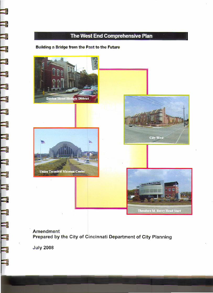
The West End Comprehensive Plan
Building a Bridge from the Past to the Future
Uni
D
Dayton Street Historic District
1
City West
on Terminal Museum Center
Theodore M. Berry Head Start
Prepared by the Department of Community Development and Planning
Prepared for the West End Community
Contributing Departments
epartment of Transportation and Engineering (Division of Transportation Planning and Urban Design)
The West End Comprehensive Plan 1
Building a Bridge from the Past to the Future 1 A New West End Community 3
Executive Summary 3
Location 3 Background 3 Issues 4
Introduction 5
Planning Process 5 History 5
Existing Conditions 7
Population 7 Race 7 Income 7 Income 8 Housing 8 Existing Land Use and Zoning 9
Assets, Issues and Opportunities 12
Changing Demographics in the West End 12 Commercial Development Opportunities 12
Development Concepts 19
Key Recommendations 23
Goals, Objectives and Strategies 23
Strategy Implementation Matrix 24
Credits 31
2

A New West End Community
Executive Summary
The purpose of this plan is to present the redevelopment issues and concerns identified by residents, businesses and key stakeholders in the West End and to provide a guide for implementation of redevelopment in the community. This plan outlines the social and economic changes that are occurring and presents a redevelopment concept derived from the community’s vision for a revitalized West End neighborhood. The West End Community Council and a group of more than 150 concerned residents, businesses, property owners and key stakeholders worked with City staff and Menelaos Triantafilou, a private consultant to the community, to develop a list of goals with objectives and strategies included in the plan.
Location The West End community is located northwest of the Cincinnati Central Business District (CBD) and west of the Over-the-Rhine (OTR) community. The West End borders OTR on Central Parkway and the CBD on Eighth Street (see figure 1).
Figure 1- West End Location Map
Background In November 2001, the Cincinnati City Council adopted the “West End Urban Design Plan”. The plan supported the development of a new Cincinnati Metropolitan Housing Authority (CMHA), HOPE VI funded, rehabilitation of the Lincoln Court and Laurel Homes project sites in the West End. The plan also included a blight study of the West End, which concluded that neighborhood conditions were not conducive to encourage new development. These conditions limit the growth of the community and impede private investment that would create employment and preserve housing opportunities. The West End Community Council, in response to the blight study conclusions, requested a plan to address those conditions.
3
The CMHA HOPE VI project and previous CitiRAMA projects successfully addressed the issue of new housing in the community. These projects, however, represented public investment and limited private dollars. They were successful in attracting new upper income families to the West End to new home and rehabilitated historic properties. These new families are attracted by 15-year tax abatement for new housing in the West End and the prospect of living near downtown. The success of these projects illustrates the potential for renewal in the West End.
Issues The plan identifies key issues, goals, and objectives, and recommends strategies for implementation. The plan divides the community into five distinct development districts. Having unique districts allows goals, objectives and strategies for redevelopment to specifically focus on the issues present in each district. Some issues will transcend all districts. The key issues outlined by the community as the overall focus of the plan are as follows: Continue Housing Development with a Balance of Housing Opportunities The community wishes to continue the new housing development and recognizes the positive impact on the neighborhood. The construction of new housing in the West End is a welcomed change, attracting new families to the community and raising the value of residential properties. The new housing should also include affordable units to ensure all residents the advantage of homeownership in the West End. City supported lower interest loans should also be made available to assist existing homeowners in maintaining and improving their properties. New Commercial Redevelopment should focus on Neighborhood Oriented Businesses The community favors continuing commercial development in the neighborhood particularly in the Linn Street commercial district and in the northeast sector. The location of the West End near the I-75 corridor and the Cincinnati Central Business District generates a regional potential for commercial retail development. The West End community desires commercial development to serve the community as well as the region as a whole. Actively Pursue a Campaign to Improve the Community’s Image and Marketability Improving the appearance of the community through crime abatement, code enforcement and the elimination of blighted structures and conditions is the central goal. The community has experienced many positive changes that have been overshadowed by negative images from the past. They wish to change the perception of the neighborhood and build a new image that focuses on the rich cultural history of the West End and promote the assets and opportunities derived from this rich cultural heritage. Work with the City of Cincinnati to Improve the Quality of Life for West End Residents The West End Community Council realizes the importance of a good working relationship with the City of Cincinnati. They actively sort out the Police for ideas to address a rash of violent crimes that plagued the business area north of Liberty Street. The council and residents have improved community and police relations and developed a partnership to abate criminal activities. They want to go further and improve the overall working relationship between the community and the city.
4

Introduction
Planning Process The Planning Department staff organized meetings in 2001 with residents, businesses and key stakeholders in the West End to discuss and identify issues and concerns. The meetings were held at various locations in the West End including neighborhood churches, community centers and public schools auditoriums. The initial meetings focused on defining an urban renewal area for the Hope VI development, later renamed City West. An urban design plan for the City West project was presented and adopted by Cincinnati City Council in November 2001. Following completion of the urban design plan, the West End community invited the University of Cincinnati, College of Design, Architecture, Art and Planning (DAAP) to assist the community in creating a vision for the overall redevelopment of the West End. The students developed a vision plan for the West End, which is incorporated into this plan. In December 2001, the City Planning Department began conducting planning forum meetings with the community to discuss the synthesis of the DAAP studies into implementation strategies that could be supported by the City of Cincinnati. The planning forum concluded in October 2002 and provided the basis for the final goals, objectives and strategies embodied in this plan.
History The West End is a community in transition. What once was a mostly low-income residential community is rapidly becoming a mixed-income neighborhood with new investment shaping the social and economic character of the community. Projects such as CitiRAMA, City West and the Theodore M. Berry Head Start Center, bring new hope to under used sites in the community. New families are relocating to the community bringing diversity in both income and race. The household income has increased 190% from 1980 to 2000 and family income has increased 155% during the same period. Families of all races are choosing the West End to build new homes, increasing the number of homeowners 60% from 1980 to 2000. The speed of change exemplifies the potential for additional West End redevelopment. The addition of new single-family housing in the West End improved property values especially in the single-family market. The West End single-family market rose from one of the lowest sales values in the city to the fifth highest1. Additionally, with new housing came a change in the racial profile of the West End, adding 850 white families to the community as shown in the 2000 Census. The greatest impact to the housing market in the West End is expected at the completion of the City West development in 2004/2005. This project is designed as a mixed-income housing development that includes new homes, market rentals and assisted rentals. City West is the largest single site housing development in the history of Cincinnati, costing over 180 million dollars. The 250 new single-family homeownership units planned for the development will be the largest increase in new homeownership units in the West End since 1990. The City West development is credited with attracting additional commercial interests in the West End. The West End offers an attractive opportunity for commercial development because of the availability of land and under used buildings and its location near downtown Cincinnati. The close proximity of the West End community to the Cincinnati Central Business District (CBD), Northern Kentucky suburbs and the I-75 corridor gives regional accessibility to any retail ventures located in the neighborhood. The Linn Street Neighborhood Business District is the primary area of interest for new commercial development. The City West project currently includes approximately 60,000 square feet of new commercial retail space in its development plan, 10,000 square feet at the ground floor of the senior citizen building on Linn Street and 50,000 square feet at the first floor of the mixed-use structures at
1 1980-2000 Hamilton County Auditor Records
5

Derrick Turnbow Avenue and Linn Street. The vacant land and buildings in the NBD hold the potential for additional commercial development in the Linn Street area. The City of Cincinnati initiated a study of the West End at the request of the West End Community Council. The community council, representing the residents in the community, is an active part of the revitalization process. The council is aware of the changing character of the community and wishes to be proactive in creating a vision for the community that will guide future planning and development activities. The community requested this study in response to the increased level of new development projects already underway in the West End. The West End business community is also an active participant in the revitalization of the West End. The business leaders have conducted meetings with both city staff and community leaders and shared their ideas and plans for the future. The business community supports the revitalization efforts and is eager to participate in the vision and implementation of this plan.
6

Existing Conditions
Demographic Analysis
s
2
4
6
8
10
12
0
5000
10000
15000
West End Population Trends
West EndPopulation
30313233343536373839
Population The population in the West End, like most of Cincinnati, is on the decline. In a twenty-year period from 1980 to 2000, the West End has lost more than 4000 residents, a 37% decline. The city population declined only 14% during the same period (figure 2). Of the families that migrated to the West End in the last twenty years, 11% are homeowners while 89% are renters, most often living in the old Lincoln Court and Laurel Homes project sites. The new City West development demolished many of the units in the first phase of development and a large number of families relocated outside the West End to other Cincinnati neighborhoods. The population, 19 and under, represents the largest percentage of the population (figure 3). Their numbers declined 8% from 1980 to 1990; however, a 43% decline occurred between 1990 and 2000, most likely because of the City West development. The majority of the 19 and under population and their families lived in Lincoln Court and Laurel Homes and relocated because their homes were demolished.
The largest percentage of the population today is the 25-64 year old residents at 48% of the community. This age group has decreased only 7% from 1980 to 1990 and 18% from 1980 to 2000, the smallest decline of all groups.
Race The West End community is predominately African American. The census statistics reported 91% African Americans in 1980, 93% in 1990 and 87% in 2000. The changes in population show a significant increase of white residents (see figure 4), from 0 in 1980 to 850 in 2000.
Figure 2 Changing Population Trend1980 1990 2000
s ds
Figure 3 City Population ChangeCincinnati Population Tren
0
1000
2000
3000
4000
5000
6000
19 and Under 20 - 24 25 - 64 65 and over
West End Population By Age
198019902000
0,0000,0000,0000,0000,0000,0000,0000,0000,0000,000
1980 1990 2000
CincinnatiPopulation
Figure 3 - Changes in Population Age Groups
Figure 2 - Changes in Population Sizes
0
000
000
000
000
000
000
1980 1990 2000
West End Population By Race
White
Black or AfricanAmerican
s
Figure 4 - Changing Racial Profile7

Income The income profile of the West End from the 1980 and 1990 census indicates a decline in the number of households with incomes below $10,000 (78% in 1980 and 71% in 1990). In the 2000 census, only 30% of household incomes were below $10,000.
$0
$5,000
$10,000
$15,000
$20,000
1980 1990 2000
West End Income Data
Medianhouseholdincome (dollars)Median familyincome (dollars)
The average median household income in the West End increased from $5,306.00 in 1980 to $15,402.14 in 2000, a 190% increase. Family income also increased in the community. The average median family income grew 43% from 1980 to 1990 and an additional 73% from 1990 to 2000 (see figure 5). Likewise, the poverty level in the West End decreased 45% from 1980 to 2000. Figure 5- Changing Income Profile
Housing The West End housing stock is a mix of largely historically significant properties on narrow lots, low-rise apartment buildings, some high-rise apartment buildings and new single-family townhouses. The housing values are as mixed as the housing stock, ranging from $30,000 to $300,0002. The current housing market trend for the West End shows a decrease in housing units and an increase in housing values. The total number of housing units decreased from 6413 in 1980 to 5141 in 2000. This decline is most visible in the southern area of the community where demolition of several blocks of high density multi-family buildings occurred to construct low density single-family and multi-family buildings for the CitiRAMA and City West projects. The completion of the CitiRAMA in 2002 and City West in 2004/2005 will add more than 1200 new units to the West End market. It is also expected to raise property values and redefine the housing market in the West End. The first CitiRAMA units completed in 1996 sold between $170,000 and $190,000. The value of these units is increasing each year. The Longworth Square properties, constructed in 1995, sold between $70,000-$90,000. These same units were resold in 2000 for $140,000-$190,000. New units at the CitiRAMA 2000 developments sell between $170,000-$300,000. The market price points for the 250 City West homeownership units begin at $160,000. New housing developments completed since 1990 is making a positive impact on the housing market in the West End. The City West project will expand the positive impacts to include rental as well as ownership units. Approximately 400 of the 1082 new housing units at the City West development will be rentals; both assisted and market units. The City West project site includes reconstruction at the Lincoln Court and Laurel Homes property and at scattered sites throughout the community. The vacancy rate for owner-occupied housing has decreased from 9% in 1990 to 3% in 2000 (see figure 6). This trend can also be seen in the rental vacancy rates. The vacancy rate for rentals in 1990 was 33%, while the 2000 rental vacancy rate decreased to 11%.
0%
5%
10%
15%
20%
25%
30%
35%
1980 1990 2000
Housing Vacancy Rate
Owner vacancyRenter vacancy
Integrated in the community’s housing stock are homes in need of repair, vacant buildings and lots. These vacant sites are present throughout the Dayton Street historic area and in the area north of Liberty Street and east of Linn Street.
Figure 6 – Housing Vacancy Profile 2 Hamilton County Auditor’s records 1990-2000
8

Existing Land Use and Zoning The existing land use is mixed, ranging from low-density single-family residential to medium and heavy industry. Single-family uses are concentrated in the northwest and the southeast quadrant. The northeast quadrant contains the Dayton Street Historic District with rehabilitated single-family homes and two and three-story apartment structures in their original historic setting. The southeast quadrant contains the Betts-Longworth Historic District and the City West project site. Like the northeast quadrant, the historic buildings in the Betts-Longworth District establish the character and scale of the area. New homes developed around the historic area match the architectural style and character of the historic older structures. The zoning in the area is predominately R-7, high-density, multi-family residential. Small areas of R-B, residential-business and O-1, low to high-density office zoning occur at Clark Street and Mound Street and along Central Avenue north of Charles Street (see figure 7).
A large portion of the land use in West End is multi-family residential. Prior to the development of City West, there were six separate public housing project sites, the largest concentrations of multi-family land use and over 490 multi-family buildings scattered throughout the community. The City West development replaces the two largest multi-family areas, Lincoln Court and Laurel Homes. The remaining projects, Park Town Apartments, Ezzard Charles Apartments, Stanley Rowe Townhouses and Stanley Rowe Seniors Building still remain. The zoning in all the multi-family areas is R-7. Industrial land uses abut residential uses north and east along Central Parkway and Liberty Street. Many of the buildings in this area are vacant and deteriorating with several vacant lots. The other industrial land uses to the west near I-75, are stable with some newly constructed buildings. The zoning for the industrial areas is M-2, high-density manufacturing. Commercial land uses, churches, parks and recreational uses are located in the residential and industrial areas. Neighborhood school sites also integrate into the blocks of residential use. The general pattern of zoning in the neighborhood reflects the current use with some non-conforming uses (see figure 8).
9

1
Figure 7- Existing Land Use
0

11
Figure 8- Existing Zoning

1
Assets, Issues and Opportunities
Changing Demographics in the West End The West End community is transitioning from a base of low-income subsidized housing units to a mix of larger market rentals and homeownership units. A significant portion of the change is attributed to the tax abatement incentives provided for the properties at the CitiRAMA, City West and the Betts-Longworth and Dayton Street Historic Districts. These abatements have generated an interest specifically in new homeownership. Since 1992, over 80 new single-family homes have been added in the West End, and many of the multi-family rental properties have been converted back to single-family use. The West End is also transitioning in its racial diversity, particularly among the number of whites living in the neighborhood. The 2000 census indicates a significant increase in the white population in the community. Whites were more than ten percent of the total population in 2000, compared to less one percent in 1990. Much of the new white population is located in the new homes created by CitiRAMA and City West. The City West project created a total of 450 new homeownership units and CitiRAMA 2000 a total of 80 new units. Both developments are expected to contribute to an increase in family and household incomes as well as the racial diversity of the West End.
Commercial Development Opportunities The redevelopment process in the West End is in the beginning stage. While new developments such as the City West project, the Theodore M. Berry Head Start Center and the proposed YMCA project have come to the community; there are still many underdeveloped areas in the community. New development should focus on increasing job opportunities for residents and creating taxes for reinvestment in the community’s infrastructure. The West End has a wide range of business development and redevelopment opportunities businesses. New projects should be evaluated on their potential to provide new employment, services to residents and taxes to support public improvements and additional project funding. Community Based Development The revitalization of the West End should include an element of community-based development or development conducted by or involving a West End supported development group with a long-term interest in the community. A locally based interest has proven to be a key element in sustaining interest and motivating new projects as determined by market factors. The West End has a new community council and is fortunate to have three local development groups already present in the community. The Miami Purchase Foundation has been part of the West End residential redevelopment for more than 20 years. They are presently completing a strategic plan for new development focused on the revitalization of the Bank Street area. The new West End Community Council has re-established its development arm with Renaissance West Incorporated, lead by a new team of local business and commercial property owners. Renaissance West, established in 2001, is charged with finding and assisting outside investment for the community to establish new retail/commercial and residential development for the large vacant buildings and sites in the community. The Seven Hills Foundation is another longstanding West End development partner. Their organization has been in the community for over 50 years. They represent the social services development arm to the community, providing facilities for youth and adults for counseling and family development. All are prepared to become involved and have genuine potential to complete projects. Development Opportunities on Linn Street The opportunities for redevelopment along Linn Street are numerous and a major focus of the community. The Washburn School, vacant for several years is scheduled for redevelopment as the Carl and Edith Linder YMCA and the new home of the Cincinnati Preparatory Academy, a West End charter school. There is also potential for a hotel facility to support entertainment activities at Music Hall, the Museum Center, or the CBD. North of the Washburn is an under used commercial strip
2

1
development currently housing the Arts Consortium, a West End landmark arts and entertainment company. Walgreens Drugs vacated the site in 1999 and was replaced by a beauty supply store (see figures 9-10). There are also two small businesses located in the complex. The present site plan for this complex with parking in the front of the older one-story structures is not pedestrian friendly. The site should be redeveloped with new buildings containing neighborhood retail space and offices in a two to three-story structure, designed with facades close to Linn Street and parking at the rear. The site is adjacent to existing multi-family residential units and new development plans should provide buffering at the side and rear yards. The community strongly suggests the design scale and massing of any new structures along Linn Street respond to the historic character of the architecture in the West End, in a way similarly to the new retail building designs at the City West development.
Figure 9- An existing retail complex in the Linn Street NBD, a potential redevelopment site.
Figure 10 –Architect’s rendering of proposed City West retail in the Linn Street NBD. The most attractive redevelopment opportunity in the Linn Street NBD is a sizeable vacant site at the northwest corner of Linn Street and Ezzard Charles Drive. This is the largest configuration of vacant parcels in the NBD. The site is ideal for a all-encompassing development with a grocery, pharmacy or other large retail development and possibly some additional small retail. It is adjacent to I-75 and located along the one of the most traveled access streets in and out of the Cincinnati CBD on route to I-75. It is also at the mid-point between the Union Terminal Museum and Music Hall. There is interest in this property by national and regional retail developer primarily because of its proximity to the new upper-income housing at City West and CitiRAMA. The development concept favored for the site envisions a retail center with one or two large, nationally recognized retail anchors that would attract customers to the area. The perception is that large retail anchors would provide support for additional small business development along Linn Street, facilitating new jobs and services to the community.
3

1
The scale and massing of any new structures at this site should avoid the big box image common in suburban communities. The recommended style of new construction is multi-story mixed-use buildings close to the street with parking in the rear - a more pedestrian friendly approach encouraging pedestrian traffic and activity in and around the new center. The major obstacle to developing this site is that the various parcels that comprise the total site have separate owners. Linn Street Corridor Infrastructure Improvements The revitalization of the Linn Street corridor must include improvements to the existing infrastructure, to support the expected increase in pedestrian and vehicular traffic. Improved circulation and aesthetics are key elements in the marketing of the area. The use of urban design elements such as street lighting, landscaped medians or planting areas at the sidewalks should be addressed for major streets such as Linn, Ezzard Charles, Liberty and Central Parkway. The historic character of the existing buildings along Linn Street and Liberty Street area suggest that streetscape lighting elements focus on emphasizing the historic period of the architecture and accent those structures that contribute to the historic fabric of the area (see figure 11-12).
Figure 11- Linn St. North of Liberty St.
New development should coordinate with the City of Cincinnati’s Department of Transportation and Engineering to determine the impact on the existing street network and ensure proper accessibility, streetscape designs and circulation for vehicles and pedestrians.
Figure 12 Liberty St. East of Linn St. Development of The Central Parkway Corridor The Central Parkway corridor is the boundary between the West End community and Over-the-Rhine community. It is one of Cincinnati’s main corridors through the downtown basin. The Cincinnati Public Schools’ (CPS) “Facilities Master Plan” proposes the relocation of the School for Creative and Performing Arts (SCPA) on Central Parkway adjacent to Music Hall in the Over-the-Rhine community (see figure 13). A study, commissioned by CPS of the relocation for SCPA on Central Parkway, describes the new development concept as the “Avenue of the Arts”. Included in the concept, as a complimentary land use along the Avenue of the Arts, is the Cincinnati Ballet Company (CBC), which is located in the West End at Liberty and Central Parkway (see figure 14). The Cincinnati Ballet features an education component in the “Otto M. Budig Academy” that trains students in the dance arts. The Ballet site extends the Avenue of the Arts into the West End and creates incentive for arts oriented commercial
n
4
Figure 13–Proposed New SCPA Campus Pla

1
redevelopment on adjacent sites in the West End on and near Central Parkway. The ballet is leading the arts oriented new construction and is expanding its campus onto the site directly south of its existing facility. The new building addition will house an expanded commercial retail store that will feature dancewear and CBC promotional clothing and materials. In addition to the retail area, the CBC will renovate space in the existing building for meeting rooms and offices for the Company. They will make their larger meeting rooms available to the public for community forums and other gatherings that serve to better the quality of life for West End residents.
Figure 14- Cincinnati Ballet Company Studios
Another partner in the “Avenue of the Arts” is WGUC Radio, a national public broadcast radio station (NPR), located at 1223 Central Parkway (see figure 15). They recently expanded the studio/office complex on the top floor of the Crosley Telecommunications Center by about 2,000 square feet, which includes construction of the first ADA compliant studio. The new “WGUC Radio” complex will have space for public tours and the capability of hosting high school and college interns. The location is adjacent to the proposed SCPA campus, directly across Central Parkway in the WCET Television building, also in the West End.
Figure 15 WCET/WGUC Broadcast Studios
WGUC and its landlord, WCET, donate hall space to the Gray History of Wireless Museum. It is a substantial collection of vintage radio broadcast transmissions and reception equipment dating back to the very dawn of the medium. Many of the items in this collection are one-of-a-kind. The museum is free and open for viewing during normal business hours. WGUC, with the blessing of Cincinnati city government, has worked to clean up and resurrect the public amphitheater adjacent to their building at the corner of Ezzard Charles and Central Parkway. They have obtained the services of a professional landscaping company to beautify the area and hope to sponsor a variety of free public concerts in the venue in the months and years ahead. This level of reinvestment in the West End community demonstrates the vision and potential present along Central Parkway. Additional investment in the area between WGUC and the CBC north of Ezzard Charles is still possible. Presently the land use in this area includes City of Cincinnati, District One Police Station, a mixed-use warehouse/residential building, an auto parts store and vacant land. There is opportunity for commercial retail offering supplies to artists, restaurant space serving patrons at Music Hall or downtown residential living units.
5

1
Abandoned and Vacant Buildings The closing of three public school facilities in the West End is adding to the number of vacant and abandoned buildings in the community. Several years ago the Washburn Elementary School closed and recently Heberle School and Sands Montessori School closed as part of the Cincinnati Public Schools new “Facilities Master Plan”. These closings present a new opportunity for residential/commercial mixed-use redevelopment. Their unique architectural character, building elements such as indoor swimming facilities and the large floor plans, makes them attractive as redevelopment sites (see figure 16-18).
Figure 16- Washburn School – Site of the New YMCA and the Cincinnati Preparatory Academy
Figure 20- Typical Northeast District Salvage Yard Site
Figure 17 - Heberle School -Vacant Building Figure 18- Sands Montessori –Vacant Site
The Northeast District
The area of the West End north of Liberty Street between Central Parkway and Linn Street is a potential commercial redevelopment opportunity. The numerous vacant, abandoned buildings and under used sites are ideal for redevelopment as commercial, industrial and residential uses. The community’s vision for this area is to redevelop blighted sites as a mixed-use light industrial and loft style multi-family residential area. The quality of life in this area is a challenge to redevelopment because of
6

the numerous auto salvage yard businesses present in the area (see figure 20). These businesses consume large blocks of land and some illegally conduct their operations on the street and in alleys resulting in unhealthy blighted conditions for the residents and obstacles to new development. Although the problem is limited to a few sites such as that pictured in figure 19, their existence creates a concern for safety and sanitation. They are nuisances to other businesses and a deterrent to business expansion and new business development. The patterns of development in the northeast district have not been planned nor evaluated in more than 40 years. Business relocations to the area resulted from the availability of inexpensive land with appropriate industrial zoning, with limited thought as to the effect on the residents and other businesses in the district. While some businesses contribute to the economic life of the district, other can be classed as a nuisance. Salvage yards are the predominant nuisance business in the district. Some of these salvage businesses started as auto repair shops or used auto parts suppliers and converted to salvage yards operating without proper licenses or required site improvements. Today these businesses do not conform to building or health code standards. The problems is growing yearly and if unchecked will inundate the area. The West End Community Council, in conjunction with a newly formed “West End Business Association” has begun a campaign to address these conditions. They are partnered with the City of Cincinnati in creating a redevelopment concept plan for the area (see Figure 21). The conceptual vision outlines land use changes for the various blocks and defines a proposed redevelopment of nuisance sites and vacant/under used buildings in the district.
n
Specifically, the concept plan recommends commethe district along Linn Street, combining neighborhoin the existing structures and new infill structures bumedium to light manufacturing land use area to theThe plan also recognizes a small pocket of stable loside of Linn Street at Dayton Street and end just socontribute to the fabric of the Dayton Street Historicresidential, although the area would support limitedparking. To support this new mixed-use land use concept, btrucks have discussed with the City Transportation would remove heavy truck traffic from the predomingoal of the redevelopment is to create a new imagedevelopment, targeting non-conforming and nuisanarea by converting non-conforming sites and vacanuse sites for businesses that offer job creation potecommunities.
Figure 21 – Redevelopment Concept Pla
1
rcial based mixed land uses for the western edge of od oriented businesses and residential apartments ilt on available vacant lots. This area would abut a
east, which would extend west to Central Parkway. w-density residential sites that begin on the east uth of Central Parkway. The buildings in this area District and, as such, should remain as primarily commercial uses that would not require additional
usinesses in the area that are serviced by large Department to determine a routing pattern that ately residential streets in the northeast district. The of the area and identify opportunities for future ce properties. The objective is to redevelop the t sites to conforming commercial/residential mixed-ntial for residents in the West End and surrounding
7

1
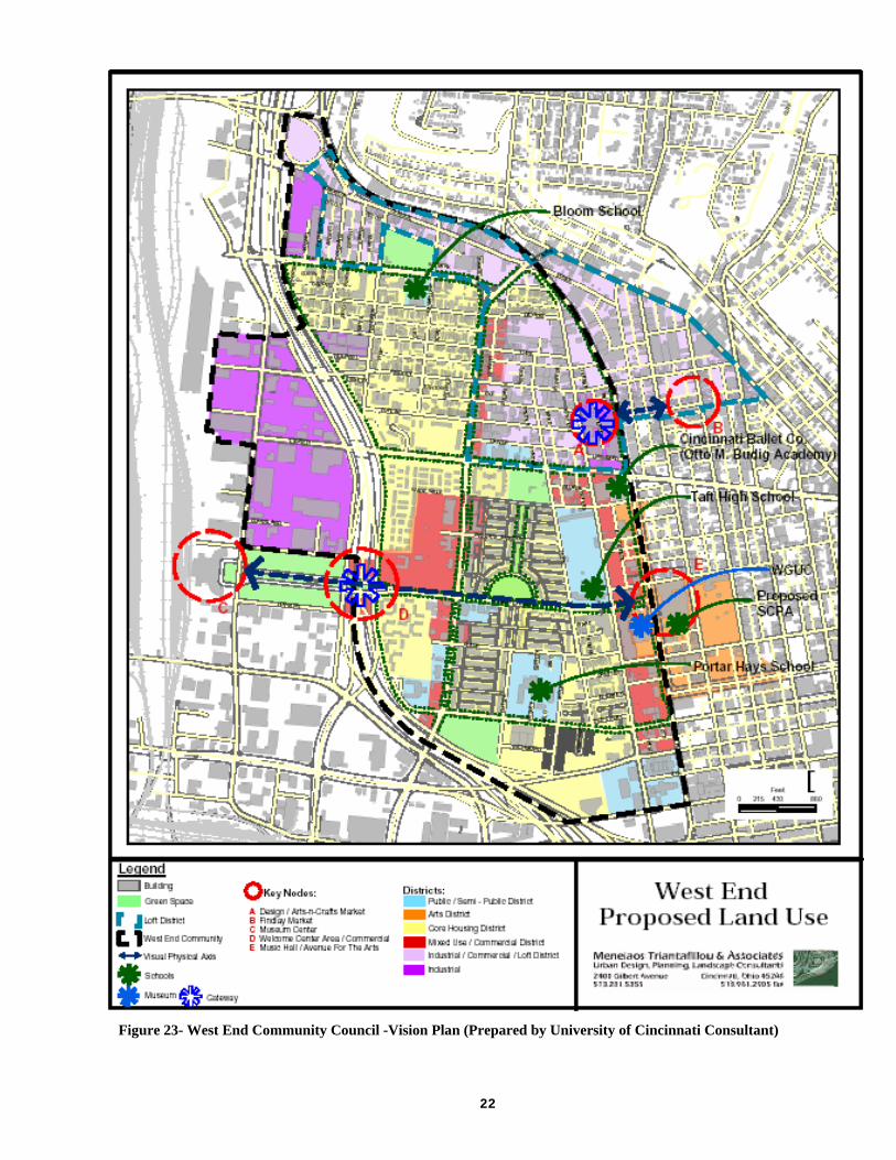
Figure 22-West End Community Council -Vision Plan (Prepared by University of Cincinnati Consultant)
8

1
Development Concepts
Several goals and objectives were developed during the planning process for this plan. They support the overall revitalization concept for the community. The vision for the community is a mix of clearly defined districts that delineate land use areas in the West End. Each district is summarized below and illustrated on the maps in Figures 22 and 23.
Loft District
A Loft District is a mixed-use commercial and residential land use, which offers sites for rehabilitation of existing manufacturing as residential apartments mixed with commercial studio, office and limited retail and commercial spaces. Building type and style and the population densities of the areas in which they are located characterize Loft Districts. Most buildings redeveloped as lofts are found in older industrial areas of the urban core. These buildings previously functioned as warehouses or factories for manufacturing businesses that have relocated or closed. The architecture of the buildings may be historic or have an appealing eclectic character. The ability to provide housing opportunities and business development in one location without major demolition of the structure makes Loft Districts a popular redevelopment concept in many urban areas around the United States. Reusing the buildings for new loft development can be part of a greater plan to revitalize an area without removing buildings that contribute to the character of the area. The buildings best suited for Loft District development have large open floor plans, minimal interior walls, and tall floor to ceiling spaces with large window openings. The building heights vary from three to five stories and have more than 10,000 square feet per floor. This type of architecture facilitates development of complete apartments or housing unit designs on a single-floor or multi-level unit with upper level spaces with balconies accessed by exposed stairwells. The entrances to the residential spaces are at the side or to the side of the main building entry, less visible to the public. Commercial spaces in loft buildings are typically at the lower floors of the structure where better visibility and access are possible from the public sidewalk and street. Commercial areas can occur on the upper floors and some designs may provide garage space for tenants and elevators, if those facilities were part of the original building plan. The northern sector of the West End near Central Parkway, north of Liberty Street has the character and infrastructure to be redeveloped as a Loft District. In the distant past, this area was part of the brewery district in Cincinnati, which extended from Price Hill into the Cincinnati downtown area along Central Parkway. Many of the original buildings that housed the breweries still stand and are structurally sound. Some have been reused for new commercial and industrial businesses, while others are vacant or under used. The West End Loft District would be an extension of the proposed loft district in the adjacent Over-the-Rhine neighborhood directly east across Central Parkway. The West End Loft District would begin from Central Parkway on the east and extend west across Linn Street to I-75. The beginnings of a district is evident in many of the structures fronting on Central Parkway west of Linn Street, where local artists have renovated several buildings for studio space and galleries. These galleries are visible to travelers on Central Parkway because of the large glass storefront windows, characteristic of the lower floors of the older buildings in this area. They represent the type of commercial land uses present in a Loft District. Mixed-Use Commercial Districts Typically, the Mixed-Use Commercial District characterizes many of the neighborhood business districts in Cincinnati communities. The businesses are neighborhood oriented and may include fast food franchises or convenience stores with gas fueling stations. They can be self-contained and provide controlled parking for tenants and customers.
9
2
Most multi-story buildings house both residential and commercial uses, with the residence placed above the commercial spaces. Other single-story structures may be strictly commercial. In the multi-story structures, separate entrances for residential and commercial tenants are important elements of the building design. The commercial spaces should be visible and accessible from the parking area or from the street and sidewalk. The Linn Street corridor provides the best location for a Mixed-Use Commercial District in the West End, combining multi-family and commercial in one location. The City West project has designs for new mixed-use structures east of Linn and south of Derrick Turnbow Lane. The existing mixed-use properties located north of Liberty Street and east on Linn Street provide the character and scale for the new structures developed in the mixed-use district for the West End. The new City West building designs are excellent examples, showing that a new development can respond to the historic architectural styles north of Liberty Street and provide an appropriate connection to the existing mixed-use district. Core Housing District The characteristic which best identifies a Core Housing District would be the predominance of stable residential land uses, typically of the same density. A district may combine a mix of low-density, two-or three-family rentals with owner-occupied single-family homes. Successful districts carefully define the design and density of new infill units to match and be compatible with existing homes. Infill units strengthen the viability of an area with new construction, but should maintain the character of the land use. Rehabilitated structures are also compatible both in density and design. The West End contains multiple core housing districts that are experiencing positive change, including the Dayton Street Historic area northwest of Liberty Street and the Betts-Longworth/CitiRAMA area southeast of Liberty Street. They are part of the vision to develop new and rehabilitated housing on the vacant and under used land parcels and buildings that exist in stable low-density residential areas of the neighborhood. The concept of residential infill is encouraged in these areas to bring new construction opportunities to replace the vacant land in the core areas. Rehabilitation of existing structures is also encouraged specifically in the historically significant area of the West End. The residents in these Core Housing Districts endorse development and redevelopment that promotes owner-occupancy, facilitating both single-family and low-density multi-family units. The character of housing in the West End is unique because of the number of historically significant structures present. Each of the core housing areas outlined above contains a historic district designation that outlines criteria for redevelopment for new construction and rehabilitation within the district boundaries. These guidelines ensure compatibility of design and density. The recent developments in the Core Housing District respond positively to the historic character of the West End. The CitiRAMA developments in the southeast quadrant integrate with the style and scale of the Betts-Longworth historic area of which it is a part. The new City West development, also in the Betts-Longworth area, won awards for the sensitivity of its architectural design to the existing structures in the area. Redevelopment in the Dayton Street area likewise maintains the character of the historically significant structures. Most of the redevelopment has occurred in the existing building stock, but new development is proposed on vacant sites in the area. The developers of City West have targeted this area for new infill units as part of their HOPE VI proposal. The developers are proposing new unit designs, which are expected to follow the historic guidelines that govern new construction and provide units that meet the vision of the community. Arts District There is a mixture of arts education and performance land uses located on the fringes of the West End at the west side of Central Parkway adjacent to the Cincinnati Music Hall that could be the beginnings of an Arts District. The district extends along Central Parkway from 13th Street to Liberty Street, and would be the center of activities for students and others interested in the arts, music, dance and other
0

21
visual and theatrical performances. The location of the Arts District near the Music Hall complex creates an environment that would attract visitors and residents and enhance the cultural character of the West End community. Several proposed developments support the Arts District concept; a new CPS School for the Creative and Performing Arts, the expansion of the Cincinnati Ballet facility and the renovation of the outdoor theater facility adjacent to the WCET broadcast station. The proposed CPS plan would create an “urban campus” anchored by a new public K-12 facility, combining the existing School for the Creative and Performing Arts and the Schiel Primary for Arts Enrichment. The new urban campus would be adjacent to Music Hall at the south side and connect to Music Hall for performances and education. The Cincinnati Ballet expansion includes a facility that houses the “Otto Budig Academy of Ballet”, a private K-12 dance institute. The Cincinnati Ballet facility is located at the corner of Central Parkway and Liberty Street and is currently expanding south and doubling in size. A crowning element to the Arts District is the public broadcast station (PBS), WCET located at Ezzard Charles Drive and Central Parkway. WCET is the oldest PBS network in the country and currently supports performances at Music Hall with independent broadcasts of the Cincinnati Symphony Orchestra, the Cincinnati Pops and the May Festival. Industrial-Commercial District The West End community has a number of industrial buildings south of Central Parkway and west of Linn Street. These buildings are in a manufacturing zone and house active businesses. The area also contains many under used properties that have the potential for relocation of new commercial businesses or warehouse storage space. The area is directly accessible to I-75 North and South and adjacent to greater Cincinnati’s U.S. Post Office facility at Dalton Street. This Industrial-Commercial area would link to the West End’s “Queensgate” area that contains a functional industrial rail line. This area of the West End is unique. The topography of the street levels separates Central Parkway and Central Avenue with a steep hill that is bridged by multi-level structures with entrances from each street at different levels. Central Avenue is the lower level street and is fronted with entrances to businesses on the lower level of the building. Central Parkway, at the higher level, is the front for businesses on a different land use type than those on the lower street. These unique characteristics create the opportunity to redevelop the area as a transition between the loft district and the industrial-commercial district. The manufacturing land uses, which are present on the Central Avenue level businesses, are separated from the galleries and arts studios present on the Central Parkway level. Both land uses are accessible from the street at its level without the need to cross into the other area. While heavy manufacturing businesses are not the ideal type of business for a neighborhood Industrial-Commercial District, some do exist in this area. This area of the community is adjacent to the Dayton Street historic area, a core residential district and a city playground. This is incompatible with this plan and the plans of the Miami Purchase Foundation Fund, a local housing developer currently working to revitalize the residential structures in the area. These remnants of the past such as meatpacking, machine parts manufacturers and other heavy industrial business should be encouraged to relocated into the nearby heavy industrial Queensgate area of the community west of I-75.
2
Figure 23- West End Community Council -Vision Plan (Prepared by University of Cincinnati Consultant)
2

2
Key Recommendations
The recommended strategies were created with the assistance of the West End community to support the goals and objectives that direct the West End redevelopment. The strategies are organized under district headings and strengthen the concept of development districts. The key recommendations of the plan include the following:
• Encourage the redevelop of the area north of Liberty Street and south of Dayton Street between John Street and Central Avenue as a neighborhood oriented commercial district. Redevelopment of this area should be part of a larger mixed-use commercial/residential loft district that would include the area along.
• Central Parkway and Bank Street west of Linn Street. Encourage the Linn Street corridor between Central Parkway north and West Court Street south as the primary Neighborhood Business District
• Retain the existing Medium-Density Manufacturing (M-2) area north of Liberty Street between
Central Parkway and Central Avenue as a general manufacturing district. Create a museum exhibit in conjunction with Samuel Adams Brewery that would focus on the beer and wine manufacturers who first developed in this area of the West End. Market and promote this exhibit as a West End asset to attract retail business activity to the West End.
• Redevelop Linn Street and Ezzard Charles Drive as boulevards with gateway elements that
identify the West End as a Cincinnati historic community.
The goal of the West End Comprehensive Plan is to outline the changes that have occurred in the past 20 years and the socio-economic improvements that have resulted. The objective of the plan is to establish the vision of the West End supported by the residents, businesses and other key stakeholders that will guide future development and redevelopment of vacant and under used properties. The plan is focused to address the needs of the community and the types of developments that should be promoted to meet those needs. The unprecedented growth in income, both family and households, and the location of the community near the expressway and the CBD generates interest from developers wishing to take advantage of the available opportunities. The vision for the community is to support development that maintains the rich heritage of the West End while integrating new concepts for land use and zoning that responds to the changing era. The graphics and strategies that follow represent the vision of the future for the West End community. They were developed and directed by the West End Community Council, residents, business owner and other key stakeholders in cooperation with City of Cincinnati departments.
Goals, Objectives and Strategies
Certain types of improvement projects require private property owner participation through assessments or modification of utility services. Each project must secure funding, coordinate with appropriate agencies and integrate with the surrounding community. Additionally, it may be required that entities be identified to provide operating and maintenance functions for public improvement projects. No City funding availability is implied in this plan. All estimates are preliminary. Accurate field surveys, subsurface investigations, property owner participation, finalized scope and design are required to establish a more accurate budget. Acquisition, demolition and relocation costs are not included. Costs depend on the final scope of the project; private and other contributions, including in-kind; and available funding from the City of Cincinnati. The detailed strategy list that follows was developed through community input:
3

24
Strategy Implementation Matrix
Industrial Redevelopment Area (Loft District) GOAL: Revitalize the northeast industrial area as a new loft district.
Objective: Redevelop the northeast quadrant as a mixed-use area for commercial, residential and limited manufacturing developments. Strategies for Implementation Possible Implementing Entities
1. Redevelop the area north of Liberty Street and south of Dayton Street, between Linn and John Streets for neighborhood scale commercial/residential and limited manufacturing.
Department of Community Development and Planning, West End Community Council, West End Business Association, Private Developer
2. Encourage the development of vacant and under usedindustrial properties north of Liberty Street and west of Central Parkway, and along Central Parkway east of Linn Street and north of Central Avenue as a mixed-use commercial/residential.
Department of Community Development and Planning, West End Community Council, West End Business Association, Private Developer
3. Conduct an environmental analysis of the manufacturing area (north of Liberty Street from Linn Street to Central Parkway and Central Parkway to Liberty Street). The focus of the analysis is to determine the existence of environmental contaminants and the cost to prepare the area for new construction such as commercial business and redevelopment projects such as loft apartments. New construction and redevelopment projects will be identified later.
Department of Community Development and Planning, West End Community Council, West End Business Association, Private Developer
4. Provide public and private open space elements such as park and parking lots that buffer residents from adjacent intermediate manufacturing land uses.
Department of Community Development and Planning, West End Community Council, West End Business Association, Private Developer

25
Mixed-Use Commercial District
GOAL: Create a diverse business community to include for-profit and non-profit entities.
Objective: Establish the Linn Street corridor north of Ezzard Charles Drive to Central Parkway as the core neighborhood commercial redevelopment area.
Strategies for Implementation Possible Implementing Entities 5. Develop an on-going support program for small
business owners. Department of Community Development and Planning, West End Community Council Developer
6. Redevelop Washburn School property as a mixed-use development compatible with the adjacent business district on Linn Street.
West End Community Council, YMCA, Cincinnati College Preparatory Academy
7. Encourage small-scale retail and office commercial redevelopments in mixed-use structures along the Linn Street Corridor from Ezzard Charles Drive to Central Parkway.
Department of Community Development and Planning, West End Community Council, Private Developer
8. Redevelop the vacant land north on Ezzard Charles Drive and west of Linn Street for a commercial use such as a grocery store, drug store and other broad market retail to anchor the Linn Street NBD. Redevelopment should have strict design controls for new structures that reflect the historic nature and neighborhood scale of the area.
Department of Community Development and Planning, West End Community Council, St. Marks Church, Chemical Addiction Treatment Services, Private Developer,
9. Encourage the redevelopment of the commercial site of the old Walgreens Drug Store and the Arts Consortium site north of Washburn School and south of Liberty Street as a new construction retail commercial project compatible with the designs and scale of the adjacent City West retail area.
Department of Community Development and Planning, West End Community Council, Private Developer

26
Quality of Life
GOAL: Provide a community living environment that will attract new residents and maintain existing residents in the West End.
Objective: Work with the Cincinnati Police Department to identify, target and abate street crimes in the community.
Strategies for Implementation Possible Implementing Entities 10. Support the Cincinnati Police Department’s
“Community Problem Oriented Policing”(CPOP) initiative and the “Cincinnati Citizen and Police Collaborative Agreement”.
Cincinnati Police Department, West End Community Council, West Residents
11. Work with the Cincinnati Police Department to expand the police athletics league into the West End.
Cincinnati Police Department, West End Community Council, West Residents, Cincinnati Recreation Commission
12. Apply for WEED –n- SEED program funding that specifically targets elimination of drug related crime activities.
Cincinnati Police Department, West End Community Council, West Residents, U.S. Justice Department
13. Work with the LSDMC to encourage C.P.S. to create a location that provides counseling and intervention focused on teaching corrective behavior for at-risk kids who are expelled from schools.
Cincinnati Public Schools, West End Community Council, West End LSDMC
Objective: Identify, promote and encourage residents to actively participate in the public health, recreation and institutional agencies programs located in the West End
Strategies for Implementation Possible Implementing Entities 14. Support the operations of the new Theodore M. Berry
Community Action Agency project on Court Street, west of Linn Street.
Theodore M. Berry CAC, Department of Community Development and Planning, West End Community Council, West End Residents
15. Endorse the expansion of the West End Health Clinic on Linn Street to provide improved health services to the community.
West End Health Center, Cincinnati Health Department, West End Community Council, West End Residents
16. Encourage the redesign of park and playground sites on the west side of Linn Street between Findlay and Poplar Streets with crime deterrence elements that discourage their use for drug activities.
Cincinnati Police Department, West End Community Council, West Residents, Cincinnati Recreation Commission
17. Actively promote the involvement of community churches in community activities and services for youth and young adults.
Amos Project, West End Community Council, West End Residents
18. Provide additional recreational activities for adults West End Community Council, West Residents, Cincinnati Recreation Commission

27
19. Encourage improvements to the Bank Street recreation area to include more green space and reduced concrete and hard paved areas.
West End Community Council, Cincinnati Recreation Commission
20. Support the redevelopment of the YMCA project in the West End neighborhood.
West End Community Council, YMCA, Cincinnati College Preparatory Academy
Core Residential District
GOAL: Promote the development of new housing in the community to provide a balance of opportunities to accommodate the economic and social diversity of existing and new residents of the West End.
Objective: Redevelop vacant and underutilized properties in established residential areas of the neighborhood.
Strategies for Implementation Possible Implementing Entities 21. Support the City West development project north of
Court Street and south of Liberty Street. Cincinnati Metropolitan Housing Authority, The Community Builders, Department of Community Development and Planning, West End Community Council
22. Encourage rehabilitation of vacant residential properties throughout the community, specifically on Whiteman and Horace Street utilizing the “Cincinnati Homeownership Infill and Rehabilitation Program” (CHIRP), administered by the City’s Community Development Department and Planning.
Department of Community Development and Planning, West End Community Council, Private Developer
23. Encourage the rehabilitation of the old Sands Montessori School and Heberle School as market rate multi-family residential redevelopments.
Department of Community Development and Planning, West End Community Council, Private Developer
24. Encourage the use the City of Cincinnati’s “Homeowner Loan Program” to rehabilitate and renovate owner-occupied housing.
Department of Community Development and Planning, West End Community Council, Home Ownership Center of Cincinnati, Private Developer
25. Designate select areas in the community as Homeowner Loan Zones.
Department of Community Development and Planning, West End Community Council, Home Ownership Center of Cincinnati
26. Support the creation of a new “Housing Docket” for delinquent property owners.
West End Community Council, West End Residents
Objective: Create homeownership opportunities in the West End
Strategies for Implementation Possible Implementing Entities 27. Designate the City West areas, CitiRAMA areas and
low-density residential properties north of Liberty Street as core areas for new homeowners relocating to the West End.
West End Community Council, West End Residents

28
28. Promote the sale of new homes in the City West and CitiRAMA redevelopment projects to new and existing residents of the West End.
West End Community Council, West End Residents
29. Rezone properties east of Linn Street on Whiteman and Horace Streets from high-density residential to low-density residential.
Department of Community Development and Planning, West End Community Council, West End Residents
30. Encourage homeownership for vacant structures rehabilitated as part of the City West off-site development in the Dayton Street Historic District.
Department of Community Development and Planning, West End Community Council, West End Residents
Boulevards and Gateways
GOAL: Enhance traffic and circulation to support new development.
Objective: Identify circulation and traffic problems within the community.
Strategies for Implementation Possible Implementing Entities 31. Encourage a new pedestrian oriented Linn Street
streetscape plan to include improved lighting, landscaping and parking.
Department of Community Development and Planning, Department of Transportation and Engineering, West End Community Council, West End Residents
32. Develop community parking and way finding signage to welcome and inform visitors to the neighborhood as well as to provide directions to Music Hall and the Museum Center.
Department of Community Development and Planning, Department of Transportation and Engineering, West End Community Council, West End Residents
GOAL: Enhance the identity the West End community.
Objective: Identify the major entry points to the West End.
Strategies for Implementation Possible Implementing Entities 33. Provide sculptural elements with signage and
infrastructure that identifies the West End and symbolizes the gateway entry points of Liberty Street and Winchell Avenue, Western Avenue and Ezzard Charles Drive, Ezzard Charles Drive and Central Parkway, Liberty Street and Central Parkway, Findlay Street and Central Parkway and Brighton Street and Central Parkway.
Department of Community Development and Planning, Department of Transportation and Engineering, West End Community Council, West End Residents
29
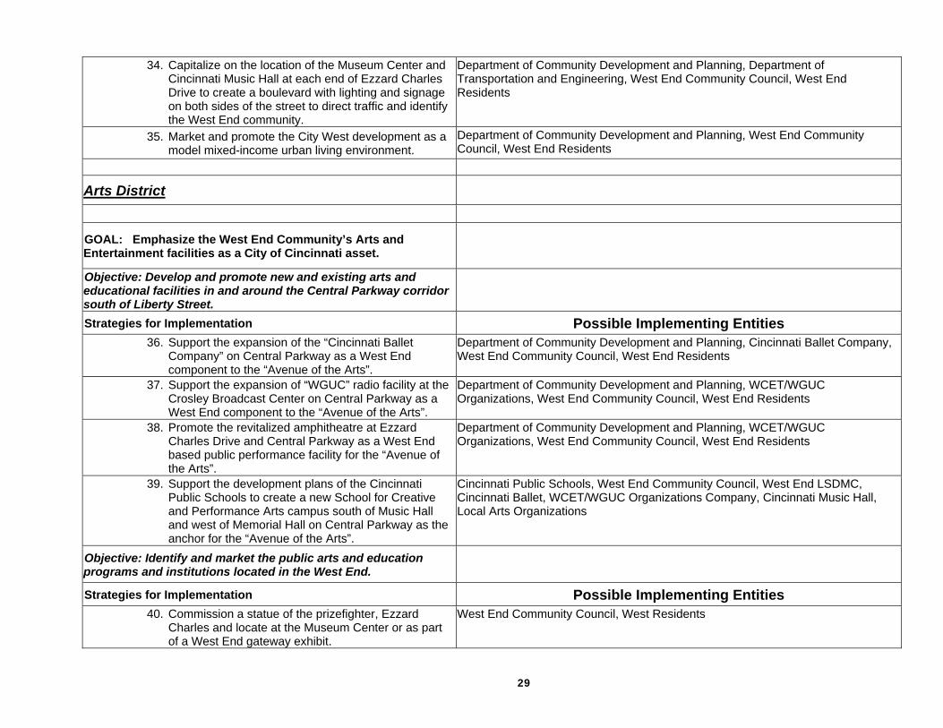
34. Capitalize on the location of the Museum Center and Cincinnati Music Hall at each end of Ezzard Charles Drive to create a boulevard with lighting and signage on both sides of the street to direct traffic and identify the West End community.
Department of Community Development and Planning, Department of Transportation and Engineering, West End Community Council, West End Residents
35. Market and promote the City West development as a model mixed-income urban living environment.
Department of Community Development and Planning, West End Community Council, West End Residents
Arts District
GOAL: Emphasize the West End Community’s Arts and Entertainment facilities as a City of Cincinnati asset.
Objective: Develop and promote new and existing arts and educational facilities in and around the Central Parkway corridor south of Liberty Street.
Strategies for Implementation Possible Implementing Entities 36. Support the expansion of the “Cincinnati Ballet
Company” on Central Parkway as a West End component to the “Avenue of the Arts”.
Department of Community Development and Planning, Cincinnati Ballet Company, West End Community Council, West End Residents
37. Support the expansion of “WGUC” radio facility at the Crosley Broadcast Center on Central Parkway as a West End component to the “Avenue of the Arts”.
Department of Community Development and Planning, WCET/WGUC Organizations, West End Community Council, West End Residents
38. Promote the revitalized amphitheatre at Ezzard Charles Drive and Central Parkway as a West End based public performance facility for the “Avenue of the Arts”.
Department of Community Development and Planning, WCET/WGUC Organizations, West End Community Council, West End Residents
39. Support the development plans of the Cincinnati Public Schools to create a new School for Creative and Performance Arts campus south of Music Hall and west of Memorial Hall on Central Parkway as the anchor for the “Avenue of the Arts”.
Cincinnati Public Schools, West End Community Council, West End LSDMC, Cincinnati Ballet, WCET/WGUC Organizations Company, Cincinnati Music Hall, Local Arts Organizations
Objective: Identify and market the public arts and education programs and institutions located in the West End.
Strategies for Implementation Possible Implementing Entities 40. Commission a statue of the prizefighter, Ezzard
Charles and locate at the Museum Center or as part of a West End gateway exhibit.
West End Community Council, West Residents
30
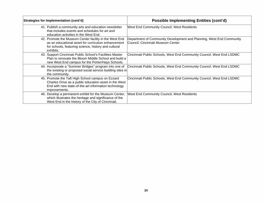
Strategies for Implementation (cont’d) Possible Implementing Entities (cont’d) 41. Publish a community arts and education newsletter
that includes events and schedules for art and education activities in the West End.
West End Community Council, West Residents
42. Promote the Museum Center facility in the West End as an educational asset for curriculum enhancement for schools, featuring science, history and cultural exhibits.
Department of Community Development and Planning, West End Community Council, Cincinnati Museum Center
43. Support Cincinnati Public School’s Facilities Master Plan to renovate the Bloom Middle School and build a new West End campus for the Porter/Hays Schools.
Cincinnati Public Schools, West End Community Council, West End LSDMC
44. Incorporate a "Summer Bridges" program into one of the existing or proposed social service building sites inthe community.
Cincinnati Public Schools, West End Community Council, West End LSDMC
45. Promote the Taft High School campus on Ezzard Charles Drive as a public education asset in the West End with new state-of-the-art information technology improvements.
Cincinnati Public Schools, West End Community Council, West End LSDMC
46. Develop a permanent exhibit for the Museum Center, which illustrates the heritage and significance of the West End in the history of the City of Cincinnati.
West End Community Council, West Residents

31
Credits
West End Community Council Dale B. Mallory, President Shirley Colbert, Vice-President Jackie Martin-Carr, Treasurer Len Garrett, NDC Director
West End Businesses and Churches
Amos Core Team Bright Star Baptist Bruening-Straley Ltd Certified Car Care Barbara Hammond, Ex. Director Cincinnati Fire Museum Dave Angner Central Fabricating Company John Breuner, Central Light Cincinnati Central Credit Union Dave Kaiser, Kaiser Foods Inc. Guava Hamilton County Library Hauck House Museum Stephen McCarthy, Holiday Inn Martin Luther King, Jr. Elementary Academy, Inc. Memorial Baptist Church Mt. Olive Baptist Church Revelation Baptist Church Samuel Adams Brewery Queensgate Glass Co. West End Comm. Church
West End Residents and Key
Stakeholders Bernice Appleton Ralph Appleton Augustus Armstrong Gerald J. Bates Steven Backs T. Baggett Simon Barret Catherine Barrett, State Representative Jerome Beckmeyer John Black Keith A. Blake Alberta Brown Arthra M. Brown Author Brown Ingrid Hicks-Brown Lisa Ann Bussey Earl Brown
V. Brown Laura H. Chapman Omar Childress Leona Coleman Leonard Coleman Wilma Collins Edward Cook Lee Crawford Jackie Davis, CMHA D. Dean Marilyn Eisbrounch Luetitia Floyd Annie Ford J. T. Gilchrist Eppie Gilliam Deborah Glenn Harold and Mikita Glenn, Jr. Monica Gloin Robert Hall, Jr. Sharon Hamilton Elizabeth Harris Mary Harvey Kathleen Hebbeler James Willard Head Bill Herring Kenneth Hillman Sandy Hitzler Michele Hobbs Cornell Hope Sadie M Houston Larry Huff Melvin Jackson Rosemary Jackson Natalie Jones Norman Kattelman Linda V. Knight Shawn L. Laws George Lee Wilma L. Lee Dorothy R. Lewis Henry Love Anthony Lowe Samuel Luel William L Mallory Jewel McClure Christopher H. McCarty Mary Lou Meacham Minnie Mitchem Tony Moore Ralph Moon Robert Murrell Jas Osborne S. Ortego Arma Penland D. Petersen
John W. Pickett, Jr. Wilbur Plear Dennis S. Rahe Loraine Ramey Angela Rankins Charles Rieger Joseph Scurry Ella Stewart Ossie Stewart Robert Smith Keith Taylor Thealonious Taylor Thelma Lee Thomas Danny Thomas Minelaos Triantafillou Rev. H.V. Turpin Jenny Wade Judy Walters William Walker Denise Warren Willie Watts Christine Weathers Ronald Willingham Barbara Wheeler Kathryn Wheeler John Whitling Maureen Wood, TCB Earl Wright Marion L. Young
City Project Team Larry Harris, Project Manager Rick Hardy Martha Kelly Jack Martin