200 saulteaux crescent winnipeg, mb r3j 3w3 mb ... · the potential ozone generation along the hvdc...
TRANSCRIPT
DATE: March 20, 2012
TO: Elise Dagdick
Land Use Approvals
MB Conservation & Water Stewardship
123 Main Street
Winnipeg, MB R3C 1A3
Forestry Branch Comments on Bipole III EIS
FROM: John Dojack
Forestry Branch
MB Conservation & Water Stewardship
200 Saulteaux Crescent
Winnipeg, MB R3J 3W3
PHONE: 1-204-945-3578
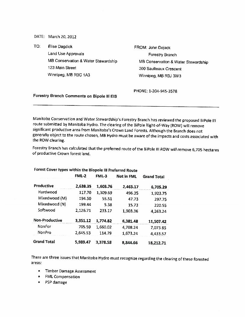
Manitoba Conservation and Water Stewardship’s Forestry Branch has reviewed the proposed BiPole IIIroute submitted by Manitoba Hydro. The clearing ofthe BiPole Right-of-Way (ROW) will removesignificant productive area from Manitoba’s Crown Land Forests. Although the Branch does notgenerally object to the route chosen, MB Hydro must be aware of the impacts and costs associated withthe ROW clearing.
Forestry Branch has calculated that the preferred route of the BiPole Ill ROW will remove 6,705 hectaresof productive Crown forest land.
Forest Covertypes within the Biopole Ill Preferred RouteFML-2 _ FML-3 Not in FML Grand Total
Softwood 2,126.71 233.17 1,903.36 4,263.24
Non-Productive 3,351.12 1,774.82 6,381.48 11,507.42NonFor 705.59 1,660.02 4,708.24 7,073.85
2,645.53 114.79 1,673.24 4,433.57
5,989.47 3,378.58
There are three issues that Manitoba Hydro must recognize regarding the clearing of these forestedareas:
. Timber Damage Assessment
. FML Compensation
Productive 2,638.35 1,603.76 2,463.17 6,705.29Hardwood 117.70 1,309.69 496.35 1,923.75Mixedwood (M) 194.50 55.51 47.73 297.75Mixedwood (N) 199.44 5.38 15.73 220.55
Non Pro
Grand Total 8,844.66 18,212.71
. PSP damage
Timber Damage AssessmentAs per Forestry Branch Policy Circular D-1 (Forest Damage Appraisal and Valuation) the Timber Dues,charges and other forest value costs must be paid to the Province of Manitoba for all Crown timberwhether it is harvested, removed, damaged or destroyed. Prior to the start of construction, ManitobaHydro must work closely with the Forestry Branch, local contractors and wood using facilities tomaximize the utilization of the timber removed from the BiPole ROW. However prior to receiving theManitoba Conservation permits required to harvest Crown timber, the Timber Damage Assessment costmust be paid to the Province of Manitoba. The charges will be calculated to ensure that the value of theTimber, investment costs and ecological value are recovered.
Forest Branch understands that Manitoba Hydro has completed a preliminary Timber DamageAssessment of the BiPole ROW clearing. In order to efficiently determine the Timber Damage Appraisalwe request that Hydro submit their assessment for review.
FML CompensationManitoba has entered into Forest Management Licence Agreements with Tolko Industries (FML# 2) andLP Canada (FML 1*3). Within these long-term area-based agreements are clauses that protect the forestmanagement companies from area “withdrawals” to their land base that affect the timber supply totheir mills. The BiPole III ROW clearing is considered a withdrawal from the FML areas.
If enough area is removed from either FML, a threshold trigger will be reached and Manitoba will berequired to provide compensation for the loss. Although our calculation shows that the BiPole Ill ROWon its own will not trigger this compensation clause, it may be triggered when combined with otherwithdrawals on the land base already or withdrawals in the future that fall within the agreed timeperiod (10 years). Manitoba Hydro must be aware that they may be responsible for a portion of FMLcompensation costs because of land removed by the BiPole Ill ROW.
Permanent Sample PlotsForestry Branch has identified seven Permanent Sample Plots (PSP) that may be impacted by the BiPoleIll development. These long-term research plots are critical to the Manitoba Conservation to monitortree and plant growth as well as ecosystem changes over time.
The cost to re-establish each of these plots is approximately $5,000 depending on access. However theBranch is most concerned with the incalculable cost from the loss of long term data and its link to all theplots previous measurements.
Some plots may be physically damaged from the clearing while the data from the other PSPs will beaffected because ofthe significant change to the forest cover.
The only option to mitigate the effects of the ROW on established PSPs is to ensure that it is locatedaway from the Forestry Branch’s PSPs by at least 200 metres. If this buffer cannot be achieved thenthe PSP must be re-established. Manitoba Hydro should re-establish two new PSPs for each PSPphysically damaged or damaged by the ROW being closer than 200 meters.
Road Development Plan
A Road Development Plan accompanying the Bipole Ill EIS would be a useful mechanism to answer manyquestions and assist Manitoba in permitting the project. In the Road Development Plan the location andtype of the roads (summer, winter, gravell) required for construction and maintenance would be shown
spatially. The water crossings along these roads would also be shown including the type of structure(bridge, culvert, frozen winter) and general installation practice.
Tending Plan
A tending plan accompanying the Bipole Ill EIS would be a useful mechanism to answer many questionsand assist Manitoba in permitting the project. A general discussion on the tending options, applicationmechanisms and selection criteria is required. Specific prescriptions are not required in the tendingplan. The chemical tending portion should include the chemical types, application mechanisms and theapplication rates. A separate discussion is required on the tending options and selection criteria forareas within sixty metres of water. Annual permits will be issued as per the tending plan and changesfrom the tending plan will require amendments to the Bipole Ill EIS. The annual tending plan that showsthe actual prescriptions should be developed prior to late December and shared with Manitoba so planscan be made to Consult on it this with 1st Nation communities prior to operations the following year(April to March).
Harvesting Trees Close to Water
In Manitoba the harvesting trees close to water is usually subject to the Forest Management Guidelinesfor Riparian Management Areas. I would encourage Manitoba Hydro to include a statement that theywill follow this guideline by vetting their operational harvest plans through the Integrated ResourceManagement Team in each of the Regions where their activities take them.

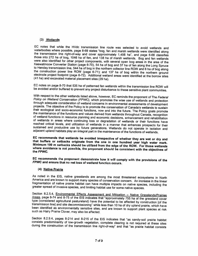
CHURCHILL RIVER
HIGHROCK PARK ZONE
WHITE ZONE
HAYES RIVER
.;
! •
Permanent Sample Plots1000 metres from Manitoba Hydro
Biople Ill preferred Route
INTERLAKE
ASPE N PARKLAND
PINELAND
. Permanent Sample Plots
— Biopole Ill Final Preferred Route (66 metre buffer)
L____i Forest Section
0 50 100 2OOKiometers
SCALE: 11,000,000
r;==— Honiloba
.. fj. z.t
1 •

Dagdick, Elise (CON)
From: Bezak, Dave (CON)Sent: March-09-1 2 1 1 :08 AMTo: Dagdick, Elise (CON)Cc: Molod, Rommel (CON)Subject: FW: Manitoba Hydro - Bipole III Transmission Project (5433.00)
Elise, air-qua’ity related comments from the Air Quality Section on the above development proposal are noted below.Thanks for the opportunity to review. DB.
From: Molod, Rommel (CON)Sent: March-09-12 9:00 AMTo: Bezak, Dave (CON)Subject: Manitoba Hydro - Bipole III Transmission Project (5433.00)
Hi Dave. These are my comments on the proposal:
. Potential air quality concerns that may be associated with the project such as dust, noise and air emissions (ex.vehicle, power generators, etc.) are adequately addressed in the submission specifically in the submittedEnvironmental Protection Plan.
. The potential ozone generation along the HVDC transmission line (corona effects on the surface of the high voltagetransmission line) is very low when compared with the typical ambient concentration.
Rommel
Rommel MolodAir Quality SpecialistClimate Change and Environmental Protection DivisionManitoba Conservation and Water StewardshipSuite 160 123 Main StreetWinnipeg MB R3CIA5T (204) 945-7047F (204)945-1211
1
d ii‘i/i),1 jt :4arI?(tlJ’, J
Infrastructure and TransportationHighway Planning and Design BranchEnvironment Section14th Floor— 215 Garry St., Winnipeg, Manitoba R3C 3P3T (204) 945-5225 F (204) 945-0593
March 16, 2012
Tracey Braun, M. Sc.Director, Environmental Assessment & Licensing BranchManitoba Conservation123 Main St., Suite 160,Winnipeg, MB R3C 1A5
RE: Manitoba Hydro Bipole III Transmission Project: A Major Reliability InitiativeClient File No 5433.00
Dear Director Braun:
MIT has reviewed The Environment Act Proposal noted above and would like to raise thefollowing concerns:
. Any new, modified or relocated access, including change in use of access, to aProvincial Trunk Highway (PTH) or Provincial Road (PR) will require a permit from theHighway Traffic Board (for PTHs) or MIT Access Management Section (for PRs).Contact for Access Management is:
0 Kevin NimchukSenior Access Management AnalystAccess Management SectionMIT Highway Planning and Design Branch(204) 945-5658
. Any change in use of the land or the buildings, or to place, construct or alter anystructures, above or below ground, including signs, within 125 ft (for PTHs and PRs) or250 ft (for Limited Access Highways) from the edge ofthe right of way of anydepartmental road, also will also require permit from MIT (for PRs) or Highway TrafficBoard (for PTHs).
. A permit will be required from MIT for any planting placed within 50 ft from the edge ofthe right of way of any PTH or PR.
. Any changes into drainage patterns and/or discharging into a departmental road’s ditchwill require a permit from MIT and/or a Provincial Drainage License from ManitobaConservation.
Mnllobaspi{i4cd cncrq
Any temporary construction access will be removed once the project is completed.Rehabilitation of all disturbed areas within the MIT’s right-of-way and controlled area isrequired after the project completion.
The proposed transmission route crosses and parallels several PRs and PTHs allthroughout the Province. Agreements with MIT must be obtained prior to any tenderingof lines within the PR’s and PTH’s right-of-way. The following are the contactinformation for MIT Regional Offices:
0 Region 1 — Eastern Region31 6-323 Main StreetSteinbach, MB R5G 1Z2(204) 346-6266
0 Region 2 — South Central Region25 Tupper Street NPortage Ia Prairie, MB R1N 3K1(204) 239-3292
0 Region 4 — West Central Region257 Industrial RoadDauphin, MB R7N 3B3(204) 622-2061
0 Region 5 — Northern Region11 Nelson RoadThompson, MB R8N 0B3(204) 677-6540
Also, please coordinate with the MIT Regional Offices (for PRs and PTHs), RuralMunicipalities (for Municipal and Main Market Roads) and MIT Water Control andStructure Branch (for bridges) regarding weight loads during construction.
MIT Region 1 — Eastern Region raised the following specific concerns:
0 What is the impact to the other utilities at highway crossings?0 PTH 59 will be upgraded to a 4-lane at some point. The towers/structures may
be affected and may need relocating. This would be in the vicinity north ofTourond.
0 ls there room to span PTH 75 at the Red River? The river is very close to PTH75 and the river bank is unstable.
0 For these particular concerns, please contact Murray Chornoboy, RegionalPlanning Technologist, at (204) 346-6287.
MIT Region 4 — West Central Region raised the following specific concern:
0 The aerial photo shows a portion of PTH 1 0 close to the eroded banks of the RedDeer River, just south of the Red Deer River Provincial Park (see Attachment A).This portion of PTH 10 may have to be relocated in the future due to further river
bank erosions. The location of the tower structure near this area may need to beset back to accommodate future highway right-ofway relocation to the west0 For this particular concern, please contact Forouzandeh Kasral, RegionalPlanning Technologist, at (204) 622-2307.
I As identified by MIT Materials Engineering Branch, quarry mineral withdrawal in thefollowing areas will be affected by the project (see Attachment B). The resources inthese townships are required for future construction and maintenance projects in Region4 and will be sterilized by the proposed Hydro lines, as mining is not permitted under thelines. Backhoe surveys will be performed on these resources this summer.
0 Twp22-IIW 0 Twp3O-17W0 Twp 22-12W o Twp 30-18W0 Twp23-12W o Twp3l-19W0 Twp 25-13W o Twp 32-20W0 Twp26-13W o Twp33-21W0 Twp 30-18W o Twp 33-25W0 Twp 32-20W o Twp 44-25W0 Twp 49-25W o Twp 45-25W
Contact person at the MIT Material Engineering Branch is:
0 Craig DrimesManager of Aggregate ResourcesMIT Matetials Engineering Branch(204) 945-1933
Thank you very much for providing us the opportunity to review the proposal.
Sincerely,
Christopher Cry-Lemon, P.iEg., P. E.AlManager of Environmental services
CC: Murray Chomoboy, MiT Region IWes Turk, MiT Region 2Forouzandeh Kasrai, MIT Region 4Variessa Nedd, MIT Region 5Kevin Nimchuk, Access Management SectionCraig Drimes, Materials Engineering Branch

Attachment B
Quarry Withdrawal Areas in Region 4
R.2V R,2WM 27W Pl 2W ft.2V R*,2Th *21W R. IQW R 1VW R11W W , EW
KGnftoba
Infrastructure and Transportation
West Central Region
LEGEN)
POVlNCIA. TNJK IHWAvSROVINCIA ROADS
_____________
MlN MNNKL HCAL2&______________IILi1lNUE NL!ftAFEA, , SLIN AC)At) MIX
_____________________________—
GLEV SUE .‘C! S
OLR F”
PROVINCIAL & EjEA PARKS
___________________
ROVINLIAL FDREST_______________ =NYPO_E III A1GNMENT
________________
QARRY 5’5
GLARN LLAS _
R...’4 .12W R.1W Ra.N .7W RW H.Wi
: ;
(r” -“•-•
‘‘/
;--- .- .-
.. ‘r0 ‘
‘.
‘:
.‘.,..
--4
.\• H-’%D • E\.— L
Oagdick, Elise (CON)
From: Schindler, Dennis (MAFRI)Sent: March-26-1 2 1 1 :08 AMTo: Dagdick, Elise (CON)Subject: RE: Bipole Ill TAC Review
MAFRI has reviewed the EIS as well as the attached relevant Technical Reports and has no concerns.
Dennis T. Schindler, P. Ag.Land Use SpecialistLand Use Planning Knowledge CentreManitoba Agriculture Food and Rural InitiativesAddress: 712 Dugald Rd. Box 160 Dugald, MB ROE OKOElectronic Mail: [email protected]: 204.3913079Fax: 204.853.5177
From: Dagdick, Elise (CON)Sent: March-20-12 1:07 PMTo: Schindler, Dennis (MAFRI)Subject: RE: Bipole III TAC Review
Hi Dennis,
An extension till the end of the week is not a problem.
Elise DagdickEnvironmental Assessment and Licensing BranchManitoba Conservation and Water StewardshipSuite 160, 123 Main St., Winnipeg, MBR3C 1A5Ph: 204-945-8173Fax: 204-945-5229
From: Schindler, Dennis (MAFRI)Sent: March-20-12 10:14 AMTo: Dagdick, Elise (CON)Subject: FW: Bipole III TAC Review
Sent this to Tracey in error. Please advise if extension is possible. I have just returned from holidays.
,T4L-Dennis T. Schindler, P. Ag.Land Use SpecialistLand Use Planning Knowledge CentreManitoba Agriculture Food and Rural InitiativesAddress: 712 Dugald Rd. Box 160 Dugald, MB ROE OKOElectronic Mail: [email protected]: 204.391.3079Fax: 204.853.5177
1
I.
Canadian Environmentd Aence ccriadenne. ; As’nentAgency devducion environnemenaIe
101 — 167 Lombard Avenue 167, avenue Lombard, bureau 101Winnipeg, Manftoba R3B 0T6 Winnipeg (Manitoba) R3B 0T6
March 16, 2012 CEAA File No.: MP2008-021MCFIIeNo.: 5433.00
Ms. Elise DagdickManitoba ConservationEnvironmental Stewardship Division123 Main Street, Suite 160Winnipeg, MB R3C 1A5
Dear Ms. Dagdick:
Subject: Bipole Ill Transmission Project
I have completed a survey of federal departments with respect to determining interest in theproject noted above. I can confirm that the project information that was provided has beenreviewed by all federal departments with a potential interest. I am enclosing copies of therelevant responses for your file. Based on the responses to the survey the application ofthe Canadian Environmental Assessment Act(the Act) by a federal authority will iQI berequired for this project.
Environment Canada provided a letter, dated March 1 4, 2012, containing advice regardingmigratory birds, species at risk, wetlands, native prairie, reclamation and invasive species(see copy attached). They also provided electronic copies of several useful documents (seeattached).
Transport Canada determined that the transmission line component of the project is unlikelyto require approvals under subsection 5(2) of the Navigable Waters Protection Act.Providing that any crossings associated with access routing meet the Minor Works andWaters (NWPA) Order, or follow the parameters of section 50 of the Exclusions ListRegulations under the Act, access routing will not trigger the Act.
A list of the appropriate federal contacts is attached. Please note that the projectinformation was also reviewed by Fisheries and Oceans Canada, Aboriginal Affairs andNorthern Development Canada, Agriculture and Agri.Food Canada, Natural ResourcesCanada and Health Canada as part of the federal coordination process.
Thank you for your effort to ensure coordination and close communication betweenprovincial and federal levels of government. If 1 can be of further assistance, please feel freeto contact me at (204) 984-3233 or by e-mail at: [email protected].
Sincerely,
Peter BoothroydProject Manager
End.
cc.: Mr. Pat McGarry — Manitoba Hydro Mr. Jeff Moyer — DFOMs. Krista Flood EC Mr. Dan Senoit — AANDCMr. Rick Grabowecky — HC Ms. Crystal Dyson — AAFCMr. Regent Dickey — MPMO

ederaI Contacts Lisj
Project: Bipole III Transmission ProjectProponent: Manitoba HydroCEAA File No: MP2008—021MC File No.: 5433.00
Transport CanadaHolly Poklitar3rd Floor, 344 Edmonton StreetWinnipeg, Manitoba R3C 0P6Telephone: 204-98388O7Fax: 204983-5048EmaiI: [email protected]
Environment CanadaKrista Flood200-4999 98th Avenue NWEdmonton, AB T6B 2X3Telephone: 204-984831 8Fax: 204-983-5692E-mail: [email protected]
Canadian Environmental Assessment AgencyPeter Boothroyd1 01 -1 67 Lombard AvenueWinnipeg, Manitoba R3B 0T6Telephone: 204-984-8020Fax: 204-983-7174Email: peter.boothroyd @ceaa-acee.gc.ca
Proposal also reviewed by:Fisheries and Oceans Canada, Aboriginal Affairs and Northern Development Canada, HealthCanada, Agriculture and Agri-Food Canada and Natural Resources Canada.

J -:1 Environment Environnement: Canada Canada
ENVIRONMENTAL PROTECTIONPRAIRIE & NORTHERN REGIONRoom 200, 4999-98 Ave. NWEdmonton, Alberta Our File No.: 4194-10-5/3081T6B 2X3 Your File No.: MP2008-021
March 14, 2012
Peter BoothroydProject ManagerPrairie RegionCanadian Environmental Assessment AgencySuite 101, 167 Lombard AveWinnipeg, MB R3B 0T6
Dear Mr. Boothroyd:
RE: BIPOLE III TRANSMISSION PROJECT - MANITOBA HYDRO
Environment Canada (EC) has reviewed the Bipole III Transmission Project Environmental ImpactStatement (EIS) prepared by Manitoba Hydro (December 2011). EC would like to take thisopportunity to provide specialist advice and/or expert information or knowledge on the proposal,with a focus on federal statutes, regulations, policy and associated program concerns as defined byEC’s mandate.
EC appreciates the opportunity to provide feedback on this matter. In general, 6 areas ofconcern/comment were identified:
(1) Migratory Birds(2) Species at Risk(3) Wetlands(4) Native Prairie(5) Reclamation(6) Invasive Species
(1) Migratory Birds
EC’s mandate includes the protection of migratory birds and their habitat.
Appendix IA, Applicable Legislation, page lA-i, EC notes that the proponent is aware of theMigratory Birds Convention Act (MBCA) and has included a summary of Section 5(a) and Section5.1 : “Except as authorized by Regulation, no person shall without lawful excuse be in possession ofa migratory bird or nest. No person shall deposit a substance or permit a substance to bedeposited in any place frequented by migratory birds if the substance is harmful to migratory birds.’
EC reminds the proponent of the Regulations pursuant to the MBCA, which provide for theconservation of migratory birds and the protection of their nests and eggs. Section 5 of theregulations prohibits the hunting of a migratory bird except under adthority of a permit, where ‘hunt’means chase, pursue, worry, follow after or on the trail of, lie in wait for, or attempt in any manner tocapture, kill, injure or harass a migratory bird, whether or not the migratory bird is captured, killed orinjured. Section 6 of the Regulations prohibits the disturbance, destruction, or taking of a nest, eggor nest shelter of a migratory bird.
I_”
Lafl1i1a

EC notes in section 8.2.7.2, Habitat Alternation, page 8-136, that the proponent plans to restrictnorthern clearing and construction activities to the winter months (with the exception of year-roundconstruction disturbances at the converter station, borrow areas, and excavated material disposalareas) and that clearing will be limited to the winter months on the southern portion of the route(page 8-1 65). The EIS indicates throughout section 8.2.7.4, Environmental Effects Assessment andMitigation that project activities and vegetation management will be restricted (but not avoided) fromApril 1 to July 31 , but also that construction and vegetation management on the southern portion ofthe route may occur year-round, including during the spring and summer nesting season. Further tothis, EC notes on page 8-133 that the EIS lists “mortality or nest loss due to construction ormaintenance during the spring nesting season” as a project related effect on migratory birds. Thisinadvertent, though reasonably predictable, disturbance or destruction of migratory bird nests andeggs is known as incidental take and is illegal.
EC provides the following recommendations as general guidelines for industry to protect the greatmajority of migratory birds while realizing the practicalities of development activities on thelandscape. However the onus remains with the proponent to comply with the legislation.
1. To minimize disturbance to breeding migratory birds in the northern Parkiand and Borealecozones of Manitoba, in areas where migratory birds may be nesting, EC recommends thathabitat destruction activities (e.g. vegetation clearing and management, construction,reclamation, etc.) for areas greater than 50 hectares (such as this project) should avoid atminimum the period between April 1 and August 31, to minimize population level effects tobreeding birds.
2. To minimize disturbance to breeding migratory birds in the Prairie and southern Parkiandecozones of Manitoba, in areas where migratory birds may be nesting, EC recommends thathabitat destruction activities (e.g. vegetation clearing and management, construction,reclamation, etc.) avoid at minimum the period between April 15 and July 31.
3. If an individual has a priori knowledge of an active nest, at any time during the year, itmust be protected with a suitable species-appropriate buffer until the young have fledged.
4. Where a migratory bird shows site fidelity and returns to the same nest in subsequentyears, the nest is considered active, and should be protected, throughout the year.
5. Wetlands attractive to breeding migratory birds (e.g. those containing water) should notbe cleared/destroyed at minimum between April 1 and August 31. Canada geese andMallards may nest early and broods of waterfowl and waterbird species are dependent uponwetlands throughout August and beyond.
(2) Species at Risk
The federal Species at Risk Act (SARA) is directed towards preventing wildlife species frombecoming extinct or lost from the wild, helping in the recovery of species that are at risk as a resultof human activities, and promoting stewardship. The Act prohibits the killing, harming or harassingof listed species; the damage and destruction of their residences; and the destruction of criticalhabitat.
EC reminds the responsible authority of their cb!igations under section 79(1) and 79(2) of theSARA.
“Every person who is required by or under an Act of Parliament to ensure that anassessment of the environmental effects of a project is conducted must, without delay,
2 of 9
notify the competent minister or ministers in writing of the project if it is likely to affect alisted wildlife species or its critical habitat.’
‘The person must identify the adverse effects of the project on the listed wildlife species andits critical habitat and, if the project is carried out, must ensure that measures are taken toavoid or lessen those effects and to monitor them. The measures must be taken in a waythat is consistent with any applicable recovery strategy and actions plans.”
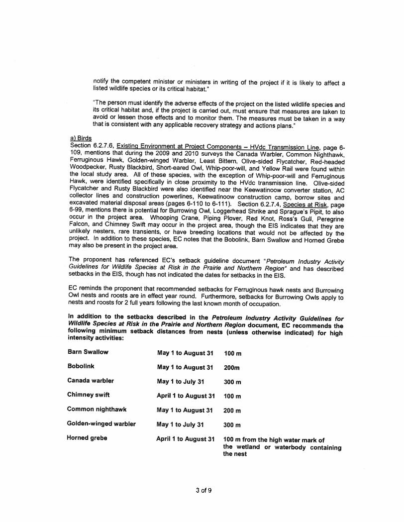
a) BirdsSection 6.2.7.6, Existing Environment at Proiect Components — HVdc Transmission Line, page 6-109, mentions that during the 2009 and 2010 surveys the Canada Warbler, Common Nighthawk,Ferruginous Hawk, Golden-winged Warbler, Least Bittern, Olive-sided Flycatcher, Red-headedWoodpecker, Rusty Blackbird, Short-eared Owl, Whip-poor-will, and Yellow Rail were found withinthe local study area. All of these species, with the exception of Whip-poor-will and FerruginousHawk, were identified specifically in close proximity to the HVdc transmission line. Olive-sidedFlycatcher and Rusty Blackbird were also identified near the Keewatinoow converter station, ACcollector lines and construction powerlines, Keewatinoow construction camp, borrow sites andexcavated material disposal areas (pages 6-1 1 0 to 6-1 1 1). Section 6.2.7.4, Species at Risk, page6-99, mentions there is potential for Burrowing Owl, Loggerhead Shrike and Sprague’s Pipit, to alsooccur in the project area. Whooping Crane, Piping Plover, Red Knot, Ross’s Gull, PeregrineFalcon, and Chimney Swift may occur in the project area, though the EIS indicates that they areunlikely nesters, rare transients, or have breeding locations that would not be affected by theproject. In addition to these species, EC notes that the Bobolink, Barn Swallow and Horned Grebemay also be present in the project area.
The proponent has referenced EC’s setback guideline document “Petroleum Industiy ActivityGuidelines for Wildlife Species at Risk in the Prairie and Northern Region” and has describedsetbacks in the EIS, though has not indicated the dates for setbacks in the EIS.
EC reminds the proponent that recommended setbacks for Ferruginous hawk nests and BurrowingOwl nests and roosts are in effect year round. Furthermore, setbacks for Burrowing Owls apply tonests and roosts for 2 full years following the last known month of occupation.
In addition to the setbacks described in the Petroleum lndustrj Activity Guidelines forWildlife Species at Risk in the Prairie and Northern Region document, EC recommends thefollowing minimum setback distances from nests (unless otherwise indicated) for highintensity activities:
Barn Swallow May I to August 31 100 m
Bobolink May I to August 31 200m
Canada warbler May I to July 31 300 m
Chimney swift April 1 to August 31 100 m
Common nighthawk May I to August 31 200 m
Golden-winged warbler May ‘1 to July 31 300 m
Horned grebe April 1 to August 31 100 m from the high water mark ofthe wetland or waterbody containingthe nest
3 of 9
Olive-sided flycatcher May I to August 31 300 m
Whip-poor-will May I to August 31 100 m
In addition, EC’s recommended setback for the Rusty Blackbird has been updated. ECcurrently recommends a minimum 300m setback from active nests from May I to July 31.
As several species at risk in the project area have sensitive periods that extend beyond July31st, EC recommends that habitat destruction activities, (including, any vegetation clearingor maintenance, construction, etc.) avoid the period from April 1 - August 31, to reduce theimpacts on both species at risk and migratory birds.
b) Amphibians and ReptilesSection 6.2.8.6, Existing Environment at Project Components, page 6-122, notes that NorthernLeopard Frogs were observed along the transmission line route and suitable breeding habitat isfound throughout the project study area (page 6-123). Section 8.2.8.4, Environmental EffectsAssessment and Mitigation, page 8-200, notes that Northern Prairie Skink were not observed, butpotential tracks were observed both within the ROW and near the ROW and on page 6-122 itmentions suitable habitat exists within the St.Claude/Assiniboine River area. Appendix 6A, TableA:Z page 6A-81 , also notes that Snapping Turtle also has the potential to occur in the projectarea.
EC notes that the construction and ROW maintenance at wetland habitats are planned to occur infall or winter, outside of peak breeding periods for Northern Leopard Frog, and that where possible,a vegetation buffer of 30 m will be retained around any identified breeding/wetland areas that occuralong the Project right-of-way (p. 8-203). For Northern Leopard Frog, EC recommends a year-round 400 m setback from both breeding ponds and wintering sites.
EC notes on page 8-201, that a 100 m buffer will be maintained around sandy-soil habitat polygons(suitable habitat for Northern Prairie Skink) where intercepted by the Project right-of-way, and thattowers will be located 200 m from any observed or located skink nests. This follows ourrecommended setback of 200 m from burrows year-round.
No setbacks were described for Snapping Turtle in the EIS. EC recommends a year-round 400 msetback from potential nesting and wintering sites.
c)jnvertebratesSection 6.2.9.4, Species at Risk — Table 6.2-15, page 6-128, lists the Pale Yellow Dune Moth,Dusky Dune Moth, Monarch, Dakota Skipper, Ottoe Skipper, Gold-edged Gem, White Flower Mothand Vernas Flower Moth as having distribution ranges in close proximity but not within the ProjectStudy Area. Although known populations do not overlap the local study area, and none wereobserved during project surveys, suitable habitat exists in the project area.
Page 8-215 of the EIS indicates that “as sandy-soil prairie habitat consists predominantly of low-growth vegetation, complete clearing is not required at these sites during the construction of thetransmission line right-of-way”, and on page 8-214 that “as prairie habitat consists predominantly oflow-growth vegetation, maintenance of overhead vegetation during the operations phase is notextensively required at such areas”. To this effect, this section of the EIS also indicates that sandy-soil prairies (that support many of the above listed invertebrates), and any native prairie remnantswithin known Dakota Skipper modeled habitat, will likely remain relatively unaffected along thetransmission line right-of-way during the construction or operation phase of the Project, respectfully.The proponent also plans to avoid suitable habitat patches, where feasible, and to maintain a 30 mvegetation buffer around sandy-soil prairie habitat where intercepted by the Project right-of-way(pages 8-215 and 8-216).
4 of 9
For the above listed invertebrate Species at Risk, with the exception of Monarch, ECrecommends a yearround 100 m setback from suitable habitat and occupied host plants.For Monarch, EC recommends a 30 m setback from occupied host plants from June 1 toSept 30.
d) Plants and LichenSection 6.2.5.4, Species on Conservation Concern, pages 6-59 to 6-62, lists the Rough PurpleFalse-foxglove, Small White Lady’s slipper, Smooth goosefoot, Hairy Prairie Clover, Riddell’sGoldenrod and Flooded Jellyskin (a lichen) as species known to occur within the Project StudyArea, although none of these species were found along the transmission line route mentioned onpage 6-68. This page of the EIS also indicates that Hairy Prairie-Clover was however, observed atone location in the Local Study Area of the transmission line route, where 12 individuals werecounted in a prairie habitat, but does not indicate the distance of these individuals from the right ofway.
For the construction of transmission lines or communication towers requiring soildisturbance, vehicle traffic andlor reclamation, EC recommends a 300 m buffer from alldetectable individuals of SARA and COSEWIC — listed plant species. For above groundtransmission lines, EC recommends a 30 m buffer (see EC’s Activity Setback DistanceGuidelines for Prairie Plant Species at Risk).
e) Mammalsi. Wolverine and Grey FoxA wolverine was observed and wolverine tracks were observed in a number of locations in theproject area. Section 6.2.6.6, Existing Environment at Project Components, pages 6-89 and 6-90,states it is anticipated that the HVdc transmission line, AC collector lines and construction powerline components, converter station, construction camp and borrow sites may overlap with wolverinehome ranges. Table 6A-4, page 6A-42, also lists the Grey Fox as having the potential to be presentin the project area.
EC recommends a year-round 500 m setback from Wolverine dens, and a 200 m setbackfrom Grey Fox dens.
ii. Boreal Woodland CaribouEC recently released a draft Recovery Strategy for the Woodland Caribou Boreal Population inCanada. The Bipole Ill HVdc transmission line final preferred route overlaps with three herdsidentified as a “Self-Sustaining Local Populations” in this recovery strategy (Reed, Wabowden andWapisu herds) and one herd identified as, “As likely as not Self-Sustaining” and “Remaining LocalPopulations” (The Bog herd). Respectively, these herds have 74%, 72%, 76% and 84% of theirrange remaining as undisturbed habitat (Appendix F-i and Appendix F-3b Draft Recovery Strategy)
The draft recovery strategy indicates that jurisdictions will need to show how, over time, they willmanage the land to ensure that caribou range is not disturbed beyond a level that jeopardizes therecovery of boreal caribou. The draft strategy states that for Self-Sustaining Local Populationherds, critical habitat is identified as 65% undisturbed habitat within the range of the localpopulation. The draft strategy also states that for Remaining Local Populations where the amount ofundisturbed habitat is 65% or more, the amount of critical habitat is 65% undisturbed habitat withinthe range of the Boreal population.
Section 8.2.6.3, Valued Environmental Components - Caribou, pages 8-87 to 8-89, mentions thatManitoba Hydro has collaborated with Manitoba Conservation on a number of strategic monitoringand research initiatives to acquire current Boreal Woodland Caribou data and as a result of thismonitoring “significant new information allowing for a more accurate characterization of local
5 of 9
populations in the Project Study Area” is available. The proponent has characterized BorealWoodland Caribou use of the project area by three herds (Reed, Wabowden and the Bog), and hasidentified core winter use and known and potential calving areas for each.
EC acknowledges on page 8-90 that the “Preliminary Preferred Route selection was considered tobe the optimal route from a caribou perspective”, and on page 8-89 that the transmission line routewas selected to minimize intersection with local populations, their calving and calf-rearing areas,core winter use areas, and/or other potential critical habitat,” and to follow, “where possible, theexisting linear development and disturbed areas” (page 8-90).
EC also notes however, that in the Wabowden range area, in order to “accommodate competingresource interests” the Final Preferred Route is “not a preferred alternative from the caribou SSEA[Site Selection Environmental Assessment] perspective” (page 8-90). In this area, the FinalPreferred Route bisects a presently unfragmented core winter use area and known calving areas inan otherwise highly fragmented region (page 8-97). The EIS indicates that “caribou in the ProjectStudy Area show considerable fidelity to previously used calving areas in this area (Bipole IllCaribou Technical Report)” (page 8-83) and that “the expected residual effects [of the project onBoreal Woodland Caribou] relate primarily to potential increase in predation rates, especially inareas where the HVdc line bisects or intersects known core winter use areas and known calvingareas” (page 8-129).
EC concurs with the concerns noted by the proponent with respect to bisecting orintersecting known core winter use areas and known calving areas. EC encourages theproponent to consult with Manitoba Conservation in order to investigate other options thatwould avoid bisecting these key caribou areas.
EC notes on pages 8-99 and 8-100 that the proponent plans to implement mitigation measuresincluding: winter construction; maintenance of natural low tree cover and development of naturalvegetation corridors in core winter use areas and known and potential calving areas in Wabowdenand The Bog ranges; access control where the transmission line bisects core use areas in theWabowden range; limited development of snowpack trails in core winter areas; limiting recreationaluse and travel along the right-of-way in the core winter use areas and known and potential calvingareas; rehabilitation of project staging areas; and long term monitoring of boreal caribou populationsand wolves, with adaptive management plans.
In addition to these measures, EC recommends reduction of sight lines along the ROW,avoidance of late winter construction in core winter use and calving areas, and restorationof cleared areas (with natural low tree cover) along the ROW throughout caribou ranges.EC also recommends that, in addition to managing access within caribou habitats, thataccess management measures be applied within the Project area wherever possible in orderto minimize access (and thus opportunities for movement of predators) into caribou habitat.
MonitorinQ of Species at RiskEC notes that the proponent plans to also monitor threatened and endangered bird speciesoccurrences at locations where species at risk were observed, or where they may be found duringconstruction. Section 82.7.6, Follow-up, page 8-184, mentions the proponents monitoring planswhich include assessments of the effectiveness of setback distances, and the occurrences of bird-wire collisions, vehicle collisions and bird electrocutions. Adaptive management is also planned.EC recommends that monitoring and adaptive management plans include all species at riskobserved or found during construction (not just birds and boreal woodland caribou). EC isinterested in receiving any reports that are produced from these monitoring programs.
6 of 9
(3) Wetlands
EC notes that while the HVdc transmission line route was selected to avoid wetlands andwaterbodies where possible, page 8-69 states “bog, fen and marsh wetlands were identified alongthe transmission line right-of-way and cover approximately 1 456 ha”, and page 6-66 classifiesthose into 272 ha of bog, 1046 ha of fen, and 138 ha of marsh wetlands. Bog and fen wetlandswere also identified for other project components, with several open bog areas in the area of theKeewatinoow Converter Station (page 6-70), 54 ha of bog and 37 ha of fen along the Long Spruceto Henday transmission line, 544 ha of bog in the northern collector line ROW and 6 ha of bog alongthe construction power line ROW (page 6-71); and 137 ha of bog within the northern groundelectrode project footprint (page 6-72). Additional wetland areas were identified at the borrow sites(41 ha) and excavated material placement sites (29 ha).
EC notes on page 8-70 that 535 ha of patterned fen wetlands within the transmission line ROW willbe avoided and/or buffered to prevent any project disturbance to these sensitive plant communities.
With respect to the other wetlands listed above, however, EC reminds the proponent of The FederalPolicy on Wetland Conservation (FPWC), which promotes the wise use of wetlands and protectionthrough adequate consideration of wetland concerns in environmental assessments of developmentprojects. The objective of the Policy is to promote the conservation of Canada’s wetlands to sustaintheir ecological and socio-economic functions, now and into the future. The Policy goals promotethe maintenance of the functions and values derived from wetlands throughout Canada, recognitionof wetland functions in resource planning and economic decisions, enhancement and rehabilitationof wetlands in areas where continuing loss or degradation of wetlands or their functions havereached critical levels, and utilization of wetlands in a manner that enhances prospects for theirsustained and productive use by future generations. Wetlands do not operate in isolation andadjacent upland habitats play an integral part in the maintenance of the functions of wetlands.
EC recommends that wetlands be avoided irrespective of whether they are wet or dry andthat buffers or setbacks originate from the one in one hundred year high water mark.Minimum 100 m setbacks should be utilized from the edge of the ROW. For those wetlandswhere avoidance is not possible, the proponent should be consistent with the objectives ofthe FPWC.
EC recommends the proponent demonstrate how it will comply with the provisions of theFPWC and ensure that no net loss of wetland function occurs.
(4) Native Prairie
As noted in the EIS, native grasslands are among the most threatened ecosystems in NorthAmerica and are known to support many species of conservation concern. An increase in the linearfragmentation of native prairie habitat can have multiple impacts on native species, including thegreater spread of invasive species, and limiting habitat use for some native species.
Section 8.2.5.4, Environmental Effects Assessment and Mitigation — Native Grasslands/PrairiesAreas, page 8-74 and 8-75 of the EIS indicates that “approximately 755 ha of the grassland covertype (considered agricultural pastureland) have the potential to be affected by construction [of thetransmission line] and site decommissioning” while less than 10 ha of dry upland prairie, which havebeen identified as environmentally sensitive sites, and are known to support plant species at risksuch as Hairy Prairie Clover, may also be affected.
Section 8.2.9.4, pages 8-214 and 8-215 of the EIS indicates that “as sandy-soil prairie habitatconsists predominantly of low-growth vegetation, complete clearing is not required at these sitesduring the construction of the transmission line right-of-way” and that “as prairie habitat consists
7 of 9
predominantly of ow-growth vegetation, maintenance of overhead vegetation during the operationsphase is not extensively require at such areas”. It also states that ‘native prairie remnants withinknown Dakota Skipper modeled habitat will likely remain relatively unaffected along thetransmission line right-of-way during the operation phase of the Project”.
EC requests clarification: As all native grassland/prairie habitat consists predominantly oflow-growth vegetation, with the exception of tower locations and trees within the prairie, isvegetation clearing planned prior to or during project construction? With the exception oftall shrubs or trees within the prairie habitat, is vegetation maintenance/managementplanned during the operations phase of the project?
EC acknowledges the mitigation measures mentioned on page 8-75 that the proponent plans to useexisting access roads and trails to the extent possible, and that where disturbance has occurred inareas prone to increased erosion, vegetation will be re-established using native species appropriatefor the site. The EIS also indicates on page 8-80 that revegetation is planned in areas wherevegetation has been completely removed.
EC recommends that the proponent limit disturbance to native prairie areas to the greatestextent possible, and restore all disturbed areas.
Finally, EC notes that while Native Grassland and Prairie Areas were identified as VECs in the EIS,the effects of the project on agriculture were minimized by routing the transmission line throughpastures (grasslands) and less productive land (page iv of Executive Summary). EC reminds theproponent that grasslands are valuable habitat for many species at risk, and recommends that inthe future native grasslands be avoided wherever possible.
(5) Reclamation
EC acknowledges in section 8.2.5.2, Potential Effects and Key Topics — Vegetation Diversity, page8-66, the proponents plans to use native plant species for revegetation of disturbed areas withincreased erosion potential or in areas where vegetation has been completely removed, and thatrevegetation will focus on the development of stable plant communities rather than theestablishment of a few species.
EC recommends that all disturbed areas are reclaimed, and that reclamation seed mixes andmaterials mimic the dominant native vegetation in the surrounding area, be of localprovenance, and be certified and inspected to be free of invasive and noxious weedmaterials.
(6) Invasive Species
Invasive species spread readily along disturbance corridors and once established are virtuallyimpossible to eradicate. During the field assessments in 2010, 27 non-native species wereobserved throughout the Project Study Area; five of which were invasive plants (page 8-66). Giventhe proposed development of new disturbance corridors, and the potential future intrusion of severalinvasive species into sensitive areas, including native prairie and wetland areas or alongwatercourses, aggressive weed and invasive species management is required from cradle to grave.
EC acknowledges the proponent’s commitment on page 8-66 to 1 ) wash and inspect all equipmentprior to working in new sites; 2) take construction materials (i.e. , gravel) from clean sources; 3)ensure ground cover materials are weed free prior to use; 4) carry out construction, maintenanceand decommissioning activities during the winter months; and 5) develop an access managementplan which considers means to limit the introduction of non-native plants during clearing andconstruction of the proposed transmission lines.
8 of 9

EC recommends that the proponent’s plans to wash equipment are extended to all vehiclesworking in the project area, and that all vehicles are inspected and cleaned prior to any workon the project. In addition to this, EC recommends that all areas containing noxious weedsbe clearly marked, so that equipment operators can easily recognize when passing throughweed infested areas, and so that the spread of species from these areas can be monitored.EC recommends that equipment and vehicles are thoroughly cleaned after passing throughthese areas in order to avoid transporting seed to other areas.
In section 8.2.5.6, Follow-up, page 8-79, EC potes that the proponent plans to monitor non-nativespecies. EC recommends long-term monitoring and adaptive management of invasivespecies along the entire HVdc transmission line route and each ofthe project areas.
EC also notes that while milkweed is one of the species listed as noxious in Manitoba, it provideshabitat and food for the SARA-listed Monarch butterfly.
EC looks forward to continued dialogue and co-operation with respect to this Project. EC may alsohave additional questions and recommendations upon receipt of the above requested information.If you have any questions, please contact me at (780) 951 8946.
Sincerely,
(Original signed by)
Krista FloodEnvironmental Assessment CoordinatorTelephone (780) 951 8946Facsimilie (780) 495 2444krista.floodecgcca
cc: Sarah James, Ecologist, ECLorna Hendrickson, Head, Environmental Assessment South, EC
9 of 9