20 - fs.usda.gov
TRANSCRIPT

1 1 R MAY E S T
1 3 JUN 1 4 JUL at 1 5 t r a AUG
ns1 6 t e a c o h m SEP c 1 7 ti p l k e t OCT y18 e t( e l NOV m o 19 s ) r e to l
DEC 2 0 e f
v t
2020 Idaho Panhandle National Forests
Coeur d’Alene River Ranger District
Firewood Map For Personal Use Firewood Permits
Welcome to the Coeur d’Alene River Ranger District. The District provides many resources including trees for firewood, wildlife, recreation, and unspoiled scenery for public use and enjoyment. As managers of the National Forests, we welcome the opportunity to provide firewood for public use. This map is part of the firewood permit and highlights additional permit terms for specific areas (FS2400-1). Please become familiar with the permit terms included here and on the permit to help make both your time in the Forest and our job more enjoyable.
Daniel Scaife District Ranger (208) 664-2318 Fernan Office
(208) 783-2363 Silver Valley Office

1
2 23
Validating Your Firewood Permit It is your responsibility to fill out your firewood permit properly. If you fail to fill out your permit you are in violation of the terms and conditions of your permit and may be subject to fines, penalties, and further prosecution.
APPROXIMATELY ONE HALF (1/2) CORD
APPROXIMATELY ONE (1) CORD
Remember to clean up slash you created out of any road ditches, and to scatter slash in the woods
Fill out permit before you start cutting your firewood.
To properly validate permit: 1. Fill out the date, time
BEFORE you start cutting.Fill out the quantity removed prior totransporting the firewood.
2. You need to fill out thepermit each time youcollect/transport firewood.
3. Have the permit with you atall times while you arecollecting/transportingfirewood.
Fire Precautions Forest fire protection associated with cutting and removing
firewood in the State of Idaho, which includes National Forest System lands, is controlled by IDAHO
ADMINISTRATIVE CODE fire rules (IDAPA 20.04.01). Firewood cutters are required to have the following equipment while cutting and transporting firewood:
Saw: Exhaust system in good repair. Screen-type spark arrester of 0.023” mesh or less, qualified under US Forest Service standards.
Shovel: Long-handled, round point with 8 inch blade.
Fire extinguisher: A fully charged operable fire extinguisher with pressurized chemicals.
Not less than eight (8) ounce capacity.
Critical Fire Danger: Restrictions that prohibit fuelwood cutting may be enacted during periods of critical fire danger.
Smoking: Smoking is prohibited during periods of critical fire danger. Contact the Coeur d’Alene River Ranger Station for current fire
restrictions.
Fire Prevention Safety Tips
1. Keep the saw well away from cigarettes or open flamewhen adjusting the saw or fueling.
2. Let your saw cool for at least 5 minutes beforerefueling.
3. Carry your gas in a safety can equipped with a spout,or use a funnel so that gasoline does not spill on theground.
4. Move your saw from the place where it was fueledand away from gasoline vapors before starting it. Also,remove oil and sawdust from all metal parts.
5. An 8-ounce minimum capacity fire extinguisher aswell as a size “0” or larger shovel should be in yourimmediate possession within the cutting area.
Report Fires to: Coeur d’Alene Interagency Fire Dispatch Office
(208) 772-3283 24-hour number

Riparian Habitat Conservation Areas (RHCA) Riparian no harvest buffers occur throughout the Idaho Panhandle National Forests. These areas are referred to as Riparian Habitat Conservation Areas (RHCA). It is your responsibility to know when you are near a stream and in a riparian no harvest zone. National Forests in Idaho, as well as a variety of other State, Federal, and private partners are working to conserve and restore riparian areas. You are required to restrict your firewood cutting to 300’ from streams, lakes and wet areas. Trees, logs, and other vegetation are vital within riparian zones for soil stabilization, influx of nutrients to the stream, cover for fish and aquatic organisms, and temperature regulation. Please help us protect these important riparian areas.
No-Harvest Buffer If you are unsure whether a dead tree or log is within a riparian buffer zone, measure the distance with a tape or similar equipment. Some rules of thumb for buffer widths are listed below.
300 feet: The length of a football field between the end zones or about 120 full paces by a person of average height.
When a road runs parallel to a stream, dead and downed logs on the uphill side of the road (the side away from the stream) within the designated zones can be cut and removed.
Stream - defined as a channel with flowing water or evidence of erosion. Some streams may be dry.
No Harvest Buffer– the no harvest buffer is 150’ either side of the stream
Cutting Zone
Cutting Zone
No Cutting Zone
CUT ONLY DEAD TREES Cutting Zone

Wildlife Trees Look Before You Cut! Standing dead trees, or snags, are very important to many animals and play a role in supporting wildlife populations in the forest. They are a source of food, perches, and protective cover for many birds and mammals. Large dead trees (especially those with cavities) are particularly important and can remain standing for many years. Since removal of snags must be carefully managed, some cutting areas on the forest are restricted to certain sized trees or species. These specifications are found on each cutting area map.
Cutting and removal of any tree bearing this sign is prohibited.
Whitebark Pine • Cutting whitebark pine on the Idaho Panhandle National
Forests is prohibited.
• High elevation whitebark pine snags of all sizes (includingdead or downed logs) provide valuable wildlife habitat.
• Standing dead or downed logs are also valued for watershedprotection. The physical position of trees on the landscapealong with downed logs helps to delay snowmelt and retainssnowdrifts into early to mid - summer preventing rapidsnowmelt.
• Identification: If the tree still has needles it will have fiveneedles per bundle as compared to lodgepole pine that onlyhas two needles per bundle. These stately trees are knownfor their multi-forked silhouettes on high mountain ridges.
Crown is broadly branched and open.
Thin gray bark.
WBP can easily be confused with lodge- pole pine, which has similar bark, but only 2 needles per fascicle.
Is this Larch tree dead? How can I tell? In the fall of the year, the needles of the western larch turn a straw yellow, contrasting sharply with the green of surrounding trees. The needles soon drop to the ground, leaving the larch bare of foliage throughout the winter and early spring. Larch is the only cone-bearing tree in the western United States that sheds all of its needles. To tell the difference between a living western larch and a dead one in the wintertime, examine the twigs. Larch needles grow from short spurs which are conspicuous on living larch trees. These spurs, like rows of tiny barrels, are absent from a dead larch. In addition, the bark on a live larch tree will be tight. If you accidentally cut into a live tree its wood will be wet. STOP cutting immediately if this happens! If the bark is intact on the tree, and branches are still attached during the dormant season the safest bet is to leave the tree standing.

Why Can’t I Cut in Active Timber Sales?
• Cutting in active timber sales is prohibited. When a timber sale is purchased by the purchaser they have bought all of the timber to be harvested within the sale area boundary.
• A timber sale will typically have “no firewood cutting signs” located in the sale area boundary. Sometimes these signs are vandalized or removed. So how will you know you are within a timber sale?
• The boundary of a sale unit is always painted with ORANGE VERTICAL STRIPES, the middle stripe faces into the cutting unit and the other two face on line with the unit boundary. All timber within this boundary is part of the timber sale.
• Most of the trees within this boundary may or may not have paint on the trees; they still cannot be cut since they could be timber that the purchaser has bought. Or the prescription that was written for this unit requires certain trees to remain standing.
• Standing dead or downed logs are also valued for large woody debris within the timber sale to help reduce soil erosion or shade protection for planted trees. The physical position of trees on the landscape along with downed logs helps to delay snowmelt and retains snowdrifts into early to mid - summer preventing rapid snowmelt.
• Cutting where log decks are present is prohibited.
What a boundary marked tree looks like
How Do I Estimate the Number of Cords on My Load?
• Firewood is commonly measured in cords. A standard cord is the amount of tightly piled wood in a stack, 4 feet high by 4 feet wide by 8 feet long.
• 1 cord = 128 cubic feet - approximately 2,700 lbs.
• To calculate the number of cords in a stack of wood, multiply the piles height by its width, and then by stick length (all in feet), then divide by 128.

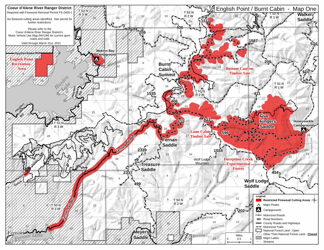
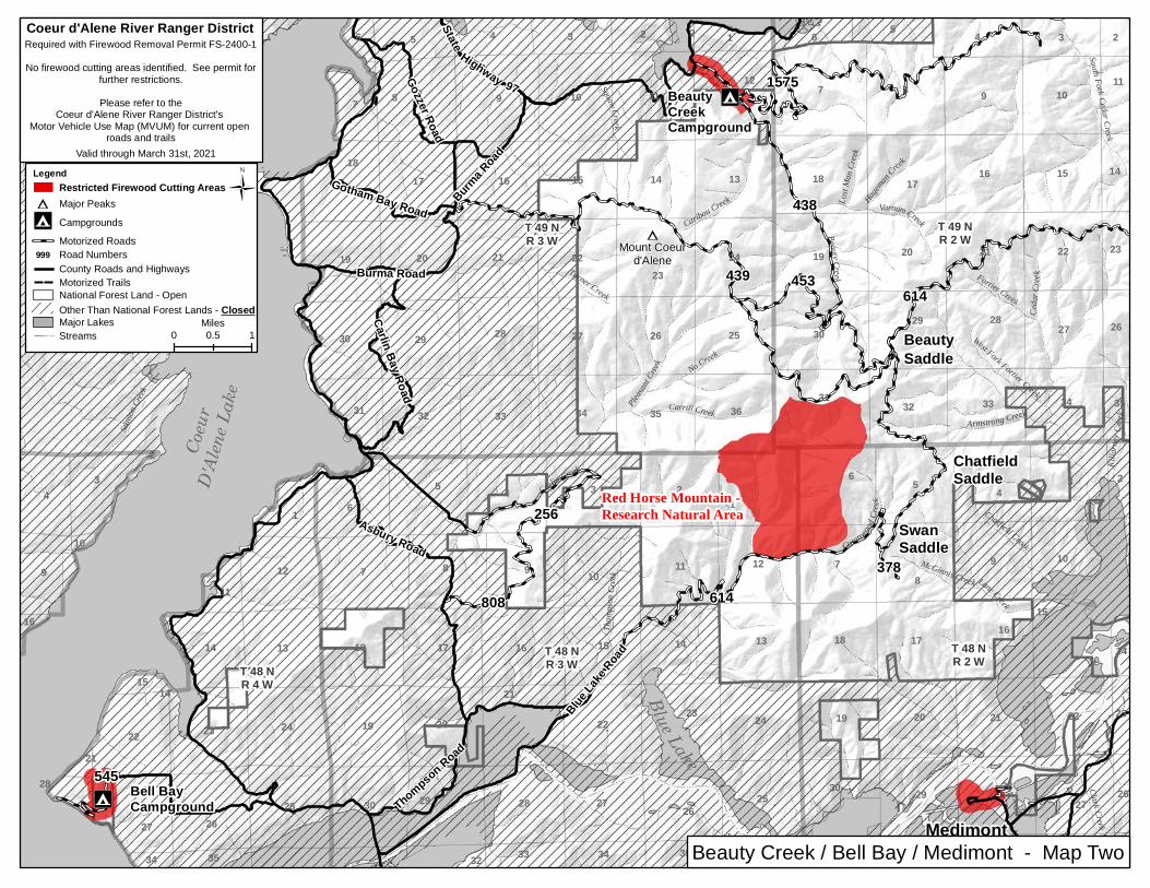
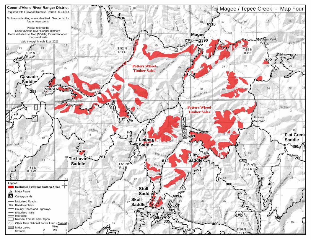
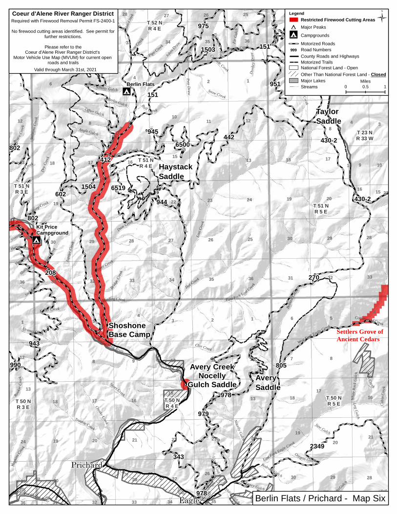
Areas shown in red on the following maps generally depict major travel corridors, special use areas, recreational areas, and timber sales. If in question about cutting in direct proximity to these areas, please contact the district office at (208)-765-7233 or avoid them within reason.

English Point / Burnt Cabin - Map One
BumblebeeMap Three
Big Hank / Black Canyon
- Map Five
Beauty Creek / Bell BayMedimont - Map Two
Murray / Dobson Pass- Map Seven
Road 332 - Map Eight
Berlin Flats / Prichard- Map Six
Magee/Tepee Creek - Map Four
Athol
Chilco
Hayden
PrichardMurray
EnavilleCataldo Kellogg Burke
Osburn
WallaceHarrison
Mullan
Coeur d'Alene
Pinehurst
2020 Firewood Cutting Restrictions - Extents Map
ÆQ
ÆQ
#¹
D
BurntCabinSummit
Wolf LodgeSaddle
WalkerSaddle
TreasureSaddle
MeyersSaddle
FiveFingersSaddle
FernanSaddle
English PointRecreation
Area Bottom CanyonTimber Sale
Deception CreekExperimental
Forest
Lone CabinTimber Sale
Hayden
Lake
Fernan LakeFernan
596
1511
610
1535
1587
434
1534
392406 1532
612
406411
534
499
259
406
612
209
202
206
Hayd
enLa
keRd
Hayden Lake Rd
Marie
Cree
kNettleton
Gulch
Hayden
Lake
Rd
Fernan Lake Rd
Ferna
n Lak
e Rd
2337
2339Wolf LodgeMountain
Ames Creek
Mille
r Cree
k
Blue R
ock Cree
k
Half Mile Creek
Picnic
Creek
Beaver Creek
Early
Creek
Hells Canyon
Montford
Creek
Jungle Gulch
Smith Gulch McMaho
n Creek
Wind
y Cree
k
Halliday Creek
Little Creek
George CreekDemorest Creek
Walke
r Cree
k
State
Creek
Lost Mine Creek
Onow
a Cree
k
Skoo
kum
Creek
Casca
deCre
ek
McLeansCr
eek
Knight Creek
BlueG
rouse
Creek
Three Forks Creek
Colburn Creek
McCauley Creek
Rondo Gulch
Cathcart Creek
Stu mp C reek
Sands Creek
Searchlight Creek
Burton Creek
Bottom Creek
Two Forks Creek
Dry G
ulch
Marie Cree
k
Marie Creek
Barney Creek
PhantomCre
ek
Nicholas Creek
Nettleton
Gulch
Blue LakeCreek
Canyon ForkNilse
n Creek
Lone
Cabin
Creek
Lonesome Creek
Stacel
Draw
Skitwish
Creek
WolfLod
ge Creek
Deception Creek
Jim Creek
Stella
Creek
Yellowbanks CreekBurnt Cabi
n Creek
Mokins Creek
North Fork Coeur dAlene River
Fernan Creek
14
10
36
30
1717
20
26
26
18
34
42
22
11
5
12
23
34
35
20
17
2
7
78
28
32
7
5
6
33
33
2 5
33
6
24
29
31
30
25
28
17
10
2120
6
32
32
5
17
24
25
20
6
5
31
19
9
21
7
21
24
13
18
2
14
31
4
23
8
10
22
22
25
18
22
16
12
32
19
16
16
3
14
5
19
15
21
30
3
3
16
7
19
4
27
36
8
18
18
28
9
8
2221
34
18
31
36
15
9
20
11
33
27
3433
1
11
14
29
1
32
27
4
15
15
10
1012
23
11
32
6
16
23 21
20
16
35
99
9
33
8
19
3531
7
29
29
8
3
33
3
30
15 13
1416
35
4
28
26
19
13
31
36
17
17
6
T 52 NR 2 W
T 51 NR 3 W
T 52 NR 3 W
T 50 NR 3 W
T 51 NR 2 W
T 50 NR 1 W
T 50 NR 2 W
T 51 NR 1 W
T 52 NR 1 W
HoneysuckleCampground
Mokins BayCampground
English Point / Burnt Cabin - Map One
0 10.5Miles
Coeur d'Alene River Ranger DistrictRequired with Firewood Removal Permit FS-2400-1
No firewood cutting areas identified. See permit forfurther restrictions.
Please refer to theCoeur d'Alene River Ranger District's
Motor Vehicle Use Map (MVUM) for current open roads and trails
Valid through March 31st, 2021
ÜLegend
Other Than National Forest Land - ClosedNational Forest Land - Open
County Roads and HighwaysMotorized Trails
#¹ Major Peaks
CampgroundsÆQMotorized RoadsRoad Numbers999
Major LakesStreams
Restricted Firewood Cutting Areas
ÆQ
ÆQ
#¹
SwanSaddle
ChatfieldSaddle
BeautySaddle
Medimont
BeautyCreekCampground
Bell BayCampground
Coeu
rD'
Alen
e Lak
e
Blue Lake
545
State
Highway 97
378
808
1575
453
438
439
256
614
614
Asbury Road
Burma R
oad
Burma Road
Gotham Bay Road
Gozzer Road
Thompson RoadCarlin Bay Road
Blue La
ke Road
Mount Coeurd'Alene
Lost M
anCr
eek
Ced a
r Cr ee
k
Hageman
Creek
McGinnis Creek
Clark Creek
No CreekWest Fork Fortier Creek
Kill a
rney C
reek
Caribou Creek
Carrill Creek
Lyle Creek
Varnum Creek
Delcardo Creek
Armstrong Creek
South Fork Cedar Creek
Pleasa
nt Cree
k
CotonwoodCr
e ek Chatfield Creek
Lane Creek
Stinso
n Cree
k
Tho m
pson C
reek
Squaw Creek
Carlin Creek
Turner CreekFortier Creek
Beaut yCree k28
19
20
31
3535
25
16
33
30
17
22
29
2
29
12
16
5
3
9
26
6
34
27
11
4
22
10
15
36
30 30
6
13
26
18
26
3
15 14
5
2023
1012
35
16
5
2625
11
14
14
5
21
13
10
28
11
9 7
34 33
10
33
18
27
6
28
21
2322
16
35
16
11
32
22
26
19
31
7
1
28
15
23
14
9
15
34
18
31
14
18
8
17
4
10
22
2728
20
3
34
14
8
34
32
1
22
25
29
24
6
12
13
7
20
27
35
19
21
2
14
8
24
17
32
17
30
9
7
4
32
2
8
3
23
36
27
21
3
29
2
23
21
15
19
4
9
24
33
T 49 NR 3 W
T 49 NR 2 W
T 48 NR 2 WT 48 N
R 4 W
T 48 NR 3 W
Beauty Creek / Bell Bay / Medimont - Map Two
Ü
0 10.5Miles
Legend
#¹ Major Peaks
CampgroundsÆQMotorized RoadsRoad Numbers999County Roads and HighwaysMotorized TrailsNational Forest Land - Open
Major LakesStreams
Restricted Firewood Cutting Areas
Red Horse Mountain -Research Natural Area
Coeur d'Alene River Ranger DistrictRequired with Firewood Removal Permit FS-2400-1
No firewood cutting areas identified. See permit forfurther restrictions.
Please refer to theCoeur d'Alene River Ranger District's
Motor Vehicle Use Map (MVUM) for current open roads and trails
Valid through March 31st, 2021
Other Than National Forest Lands - Closed

ÆQ
D
209H
209G
209J
209M
209F
1604
259D
3010806
796
413
2352
323
323
209
259
Old River Rd
Ccc Road
Wall RidgeFo
rest
Highway
9
Bear Creek
Coeur dAlene River
Fall Creek
Gimlet Creek
Nelso
n Cree
k
Hard
y Gulch
Copper Creek
Smith Creek
Guard Creek
Coeur dAleneRiver
McRae CreekCou nty Creek
Marsh
Creek
Cann
on Cr
eek
Owl Creek
Breakw
ater C
reek
Williams Draw
Browns Gulch
Whitem
anDraw
Thomas Creek
Novem
berCr
eek
Hultman Gulch
Studer Creek
McPhee
Gulch
Hayden
Gulch
Little Bumblebee Creek
Prado Creek
Lightner Draw
Hazendorf Gulch
Bumblebee Creek
Cougar Gulch
Little
Tepee
Creek
Coeur
dAlene
River
North Fork Coeur dAlene River
21
27
23
13
26
12
30
333232
6
10
20 23
30
7 8
26
28
7
5
22
19
26
20
34
14
29 25
3
21 21
28
30
23
28
22
22
17
24
22
10
29
29
19
4
18
2529
31
2
27
2420
11
18
9
33
14
20
9
19
2
28
17
16
26
19
2730
31 36
3
1516
23
5
16
11
27
4
21
35
15
8
3435
T 50 NR 2 E
T 49 NR 1 E T 49 N
R 2 E
T 50 NR 1 E
BumblebeeCampground
Ü
0 10.5Miles
National Forest Land - Open
Major LakesStreams
Interstate
Legend
#¹ Major Peaks
CampgroundsÆQMotorized RoadsRoad Numbers999County Roads and HighwaysMotorized Trails
Restricted Firewood Cutting Areas
Other Than National Forest Land - Closed
Coeur d'Alene River Ranger DistrictRequired with Firewood Removal Permit FS-2400-1
No firewood cutting areas identified. See permit forfurther restrictions.
Please refer to theCoeur d'Alene River Ranger District's
Motor Vehicle Use Map (MVUM) for current open roads and trails
Valid through March 31st, 2021
Bumblebee - Map Three
#¹
#¹
Magee
Tie LavinSaddle
StullSaddle
SkullSaddle
RileySaddle
LeibergSaddle
IndependenceSaddle
Flat CreekSaddle
CascadeSaddle
902
261
959
6310
4222390
2329
2306
911
6749
1514
407
400
260
534SC
409A
796
436
335
379
794
209
436
409
812
409
804
400900
265
258
422
260
534
Hell Cree
k
Second Creek
Evans CreekLa
voile
Creek
West Fork
Mann Creek
Lunch Creek
Third Creek
Cataract Creek
Porcupine Creek
Lindberg Creek
Hump Creek
Blackie Creek
Clark
Gulch Boston Brook Creek
Trestle Creek
New Creek
Martin Creek
Long Tom Creek
Y Creek
Clay Cree
k
North
Fork
Callis
Creek
Riley Creek
Betty Creek
Coon Gulch
Plant CreekRablens Fork
Steep Creek
June Creek
Hamilton Cre ek
Miners Creek
Dress
erCr
eek
Ryan
Creek
Magee Creek
US Creek
Stull Creek
West BearCreek
Lavin Creek
Brett Creek
Can C
reek
Tie Creek
Cascade CreekSouth Fork Pottrer Creek
Bear Creek
Autum
n Cree
k
Van
HoosterCreek
Fearn Creek
Cabin Creek
Boundary Creek
Hemlock Creek
First Creek
Flat Creek
Drexall Creek
Smith
Creek
Short Creek
Picnic Creek
Bootj
ackCre
ek
Little East
ForkSte
amboa
t Creek
Little Elk Creek
Comfy Creek
North Fork Coeur dAlene River
Potter Creek
EastF
orkS te
amboa
t Cree
k
West Fork Steamboat Creek
Halsey Creek
Steward Creek
Callis Creek
Leibe
rgCre
ek
BigElk
Creek
Trail Creek
Tepee
Creek
Spyglass Peak
GrassyMountain
10
26
2
34
11
19
5
14
36
1
22
25
16
36
22
24
19
27
20
28 26
4
8
3
10
7 7
24
30
31 32
16
29
23
12
36
16
22
18
12
30
13
35
29
32
32
4
32
18
10
33
26
21
14
22
8
21
23
23
15
10
20
25
20
34
31
27
9
34
15
24
7
26
9
13
15
27
17
1
6
23
11
24
2319
12
31
14
13
8
4
18
127
17
2927
1
31
26
34
17
33
33
28
14
25
28
20
13
5
21
11
25
1418
35
14
2
34
16
29
27
12
24
36
36
12
36
2
19
6
24
3
35
13
15
11
10
3
27
34
11
3533
8
3028
35
1515
5
12 11
13
25
22
10
23
9
3
26
35
6
21
30
25
9
22
17
T 50 NR 2 E
T 52 NR 1 E
T 51 NR 1 E T 51 N
R 2 ET 51 NR 1 W
T 52 NR 2 ET 52 N
R 1 W
T 50 NR 1 E
Potters WheelTimber Sales
£¤I-90
Ü
0 10.5Miles
National Forest Land - Open
Major LakesStreams
Interstate
Legend
#¹ Major Peaks
CampgroundsÆQMotorized RoadsRoad Numbers999County Roads and HighwaysMotorized Trails
Restricted Firewood Cutting Areas
Other Than National Forest Land - Closed
Coeur d'Alene River Ranger DistrictRequired with Firewood Removal Permit FS-2400-1
No firewood cutting areas identified. See permit forfurther restrictions.
Please refer to theCoeur d'Alene River Ranger District's
Motor Vehicle Use Map (MVUM) for current open roads and trails
Valid through March 31st, 2021
Potters WheelTimber Sales
Magee / Tepee Creek - Map Four

ÆQ
ÆQ
ÆQ
#¹
#¹
#¹
#¹
#¹
LittleGuardPeak
Magee
RileySaddle
Flat CreekSaddle
Eighty DaySaddle
BrownCreekSaddle
Black Canyon Saddle 1005C
6636
1005A
6538
69236924
1547
965207335
2329
959
2360A
1566
6749
6310
6310
257990
994
1568
943
3099
2367
802
993
943
409
602
1005-CZ991
412
260
400
943
961
260
900 1569
513
622
804
2352
265
400
208
Drew Gulch
Ulm Creek
Emery
Creek
Coeur dAlene River
Windfa
ll Cree
k
Short Creek
Carrol Gulch
Forks Creek
Mercury C
reek
Keller Creek
Magee Creek
Chute
Creek
Venus
Creek
Swift Creek
Pablo
Cre
ek
Harvey Creek
Mac Creek
Stony Creek
Cardi
nalCreek
Tent C
reek
Cool
Water
Creek
Blackie Creek
Guard Creek
SteepCreek
DavyCr
eek
Mer cur yCr ee k
Beetle Creek
Lion Creek
Betty Creek
November C reek
South Fork Hells Gulch
CoeurdA
lene River
Nelso
n Creek
ClarkGulch
Hart C
reek
Tent C
reek
Uranus Creek
Felder CreekMorr
is Cree
k
Jack Creek
Simmons Draw
SilverCreek
Martin Creek
Long Tom Creek
Evans Creek
Bruce C
reek
Senator Creek
Clay C
reek
St eep Creek
Opp osi te Cr ee k
Drexall Creek
Fergu
sonCre
ek
Black Canyon
Ash Creek
Hopki
ns Cre
ek
Wilson Creek
Taft Creek
Steep Creek
Bennett Creek
Presidents Creek
EastF
orkDo
w ne y
Creek
Ryan
Creek
Independence Creek
Pierson Creek
June Creek
Big Bob Creek
Short Creek
Rookie Creek
Little
Canyo
n Cree
k
Hells Gulch
Au tumn Creek
Hemlock Creek
Sentine
l Creek
Fearn CreekLittle Gri zzl yCre ek
Dennis Creek
Touri s
t Cree
k
Plant CreekCabin Creek
West F
orkDo
wney
Creek
Eighty Day Creek
Omaha Creek
Lindsey Creek
Cougar Gulch
Cinnamon Creek
Dry Creek
Little Elk Creek
Little Lost Fork
Debbs Creek
Coeur dAlene River
Big Hank Creek
Valito
nsCr
eek
Scott Creek
Can Creek
Teddy
Creek
West Fork Steamboat Creek
Little
East F
ork Ste
amboa
t Cree
k
Gold CreekDewey Creek
North Grizzly Creek
Downey Creek
Comfy Creek
Shoshone Creek
Brett Creek
Halsey Creek Miners Creek
Indian Creek
Brow
n Cree
k
Grizzly Creek
Barry
more
Creek
Eas tFork St e amboatCreek
Yellow
Dog Creek
Steamboa t Cr ee k
Flat Creek
Tepee Creek
Coeur dAlen eRiver
SpyglassPeak
SpionKop Rock
GrassyMountain
GrizzlyMountain
Cougar Peak
31
28
10
15
21
4
9
2
34
24
19
5
18
8
18
1
36
19
24
27
19
27
18
26
24
6
20
16
28 26
4
24
8
25
7
2
20
8
1
10
1
34
14
14
17
12
36
16
22
19
12
13
33
18
29
32
3
32
13
30
4
18
63
11
10
33
6
31
21
14
34
16
32
11
19
7
3
21
1210
31
32
12
15
20
25
34
2
12
31
9
15
7
5
31
11
15
26
23 23
8
29
13
7
17
1
32
10
21
19
22
18
23
2830
31
2
8
19
23
7
31
9
27
32
6
22
12
2
6
28
5
22
5
13
31
3
19
10
2630
18
33
14
20
16
22
29
27
3335
30
13
18
24
7
19
17
23
1
36
20
42
6
34
36
13
1814
16
3
24
36
7
15
7
35
34
11
9
29
11
9
35
33
14
3533
21
4
30
6
35
15
25
16
5
11
8
22
4
17
23
3
7
5
17
6
2021
30
25
9
17 16
T 51 NR 3 E
T 50 NR 2 E
T 50 NR 3 E
T 53 NR 2 E
T 52 NR 3 E
T 53 NR 3 E
T 50 NR 4 E
T 51 NR 4 E
T 51 NR 2 E
T 52 NR 4 E
T 52 NR 2 E
Big HankCampground
Devils ElbowCampground
Kit PriceCampground
Potters WheelTimber Sales
Spion Kop -Research Natural Area
Pond Peak - Research Natural Area
Coeur d'Alene River Ranger DistrictRequired with Firewood Removal Permit FS-2400-1
No firewood cutting areas identified. See permit forfurther restrictions.
Please refer to theCoeur d'Alene River Ranger District's
Motor Vehicle Use Map (MVUM) for current open roads and trails
Valid through March 31st, 2021
Ü
0 10.5Miles
Legend
#¹ Major Peaks
CampgroundsÆQMotorized RoadsRoad Numbers999County Roads and HighwaysMotorized TrailsNational Forest Land - Open
Major LakesStreams
Restricted Firewood Cutting Areas
Other Than National Forest Land - Closed
Big Hank / Black Canyon - Map Five
ÆQ
ÆQ
D
D
ShoshoneBase Camp
LittleGuardPeak
TaylorSaddle
HaystackSaddle
AverySaddle
Avery CreekNocelly
Gulch Saddle
Prichard
Eagle
801975
6500
990
802
978
978
944 430-2
802
151
950
1504
945
1503
951
412
208
151
270
805
430-2
6519
2349
947
602
943
442
343
979
Gold Run
Coeur dAlene River
Log Gulch
Saw Gulch
Short Creek
Sissons Creek
Cascade Creek
Mercury CreekHarvey Creek
L Haystack Creek
Berlin Gulch
PeteD raw
Rampike Creek
Cottonwood Creek
Donk
eyDr
aw
Cabi n
Creek
Cabin
Creek
Bull Creek
FirGu
lch
Rocky
Draw
Ucelly Gulch
Bruce C
reek
Rookie
Cree
k
SteepCreek
Daisy Gulch
White
Rock
Gulch
AlderGulch
Falls Creek
North Fork FallsCreek
Bridge
Creek
Eagle Creek
Keller Creek
Johns Draw
Venus
Creek
Fergu
son
Creek
Oregon Gulch
Jack Creek
Bedrock Gulch
Hulliman Creek
Angle Gulch
Jupite
r Cree
k
Clover Creek
Nocelly Gulch
Snow Creek
Dam Creek
Coeur dAlene River
Offset Gulch
Short Creek
Loading Creek
Chute C
reek
Sunday Gulch
Pipe Creek
North
Fork
Hayst
ack
Creaky Creek
Fancy Gulch
Clee Creek
Monday Gulch
Valito
ns Cr
eek
Uranus Creek
Trouble Creek
South Fork Falls Creek
Stack Creek
Dry C
reek
Hopki
nsCree
k
Pine Flat Creek
Hat Creek
Prichard Creek
Haystack Creek
Bobta
il Cree
k
Falls Creek
East Fork Eagle Creek
East Fork Lost Creek
West Fork Eagle Creek
Lost C
reek
Shosho
neCre
ek
Coeur dAlene River
31
9
28
32
18
29
33
21
24
27
35
33
9
25
28
17
17
22
26
1
108
1
32
10
32
19
20
17
33
32
24
20
19
30
7
136
33
6
25
48
28 27
10
27
1923
12
362831
31
22
32
29
13
7
1
32
25
4
16
29
21
34
2
26
19
14 16
28
33
21
3
7
4
5
21
14
12
18
31
34
11
5
13 17
36
16
35
30
15
1624
25
30
18
12
3135
28
119
5
22
333236
13 16
29
24
2930
9
22
2
8
18
20
6
20
23
3
6
27
25
30
12
21
34
15
30
36
1315
4
20
26
34
31
5
8 7
2529
36
T 51 NR 3 E
T 23 NR 33 W
T 50 NR 3 E
T 51 NR 5 E
T 52 NR 3 E
T 52 NR 5 E
T 50 NR 5 ET 50 N
R 4 E
T 51 NR 4 E
T 24 NR 33 W
T 52 NR 4 E
Kit PriceCampground
Berlin Flats
Settlers Grove ofAncient Cedars
Coeur d'Alene River Ranger DistrictRequired with Firewood Removal Permit FS-2400-1
No firewood cutting areas identified. See permit forfurther restrictions.
Please refer to theCoeur d'Alene River Ranger District's
Motor Vehicle Use Map (MVUM) for current open roads and trails
Valid through March 31st, 2021
Ü
0 10.5Miles
Legend
#¹ Major Peaks
CampgroundsÆQMotorized RoadsRoad Numbers999County Roads and HighwaysMotorized TrailsNational Forest Land - Open
Major LakesStreams
Restricted Firewood Cutting Areas
Other Than National Forest Land - Closed
Berlin Flats / Prichard - Map Six
D
D
D
D
D
DobsonPass
Two MileSaddle Cooper
Pass
ThompsonPass
WhiteCreekSaddle
KingsPass
King PassTimber Sale
White BeaverTimber Sale
White BeaverTimber Sale
King BeaverTimber Sale
King BeaverTimber Sale
RevettLake
LowerGlidden Lake
Prichard
Eagle
Murray
BurkeSh6
6532
2322
6534
424
2349
953615
957
978
957
266
424
1505
23492349
430-3
7623
429
933
271
Forest Highway 9
NorthForkSt Joe-Placer
TwoMile
East Eagle Creek343
Beaver Creek
Keystone Gulch
Rattail Gulch
Grouse Gulch
Perry G
ulch
Niagara reek
Mona
rchGu
lch
Poorman Gulch
Hurrican Gulch
Tobog
gon C
reek
Raven
Gulch
Wilson Creek
No Name Gulch
Meyer
Gulch
Accident Gulch
Deadm
anGulc
h
Shei l
dsGu
lchShehee Gulch
CougarGulc
h
Missouri Gulch
French Gulc h Rabbit
Gulch
Vendetta Gulch
Reeder
Gulch
Dago
Peak
Gulch
McComber Gulch
Mill Creek
Eagle Creek
Kid Gulch
Pionee
r Gulch
Ceme
nt Gulch
Axe Gulch
Cat Creek
Bucks
kinGul
ch
Military Gulch
East Fork Alder C
reek
Lake
G ulch
O'Neill Gulch
Bell Gulch
Shirttail Gulch
Ophir Gulch
Daisy Gulch
Dry B
utteG
ulch
Bedrock Gulch
Sawmill Gulch
Cedar C
reek
Jewel l
Gulch
Sulliv
a nGu
lc h
L ans d
a leCr
eek
Jo Gulch
McFarre
n Gulc
h
Hutchin s Gulch
Prospect Gulch
Placer Gulch
Tiger Gu lch
Cleveland Gulch
East Fork Twomile Creek
Gorge Gulch
Missoula GulchFerguson Creek
Humb
oldt G
ulch
Dobson Gulch
Paragon Gulch
Bonanza Gul ch
Moore Gulch
Scott Gulch
Fancy Gulch
SonoraGulch
Nucko
ls Gulc
h
GoldRun
BlackcloudCreekWe
st Fork
Granite Gulch
Little North Fork
WespGulc
h
Barton Gulch
Carbon Creek
Unknown Gulch
Moonshine Gulch
Idaho
Gulc
h
Revenue Gulch
Dudley Creek
AlderGulch
Carpe
nter G
ulch
Casc adeGulch
South Fork Coeur dAlene River
Potosi Gulch
Deer Creek
Terror
Gulch
Trail Creek
Alder Creek
Gran
iteGu
lch
Pony Gulch
Ninem
ileCr
eek
Twom
ile Cre
ek
White Creek
EastFork
Ninemile Creek
Coeur dAlene River
Butte Gulch
Bear Gulch
Canyon Creek
Beaver Creek
Prichard Creek
21
6
20
32
3
9
15
14
33
23
2
28
27
24
25
18
28
7
36
19
33
5
1
17
28
6
17
51
633
33
13
1
5
22
1212
1
10
2019 23
20
32
30
28
15 14
25
2
5
13
9
8
33
8
13
712
18
911
25
17
21
4
13
3
6
21
10
8
2
29
24
25
10
27
20
32
18
34
18 18
3
32
36
32
32
11
22
29
23
13
19
1011
24
4
4
22
3
22
29
29
27
36
19
21
20
19
2
20
23
7
31
21
16
13
2019
29
2029
31
12
16
20
24
44
31
9
8
16
16
21
35
29
7
35
35
7
25
17
8
3135
5
30
5
4
24
19
9
33
4
34
16
31
17
12
5
24
33
15
31
34
97
21
26
6
16
24
2826
1
14
1816
6
8
21
8
26
2730
11
15
30
3136
17
28
12
17
19
1
26
34
25
30
14
9
4
3636
30
30
T 21 NR 32 W
T 49 NR 4 E
T 48 NR 5 E
T 50 NR 3 E
T 49 NR 5 E
T 49 NR 6 E
T 22 NR 32 WT 50 N
R 5 E
T 48 NR 4 ET 48 N
R 3 E
T 48 NR 6 E
T 50 NR 4 E
T 20 NR 32 W
T 49 NR 3 E
T 50 NR 6 E
Coeur d'Alene River Ranger DistrictRequired with Firewood Removal Permit FS-2400-1
No firewood cutting areas identified. See permit forfurther restrictions.
Please refer to theCoeur d'Alene River Ranger District's
Motor Vehicle Use Map (MVUM) for current open roads and trails
Valid through March 31st, 2021
Ü
0 10.5Miles
National Forest Land - Open
Major LakesStreams
Interstate
Legend
#¹ Major Peaks
CampgroundsÆQMotorized RoadsRoad Numbers999County Roads and HighwaysMotorized Trails
Restricted Firewood Cutting Areas
Other Than National Forest Land - Closed
Murray / Dobson Pass - Map Seven

#¹
#¹
D
D
WeberSaddle
SolitareSaddle
Sage CreekSaddle Independence
Saddle
332
332
Lake Pend
Oreille
Bayview
Lakeview
209
407
7941530
332
1520
205
2378
407
1507
904
1550
406
258385
903
436
1560
6728
1525
Ace Creek
Solitaire Creek Coon Gulch
Hamburg Creek
Templeman Creek
McHarg CreekMiller Creek
Old D
oeDr
aw
PyriteCreek
FernCreek
Salee
Creek
North For k C all isCr eek
Lewellen Creek
Old Maid Creek
Prospect Creek
Gosling Creek
Camp Creek
Snowbird CreekGreen Creek
Ermine Creek
Callis CreekChilcoCree
k
Spruce Creek
West F
orkSol
itaire Creek
North Fork Sage Creek
Hamilto n Creek
Lewelling Creek
Sob Creek
East Fork Solitaire Creek
Snow Creek
Trapper Creek
Sage Creek
Ellis CreekSurpr is e Creek
Cheer Creek
Kick Bush Gulch
Roush Creek
South Twin Creek
Goose Creek
Honey CreekIro
nCree
k
Chloride Gulch
Tom Lavin Creek
Sawpit Creek
Branch NorthGold Creek
Declaration Creek
North
Fork
Coeu
r dAle
n eRiv
er
North Gold Creek
West Gold Creek
Gold Creek
Independ
ence Creek
Bayvi
ew Cr
eek
North ChilcoMountain
South ChilcoMountain
26
12
33
34
25
4
21
27
21
7
4
16
9
3
8
20
3531
11 7
17 15 18
7
30
23
2
10
23
36
35
32
16
18
26
19
28
31
52
5
7
3
27
9
25
35
8
4
2023
4
17
33
31
15
3236
10
19
9
27
32
6
9
9
13
36
1
27
34
30
10
10
36
30
11
27
12
16
28
14
33
29
3 5
28
6
14
17
21
25
34
33
15
10
34
25
10
3028
20 22 22
42
35
13
3
8
26
13
9
32
3
34
1816
12
17
29
1713
11
15
24
15
33
10
24
15
26
6
27
16
14
88
18
12
29
14
4
29
31
29
22
11
15
34
1
32
16
28
T 52 NR 2 W
T 52 NR 1 E
T 53 NR 1 ET 53 N
R 2 W
T 54 NR 1 W
T 53 NR 1 W
T 54 NR 2 W
T 54 NR 1 E
T 52 NR 1 W Coeur d'Alene River Ranger District
Required with Firewood Removal Permit FS-2400-1
No firewood cutting areas identified. See permit forfurther restrictions.
Please refer to theCoeur d'Alene River Ranger District's
Motor Vehicle Use Map (MVUM) for current open roads and trails
Valid through March 31st, 2021
Ü
0 10.5Miles
Legend
#¹ Major PeaksMotorized RoadsRoad Numbers999County Roads and HighwaysMotorized TrailsNational Forest Land - Open
Major LakesStreams
Restricted Firewood Cutting Areas
Other Than National Forest Land - Closed
Road 332 - Map Eight
Coeur d'Alene
§̈¦90§̈¦90
£¤95
£¤2
£¤95
Wallace L. ForestConservation Area( Blue Creek)
Mineral Ridge Scenic Area
Beauty BayPIcnic Area
Blue Creek/ Mineral Ridge/Beauty Bay
0 0.45 0.9Miles
-No warranty is made by the Bureau of Land Management. The accuracy, reliability, orcompleteness of these data for individualuse, data is not guaranteed.
Hwy 97 Exit(To Harrison)
NO FIREWOOD CUTTING AREA
LegendNorth Idaho Vincinity Map
Red Sqaure Indicate
Detail Map Location
BLMOwnership