2 site conditions and environment - city of bunbury and building/koombananspart2… · 28 koombana...
TRANSCRIPT

2 SITE CONDITIONS AND ENVIRONMENT

28 Koombana North Bunbury Waterfront
2.1 ENVIRONMENTAL ASSETS ASSESSMENT
2.1.1 VEGETATION
A Flora and Vegetation Survey has been undertaken by Ekologica (refer Appendix C) for the Koombana North Precinct. The key details of the survey are outlined below.
Bunbury is located in the south of the Drummond Botanical Subdistrict or the Swan Coastal Plain Bio-geographical Region. It is expected that prior to urban development in the area, typical vegetation would have ranged from hardy coastal shrubs, through pockets of wetland marshes and karri forests.
The subject land is regarded as highly disturbed, with relatively few non-cultivated native species. The vegetation is dominated by exotic species, either planted as part of landscaping, or present as annual or short-lived perennial shrubs. All of the vegetation within the survey area is considered to be ‘Completely Degraded’. The subject land does not contain any native remnant vegetation as it is reclaimed land within a completely cleared urban environment.
There is evidence of Puccinellia vassica (P1 species) within a five kilometre radius of the survey area, with a ‘possible’ likelihood of occurrence within the subject land. This species is under consideration for declaration as ‘rare flora’, however not in urgent need of further survey.
No natural, or semi-natural, plant communities occur within the survey area and consequently the conservation value of the vegetation is low. No Declared Rare Flora, Priority Flora, or flora listed as ‘Endangered’ under the EPBC Act are present.
2.1.2 FAUNA
A Fauna Assessment has been undertaken by Greg Harewood for the Koombana North Precinct (refer Appendix D). A summary of the key elements of this report is provided below.
FAUNA HABITATS
The Koombana North study area has a long history of disturbance and modification and no longer contains any original natural elements. Prior to European settlement the area would have either formed part of Koombana Bay, Leschenault Estuary or the adjoining land. Over time the area has been totally cleared of native vegetation, filled and raised to allow for various developments located onsite and nearby. The fauna habitats present with the study area are comprised of:
• Flat, open grassed areas with some emergent trees (peppermint and Norfolk Island pines);
• Gardens containing a range of endemic, non-endemic and exotic trees and shrubs (including peppermint and sheoak);
• A manmade rocky shoreline bordering the channel connecting Koombana Bay to Leschenault Inlet; and
• A small section of a low open shrubland on a dune bordering a sandy beach fronting Koombana Bay.

Koombana North Bunbury Waterfront 29
OPPORTUNISTIC FAUNA OBSERVATIONS
A total of 10 native fauna species were observed within or near the study area. Three introduced species were also sighted.
One bird species listed as migratory (Osprey) was observed during the site assessment. This species were observed flying overhead and, while listed as potential species, is unlikely to utilise the study area except for occasional roosting in the larger pine trees.
No evidence of the site being used by western ringtail possums was found (i.e. no scats, dreys or individuals were seen) and given the limited extent of suitable vegetation and the sites isolation it has been concluded that they are very unlikely to utilise the area as habitat now or in the future.
No evidence of the site being used by black cockatoos was observed (i.e. no foraging evidence, no roosting evidence and no trees with hollows). Black cockatoos may very occasionally visit the area but the vegetation present has a very low value as black cockatoo habitat and cannot be considered a site of significance for them.
No evidence of any other conservation significant species using the site was found during the field survey.
FAUNA VALUES
The results of the site assessment clearly indicate that the study area has almost no local or regional conservation significance with respect to fauna. The area is too isolated, degraded and small to have any substantial value to native fauna species except a small number of the more common widespread species normally associated with highly modified habitats.
The value of the site as an ecological linkage is compromised by the limited quality of the fauna habitats present and the fact that it is bordered by a multilane road, Koombana Bay, the Leschenault Inlet channel and existing developments. The site cannot be considered as having any value as an ecological linkage or as corridor for wildlife movement.
POTENTIAL CONSTRAINTS ON DEVELOPMENT
Constraints on development of projects of this nature generally centre on the presence of habitat used or potentially used by threatened and/or migratory fauna species in particular those listed under the federal Environment Protection and Biodiversity Conservation Act 1999 (EPBC Act) and/or the Wildlife Conservation Act 1950.
The assessment suggests that no fauna species of conservation significance are likely to be utilising the study site to a degree that would constrain development in any way. While some species of conservation significance may utilise sections of the study area on occasions, the area is too isolated, degraded and small to have any substantial value to any of the fauna species likely to be present in the general area.
The loss or modification of the existing habitats present within or immediately adjoining the study area that may occur as a consequence of the proposed development cannot be considered as likely to have any significant impact on any specially protected fauna species.
30 Koombana North Bunbury Waterfront
EPBC ACT
The results of the fauna assessment reported on here suggests that no species of conservation significance listed under the EPBC Act are likely to be utilising the study site to a degree whereby development of the area would result in a “significant impact” or “likely significant impact” as defined by the Department of Sustainability, Environment, Water, Population and Communities (DSEWPaC). It is therefore concluded that there are no issues relating to fauna species that would require an EPBC Act referral to be submitted.
2.1.3 STRUCTURE PLAN RESPONSE TO ENVIRONMENTAL ASSETS
As no environmental assets have been identified on the subject site, no specific measures are required.

Koombana North Bunbury Waterfront 31
2.2 LANDFORM AND SOILS
2.2.1 SOIL TYPE
The subject land is located on the Swan Coastal Plain, and is underlain by fill, Safety Bay sand (aeolian and beach lime sand) and alluvium (clay and sand). The presence of uncontrolled fill material (sand to clayey sand) is evident across the site to various depths. Light brown beach sand was observed underlying the sand to clayey sand fill material. Deeper down the profile and below the water table, a layer of fine to coarse grey sand was evident.
The dunal landform has been substantially modified in the past decades by local industry and urban development. The subject land was reclaimed in 1951 and the source of the fill (predominantly sands) is unknown.
Based on the geotechnical investigations undertaken by Coffey Geotechnics (refer Appendix E), the subject land has a generalised subsurface profile as outlined in Table 5.
TABLE 5: GENERALISED SUBSURFACE PROFILE
Layer/Unit Typical Depth to Top of Layer (m)
Typical Layer Thickness (m)
Description/Remarks
Topsoil (Fill) Surface 0.1 to 0.2 Sand, fine to medium grained, brown, with trace of organic matter.
Fill 0.1 to 0.2 1.8 to 3.5 Sand, loose to medium dense.
Sand 2.0 to 3.6 1.0 to 2.0 Sand, fine to medium grained, variable colours, loose to medium dense.
Alluvium 3.0 and 4.0 2.5 to 3.5 Sand and sandy clay.
Basalt 7.0 to 9.5 To maximum depth of investigation (14.5m)
Fine grained, grey to dark grey, moderate weathered to slightly weathered, high to very high strength.
2.2.2 SOIL CONTAMINATION
The site investigations undertaken do not suggest wide spread contamination at the site. In general, the data from the soil samples collected indicated that the soil quality meets the DEC HILs for standard residential with accessible soil (HIL A) through to commercial/industrial (HIL F). Nevertheless, as site contamination investigations collect samples from discrete locations, it is the recommendation of Golder Associates that a Construction Environmental Management Plan (CEMP) be prepared to provide guidance on how to treat potential unexpected contamination finds during earthworks and constructions. The CEMP will address the following:
• Water management;
• Dust and noise;

32 Koombana North Bunbury Waterfront
• Roles and responsibilities;
• Unexpected finds; and
• Community complaints.
2.2.3 ACID SULPHATE SOILS
The Department of Environment’s Acid Sulphate Soils (ASS) Risk Mapping indicates that the Koombana North subject site is located in an area of “high to moderate ASS disturbance risk (<3m from surface)”. Golder Associates have undertaken a Detailed Site Investigation (DSI) for the Koombana North development site (refer Appendix F), which includes an assessment of the potential for ASS.
The assessment of the acid generating potential in soils involved the collection of soil samples at 0.25m intervals, or change in lithology during the investigation. The intent of the ASS field screening tests was to provide an initial evaluation of the potential (high, medium, low) for each soil sample to be ASS. Based on the ASS indicators discussed above, the inferred PASS risk was high for one sample, moderate for one sample, and low for the remaining 125 samples. The high risk sample was collected between 2.40 and 2.65 m below ground level in brown (mottled black) clayey sand (Fill). It should be noted that the ASS field screening test provides an indication only of ASS. Laboratory analysis was undertaken for select samples, based on the results of the field screening.
Based on ASS field screening tests and subsurface material encountered, fifteen samples were submitted for the Suspension Peroxide Oxidation Combined Acidity and Sulfate (SPOCAS) to quantitavely assess the acid generating potential of each soil type. Of these samples, four samples were identified as potential acid sulphate soils (PASS) based on DEC guideline criteria. Further analysis of these samples was undertaken to determine the likelihood of acid generation in natural ground conditions. The analysis concluded that limited ASS are present on site, however these samples have been noted to neutralise any acidity generated in situ. This, however, is based on the assumption that the development requires minimal amounts of excavation. If the proposed works involve large-scale disturbance, treatment and validation of disturbed material would be required.
Golder Associates have also prepared an ASS Management Plan (ASSMP) for Koombana North. The purpose of the ASSMP is to mitigate or control potential impacts relating to disturbance of ASS associated with the proposed development. Should suspected ASS materials be exposed during excavations at the site, identification and characterisation of suspected ASS will occur to confirm the material status and treatments required. Further detail on ASS management is provided in the ASSMP (refer Appendix G).
2.2.4 LANDFORM AND EXISTING SITE LEVELS SUMMARY
The subject land is predominantly reclaimed land on the foreshore of Koombana Bay. The reclaimed area was once the historical natural opening of the Leschenault Estuary.
The topography of the subject land varies, with levels at the Koombana Drive road bridge over the Plug at approximately 5.4m AHD. This is generally the high point on site and there is a generally consistent grade toward the westerly direction from this point. The lowest point within the site boundary is at the western boundary where the existing contour is at 2.6m AHD. A contour of around 4.0m AHD exists at the northern boundary along the top of a 1.5m high batter which grades down into the existing beach. The site dimension is approximately 170m in length in an east/west direction and approximately 80m wide between the existing beach and Koombana Drive.

Koombana North Bunbury Waterfront 33
The site also falls away to the east of the site, where the existing rock batter protects the land from the channel to the Plug. The top level of the rock batter varies between about 1m and 2.5m AHD. The current eastern extent of pavement on Holman Street is at an elevation of 3.0m AHD. The former railway and current pedestrian bridge connecting the Koombana Bay Yacht Club to the Koombana North site has a current finished level of approximately 4.5m AHD with landform locally protecting the bridge contours.
2.2.5 GEOTECHNICAL TESTING DEPTH & BASEMENT CONSTRUCTION
Section 8.5 of the Report on Geotechnical Investigation prepared by Coffey Geotechnics (refer Appendix E) considers the construction of single level basements within the Koombana North Structure Plan area. Based on the proposed building pad levels (3.80m to 4.60m), Coffey estimated levels of around 0.5m AHD to 1.0m AHD for a single level basement. At the time of the investigations, a groundwater level of approximately 0.3m AHD was encountered; however, this is very likely to fluctuate due to seasonal, tidal and weather variations. Coffey recommended that allowance be made for the dewatering of basement and foundation excavations and that the inflow of groundwater can be expected to be substantial for excavations which extend below the groundwater table, given the proximity to Leschenault Inlet. Consequently, sheet piling may also be required to restrict water inflow and to support the excavations.
In view of the potential groundwater and tidal level variation, Coffey also recommended that the basements be constructed to be impermeable (i.e. tanked) and that the basement slab be tied into the structure in order to prevent any buoyancy uplift pressures that may arise.
Coffey has further considered the development of two level basements within the Koombana North Structure Plan area. Excavations are expected to extend to depths of approximately 7m, with basement levels at approximately -2.5 to -3.5m AHD (i.e. approximately 3 to 4m below the water table). In the presence of highly permeable marine sands and alluvium, considerable dewatering and excavation support would be required. From a geotechnical perspective, the excavation of two level basements is feasible; however, thorough groundwater control and excavation support will be required.
Coffey envisages the use of contiguous or secant pile walls, socketed into the bedrock, to form the final basement walls, provide support for the excavation and to restrict water ingress during excavation. Dewatering of the excavation, even following the construction of contiguous piles may still be required, depending on the degree to which water ingress is reduced and given the potential for water to enter through cracks, fissures etc in the bedrock.
Rock may be encountered at levels of between -2.5 and -6.0m AHD. As such, there may be some possibility that rock could be encountered at the base of the two level excavations, which would potentially require breaking out. The final basement would require ‘tanking’ and integration of the slab with structural piles to prevent buoyancy uplift.

34 Koombana North Bunbury Waterfront
2.3 GROUNDWATER AND WATERWAYS
2.3.1 EXISTING GROUNDWATER LEVELS
Groundwater levels have been recorded at 8 well locations by Coffey Geotechnics and Golder Associates. Table 6 below shows a summary of groundwater monitoring data. Based on the proposed development and groundwater levels, dewatering will be required at the site.
TABLE 6: GROUNDWATER LEVEL MONITORING DATA
Well Location
Date Measured Depth to Water (m) Surface Level
(m AHD) Water Level
(m AHD)
CPT3U 26/03/2012 5.5 4.0 - 1.5
CPT4U 27/03/2012 2.4 2.7 0.3
GW01 29/02/2012 3.330 3.502 0.172
GW02 29/02/2012 3.720 3.855 0.135
GW04 29/02/2012 4.845 5.008 0.163
GW05 29/02/2012 4.020 4.251 0.231
In addition, data loggers are being used by Strategen to measure groundwater levels in three bores. The data loggers record groundwater levels at five minute intervals to enable the monitoring of the impacts of tides and storm surges on groundwater levels. The loggers were installed on May 2012 and record data until the end of October 2012 to obtain winter peak groundwater levels.
It should be noted that the site is in very close proximity to the ocean and inlet. Groundwater elevations can be expected to be dictated by the elevation of mean sea level, tidal movement and storm surge (attenuated with increasing distance from the water edge) and localised direct rainfall infiltration. Storm surge is considered to be the likely primary driver of groundwater levels on the site.
As the project area is close to the coast in a sandy environment, the water level is expected to be only slightly higher than sea level; possibly with a shallow freshwater lens over a saline superficial aquifer.
A Dewatering Management Plan has been prepared and will be implemented in the development of the Koombana North site.

Koombana North Bunbury Waterfront 35
2.3.2 PREDICTED GROUNDWATER LEVELS
The likely peak groundwater levels have been estimated for the Koombana North Precinct, taking into account extreme sea levels due to storm surge events. This process lead to estimated peak groundwater levels of:
• 0.66m AHD in a 1 in 1 year ARI storm surge event;
• 0.73m AHD in a 1 in 10-year ARI storm surge event; and
• 0.79m AHD in a 1 in 100 year ARI storm surge event.
These estimated levels have been interpreted from historical storm surge levels and groundwater logger data. These estimates will be reviewed at the subdivision stage when additional logger data is available.
These levels do not take into account sea level rise due to climate change. Increases in sea levels due to climate change are not cyclical like tides or storm surge and are not impacted by tidal or storm surge influences. As the Koombana North site is surrounded by marine and estuarine water bodies on three sides, an increase in sea level as a result of climate change is anticipated to result in an equivalent increase in groundwater levels on the assumption that the other factors affecting groundwater flow and levels will remain constant. This assumption results in the estimated groundwater levels in Table 7.
TABLE 7: ESTIMATED GROUNDWATER LEVELS
Average Return Interval
1 in 1-year 1 in 10-year 1 in 100-year
2010 level (mAHD) 0.66 0.73 0.79
2060 estimated level (mAHD) 0.96 1.03 1.09
2110 estimated level (mAHD) 1.56 1.63 1.69
Based on this, the 2110 estimated level for a 1 in 1 year storm surge event of 1.56m AHD has used as the design groundwater level. This level is the estimated peak groundwater level expected to occur on an annual basis when sea level rise occurs. The use of a 2110 estimated level results will result in a ‘future proof’ design that takes into account both climate change and storms.
2.3.3 GROUNDWATER QUALITY
Groundwater quality sampling has been undertaken for the Koombana North site. The pH in the site bores was circum-neutral and the ranged between 6.89 and 7.22. The electrical conductivity ranged from 1.63 to 3.64 mS/cm, or approximately 830 mg/L to 1860 mg/L total dissolved solids (TDS). This can be considered to represent fresh to brackish water, and is significantly below the salinity of seawater (approximately 35 000 mg/L TDS).
Total phosphorus (TP) results ranged from 0.11 to 0.14 mg/L and were above the estuarine and inshore marine guidelines of 0.03 and 0.02 mg/L respectively. Total nitrogen (TN) levels varied from 0.4 to 1.4 mg/L. The mean TN level was 0.95 mg/L, which was above the estuarine and inshore marine guidelines of 0.75 and 0.23 mg/L respectively. As the project is not anticipating on moving groundwater off site through subsoil drainage, it is currently not proposed to undertake further groundwater quality monitoring.

36 Koombana North Bunbury Waterfront
2.3.4 WATERWAYS
2.3.4.1 LESCHENAULT INLET
The subject land is located on the northern portion of the existing Lucianna Park between the Bunbury City Centre and Koombana Channel, locally known as ‘the Plug’. The Plug is a connection between Koombana Bay (and the greater Indian Ocean) and the Leschenault Inlet.
Originally, the Leschenault Inlet and Leschenault Estuary were a single water body (termed the Leschenault Inlet). In 1951 however, the natural mouth of the inlet to the ocean was closed and a new connection to the sea was made, opposite to the mouth of the Collie River. In 1968-69, the Preston River was diverted to allow for construction of the Bunbury Port inner harbour. During this work, the southern part of the Inlet was separated from the rest of the water body. Thus, the Leschenault Estuary (larger northern section of the original inlet) and the ‘new’ Leschenault Inlet (small southern portion) were formed. On completion of the inner harbour work, a channel (‘The Plug’) joining the ‘new’ Leschenault Inlet to the sea was constructed.
The Inlet is about 1.9km long and up to 200m wide, has an urban catchment area of around 500ha and is an iconic feature of Bunbury. The Inlet is considered environmentally significant as it supports the southernmost mangrove vegetation in Western Australia.
2.3.4.2 THE PLUG
The Plug connects the Leschenault Inlet with Bay Koombana and contains the Bunbury Storm Surge Barrier, which is a set of storm gates operated by the Department of Transport (DoT). The barrier is designed to be closed during storm events to prevent seawater flooding low lying areas surrounding the Leschenault Inlet. The gates are designed to be closed when it is anticipated that sea levels will exceed 0.7m AHD. The gates are reopened when the risk of the storm has passed. All maintenance works for the Plug are the responsibility of the DoT.
The integrity of the plug wall has been raised as an issue by the City of Bunbury, with regard to the ongoing protection of the Koombana North development. LandCorp is committed to facilitating an inter-government meeting between key stakeholders including the City of Bunbury, Department of Planning, Regional Development & Lands, Department of Transport and the Bunbury Port Authority to discuss this issue and to develop an appropriate remediation and ongoing management plan for the Plug Wall into the future.
2.3.4.3 KOOMBANA BAY & SKI BEACH
The Koombana North Precinct is located at the west side of the Leschenault Inlet entrance. The subject site is fronted on the western side of Koombana Bay by what is locally known as the Ski Beach. The beach is located in what was previously the entrance of the Leschenault Inlet. The existing beach is an artificial beach which was constructed as a part of changes to the inlet entrance location to incorporate a surge barrier.
Both the Leschenault Inlet training wall and Marlston Waterfront seawall act as headlands and control the shape and orientation of the beach. The Ski Beach is protected from all directions except fetch limited local seas from the north by the Bunbury outer harbour breakwater and may be considered a relatively low energy beach.

Koombana North Bunbury Waterfront 37
BEACH PROFILE AND BATHYMETRY
The width of the beach fronting the development (Ski Beach) is about 300 m. The slope of the offshore seabed is very mild (about 1:100) with a closure depth at the head of the Leschenault Inlet training wall of about -2 m (AHD). The active beach level is around the mean sea level (MSL) and backed by a relatively low fore-dune (2.7 m AHD). The fore-dune is backed by a relatively low area at the upper beach (2 m, AHD).
SEDIMENT CHARACTERISTICS
During BMT JFA’s site visit to this study are, four sediment samples were taken across the beach and analysed for particle size distribution (PSD) tests in order to characterise the sediment properties at the beach. The participle size distributions at all four locations across the beach were almost identical. The D50 of the sands are about 0.4 mm. The results of the tests for all the samples are included as an appendix to the Coastal Stability and Setback Review (Appendix A).
2.3.5 COASTAL ENVIRONMENT
2.3.5.1 COASTAL PROCESSES
As discussed, Koombana Bay is a relatively low energy marine environment due to the shelter provided by the Outer Harbour and the causeway leading to the historic jetty. This environment has led to low sediment transport rates along the coast, as evidenced by the presence of fine sediments within the bay. The current dominant sediment transport is from east to west as evidenced by the build up adjacent to the existing groynes. Therefore, it is not likely that any long-term build-up of sediment will impact the Koombana North subject site.
Some long-term build-up of sediment is likely along eastern side of Koombana Bay, however as this does not cause major erosion or accretion against existing groynes, and because the reclamation is just an extension of an existing structure, it is unlikely that the changes will be significant in the modified environment.
Further investigations will be undertaken to investigate the age of the existing structures, investigate any historical management undertaken and to estimate the rates of accretion against existing structures.
2.3.5.2 SHORELINE STABILITY
In addition to establishing coastal stability and setback requirements, an assessment of shoreline stability and vulnerability was also undertaken and can be summarised as follows:
• The beach is a pocket beach protected from all directions except fetch limited local seas from the north by the Bunbury Outer Harbour Breakwater and as review of the wave conditions show, the Ski Beach may be considered a relatively low energy beach.
• Given the limited direction for energy to impact the beach in either ambient conditions or extreme local sea storms the beach is likely to vary little in alignment and may be considered relatively stable.
• Review of shoreline movements, shows the beach has remained stable on its current alignment since 1985 with 5 m erosion in 1991 which had recovered by 1996.
• Storm erosion modelling showed that the development site was vulnerable to an extreme sequence of northerly storms at the projected 100 year MSL and the site may require protection.

38 Koombana North Bunbury Waterfront
• The modelled protection at the boundary was shown to adequately protect the development from the extreme storm sequence and upper profile wave conditions were within reasonable limits to feasibly design in control of run-up and overtopping.
• Location of the proposed protection at the rear of the extreme storm sequence profile is unlikely to impact beach amenities and sediment is unlikely to move outside the compartment.
2.3.5.3 COASTAL SETBACKS
The Coastal Stability and Setback Review Report focuses on documenting the accepted hazard and the adaptation measures required to manage the identified hazard(s) taking into account the need for coastal protection.
Based on previous calculations of acceptable setbacks for the nearby beaches, the subject land would require setback of the project boundary or protection with available setback from the Horizontal Setback Datum (HSD) in the order of 20 m at the top of the active beach on this sandy shoreline with a small frontal dune. However, as the Department of Transport (DoT) requires an SLR of 0.9 m over the 100 year planning horizon, compared to an SLR (100yr) of 0.38m as stated in SPP 2.6, this will likely increase these estimates.
• SPP 2.6 recommends considering the following components for establishing the physical processes setback in response to the assessed erosion hazard:
• S1 Erosion: Allowance for the current risk of storm erosion.
• S2 Erosion: Allowance for historic shoreline movement trends.
• S3 Erosion: Allowance for erosion caused by future sea level rise.
The recommended horizontal setback for the existing beach profile at Ski Beach (north of the subject land) based on SPP 2.6 is outlined in Table 8.
TABLE 8: CALCULATED HORIZONTAL SETBACK REQUIREMENTS
Erosion Allowance components Horizontal setback values (m)
S1 35
S2 0
S3 13
Total 38
The calculated physical processes setback in response to the assessed erosion hazard for the subject land confirms that setback of the project boundary would be required or adaptation measures such as coastal protection implemented. As the setback to development has been established through the Taskforce process (and this is less than the calculated minimum under the provisions of SPP 2.6), physical mitigation measures will be required in order to protect future development from coastal processes.
Adaptation measures through building design, coastal protection, beach nourishment and profile enhancement are required in order to manage the assessed erosion hazard. The following adaptation measures are recommended for the proposed development:
Koombana North Bunbury Waterfront 39
• Protection to be provided by implementing a buried seawall in front of or as part of the pedestrian path at the rear of the beach. Design of this feature as a rock revetment incorporating a crest wall or as a block seawall founded below the estimated extreme event erosion profile can readily control run-up and overtopping impacts on development buildings in the design storm sequence.
• Accommodation features can also be incorporated in built form design to accommodate the risk of run-up and overtopping impacts on development buildings. Measures may include design of the buildings and public spaces to accommodate or prevent spray damage, good drainage to prevent flooding and management plans to prevent access in extreme storm conditions for safety.
• Further coastal protection is afforded by increasing the buffer sand storage at the top of the profile by filling in the area between the foreshore dune and the proposed seawall. This creates a buffer mild slope sandy beach which would reduce the recession due to the future sea level rise. Modelled beach response indicates that the deposited materials at the toe will remain within the compartment and renourishment if it should be required would be small.
40 Koombana North Bunbury Waterfront
2.4 EXISTING MOVEMENT NETWORK
2.4.1 ROAD NETWORK
The Koombana North Precinct is generally surrounded by Blair Street and Clifton Street to the south west, Holman Street to the west, Casuarina Drive to the west and north-west and Koombana Drive to the south. Some key details of each road are as follows:
• Koombana Drive – district distributor road with posted speeds of 60 kph. It provides key gateway access to the Bunbury CBD and provides access over the Plug. It is a two lane road, which in places provides four lanes. At the western end of Koombana Drive, a two lane roundabout controls the intersection of Blair Street. Access to the Perth-Bunbury Highway is provided at the eastern end of Koombana Drive via a roundabout.
• Blair Street – district distributor road which lies to the south west of the Koombana North Precinct area. It is a four lane divided road with a posted speed limit of 60 kph.
• Casuarina Drive – has posted speeds of 60 kph and provides a wide four-lane divided road with median planting. The site access road to the proposed development (Holman Street) is located off this road.
• Clifton Street – connects the Bunbury CBD to the Koombana Drive roundabout. It is a single carriageway road with posted speeds of 50 kph, which provides two traffic lanes and on-street parking. The road widens to a further two lanes at the roundabout approach and exit.
• Holman Street – lies to the east of Casuarina Drive and will provide access to the development site. The road currently provides access to a hotel and 54 existing on-street car parking bays.
• Carey Street – lies adjacent to the Holman St/Casuarina Drive intersection. It has left-in/left-out access onto Casuarina Drive and provides access to the Marlston Hill car park, via Brewery Lane. It is a 50kph single carriageway road.
2.4.1.1 EXISTING TRAFFIC VOLUMES
Traffic volumes along major roads in the vicinity of the development are shown in Table 9. The morning and evening network peak hours are generally 8-9 am and 5-6 pm, although there are some secondary peaks between 12pm and 2pm.
TABLE 9: EXISTING TRAFFIC COUNTS ALONG MAJOR ROADS IN THE VICINITY KOOMBANA NORTH
Road Daily Traffic Volumes Year of Count
Koombana Drive (west of inlet bridge) 10,487 2010
Clifton Street (west of Blair Street) 6,557 2011
Casuarina Drive (north of Koombana Drive) 6,076 2010
Blair Street (south of Koombana Drive 9,605 2008
Koombana North Bunbury Waterfront 41
2.4.2 PEDESTRIAN NETWORK
There are a number of existing footpaths which link the subject site with Marlston Waterfront to the north, the CBD to the west and south-west and the areas east of the Plug to the east.
Existing pedestrian crossing points on Casuarina Drive are provided to the north of Holman Street. Other crossing points are also available across Blair Street, Clifton Street and Koombana Drive. Blair Street and Koombana Drive provide wide medians which facilitate safe two-stage pedestrian crossing.
The WAPC’s Transport Assessment Guidelines for Development recommend an analysis of the operation and safety of the pedestrian and bicycle networks including identification of which roads could potentially be difficult for pedestrians and cyclists to cross, where safe crossing should be provided, and where safe crossings are proposed. According to the guidelines, traffic volumes that adversely impact on the ability of pedestrians to cross safely are:
• Two-lane divided road – 2,800 vehicles per hour (two-way), equivalent to 28,000 vehicles per day; and
• Four-lane divided road – 1,600 vehicles per hour (two-way), equivalent to 16,000 vehicles per day.
All roads within the area of Koombana North have estimated traffic volumes that are below these levels. As such, the network flows would not compromise the safety and efficiency of pedestrians crossing streets.
2.4.3 CYCLIST NETWORK
There is a network of off-road shared paths, on-road bike lanes, and bike parking that enables safe bike travel around the Leschenault Inlet and the waterfront area. A number of shared paths provide grab rails at desired crossing points which help to provide a visual marker that is viewed by the cyclist as a safe crossing point.
2.4.3.1 CITY OF BUNBURY BICYCLE PLAN
The City of Bunbury issued a Bicycle Plan in 2010 that identified the existing infrastructure available to cyclists and the need for cycle infrastructure improvements in and around Bunbury. Consequently, numerous cycle paths that connect to the Koombana North development where identified as requiring upgrade. These are depicted in Figure 10 and summarised in Table 10. Paths that are identified in the City’s Bicycle Plan that abut or traverse Koombana North will be constructed as part of the development of the subject site, as outlined in Section 3.3.4.1 The requirements will be discussed and agreed to with the City of Bunbury during the engineering and landscape design approval and construction phases.

42 Koombana North Bunbury Waterfront
TABLE 10: IDENTIFIED CYCLE NETWORK UPGRADES (CITY OF BUNBURY BICYCLE PLAN)
Link Recommended Works Description
Ocean Drive to Blair Street Install 1.5m on-road bicycle lanes, on both sides.
650m on-road bicycle land. Remove parking bays north side and reallocate road space. Many challenges including existing taxi rank.
Ocean Drive to Blair Street Upgrade path to 3.0m red asphalt.
650m high quality commuter link to CBD. Consider separation of cyclist/pedestrians.
Estuary Drive – Koombana Drive to Old Coast Road
Upgrade existing cycleway to 3.5m PSP standard.
3300m high quality red asphalt PSP along existing alignment.
Upgrade culvert crossings and replace majority of existing path including existing cycle connection bypassing Eelup Rotary.
Koombana Drive – Leschenault Inlet to Estuary Drive
Install 1.5m on-road bicycle lane – both sides.
1350m high quality recreational path link along foreshore, connecting into existing wide shared path at Rowing Club.
Leschenault Inlet Southern Loop – Blair Street to King Road
Upgrade existing path to 3.0m red asphalt RSP along foreshore.
1300m high quality recreational path link along foreshore, connecting into existing wide shared path at Rowing Club.
Casuarina Drive/Bonnefoi Boulevard Koombana Drive to Port
Install 3.5m red asphalt RSP along Casuarina Drive.
900m high quality red asphalt RSP along Casuarina Drive alignment. Connection to existing cycling facilities in Queens Gardens.
Figure 10 – City of Bunbury Bicycle Plan Extract

Koombana North Bunbury Waterfront 43
2.4.4 PUBLIC TRANSPORT
2.4.4.1 BUS SERVICES
The Koombana North Precinct is located approximately 650m to the north of the existing Central Bunbury Bus Station on Carmody Place. A total of 10 bus services operate from the Central Bunbury Bus Station, linking the CBD with Glen Iris, the existing railway passenger terminal, the health campus, Dalyellup, Kingston and Eaton.
2.4.4.2 EXISTING RAIL SERVICE
The nearest rail station is located less than four kilometres away from the Koombana North site. It is located on Picton Road in the suburb of Wollaston, to the south-east of the Bunbury CBD. Australind rail services to Perth are available from this station two to three times a day.
2.4.4.3 FUTURE PERTH TO BUNBURY FAST RAIL SERVICE
The potential development of high speed inter-city railway operating between the CBDs of Perth and Bunbury has been considered for a number of years, with a number of studies and reports being undertaken. GHD were engaged by the Public Transport Authority (PTA) to undertake a feasibility study for the possible future Perth to Bunbury fast rail service. Further feasibility work has been undertaken by Cardno in May 2010 on behalf of the PTA, investigating the forecast patronage of the high speed rail connection.
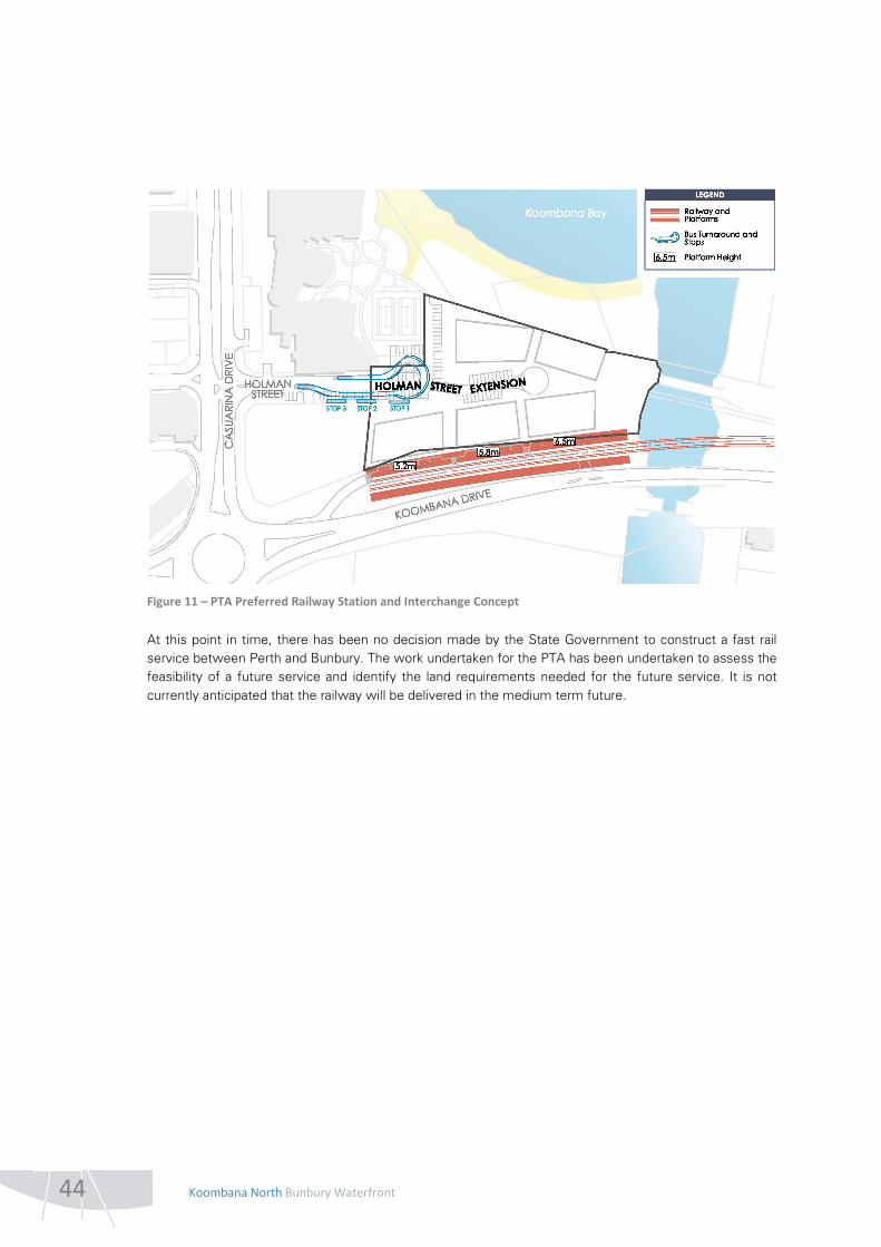
The Fast Train Study Report, issued in January 2010, considered the location of three stations on the proposed railway: Bunbury Central, Bunbury Park and Ride, and a mid-point station. It was the strong preference of key stakeholders for the station to be constructed in the vicinity of Koombana Drive/Casuarina Drive/Blair Street intersection. The Study Report identified the need for the station design to be able to accommodate six car trains and, consequently, a 155m straight platform. Furthermore, two platforms should be provided to allow a stationary train to wait within the station without inhibiting the movement of the other service. The design of the station should fulfil the role of being a city centre station and provide safe and convenient access to and from the Bunbury CBD; therefore it is considered that it would cater for walk up demand. The Study Report stated that street access must be provided for local public transport (buses or light rail) and taxis and that a strictly limited number of passenger drop off bays should also be provided. Passenger facilities at the station should include ticketing and information services, waiting rooms, toilets and showers, luggage lockers, bicycle lockers, food and beverage services and appropriate security measures (CCTV and emergency telephones).
GHD has undertaken further detailed design investigations into the proposed station footprint requirements adjacent to the Koombana North site. The PTA’s preliminary indicative requirements for the station (including platform heights) and bus/taxi/kiss-n-ride interchange are outlined in Figure 11. The Koombana North Structure Plan has been prepared in accordance with the principles of the PTA’s design concept, with the existing central Holman Street area (south of the tennis courts) being converted into a bus turnaround facility in the future when the railway is delivered. GHD has also provided its support for the marginal shortening of the railway platform at the western end so that pedestrian access to Koombana Drive and the CBD can be provided. GHD is also continuing with design investigations for the alignment of the fast rail between Perth and Bunbury and anticipates that this work will be completed by the end of 2012. Following this and in collaboration with the WAPC, it will commence the process of reserving land in the GBRS for the proposed railway alignment in 2013.
44 Koombana North Bunbury Waterfront
Figure 11 – PTA Preferred Railway Station and Interchange Concept
At this point in time, there has been no decision made by the State Government to construct a fast rail service between Perth and Bunbury. The work undertaken for the PTA has been undertaken to assess the feasibility of a future service and identify the land requirements needed for the future service. It is not currently anticipated that the railway will be delivered in the medium term future.

Koombana North Bunbury Waterfront 45
2.5 HERITAGE The rich cultural heritage of the Bunbury Harbour spans across many time phases, beginning in the Ice age and encompassing Aboriginal prehistoric, French and British exploration, early settlement, and Industrial adaptations.
2.5.1 ABORIGINAL HERITAGE
In 2007, Bradley Goode undertook an ethnographic survey of the subject site to determine whether any aboriginal heritage issues exist that should be reflected in the planning for the Bunbury Waterfront project (refer Appendix H). As a result of archival research, no previously recorded Aboriginal Heritage sites were identified to be located within the Bunbury Waterfront development area. The survey report did, however, make a number of recommendations, which are outlined below:
• The Leschenault Inlet, from what was formerly known as Bar Point and Point Macleod following its original path to the Leschenault Estuary as depicted within the Preston River Settlements c1850 map be considered to be component of Site ID 16713 Collie River Waugal (Site Complex ID 16) and recorded as a site of mythological significance under Section 5(b) of the Western Australian Aboriginal Heritage Act 1972 (WAAHA 1972).
• LandCorp should apply for a Section 18 clearance under the WAAHA 1972 to use the land that may contain an Aboriginal site for any work that will impact upon the Leschenault Inlet within 30m of the normal high watermark.
• As the traditional owners of this site are supportive of development, it is recommended that following registration the Aboriginal Cultural Material Committee (ACMC) recommends that ministerial consent should be given for the work as proposed with the following conditions attached:
− Engagement of suitable Nyungar representatives to conduct the necessary propitiatory rituals prior to the commencement of works so as to not to create any adverse spiritual problems for the community.
− The monitoring of earthworks during development in order to appropriately manage any skeletal remains that may be unearthed during development in line with the obligations set out under the terms of the WAAHA 1972.
• Developers should give due consideration to the identified significance of the area and its mythological association with the marine life of Koombana Bay and acknowledge the significance with interpretation and conduct of good sustainable environmental management practices that endeavour to minimise the environmental effects on the marine ecology of the bay.
• LandCorp should supply the South West Aboriginal Land and Sea Council Gnaala Karla Booja Native Title working party and the Bunbury Aboriginal Women’s Group with copies of all environmental studies associated with the development and the effects on the marine ecology in Koombana Bay as requested during consultation for comment.
• Good public access should be maintained throughout the development area so that Nyungars can continue to use the shores of Koombana Bay and the Leschenault Inlet for recreational, social activities and customary use.
• LandCorp should give due consideration to requests made by the Nyungar community for the provision of employment opportunities during the development and that assistance be rendered to the Nyungar community to progress the development of a cultural centre within land administered by the City of Bunbury south of Koombana Drive.

46 Koombana North Bunbury Waterfront
2.5.2 EUROPEAN HERITAGE
European exploration of the area began with the French in 1803 that provided the first map of the area (refer Figure 12) and noted that it would provide an excellent small vessel harbour which was named Port Leschenault.
Figure 12 – French Map of Port Leschenault (1803)
Some years later, Captain Stirling made the same observation during his 1827 exploratory voyages, and Port Leschenault formed the focal point of the settlement of Bunbury. The notion of Koombana Bay providing safe harbour came into question some years into settlement however, following the successive wrecking of a number of ships that were driven on shore by the northerly gale. As the settlement progressed and grew, so too did the harbour and its facilities, which intensified with industrial usage in the post-war era.
2.5.2.1 HERITAGE LISTINGS
There are a number of lists of places of Aboriginal and historical value that are compiled and maintained by the various heritage agencies and local governments. Those lists reviewed as part of this study include, Heritage Council of WA Data Base and State Register, Aboriginal State Register, Register of the National Estate, Shire of Bunbury Municipal Inventory, Bunbury Shire Town Planning Scheme Heritage List and the Register of Shipwrecks, refer Table 11.

Koombana North Bunbury Waterfront 47
TABLE 11: HERITAGE PLACE LISTINGS FOR WHOLE OF BUNBURY OUTER HARBOUR
MI TPS HCWA NAME LOCATION DATE STATUS
B102 - 02500 05655
Bunbury Shoreline as at 1841 Koombana Bay, North Shore Bunbury 1841
B016 03379 6601
Jetty Crane, Causeway Outer Harbour Bunbury 1911
B019 12 03402 Bunbury Timber Jetty Lot 767 Koombana Bay (Opp Henry St)
1864 1998
CSR/RNE
B256 04259 Dolphin Discovery Centre Lot 830 Koombana Dr 1994
B283 05494 Original Railway Route - site Wittenoom St to Jetty 1887 1891
B078 54 05632 Wreck Site - Laughing Wave Koombana Bay 1868
B081 57 05635 Wreck Site - Citizen of London Koombana Bay 1878 1882
B082 58 05636 Wreck Site - Star of the South Koombana Bay 1875
B103 68 05656 Wreck Site - Agra North Shore, Koombana Bay 1893
B104 69 05657 Wreck Site - Cingalee North Shore, Koombana Bay 1872
B105 70 05658 Wreck Site - Annie M Young North Shore, Koombana Bay 1863
B106 71 05659 Wreck Site - Elizabeth North Shore, Koombana Bay 1832
B107 72 5660 Wreck site - North America No 1 North Shore, Koombana Bay 1843
B108 73 05661 Wreck Site - Samuel Wright North Shore, Koombana Bay
B109 74 05662 Wreck Site - Midas North Shore, Koombana Bay 1865
B110 75 05663 Wreck Site -Solglyt North Shore, Koombana Bay 1888 1901
B125 5674 Flood Gates Storm Serge Barrier Koombana Drive Leschenault Inlet. 1980
B126 82 5675 Site: Military Camp 1830 Point McCleod, Leschenault Inlet
B188 05691 Railway Marshalling Yards & environs (fmr) Blair St 1893 1927
B017 - 06599 Jetty Public Baths No 1 - Site Outer Harbour Bunbury 1880
B020 - 06602 Breakwater Lot 415 Outer Harbour, Casuarina Pt 1897
B027 06685 Jetty Public Baths No 2 - site Outer Harbour Bunbury 1917
B033 - 06700 Jetty Public Baths No 3 - site Outer Harbour Bunbury 1930
B069 48 07472 Wreck site - North America No 2 North Shore, Koombana Bay 1840
Key Column 1 City of Bunbury Municipal Inventory Listing. Column 2 City of Bunbury Town Planning Scheme Heritage List. Column 3 Heritage Council Data Base and Register List Column 4 Place Name. Column 6 Place address. Column 7 Construction date. Column 8 Denotes those sites included on the State Heritage Register (HCSR) and the Register of the National Estate.

48 Koombana North Bunbury Waterfront
The Bunbury Harbour area represents the historical focus of the Bunbury Township and about 80 sites and places have been identified within the wider Bunbury Harbour area. These sites include, Aboriginal Artefact Scatters and Burials, Commercial and Community buildings, Ship Wrecks, Port Facilities and Transport and trade infrastructure sites.
There are 24 listed sites that fall either within or in close proximity to the three development precincts, and may be impacted by development within the wider harbour area. Many of these sites no longer exist physically in the landscape, but some may have archaeological potential.
It is noted that there have been considerable impacts to the archaeological record of Point Casuarina and Koombana Bay through successive excavations, mining operations, dredging, land reclamation and remediation programmes, that have significantly modified the original landform. The extent of this modification can be seen in a comparison between an 1830 and 2007 map, which shows that the original landform is barely discernible within the modern setting of the harbour. This successive redevelopment has served to both create and destroy the archaeological record. The three areas of proposed development are comprised almost entirely of reclaimed land that has buried and or obscured a large number of the listed sites.
The most significant site within the proposed development area is the Bunbury Timber Jetty that has been placed on the State Heritage Register and the Register of the National Estate. Part of the Timber Jetty still exists and there is strong community opinion for its restoration.
There are also two possible ship wreck archaeology sites - Laughing Wave and Midas - located along the east of the Timber jetty that were wrecked alongside the jetty in 1903 and 1872 respectively. Most of the other listed shipwreck sites are located under the area of land reclamation on Koombana Beach.
The public baths sites are believed to have been similarly buried, but some archaeological remains may exist. Other sites with possible archaeological remains include the original railway and marshalling yards.
There may be enough archaeological, archival and photographic and oral historical evidence to undertake an interpretative reconstruction of a number of sites were the original structures or place no longer exists such as the original shore line of Koombana Beach, the original rail line and associated yards, the original jetty and jetty baths, the breakwater and the old military camp on Point MacLoud.
Some recently constructed sites such as the Dolphin Discovery Centre and the flood gates have been placed on the City of Bunbury’s Municipal Inventory and the Heritage Council of WA data base.

Koombana North Bunbury Waterfront 49
2.6 CLIMATIC CONDITIONS
2.6.1 CLIMATE
Bunbury experiences a Mediterranean climate, with dry hot summers and cooler winters. The annual rainfall is approximately 718 mm/yr, with most of this falling between May and September as outlined in Table 12.
TABLE 12: BUNBURY RAINFALL
Jan Feb Mar Apr May Jun Jul Aug Sep Oct Nov Dec Annual
Mean rainfall (mm)
12.3 7 15 36 91.6 147.5 148.4 117.7 79 31.8 25.2 15.8 718.2
2.6.2 WIND
Local ambient wind conditions at Bunbury are dominated by the sea breeze/land breeze system. Predominately easterly winds prevail in the morning (9am) and predominately westerly winds in the afternoon (3pm). The frequency of occurrence of strong northerly winds (stronger than 40 km/hour) is negligible compared to the westerly events.
50 Koombana North Bunbury Waterfront
2.7 OPPORTUNITIES, CONSTRAINTS AND SITE CONTEXT ANALYSIS An analysis of the existing site conditions and the potential opportunities and constraints that require consideration in the planning and development of the Koombana North precinct has been undertaken to inform the preparation of the Structure Plan. The key elements of this analysis are considered in further detail below and outlined in Figure 13.
2.7.1 POSSIBLE FUTURE RAILWAY STATION
As identified above in Section 1.3.3, the extent of the GBRS Amendment for Koombana North was considered further by the City of Bunbury, Department of Planning and PTA following advertising to ensure that the proposed amendment would not prejudice the possible future delivery of a Perth to Bunbury fast train service into the Bunbury CBD, with a station adjacent to the amendment site. It was determined that a future station could be accommodated, immediately adjacent to the amendment site, in the unconstructed northern portion of the existing Koombana North Other Regional Road reservation.
As such, the subject site benefits from its potential exposure to major transit infrastructure that would link the Perth and Bunbury CBDs. The presence of this transit infrastructure would provide high exposure to the subject site and train patrons and visitors would be likely to generate demand for festival and convenience retail facilities within the development site.
However, there is presently no government financial commitment to the construction of a fast-train service between Perth and Bunbury and it is not foreseen that a decision to proceed with the rail service is likely to occur in the foreseeable future. For this reason, any planning and development that occurs in the short to medium term must not prejudice the possible delivery of the railway at some point in the future. The planning framework must therefore be sufficiently robust to enable development to occur in the short-term to provide a public benefit and allow for the development of the railway to occur in the future, if a decision is made by government.
The planning for the Koombana North site at this time must therefore ensure that sufficient space is provided for the future railway platforms and associated infrastructure (i.e. bus turnaround and drop off facilities), an appropriate ground floor built form edge is provided to the future platforms and non-residential ground floor activity is provided for. As outlined in Section 2.4.4.3, GHD (PTA Engineering Consultant) has been consulted during the Structure Plan preparation process regarding its requirements for the station and associated infrastructure.
2.7.2 EXISTING BUNBURY CBD GATEWAY
The Koombana North precinct benefits from its high exposure along Koombana Drive on entry to the existing Bunbury CBD. The opportunity therefore exists to contribute to the existing entry experience to Bunbury, through a combination of built form architectural elements and high amenity landscape works. Landmark architectural elements will be required for the eastern built form facade of the Koombana North precinct, given its high visual exposure along the stretch of Koombana Drive approaching the Plug. Landscape works in the location of the possible future railway platforms could also be undertaken to celebrate the garden-style heritage of parts of the existing Bunbury CBD entry experience.

P
P
P
CA
SU
ARIN
A D
RIV
E
HOLMAN STREET
(EXISTIN
G)KOOMBANA D
RIVE
0m 5 10 15m
p:
d:
s:
Barnett. All areas and dimensions displayed are subject to detail survey.means, electronic, mechanical, photocopying, microcopying or recording without permission in writing from Taylor Burrell Copyright Taylor Burrell Barnett. All rights reserved. No part of this document may be reproduced in any form or by any other
06/099/021
21 June 2012
1:1250@A3
LEGEND
P
figure
13A LandCorp Project
SEE INSET A
OPPORTUNITIES, CONSTRAINTS AND SITE CONTEXT ANALYSIS
Land Use / Built Form / Vistas
Open Space
Movement and Parking
Koombana North
INSET A - POSSIBLE INTERIM RAILWAY STATION LANDSCAPE ENTRY AND PUBLIC PARKING USE OPTION
Possible future public parking
future railway station
parking in the interim prior to construction of possible
Possible future temporary vehicle access and public
Harbour port-related activities
signalised intersection with cessation of Outer
Potential future conversion of roundabout to
vehicle access to future buildings
Indicative extension of Holman Street to provide
network to service possible future railway station
Bus / taxi / kiss-n-ride drop off movement circulation
volumes warrant upgrade
south of the existing carriageway when traffic
Possible future duplication of Koombana Drive to the
Possible future Bunbury CBD railway station
Proposed pedestrian and cyclist connections
trees and re-use for landscaping purposes elsewhere
Opportunity to transplant existing Norfolk Island Pine
incorporated into interim landscape area
Existing Norfolk Island Pine trees to be retained and
parking area
Potential interim temporary landscape and public
(subject to assessment of quality)
Existing vegetation to be considered for retention
active and passive recreation opportunities
Potential public foreshore enhancements including
Beach to be retained
High public amenity of existing Koombana Bay Town
Leschenault Inlet
Attractive views over Koombana Bay and
Precinct
Potential new viewline / vista to Koombana North
Existing viewlines / vistas
location
Possible iconic built form / landmark element
realm / possible future railway station platform
Activated built form edge on ground floor to public
Taskforce
heights in storeys from the Bunbury Waterfront Project
Indicative building locations and maximum building
Koombana North Precinct Subject Site
PRECINCTUSE
MIXED SILOS
BAYKOOMBANA
WATERFRONTMARLSTON
OTHERS)(DEVELOPMENT BY
LOT 850
development
Marlston Waterfront
connect with existing
Opportunity to
Bunbury CBD
connect with existing
Opportunity to
Koombana Drive
network south of
Leschenault Inlet path
connect with existing
Opportunity to
Discovery Centre)
(including Dolphin
to eastern attractions
enhanced connection
Opportunity for
Marlston Waterfront
Views to existing
Bunbury CBD
Views to existing P
P
P
P
(EXISTIN
G)KOOMBANA D
RIVE

Koombana North Bunbury Waterfront 51
These works could incorporate the retention of the existing mature Norfolk Island pine trees adjacent to the carriageway and the possible relocation of the smaller pine trees located further north. In this way, development of the Koombana North precinct has the potential to provide a new flavour to the architectural vernacular of Bunbury whilst at the same time respecting the current landscape feel of the entry experience.
2.7.3 KOOMBANA DRIVE
Koombana Drive, as one of the main entry roads to the Bunbury CBD, provides the subject site with high visible and functional exposure. Given the ultimate presence of the possible future railway platform, no direct vehicle access from Koombana Drive is considered achievable in the ultimate development of the site. However, the opportunity exists to provide a temporary landscape treatment in this location, along with some public visitor parking, in the interim prior to construction of the railway platform. Temporary public car parking would benefit the non-residential facilities of the site (i.e. shops and offices), particularly those identified to front Koombana Drive.
Given the proposed location of the possible future railway station within the unconstructed northern portion of the Koombana Drive road reserve, any major future upgrades (and the possible duplication) of Koombana Drive would need to occur to the south of the existing carriageway. The opportunity also exists to convert the existing roundabout at the intersection of Koombana Drive and Casuarina Drive to a signalised four-way intersection, when trucking movements to and from the outer harbour cease.
The impacts of traffic noise from Koombana Drive will need to be considered for future Development Sites located within the vicinity of the existing road. Any required mitigations measures should be incorporated seamlessly into the built form.
2.7.4 FORESHORE & GREEN SPACE
The Koombana North Precinct abuts the existing Koombana Bay Ski Beach to the north and the Plug foreshore area to the east. As such, there is the opportunity to enhance these public areas as part of the development of Koombana North precinct, for the benefit of the wider Bunbury community, visitors and tourists and future residents alike.
The Koombana Bay Beach will be upgraded to provide for improved public access by all members of the community and will incorporate public paths for pedestrians and cyclists and small sit-down areas for beach visitors. The enhancement of the existing beach and foreshore area will also include basic public amenities, such as drinking fountains and beach showers.
Public Open Space will be provided at the eastern end of the Koombana North Precinct, which will serve to ensure that public access will be maintained to the water’s edge and immediate surrounds of the Plug. Opportunities for the possible retention of existing shrubbery in this area will be investigated. This area will logically connect with the enhancements to the Koombana Bay Ski Beach foreshore area and will link with the existing green spaces to the south of Koombana Drive and to the east of the Plug.

52 Koombana North Bunbury Waterfront
2.7.5 EXISTING MARLSTON WATERFRONT, SILOS REDEVELOPMENT & CBD
The subject site is located in close proximity to the existing Marlston Waterfront, Silos Precincts and the CBD. As such, there is the potential for new physical (i.e. pedestrian and cyclist paths) and psychological (i.e. viewlines, architectural elements) connections between these existing areas and the Koombana North precinct. Both the existing and the proposed development areas have the potential to mutually benefit from the retail and commercial activity that is generated by the non-residential attractors (i.e. shops, cafe, beach) to the broader area. This potential symbiotic relationship should be encouraged and nurtured through the development of the Koombana North precinct for the benefit of the wider area and ultimately the Bunbury community.
2.7.6 VIEWS & VISTAS
The entrance to the Bunbury CBD is currently characterised by views to the existing CBD buildings, including the Bunbury Tower, and views toward the Marlston Waterfront and Hill development areas. These vistas can be viewed along Koombana Drive to the east of the Plug. These vistas should be preserved and not obstructed in the development of the Koombana North precinct on approach along Koombana Drive.
In addition, as discussed in Section 2.7.2 above, the prominent location of the site as an entry to the Bunbury CBD provides the opportunity for a new iconic built form landmark on the eastern edge of the development, which can be seen on entry to Bunbury from the east along Koombana Drive. This will assist in enhancing the entry experience into Bunbury.
Development of the Koombana North site has the potential to capitalise on very attractive water views to the north and south. Development on the northern side of the precinct will take advantage of views over Koombana Bay, the outer harbour and the Indian Ocean. Development on the southern side will take advantage of views over the Leschenault Inlet.
2.7.7 TASKFORCE CONSIDERATIONS
The Bunbury Waterfront Project Taskforce established a broad vision for the development of the Koombana North Precinct. The Taskforce identified the proposed development of five buildings, with varying maximum heights of four to six levels. The Taskforce report outlines a preference for activated land uses such as restaurants, cafes and shops at the ground level, with the potential for some office facilities as well. Residential development is proposed to occur in the upper stories above the ground level. The Taskforce layout also provides for public access to the beach and foreshore. These key elements, regarding building height, land use and public open space connectivity, should guide the more detailed planning and development of the Koombana North Precinct.
As outlined in Section 1.3.2.2 above, the Taskforce Report also encourages the use of cash-in-lieu for parking. The acceptability of cash-in-lieu will be to the satisfaction of the City of Bunbury and is to be considered at the Development Application stage. It is noted that a parking study is being progressed for the existing waterfront area, including the Koombana North precinct, which will assess whether a shortfall exists in the locality and identify suitable locations for the provision of parking with cash-in-lieu funds.