18dcp132q: 69-02 queens boulevard - tech memo
TRANSCRIPT

69-02 Queens Boulevard Technical Memorandum 003 CEQR No. 18DCP132Q 13 December 2019
Page J-1
1) BACKGROUND
The purpose of Technical Memorandum 002 was to assess the environmental effects of the inclusion
of Block 2432 Lot 8 into the Development Site (Block 2432, Lots 9, 21, 41, 44, and 50) and the changes
to the project footprint and lot coverage that would occur as a result. Additionally, Technical
Memorandum 002 assessed the change in programming compared to the development assessed in
Technical Memorandum 001 and the Revised Environmental Assessment Statement (EAS).
The Applicant (QB Development Owner, LLC) proposes to develop two predominantly residential
buildings on the Development Site at 69-02 Queens Boulevard in the Woodside neighborhood of the
Borough of Queens, Community District 2. The site is generally bounded by Queens Boulevard to the
north; 70th Street to the east; 47th Avenue to the south; and 69th Street to the west. The elevated
Long Island Rail Road (LIRR) tracks traverse the southwest corner of the site. To facilitate the
development, the Applicant requested approval of three discretionary actions: (i) a zoning map
amendment to rezone Lot 1 and parts of Lots 41, 44, and 50 on Block 2432 (“Rezoning Area”) from
an M1-1 zoning district to an R7X zoning district with a C2-3 commercial overlay; (ii) a Large-Scale
General Development (LSGD) Special Permit to modify building height requirements on the
Development Site; and (iii) a zoning text amendment to Appendix F of the New York City Zoning
Resolution (ZR) to designate a Mandatory Inclusionary Housing (MIH) area on the entirety of Block
2432 (Lots 1, 8, 9, 21, 23, 39, 41, 44, and 50). Collectively, the discretionary actions (“Approved
Actions”) affected Block 2432, Lots 1, 8, 9, 21, 23, 39, 41, 44, and 50 (“Directly Affected Area”).
The initial proposed development would include a total of 495,076 gross square feet (gsf), comprised
of approximately 5,640 sf of ground floor retail use; approximately 561 dwelling units on the upper
floors, of which approximately 30 percent (169 units) would be permanently affordable pursuant to
Mandatory Inclusionary Housing (MIH) requirements; and approximately 33,106 gsf of at-grade
parking (242 spaces) using stackers accessed via an existing curb cut on 69th Street.
The Department of City Planning (DCP) on behalf of the City Planning Commission (CPC) determined
the development as described above, and contemplated in an Environmental Assessment Statement
(EAS) dated April 6, 2018, would not have the potential to result in a significant adverse impact on
the environment and issued a Negative Declaration on April 9, 2018. Subsequent to the issuance of
the April 9 Negative Declaration, Lot 8 on Block 2432 was removed from the special permit (but
remained part of the Directly Affected Area because of its continued inclusion in the designated MIH
area) and a Revised EAS reflecting this change was issued on August 31, 2018 (the “August 31 EAS”).
A Revised Negative Declaration was issued on September 5, 2018. The Proposed Actions were
approved by the CPC on September 5, 2018 (see CPC Reports C 180265 ZMQ, N 180266 ZRQ, and C
180267 ZSQ).
The development contemplated in the August 31 EAS comprised approximately 456,330 gsf of
mixed-income residential area (561 dwelling units), of which approximately 30 percent (169
dwelling units), would be allocated as permanently affordable for households with incomes at an
average of 80 percent of the Area Median Income (AMI); approximately 5,907 gsf of ground floor
retail space; an approximately 6,971-square-foot (0.16-acre) publicly accessible landscaped
pedestrian walkway; and approximately 33,106 gsf of at-grade accessory parking (shared by both

69-02 Queens Boulevard Technical Memorandum 003 CEQR No. 18DCP132Q 13 December 2019
Page J-2
buildings with double stackers) that would be accessed by an existing curb cut on 69th Street (264
parking spaces).
During the Uniform Land Use Review Procedure (ULURP) process, in response to concerns raised by
the Queens Borough President and the local councilmember, the Applicant revised the proposed
project to include a school. No additional discretionary actions were required because the Proposed
Actions approved by the CPC on September 5, 2018 allow for a school as-of-right in the R7X district.
During the ULURP process, the City Council proposed modifications that would reduce building
heights. While the development footprint would remain the same, the West Tower was reduced from
a 17-story (181.5-foot) building to a 15-story (161.5-foot) building and the East Tower was reduced
from a 14-story (151.5-foot) building to a 12-story (140-foot) building. Additionally, the
development would implement minor signal timing improvements at the intersections of Queens
Boulevard and 69 Street and Queens Boulevard and 70 Street.1 To facilitate such improvements, the
DCP or the Applicant will inform the New York City Department of Transportation (DOT) in writing,
six (6) months prior to completion and operation of the proposed project for the implementation of
the proposed improvements. In response to the City Council proposed modifications, a
supplementary assessment of the potential environmental effects of the inclusion of the school and
reduced building heights was performed, and is detailed in Technical Memorandum 001.
As assessed in Technical Memorandum 001, the actions approved on September 5, 2018 would
facilitate the development of two buildings collectively containing approximately 493,791 gross
square-foot (gsf) of mixed residential, commercial, community facility, and parking. The
development assessed in Technical Memorandum 001 would comprise approximately 354,791 gsf of
mixed-income residential floor area (approximately 431 dwelling units), of which approximately 30
percent (129 dwelling units), would be allocated as permanently affordable for households with
incomes averaging 80 percent of the Area Median Income (AMI); approximately 12,787 gsf of
commercial retail space; an approximately 79,702 gsf community facility (school); and
approximately 46,511 gsf (217 parking spaces) of accessory parking using double stackers.
On October 31, 2018 the City Council approved the development assessed in Technical Memorandum
001 (henceforth referred to as the “Approved Project”). The Applicant then sought approval of
certain minor modifications to the Approved Project, approved by the City Planning Commission on
September 5, 2018 and approved with modifications by the City Council on October 31, 2018. The
requested minor modifications would (i) reinstate Block 2432, Lot 8, into the Development Site
resulting in an increased lot area from approximately 71,696 square feet to 71,907 square feet and
(ii) slightly alter the building footprints of the West and East Towers (resulting in an increase in lot
coverage from 47.1 percent to 51.3 percent) so that all available floor area would be utilized.
The requested site plan minor modifications would facilitate the development of two buildings,
collectively containing approximately 548,620 gsf of mixed residential, commercial, community
facility, and parking (the “Modified Project”). The Modified Project would comprise approximately
1 At the intersection of Queens Boulevard and 69 Street, minor signal timing improvements would be made during the weekday AM and weekday afternoon peak hours. At the intersection of Queens Boulevard and 70 Street, minor signal timing improvements would be made during the weekday AM peak hour.
69-02 Queens Boulevard Technical Memorandum 003 CEQR No. 18DCP132Q 13 December 2019
Page J-3
405,848 gsf of mixed-income residential floor area (approximately 505 dwelling units), of which
approximately 30 percent (152 dwelling units), would be allocated as permanently affordable for
households with incomes averaging 80 percent of the AMI;2 approximately 15,033 gsf of commercial
retail space; an approximately 81,484 gsf community facility (school); and approximately 46,255
(238 parking spaces) of accessory parking using double stackers. The Modified Project was assessed
in the Revised EAS dated November 27, 2019 and a revised negative declaration was issued.
Shortly after the publication of the Revised EAS dated November 27, 2019, new data was released by
the NYC School Construction Authority (SCA) including Projected Public School Ratios (housing
multipliers). The data is available on SCA's website: Capital Plan Reports & Data. Projected Public
School Ratios for grades PreK-5 (Elementary Schools) and 6-8 (Middle Schools) were calculated at
the Community School District (CSD) level. Projected Public School Ratios for grades 9-12 (High
School) were calculated at the borough level. Since the newly released data indicates an increase in
the number of pupils generated for all grade levels by new housing in the CSD 24, the community
school district in which the Modified Project is situated, this Technical Memorandum presents an
updated assessment using the new housing multiplier data in order to more conservatively and
accurately estimate the number of pupils anticipated to be generated by the Modified Project. This
assessment continues to include enrollment data from the 2017-2018 Academic Year and housing
starts data from 2018, as neither updated data would affect the conclusions and updated housing
starts are not yet available. The assessment conclusions presented in this Technical Memorandum,
indicating that no significant adverse impacts related to public schools would result from the
Modified Project, do not alter the conclusions of the Revised EAS dated November 27, 2019.
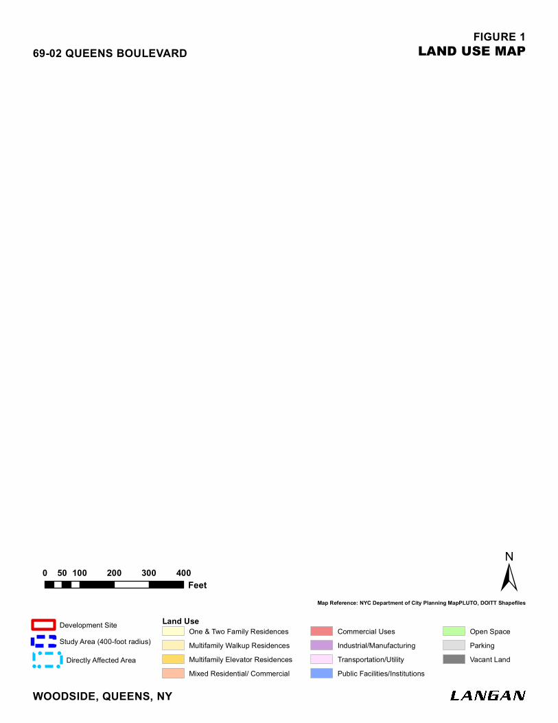
2) DESCRIPTION OF THE SURROUNDING AREA
As shown in Figure 1, the 400-foot radius surrounding the Directly Affected Area (“Study Area”) is
characterized by a mix of one- and two-family and multifamily walk-up residences to the north and
southwest; commercial and industrial uses along Queens Boulevard and 47th Avenue to the
southeast; and community facility uses to the south. Lots 23, 26, 34, and 37 on the northeast corner
of Block 2432 are currently being developed with a nine-story residential building. A LIRR right-of-
way runs adjacent to the Development Site on the southwestern corner of Block 2432 (Lot 1); Queens
Boulevard runs east-west along the north side. The block to the southeast of the Development Site is
occupied by Saint Mary’s Church and includes the church, church rectory, a School for Language &
Communication Development (an intermediate school), and SCO Family Services.
The predominant zoning classifications within the Study Area are residential zoning districts R4-1,
R4, R5, and R7X. There is a C2-3 commercial overlay along Queens Boulevard and an M1-1
manufacturing zoning district to the south of the Development Site (Figure 2). The Development Site
is served by New York City Transit (NYCT) bus lines that include the Q47 running north-south on
69th Street, the Q60 and X63 running east-west on Queens Boulevard, and the Q18 running three
blocks west of the Development Site on 65th Place. The northbound Q47 and eastbound Q60 stop on
the northwestern corner of the Development Site. In addition, the LIRR Woodside Station is
approximately 0.7 miles to the northwest of the Development Site.
2 For the purpose of this analysis, development contemplated in the With-Action Condition would include 20 percent of the residential floor area (101 dwelling units) as affordable for families with incomes at or below 80 percent AMI.
!!
!!
!
!!!!!!!!!
!!
!!
!!
!!
!!
!!
!!
69 S
TREE
T
48 AVENUE
47 AVENUE
70 S
TREE
T
44 AVENUE
49 AVENUE
45 AVENUE
72 STREET68 S
TREE
T
QUEENS BOULEVARD
QUEENS BOULEVARD
FIGURE 1
0 100 200 300 40050Feet
LAND USE MAP
WOODSIDE, QUEENS, NY
69-02 QUEENS BOULEVARD
Map Reference: NYC Department of City Planning MapPLUTO, DOITT Shapefiles±
One & Two Family ResidencesMultifamily Walkup ResidencesMultifamily Elevator ResidencesMixed Residential/ Commercial
Commercial UsesIndustrial/ManufacturingTransportation/UtilityPublic Facilities/Institutions
Open SpaceParkingVacant Land
Land UseDevelopment SiteStudy Area (400-foot radius)
!
! !
!! Directly Affected Area

!!
!!!
!!
!
!!
72 S
T.
QUEENS BLVD.
44 AVE.
67 S
T.
66 S
T.
45 AVE.
QUEENS BLVD.
69 S
T.47 AVE.
72 ST.
70 S
T.
0 750 1,500375Feet
EXISTING ZONING MAP
WOODSIDE, QUEENS, NY
69-02 QUEENS BOULEVARD
Map Reference: NYC Department of City Planning MapPLUTO, Zoning Boundary Shapefiles
±
FIGURE 2!
!
!
! Directly Affected Area Development SiteStudy Area (400-foot radius)
Zoning District
! ! !
! ! !Commercial Overlay
69-02 Queens Boulevard Technical Memorandum 003 CEQR No. 18DCP132Q 13 December 2019
Page J-6
3) DESCRIPTION OF THE DEVELOPMENT SITE
The Development Site is located at 69-02 Queens Boulevard and comprises Block 2432, Lots 8, 9, 21,
41, 44, and 50; these seven tax lots have a total area of approximately 71,907 square feet (sf) (Figure
3). The Development Site is bounded by Queens Boulevard to the north; 70th Street to the east; 47th
Avenue to the south; elevated LIRR tracks to the southwest; and 69th Street to the west. Lots 8, 9 and
21 comprise the northwestern part of the site. Lots 41, 44, and 50 comprise the southeastern part of
the site. As a result of the approval of the Proposed Actions on October 31, 2018, the entire
Development Site is mapped with an R7X zoning district and a C2-3 commercial overlay and falls
within a designated Mandatory Inclusionary Housing (MIH) area.
The northwestern part of the Development Site comprises Lots 8, 9 and 21. Lot 9 is currently vacant
and was previously improved with a one-story building used as a gas station/car wash and an auto
repair shop; Lots 8 and 21 are currently vacant. The southwestern part of the Development Site
comprises Lots 41 and 50, which are currently vacant, and Lot 44, which is improved with a one-
story warehouse building occupied by a floral decorating business.
4) MODIFIED PROJECT
The requested site plan minor modification would facilitate the construction of one 15-story (161.5-
foot) mixed residential/commercial building and one 12-story (140-foot) residential building,
totaling approximately 548,620 gsf (the “Modified Project”). The Modified Project would comprise
approximately 405,848 gsf of mixed-income residential area (505 dwelling units), of which
approximately 30 percent (152 dwelling units) would be permanently affordable for families with
incomes averaging 80 percent AMI pursuant to Option 2 of the MIH program; approximately 15,033
sf of ground floor retail space; an approximately 81,484 gsf community facility (school); an
approximately 7,293-square-foot (0.17-acre) publicly accessible landscaped pedestrian walkway;
and approximately 46,255 gsf of accessory parking (238 parking spaces)3 using double stackers
accessed by an existing curb cut on 69th Street. Additionally, the Modified Project would implement
the same minor signal timing improvements at the intersections of Queens Boulevard and 69 Street
and Queens Boulevard and 70 Street as were described in Technical Memorandum 001.4 To facilitate
such improvements, the DCP or the Applicant will inform the New York City Department of
Transportation (DOT) in writing, six (6) months prior to completion and operation of the proposed
project for the implementation of the proposed improvements.
3 23 spaces for income restricted units at 15 percent of the total affordable units (152 units) (ZR §25-251 and §36-33); and 177 spaces for market-rate units at 50 percent of the total market-rate units (354 units) (ZR §36-33 and §25-23); and 38
spaces for commercial use at 1 per 400 sf of commercial floor area (ZR §36-21). 4 At the intersection of Queens Boulevard and 69 Street, minor signal timing improvements would be made during the weekday AM and weekday afternoon peak hours. At the intersection of Queens Boulevard and 70 Street, minor signal timing improvements would be made during the weekday AM peak hour.
69-02 Queens Boulevard Technical Memorandum 003 CEQR No. 18DCP132Q 13 December 2019
Page J-7
The 15-story (161.5-foot) mixed residential/commercial building would front Queens Boulevard
(“West Tower”) and would include the following:
Approximately 243,520 gsf of residential area (314 dwelling units) on floors 2 through 15.
Approximately 94 dwelling units would be permanently affordable for families with incomes
averaging 80 percent AMI; and5
Approximately 15,033 gsf of retail space fronting Queens Boulevard.
The 12-story (140-foot) mixed residential/community facility building would front 47th Avenue
(“East Tower”) and would include the following:
Approximately 162,326 gsf of residential use (191 dwelling units) on floors 1 through 12.
Approximately 57 dwelling units would be permanently affordable for families with incomes
averaging 80 percent AMI.6
An approximately 81,484 gsf community facility (elementary/ intermediate school).
The Modified Project would be developed in a single phase. Construction would commence as soon
as the requested site plans and building permits are granted. The Modified Project would be
constructed over an approximately 22 month period by the end of 2021, and the residential and
commercial portions would be anticipated to be operational by the end of 2021. However, as a result
of the site selection period and fit out process for the proposed elementary/intermediate school, the
build year for the purposes of this assessment would be 2025.
As stated in the August 31 EAS, in the No-Action Condition, Lots 9, 21, and 41 would be developed
with a 12-story, approximately 311,596-gross-square-foot (gsf) mixed residential/commercial
building. Development in the No-Action Condition would include (i) approximately 5,460 sf of
commercial space on the ground floor fronting Queens Boulevard; (ii) approximately 226,840 gsf of
residential space (289 dwelling units, of which 58 units would be affordable); and (iii) approximately
79,296 gsf of at-grade and below-grade parking (124 spaces). The No-Action Condition would also
include the existing two-story, approximately 10,943-gsf community center and surface parking (25
spaces) on Lot 50. A portion of the existing one-story commercial warehouse on Lot 44 would be
demolished to accommodate the development in the No-Action Condition; the remaining portion of
the existing warehouse would continue to operate as a warehouse facility.
5 For purposes of this environmental review, the Modified Project contemplates that 20 percent of the residential floor area in the West Tower (63 dwelling units) would be allocated as affordable for families with incomes at or below 80 percent AMI. 6 For purposes of this environmental review, the Modified Project contemplates that 20 percent of the residential floor area in the East Tower (38 dwelling units) would be allocated as affordable for families with incomes at or below 80
percent AMI.

!!
!!
!
!!!!!!!!!
!!
!!
!!
!
!
!
!
!!
!
!
8
69 ST
REET
48 AVENUE
47 AVENUE
70 ST
REET
44 AVENUE
49 AVENUE
QUEENS BOULEVARD
45 AVENUE
72 STREET68 ST
REET
QUEENS BOULEVARD
450.27
225
275.18
404.3
130
82
234.11
90
12583
79
75
200.0
1
100
194.46
70
192.66
185.12
175.11
179.19
58
171.4
6
156.87
135.8
128.1
155.75
156.02
152.1
5
153.99
125.1
150.09
110.8
97.3
30
143.42 147.88
51
134.83
140.32
131.69
48
106.2
49
129.5
4
97.29
129.89
82.5
122.02
100.4
121.48
81.4
125.08
120.07
99.02
116.33
71.7
76.594.56
121.82
77.7
22
97.99
95.86
94.76
98.53
94.41
166.17
43
90.99
90.69
91.06
105.49
101.67
90.05
89.29
89.53
91.41
63.5
106.74
89.35
104.96
108.06
87.05
60.4
80.38
80.54
100.77
102.9
8
81.39
83.32
81.12
63.6
78.85
77.56
74.53
80.04
78.17
74.04
76.24
106.1
7
18.88
59.9
74.25
30
58.9
32
78.53
70.04
55.6
69.12
57.7
65.26
66.71
65.77
68.59
62.15
60.56
65.99
62.75
62.52
59.78
55.82
25.6455.76
24
52.25
50.26
52.12
47.13
50.04
49.56
50.03
47.52
50.02
47.69
20
42.78
43.21
19
21.01
43.96
41.37
20.84
39.05
20.83
49.04
35.89
32.04
17.07
7
30.97
33.64
32.23
34.77
23.6
29.11
30.15
30.04
30.56
29.28
29.19
28.51
21.6
26.03
25.03
27.25
28.29
29.02
26.02
23.67
24.68
20.5
17.5
20.49
22.61
20.77
21
18.01
11.23
25
21
50.03
21
25.02
0
100
25
28
100
28
100
100.0
6
25
100.0
6
50.03
112.5
21
100.12
45
25.01
25.01
25.01
50 29
50
21.02
112.5
25
100.08
20
150.09
100.0
5
75.03
100.0
5
25.01
80.05
100.06
50.03
49
70.02
100
100.06
47.13
25.01
25.01
50
100.05
80.04
112.5
25
100
80.05
25
50 100
50.04
29
25
100.06
22
100.0
5
25
28.51100.05
30
29 25
100.0
6
20
100.0
5
50.03
50
25
450.27
100.0
6
25
0
25
25
25.01
100
145.09
25.01
25.01
29
50 28
25
23.25
80.05
80.05
30.43
50
90.69
100.05
50.03
0
50
50.03
100.12
22
100
100
29.19
25.02
25
50
30
21
22.25
1351
2431
2448
2432
244524332430
24342429
2444
1352
1350
1348
1347
1
1
12
57923
50
23
1
40
20
1
6
51
25
3
8
44
33
14
182
40
75
66
16
27
4
1
2
9
57
32
1
1
1
6
12
32
22
53
514 7
35
26
38
24
39
20
3
36
46
31
36
61
22
41
94
54
7
49
1
4
4
87
1
5
67 5
8
13
9
3
80
26
26
45
109
21
21
8
26
25
1
54
4
34
9
96
928
23
37
11
5
9
1
10
34
7
75
6
7
60
4 9 11
39
264
57
58
3437
8
14
81
38
60
80
22201917
53
28
89
69
16
29
85
48
51
34
16
90
72 667077
55
7573
84 79
31
3
78
7
383732
29
36
6
91
52
10
15
16
28
13
47
49
46
18
8
40
1
16
56
43
11 63
42
29
61
17
44
28
46
2
52
4345
13
10
41
38
58
30
34
83
32
74
35
26
17
56
39
45
23
3129
10
96
45
55
43
41
19
36
4110
48
5413
87
30
34
11
50
3830 32
7
10
27
31
12
99
92
20
37
33
142
35
21
1922
1312
103
64
3716
11
45
24
20
69
98
26
65
27
20
10
14
17
21
49
48 28
25
52
70
98
18 19
95
472315
4
26
2524
42
27
153
6
71
28
17
99
35
25
21
23
100
4443
46
42
72
19
22
25
45
4
24
10
18
20
12
32 35
102
43
18
11
100
20
23
12
109
41
14
46
10
FIGURE 3
0 100 200 300 40050Feet
TAX MAP
WOODSIDE, QUEENS, NY
69-02 QUEENS BOULEVARD
Map Reference: Aerial Image from NearMap; and NYC Department of City Planning MapPLUTO and LION Shapefiles.
9
±Tax BlockDevelopment Site 2432 Tax Lot Directly Affected Area
!
!
!
!

69-02 Queens Boulevard Technical Memorandum 003 CEQR No. 18DCP132Q 13 December 2019
Page J-9
Proposed Minor Modifications
The Modified Project would not result in a building footprint that exceeds or differs substantially
from what was assessed in the August 31 EAS or Technical Memorandum 001. However, the
Development Site would be expanded to include Block 2432 Lot 8. In contrast to the development
contemplated in the August 31 EAS, the Modified Project would result in an increase of community
facility floor area and a reduced residential component. The approximately 548,620 gsf mixed use
Modified Project comprises approximately 405,848 gsf of residential floor area (505 dwelling units,
of which, approximately 152 would be permanently affordable), 15,033 gsf of commercial floor area,
an approximately 81,484 gsf community facility (school), and approximately 46,255 gsf of parking
area (238 parking spaces).
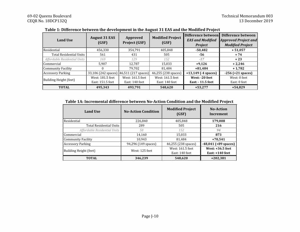
As shown in Table 1, the Modified Project would result in a net decrease of approximately 50,482 gsf
of residential area (56 total dwelling units, including 17 permanently affordable dwelling units), a
net increase of approximately 9,126 gsf of commercial floor area, a net increase of approximately
81,484 gsf of community facility floor area (school), and a net decrease of approximately four (4)
parking spaces.
Compared to the development in the No-Action Condition, as shown in Table 1A, the Modified Project
would result in a net increase of approximately 179,008 gsf of residential area (216 total dwelling
units, including 94 permanently affordable dwelling units), a net increase of approximately 873 gsf
of commercial floor area, a net increase of approximately 70,541 gsf of community facility floor area
(school), and a net increase of approximately 89 parking spaces.
69-02 Queens Boulevard Technical Memorandum 003 CEQR No. 18DCP132Q 13 December 2019
Page J-10
Table 1: Difference between the development in the August 31 EAS and the Modified Project
Land Use August 31 EAS
(GSF)
Approved
Project (GSF)
Modified Project
(GSF)
Difference between
EAS and Modified
Project
Difference between
Approved Project and
Modified Project
Residential 456,330 354,791 405,848 -50,482 + 51,057
Total Residential Units 561 431 505 -56 + 74
Affordable Residential Units 169 129 152 -17 + 23
Commercial 5,907 12,787 15,033 +9,126 + 2,246
Community Facility 0 79,702 81,484 +81,484 + 1,782
Accessory Parking 33,106 (242 spaces) 46,511 (217 spaces) 46,255 (238 spaces) +13,149 (-4 spaces) -256 (+21 spaces)
Building Height (feet) West: 181.5 feet
East: 151.5 feet
West: 161.5 feet
East: 140 feet
West: 161.5 feet
East: 140 feet
West: -20 feet
East: - 11.5 feet
West: 0 feet
East: 0 feet
TOTAL 495,343 493,791 548,620 +53,277 +54,829
Table 1A: Incremental difference between No-Action Condition and the Modified Project
Land Use No-Action Condition Modified Project
(GSF)
No-Action
Increment
Residential 226,840 405,848 179,008
Total Residential Units 289 505 216
Affordable Residential Units 58 152 94
Commercial 14,160 15,033 873
Community Facility 10,943 81,484 +70,541
Accessory Parking 94,296 (149 spaces) 46,255 (238 spaces) -48,041 (+89 spaces)
Building Height (feet) West: 125 feet West: 161.5 feet
East: 140 feet
West: +36.5 feet
East: +140 feet
TOTAL 346,239 548,620 +202,381
69-02 Queens Boulevard Technical Memorandum 003 CEQR No. 18DCP132Q 13 December 2019
Page D-1
5) ASSESSMENT OF PROPOSED MODIFICATIONS
The Modified Project would result in a decrease in the number of residential dwelling units (505)
compared to the development contemplated in the August 31 EAS (561 dwelling units). The Modified
Project would result in an increase in commercial and community facility floor area compared to the
development contemplated in the August 31 EAS. Specifically, the Modified Project includes an
increase of approximately 9,126 gsf of commercial floor area and an increase of approximately
81,484 gsf of community facility floor area (school). These additional commercial and community
facility uses were not assessed in the August 31 EAS, but were assessed in Technical Memorandum
001.
Compared to the Approved Project, the Modified project would result in an increase of approximately
74 dwelling units, an increase of 2,246 gsf of commercial space, and an increase of 1,782 gsf of
community facility area. The Modified Project would also result in an increase of approximately 21
parking spaces compared to the Approved Project. However, the building heights of the Modified
Project would remain the same as the Approved Project.
A. COMMUNITY FACILITIES AND SERVICES
Public Schools
While the Modified Project would result in fewer dwelling units than what was assessed in the August
31 EAS, because the build year has been extended to 2025, a revised community facilities assessment
is warranted.
Elementary and Intermediate Schools
As disclosed in the August 31 EAS, in the With-Action Condition, elementary schools within Sub-
district 2 of Community School District (CSD) 24 (the “School Study Area”) would operate with a
deficit of approximately 793 seats. The increase in the elementary school utilization rate from the
future No-Action to the future With-Action condition would be approximately 1.65 percent.
Intermediate schools within Sub-district 2 of CSD 24 would operate with a deficit of approximately
1,793 seats. The increase in the intermediate school utilization rate between the No-Action and With-
Action Condition would be approximately 0.67 percent.
The August 31 EAS concluded that development in the With-Action Condition would result in a
combined7 elementary and intermediate school utilization rate (the “collective utilization rate”) of
approximately 127 percent. Compared to the No-Action Condition, the development in the With-
Action Condition would result in an increased elementary school utilization rate of approximately
1.65 percent, and an increased intermediate school utilization rate of approximately 0.67 percent.
Although elementary and intermediate schools within the School Study Area would continue to
operate at a deficit (i.e., above their designed capacity) the increase in the collective utilization rates
7 The average of the utilization rates of elementary and intermediate schools.
69-02 Queens Boulevard Technical Memorandum 003 CEQR No. 18DCP132Q 13 December 2019
Page J-12
would be less than the threshold set forth by the CEQR Technical Manual (five (5) percent)
representing the potential to result in an adverse environmental impact.
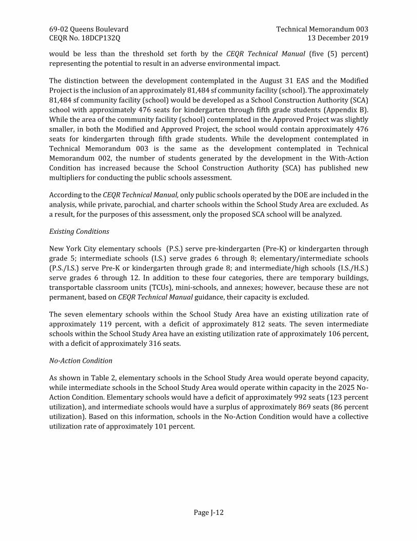
The distinction between the development contemplated in the August 31 EAS and the Modified
Project is the inclusion of an approximately 81,484 sf community facility (school). The approximately
81,484 sf community facility (school) would be developed as a School Construction Authority (SCA)
school with approximately 476 seats for kindergarten through fifth grade students (Appendix B).
While the area of the community facility (school) contemplated in the Approved Project was slightly
smaller, in both the Modified and Approved Project, the school would contain approximately 476
seats for kindergarten through fifth grade students. While the development contemplated in
Technical Memorandum 003 is the same as the development contemplated in Technical
Memorandum 002, the number of students generated by the development in the With-Action
Condition has increased because the School Construction Authority (SCA) has published new
multipliers for conducting the public schools assessment.
According to the CEQR Technical Manual, only public schools operated by the DOE are included in the
analysis, while private, parochial, and charter schools within the School Study Area are excluded. As
a result, for the purposes of this assessment, only the proposed SCA school will be analyzed.
Existing Conditions
New York City elementary schools (P.S.) serve pre-kindergarten (Pre-K) or kindergarten through
grade 5; intermediate schools (I.S.) serve grades 6 through 8; elementary/intermediate schools
(P.S./I.S.) serve Pre-K or kindergarten through grade 8; and intermediate/high schools (I.S./H.S.)
serve grades 6 through 12. In addition to these four categories, there are temporary buildings,
transportable classroom units (TCUs), mini-schools, and annexes; however, because these are not
permanent, based on CEQR Technical Manual guidance, their capacity is excluded.
The seven elementary schools within the School Study Area have an existing utilization rate of
approximately 119 percent, with a deficit of approximately 812 seats. The seven intermediate
schools within the School Study Area have an existing utilization rate of approximately 106 percent,
with a deficit of approximately 316 seats.
No-Action Condition
As shown in Table 2, elementary schools in the School Study Area would operate beyond capacity,
while intermediate schools in the School Study Area would operate within capacity in the 2025 No-
Action Condition. Elementary schools would have a deficit of approximately 992 seats (123 percent
utilization), and intermediate schools would have a surplus of approximately 869 seats (86 percent
utilization). Based on this information, schools in the No-Action Condition would have a collective
utilization rate of approximately 101 percent.
69-02 Queens Boulevard Technical Memorandum 003 CEQR No. 18DCP132Q 13 December 2019
Page J-13
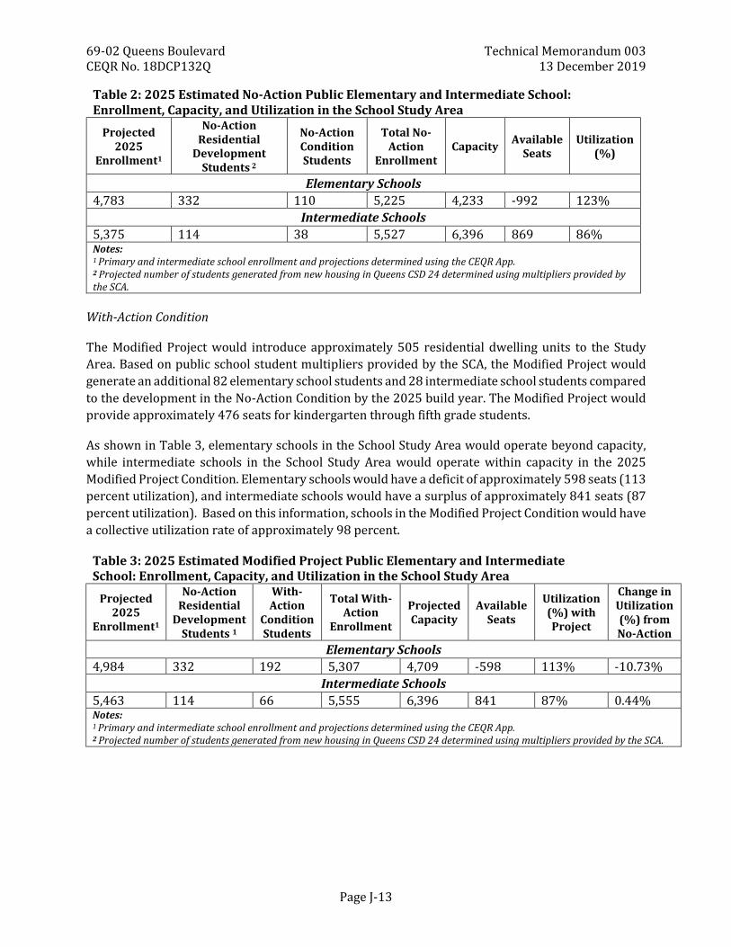
Table 2: 2025 Estimated No-Action Public Elementary and Intermediate School: Enrollment, Capacity, and Utilization in the School Study Area
Projected 2025
Enrollment1
No-Action Residential
Development Students 2
No-Action Condition Students
Total No-Action
Enrollment Capacity
Available Seats
Utilization (%)
Elementary Schools
4,783 332 110 5,225 4,233 -992 123%
Intermediate Schools
5,375 114 38 5,527 6,396 869 86% Notes: 1 Primary and intermediate school enrollment and projections determined using the CEQR App. 2 Projected number of students generated from new housing in Queens CSD 24 determined using multipliers provided by the SCA.
With-Action Condition
The Modified Project would introduce approximately 505 residential dwelling units to the Study
Area. Based on public school student multipliers provided by the SCA, the Modified Project would
generate an additional 82 elementary school students and 28 intermediate school students compared
to the development in the No-Action Condition by the 2025 build year. The Modified Project would
provide approximately 476 seats for kindergarten through fifth grade students.
As shown in Table 3, elementary schools in the School Study Area would operate beyond capacity,
while intermediate schools in the School Study Area would operate within capacity in the 2025
Modified Project Condition. Elementary schools would have a deficit of approximately 598 seats (113
percent utilization), and intermediate schools would have a surplus of approximately 841 seats (87
percent utilization). Based on this information, schools in the Modified Project Condition would have
a collective utilization rate of approximately 98 percent.
Table 3: 2025 Estimated Modified Project Public Elementary and Intermediate School: Enrollment, Capacity, and Utilization in the School Study Area
Projected 2025
Enrollment1
No-Action Residential
Development Students 1
With-Action
Condition Students
Total With-Action
Enrollment
Projected Capacity
Available Seats
Utilization (%) with Project
Change in Utilization (%) from No-Action
Elementary Schools
4,984 332 192 5,307 4,709 -598 113% -10.73%
Intermediate Schools
5,463 114 66 5,555 6,396 841 87% 0.44% Notes: 1 Primary and intermediate school enrollment and projections determined using the CEQR App. 2 Projected number of students generated from new housing in Queens CSD 24 determined using multipliers provided by the SCA.
69-02 Queens Boulevard Technical Memorandum 003 CEQR No. 18DCP132Q 13 December 2019
Page J-14
Due to the addition of a school in the Modified Project, the elementary school utilization rate would
decrease by approximately 10.73 percent and the intermediate school utilization rate would increase
by approximately 0.44 percent, compared to the No-Action Condition. Neither the project analyzed
in the August 31 EAS, the Approved Project analyzed in Technical Memorandum 001, nor the
Modified Project (as analyzed in Technical Memorandum 002) resulted in a significant adverse
impact on schools.
Conclusion
Based on the assessment above, the Modified Project would result in a collective utilization rate of
approximately 98 percent. The decrease in the collective utilization rate is comprised of a -10.73
percent decrease in primary school utilization and a 0.44 percent increase in intermediate school
utilization. Although elementary schools within the School Study Area would continue to operate
beyond their designed capacity, the Modified Project would alleviate capacity restraints.
Intermediate schools in the School Study Area would operate with a surplus of approximately 841
seats in the Modified Project Condition.
Based on this information, the Modified Project is not anticipated to result in any adverse
environmental effects to community facilities and services, therefore no further analysis is
warranted, and the conclusions of the August 31 EAS and/or Technical Memorandum 001 would not
change.8
Child Care Centers
The Modified Project would result in a decrease of approximately 17 low- to moderate-income units
beyond what was assessed in the August 31 EAS. Based on this information, the number of project-
generated children under the age of six who would be eligible for publicly funded child care programs
would not increase beyond what was assessed in the August 31 EAS. Therefore, the Modified Project
would not result in any new adverse environmental effects to publicly funded child care programs,
and the conclusions of the August 31 EAS and/or Technical Memorandum 001 would not change.
Libraries
As concluded in the August 31 EAS, the development contemplated in the August 31 EAS would not
result in a five percent or more increase in the ratio of residential units to library branches – the
CEQR threshold for determining impacts to library services. The Modified Project would result in the
development of approximately 56 fewer residential dwelling units than the development
contemplated in the August 31 EAS. Therefore, the Modified Project would generate fewer residents
than the project contemplated in the August 31 EAS, and thus, would not meet the threshold for
library analysis.
Based on this information, the Modified Project would not result in any adverse environmental
effects to libraries, and the conclusions of the August 31 EAS and/or Technical Memorandum 001
would not change.
8 The development contemplated in the August 31 EAS would not have been anticipated to result in adverse
environmental effects to community facilities and services.
69-02 Queens Boulevard Technical Memorandum 003 CEQR No. 18DCP132Q 13 December 2019
Page J-15
Health Care Facilities
The Modified Project would not result in the development of a sizeable neighborhood where none
existed before; thus, the Modified Project does not meet the threshold for analysis of health care
facilities. Therefore, the Modified Project would not result in any new adverse environmental effects
to health care facilities, and the conclusions of the August 31 EAS and/or Technical Memorandum
001 would not change.
Police Services
The Modified Project would neither result in direct effects on the physical operations of, or access to
and from, any New York Police Department (NYPD) precinct house, nor result in a sizeable new
neighborhood where none existed before. An assessment of the Modified Project as it relates to police
services is not required. The Modified Project would not result in any new adverse environmental
effects to police services; therefore, the conclusions of the August 31 EAS and/or Technical
Memorandum 001 would not change.
Fire Protection
The Modified Project would neither result in direct effects on the physical operations of, or access to
and from, any Fire Department of the City of New York (FDNY) facility, nor result in a sizeable new
neighborhood where none existed before; therefore, a detailed assessment of fire protection services
is not required. The Modified Project would not result in any new adverse environmental effects to
fire protection services, and the conclusions of the August 31 EAS and/or Technical Memorandum
001 would not change.

69-02 Queens Boulevard Technical Memorandum 003 CEQR No. 18DCP132Q 13 December 2019
Page J-16
6) CONCLUSION
Shortly after the publication of the Revised EAS dated November 27, 2019, new data was released by
the NYC School Construction Authority (SCA) including Projected Public School Ratios (housing
multipliers). Since the newly released data indicated an increase in the number of pupils generated
for all grade levels by new housing in the CSD 24, the community school district in which the Modified
Project is situated, the purpose of this Technical Memorandum is to provide an updated assessment
using the new housing multiplier data in order to more conservatively and accurately estimate the
number of pupils anticipated to be generated by the Modified Project.. As determined by the
assessment of Community Facilities, no significant adverse impacts related to public schools would
result from the Modified Project, and the results of the assessment do not alter the conclusions of the
Revised EAS dated November 27, 2019.
Accordingly, as demonstrated herein, the Modified Project would not result in any new
environmental effects that had not been previously disclosed in the August 31 EAS, Technical
Memorandum 001, and/or Technical Memorandum 002.