180228 theta hill drilling results and tgme project update · for the tgme project, with a number...
TRANSCRIPT

Stonewall Resources Limited ABN 30 131 758 177 Level 18, 111 Pacific Highway, North Sydney NSW 2060 Tel: (02) 9460 2021 Email: [email protected] www.stonewallresources.com
28 February 2018 Australian Securities Exchange Level 5, 20 Bridge Street SYDNEY NSW 2000
ASX ANNOUNCEMENT
Theta Hill Drilling Results & TGME Project Update Stonewall Resources Limited (ASX: SWJ, SWJO) (“The Company”) is pleased to provide an update on the TGME gold project in South Africa, including ongoing drilling at the Theta Hill prospect.
Summary
Further positive drilling results at Theta Hill received including:
o 1m @ 11g/t Au from 29m (RCBH55B);
o 1m @ 9.2g/t Au from 23m (RCBH51);
o 1m @ 10.4g/t Au from 51m (RCBH46B); and
o 1m @ 9.6g/t Au from 55m (RCBH61)
in shallow, flat lying gold reef (Implied in‐situ grade over 0.3m is approximately 30g/t Au).
Diamond drilling rig currently mobilising to Theta Hill site, ahead of maiden open‐cut resource estimation work planned
Engineering groups on‐site to assess the existing CIL plant last operated in 2015 as a prelude to providing cost of refurbishment & plant expansion details
Rietfontein de‐watering to level 4 is ongoing, as part of plans for underground sampling, resource drilling and preliminary development work
Steady repayment of debt including variable convertible loan (Lind) by $130,000 per month (current balance $1million).
South Africa listed by Goldman Sachs as the best emerging market story of 2018 recently, with the election of President Cyril Ramaphosa seen as a major positive for the economy
Stonewall MD Rob Thomson commented, “Based on the confidence we are gaining on the likelihood of declaring open cut reserves later in 2018, we are accelerating development plans for the TGME project, with a number of activities underway including drilling, engineering assessment and progressing of approvals. We are aiming to be in a position, subject to financing, to be able to commence plant refurbishment and submit mine plans for approval in 2H’2018. Our Indaba, Cape Town presentation was well received and generated interest from a number of groups keen to assist us with development plans. In addition to investing significantly in our development plans we have also reduced overall debt levels including steady repayment of the variable convertible loan (Lind) by $130,000 per month (current balance $1million).
For
per
sona
l use
onl
y

2
Given the encouraging developments and progress and the renewed investment interest in South African under new President Cyril Ramaphosa, we believe now is the time to ramp‐up our activities to the next level orientated towards re‐establishing gold production”.
The second drilling program at Theta Hill continues, with plans to complete 27 holes, for approximately 1,500m of RC drilling. Assays continue to indicate that high grade, oxide gold resources will be established. A diamond drill rig on site this week will provide accurate information on reef thickness, and overcome some of the issues relating to ground conditions which have hampered the recent RC drilling.
The location of the project is shown in Figure 1, with drill hole locations illustrated in Figure 2.
Figure 1) Regional map showing location of Theta Hill and Columbia Hill target areas
For
per
sona
l use
onl
y

3
Figure 2) Location of Phase 2 drilling at Theta Hill
Since the recommencement of drilling on Theta Hill in January 2018, a total of 20 out of a planned 27 holes have been drilled with 7 completed to depth and the remaining thirteen planned for diamond tail drilling. All the assays have been received except for 3 holes which are due early next week.
Drilling planned for this phase, shown in metres below:
Drilling Method Planned Actual Remaining
Reverse Core (RC) Total 1,413 918 495
RC Pilot 588 538 50
RC Only 825 380 445
Diamond Total 436 0 436
Diamond tail on RC 436 0 436
The remaining RC holes are expected to be completed within the next 2 weeks and the Diamond rig is expected on site over the weekend with drilling to commence on Monday 5 March 2018 for a period of around 4 weeks.
Encouraging assays continue to be received from Theta Hill, including:
1m @ 11g/t Au from 29m (RCBH55B) – Lower Theta reef
1m @ 9.2g/t Au from 23m (RCBH51) – Lower Theta reef
1m @ 6.8g/t AU from 43m (RCBH45) – Lower Theta reef
1m @ 10.4g/t Au from 51m (RCBH46B)‐ Lower Theta reef
1m @ 9.6g/t Au from 55m (RCBH61)‐ Lower Theta reef
For
per
sona
l use
onl
y
4
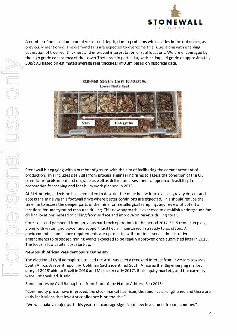
A number of holes did not complete to total depth, due to problems with cavities in the dolomites, as previously mentioned. The diamond tails are expected to overcome this issue, along with enabling estimation of true reef thickness and improved interpretation of reef locations. We are encouraged by the high grade consistency of the Lower Theta reef in particular, with an implied grade of approximately 30g/t Au based on estimated average reef thickness of 0.3m based on historical data.
Stonewall is engaging with a number of groups with the aim of facilitating the commencement of production. This includes site visits from process engineering firms to assess the condition of the CIL plant for refurbishment and upgrade as well as deliver an assessment of open‐cut feasibility in preparation for scoping and feasibility work planned in 2018.
At Rietfontein, a decision has been taken to dewater the mine below four level via gravity decant and access the mine via this footwall drive where better conditions are expected. This should reduce the timeline to access the deeper parts of the mine for metallurgical sampling, and review of potential locations for underground resource drilling. This new approach is expected to establish underground fan drilling locations instead of drilling from surface and improve on reserve drilling costs.
Core skills and personnel from previous hard‐rock operations in the period 2012‐2015 remain in place, along with water, grid power and support facilities all maintained in a ready to go status. All environmental compliance requirements are up to date, with routine annual administrative amendments to proposed mining works expected to be readily approved once submitted later in 2018. The focus is low capital cost start‐up.
New South African President Spurs Optimism
The election of Cyril Ramaphosa to lead the ANC has seen a renewed interest from investors towards South Africa. A recent report by Goldman Sachs identified South Africa as the ‘Big emerging market story of 2018’ akin to Brazil in 2016 and Mexico in early 2017’. Both equity markets, and the currency were undervalued, it said.
Some quotes by Cyril Ramaphosa from State of the Nation Address Feb 2018:
“Commodity prices have improved, the stock market has risen, the rand has strengthened and there are early indications that investor confidence is on the rise.”
“We will make a major push this year to encourage significant new investment in our economy.”
For
per
sona
l use
onl
y

5
“Mining is another area that has massive unrealised potential for growth and job creation. We need to see mining as a sunrise industry.
With the revival in commodity prices, we are determined to work with mining companies, unions and communities to grow the sector, attract new investment, create jobs and set the industry on a new path of transformation and sustainability.
This year, we will intensify engagements with all stakeholders on the Mining Charter to ensure that it is truly an effective instrument to sustainably transform the face of mining in South Africa.
By working together, in a genuine partnership, underscored by trust and a shared vision, I am certain we will be able to resolve the current impasse and agree on a Charter that both accelerates transformation and grows this vital sector of our economy.
Processing of the MPRDA Amendment Bill through both houses of parliament is at an advanced stage, with an indication by Parliament that the Bill will reasonably be finalised during the first quarter of 2018.
The Bill, once enacted into law, will entrench existing regulatory certainty, provide for security of tenure and advance the socio‐economic interests of all South Africans.”
Competent Person Statement The information in this report relating to exploration results is based on, and fairly reflect, the information and supporting documentation compiled by Mr Uwe Engelmann (BSc (Zoo. & Bot.), BSc Hons (Geol.), Pr.Sci.Nat. No. 400058/08, MGSSA), a director of Minxcon (Pty) Ltd and a member of the South African Council for Natural Scientific Professions.
Mr Engelmann has sufficient experience that is relevant to the style of mineralisation under consideration and to the activity being undertaken to qualify as a Competent Person as defined in the 2012 Edition of the Joint Ore Reserves Committee (JORC) Australasian Code for Reporting of Exploration Results, Mineral Resources and Ore Reserves. Mr Engelmann consents to the inclusion in the report of the matters based on his information in the form and context in which it appears.
For
per
sona
l use
onl
y

6
Forward Looking Statement
This announcement may refer to the intention of Stonewall Resources regarding estimates or future events which could be considered forward looking statements. Forward looking statements are typically preceded by words such as “Forecast”, “Planned”, “Expected”, “Intends”, “Potential”, “Conceptual”, “Believes”, “Anticipates”, “Predicted”, “Estimated” or similar expressions. Forward looking statements, opinions and estimates included in this document are based on assumptions and contingencies which are subject to change without notice, and may be influenced by such factors as funding availability, market‐related forces (commodity prices, exchange rates, stock market indices and the like) and political or economic events (including government or community issues, global or systemic events). Forward looking statements are provided as a general reflection of the intention of the Company as at the date of release of this announcement, however are subject to change without notice, and at any time. Future events are subject to risks and uncertainties, and as such results, performance and achievements may in fact differ from those referred to in this announcement. Mining, by its nature, and related activities including mineral exploration, are subject to a large number of variables and risks, many of which cannot be adequately addressed, or be expected to be assessed, in this document. Work contained within or referenced in this document may contain incorrect statements, errors, miscalculations, omissions and other mistakes. For this reason, any conclusions, inferences, judgments, opinions, recommendations or other interpretations either contained in this report, or referencing this report, cannot be relied upon. There can be no assurance that future results or events will be consistent with any such opinions, forecasts or estimates. The Company believes it has a reasonable basis for making the forward looking statements contained in this document, with respect to any production targets, resource statements or financial estimates, however further work to define Mineral Resources or Reserves, technical studies including feasibilities, and related investigations are required prior to commencement of mining. No liability is accepted for any loss, cost or damage suffered or incurred by the reliance on the sufficiency or completeness of the information, opinions or beliefs contained in this announcement.
For
per
sona
l use
onl
y

7
ABOUT STONEWALL RESOURCES LIMITED Stonewall Resources Limited (ASX: SWJ) is a gold development company that holds a range of prospective gold assets in a world‐renowned South African gold mining region. These assets include several surface and near‐surface high‐grade gold projects which provide cost advantages relative to other gold producers in the region.
Stonewall’s core project is TGME, located next to the historical gold mining town of Pilgrim’s Rest, in Mpumalanga Province, some 370km east of Johannesburg by road or 95km north of Nelspruit (Capital City of Mpumalanga Province).
Following small scale production from 2011 – 2015, the Company is currently focussing on the refurbishment of the existing CIL plant and nearby mines with the intention of resuming gold production.
The Company aims to build a solid production platform to over 100kozpa based primarily around shallow, adit‐entry hard rock mining sources. Stonewall has access to over 43 historical mines and prospect areas that can be accessed and explored.
For more information please visit: www.stonewallresources.com
For further information please contact: General Enquiries Investor Enquiries Rob Thomson, Managing Director Bill Guy Stonewall Resources Limited or Stonewall Resources Limited M: +61 409 843 963 P: +61 2 9460 2021 [email protected] [email protected]
For
per
sona
l use
onl
y

8
Table 1: JORC Checklist – Table 1 Assessment and Reporting Criteria
SECTION 1: SAMPLING TECHNIQUES AND DATA Criteria Explanation Detail
Sampling techniques
Nature and quality of sampling (e.g. cut channels, random chips, or specific specialised industry standard measurement tools appropriate to the minerals under investigation, such as down hole gamma sondes, or handheld XRF instruments, etc.). These examples should not be taken as limiting the broad meaning of sampling.
For the phase 2 drilling programme reverse circulation (RC) drilling was conducted on the Bentley Project at Theta Hill to test the current high-level model utilised to determine the exploration targets. The possible target reefs are the Bevetts Reef, Upper Theta Reef, Lower Theta Reef and Beta Reef. The reef widths are generally between 20 cm and 40 cm but the RC drilling at 1 m interval samples was utilised to test the mineralisation and position of the potential reefs in the Project Area. A total of 842 RC rock chip samples were sent for analysis; of these, 73 were QAQC samples. The samples were sent to an accredited laboratory in Barberton, South Africa.
Include reference to measures taken to ensure sample representivity and the appropriate calibration of any measurement tools or systems used.
The reef is fairly flat with an average dip of approximately 8 degrees. The -90 holes therefore allowed for the samples to be taken normal to the reef. At this stage, the 1 m sample will dilute the reef grade and will not provide true reef thicknesses but is deemed to be sufficient for this initial drilling programme. The plan below shows the initial drilling completed in relation to the total drilling plan.
Aspects of the determination of mineralisation that are Material to the Public Report. In cases where ‘industry standard’ work has been done this would be relatively simple (e.g. ‘reverse circulation drilling was used to obtain 1 m samples from which 3 kg was pulverised to produce a 30 g charge for fire assay’). In other cases more explanation may be required, such as where there is coarse gold that has inherent sampling problems. Unusual commodities or mineralisation types (e.g. submarine nodules) may warrant disclosure of detailed information.
The RC drilling samples were taken in 1 m intervals. The entire drillhole was sampled. Each sample was weighted and then quartered by means of a riffle splitter to collect a sample, which is stored at the Sabie core yard for future testwork if required. This sample is between 2 kg and 6 kg in weight. Another 2 kg sample is collected for analysis at the accredited laboratory. The 2 kg sample is used to produce a 50 g aliquot for the fire assay.
Drilling techniques
Drill type (e.g. core, reverse circulation, open-hole hammer, rotary air blast, auger, Bangka, sonic, etc.) and details (e.g. core diameter, triple or standard tube, depth of diamond tails, face-sampling bit or other type, whether core is oriented and if so, by what method, etc.).
Torque Africa Exploration (Pty) Ltd is doing the reverse circulation (RC) drilling on site using a track-mounted Thor drilling machine with cyclone. RC drilling was utilised during the initial drilling phase. The drillhole was not surveyed down the hole as maximum depth of the drilling is 132 m. The collar positions were determined with a Garmin 78s handheld GPS.
Drill sample recovery
Method of recording and assessing core and chip sample recoveries and results assessed.
The RC chips were weighed before splitting and compared to an estimated weight for the 1 m sample if there was 100% recovery in the dolomites. A density of 2.84 t/m3 was used for the dolomite in the weight estimate. Owing to the natural cavities occurring in the dolomites, the
For
per
sona
l use
onl
y

9
SECTION 1: SAMPLING TECHNIQUES AND DATA Criteria Explanation Detail
recoveries were monitored to note the natural cavities or, possibly, an area of historical mining. This was crucial as one of the aims of the drilling programme was to test for the extent of historical mining stopes.
Measures taken to maximise sample recovery and ensure representative nature of the samples.
The RC rock chips were collected via a cyclone directly into a sample bag in order to collect the maximum sample. Care was taken by the drillers to drill slower through areas which had bad ground conditions. In order to ensure the representative nature of the drilled intersections and due to the dip of the reef being very shallow at around 3° to 9° to the west, drillholes were drilled vertically in order to obtain an intersection as close to normal as possible.
Whether a relationship exists between sample recovery and grade and whether sample bias may have occurred due to preferential loss/gain of fine/coarse material.
Sample recovery versus grade has not been assessed to date. However, it has been noted that grade has been observed in higher and lower chip recovery samples. Further diamond drilling will assist in this respect.
Logging
Whether core and chip samples have been geologically and geotechnically logged to a level of detail to support appropriate Mineral Resource estimation, mining studies and metallurgical studies.
All drilled and completed drillholes have been geologically logged in field on the drilling site. Geological logging of rock chips is done “on the go” as soon as sample bags containing rock chips are obtained from the drillers. Geological logging is done on a standard log sheet in the field and the data is captured on computer onto an MS Excel spreadsheet. Using a sieve, the geologist scoops a portion of the sample and cleans it in a bucket of water until the rock chips are free of dust, mud or clay. The geologist uses a hand lens to check the lithology types and alteration and mineralisation such as pyrite, arsenopyrite, chalcopyrite, sericite etc. All identified minerals, alterations and lithologies are then captured onto a geological log sheet for the particular drillhole. The cleaned rock chips are then put in a sample-chip tray in order of drill depths. No geotechnical logging or studies have been completed at this early stage.
Whether logging is qualitative or quantitative in nature. Core (or costean, channel, etc.) photography.
The rock chip logging is both qualitative and quantitative. The drillhole logs are captured in StudioEMTM for electronic logs and the rock chips are stored in chip trays and stored at the Sabie core yard as well as photographed for electronic filing.
The total length and percentage of the relevant intersections logged.
To date, 918 m of RC drilling (20 drillholes) have been completed and all the rock chips have been logged and sampled.
Sub-sampling techniques and sample preparation
If core, whether cut or sawn and whether quarter, half or all core taken.
All the drilling has been RC drilling. Diamond core drilling will follow in the next phase of drilling.
If non-core, whether riffled, tube sampled, rotary split, etc. and whether sampled wet or dry.
The 1 m samples were collected via a cyclone and the total sample was collected. The sample was quartered by means of a riffle splitter and one quarter was kept for achieving purposes at the Sabie core yard. The remaining sample was then split further until a sample of approximately 2 kg was collected for assay purposes. The remainder of the sample was discarded.
For all sample types, the nature, quality and appropriateness of the sample preparation technique.
The sample type is deemed to be appropriate for this initial drilling programme as the aim was to test the presence of the various reefs and the indicative grade. This sampling has given TGME an indication of what the grades may be expected over assumed reef widths, which is based on the previous work completed for the exploration targets.
Quality control procedures adopted for all sub-sampling stages to maximise representivity of samples.
The sample is first weighed, so that the recoveries can be noted, and then split be means of the riffle splitter to acquire representative sub-samples. A quarter is archived and the sample for assaying purposes is riffle split further to a weight of 2 kg. The riffle splitter is also cleaned between each 1 m sample to avoid contamination.
Measures taken to ensure that the sampling is representative of the in situ material collected, including for instance results for field duplicate/second-half sampling.
Even though the reef is narrow ranging between 20 cm and 40 cm (determined from previous work), the 1 m sample will provide a grade over 1 m. This allows for the estimation of the cm.g/t which can be used to estimate a grade over an assumed narrower in situ reef width. This sample is therefore representative of in situ mineralisation.
For
per
sona
l use
onl
y

10
SECTION 1: SAMPLING TECHNIQUES AND DATA Criteria Explanation Detail
Duplicates are requested as part of the assaying protocols as part of the QAQC.
Whether sample sizes are appropriate to the grain size of the material being sampled.
Diamond core drilling will be more suitable for these narrow reefs but for the aim of this initial drilling programme, i.e. to test the presence of the reef and indicative grades, this drilling and sampling methodology are considered to be appropriate. Future drilling will include diamond core drilling and sampling of the reef only, i.e. undiluted.
Quality of assay data and laboratory tests
The nature, quality and appropriateness of the assaying and laboratory procedures used and whether the technique is considered partial or total.
All samples are sent to SGS Barberton which is an accredited laboratory (for the determination of Au by Lead Fusion followed by Atomic Absorption Analysis or Gravimetric) as accredited by SANAS for ISO 17025. Sample Preparation: -
The sample is weighed when received. The sample is dried. Crushed to 80% passing 2 mm. 500 g split by rotary splitter. 500 g split of 2 mm material pulverised to 85%
passing 75 μm in a LM2 puck pulveriser.
Analysis:- Determination of Au by fire assay, AAS/Gravimetric
finish (50 g aliquot). All samples that exhibit a gold concentration of >10
g/t via the AAS finish (M702) are re-assayed via the gravimetric finish (M701).
This sample preparation and analysis is according to best practices for this type of mineralisation.
For geophysical tools, spectrometers, handheld XRF instruments, etc., the parameters used in determining the analysis including instrument make and model, reading times, calibrations factors applied and their derivation, etc.
No assay methods other than those conducted by laboratories as mentioned above were utilised in the generation of the sampling database.
Nature of quality control procedures adopted (e.g. standards, blanks, duplicates, external laboratory checks) and whether acceptable levels of accuracy (i.e. lack of bias) and precision have been established.
As part of the QAQC protocol blank, duplicates and certified reference material (CRMs) from African Mineral Standard are introduced into the sampling stream. Every 20th sample is either a blank, duplicate or CRM. Each drillhole sampling begins with a blank and ends in a blank with every 20th sample being a QAQC sample. In the case of short holes (shorter than 20 m), the hole starts and ends with a blank and a CRM or duplicate is inserted in the sample batch. The QAQC material utilised is as follows: -
Blank: silica sand; Duplicate: a request for another sample either
before or after the duplicate sample to be duplicated;
CRM - AMIS0023: This standard was made of feed material sourced from the Anglo Gold Ashanti Mponeng Gold Mine in South Africa. It represents Ventersdorp Contact Reef ore with diluting Ventersdorp Lava hanging wall and quartzitic footwall from routine underground mining operations. (certified grade is 3.57 g/t with a two-standard deviation of 0.26 g/t).
This data is graphed on a continual basis to monitor the assay quality. In cases where the QAQC samples fail the batch is re-assayed. Of the total of 842 samples submitted for assay, 73 are QAQC samples. This is close to 9%.
Verification The verification of significant No verification of assay results has taken place as yet. The
For
per
sona
l use
onl
y

11
SECTION 1: SAMPLING TECHNIQUES AND DATA Criteria Explanation Detail
of sampling and assaying
intersections by either independent or alternative company personnel.
use of umpire laboratories will be introduced in the next phase of drilling.
Discuss any adjustment to assay data.
No adjustments have been applied to the assay data. TGME will, however, review the sample grades over 1 m and conduct in-house calculations to get an understanding as to what the grade would be over a narrower reef width, which will be assumed from the previous work conducted on the historical mining data that assisted in determining the initial exploration targets.
Documentation of primary data, data entry procedures, data verification, data storage (physical and electronic) protocols.
Geological logging of rock chips is done “on the go” as soon as sample bags containing rock chips are obtained from the drillers. Geological logging is done on a standard log sheet in the field and the data is captured on computer onto an excel spreadsheet. The MS Excel database is also entered into StudioEMTM for the digital capture of the drillhole logs. Here it is verified for overlaps and gaps as well as visual checks. Photographs are taken of all the chip trays (chip trays are stored at the Sabie core yard). In addition to this, representative samples of each metre are taken and place in order on a sheet of plastic and photographed. The archive sample that is collected at the rig is also stored at the Sabie core yard. The samples were also captured in a sample submission form detailing all the information of the sample, i.e. type, QAQC details, ID and from and to.
The use of twinned holes. No twinned holes were drilled.
Location of data points
Accuracy and quality of surveys used to locate drillholes (collar and down-hole surveys), trenches, mine workings and other locations used in Mineral Resource estimation.
A Garmin 78s handheld GPS was utilised for the purpose of locating historical adits and mine entrances, which in turn have been utilised in positioning the historical underground workings in 3D. The new drillhole collar positions have also been marked using the handheld GPS. It is Minxcon’s opinion that the positional accuracy would be within 5 m to 10 m which is within acceptable limits for this initial drilling phase. The collar positions will be surveyed in during the follow up drilling phase.
Specification of the grid system used. The grid system used is Hartebeeshoek 1994, South African Zone WG31.
Quality and adequacy of topographic control.
Minxcon utilised the GPS co-ordinates provided by Stonewall for the adit positions, as well as ventilation openings to assist in verifying and fixing the workings in 3D space. Very good correlation between the digital topography and the underground mining profiles was found.
Data spacing and distribution
Data spacing for reporting of Exploration Results.
Phase 1 drilling programme was designed on a 50 m x 50 m grid. The initial drilling for Phase 1 and phase 2 is however only a selection of these holes and range from a spacing of about 50 m to 250 m spacing. This phase of drilling was not conducted on a specific grid as the focus was on determining the potential of the exploration targets and verifying the current geological model for the Project.
Whether the data spacing and distribution is sufficient to establish the degree of geological and grade continuity appropriate for the Mineral Resource and Ore Reserve estimation procedure(s) and classifications applied.
It is Minxcon’s opinion that the drillhole and sample spacing is adequate for the purpose of conducting meaningful calculations for an Exploration Target in and around stoping areas and for the verification of the current geological model.
Whether sample compositing has been applied.
All samples within the new drilling database represent 1 m “diluted” samples due to the narrow reef in the Project Area.
Orientation of data in relation to geological structure
Whether the orientation of sampling achieves unbiased sampling of possible structures and the extent to which this is known, considering the deposit type.
The reefs are near horizontal and as such dip at between 3° to 9° to the west and strike in a north–south direction. Drillholes were drilled vertically (-90° dip) to intercept the mineralised shear zones at a near perpendicular angle so that the sampling of the drill rock chips minimises the sampling bias. It is Minxcon’s view that sampling orientation has attempted to reduce sample bias with respect to angle of intersection.
For
per
sona
l use
onl
y

12
SECTION 1: SAMPLING TECHNIQUES AND DATA Criteria Explanation Detail
If the relationship between the drilling orientation and the orientation of key mineralised structures is considered to have introduced a sampling bias, this should be assessed and reported if material.
Available information indicates that the drilling orientation provides reasonably unbiased sampling of the mineralisation zones.
Sample security
The measures taken to ensure sample security.
Minxcon site geologists were responsible for the security of all the samples. The site geologists transported the samples to the TGME plant facility, which is in close proximity to the drilling, for safe keeping (overnight) if the samples were not taken directly to the Sabie core yard. At the Sabie core yard, the Minxcon geotechnician signed the samples in and checked their quality. Once accepted, the samples were stored here and QAQC samples introduced before transporting them to the SGS Laboratory in Barberton.
Audits or reviews
The results of any audits or reviews of sampling techniques and data.
Minxcon reviewed all historical datasets attributed to the Bentley Project (Theta Hill), as well as digital plans (scanned DXF plans of sampling plans) and found that captured sample positions had good agreement with those in the digital dataset. However, the recent drilling data has not been through any reviews or audits.
SECTION 2: REPORTING OF EXPLORATION RESULTS Criteria Explanation Detail
Mineral tenement and land tenure status
Type, reference name/number, location and ownership including agreements or material issues with third parties such as joint ventures, partnerships, overriding royalties, native title interests, historical sites, wilderness or national park and environmental settings.
Stonewall holds a 74% shareholding in Transvaal Gold Mining Estates Limited (TGME) (which wholly owns mines reporting to the Bentley Project) and Sabie Mines Proprietary Limited (Sabie Mines), the balance is held by Black Economic Empowerment (BEE) entities. This is in line with the requirements of the South African Mining Charter. The South African Mining Charter requires a minimum of 26% meaningful economic participation by the historically disadvantaged South Africans, i.e. black South Africans (HDSA). The mineral rights as applicable to the Bentley Project are summarised in the following item below.
The security of the tenure held at the time of reporting along with any known impediments to obtaining a licence to operate in the area.
The Bentley Exploration Target confirmatory drilling (phase 1 to 3) spans over the farms Grootfontein 562 KT and Ponieskrantz 548 KT. However, the current drilling is only on the farm Ponieskrantz 548 KT.
Grootfontein 562 KT was previously held under 404PR by TGME. This right, was renewed, expired in February 2017. Application has been submitted for conversion of this 404PR into a mining right under 10167MR. The acceptance letter of this 10167MR excludes Grootfontein 562 KT.
An application has been submitted for a mining right 330MR to encompass Grootfontein 562 KT and Grootfonteinberg 561 KT. Stonewall has indicated that the right has been granted by the DMR but not yet executed. Due to administrative complications at the DMR offices, no written documentation is available in this regard as yet.
Ponieskrantz 543 KT is held under mining right 83MR issued to TGME for gold, silver and copper ore, as well as stone aggregate. The right is valid to 15 October 2023.
Stonewall has indicated that the farm Grootfontein 562 KT is additionally covered in one 341MR, the details of which are unknown to Minxcon. It is highlighted that it is unlawful, in accordance with the MPRDA, to issue multiple mineral rights over the same property for the same mineral and for the same or overlapping period. It is recommended that this be resolved with the DMR.
Exploration done by other parties
Acknowledgment and appraisal of exploration by other parties.
Acknowledgement is hereby made for the historical exploration done by TGME, Simmer and Jack, and other possible unknown historical parties who conducted historical drilling on the properties.
For
per
sona
l use
onl
y

13
SECTION 2: REPORTING OF EXPLORATION RESULTS Criteria Explanation Detail
Geology Deposit type, geological setting and style of mineralisation.
The Bentley Project Gold Mine orebodies are shear hosted quartz-carbonate vein mesothermal gold deposits, with the exception of the Bevett’s lithologies which are thought to represent a later erosional surface which impinged on the other reefs and was later intruded by the Bevett’s Reef. It is thought that the emplacement is possibly associated with the Bushveld Igneous event in South Africa. Pressure and temperature estimates indicate that the ore fluids of the Sabie-Pilgrims Rest Goldfield were similar to other typical mesothermal gold deposits. The mineralisation in the area of interest is principally “flat” bedding parallel shears located mainly on shale partings within Malmani Dolomites. However, mineralisation also occurs in other formations of the Transvaal Supergroup. The ore bodies occur as narrow quartz-carbonate veins (reefs), which occupy bedding parallel faults and shears, and generally conform to the shallow regional dip of the strata. Gold mineralisation is accompanied by various sulphides of Fe, Cu, As and Bi.
Drillhole Information
A summary of all information material to the understanding of the exploration results including a tabulation of the following information for all Material drillholes: * easting and northing of the drillhole collar * elevation or RL (Reduced Level – elevation above sea level in metres) of the drillhole collar * dip and azimuth of the hole * down hole length and interception depth * hole length.
A total of 20 drillholes for some 918 m were completed from the 30 January 2018 until the 15 February 2018 on Theta Hill which forms part of the Bentley Project. Of the 20 drillholes, 17 were abandoned due to bad ground conditions and these will be completed will a diamond tail. The detailed summaries of drillhole easting, northing and elevation of the drillhole collar, as well as the dip and azimuth of the drillholes and final drillhole depth, are presented below.
If the exclusion of this information is justified on the basis that the information is not Material and this exclusion does not detract from the understanding of the report, the Competent Person should clearly explain why this is the case.
All the drillholes that were sampled are being utilised to test the current geological model and grade estimates.
Data aggregation methods
In reporting Exploration Results, weighting averaging techniques, maximum and/or minimum grade truncations (eg cutting of high grades) and cut-off grades are usually Material and should be stated.
All the sampling data is based on the 1 m sample interval. Therefore, all the grades are representative of the full 1 m sample. No top cuts or bottom cuts have been applied. The sample represents a “diluted” in situ grade due to the fact that the reefs are narrow (between 20 cm and 40 cm) and the sample includes hanging wall and footwall dolomite dilution.
Where aggregate intercepts incorporate short lengths of high grade results and longer lengths of low grade results, the procedure used for such aggregation should be stated and some typical examples of such aggregations should be shown in detail.
There is no aggregation of sampling data.
The assumptions used for any reporting of metal equivalent values should be clearly stated.
No metal equivalents were calculated.
XCOLLAR YCOLLAR GPS_Elevation AZIM DIP EOHm ° ° m
RCBH45 -24672 -2757123 1541 0 -90 132 CompletedRCBH47 -24696 -2757068 1540 0 -90 31 Abandoned due to bad ground
RCBH47B -24694 -2757074 1540 0 -90 30 Abandoned due to bad groundRCBH46 -24631 -2757183 1543 0 -90 42 Abandoned due to bad ground
RCBH46B -24623 -2757190 1543 0 -90 74RCBH49 -24696 -2757068 1540 0 -90 45 Abandoned due to thick clayRCBH50 -24601 -2756779 1503 0 -90 22 Abandoned due to thick clayRCBH51 -24624 -2756780 1525 0 -90 42 Abandoned due to thick clayRCBH55 -24661 -2756820 1525 0 -90 17 Abandoned due to cavity
RCBH55B -24655 -2756816 1525 0 -90 40 Abandoned due to cavityRCBH56 -24689 -2756852 1525 0 -90 20 Abandoned due to cavity
RCBH22A -24609 -2756928 1554 0 -90 54 Abandoned due to cavityRCBH48 -246133 -2756970 1549 0 -90 67 Abandoned due to cavityRCBH60 -24588 -2756900 1560 0 -90 13 Abandoned due to steel underground
RCBH60B -24586 -2756900 1560 0 -90 18 Abandoned due to cavityRCBH61 -24568 -2756949 1561 0 -90 90 Completed
RCBH29B -24554 -2757051 1576 0 -90 44 Abandoned due clayRCBH42 -24548 -2757105 1577 0 -90 32 Abandoned due to cavityRCBH40 -24551 -2757146 1580 0 -90 36 Abandoned due to steel undergroundRCBH59 -24488 -2757244 1579 0 -90 60 Abandoned due to cavity
StatusBHID
WG31
For
per
sona
l use
onl
y

14
SECTION 2: REPORTING OF EXPLORATION RESULTS Criteria Explanation Detail
Relationship between mineralisation widths and intercept lengths
If the geometry of the mineralisation with respect to the drillhole angle is known, its nature should be reported. If it is not known and only the down hole lengths are reported, there should be a clear statement to this effect (e.g. ‘down hole length, true width not known’).
All sample lengths are down hole lengths. All drilling was conducted near normal to bedding, thus reef width would be very closely related to the intersection length due to the low dip of the orebody and the vertical orientation of the drillholes. It must be noted that the sample is a “diluted” grade as it contains hanging wall and footwall dolomite that is not part of the reef. The actual reef width is unknown at this stage and only assumptions can be made in this respect based on the previous work completed for the exploration targets that was based on historical data.
Diagrams
Appropriate maps and sections (with scales) and tabulations of intercepts should be included for any significant discovery being reported These should include, but not be limited to a plan view of drillhole collar locations and appropriate sectional views.
Below is a plan showing the location of the drilling. Sections are to follow shortly once the data has been incorporated into the current geological model. Plan View
Balanced reporting
Where comprehensive reporting of all Exploration Results is not practicable, representative reporting of both low and high grades and/or widths should be practiced to avoid misleading reporting of Exploration Results.
The range of grades intersected during phase 2 drilling, ranges from detection limit to 11.30 g/t over 1 m. The table below is a selection of significant mineralised intersections that could be correlate with potential reefs per drillhole. This is a “diluted” grade and the grade would be higher over the reef width only. The table below is incomplete as assay results for three drillholes are still outstanding.
Other substantive exploration data
Other exploration data, if meaningful and material, should be reported including (but not limited to): geological observations; geophysical survey results; geochemical survey results; bulk samples – size and method of
No other exploration data other than the historical data captured for the exploration target estimation is available. This is historical underground channel sampling and drilling data that was captured by Minxcon previously and can now be verified with the more recent RC drilling of this drilling phase. No metallurgical data nor bulk density data is available for
RCBH EOH m From To Width Au g/t Commentsm m m
46 42m 0 3 3 0.18 Quartz in shales31 34 3 0.37 Shale/Bevetts contact zone
47 31m 30 31 1 0.29 Shale/Bevetts contact zone47B 30m 9 10 1 0.33 Quartz in shales
18 19 1 0.31 Quartz in shales45 132m 2 7 5 1.63 Quartz in shales
42 46 4 1.82 L. Thetaincl 43 44 1 6.79 L. Theta
83 86 3 0.12 U Beta?89 92 3 0.10 Beta
100 111 11 1.00 ?46B 74m 15 33 18 0.41 Quartz in shales
incl 15 19 4 1.09 Quartz in shales51 52 1 10.40 L Theta58 59 1 0.25 ?68 69 1 0.56 Beta
49 45m 26 27 1 0.96 L Theta?37 38 1 0.18 ?43 44 1 0.25 ?
50 22m 16 20 4 0.41 Bevetts/U Theta?51 42m 23 24 1 9.16 L. Theta
37 38 1 5.40 Beta55 17m Nil Abandoned in HW of LT
22A 54m Nil Abandoned in HW of LT55B 40m 28 31 3 4.10 L Theta
incl 29 30 1 11.30 L Theta61 90m 55 56 1 9.61 L ThetaF
or p
erso
nal u
se o
nly

15
SECTION 2: REPORTING OF EXPLORATION RESULTS Criteria Explanation Detail
treatment; metallurgical test results; bulk density, groundwater, geotechnical and rock characteristics; potential deleterious or contaminating substances.
Theta Hill. Historical density figures are being used for density. A historical regional geophysical survey was conducted in 2008 over Browns Hill and Theta Hill North, but requires interpretation and reconciliation with regards geological structure and underground workings.
Further work
The nature and scale of planned further work (e.g. tests for lateral extensions or depth extensions or large-scale step-out drilling).
The total drilling programme for Phase 1 to 3, which target the higher-grade exploration targets for the Lower Theta and Beta Reefs, is in the region of 135 diamond drillholes and totals 7,155 m of drilling. This is widely based on a 50 m x 50 m grid. This recent drilling in conjunction with the initial drilling is only a selection of drillholes from the total planned drilling to confirm the presence of the various reefs and assess the grades in the previously defined exploration target blocks. The recent drilling has been positive and further drilling is recommended. It is strongly recommended that the drilling be diamond drilling and additional density testwork be carried out.
Diagrams clearly highlighting the areas of possible extensions, including the main geological interpretations and future drilling areas, provided this information is not commercially sensitive.
The potential for the Bentley Project at Theta Hill and Browns Hill is associated with the unmined areas in the two hills. This is what is currently being tested. The drilling for Phases 1 to 3 is only targeting the higher-grade exploration targets and there is additional potential in the areas that have no drilling planned at this stage.
SECTION 3: ESTIMATION AND REPORTING OF MINERAL RESOURCES Criteria Explanation Detail
Database integrity
Measures taken to ensure that data has not been corrupted by, for example, transcription or keying errors, between its initial collection and its use for Mineral Resource estimation purposes.
Minxcon reviewed all historical datasets attributed to the Project, as well as digital plans (scanned DXF plans of sampling plans) and found that captured sample positions had good agreement with those in the digital dataset.
Data validation procedures used.
Minxcon reviewed all historical datasets attributed to Project Bentley, and found that captured sample positions had good agreement with those in the digital dataset. Different versions of the underground sampling plans were found and cross-validated to test for data changes or eliminations over the years.
Site visits
Comment on any site visits undertaken by the Competent Person and the outcome of those visits.
Minxcon personnel have consistently visited the gold properties held by Stonewall in the Sabie-Pilgrims Rest area, including Project Bentley, since 2009 when they took on the role of Competent Persons. Most recently, the Competent Person, Mr Uwe Engelmann, undertook a site visit to the TGME Properties on 23 November 2017. Accompanied by Stonewall personnel, Mr Engelmann inspected the RC drilling operations on Theta Hill.
If no site visits have been undertaken indicate why this is the case.
See above.
Geological interpretation
Confidence in (or conversely, the uncertainty of) the geological interpretation of the mineral deposit.
The geological reef wireframes for the Bentley Project were constructed by a Minxcon geologist and are based upon mine development plans and historical surveyed peg files (honouring the on-reef development) provided by Stonewall. Minxcon is of the view that the confidence in the geological wireframes is such that it supports the declaration of a compliant Exploration Target as defined by the JORC Code. The recent drilling is focused on testing the current geological model.
Nature of the data used and of any assumptions made.
Scanned plans were digitised to generate development strings. These were coordinated and repositioned relative to underground plans and survey pegs. A geological contour plan was also used in conjunction with limited underground geological mapping as well as underground survey pegs were used in the generation of the geological model.
The effect, if any, of alternative interpretations on Mineral Resource estimation.
Minxcon did not investigate alternative interpretations with respect to the geological model due to the lack of additional geological data. Minxcon recommended that further geological work is undertaken to enhance the geological interpretation. The recent drilling is focused on testing the current geological model.
For
per
sona
l use
onl
y

16
SECTION 3: ESTIMATION AND REPORTING OF MINERAL RESOURCES Criteria Explanation Detail
The use of geology in guiding and controlling Mineral Resource estimation.
The geological reef wireframes for the Bentley Project were constructed by a Minxcon geologist and are based upon mine development plans and historical surveyed peg files (honouring the on-reef development) provided by Stonewall. The resultant geological wireframes were then utilised as a closed volume to constrain the volume and spatial calculation of the Project Bentley Exploration Target. The recent drilling is focused on testing the current geological model.
The factors affecting continuity both of grade and geology.
The Project Bentley Exploration Target calculation has been restricted to the hard boundaries defined in the geological interpretation in the form of faulting and outcrop lines.
Dimensions
The extent and variability of the Mineral Resource expressed as length (along strike or otherwise), plan width, and depth below surface to the upper and lower limits of the Mineral Resource.
The orebodies consist of five near-horizontal shear zones varying in width from 25 cm to approximately 1 m in width and have been modelled to a strike length of approximately 2,500 m. The orebodies have been wireframed to an average depth of 110 m below surface, of which a maximum of approximately 200 m is achieved at Theta Hill South. The recent drilling is focused on testing the current geological model.
Estimation and modelling techniques
The nature and appropriateness of the estimation technique(s) applied and key assumptions, including treatment of extreme grade values, domaining, interpolation parameters and maximum distance of extrapolation from data points. If a computer assisted estimation method was chosen include a description of computer software and parameters used.
No Mineral Resource has been declared for the Bentley Project (Theta Hill). An Exploration Target was estimated for the Theta Hill Project in September 2017 which formed the basis for the drilling programme. The recent drilling is focused on testing the current geological model.
The availability of check estimates, previous estimates and/or mine production records and whether the Mineral Resource estimate takes appropriate account of such data.
No compliant historical Mineral Resource estimates have been conducted on the Bentley Project to Minxcon’s knowledge. The previous Exploration Target calculation utilises the Au g/t values as well as reef width (cm) and geologically modelled thicknesses and is modelled in 3D.
The assumptions made regarding recovery of by-products.
No investigation has been conducted with regards secondary mineralisation or correlation to by-products.
Estimation of deleterious elements or other non-grade variables of economic significance (e.g. sulphur for acid mine drainage characterisation).
No assumptions or determinations pertaining to deleterious elements or other non-grade variables of economic significance (e.g. sulphur for acid mine drainage characterisation) have been conducted.
In the case of block model interpolation, the block size in relation to the average sample spacing and the search employed.
No interpolated block model was generated during the calculation of the initial Exploration Target or as a result of the recent drilling.
Any assumptions behind modelling of selective mining units.
No interpolated block model was generated during the calculation of the initial Exploration Target or as a result of the recent drilling.
Estimation and modelling techniques (continued)
Any assumptions about correlation between variables.
Mean Grade (Au g/t) and reef width was calculated - no correlation between thickness and grade was found during the statistical analysis of the initial Exploration Target prior to this recent drilling.
Description of how the geological interpretation was used to control the resource estimates.
No Mineral Resource has been estimated for the Bentley Project (Theta Hill). The initial Exploration Target calculation has been restricted to the hard boundaries encompassed by the geological wireframe.
Discussion of basis for using or not using grade cutting or capping.
The dataset was not capped for the purposes of calculating the initial Exploration Target. CAE Studio 3™ was utilised for the statistics and the calculation of mean grades.
The process of validation, the checking process used, the comparison of model data to drillhole data, and use of reconciliation data if available.
No block model was generated for the purposes of reporting.
Moisture
Whether the tonnages are estimated on a dry basis or with natural moisture, and the method of determination of the moisture content.
The density is based on a dry rock mass as utilised in neighbouring project areas.
For
per
sona
l use
onl
y

17
SECTION 3: ESTIMATION AND REPORTING OF MINERAL RESOURCES Criteria Explanation Detail
Cut-off parameters
The basis of the adopted cut-off grade(s) or quality parameters applied.
The initial Exploration Target was calculated without the use of a cut-off calculation as it does not represent a Mineral Resource in terms of eventual economic extraction.
Mining factors or assumptions
Assumptions made regarding possible mining methods, minimum mining dimensions and internal (or, if applicable, external) mining dilution. It is always necessary as part of the process of determining reasonable prospects for eventual economic extraction to consider potential mining methods, but the assumptions made regarding mining methods and parameters when estimating Mineral Resources may not always be rigorous. Where this is the case, this should be reported with an explanation of the basis of the mining assumptions made.
In situ reef tonnage only was calculated with no consideration of mining widths as the calculation of the Exploration Target does not represent a Mineral Resource in terms of eventual economic extraction. Minxcon did, however, run high level open cast pit optimisations (in NPV scheduler) to test the viability of open cast mining with favourable results. The recent drilling programme is aimed at testing the geological model and exploration targets for potential open cast mining. Historical underground and open cast mining has taken place at the Bentley Project (Theta Hill) and historic production numbers and Mineral Resources indicate potential on the modelled reefs. The exploration targets relate to the historically known reefs in the area and are an estimate of the potential still in the ground. According to historical documentation, the previous open cast mining was discontinued due to a lack of capital injection and lack of appropriate equipment. The recent drilling results are positive and indicate that some of the reefs have been intersected and carry reasonable grade.
Metallurgical factors or assumptions
The basis for assumptions or predictions regarding metallurgical amenability. It is always necessary as part of the process of determining reasonable prospects for eventual economic extraction to consider potential metallurgical methods, but the assumptions regarding metallurgical treatment processes and parameters made when reporting Mineral Resources may not always be rigorous. Where this is the case, this should be reported with an explanation of the basis of the metallurgical assumptions made.
No metallurgical factors or assumptions were applied to the initial Exploration Target.
Environmental factors or assumptions
Assumptions made regarding possible waste and process residue disposal options. It is always necessary as part of the process of determining reasonable prospects for eventual economic extraction to consider the potential environmental impacts of the mining and processing operation. While at this stage the determination of potential environmental impacts, particularly for a greenfields project, may not always be well advanced, the status of early consideration of these potential environmental impacts should be reported. Where these aspects have not been considered this should be reported with an explanation of the environmental assumptions made.
No environmental factors or assumptions were applied to the initial Exploration Target.
Bulk density
Whether assumed or determined. If assumed, the basis for the assumptions. If determined, the method used, whether wet or dry, the frequency of the measurements, the nature, size and representativeness of the samples.
Bulk density was assumed at 3.6 t/m³ based upon historical assumptions and estimates for the reef shear zones. A density of 2.84 t/m³ based on typical industry dolomite densities was utilised for waste. No bulk density tests have been conducted.
The bulk density for bulk material must have been measured by methods that adequately account for void spaces (vugs, porosity, etc.), moisture and differences between
No bulk densities were taken and only historic densities are available.
For
per
sona
l use
onl
y

18
SECTION 3: ESTIMATION AND REPORTING OF MINERAL RESOURCES Criteria Explanation Detail
rock and alteration zones within the deposit. Discuss assumptions for bulk density estimates used in the evaluation process of the different materials.
No bulk densities were taken and only historic densities are available.
Classification The basis for the classification of the Mineral Resources into varying confidence categories.
No Mineral Resources are declarable for this Project – only an initial Exploration Target has been declared. The recent drilling is focused on testing the current geological model and Exploration Target.
Whether appropriate account has been taken of all relevant factors (i.e. relative confidence in tonnage/grade estimations, reliability of input data, confidence in continuity of geology and metal values, quality, quantity and distribution of the data).
No Mineral Resources are declarable for this Project – only an initial Exploration Target has been declared. The recent drilling is focused on testing the current geological model and Exploration Target.
Whether the result appropriately reflects the Competent Person’s view of the deposit.
It is the Competent Person’s opinion the initial Exploration Target calculation conducted by Minxcon is appropriate and presents a reasonable result in line with accepted industry practices. The recent drilling is focused on testing the current geological model and Exploration Target. The initial results show reasonable correlation with the initial geological model and Exploration Targets.
Audits or reviews
The results of any audits or reviews of Mineral Resource estimates.
Minxcon, including the Competent Person, conducted internal reviews of the Exploration Target calculation, geological modelling and the data transformations from 2D to 3D as well as the recent drilling programme.
Discussion of relative accuracy/ confidence
Where appropriate a statement of the relative accuracy and confidence level in the Mineral Resource estimate using an approach or procedure deemed appropriate by the Competent Person. For example, the application of statistical or geostatistical procedures to quantify the relative accuracy of the resource within stated confidence limits, or, if such an approach is not deemed appropriate, a qualitative discussion of the factors that could affect the relative accuracy and confidence of the estimate.
The relative accuracy pertaining to the initial Exploration Target declaration have been conducted in compliance with the requirements as defined by the JORC Code, with calculated value ranges for tonnage, grade and content. The potential tonnage and grade of the exploration target ranges are conceptual in nature and there is insufficient exploration data to estimate a Mineral Resource and it is uncertain if further exploration will result in the estimation of a Mineral Resource. The Competent Person deems the initial Exploration Target calculation for the Bentley Project to reflect the relative accuracy as required by the Code for the purposes of declaration and is of the opinion that the methodologies employed in the Exploration Target calculation, based upon the data received may be considered appropriate. The recent drilling programme was aimed at testing the geological model and exploration target will favourable results.
The statement should specify whether it relates to global or local estimates, and, if local, state the relevant tonnages, which should be relevant to technical and economic evaluation. Documentation should include assumptions made and the procedures used.
Regional accuracy is considered acceptable in line with the requirements as embodied in the JORC Code.
These statements of relative accuracy and confidence of the estimate should be compared with production data, where available.
Accuracy of the initial Exploration Target calculation relative to production data cannot be ascertained at this point as the project is still in the exploration phase and production data is not available. However, the initial Exploration Target has utilised the historical sampling data to identify areas of exploration potential.
For
per
sona
l use
onl
y