18 drip irrigation as a method for soil and water...
TRANSCRIPT

18 Drip irrigation as a method for soil and water conservation in sloping areas: a case study from Malaga Province, Spain.
W. Siderius and G.W.W. Elbersen
ITC Soils Group, Department of Land Resource Survey and Rural Development. I I . Abstract
A semi-detailed soil survey was carried out .in the lower Guadalhorce catchment near Malaga in Southern Spain, from May/June 1984. The main LUT of the area is ‘medium to large scale, high technology, gravity irrigated farming of citrus’. This LUT occupies all the level Alluvial soils and is at present extending over sloping heavy clay soils of the valley sides, where it forms an alternative for the LUT ‘large to medium scale mechanized rainfed cultivation of cereals’.
The main problem of the rainfed agriculture is the’low precipitation. The main prob- lems of the irrigated agriculture are formed by the periodic shortage and quality decline of irrigation water caused by the competing demands of tourism and industry on the scarce water resources of the area.
The citrus LUT requires the construction of very large bench terraces on the slopes which enable mechanized gravity-irrigated cultivation of this crop. As a result of the construction of these terraces, natural soil profiles are destroyed and subsoil with unfa- vourable properties is exposed. This results in drainage and stability problems in the winter while salinization occurs in the summer, seriously affecting growth and yield of the citrus. An alternative irrigation method is drip irrigation which does not require bench terracing.
Advantages and disadvantages of both irrigation systems for the sloping heavy clay soils are compared and preliminary conclusions and recommendations are given. They indicate that the introduction of drip irrigation may save water and conserve the slopes better, while yields are increased at a lower installation cost.
18.1 Introduction
In the Guadalhorce catchment area the government has initiated the development of irrigated agriculture. The land preparation methods carried out prior to the esta- blishment of gravity irrigation lay-out (furrow and basin irrigation) and the efficiency of this irrigation method in comparison to drip irrigation is the subject of this paper. Data collection took place during fieldwork in May-June 1984, within the framework of training of ITC students in soil survey. A semi-detailed soil map and report are in preparation.
The extent of the levelling and terracing and the effect of it on the landscape as a whole and on the soil in particular, poses a number of questions concerning the validity of the practices in relation to other methods of irrigation. Subsequently an area was selected for further investigations in the Guadalhorce catch- ment where the traditional irrigation methods are compared to drip irrigation for the
263 same produce, i.e. citrus production.

18.2 Environmental setting
18.2.1 Location
The Guadalhorce catchment area is located in the Malaga Province, Southern Spain. The centre coordinates are 36"45'N, 4'42'E respectively (Figure 18.1). The area has good access by all weather roads and has a well developed infra-structure. The total survey area comprises 80,000 ha, of these 1 1,000 ha are under gravity irrigation, while a further 2,000 ha are planned, in the context of the Guadalhorce scheme.
18.2.2 Climate
According to Köppen the area has a Mediterranean type of climate (Csa) characterized by cool moist winters and warm dry summers. The winter rains are concentrated in the months October to April and comprise on average 470 mm. The area has been subject to a severe dry spell over the last 10 years, which was terminated during the
Figure 18.1 Location map of the study area. The Guadalhorce river and the complex of barrages which supply irrigation water are indicated.
264

where subtropical crops are being introduced. Evaporation follows the seasonal pattern and exceeds the rainfall in the months April to October the average yearly deficit is 278 mm. Climatic differences are locally ob-
18.2.3 Geology
The area is covered by a geological map scale 1 : 50,000, Alora sheet (IGME, 1972) and accompanying explanatory text. The whole area is underlain by rocks of the Pre- Cambrian Basement System, which are exposed in several hills and mountains ranges, and have been subject to severe folding and trusting. The occurrence of rocks from the Mesozoicum is limited in contrast to those of the Tertiary period. The Flysch deposit developed as a marine sediment laid down in a geosynclinal during the Eocene- Oligocene period. This clayey unconsolidated material, which may include sandstone benches, forms the dominant parent material for the soils in question.
In some parts of the survey area it is overlain by a deltaïc marine infill, which mainly consists of fossil-bearing clays and mark. The whole region was subject to a rise of about 450 m during the last part of the Pliocene and the beginning of the Pleistocene, resulting in renewed erosion and continental deposition. The Guadalhorce river in- cised in the original fairly level topography and formed an alluvial plain and associated terraces.
Presently most of the man-made terracing takes place in areas underlain by the Flysch and by the ‘Clay and Marl’ deposit. The latter Neogene deposits seem to have a slightly lower percentage of clay but a higher percentage of silt in comparison to the Paleogene Flysch. In addition the Flysch appears to be more ‘marine’, i.e. higher exchangeable sodium percentage and higher salt content than the associated clays and marl. The present investigations concern mainly irrigation of soils developed on the Flysch.
18.2.4 Geomorphology
The area’s topography is presented at scale 1 : 50,000 (Instituto Geografico Y Catastral, 1975).
The present relief is caused by the combined effects of geological processes and
265

geomorphological development giving rise to the formation of a number of land types. They concern mountains and hills, piedmonts, plateaus, dissected plains and alluvial valleys. The Guadalhorce river has been and still is actively involved in the further shaping of the relief. The Flysch landscape and to a certain extent also the ‘Clay and Marl’ landscape may be described as a steeply dissected to undulating plain, developed on unconsolidated marine sediments at an altitude of 200,250 m. The interfluves have a gentle relief (2-8%) slope, but the valley sides have slope gradients of 30% or more. Valleys are usually V-shaped, with convex tops and concave transitions to the valley bottom. Where the Flysch landscape is associated with the hills and mountains, relief and slopes are more pronounced, in addition to the occurrence of sandstone outcrops, which presumably represent another facies during the deposition of the generally clayey Flysch sediments.
The occurrence of landslides is common on the steeper terrain and’is attributed to the composition of the parent material (see previous par.). There is little visible evidence of erosion under the present conditions of land use apart from these slumps and some gullies.
18.2.5 Soils
Soil information was gathered during six weeks in May/June 1984. Observations were carried out by auger and soil pits in addition to road cuts and quarries. The major soil in the Flysch landscape is classified as a Entic Chromoxerert clayey, montmorillonitic kaolinitic, calcareous, thermic. (Soil Survey Staff, 1975). Ac- cording to the FAO-Unesco (1974) the soils classify as Chromic Vertisols. These Vert- isols are considered deep, moderately well drained to well drained, dull yellowish brown, calcareous, cracking fine to very fine clays. Vertic properties are well devel- oped, apart from gilgai micro-relief which is generally obscured by soil management practices, as virtually the total area of these soils is in agricultural use at present.
The occurrence of these Vertisols is not limited to the flatter areas and/or depressions but they are also found extensively on steep to very steep sloping terrain, with slopes of 30% or more. Even in these positions the soils are well developed apart from a small colour difference and show little or no signs of truncation or degradation.
The solum is clayey throughout, the percentage clay 60% or more, while the percent- age fine silt is around 10% and the percentage coarse silt around 5%. The percentage fine and very fine sand varies between the 10-20%. With depth there is a significant decrease in the percentage sand but an increase in the amount of silt and clay.
The pH is high throughout which is in accordance with the relatively high amount of CaC03 and CaS04, but does not correspond to high ESP values in the BC and C horizons, presumably because of the presence of Mg and Ca on the exchange com- plex. Base saturation is 1 OO%, while CEC(soi1) is well above 24 meq/l00 g.
The natural salinity is low in the upper part of the solum but increases with depth and classifies as slightly saline in the C horizon (data from non-irrigated soil).
Organic matter is low in the top soil and decreases regularly with depth, correspond- ing C/N values are around 6 and decrease till 1.5 in the C. Clay mineralogical analysis indicate the equal presence of kaolinite and smectite in the upper three horizons, wher- eafter the percentage kaolonite increases. This may explain the general decrease in
266


to a trickle while heavy rainfall in the winter months may cause flooding. The scarcity of water in the dry season puts emphasis on an efficient water use specially with regard to the tourists and other industries at the one hand and agricultural use on the other hand. The high value of first quality agricultural, produce, i.e. lemons and oranges for the export market in particular within the common market requires a reliable water supply throughout the year. In this respect the optimalization of the irrigation methods warrants high priority. While quantity of water is limited in some years, the quality of water is also subject to change. This is caused by the occurrence of a saline spring on the bottom of one of the dams, causing the release of NaCl in the water. While during normal years the input of this water is limited, in dry years it is necessary to obtain sufficient water to meet demands. The application ‘of saline water for irrigated agriculture constitutes a hazard, which could be reduced by adapted irrigation prac- tices.
18.3 Landuse
In the area three major land uses are distinguished, i.e. rainfed agriculture, irrigated agriculture and extensive grazing. In terms of the FAO Framework for Land Evalua- tion (FAO, 1975) ten land utilization types (LUT’s) were described.
18.3.1 . Rainfed agriculture
Those pertaining to rainfed agriculture include: I . the cultivation of cereals with or without rotation of pulses, occasionally with some
2 . the cultivation of olives and/or almonds often in association with other sources
In normal rainfall years yields are relatively low, up to 2/ton/ha for wheat and/or barely while yields of olives range from 15 to 30 kg tree/year.
The LUT’s are further characterized by farm size, on the larger farms (> 50 ha) management is largely mechanized, while on the smaller farms, which often occupy strongly sloping and/or stony land, farming operations by hand are common. They include stone clearing practices in those parts of the Flysch landscape where sandstone is exposed or is close to the surface and where sandstone fragments are brought up by the churning processes common to the Vertisols. However, stone clearing is also carried out on mechanized farms to obtain large enough fields for farming operations. Prior to the introduction of irrigation in about 1960, most of the area was under rainfed cultivation of annuals and perennials, except for some parts of the alluvial plain where irrigation practices have been in vogue for a long time, and near villages where local springs or wells supplied irrigation water for small farm operations, like vegetables and fruits. The recent drought in the area, which seems to have ended by the winter rains 1983/1984 caused a sharp decline in agricultural produce, making the introduc- tion of irrigation an attractive proposition.
No soil conservation measures were observed, occasionally adverse management practices are carried out (ploughing perpendicular to the slope).
268
sheep and/or goats,
of income.
18.3.2 Irrigated agriculture
The irrigated agriculture in the area is mainly focussed on the production of perennial fruits. Of these, citrus, especially lemon, is the main crop while apricots, peaches and pears occupy minor areas. Interesting tropical fruits which have been introduced rather recently are nisperas and avocado pears.
The irrigated land use has further been defined by key attributes into four land utilization types; they concern: '
- small to medium scale, medium to high technology, gravity irrigated farming of vegetables, citrus and some fruit,
- small to medium scale, medium to high technology, gravity irrigated farming of mixed fruit and vegetables,
- medium to large scale, high technology, gravity irrigated farming of citrus, mainly lemon and orange, occasionally with vegetables,
- large scale high technology, drip-irrigated farming of citrus with vegetables and some fruit trees.
The latter two LUT's form the main topic of this publication. The main irrigated areas are the Guadalhorce valley bottom and the alluvial plains
of its tributaries and the adjacent valley slopes which have been converted into bench terraces to a large extent for this purpose. (Figure 18.2) The main irrigation system draws its water from the 3 dams of the Guadalhorce river and commands at present' 11,000 ha, which will extend in due course to 13,000 ha. Various local systems exist which draw their water from local sources and often date back to the Morish period. The local schemes which were drawing their water from the Guadalhorce river proper are now being incorporated into the main Guadalhorce scheme.
The main government agency for the development of the agriculture in the area is IRYDA (Institute for Land Reallocation and Agricultural Development) which stimulates the development with subsidies and loans on favourable terms.
Part of the development costs are incorporated in the annual irrigation charges which vary at present from 4,300 Pts/ha for old irrigation schemes incorporated in the Guadalhorce scheme to 6,700 Ptas/ha for agricultural areas into which irrigation was introduced and to 9,100 Ptas/ha for new irrigation areas ofwhich the entire infra- structure has to be established. These charges are gradually introduced for newly started farmers; subsequently it takes I O years before the full yearly amount is levied.
The dominant irrigation practice is the traditional check irrigation (basins contain- ing one or more trees) or flood irrigation. Drip (trickle) irrigation is being introduced by a number of farmers for citrus and avocado. This development is mainly taking place outside the Guadalhorce scheme using local water supplies. The Guadalhorce scheme does not favour this new development since its water-pricing system does not offer any incentive for water-saving measures and since its water-distribution timetable does not fit the requirements of drip. This situation is very similar to the one described by Lyons (1977) for the citrus culture in Texas U.S.A. Moreover transport of water saved by farmers to fields outside the established perimeter of the scheme is not tolerat- ed.
The irrigation season has a duration of 4 months and lasts from May till September. Water is applied to citrus with a frequency of 30 days on medium textured and heavier soils and with a frequency of 20 days on lighter textured soils. Other fruits harvested
269
I
I I
i
early in the irrigation season are irrigated with a lower frequency after the harvest. An average irrigation intensity of about 4mm/day can be computed for the whole scheme, from data about the amount of water suppied for 11,000 ha in 1982 in the period May/September. This tallies with the maximum capacity of the main canal of 7 "/sec if the amount destined for comsumptive use of the city of Malaga is de- ducted.
The amounts of water reported to have been received by individual citrus farmers for gravity irrigation vary from 4.9 to 4.0 mm if recalculated to a daily basis. An apricot farmer reported receiving an equivalent of 2.3 "/day during the irrigation season. Many farmers complained about poor quality water.
Drip-irrigated citrus was reported to receive an equivalent of 0.2 "/day for recent- ly planted trees, 0.7 "/day for half grown trees and 1.5-2 "/day for fully grown trees. Similar amounts seem to apply for avocado trees. More details about water use will be given in the following sections.
The main harvest of lemons falls in the spring period. A minor but very valuable harvest of so-called summer lemons is reported for certain varieties in August.
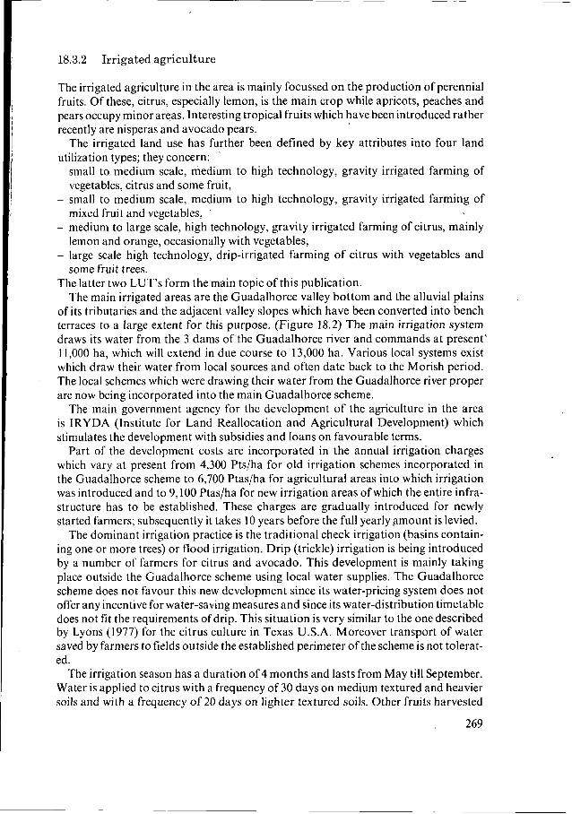
The best yields are reported for lemon groves on the Guadalhorce alluvium: 32 tons per ha per year, 20-25 tons per ha seems to be a reasonable average. For bench-terraced lemon groves on heavy soils, yields of less than half those on the alluvium seem to be common (about 10 tons/ha). A drip- irrigated lemon grove on sloping heavy soils of the F landscape of 7 years old and not yet in full production was reported to produce about 17 tons of lem.ons/ha (see Figure 18.3).
Prices of lemons are commonly around 20 Ptas/kg in the main harvest period. Prices of up to 125 Ptas/kg are said to have been paid in special cases. In times of bumper crops prices may fall as low as 6 Ptas per kg. The cost of picking being in the order of 3 to 4 pesetas/kg.
18.4 Current soil and water conservation problems
18.4.1 Rainfed agriculture
At present most of the soils of the Flysch (F) landscape are in use for rainfed agricul- ture. The main problem for the rainfed annuals is the low precipitation. The water balance for wheat (Figure 18.4) shows that for an average year and assuming a storage capacity in the root zone of 1 O0 mm and 100% effective rainfall, severe moisture deficits occur in the yield formation and ripening stages. These moisture deficits are the main cause for the average low yields reported. Comparison of the two graphs representing early and late sowing shows the importance of choosing an early planting date whenev- er possible. The Vertic properties of the soils form an impediment for mechanization and make moisture conservation measures such as dùst mulching difficult.
The fact that the first rains disappear into the open cracks of these soils, effectively preventing the moistening of the topsoil to a state that allows plowing, is probably the cause for the relatively late sowing practised in the area. On the steeper slopes the effectiveness of the rainfall will be much lower than 100%. As such the moisture deficit on such soils will be much more severe. This factor and the additional impediment to mechanization caused by the'steeper slopes causes such
270
'

10
mm/DAY O
- 2
-4
- 6
- 8
-10
WHEAT
MONTH
J F M A M J J A S O N D
5.48
2.00 2.58
2.13
STAGE
Soil water budgel Max. storage avail. moist. 100 mm
DAYS
15 20 25 45 30 35 15
179
KC
0.35 0.70 0.75 0.75 1.10 0.70 0.25 0.20
Soil water budget
Starling date 1-1
Avail. moist at start-dale 50 mm m m mm
Max. storage avail. moist. 60 mm Avail. moist at start-date 50 mm
200
180
160
140
120
100
80
60
40
20
O
Figure 18.4 Water balance for rainfed wheat in the study area. Severe moisture deficit in the yield formation and ripening stages is common, especially when the crop i s sown late. Based on the following climatic data: 50 percent prob.rainfa11 and potential evapotranspiration according to the radiation method, both for the station Malaga. Stages and crop coefficients according to Doorenbos and Kassam (1979)
272
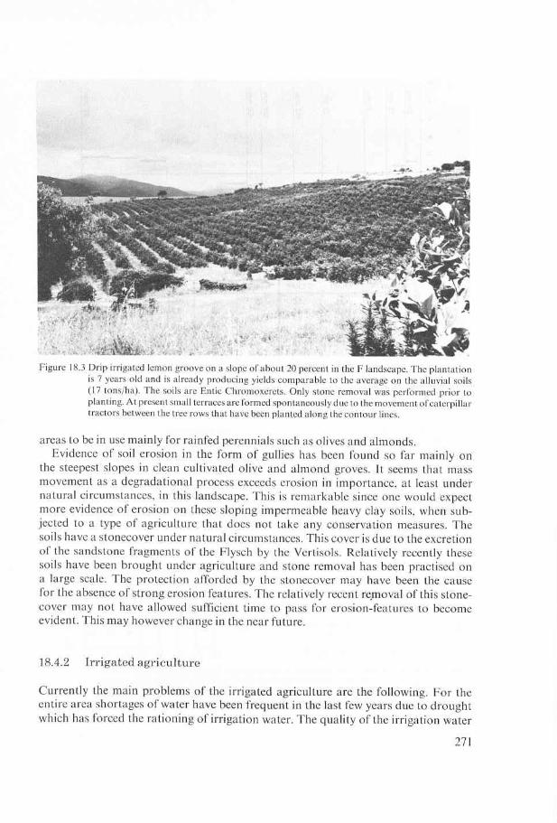
Figure 18.5 Salt crust has formed in the topsoil of a large bench terrace on which citrus is grown. The salinity is concentrated at the foot of the riser where the grey parent material is exposed. Large step heights and poor quality irrigation water (See Figures 9 and 8) are the main causes for this phenomenon. Note the poor stand of the citrus.
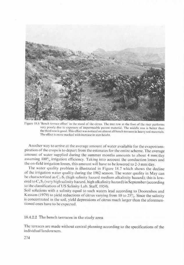
declined in this period. In the bench terraced areas the aforementioned problems were aggravated due to poor design of the terraces which induced local salinization of the soils especially in the heavy clays of the F landscape. (Figure 18.5) Poor design of certain terraces furthermore caused drainage and stability problems in the winter peri- od. (Fig. 18.6)
18.4.2.1 The water shortage
The water requirements for citrus according to Doorenbos and Kassam (1 979) are during the irrigation season (May/September) 0.65 x the potential evapotranspiration. This amounts to about 4 "/day during this period. With traditional irrigation meth- ods the 'on-farm' irrigation efficiency cannot be more than 65-60% (Hoare et al., 1974). Mantel1 (1974) even quotes a U.S. figure of 44%. This means that even a supply of 4.9 mm will not be sufficient. Poor quality irrigation water will aggravate the situation further. As such it can be concluded that under the present circumstances irrigation intensity under traditional gravity irrigation is not sufficient to provide for optimal production. Lemon trees carrying up to 4 generations of fruit-probably indicative of drought-induced flowering, were frequently seen.
273


Conductivity mslci
3000
I 2000
1982
M I A I M I J I J I A I S I
SAR 10
9
8
7
6
1982
M ' A I M ' I J ' J I A ' 1 s ' I C3-SZ C3-SZ C3-S I C4-SZ C4-SZ C4-SZ I C 4 4 3 I
I high s a l i n i t y hazard medium a l k a l i n i t y hazard medium a l k a l i n i t y hazard high a l k a l i n i t y hazard
I very hish s a l i n i t y hazard very high s a l i n i t y hazard I I
Figure 18.7 Graphs illustrating the decline of the water quality during the 1982 irrigation season. Several dry years had diminished the quantity of good quality irrigation water in the barrages and made admixture of poor quality saline water inevitable. No field observations for 1982 are available.
The following remarks can be made about the terraces in general; (see Figures 18.8 and 18.9) as compared with the recommendations of FAO Bulletin 30 (Constantines- co, 1976): - In order to get large terraces which make efficient farming and irrigation operations
possible, step heights far in excess of the recommended maximum of 1 m, are chosen especially in steep terrain. This has the following consequences: a. Degradation of the soil profile and exposure of raw parent material in large parts
of the terraces. b. Locally the winter groundwatertable may be intersected by the terraces leading
to grave drainage problems. In the summer capillary contact with the ground- water is maintained in the deepest parts of the terraces leading to salinization.
c. Requirements for cut and fill which exceed the FAO specifications by a factor 3 to 6! (1,250 m3 to get 1 ha of level land (FAO) versus 3,750-7,500 in the study area.
275

ditch lip
, 40 50
-----original surface /-7d///' ' ' parent mterial
I I
40 5 30
m Figure 18.8 Cross sections of bench terraces on a 30 percent slope. The upper drawing shows the bench
terraces ifmade according to the specifications OfconstantinesCu ( I 976): step height of 1 meter, riser at 45", lip and ditch. The lower drawing shows the bench.terraces commonly encountered in the study area: height of 5 meters, riser at 45", no ditch and no lip. Note the intersection of the parent material at a depth of I meter by the large terraces. For technical details see the underlined figures in Figure 10.
30 X Slope
) % ope
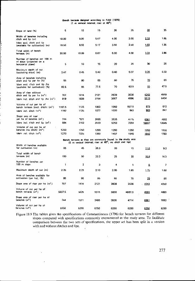
Slope of I d 1%)
Width of benches including ditch and lip (ml Idem excl. ditch and lip (available for cultivation) Iml
Total width of bench terrkR (ml
Number of bencher per 100 m of slope lpropcted on a horizontal planel
Maximum depth of cut (excluding drain) (ml
Area of benches including ditch and lip per ha (%I Idem excl. ditch and lip /ha (available for cultivation) (%I
Area of riser without ditch and lip per ha (m'l Idem incl. ditch and lip /ha (m'1
Volume of cut per ha of bench terraces (excl. ditch) ( m a l Idem incl. ditch ( m a )
Slope area of riser per ha of benches lm') Idem incl. ditch and lip (m')
Volume of cut per ha of benches (no ditch) (m') Idem incl. ditch (m'l
Width of benches available for cultivation (ml
Total width of bench terraces (ml
Number of benches per 100 m slope
Maximum depth of cut (ml
Area of benches available for cultivation (per ha), (%)
Slope area of riser per ha (m')
Volume of cut per ha of bench terraces (m')
Slope area of riser per ha of benches (m'l
Volume of cut per ha of benches (m'l
Bench terram desiyud wording to FAO (19761 (1 m vertical intewal; riser at 45'1
5 10
19.00 9.00
18.50 8.50
20.w 10.00
5 10
0.47 0.45
95 90
92.5 85
707 1414 919 1838
1187.5 1125 1192 1135
744 1571 994 2162
1250 1250 1270 1335
15
5.67
5.17
6.67
15
0.42
85
77.5
2121 2758
1063 1077
2495 3559
1250 1390
20
4.00
3.50
5.00
20
0.40
80
70
2828 3067
loo0 1020
3535 5253
1250 1457
25
3.00
2.50
4.00
25
0.37
75
62.5
3536 4596
937.5 963
4715 7354
1250 1540
Bench terraces as they are commonly found in the study area (5 m veltical interval; riser at 45'; no ditch and lip1
95 45 28.3 20 15
100 50 33.3 25 20
1 2 3 4 5
2.35 2.25 2.10 2.00 1.85
95 90 85 80 75
707 1414 2121 2828 3536
5315 5000 4687.5 5937.5 5625
744 1571 2495 3535 4714
6250 6250 6250 6250 6250
- 16.6
- 6
4243
35
1 .e6
1.36
2.86
35
0.32
65
47.5
4950 6434
813 847
7692 13545
1250 1783
9.3
14.3
7
1.60
65
4950
4065
7692
6250
Figure 18.9 The tables gives the specifications of Constantinescu (1796) for bench terraces for different slopes compared with specifications commonly encountered in the study area. To facilitate comparison between the two sets of specifications, the upper set has been split in a version with and without ditches and lips.
277

- The slope of the risers of the terraces is frequently in excess of the 45" recommended as a general rule for unsupported structures. This is done in order to eke out more cultivable area from the slopes. It leads often to instability and failures are frequent especially in the impermeable clays with Vertic properties. (Figure 18.10)
- Since the terraces are constructed purely for the purpose of introducing gravity irri- gation for the summer months, the conservation aspect of these terraces which is important in the wintermonths, is neglected. This means that no drainage system as specified by FAO is provided while the sides of the terraces are not protected by a 'lip' against over-topping drainage. These measures are probably omitted since they reduce considerably the amount of cultivable area. (See Figures 18.8 and 18.9)
18.5 Drip irrigation an alternative to improve soil and water conservation
Since the 60's various alternative methodologies for gravity irrigation have been intro- duced. Sprinkler, drip, (trickle) microsprinkler, subsurface trickle etc. These methodo- logies aim a t improving the irrigation efficiency (from aforementioned 44% to 90%) and/or cutting down on labour and operating costs. Especially systems that aim at , distributing the irrigation water in carefully measured amounts at short intervals to the root system of plants and not to the field in general (trickle or drip surface and subsurface systems and microsprinklers) fulfil both the aforementioned requirements.
Figure 18.10 Landslide in the riser of a large bench terrace on heavy clay. The Vertic properties of the clay cause instability of the risers in the moist winter season. Steep risers accompanied by large step heights cause this phenomenon.
278

Numerous experiments have shown the superiority of trickle/drip irrigation in this
Bester et a1.(1974), Uys (1974), Davis and Pugh (1974), Marsh et al. (1974), Aljibury respect over other irrigation methods:
et al. (1974), Rodney et al. (1977), Gerard (1974).
18.5.1 The water savings
- Water is supplied to the root zone of the plants and not to the soil in general. Losses due to surface evaporation and transpiration by weeds are prevented. This is especially important for young crops which cover only a small part of the field.
- Water is carried to the spot where it is used by means of plastic tubing which means that the on-farm losses can be cut to less than 10%.
- Water can be dosed so precisely that seepage losses even on coarse permeable soils can be prevented by using low dosage-high frequency. The same applies for runoff losses on steep soils with low intake rates.
- The water use efficiency under drip irrigation is higher than under other forms of irrigation. This means that the amount of marketable product produced per unit of water supplied is in general higher for drip than for any other system of irrigation. This is due to the following factdrs: (Rawitz and Hillel, 1974). A high matric potential is maintained continuously in the root zone. The absence of moisture stress in the plants produces higher yields. The flux of water to replace the uptake by the plant roots depends in general on the unsaturated permeability. Under drip irrigation the permeability is higher since the soil is not allowed to dry out. Due to the high concentration of roots in the upper layer under drip irrigation, the flow path of water and nutrients towards active roots is strongly reduced. This means that there is less delay between the application of the irrigation and the effect ofit.
- Irrigation waters which are unsuitable or marginally suitable for irrigation with conventional practices can be used profitably in drip systems as experiments by e.g. Bernstein and Francois (1973) and Tscheschke et al (1974) have shown. Wad- leigh and Gauch (1948) showed that matric potential and osmotic potential are additive in their effect on plant growth. This means that water of low osmotic poten- tial (saline water) can be used profitably by plants if it is offered to their roots at a high matric potential. Frequent well-dosed drip can do this and thus make irriga- tion with low quality water profitable.
- Accumulation of salt in quantities harmful to roots will take place under drip irriga- tion as well as under conventional irrigation practices but the drip irrigation, if properly managed, will keep the salts out of the root zone of the plants. Salts will accumulate as a bubble shaped body around the margin of the wetted soil volume. They can be kept there indefinitely (perennials) or have to be leached periodically e.g. winter rain if row crops of annuals are involved. The amount of salt introduced into the soil under irrigation is in first instance a function of the amount of water applied. As such, drip uses less water and brings less salt than other irrigation methods. Periodic leaching may be required under both systems. This leaching can be postponed under drip irrigation to the most
279 favourable season however.

18.5.2 The advantage in saving labour and cutt ing installation- and management-costs
- Drip irrigation makes levelling of fields such as is necessary for gravity irrigation
- Labour is saved since the system can largely be automated and can be used to distri-
- Since interrow spaces do not receive water the weed control in these areas does
largely unnecessary.
bute fertilizers, micronutrients, pesticides and herbicides as well.
not pose a problem in the dry season.
18.5.3 Disadvantages of drip irrigation
- Drip systems need very clean waters in order to avoid clogging problems. Filtration is necessary. Mineral constituents can also cause clogging which can be counteracted by the periodic flushing with chemicals (e.g. HC1 to dissolve CaC03). Micro- sprinklers are less sensitive to these problems than drip emitters.
- Shallow rooting induced by surface drip irrigation causes the buffering capacity of the root zone to become very small which means that the plants become totally dependent on the system. Failure of the system in a critical period may become disastrous. This total dependency on the system for water and nutrients applies specifically in those cases where adverse soil and/or slope conditions dictate high- frequency/low-dosage drip.
18.5.4 Comparison of the cost effectiveness of drip and gravity irrigation systems for citrus in sloping parts of the survey area.
The amount of data collected during the 1984 fieldwork is insufficient to make a de- tailed cost/benefit analysis of both drip and conventional irrigation systems for sloping areas. An effort will be made however to compare the main aspects of the two options on the basis of the data available. The following points will be considered: Installation costs, irrigation efficiency in relation to yields and labour- and management costs.
18.5.4.1 Installation costs
For the present cost of a drip installation including pumps, filters etc., a local figure was obtained in the order of 200,000 to 250,000 pesetas/ha. This is of the same order of magnitude as a figure of US $800-900 per ha quoted by Uys (1 974) for South Africa.
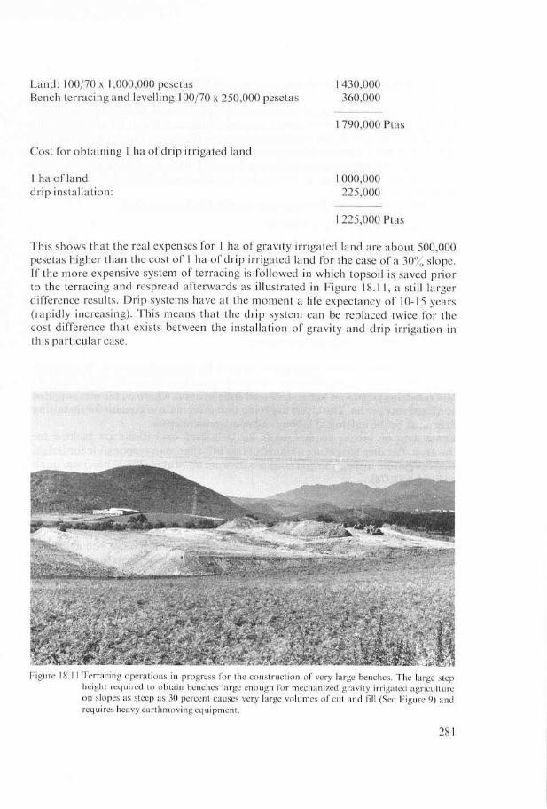
For the cost of preparing 1 ha of sloping land for irrigation by means of bench terraces a general figure of 250,000 pesetas was locally obtained. This figure was veri- fied by data from the Table in Figure 18.10 for a 30% slope and found reliable using data from Agricultural Compendium (Ilaco, 1981) and a locally obtained rate of 9,000 pesetas per tractor hour. On the basis of these data the following comparison can be made for land locally sold at a price of 1 million pesetas/ha:
280
Cost for obtaining 1 ha of benches on land with a 30% slope (Figure 18.9).

18.5.4.2 Irrigation efficiency in relation t o yields
The figures given in the preceeding section indicate that drip irrigated citrus uses about half the amount of water that gravity irrigated citrus needs (2 mm versus 4 mm daily) during the irrigation season. In terms of water-use efficiency (amount of product per unit of irrigation water) the following can be computed. For gravity-irrigated citrus the yields vary from 32 tons/ha (best yield) to 22 (average yield) on Alluvial soils and to 10 tons for bench-terraced citrus on the heavy soils of the F landscape. These figures lead to the following water-use efficiencies respectively:
6.7 kg/m3, 4.6 kg/m3 and 2.1 kg/m3
If the data (17 ton/ha) of the drip irrigated orchard on sloping Vertisols of F (Figure 18.1 1) which is not yet in full production are compared to this, a water-use efficiency of 7.1 kg/m3 results which is already superior to the best orchards in the Alluvium and about triple the figure that holds for the bench-terraced gravity irrigated heavy soils.
18.5.4.3 Labour and management costs
Savings on labour and management costs of the drip system versus the gravity system must be considerable since it was observed (see Figure 18.12) that people laid out drip systems on bench-terraced soils in areas where water was supplied a t a fixed rate per ha . The latter implying that their main argument for installing drip must be the cutt ing of labour and management costs. Exact da ta on labour requirements for irrigation operations are lacking for the area. For drip irrigation a figure of one full-time man responsible for irriga- tion operation, inspection and maintenance per 50-70 acres (22-32 has.) was quot- ed by Uys (1974).
18.6 Conclusions and recommendations
Most of the data used in this paper have been obtained in interviews with individual farmers. Wherever possible they have been verified against statements from other indi- viduals and against figures quoted in the literature.
As such the order of magnitude of the figures given is considered to be reliable, and justifies the following preliminary conclusions and recommendations for the sur- vey area. Further studies will have to be undertaken in order to refine the conclusions and to add detail to our recommendations. The recommendations take into account that optimum use must be made of the available water, a scarce resource for which agriculture on the one hand and industry and tourism on the other hand compete.
282


cording to slope and soil can be worked out on the basis of local soil survey results). - Convert the fixed-rate water charge to a.price per unit in order to stimulate water-
saving investments. - Convert the water distribution system to a demand system that allows users to with-
draw small quantities on a daily basis for drip irrigation. - Reclaim terraces with stability, drainage- and salinity-problems by adding a drain-
age ditch at the foot of the riser and a lip at the top of the riser. Reduce the slope of unstable risers to 45".
- Convert reclaimed terraces to drip irrigation.
References
Aljibury, F.K., M. Gerdts, A. de Lange, J. Huntamer and G. Leavitt, 1974. Performance of Plants with
Bernstein, L. and L.E. Francois, 1973. Comparison ofdrip, furrow, and sprinkler irrigation. Soil Sci. 1 15(1):
Bester, D.H., D.C. Lötter and G.H. Veldman, 1974. Drip irrigation on citrus. Proc. of the 2nd Int. Drip
Constantinesco, I . , 1976. Soil conservation for developing countries. FAO Soils Bulletin 30. FAO, Rome,
Davis, S. and W.J. Pugh, 1974. Drip irrigation: surface and subsurface compared with sprinkler and furrow.
Doorenbos, J. and A.H. Kassam, 1979. Yield response to water. FAO Irrigation and Drainage paper 33.
FAO-Unesco, 1974. Soil Map of the World 1: 5,000,000 Vol. I Legend. UNESCO, Paris. FAO, 1976. A framework for land evaluation. FAO Soil Bulletin 32. FAO, Rome, 72 pp. Gerard, C.J., 1974. Drip and furrow irrigation studies on sugarcane. Proc. of the 2nd Int. Drip Irr. Cong.
Hoare, E.R., K.V. Garzoli and J . Blackwell, 1974. Plant water requirements as related to trickle irrigation.
IGME, 1972. Mapa geologico de Espana escala I : 50,000 Hoja Alora serie 2 edicion 1. llaco B.V., 1981. Agricultural Compendium for Rural Development in the Tropics and Subtropics. Else-
Instituto Geografico y Catastra, 1975. mapa Topografico nacional de Espana. Hoja 1052,l: 50,000 Alora. Lyons, C.G., 1977. Water management in Texascitrus. Proc. Int. Soc. Citriculture, 1977(1): 117-1 17. Mantell, A., 1977. Water-use efficiency of citrus: Room for improvement? Proc. Int. Soc. Citriculture,
Marsh, A.W., C.D. Gustafson, R.L. Branson and R.A. Strohman, 1974. Water use by drip and sprinkle irrigated avocados related to plant cover, evaporation and air temperature. Proc. of the 2nd Int. Drip Irr. Cong. 1974, San Diego: 346-350. Rawitz, E. and D. Hillel, 1974. The progress and problems of drip irrigation in Israel. Proc. of the 2nd Int. Drip Irr. Cong. 1974, San Diego: 23-28.
Rodney, D.R., R.L. Roth and B.R. Gardner, 1977. Citrus responses to irrigation methods. Proc. Int. Citri- culture, 1977 ( I ) : 106-1 IO.
Soil Survey Staff, 1975. Soil Taxonomy. SCS-USDA, Agriculture Handbook 436. US Printing Offce, Wash- ington D.C. 753 pp.
Tscheschke, P., J.F. Alfaro and R.J. Hanks, 1974. Trickle irrigation soil water potential as influenced by management of highly saline water. Soil Sci. I17 (4): 226-231.
United States Salinity Laboratory Staff, 1954. Diagnosis and Improvement of Saline and Alkali Soils. Agri- culture Handbook 60. United States Department of Agriculture, Washington, 160 pp.
Uys, W.J., 1974. Some results of a field survey of drip irrigated systems in the Republic of South Africa. Proc. of the 2nd Int. Drip irr. Cong. 1974, San Diego: 65-70.
Wadleigh, C.H. and H.G. Gauch, 1948. Rate of leaf elongation as affected by the intensity of the total soil moisture stress. Plant Physiol. 1948 (23): 485-495.
drip irrigation. Proc. of the 2nd Int. Drip. Irr. Cong. 1974, San Diego: 497-502.
73-86.
Irr. Cong. 1974, San Diego: 58-64.
92 PP.
Proc. of the 2nd Int. Drip Irr. Cong. 1974, San Diego: 109-1 14.
FAO, Rome, 193 pp.
1974, San Diego: 329-334.
Proc. of the 2nd Int. Drip Irr. Cong. 1974, San Diego: 323-328.
viers, Amsterdam, 739 pp.
I977 ( I ) : 74-79.
284

Acknowledgements
We gratefully acknowledge the help of the following entities in supplying data: Servicio de Extension Agraria (SEA) for general data on the agriculture of the area, Confedera- cion Hidrografica del Sur de Espana for data on water supply, the Comisaria de Aguas of Malaga city for data on water quality and the land reform institute IRYDA for data on credit terms. In addition about 20 farmers were interviewed who willingly supplied information.
Appendix 18.1
Soil profile description Site 1
Site information
Profile No. Data Location
Photo number Soil Classification Parent material
Landform surrounding country Microrelief
Vegetation/land use
Drainage Moisture conditions Depth groundwater Presence of salt or alkali Human influence
Soil description
Horizon Depth in cm
: 84.04.26 : June 1984 : about 2.5 km Southwest of Alora town, coordinates
: BOS, Scale 1: 17,500 : Entic Chromoxerert : unconsolidated marine clayey sediment of the Paleogene
appr. 36"48'N, 4'44'E
(Flysch)
: dissected plain, undulating to rolling : plough ridges, on the opposite valley slope various bench
: olive groove, above the irrigation command, rainfed ce-
: well drained : moist 0-35 dry to slightly moist below 35 cm : unknown : not observed in the field : weeding to conserve moisture by mule-drawn plough
terraces are constructed
reals and pulses
Description
AP 0-15 Yellowish brown (10YR5/6) dry, dull yellowish brown (10YR5/4) moist, clay; weak fine subangular blocky; slightly hard dry, friable moist, sticky and plastic wet; many fine pores; many fine and medium roots; slightly calcareous; pH8.0 clear smooth boundary to
Bw 1 15-35 yellowish brown (lOYR5/6) dry, dull yellowish brown
285

(1 OYR5/4) moist, clay; strong medium subangular blocky, hard dry, firm moist, sticky and plastic wet; common pores; few fine and medium roots; slightly cal- careous; pH8.0; smooth/gradual boundary to
Bw2 35-60 yellowish brown (1 OYR5/8) moist, clay; strong medium angular blocky; firm moist, stickjr and plastic wet; few fine roots; highly calcareous; pH8.5; gradual smooth boundary to
Bw3 60- 1 O0
BC 100- 130
Yellowish brown (10YR5/6) moist, clay; strong medi- um angular blocky; firm moist, sticky and plastic wet; very few fine roots; highly calcareous; pH8.5; gradual. smooth boundary to
Yellowish brown (10YR5/6) moist, clay; strong medi- um angular blocky; firm moist, sticky and plastic wet; slightly calcareous; pH8.0; few (Fe & Mn?) concretions; some powdery light grey (7.5YR8/2) gypsum, smooth gradual boundary to
C 130-150+ Yellowish brown (10YR5/6) clay; firm moist, stickly and plastic wet; slightly calcareous.
Information Site 2
Obs. No. Data Location
Photo number Parent material
Physiographic position
Landform surrounding country Microrelief Vegetation
Drainage Moisture conditions Presence of salt or alkali
Human influence
: 84.04.26a : June 1984 : about 2.5 km Southwest of Alora town, coordinates
: BOS, Scale 1:17,500 : unconsolidated marine clayey sediment of the Paleogene
(Flysch) : close to the rise of a bench terrace, about halfway a SSW
facing slope; original slope gradient 27%, altitude 150 m : undulating to rolling dissected plain
appr. 36"48'N, 4'44'E
: none : citrus orchard, strong variation in tree growth due to po-
sition on terrace : imperfectly to poorly drained : moist throughout : salt crust presence, strongly saline taste presumably
caused by NaCl : construction of bench terraces of 7 m wide, 50 m long
and with a rise of & 5 m
286

Material
Depth in cm Description
0-2 White (10YR8/1) saline soft crust, 2-15 light yellowish brown (1 OYR6/4) clay; structureless; firm
moist, sticky and plastic wet; calcareous; pH8.0
Material
Depth in cm Description
0-2 White (10YR8/1) saline soft crust, 2-15 light yellowish brown (1 OYR6/4) clay; structureless; firm
moist, sticky and plastic wet; calcareous; pH8.0
Analytical results profile 84.04.26
lab.no. pH 1:2.5 EC exchangeable cations meg/100 g CEC Base ESP mS/cm sat%
H20 KCI Ca Mg K Na Sum
84.513 8.6 8.6 24.6 22.0 16.5 0.8 3.3 42.6 16.8 100(254)19.6 85.514 8.2 7.6 4.7 18.8 15.4 1.1 6.1 41.4 25.9 100(160)23.6
~~
Lab. Sample Depth Horizon Particle size distr. (u) in % weight no. no. cm
Sand Silt Clay
2000 1000 500 250 100 . 50 20 ,<2 1000 500 250 100 50 20 2
~~
84.507 l a O- 15 Ap 0,6 1,l 3,4 8,9 5,8 6,2 13,2 61,O 84.508 Ib 15- 35 Bwl 0,9 1,3 2,6 10,3 7,7 4,6 13,s 59,l 84.509 I C 35- 60 Bw2 0,4 1 , l 2,6 10,2 6,l 4,7 9,7 65,O 84.510 Id 60-100 B w ~ 0,3 0,7 1,s 4,6 2,9 2,7 16,4 70,8 84.511 le 100-130 BC 0,3 1,4 2,6 4,l 1,9 3,6 14,8 71,3 84.512 If 130-150f C 0,l 0,l 0,I 0,2 0,l 1,3 20,4 77,7
pH4 1:2,5 EC2.5 CaC03 org. matter
~
8,I 7,I 0,39 3,8 0,68 0,I I 62 8,3 7J 0,37 4,s 0,50 .0,09 5,6 8,s 733 0,45 6 5 0,20 0,06 3,3
8,O 7,3 4,30 3,7 0,13 0,08 1,6 8,O 7,o 2,20 4,i 0,16 0,l I 1 s 7,9 7,2 2,73 5 3 1 0,16 0,07 2,3
287

Lab no. Exchangeable bases in NH4 Ac/A I C CEC Basesat. CEC ESP (me/ 1 O0 g soil) pH7.0 % Clay
CA* Mg K Na Sum
29,l 6,O 1,l 0,2 36,4 30,3 I 00( 120) 68,l 0,7 27,5 6,5 0,8 0,2 35,O 28,4 lOO(123) 43,l 0,7 24,5 10,7 0,8 0,9 36,9 27,3 lOO(135) 42,O 3,3 33,2 11,l 0,9 1,3 46,5 36,4 loo( 153) 42,9 4,3 22,9 16,8 0,8 3,4 43,9 28,4 lOO(155) 39,8 12,o 9,4 20,5 0,7 6,5 37,l 31,8 loo( 1 16) 40,9 20,4
Lab no. Clay mineralogy
kao- Smec- mi (illiteiu illite- . sw. linite tite chlorite) smectite chlorite goethite feldspar quartz
++ ++ + ++ ++ + ++ ++ + ++ + + ++ + + + + +
- tr tr tr tr tr tr O-tr tr tr tr tr-x tr O-tr tr-x tr tr tr-x
Relatively of abundance + few
+ + moderate + + + abundant * error
Resumen
Un levantamiento de suelos semi-detallado fué llevado a cab0 en la parte baja de la cuenca del rio Guadalhorce cerca de Malaga en el sur de Espaiia de mayo a junio 1984.
El principal tipo de utilisacide la tierra (TUT) de la zona es ‘cultivo de citricos bajo riego de gravedad, altamente tecnificado, utilizado en escala media hasta grande’. Este TUT ocupa todos los suelos aluviales planos y esta en el momento dispersandose sobre los suelos pesados de las laderas de los valles. En estos Últimos lugares forma una alternativa para el TUT ‘cultivo mecanisado de cereales en secano a escale media hasta grande’. El problema principal de la agricultura de secano es la baja pluviosidad, y la mayor dificultad del regadío esta ocasionada por la escasesy baja cualida del agua de riegolo cual occurre periódicamente debido a la competencia entre las demandas del turismo, la industria y la agricultura por losescasos recursos de aguas de la región.
El TUT de los citricos require la construcción de bancales muy largos sobre las pendientes, los cuales permiten el cultivo mecanisado bajo riego de gravedad de este producto. Como resultado de la construcción de tales bancales el perfil natural de los suelos esto siendo destrudo quedando expuesto un subsuelo con propiedades adver-
288

sas. Este hecho se manifiesta en problemas de drenaje y estabilidad de la pendiente en el invierno, mientras que salinisación occurre verano, affectando seriamente el creci- miento y la cosecha de los citrocos. Un método de riego alternativo el cual no require la construcción de bancales es el goteo.
Se comparan lasventajas y desventajas de ambos sistemas de riego para los suelos pesados pendientes y se presentan conclusiones y recomendaciones preliminares. Estas indican que la introducción del riego de goteo ‘puede ahorrar agua y conservar las pendientes mejor, favoreciendo una cosecha mayor a un gasto de instalación inferior al costo del otro sistema.
Discussion
de Meester: Does not the churning of the Vertisols cause rupture of the citrus roots under intermittent wetting and drying under irrigation? Siderius: Under drip irrigation a small but significant area around the rootzone is kept moist continuously, therefore the effect of churning is neglectible.
Siderius: Drip irrigation may be beneficial as long as protective measures are being taken even in strongly sloping areas,; if the water can be brought, disregarding the soil-landscape then one introduces a high erosion hazard.
289