17436 afc spring04 - forestry commission · •the afc ranks 11th in the south in ... alabama’s...
TRANSCRIPT
TTALABAMA’S
FORESTSSPRING SPRING 20042004
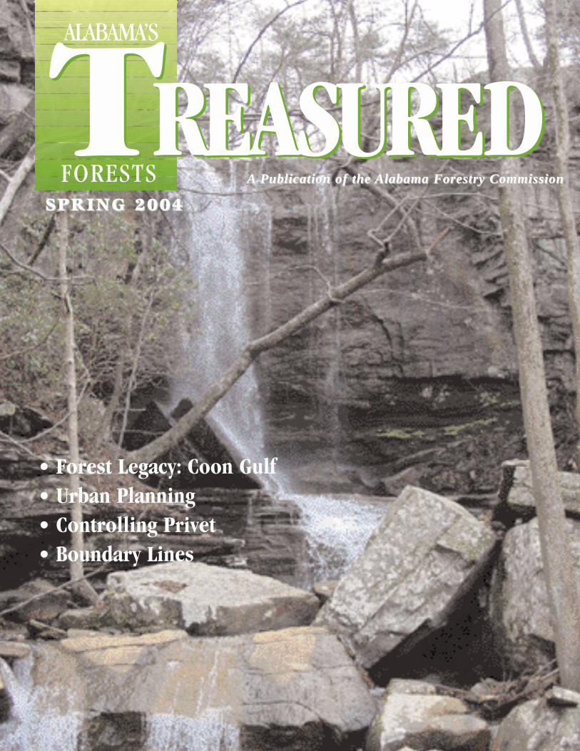
• Forest Legacy: Coon Gulf• Urban Planning• Controlling Privet• Boundary Lines
AA Publication of the Publication of the Alabama Forestry CommissionAlabama Forestry Commission
REASUREDREASURED
TIMOTHY C. BOYCE
State Forester
In the past year the state’s financial situation has been oneof the most critical issues affecting our state. During thiscurrent budget year the Alabama Forestry Commission(AFC) is operating under an 18 % decrease in general fund
appropriations from last year. As with any financial cut of thisamount, things have to change. We have initiated several costsaving initiatives that will affect the way we do business in thefuture. I have outlined our situation below.
The Facts•Seventy-one percent of Alabama’s land base is covered withforests.
•Alabama is the second largest commercial forest in the nationwith 22.9 million acres of forestland. Our neighbor Georgiais number one with 24.4 million acres.
•The forest products industry is the number one manufactur-ing industry in the state contributing $13 billion to the state’seconomy annually.
•There are approximately 440,000 forest ownerships inAlabama.
•Private family forest landowners own approximately 78 % ofAlabama’s forests. These are the people the Commissionserves on a day-to-day basis.
•There are 1,936 certified TREASURE Forests in Alabamamanaging approximately 1,833,000 acres of land under theTREASURE management concept.
•During the 2002-2003 fiscal year, the AFC handled 1,350fires that burned approximately 12,406 acres. This is the low-est average for both fires and acreage since 1941. The five-year average for number of fires and acres burned is 4,000fires and 40,000 acres.
•Last year AFC firefighters personnel kept the average sizefire to 9.1 acres and saved 382 homes and 146 other struc-tures.
•The Commission supports approximately 1000 rural volun-teer fire departments.
The Budget•Since the 1994 budget year, the Commission total budget hasdecreased from just over $26 million to below $24 million.
•The AFC ranks 11th in the south in dollars spent per forestedacre, $1.23. We are below the southern average of $1.76 peracre. Florida is number one with $3.86, North Carolina num-ber two spending $2.71, and Georgia number three at $1.91.
Our People•Seventy-five percent of the AFC budget goes to personnel.
•In the 1991 budget year the Commission had 529 employees.Today the AFC has approximately 342 employees – 187 lessthan 1991.
•Although the Commission saw an 18 % decrease in stateGeneral Fund appropriations, only those positions notalready filled were lost.
•Currently there have been 47 budgeted positions cut (or 14 %of our manpower) in the Commission.
•Alabama is second among the southern states in forestedacres with 22.9 million acres, but 13th or last in number ofagency personnel per million acres of forestland.
Although the Alabama Forestry Commission will not be par-ticipating in many of the activities and programs that we havein the past, we will remain the leader in wildfire suppressionand we will be providing technical assistance to landowners justas we always have. Unfortunately, one of the cutbacks will beAlabama’s TREASURED Forests magazine which will be lim-ited to three issues per year.
The Alabama Forestry Commission is one of the most costeffective forestry agencies in the nation and we will continue toprovide the best services possible to the citizens of our statewith the appropriations we are given.
2 / Alabama’s TREASURED Forests Spring 2004
A MESSAGE FROM . . .
Spring 2004 Alabama’s TREASURED Forests / 3
GovernorBob Riley
Alabama Forestry CommissionDavid Long, ChairmanGary Fortenberry, Vice ChairmanJohnny DennisTed DeVosCharlie HamiltonDennis HarborJerry Lacey
State ForesterTimothy C. Boyce
Assistant State ForesterRichard H. Cumbie
Administrative Division DirectorJerry M. Dwyer
Fire Division DirectorDavid Frederick
Management Division DirectorBruce Springer
Northwest RegionRegional Forester Wayne StrawbridgeAsst Regional Forester, Administration Bart Williams
Northeast RegionRegional Forester Phearthur MooreAsst Regional Forester, Administration Charles Hall
Southeast RegionRegional Forester Franklin McAlileyAsst Regional Forester, Administration Dave Duckett
Southwest RegionRegional Forester Gary ColeAsst Regional Forester, Administration Otis French
Editorial BoardBruce Springer Alabama Forestry CommissionDavid Frederick Alabama Forestry CommissionElishia Ballentine Johnson Alabama Forestry CommissionDana McReynolds Alabama Forestry CommissionDon Stinson Alabama TREASURE Forest Assoc.Coleen Vansant Alabama Forestry Commission
EditorElishia Ballentine Johnson
Managing EditorColeen Vansant
Vol. XXIII, No. 1 Spring 2004
Alabama’s TREASURED Forests (ISSN 0894-9654) is published quarterly by the Alabama ForestryCommission, 513 Madison Avenue, Montgomery, AL 36130. Telephone (334) 240-9355. Bulk rate postagepaid at Montgomery, Alabama. POSTMASTER: Send address changes to: Alabama’s TREASUREDForests, P.O. Box 302550, Montgomery, AL 36130-2550. Web site: www.forestry.state.al.us
The Alabama Forestry Commission is an equal opportunity employer and provider.
4 “Welcome to the Hahn-da-rosa” by Tilda Mims
8 The TREASURE Forest Program - Six Steps to Success
9 Forest Legacy: Coon Gulf by Brigetta Giles
12 Get Involved with Urban Planning by Bruce Springer
16 Mountain Longleaf National Wildlife Refuge by Dana McReynolds
18 Cross Sectional View of a Topographic Feature by Douglas A. Smith
18 Map Distance vs. Ground Distance by Douglas A. Smith
20 Privet is a Plague by James H. Miller and Tim Albritton
22 Boundary Lines: Why They Should Be Well Establshed and Maintained by Joe Mullins
27 Tribute to a True TREASURE: In Loving Memory of Jerry Johnson by Joel Glover
28 Swamp Turkeys by Steven W. Barnett
DEPARTMENTS2 Message from the Governor and the State Forester
7 New TREASURE Forest Certifications
23 LEGISLATION AND POLICY
Legislative Profile: Allen Layson by Coleen Vansant
24 THREATENED AND ENDANGERED SPECIES
Beauty in the Bog: Yellow-Fringed Orchid by Jim Lacefield
32 TREES OF ALABAMA: Eastern Hemlock by Coleen Vansant
CONTENTS
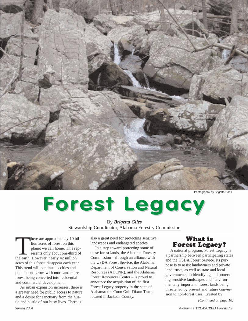
COVER: This scenic waterfall is one of the treasures found on Coon Gulf inJackson County, Alabama’s first “Forest Legacy” property. More photosaccompany the story starting on page 9. Photography by Brigetta Giles
BACKGROUND: Spring dogwoods bloom beautifully in the forests ofAlabama. Photography by Coleen Vansant
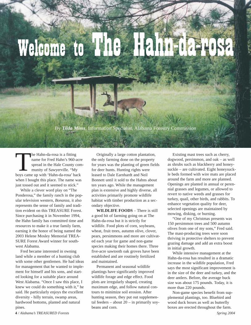
The Hahn-da-rosa is a fittingname for Fred Hahn’s 960-acrespread in the Hale County com-munity of Sawyerville. “My
boys came up with ‘Hahn-da-rosa’ backwhen I bought this place. The name wasjust tossed out and it seemed to stick.”
While a clever word play on “ThePonderosa,” the family ranch in the pop-ular television western, Bonanza, it alsorepresents the sense of family and tradi-tion evident on this TREASURE Forest.Since purchasing it in November 1994,the Hahn family has committed time andresources to make it a true family farm,earning it the honor of being named the2003 Helene Mosley Memorial TREA-SURE Forest Award winner for south-west Alabama.
Fred became interested in owningland while a member of a hunting clubwith some other gentlemen. He had ideasfor management that he wanted to imple-ment for himself and his sons, and start-ed looking for a suitable place aroundWest Alabama. “Once I saw this place, Iknew we could do something with it,” hesaid. He particularly enjoys the excellentdiversity - hilly terrain, swamp areas,hardwood bottoms, planted and naturalpines.
Originally a large cotton plantation,the only farming done on the propertyfor years was the planting of green fieldsfor deer hunts. Hunting rights wereleased to Dale Earnhardt and NeilBonnett until it sold to the Hahns aboutten years ago. While the managementplan is extensive and highly diverse, allactivities primarily promote wildlifehabitat with timber production as a sec-ondary objective.
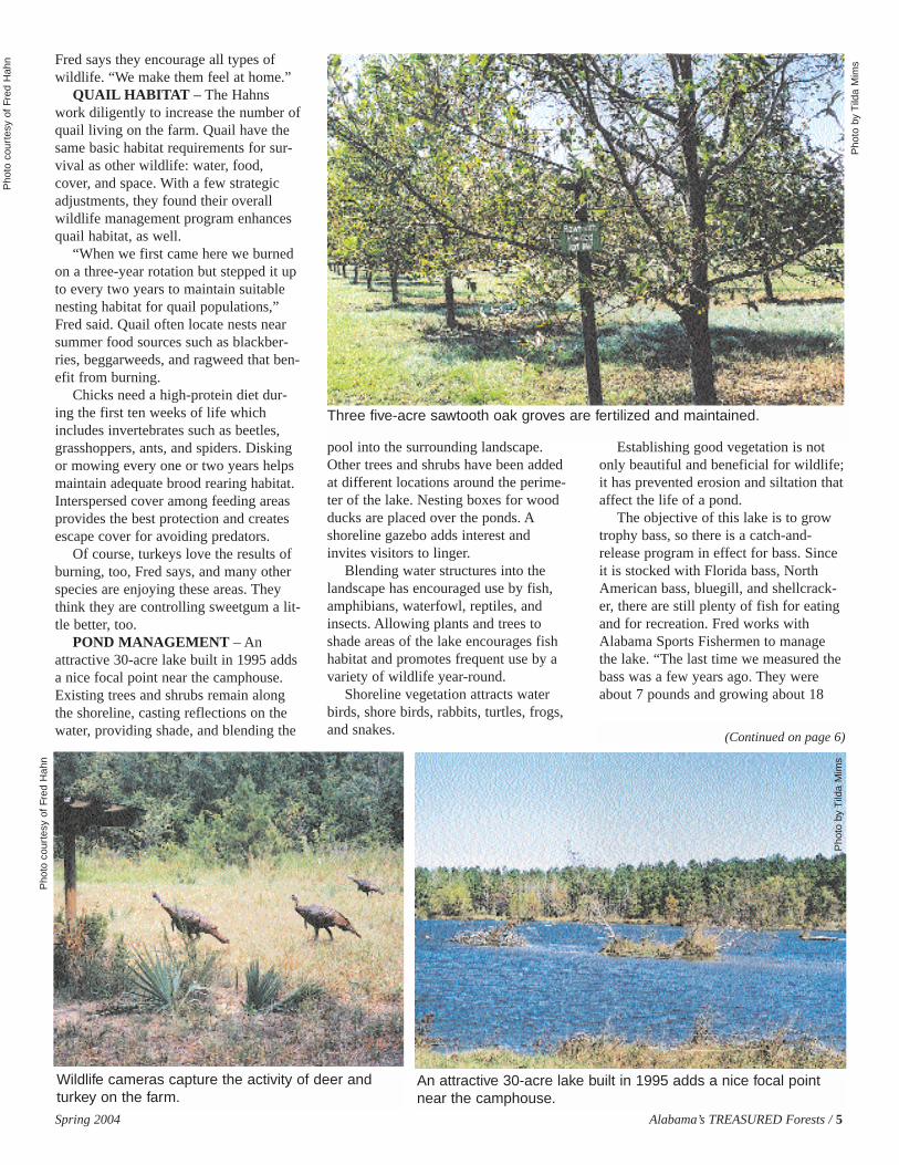
WILDLIFE FOODS – There is stilla good bit of farming going on at TheHahn-da-rosa but it is strictly forwildlife. Food plots of corn, soybeans,wheat, fruit trees, autumn olive, clover,pears, persimmons and more are cultivat-ed each year for game and non-gamespecies making their homes there. Threefive-acre sawtooth oak groves have beenestablished and are routinely fertilizedand maintained.
Permanent and seasonal wildlifeplantings have significantly improvedwildlife forage and edge effect. Foodplots are irregularly shaped, creatingmaximum edge, and follow natural con-tours to minimize soil erosion. Afterhunting season, they put out supplemen-tal feeders – about 20 – in primarily soy-beans and corn.
Existing mast trees such as cherry,dogwood, persimmon, and oak – as wellas shrubs such as blackberry and honey-suckle – are cultivated. Eight honeysuck-le beds formed with wire mats are placedaround the farm and more are planned.Openings are planted in annual or peren-nial grasses and legumes, or allowed torevert to native weeds and grasses forturkey, quail, other birds, and rabbits. Toenhance vegetation quality for deer,selected openings are maintained bymowing, disking, or burning.
“One of my Christmas presents was150 persimmon trees and 500 autumnolives from one of my sons,” Fred said.The mast-producing trees were soonthriving in protective shelters to preventgrazing damage and add an extra boostin initial growth.
While intensive management at theHahn-da-rosa has resulted in a dramaticincrease in the wildlife population, Fredsays the most significant improvement isin the size of the deer and turkey, and thedeer antlers. Before, the average bucksize was about 175 pounds. Today, it ismore than 220 pounds.
Non-game species benefit from sup-plemental plantings, too. Bluebird andwood duck boxes as well as butterflyboxes are erected throughout the farm.
4 / Alabama’s TREASURED Forests Spring 2004
By Tilda Mims, Information Specialist, Alabama Forestry Commission
Fred says they encourage all types ofwildlife. “We make them feel at home.”
QUAIL HABITAT – The Hahnswork diligently to increase the number ofquail living on the farm. Quail have thesame basic habitat requirements for sur-vival as other wildlife: water, food,cover, and space. With a few strategicadjustments, they found their overallwildlife management program enhancesquail habitat, as well.
“When we first came here we burnedon a three-year rotation but stepped it upto every two years to maintain suitablenesting habitat for quail populations,”Fred said. Quail often locate nests nearsummer food sources such as blackber-ries, beggarweeds, and ragweed that ben-efit from burning.
Chicks need a high-protein diet dur-ing the first ten weeks of life whichincludes invertebrates such as beetles,grasshoppers, ants, and spiders. Diskingor mowing every one or two years helpsmaintain adequate brood rearing habitat.Interspersed cover among feeding areasprovides the best protection and createsescape cover for avoiding predators.
Of course, turkeys love the results ofburning, too, Fred says, and many otherspecies are enjoying these areas. Theythink they are controlling sweetgum a lit-tle better, too.
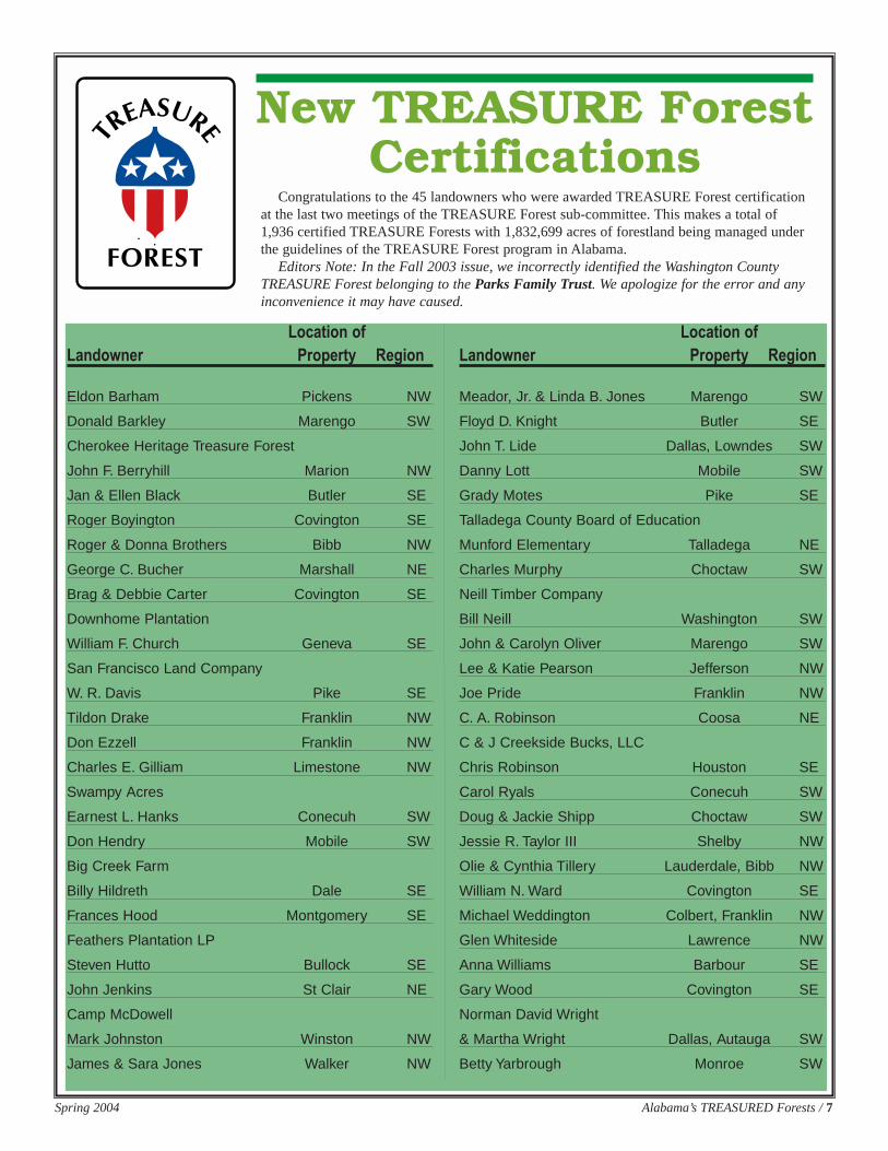
POND MANAGEMENT – Anattractive 30-acre lake built in 1995 addsa nice focal point near the camphouse.Existing trees and shrubs remain alongthe shoreline, casting reflections on thewater, providing shade, and blending the
pool into the surrounding landscape.Other trees and shrubs have been addedat different locations around the perime-ter of the lake. Nesting boxes for woodducks are placed over the ponds. Ashoreline gazebo adds interest andinvites visitors to linger.
Blending water structures into thelandscape has encouraged use by fish,amphibians, waterfowl, reptiles, andinsects. Allowing plants and trees toshade areas of the lake encourages fishhabitat and promotes frequent use by avariety of wildlife year-round.
Shoreline vegetation attracts waterbirds, shore birds, rabbits, turtles, frogs,and snakes.
Establishing good vegetation is notonly beautiful and beneficial for wildlife;it has prevented erosion and siltation thataffect the life of a pond.
The objective of this lake is to growtrophy bass, so there is a catch-and-release program in effect for bass. Sinceit is stocked with Florida bass, NorthAmerican bass, bluegill, and shellcrack-er, there are still plenty of fish for eatingand for recreation. Fred works withAlabama Sports Fishermen to managethe lake. “The last time we measured thebass was a few years ago. They wereabout 7 pounds and growing about 18
Spring 2004 Alabama’s TREASURED Forests / 5
(Continued on page 6)
Pho
to c
ourt
esy
of F
red
Hah
n
Pho
to b
y T
ilda
Mim
s
Pho
to b
y T
ilda
Mim
s
Pho
to c
ourt
esy
of F
red
Hah
n
Three five-acre sawtooth oak groves are fertilized and maintained.
An attractive 30-acre lake built in 1995 adds a nice focal pointnear the camphouse.
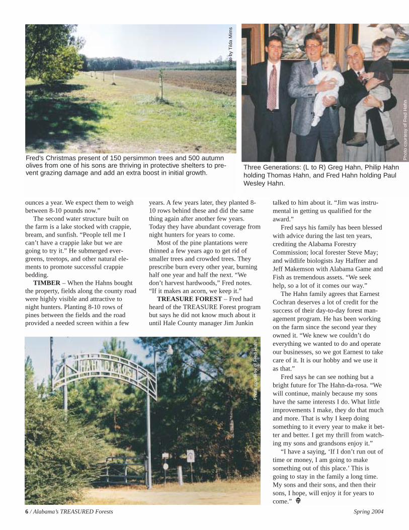
Wildlife cameras capture the activity of deer andturkey on the farm.
ounces a year. We expect them to weighbetween 8-10 pounds now.”
The second water structure built onthe farm is a lake stocked with crappie,bream, and sunfish. “People tell me Ican’t have a crappie lake but we aregoing to try it.” He submerged ever-greens, treetops, and other natural ele-ments to promote successful crappiebedding.
TIMBER – When the Hahns boughtthe property, fields along the county roadwere highly visible and attractive tonight hunters. Planting 8-10 rows ofpines between the fields and the roadprovided a needed screen within a few
years. A few years later, they planted 8-10 rows behind these and did the samething again after another few years.Today they have abundant coverage fromnight hunters for years to come.
Most of the pine plantations werethinned a few years ago to get rid ofsmaller trees and crowded trees. Theyprescribe burn every other year, burninghalf one year and half the next. “Wedon’t harvest hardwoods,” Fred notes.“If it makes an acorn, we keep it.”
TREASURE FOREST – Fred hadheard of the TREASURE Forest programbut says he did not know much about ituntil Hale County manager Jim Junkin
talked to him about it. “Jim was instru-mental in getting us qualified for theaward.”
Fred says his family has been blessedwith advice during the last ten years,crediting the Alabama ForestryCommission; local forester Steve May;and wildlife biologists Jay Haffner andJeff Makemson with Alabama Game andFish as tremendous assets. “We seekhelp, so a lot of it comes our way.”
The Hahn family agrees that EarnestCochran deserves a lot of credit for thesuccess of their day-to-day forest man-agement program. He has been workingon the farm since the second year theyowned it. “We knew we couldn’t doeverything we wanted to do and operateour businesses, so we got Earnest to takecare of it. It is our hobby and we use itas that.”
Fred says he can see nothing but abright future for The Hahn-da-rosa. “Wewill continue, mainly because my sonshave the same interests I do. What littleimprovements I make, they do that muchand more. That is why I keep doingsomething to it every year to make it bet-ter and better. I get my thrill from watch-ing my sons and grandsons enjoy it.”
“I have a saying, ‘If I don’t run out oftime or money, I am going to makesomething out of this place.’ This isgoing to stay in the family a long time.My sons and their sons, and then theirsons, I hope, will enjoy it for years tocome.”
6 / Alabama’s TREASURED Forests Spring 2004
Pho
to c
ourt
esy
of F
red
Hah
n
Pho
to b
y T
ilda
Mim
s
Three Generations: (L to R) Greg Hahn, Philip Hahnholding Thomas Hahn, and Fred Hahn holding PaulWesley Hahn.
Fred’s Christmas present of 150 persimmon trees and 500 autumnolives from one of his sons are thriving in protective shelters to pre-vent grazing damage and add an extra boost in initial growth.
Pho
to c
ourt
esy
of F
red
Hah
n
Spring 2004 Alabama’s TREASURED Forests / 7
Location ofLandowner Property Region
Eldon Barham Pickens NW
Donald Barkley Marengo SW
Cherokee Heritage Treasure Forest
John F. Berryhill Marion NW
Jan & Ellen Black Butler SE
Roger Boyington Covington SE
Roger & Donna Brothers Bibb NW
George C. Bucher Marshall NE
Brag & Debbie Carter Covington SE
Downhome Plantation
William F. Church Geneva SE
San Francisco Land Company
W. R. Davis Pike SE
Tildon Drake Franklin NW
Don Ezzell Franklin NW
Charles E. Gilliam Limestone NW
Swampy Acres
Earnest L. Hanks Conecuh SW
Don Hendry Mobile SW
Big Creek Farm
Billy Hildreth Dale SE
Frances Hood Montgomery SE
Feathers Plantation LP
Steven Hutto Bullock SE
John Jenkins St Clair NE
Camp McDowell
Mark Johnston Winston NW
James & Sara Jones Walker NW
Location ofLandowner Property Region
Meador, Jr. & Linda B. Jones Marengo SW
Floyd D. Knight Butler SE
John T. Lide Dallas, Lowndes SW
Danny Lott Mobile SW
Grady Motes Pike SE
Talladega County Board of Education
Munford Elementary Talladega NE
Charles Murphy Choctaw SW
Neill Timber Company
Bill Neill Washington SW
John & Carolyn Oliver Marengo SW
Lee & Katie Pearson Jefferson NW
Joe Pride Franklin NW
C. A. Robinson Coosa NE
C & J Creekside Bucks, LLC
Chris Robinson Houston SE
Carol Ryals Conecuh SW
Doug & Jackie Shipp Choctaw SW
Jessie R. Taylor III Shelby NW
Olie & Cynthia Tillery Lauderdale, Bibb NW
William N. Ward Covington SE
Michael Weddington Colbert, Franklin NW
Glen Whiteside Lawrence NW
Anna Williams Barbour SE
Gary Wood Covington SE
Norman David Wright
& Martha Wright Dallas, Autauga SW
Betty Yarbrough Monroe SW
New TREASURE ForestCertifications
Congratulations to the 45 landowners who were awarded TREASURE Forest certificationat the last two meetings of the TREASURE Forest sub-committee. This makes a total of1,936 certified TREASURE Forests with 1,832,699 acres of forestland being managed underthe guidelines of the TREASURE Forest program in Alabama.
Editors Note: In the Fall 2003 issue, we incorrectly identified the Washington CountyTREASURE Forest belonging to the Parks Family Trust. We apologize for the error and anyinconvenience it may have caused.
8 / Alabama’s TREASURED Forests Spring 2004
Alabama has over 22 million acres of forestland. These forests provide valu-able resources which directly affect the quality of life of every Alabamian.They provide wood products that we depend on every day. These sameforests also provide habitat for wildlife, clean the air, purify water, protect
valuable topsoil, and provide scenic beauty and recreational opportunities. For all thesereasons, Alabama’s forests are vitally important.
Recognizing both the economic and social importance of Alabama’s forests and itsmultiple resources, the Alabama Forestry Planning Committee, made up of forestryand natural resource agencies and groups in the state, initiated the TREASURE ForestProgram in 1974. TREASURE is an acronym that stands for Timber, Recreation,Environment, and Aesthetics for a Sustained Usable REsource.
The TREASURE Forest Program is a voluntary program that seeks to promotesound and sustainable, multiple-use forest management. This type of managementencourages landowners to use their forests wisely to meet their own needs while at thesame time protecting and enhancing the environment. The TREASURE ForestProgram promotes this management ethic through two avenues: education and recogni-tion. Education is provided through information and on-the-ground technical assistancefrom the member agencies and groups of the Alabama Forestry Planning Committee.Alabama’s TREASURED Forests magazine is a quarterly publication that offers valu-able insight on management according to TREASURE Forest principles. Recognitionoccurs through the TREASURE Forest Award.
The TREASURE Forest Program has been a tremendous success. In fact, it hasbeen so successful that it was used as the model for the National Forest StewardshipProgram, passed by the U.S. Congress in 1990.
The TREASURE Forest Certification Award is earned by private landowners whodisplay their commitment to the TREASURE Forest ethic through the physical man-agement that takes place on their land. The TREASURE Forest Certification Awardincludes a numbered and signed TREASURE Forest Certificate, a TREASURE Forestsign to display on the property, and a TREASURE Forest hat. When the award isgiven, the land is called a Certified TREASURE Forest and the landowner is called aTREASURE Forest landowner. “TREASURE Forest” and “TREASURE Forestlandowner” are earned titles that represent good stewardship of the land, protectionand/or enhancement of the multiple values of the forest, and providing benefits to bothpresent and future generations.
Since the inception of the TREASURE Forest Program in 1974, over 1,900 TREA-SURE Forests have been certified, collectively totaling over 1.8 million acres ofAlabama forestland.
Anyone owning ten or moreacres of forestland can be con-sidered for TREASURE Forestcertification. To be eligible, a
landowner must do the following withrespect to all their forestland in Alabama:
1. Identify one primary and at least onesecondary management objective forthe property based on the followinglist of choices: Timber Production,Wildlife, Recreation, Aesthetics, andEnvironmental Education.
2. Possess or acquire a written multiple-use management plan for the property.Your local Alabama ForestryCommission (AFC) office can helpyou identify options for obtaining awritten management plan. (A writtenmanagement plan is encouraged butnot required for TREASURE Forestcertification.)
3. Actively practice multiple-use man-agement on the property consistentwith TREASURE Forest standards.
4. When you feel that your propertyqualifies for the TREASURE Forestcertification award, contact the AFCto begin the nomination process. Youmay also complete a nomination form,which is located on the AFC websiteat www.forestry.state.al.us.
5. The property must be inspected by aregistered forester and certifiedwildlife biologist.
6. The nomination and inspection reportmust be submitted to the TREASUREForest Subcommittee of the AlabamaForestry Planning Committee forreview and approval. This step will bearranged following the propertyinspection.
If you would like to be considered fora TREASURE Forest CertificationAward, or know of someone else whomay qualify, contact your local office ofthe Alabama Forestry Commission oryour County Chapter of the AlabamaTREASURE Forest Association orAlabama Forestry Planning Committee.They will be happy to assist you with thecertification process.
SSSSiiiixxxx SSSStttteeeeppppssss ttttoooo SSSSuuuucccccccceeeessssssss
The The TREASURE ForTREASURE Forest est
PrProgramogram
Pho
to b
y Jo
hn D
icks
on
Spring 2004 Alabama’s TREASURED Forests / 9
There are approximately 10 bil-lion acres of forest on thisplanet we call home. This rep-resents only about one-third of
the earth. However, nearly 42 millionacres of this forest disappear each year.This trend will continue as cities andpopulations grow, with more and moreforest being converted into residentialand commercial development.
As urban expansion increases, there isa greater need for public access to natureand a desire for sanctuary from the hus-tle and bustle of our busy lives. There is
also a great need for protecting sensitivelandscapes and endangered species.
In a step toward protecting some ofthese forest lands, the Alabama ForestryCommission – through an alliance withthe USDA Forest Service, the AlabamaDepartment of Conservation and NaturalResources (ADCNR), and the AlabamaForest Resources Center – is proud toannounce the acquisition of the firstForest Legacy property in the state ofAlabama: the Coon Gulf-Dixon Tract,located in Jackson County.
WWhhaatt iiss FFoorreesstt LLeeggaaccyy??
A national program, Forest Legacy isa partnership between participating statesand the USDA Forest Service. Its pur-pose is to assist landowners and privateland trusts, as well as state and localgovernments, in identifying and protect-ing sensitive landscapes and “environ-mentally important” forest lands beingthreatened by present and future conver-sion to non-forest uses. Created by
Forest LegacyForest LegacyBy Brigetta Giles
Stewardship Coordinator, Alabama Forestry Commission
(Continued on page 10)
Photography by Brigetta Giles
10 / Alabama’s TREASURED Forests Spring 2004
Congress in the 1990 Farm Bill, theForest Legacy Program was designed toassure that both traditional uses of pri-vate lands and the public values ofAmerica’s forests resources are protectedfor future generations. Through the uti-lization of conservation easements andfee-simple purchase, the program hasalready conserved over 600,000 acresacross 26 states and territories.
Environmentally important forestlands include those offering:
•Wildlife and fish habitats includingrare, threatened, or endangered eco-systems
•Ecological values such as forestbuffers that filter potential stream pol-lutants and stabilize soil.
•Beautiful scenery and recreationalresources for wildlife photography,fishing, hiking, camping, canoeing,and swimming
•Culturally significant values such asunique geology, historic settlementsand artifacts
FFoorreesstt LLeeggaaccyy iinn AAllaabbaammaa
In 2000, Governor Don Siegelmanappointed the Alabama Forestry Com-mission (AFC) as the lead agency todevelop and administer a Forest LegacyProgram in consultation with theAlabama Forest Stewardship AdvisoryCommittee. Since that time, the AFC –through the Alabama Forest ResourcesCenter – has prepared the required
Assessment of Need document thatexplains both the criteria and processesof enrolling and purchasing propertiesthrough the program. Completed in2002, this document allowed Alabama tosubmit its first Forest Legacy tract forapproval: the Coon Gulf-Dixon Tract,which was purchased in 2003.
The Forest Legacy Program requires a25 percent match for each project, whichcan be donated by landowners or otherorganizations. For some states, coming
up with this match has been a challenge.However, Alabama is very fortunate tohave its own program that already pre-serves unique and important land andwater: the “Forever Wild” land trust pro-gram. Created in 1992 and administeredthrough the State Lands Division of theADCNR, Alabama’s Forever Wild pro-vided the needed match for Coon Gulf.To date, that program has purchased 36tracts totaling 102,650 acres.
Coon Gulf’s “Saltpeter Cave” has both biological and historical significance.Photography by Brigetta Giles
Pho
togr
aphy
by
Brig
etta
Gile
s
Other parties supporting the ForestLegacy purchase of Coon Gulf includeThe Tennessee Valley Authority’sResource Management Office andNatural Heritage Program, The NatureConservancy of Alabama, The LandTrust of Huntsville and North Alabama,the Alabama Forest Resources Center,and the ADCNR.
The State Lands Division of theADCNR will manage the property.
CCoooonn GGuullffSituated within the Sequatchie Valley
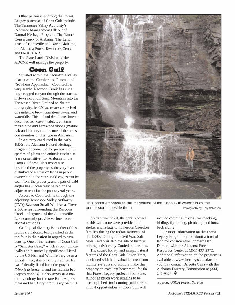
district of the Cumberland Plateau and“Southern Appalachia,” Coon Gulf isvery scenic. Raccoon Creek has cut alarge rugged canyon through the tract asit flows north off Sand Mountain into theTennessee River. Defined as “karst”topography, its 656 acres are comprisedof sandstone brow, limestone caves, andwaterfalls. This upland deciduous forest,described as “cove” habitat, containsmesic pine and hardwood slopes (matureoak and hickory) and is one of the oldestcommunities of this type in Alabama.
In a survey conducted in the early1990s, the Alabama Natural HeritageProgram documented the presence of 33species of plants and animals tracked as“rare or sensitive” for Alabama in theCoon Gulf area. This report alsodescribed the property as the very leastdisturbed of all “wild” lands in publicownership in the state. Bald eagles can beseen from the property, and a pair of baldeagles has successfully nested on theadjacent tract for the past several years.
Access to Coon Gulf is through theadjoining Tennessee Valley Authority(TVA) Raccoon Small Wild Area. These2,366 acres surrounding the RaccoonCreek embayment of the GuntersvilleLake currently provide various recre-ational activities.
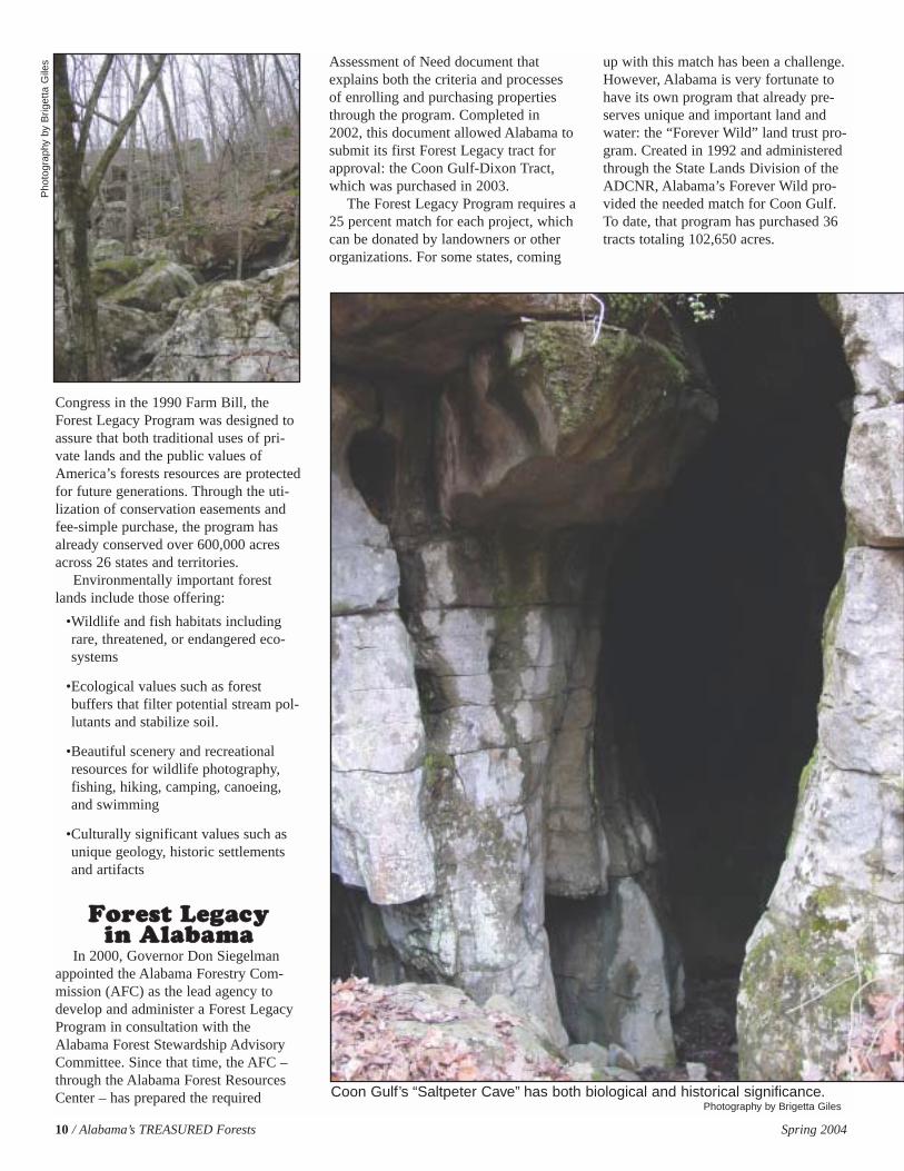
Geological diversity is another of thisregion’s attributes, being ranked in thetop four in the nation in regard to cavedensity. One of the features of Coon Gulfis “Saltpeter Cave,” which is both biolog-ically and historically significant. Listedby the US Fish and Wildlife Service as apriority cave, it is presently a refuge fortwo federally listed bats: the gray bat(Myotis grisescens) and the Indiana bat(Myotis sodalis). It also serves as a ma-ternity colony for the rare Rafinesque’sbig-eared bat (Corynorhinus rafinesquii).
As tradition has it, the dark recessesof this sandstone cave provided bothshelter and refuge to numerous Cherokeefamilies during the Indian Removal ofthe 1830s. During the Civil War, Salt-peter Cave was also the site of historicmining activities by Confederate troops.
The scenic beauty and unique naturalfeatures of the Coon Gulf-Dixon Tract,combined with its invaluable forest com-munity systems and wildlife make thisproperty an excellent benchmark for thefirst Forest Legacy project in our state.Although much work remains to beaccomplished, forthcoming public recre-ational opportunities at Coon Gulf will
include camping, hiking, backpacking,birding, fly-fishing, picnicing, and horse-back riding.
For more information on the ForestLegacy Program, or to submit a tract ofland for consideration, contact DanDumont with the Alabama ForestResources Center at (251) 433-2372.Additional information on the program isavailable at www.forestry.state.al.us oryou may contact Brigetta Giles with theAlabama Forestry Commission at (334)240-9323.
This photo emphasizes the magnitude of the Coon Gulf waterfalls as theauthor stands beside them. Photography by Gary Wilkinson
Spring 2004 Alabama’s TREASURED Forests / 11
Source: USDA Forest Service
12 / Alabama’s TREASURED Forests Spring 2004
As populations expand in theSouth, forests are increasinglyaffected by human activities.In the Wildland-Urban
Interface (WUI), that area where homesor other structures are adjacent to orwithin forests, city planners and naturalresource professionals face increasedchallenges. These challenges includewildfire control, natural landscape pro-tection, soil, water quality management,and wildlife management as urban areasexpand. As unplanned WUI areasincrease, devastating wildfires willdestroy homes and property (figure 1).These challenges have a direct impact onpublic safety, welfare, and quality of life.
Fire management is a challenge inevery interface community, but it is notthe only concern. Management ofincreasingly fragmented parcels of forest-land is more difficult and less economi-cal. The number of these parcels isincreasing as people purchase smalltracts in the WUI area – but this is theAmerican Dream!
Clearly, there must be a balancebetween growth and protection. The onlyway to minimize the effects of urbangrowth is by getting involved in the plan-ning process to ensure growth is wellorganized, concentrated, and providesadequate natural landscape in a mannerbeneficial to the environment and people.
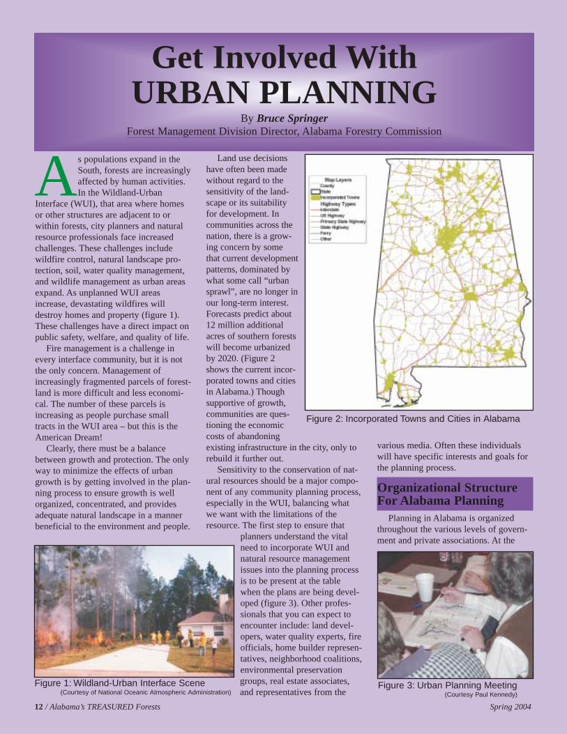
Land use decisionshave often been madewithout regard to thesensitivity of the land-scape or its suitabilityfor development. Incommunities across thenation, there is a grow-ing concern by somethat current developmentpatterns, dominated bywhat some call “urbansprawl”, are no longer inour long-term interest.Forecasts predict about12 million additionalacres of southern forestswill become urbanizedby 2020. (Figure 2shows the current incor-porated towns and citiesin Alabama.) Thoughsupportive of growth,communities are ques-tioning the economiccosts of abandoningexisting infrastructure in the city, only torebuild it further out.
Sensitivity to the conservation of nat-ural resources should be a major compo-nent of any community planning process,especially in the WUI, balancing whatwe want with the limitations of theresource. The first step to ensure that
planners understand the vitalneed to incorporate WUI andnatural resource managementissues into the planning processis to be present at the tablewhen the plans are being devel-oped (figure 3). Other profes-sionals that you can expect toencounter include: land devel-opers, water quality experts, fireofficials, home builder represen-tatives, neighborhood coalitions,environmental preservationgroups, real estate associates,and representatives from the
various media. Often these individualswill have specific interests and goals forthe planning process.
Organizational StructureFor Alabama Planning
Planning in Alabama is organizedthroughout the various levels of govern-ment and private associations. At the
Get Involved With URBAN PLANNING
By Bruce SpringerForest Management Division Director, Alabama Forestry Commission
Figure 2: Incorporated Towns and Cities in Alabama
Figure 3: Urban Planning Meeting(Courtesy Paul Kennedy)
Figure 1: Wildland-Urban Interface Scene(Courtesy of National Oceanic Atmospheric Administration)

Spring 2004 Alabama’s TREASURED Forests / 13
state level, the Governor’s office, theAlabama Development Office (ADO),the Alabama Department of Economicand Community Affairs (ADECA), andsimilar offices serve as organized agen-cies that lead planning throughout theState. The Alabama Association ofRegional Councils (ALARC) also servesin a statewide capacity. This non-govern-ment organization consists of twelveregional councils (see figure 4) that arekey players in the planning process.These councils usually have a profession-al staff and resources to perform plan-ning work.
To find out more about these groups,visit their web sites: http://www.gover-nor.state.al.us, http://www.ado.state.al.us,http://www.adeca.state.al.us, andhttp://www.alarc.org.
County commissions usually directcounty-level organizations, such as coun-ty industrial development boards. Theynormally have several county employeesto assist with development work. Citiesusually have dedicated planners on staffand work in conjunction with a zoningboard.
The Planning ProcessMost planning is done at a regional-
to-local level. Regionally, the Environ-mental Protection Agency (EPA) recentlypublished a report, “Southeast EcologicalFramework Project.” Also, the SouthernGroup of State Foresters established the
Southern Forest Urban Interface Council,and is working with the USDA ForestService to establish a center for WildlandUrban Interface Research andInformation. There are also many othergroups and organizations trying toaddress these issues. Many of thesegroups, which are often well funded andorganized, have specific goals, whichmay not often reflect urban planners andlandowner goals.
The planning process differs witheach community, but generally involves acombination of local elected officials,paid planning staff (from planning, zon-ing, and inspection departments), andvarious standing advisory committees ofappointed citizens. The planning processmust incorporate a constantly changinglist of federal, state, and local laws andregulations. Examples include theNational Pollution Discharge EliminationSystem (storm water discharge rule), theFarmland Protection Policy Act, CleanAir Act, Clean Water Act, Safe DrinkingWater Act, Endangered Species Act, andthe National Environmental ProtectionAct. The list of people and regulationsinvolved with the planning process isalmost endless!
Local citizen advisory committeeshave a surprising amount of influence onthe development of the comprehensiveurban plan. Required by most states incommunities with a population of 20,000or more, or with a significant trend of
growth or change, the comprehensiveplan is a long-range guide for the physi-cal growth and development of a com-munity. It guides decisions on land-usezoning, expansion and location of majorinfrastructure (e.g., sewer, water, andtransportation), and major public invest-ments (e.g., schools, fire stations, andparks). Comprehensive plans arerevamped every five to ten years,depending on the size and growth rate ofthe community.
A significant component of the com-prehensive plan is identification of primeagricultural and forest land and waterresources with the goal of conservingthese resource uses as a viable part of thecommunity’s culture and landscape.Comprehensive plans that minimizegrowth to the smallest and least environ-mentally sensitive lands will do the mostgood in preserving large blocks of ruralland for long-term forest and agricultureuses (figure 5).
How To Get InvolvedThe task for natural resource profes-
sionals and landowners is to get involvedto influence the planning process to mini-mize the area of impact by urban devel-opment. You should help communitiesand planners understand ecological sys-tems so they can make their planning anddevelopment decisions in an informed,science-based manner. Be sure torespond to their requests for comments.
Here are a few additional steps thatyou can take:
•Visit your local courthouse orcity/county government services center.Go to the planning department andinquire about the planning process.Find out if there is a planning commis-
(Continued on page 14)Figure 4: Alabama Association of Regional Councils
(Courtesy http://www.alarc.org)
Figure 5: Aerial view of an UrbanDevelopment Area
(Courtesy Paul Kennedy)
1 - Northwest Alabama Council of Local Governments (Tel: 256.389.0500)
2 - West Alabama Planning and Development Council (Tel: 205.333.2990)
3 - Birmingham Regional Planning Commission (Tel: 205.251.8139)
4 - East Alabama Regional Planning &Development Commission (Tel: 256.237.6741)
5 - South Central Alabama Development Commission (Tel: 334.244.6903)
6 - Alabama-Tombigbee Regional Commission (Tel: 334.682.4234)
7 - Southeast Alabama Regional Planning &Development Commission (Tel: 334.794.4093)
8 - South Alabama Regional Planning Commission (Tel: 334.794.4093)
9 - Central Alabama Regional Planning Development Commission (Tel: 334.262.4300)
10 - Lee-Russell Council of Governments (Tel: 334.749.5264)
11 - North Central Alabama Regional Council ofGovernments (Tel: 256.355.4515)
12 - Top of Alabama Regional Council of Governments (Tel: 256.533.3330)

14 / Alabama’s TREASURED Forests Spring 2004
sion or zoning board. Find out whenthese groups meet.
•Obtain a copy of your local compre-hensive plan and zoning ordinances.
•Obtain information on where utilityprojects are planned or ongoing. Manyof these are federally funded. Theyindicate where growth is occurring.
•Attend the planning meetings to seehow the process works.
•Volunteer your time to a community-planning group.
Tools For ImplementingUrban Planning
The process of urban planning isextremely complicated with many differ-ent organizations and agencies involvedusing a multitude of programs. A few ofthese programs and other considerationsare presented in the following section toshow a sample of what is available.Many other programs across the nationprovide additional resource tools.
“Firewise” CommunitiesFirewise is sponsored by the National
Wildfire Coordinating Group (NWCG).Its goal is to encourage and acknowledgeaction that minimizes home loss to wild-fire. The program includes planning anddevelopment resources and various publi-cation information that planners, devel-opers, and homeowners can use to maketheir communities and homes fire safe.The program provides this informationthrough various publications and work-shops using state-of-the-art mapping andwildfire simulations. Once a communitybecomes “fire safe” it can be recognizedfor this accomplishment by becoming aFirewise Community/USA. The AlabamaForestry Commission is actively support-ing wildland-urban interface councils,partially funded through the USDAForest Service grants. By readingFirewise publications or attending work-shops participants will learn how to:
•recognize interface fire hazards
•design Firewise homes and landscapes
•deliver fire education materials, and
•incorporate Firewise planning intoexisting and developing areas
To learn more about Firewise, go tothe web site http://www.firewise.org orcontact the Fire Division of the AlabamaForestry Commission.
“Smart Growth” NetworkIn 1996, the US Environmental
Protection Agency (EPA) joined withseveral non-profit and government orga-nizations to form the Smart GrowthNetwork. The Smart Growth Networkwas formed in response to increasingcommunity concerns about the need fornew ways to grow that boost the econo-my, protect the environment, andenhance community vitality. The SmartGrowth partners include environmentalgroups, historic preservation organiza-tions, professional associations, develop-ers, and local and state government rep-resentatives.
Smart Growth includes mechanisms toidentify priority and development areas,and limit growth to these areas. This cre-ates more compact and efficient commit-tees and preserves open space and envi-ronmentally sensitive areas. The SmartGrowth partners pool their experienceand follow several key principles as aframework for urban growth:
•Mix land uses (residential,retail, etc.)
•Take advantage of compactbuilding design (multi-unithousing/retail stores)
•Create a range of housingopportunities and choices
•Create walkable neighborhoods
•Foster distinctive, attractivecommunities with a strongsense of place
•Preserve open space, farmland,natural beauty, and critical environmental areas
•Strengthen and direct develop-ment towards existing and historical communities
•Provide a variety of transpor-tation choices to reduce automobile mileage
•Make development decisionspredictable, fair, and cost effective
•Encourage community and stakeholdercollaboration in development decisions
Christine Todd Whitman, formerGovernor of New Jersey, says the follow-ing about Smart Growth, “With SmartGrowth we will save acres, save moneyon roads, and sewers, keep homes moreaffordable, and make our cities and towncenters thrive. That’s good growth.”
Maryland implemented Smart Growthfor the entire state in 1998. Under theirprogram, they have limited growth byonly allowing federal and state develop-ment grants, such as water and sewerconstruction, to go only in priority fund-ing areas. Only these designated areasget federal and state funds (figure 6). Tolearn more, visit the website at,http://www.smartgrowth.org.
Not all agree with the principles ofSmart Growth. Portland, Oregon, was thefirst city to incorporate Smart Growth,with the response from increased regula-tion producing a decrease in the quality oflife, increases in traffic congestion, airpollution, and taxes. People were not will-ing to move back into densely populatedcities with multi-purpose housing/retailstores and give up the freedom of automo-biles for mass transit transportation. While
Figure 6: Smart Growth Priority FundingAreas in Maryland
(Courtesy http://www.smartgrowth.org)
Getting Involved with URBAN PLANNING(continued from page 13)
Spring 2004 Alabama’s TREASURED Forests / 15
some principles are extremely useful, it isimportant to weigh any program’s guide-lines with expected outcomes.
“Your Town Alabama” ProgramOne way you can learn more about
urban, suburban, and rural planning is byattending a “Your Town Alabama”Workshop. The Your Town AlabamaProgram is a first step in meeting thedevelopment needs in rural Alabama. Theworkshop format is an intensive engage-ment of citizen leaders and professionals.The three-day workshop is highly partici-patory with lectures, case-study presenta-tions, and interactive group problem solv-ing, including work on realistic issues in ahypothetical small town. The goal of theprogram is to provide advanced leader-ship skills supported by information andplanning tools that can be taken home toall corners of our state and applied to theprocess of “Designing Our Future.”
Your Town Alabama was establishedin 1998, spearheaded by Paul Kennedy, aYour Town graduate, of the CawacoRC&D Council. With the help and sup-port of several planning and developmentgroups in the state, Your Town Alabamahas held seven adult workshops, reachingnearly 330 people from 90 towns in thestate. The citizens of the Alabama smalltowns that have participated in the pro-gram include: Brighton, Chelsea,Gadsden, Lanett, Lineville, Marion,Montevallo, Slocomb, and Valley.
For more information on this programvisit http://www.yourtownalabama.org.
Watershed Management PlansThe Alabama Department of Environ-
mental Management (ADEM) operatesunder the guidance and direction of theEPA. One of their top priority tasks is thedevelopment of Watershed BasinManagement Plans for the ten mainwatersheds in Alabama. The AlabamaClean Water Partnership, a coalition ofpublic and private individuals, compa-nies, organizations, and governing bodiesis working with ADEM on this project.The plans will have a direct impact onurban development in each basin, andnatural resource professionals andlandowners should be involved in theirdevelopment.
To find out more about activities inyour area, visit one of these websites:
http://www.cleanwaterpartnership.org or http://adem.state.al.us.
Green Infrastructure PlanningMany planning programs have been
developed. One course textbook thatdetails the planning process with empha-sis on protecting important green spacewas published in 2002 by The Conserva-tion Fund, “Green Infrastructure: AStrategic Approach to Natural ResourcePlanning and Conservation.” The work-book shows a user how to set up an urbandevelopment plan using GIS (Geographi-cal Information Systems) mapping tech-nology. First, a planner must identify andestablish landscape features, both naturaland man-made. Then the planner mustidentify what areas would be beneficialfor development (hubs), what areas needto be protected (green space), and howthe landscape “links” the various sitestogether.
The workbook uses the Land Evalua-tion and Site Assessment Program, devel-oped by the USDA Natural ResourcesConservation Service (NRCS), to deter-mine the quality of land for agriculturaluses and to assess sites for their agricul-tural economic viability. It also usesother resource GIS data, such as wetlandsites, as layers of information to create ascientifically based analysis of the land-scape and its development potential. Formore information about this program,visit http://www.greeninfrastructure.net.
Conservation Easements andLand Purchases
Increasing pressures of urban develop-ment around a landowner’s propertyincreases the property value. Many timeslandowners sell their land for “higher andbetter” uses. To reduce these pressuresand prohibit development of rural landfor “the good of the public,” tax incen-tives and credits, as well as private andgovernment funds are becoming avail-able to purchase property or conservationeasements.
Conservation easements allow a landtrust or government agency to accept atransfer of land rights through a deed.The conservation easement identifiesconservation values on a specific proper-ty and restricts activities that may dimin-ish those values. Conservation easementsmost often limit subdivision or urban
(Continued on page 30)
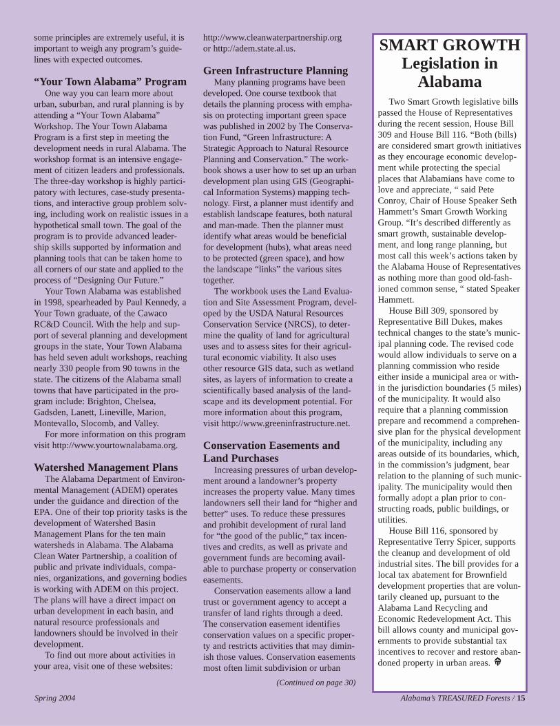
SMART GROWTHLegislation in
AlabamaTwo Smart Growth legislative bills
passed the House of Representativesduring the recent session, House Bill309 and House Bill 116. “Both (bills)are considered smart growth initiativesas they encourage economic develop-ment while protecting the specialplaces that Alabamians have come tolove and appreciate, “ said PeteConroy, Chair of House Speaker SethHammett’s Smart Growth WorkingGroup. “It’s described differently assmart growth, sustainable develop-ment, and long range planning, butmost call this week’s actions taken bythe Alabama House of Representativesas nothing more than good old-fash-ioned common sense, “ stated SpeakerHammett.
House Bill 309, sponsored byRepresentative Bill Dukes, makestechnical changes to the state’s munic-ipal planning code. The revised codewould allow individuals to serve on aplanning commission who resideeither inside a municipal area or with-in the jurisdiction boundaries (5 miles)of the municipality. It would alsorequire that a planning commissionprepare and recommend a comprehen-sive plan for the physical developmentof the municipality, including anyareas outside of its boundaries, which,in the commission’s judgment, bearrelation to the planning of such munic-ipality. The municipality would thenformally adopt a plan prior to con-structing roads, public buildings, orutilities.
House Bill 116, sponsored byRepresentative Terry Spicer, supportsthe cleanup and development of oldindustrial sites. The bill provides for alocal tax abatement for Brownfielddevelopment properties that are volun-tarily cleaned up, pursuant to theAlabama Land Recycling andEconomic Redevelopment Act. Thisbill allows county and municipal gov-ernments to provide substantial taxincentives to recover and restore aban-doned property in urban areas.
16 / Alabama’s TREASURED Forests Spring 2004
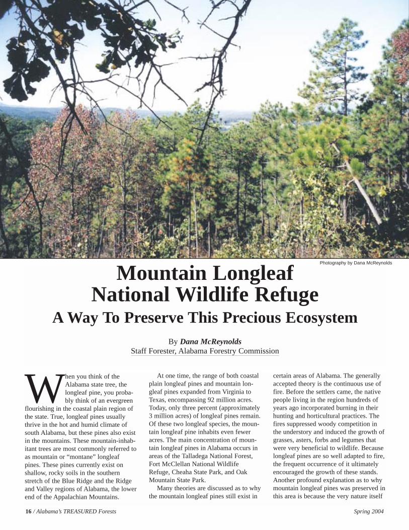
When you think of theAlabama state tree, thelongleaf pine, you proba-bly think of an evergreen
flourishing in the coastal plain region ofthe state. True, longleaf pines usuallythrive in the hot and humid climate ofsouth Alabama, but these pines also existin the mountains. These mountain-inhab-itant trees are most commonly referred toas mountain or “montane” longleafpines. These pines currently exist onshallow, rocky soils in the southernstretch of the Blue Ridge and the Ridgeand Valley regions of Alabama, the lowerend of the Appalachian Mountains.
At one time, the range of both coastalplain longleaf pines and mountain lon-gleaf pines expanded from Virginia toTexas, encompassing 92 million acres.Today, only three percent (approximately3 million acres) of longleaf pines remain.Of these two longleaf species, the moun-tain longleaf pine inhabits even feweracres. The main concentration of moun-tain longleaf pines in Alabama occurs inareas of the Talladega National Forest,Fort McClellan National WildlifeRefuge, Cheaha State Park, and OakMountain State Park.
Many theories are discussed as to whythe mountain longleaf pines still exist in
certain areas of Alabama. The generallyaccepted theory is the continuous use offire. Before the settlers came, the nativepeople living in the region hundreds ofyears ago incorporated burning in theirhunting and horticultural practices. Thefires suppressed woody competition inthe understory and induced the growth ofgrasses, asters, forbs and legumes thatwere very beneficial to wildlife. Becauselongleaf pines are so well adapted to fire,the frequent occurrence of it ultimatelyencouraged the growth of these stands.Another profound explanation as to whymountain longleaf pines was preserved inthis area is because the very nature itself
Mountain Longleaf National Wildlife Refuge
A Way To Preserve This Precious EcosystemBy Dana McReynolds
Staff Forester, Alabama Forestry Commission
Photography by Dana McReynolds
Spring 2004 Alabama’s TREASURED Forests / 17
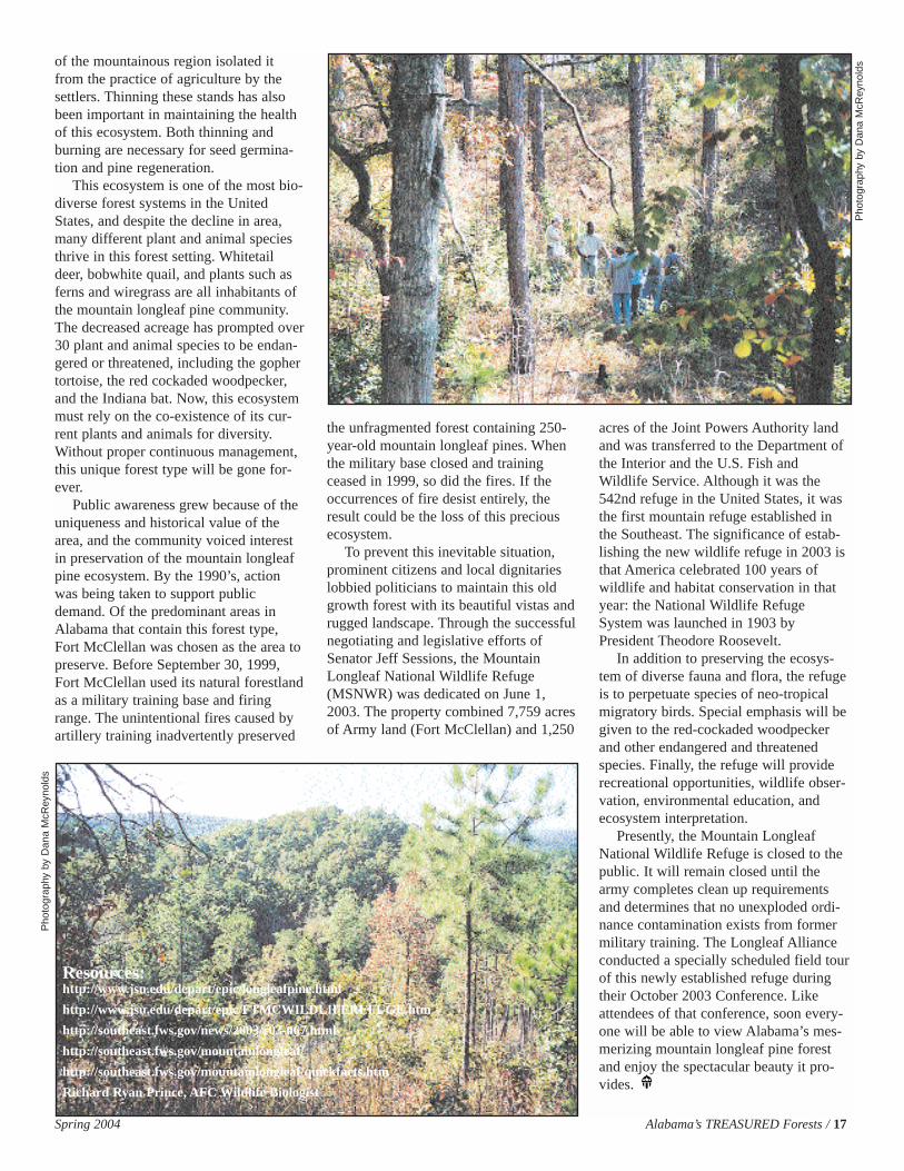
of the mountainous region isolated itfrom the practice of agriculture by thesettlers. Thinning these stands has alsobeen important in maintaining the healthof this ecosystem. Both thinning andburning are necessary for seed germina-tion and pine regeneration.
This ecosystem is one of the most bio-diverse forest systems in the UnitedStates, and despite the decline in area,many different plant and animal speciesthrive in this forest setting. Whitetaildeer, bobwhite quail, and plants such asferns and wiregrass are all inhabitants ofthe mountain longleaf pine community.The decreased acreage has prompted over30 plant and animal species to be endan-gered or threatened, including the gophertortoise, the red cockaded woodpecker,and the Indiana bat. Now, this ecosystemmust rely on the co-existence of its cur-rent plants and animals for diversity.Without proper continuous management,this unique forest type will be gone for-ever.
Public awareness grew because of theuniqueness and historical value of thearea, and the community voiced interestin preservation of the mountain longleafpine ecosystem. By the 1990’s, actionwas being taken to support publicdemand. Of the predominant areas inAlabama that contain this forest type,Fort McClellan was chosen as the area topreserve. Before September 30, 1999,Fort McClellan used its natural forestlandas a military training base and firingrange. The unintentional fires caused byartillery training inadvertently preserved
the unfragmented forest containing 250-year-old mountain longleaf pines. Whenthe military base closed and trainingceased in 1999, so did the fires. If theoccurrences of fire desist entirely, theresult could be the loss of this preciousecosystem.
To prevent this inevitable situation,prominent citizens and local dignitarieslobbied politicians to maintain this oldgrowth forest with its beautiful vistas andrugged landscape. Through the successfulnegotiating and legislative efforts ofSenator Jeff Sessions, the MountainLongleaf National Wildlife Refuge(MSNWR) was dedicated on June 1,2003. The property combined 7,759 acresof Army land (Fort McClellan) and 1,250
acres of the Joint Powers Authority landand was transferred to the Department ofthe Interior and the U.S. Fish andWildlife Service. Although it was the542nd refuge in the United States, it wasthe first mountain refuge established inthe Southeast. The significance of estab-lishing the new wildlife refuge in 2003 isthat America celebrated 100 years ofwildlife and habitat conservation in thatyear: the National Wildlife RefugeSystem was launched in 1903 byPresident Theodore Roosevelt.
In addition to preserving the ecosys-tem of diverse fauna and flora, the refugeis to perpetuate species of neo-tropicalmigratory birds. Special emphasis will begiven to the red-cockaded woodpeckerand other endangered and threatenedspecies. Finally, the refuge will providerecreational opportunities, wildlife obser-vation, environmental education, andecosystem interpretation.
Presently, the Mountain LongleafNational Wildlife Refuge is closed to thepublic. It will remain closed until thearmy completes clean up requirementsand determines that no unexploded ordi-nance contamination exists from formermilitary training. The Longleaf Allianceconducted a specially scheduled field tourof this newly established refuge duringtheir October 2003 Conference. Likeattendees of that conference, soon every-one will be able to view Alabama’s mes-merizing mountain longleaf pine forestand enjoy the spectacular beauty it pro-vides.
Resources:http://www.jsu.edu/depart/epic/longleafpine.html
http://www.jsu.edu/depart/epic/FTMCWILDLIFEREFUGE.htm
http://southeast.fws.gov/news/2003/r03-067.html
http://southeast.fws.gov/mountainlongleaf/
http://southeast.fws.gov/mountainlongleaf/quickfacts.htm
Richard Ryan Prince, AFC Wildlife Biologist
Pho
togr
aphy
by
Dan
a M
cRey
nold
s
Pho
togr
aphy
by
Dan
a M
cRey
nold
s
18 / Alabama’s TREASURED Forests Spring 2004
Previous articles provided infor-mation about direction, dis-tance, location, and topography.Another asset to utilizing your
map knowledge is the understanding ofthe relationship between map distance to
ground distance. This is a valuable toolfor practical application.
Determine the scale of your map. It isoften both explained in text and depictedas a graph bar. Take a ruler and measurethe distance between two points on themap. Suppose the map scale was 1” =
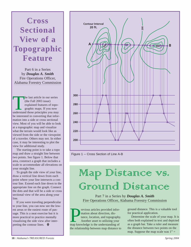
The last article in our series(the Fall 2003 issue)explained features of topo-graphic maps. If you now
understand those principles you maybe interested in converting that infor-mation into a side or cross sectionalview. Most of you will be able to lookat a topographic map and visualizewhat the terrain would look like asviewed from the side or the viewpointof a traveler. Others may not. In eithercase, it may be interesting to plot theview for additional study.
The starting point is to take a topomap and draw a straight line betweentwo points. See figure 1. Below thatarea, construct a graph that includes ascale to accommodate all elevations onyour straight line.
To graph the side view of your line,draw a vertical line down from eachpoint where your line intersects a con-tour line. Extend each line down to theappropriate line on the graph. Connectthe dots and that will be a side or crosssectional view of the area along yourline.
If you were traveling perpendicularto your line, you can now see the low-est areas or the easiest route of pas-sage. This is a neat exercise but it ismore practical to practice mentallyvisualizing the side view after inter-preting the contour lines.
CrCross oss Sectional Sectional VView of aiew of a
TTopographic opographic FeaturFeatureePart 6 in a Series
by Douglas A. SmithFire Operations Officer,
Alabama Forestry Commission
Figure 1 -- Cross Section of Line A-B
Part 7 in a Series by Douglas A. SmithFire Operations Officer, Alabama Forestry Commission
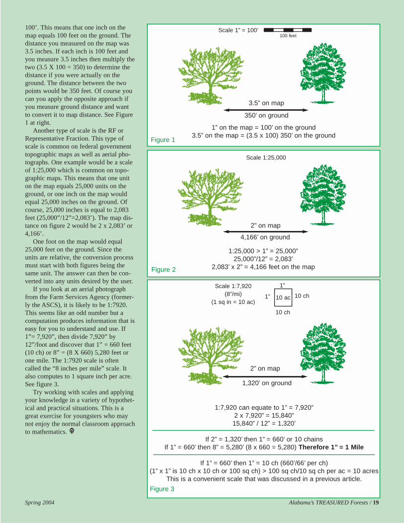
100’. This means that one inch on themap equals 100 feet on the ground. Thedistance you measured on the map was3.5 inches. If each inch is 100 feet andyou measure 3.5 inches then multiply thetwo (3.5 X 100 = 350) to determine thedistance if you were actually on theground. The distance between the twopoints would be 350 feet. Of course youcan you apply the opposite approach ifyou measure ground distance and wantto convert it to map distance. See Figure1 at right.
Another type of scale is the RF orRepresentative Fraction. This type ofscale is common on federal governmenttopographic maps as well as aerial pho-tographs. One example would be a scaleof 1:25,000 which is common on topo-graphic maps. This means that one uniton the map equals 25,000 units on theground, or one inch on the map wouldequal 25,000 inches on the ground. Ofcourse, 25,000 inches is equal to 2,083feet (25,000”/12”=2,083’). The map dis-tance on figure 2 would be 2 x 2,083’ or4,166’.
One foot on the map would equal25,000 feet on the ground. Since theunits are relative, the conversion processmust start with both figures being thesame unit. The answer can then be con-verted into any units desired by the user.
If you look at an aerial photographfrom the Farm Services Agency (former-ly the ASCS), it is likely to be 1:7920.This seems like an odd number but acomputation produces information that iseasy for you to understand and use. If1”= 7,920”, then divide 7,920” by12”/foot and discover that 1” = 660 feet(10 ch) or 8” = (8 X 660) 5,280 feet orone mile. The 1:7920 scale is oftencalled the “8 inches per mile” scale. Italso computes to 1 square inch per acre.See figure 3.
Try working with scales and applyingyour knowledge in a variety of hypothet-ical and practical situations. This is agreat exercise for youngsters who maynot enjoy the normal classroom approachto mathematics.
Spring 2004 Alabama’s TREASURED Forests / 19
3.5” on map
350’ on ground
2” on map
4,166’ on ground
1:7,920 can equate to 1” = 7,920”2 x 7,920” = 15,840”15,840” / 12” = 1,320’
If 2” = 1,320’ then 1” = 660’ or 10 chainsIf 1” = 660’ then 8” = 5,280’ (8 x 660 = 5,280) Therefore 1” = 1 Mile
If 1” = 660’ then 1” = 10 ch (660’/66’ per ch)(1” x 1” is 10 ch x 10 ch or 100 sq ch) > 100 sq ch/10 sq ch per ac = 10 acres
This is a convenient scale that was discussed in a previous article.
2” on map
1,320’ on ground
Scale 1:25,000
Scale 1” = 100’
Scale 1:7,920(8”/mi)
(1 sq in = 10 ac)
Figure 3
1:25,000 > 1” = 25,000”25,000”/12” = 2,083’
2,083’ x 2” = 4,166 feet on the mapFigure 2
1” on the map = 100’ on the ground3.5” on the map = (3.5 x 100) 350’ on the ground
Figure 1
100 feet
1”
10 ch10 ac1”
10 ch
20 / Alabama’s TREASURED Forests Spring 2004
Have you noticed how privetappears to be exploding acrossthe landscape? Privet is thatrampant small-leaved shrub
that stays green in winter and can be seenalong many fencerows and forest edges,as well as invading interior forests. Whatat one time was considered the staplefarm house shrub is now completely outof control. It has become a plague. Infact, it is spreading through our most pre-cious forests — bottomland hardwoodsand forest preserves. What was once con-sidered beauty to grace our homes hasturned against us to rapidly spread alongroadsides and stream-sides to infiltrateour forests.
Landowners and managers can eitherstand by and watch the takeover or startthe process to battle this plant plague. Tobegin, we want to tell you how to identi-fy the different species of privet that areinvading our forests, and then explainhow you can combat them.
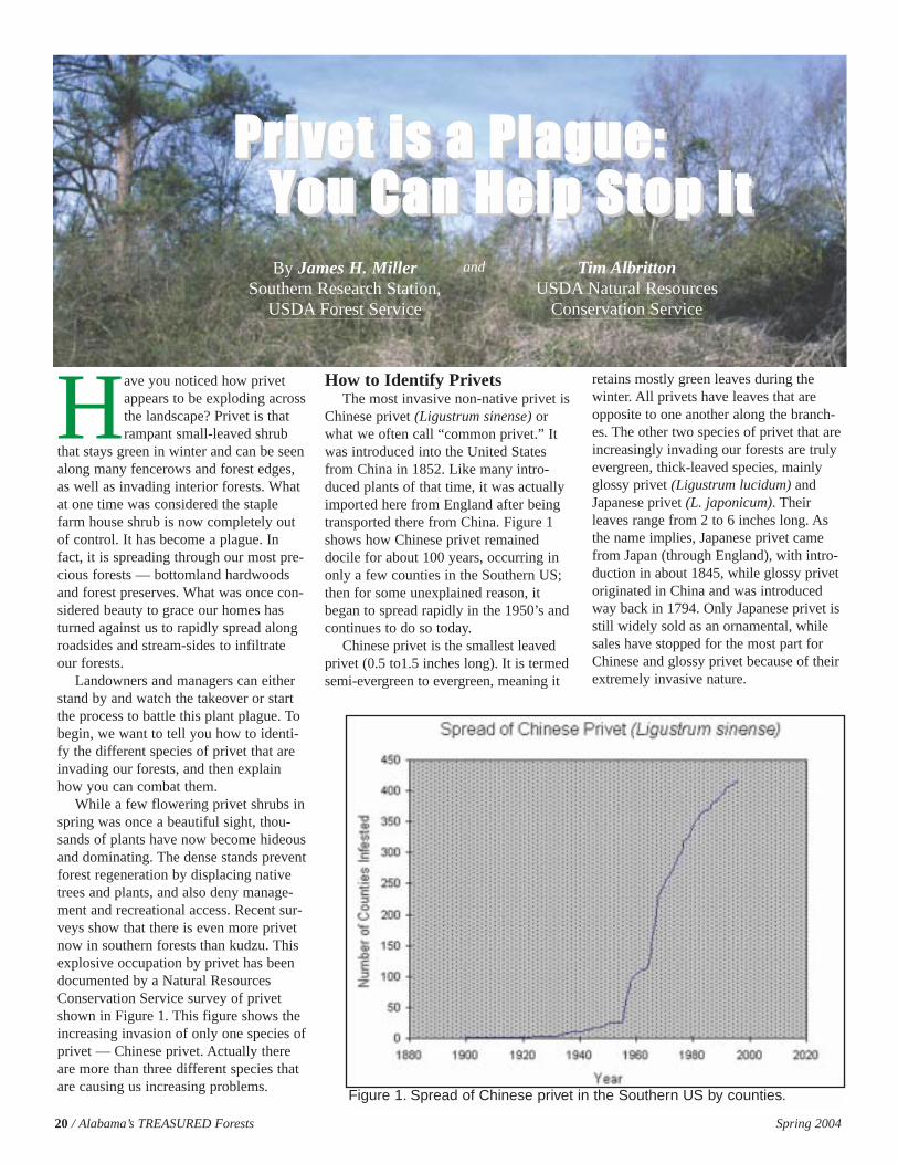
While a few flowering privet shrubs inspring was once a beautiful sight, thou-sands of plants have now become hideousand dominating. The dense stands preventforest regeneration by displacing nativetrees and plants, and also deny manage-ment and recreational access. Recent sur-veys show that there is even more privetnow in southern forests than kudzu. Thisexplosive occupation by privet has beendocumented by a Natural ResourcesConservation Service survey of privetshown in Figure 1. This figure shows theincreasing invasion of only one species ofprivet — Chinese privet. Actually thereare more than three different species thatare causing us increasing problems.
How to Identify PrivetsThe most invasive non-native privet is
Chinese privet (Ligustrum sinense) orwhat we often call “common privet.” Itwas introduced into the United Statesfrom China in 1852. Like many intro-duced plants of that time, it was actuallyimported here from England after beingtransported there from China. Figure 1shows how Chinese privet remaineddocile for about 100 years, occurring inonly a few counties in the Southern US;then for some unexplained reason, itbegan to spread rapidly in the 1950’s andcontinues to do so today.
Chinese privet is the smallest leavedprivet (0.5 to1.5 inches long). It is termedsemi-evergreen to evergreen, meaning it
retains mostly green leaves during thewinter. All privets have leaves that areopposite to one another along the branch-es. The other two species of privet that areincreasingly invading our forests are trulyevergreen, thick-leaved species, mainlyglossy privet (Ligustrum lucidum) andJapanese privet (L. japonicum). Theirleaves range from 2 to 6 inches long. Asthe name implies, Japanese privet camefrom Japan (through England), with intro-duction in about 1845, while glossy privetoriginated in China and was introducedway back in 1794. Only Japanese privet isstill widely sold as an ornamental, whilesales have stopped for the most part forChinese and glossy privet because of theirextremely invasive nature.
Figure 1. Spread of Chinese privet in the Southern US by counties.
PPrriivveett iiss aa PPllaagguuee:: PPrriivveett iiss aa PPllaagguuee:: YYoouu CCaann HHeellpp SSttoopp IIttYYoouu CCaann HHeellpp SSttoopp IIttBy James H. Miller
Southern Research Station,USDA Forest Service
Tim Albritton USDA Natural Resources
Conservation Service
and
There are at least two other species ofornamental privet escaping into southernforests: European privet (L. vulgare),which closely resembles Chinese privet,and border privet (L. obtusifolium), whichresembles glossy and Japanese privet. Allof these species can occur in the sameinfestation. Thus, the privet plague willbe gaining new recruits. The good news isthat all these privet species are control-lable.
Because privets retain their foliageduring fall and winter, they have the com-petitive advantage over native plants thatgo dormant. During warm sunny days infall and winter, privets can produce andstore sugars from photosynthesis whilenative plants sleep. Another big advan-tage is their abundant fruity seeds, justperfect for spread by birds and animals.Privets are in the olive family and justlike the olives we buy in a jar, there is athin fleshy fruit covering a hard seed inthe center. These dark-purple or blackishfruit often dangle in huge clusters onprivet branches in winter and early springwhen most birds are migrating north.Birds are the main means of spread andare the most probable cause of the privetexplosion since the 1950’s. Birds havelearned to count on privets during theirnorthern migration. Another factor for theexplosion has been the removal of somuch southern lands from cultivation dur-ing this period, a prime invitation forinvasion.
Deer is another species of wildlife thatbrowse seedling plants of Chinese privet,often on the expanding edges of privetpatches. Of course, the rapid growth ofChinese privet soon puts the tender twigsout of reach. It does not take but a fewyears for privets to reach their maximumheights of 20 to 35 feet. Chinese privethas multiple stems from a base that willeventually lean and arch. Glossy andJapanese privets grow more as centralupright stems. The prolific root sproutingof Chinese privet yields thousands ofsprouts per acre that spread and intensifya patch, along with a horde of seedlings.
Regardless of the use by birds anddeer, many more species of wildlife aredenied suitable habitat by privet infesta-tions and the infested lands becomeworthless for timber production, recre-ation, and native plant conservation.
Successful Privet ControlPrivets can be controlled with concert-
ed efforts and by using methods that haveproven to be effective. A combination oftreatments in an integrated manner usual-ly will provide the most effective strategyfor successful eradication. Many forms oftreatment can be used such as: prescribedburning; tractors with rootrakes andshredder-mulcher heads; brushsaws;pulling and digging plants; and safe andeffective herbicides. The right combina-tion depends on the extent of your privetinfestation, the size of the privet, yourobjectives, and your budget.
The usual objective is to first eradicatethe privets and then facilitate native plantre-establishment. Selective removal ofprivets before they become an infestationis the best situation to address, usingtreatments that have minimal impact onassociated native plants. But large infesta-tions can be eradicated with a more con-certed effort.
For multi-acre infestations of largeprivet, tractors with rootrakes or mowerheads are often the best approach. Someof the over-sized bush hogs or mulcher-shredders used on utility right-of-wayscan grind large privet shrubs to chipmulch. Another approach would be tochainsaw or brushsaw large privet. Ofcourse, all stumps should be immediatelytreated with Garlon 3A or a glyphosateherbicide as a 20% solution (2.5 quartsper 3-gallon mix) in water with a surfac-tant to prevent resprouting. If safety tosurrounding trees is not an issue, thenArensal AC, Chopper, or Velpar L as a10% solution (1 quart per 3-gallon mix)can be used, staying mindful of soil activ-ity. With all cut stump treatments, saw-dust and chips should be swept from thestump before herbicide application to pre-vent de-activation. Applications can bemade with a backpack sprayer or utilityspray bottle, or a wick applicator, dropperbottle, or paintbrush.
Tree injection, hack-and-squirt, andbasal stem sprays are other methods fortreating privet stems larger than one inchin diameter. Privet injection and hack-and-squirt are difficult because of themultiple stems and the need to treat eachone. The long tube of an E-Z-ject injectorpermits easier treatment of the multi-stemmed base while a machete and squirtbottle will aid with treating each stem.
Spring 2004 Alabama’s TREASURED Forests / 21
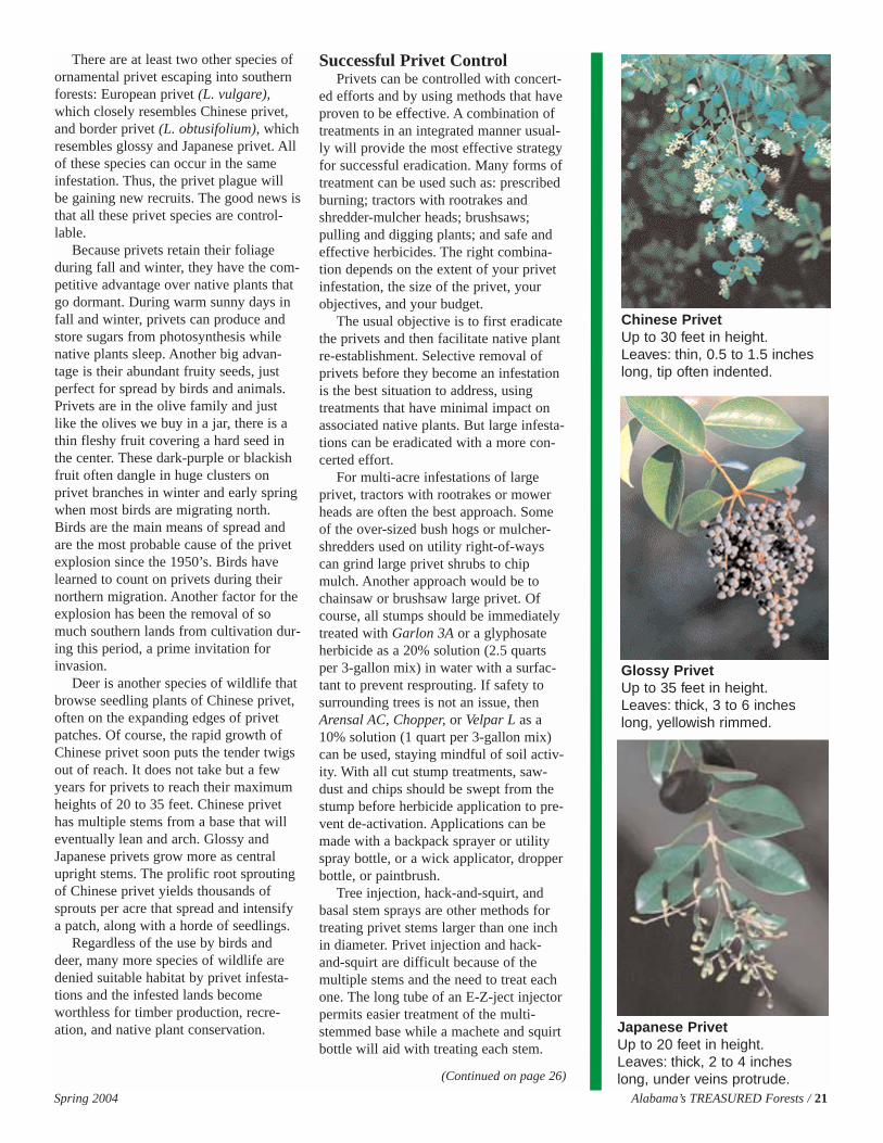
Chinese PrivetUp to 30 feet in height.Leaves: thin, 0.5 to 1.5 incheslong, tip often indented.
Glossy PrivetUp to 35 feet in height.Leaves: thick, 3 to 6 incheslong, yellowish rimmed.
Japanese PrivetUp to 20 feet in height.Leaves: thick, 2 to 4 incheslong, under veins protrude.(Continued on page 26)

22 / Alabama’s TREASURED Forests Spring 2004
Our state was born as the resultof the division of theMississippi Territory. Thegoverning body that was in
charge of seeing that the new state ofAlabama would be divided into manage-able and marketable size parcels was theUnited States General Land Office(GLO). In 1819 an office was establishedin Alabama by the GLO to facilitate thedividing of the state into a series of 36mile squares called townships. Withinthose townships were 36 one-mile square(or nearly square) sections containingapproximately 640 acres.
Today, we are trying to maintainboundary lines that may or may not havebeen marked as the GLO said they wereto be 175 years ago. It has been estimat-ed that less than five percent of all theoriginal GLO corners have ever beenfound and proven. Because of the ingre-dients in the recipe for the GLO and itshandling of the public land survey ofAlabama, we have been left with verylittle to hang on to in relation to true sec-tion corners, section lines, and quarterquarter lines.
Originally, each section was intendedto have 16 nearly equal sized parts calledquarter quarter sections, or what wecommonly know as a forty (i.e. 40acres). The GLO was responsible for hir-ing contractors to establish the outerboundaries of the sections and the town-ships. They left it up to the settlers todetermine the interior boundaries whentracts smaller than 640 acres or a sectionwere sold. Some of the circumstancesinvolved in the original survey of thepublic lands included: 1) the US govern-mental agency, “GLO”, in charge ofoverseeing programs resulted in poorsupervision; 2) Corruption within USgovernmental agency at the state level;3) Incompetent or corrupt contractors
were often understaffed and unsuper-vised; 4) Poor working conditions suchas warring Indians, disease, harsh weath-er, and low pay ($2.00 per mile); and 5)Fallible men trying to accomplish analmost impossible task, when items onethrough four are considered.
Most likely the legal description inthe deed that describes your land beginsmuch like this: “Commence at the NEcorner of Section 12, run thence dueWest along the said section line for 3100feet to the East margin of County Road14.” Usually the section corner in ques-tion is not a GLO section corner, andmore often the section line does not havea true bearing of due West. The truth ofthe matter is that 95 percent of all deedscall reference to the GLO corners (i.e.NE corner of Section 12), which areactually “monumented” and representedin the field by a rock pile, pine knot,concrete, iron, axle, etc. None of theseitems were used by the GLO to monu-ment corners. So, sometime over the past175 years, someone besides the GLOcontractor set or placed the corner of thesection referenced in your legal descrip-tion. Without the original charred 6x6pine stake set by the GLO contractor orthe original “witness” trees, we are leftto assume that the Section corner refer-enced in said legal description is some-thing else. Boundary case law definesthis “something else” as “monumentationby acquiescence and recognition.” Asyou look at your legal description, whichis the essence of what you say and thinkyou own, you may find evidence of aline consisting of old barbed wire intrees, mature trees in a straight linemarked with blazes, rock piles and pineknots at each half mile corner, or some-thing close to that. All of these elementsare, void of GLO corners, boundary byrecognition and acquiescence. Deed ref-
erencing to the “NE corner of Section12” usually means “the locally accepted”NE corner of Section12.
To maintain the integrity of yourboundary lines, use high quality productssuch as boundary line paint and paintyour boundary line every five to sevenyears. A good boundary paint will lastlonger than five to seven years, but onewould need to walk the boundary line atleast every five to seven years to invento-ry what the outer boundary looks like anddetermine if there are any problems fromtrespassers, poachers, timber cutting, etc.
Take care in marking trees to bepainted, as they should not be more than3 feet from the line. A good way to marka boundary line is to use a brush hook toplace two hacks on the neighbor’s sideof the line and three hacks on your sideof the line. Space the hacks 10 to 14inches apart on trees larger than 6 inchesDBH. Painted trees should not be furtherapart than 1 Chain (66 feet). At each cor-ner or break point, find three suitabletrees that are within 25 to 30 feet of thecorner and that create somewhat of a tri-angle around the corner and scrape theouter bark and moss off. Be careful notto penetrate through into the cambianlayer; this will cause the tree to bleedand may invite disease. Scrape all theway around the tree and create a band 6to 8 inches wide. Paint the entire band360 degrees around this tree.
While in the process of managingyour land and maintaining your bound-aries, always show class by not harvest-ing the boundary line trees. Occasionallya tree will reach full maturity or becomeinferior and need to be taken. If this isthe case, discuss it with your neighborbefore doing so. Good boundary lineestablishment and a maintenance pro-gram will prove valuable if there is ever
BOUNDARY LINES:Why They Should Be
Well Established and MaintainedBy Joe Mullins, Consultant
(Continued on page 27)
Spring 2004 Alabama’s TREASURED Forests / 23
Visit the AFC website atwww.forestry.state.al.us
Legislative ProfileBy Coleen Vansant, Information Manager, Alabama Forestry Commission
Allen Layson will proudly tellyou that he is the only regis-tered forester in a state Houseof Representatives in the
nation. This fact, along with many otherinterests in forestry and naturalresources, has made him a key championin the state legislature for forestry, forestindustry, and volunteer fire departments.
Representative Layson is a native ofGeorgia where he received his degree inforestry from the University of Georgia.His experience in the forestry industry isextensive, including 14 years withBowater Incorporated and 18 years atWeyerhaeuser Company. He is currentlyemployed with Midsouth ForestryServices as a consulting forester. He andhis wife JoAnn have called Reform homefor many years and have five children,“all grown” according to Layson.
Currently serving in his fifth term asrepresentative of the 61st District, whichincludes Pickens and Tuscaloosa coun-
ties, Layson is chair of the AgricultureSub-committee of the Agriculture,Forestry and Natural ResourcesCommittee. He also serves on the HealthCommittee, the Legislative ForestryStudy Committee, the Oil and GasInterim Committee, and the Energy andEnvironment Committee.
Through his experience and know-ledge as a forester, RepresentativeLayson has been able to help theAlabama Forestry Commission and firedepartments, as well as forestry and natu-ral resources across the state over theyears, not only in the House ofRepresentatives, but also by his involve-ment in many private organizations. Hesponsored the legislation which createdthe Alabama Prescribed Burning Act.Passed in 1995, this legislation declaredthat prescribed burning is a landownerproperty right that benefits the environ-ment and the public. The Act limited theliability of landowners for prescribedburns which are conducted in compliancewith the law. Additionally, he has spon-sored numerous pieces of legislationwhich benefitted volunteer fire depart-ments. Prior to his election to theLegislature, he served on the committeewhich drafted Alabama's Best Manage-ment Practices (BMPs) for forestry.
Layson served from 1979 to 1983 as aCommissioner of the Alabama ForestryCommission. He is one of the first lifemembers of the Alabama WildlifeFederation and has served two terms aspresident of that organization. He is apast member of the Board of Directors ofthe Alabama Forestry Association and ispast chairman of the Alabama Divisionfor the Society of American Foresters.Currently, he is serving on the AdvisoryCouncil of Auburn University’s Schoolof Forestry and Wildlife Sciences.
He also serves on many national com-mittees including the AmericanLegislative Exchange Council, the
Council of State Governments, and hasbeen an Alabama delegate to the NationalWildlife Federation for five years.
Representative Layson has been hon-ored as a recipient of the Governor’sConservationist of the Year Award inForestry, the Kelly Mosley Environment-al Award, and the American PulpwoodAssociation’s Southwestern U.S.Technical Writing Award.
At home in Pickens County he isequally involved in his community. He isa Lay Leader and Lay Speaker of theUnited Methodist Church, a founder ofthe Reform Area Public Library, a pastPresident of the Reform Rotary Club, amember of the Pickens County MentalHealth Association, a Master Mason, amember of the American Legion, SierraClub, Alabama Cattlemen’s Association,Boy Scout Troup Committee, and is aproud member of 16 fire departments.
According to Wayne Strawbridge,Alabama Forestry Commission North-west Regional Forester, “Allen has anexcellent knowledge of how we operateand as a registered forester he under-stands the job that we do.” Strawbridge,who has known Representative Laysonsince he (Layson) first came to Alabama“34-35 years ago,” says, “Allen hasalways been willing to help with forestryand volunteer fire department matters inany way he could. He is more than will-ing to help us in the legislature and hewill listen to us and our concerns.”
Editor’s Note: Legislative Profile is anew segment of the Legislation andPolicy department. Its purpose is to spot-light state legislators who have been afriend of the Alabama ForestryCommission, forest industry, and RuralCommunity Fire Protection (RCFP) overthe years. We extend a special thanks toRepresentative Layson for agreeing to bethe first “profile.”
Allen LaysonDemocratDistrict 61
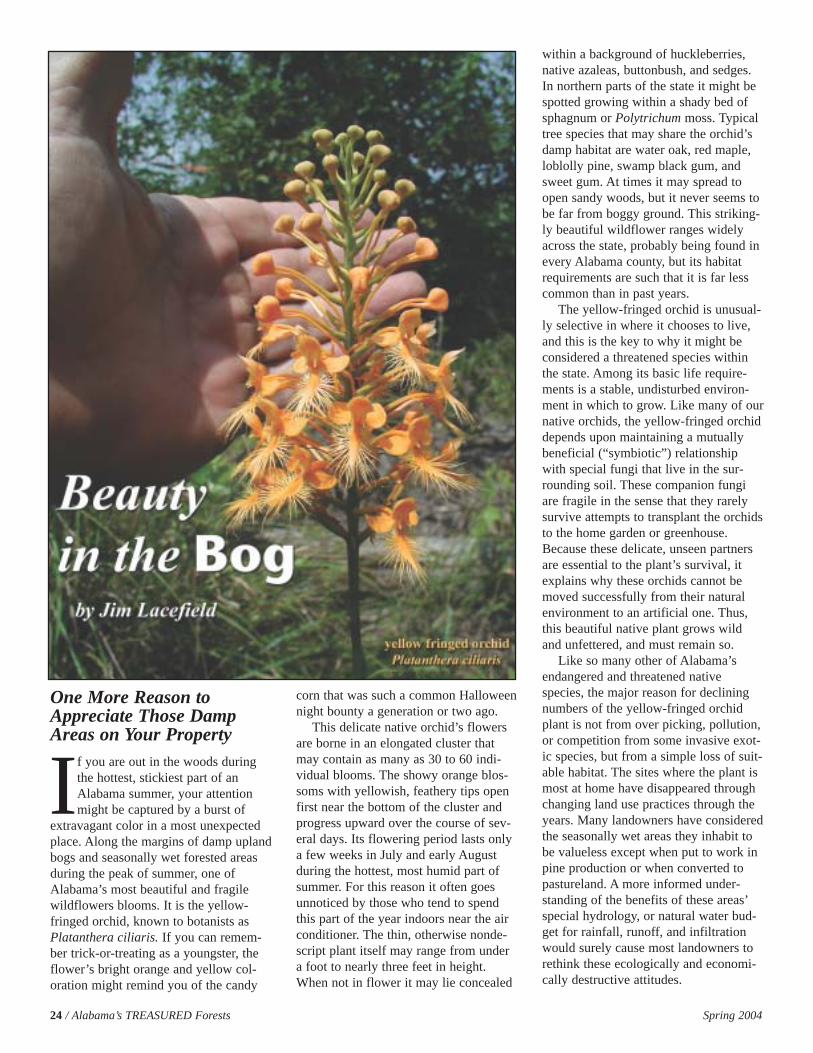
24 / Alabama’s TREASURED Forests Spring 2004
One More Reason toAppreciate Those DampAreas on Your Property
If you are out in the woods duringthe hottest, stickiest part of anAlabama summer, your attentionmight be captured by a burst of
extravagant color in a most unexpectedplace. Along the margins of damp uplandbogs and seasonally wet forested areasduring the peak of summer, one ofAlabama’s most beautiful and fragilewildflowers blooms. It is the yellow-fringed orchid, known to botanists asPlatanthera ciliaris. If you can remem-ber trick-or-treating as a youngster, theflower’s bright orange and yellow col-oration might remind you of the candy
corn that was such a common Halloweennight bounty a generation or two ago.
This delicate native orchid’s flowersare borne in an elongated cluster thatmay contain as many as 30 to 60 indi-vidual blooms. The showy orange blos-soms with yellowish, feathery tips openfirst near the bottom of the cluster andprogress upward over the course of sev-eral days. Its flowering period lasts onlya few weeks in July and early Augustduring the hottest, most humid part ofsummer. For this reason it often goesunnoticed by those who tend to spendthis part of the year indoors near the airconditioner. The thin, otherwise nonde-script plant itself may range from undera foot to nearly three feet in height.When not in flower it may lie concealed
within a background of huckleberries,native azaleas, buttonbush, and sedges.In northern parts of the state it might bespotted growing within a shady bed ofsphagnum or Polytrichum moss. Typicaltree species that may share the orchid’sdamp habitat are water oak, red maple,loblolly pine, swamp black gum, andsweet gum. At times it may spread toopen sandy woods, but it never seems tobe far from boggy ground. This striking-ly beautiful wildflower ranges widelyacross the state, probably being found inevery Alabama county, but its habitatrequirements are such that it is far lesscommon than in past years.
The yellow-fringed orchid is unusual-ly selective in where it chooses to live,and this is the key to why it might beconsidered a threatened species withinthe state. Among its basic life require-ments is a stable, undisturbed environ-ment in which to grow. Like many of ournative orchids, the yellow-fringed orchiddepends upon maintaining a mutuallybeneficial (“symbiotic”) relationshipwith special fungi that live in the sur-rounding soil. These companion fungiare fragile in the sense that they rarelysurvive attempts to transplant the orchidsto the home garden or greenhouse.Because these delicate, unseen partnersare essential to the plant’s survival, itexplains why these orchids cannot bemoved successfully from their naturalenvironment to an artificial one. Thus,this beautiful native plant grows wildand unfettered, and must remain so.
Like so many other of Alabama’sendangered and threatened nativespecies, the major reason for decliningnumbers of the yellow-fringed orchidplant is not from over picking, pollution,or competition from some invasive exot-ic species, but from a simple loss of suit-able habitat. The sites where the plant ismost at home have disappeared throughchanging land use practices through theyears. Many landowners have consideredthe seasonally wet areas they inhabit tobe valueless except when put to work inpine production or when converted topastureland. A more informed under-standing of the benefits of these areas’special hydrology, or natural water bud-get for rainfall, runoff, and infiltrationwould surely cause most landowners torethink these ecologically and economi-cally destructive attitudes.
Spring 2004 Alabama’s TREASURED Forests / 25
The Importance ofSubsurface Hydrology toForest Productivity
While it may be true that sites wherewater stands throughout parts of the yearmay not be the ideal spots for cultivationand harvesting of trees on a commercialscale, these areas are valuable for otherreasons. Much has been learned recentlyabout the tremendous value that wet-lands, both large and small, offer inimproving water quality, providingdrought insulation, and as prime wildlifehabitat. The contribution that wetlandsmake to environmental quality goes farbeyond the benefit they have for individ-ual landowners, but also extends out tobenefit systems far removed from theirimmediate locations.
Forestry scientists as well as the pub-lic in general are becoming increasinglyaware of the importance wet areas havein larger hydrologic and conservationsystems. The hydrology of an area – thedynamics of rainfall, runoff, infiltration,and the underground movement and stor-age of fresh water – plays a key role inthe land’s productivity and sustainableuse for forestry and agricultural purpos-es. All watersheds have localized areaswhose natural topography and soil char-acteristics are such that rainfall runoff istemporarily stored. These areas may beas small as a fraction of an acre in size,but they have an oversized role to play inthe way rainfall is made available to theland. Hydrologists use the term “catch-ments” for these temporary storagebasins for rainfall runoff. The size andstorage ability of a catchment may beinfluenced by land relief and slope,drainage pattern, geographic orientation,and the characteristics and structure ofunderlying earth material such as soiland rocks.
Forest productivity depends on havingadequate availability of soil moisture, aneed that is particularly critical duringthe hot months of summer when rainfallamounts may be highly variable andrapidly growing trees are at their peak ofwater loss through transpiration. Low,damp areas that were once seen as eco-nomic “under achievers” are nowbecoming recognized for their hydrolog-ic value as catchments, helping to slowdown rainfall runoff and allowing theinfiltration of water both into the soil and
into deeper aquifers for longer term stor-age. Small bogs and topographic depres-sions – “loblollies” as they were knownto Alabama’s early loggers and timbermen in the flat woods of the southernpart of the state – are like savings banksthat hold water for later withdrawal dur-ing drier parts of the climate cycle. NoAlabama timber producer should need tobe reminded of the economic importanceof maintaining supplies of soil moistureafter the recent years when droughtstress in forests led to near catastrophiclosses from pine beetles across the state.Trees use water not just in photosynthe-sis for producing new tissue, but waterloss through leaves during transpirationhelps to lower surface temperatures andkeep enzyme systems at peak efficiencyfor maximum growth to occur.
How land is managed can greatlyaffect the availability of soil moisture.Much of Alabama’s landscape is under-lain by sand and clay layers that serveimportant roles in storing and transport-ing water underground. Sandy horizonscan store large amounts of subsurfacewater between individual sand grains.Clay layers serve to slow the gravity-driven downward movement of waterinto zones where it is inaccessible toplant roots. Transpiration by trees exertsa pressure on this underground supply,and capillary attraction helps draw mois-ture back toward the surface. With theirnatural subsurface “plumbing” intact,small catchments scattered across thelandscape help recharge the water tableby encouraging a higher level of rainfallinfiltration into subsurface zones. Storedhere it can re-supply the soil during driermonths and provide a natural insulationagainst drought and the accompanyingstress it produces in forests. Human-induced landscape modification such aschannelization of streams or draining ofwetlands to accelerate runoff disruptscollection and storage of rainfall in thesenatural catchments, and likely has long-term adverse consequences on the poten-tial productivity of the surrounding forestcommunity. Heavy equipment such asskidders used in harvesting trees in thesesensitive areas can also compact soils
and reduce their capacity to absorb andstore rainfall for many years.
Sound Reasons to ProtectThose Streamsides andBoggy Areas
So you see, bogs are beautiful! Thereare a number of contributions, both eco-nomic and aesthetic, that even small wet-lands make to your property. Let’s sum-marize here some of reasons why you, asa forest owner or manager, should valuethese parts of your land. If you have aneye on the economic returns from timberproduction, you can recognize the impor-tance woodland catchments have inextending forest growth into dry seasonsand periods of drought. They help bufferthe forest’s moisture supply during drytimes and help to reduce stress and dis-ease in your trees.
If you are a wildlife lover you areprobably already aware of the year-roundbenefit that wetlands offer to local andmigratory populations of mammals,frogs, fish, and birds. Maintaining thesewet areas protects many of the key habi-tats that allow Alabama to boast such arich variety of plant and animal life.
If you support the wise use ofAlabama’s resources and the pursuit of ahealthy environment you undoubtedlyknow of the protective and cleansingproperties of wetlands. Slowing waterdown in its path to the sea reduces itsoften-damaging effect on the land andmakes it better available to all life.Streamside management zones reducesoil erosion and siltation in downstreamareas, improving water quality in ourlakes and rivers.
If you need yet one final reason toappreciate those wooded stream marginsand damp environments on your proper-ty, then the chance to glimpse a radiantyellow-fringed orchid rising out of theboggy area at the peak of summer mightjust do it for you.
Dr. Jim Lacefield teaches biology and earth science part-time at the University of NorthAlabama and is a TREASURE Forest landowner. He and his wife, Faye, developed CaneCreek Canyon Nature Preserve, a 413-acre scenic natural area in Colbert County. Many rareand endangered plant species – including the yellow-fringed orchid – occur on the preservewhich is open to the public. Contact Dr. Lacefield at [email protected].
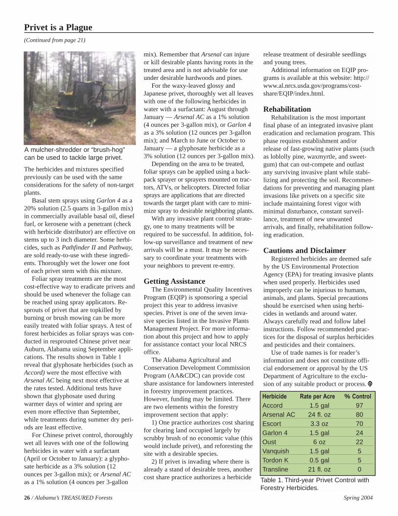
26 / Alabama’s TREASURED Forests Spring 2004
The herbicides and mixtures specifiedpreviously can be used with the sameconsiderations for the safety of non-targetplants.
Basal stem sprays using Garlon 4 as a20% solution (2.5 quarts in 3-gallon mix)in commercially available basal oil, dieselfuel, or kerosene with a penetrant (checkwith herbicide distributor) are effective onstems up to 3 inch diameter. Some herbi-cides, such as Pathfinder II and Pathway,are sold ready-to-use with these ingredi-ents. Thoroughly wet the lower one footof each privet stem with this mixture.
Foliar spray treatments are the mostcost-effective way to eradicate privets andshould be used whenever the foliage canbe reached using spray applicators. Re-sprouts of privet that are topkilled byburning or brush mowing can be moreeasily treated with foliar sprays. A test offorest herbicides as foliar sprays was con-ducted in resprouted Chinese privet nearAuburn, Alabama using September appli-cations. The results shown in Table 1reveal that glyphosate herbicides (such asAccord) were the most effective withArsenal AC being next most effective atthe rates tested. Additional tests haveshown that glyphosate used duringwarmer days of winter and spring areeven more effective than September,while treatments during summer dry peri-ods are least effective.
For Chinese privet control, thoroughlywet all leaves with one of the followingherbicides in water with a surfactant(April or October to January): a glypho-sate herbicide as a 3% solution (12ounces per 3-gallon mix); or Arsenal ACas a 1% solution (4 ounces per 3-gallon
mix). Remember that Arsenal can injureor kill desirable plants having roots in thetreated area and is not advisable for useunder desirable hardwoods and pines.
For the waxy-leaved glossy andJapanese privet, thoroughly wet all leaveswith one of the following herbicides inwater with a surfactant: August throughJanuary — Arsenal AC as a 1% solution(4 ounces per 3-gallon mix), or Garlon 4as a 3% solution (12 ounces per 3-gallonmix); and March to June or October toJanuary — a glyphosate herbicide as a3% solution (12 ounces per 3-gallon mix).
Depending on the area to be treated,foliar sprays can be applied using a back-pack sprayer or sprayers mounted on trac-tors, ATVs, or helicopters. Directed foliarsprays are applications that are directedtowards the target plant with care to mini-mize spray to desirable neighboring plants.
With any invasive plant control strate-gy, one to many treatments will berequired to be successful. In addition, fol-low-up surveillance and treatment of newarrivals will be a must. It may be neces-sary to coordinate your treatments withyour neighbors to prevent re-entry.
Getting AssistanceThe Environmental Quality Incentives
Program (EQIP) is sponsoring a specialproject this year to address invasivespecies. Privet is one of the seven inva-sive species listed in the Invasive PlantsManagement Project. For more informa-tion about this project and how to applyfor assistance contact your local NRCSoffice.
The Alabama Agricultural andConservation Development CommissionProgram (AA&CDC) can provide costshare assistance for landowners interestedin forestry improvement practices.However, funding may be limited. Thereare two elements within the forestryimprovement section that apply:
1) One practice authorizes cost sharingfor clearing land occupied largely byscrubby brush of no economic value (thiswould include privet), and reforesting thesite with a desirable species.
2) If privet is invading where there isalready a stand of desirable trees, anothercost share practice authorizes a herbicide
release treatment of desirable seedlingsand young trees.
Additional information on EQIP pro-grams is available at this website: http://www.al.nrcs.usda.gov/programs/cost-share/EQIP/index.html.
RehabilitationRehabilitation is the most important
final phase of an integrated invasive planteradication and reclamation program. Thisphase requires establishment and/orrelease of fast-growing native plants (suchas loblolly pine, waxmyrtle, and sweet-gum) that can out-compete and outlastany surviving invasive plant while stabi-lizing and protecting the soil. Recommen-dations for preventing and managing plantinvasions like privets on a specific siteinclude maintaining forest vigor withminimal disturbance, constant surveil-lance, treatment of new unwantedarrivals, and finally, rehabilitation follow-ing eradication.
Cautions and DisclaimerRegistered herbicides are deemed safe
by the US Environmental ProtectionAgency (EPA) for treating invasive plantswhen used properly. Herbicides usedimproperly can be injurious to humans,animals, and plants. Special precautionsshould be exercised when using herbi-cides in wetlands and around water.Always carefully read and follow labelinstructions. Follow recommended prac-tices for the disposal of surplus herbicidesand pesticides and their containers.
Use of trade names is for reader’sinformation and does not constitute offi-cial endorsement or approval by the USDepartment of Agriculture to the exclu-sion of any suitable product or process.
Privet is a Plague(Continued from page 21)
Herbicide Rate per Acre % ControlAccord 1.5 gal 97Arsenal AC 24 fl. oz 80Escort 3.3 oz 70Garlon 4 1.5 gal 24Oust 6 oz 22Vanquish 1.5 gal 5Tordon K 0.5 gal 5Transline 21 fl. oz 0
A mulcher-shredder or “brush-hog”can be used to tackle large privet.
Table 1. Third-year Privet Control withForestry Herbicides.
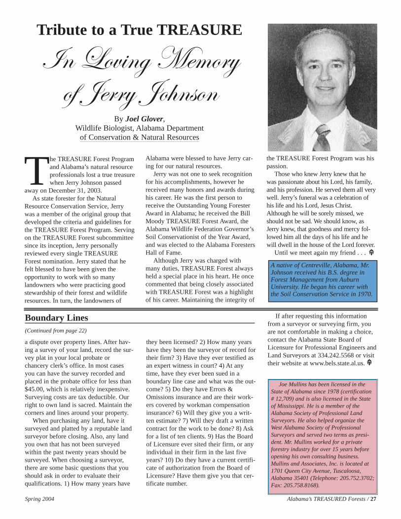
The TREASURE Forest Programand Alabama’s natural resourceprofessionals lost a true treasurewhen Jerry Johnson passed
away on December 31, 2003.As state forester for the Natural
Resource Conservation Service, Jerrywas a member of the original group thatdeveloped the criteria and guidelines forthe TREASURE Forest Program. Servingon the TREASURE Forest subcommitteesince its inception, Jerry personallyreviewed every single TREASUREForest nomination. Jerry stated that hefelt blessed to have been given theopportunity to work with so manylandowners who were practicing goodstewardship of their forest and wildliferesources. In turn, the landowners of
Alabama were blessed to have Jerry car-ing for our natural resources.
Jerry was not one to seek recognitionfor his accomplishments, however hereceived many honors and awards duringhis career. He was the first person toreceive the Outstanding Young ForesterAward in Alabama; he received the BillMoody TREASURE Forest Award, theAlabama Wildlife Federation Governor’sSoil Conservationist of the Year Award,and was elected to the Alabama ForestersHall of Fame.
Although Jerry was charged withmany duties, TREASURE Forest alwaysheld a special place in his heart. He oncecommented that being closely associatedwith TREASURE Forest was a highlightof his career. Maintaining the integrity of
the TREASURE Forest Program was hispassion.
Those who knew Jerry knew that hewas passionate about his Lord, his family,and his profession. He served them all verywell. Jerry’s funeral was a celebration ofhis life and his Lord, Jesus Christ.Although he will be sorely missed, weshould not be sad. We should know, asJerry knew, that goodness and mercy fol-lowed him all the days of his life and hewill dwell in the house of the Lord forever.
Until we meet again my friend . . .
Spring 2004 Alabama’s TREASURED Forests / 27
Tribute to a True TREASURE
\Ç _Éä|Çz `xÅÉÜç
Éy ]xÜÜç ]É{ÇáÉÇBy Joel Glover,
Wildlife Biologist, Alabama Department of Conservation & Natural Resources
A native of Centreville, Alabama, Mr.Johnson received his B.S. degree inForest Management from AuburnUniversity. He began his career withthe Soil Conservation Service in 1970.
a dispute over property lines. After hav-ing a survey of your land, record the sur-vey plat in your local probate orchancery clerk’s office. In most casesyou can have the survey recorded andplaced in the probate office for less than$45.00, which is relatively inexpensive.Surveying costs are tax deductible. Ourright to own land is sacred. Maintain thecorners and lines around your property.
When purchasing any land, have itsurveyed and platted by a reputable landsurveyor before closing. Also, any landyou own that has not been surveyedwithin the past twenty years should besurveyed. When choosing a surveyor,there are some basic questions that youshould ask in order to evaluate theirqualifications. 1) How many years have
they been licensed? 2) How many yearshave they been the surveyor of record fortheir firm? 3) Have they ever testified asan expert witness in court? 4) At anytime, have they ever been sued in aboundary line case and what was the out-come? 5) Do they have Errors &Omissions insurance and are their work-ers covered by workman compensationinsurance? 6) Will they give you a writ-ten estimate? 7) Will they draft a writtencontract for the work to be done? 8) Askfor a list of ten clients. 9) Has the Boardof Licensure ever sited their firm, or anyindividual in their firm in the last fiveyears? 10) Do they have a current certifi-cate of authorization from the Board ofLicensure? Have them give you that cer-tificate number.
If after requesting this informationfrom a surveyor or surveying firm, youare not comfortable in making a choice,contact the Alabama State Board ofLicensure for Professional Engineers andLand Surveyors at 334.242.5568 or visittheir website at www.bels.state.al.us.
Boundary Lines(Continued from page 22)
Joe Mullins has been licensed in theState of Alabama since 1978 (certification# 12,709) and is also licensed in the Stateof Mississippi. He is a member of theAlabama Society of Professional LandSurveyors. He also helped organize theWest Alabama Society of ProfessionalSurveyors and served two terms as presi-dent. Mr. Mullins worked for a privateforestry industry for over 15 years beforeopening his own consulting business.Mullins and Associates, Inc. is located at1701 Queen City Avenue, Tuscaloosa,Alabama 35401 (Telephone: 205.752.3702;Fax: 205.758.8168).
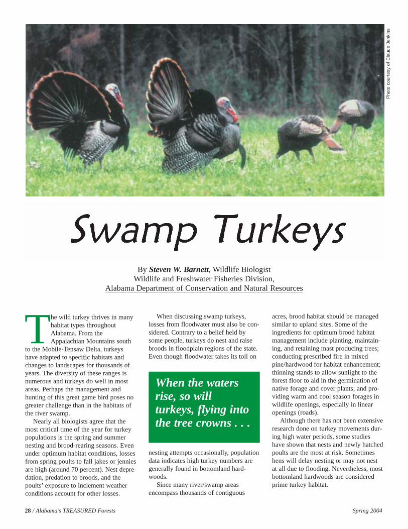
The wild turkey thrives in manyhabitat types throughoutAlabama. From theAppalachian Mountains south
to the Mobile-Tensaw Delta, turkeyshave adapted to specific habitats andchanges to landscapes for thousands ofyears. The diversity of these ranges isnumerous and turkeys do well in mostareas. Perhaps the management andhunting of this great game bird poses nogreater challenge than in the habitats ofthe river swamp.
Nearly all biologists agree that themost critical time of the year for turkeypopulations is the spring and summernesting and brood-rearing seasons. Evenunder optimum habitat conditions, lossesfrom spring poults to fall jakes or jenniesare high (around 70 percent). Nest depre-dation, predation to broods, and thepoults’ exposure to inclement weatherconditions account for other losses.
When discussing swamp turkeys,losses from floodwater must also be con-sidered. Contrary to a belief held bysome people, turkeys do nest and raisebroods in floodplain regions of the state.Even though floodwater takes its toll on
nesting attempts occasionally, populationdata indicates high turkey numbers aregenerally found in bottomland hard-woods.
Since many river/swamp areasencompass thousands of contiguous
acres, brood habitat should be managedsimilar to upland sites. Some of theingredients for optimum brood habitatmanagement include planting, maintain-ing, and retaining mast producing trees;conducting prescribed fire in mixedpine/hardwood for habitat enhancement;thinning stands to allow sunlight to theforest floor to aid in the germination ofnative forage and cover plants; and pro-viding warm and cool season forages inwildlife openings, especially in linearopenings (roads).
Although there has not been extensiveresearch done on turkey movements dur-ing high water periods, some studieshave shown that nests and newly hatchedpoults are the most at risk. Sometimeshens will delay nesting or may not nestat all due to flooding. Nevertheless, mostbottomland hardwoods are consideredprime turkey habitat.
28 / Alabama’s TREASURED Forests Spring 2004
Pho
to c
ourt
esy
of C
laud
e Je
nkin
s
By Steven W. Barnett, Wildlife BiologistWildlife and Freshwater Fisheries Division,
Alabama Department of Conservation and Natural Resources
When the watersrise, so willturkeys, flying intothe tree crowns . . .
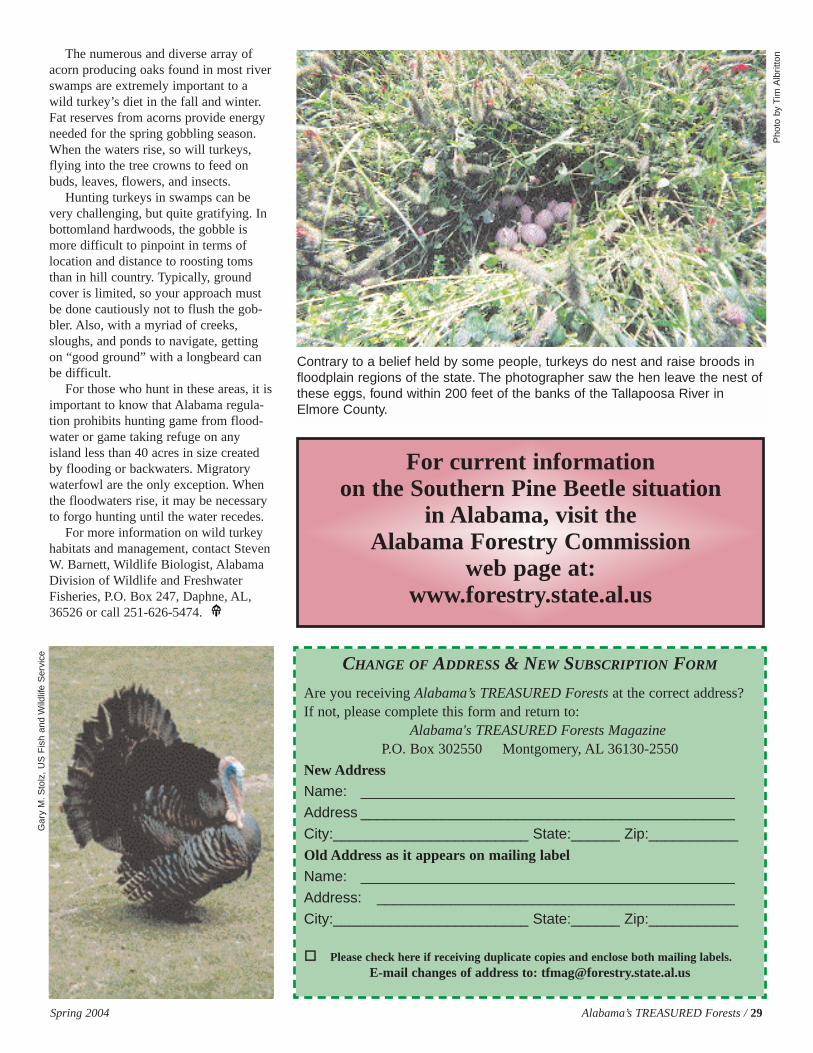
The numerous and diverse array ofacorn producing oaks found in most riverswamps are extremely important to awild turkey’s diet in the fall and winter.Fat reserves from acorns provide energyneeded for the spring gobbling season.When the waters rise, so will turkeys,flying into the tree crowns to feed onbuds, leaves, flowers, and insects.
Hunting turkeys in swamps can bevery challenging, but quite gratifying. Inbottomland hardwoods, the gobble ismore difficult to pinpoint in terms oflocation and distance to roosting tomsthan in hill country. Typically, groundcover is limited, so your approach mustbe done cautiously not to flush the gob-bler. Also, with a myriad of creeks,sloughs, and ponds to navigate, gettingon “good ground” with a longbeard canbe difficult.
For those who hunt in these areas, it isimportant to know that Alabama regula-tion prohibits hunting game from flood-water or game taking refuge on anyisland less than 40 acres in size createdby flooding or backwaters. Migratorywaterfowl are the only exception. Whenthe floodwaters rise, it may be necessaryto forgo hunting until the water recedes.
For more information on wild turkeyhabitats and management, contact StevenW. Barnett, Wildlife Biologist, AlabamaDivision of Wildlife and FreshwaterFisheries, P.O. Box 247, Daphne, AL,36526 or call 251-626-5474.
Spring 2004 Alabama’s TREASURED Forests / 29
Contrary to a belief held by some people, turkeys do nest and raise broods infloodplain regions of the state. The photographer saw the hen leave the nest ofthese eggs, found within 200 feet of the banks of the Tallapoosa River inElmore County.
For current information on the Southern Pine Beetle situation
in Alabama, visit the Alabama Forestry Commission
web page at:www.forestry.state.al.us
CHANGE OF ADDRESS & NEW SUBSCRIPTION FORM
Are you receiving Alabama’s TREASURED Forests at the correct address?If not, please complete this form and return to:
Alabama's TREASURED Forests MagazineP.O. Box 302550 Montgomery, AL 36130-2550
New Address
Name: ______________________________________________
Address ______________________________________________
City:________________________ State:______ Zip:___________
Old Address as it appears on mailing label
Name: ______________________________________________
Address: ____________________________________________
City:________________________ State:______ Zip:___________
� Please check here if receiving duplicate copies and enclose both mailing labels.E-mail changes of address to: [email protected]
Pho
to b
y T
im A
lbrit
ton
Gar
y M
.Sto
lz,
US
Fis
h an
d W
ildlif
e S
ervi
ce
30 / Alabama’s TREASURED Forests Spring 2004
development on enrolled property. Theentity pays landowners for agreeing tothe restrictions. In addition, the value ofa qualified conservation easement dona-tion may be deducted from your taxes.The federal tax code for conservationeasements is found in section 170(h).Alabama conservation easement policiesare also identified in the AlabamaConservation Easement Law (AL CodeSec. 35-18-1). Other economic incentivesand compensation to landowners for pub-lic benefits from their forests include set-ting aside riparian buffers, habitat forendangered species, carbon sequestration,and greenspace.
There are many non-profit organiza-tions and government agencies that areactively purchasing sensitive lands thatare in danger of being converted throughurban sprawl. For example, according tothe Land Trust Alliance, in 1999, out of102 local initiatives voted on in theUnited States to devote public funding toprotect open space, 90 percent wonapproval, committing $7.3 billion. TheUSDA Natural Resource ConservationService, US Fish and Wildlife Service,EPA, ADEM, and the State LandsDivision of the Alabama Department ofConservation & Natural Resources are afew of the many government agenciesthat have funds available to purchaseconservation easements. Non-profitsinclude the Alabama Forest ResourceCenter, Alabama Land Trust Alliance,and The Nature Conservancy. Thousandsof acres in Alabama have already beenpurchased and set aside as conservationeasements.
Tax ImplicationsDepending upon how they are struc-
tured, taxes can accelerate developmentat the wildland-urban interface or helpshape development to meet the needs ofa growing population while retaining asmuch land as possible in a rural condi-tion. Generally, lower property taxes, tax-ation based on current use, and lowerinheritance taxes provide the greatestincentives for landowners to retain theirproperty. These can be offset by greaterseverance taxes if needed.
Under the Alabama severance tax law,the timber is not taxed until it is harvest-
ed. The deferred tax on the timber mostoften is based on the amount, or yield, ofthe harvest. The economic effect of sev-erance taxes is minor – it has the mini-mum effect on a landowner’s manage-ment or decision to sell land. It may,however, sometimes provide a disincen-tive to harvest timber.
Laws and RegulationsLocal governments have traditionally
held the authority to make land use deci-sions because, in addition to being seenas more sensitive and responsive to localconcerns, they are perceived as havingmore expertise in implementing fair andefficient land use policy. These local landuse policies, however, often have theeffect of increasing development andexpanding the wildland-urban interface.Local governments receive most of theirfunding from property and sales taxes.Therefore, they have little incentive toattempt to limit land development in theirjurisdictions, except perhaps to reduceinfrastructure costs.
While the states generally delegatetheir authority over land use to local gov-ernments, state legislatures can review orsupersede local zoning where statewideinterests are at stake. The State’s policepowers are usually delegated throughenabling statutes, frequently patternedafter the Standard State Zoning EnablingAct (SSZEA) of 1924. A 1997 surveyconducted by the American PlanningAssociation revealed that many southernstates lack modernized planning statutes.This deficiency makes it more difficultfor these states to effectively managegrowth and change in the interface.
There are also many federally mandat-ed laws which must be followed. As pre-viously mentioned, the Clean Water Act,for instance, contains provisions for area-wide land use planning to address pollu-tion from non-point sources. The EPAmandates some development regulationsthrough this law. In addition, under theClean Air Act, states create air-qualitycontrol regions and prepare StateImplementation Plans (SIP) that aredesigned to enable each region to attainfederally set numerical limits for ambientconcentrations of specific pollutants. If aregion fails to meet its SIP obligations or
fails to prepare an adequate SIP, federalhighway funds can be jeopardized andnew construction can be halted. TheCoastal Zone Management Act attemptsto minimize adverse impacts of develop-ment in coastal areas by providing feder-al funding and guidelines for states todevelop coastal management plans tai-lored to fit their specific needs. TheEndangered Species Act is another exam-ple of a federal law with a purpose toconserve and protect natural resources.The US Fish and Wildlife Service hasfunds to purchase critical habitat areas toprotect endangered species, but can alsoregulate land use to protect endangeredspecies.
Urban Forestry ProgramsEven after growth reaches an area, the
work continues. Urban growth placestremendous pressure on the surroundingnatural resources. Reduced tree cover andan increase in impervious surface areatake their toll on air and water qualityand energy consumption. For example, arecent study showed that the greater SanAntonio area has lost 45,000 acres ofheavy tree canopy over the last 15 years,costing its citizens $9 million a year forair pollution abatement and $146 millionfor storm water management. They alsolost $17.7 million in residential summerenergy savings, according to the study.
The Stormwater ManagementAuthority (SWMA) is conducting a studyof 26 cities that places a dollar value ontree canopy (http://www.swma.com). InMarch 2001, SWMA, Trees for Alabama,CAWACO, and Southern EnvironmentalCenter at Birmingham Southern Collegereceived a grant from the USDA ForestService to establish a baseline of infor-mation on the forest cover and relatedinformation in Jefferson CountyAlabama, and to inform the local govern-ments and the public at large on the find-ings of the study. The project will applycurrent technology to forestry applica-tions in a deteriorating urban and subur-ban forest. Benefits of this study includedocumentation of the existing forestcover, education of the general public,and establish the environmental and utili-ty value of the forest canopy in JeffersonCounty.
Getting Involved with URBAN PLANNING(Continued from page 15)

Spring 2004 Alabama’s TREASURED Forests / 31
The urbanizing forest becomes morevaluable because it reduces heat islandsand air conditioning needs, slows andabsorbs storm water, and improves airand water quality. Individually, every treeprovides benefits and, cumulatively, theforest provides enormous services thatcan reduce the need for regional powergeneration stations and equally costlywater treatment and processing facilities.Some people still have the notion thattree benefits are purely aesthetic. Urbanplanners can use the new technologies toshow how trees will impact their city andplans for new development.
For example, CITYgreen is a GISsoftware application, developed byAmerican Forests, which merges scienceand technology to help calculate the val-ues of trees. It allows users to calculatethe environmental and economic benefitsof forests and trees. City planners useCITYgreen to map and measure treecover changes and to calculate the bene-fits urban trees and forests provide,including reduced stormwater runoff,energy savings, carbon sequestration, andthe removal of pollutants. CITYgreen ispart of a method of land assessment usedby American Forests called RegionalEcosystem Analysis. To learn more aboutthis program visit the web site:http://www.americanforests.org.
Current Research In WUITo understand the impact of expand-
ing human populations on multiple forestresources and, ultimately, our quality oflife, two dozen researchers affiliated withAuburn University are participating in aresearch project about the many ways alandscape changes when it is developed.Each scientist is working on an individu-al aspect of the project, which eventuallywill be tied together in a single model.
These scientists are studying the influ-ence of urbanization on local economies,faunal and floral biodiversity, water qual-ity, and community sociology. The spe-cific study area is a forested landscape inwest-central Georgia, in an area of rapidpopulation growth. This site was chosenover sites in Alabama because of itsproximity to the scientists. However,both the soils and the rates of growth aresimilar to those in the rapidly growingBirmingham and Atlanta areas.
Their goal is not to halt development;rather, to understand the effect of devel-
opment. If they can identify what thatthreshold of greenspace might be, thenthat information might be useful to resi-dents of the area, policy makers, planners,and others interested in the development.They are trying to learn what is occurringand then give that information to peoplewho might be able to make some use ofit. This will allow direct comparison of abroad array of urbanization influencesthrough conversion of each biologicalvalue to a monetary scale.
The USDA Forest Service and otherorganizations are building resources tofurther address these issues. You canlearn more by visiting their web site,http://fs.fed.us, or the Interface-Southweb site, http://www.interfacesouth.org/.
Summary and Action PlanThere are more than 69 million acres
of urban forests associated with thenation’s 45,000 communities, and inwhich reside nearly 80 percent of thenation’s population. The forests providetremendous ecological, economic, andsocial benefits vital to everyone. It iseveryone’s responsibility to do a better jobof directing urban sprawl to ensure thatthere is a balance between growth and theprotection of our natural landscape.
The location of where you live andyour perception of the severity of theurban sprawl situation will no doubtinfluence your beliefs on what, if any-thing, needs to be done. Past surveysindicate that most landowners do notwant regulations. On the flip side, theywould like to have some input on devel-opment in their area. As citizens of thisgreat State of Alabama, you have a rightto be involved in important public plan-ning policy decisions currently beingmade by your elected officials and urbanplanners.
You must get involved with this pro-cess. Find out how you can participate inyour community. Attend planning meet-ings and workshops. Support and pro-mote citizen-based volunteer organiza-tions. Form partnerships with urban plan-ners and resource professionals to pre-pare landscape-level urban developmentplans. Determine ways to grow withoutfragmenting forested landscapes. Identifythe most important, imperiled ecosystemsto conserve and manage and plan urbangrowth in more condensed areas awayfrom these sensitive ecosystems.
References:Macie, E.A. and L.A. Hermansen, eds. 2002.
Human Influences on Forest Ecosystems:The Southern Wildland-urban InterfaceAssessment. Gen. Tech. Report SRS-55.Asheville, NC, USDA, Forest Service,Southern Research Station. 161 p.
Wear, D.N., Gries, J.G, eds. 2002. SouthernForest Resource Assessment. Gen. Tech.Report SRS-53. Asheville, NC, USDA,Forest Service, Southern Research Station.635 p.
DeCoster, L.A. 2000. Summary ofFragmentation 2000 – A Conference onSustaining Private Forests in the 21stCentury: September 17-20, 2000.Sampson Group, Inc., Alexandria, VA.389 p.
Southern Group of State Foresters. When theForest Becomes a Community: AForester’s Handbook for theWildland/Urban Interface.
Benedict, M.A., Bjornlund, L. 2002. GreenInfrastructure: A Strategic Approach toNatural Resource Planning andConservation (Course Textbook). TheConservation Fund. 196 p.
Jenkins, D.H., Goerlich, D.L. Local Land-Use Planning: How to Make a Difference.Journal of Forestry. Jan/Feb 2003. Pages5-6.
Kollin, C. 2003. San Antonio: Ripples ofChange. American Forests. Spring 2003.Pages 7-10.
Stribling, L. 2002. Conserving ForestResources for Future Generations.Alabama Agricultural Experiment StationMagazine, Volume 1, Number 1, October2002. Pages 5-9.
Brinker, R.W. 2003. Peak of Excellence –An Update. Alabama Forests. Spring2003. Pages 10-11.
Yanong. Q. etal. 1998. Forestry: ACommunity Tradition. NationalAssociation of State Foresters. 40 p.
Samuel, Peter & Randal O’Toole. 1999.Smart Growth at the Federal Trough:EPA’s Financing of the Anti-SprawlMovement. Cato Institute, Policy Analysis#361. (http://www.cato.org).
O’Toole, Randal. 2001. The Folly of SmartGrowth. Regulation Magazine, Fall 2001.Pages 20-25.
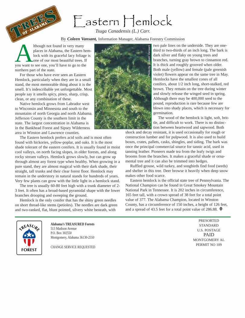
Alabama’s TREASURED Forests513 Madison AvenueP.O. Box 302550Montgomery, Alabama 36130-2550
CHANGE SERVICE REQUESTED
PRESORTED STANDARD
U.S. POSTAGE PAID
MONTGOMERY ALPERMIT NO 109
Although not found in very manyplaces in Alabama, the Eastern hem-lock with its graceful lacy foliage isone of our most beautiful trees. If
you want to see one, you’ll have to go to thenorthern part of the state.
For those who have ever seen an EasternHemlock, particularly when they are in a smallstand, the most memorable thing about it is thesmell. It’s indescribable yet unforgettable. Mostpeople say it smells spicy, piney, sharp, crisp,clean, or any combination of these.
Native hemlock grows from Labrador westto Wisconsin and Minnesota and south to themountains of north Georgia and north Alabama.Jefferson County is the southern limit in thestate. The largest concentration in Alabama isin the Bankhead Forest and Sipsey Wildernessarea in Winston and Lawrence counties.
The Eastern hemlock prefers acid soils and is most oftenfound with hickories, yellow-poplar, and oaks. It is the mostshade tolerant of the eastern conifers. It is usually found in moistcool valleys, on north facing slopes, in older forests, and alongrocky stream valleys. Hemlock grows slowly, but can grow upthrough almost any forest type when healthy. When growing in apure stand, they are almost magical with their dark shade, theirstraight, tall trunks and their clear forest floor. Hemlock mayremain in the understory in natural stands for hundreds of years.Very few plants can grow with the little light in a hemlock stand.
The tree is usually 60-80 feet high with a trunk diameter of 2-3 feet. It often has a broad-based pyramidal shape with the lowerbranches drooping and sweeping the ground.
Hemlock is the only conifer that has the shiny green needleson short thread-like stems (petioles). The needles are dark greenand two-ranked, flat, blunt pointed, silvery white beneath, with
two pale lines on the underside. They are one-third to two-thirds of an inch long. The bark isdark silver and flaky on young trees andbranches, turning gray brown to cinnamon red.It is thick and roughly grooved when older.Both male (yellow) and female (pale greenishviolet) flowers appear on the same tree in May.Hemlocks have the smallest cones of allconifers, about 1/2 inch long, short-stalked, redbrown. They remain on the tree during winterand slowly release the winged seed in spring.Although there may be 400,000 seed to thepound, reproduction is rare because few areblown into shady places, which is necessary forgermination.
The wood of the hemlock is light, soft, brit-tle, and difficult to work. There is no distinc-tion between heartwood and sapwood. Both
shock and decay resistant, it is used occasionally for rough orconstruction lumber and for pulpwood. It is also used to buildboxes, crates, pallets, casks, shingles, and siding. The bark wasonce the principal commercial source for tannic acid, used intanning leather. Pioneers made tea from the leafy twigs andbrooms from the branches. It makes a graceful shade or orna-mental tree and it can also be trimmed into hedges.
Ruffled grouse, wild turkey, and songbirds find food (seeds)and shelter in this tree. Deer browse it heavily when deep snowmakes other food scarce.
Eastern hemlock is the official state tree of Pennsylvania. TheNational Champion can be found in Great Smokey MountainNational Park in Tennessee. It is 202 inches in circumference,165 feet tall, with a crown spread of 38 feet for a total pointvalue of 377. The Alabama Champion, located in WinstonCounty, has a circumference of 150 inches, a height of 126 feet,and a spread of 43.5 feet for a total point value of 286.88.
Tsuga Canadensis (L.) Carr.
By Coleen Vansant, Information Manager, Alabama Forestry Commission
Pho
to b
y C
olee
n V
ansa
nt
OF • ALABAMA