150906 rapport ocha demolition zone c
DESCRIPTION
Rapport publié le 7 septembre par le bureau pour la coordination des Affaires humanitaires de l'ONU (Ocha) sur la démolition de structures palestiniennes en Cisjordanie sous contrôle administratif et militaire israélien (Zone C).TRANSCRIPT

Scan it!with QR reader App
www.ochaopt.org United Nations Office for the Coordination of Humanitarian Affairs occupied Palestinian territoryP. O. Box 38712 East Jerusalem 9138602 l tel +972 (0)2 582 9962 l fax +972 (0)2 582 5841 l [email protected] facebook.com/ochaopt
Coordination Saves Lives
UNDER THREAT
Demolition orDers in AreA C
of the West BAnkOfficial data released by the Israeli authorities indicate that over 11,000 demolition orders - affecting an estimated 13,000 Palestinian-owned structures, including homes -are currently ‘outstanding’ in Area C of the West Bank. These orders heighten the vulnerability of thousands of poor Palestinian households, some of whom are at imminent risk of forcible displacement.
Israel retains direct control over Area C, which encompasses more than 60 per cent of the West Bank and is home to approximately 300,000 Palestinians.
Due to the lack of adequate planning and discriminatory allocation of public land, it is nearly impossible for Palestinians to obtain building permits in most of Area C.
In the SpotlIght
Demolition in Umm al Khair, Hebron governorate. October 2014.
Phot
o by
OC
HA

DeMolItIon oRDeRS AgAInSt pAleStInIAn StRUCtUReS
Demolition Orders SystemAn interactive-web based platform accompanies this report that will enables users to visualize/map all demolition orders based on various indicators, including year, status, governorate, residential area, geographical area, etc. There are two dashboards featuring the orders against Palestinian structures and Israeli settlement structures.

3In the SpotlIght | UNDER THREAT: DEmoliTioN oRDERs iN AREA C of THE WEsT BANk
IntRoDUCtIonArea C is a home to approximately 300,000 Palestinians currently residing in 532 residential areas. Many of these residential areas are located entirely in Area C, but, in other cases, the area is part of a larger community, part of which is located in Areas A or B.1
According to the Israeli Central Bureau of Statistics, there are also about 356,000 Israelis residing in 135 settlements and some 100 settlement ‘outposts’ established in Area C; both are considered to contravene international law, while the settlement ‘outposts’ are also considered illegal under Israeli law.
The planning and zoning regime applied by the Israeli authorities, including the ways in which public land is allocated, makes it virtually impossible for Palestinians to obtain building permits in most of Area C. Even basic residential and livelihood structures, such as a tent or a fence, require a building permit.
This situation impedes the development of adequate housing, infrastructure and livelihoods in the Area C Palestinian communities, and has significant consequences for the entire West Bank population. A recent World Bank report, for example, estimated that if “businesses and farms were permitted to develop in Area C, this would add as much as 35 per cent to Palestinian GDP”.2
Those Palestinian residents who attempt to stay are often left with no choice but to build without authorization to meet their basic needs.
Structures built without permits are regularly served with demolition orders. While only a minority of the orders issued are executed, these orders do not expire and leave affected households in a state of chronic uncertainty and threat. Where the orders are implemented, they have resulted in displacement and disruption of livelihoods, the entrenchment of poverty and increased aid dependency.
While the demolition of Palestinian structures in Area C of the West Bank is systematically monitored by the humanitarian community, the issue of demolition orders has received less attention. A database released by the Israeli Civil Administration (ICA) this year sheds light on the scope of this phenomenon. The dataset includes detailed information on all the demolition orders issued in Palestinian communities and Israeli settlements across Area C between 1988 and 2014.3 This OCHA report explores these data and highlights some of the key trends to emerge.
Any destruction by the Occupying Power of real or personal property belonging individually or collectively to private persons, or to the State, or to other public authorities, or to social or cooperative organizations, is prohibited, except where such destruction is rendered absolutely necessary by military operations.
Article 53, Fourth Geneva Convention, 1949.
figures at GlanceTotal demolition orders 14,087
Demolition orders executed 2,802Outstanding demolition orders 11,134
Demolition orders “ready for execution” 570
Approved permit applications (2010 - 2014) 1.5%
Area C planned for Palestinians 1%
Demolition orders against structures located on Palestinian private land
77%
Residential Areas
Estimated Residents
100% 241 67,102
50%- 99% 51 55,018
less than 50% 240 175,866
Grand total 532 297,986
PerCentAGe of Built-uP AreA in AreA CPercentage of built-up
area in Area C
DeMolItIon oRDeRS AgAInSt pAleStInIAn StRUCtUReS

4 In the SpotlIght | UNDER THREAT: DEmoliTioN oRDERs iN AREA C of THE WEsT BANk
Creating Area CIn the 1995 Interim Agreement on the West Bank and the Gaza Strip, Israel and the Palestine Liberation Organization (PLO) agreed to the temporary division of the West Bank (excluding East Jerusalem) into three areas: A, B and C. In Area C, Israel retained full control over security and planning and zoning, as well as other aspects related to ‘territory’. This division was intended to last until a final status agreement was reached within five years.
With the breakdown in negotiations in 2000, approximately 36 per cent of the West Bank had been categorized as Areas A and B, with an additional three percent of land, designated a nature reserve that was to be transferred to the Palestinian
Authority under the Wye River Memorandum. This left the majority of the West Bank as Area C. There has been no official change to this division since 2000. Of particular importance is that responsibility over planning and zoning in Area C, which was to be transferred to the Palestinian Authority by the end of 1998, has remained with Israel.
Moreover, Area C holds the most significant land reserves available for Palestinian development, as well as the bulk of Palestinian agricultural and grazing land. It is also the only contiguous territory in the West Bank; therefore, any large-scale infrastructure projects (roads, water and electricity networks, etc.) also involve work in Area C. As a result, the entire West Bank population is affected by what happens in Area C.
The Israeli position regarding Area C demolitionsAccording to the Israeli authorities, the demolition of structures erected without the required building permit is a legitimate measure of law enforcement grounded in Jordanian legislation, which was in force at the start of Israeli rule in the West Bank, and in the amendments introduced to it since by Israeli military legislation. These demolitions are also consistent, according to the authorities, with Israel’s obligations under Article 43 of the Hague Convention Respecting the Laws and Customs of War on Land of 1907, which requires the occupying power to ensure “[…] public order and safety, while respecting, unless absolutely prevented, the laws in force in the country.” Finally, the Israeli authorities defend the legality of demolitions by citing the 1995 Interim Agreement signed between Israel and the Palestine Liberation Organization (PLO), under which planning and zoning in Area C is subject to the approval of the appropriate planning committees.5
The States Parties to the present Covenant recognize the right of everyone to an adequate standard of living for himself and his family, including adequate food, clothing and housing, and to the continuous improvement of living conditions.
Article 11 section 1 of the International Covenant on Economic, Social, and Cultural
Rights, 1966.
According to Israeli Civil Administration data, between 2010 and 2014, Palestinians submitted 2,020 applications for building permits in Area C. Only 33 – just 1.5 per cent – were approved. 4
Demolition in Abu Kbash, Nablus governorate. August 2015.
Phot
o by
OC
HA

5In the SpotlIght | UNDER THREAT: DEmoliTioN oRDERs iN AREA C of THE WEsT BANk
DeMolItIon oRDeRS AgAInSt pAleStInIAn StRUCtUReS
Legal aid to affected households In 2010, the humanitarian community in the occupied Palestinian territory established a Legal Task Force (LTF), with the primary objective to ensure effective coordination between Palestinian, Israeli and international actors providing legal aid to Palestinians facing threats, particularly related to housing, land and property issues in East Jerusalem and Area C of the West Bank. The LTF is composed of 14 organizations and works closely with the Government of Palestine through various ministries. The aid provided has proved effective in halting or delaying demolitions and related displacements.
Between 1988 and 2014, the ICA issued 14,087 demolition orders6 against Palestinian-owned structures located in Area C. In many cases, the same order targets multiple structures owned by the same household (e.g. their residence, an animal shelter, a storage room and a latrine). The actual number of structures affected is estimated, based on an examination of over 90 per cent of the records, at about 17,000.
Distribution of orders by status of implementationAccording to the ICA records, almost 20 per cent of the demolition orders issued during this period (2,802 orders) had been executed as of the end of December 2014, including demolitions carried out by the ICA or by the affected households themselves in compliance with an ICA order. Another one per cent (151 orders) were revoked, presumably after the owners succeeded in obtaining a building permit and legalizing the relevant structures. The remaining 11,134 demolition orders were outstanding as of January 2015.
Of the total orders, 570 (four per cent ) were categorized by the ICA as “ready for execution”. This can be understood as orders that are prioritized and are not challenged legally or otherwise. During the first half of 2015, OCHA recorded the demolition or dismantlement and confiscation of 245 Palestinian structures in Area C, most of which are presumably included in this category.
Another 17 per cent of the total orders issued (2,454 orders) were classified by the ICA as on hold due to legal proceedings. The latter include appeals filed by affected households to the ICA, as well as petitions against the orders filed with the Israeli High Court of Justice (HCJ), which are often followed by temporary injunctions preventing the execution of the orders.
The remaining 58 per cent of the total orders (8,110 orders) were categorized as “in process”. While this is the largest category, the nature of the “in process” is not defined in the dataset and the meaning remains unclear.
Demolition orDers By stAtus
Ad Deir, Tubas governorate. August 2015.
Phot
o by
OC
HA
In Process 58%Executed
(demolished)
20%
On hold due to legal proceedings
17%
Ready for execution
4%
File closed
1%

6 In the SpotlIght | UNDER THREAT: DEmoliTioN oRDERs iN AREA C of THE WEsT BANk
1% of Area C is planned
for Palestinian development.
In 29% of Area C
Palestinian construction
is heavily restricted.
In 70% of Area C
Palestinian construction is prohibited.
"J
"J
"J
"J
"J
"J"J
"J
"J
"J
"J
!
!
!!!!
!!!!
!!!!!!!!!!
!!
!!!
!
!!!!
!
! !!!!
!
!!
!
!!!!!!!!
!
!
!!!
!!!!!
!!!!!
!!!!
!
!!!
!!
!!!
!!!!!
!!
!!!!!
!!!
!!!!!
!!!!!!!
!!!!!!!
!!!!!!!!!!!!!!
!!!
!
!
!!!!
!!!!
!
!!
!!
!
!!!!!!!!!!!!!!!!!!!!!
!!!!!!!!!!
! !
!!!!
!!!!!!!!
!
!!!
!!!!!!!!!!!!!!!!!!!!!!!!!!!!!!!!
!!!
!
!!
!!!!!
!
!
!!!!!!!!!
!
!!!!!!!!!!!!!!!!!!!!!!!!!!!!
!!!
!
!!!!!!!!!!
!!
!
!!!!!!
!!!!!!
!!!!!!!!!!!!
!!!
!
!!
!
!!!!
!!
!
!!
!!
!
!
!!!
!
!!!
!!
!!
!!!!!!
!
!
!!!!
!!!!!!
!!
!!!!!
!!
!
!!!!!
!!!!
!
!!!!!
!!!!!!!
!
!!
!!!!!!
!!
!!
!!!!!!!!!!!!
!
!
!
!
!!!
!!
!
!
!
!!!
!!!!!
!!!!!!!!!!!!! !
!!!!!
!
!!!! !!!
!!
!!!!!!!!!!!!!!!!
!!!
!!!!
!!!!!!
!!
!
!!!!!!!!!!!!!!
!!!!!!
!!!!!!!!!!!!
!!!!
!!
!!!!!!!!!!!
!
!!
!!!!
!!!!
!
!
!
!!
!
!!!
!
!!
!!!!!
!!!! !!!
!
!!!!!!!
!!!!!!!!!!!!!!!!!!
!
!!
!!!!!
!
!!
!!
!
!
!
!!!!!!!
!!!!!!!!! !!
!
!!!
!!
! !!! !!!
!
!!!!!
!!
!!!!!!!! !
!!!!
!!!!
!
!!!!!!
!!!!!!!!
!
!!!!!!!!!!!!
!!!
!!
!!!!
!!!
!
!!!!!!!!!!
!!!!
!
!!
!!
!!!!!
!!!!!!!!!!!!!
!!! !!!!
!!
!!!!!!
!
!
!!
!
!
!!
!
!
!!!!!!!!!!!!!!!
!
!
!!!
!!!!
!
!
!!!!!!!!
!!!!!!!!
!!!!!!!!
!
!!
!! !!!
!
!!!!
!!!!!
!!!!!!!!
!!
! !!!
!!!!!
!
!!!!!!!!!!!!!!!
!!!!!
!!!!!
!
!
!!!
!
!!!
!!!!!! !!!
! !!!!!!!!
!!
!!
!!!!
!!!
!
!!!
!!!
!
!!
!
!!!!!!!!!
!!!!!!!!!
!
!
!!
!!
!
!
!
!!
!!!!!
!
!
!
!!
!
!
!!!!!!!!!!!!!!!!!
!
!!
!!!!!
!!!!
!!!!!
!!!!!!!!!!!!
!!
!!!!
!
!
!!!
!!!
!
!!!
!!!!!!!
!!!!!!!!!!!!!!!!!!
!!!
!
!!!
!!
!
!!
!
!!!!!!!!!!!
!!!!!!!!!!!!
!
!!!
!!!!
!!!!!!!
!!!
!!!!!!!!!!!!!!!!!!!!!!!!!!!!!!!!
!!!!!!!!!!!!!!!!!!!!!!!!!!!!!!!!!!!!!!!
!!!!
!!!!
!!!!
!!!!
!!!!! !!
!!!!!!
!!!!!
!
!!!!!
!!
!!!!!!!!!!!!!
!!!!!!!!!!!!!!!!
!!
!!!!!!
!
!!!!!!!
!
!
!!!
!!!!!!!!!!
!!!!!
!!!!!
!!!!!!!!!!!!!!
!
!!!!
!
!
!!!!!
!
!!!!!!!!!!!!
!!!!!!!!!!!!!
!
!
!
!!
!!
!
!!!!!!!!!!!!!!!!!!!!!!!!!!!!
!!!!!
!!
!
!!
!!!!!
!!!!!
!
!!!!!!!!!
!!!!!!!!!
!
!
!!
!!!
!
!! !!!!!!
! !!!
!
!!
!
!!!
!!!!
!
!!
!
!!!
!!
!!!!!!
!!!!!
!
!
!!!!!!!!!!!!!!!!!!!
!!!!!!!!
!
!!!
!
!!!
!!!!!!!!!!!!
!!!!!!!!
!!!
!
!
!!!!!!!!!!!
!
!!!
!!!
!!
!
!!!!!!!!!!
!
!!!
!!!
!
!
!!!!
!
!
!
!
!
!!!
!!
!
!!
!
!!!!!!!!!!!
!!!
!
!
!!!!!!!!!!!!!
!!!!!!!!!!!!!!!
!!!!!!!!
!!!!!!!
!!!!!!!!!!!!!!!!!!!!!!!!!!!!!
!
!!!!!!!!!!
!!!!!!!!!!!
!!!! !
!
!!
!!!
!!
!!!
!!!!!!!!! !!!
!
!!!!!!!!!!!!!!!!!!!!!!!!!!!!
!
!!!!!!!!!!!
!!!
!!
!!
!!!!!!!
!!!!!!!!!!!!!!!!!!!!!! !!!!!!!!
!!!!!!!!!!!!!!!!!
!!!
!!!!!
!!!!
!
!!!!
!!!!!!!!!!!
!!!!!!!!!!!!! !!!!!!!
!!!!!!!!!!!!!!!
!!!!!!!!!!!!!!!!!!!!!!!!!!
!!!!!!!!!!
!!!!!!!!
!!!!!!
!!
!
!!
!
!
!!!!
! !
! !!!!!!!!!
!!!
!!!!!!
!!!!!!
!
!!!!!
!!
!
!!
!!!!!!!!!!!!!!!!!!!!!!!!!!!
!
!!
!
!
!!!!!!!!!
!!
!
!!
!!
!!! !!!!!!!!!!!!!
!!!!!!!!
!!
!!!!!!!!!!!!
!
!
!
!!!!!!!
!!!!!!!
!!
!
!
!
!!
!!!!!!
!!!
!
!
!!
!!!!!!!!!!!!!
!!
!!!!!!!
!
!
!
!!
!!!
!
!!!
!!!!!
!
! !!!!
! !!!!!!
!
!!!!!
!!
!
!!
!
!
!
!
!!!
!!
!
!
!
!
!!!!!!!!!!!
!!
!!!
!
!!!!
!!!!!
!!!
!
!
!!
!!!!!!!!
!!!
!!!!!!!!!!!
!!!!!!!!!!!!!!
!!!!!!!!!!!!!!!!!!!!!!!!!!!!!!!!!!
!!!!!
!
!!
!!!
!!
!!!!!
!!!!!!
!!!
!!!!!!!
!
!!!!!!!!!!!!!!!
!!!
!!!!!!!!!!!
!
!!!!!!!!!!!!!!!
!!
!!!!!!!!
!
!!!
!
!!!!!!!!!!!!!!
!!!!
!
!!!!!!!!!!!!!!!!!!!!!!!!!!!!
!!!
!
!
!
!
!
!!
!!
!
!!
!!
!
!!!!!
!!!
!
!!
!
!!!!!!!!!
!
!!
!
!!
!
!
!!!
!!!!!!!!!!!!!!!!!!!!!!!!!!!!
!
!
!!
!
!
!!!
!
!
!
!!!!!!!!!!!!
!!!!
!!
!!!!!!!!!!
!!!!
!
!
!
!
!
!
!
!
!
!!!
!
!
!
!!!!!!!!!!!!!!!!
!
!!
!!!!!
!
!
!
!
!
!
!
!
! !!
!
!
!
!
!
!!!
!!
!
!
!
!!!!
!!
!
!
!
!!
!
!
!!!!
!
!
!
!
!
!
!!
!!!
!!
!!
!
!!
!
!!!!
!!
!
!!
!!!!
! !!
!!
!
!
!!!!
!! !!
!
!!
!
!
!!! !!!
!!
!!!!!!
!!
!!
!!!!!!!
!
!!
!!!
!
!!!!!!!
!!
!
!!
!!!
!
!
!!!
!!!!
!
!!
!
!! !!
!
!
!
!!
!!
!!
!
!
!
!!
!
!!!!!!!!
!!!!!!!
!!!
!
!!
!!
!!!!!!
!
!
!
!!!!
!
!
! !
!!
!!!
!
!
!
!
!!
!
!
!!
!
!!!
!
!
!
!!!!
!
!!!!
!! !
!
!
!!!!!!
!
!!
!
!
!
!
!
!
!
!
!
!
!
!!
!
!!
!
!!
!
! !!
! !
!!
!
!!
!
!
!!!!
!!
! !!
!
!
!! !
!!!
!!!!
!
!
!!!!!
!
!!
!
! !
!!!!!!!!!!
!!!
!
!
!
!
!
!!!!
!!!!
!
!!
!!
!!
!!!!!!
!
!
!!!
!
!!!!!!
!!!!! !!!
!!!!!
!!
!!
!
!!!
!
!
!
!
!
!
!
!
!!
!!
!
!
!
!!
!
!
!!
!!
!
!!
!
!
!!
!!
!
!
!!
!
!
!!
!
!!! !
!
!!
!
!
!!! !!!!
!
!
!
!!!!!!
!
!
1949 Armistice (Green Line)
Tubas
Jenin
Nablus
Hebron
Salfit
Tulkarm
Jericho
Ramallah
Bethlehem
Qalqiliya
Jerusalem
0 10 205Km
¥Outstanding Demolition Orders
Dead
Sea
Riv
erJo
rda n
Inte
rnat
iona
l Bou
ndar
y
Demolition Order Status
Ready to be executed
On hold due to legal proceedings
In Process
Planned Barrier
Oslo Agreement Area C/Restricted Areas
Oslo Agreement Areas A,B
East Jerusalem
No Man's Land
Constructed/Under Construction Barrier
outstAnDinG Demolition orDers

7In the SpotlIght | UNDER THREAT: DEmoliTioN oRDERs iN AREA C of THE WEsT BANk
Percentage of built-up area in Area C
Spatial distributionNearly 60 per cent of the outstanding demolition orders affect communities where part of their built-up area is designated as Area A and/or Area B (see table herein). In many cases, particularly in relation to livelihood or service-related structures, although the structure served with a demolition order is located in Area C, the family affected resides in Area A or B.
This is due to the fact that, for a large number of communities across the West Bank, only the areas that were already built-up at the time the Interim Agreement was implemented (second half of the 1990s) were designated as Area A or B, while the open spaces surrounding the built-up area, which should be made available for future development, were designated as Area C.
The geographic distribution of outstanding orders is highly uneven, with about a third of them concentrated in the governorate of Hebron (33 per cent), followed by Jerusalem (16 per cent), Ramallah (11 per cent) and Bethlehem (10 per cent) governorates.
Percentage of outstanding
demolition orders
Percentage of order excuted (demolished)
100% 41% 49%
50%- 99% 16% 9%
less than 50% 43% 51%
0 5 102.5Km
Hebron3,638
Jenin535
Ramallah1,172
Nablus650
Jericho757
Tubas317
Bethlehem1,136
Salfit550
Jerusalem1,753
Tulkarm172
Qalqiliya454
170-350
351 - 550
551 - 750
751 - 1750
1751 - 3650
¥
outstAnDinG Demolition orDersBy GovernorAte
Arab al Jahilin al Jabal, May 2015.
Phot
o by
OC
HA
8 In the SpotlIght | UNDER THREAT: DEmoliTioN oRDERs iN AREA C of THE WEsT BANk
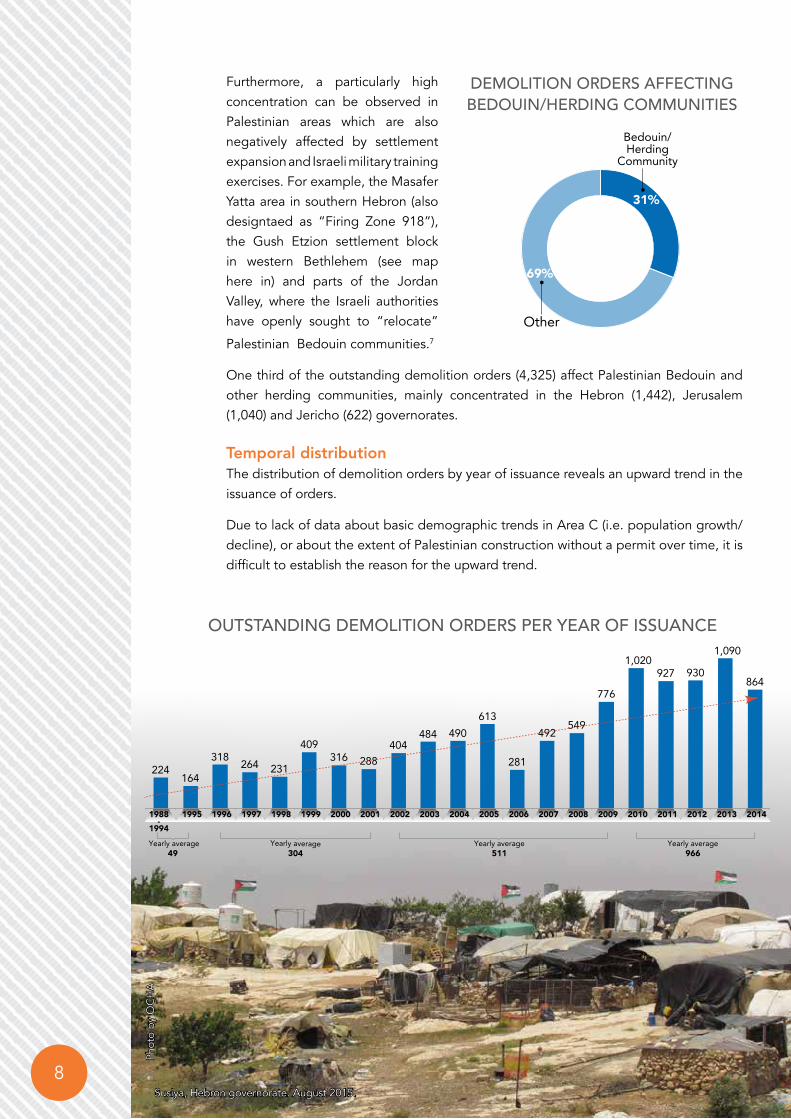
69%
Other
31%
Bedouin/Herding
Community
Furthermore, a particularly high concentration can be observed in Palestinian areas which are also negatively affected by settlement expansion and Israeli military training exercises. For example, the Masafer Yatta area in southern Hebron (also designtaed as “Firing Zone 918”), the Gush Etzion settlement block in western Bethlehem (see map here in) and parts of the Jordan Valley, where the Israeli authorities have openly sought to “relocate”
Palestinian Bedouin communities.7
One third of the outstanding demolition orders (4,325) affect Palestinian Bedouin and other herding communities, mainly concentrated in the Hebron (1,442), Jerusalem (1,040) and Jericho (622) governorates.
Temporal distributionThe distribution of demolition orders by year of issuance reveals an upward trend in the issuance of orders.
Due to lack of data about basic demographic trends in Area C (i.e. population growth/decline), or about the extent of Palestinian construction without a permit over time, it is difficult to establish the reason for the upward trend.
Demolition orDers AffeCtinG BeDouin/herDinG Communities
outstAnDinG Demolition orDers Per yeAr of issuAnCe
224
Yearly average49
164
318 264 231
409316 288
404484 490
613
281
492549
776
1,020927 930
1,090
864
1988-
19941995 1996 1997 1998 1999 2000 2001 2002 2003 2004 2005 2006 2007 2008 2009 2010 2011 2012 2013 2014
Yearly average304
Yearly average511
Yearly average966
Phot
o by
OC
HA
Susiya, Hebron governorate. August 2015.

9In the SpotlIght | UNDER THREAT: DEmoliTioN oRDERs iN AREA C of THE WEsT BANk
The data indicate that demolition orders do not expire; do not expire; some of the 570 orders classified as “ready for execution” were issued as far back as 20 years ago.
Distribution by status of landApproximately 77 per cent of the demolition orders issued by the ICA since 1988 target structures located on land recognized by the Israeli authorities as privately-owned Palestinian land, while the remaining 23 per cent apply to structures built on land designated as public (also known as “state”) land.8
Given the private status of the land in the first category, it is possible to infer that the grounds for denying a building permit in this category is the absence of a planning scheme or “outline plan”. Overall, less than one per cent of Area C (18,243 dunums) has a planning scheme approved by the ICA allowing for Palestinian development.9
¥Private
Public
Hebron31161315
Jenin684108
Ramallah1374
95
Nablus674133
Jericho459528
Tubas40469
Bethlehem1192195
Salfit57179
Jerus alem1592556
Tulkarm29618
Qalqilya61613
0 5 102.5Km
Demolition orDers reADy for exeCution By yeAr of issuAnCe
103 2 4
1421 24
33
5964
4739
69
92
81
8
1992-
1998 2000 2001 2002 2003 2004 2005 2006 2007 2008 2009 2010 2011 2012 2013 2014
Demolition orDers By stAtus of lAnD

10 In the SpotlIght | UNDER THREAT: DEmoliTioN oRDERs iN AREA C of THE WEsT BANk
The denial of permits for structures located on public land is directly linked to Israel’s long-standing policy which places most public land, once identified or declared as such, within the jurisdictional boundaries of the local and regional councils of Israeli settlements, and automatically off-limits for Palestinian development.10
Only 8.6 km², or 0.4 per cent of all state land, were allocated for Palestinian use, on an exceptional basis.11 The bulk of these allocations were in the context of various “relocation” plans for Bedouin communities in the Bethlehem, Jerusalem, Ramallah and Jericho governorates.
Under International Humanitarian Law, the occupying power is only entitled to administer the government and public property found in the occupied territory for the benefit of the protected population (i.e. the Palestinians), or for its own military needs. The international community has repeatedly called on Israel to halt settlement activities, including the allocation of Government resources for this purpose.
Private77%
Public23%
numBer of Demolition orDers By lAnD stAtus
BeitarIllit
Bat Ayin
KfarEtzion
Migdal Oz
AlonShvut
Har Gilo
NeveDaniel
RoshTzurim
El'azar
Efrata
Gva'ot
NeveDanielNorth
BatAyinEast
GivatHatamar
Old Massu'otItzhak
GivatHadagan
GivatHahish
DerechHa'avot
Bat AyinWest
UmmSalamuna
Al Walaja
Surif
WadiRahhal
Wadian Nis
MarahRabah
Al Ma'sara
WadiFukin
Nahhalin
Husan
Al Khadr
Artas
Ad DuheishaCamp
Ad Doha
BeitJala
Battir
Safa
Al Beida
Al Jab'a
Khirbetad Deir
KhalletSakariya
Juratash
Sham'a
Bir Onah
BeitFajjar
BeitUmmar
Al 'ArrubCamp
Bethlehem
Khirbet
MarahMa'alla
Khirbetan Nahla
Khirbet alMantara
Khallet'Afana
AthThabra
Khallet alBalluta
¥
0 1 20.5Km
Settlements Outer-limit
Oslo Agreement Area C
Oslo Agreement Areas A, B
East Jerusalem
Governorate BoundaryProjected Barrier
Declared State Land in 2014
Barrier Constructed/Under Construction
Israeli Settlement
Israeli Settlement Outpost
Palestinian Community
Demolition Order Against Palestinians

11In the SpotlIght | UNDER THREAT: DEmoliTioN oRDERs iN AREA C of THE WEsT BANk
In 2014, some 5,000 dunums
(1,250 acres) of land in the Gush
Etzion area were newly declared
“state land”.
CASE STUDy
PAlestiniAn resiDentiAl AreAs BetWeen the BArrier AnD the Green line: the Gush etzion settlement BloC
In the Bethlehem governorate, nine Palestinan villages, with a population of 24,155 residents, are located in area that is planned to be surrounded by the Barrier. This area is also known as the Gush Etzion settlement bloc.
Nearly one third of the demolition orders issued in Bethlehem governorate (410 of 1,380 orders) target Palestinian-owned structures located in this area. The affected communities are already vulnerable due to access restrictions and loss of land in the context of settlement expansion.12
Moreover, if the Barrier in this area is completed as planned, the residents of these Palestinian villages will be separated from their service centre in Bethlehem and the wider West Bank. Another six Palestinian communities whose lands fall within the settlement bloc will have impeded access to their land.
Community Number of demolition orders
100%Khallet Sakariya 68
Khallet ‘Afana 22
Khallet al Balluta 15
50%- 99% Al Walaja 65
less than 50%
Nahhalin 54
Husan 80
Al Jab'a 41
Battir 40
Wadi Fukin 25
Total 410
Percentage of built-up area in
Area C
BeitarIllit
Bat Ayin
KfarEtzion
Migdal Oz
AlonShvut
Har Gilo
NeveDaniel
RoshTzurim
El'azar
Efrata
Gva'ot
NeveDanielNorth
BatAyinEast
GivatHatamar
Old Massu'otItzhak
GivatHadagan
GivatHahish
DerechHa'avot
Bat AyinWest
UmmSalamuna
Al Walaja
Surif
WadiRahhal
Wadian Nis
MarahRabah
Al Ma'sara
WadiFukin
Nahhalin
Husan
Al Khadr
Artas
Ad DuheishaCamp
Ad Doha
BeitJala
Battir
Safa
Al Beida
Al Jab'a
Khirbetad Deir
KhalletSakariya
Juratash
Sham'a
Bir Onah
BeitFajjar
BeitUmmar
Al 'ArrubCamp
Bethlehem
Khirbet
MarahMa'alla
Khirbetan Nahla
Khirbet alMantara
Khallet'Afana
AthThabra
Khallet alBalluta
¥
0 1 20.5Km
Settlements Outer-limit
Oslo Agreement Area C
Oslo Agreement Areas A, B
East Jerusalem
Governorate BoundaryProjected Barrier
Declared State Land in 2014
Barrier Constructed/Under Construction
Israeli Settlement
Israeli Settlement Outpost
Palestinian Community
Demolition Order Against Palestinians

12 In the SpotlIght | UNDER THREAT: DEmoliTioN oRDERs iN AREA C of THE WEsT BANk
The Israeli Civil Administartion (ICA) is also responsible for issuing demolition orders against settlement structures in Area C erected without the required Israeli permits.
During the same period (1988-2014), the ICA issued a total of 6,948 demolition orders against structures in settlements located in Area C. About 45 per cent (3,133) of the records do not provide any information about the current status of the order. More than one-third of the orders (2,593) are classified as “in process”, although, as with orders imposed on Palestinians, the nature of the “process” is unclear. The
remainder of the records include 854 orders (12
per cent) classified as executed (demolished by the ICA or by the relevant settlers), 167 orders (two per cent) that were cancelled, 111 orders (two per cent) classified as “ready for execution”, and another 90 orders (two per cent) on hold due to legal proceedings.
Overall, 12.3 per cent of demolition orders against structures in settlements were executed versus 19.9 per cent of orders executed against Palestinian structures. Additionally, while approximately 70 per cent of the orders implemented in settlements involved demolition by settlers and 30 per cent demolitions by the ICA, almost the exact opposite applies to Palestinian structures: 72 per cent of the orders were implemented by the ICA and 28 per cent were sdemolished by the owners. In many
PerCentAGe of Demolition orDers exeCuteD
Demolition orDers AGAinst settlement struCtures
DeMolItIon oRDeRS AgAInSt SettleMent StRUCtUReS
The Occupying Power shall not deport or transfer parts of its own civilian population into the territory it occupies.
Article 49, sixth paragraph, of the 1949 Geneva
Convention IV
Undefined45%
Undefined45%
In process37%
Executed (demolished)12%
File closed2%
Ready for execution2%
On hold due to legal proceedings
2%
6,948Demolition
Orders
14.3
3.6
5.6
8.7
Percentage of demolition orders implemented
Demolished by owner
Demolished by ICA
19.9
12.3
PalestinianStructures
SettlementStructures
cases, demolition by settlers, particularly of structures located in unauthorized outposts, are carried out under an arrangement reached with the Israeli authorities for relocation of the targeted area elsewhere, sometimes including compensation and support from the authorities.13 Although the Israeli authorities proposed compensation and alternative locations for Palestinians in some exceptional cases, this has actually had a negative impact on their pastoral lifestyles and living conditions.14

13In the SpotlIght | UNDER THREAT: DEmoliTioN oRDERs iN AREA C of THE WEsT BANk
DIFFERENT STANDARDSThe different execution rates of demolition orders against unauthorized construction by Palestinians and Israeli settlers is just one illustration of an inconsistent approach on the part of the Israeli authorities towards both populations, particularly regarding planning.
For example, to date, settlement outline plans in Area C approved by the ICA encompassed a total of 282,174 dunums, or 8.5 per cent of Area C. These areas are smaller than the municipal boundaries of settlements, which are allocated in principle for development but not planned. In contrast, the area included within approved outline plans in Palestinian residential areas stands at 18,243 dunums, or less than 1 per cent of Area C.
Taking into account the size of both populations, the planned area per Israeli settler is more than 13 times larger than the planned area per Palestinian (0.79 vs 0.06 dunum per settler and per Palestinian respectively).
In the past five years, the Palestinian Authority, in consultation with the communities concerned, prepared outline plans for 116 Palestinian communities in Area C, of which a total of 67 plans were submitted to the ICA for approval. So far, only three of them covering an area of 570 dunums (0.02% of Area C) have been endorsed by the ICA.
Another indicator of the uneven approach is the policy towards the development of public land. Beyond the customary inclusion of such land within settlement boundaries (see page 9), the Israeli authorities are actively involved in allocating this land for development by settlements. For example, between 2002 and 2015 the Israeli authorities issued tenders on public land for the construction of 12,639 housing units in settlements, including 2,359 in 2014 alone, the largest such figure during this period.16 There is no similar process applied for the development of housing in Area C for the Palestinian population.
603
2,093
962
1,184
971
65
565
1,009
606
1,665
2,359
2002 2003 2004 2005 2006 2007 2008 2011 2012 2013 2014
tenDers for settlement ConstruCtion (housinG units) Per yeAr in AreA C
Israel has to, in compliance with international law, amend the planning legislation and processes in order, in particular, to ensure the security of tenure and the full participation of Palestinians. Israel must also refrain from implementing evictions and demolition orders based on discriminatory and illegal planning policies, laws and practices.15

14 In the SpotlIght | UNDER THREAT: DEmoliTioN oRDERs iN AREA C of THE WEsT BANk
1. OCHA, In the Spotlight: Area C Vulnerability Profile, 2014.2. World Bank, report on “Area C of the West Bank and the Future of the Palestinian Economy,”report No:
AUS2922, October 2013.3. The dataset was obtained from the Israeli Civil Administration by Dror Etkes based on the Israeli Freedom
of information Act.4. Response dated 16 November 2014 from Lieut. Eliran Sason of the Civil Administration to a request
under the Freedom of Information Act submitted by Adv. Sharon Karni-Cohen of Bimkom.5. Letter from the Israeli Civil Administration to OCHA, 9 June 2015; HCJ11258/05 Majd ‘Afif ‘Aaref Hanani
et al. vs. the Planning Inspection Committee et al., petition dated 2005. 6. The total figure includes those orders that fall in areas that later became Area C. It excludes 343 orders
that, according to the coordinates referred to in the ICA dataset, fall in areas A, B, H2, East Jerusalem and no man’s land.
7. OCHA, humanitarian fact sheet on Bedouin Communities at Risk of Forcible Transfer, September 2014. 8. A Geographic Information System (GIS) layer obtained from the Israeli Civil Administration (ICA) was used
to determine the status of the land in the relevant areas as either privately-owned or public land.The term “public land” includes the category “Surveyed Land”.
9. For more information, read: An International Advisory Board, report on“Spatial Planning in Area C of the Israeli occupied West Bank of the Palestinian territory”, May 2015; OCHA, “Restricting Space: The Planning Regime Applied by Israel in Area C of the West Bank”, 2009; Bimkom ,“The Prohibited Zone: Israeli Planning Policy in Palestinian Villages in Area C”, 2008.
10. B’Tselem “Acting the Landlord: Israel’s policy in Area C”, June 2013; B’Tselem, “Under the Guise of Legality: Declaration on state land in the West Bank”, 2012; B’Tselem,“By Hook and by Crook: Israeli settlement policy in the West Bank”, 2010.
11. Letter from Attorney’s office of Jerusalem District to Association for Human Rights in Israel (ACRI), 4/2/2013.
12. OCHA, “Bethlehem Governorate: Fragmentation and Humanitarian Concerns”, January 2015; OCHA, “The Humanitarian Impact of Israeli Settlement Policies: Update”, December 2012; OCHA, “Displacement and Insecurity in Area C of the West Bank”, August 2011.
13. Haaretz, “Israel plans to legalize 13 contentious West Bank outposts”, 7 June 2012; Haaretz, “After Ulpana Hill, the next West Bank outposts on Israel’s agenda” 7 June 2012.
14. UNRWA & Bimkom, “Al Jabal: A Study on the Transfer of Bedouin Palestine Refugees”, 2013.15. The UN Secretary-General’s report to HRC on Israeli settlements in the Occupied Palestinian Territory,
including East Jerusalem, and in the occupied Syrian Golan. A/HRC/25/38, 12 February 201416. Based on data obtained from Peace Now.
END NOTES

UNITED NATIONS Office for the Coordination of Humanitarian Affairsoccupied Palestinian territory
P. O. Box 38712 East Jerusalem 9138602 www.ochaopt.org
Tel. +972 (0)2 582 9962 Fax +972 (0)2 582 5841 [email protected]